Embed Size (px)
Citation preview
EMAIL: [email protected] | WWW.FACEBOOK.COM/GROUPS/BERMUDABRIDGEAG | TWITTER @BERMUDABRIDGEAG
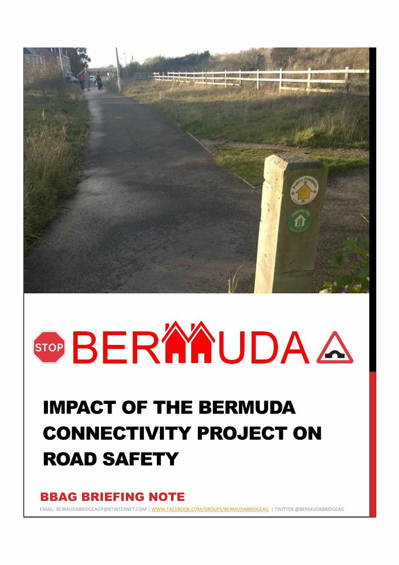
IMPACT OF THE BERMUDA
CONNECTIVITY PROJECT ON
ROAD SAFETY
BBAG BRIEFING NOTE

ROAD SAFETY BBAG BRIEFING NOTE
INTRODUCTION
The document is to be read in conjunction with the Bermuda
Connectivity Project Briefing Note prepared by the Bermuda Bridge
Action Group and the briefing noted on cycling. This briefing notes
details the wider impacts on road safety of opening the Bermuda
Bridge over the A444 to all traffic including heavy goods vehicles as
being promoted by Warwickshire County Council (WCC) with funding
from the Coventry & Warwickshire Local Enterprise Partnership.
BACKGROUND
The project proposes that the pedestrian and cycling bridge over the
A444 is opened up to all road traffic in order to provide “greater
connectivity” for the local road network and to provide a direct link
between West Nuneaton and the Griff Roundabout avoiding the A444
bypass. Some of the relevant objectives of the scheme are:
• Opening the existing bridge over the A444 to all traffic and road users
and connecting to the local highway network.
• Enhancements to Heath End Road / Bermuda Road junction.
• Enhancements to Griff Roundabout.
• Enhancements to the highway and cycle way on St Georges Way.
• Provision of additional car and cycle parking for Bermuda Rail Station.
Unfortunately the negative aspects of opening the bridge to traffic to
the local community and in particular the impact on road safety have
been ignored in pursuing growth fund monies to implement what is
purely a congestion relieving scheme for the A444 (see quotes
opposite). The impact of the scheme will create a Nuneaton Western
Bypass through a residential community providing a short cut for
commuters and heavy goods vehicles heading towards Coventry, the
M6 Motorway, Bermuda Park and the A5. The Bermuda Bridge Action
Group is calling upon all road safety groups and other interested
parties to get involved in the forthcoming public consultation and reject
the scheme proposals.
JMP Bridge Feasibility Study for Warwickshire County Council:
3.51 - "Construction of the development, as well as opening it to the traffic will produce air and noise pollution and increase roads accidents and congestion around the site. The development will also affect residents of Nuneaton due to increase of pollutants related to traffic emission."
4.2 - "The assessments indicate that limited bus operational and patronage benefits would occur from the opening of the bridge in the form of a sustainable modes bridge given that cycling and walking are already catered for on an informal basis.
Table 6.3 -"The above analysis assumes that no new benefits accrue from the provision of the cycle ways as these journeys can already be made."
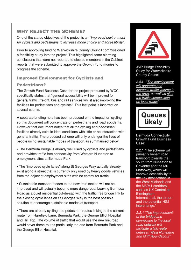
WHY REJECT THE SCHEME?
One of the stated objectives of the project is an “Improved environment
for cyclists and pedestrians to increase mode choice and accessibility”.
Prior to approving funding Warwickshire County Council commissioned
a feasibility study into the project. This highlighted some alarming
conclusions that were not reported to elected members in the Cabinet
reports that were submitted to approve the Growth Fund monies to
progress the scheme.
Improved Environment for Cyclists and
Pedestrians?
The Growth Fund Business Case for the project produced by WCC
specifically states that “general accessibility will be improved for
general traffic, freight, bus and rail services whilst also improving the
facilities for pedestrians and cyclists”. This last point is incorrect on
several counts.
A separate briefing note has been produced on the impact on cycling
so this document will concentrate on pedestrians and road accidents.
However that document notes that all the cycling and pedestrian
facilities already exist in ideal conditions with little or no interaction with
general traffic. The proposed scheme will only endanger the lives of
people using sustainable modes of transport as summarised below:
• The Bermuda Bridge is already well used by cyclists and pedestrians
and provides traffic free connectivity from Western Nuneaton to
employment sites at Bermuda Park.
• The “improved cycle lanes” along St Georges Way actually already
exist along a street that is currently only used by heavy goods vehicles
from the adjacent employment sites with no commuter traffic.
• Sustainable transport modes to the new train station will not be
improved and will actually become more dangerous. Leaving Bermuda
Road as a quiet residential cul-de-sac with the traffic free bridge link to
the existing cycle lanes on St Georges Way is the best possible
solution to encourage sustainable modes of transport.
• There are already cycling and pedestrian routes linking to the current
route from Harefield Lane, Bermuda Park, the George Elliot Hospital
and Hill Top. The volume of traffic that would use the new link road
would sever these routes particularly the one from Bermuda Park and
the George Elliot Hospital.
JMP Bridge Feasibility Study for Warwickshire County Council:
3.53 - "The development will generate and increase traffic volume in the area, as well as alter the traffic composition on local roads”
Bermuda Connectivity Growth Fund Business Case:
2.2.1 “The scheme will primarily benefit road transport towards the south from Nuneaton to Coventry and the M6 Motorway, which will improve accessibility to the key destinations in the West Midlands and the M6/M1 corridors, such as UK Central at Birmingham International, the airport and the potential HS2 interchange.”
2.2.1 “The improvement of the bridge and connection to the local road network will facilitate a link route between West Nuneaton and Griff Roundabout”
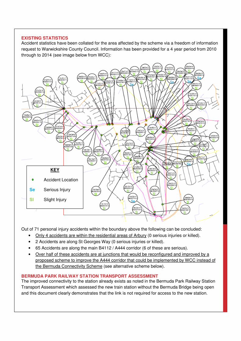
EXISTING STATISTICS
Accident statistics have been collated for the area affected by the scheme via a freedom of information
request to Warwickshire County Council. Information has been provided for a 4 year period from 2010
through to 2014 (see image below from WCC):
Out of 71 personal injury accidents within the boundary above the following can be concluded:
• Only 4 accidents are within the residential areas of Arbury (0 serious injuries or killed).
• 2 Accidents are along St Georges Way (0 serious injuries or killed).
• 65 Accidents are along the main B4112 / A444 corridor (6 of these are serious).
• Over half of these accidents are at junctions that would be reconfigured and improved by a
proposed scheme to improve the A444 corridor that could be implemented by WCC instead of
the Bermuda Connectivity Scheme (see alternative scheme below).
BERMUDA PARK RAILWAY STATION TRANSPORT ASSESSMENT
The improved connectivity to the station already exists as noted in the Bermuda Park Railway Station
Transport Assessment which assessed the new train station without the Bermuda Bridge being open
and this document clearly demonstrates that the link is not required for access to the new station.
KEY
Accident Location
Se Serious Injury
Sl Slight Injury
The Bermuda Park Railway Station Transport Statement states in
Section 3.21. “Whilst all road traffic accidents are regrettable, the
Personal Injury Accident data gives no indication of specific concerns
relating to the level or nature/pattern of PIAs in the immediate area
surrounding the proposed site in relation to the proposed development.
The potential slight increase in traffic levels and pedestrian/cycle
movements related to the proposed development is unlikely to increase
the accident volumes within the immediate area surrounding the site.”
Clearly with St Georges Way being opened up as an all traffic through
route providing a congestion relieving bypass to the M6, this statement
would no longer be true and would change the above conclusions
significantly posing a significant safety risk to cyclists and pedestrians.
The area proposed to benefit from the Connectivity Project already has
ideal cycling and pedestrian access to the new station as noted in
Section 3.26 of the Transport Assessment.
Other Safety Issues & Concerns
This section summarises a wide range of safety issues created by the
opening of the bridge over the A444 for the local community:
• There is a vibrant community along the route consisting of families
with young children and the elderly who have chosen to invest in
property along a safe quiet residential cul-de-sac away. Many of us
purposely chose our homes to avoid the safety concerns of living
along “rat runs” and main roads which will now be imposed on us.
• The proposals would remove a “near traffic free” route for cyclists /
pedestrians to Bermuda Park Industrial Estate and local amenities.
• There are no safe crossing points along the proposed route despite
numerous community facilities including: Ensor’s Pool, children’s
playgrounds, Phoenix Community Centre, sports facilities, playing
fields, Harefield Lane and the Bermuda Lake.
• The proposed Bermuda Connectivity link is 600m shorter than the
current main road route via the B4112 / A444. It has no delay
conflict points in comparison to the 2 signalised crossings and 3
roundabouts along the current route. As a result all existing traffic
heading towards Coventry and the M6 will “rat run” through
Bermuda Road rather than using the purpose built A444. As a
result Bermuda Road will become Nuneaton’s Western bypass and
be the route of choice to the A444 and the M6 motorway.
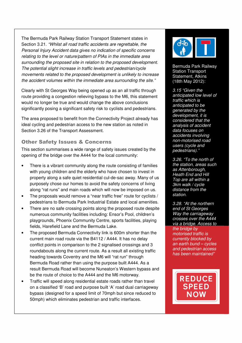
• Traffic will speed along residential estate roads rather than travel
on a classified ‘B’ road and purpose built ‘A’ road dual carriageway
bypass (designed for a speed limit of 70mph but since reduced to
50mph) which eliminates pedestrian and traffic interfaces.
Bermuda Park Railway Station Transport Statement, Atkins (18th May 2012):
3.15 “Given the anticipated low level of traffic which is anticipated to be generated by the development, it is considered that the analysis of accident data focuses on accidents involving non-motorised road users (cycle and pedestrians).”
3.26. “To the north of the station, areas such as Attenborough, Heath End and Hill Top are all within a 3km walk / cycle distance from the station.
3.28. “At the northern end of St Georges Way the carriageway crosses over the A444 via a bridge. Access to the bridge by motorised traffic is currently blocked by an earth bund – cycles and pedestrian access has been maintained”

• Traffic from the Western suburbs of Nuneaton will reassign from Tompkinson Road / Greenmoor
Road route (plus the Ring Road) to access the new Bermuda Road route along Church Road,
Westbury Road or Northumberland Avenue / The Raywoods. These streets already have traffic
calming measures and weight restriction in place on an existing rat run to Heath End Road and will
suffer more misery as further traffic diverts onto these “unclassified” residential streets.
• The Raywoods and Northumberland Avenue provide access to
Croft and Glendale infant and junior schools. There is no budget in
the scheme for new crossing facilities and parents and children will
be put at risk until funding can be found from other sources or until
enough accidents have occurred to justify the required crossing
facilities if the scheme proceeds.
• There are no safety mitigation measures for local community within
the scheme budget (e.g. traffic calming, weight limits or pedestrian
crossings) as already installed on The Raywoods and
Northumberland Avenue (this is even before the additional
redistribution of traffic is factored in).
• The character of the quiet and historic Bermuda village will be
affected as it gets severed from Arbury Ward by the new “bypass”.
• Up to now, new housing in the area has been carefully planned to
preserve the safety of local communities by not opening up through
routes for traffic as part of the Bermuda Road, Shillingstone Estate,
the Bridleway and Bermuda Park developments.
• The road width in many areas is narrower than Design Manual for
Roads and Bridges (DMRB) standards for 2 way traffic (approx. 6.0
to 6.5m compared to the B4112 Heath End Road which is approx.
7.5 to 11m wide). A typical two way road is 7.3m wide.
• There are numerous drives and side roads that are not suitable for
direct access onto a link road and will lead to vehicle conflict.
• On-street parking is required and is likely to lead to accidents as
vehicles speed up to get through single file narrowings created by
parked vehicles before opposing traffic does.
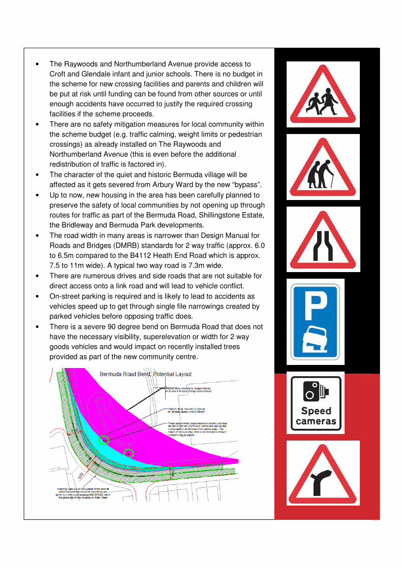
• There is a severe 90 degree bend on Bermuda Road that does not
have the necessary visibility, superelevation or width for 2 way
goods vehicles and would impact on recently installed trees
provided as part of the new community centre.
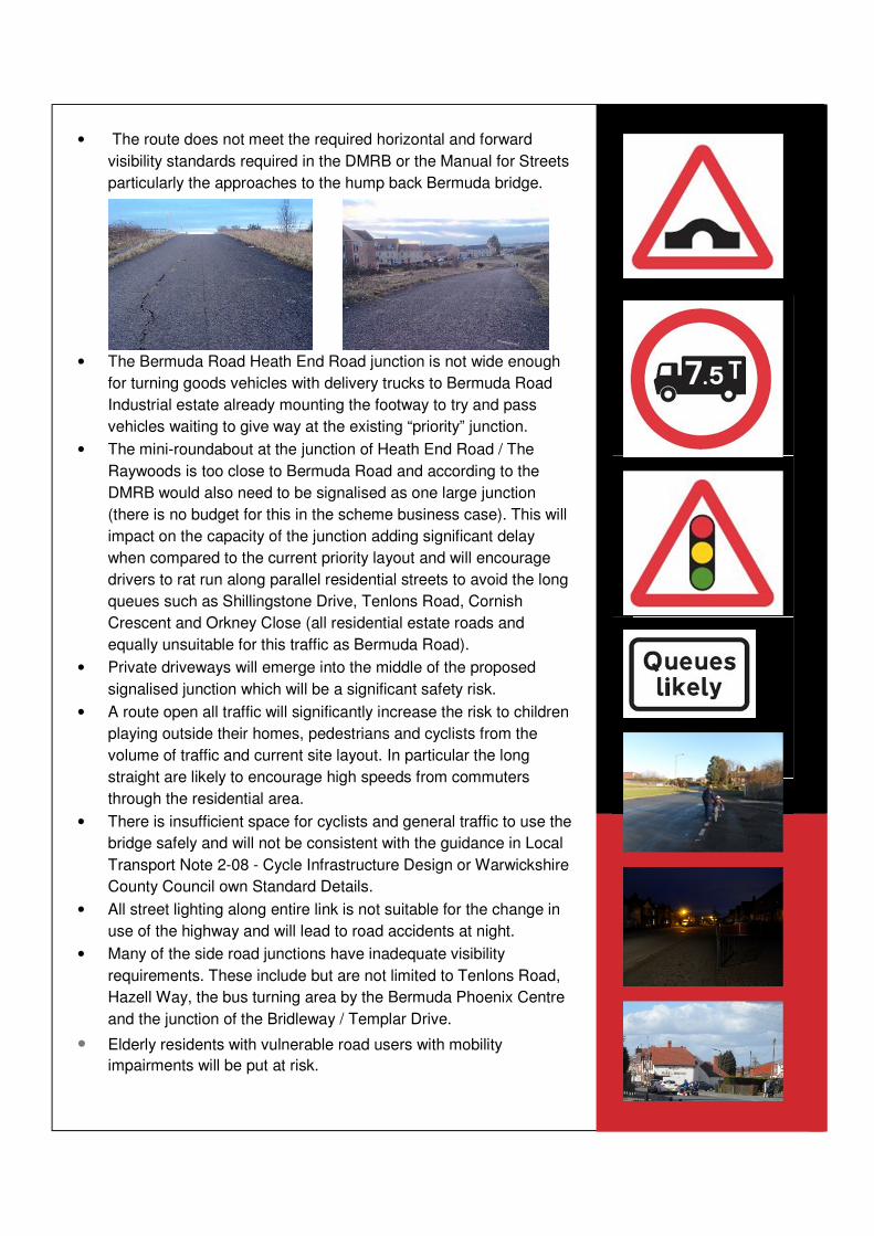
• The route does not meet the required horizontal and forward
visibility standards required in the DMRB or the Manual for Streets
particularly the approaches to the hump back Bermuda bridge.
• The Bermuda Road Heath End Road junction is not wide enough
for turning goods vehicles with delivery trucks to Bermuda Road
Industrial estate already mounting the footway to try and pass
vehicles waiting to give way at the existing “priority” junction.
• The mini-roundabout at the junction of Heath End Road / The
Raywoods is too close to Bermuda Road and according to the
DMRB would also need to be signalised as one large junction
(there is no budget for this in the scheme business case). This will
impact on the capacity of the junction adding significant delay
when compared to the current priority layout and will encourage
drivers to rat run along parallel residential streets to avoid the long
queues such as Shillingstone Drive, Tenlons Road, Cornish
Crescent and Orkney Close (all residential estate roads and
equally unsuitable for this traffic as Bermuda Road).
• Private driveways will emerge into the middle of the proposed
signalised junction which will be a significant safety risk.
• A route open all traffic will significantly increase the risk to children
playing outside their homes, pedestrians and cyclists from the
volume of traffic and current site layout. In particular the long
straight are likely to encourage high speeds from commuters
through the residential area.
• There is insufficient space for cyclists and general traffic to use the
bridge safely and will not be consistent with the guidance in Local
Transport Note 2-08 - Cycle Infrastructure Design or Warwickshire
County Council own Standard Details.
• All street lighting along entire link is not suitable for the change in
use of the highway and will lead to road accidents at night.
• Many of the side road junctions have inadequate visibility
requirements. These include but are not limited to Tenlons Road,
Hazell Way, the bus turning area by the Bermuda Phoenix Centre
and the junction of the Bridleway / Templar Drive.
• Elderly residents with vulnerable road users with mobility
impairments will be put at risk.
??????
The Alternative
However there are alternatives. The same scheme promoters (WCC
and CWLEP) have the A444 Corridor Improvements project.
http://bermudabridgeactiongroup.co.uk/the-alternatives-to-the-bridge/
Implementing this project would solve all the congestion issues on the
A444 and allow for economic growth and all envisaged development
within Nuneaton in the future. It is clear from the business case that
these conclusions have been determined without the bridge being
opened to traffic (see image below from the business case which
shows the bridge closed to traffic). This proves that opening up the
Bermuda Bridge is unnecessary, a waste of public funds and that there
is a far better alternative that would reduce rather than increase road
accidents.
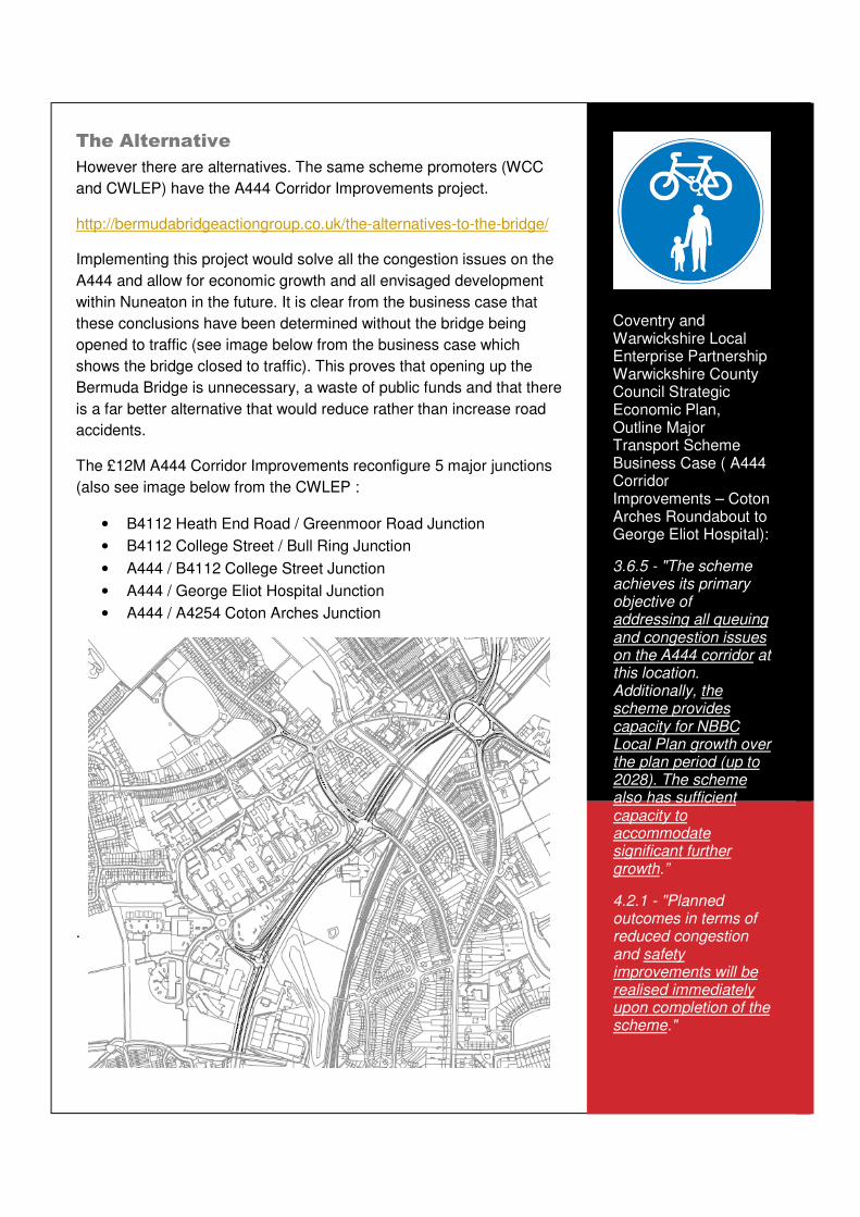
The £12M A444 Corridor Improvements reconfigure 5 major junctions
(also see image below from the CWLEP :
• B4112 Heath End Road / Greenmoor Road Junction
• B4112 College Street / Bull Ring Junction
• A444 / B4112 College Street Junction
• A444 / George Eliot Hospital Junction
• A444 / A4254 Coton Arches Junction
.
Coventry and Warwickshire Local Enterprise Partnership Warwickshire County Council Strategic Economic Plan, Outline Major Transport Scheme Business Case ( A444 Corridor Improvements – Coton Arches Roundabout to George Eliot Hospital):
3.6.5 - "The scheme achieves its primary objective of addressing all queuing and congestion issues on the A444 corridor at this location. Additionally, the scheme provides capacity for NBBC Local Plan growth over the plan period (up to 2028). The scheme also has sufficient capacity to accommodate significant further growth.”
4.2.1 - "Planned outcomes in terms of reduced congestion and safety improvements will be realised immediately upon completion of the scheme."
The £3M Coton Arches element of the project has now been funded
with Growth Fund monies. Therefore, the remainder of the A444
Corridor Improvement Project could be completed for a similar capital
cost to the Bermuda Connectivity Project.
On this basis we hope that road safety groups and those with an
interest in protecting communities and vulnerable road users will review
the scheme proposals in more detail and object to Warwickshire
County Council in regard to opening the bridge to all traffic at the
Bermuda Connectivity Project public consultation (planned for June
2015).
By opposing the Bermuda Connectivity Project you will be:
• Saving lives.
• Preventing segregation of a community.
• Protecting a sustainable transport route to the new train station
and Bermuda Park.
• Preventing commuters and heavy goods vehicle cutting along
unsuitable roads through residential communities.
Implementing the A444 Corridor Improvement instead of the Bermuda
Connectivity Project will:
• Keep strategic traffic on strategic routes away from pedestrians.
• Keep traffic on a purpose built dual carriageway designed for
large volumes of high speed traffic.
• Reduce congestion.
• Reduce accidents.
• Deliver more economic benefits than opening the bridge.
• Ensure the new train station isn’t adjacent to a main road.
CWLEP SEP, Outline Major Transport Scheme Business Case ( A444 Corridor Improvements – Coton Arches Roundabout to George Eliot Hospital):
3.2.8 - "The proposed scheme is designed to address existing congestion problems and related safety concerns by reducing vehicle delays at key pinch points on the approach to and from Nuneaton town centre and to facilitate significant future employment and housing growth as set out in Nuneaton and Bedworth Borough’s Local Plan."
3.2.9 - "Benefits in terms of congestion relief should be realised immediately upon scheme completion.”


![Request for Proposals Bermuda Schools Condition Surveys ......Request for Proposals Bermuda Schools Condition Surveys [28 Schools] ... 4 S0063 Port Royal Primary School 6 Church Road](https://img.pdfslide.us/doc/110x75/5ea07e8f5f004576f9284ad5/request-for-proposals-bermuda-schools-condition-surveys-request-for-proposals.jpg)