Embed Size (px)
Citation preview
F • Postal Address: PO Box 1461, Westville, 3630, South Africa
• Physical Address: 122 Intersite Avenue, Umgeni Business Park, Durban, 4001, South Africa
• Tel: +27 (0)31 266 0458/0861 GEOSURE (436 7873) • Fax: 086 689 5506 • Mobile: +27 (0) 82 784 0544
• E-Mail: [email protected]
www.geosure.co.za
Report to GM Turner & Associates on the Results of a
Geotechnical Investigation for the Proposed Bhudlu
Vehicular Bridge over the Mtamvua River, KwaZulu-Natal
Reference: 092-15.R02
Dated: 16 July 2015
Geotechnical Engineering Services
Engineering Geology
Environmental and Groundwater
Pile Integrity Testing
SANAS Accredited Soils/Rock Laboratory
Earthworks/Materials Supervision & Control
Geotechnical Monitoring Systems
Road Pavement Materials and Design
Project Management
LEVEL 1 BEE CONTRIBUTOR
Geosure (Pty) Ltd www.geosure.co.za 092-15.R02
Report to GM Turner & Associates on the Results
of a Geotechnical Investigation for the Proposed
Bhudlu Vehicular Bridge over the Mtamvua River,
KwaZulu-Natal
Reference: 092-15.R02
Dated : 16 July 2015
GEOSURE (PTY) LTD Geotechnical, Environmental & Groundwater Engineering Consultants
Civil Engineering Soils Laboratory
Head Office & Laboratory
122 Intersite Avenue, Umgeni Business Park, Durban, 4001, South Africa
PO Box 1461, Westville, 3630
Head Office
Tel.: 031 266 0458 (International +2731 266 0458)
Fax: 086 689 5506 (International +2786 689 5506)
Cell: +27 (0)82 784 0544
E-mail: [email protected]
Civil Engineering Laboratory Gauteng Branch
Tel: 031 701 9732 PO Box 32381, Kyalami, 1684
Fax: 086 684 9785 Tel: 0861 GEOSURE (4367873)
Cell: 072 870 2621 Cell: +27 (0)83 447 3556
E-mail: [email protected] Fax: +27 086 689 8327
E-mail: [email protected]
www.geosure.co.za
Geosure (Pty) Ltd www.geosure.co.za 092-15.R02
Document Control Record
Document prepared by:
Geosure (Pty) Ltd
122 Intersite Avenue
Umgeni Business Park
Durban
South Africa
4001
Tel: 031 266 0458
Fax: 086 689 5506
E-mail: [email protected]
Website: www.geosure.co.za
A person utilising Geosure (Pty) Ltd documents must take note of the following:
a) Electronic copies to be checked against original hard copy version to ensure accuracy.
b) Utilising the documents or data for any purpose not agreed to in writing with Geosure
(Pty) Ltd is prohibited.
Document Control Report Title: Report to GM Turner & Associates on the Results of a Geotechnical
Investigation for the Proposed Bhudlu Vehicular Bridge over the Mtamvua
River, KwaZulu-Natal
Report Reference 092-15.R02 Responsible Person Mr S. Dhanbir
Client GM Turner & Associates Client Contact Details Tel: 031 309 2958 E-Mail: [email protected]
Revision Date Revision Details/Status Author Reviewer
16/07/2015 Geotechnical report N. Govender D. Naidoo
1
2
3
4
Current Revision
0
Approval
Author Signature
Reviewer Signature
Name Mr N Govender Name Mr D. Naidoo
Title Engineering Geologist Title Director
Geosure (Pty) Ltd www.geosure.co.za 092-15.R02
List of abbreviations and expansions utilised in report
Abbreviation Expansion
AASHTO American Association of State Highway and Transportation Officials
BH Borehole
CL Inorganic Clays of low to medium plasticity
E East
EGL existing ground level
GM Grading Modulus
GPS Global Positioning System
IMC Insitu Moisture Content
km kilometre
kN/m2 kilo Newton per metre square
LL Liquid Limit
LS Linear Shrinkage
m metre
MAMSL metres above mean sea level
mm millimetre
MPa Mega Pascal
No. number
NWD4 core barrel size
NXC core barrel size, 75mm diameter
PI Plasticity Index
RHDHV Royal HaskoningDHV
S South
SANRAL South African National Roads Agency Ltd
SANS South African National Standards
SPT Standard Penetration Test
UCS Uniaxial Compressive Strength
USCS Unified Soil Classification System (1984)
Geosure (Pty) Ltd www.geosure.co.za 092-15.R02
Report to GM Turner & Associates on the Results of a
Geotechnical Investigation for the Proposed Bhudlu Vehicular
Bridge over the Mtamvua River, KwaZulu-Natal
Reference: 092-15.R02 Date: 16 July 2015
TABLE OF CONTENTS
1. INTRODUCTION AND TERMS OF REFERENCE ..................................................................... 1
2. CODES OF PRACTICE AND STANDARDS ................................................................................. 1
3. INFORMATION UTILISED ............................................................................................................ 2
4. SITE DESCRIPTION ........................................................................................................................ 2
5. FIELDWORK .................................................................................................................................... 3
5.1 TERRAIN APPRAISAL ........................................................................................................................ 3 5.2 BOREHOLE DRILLING ....................................................................................................................... 3
6. ANTICIPATED SUBSOIL CONDITIONS ..................................................................................... 4
7. GROUNDWATER ............................................................................................................................. 5
8. LABORATORY TESTS .................................................................................................................... 5
9. DEVELOPMENT GUIDELINES .................................................................................................... 6
9.1 PROPOSED DEVELOPMENT ............................................................................................................... 6 9.2 GENERAL STABILITY OF THE SITE .................................................................................................... 6 9.4 GENERAL EARTHWORKS .................................................................................................................. 7 9.5 FOUNDATION RECOMMENDATIONS .................................................................................................. 8
9.5.1 Caissons .............................................................................................................................................. 9 9.5.2 Piled Foundations .............................................................................................................................. 9
10. QUALITY ASSURANCE TESTING DURING CONSTRUCTION........................................... 10
11. ADDITIONAL BOREHOLE INVESTIGATION ......................................................................... 11
12. CONCLUSION ................................................................................................................................. 11
Appendix A: Borehole Logs
Appendix B: Laboratory Test Results
Figure 201: Site Plan
1
Geosure (Pty) Ltd www.geosure.co.za 092-15.R02
Report to GM Turner & Associates on the Results of a Geotechnical
Investigation for the Proposed Bhudlu Vehicular Bridge over the
Mtamvua River, KwaZulu-Natal
Reference: 092-15.R02 Date: 16 July 2015
1. INTRODUCTION AND TERMS OF REFERENCE
Geosure (Pty) Ltd was invited by Royal HaskoningDHV (RHDHV) to tender to carry out a
geotechnical investigation for the proposed Bhudlu Bridge and access road crossing the
Mtamvua River near Harding in KwaZulu-Natal.
Geosure submitted a proposal and cost estimate to RHDHV in a letter referenced p050-15
– Rev 1/ng and dated 27 February 2015.
Subsequently, Geosure was appointed on 10 April 2015 by Mr S. Dhanbir on behalf of GM
Turner and Associates to carry out the investigation as proposed by accepting and
returning a signed copy of the Geosure letter referred to above.
This report provides an assessment of subsoil conditions encountered at the proposed
bridge site. Comment is made on the general stability of the site. Recommendations for
foundations, excavatability/rippability and general earthworks are given.
2. CODES OF PRACTICE AND STANDARDS
The services performed by Geosure were conducted in a manner consistent with the level
of care and skill ordinarily exercised by members of the geotechnical profession practising
under similar conditions in the locality of the project. No other warranty, expressed or
implied, is made.
The investigation was carried out according to standard practice codes and guidelines
relevant to geotechnical investigations.
The nature of geotechnical engineering is such that variations in soil conditions may occur
even where sites seem to be consistent. Variations in what is reported here may become
evident during construction and it is thus imperative that an appropriately qualified and
experienced Competent Person inspects all critical stages of development including, but
not limited to, excavations to ensure that conditions at variance with those predicted do not
occur and to undertake an interpretation of the facts supplied in this report.
It is possible that certain indications of ground stability, contamination or groundwater
levels were latent or otherwise not visible. Our opinions can only be based on what was
visible at the time the investigation was conducted.
This report was prepared for use by the GM Turner & Associates, RHDHV and their
professional team for the purpose stated and should not be relied upon for any other
purpose.
2
Geosure (Pty) Ltd www.geosure.co.za 092-15.R02
3. INFORMATION UTILISED
For the purposes of assisting with this investigation, the following information was
utilised:
Global Positioning System (GPS) co-ordinates of the proposed road;
An electronic copy of drawing no. T01.DUR.000413_GA_01 Rev A, titled "Bhudlu
River Bridge and Access Road", dated 08 August 2015 and prepared by RHDHV to a
scale of 1:1000;
A 1:250 000 Geological Map titled “3028 Kokstad”, dated 1988 and published by the
Council for Geoscience of South Africa; and
Low resolution aerial imagery sourced from Google Earth 2015.
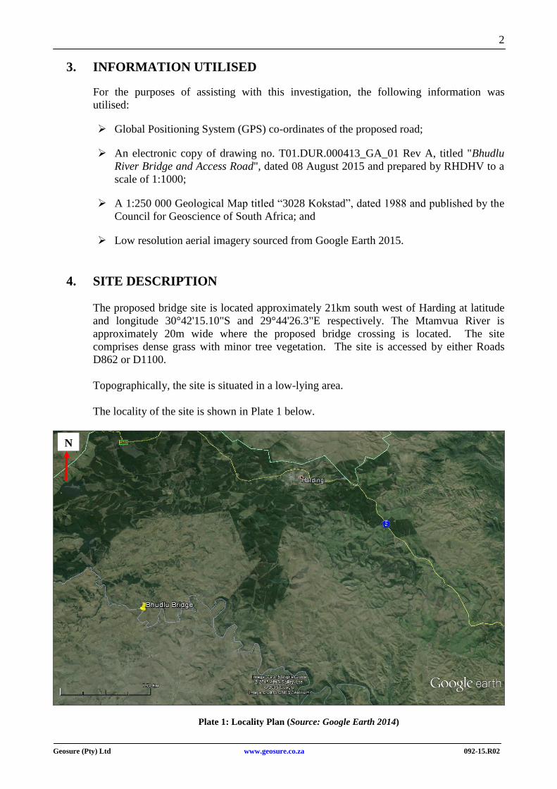
4. SITE DESCRIPTION
The proposed bridge site is located approximately 21km south west of Harding at latitude
and longitude 30°42'15.10"S and 29°44'26.3"E respectively. The Mtamvua River is
approximately 20m wide where the proposed bridge crossing is located. The site
comprises dense grass with minor tree vegetation. The site is accessed by either Roads
D862 or D1100.
Topographically, the site is situated in a low-lying area.
The locality of the site is shown in Plate 1 below.
Plate 1: Locality Plan (Source: Google Earth 2014)
N
3
Geosure (Pty) Ltd www.geosure.co.za 092-15.R02
5. FIELDWORK
The fieldwork was carried out over the period 13 May 2015 to 26 May 2015 and
comprised the following:
Terrain appraisal; and
Rotary core borehole drilling.
5.1 Terrain Appraisal
Prior to the subsurface investigation, a site walkover assessment was carried out to identify
the following major features significant to the geotechnical character of the site:
a) Surface geology;
b) Topography, surface drainage patterns and related major geotechnical features relevant
to the proposed development.
5.2 Borehole Drilling
Three boreholes were carried out across the bridge site at the positions given in Figure 201.
The boreholes, designated BH1 through BH3, were carried out by a specialist contractor
and advanced by a rotary drilling rig utilising NXC and NWD4 size core barrels. Standard
Penetration Tests (SPT) were carried out at 1m intervals in the subsoil.
The boreholes were advanced to final depths in the range 7.0m (BH2) to 10.5m (BH3)
below EGL.
All the borehole positions were surveyed by RHDHV prior to the commencement of the
drilling contract. Borehole numbers, positions and elevations are summarised in Table 1
below.
The material recovered from the boreholes was profiled using the South African
Geoterminology Guidelines (2002)1.
Copies of the detailed borehole profiles are given in Appendix A.
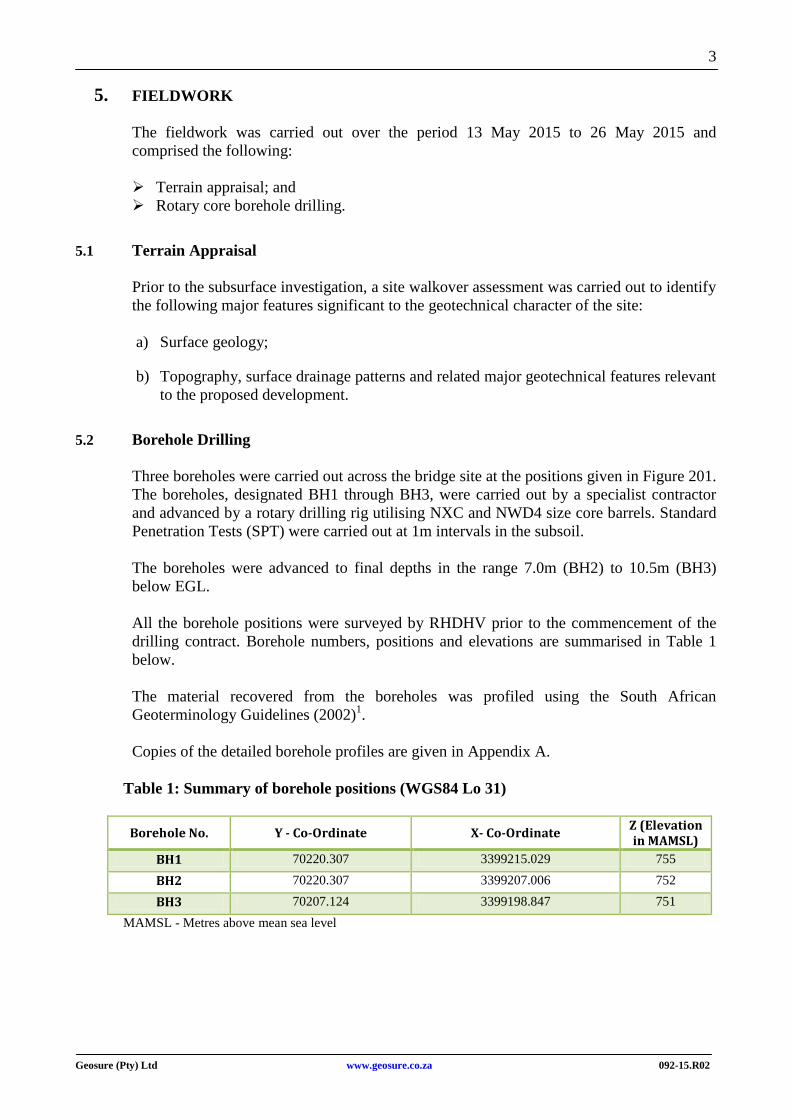
Table 1: Summary of borehole positions (WGS84 Lo 31)
Borehole No. Y - Co-Ordinate X- Co-Ordinate Z (Elevation in MAMSL)
BH1 70220.307 3399215.029 755
BH2 70220.307 3399207.006 752
BH3 70207.124 3399198.847 751
MAMSL - Metres above mean sea level
4
Geosure (Pty) Ltd www.geosure.co.za 092-15.R02
6. ANTICIPATED SUBSOIL CONDITIONS
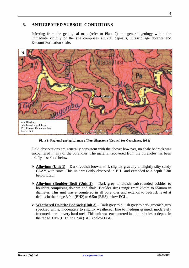
Inferring from the geological map (refer to Plate 2), the general geology within the
immediate vicinity of the site comprises alluvial deposits, Jurassic age dolerite and
Estcourt Formation shale.
Plate 1: Regional geological map of Port Shepstone (Council for Geoscience, 1988)
Field observations are generally consistent with the above; however, no shale bedrock was
encountered in any of the boreholes. The material recovered from the boreholes has been
briefly described below:
Alluvium (Unit 1) – Dark reddish brown, stiff, slightly gravelly to slightly silty sandy
CLAY with roots. This unit was only observed in BH1 and extended to a depth 2.3m
below EGL.
Alluvium (Boulder Bed) (Unit 2) – Dark grey to bluish, sub-rounded cobbles to
boulders comprising dolerite and shale. Boulder sizes range from 25mm to 550mm in
diameter. This unit was encountered in all boreholes and extends to bedrock level at
depths in the range 3.0m (BH2) to 6.5m (BH3) below EGL.
Weathered Dolerite Bedrock (Unit 3) – Dark grey to bluish grey to dark greenish grey
speckled white, moderately to slightly weathered, fine to medium grained, moderately
fractured, hard to very hard rock. This unit was encountered in all boreholes at depths in
the range 3.0m (BH2) to 6.5m (BH3) below EGL.
m - Alluvium Jd - Jurassic age dolerite
Pe - Estcourt Formation shale
f---f - Fault
N
5
Geosure (Pty) Ltd www.geosure.co.za 092-15.R02
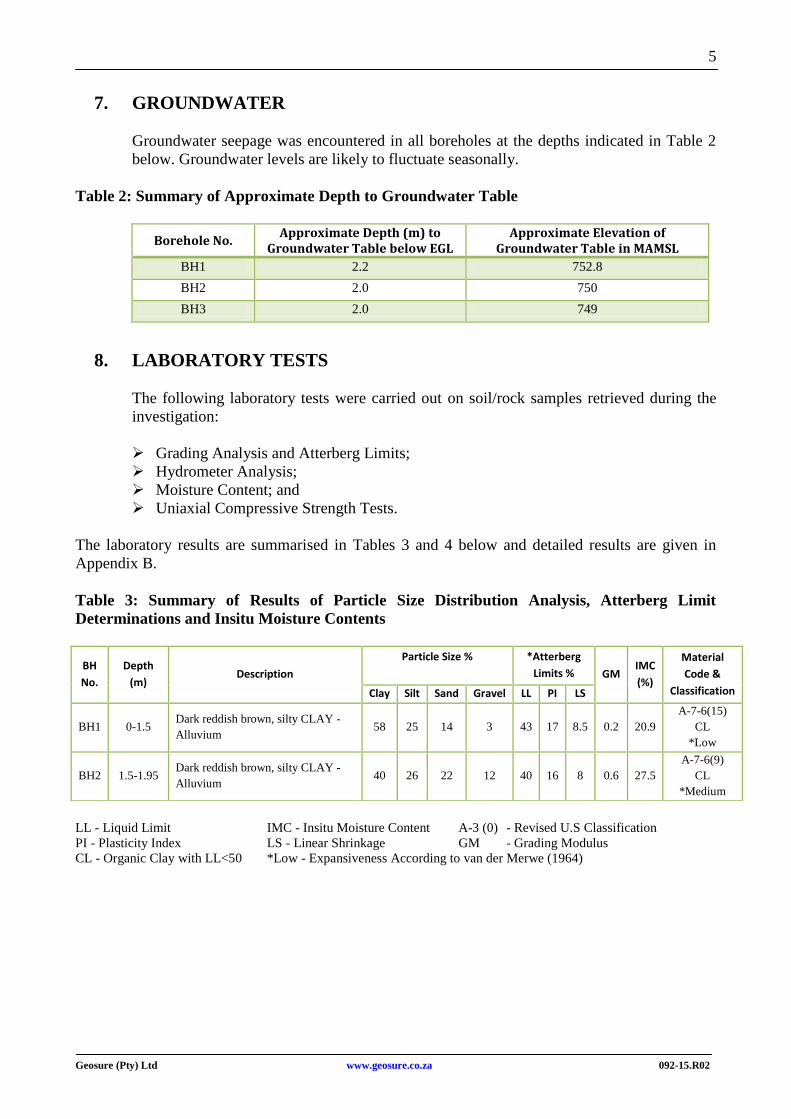
7. GROUNDWATER
Groundwater seepage was encountered in all boreholes at the depths indicated in Table 2
below. Groundwater levels are likely to fluctuate seasonally.
Table 2: Summary of Approximate Depth to Groundwater Table
Borehole No. Approximate Depth (m) to
Groundwater Table below EGL Approximate Elevation of
Groundwater Table in MAMSL
BH1 2.2 752.8
BH2 2.0 750
BH3 2.0 749
8. LABORATORY TESTS
The following laboratory tests were carried out on soil/rock samples retrieved during the
investigation:
Grading Analysis and Atterberg Limits;
Hydrometer Analysis;
Moisture Content; and
Uniaxial Compressive Strength Tests.
The laboratory results are summarised in Tables 3 and 4 below and detailed results are given in
Appendix B.
Table 3: Summary of Results of Particle Size Distribution Analysis, Atterberg Limit
Determinations and Insitu Moisture Contents
LL - Liquid Limit IMC - Insitu Moisture Content A-3 (0) - Revised U.S Classification
PI - Plasticity Index LS - Linear Shrinkage GM - Grading Modulus
CL - Organic Clay with LL<50 *Low - Expansiveness According to van der Merwe (1964)
BH
No.
Depth
(m) Description
Particle Size %
*Atterberg
Limits % GM IMC
(%)
Material
Code &
Classification Clay Silt Sand Gravel LL PI LS
BH1 0-1.5 Dark reddish brown, silty CLAY -
Alluvium 58 25 14 3 43 17 8.5 0.2 20.9
A-7-6(15)
CL
*Low
BH2 1.5-1.95 Dark reddish brown, silty CLAY -
Alluvium 40 26 22 12 40 16 8 0.6 27.5
A-7-6(9)
CL
*Medium
6
Geosure (Pty) Ltd www.geosure.co.za 092-15.R02
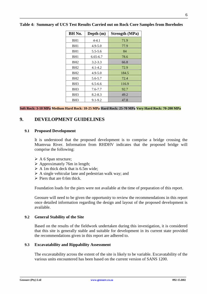
Table 4: Summary of UCS Test Results Carried out on Rock Core Samples from Boreholes
BH No. Depth (m) Strength (MPa)
BH1 4-4.1 71.9
BH1 4.9-5.0 77.9
BH1 5.5-5.6 84
BH1 6.65-6.7 78.6
BH2 3.2-3.3 66.8
BH2 4.1-4.2 72.9
BH2 4.9-5.0 184.5
BH2 5.6-5.7 72.4
BH3 6.5-6.6 116.9
BH3 7.6-7.7 92.7
BH3 8.2-8.3 49.2
BH3 9.1-9.2 47.8
Soft Rock: 3-10 MPa Medium Hard Rock: 10-25 MPa Hard Rock: 25-70 MPa Very Hard Rock: 70-200 MPa
9. DEVELOPMENT GUIDELINES
9.1 Proposed Development
It is understood that the proposed development is to comprise a bridge crossing the
Mtamvua River. Information from RHDHV indicates that the proposed bridge will
comprise the following:
A 6 Span structure;
Approximately 76m in length;
A 1m thick deck that is 6.5m wide;
A single vehicular lane and pedestrian walk way; and
Piers that are 0.6m thick.
Foundation loads for the piers were not available at the time of preparation of this report.
Geosure will need to be given the opportunity to review the recommendations in this report
once detailed information regarding the design and layout of the proposed development is
available.
9.2 General Stability of the Site
Based on the results of the fieldwork undertaken during this investigation, it is considered
that this site is generally stable and suitable for development in its current state provided
the recommendations given in this report are adhered to.
9.3 Excavatability and Rippability Assessment
The excavatability across the extent of the site is likely to be variable. Excavatability of the
various units encountered has been based on the current version of SANS 1200.
7
Geosure (Pty) Ltd www.geosure.co.za 092-15.R02
Alluvial subsoils (Unit 1 and Unit 2) is anticipated to classify as SOFT. These conditions
are inferred to occur to depths in the range 0.00m to 6.5m below EGL.
However, boulders were identified within the alluvial layer and when encountered these
may result in slower excavation rates. These conditions are inferred to occur at depths in
the range 0.00m to 6.5m below EGL and is anticipated to classify as INTERMEDIATE TO
HARD or even BOULDER CLASS excavation.
The dolerite bedrock (Unit 3) is anticipated to classify as HARD.
The type of excavation plant and nature of the underlying bedrock will determine actual
trenchability depths. Excavations within the alluvial units are likely to display rapid
sidewall collapse, particularly below the groundwater table. Slow excavation rates are
therefore considered likely.
9.4 General Earthworks
All earthworks should be carried out in a manner to promote stable development of the
site. It is recommended that earthworks be carried out along the guidelines given in SANS
1200 (current version).
All vegetation should be removed from the areas over which fills are to be built. Where
natural ground slopes are steeper than 1(vertical):6(horizontal) (6 degrees), the fill must be
benched into the slope. Benches should be minimum 0.5m deep and 2.0m wide. A
minimum of three benches per fill is recommended.
Placement of fill layers should be undertaken in layers not exceeding 200mm thick when
placed loose and compacted using suitable compaction plant to achieve 93% Modified
AASHTO maximum dry density at ±2% optimum moisture content. Boulders larger than 2/3 of the layer thickness must not be included in the fill material. A carefully engineered
fill embankment should not settle more than 0.5% of its height due to self-weight.
Density control of placed fill material should be undertaken at regular intervals during fill
construction.
Cut in subsoils and fill slopes soils should be formed to batters of 1 (vertical) to 2
(horizontal) and to a height not greater than 3 metres where retaining walls are not
provided.
Cuts in weathered bedrock should be formed to batters of 1 vertical to 0.75 horizontal and
to a height not greater than 3 metres where retaining walls are not provided.
Although not encountered in the boreholes, shale bedrock is likely to occur in close
proximity to the site. If encountered, shale slopes may be susceptible to slope instability, in
particular block sliding on thin clay layers along bedding planes that daylight in cuttings.
In similar areas, seepage was often found to be the triggering mechanism. Therefore, the
control of stormwater above cuttings will need to be carefully designed with stormwater
guided away from the crest and face of cuttings. It is recommended that a geotechnical
specialist be appointed to inspect the cutting and assess the global stability of the slope
during construction. Shale bedrock is also known to slake and breakdown to a soil when
8
Geosure (Pty) Ltd www.geosure.co.za 092-15.R02
exposed, and therefore consideration should be given to covering the cutting with shotcrete
immediately.
Engineered fill slopes should be over constructed and thereafter trimmed back to the
required position.
Cut and fill heights greater than 2 metres would need to be inspected and approved by an
engineering geologist or geotechnical engineer.
Sidewall collapse of excavations not battered back or shored is considered likely.
Workers should not enter any excavation deeper than 1.2 metres that is not shored or
battered back as described above. Steeper batters can be considered but will be subject to
inspection and approval by a geotechnical professional on site during construction.
Due to the prevalent shallow groundwater condition and loosely consolidated nature of the
Units 1 and 2, workers should not enter any excavations deeper than 1.2m that are not
shored or battered back. It remains, however, the responsibility of the contractor/engineer
on site to ensure excavations are safe and shored in line with requirements as set down in
the current “Occupational Health and Safety” Act 85 (1993 as amended).
9.5 Foundation Recommendations
All foundation loads should be designed to act in end-bearing. It is recommended that
foundations are taken down through the alluvial material (subsoil and boulders) and placed
on or socketed into the underlying weathered dolerite bedrock.
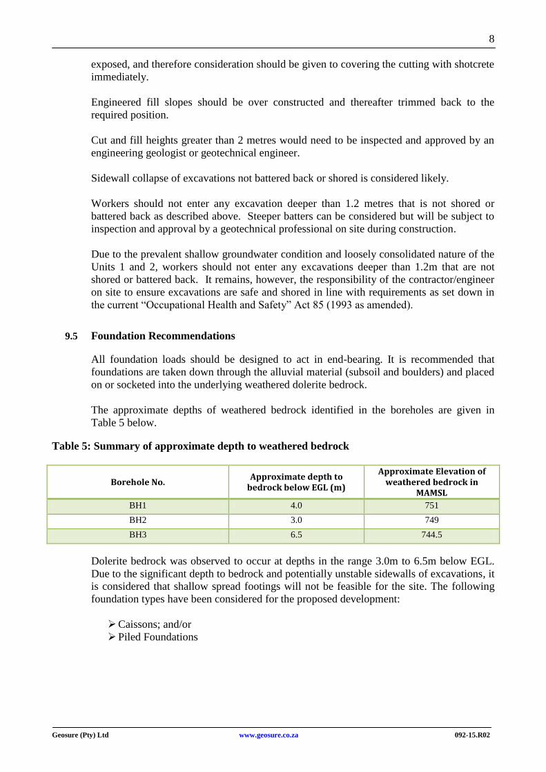
The approximate depths of weathered bedrock identified in the boreholes are given in
Table 5 below.
Table 5: Summary of approximate depth to weathered bedrock
Borehole No. Approximate depth to
bedrock below EGL (m)
Approximate Elevation of weathered bedrock in
MAMSL
BH1 4.0 751
BH2 3.0 749
BH3 6.5 744.5
Dolerite bedrock was observed to occur at depths in the range 3.0m to 6.5m below EGL.
Due to the significant depth to bedrock and potentially unstable sidewalls of excavations, it
is considered that shallow spread footings will not be feasible for the site. The following
foundation types have been considered for the proposed development:
Caissons; and/or
Piled Foundations
9
Geosure (Pty) Ltd www.geosure.co.za 092-15.R02
9.5.1 Caissons
The caissons must be taken down into competent weathered bedrock of at least medium
hard rock strength, where a maximum allowable bearing pressure of 2000kN/m2 is
considered applicable. The need to anchor the caissons into bedrock will have to be
assessed by the structural engineer.
Use of caissons could avoid the need for lateral support, but it is considered that de-
watering will be necessary.
Care should to be taken when sinking the caisson through the boulders in order to
minimise the risk of hang up on large boulders, and local damage to the cutting edge and
the adjacent caisson wall. Installation of the caisson through these layers is likely to be
time consuming.
It is recommended that all foundation excavations be inspected and approved by Geosure
(Pty) Ltd prior to blinding and casting concrete.
9.5.2 Piled Foundations
It is preferred to support the bridge on a piled foundation due to the following reasons:
Significant depth to competent bedrock in some cases up to 6.5m below EGL;
Shallow groundwater conditions, with majority of the foundations being installed within
the existing riverbed; and
Significant thickness of boulder bed horizon, up to 6.5m below EGL.
It is quite likely that a number of the piles are to act in tension caused by debris loads on
the bridge structure. In addition, the aspect of scour of the alluvial soils may also require
that piles be socketed into the bedrock. Piles will need to penetrate the alluvial boulder bed
in order to achieve the above.
It is therefore recommended that only the following pile types be considered:
Oscillator piles; and/or
Rotapiles.
Both these pile types are able to penetrate alluvial boulder beds of significant thickness.
Provided the piles are socketed into competent weathered bedrock of at least medium hard
rock strength, a maximum nett allowable bearing pressure of 2000 kN/m2 is considered
applicable, subject to verification by ongoing laboratory testing. Higher allowable bearing
pressures can be considered but will need to be subject to inspection and confirmation by
the geotechnical professional. The approximate loads given in Table 6 may be adopted for
the design of piles.
10
Geosure (Pty) Ltd www.geosure.co.za 092-15.R02
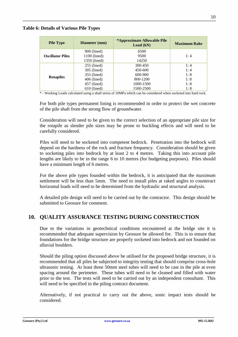
Table 6: Details of Various Pile Types
Pile Type Diameter (mm) *Approximate Allowable Pile
Load (kN)
Maximum Rake
Oscillator Piles
900 (lined)
1100 (lined)
1350 (lined)
6500
9500
14250
1: 4
Rotapiles
255 (lined)
305 (lined)
355 (lined)
406 (lined)
457 (lined)
610 (lined)
300-450
450-600
600-900
800-1200
1000-1500
1500-2500
1: 4
1: 4
1: 8
1: 8
1: 8
1: 8
* - Working Loads calculated using a shaft stress of 10MPa which can be considered when socketed into hard rock.
For both pile types permanent lining is recommended in order to protect the wet concrete
of the pile shaft from the strong flow of groundwater.
Consideration will need to be given to the correct selection of an appropriate pile size for
the rotapile as slender pile sizes may be prone to buckling effects and will need to be
carefully considered.
Piles will need to be socketed into competent bedrock. Penetration into the bedrock will
depend on the hardness of the rock and fracture frequency. Consideration should be given
to socketing piles into bedrock by at least 2 to 4 metres. Taking this into account pile
lengths are likely to be in the range 6 to 10 metres (for budgeting purposes). Piles should
have a minimum length of 6 metres.
For the above pile types founded within the bedrock, it is anticipated that the maximum
settlement will be less than 5mm. The need to install piles at raked angles to counteract
horizontal loads will need to be determined from the hydraulic and structural analysis.
A detailed pile design will need to be carried out by the contractor. This design should be
submitted to Geosure for comment.
10. QUALITY ASSURANCE TESTING DURING CONSTRUCTION
Due to the variations in geotechnical conditions encountered at the bridge site it is
recommended that adequate supervision by Geosure be allowed for. This is to ensure that
foundations for the bridge structure are properly socketed into bedrock and not founded on
alluvial boulders.
Should the piling option discussed above be utilised for the proposed bridge structure, it is
recommended that all piles be subjected to integrity testing that should comprise cross-hole
ultrasonic testing. At least three 50mm steel tubes will need to be cast in the pile at even
spacing around the perimeter. These tubes will need to be cleaned and filled with water
prior to the test. The tests will need to be carried out by an independent consultant. This
will need to be specified in the piling contract document.
Alternatively, if not practical to carry out the above, sonic impact tests should be
considered.
11
Geosure (Pty) Ltd www.geosure.co.za 092-15.R02
11. ADDITIONAL BOREHOLE INVESTIGATION
Due to the variation in elevation of competent bedrock levels, in some cases up to 5.5m, it
is recommended that additional boreholes be carried out at each pier position. This will
provide a better understanding of the founding levels at each pier position and avoid the
risk of placing foundations on boulders. Furthermore, no boreholes were carried out within
the river bed and competent bedrock can occur at greater depths than the boreholes drilled
on the embankment.
This investigation should be carried out in accordance with the South African National
Roads Agency Ltd (SANRAL) requirement given in the following documents:
Code of Procedure for the Planning and Design of Highway and Road Structures in
South Africa, February 2002; and
South African Pavement Engineering Manual, Chapter 7, Geotechnical Investigations
and Design Considerations, January 2013.
12. CONCLUSION
This report provides an assessment of subsoil conditions encountered at the proposed
bridge site. Comment is made on the general stability of the site. Recommendations for
foundations, excavatability/rippability and general earthworks are given.
Based on the results of the fieldwork undertaken during this investigation, it is considered
that this site is generally stable and suitable for development, provided the
recommendations given in this report are adhered to.
The bridge site is observed to be underlain by alluvial subsoil, alluvial boulders and
dolerite bedrock. Dolerite bedrock was observed to occur at depths in the range 3.0m to
6.5m below EGL.
Groundwater seepage was encountered in all boreholes at depths in the range 2.0m to 2.2m
below EGL. Therefore, a shallow groundwater condition is considered likely. Due to close
proximity to the river, groundwater levels are likely to fluctuate both during and after
periods of rainfall.
All foundation loads should be designed to act in end-bearing, founded in the underlying
competent dolerite bedrock.
Dolerite bedrock was observed to occur at depths in the range 3.0m to 6.5m below EGL.
Due to the significant depth to bedrock and potentially unstable sidewalls of excavations, it
is considered that shallow spread footings will not be feasible for the site. The following
foundation types have been considered for the proposed development:
Caissons; and/or
Piled Foundations.
12
Geosure (Pty) Ltd www.geosure.co.za 092-15.R02
Due to the presence of boulders, strong groundwater flow and significant depth to bedrock,
it is preferred to support all loads on a piled foundation. In this regard, it is considered that
the following pile types will be suitable for the site conditions:
Oscillator piles; and/or
Rotapiles.
Due to the variation in elevations of bedrock level, in some cases up to 5.5m, it is
recommended that additional boreholes be carried out at each pier position as per the
guidelines provided in the SANRAL documents referred to in Section 11.
The ground conditions given in this report refer specifically to the field tests carried out on
site. It is therefore, quite possible that conditions at variance with those given in this report
can be encountered elsewhere on site during construction. It is therefore important that
Geosure (Pty) Ltd be appointed to carry out a strict quality assurance program during
construction. Any change from the anticipated ground conditions could then be taken into
account to avoid unnecessary expense.