Embed Size (px)
Citation preview
. '
,
(
RICHARD MILLS ASSOCIATES, INC.
9624 Turner Avenue
Rancho Cucamonga, California 91730
(714) 989-1751
ENGINEERING GEOLOGIC INVESTIGATION
Proposed Residential Tract
Etiwanda Avenue at 24th Street
Rancho Cucamonga, California
for
WAYNE D. BLANTON
C/0 Newton Realty
1297 North Towne Avenue
Pomona, California 91767
September 9, 1983
83-225
INTRODUCTION
RICHARD MILLS ASSOCIATES, INC.
9624 Turner Avenue
Rancho Cucamonga, California 91730
An engineering geologic investigation was conducted for
the proposed residential tract located on Etiwanda Avenue at
24th Street in the City of Rancho Cucamonga, California
during July 1983. The purpose of the investigation was to
determine if the Red Hill fault, as mapped on the California
State Special Studies Zone Map, Cucamonga Peak Quadrangle
extends into the tract area. our investigation consisted of
excavating 983 lineal feet of trench perpendicular to the
projection of the mapped fault trace, detailed logging of the
exposed excavation, literature rese~rch, stereoscopic
examination of aerial photos of the area, analysis of the
data obtained in the research and exp_'.oratory phases and
preparation of this report.
The recommendations and conclusions presented in this
report have been prepared in accordance with generally
accepted engineering geologic principals and practices. This
warranty is in lieu of any other warranty either expressed or
implied.
LOCATION AND ACCESS
The site is located on the west side of Etiwanda Avenue
south of 24th Street in the City of Rancho Cucamonga,
California. Access is obtained from the unpaved extension of
24th Street west onto the site. Irregular in shape, the
1
.. -. ·-' ·-' RIC(-JARD MILLS ASSOCIATt;S
.. approximately 63 acre site occupies the northeast portion of
Section 29 TlN R6W, and is currently vacant. The site is
bounded by 24th Street on the north, by Etiwanda Avenue on
the east, by vacant land and a water reservoir on the south,
and by an unpaved road on the west.
GENERAL SITE CONDITIONS
The site lies in an area of south sloping, coalescing
alluvial fans emanating from Day Canyon and East Etiwanda
Canyon. Regional topography slopes southerly at
approximately 7 percent. Vegetation consists of a dense
cover of chamise and sage. A Metropolitan Water District
water main parallels the northern boundary of the site. At
the time of our investigation, the site was vacant. No other
significant surface features were.noted.
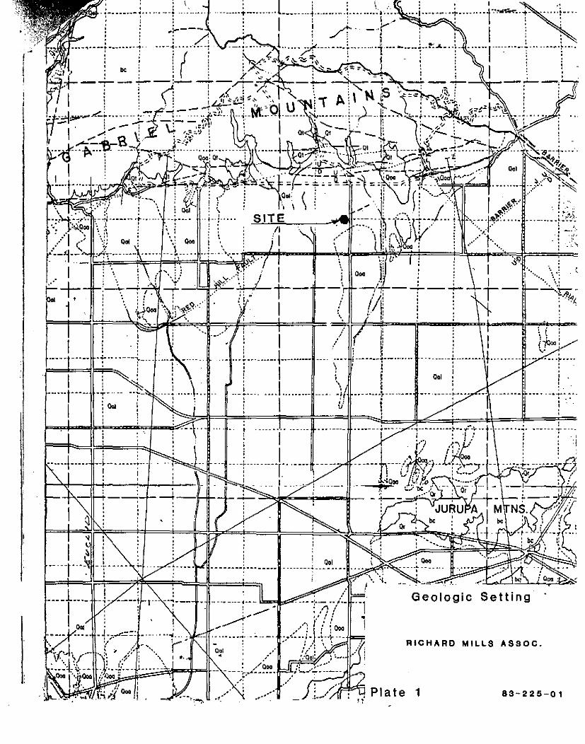
GEOLOGY
GEOLOGIC SETTING
The site lies in an alluvial area along the foothills of
the San Gabriel Mountains. Deposition has been from Day
Canyon on the northwest and East Etiwanda Canyon on the
northeast. The alluvium is generally coarse with an
abundance of subrounded clasts consisting of pebbly gravel
lenses with cobbles and boulders.
Structurally the area is dominated by the Cucamonga
fault. The Cucamonga fault is a low angle reverse or thrust
fault that forms the southern front of the San Gabriel
Mountains and normally separates the basement complex igneous
and metamorphic rocks exposed in the mountains from the
alluvial fan deposits that emanate from the mountain range.
The Cucamonga fault is considered potentially active and has
2
a State established Special Studies Zone along its mapped
trace. Adjacent to and encroaching onto the property is the
State Established Special Studies Zone for the Red Hill
fault. The Red Hill fault has a mapped trace located 800
feet northeast of the site. The state zone established for
this portion of the fault has been extended south to the
southern edge of Redhill near Foothill and Grove Avenues by
the City of Rancho Cucamonga. The Red Hill fault is
postulated to be a branch of the Cucamonga fault. The Red
Hill fault's main surface expression is a small scarp in the
recent alluvium northeast of the site. Its southwest
extension towards Red Hill and through the site, is inferred
by a ground water barrier. Regionally the area is bounded on
the east by the San Jacinto fault, on the west by the Puente
and San Jose Hills, on the south by the Santa Ana Mountains,
and on the north by the Cucamonga fault.
Ground water was not encountered during our
investigation. Our research indicates that ground water lies
approximately 200 feet below the existing ground surface.
(Seismic and Public Safety Element B :ickground Report San
Bernardino County Map 10).
EARTH MATERIALS
The site is underlain by crudely bedded, coarse grained
alluvial sands and gravel with varying quantities of cobbles
and boulders. These materials are covered with a shallow
soil cover consisting of a dark brown silty sand with
scattered concentrations of gravels and cobbles. These
sediments are of Quaternary Age and are estimated to extend
1000 feet to the underlying basement complex. (Seismic and
Public Safety Element Background Report Map 9). The general
petrology of the sediment clasts are hornblend shists, quartz
diorites, biotite gneiss, mica shists and dacite phorphyry.
3
RICf.JARD MILLS ASSOCIATi:;:S
.i
I '· 'I ,, .,
I !1 ..
These rnaterials are basically granular and non-expansive.
They are not expected to cause unusual foundation problems;
however, site grading will generate unknown quantities of
oversize materials. Oversize materials should be placed in
accordance with recommendations provided by the soils
engineer.
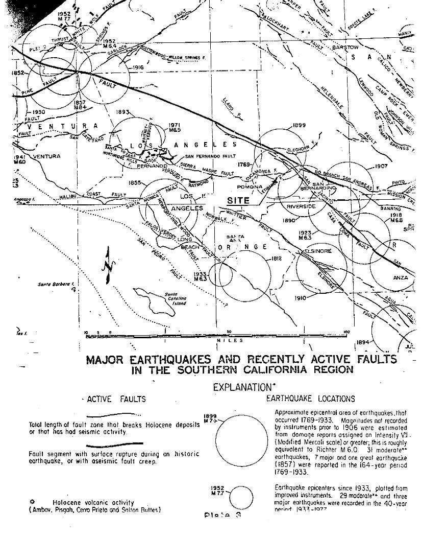
SEISMICITY
The site lies. within the Chino Basin portion of the
upper Santa Ana River drainage area at an elevation of
approximately 1680 feet, The Chino Basin is a vast area of
alluvial material some 25 miles long and up to 15 miles wide.
Seismically, the Chino Basin area has been relatively active
with rnany events of rnagnitudes up to 4 and 5 having been
recorded on the surrounding faults. Strong earthquakes
which have affected the Chino Basin area during historical
tirnes include:
1899 - Cajon Pass area, Intensi".:y VIII
1857 - Fort Tejon, Intensity VI[! - magnitude estimated
at 8.3
1918 - Riverside County, San Jacinto-Hemet area,
Intensity IX - rnagnitude 6.8
1923 - East of Riverside - magnitude 6.3
1933 - Long Beach - magnitude 6.3
1947 - Manix Barstow area - magnitude
1948 - Desert Hot Springs - magnitude
1952 - Wheeler Ridge Bakersfield area
1971 - San Fernando - magnitude 6.6
1979 - Imperial Valley - magnitude 6.6
See Plate 3
4
6.4
6.5
- magnitude 7.7
... ~
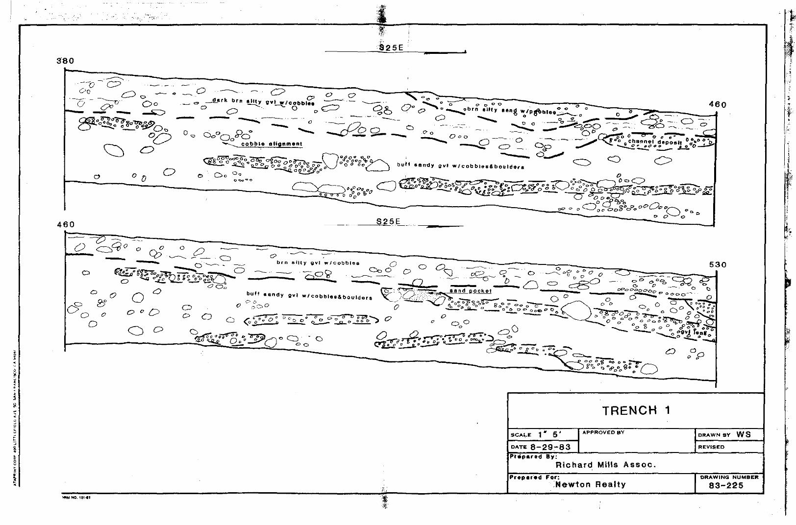
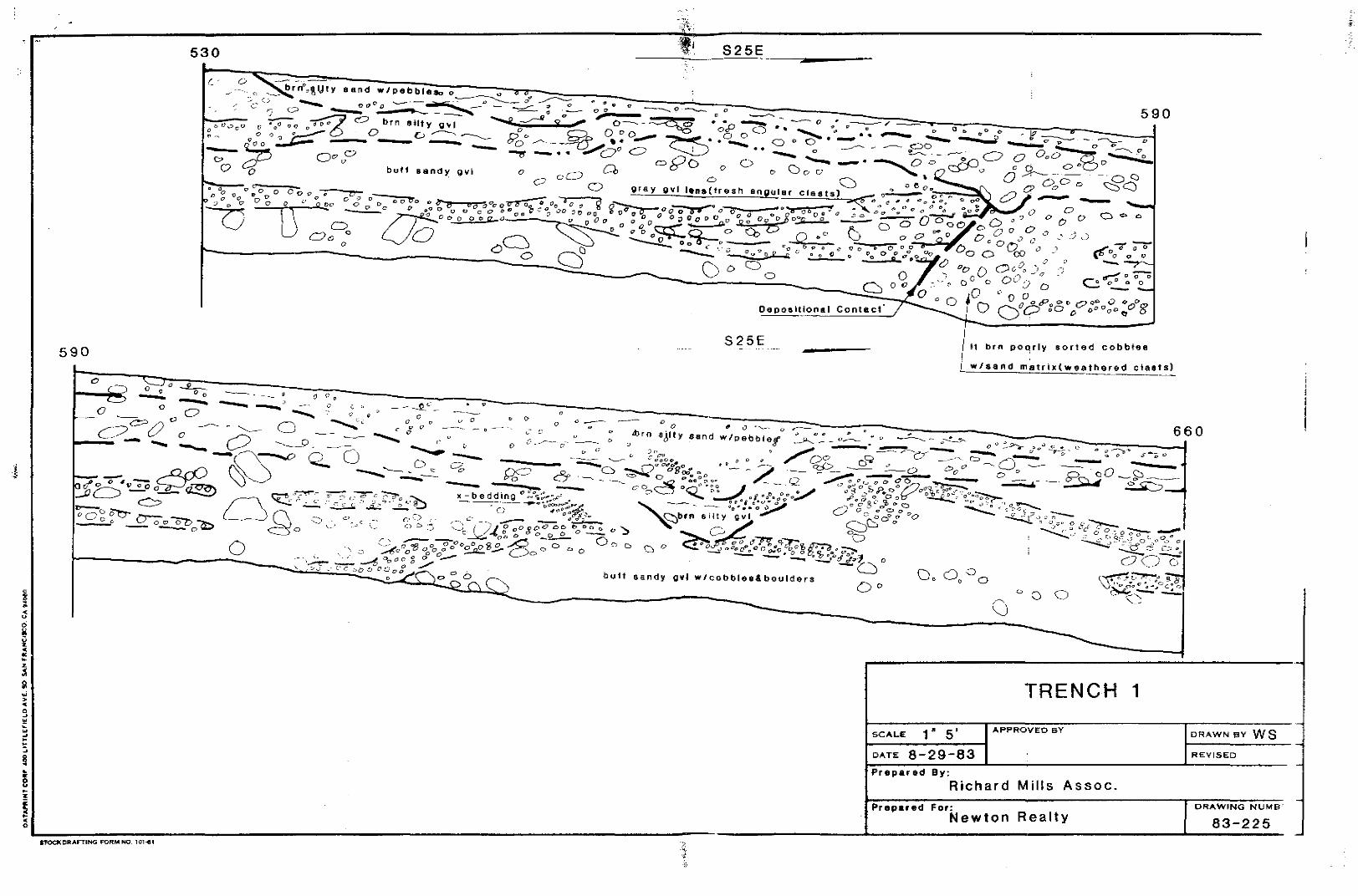
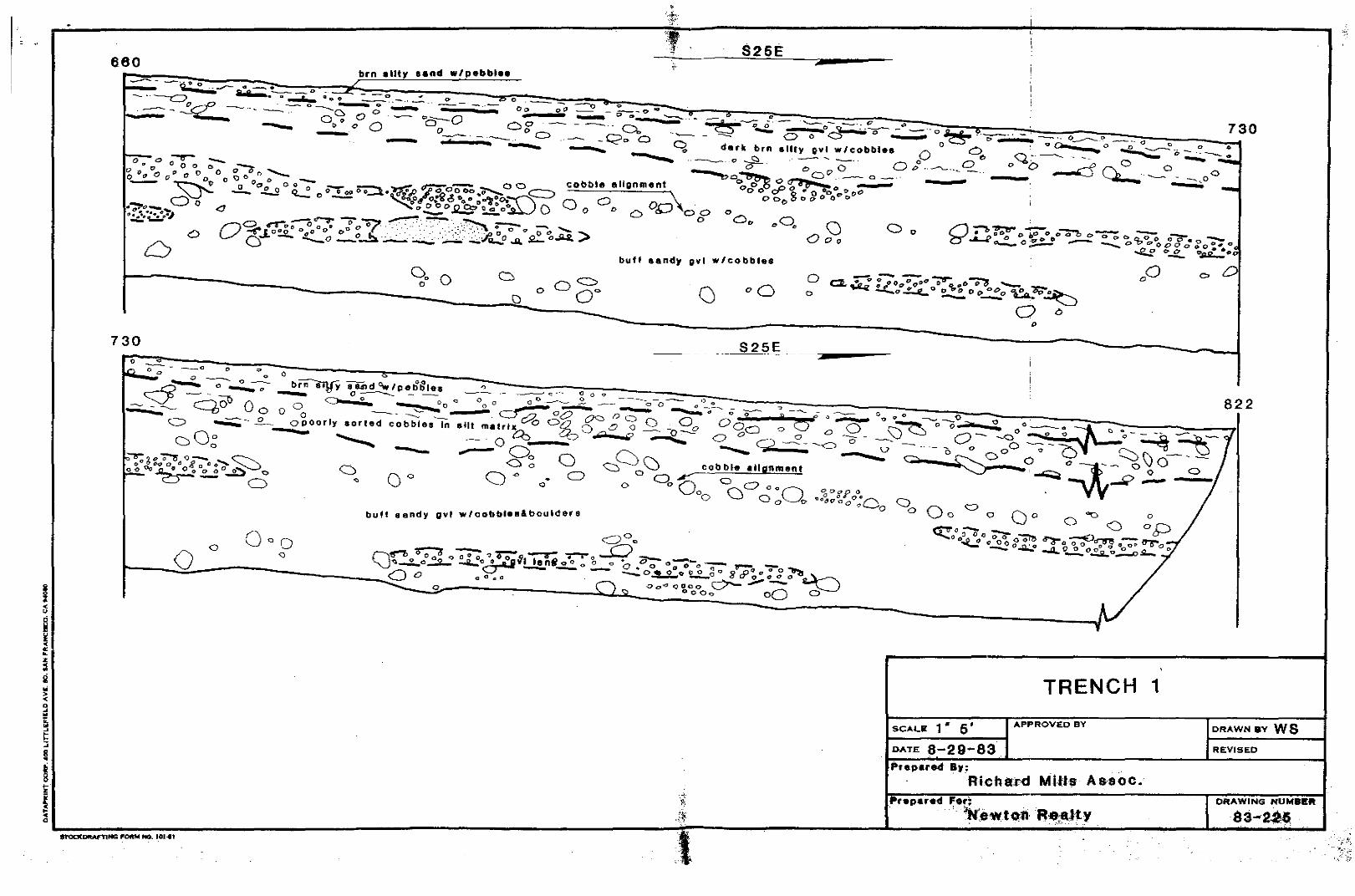
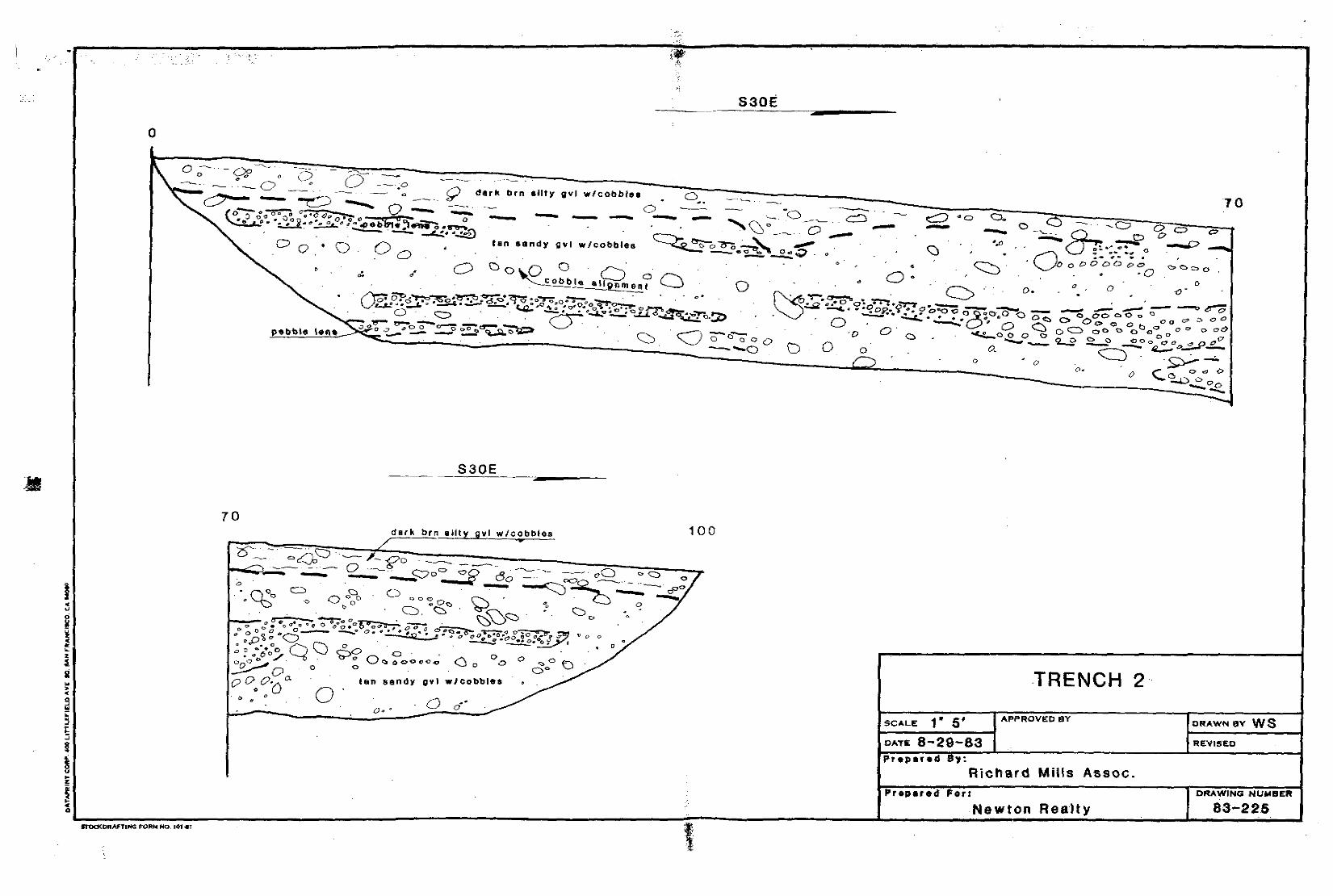
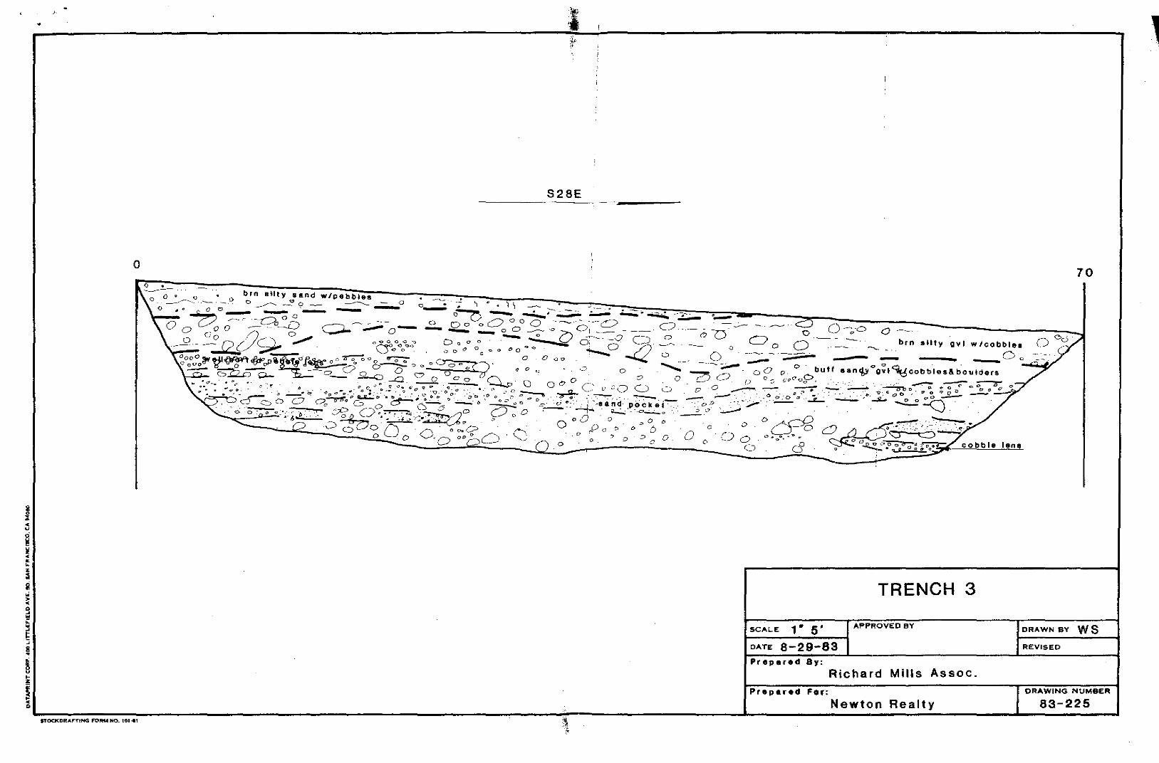
CONCLUSIONS ANO RECOMMENDATIONS
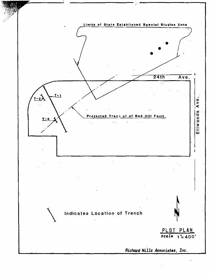
The site lies partially within the State and City of
Rancho Cucamonga Established Special Studies Zone for the Red
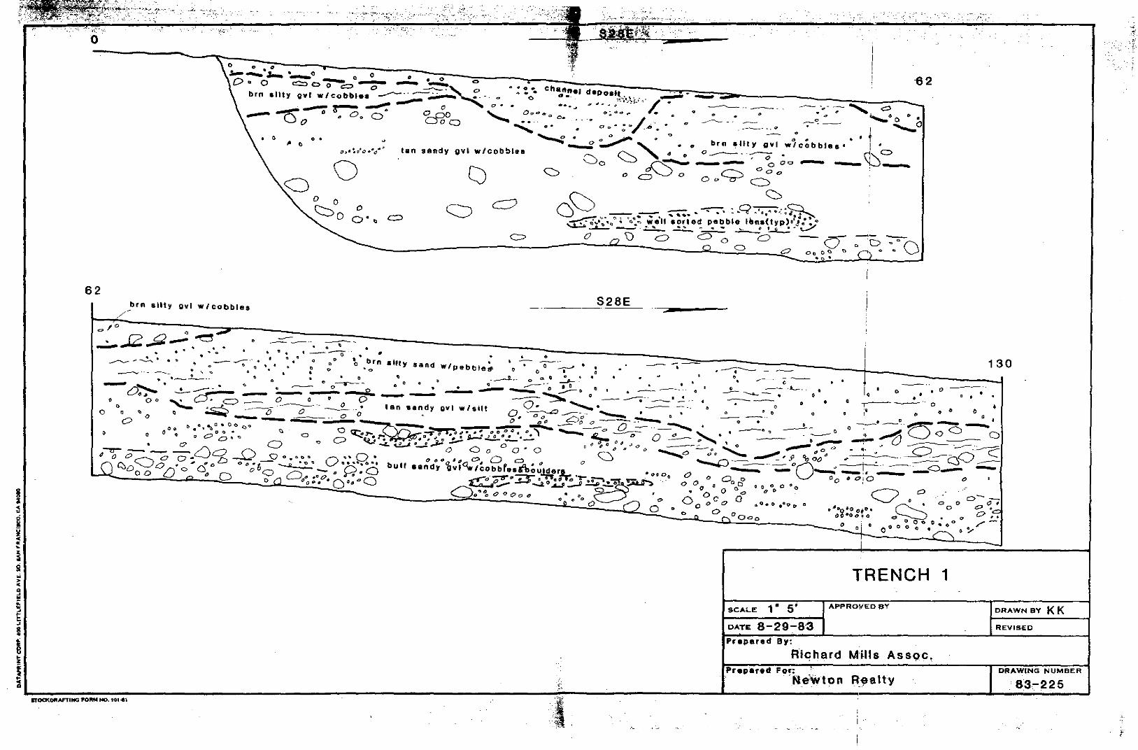
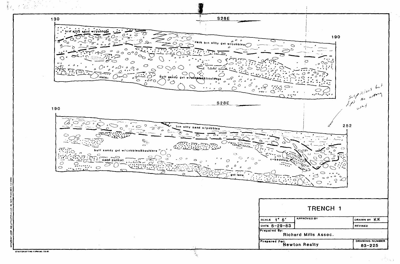
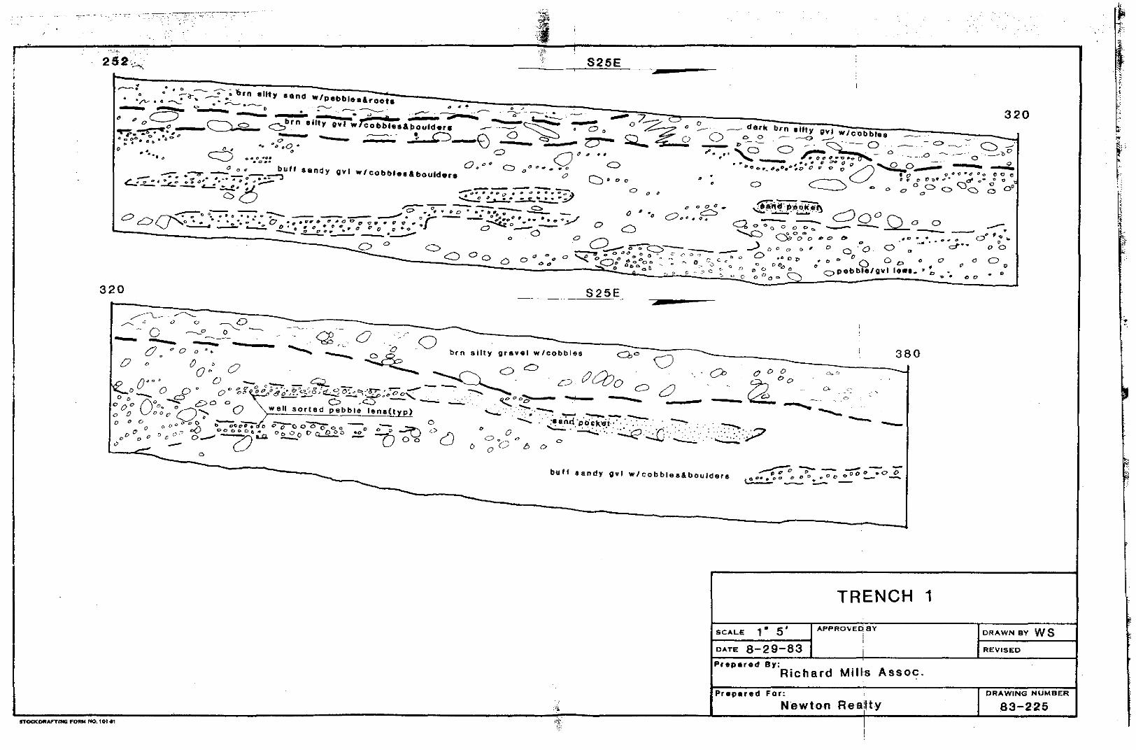
Rill fault. A total of 983 lineal feet of trenching was
performed at essentially right angles to the projection of
the mapped fault. This included 822 feet in the main trench
and two short paralleling trenches for supplemental data.
The subsurface excavations encountered no surface rupture or
offset deposits due to the Red Rill fault. The trenches
revealed essentially 3 mappable stratigraphic units. These
uni ts were distinguished according to their color, grain
size, firmness and frequency and quality of bedding as noted
on the .trench logs. Layered bedding is present in the form
of planar pebble and sand lenses. Individual layers are
commonly continuous over distances of 25 feet. Where
individual layers or lenses are not continuous, continuity of
bedding is shown by unaltered stratJgraphic contacts.
The alluvial materials show bo 'h gradational and sharp
contacts and localized unconformi ties. Our detailed
examination of the materials exposed in the trench
excavations revealed no fault features such as shears,
slickensides, offset layers or anomalous zones.
Consequently, it is our professional opinion that
restrictions on construction based on surface rupture due to
on-site faulting is unwar.ranted at this site. However, the
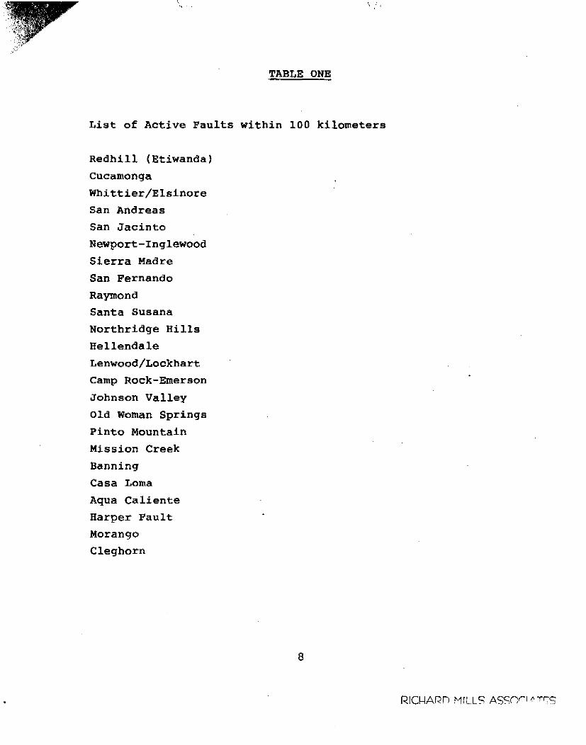
site does lie in an area considered to be seismically active.
Strong shaking from earthquakes generated on any one of the
several known faults indicated on Table One, should be
anticipated. Therefore, all structures should be designed
according to all seismic requirements of the Uniform Building
Code and the City of Rancho Cucamonga Department of Building
and Safety,
5
RIC(-JARD MILLS ASSCCIATt;;S
. , . '
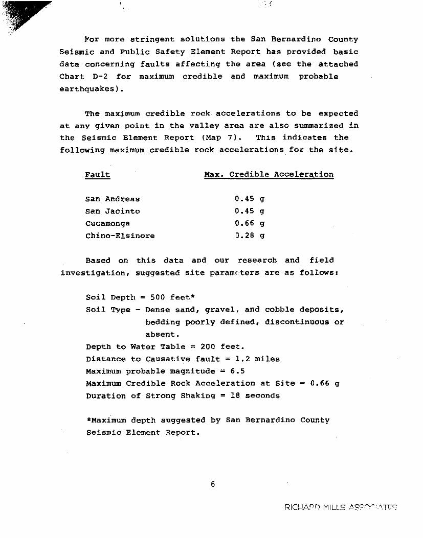
For more stringent solutions
Seismic and Public Safety Element
the San Bernardino County
Report has provided basic
data concerning faults affecting the area (see
Chart D-2 for maximum credible and maximum
earthquakes).
the attached
probable
The maximum credible rock accelerations to be expected
at any given point in the valley area are also summarized in
the Seismic Element Report (Map 7). This indicates the
following maximum credible rock accelerations for the site.
Fault Max. Credible Acceleration
San Andreas
San Jacinto
Cucamonga
Chino-Elsinore
0.45 g
0.45 g
0.66 g
0.28 g
Based on this data and our research and field
investigation, suggested site parameters are as follows:
Soil Depth = 500 feet*
Soil Type - Dense sand, gravel, and cobble deposits,
bedding poorly defined, discontinuous or
absent.
Depth to Water Table = 200 feet.
Distance to causative fault = 1.2 miles
Maximum probable magnitude ~ 6.5
Maximum Credible Rock Acceleration at Site = 0.66 g
Duration of Strong Shaking = 18 seconds
*Maximum depth suggested by San Bernardino County
Seismic Element Report.
6
RIO-IAf"IJ MILLS t>.S""",...'-\Tl::S
Ground water is estimated to lie approximately 200 feet
below the existing ground surface. Therefore, seismically
induced liquefaction is not considered to be a hazard at the
site.
The site does not lie below or adjacent to any large
bodies of water. Therefore, tsunamis, seisches or other
forms of seismically induced flooding is not considered a
hazard.
Earthquake induced differential settlement is not
expected because the underlying soils are generally massive,
compact, granular materials with low potential for
consolidation during short term cyclic loading.
Based on our research and field investigation, the site
appears suitable for development from an engineering geologic
standpoint.
7
Respectfully submitted,
RICHARD MILLS ASSOCIATES
;<::£~~/Pr Kelvin L. Kau
Q~logs•
Richard B.
President
CEG tll4
RICf.-lARD MILLS ASSOCIAT!;S
\ ; ..
TABLE ONE
List of Active Faults within 100 kilometers
Redhill (Etiwanda)
Cucamonga
Whittier/Elsinore
San Andreas
San Jacinto
Newport-Inglewood
Sierra Madre
San Fernando
Raymond
Santa Susana
Northridge Hills
Hellendale
Lenwood/Lockhart
Camp Rock-Emerson
Johnson Valley
Old Woman Springs
Pinto Mountain
Mission Creek
Banning
Casa Loma
Aqua Caliente
Harper Fault
Moran go
Cleghorn
8
RIC~ARn MIL.LS Assnr1~~r:-s
\
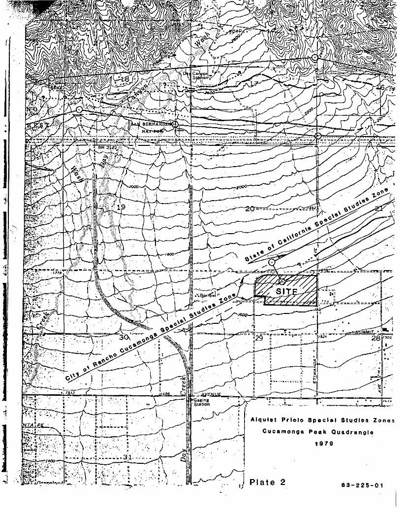
Limits ot State Eetablls~ed Spaolal Studies Zone
• • •
ProJaoted Trac• of ot Rad Hiii Fault
Indicates Location of Trench
PLOT PLAN scale 1":400'
Richard Mills Associates, Inc.
.... w
r l I
• I I ! :
- .. -. -·-··- ..... ·-· -·-· ·-. ----·.' ' ' ' ' : I .. :----
: : / ·-·-""1··--t--T•&&TT-11•"
' I ' . '
"i""·---~;.~--- -···1 t==*==4)='1'="" ; ~ . I . . .
' ••••••t••••• "T"
I
·····-!-·--·
I ~ --r--·~
----t----1 0.1
0.1
T-i.--~-~----~--- • 1
1--- ~--:---
• ••"II_-· ,,;.
II , I
. I ...... i ·---···-· l---····---
1 I ___ L_ __ ... .I ........ -
.. .. ..
I
-· /
1:
; I T------~-t·-· .. ••TT
l ' l ' j \ ! -!( ---·--··[-------· u I
'
I•.,
' : .• ..
. -· --··-·-~:~~~ I
I .,J.·
• : ""!
' "',. '•!) l
. -... ·= ( :1 '···· ••• '.: . I I r-: ~~h-~
1-.-91.q : ".,(
t f :
. I /1'iooi ' v -- ....... j .......... + ..... ----· ....... ~ .. .. ' ' . I
Qol
RICHARD MILLS ASSOC.
1
•
i
' ..
'•
:.•, • • "
'c.\\'I
. '· ' IJ .. ; • .. "
I ·j
"''
o' I I
' ' _. J'_ .... r r
•· ' " .
• ... • •
' "' .. ··-~-~--
I ,. '" . . •••···-.,~-.~o-::~.:!' . .,
:~~-lL~--~~~----· ~· •. 1
•
Alqulst Priolo Spacial Studies Zone•
Cucamonga Peak Quadrangle
1979
Plate 2 83-225-01
•. ... .. ··.
S111r;IJ 81Jf"1Hua I. ! 'ii '
I I
·•· ... ~·"'" •.• · Cdldlhta
• • /,j./tJtlll
···· ....
• ·.iJ ·-" -
"~ SP~
"' ' - •
4t.i~-~·-,·~"1<1.
t' I:• S \ ''j" 1 189~\ .. ~ MAJOR EARTHQUAKES AND RECENTLY ACTIVE FAULTS
IN THE 501:-JTH~RN CALIFORNIA REGION
EXPLANATION' · ACTIVE FAULTS
1899 IA 7+
Total length of fault zone that breaks Holoc_ene deposits or that hos hod seismic activity
Faull segment w1lh surface rupture during an historic earthquake, or with oseismic fault creep.
<> Holocene volcanic activity . ( Ambov. Pisgah, Cerro Prieto and Snllnn Rutte' I
M7.7 19~20
EARTHQUAKE LOCATIONS
Appro•imole ep1cenlrol oreo of eorlhquokes.lhat occurred 1769-1933. Magnitudes nol recorded by instruments prior lo 1906 were esl1moled from. domaqe r<>pons assigned an Intensity VII . (Modified Mercoli scale) or greater; this 1s roughly equivalent lo Richter M 6.0. 31 moderate•· earthquakes, 7 major and one greul earl hquoke ( 1857) were reported in the 164-year period 1769-1933.
Earthquake epicenters since 1933, plotted from improved instruments. 29 moderate .. and three major earthquakes were recorded in the 40-veor nprinrl jQ~~ ~1077 .
REFERENCES
1. California Dept. of Water Resources, 1970, Meeting water
demands in the Chino-Riverside area - Appendix A: water
supply: California Dept. of Water Resources Bull. No.
104-3, 108 p., 20 pls.
2. City of Rancho Cucamonga General Plan 1980, Figure 11-3
•Geotechnical Ha2aras•.
3. Duthcer, L.C. and Garrett, A.A., 1963, Geologic and
Hydrologic Features of the San Bernardino area.
4. Geology Seismicity and Environmental Impact 1973,
Special Publication Assoc. of Engr. Geologists.
5. Hadley, David and Combs, JamEs, 1974, Microearthquake
distribution and mechanisms of faulting in the
Fontana-San Bernardino area '"f Southern California:
Seismological Soc. Amer. Bull. 64, no. 5, P. 1477-1499.
6. Hileman, J.A., Allen C.R., and Nordquist, J.M., 1974,
Seismicity of the Southern
1932 to 31 December 1972:
California region, 1 January
Seismological Laboratory,
California Institute of Technology, Pasadena,
California, 404 p.
7. Morton, D.M., 1976, Geologic Map of the Cucamonga fault
2one between San Antonio Canyon and Cajon Creek, San
Gabriel Mountains, Southern California: U.S.G.S.
Open-File Rpt. 76-726.
9
RIC(-JARD MILLS ASSOCIAT~S
(. (
8. Richard Mills Associates, 1979, Engineering Geologic
Investigation, 453 acre site, north of Etiwanda, File
No. S-306.
9. Richard Mills Associates, 1981, Fault Investigation,
16th Street Project, Baseline and Campus, Rancho
Cucamonga, California, File No. S-345.
10. Richard Mills Associates, 1982, Engineering Geologic
Investigation, Tract Number 10210, Sapphire and Almond, ' San Bernardino County, California. File No. 82-251.
11. Richard Mills Associates, 1981, Engineering Geologic
Investigation, 5 million gallon water tank, Cucamonga
Wash north of 26th Street. File No. V-317.
12. Richard Mills Associates, 19'11, Seismic Exposut'e and
Fault Investigation, Tract N• :mber 11350, Turner and
Baseline, Rancho Cucamonga, C<.lifornia. File No. T-75.
13. San Bernardino County, California, 1974, Public Safety
Element (Seismic Safety Section).
14. Smith, D.P., 1978, Fault scarp map of the Cucamonga
fault zone. Unpublished map, C.D.M.G. Fault Evaluation
Report FER-39.
15. State of California · Special Studies Zones, Cucamonga
Peak Quadrangle, Jan. 1, 1979.
10
RICl-i'"'D" M!I_' '"" 'SSOCIAT!;S
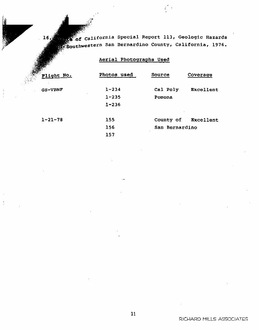
Special Report 113, Geologic Hazards
f~uthwestern San Bernardino County, California, 1976. ,r·
NO.
GS-VBNF
1-21-78
Aerial Photographs Used
Photos used
1-234
1-235
1-236
155
156
157
11
source
Cal Poly
Pomona
County of
Coverage
Excellent
Excellent
San Bernardino
RIC~ARD MILLS ASSOCIAT!;S
~ : 9 M
. -~:. - - ;.; - .. ·
0
62
..
0 0
•
0
• o o • •
0 0
channa1 dep alt --- ... ........ ....... O ,s.-......._ ~ ._ - c- ..-... --~o ... ~:·. o. o -,, - - --.-... ---;-- '....__• • • 0 • 0 = 0 • = 0 ~ ~ ~ • • • •• • • .. .. _,. •..• ., ' /. • • -:---: .... ~ - 0 '
brn silty ovl w/cobbl•:.- ,__. o ". • o •••• o. ., •• "/ • " ______..___ - - ---- .. o ----~ -- l '-
-C).0-.~. o. a· ffiO,., '...:·· •.• o.·;· ...
0 0
,·
0
bbleae"" '1 ~
"62
• 0 ••
0 0 0
c::::::. 0 0
o·"
'-" ._ o • brn •HI y ovl w co ~·.·· = ~ • o~, ' 0 o----·-=-o • - - , -~ "- '~--· 0 00 '-.._) """-...). _r-;:::: r--... 0 0 0
0 " 0'---J 0 0 "~ c::>
tan sandy ovl w/cob!>lu
c::::,
brn a Illy ovl w /cobbles /-
S28E
TRENCH
130
• • • •
1
' ~·-······ !
~
• 5' SCALE 1 APPRO'h'EDBY
REVISED
DRAWN BY KK
DATE 8-29-:-8-3 Prepared By:
Richard ASSQC, Mms
R~alty
.··L
i ;
I
S28E I
i I ' I
' 190 j . ; .
•
S 2 S_i::_E_ -=----- ----190 /
;
/ /
' ; /
I 252 i I
I
• • • • .
-
TRENCH 1
APPROVED BY
t~S~CA~L;E~~1~·~~5~·~~-=-=--=~~:--~~~~~~~~~~~R~E~~V~IS~E~~D~~~~R-OATE 8-29-83
d By: Assoc. -Prepere Richard Mills DRAWING NUMBER
83-225
DRAWN BY KK
Prepared F01~ewton Realty
. ·,
·. .
1 .,_ .....
•
320
.·
.... ~ ;p ~
:.~.· .. • S25E
0
0
0
0
S25E - -- . ---=-=--=-·--
bf n s i It Y gr a. v e I w I cob b I es
• • 0 0 .(J ...
# 0 c:::::::, •• o°'., .. ;, ...
--~---
380 C'
0 0 0
~"o
--- -- - -... 7!'):9
bu ff a andy gv I w/ cohblea&bou,de-re.
TRENCH 1
1· 5' APPROVE~BY
i SCALE
DA.TE 8-2 9 83 i '
Prepued Br:Richard Mills Assoc.
Prepued Far: Newton Realty
I
I
J
320
0 " 00 v • c,, •
'
DRAWN BY WS
REVISED
DRAWING NUMBER
83-225
~ 0 u
-. ~
.
0
Oo ~
~ooS:_°J?8.,~~0
460
--o~
o c:::f:ti 0 -0
0
0
0
0
0 6
0 0 D o D 0
D
1'Mit MO. 1Ol41
0 _!l•rk brn !l!!!' =
0 -o_,
0 --
0 0 0
0
---
0
·~· S25E
. .
0 ' o., 0 .. 0 0 0 . <> <> 0 0 :.... g . .,.--...._ ---..
0 0
b
0
om" oend w/pAblee_;;;.-.__. o - a - '--' o O o _ ~o- o rn • e o- ., .- ,...-...
o ,..--, ~ ...._ 0 -'!:... -='Oo - ::: ~ . .._, ~ ~ _c:: ,__, _-..?. ~ 0 c ~ •
- . -CC:. - rJ>o channel deposit 0 "'c~
460
_--...._ __,. 0 0 ~ o ......- o o e c •1:1io o '"'b 0 0 Q D 0 0 ------ . -Q -· -._ . - ":;,/ ~ =-:_o • ..!..-- "'-!.,
-....._ ~ CJ -· O,p 0 - • 0.-' C=> c:::>
-~3S~2~5~E=--~-------~-- --·
M 5' SCALE 1
D.t.TE 8-29~83 Pttipued By:
TRENCH
.t.PPROVED BY
-
Richard Mills Assoc.
d For: I Prepu• :Newton Rea ty
530
Cl 0 0 0
1
DRAWN SY ws REVi$ED
DRAWING NUMBER
83-225
·~ ~-
. ~~
';f ~-.
;:
.. ~ ..
! , ! • ·* f • "
" 1:: ...
' i . ' ' ' ! • I
'" 'i:
~-,.
~ ~ > ~
0 j
~ ~
w j
" " j
!
590
~-:--~ .... _.
530 S25E
590
o e p o-e. H ion a. I Cont ia ct
I
S25E I 11
t1 brn p-oQrly sor1 ed cobbttJe
I w/aa n d m~trix ( w eathereid ctaets)
TRENCH 1
SCALE 1· 5' APPROVED BY DRAWN BY WS
DATE 8 29-83 REVJSED
Prepu ed By:
! '""'"' '"Newtoo Realty IL_~~~~~~11-~_L_~~~~ ITOCIC CRAFTING f"ORM NO. 1 Ql -41
DRAWING NUMB.
83-225
Richard Mills Assoc.
-~.
-.i-
-
--
-
-
•
B25E
00~ ,,00 C) Q Oo
Oo
buff aandr gvl w/co>bbles
()0 0
0 0 oO a 0 D
730 S 2 5 E _ -----c~---
t"'"._~ .. o.-o - -o-"-'. • _::,, • '""'lfi ~""""··-"••• • ••• -;o-::_ ; • : -~-·-:::..:.\'--. • ; -- .- "Q ·. -~ -.o·~ "'- ··-· : ~ . ,_~-ti -<>-- • -- - ~ • - ~ ..:· • o~ •o cA 0 D 0 0 Ooo 0 CJ D" -"'--- oo- -;p -;-0 C0r-o---- -~-- --;:::--; [}J 0 o o ~ - ~ - . '-"o oo 0 o o -- -o ~ o o o o ----a a o ~o 0 o:;x~ o Vo o - - ---0 o o aoned cobbles In slit m.irti;...,__ Gt, a ..V --.._ -- ~ ~ ---.. Q - -1--... - ... c::> -;;;;;;; _ _ o__ o poorly _ _ _ O <--u - "'* ~ ,,_:;;;> -
,--._ Qoo w ~ -- - S>" a <;::,a() cobble •llqnment
'---' C) - o C) o C)o ,,,,--0 O(jO o •o o o~o o
0 0
-.. • o ;:1., O"o r-. o o oo o o <> ···~ o o " o '-'o
Cl Oo 0
• 5' SCALI! 1
DATE 8-29-83 -
0 0
TRENCH
A.PPROVED BY
Pfepare<t Br: A •oc -- Richard MlHS' s.. •
-~
0
1
730
822
DRAWN BY W$
REVISED
DRAWING NUMBER
• u
w > • 9 w ;;:
a
; .
70
Do ·o •
pebble 1•11•
0
•Illy qv 1 w / c obbleo
0 - - - -t 8 n 8 8 n d y g v 1 w J cobbles
60-.e 0 . 0 0 . cobble: &11-pnm ent
S30E
dark br n a II t Y iv I w I e ~ b bf es
O• • 0 o"
o .. -..
100
S30E
c:::J •o -•
0 0·
-•.o
~ 0
70
C>
0
• C>' o. :.-·--~ -- .,.._ - - 0 ~ oO ......... -o"""Clo: ...... ;'r'T .. --- _..._,. - o-o - 0 00 °
0
0 a C" :;,. ~ -:....C., • •C:o:;:,._'? .'• 9 <>"Q"' o .2:"'• Cl<::. C> 0 e> "' o ti 0 0
o
0
oo · . -.... ~·.: ..... :.:o• 0 CJ o= o 0 0 <> "0° .,o
0 · 0 · . ~oo o o ~ ~ ..$?._oo oa,,...:z_p_ · ·o a - o. - -- c:::) ~ ~ _;., Q 0 O 0 'o C.. o~o
o~ o ~ o oo --
TRENCH 2
1 o••W,NO """""
§ ~
I
REVISED
DRAWN BY W$ APP ROVED BY 1• 5' SCALE
DATE 8-29-83
Prepued Sy: M·ills Assoc. Richard
Sl'OCKDRMTING FORM HO. 101 ... l
,
S28E
0 70
~ .. brn allty ••nd wipe~ _ 0 0
-~ -; \ • • ) \ ~ :...-- ~·--...;. -~ ·-
TRENCH 3
SCALE 1 • 5' AP-PROVED BY DRAWN SY W$
DATE 8-29-83 REVISED
Prepared By: A Richard Mills ssoc.
DRAWING NUMBER
83-225