Embed Size (px)
Citation preview
Report on the Hogsmill River Outfall Safari
24th November 2016
UK & Europe Conservation Programme
Zoological Society of London
Regent's Park
London, NW1 4RY
www.zsl.org/conservation/regions/uk-europe/london’s-rivers

1
Acknowledgements
This project, funded by the Rivers Wetlands and Community Days Fund and The Postcode
Local Trust, has been delivered on behalf of the Hogsmill Catchment Partnership with the
support of Kingston Biodiversity Network, Kingston University, The Lower Mole Project, The
Environment Agency (EA) and the South East Rivers Trust. It would not have been possible
without the help of all the dedicated volunteers who collected the data. Special thanks go to
Bill Millard and Peter Short.
Introduction
Misconnected waste water pipework, cross connected sewers and combined sewer
overflows are a chronic source of pollution in urban rivers. An estimated 3% of properties in
greater London are misconnected (Dunk et al., 2008) sending pollution, via outfalls, into the
nearest watercourse. At the moment there is no systematic surveying of outfalls in rivers to
identify sources of pollution and to notify the relevant authorities. The Outfall Safari (OSaf) is
a survey method devised to address this reporting and evidence gathering gap. It was
devised by the Citizen Crane project steering group which consists of staff from Thames
Water, The Environment Agency, Friends of River Crane Environment, Frog Environmental
and the Zoological Society of London (ZSL). It was first used on the River Crane in 2016.
Aims
The aims of the Hogsmill OSaf were to:
record and map the dry weather condition behaviour of surface water outfalls across the
Hogsmill Catchment
geolocate and photograph sources of pollution in the Hogsmill River and to report these
to the EA and Thames Water
recruit more volunteers and to further engage existing volunteers in the work of the
Hogsmill Catchment Partnership.
build evidence on the scale of the problem of polluted surface water outfalls in the
London region

2
Method
The survey of outfalls was conducted between October 1st and November 3rd 2016. Twenty
six people took part in the OSaf, comprising 24 volunteers and one member of staff from
each of the Environment Agency and ZSL.
Volunteers were trained during two separate training events, covering the following elements
of activity:
an overview of water quality issues in the Hogsmill catchment
information on outfalls and how they become polluted
instruction on how to assess each outfall using the project App and how to upload
information to the database
a health & safety briefing and signing of the risk assessment
During the training, groups of volunteers were assigned lengths of river to survey. Further
coordination of survey dates and reaches was conducted by the volunteer group on a closed
Facebook group set up specifically for the Osaf. Groups of volunteers were free to conduct
the survey of their reach when convenient to themselves, within the survey period, provided
there had been no rain for 48 hours prior to survey. A period of 48 hours of no rain is
required before any survey work since rainfall and high surface water flows can obscure the
negative impacts of outfalls by washing away sewage fungus, discoloured sediments and
rag.
The majority of the survey work (19.0km) was conducted from the riverside path (see Figure
1a), with the occasional need to enter the river to properly assess and photograph an outfall.
The risk assessment for riverside outfall surveying highlighted the need to assess conditions
in the river before entering it and stressed that volunteers should only enter the river channel
if the level was lower than Wellington boot depth (c.35cm). During the training volunteers
were also shown images of Giant Hogweed (Heracleum mantegazzianum). It was essential
that volunteers could identify Hogweed before undertaking any survey work as it is a
relatively common plant along the banks of rivers in London and can burn and blister skin if
touched.
In some reaches of the river, where it flows through private land or is inaccessible from the
banks, the survey had to be conducted in-channel. More stringent health and safety rules
applied to in-channel surveys all of which were led by ZSL staff. Waders, stabilising poles
and life jackets were used by in-channel survey teams (see Figure 1b). The local knowledge

3
of volunteers was very helpful in ensuring that all tributaries in the catchment were located.
Approximately 6.5 km of the river were surveyed from within the channel bringing the total
length of river surveyed to 25.5 km.
In addition to personal protective equipment (PPE) volunteers took a printed handout,
designed to help with ranking the impacts of each outfall, and a smart phone or tablet loaded
with a specially created data entry App.
The majority of the river and its tributaries were surveyed but small sections could not be
accessed. These included:
culverted sections
private land, such as schools, to which we could not gain access
some heavily overgrown stretches at the top of the tributaries
Figure 1- Photos of volunteers surveys from, a, the riverbank and, b, with the EA in-channel
The App
For ease of data collection from the river, the volunteers used an app created in
EpicollectPlus (plus.epicollect.net). Created by researchers at Imperial College, Epicollect is
free and openly available. Once a project is set up in Epicollect it provides an app for remote
data collection and upload, usable on GPS enabled smart phones, and a web portal to
access and download the data. The outfall assessment form created in the app consisted of
eleven questions for volunteers to fill in at each outfall. The questions are taken directly from
the form that Thames Water use for assessing the impact of outfalls and are shown in Table
1.
a b

4
Table 1 – Questions used in the Epicollect App to assess each outfall and their
corresponding Impact Score
Question Options EA score
1. Volunteer name
2. Date of Survey
3. GPS location
4. Photo of the outfall
5. Catchment Location
6. Description of the nearest landmark
7. How many other outfalls can be seen from this location
8. Which bank is the outfall on (when looking downstream)
9. Ranking of the flow coming out of the outfall
a. No Flow
b. Trickle
c. Low Flow
d. Moderate Flow
e. High Flow
10. Ranking of the visual impact of the outfall
a. No visible effect 0
b. Within 2m of outfall 2
c. Impact 2 to 10m 4
d. Impact 10 to 30m 6
e. Impact greater than 30m 10
11. Ranking of the aesthetics of the outfall
a. No odour or visible aesthetics 0
b. Faint smell, slight discolouration 2
c. Mild smell, mild discolouration, small
coverage of sewage fungus 4
d. Strong smell, strong discolouration, large
coverage of sewage fungus and/ or litter 6
e. Gross smell, gross sewage 10

5
Conversion of outfall assessment to impact scores
In order to assist with prioritisation of the outfalls, the EA provided a method of converting
the assessment data to a numeric impact score for each outfall. These scores are shown on
the right hand column in Table 1. Any outfall with an impact score of 8 or more, from the
options in questions 10 and 11, were reported to the EA’s National Reporting System (NRS).
Data Processing
Outfall data were checked to remove double entries and those with an impact score of two or
greater were mapped using QGIS Desktop 2.12.3.
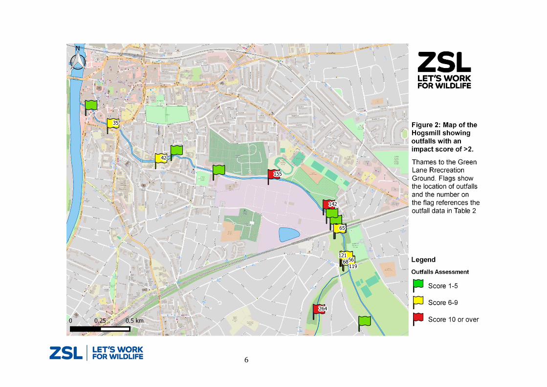
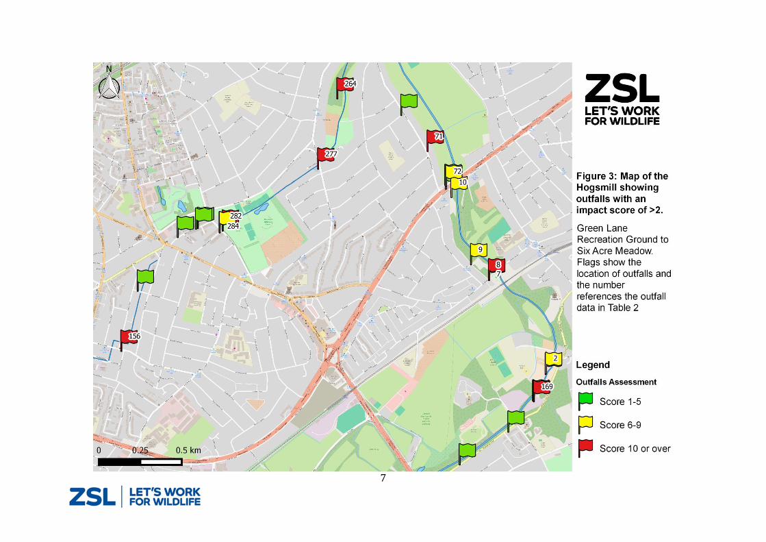
Results
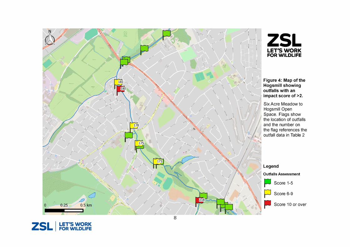
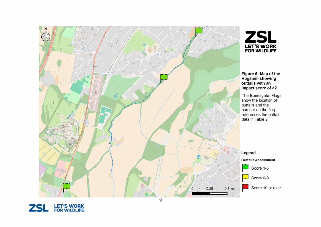
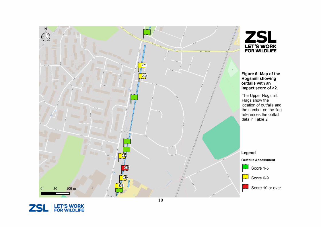
The volunteers photographed, located and assessed a total of 288 outfalls. Of this total 67
showed some signs of pollution and scored ˃ 0. The locations of these outfalls are shown in
Figures 2 to 6. The colour of the flags shown in the maps reflects the impact score for each
outfall. The details of the outfalls with in impact score of ≥ 6 are given in Table 2. The
numbers on the flags in Figures 2 to 6 references outfalls listed in Table 2. The full 2016
Hogsmill OSaf dataset is available from ZSL.
6
7
8
9
10

11
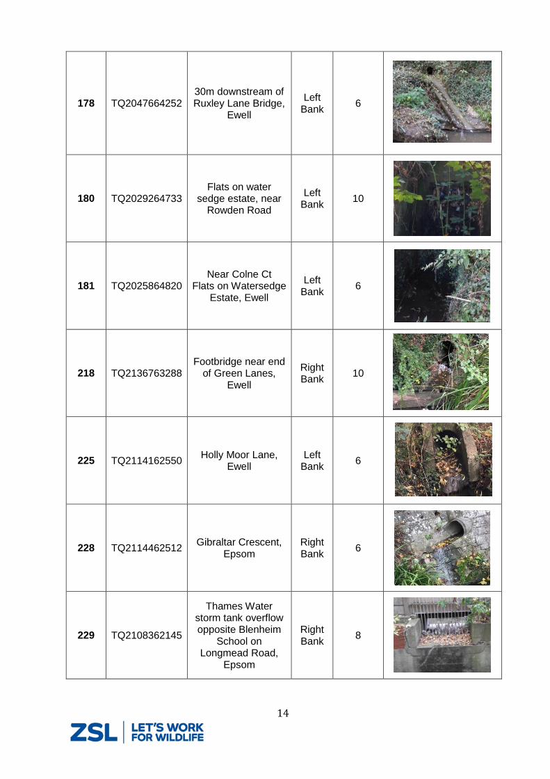
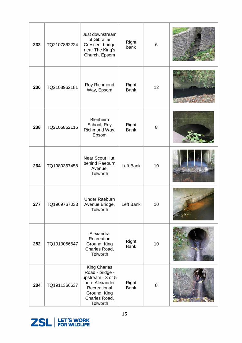
Table 2 – Details and photos of outfalls shown in figure 1 to 5 - only outfalls with an impact score of greater than or equal to 6 are included
Photo ID
NGR Location details
Bank side
Assessment Score
Photo
2 TQ2110165837
Riverside Cottage, Old Malden Lane,
Worcester Park
Right Bank
6
7 TQ2074466388 sheephouse
Way, Old Malden
Right Bank
10
8 TQ2074366392 Knollemead,
Tolworth Left
Bank 10
9 TQ2063366480 71 Southwood Drive, Tolworth
Right Bank
6
10 TQ2050566882
5m upstream of A3 Malden Way S Bridge, New
Malden
Right Bank
8
35 TQ1802768981 3 St. James’s
Road, Kingston Right Bank
6
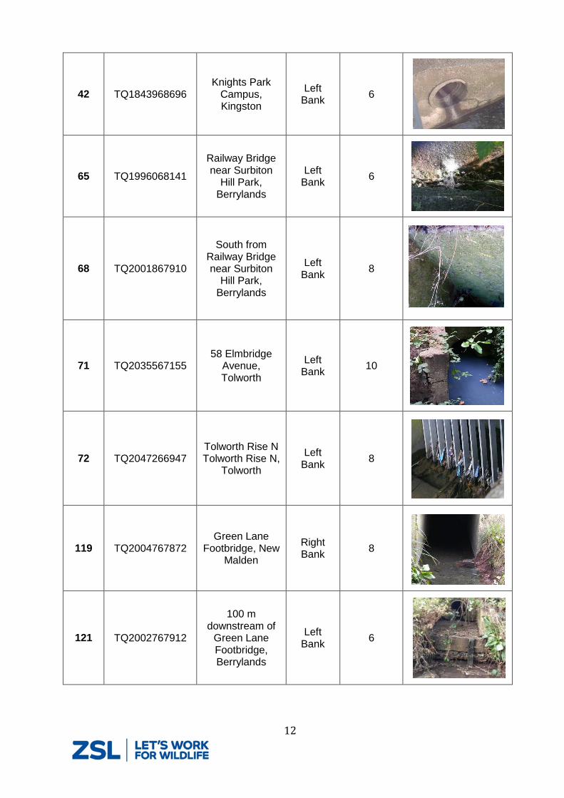
12
42 TQ1843968696 Knights Park
Campus, Kingston
Left Bank
6
65 TQ1996068141
Railway Bridge near Surbiton
Hill Park, Berrylands
Left Bank
6
68 TQ2001867910
South from Railway Bridge near Surbiton
Hill Park, Berrylands
Left Bank
8
71 TQ2035567155 58 Elmbridge
Avenue, Tolworth
Left Bank
10
72 TQ2047266947 Tolworth Rise N Tolworth Rise N,
Tolworth
Left Bank
8
119 TQ2004767872 Green Lane
Footbridge, New Malden
Right Bank
8
121 TQ2002767912
100 m downstream of
Green Lane Footbridge, Berrylands
Left Bank
6

13
142 TQ1986668340 Near Barker Close,
New Malden Right Bank
16
155 TQ1939568584 Near Barker Close,
New Malden Right Bank
10
156 TQ1853565910 Cotterill Road East,
Surbiton Right Bank
12
169 TQ2103265665
5m upstream of River Club Bridge, Old Malden Lane, Worcester Park
Left Bank
10
173 TQ2079663784
100m from bridge at Ewell court100m downstream of Footbridge near
Ewell Court, Ewell
Left Bank
8
175 TQ2054864018
20m downstream of Footbridge from Alway Avenue,
Ewell
Left Bank
8
14
178 TQ2047664252 30m downstream of Ruxley Lane Bridge,
Ewell
Left Bank
6
180 TQ2029264733 Flats on water
sedge estate, near Rowden Road
Left Bank
10
181 TQ2025864820 Near Colne Ct
Flats on Watersedge Estate, Ewell
Left Bank
6
218 TQ2136763288 Footbridge near end
of Green Lanes, Ewell
Right Bank
10
225 TQ2114162550 Holly Moor Lane,
Ewell Left
Bank 6
228 TQ2114462512 Gibraltar Crescent,
Epsom Right Bank
6
229 TQ2108362145
Thames Water storm tank overflow opposite Blenheim
School on Longmead Road,
Epsom
Right Bank
8
15
232 TQ2107862224
Just downstream of Gibraltar
Crescent bridge near The King's Church, Epsom
Right bank
6
236 TQ2108962181 Roy Richmond Way, Epsom
Right Bank
12
238 TQ2106862116
Blenheim School, Roy
Richmond Way, Epsom
Right Bank
8
264 TQ1980367458
Near Scout Hut, behind Raeburn
Avenue, Tolworth
Left Bank 10
277 TQ1969767033 Under Raeburn Avenue Bridge,
Tolworth Left Bank 10
282 TQ1913066647
Alexandra Recreation
Ground, King Charles Road,
Tolworth
Right Bank
10
284 TQ1911366637
King Charles Road - bridge -
upstream - 3 or 5 here Alexander
Recreational Ground, King Charles Road,
Tolworth
Right Bank
8
16
Discussion Finding outfalls was not always easy, especially where there was thick vegetation reaching right
down to the water’s edge. The fact that volunteers, familiar with the river, found outfalls that
they had not noticed before suggests the majority of outfalls were identified in the survey area.
Nonetheless there could be some “hidden” outfalls that were missed.
Volunteers were trained in assessing the impact of outfalls but there are elements of subjectivity
in the assessment that may lead to inconsistencies in the way the outfalls are assessed. It is
recommended that the data in this report is taken as a guide and that Thames Water reassess
the outfalls listed in Table 2 before prioritising work within the catchment.
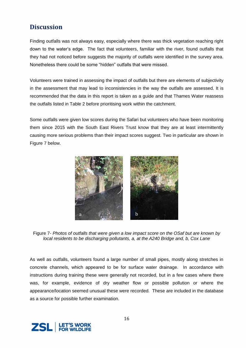
Some outfalls were given low scores during the Safari but volunteers who have been monitoring
them since 2015 with the South East Rivers Trust know that they are at least intermittently
causing more serious problems than their impact scores suggest. Two in particular are shown in
Figure 7 below.
Figure 7- Photos of outfalls that were given a low impact score on the OSaf but are known by local residents to be discharging pollutants, a, at the A240 Bridge and, b, Cox Lane
As well as outfalls, volunteers found a large number of small pipes, mostly along stretches in
concrete channels, which appeared to be for surface water drainage. In accordance with
instructions during training these were generally not recorded, but in a few cases where there
was, for example, evidence of dry weather flow or possible pollution or where the
appearance/location seemed unusual these were recorded. These are included in the database
as a source for possible further examination.
a
b
17
Other issues reported during the OSaf
A cracked sewer pipe at the point that it passes over The Green Lanes Stream, near
Blenheim Road (TQ 2084 6172). This was called in to Thames Water (reference
61025787247).
Illegal fishing gear observed near River Club Bridge, Old Malden Lane, Worcester Park
(TQ2103265665). This was reported to the EA.
Pollution from a portable toilet turned the river blue during a section of the OSaf in Ewell.
This incident was reported to the EA.
References Dunk, M.J., McMath, S.M., Arikans, J., 2008. A new management approach for the remediation
of polluted surface water outfalls to improve river water quality. Water Environ. J. 22, 32–41.
Contact details Joe Pecorelli
Project Manager - Europe Conservation Programme