Embed Size (px)
Citation preview


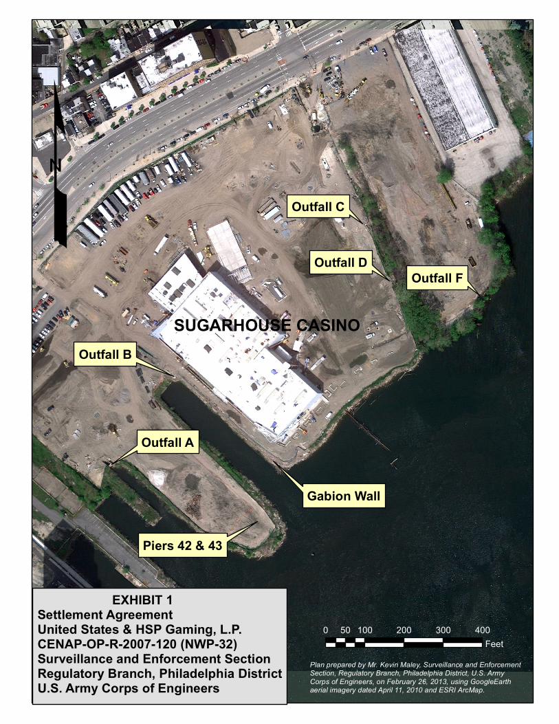
Outfall F
0 100 200 300 40050Feet
Outfall C
Outfall D
Outfall B
Outfall A
Gabion Wall
Piers 42 & 43
Plan prepared by Mr. Kevin Maley, Surveillance and Enforcement Section, Regulatory Branch, Philadelphia District, U.S. Army Corps of Engineers, on February 26, 2013, using GoogleEarth aerial imagery dated April 11, 2010 and ESRI ArcMap.
£
EXHIBIT 1Settlement AgreementUnited States & HSP Gaming, L.P.CENAP-OP-R-2007-120 (NWP-32)Surveillance and Enforcement SectionRegulatory Branch, Philadelphia DistrictU.S. Army Corps of Engineers
SUGARHOUSE CASINO


! ! ! ! ! ! ! ! ! ! ! ! ! ! ! ! ! ! ! ! ! ! ! ! ! ! ! ! ! ! ! ! ! ! ! ! !
4
6.56.1
5.4
2
4.9
3.8
2.9
2.6 0.80.7
3.8
0 1 2 3 40.5
Feet
ConcreteConcrete
Concrete Spillway
Settlement Agreement:United States & HSP Gaming, L.P.CENAP-OP-R-2007-120 (NWP-32)Surveillance and Enforcement SectionRegulatory Branch, Philadelphia DistrictU.S. Army Corps of Engineers
18" ID Stormwater PipeFilled 16" Pipe
OUT FALL "F"(Plan View) Settlement Agreement:
United States & HSP Gaming, L.P.CENAP-OP-R-2007-120 (NWP-32)Surveillance and Enforcement SectionRegulatory Branch, Philadelphia DistrictU.S. Army Corps of Engineers
Work authorized by Nationwide Permit (NWP) 32, Completed Enforcement Actions. 49 square feet of dredged and/or fill material discharged into waters of the United States associated with reconstruction of storm water Outfall "F".
Plan prepared by Messrs. Kevin F. Maley and Jeffrey Steen, Philadelphia District, USACOE, on February 11, 2013, using field measurementsdated January 31, 2013. Elevations provided by Mr. Stephen A. Farrell, Philadelphia District, Survey Branch, based on survey dated May 20, 2011.
EXHIBIT 3
High Tide LineLimit of Area Subject to
Federal Jurisdiction
DELAWARE RIVER
Concrete Headwall
High Tide LineEl. 4.55" NAVD 1988

! ! ! ! ! ! ! ! ! ! ! ! ! ! ! ! ! ! ! ! ! ! ! ! ! ! ! ! ! ! ! ! ! ! ! ! !
5
7.9
6.1
2
4.7
4.13.7
3.4 2.2
1.9
1.7 1.6
1.4
0.51.4
0 1 2 3 40.5
Feet
Filled16" Pipe
StoneBlocks
OUT FALL "F"(Front View)
StoneBlocks
OUT FALL "F"(Front View) Settlement Agreement:
United States & HSP Gaming, L.P.CENAP-OP-R-2007-120 (NWP-32)Surveillance and Enforcement SectionRegulatory Branch, Philadelphia DistrictU.S. Army Corps of Engineers
High Tide LineEl. 4.55" NAVD 1988
Concrete Headwall
Mean High Water LineEl. 2.94' NAVD 1988
StoneBlocks
OUT FALL "F"(Front View) Settlement Agreement:
United States & HSP Gaming, L.P.CENAP-OP-R-2007-120 (NWP-32)Surveillance and Enforcement SectionRegulatory Branch, Philadelphia DistrictU.S. Army Corps of Engineers
High Tide LineEl. 4.55" NAVD 1988
Plan prepared by Messrs. Kevin F. Maley and Jeffrey Steen, Philadelphia District, USACOE, on February 11, 2013, using field measurementsdated January 31, 2013. Elevations provided by Mr. Stephen A. Farrell, Philadelphia District, Survey Branch, based on survey dated May 20, 2011.
18" ID Stormwater
Pipe
Rip-Rap &Concrete
Blocks
Concrete Concrete
Concrete Headwall
Concrete Spillway
Work authorized by Nationwide Permit (NWP) 32, Completed Enforcement Actions. 49 square feet of dredged and/or fill material discharged into waters of the United States associated with reconstruction of storm water Outfall "F".
EXHIBIT 4