Embed Size (px)
Citation preview

1
Report of the Field Survey by Tokyo Tech Team after the April 25, 2015
Nepal Earthquake
A moment magnitude 7.8 earthquake occurred on April 25, 2015 with the epicenter in Barpak village, Gorkha district, 77 km north-west of the capital city Kathmandu, followed by a major aftershock of moment magnitude 7.3 on May 12, 2015 with epicenter 18 km south-east of Kodari village, Sindhupalchowk district (see Fig.1a). The number of fatalities due to both earthquakes was more than 8,000 and the economic loss is estimated to be 10 billion US$. The last major earthquake that occurred in Nepal in 1934 had a Richter magnitude of 8.4, and caused the loss of almost 30% of the population of Kathmandu alone.
A team from Tokyo Tech carried out a field survey in Nepal from June 1-8, 2015 to
investigate the damage caused by the earthquakes (see Fig.1b). The team was led by Civil Engineering Associate Professor Anil C. Wijeyewickrema and included five students from structural earthquake engineering Samith Buddika (D2), Satish Bhagat (D1), Rohit Kumar Adhikari (M2), Anuja Shrestha (M2) and Sanjeema Bajracharya (M1); one student from geotechnical earthquake engineering Jenisha Singh (M1) and one student from disaster management Rajali Maharjan (M2). All students other than Samith Buddika are from Nepal.
Fig. 1. (a) Map of Nepal showing the epicenters and (b) areas surveyed indicated by red circles.
(a)
(b)

2
Though, Nepal is in a seismically active region, due to economic conditions of the country, most of the older structures had been constructed with little or no consideration of seismic effects. The main objectives were to assess the extent and nature of damage caused by the earthquakes, especially in Kathmandu valley (Kathmandu, Bhaktapur and Lalitipur districts) and Sindhupalchowk district (the district with largest number of casualties) and to propose seismic mitigation measures for structures (see Fig. 2). The team also investigated geotechnical damage such as landslides, settlement of ground, and liquefaction that were due to the earthquakes.
From the field survey, it was determined that the major reasons for damage to structures
were poor construction practices where seismic design guidelines had not been followed, as minor or no structural damage was observed in well-engineered buildings. Cultural heritage sites that suffered heavy damage were the old monuments without proper maintenance and where necessary retrofitting measures had not been adopted. In addition, the need of proper testing of soil properties and ground improvement prior to construction were greatly felt.
Damage to reinforced concrete structures and masonry structures are shown in Figs. 3-10.
Geotechnical damage is shown in Figs. 11-16.
A comprehensive report of the field survey including chapters on (a) damage to structures,
(b) geotechnical damage, and (c) disaster relief and humanitarian aid is available at the Anil lab webpage.
Fig. 2. Map of Nepal showing the districts. The field visit included Kathmandu district, Lalitpur district, Bhaktapurdistrict, and Sindhupalchowk district.

3
Fig. 4. Collapse of four-story school building in Sangachowk, Sindhupalchowk district. The collapsed first-story columns can be seen at ground level.
Fig. 3. Field survey team at a high-rise apartment building in Nakkhu, Lalitpur district which sustained significant non-structural damage.
2 stories collapsed
Fig. 5. Lower 2 stories of the building collapsed in Gongabu, Kathmandu district due to soft story effect.
Fig. 6. Heavily damaged masonry infill wall of a school building in Sangachowk, Sindhupalchowk district.
Fig. 7. Curtain fall collapse of entire side wall of partial loadbearing masonry structure with timber columns near BhaktapurDurbar Square area, Bhaktapur district.
Fig. 8. Addition of extra stories over the existing old structure in Bhaktapur district and yet, no significant damage due to the earthquake was observed.

4
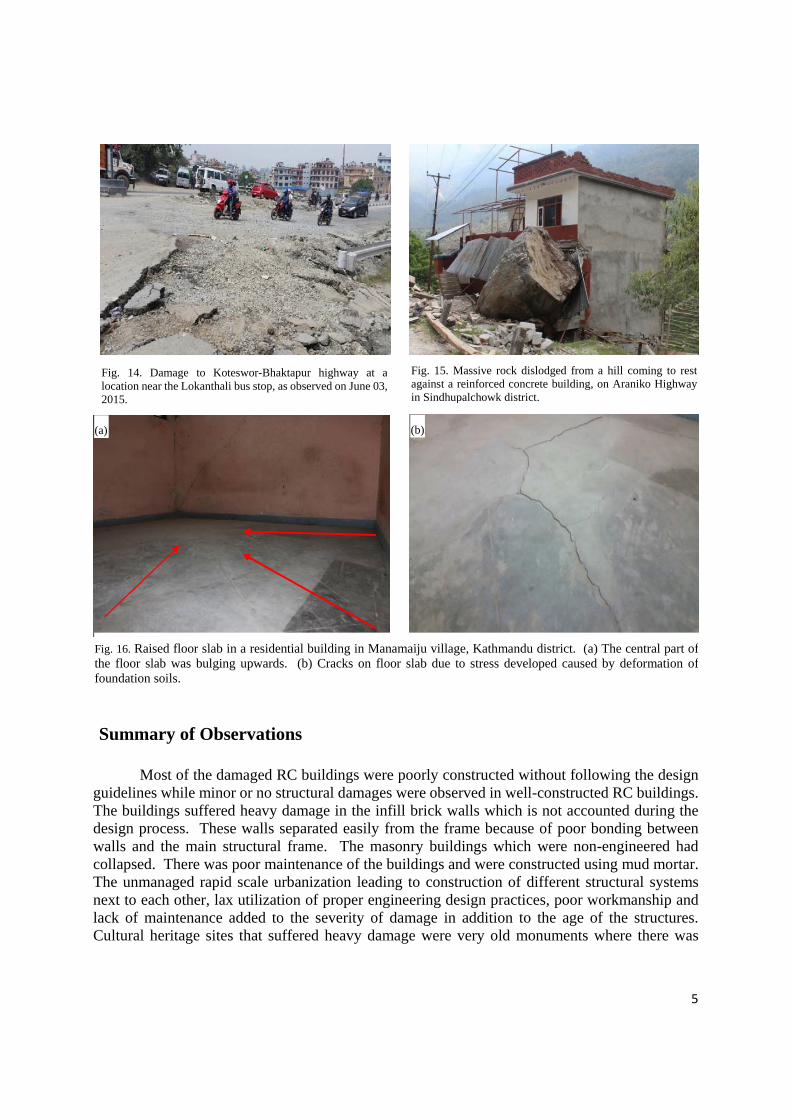
Fig. 13. Damage to Koteswor-Bhaktapur highway at a location near the Kaushaltar bus stop. Extent of separation of roadway as observed on June 03, 2015.
AfterBefore
Before After
Fig. 9. Maju deval temple in Basantapur Durbar Square, Kathmandu district. The earthquake caused the three-story pagoda style temple to be reduced to rubble. However, the foundation and the stairway to the temple up to the plinth level is intact. The white-colored shikara style temple next to it is also completely damaged.
Fig. 10. The nine-story, historic landmark tower, Dharaharain Kathmandu district collapsed. 180 people lost their liveswhen the tower collapsed.
Fig. 11. Active landslide along Araniko highway between Dolalghat and Tatopani in Sindhupalchowk district.
Approx. 190m
Fig. 12. Landslide near to Barahbishe, Sindhupalchowkdistrict.
5
Summary of Observations Most of the damaged RC buildings were poorly constructed without following the design
guidelines while minor or no structural damages were observed in well-constructed RC buildings. The buildings suffered heavy damage in the infill brick walls which is not accounted during the design process. These walls separated easily from the frame because of poor bonding between walls and the main structural frame. The masonry buildings which were non-engineered had collapsed. There was poor maintenance of the buildings and were constructed using mud mortar. The unmanaged rapid scale urbanization leading to construction of different structural systems next to each other, lax utilization of proper engineering design practices, poor workmanship and lack of maintenance added to the severity of damage in addition to the age of the structures. Cultural heritage sites that suffered heavy damage were very old monuments where there was
Fig. 15. Massive rock dislodged from a hill coming to rest against a reinforced concrete building, on Araniko Highway in Sindhupalchowk district.
Fig. 14. Damage to Koteswor-Bhaktapur highway at alocation near the Lokanthali bus stop, as observed on June 03,2015.
(a) (b)
Fig. 16. Raised floor slab in a residential building in Manamaiju village, Kathmandu district. (a) The central part of the floor slab was bulging upwards. (b) Cracks on floor slab due to stress developed caused by deformation of foundation soils.

6
deterioration of the construction material. Lack of maintenance and unpreparedness for strong ground shaking added to the damage, which could have been minimized with proper management.
Damage to roads observed along the Koteshwar-Bhaktapur road were mainly due to the deformationconsolidation of the soil beneath it. Some landslides that occured along mountainous roads are unavoidable but can be minimized. Minor damage to structures due to geotechnical failures were observed, whereas rockfalls along the highway caused severe damage to buildings.
Acknowledgements Partial financial support from the Department of Civil Engineering and the Civil
Engineering Alumni Association of Tokyo Tech for the field visit is gratefully acknowledged. Prof. Junichiro Niwa, Head of Department, Dr. Jiro Takemura and Professor Akihiro
Takahashi, Department of Civil Engineering, Tokyo Institute of Technology are thanked for their kind support and encouragement when the initial plan for a field visit was proposed.