Embed Size (px)
Citation preview

REDISCOVERING URBAN DENSITY: AMELIORATING LANDSCAPE QUALITY
THROUGH RESIDENTIAL DESIGN IN QUITO, ECUADOR
by
ISABEL JÁCOME
(Under the Direction of Amitabh Verma)
ABSTRACT
Unfortunately, in most countries in Latin America, city planning continues to follow
theories responsible for current environmental problems in the world. Ecuador and its
capital city, Quito, are no exception. International urban and landscape design trends,
such as regenerative techniques, sustainability, and compaction of cities, and
contemporary concerns, which include health, environmental issues, and quality of life,
are not considered.
This thesis researches Quito's lack of organized, safe, and quality open spaces. It
discovers that the absence of these important features and the city's urban growth have
caused loss and imbalance of several essential values that contribute to quality of life. It
provides design principles applicable to high-density residential projects in order to
create, in Quito's future development, a healthy environment to regain balance of these
values. Through the analysis of historic and contemporary case studies, literature
research, and personal interviews, it seeks for an opportunity of intervention.
INDEX WORDS: Residential design, Landscape design, Environmental values,Quito, Ecuador

REDISCOVERING URBAN DENSITY: AMELIORATING LANDSCAPE QUALITY
THROUGH RESIDENTIAL DESIGN IN QUITO, ECUADOR
by
ISABEL JÁCOME
Professional Degree in Architecture, San Francisco de Quito University, Ecuador, 2007
A Thesis Submitted to the Graduate Faculty of The University of Georgia in Partial
Fulfillment of the Requirements for the Degree
MASTER IN LANDSCAPE ARCHITECTURE
ATHENS, GEORGIA
2010

© 2010
Isabel Jácome
All Rights Reserved

REDISCOVERING URBAN DENSITY: AMELIORATING LANDSCAPE QUALITY
THROUGH RESIDENTIAL DESIGN IN QUITO, ECUADOR
by
ISABEL JÁCOME
Major Professor: Amitabh Verma
Committee: Georgia HarrisonFausto SarmientoPaul Duncan
Electronic Version Approved:
Maureen GrassoDean of the Graduate SchoolThe University of GeorgiaJuly 2010

TABLE OF CONTENTS
Page
LIST OF TABLES ........................................................................................................ vi
LIST OF FIGURES …................................................................................................. vii
CHAPTER
1. INTRODUCTION …...........................................................................................1
Ecuador ….........................................................................................................1
Statement of issues ….......................................................................................3
Methodology …..................................................................................................4
2. QUITO'S URBAN DEVELOPMENT …..............................................................5
Quito …..............................................................................................................5
Historic case studies …....................................................................................11
Summary ….....................................................................................................40
3. VALUES IN QUALITY OF LIFE …...................................................................45
Environmental values …..................................................................................46
Aesthetic values …..........................................................................................48
Social values …...............................................................................................49
Economic values ….........................................................................................51
Traffic and transportation issues ….................................................................52
4. EVALUATION AND ANALYSIS OF CONTEMPORARY TYPOLOGIES AND
FUTURE CONDITIONS …..............................................................................56
iv

Problems with current development …............................................................56
Contemporary case studies ….........................................................................69
Opportunities for intervention …......................................................................84
5. INSPIRATION …..............................................................................................86
Global conditions ….........................................................................................86
Remedial approaches …..................................................................................88
Recommendations ….....................................................................................100
6. DESIGN PRINCIPLES AND APPLICATION …..............................................104
Design principles ….......................................................................................104
Site information, inventory, and analysis …....................................................111
Design application ….....................................................................................124
7. CONCLUSION ….......................................................................................... 141
BIBLIOGRAPHY ….................................................................................................. 145
v

LIST OF TABLES
Page
TABLE 2.1: Projected population of Quito …................................................................7
TABLE 2.2: Projected population of Tumbaco …....................................................... 32
TABLE 4.1: Projected densification of Quito by 2025 …............................................ 58
TABLE 4.2: Housing typologies in Quito …................................................................ 63
TABLE 6.1: Projected population of El Valle de Los Chillos..................................... 112
TABLE 6.2: List of suggested plants ….................................................................... 137
vi

LIST OF FIGURES
Page
FIGURE 1.1: Ecuador and Quito's location …............................................................. 1
FIGURE 2.1: Evolution of Quito's urban sprawl ….....................................................10
FIGURE 2.2: Mejía house aerial ................................................................................13
FIGURE 2.3: Mejía house context diagram ...............................................................14
FIGURE 2.4: Mejía house diagram and images ........................................................15
FIGURE 2.5: Café Cultura aerial ...............................................................................19
FIGURE 2.6: Café Cultura context diagram .............................................................. 20
FIGURE 2.7: Café Cultura diagram and images ....................................................... 21
FIGURE 2.8: Casabella aerial ................................................................................... 26
FIGURE 2.9: Casabella context diagram .................................................................. 27
FIGURE 2.10: Casabella diagram and images ......................................................... 28
FIGURE 2.11: La Viña aerial ..................................................................................... 34
FIGURE 2.12: La Viña context diagram .................................................................... 35
FIGURE 2.13: La Viña diagram and images ............................................................. 36
FIGURE 2.14: Location of historic case studies within Quito.....................................39
FIGURE 3.1: Quito and its surroundings ...................................................................45
FIGURE 3.2: Environmental values ...........................................................................47
FIGURE 3.3: Aesthetic values ...................................................................................49
FIGURE 3.4: Social values ........................................................................................51
vii

FIGURE 3.5: Economic values ..................................................................................52
FIGURE 3.6: Traffic and transportation issues .......................................................... 54
FIGURE 4.1: Population density of Quito ..................................................................57
FIGURE 4.2: Projected densification of Quito ........................................................... 58
FIGURE 4.3: Concentration of services and infrastructure ........................................59
FIGURE 4.4: Quito's land categorization ...................................................................60
FIGURE 4.5: Green areas in Quito ............................................................................67
FIGURE 4.6: Housing project environmental impact .................................................68
FIGURE 4.7: Parque Real aerial ............................................................................... 72
FIGURE 4.8: Parque Real context diagram ...............................................................73
FIGURE 4.9: Parque Real diagram and images ........................................................74
FIGURE 4.10: Génova aerial .....................................................................................78
FIGURE 4.11: Génova context diagram .................................................................... 79
FIGURE 4.12: Génova diagram and images .............................................................80
FIGURE 4.13: Location of contemporary case studies within Quito …......................83
FIGURE 5.1: Tech-Linx Techonology Park ................................................................ 92
FIGURE 5.2: Jabal Omar Towers .............................................................................. 92
FIGURE 5.3: Editt Tower ........................................................................................... 93
FIGURE 5.4: Provincial Law Courts .......................................................................... 95
FIGURE 5.5: King's Landing …..................................................................................95
FIGURE 5.6: Museo Quimbaya …............................................................................. 99
FIGURE 5.7: Las Torres del Parque ….................................................................... 100
FIGURE 6.1: Location of site within Quito ............................................................... 116
viii

FIGURE 6.2: Site's context map ….......................................................................... 117
FIGURE 6.3: Site's connectivity and transportation …............................................. 118
FIGURE 6.4: Site inventory …..................................................................................119
FIGURE 6.5: Circulation analysis …........................................................................ 120
FIGURE 6.6: Elevation analysis …...........................................................................121
FIGURE 6.7: Slope analysis …................................................................................ 122
FIGURE 6.8: Sections of existing conditions …....................................................... 123
FIGURE 6.9: Images of existing conditions …......................................................... 123
FIGURE 6.10: Site with setbacks ….........................................................................126
FIGURE 6.11: Process ….........................................................................................127
FIGURE 6.12: Master plan …...................................................................................128
FIGURE 6.13: Upper area …................................................................................... 129
FIGURE 6.14: Middle area …...................................................................................130
FIGURE 6.15: Lower area …................................................................................... 131
FIGURE 6.16: Section A – A …................................................................................ 132
FIGURE 6.17: Section B – B …............................................................................... 132
FIGURE 6.18: Section C – C …............................................................................... 132
FIGURE 6.19: Types of housing units …..................................................................133
FIGURE 6.20: Housing unit perspective ..................................................................134
FIGURE 6.21: Grilling area perspective …...............................................................135
FIGURE 6.22: Retail plaza perspective …............................................................... 136
ix

CHAPTER 1
INTRODUCTION
Ecuador
Ecuador, “a little known landmass straddling the equator on the Pacific coast of
northwestern South America, is one of the most diverse countries on the planet" (Bish
and Oxford, 9). This country is comprised of four regions “the coastal plain, the inter-
Andean central highlands, the flat to rolling eastern jungle” (CIA World Factbook), and
the volcanic archipelago. These four areas are commonly known as Costa, Sierra,
Oriente, and Galapagos, respectively. The climate varies according to the region,
“tropical along coast, becoming cooler inland at higher elevations, and tropical in
Amazonian jungle lowlands” (CIA World Factbook).
FIGURE 1.1: ECUADOR AND QUITO'S LOCATION (Diagrams by Isabel Jácome)
1

Ecuador's area is a little over 250,000 square kilometers (96,525 square miles),
about the size of the state of Colorado. The country shares borders with two other
South American countries: Colombia and Peru. "Ecuador's geography is also
impressive, with a wide range of unique features, including Cotopaxi, the world's highest
active volcano, and Chimborazo, the volcano whose summit is the point on the globe
farthest from the center of the earth" (Bish and Oxford, 9). There are several other
volcanoes that are worth mentioning such as Cayambe, where latitude and temperature
reach zero degrees, and Tungurahua, which has been active for several years and is
presently a tourist attraction. The elevation extremes of Ecuador are zero meters at the
Pacific Ocean to 6,267 meters (20,561 feet) above sea level at Chimborazo's summit.
Natural hazards include “frequent earthquakes, landslides, volcanic activity, floods, and
periodic droughts” (CIA World Factbook).
About the social aspect, Spanish is the nation's official language and Catholicism the
predominant religion. Ecuador's population is roughly twelve million people. There are
many indigenous cultures such as the Cayapas, Colorados, Andean Kichwa, etc. which
have their own beliefs and dialects. The Amerindian languages include Chachi, Tsáchila,
Quichua, and Cofán among others.
Ecuador's biodiversity is very broad. This country “has more known orchid species
(almost 4,000) than any other country. The figures for birds are just as impressive:
Ecuador is home to 1,618 species, approximately double the number found in the
United States and almost as many as in Brazil, a country thirty-two times larger" (Bish
and Oxford, 9). Several ecosystems can be found in this nation, there are “habitats
ranging from permanent glaciers to cloud forests, the Amazon rain forest, scrub deserts,
2

coastal dry forests, and an oceanic archipelago" (Bish and Oxford, 9).
This country's economy has evolved throughout the years. "In the 1970's, Ecuador
went from an agricultural to a predominantly petroleum-based economy. Petroleum
experts accounted for half the total by the 1980's although agriculture, including fishing,
still employs a third of the labor force. Ecuador is the world's largest exporter of
bananas, and shrimp farming has become a booming industry" (Mahasti, Sciupac, and
Mahuad Witt, 6).
Statement of issues
There are several environmental themes or topics that have become common in
current international urban design trends, such as landscape regenerative techniques,
sustainability, environmentalism, and compaction of cities. Current concerns include
health, environmental issues, quality of life, social structure, and aesthetic values.
Developed countries are finding ways to implement these current trends and also
solutions for their concerns, while developing countries, especially Latin America, often
continue to follow patterns responsible for current environmental problems in the world.
In Ecuador, where population growth rates are booming and few regulations exist to
manage development, urban design is not easy to address. City planning, because of
the rapidly growing population's demands, is spontaneous and a quick response instead
of being a thought out process. Key factors that may encourage creativity and solutions
are ignored. These factors, however, are necessary to consider in order to create
successful urban spaces. Such factors include the existing landscape, urban density,
and infrastructural needs, such as housing, required to fulfill the population's growth.
Quito, Ecuador's capital, is a city that lacks organization, quality spaces, open
3

spaces, community spaces, and safety. The absence of all these important features and
the way urban development has been driven in this city have caused loss and
imbalance of several essential values that contribute to quality of life. These values
were once an essential part of Ecuador's culture; but recently, traffic, pollution, and long
travel distances have made citizens conscious of the environmental, social, economic,
and aesthetic issues that are occurring and that are not being addressed by the
government and authorities. Therefore, current circumstances set the stage to bring lost
values back and also regain balance between them.
Methodology
This thesis analyzes historic case studies that can make evident different patterns
which were traditionally utilized in creating a positive environment. It finds requirements
and expectations that Quito's population may have previously had that could be
valuable in recapturing the quality of space and life. It then analyzes contemporary
practices which are presently creating an undesirable and unsustainable environment.
Finally, it provides design principles that will help create, in Quito's future development,
a healthier environment to regain balance between the values of quality of life. Through
the analysis of historic and contemporary case studies, literature research, and personal
interviews, this thesis seeks an opportunity of intervention.
After research is completed and design principles are established they will be
applied on a high-density residential project. The goal of this project is to show how the
principles can be used to provide a healthier, more sustainable, and livable urban
environment by creating enjoyable open-green spaces for recreation, interaction, and
the development of a strong sense of community.
4

CHAPTER 2
QUITO'S URBAN DEVELOPMENT
Quito
Geographical context
Besides the insular region, continental "Ecuador is divided into three regions: the
coastal lowlands, the Andean mountain range, and the jungles of the upper Amazonian
basin. Nestled on a plateau in the Andes, Quito, at 2,850 meters (9,350 feet), is the
second highest capital in the world" (Mahasti, Sciupac, and Mahuad Witt, 6). It is well-
known around the world for its historic core surrounded by beautiful natural features.
"Occupying a narrow valley in the Andes, Quito's evolution from colonial outpost to
modern city has been shaped by legend, myth, topography, and a rising population"
(Izurieta-Varea, 30).
The valley where Quito was founded is not the ideal location for a city. The city was
"(...) laid over the ravines coming down from the Volcano Pichincha. Despite its
inappropriateness to the landscape, this urban core functioned efficiently for more than
400 years, surviving well into the twentieth century" (Izurieta-Varea, 30). Topography in
the valley was so irregular that, in order for the Spanish conquerors to lay the colonial
grid, a large ravine, Jerusalem, had to be filled. Later, development had a different
approach. The landscape was considered and respected and "the topography of the
area modified the regularity of that pattern outside the central core" (Zaaijer, 87).
5
Natural conditions are particular and unique not only within the city, but also in the
surroundings. "The region of Quito, with its volcanoes and snow-covered peaks, with
winds whistling over the cold moors and the farm lands that lavishly drape themselves
over the valleys between 2,500 and 3,000 meters (8,202 and 9,842 feet) above sea
level, astounds the onlooker with its exuberant vegetation" (Tasquer and Peralta, 10).
Although generous nature can be found in the area, the dynamic borders and contrasts
between the city and the countryside make clear how urban development has taken
over the natural setting without consideration.
Climate
Climate on the base of the Pichincha Volcano is very constant, mild to cool,
throughout the year. "The proximity of the city to the equatorial line, together with its
great altitude, gives Quito an exceptional climate allowing it to enjoy several harvests a
year, as well as evergreen, blooming surroundings" (Tasquer and Peralta, 11).
Temperature variations occur more drastically during the day than during the year:
The typical temperature at noon is 25°C (77ºF) with a normal night-time low of 6°C
(43ºF). The average temperature is 15° C (64ºF). The city experiences only two
seasons: dry and wet. The dry season, June through September (4 months), is
referred to as summer; the wet season, October through May (8 months), is referred
to as winter. In reality, you can experience all the seasons in one day. Even though a
day may start with a morning of blazing sun and blue skies, in the afternoon you can
get a hailstorm and at night mountain mist (MDMQ).
Population
Quiteños, people from Quito, are very friendly and proud of their city. Most of them
6

realize that the city is growing too fast and with no control. Accommodating all the
growth is a difficult task because of Quito's geographic limitations. "According to the
census in 2001, this is a city that does not exceed 2 million inhabitants, with a still
compelling scale extending, in its central consolidated area, through more than 35
kilometers (21.8 miles) and a width ranging between 3 and 5 kilometers (1.9 and 3.1
miles)” (Tasquer and Peralta, 10-11). This data does not consider one nearby valley,
Rumiñahui, that is basically Quito's suburban development, and also the population
increase since 2001. These two factors contribute to Quito's current population which,
by now, is expected to exceed 2 million as indicated on the following table (INEC).
TABLE 2.1: PROJECTED POPULATION OF QUITO
1990 CENSUS 1,388,500 inhabitants2001 CENSUS 1,842,201 inhabitants
DEMOGRAPHIC RATE OF GROWTH 2.60%INCREMENTS 33.00%
EXPECTED IN 2005 2,007,767 inhabitantsRATE OF GROWTH 2.20%EXPECTED IN 2010 2,215,820 inhabitants
(“Instituto Nacional de Estadisticas y Censos” INEC)
History
The capital city of Ecuador has a rich history. In an article published in the journal
Cities, this history is summarized very efficiently:
Quito's name is derived from the Quitus - one of the original tribes to inhabit the area
in the 11th Century. Conquered by the Caras then the Shyries, invaders from the
coast, the territory fell to the Inca ruler Huaina Capac toward the end of the 15th
Century. In 1531, the Spanish, led by Francisco Pizarro, landed in Peru,
7

subsequently capturing and executing Atahualpa, Huaina Capac's heir. Sebastián de
Benalcázar, one of Pizarro's lieutenants, took possession of Quito in 1534, though
the settlement was razed to the ground by the Incas. On December 6, the town of
San Francisco de Quito was established. The following year, construction of the
city's first religious building began on the site of the present Cathedral (Mahasti,
Sciupac, and Mahuad Witt, 6).
Quito remained part of the Spanish Colonies until 1822 when the Battle of
Independence, named Pichincha, occurred. After this event, the city became part of “La
Gran Colombia”, a country that comprised what currently is Ecuador, Colombia,
Venezuela, and Panama. The republic of Gran Colombia dissolved in 1830 and the
Republic of Ecuador was born with its capital, Quito.
Although, the urban development of Quito's colonial town has been controversial
and thoroughly analyzed because of its lack of planning, it was added to the UNESCO
World Heritage Site List in 1978, as “despite the 1917 earthquake, the city has the best-
preserved, least altered historic centre in Latin America” (UNESCO). In general, the
city's growth has been clearly constrained by the form of the surrounding valley. Initially,
the expansion was gradual and this shape did not present any limitations. “During the
four centuries following its foundation, the city's outline and architecture grew at a slow,
concentric rhythm around the Plaza Mayor, preserving its compact urban structure”
(Tasquer and Peralta, 22). It was in the 19th Century and the beginning of the 20th
Century that Quito's development:
(...) modified the ancient system of concentric growth around the inner city and
started a linear expansion within the natural topographic limits. The inner city began
8

to lose its original social organization. Its traditional inhabitants, the bourgeoisie, left
for the northern part of the city in search of new patterns of comfort and the historic
centre was gradually invaded by lower income groups. (...) In the south the city
rapidly expanded in a series of spontaneous settlements. This process was strongly
accelerated from 1974 onwards when the effects of the oil boom were felt in
Ecuador. In 1984 the population growth of Quito amounted to 5.2%. Of this, 1.7%
was due to natural growth and 3.5% to immigration (Zaaijer, 87).
During this exponential development the city kept its low density. It was not until the last
decades of the 20th Century that “the tall building emerged, modifying the urban image.
In broad sectors, the city grew vertically” (Tasquer and Peralta, 25). Currently, Quito's
development incorporates both the small rural populations and the valleys around it.
The limits of the city are uneven: they sometimes respect the topography and
geography they lie on and at other times ignore it.
This type of development, called “Bow Tie”, consists of a strong well-configured
center that expands in layers that spread, in Quito's particular case, mostly north-south.
Layers were configured according to the various needs that characterized different time
periods. The typology and shape within every layer of the urban context responded to
several political, environmental, aesthetic, and economic conditions as well as the social
factors of the time. In Quito, four layers can be easily identified: the colonial center or
downtown; the early to mid 20th Century expansion; the vertical growth; and the current
sprawl. Each of these is discussed below in specific detail within the context of each
case study.
9

FIGURE 2.1: EVOLUTION OF QUITO'S URBAN SPRAWL (Barrera Guarderas)
10

For each layer, one example has been selected as an iconic representative of the
style and pattern of development. All of the case studies are private projects and, with
the exception of the vertical growth which is an apartment building, single-family
houses. They were selected as single-family housing has constituted the highest
proportion of development during those time periods. Such projects, due to the
availability of economic resources and associated with social factors, represent the
popular attitudes and social priorities in the latest developing trends of each time period.
Historic case studies
1. Single family house in the colonial downtown: Mejía House.
Background information:
The colonial downtown, or old town, is the center of the city and the heart of the
previously mentioned Bow Tie. This neighborhood began to develop when Spanish
settlers founded Quito in 1534. Before the Spanish foundation, Quito was a major city
that belonged to the Inca Empire. The old town is characterized by narrow stone-paved
streets meant for carriages and horses, the streetscape also included wide sidewalks to
supply the extensive pedestrian activity of the colonial era. The urban fabric of this area
consisted of a tight grid. "The evenly proportioned city blocks and narrow streets
connected by well-placed plazas have not been modified in the least" (Mahasti,
Sciupac, and Mahuad Witt, 4). Means of transportation and market areas facilitated
human interaction and, therefore, the identity and sense of community of this city was
really strong.
Quito's colonial core accommodates the working class and indigenous people,
which have contributed to the character of this neighborhood for the past half century.
11

Although people from different statuses who live in different areas of the city commute
to downtown everyday to work, they contribute little to the character of this location. In
2006, a very extensive and well-managed restoration project was completed in this part
of the capital city, addressing different types of structures and their needs. The
appearance of churches and buildings was improved, historic theaters were
rehabilitated, and the formerly unsafe streets are now well preserved and ready to be
explored again. Some other sites required a deeper intervention, such as structural
restoration. This consisted in drilling the original adobe structural walls to strengthen
them with a new reinforced concrete framework.
Housing typology follows the Spanish Patio House Style although, currently, most
patios have been covered with modern clear glass and steel roofs. "The typical local
architecture is characterized by the large, one-or two-storeyed houses with spacious
interior patios surrounded by open balconies on the ground and first floor, the patios
having a strong domestic and recreational function" (Zaaijer, 89). Everything within the
house was organized around this courtyard and, as a consequence of this arrangement,
patios were very private and the most important space in the house. Despite the
massive structural adobe walls that comprised these houses, they were fairly open to
the street but yet conserved a private character.
The case study for this first layer of Quito's urban development, the Mejía House, is
located one block northeast from the very center of downtown, “La Plaza Grande.” This
plaza is surrounded by important administrative, political, and religious buildings such
as the Presidential Palace, the Municipal Palace, the Archbishop's Palace, and the
Cathedral.
12

13
FIGURE 2.2: MEJÍA HOUSE AERIALAerial of Colonial Downtown showing the location of the Mejía House

14FIGURE 2.3: MEJÍA HOUSE CONTEXT DIAGRAM

15
Mejía House from outside - Several openings punctuate the thick adobe walls. Two story building that exposes two facades to the street.
Inside the Mejía House - Indoor patio that provides connection between stories. Metal and glass roof covering the patio, this is not part of the original house.
FIGURE 2.4: MEJÍA HOUSE DIAGRAM AND IMAGES

Findings:
The Mejía house is a good example of a colonial house due to its Spanish Patio
House Style and the thick adobe structural walls. Like most houses of the colonial
period, this was a single family house where all public rooms were at ground level and
all private rooms on the first story. Circulation was always directed around the patio,
providing a more frequent opportunity for family members and guests to stumble upon
each other and interact regardless of the level they were on.
Patios usually combined both hardscape and landscape. In other words, they were
stone-paved with a couple of planters and a tree. Because of the absence of cars and
pollution, the presence of market and recreational areas, and the proximity of the
undeveloped countryside, greenspaces were not needed within the colonial city.
Considering the exponential increase in population, pollution, and development this
neighborhood currently has an enormous lack of green public areas because patios fail
to supply such spaces. Streets have been widened to fit automobiles, taking over the
wide sidewalks giving preference to cars instead of pedestrians. Pedestrians now find
themselves in a very uncomfortable situation when walking through this neighborhood's
streets. The problem is not only the narrow sidewalks that put them right against a gray
building (that used to be white), but also the abandoned narrow alleys meant for
carriages that, with the other motorized modes of transportation, have become useless.
This colonial house provides an example regarding social aspects. The sense of
community is really strong in this kind of development due to the countless opportunities
and places devoted to human interaction. Colonial structures tend to have a good
approach to the private-public character dichotomy; subsequently, spaces are provided
16

with the right attribute according to the hosted functions and activities. Houses are
private yet public because of the interaction and relation, at different levels, with the
patio and the street. Another important aspect is connectivity. Due to the size of the city
at that time, connections and displacements throughout it were quick and fast.
Everything was close, within walking distance and easily accessible. Finally, in terms of
aesthetics, the colonial typology of Quito provides a defined identity that used to be
pleasing. Currently, because of its deteriorated condition, the beauty behind it cannot be
easily appreciated.
2. Single family house in “La Mariscal”: Café Cultura.
Background information:
La Mariscal is the second layer in the history of Quito's urban development. This
neighborhood was developed between the 1920's and the 1960's as a response to the
saturation of the colonial downtown. As people began to feel the need to get away from
the city to a cleaner environment they yearned for open areas, like the countryside, that
would provide them direct contact with nature. The new neighborhood consisted of large
plots of land that each held a single family house and amenities such as stables,
themed gardens, and picnic areas. “In the 1930's, renowned foreign architects who had
been living in the country since the beginning of the 20th Century, designed neoclassic
or historical mansions and palaces on large lots with gardens and trees” (Tasquer and
Peralta, 130-131). It was the suburban development of that time. Streets were narrow
and meant for carriages since, at the beginning of this period, automobiles were still not
common in Quito and only a few members of the upper class owned them. But because
of the foreseen popularity of cars, ordinances required large setbacks in order to widen
17

streets when necessary. By the 1960's the majority of the population owned cars.
The urban fabric was more open than downtown's grid, but pedestrian activity in this
area was very low compared to the previous time period. The fact that La Mariscal was
not within walking distance from downtown reduced pedestrian activity and therefore,
opportunities for human interaction as well. By that time, Quito had considerably grown
in size and population. By the 1950's Quito's population consisted of 220,000
inhabitants (Murray, Section 2). “In the 1960's the center of urban life passed from the
Historic Center to La Mariscal” (Tasquer and Peralta, 132). After the 1960's La Mariscal
stopped fulfilling people's needs for open-green spaces. Quito kept growing and this
suburban development was quickly saturated, overbuilt, and green turned into gray.
The case study for this second layer is what used to be a single-family house and
now is being converted into a luxurious thirty-room hotel, Café Cultura. It is located
close to the southwest boundary of La Mariscal. This neighborhood's boundaries now
consist of very busy thoroughfares that contribute to the pollution and deterioration of
this once “Garden-City Among the Trees” (Tasquer and Peralta, 130).
18

19
FIGURE 2.5: CAFÉ CULTURA AERIALAerial of the early to mid 20th Century expansion showing the location of Café Cultura

20FIGURE 2.6: CAFÉ CULTURA CONTEXT DIAGRAM

21
Mid 20th Century Style - Large houses built under european infl uence.
Café Cultura from the outside - Despite its deteriorated condition aesthetics are evident.Inside Café Cultura - Rooms with elaborate carved decoration.
FIGURE 2.7: CAFÉ CULTURA DIAGRAM AND IMAGES

Findings:
According to the architect designing Café Cultura, Mateo Madriñán, the original
house used to occupy the entire block. The property was so ample that it
accommodated a separate house for staff and stables. This house was built in the
1930's by a Mexican Architect, Durini, who was deeply influenced by the Italian Villas
and the European styles popular in La Mariscal at that time. These foreign styles
developed in Quito because of the immigration, due to World War I, that all South
American countries received mostly in the first three decades of the 20th Century. Café
Cultura has had two previous renovations and additions before this last one about to
take place, the first in the 1960's and the second in the 1990's. These changes are easy
to identify because of the use of different materials, such as concrete versus wood, and
forms, straight versus curvilinear. Over time, the built structure has taken over most of
the site and there is practically no greenspace left. The new project is turning these
areas into concrete and building the site to its maximum capacity according to current
zoning ordinances. La Mariscal, once characterized by ample green-open spaces and
large houses surrounded by setbacks from property boundaries, is now overdeveloped.
Setbacks have been taken by streets and buildings have been enlarged (Madriñán).
During the analysis of this case study, several positive aspects of the 1920's –
1960's development were identified which provide a good example regarding the
environmental values that have been lost. In the 1930's when the original house was
built, there was a concern for green areas and, unlike downtown's development, these
areas had a more public character. Setbacks were private open spaces visible from the
street and sidewalk; hence, visually public but not publicly accessible. La Mariscal's
22

development was very sustainable -impermeable surfaces basically were limited to the
houses because streets and sidewalks were paved with large stones that allowed
infiltration. Connections between the indoors and outdoors were very important and, as
a result, wall openings became larger. Despite the lack of pedestrian movement,
boundaries between properties were permeable and neighbors were able to know each
other, interact, and create community. European influence provided a good aesthetically
pleasing model; therefore, all the houses built in this time period were extremely
beautiful. Owners resources facilitated the design of every detail to make sure
everything matched the overall project.
3. Apartment building in “La González Suárez”: Casabella.
Background information:
The neighborhood in which González Suárez Avenue is located started as a
suburban development similar to La Mariscal. During the development of Quito's urban
plan, in 1967, this avenue was conceived as an upper class residential neighborhood
that would allow a maximum of three-story construction. At that time, La González, as it
is popularly known, was barely starting to develop and was mostly a dirt road with
houses around it. In the 1970's this urban plan was deeply modified because of unclear
reasons. Architect Sixto Durán Ballén during his period as Quito's mayor, from 1970 to
1978, changed the ordinances for this specific avenue allowing taller structures.
Buildings up to eighteen stories were built and covered a bigger percentage of the land
compared to the original houses. According to the former mayor's statements, the
decision was made because the potential of the location of this prestigious avenue was
being wasted. This avenue runs in north-south direction along a ridge and it has great
23

views to both sides, to the impressive Pichincha Volcano on the west and the Guápulo
Ravine and the Tumbaco Valley to the east. There are some statements made by
different interested parties that mention how profitable these plots became once the
ordinances were changed. Upper class owners of these lands persistently asked
Architect Durán Ballén to change the regulations and, suddenly, from a small piece of
land great incomes could be made because of the vertical development (Hoy 1992).
As a consequence of the previous mentioned process, González Suárez Avenue
started its vertical development in the late 1970's. The discovery of new materials
provided the means to achieve altitude and higher density. Buildings rose on both sides
of the street and kept getting taller as time progressed, beginning with six to eight
stories and ending with as many as twenty stories. This is how an elite residential
neighborhood was born. Design quality started to decrease and each building was
viewed as an independent structure. They were separate entities designed with neither
context consideration nor possible formal and functional relations with adjacent
buildings.
This modern development started strong and with a big impulse, but ten years later
problems started to arise. Quito's population, authorities, planners, and developers,
during the 1980's, realized the intrinsic danger of this avenue's location. Despite the fact
that geologists had been talking about a geologic fault lying beneath this avenue and
warning about the danger of building tall structures in this neighborhood, development
continued. Geologists saw the proximity to the deep Guápulo ravine as an aggravating
factor instead of an aesthetic asset. Finally, the 1987 earthquake confirmed this
geologic fault, but the buildings were already there. La González has always been and
24

still is a zone of high seismic danger (Hoy 1992).
Another permanent danger that this elite neighborhood faces is airplane crashes.
Quito's airport is located in the northern part of the city and these avenues' buildings are
in the way of the airplane's approach route. When the airport was built the land around it
was countryside, but now that the city has grown and expanded, it is surrounded by
mostly developed residential areas. There have been four airplane crashes involving
buildings in La González in the last twenty years. The incidents occurred in July 1988
(11 casualties), December 1992 (10 casualties), another one in December 1992 (5
casualties), and the last one in March 2009 (7 casualties). There is a new airport being
built in the countryside; but in the meantime, this remains an imminent menace to this
neighborhood (La Prensa) (Informada).
This third layer's case study is a twenty-story apartment building designed in 1992,
Casabella. It is located towards the center of González Suárez Avenue and belongs to
this set of prestigious residential buildings. The design and development of this project
took place after the major earthquake of 1987 and in the same year of the two airplane
accidents. Finding funds for the building was not an easy task, but finally people were
able to buy apartments before the structure was built and provide resources to complete
it (Navarro and Banderas Vela).
25

26
FIGURE 2.8: CASABELLA AERIALAerial of the vertical growth showing the location of Casabella

27FIGURE 2.9: CASABELLA CONTEXT DIAGRAM

28
Casabella from the outside - Aesthetics are innovative. Interesting use of brick. Ground level patios are left over spaces.
Inside Casabella - Dark lobby that is not used. Access ramp to underground parking. Uncomfortable and cold indoor spaces.
FIGURE 2.10: CASABELLA DIAGRAM AND IMAGES

Findings:
Casabella is a brick building that illustrates how designers can refine design to
achieve improved appearances. According to the architects who designed this project, it
was hard to design something aesthetically pleasing and fulfill the profitable square
footage and program requirements at the same time. There was no room for
manipulation since space was very tight and the building was developed according to
the plot's maximum built-up capacity. The design incorporated various amenities such
as two levels of underground parking, sauna, lobby with a lounge, ball room, etc.
Despite the fact that places for interaction between neighbors were provided, they are
never used and residents of this building don't know each other. An interesting fact
mentioned by the architects was that the lack of green spaces in this project is due to
the client's demand. Apparently providing enough depth of soil for plantings above the
parking deck would increase the costs of construction and the expense of maintenance
post construction (Navarro and Banderas Vela).
The practice of avoiding green areas in order to reduce project cost has set the
stage for other problems to develop. One of these issues is dark shady areas. These
can be found throughout the ground level and they basically consist of paved patios that
are never used, always dirty, and aesthetically unpleasing. Another issue is the
indoor/outdoor relationship as well as the relationship between the project and its
surroundings; these two are minimized to just visual interaction. Although, considering
the traffic and pollution along this avenue, maintaining superficial interaction may be the
healthiest approach.
Some of the positive characteristics identified in this case study are the values of
29

creativity and aesthetics. Despite the lack of community, this building has its own
identity because of the dynamic architecture and interesting use of brick. On the other
hand, the extraordinary views from the apartments within this building probably maintain
the elite and prestigious status of the neighborhood. Views are mostly a consequence of
location; but they can also be a consequence of good design. If the site does not have
good views, they can be created.
4. Contemporary single family house in “Tumbaco”: La Viña.
Background information:
Tumbaco is a valley located approximately 15 kilometers (9.4 miles) to the northeast
of Quito. Its southern boundary is the Ilaló Volcano which erupted for the last time in
1938 and has been inactive since then. The area comprised by Tumbaco, Cumbayá,
and some other contemporary neighborhoods previously served as the setting for trade
between the highlands and the rain forest. The original population of the valley
consisted of indigenous people and it was approximately 500 years ago when they
settled and started building their community church. This native community was devoted
to agriculture and the production of charcoal. By the 1920's, most of the valley's forests
were being burned and the charcoal produced was sold to the big cities. As time
passed, Quito's development started invading the valley with mainly suburban
subdivisions. That is how a community that originally was only worried about their plots
and charcoal production have recently been protesting against the urban development
of the lands located towards the base of Ilaló (Hoy 1997).
Today, Tumbaco and its surroundings are fully developed and contain a broad
variety of structures such as schools, country clubs, universities, and residential
30

projects. Although it has become a small city, the lack of organization and planning of
this growth led to problems with utilities and connectivity. The population residing in
these neighborhoods has issues with the supply of water, electricity, and sewer system,
and also with traffic and mobilization. Despite these important disadvantages, people
keep moving into this area, complicating the situation even more. Therefore, ordinances
and regulations are not respected and development is getting out of control. Finally, the
geologic fault named “Guayllabamba” represents an imminent danger for all the people
living in the valley (Rivadeneira).
Most people who live in this valley must commute to Quito to work. There are
approximately 32,000 vehicles a day that perform this trip. Since circulation networks
between the city and the valley have not been included in Quito's urban plans, they
were built according to need. Nowadays, there is one highway in good condition and
several other secondary roads that have been modified to serve as connectors. Projects
to mediate this problem have been developed, but implementing them requires
resources. The altitude difference between Quito and the valley is 400 meters (1,312
feet) and the existing infrastructure leaves no room for winding roads (JLV).
The latest partial plan of territorial regulations for the Tumbaco valley addresses
some of the previously mentioned issues but is still pending approval. It analyzes and
proposes solutions for the 9,205.3 hectares (35.54 square miles) that constitute the
entire valley, of which only 79% is considered as Tumbaco. Population data is also
provided and the exponential growth of this area is evident.
31

TABLE 2.2: PROJECTED POPULATION OF TUMBACO
1990 CENSUS 21,898 inhabitants2001 CENSUS 38,498 inhabitants
DEMOGRAPHIC RATE OF GROWTH 5.30%EXPECTED IN 2005 44,634 inhabitantsRATE OF GROWTH 3.80%EXPECTED IN 2010 52,390 inhabitantsRATE OF GROWTH 3.30%EXPECTED IN 2015 60,246 inhabitantsRATE OF GROWTH 2.80%EXPECTED IN 2020 68,210 inhabitantsRATE OF GROWTH 2.50%EXPECTED IN 2025 76,289 inhabitants
(Marquez)
Luckily the concern of this plan is the quality of life of the population in this district. In
fact, the primary goals are the well-being, fulfillment of aspirations, and harmonious
coexistence of the population. Marquez, the author of this plan, and his team are aware
of the effect infrastructural development has had on the quality of life and how the
potential of the land is being wasted. Issues like insufficient and deficient public spaces
for the development of community activities, connectivity, and mobility are being
addressed (Marquez, 3).
Tumbaco is part of the fourth layer in the history of Quito's urban development.
Since this valley is the current suburban and latest development, it displays
contemporary styles and trends. This growth, like La Mariscal's, is characterized by
ample green open spaces that can be perceived by the general public because of the
permeability of property boundaries; but are private in nature. The typology is the same
32

as the 1920's to 1960's development -big sites with a lot of green space surrounding the
built portion of the project. The land surrounding Quito's metropolitan area is being built
because people, again, seek to escape the city, enjoy clean and healthy environments,
and want direct contact with nature. The architectural style throughout this development
is very eclectic. Every design has a different approach to the surrounding conditions and
a different solution depending on the perspective of the architect, designer, developer,
investor, or builder.
The case study analyzed for this layer is a single-family house, La Viña, located in a
suburban subdivision in which ordinances have been followed and respected. It is
surrounded by large green areas that have been developed, such as yards; and also
undeveloped green areas that are going to be preserved in the future. La Viña is located
at approximately 14 kilometers (8.75 miles) from Quito, which due to traffic variations
could either be a 15 minute drive or a 45 minute drive (Moreano).
33

34
FIGURE 2.11: LA VIÑA AERIALAerial of the current suburban development showing the location of La Viña

35FIGURE 2.12: LA VIÑA CONTEXT DIAGRAM

36
La Viña from the outside - Aesthetically clean and simple. Buried in the topography,retaining wall. Flat part of the site left for recreation. Close and private to the street. Large windows and openings to backyard and view.
FIGURE 2.13: LA VIÑA DIAGRAM AND IMAGES

Findings:
Gonzalo Diez, the architect who designed La Viña, commented on how the site's
topography, vistas, natural light, and orientation were all considered during the design
process. Because of the privileged location of this house, the indoor/outdoor relation
was also emphasized as a major concern for the architect. Physical interaction with the
immediate landscape and visual interaction with the distant landscape were addressed
in this project (Diez).
The site was divided in two parts, the steep and the flat part. Most architects would
have taken advantage of the flat part and would have located the house there, but Diez
decided that the flat part was going to be left for recreation and the steep part was
where the house was going to be placed. This decision provided interesting situations
that led to a peculiar design. Several issues were easily solved because of placing the
house on the slope. One of these issues is privacy; because the boundaries of this
property are permeable, the house could have been easily seen by people passing by;
but the fact that it is actually buried in the topography, acting as a retaining wall, helped
hide it and gave it a sense of privacy. The relationship between the built structure and
the landscape was also emphasized with this gesture. Topography was, in this case,
barely modified despite the fact that the house is embedded in the land. Overall,
Gonzalo was looking for a clean look, a very modern aesthetic that would not get in the
way of functionality and comfort (Diez).
Living in this kind of setting seems convenient; but in fact, there are several
downsides to it. The large distances between neighbors and the lack of connectivity with
the rest of the city provide no opportunity for interaction and no sense of community.
37

This suburban development pattern can be also qualified as socially unjust. In this case,
only the upper class, which has enough resources to buy large expanses of expensive
land, has access to healthy green recreational spaces. Further, these people drive long
distances everyday, contributing to traffic and pollution in other areas of the city.
According to María Moreano, owner of La Viña, the situation is changing in this area
of the city. Regulations and ordinances are being modified to allow more density. For
example, the minimum plot area for the new subdivisions is smaller than what it used to
be and, in this particular subdivision, it went from 1,000 to 600 square meters (from
3,280.84 to 1,968.50 square feet) and will keep getting smaller (Moreano).
There are several positive aspects of this case study that should be highlighted. The
architect's effort to respect the landscape and being innovative without sacrificing
comfort is a credible approach. Innovation could be achieved with blunt statements or
by introducing the unknown in a subtle manner. Additionally, the aesthetics of the project
can be categorized as clean and straightforward which, according to current taste, make
it pleasing. The sense of privacy that is perceived by the owners of the house, despite
the permeable boundaries and open character of the project, is another positive aspect.
Finally, the presence of green areas and the lack of pollution contribute to the healthy
environment.
38

39
Historic Case Studies:1. Mejía House - Colonial Downtown2. Café Cultura - Early to Mid 20th Century Expansion3. Casabella - Late 20th Century Vertical Growth4. La Viña - Current Suburban Development
1
2
3
4
FIGURE 2.14: LOCATION OF HISTORIC CASE STUDIES WITHIN QUITO

Summary
This evaluation and analysis, of the different layers of the Bow Tie, is meant to
search for historic patterns in order to apply the positive precedents in current
development. The landscape and community approach of the selected projects is
considered typical of their specific time periods. The incorporation of the landscape into
the design was evaluated, but there are some other important aspects that were also
considered such as architecture, sense of community, quality environment, connectivity,
distances, means of transportation, sense of identity, and overall fulfillment of human
needs supplied by the development. All these conditions have a deep impact on how
comfortable and happy people lived in each different age and case study. Although most
of these projects have evolved and changed since their creation, the analysis focuses
on the original conditions in which they were conceived. It is clear that, currently, most
of them have deficiencies due to further development and unforeseen growth; but these
concerns are not part of the scope of this thesis.
After finalizing the analysis of the design examples for the different layers of Quito's
development, it can be said that this city has gone through several stages in which
priorities were the same, but each time period emphasized a different one:
• In the colonial downtown, social relationships were extremely important. There
was a strong established community that would work to remain that way. People
were interested in interacting with each other and the built environment helped
this purpose. Pollution and the environment did not represent a concern during
this time period because automobiles and other polluting agents were not
40

present. The city was really small and the countryside was really close. It was a
healthy and sustainable era. People were able to walk everywhere, from their
house to their working place, to the commercial area, recreational area, etc.
Aesthetically, the Spanish Patio House Typology provided clear guiding principles
for design and construction and, due to good implementation of these principles,
Quito's downtown is in the World's Heritage List.
• In the early to mid 20th Century development the main concerns were
environmental. This “suburban” development began because of the saturation of
the colonial downtown. Downtown looked and felt like big cities during the
industrial revolution. Unhealthy and unsanitary conditions expelled the upper
class to the new “Garden-City Among Trees” development. This development
was very sustainable as it used natural and local materials, and employed local
labor. Automobiles were present in Quito at this point, but they did not represent
a concern and neither did pollution. Social conditions were not a high priority in
this layer. In fact, social interaction decreased during this time period due to the
increase in traveling distances and the use of different means of transportation.
Opportunities for people to interact did not happen spontaneously and naturally,
but had to be planned. The creation of community was probably not addressed at
this time because it had never been a concern before, strong identity and
community had always been present since the foundation of Quito. Aesthetically,
this garden city was characterized by its large houses inspired by Italian Villas, a
typology internationally recognized as beautiful.
41
• In the vertical growth, economic factors guided the development. Developers
realized how much profit could be earned from a piece of land and they started
building with only this goal in mind. The environment was not considered
anymore and there were hardly any open spaces left. The only areas that were
not built were setbacks and leftover spaces. Due to this approach to design,
buildings stopped talking and interacting with each other and became blocks of
concrete hosting the maximum marketable square footage possible. The social
aspect was considerably affected by this vertical development. Interaction
between people went from high (colonial downtown) , to medium (garden city), to
null. This situation could have also been a product of the new increase in
traveling distances and the use of cars. People's life became dominated by
driving, working, and waiting to get home for privacy, rest, and to recover energy
to do the same thing the next day.
• In the current suburban development there is a mix of priorities. This
development is equally concerned with most of the previously mentioned
aspects; the only one that is left behind is the social aspect. The new suburban
neighborhoods are far away from the city and the only means of transportation
available is private cars. Like in the two previous time periods, there is an
increase in traveling distances because residences are farther away from the
city's core where all the activities take place. Despite the few green public spaces
provided, recreational areas are comprised of private yards were there is no
opportunity for interaction and to meet neighbors and new people. Environmental
42

concerns are present and people seek to be more in touch with nature and take
care of it. Despite the lack of expertise and experience, latest theories on
ecological restoration, sustainability, and environmentalism are being applied.
Aesthetically, the suburban areas present a strongly contemporary appearance
and these houses are seen by architects as an opportunity to be innovative and
creative. Suburban development is also economically efficient. Each plot is very
expensive and that is why this expansion of the city has been mentioned to be
socially unjust.
Quito's urban development has had an evolution of concerns and it is evident how
the main priorities of the first and second layers were completely lost during the
construction of the third one. The vertical development represents a break or jump in
the continuity of this city's development due to the priority given to the economic factor.
Now that the importance of the original concerns has been identified, people with
resources are working to redirect current development towards a more environmental,
aesthetic, and economic oriented approach, as before. Unfortunately, provided solutions
are not available for the entire population. While people with economic resources have
access to healthier, greener, more beautiful spaces, people belonging to the low income
class still have to live in a polluted, unhealthy, and saturated environment.
In Quito, current development does not proportionally address environmental,
social, aesthetic, and economic issues at the same time. Suburban development lacks
the social aspects and, considering how distant it is from the city, is not sustainable.
Development within the city, basically high density residential projects, takes care of
community and social concerns while ignoring aesthetics and environmental concerns.
43

The combination of both types of development can provide a direction for future growth
which could efficiently approach problems present in Quito, such as lack of space and
infrastructure demand. This combination of theories can also provide the opportunity for
values present in old urban patterns to be regained.
44

CHAPTER 3
VALUES IN QUALITY OF LIFE
Quito's urban development has been very impulsive and unplanned as a quick
response to the rapidly growing population. The natural setting of Quito is comprised of
high mountains, active volcanoes, agricultural valleys, naturals springs, and rivers and
cascades. These beautiful natural features that surround this densely populated city,
however, cannot be appreciated or even felt when immersed in the heart of Quito. When
looking at the city's urban fabric up close, it is easy to notice the scarcity of natural living
elements and open spaces. It seems like all nature has been expelled from the city and
what is left is just surrounding it but not necessarily interacting or being part of it.
FIGURE 3.1: QUITO AND ITS SURROUNDINGS
Left: Quito and its surrounding natural features (Photo by: Juan Sebastián Jácome)
Right: Colonial downtown grid lacking green elements (Molina, Ortega, and Zhagüi)
45

The lack of green areas within Quito is directly related to several values that
influence life in it and the quality of life itself. These values, that have lost proportion and
balance in the developmental process of Quito, can be divided into four different
categories: environmental, aesthetic, social, and economic. There are different studies
about the benefits that open-recreational spaces provide to citizens of consolidated
urban cores and, also, the negative consequences of the under-supply of these spaces.
This city's population has lost access to green spaces and providing an adequate
amount of recreational areas currently represents a big challenge. Despite the
complexity of the situation, values need to regain balance through greening the city in
order to begin a healthy and sustainable development that can continue with future
generations.
1. Environmental values
Recent urban development, as in most cities, has been focused on automobiles and
vehicular transportation, marginalizing pedestrian needs. "In this modern city (Quito),
the pedestrian is losing the urban space that he owned for centuries. Ironically, the
automobile expresses a more dynamic but also a less human era" (Tasquer and
Peralta, 25). This type of development contributes to several kinds of pollution such as:
water pollution, air pollution, and noise pollution. As Quito is nested in a valley, it is
difficult for pollution to scatter or find a way out.
Extensive impermeable surfaces have been built without considering their
environmental impact. These impermeable surfaces produce large amounts of runoff
that are directed straight to the sewers. Infiltration basins, bio-retention areas, rain-
gardens, and other methods of runoff treatment are not implemented along these major
46

transportation projects. The lack of these sustainable environmental practices is due to
financial reasons and/or ignorance of the subject. In Quito, littering is a prominent
problem that, despite currently being addressed by authorities, is not improving. With
excessive runoff and litter the sewers end up getting clogged, consequently
contaminating the water.
Vehicles contribute to air pollution within the city and surrounding valleys. Quito's
Mayor, Augusto Barrera Guarderas, has mentioned and published data that proves that
automobiles are the primary contributors to air pollution. Finally, noise is an influential
factor when it comes to quality of life. Living right next to a highly trafficked street or
major thoroughfare can not only be overwhelming, but also damaging to people's health
and well-being. Therefore, as a consequence of this car-driven development,
sustainability and health have declined. In Quito, fundamental physical conditions and
several other aspects that an environment needs in order to be suitable for the
development of a good quality of life within it have been taken away.
FIGURE 3.2: ENVIRONMENTAL VALUES
Left: Quito, litter on the streets after a political event (Hinojosa Ayala)
Right: Quito, extensive impermeable surfaces with no close green areas (Coandes)
47

2. Aesthetic values
Quito is a city that lacks sense of place and identity. It is difficult to find common
aspects or aesthetic trends between new structures and existing ones; and also within
the new built environment itself. The factors that currently influence development and
construction in this city are removed from moral and ethical concerns. Because
developers are mostly concerned about rentability and economic aspects, Quito's
appearance has been affected in a negative way. Projects that maximize marketable-
profitable space are predominant in current development within the city. Huge volumes
of concrete are being placed throughout Quito without acknowledging surroundings and
place. Structures are designed and built in order to fit anywhere with no consideration to
neighboring environment and site specific conditions. New infrastructure lacking
character or identity can be found everywhere now. This approach produces
aesthetically unpleasing infrastructure, and when these projects are placed one next to
the other a visually polluted image is created.
Quito's visual images are polluted not only by constructions but also by advertising,
billboards, and signage. Ecuadorian newspaper, “Diario Hoy”, published an article
explaining how street ads have gotten out of control. By September of 2005, the
billboards in the northern area of the city were divided as follows: 170 were legally
authorized, 90 were completely illegal, and 70 were pending the payment for
authorization. After these findings, authorities realized that ordinances were not
respected and that advertising boards exceeded it's maximum by thirty percent. The
main problem here is that exaggerated amounts of display affect quality of life and
citizenry safety because attention is distracted from the actually important boards such
48

as transit signage and traffic announcements. In the article is also expressed how,
without the government's intervention, this problem is not going to be solved (Hoy,
2005).
FIGURE 3.3: AESTHETIC VALUES
Left: Townhouse complex with no identity (www.olx.com.ec)
Right: Visual contamination and pollution in Quito (Hoy, 2005)
3. Social values
Social values, as a result of the unhealthy situation described under environmental
values, the aesthetic problems that the new infrastructure creates, and the lack of green
areas have been almost completely lost.
Quiteños, when perceiving their city as dirty and ugly, do not feel proud of it and do
not take care of it. Acts of vandalism and crime have increased in the city which have
worsened the situation and set the stage for increasing delinquency. Electronic articles
and newspaper articles from 2008 and 2009 have already mentioned a concern for
crime's rapid growth. Stolen automobiles, damage to private and public properties,
murders, etc. are becoming more common and an everyday event in Quito (González)
49

(Universo). These antisocial acts and behavior have weakened the social relationships
and the sense of community in Quito.
Another factor that negatively affects human relationships is the latest development
pattern, urban sprawl. Through people segregation and the promotion of a lonely way of
life, it contributes to the decrease of human interaction. "From a social point of view,
there are various cities within the city of Quito. Old and modern neighborhoods preserve
solid relationships between neighbors and even old social and cultural customs; while in
other urbanizations or in apartment buildings, daily relationships and neighborly
practices are ignored" (Tasquer and Peralta, 27). The inefficiency of public
transportation obligates people to mostly use personal vehicles as their mean of
transportation, which collaborates with pollution and works against the creation of
community.
The lack of public open spaces for recreation and interaction, and the absence of
inspiring aesthetics are weakening the essence of ecuadorian culture and traditions.
Quito's society is developing an isolated way of life. People go from hurried mornings to
avoid traffic, to polluted work environments, to the afternoon rush hour, and when they
finally get home, there is no close outdoor space to relax and enjoy the company from
family and friends. This reality makes people resort to other types of entertainment. As a
consequence, Quito's culture is now mostly influenced by external international factors,
such as TV programs and online entertainment, instead of being strengthened by
internal interchange. Family bonds are not as strong as they used to be and customs
and traditions are getting lost. The sense of identity and community of the Quiteños has
been impoverished throughout the urban developmental process and, with the purpose
50

of improving quality of life in Quito, they need to be reestablished.
FIGURE 3.4: SOCIAL VALUES
Left: Vandalism and damage to public property (Photo by: Francisco Alvarado Plaza)
Right: Example of aesthetically unpleasant townhouses in Quito (www.olx.com.ec)
4. Economic values
These values are actually being considered in current urban development and,
perhaps, they are given too much importance. Presently, it can be said that,
development is mostly profit-oriented and economic values outweigh all the values
previously mentioned. Investors and fund-providers are interested in profit, numbers,
and return incomes; designers and developers are concerned about getting enough
funds to bring their projects to reality; and health, sustainability, identity, community, and
quality of life are all relegated to a marginal position.
Although economic issues are a primary concern, they should not relegate all other
important issues to the background. By focusing on the economic aspect when
designing projects, development is taking a wrong approach towards the financial
51

viability of a city. "The main findings indicate that quality of life is important to local
economic development provided that the basic traditional factors such as land, quality
workforce, infrastructure and accessible locations are already in place" (Seik).
Therefore, projects should definitely consider economic aspects but they should not
negatively influence the quality of life. This approach may, in the end, have a
counterproductive consequence.
FIGURE 3.5: ECONOMIC VALUES
Left: Two-story house left surrounded by buildings because of change in zoning
ordinances (inmobiliaria.com)
Right: Adjacent buildings built to their maximum capacity (Inmobiliaria)
Traffic and transportation issues
Traffic and transportation are important issues that have been partially mentioned
above, but need to be analyzed more in depth since they affect all four values that
influence quality of life in a city. Environmentally, the excessive use of automobiles
52

contributes to air, water, and noise pollution. Aesthetically, smog produced by vehicles
deteriorates the built structure and traffic reinforces visually polluted images. Socially,
the use of personal transportation inhibits human interaction which strengthens
community relationships. Finally, economically, it is a waste of natural resources,
money, and people's energy and productive time. Therefore, by addressing traffic and
transportation conditions in Quito, quality of life is approached from all possible angles.
The abrupt expansion of the city produced a new type of interaction between the
center of the city and the surrounding new development. "The multifunctional role of the
inner city inevitably produces an intense concentration of traffic, transport and car
parking, reinforced by the fact that Quito is a mono-centric and linear city. (...)
Environmental pollution is one product of the excessive traffic flow" (Zaaijer, 88).
According to Mayor Barrera Guarderas, from the mobility perspective, Quito's urban
development has caused: an increase in the use of personal vehicles with more people
commuting long distances; concentration of services, therefore everybody needs to go
to the same area; and a lack of mobility choices and networks. Currently, public
transportation does not supply the demanded quantity and quality; thus is deficient.
Consequently, the number of particular vehicles has significantly increased which
affects social, environmental, aesthetic, and economic values altogether (Barrera
Guarderas).
53

FIGURE 3.6: TRAFFIC AND TRANSPORTATION ISSUES
Left: One of Quito's thoroughfares during rush hour (Marketsupport)
Right: Traffic and transportation situation in Quito (Marketsupport)
Transportation is an aspect that large cities can alleviate by increasing their density.
The goal is to shorten the distances between residential, business, and recreational
districts, in order to make alternate modes of transportation feasible. Alternatives may
include biking and walking. In Quito's particular case, high-density residential projects,
that are conceived with a holistic approach considering all four values with the right
balance, would significantly contribute to ameliorate traffic. Additionally to contributing to
this matter, they would also provide a healthier and more sustainable environment with
enhanced quality of life.
Presently, Quito is facing a troubled reality that has set the stage to bring values
from older patterns back into future development with an appropriate balance. This will
make subsequent growth more sustainable in every way. The issues that Quito is facing
are present not only in Latin American cities or developing countries' cities, they are a
worldwide common denominator in large metropolises. "Urban quality of life research
54

projects are now being actively pursued by researchers from all corners of the world.
(...) they reflect the response of urban professionals and institutions towards meeting
the growing aspirations of urban residents to achieve a better quality of life" (Seik).
Therefore, the increasing concern for quality of life should also be addressed in Quito.
Since Quito has special affinity and similarity to other Latin American cities because
of common characteristics such as: overpopulation, lack of resources, pollution, social
issues, etc; this research and its final product can be helpful and serve educational
purposes. They can be seen as an example or case study and be used for the formation
of future professionals and future development.
It is important to understand that cities are created and they grow, develop, and
evolve in order to fulfill the needs of the growing population. Human kind alters nature
with structures and infrastructure in order to provide comfort, security, and safety for
itself. So all the issues mentioned before are not going to completely disappear, but they
can be mediated through different techniques and approaches.
55

CHAPTER 4
EVALUATION AND ANALYSIS OF CONTEMPORARY TYPOLOGIES
AND FUTURE CONDITIONS
Problems with current development
Most cities in developing countries, including Latin America, have grown in a similar
way: an unplanned and disorganized manner. According to Quito's current mayor,
Augusto Barrera Guarderas, this city's territorial organization has been guided by
horizontal expansion due to low density development. The urban sprawl is oriented
mostly north-south and, just in the past couple of years, it has also taken over large
valleys located to the east. Due to lack of planning and spontaneous settlements, utility
distribution is very inequitable throughout the city. Several neighborhoods are missing
some primary services that should be easily accessed by and provided to the city's
entire population (Barrera Guarderas).
The “Plan General de Desarrollo Territorial 2000 – 2020 Distrito Metropolitano de
Quito (PGDT)” (General Plan for Quito's Territorial Development 2000 - 2020) states
that Quito's population density has increased from 61 inhabitants / hectare in 1990 to 91
inhabitants / hectare in 2005 (MDMQ and DMPT, 22). The density expected by 2020 is
101 inhabitants / hectare (MDMQ and DMPT, 87). Mayor Barrera in his recently
released mobility plan for Quito, made public on January 11th of this year, explains how
Quito's population has grown and is expected to grow until 2025.
56
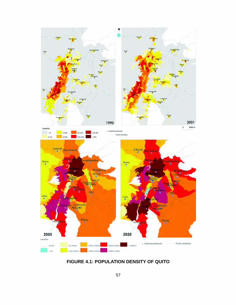
FIGURE 4.1: POPULATION DENSITY OF QUITO
57

FIGURE 4.2: PROJECTED DENSIFICATION OF QUITO
(Barrera Guarderas; MDMQ and DMPT, 19)
TABLE 4.1: PROJECTED DENSIFICATION OF QUITO BY 2025
POPULATION 2009 2025TOTAL 2, 156,336 2, 736,638CITY 1, 546,762 1, 469,436
SUBURBAN 609, 574 1, 267,202(Barrera Guarderas; MDMQ and DMPT 91)
According to his data, Quito's population will continue to grow at a rapid rate, but the
suburban area will become denser while the population that lives within the city will
actually decrease. This phenomenon represents serious problems not only in terms of
connectivity, transportation, and mobility, which are already being addressed by this
plan; but also in environmental and social terms. Quito's mono-centric growth is not
conducive to long traveling distances. Services and infrastructure are mostly
concentrated in the center and hyper-center of the city, although, a big percentage of
58

the population needs to have access to these areas almost daily. In the PGDT several
strategies have been set out to achieve this much needed change from mono-centric
structure to a multi-centric one. According to Urban Planner José Atiaga, Quito's
excessive expansion is expensive, represents a threat against hillside stabilization,
increases impermeable surfaces and drainage areas, and also increases vehicular
pollution (Atiaga, 5). Several other negative consequences will result from expansion,
such as the building rural agricultural land and decreased sense of community, due to
reduced human interaction.
FIGURE 4.3: CONCENTRATION OF SERVICES AND INFRASTRUCTURE
(Barrera Guarderas)
On top of the population's growth and the horizontal expansion of the city, Quito is
reaching the spatial limits of its geographic location. There are two prominent mountain
chains located to the east and west side of this capital city that act as boundaries, and
different ravines and rivers that contain it to the north and south. The totality of this land
is already developed, some of it built to its maximum capacity in Quito's center and
59

hyper-center, and the rest is part of the suburban development which will be denser in
the near future.
FIGURE 4.4: QUTO'S LAND CATEGORIZATION
60

In the previous map, taken from Quito's Planning Department's website, is evident
how space is lacking and how the city is growing in density. Land is divided into
developed, developable, and undevelopable. Developed land represents the area that
was already developed by 2000 and was going to be adapted in order to fulfill
population's demands until 2010. Because of rates of growth and the manner in which
the land has been occupied, this adaptation can be seen as exploitation of the land.
Developable land represents the region to be developed until 2020 to supply new
demanded infrastructure. As seen on the map, this land does not represent a large
area; but, because of a denser development, it should be enough for the upcoming ten
years' growth. Undevelopable land is basically comprised of natural areas that should
be preserved and unsafe regions such as ravines, steep slopes, ridges, mountains,
hillsides, etc (MDMQ and DMPT, 32-34).
To keep Quito from growing and to limit immigration is a nearly impossible task.
Ecuador has very few large cities and, as an inevitable trend, people move to places
where there is a possibility for better life, hence, to cities that act as economic catalysts.
Additionally, Quito may not be Ecuador's largest city; but is the country's capital city, a
characteristic that gives it an intrinsic importance and prominence. Therefore,
regulations about population growth and immigration, as well as providing it with other
city centers and making Quito multi-centric, can be long term solutions. But in the short
term, population is inevitably exponentially growing and the new demands need to be
fulfilled.
Quito's Planning Department has defined a new pattern of development in the PGDT
valid until 2020. Currently, Quito is guiding its development towards the re-concentration
61

of the urban sprawl. It is mentioned that the city needs to be compacted. There are
several reasons that make this idea so appealing. The expansion of the urban fabric
has affected the economy, sustainability, quality of life, and governability of the city. By
compacting it, energy expenses, utility expenses, and the development of agricultural
land and natural resources will be reduced. This new pattern will also make it easier to
provide basic services and utilities to citizens, preserve natural areas, and create places
where people can interact, relate, and inhabit (MDMQ and DMPT, 31-32).
When comparing Quito's 2003 and 2005 Land Use Plans, it is evident how more
density is allowed in urban centers and how the urban sprawl keeps growing. It is visible
how natural areas are changed into low density residential areas, low density residential
into medium density, and from medium to high. Some areas of the city that were already
high density residential now allow multiple uses, and agricultural land is being mixed
with residential as well. Most of these changes occur towards the eastern side of the
city, the valleys. This trend needs to be cut short in order stop developing agricultural
land and support the compaction of the city (DMPT 2003) (DMPT 2005) (CMQ 2006).
From the housing and residential perspective, Quito's development is facing serious
problems. Lately, and because of the previously mentioned conditions, Quito has seen a
predominance of high density projects like apartment buildings and townhouses.
Unfortunately, this type of growth segregates population and limits the ability to provide
public spaces because the few open areas left are occupied by them. Another important
problem that the city confronts is the increase of illegal settlements in the periphery,
near preserved ecological areas (MDMQ and DMPT, 22-23). In fact, Quito has 356 legal
and constituted neighborhoods, 82 approved subdivisions, and 357 informal and illegal
62

settlements (DMQ 2008). This means that about fifty percent of the houses are built
without the direction and supervision of professionals in the construction and design
fields. Most of these structures are located in dangerous areas of the city, classified as
undevelopable, and represent a threat in case of natural disasters such as, volcano
eruptions and earthquakes, both recurrent phenomenons in Quito. It is proven that,
despite the high density residential projects that provide houses within the city, illegal
settlements around it keep increasing. According to Architect and Urban Planner José
Atiaga, Professor at San Francisco de Quito University, this happens because the
housing supply caters to middle and upper classes, and not to the low income class.
There is enough housing in Quito; but it is not correctly directed. People who have a
house are being offered another; but people who need a house cannot find one that is
affordable.
TABLE 4.2: HOUSING TYPOLOGIES IN QUITO
TYPOLOGY URBAN SUBURBANHOUSE – VILLA 30.30% 66.70%
APARTMENT 49.00% 15.10%OTHER 20.70% 18.20%
(INEC)
This table, elaborated with data from INEC's 2005 and 2006 census and survey,
shows how housing is divided in Quito into different typologies. As current trends
promote high density, the percentage of apartments will increase in both regions of the
city, urban and suburban (DMQ 2005-2006).
The PGDT mentions the need to promote and facilitate a constant supply of
urbanized land, while considering the different necessities and family types within the
63

demanding population. Several strategies are proposed in order to accomplish this goal
and also contribute to the compaction of the city: densification of Quito's center and
hyper-center; occupation of existing vacant land within the consolidated urban fabric;
regeneration and reprogramming of underutilized land; improvement and renovation of
existing housing projects; provision of new housing projects through rehabilitation and
construction; and the development of projects through citizen participation in order to
strengthen the sense of community and achieve a long term commitment (MDMQ and
DMPT, 60-61). Furthermore, the design and construction of holistic and integral housing
projects that allow sustainable use of land, improvement of public spaces, increase in
quality of life, and embellishment of the urban image, is requested and urged (MDMQ
and DMPT, 24-25). These projects can provide guidelines and principles for other
housing projects and also set an example for future development, not only in Ecuador;
but in other Latin American countries too.
The inclusion of green areas in housing projects in Quito can have several benefits
within the project and also help provide solutions for issues that affect the city as a
whole. Housing projects become static and ineffective when they are not accompanied
by spaces that allow the development of human activities (Atiaga, 6). This city, because
of its consolidated urban fabric and the necessity for high density, lacks green spaces
necessary to create a healthy environment. Spaces required for human interaction,
recreation, and reinforcement of the sense of community are missing.
In 1993, a newspaper published the opinion of several professionals in different
fields regarding Quito's growth and urban development. A historian said that Quito
should preserve the existing forested hillsides because, otherwise, instead of being
64

surrounded by a perimeter fence of trees that provide a beautiful vista, the city will be
limited by a fence of aesthetically unpleasant housing projects. An architect commented
that during its development, Quito had no defined boundary for years and, during this
period, urbanization was allowed in areas that should have been preserved. Finally, an
urban planner made clear that throughout Quito's development, authorities should have
set aside land destined to become green recreational areas. But instead, part of this
land was devoted to projects of social character and the rest was sold to private parties
(Albornoz Tinajero). This information makes evident that these concerns, regarding the
lack of green public spaces and the preservation of natural areas in Quito, have been
present within the public and professional realm for more than 15 years.
Another newspaper article published in “Diario Hoy” in 1994 reveals the population's
concerns not only towards the quantity of green public spaces; but also the quality of
the few existing ones. It explains how kids spend more time in front of the TV than
outdoors because public spaces for recreation are not maintained and seem more
detrimental than beneficial. Most of the small neighborhood parks either serve as a
place to store construction materials or host unauthorized structures. After reporters
talked to Quito's Parks and Recreation Department, they came to the conclusion that
there are two types of parks in the city: the prominent large open areas that are
maintained by the authorities because they contribute to Quito's image, and the small
neighborhood parks that are not considered important and are often not maintained.
According to Quito's Parks and Recreation Department representative, there are no
resources to maintain and supervise all public spaces in Quito, so they have focused
only on the important and prominent ones. By the end of this article, there is a call for
65

private involvement. It is believed that the lack of public resources can be alleviated
through private cooperation in order to save and protect the few green spaces that are
left in Quito (Hoy 1994).
Quito's authorities have been actively working on providing and improving green
spaces since the beginning of this century (Hoy, 2004). In 2004 a goal regarding green
areas and all the strategies to achieve it were explained in a newspaper article.
Municipalities of Ecuador's two largest cities -Quito and Guayaquil- are trying to provide
5 square meters of green space per inhabitant. Currently, Quito has only 50% of this
required green area. The city provides 9 thousand hectares of green spaces to its
citizenry when the number should be as high as 18 thousand hectares. Due to this data
and the concern it aroused, a reforestation project was started in Quito in 2002.
Through this project, 3.5 million trees have been planted throughout Quito's major
parks. Fernando Velasco, the project manager, says that this is just the beginning, but
not enough to reach the five square meter goal for which, according to him, 6 years and
7 million trees are needed. Velasco also talked about the problem with maintenance that
was already a concern in 1994. He explained that even if green areas are built and
already there, it is extremely hard to take care of them and make people care.
Authorities think that the solution to this problem is to have community members
actively involved and constantly participating in maintenance labors (Hoy 2004).
As a consequence of environmental and social concerns between 1993 and 2004,
translated into worries about quantity and quality of green areas, the need for more and
better recreational spaces has been revealed. From this important discovery, in the
PGDT, developed mostly in 2000 and updated every 5 years, the need to provide more
66

green public spaces and improve the existing ones is mentioned; but there are no
proposed strategies or plans on how to achieve this goal. The only new noticeable
project that addresses this aspect is the Bicentennial Park and Convention Center that
will take over the soon to be vacant land once Quito's airport moves to its new location.
The current airport is situated on top of 130 hectares in the core of the north of the city.
FIGURE 4.5: GREEN AREAS IN QUITO (MDMQ and DMPT)
67

Although authorities, prominent professionals, and the general public have spoken
out about this topic, projects in Quito remain conceived and built with no consideration
for environmental and social matters. Recently, 25 hectares (61.77 acres) of mature
eucalyptus forest were cut down to clear a site for the construction of a residential
project. This project is comprised of 760 apartments of 88 square meters (947.25
square feet) each and is large enough to be built by 4 different construction companies
at the same time. Diario Hoy mentioned that the municipality sold this forested hillside
to the private sector when, as mentioned in 1993's article, it should probably have been
preserved in order to provide a clear boundary for the city and beautiful vistas. The
project manager says that they have all the paper work in order and, in fact, Quito's
Department of Environment is supervising the project to make sure that noise, dust, and
contamination produced by the construction site complies with regulations. People in
the neighborhood already complain about the negative effects of this project even
though it is still under construction. The observations include the sliding of hillside soil
that clogs the sewer system around the area, inconvenience because of road
construction, increase in vehicular circulation, and risk of floods (Hoy 2010).
FIGURE 4.6: HOUSING PROJECT ENVIRONMENTAL IMPACT (Hoy 2010)
68

Nivel de confort, or comfort level in Quito, based on housing conditions, was
revealed through a study by Quito's Planning Department in 2006, which compares
housing conditions in 1990 and 2001. According to the data provided, the comfort
situation has improved considerably between these years. Since 1990, more houses
have been provided with electricity, land phone, water, and sewer system and also
building materials and overcrowding have improved (DMPT 2006). Strangely, something
that is not considered in this study, but has an important influence in comfort and quality
of life, is the accessibility to recreational areas and green spaces. As long as the
authorities do not consider this parameter as influential for the quality of life, it will not be
a concern for future development.
Considering that the construction of high density residential projects in Quito is
currently at its peak, it is important to provide a viable, clear, and efficient solution to
approach the creation of quality green recreational spaces and the provision of housing
projects at the same time.
Contemporary case studies
The case studies presented in this chapter represent the solutions that are currently
provided for the housing and green space demand in Quito. Two different high density
residential typologies, apartment building and townhouses, represent this development
and are analyzed in this section of the thesis.
1. Apartment buildings: Parque Real.
Background information:
Parque Real is a project designed and built by Uribe & Schwarzkopf. "Uribe &
Schwarzkopf was established in 1973 as an architecture firm that understood the
69
housing needs in Quito at that time" (Uribe and Schwarzkopf, 15). After just a few years
of practice, they say, "we deepened our approach and specialized in housing for the
middle class. Our designs became more technical and more functional, always bearing
in mind the needs of the clients and their purchasing power" (Uribe and Schwarzkopf,
15). This company is representative of Quito's urban growth because it builds a large
percentage of the housing projects in the new development. They have achieved
accountability and continuity by taking control of the entire process, from conception of
the project to execution and construction. They plan, promote, and build apartments,
commercial space, suites, and some single-family houses.
According to an electronic article, Uribe & Schwarzkopf is different from other
architectural firms because of the way they commercialize their projects. They offer
financial deals through different means which gives their customers several convenient
opportunities and possibilities of purchasing. This firm is the only one in Ecuador that
has built more than 200 projects in 34 years; it employs directly and indirectly more than
2 500 people per year providing stability and a professional future for many of them; and
it was also the first architectural firm to actually build a smart building in Ecuador. All of
the previous facts provide evidence of the size of this company and also emphasize its
prominence and influence in Quito's urban development (macrovisionmedia).
The site where the case study is located has an area of 22,721.85 square meters
(244,583.96 square feet) and was previously an industrial site occupied by a textile
factory. It was "a run-down industrial district, laden with smoke and heavy traffic” (Uribe
and Schwarzkopf, 16). Parque Real consists of 12 towers, 846 apartments, 60
commercial premises, 2 office towers, and a hotel. The total built-up area or the project
70

is 103,912.73 square meters (1,118,543.91 square feet) ( (Uribe and Schwarzkopf, 111).
The design process took from 2001 to 2005 and construction is still not finished, 12
towers have been erected and 3 are still under construction. Some of the completed
towers are already inhabited and the entire project is expected to have “4,000 people
living in it” (Uribe and Schwarzkopf, 17).
71

72
FIGURE 4.7: PARQUE REAL AERIALAerial showing the location of Parque Real and its surroundings

73FIGURE 4.8: PARQUE REAL CONTEXT DIAGRAM

74
Inside Parque Real - Green areas not enough for inhabitants. Not enough depth of soil.
Parque Real from the outside - Out of scale compared to surroundings. Perimeter plazas sporadically used.
FIGURE 4.9: PARQUE REAL DIAGRAM AND IMAGES
Plazas

Findings:
Parque Real is built to its maximum capacity and the few open areas left have been
used for landscape and hardscape. The design includes a "perimeter that merges with
the public space. Small plazas are meeting points in the ensemble” (Uribe and
Schwarzkopf, 111). These plazas work to a certain point: during the day they are used
mostly by general public, since the two adjacent avenues are main thoroughfares with
public transportation; but at night they are abandoned. Commercial activity around the
courtyards stops after office hours so there is no attracting factor, therefore, project
dwellers stay in their apartments and enjoy the so yearned for privacy and isolation after
an exhausting day of work.
On the other hand, green spaces within the project seem nice and large; but are not
enough for 4,000 people. These areas are probably underutilized because no
landscape architect was included in the design team, therefore, they have been
relegated to be the leftover space managed by the gardener. Additionally, this housing
project has a very large underground level below the entire site, leaving no soil depth to
work with in the landscape design and plant selection. Despite the previously mentioned
characteristics, an interesting programming element that this project includes, usually
not included in other projects, is the possibility for general public to enjoy a part of it.
Parque Real provides an interesting approach to the private / public dichotomy.
Finally, the architecture of these apartment buildings provides a barrier and it is a
good attempt to filter pollution. With these tall and massive buildings, the polluted air
and noise from adjacent primary streets is perceived in a muffled way. Due to the
prominence of the structures and the chosen materials, these buildings provide identity
75

to the neighborhood and its inhabitants. Despite these two positive aspects about the
infrastructure, when examined in context, Parque Real provides no consideration to its
surroundings; it is totally out of scale and blocks views and air circulation to its
neighbors. Additionally, the physical indoor/outdoor relationship within the project is null;
it is limited to visual.
Overall, the project is a good attempt to improve the quality of life; but it appears to
do a little here and there, but not enough as a whole. Environmentally, green areas are
definitely not ideal; but they are a better than what is usually provided in other
apartment complexes. Even though these areas lack environmental functions, they help
just by not being impermeable surfaces. Socially, Parque Real provides an identity, but
no sense of community. Neighbors do not know each other. Even though spaces for
recreation and interaction are provided, they are not used and as a consequence,
human relationships are weak. Aesthetically, these towers have a strong character,
which could be beneficial or detrimental, depending on the point of view. In this case,
the fact that it provides a clear image and identity is a positive thing. Finally,
economically, the housing project has been very profitable, due to certain conditions,
such as configuration of the apartments (area vs. number of rooms), mixed uses, lack
of soil depth, investments in plant materials, and maximized profitable areas.
2. Townhouses: Génova.
Background information:
Génova is a townhouse project design by architect Roberto Villacreses. The 88
houses are targeted towards the mid to high economic statuses. On the site where
Génova is currently located, there was previously a beautiful house with a wooden
76

structure, slate roof, children's playground, BBQ area, and surrounding mature pine
forest. It had a pleasing rustic feeling and look. The owner decided to sell his property
and move to the new suburban development in the valleys because zoning ordinances
changed. Now all the houses in the area are also being sold and turned into high
density housing projects (Arteaga).
The architect, by completely clearing the site for the new development, revealed that
environmental concerns did not represent a priority. In the design process of this
project, landscape architects were brought in after all the built structures were finished.
They received a master plan that showed the house footprints and a delineation of the
areas destined to be green spaces. In Quito, a project with these characteristics is
required to have a minimum of 8% of the total area as recreational green areas.
Obviously Génova was built to the site's maximum capacity with profitable saleable
space; therefore, the process of designing the open areas required plenty of creativity. It
was basically turning leftover space into pleasing, fun, and interesting areas (Arteaga).
Ricardo Arteaga, the landscape architect, and his team of designers worked on
Génova during the first three months of 2004. The landscape project comprised
retaining walls, small recreational area, BBQ area, playground, workout circuit, planters,
hillside, and pavement patterns for pedestrian, vehicular traffic, and parking spaces. The
implementation of this design took 2 years, during which many changes were made to
fit budget requirements. Once Génova was completely finished, Arteaga left a
management and maintenance instruction booklet for use by the gardeners or the
gardening company to be hired. Although information was made available, it has not
been used or followed (Arteaga).
77

78
FIGURE 4.10: GÉNOVA AERIALAerial showing the location of Génova and its surroundings

79FIGURE 4.11: GÉNOVA CONTEXT DIAGRAM

80
Génova - Presence of steep useless hillside and other defi cient green areas. Eco-Pavers used to make the project look greener. Mature pine forest was cleared in order to build this project.
FIGURE 4.12: GÉNOVA DIAGRAM AND IMAGES

Findings:
Génova is a residential complex that provides examples of positive and negative
aspects of the current high density development in Quito. One of the aspects worth
highlighting is the strong sense of community, despite the lack of identity. This typology,
more horizontal than apartment buildings, provides more opportunities for human
interaction and the creation of relationships. In this project, neighbors know each other,
their kids play together, and they are always attentive and helpful. Another positive
aspect, mostly because of location, is how connected all these people are to the rest of
the city. Even though the fact that the project was developed towards the northern part
of Quito, the proximity to a big multi-modal station it makes easy for the residents to
move around the city.
On the other hand, the lack of green spaces is evident. The large hillside towards
the edge of the property is so steep that it becomes useless and inaccessible for
residents as a recreational space. The only green area that could be used for recreation
is right next to Quito's perimeter highway. Pollution produced by vehicular traffic can be
perceived in the project due to the lack of a green area that could act as a buffer.
Furthermore, the other green spaces are a product of the use of Eco-pavers. All parking
spots in the project are paved with material that allows groundcover to grow. When
there are no cars parked, it looks green, but once everybody is home it becomes a
regular parking area.
Private and public dichotomy in this project is difficult to analyze. There is lack of
privacy, but at the same time, it contributes to stronger community bonds. Moreover, the
projects surrounding Génova follow the same typology and pattern. There are several
81

townhouses in the area and they all contribute and emphasize the public character of
life in high density residential projects.
Comprehensively, Génova is a successful project in terms of community.
Environmentally, it definitely has a deficit in quality and quantity of green recreational
areas. Notably, the destruction of a mature pine forest, that belonged to a villa-like
house, reflects the blindness of architects and planners towards environmental
practices. Socially, as mentioned before, this townhouse project allows a strong sense
of community through human interaction. Aesthetically, it looks like the neighboring
projects. It definitely does not provide a distinct image to which people can relate and
identify with. Ultimately, referring to the economic aspect, Génova has evidence of
being a profit-oriented development; therefore, it was an economic success for its
developers.
82

83
FIGURE 4.13: LOCATION OF CONTEMPORARY CASE STUDIES WITHIN QUITO
Historic Case Studies:1. Mejía House - Colonial Downtown2. Café Cultura - Early to Mid 20th Century Expansion3. Casabella - Late 20th Century Vertical Growth4. La Viña - Current Suburban Development
Contemporary Case Studies:5. Parque Real - Apartment Buildings6. Génova - Townhouses
1
2
3
4
5
6

Opportunities for intervention
Quito's position as the capital city of Ecuador makes it an economic catalyst and
continues to attract people looking for job opportunities and better quality of life. The
population is and has been rapidly growing, and immigration to this city is difficult to
regulate and control. The increase in inhabitants has lead to the replacement of most of
the single family houses with big yards developed in the early to mid 20th Century, as in
Génova's case, with high-density residential projects. These projects are designed from
the perspective of investors and developers and have consequently decreased the
amount of green open spaces in these neighborhoods. On the other hand, people
located in suburban neighborhoods are forced to drive and deal with traffic for extended
periods of time every day. They have several advantages that the suburb provides, such
as immediate access to green spaces and reduced pollution and contamination; but
there is also a down side which is having to commute long distances so frequently.
The reality is that Quito is a large city with contradictory demands. The growing
population demands housing and equipment infrastructure as well as green open
spaces and quality of life. Both are required in close proximity so that they can be
immediately accessed to avoid long traveling distances. Development is moving
towards the compaction of the city and the configuration of live-work spaces. Therefore,
the fact that there are not enough public green spaces in Quito seems more worrying
and serious. However, and as a result of this lack, the quality of the existing spaces is
inadequate. The available acreage is not enough to supply current populations needs
and land is not used for environmental purposes. Because of Quito's consolidated urban
fabric, it is very difficult to expropriate extensive land in order to build parks and create
84

public open recreational spaces. As a result, Quito must rely on private green spaces to
fulfill the current population's needs and societal expectations regarding healthy
environments that will contribute to a better quality of life.
As Quito runs out of space and the population keeps growing and demanding, it
seems that the only solution to supply all the needed infrastructure and open spaces is
high urban density. Although there are several ways to approach the problem of urban
development within the city of Quito, this thesis focuses on high density residential
projects as the most practical and rational approach.
Based on the two high density residential projects previously analyzed, it can be said
that housing development in Quito is currently profit-oriented. Because of giving too
much importance to the economic aspect, new projects are sacrificing the quality of
spaces and the quality of life that develops within them. Furthermore, designs are also
sacrificing the environment and threatening Quito's sustainability by cutting down forests
and replacing them with impervious surfaces surrounded by open spaces with no
environmental function.
High density residential projects are seen as an opportunity to bring private green
open spaces to a consolidated city, like Quito, while supplying it with housing and other
needed infrastructure; hence, setting the stage for values to regain the right proportion.
This approach to high density housing is not a new theory; it has been addressed
before and is a universal concern. There are many documents and examples on how to
achieve this goal; but none, however, are site specific to Quito, considering geographic
location and demographics.
85

CHAPTER 5
INSPIRATION
Global conditions
The lack of green spaces in consolidated cities is a concern all around the world.
There are several designers as well as authorities, investors, and developers that
recognize this concern as a major issue. It has not only involved aesthetic issues but
also health, sustainability, community, and future development. "Managing the
environmental quality of large cities is already proving a tall challenge, from the vast
squatter settlements of Lagos, Nigeria, that lack clean water and sanitation to the smog-
generating traffic jams of Los Angeles" (Daniels). Each city has its own problems; but
despite their differences, all of them are facing troubled realities that necessitate growth
towards the creation of more livable and enjoyable spaces. "Cities must prove to be a
winning alternative for healthy places to live; they must promote social harmony; they
must demonstrate a valid role in national economic security" (Daniels). Cities must be
efficient in every aspect: social, economic, aesthetic, and environmental.
Contemporary large cities have failed to fulfill current people's needs. Previous
development did not foresee today's conditions; therefore it was not planned
contemplating future possibilities. Due to growth lacking sustainability principles, cities
86

have reached a point where there needs to be a fundamental change in principles for
development. "In order to truly reduce our carbon footprint, Americans must shift from
car-dependent, metropolitan areas comprised of specialized districts to complex,
vibrant, mixed-use urban environments where jobs, shopping, entertainment, and
housing are intermixed and are fundamentally oriented around transit and pedestrians"
(McCullough). Latin America and developing countries, including Ecuador, have a
tendency to see developed countries as role models. In this case, the carbon footprint
situation in South America is not as bad as in the United States. So the undesirable
developmental pattern applied in North America, which developing countries have
adopted as model, should not be followed any further. These countries should jump
ahead and start applying the solution before the problem is worsened.
Density “is a sustainability silver bullet, providing across-the-board reductions in per-
capita resource use. These reductions occur in proportion to increasingly development
density. Even better, this same density silver bullet provides local, regional, and global
benefits" (Farr, 103). The need for density is not only manifested in the United States;
but several countries around the world have also stated this concern or have already
implemented this development pattern:
As metropolitan regions continue to expand across the globe, signs increasingly
indicate that the current spatial forms and organization of metropolitan landscapes
are becoming less sustainable and more vulnerable to change because of larger
environmental trends such as global warming, fossil fuel depletion, and biodiversity
87

loss. Translational research that involves scientists, landscape architects, planners,
and engineers will be crucial for guiding best practices in sustainable development
toward the goals of metropolitan landscape sustainability, resilience, and
regeneration (Musacchio, 5).
There is “an economic hypothesis that gained much currency in the 1990's by
suggesting that economic prosperity initially leads to environmental decline, but
eventually a self-correction mechanism leads to environmental controls" (Ali). Now that
it is understood that "a quality environment produces jobs, whereas a polluted
environment destroys them" (Daniels), the presence of "environmental, economic and
social (equity) sustainability" (Daniels) is valued and much needed to secure a viable
future for current developing cities.
Remedial approaches
In order to help remedy the lack of quality spaces and sustainability in large cities
several techniques and small-scale interventions have been done such as: rain-
gardens, bio-retention areas, energy efficiency to waste reduction, solid waste disposal,
brownfield redevelopment, rain-water harvesting, urban agriculture, neighborhood
beautification, sensitivity to natural features and urban ecosystems, etc. Yet there are
some other deeper attempts to solve these problems. These attempts have become
trends and styles with their own guidelines and set of design principles.
Some of these trends or design movements are:
• New Urbanism: "Proponents argue that unlike recent urban forms, New
88

Urbanism integrates traditional urban morphological characteristics to create
vibrant, pedestrian-friendly communities that have a relatively low environmental
impact. Although carried out in a variety of ways, New Urbanism is often
implemented through traditional neighborhood developments, which include high
building densities, mixed uses, grid street patterns, narrow streets, and short
setbacks" (Conway). This movement has been highly criticized; but it constitutes
an attempt to solve current urban problems.
• Landscape Ecology: "Design from the ecologists' perspective is usually used in
the context of the creation of reserve systems for biodiversity and/or specific
wildlife species. Landscape architects and planners design for wildlife in relation
to human needs and other environmental concerns (eg., water quality, visual
quality, and recreational access)" (Musacchio, 2). By uniting these two
approaches to design, Landscape Ecology is another movement concerned with
current environmental quality in large cities.
• Landscape Urbanism: “is an interdisciplinary approach that, in theory,
amalgamates a wide range of disciplines including landscape architecture, urban
design, landscape ecology, engineering, etc, It is also committed to addressing
the many challenging issues and conditions facing contemporary cities" (Livesey,
45). An interesting aspect of this movement is how landscape urbanists "allow for
a general design to evolve over time, rather than existing as a static pictoral
composition" (Livesey, 47).
89

• Sustainable Urbanism: “is walkable and transit-served urbanism integrated with
high-performance buildings and high-performance infrastructure.
Compactedness (density) and biophilia (human access to nature) are core values
of sustainable urbanism" (Farr, 42). This trend shares interests and concerns with
all of the above.
Negative aspects of current urban development have been identified. “Sprawl is
environmentally destructive, socially segregating, and economically dependent on
cheap, plentiful, and imported energy” (Daniels). Therefore, urban density is presently a
popular subject. All the previously mentioned theories on how to improve current
unsustainable cities have considered it as a method of reaching sustainability. Dealing
with density is not a simple task. As a response to current city configuration the word
density has a negative connotation. Furthermore, "the words 'high-density housing'
conjure up images of closely spaced highrise apartment towers with a consequent lack
of daylight, reduced open spaces, and blocked views. Even at medium and lower
densities, there is little public awareness of the different potential configurations of
buildings and their impact on streets and neighborhoods" (Ellis, 36). This image
immersed in people's minds has inspired designers' imagination and creativity in order
to achieve density and sustainability without sacrificing quality of life.
Quality of life can be altered by improving environmental, social, aesthetic, and
economic aspects of projects. Designers like the architects Ken Yeang and Arthur
Erickson provide some examples of the combination of density and quality.
90

Yeang is originally from Malaysia, a country that, compared to Ecuador, has about
thirty percent more area and more than twice its population. This may have been the
reason why this architect started researching green skyscrapers as early as the 1980's.
Malaysia is a country that has found a way to a more stable economy, which moved it
from the developing country to newly industrialized country category. Several similarities
can be found between Ecuador and Malaysia; but it seems Malaysia is a little ahead on
the path. So analyzing a successful architect that is a figure not only in his country but
internationally can be helpful for the purpose of this thesis.
Erickson is an architect that influenced and helped Vancouver in its process of
becoming a city based on sustainable density. This city is a role model for older cities
such as New York and San Francisco. It is a good example of what urban development
should be directed to. Despite the large differences between Quito and Vancouver,
regarding economic, political, and social aspects, it is definitely worth analyzing a city
and its initiator which are both recognized world wide.
Ken Yeang is an associate at T.R. Hamzah and Yeang International. "The firm's
design expertise is in their ecological approach for the design of large projects and
buildings that include consideration given to their impacts on the site's ecology and the
building's use of energy and materials over its life-cycle" (Hamzah and Yeang). This
architect has also written several books about sustainable intensive building. In his
book, Green Skyscraper, published in 1999 he says: "some of the basic premises of
'green' design should be obvious to all, and yet buildings continue to be produced
91

without these premises in mind" (Yeang, 279). He also emphasizes how:
Traditional architectural education, obviously, will have to be modified. Ecology and
environmental biology will have to be included in architectural curricula. In addition,
related disciplines such as resource conservation, recycling, energy and materials
management and pollution control are also germane to ecological design and must
also be taught (Yeang, 282).
Here are some images of projects done by his architectural firm:
FIGURE 5.1: TECH-LINX TECHNOLOGY PARK (Hamzah and Yeang)
FIGURE 5.2: JABAL OMAR TOWERS (Hamzah and Yeang)
92

FIGURE 5.3: EDITT TOWER (Hamzah and Yeang)
Another good example of high-density urban development is Vancouver. This city
has set an example of sustainable density for other densely populated cities such as
New York and San Francisco. In fact, Vancouverism is a relatively new technique
93

influencing urban planning and architecture. It is “a form of social bonus zoning, in
which extra density in housing developments is granted in return for such public
amenities as cultural facilities, parks, schools, and social housing” (Broddy). The
starting point of Vancouver's urban plan is also very different, “rather than create an
overall city diagram indicating where the tallest structures should be, they did the
opposite--they mapped where the view corridors must remain open and not be blocked
by views” (Chappell). So far, several neighborhoods in Vancouver have been developed
with this typology, including False Creek, Yaletown, Coal Harbor, and West End.
Vancouver is also a city pioneer on the EcoDensity Planning Initiative:
EcoDensity is the product of over two years of creative thinking and challenging
public debate on how density, design, and land use can contribute to environmental
sustainability, affordability, and livability. EcoDensity is a Charter that commits the
City of Vancouver and its citizens to address change more proactively and adapt our
city and our way of life to meet the challenges we all face (Vancouver).
Arthur Erickson was an influential architect and designer in Vancouver's process
towards a sustainable city. His concept of architecture reveals his design philosophy
which explicitly states a concern towards people and their surroundings:
Architecture, as I see it, is the art of composing spaces in response to existing
environmental and urbanistic conditions to answer a client's needs. In this way the
building becomes the resolution between its inner being and the outer conditions
imposed upon it. It is never solitary but is part of its setting and thus must blend in a
94

timeless way with its surroundings yet show its own fresh presence (Erickson).
Here are some of his projects:
FIGURE 5.4: PROVINCIAL LAW COURTS (Erickson)
FIGURE 5.5: KING'S LANDING (Erickson)
95
A city that can also be seen as an example, because of its similar condition to Quito,
is Bogotá, Colombia's capital city. Bogotá is a city that has been through an urban
development process analogous to Quito's. In the book “I Saw a City Invincible: Urban
Portraits of Latin America”, the saturation and unhealthy situation of Bogotá's colonial
downtown in the late 19th Century is described:
The streets and plazas of the city are infested with pickpockets, drunks, lepers,
loafers, and even crazy people. Nightfall places everything sacred at the exclusive
disposition of crime and vice. Incredible scenes take place only a few steps from the
door of the cathedral. (…) The material decay goes hand in hand with moral decay.
The state of the streets, with their piles of filth, is suitable only for guaranteeing
unsanitary conditions. The water service or supply is such that the houses that
should get water will quickly depreciate after being burdened with a tax favoring the
bricklayers and plumbing. Street lighting, except on a few commercial streets, comes
from the moon (Joseph and Szuchman, 106).
From this point, the city's expansion was inspired by the necessity for cleaner, healthier,
more enjoyable spaces, close to the countryside and undeveloped land.
The suburban development of the early to mid 20th Century took place and "the pace
of urban growth accelerated with the development of motorized transport and
particularly when private car ownership exploded in the 1970s. Gradually, the urban
area spilled across Bogota's administrative boundaries. (...) Since then, the city has
again spread beyond its boundaries" (Gilbert, 249). A major difference that this city's
96

development has with Quito's is the creation of new centers, the evolution from a mono-
centric to a plural-centric city. "New sub-centres have also emerged, many located
around shopping malls (...), others connected with office developments (...), new
transport termini (...), and wholesale market centres (...). During the past twenty or thirty
years, the central area's dominance has declined sharply" (Gilbert, 250-251). Despite
this major difference though, Bogotá has faced, during the latest urban development,
the same issues Quito is dealing with now.
Alan Gilbert, in 1996, analized Bogotá and identified the city's most important urban
problems. "(Bogotá) has a serious housing problem and far too many families live in bad
accommodation" (Gilbert, 251). This condition was worsened by the rapidly growing
population that most Latin American cities had to deal with, therefore, “most low-income
settlements are developed through illegal processes. Between 1935 and 1985, 31 per
cent of all housing was built on land that was developed illegally" (Gilbert, 253).
Another problem identified by Gilbert is pollution. Apparently, environmental
conditions in Bogotá during the late 20th Century were decadent. Water, air, and noise
pollutions were reaching unlivable levels:
The level of pollution affects the health of communities living close to the river and
its tributaries. Sanitary conditions close to the Tunjuelito river in the south of the city
are particularly bad. Since the polluted water is also used for irrigation, all of
Bogotá's people are at risk when they consume milk and vegetables produced near
to the city (Gilbert, 260).
97

The last problem that both Latin cities share is traffic congestion. “The major cause
of congestion is the huge expansion in private car ownership. Between 1977 and 1985,
the number of road vehicles registered in Bogotá and ten nearby municipalities
increased annually by 8 per cent (Gilbert, 260). Although in Colombia's capital, this
problem has already been effectively addressed with the implementation of efficient
public transportation and the TransMilenio. TransMilenio is a rapid transit bus system
that has 9 lines throughout the city and a total of 84 kilometers (54 miles).
Colombian architects, urban planners, and authorities have began to remediate
some of Bogotá's problems through different approaches. Rogelio Salmona was an
architect particularly helpful in ameliorating these matters and he approached these
urban issues through high-density residential projects.
He was a craftsman who wanted to make buildings that add without subtracting and
serve without dominating (..) Like Niemeyer, he worked with the great modernist
giant, Le Corbusier. And like Le Corbusier, modernism for him was a mission, an
impetus to Utopian thinking, a mandate to build transformative buildings that
bettered the lives of those who lived in and among them. Unlike Le Corbusier,
Salmona seemed aware of the dangers of modernism, its power to disconnect the
architect from place and tradition, its frequent contempt for the local and dismissive
neglect of long legacies of material knowledge (Kennicott).
Architect Salmona was the first Latin American to receive the Alvar Aalto Medal,
therefore and eminence in Colombian architecture. He was “a leading proponent of
98

redesigning urban spaces to instill a sense of interaction among residents in the face of
endemic political tension and crime” (Romero). Rogelio Salmona was an architect who
addressed all aspects of architecture, environmental, social, aesthetic, and economic.
Salmona did a vast variety of high-density residential projects that would “sought to
incorporate his buildings into the surrounding landscape” (Romero). He would design
quality open recreational areas for human interactions and provide pleasing aesthetics
that have created a strong identity for Bogotá at the same time. This architect's projects
in Colombia's capital city have not only strengthened the sense of community between
bogotanos, but also have set an example on how to approach improve quality of life
through high-density residential projects.
FIGURE 5.6: MUSEO QUIMBAYA (Durán)
99

FIGURE 5.7: LAS TORRES DEL PARQUE (Hervia)
Recommendations
To conclude this chapter, it is worth mentioning that, on one hand, “greening the city
has become a necessity as an antidote to suburban sprawl, to protect public health, and
to promote economic prosperity and social integration" (Daniels). On the other hand,
cities need to grow in density and not in physical dimension in order to be more efficient
and sustainable. Both, seemingly contradicting theories, actually complement each
other with the common goal of improving quality of life.
100

Since high density has a negative connotation within the public realm, it is important
to change this perception. A compact city can provide every service, space, and
opportunity that current cities provide, but in a more sustainable way. In a dense city, in
addition to all of its benefits, commuting distances could be shorter, pollution could
decrease, the environment could be healthier, walking and biking could be efficient
means of transportation, social bonds could be tighter, sense of community could be
stronger, etc. All of these conditions can be improved with density.
Quality of life has become a large influence in city planning. This component of
urban design needs to be approached from all possible perspectives. It should follow
people throughout the day: at home, work, recreation places, and along the way; and it
should cover all four values that have been repeated along this thesis: social, economic,
aesthetic, and environmental. Although a holistic approach is needed, only residential
design in Quito, Ecuador is addressed in this thesis.
Lately, high density residential projects have become a common practice to provide
housing in Quito. As illustrated in the previous chapter, current housing projects' designs
fail to fulfill the population's needs by over-weighting economic values. Although this
type of residential project is presently leading the construction industry, the approach to
values needed for quality of life does not seem to change. Because of these projects'
lack of values' balance and physical dimension, they are affecting not only quality of life
within them; but also quality of life in Quito. Therefore, the most effective way to
ameliorate the living conditions and situation is to improve the design of the projects that
101

makes the largest percentage of construction. In this way, landscape quality in the city
will increase through residential design.
To improve quality of life in high-density residential projects in Quito, some of the
techniques used by Yeang, Erickson, and Salmona can be applied to forthcoming
development:
• Yeang's basic concept of built structures describes his approach to
architecture and surrounding landscape:
Any built form spatially displaces the ecosystem upon which is it located by
virtue of its physical presence and form. Besides this areal impact, the built
form also modifies the climate, which itself is one of the major determining
factors of an ecosystem. The built environment as a system and the earth
with its ecosystems as the environment must both be considered
simultaneously in the ecological approach to design (Yeang 1995, 189).
Yeang also presents innovative and modern aesthetics which provide
inspiration for creative ways of providing greenery within a project.
• Erickson's way of conceiving density and the success of Vancouver should
also be considered when designing in Quito. Vancouver's view corridors have
been a prominent element in providing good quality of life. Density should
neither inhibit vistas nor obstruct open green spaces.
• Salmona's holistic approach to design should be set as role model. With his
architecture and especially high-density residential projects, he improved
102
several aspects of a decaying city. He provided an identity for Bogotá with his
aesthetic approach, ameliorated environmental issues throught the provision
of green spaces and high density, and addressed social aspects without
ignoring the economic factor.
The residential aspect of Quito has been researched, analyzed, and improved
through a set design principles and application in this thesis. The principles have
considered the universal trends and examples provided by other countries and
explained in this chapter.
103

CHAPTER 6
DESIGN PRINCIPLES & APPLICATION
Design principles
Throughout the development of the previous chapters, some design concepts have
been identified as aids for regaining the lost balance between the values of quality of
life. There are positive aspects in each of the case studies and examples which can be
applied to current situations in order to rebuild the good conditions that they previously
helped create. These useful ideas can be translated into design principles to be applied
in high-density residential projects in Quito, Ecuador.
This thesis presents ten design principles that are a consequence of the combination
of present international urban and landscape design practices and Quito's local
condition. These principles, that seem logical and are common sense, have been
proposed, argued, and used many times throughout the design field. But here, they are
stated and made specific to the previously mentioned location and type of project. The
design principles have been loosely categorized; although, due to their broad nature,
they can overlap and fall into more than one category.
Environmental principles
1. Ecological appropriateness
104

A design should consider and fulfill both nature's and human needs. A project is
required to approach the surroundings in a sustainable – ecological way without
sacrificing human comfort, especially residential projects. Also, ecological
appropriateness comes with the understanding of the contextual environment; therefore,
technology and innovative techniques needed to reach this understanding should be
applied. On one side, high-density residential projects often disrespect topography.
Landforms are, sometimes, deeply altered, consequently disrupting existing
ecosystems. Also, the inappropriate use of plant materials is very common. Existing and
proposed vegetation should work together in order to accelerate and optimize nature's
recovery and future growth after the intervention. On the other side, a healthy and
beautiful environment contributes to human comfort, well-being, and satisfaction. So
high-density residential projects need to provide this environment.
2. Maximized functional green areas
Functional green areas are spaces that, on top of being green and open for
recreation and interaction, serve an environmental purpose. In Quito, spaces with
environmental purposes and ecological practices are not commonly seen. Through the
increase of these functional green areas, Quito's environmental conditions would
improve and pollution would decrease. For that reason, it is important to include them in
future development. In high-density residential projects, specifically, the implementation
of bio-retention areas, rain-gardens, rain-water harvesting, and civic agriculture can be
very efficient. Use of these techniques could also serve an educational purpose. The
105

public would learn about these practices and, consequently, they would become more
popular and used.
3. Pollution reduction
Large cities presently face a state of permanent pollution due to excessive vehicles,
trash, impermeable surfaces, lack of air circulation, etc. Current housing projects do
little to remedy these issues, and set the stage for a significant number of people to live
in contaminated environments. Functional green areas can take care of some water
filtration and infiltration; but air and noise pollution remain unaddressed. High-density
residential projects should try to protect their inhabitants from all types of pollution.
Structures and greenery can be use as buffers to the outside. They can block noise and
promote air circulation or block smog. By using fundamental elements of the project to
accomplish alternative purposes, the overall design can become innovative, out of the
ordinary, and efficient.
Aesthetic principles
4. Increased aesthetic value
Pleasing aesthetics have a strong influence on the sense of identity and community,
and therefore, on quality of life. Enhanced aesthetic value is comprised of several
factors such as materials, colors, style, and context. Materials have different effects on a
projects aesthetics; for example: wood produces a warm cozy image, while steel
produces a cool clean look. Colors have an effect similar to materials; warm colors
produce welcoming, active environments and cold colors produce soothing
106

environments. Style and context are two aspects that should come together. Style
should be chosen according to context; one should complement the other.
Neighborhood beautification, an international trend, should also be taken into account.
In high-density residential projects, aesthetic matters are harder to address. On top of
considering the surroundings, they need to consider their inhabitants' preferences which
can vary in a wide range.
Social principles
5. Inclusive relationship with surroundings
There are two types of relationships between people and their surroundings:
passive/visual and active/physical. Due to Quito's outdoor conditions, the relationship of
quiteños with their environment has been limited to a passive/visual one. Even though
an active/physical relation has been proven beneficial in several ways, in most cases, it
is not practiced. Being outdoor and being active improves physical, emotional, and
mental health. For this reason, the promotion of an active/physical relationship is
necessary. High-density residential projects should provide pleasant outdoor
environments that would inspire people to go outside. A variety of activities should be
provided so that people's interest is maintained. Outdoor spaces could include: sports
courts and fields, BBQ areas, playgrounds, community gardens, walking and biking
trails, educational stations, etc.
6. Enhanced social interaction
Sense of community is a strong influential factor in quality of life. For a community to
107

grow and develop, human interaction is necessary. In Quito, the sense of community
has been affected negatively because of the decrease in human interaction, related to
the lack of places where this can happen. Subsequently, these spaces must be
provided in future development to regain the sense of community that has been lost.
Providing spaces is not enough, it is necessary to ensure their liveliness. A common
tactic to guarantee activity during day and night is to have mixed uses. Plazas with
restaurants and retail shops combined with residential uses are effective. Semi-public
spaces, such as common areas in high-density residential projects, can include outdoor
activities like the ones mentioned under principle 5 to attract people. It is important to
realize that open spaces by themselves are not successful in bringing people together, it
is common interest that does.
7. Private / public balance
A balance between private and public is important to generate good quality of life.
On the one hand, a sense of community and identity are deeply connected to human
interaction and public spaces where bonding happens. Residences and places where
people perform daily activities, on the other hand, need to be private. Semi-public areas
are key to the development of tight human bonds; they are spaces where people can
meet but they are not widely public. When designing, it is important to think of human
activities and provide all types of spaces necessary for their realization. In high-density
residential projects, spatial arrangement and typology can affect private/public balance
and social dynamics. Often, townhouses promote interaction and generate opportunities
108
for the development of neighborly relationships, while apartment buildings are socially
less effective because privacy predominates.
8. Safety considerations
The need to be safe is part of human nature, therefore, safety considerations need
to be addressed when designing. Besides location, alarm systems, dogs, etc. there is
plenty that can be done with the form and design itself. Do not leave dark, shady, left
over spaces, especially at ground level. These spaces provide opportunities for unsafe
situations and they also accumulate trash, unwanted objects, and rain water if not
drained properly. Due to the usual size and conditions of these areas, they become
unpleasant, and useless, therefore abandoned and dangerous. In high-density
residential projects, safety is easier to address because of the presence of a large
number of people. Mishaps are not likely to happen when surrounded by potential help.
However, design should always pay attention to ground level spaces and avoid
awkward left over areas that could represent a threat. If designed carefully, all spaces
could be an opportunity for recreation and interaction.
Economic principles
9. Maximized positive views
Positive views are always appreciated. Offices, houses, and sites with views are
always sought-after because of the positive feelings they provoke. People enjoy being
in them since they inspire calmness, tranquility, and relaxation. All these sensations
have a positive effect on people's behavior, health, and life. Unfortunately, not all places
109

have nice views. This aspect can be tightly related with geographical location and
surrounding structures and development. However, disregarding location, there is plenty
a designer can do in this matter. Views can be created within a project. Attractive
features and natural areas can be immersed in the project, in this way, defeating the
need to resort to external landscapes. High-density residential projects have the
advantage of large sites. Space is an important resource when it comes to designing
accents that will enhance views. Views will also promote the project and will benefit
return incomes and profit.
10.Complementary relationship with context
As explained under principle 1, ecological considerations with the context are
necessary, but social considerations are equally important. Social context should be
considered in every aspect of the design process. Programming, aesthetics, structures'
form, infrastructures' placement, circulation, hardscape, etc. should work towards
supplying what is missing. They should behave as a complement of existing conditions
and also foresee future conditions to complement them as well. This is how high-density
residential projects can provide good quality of life to their inhabitants and also improve
it for the surrounding neighborhood. If the area is lacking recreational spaces, retail,
basic services, etc. they can be provided through the new project. Another matter that is
essential, but difficult to be approach through a private project is transportation.
Connectivity with the rest of the city should always be optimal and projects should
approach and improve this issue as much as possible. If overall conditions are
110

improved, then the project's value will increase.
Projects that provide settings that contribute to a better quality of life can be
designed by following these principles. High-density residential projects in Quito,
Ecuador have more potential to be improved by paying attention to these ten aspects.
Following this section, an application of these principles is developed. This project
represents an example of how they can be used in a particular setting. However, is
important to keep in mind that they can be applied in diverse ways to several projects in
different locations.
Site information, inventory, and analysis
The site where the high-density residential project of this thesis will be developed is
located in the San Rafael area, in “El Valle de los Chillos”. This neighborhood is where
the city meets the suburban development. Because of this condition, ordinances in San
Rafael have recently changed and, what used to be part of the suburban development
is now overbuilt. The land use plan allows the following uses in this section of the city:
residential, multiple uses, equipment uses, and ecological preservation. (Perez)
• Residential: consists of single family houses, small housing projects, and high
density residential projects combined with offices related to neighborhood
services (CMQ).
• Multiple use: refers to residential and commercial use in one structure (CMQ).
• Equipment use: it is comprised of educational, cultural, social well-being,
health, recreational, religious, and public administration facilities (CMQ).
111

• Ecological preservation: includes forests, parks, right of way of natural
features, flooding planes, and protective vegetation (CMQ).
The previous use was mainly residential only allowing single-family houses. Except for
ecological preservation, all the current uses allow taller structures and a higher FAR
than before. The minimum plot size is also smaller (Perez).
TABLE 6.1: PROJECTED POPULATION OF EL VALLE DE LOS CHILLOS
1990 CENSUS 73,894 inhabitants2001 CENSUS 116,946 inhabitants
DEMOGRAPHIC RATE OF GROWTH 4.30%EXPECTED IN 2005 132,601 inhabitantsRATE OF GROWTH 3.20%EXPECTED IN 2010 152,170 inhabitantsRATE OF GROWTH 2.80%EXPECTED IN 2015 171,739 inhabitantsRATE OF GROWTH 2.40%EXPECTED IN 2020 191,309 inhabitantsRATE OF GROWTH 2.20%EXPECTED IN 2025 210,878 inhabitants
(Perez)
Most of the site's immediate context has considerably changed in the past few years.
Buildings and high-density residential projects have replaced large houses and their
yards. Currently, three single-family houses can still be found on the site. It is probable,
based on previous patterns seen in the city, that investors and developers will buy this
land and turn it into a housing project which would not be environmentally friendly. This
site represents a typical case of profit-oriented development; therefore, it provides an
112

opportunity to demonstrate a different way of designing housing projects.
The site's total area is 1.24 hectares (3.07 acres), and the FAR is 50%. Structures
can be 3 stories tall or a total of 9 meters (29.53 feet). Zoning ordinances require a 5
meter (16.4 feet) setback from the street, a 3 meter (9.84 feet) setback from neighboring
properties, and a 10 meter (32.8 feet) setback from the river. The area excluding
setbacks is 0.86 hectares (2.13 acres) (Figure 6.10).
• Figure 6.1 shows the location of the case studies, historic and contemporary,
and also the location of the site within Quito.
• Figure 6.2 shows the site's immediate context and the highly commercial area
nearby. In this area all services can be found as well as public transportation
which provides connectivity with the rest of the city. This figure also shows the
presence of the “Santa Clara” river, which is an attractive feature of the site
and also a river that overflows during rainy periods, apparently during a 20-
year storm event.
• Figure 6.3 explains the site's connectivity and transportation. Major
thoroughfares are located just a block away from it. However, traffic, noise,
and pollution are not as noticeable on site because the access street to it is a
cul-de-sac. A dead-end street always ensures no through traffic, privacy, and
safety. All of these characteristics are reinforced, in this case, by the “Santa
Clara” river.
• Figure 6.4 is a site inventory. Major features have been traced such as
113

structures, hardscape, water features, and major vegetation. Other elements
such as temporary fences, doors, and minor vegetation have not been shown.
Soil survey research indicate that the soil on site is a mix of thick sand and
clay. This type of soil is stable and able to support two to three-story
structures with no problem. The presence of thick sand makes drainage easy,
it naturally takes water to the lowest points which are all located towards the
river without the need of human intervention. Surrounding uses are also
denoted as well as the sun's trajectory. Because of Quito's location so close
to the equator, the amount of sunlight received from the north and south sides
is the same. Therefore, the only important information regarding this matter is
the direction of dawn and dusk which provides orientation of morning and
afternoon sunlight.
• Figure 6.5 is a circulation analysis. Existing pedestrian and vehicular
circulation was traced as reference for future design. Current vehicular
circulation is particularly important because of the required maximum slope
for driveways which is 10%. Current pedestrian circulation on site has taken
place naturally, therefore, it provides paths that common sense and human
comfort have developed according to topography and other site specific
conditions.
• Figure 6.6 is an elevation analysis. The lowest point of the site is about 2,395
meters (7,857.61 feet) and the highest about 2,410 meters (7,906.82 feet)
114

above sea level. The site is a fairly stable hillside, with no high points or low
points within it, just at the borders.
• Figure 6.7 is a slope analysis. The figure clearly identifies three areas with
steep slopes that would need to be respected and remain untouched. Most of
the site's slope is easy to work with and prone to efficient and viable
development. Some of it, because of existing structures, has already been
graded in a reusable way. Consequently, building footprints will need to be
considered during the design process.
• Figure 6.8 presents sections of existing conditions. These sections are an
accurate representation of topography and buildings. Vegetation has been
placed just to identify open green spaces and are not placed precisely where
trees are currently located on site.
• Figure 6.9 is comprised by different images of the site that show existing
conditions and the suburban character of it. There is old and mature
vegetation on site and some trees have grown to an art-like shape providing a
natural feature to be looked at. The generous driveway is also shown, which
is well designed and used often. The old stone water feature is still working
and it can be turned on. The last photo provides an idea of the architecture of
all three structures and particularly the house on the upper portion of the
property.
115

Historic Case Studies:1. Mejía House - Colonial Downtown2. Café Cultura - Early to Mid 20th Century Expansion3. Casabella - Late 20th Century Vertical Growth4. La Viña - Current Suburban Development
Contemporary Case Studies:5. Parque Real - Apartment Buildings6. Génova - Townhouses
Site
FIGURE 6.1: LOCATION OF SITE WITHIN QUITO
1
2
3
4
5
6
116

117
FIGURE 6.2: SITE’S CONTEXT MAP - Aerial of the site and its surroundings.According to the land use map, the immediate context of the site is comprised by residential use, multiple use, equipment use, and natural areas. The site is located at the edge of a highly commercial area that is active all day. The setbacks and fl ooding areas related to the “Santa Clara” river are natural areas to be preserved.
Santa Clara River
Highly Commercial Area
Enclosed Area: Site

FIGURE 6.3: SITE’S CONNECTIVITY AND TRANSPORTATIONPublic transportation and major thoroughfares are located close to the site. Several bus stops can be found within a ten minute walk which provides good connectivity with the rest of the city. The site’s access street is a culdesac that ensures no through traffi c, privacy, and safety which is also reinforced by the “Santa Clara” river.
Santa Clara RiverPrimary Avenues
Secondary Streets Enclosed Area: Site
Neighborhood Roads118

FIGURE 6.4: SITE INVENTORY
119
SINGLE FAMILY HOUSE
HIGH DENSITY RESIDENTIAL
BUILDING
RETAIL
RETAIL
SINGLE FAMILY HOUSE
HIGH DENSITY RESIDENTIAL
COMPLEX
SINGLE FAMILY HOUSE
DEAD END
TO MAIN STREET
EW
FLOOD ZONE(20-year storm)
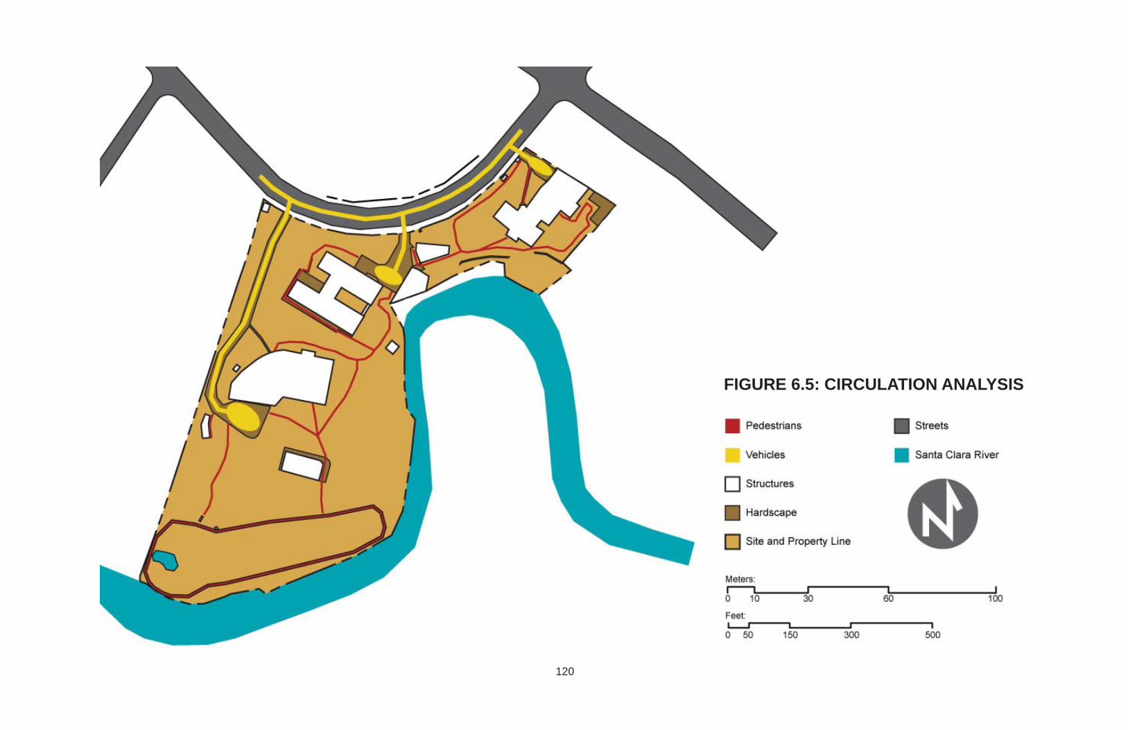
FIGURE 6.5: CIRCULATION ANALYSIS
120

FIGURE 6.6: ELEVATION ANALYSIS
121

FIGURE 6.7: SLOPE ANALYSIS
122

123
FIGURE 6.8: SECTIONS OF EXISTING CONDITIONS
FIGURE 6.9: IMAGES OF EXISTING CONDITIONS
SECTION A - A
SECTION B - B SECTION C - C
Mature art-like vegetation Lower vehicular access Water feature Upper house

Design application
A high-density residential project has been designed on the previously analyzed site.
Regarding the design principles, this project addresses them as follows:
1. Ecological appropriateness: Steep slopes that were found on site are left
untouched and used as features to provide vistas. The existing driveway is
used in order to utilize already graded land. Houses are provided with
garages and cross ventilation for human comfort.
2. Maximized functional green areas: Bio-retention areas are proposed on site
and a list of recommended plants is also provided. Steep slopes are stabilized
with vegetation. Other practices such as solar panels, rainwater harvesting,
and green walls and roofs are recommended for the architecture.
3. Pollution reduction: A vegetated buffer towards the access street is provided.
This buffer also provides privacy for the common grilling area. Buildings are
also used as buffers, they isolate vehicular circulation within the project so
that common and open areas are free of automobiles, noise, and pollution.
4. Increased aesthetic value: The aesthetics of the project are loosely
addressed. It is suggested to make architecture dynamic and, also, apply
sustainable and ecological practices as mentioned before.
5. Inclusive relationship with surroundings: Quality open recreational areas are
easily accessed from any location within the project since they are scattered
throughout the site; and units have two free facades that face open areas,
124

providing views. Both, active and passive relationships are addressed.
6. Enhanced social interaction: To ensure people's presence in common areas,
the design has set the stage for several activities to happen, including a
community garden, children's playgrounds, a grilling area, bio-retention areas
with an educational purpose, and outdoor furniture to provide comfort.
7. Private / public balance: This aspect is approached through the provision of
public, semi-public, and private spaces. Also, this design consists of a small-
scale townhouse project divided into two complexes that would minimize the
lack of privacy that typical townhouses have.
8. Safety considerations: The project can be accessed through two entrances,
pedestrian and vehicular, both of which are designed to be easily controlled.
Useless, small, left over spaces are minimized, and the building configuration
allows neighbors to notice if any unsafe situation is happening.
9. Maximized positive views: Housing units are provided with openings and
views to two sides minimum. Most of them have one natural view, a product
of the site's location and features, and one created or designed view. Through
this method, views have been maximized throughout the project.
10.Complementary relationship with context: Building heights, circulation,
hardscapes, and program are planned considering the contexts. The parking
area and plaza supply usable spaces that the neighborhood lacks. Street
frontage buildings harmonize in height with surrounding ones.
125

126
FIGURE 6.10: SITE WITH SETBACKS

127
FIGURE 6.11: PROCESSThese sketches show steep slopes that were left untouched; illustrate some ideas of outdoor activities; and provide different reinterpretations of the typical patio previously used in Quito’s residential architecture. The patio idea was applied to housing units and public retail area. Ecological and social aspects were considered in the design process.

128
FIGURE 6.12: MASTER PLAN
1. Commercial plaza with restaurants and retail2. Grilling area3. Soccer lawn4. Visitors and pedestrian entrance5. Vehicular entrance6. Building #1 complex7. Building #2 complex8. Biking and walking track9. Water feature10. Playground11. Community garden12. Common area with plaza and deck13. Restrooms
1
2
34
5
6
7
8
910
11
12
13
SANTA CLARA RIVER
A
B
C
A
B
C
Meters
Feet0 5 15
15
30
90
50
1500 45

129
FIGURE 6.13: UPPER AREA
1. Vehicular service entrance for retail2. Eco-paved public parking spaces3. Commercial plaza4. Structure with retail on ground level and apartments on upper levels5. Grilling area with pergola6. Soccer lawn7. Slope stabilized with vegetation8. Backdrop planter for retail venues
1
2
3
4
5
6
7
8
Meters
Feet0 5 15
15
30
90
50
1500 45
SANTA CLARA RIVER

130
FIGURE 6.14: MIDDLE AREA
1. Main vehicular entrance2. Vehicular access to building complex #1 3. Vehicular connection to building complex #24. Housing units building complex #25. Garden with bioretention area and gathering area for building complex #16. Eco-paver access to garages7. Existing restrooms8. Patio shared between housing units (typ)9. Slope stabilized with vegetation10. Main visitors and pedestrian entrance
1
2
34
5
6
7
8
9
10
SANTA CLARA RIVER
Meters
Feet0 5 15
15
30
90
50
1500 45
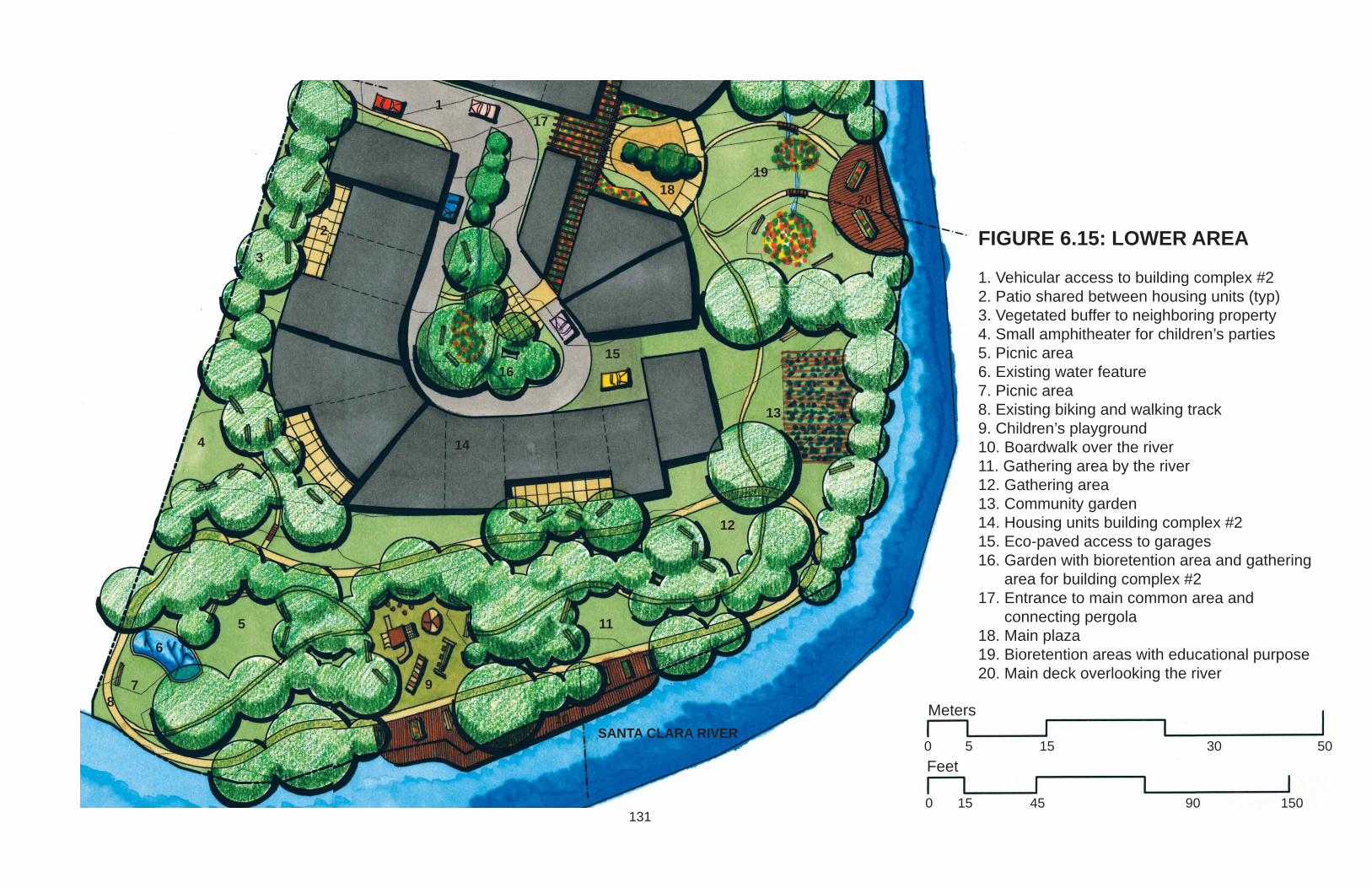
131
FIGURE 6.15: LOWER AREA
1. Vehicular access to building complex #22. Patio shared between housing units (typ)3. Vegetated buffer to neighboring property4. Small amphitheater for children’s parties5. Picnic area6. Existing water feature7. Picnic area8. Existing biking and walking track9. Children’s playground10. Boardwalk over the river11. Gathering area by the river12. Gathering area13. Community garden14. Housing units building complex #215. Eco-paved access to garages16. Garden with bioretention area and gathering area for building complex #217. Entrance to main common area and connecting pergola18. Main plaza19. Bioretention areas with educational purpose20. Main deck overlooking the river
1
2
3
4
5
6
78
9
10
11
12
13
SANTA CLARA RIVERMeters
Feet0 5 15
15
30
90
50
1500 45
14
1516
17
1819
20

132
FIGURE 6.16: SECTION A - A
FIGURE 6.17: SECTION B - B
FIGURE 6.18: SECTION C - C
Meters
Feet0 5 15
15
30
90
50
1500 45

133
FIGURE 6.19: TYPES OF HOUSING UNITSIn order to provide a more diverse community, housing units where designed with the purspose of mixing social strata. According to location, parking units, and square footage, their value varies. Therefore, smaller units with no parking spaces closer to main thoroughfare will be more affordable than larger houses with garages closer to the track.
Santa Clara River
High Income
Mid Income
Low Income

134
FIGURE 6.20: HOUSING UNIT PERSPECTIVE

135
FIGURE 6.21: GRILLING AREA PERSPECTIVE

136
FIGURE 6.22: RETAIL PLAZA PERSPECTIVE

Common areas should be accessed by emergency vehicles. There are wide green
paths that allow transit of these vehicles. These green areas should use eco-pavers,
structural soil, or vehicular accessible grass.
The patios that are shared between housing units are a recreation of the
architectural style of the colonial period. Balconies are suggested for these areas. Also
the use of rain-water harvesting to provide water features within the patios is
recommended. This practice will not only provide interesting aesthetics, but will also
refreshen and moist the usually dry environment.
TABLE 6.2: LIST OF SUGGESTED PLANTS
BOTANICAL NAME COMMON NAMEGROUNDCOVERSAlyssum maritimum GranizoAzorella pedunculata AlmohadillaBegonia spp. BegoniaCineraria AzulinaCrassula portulacea MatacallosDianthus caryophyllus ClavelFestuca ovina glauca Barba de GatoGazania splendens PrimaveraHemerocallis hybrida NardosImpatiens hybrida MiramelindasIresine aureoreticulata EscancelIris xiphium IrisLiriope muscari LirioMatthiola incana AlhelíPelargonium peltatum Geranio
137

Petunia hybrida PetuniaPortulaca grandiflora Portulaca Sedum PlatanitoTropaeolum majus MastuerzoVerbena erinoides VerbenaTALL GROUNDCOVERSAgapanthus africanus AgapantoAnthurium spp. AnturioCanna spp. AtchieraChysanthemum maximum CrisantemoGazania hybrids DormilonaHippeastrum vittatum AzucenaHydrangea hotensia HortensiaKniphofia uvaria Cresta de GalloLychnis coronaria Oreja de ConejoRosa spp. RosaZantedeschia aethiopica CartuchoSHRUBSArbovitae Pino libroBarbadesia spinosa Espino ChiñianBougainvillea BuganvillaBrugmansia arborea FloripondioBrugmansia sanguinea GuantugBuxus sempervirens BojCortaderia selloana CarrizoCupressus mecrocarpa Yucca AloifoliaCyperus papyrus Papiro de EgiptoEuphorbia cotinifolia NacederoFagaria chiloensis FrutillaFuchsia hybrida Zarcillo
138

Hibiscus rosa-sinesis CucardaHypericum laricifolium RomerilloLigustrum vulgare TruenoNeriun oleander Laurel RosadoPiper nigrum Pimienta BlancaPhyllanthus salviifolius CedrilloPhysalis peruviana UvillaSenna multiglandulosa Chin-chínSpartium junceum RetamaSpirea tomentosa SpireaVaccinum floribundum MortiñoVINESHeliotropium arborescens HeliotropoJasminum grandiflorum JazmínPassiflora spp. TaxoPlumbago capensis Enredadera azulRubus fructiosus MoraTREESAbutilon megapotamicum Farol ChinoAlnus acuminata AlisoAraucaria excelsa AraucariaCaesalpinia spinosa AlgarroboCallistemon citrinus CalistemoCedrela montana CedroCeroxylon ventricosum Palma de CeraChionanthus pubenscens ArupoCitrus limonum LimónCupressus spp. CiprésDelostoma integrifolium YalománEriobotrya japonica Nispero
139

Euphorbia pulcherrima Estrella de PanamáInga insignis GuabaJacaranda mimosifolia JacarandáJuglans neotropica Nogal-TocteLaurus nobilis LaurelMagnolia grandiflora MagnoliaMalus spp. ManzanaMyrtus communis ArrayánOpuntia ficus-indica TunaOreopanax ecuadorensis Puma-maquiParajubaea cocoides Coco CumbiPersea americana AguacatePinus patula Pino RojoPodocarpus oleifolius SinsínPrunus serotina CapulíShinus molle MolleTecoma stans CholánTectona gradis Teca
(Arteaga) (Ramirez)
140

CHAPTER 7
CONCLUSION
Quito is a city that follows urban developmental patterns responsible for current
environmental problems in the world. In Ecuador's capital, these patterns have led to
unsustainable and undesirable conditions which are presently showing their
environmental, social, aesthetic, and economic consequences. Pollution is a problem in
this city; the excessive use of personal vehicles and the city's setting in a valley
contribute to the emission and buildup of contaminants due to the lack of air circulation.
Long commuting distances and traffic are also an issue; the percentage of the
population that lives in the suburbs is significant and there is no efficient public
transportation that connects these neighborhoods with the core of the city. Floods are
also common due to impermeable surfaces, clogged sewer systems, and lack of
environmental practices. These major issues urgently need to be addressed.
Present development tries to minimize horizontal expansion of the city and works
towards the compaction of it. In this way, agricultural and rural land that surrounds Quito
will no longer be developed. Through the increase of density in the city, quality of life
can be deeply affected. Therefore, it is important for future dense urban development to
consider aspects and values that contribute to quality of life.
Residential projects are more susceptible to this matter. Housing projects are
promptly needed in Quito due to the rapidly growing population. Current high-density
141

residential development is not providing an appropriate environment for quality
lifestyles. Consequently these projects are seen as an opportunity to remedy some of
the previously described problems.
In order to understand what is important for Quiteños when it comes to quality of life,
and to understand the city's urban development, four case studies, corresponding to the
four major expansion periods of the city, were analyzed. Through this process, values
that have regularly been part of life in Quito were discovered and followed through the
development. All four time periods present aspects that have been categorized in
environmental, social, aesthetic, and economic values. A different value is prioritized in
every stage; therefore, all of them are important to the city's population.
Current dense development within the city was also analyzed through case studies
in order to find out how they address values in quality of life and see how they can be
improved. Additionally, some of the solutions given around the world to the same city
problems were mentioned and researched. The overall problem that Quito faces is a
common trend in developing countries, especially Latin America. Unfortunately, in these
countries, development is unfair and quality of life is only available and affordable by
wealthy people who live in the suburbs.
To ameliorate the situation in Quito, this thesis provides a set of design principles
that can be applied to high-density residential projects in Quito, Ecuador, specifically;
but also to a wide range of projects. An example of how to apply them is provided.
The importance of this study is the identification of Quito's particular issues, their
sources, and the value of landscape within Quito. In order to address a problem, it is
fundamental to know its origin and once the start point is located, solutions can be more
142

easily found. The landscape in Quito can be a powerful tool to remedy current urban
problems. By improving landscape conditions within the city, the overall quality of life
can be improved as well. Because of this thesis' focus on high-income high-density
residential projects, several other types of development were left unaddressed. A study
on these projects can help have a holistic understanding of Quito's current issues and
therefore a more solid and founded solution for them. For example, research on the
counter part of the previously analyzed matter would be focused on low-income high-
density residential projects which are also a large percentage of current development
and can definitely, if improved, make a big difference in quality of life. Although this
study's design application provides housing units that will have different economic value
in order to integrate residents of varying income levels, this is done from the social
perspective. Proper research and analysis on the low-income subject is still needed.
Design principles represent the beginning of the solution for Quito's deeper
problems described before, and they do not pretend to completely solve all issues.
Although they are just the starting point of the improvement of quality of life in this city,
they present a solid foundation and an introduction to a critical matter that would need
further exploration. This investigation sets the stage for research to keep building on
and for practical solutions to be found and applied.
Design guidelines were purposely left as broad concepts and statements. This gives
designers the opportunity to fine-tuned them during the application process and
therefore, get a varied range of results. This can also be done with all the information
presented in this thesis. Elements from the historic case studies such as: the Spanish
Patio House Style, the “Garden City among Trees” aesthetics, the use of traditional
143

materials like brick, or modern materials like steel; can be introduced in forthcoming
development in a variety of ways. In the design application example of this research, the
Spanish Patio House Style was reinterpreted in order to strengthen Quito's culture,
traditions, and identity. Lessons provided by internationally recognized architects such
as Ken Yeang, Arthur Erickson, and Rogelio Salmona can also be applied to different
settings and fine-tuned tuned. Yeang's designs obviously require vast economic
resources but they provide inspiration for smaller scale interventions in countries like
Ecuador and cities like Quito.
After this profound analysis of Quito, the identification of its problems, and the
statement of a possible partial solution, the improvement of quality of life within it seems
closer. Imagining this city as an enjoyable place to live and as an example for fellow
Latin American cities sounds fair. Quiteños should realize what they have in their hands
and work towards recovering what has been declared a World Wide Heritage Cultural
Site instead of letting it decay. Although Quito's history, culture, and beauty is so rich
and deeply immerse in its population that can never be lost.
144

BIBLIOGRAPHY
WORK CITED
Albornoz Tinajero, Consuelo. "Los Golpes Bajos Contra Quito." Diario Hoy July 20,1993 02.28.2010. Print. <http://www.explored.com.ec/noticias-ecuador/los-golpes-bajos-contra-quito-38287-38287.html>
Ali, Saleem H. "Green Cities: Urban Growth and the Environment." Journal of theAmerican Planning Association 74 1 (2008): 143-43. Print.
Arteaga, Ricardo. "Landscape Architect Ricardo Arteaga Interview ". Ed. Jacome,Isabel. Quito: Not Published, January 2010. Print.
Atiaga, Jose. "Architect and Urban Panner Jose Atiaga Interview ". Ed. Jacome, Isabel.Quito: Not Published, January 2010. Print.
Atiaga, Jose. "El Uso Residencial En Relacion a La Regeneracion Urbana Y LaSostenibilidad Del Patrimonio Edificado." Tucson: Arizona Univeristy, 2009. 7. Print.
Ayala Hinojosa, Danny. "Quito Político". Quito, 2008. April 25, 2010.<http://quitopolitico.blogspot.com/2008/08/el-municipio-nos-vende-agua-sucia.html>.
Barrera Guarderas, Augusto. "Hacia Un Nuevo Modelo De Movilidad En El Dmq." Ed.Movilidad, Secretaria de. Quito: Municipio del Distrito Metropolitano de Quito, January11, 2010. Print.
Bish, Reneé, and Pete Oxford. Ecuador. Ed. Dinediciones. Quito: Imprenta Mariscal,2004. Print.
Boddy, Trevor. "Insight: Vancouverism Vs. Lower Manhattanism: Shaping the HightDensity City." ArchNewsNow.com (2005). April 16, 2010.<http://www.archnewsnow.com/features/Feature177.htm>.
Chappell, Jim. "Vancouver's View Corridors." SPUR Ideas and action for a better city(2003).<http://www.spur.org/publications/library/article/vancouverviewcorridors11012003>.
145

CIA, Central Inteligence Agency. "The World Factbook". 2010. May 17, 2010.<https://www.cia.gov/library/publications/the-world-factbook/geos/ec.html>.
CMQ, Consejo Metropolitano de Quito. "Ordenanza De Zonificacion No. 0024." Ed.Quito, Consejo Metropolitano de, 2006. Print.
Coandes. "Constructora De Los Andes Cia. Ltda.". Quito, 2010. April 25, 2010.<http://www.coandes.com.ec/proyectos/viales.htm>.
Conway, Tenley. "Local Environmental Impacts of Alternative Forms of ResidentialDevelopment." Environment & Planning B: Planning & Design 36 5 (2009): 927-43.Print.
Daniels, Tom. "Review Essay: Works on Green Cities: From Potential to Imperative."Journal of the American Planning Association 74 4 (2008): 521-22. Print.
Diez, Gonzalo. "Architect Gonzalo Diez Interview ". Ed. Jacome, Isabel. Quito: NotPublished, July 2009. Print.
DMPT. "Plan De Uso Y Ocupacion De Suelo." Ed. Principal, Mapa de Uso de Suelo.Quito: DMQ, 2003. Print.<http://www4.quito.gov.ec/spirales/9_mapas_tematicos/9_3_planes_urbanos/9_3_3_1.html>
DMPT. "Plan De Uso Y Ocupacion De Suelo." Ed. Principal, Mapa de Uso de Suelo.Quito: DMQ, 2005. Print.<http://www4.quito.gov.ec/spirales/9_mapas_tematicos/9_3_planes_urbanos/9_3_4_1.html>
DMPT. Nivel De Confort Basado En Las Condiciones De La Vivienda. Quito: DMPT andMDMQ, 2006. Print. <http://www4.quito.gov.ec/spirales/9_mapas_tematicos/9_4_poblacion_y_vivienda/9_4_7_7.html>
DMQ, Unidad de Estudio. Barrios, Urbanizacions Y Asentamientos En El Dmq. Quito:DMPT-MDMQ, 2008. Print.
DMQ, Unidad de Estudio. Encuesta Condiciones De Vida Inec. Quito: DMPT-MDMQ,2005-2006. Print.
Durán, Alejandra Chacra. "Maa: Rogelio Salmona." Arquitectura en Red (September 4,2009). June 22, 2010 <http://www.arqred.mx/blog/2009/09/04/maa-rogelio-salmona/>.
Ellis, John G. "Explaining Residential Density." Places: Forum of Design for the PublicRealm 16 2 (2004): 34-43. Print.
146

Erickson, Arthur. "Arthur Erickson". Vancouver, 2010. April 16, 2010.<http://www.arthurerickson.com/designpa.html>.
Farr, Douglas. Sustainable Urbanism : Urban Design with Nature. Hoboken, N.J.: Wiley,2008. Print.
Gilbert, Alan. The Mega-City in Latin America. Tokyo ; New York: United NationsUniversity Press, 1996. Print.
González, Javier. "El Tráfico Y Crimen En Quito Es Espantoso." Univision.com (2008).April 25, 2010.< http://foro.univision.com/t5/Comunidad-Ecuatoriana/El-trafico-y-crimen-en-Quito-es- espantoso/m-p/299495573 #>.
Hamzah, and Yeang. "T.R. Hamzah & Yeang International ...Architects and Planners ofEcologically-Responsive Large Buildings and Sites". Kuala Lumpus. April 16, 2010.< http://www.trhamzahyeang.com/ >.
Hervia, Guillermo. "Fallecimiento Del Arquitecto Colombiano Rogelio Salmona."Plataforma Arquitectura (October 5, 2007). June 22, 2010<http://www.plataformaarquitectura.cl/2007/10/05/fallecimiento-del-arquitecto-colombiano-rogelio-salmona/>.
Hoy, Reporters. "Una Calle Fuera De La Ley." Diario Hoy December 29, 1992. Print02.01.2010. < http://www.explored.com.ec/noticias-ecuador/una-calle-fuera-de-la-ley-45589- 45589.html >
Hoy, Reporters. "Hay Parques... Y 'Parques'." Diario Hoy September 20, 199402.28.2010. Print.<http://www.explored.com.ec/noticias-ecuador/hay-parques-y-parques-28857-28857.html>
Hoy, Reporters. "El Aguacerito Dejo De Caer En Tumbaco." Diario Hoy September 13,1997. Print. 02.03.2010.< http://www.hoy.com.ec/noticias-ecuador/el-aguacerito-dejo-de-caer-en-tumbaco- 113914-113914.html >
Hoy, Reporters. "En Quito Y Guayaquil Hacen Falta Mas Parques." Diario Hoy August31, 2004 02.28.2010. Print.<http://www.hoy.com.ec/noticias-ecuador/en-quito-y-en-guayaquil-hacen-falta-mas-parques-184710-184710.html>
Hoy, Reporters. "Contaminacion Visual Y Letreros." Diario Hoy September 25, 2005
147

04.25.2010. Print.<http://www.hoy.com.ec/noticias-ecuador/contaminacion-visual-y-letreros-214909-214909.html>
Hoy, Reporters. "Un Plan De Vivienda Acaba Con 25 Hectareas De Bosque En Quito."Diario Hoy February 11, 2010 02.11.2010. Print.<http://www.hoy.com.ec/noticias-ecuador/un-plan-de-vivienda-acaba-con-25-hectareas-de-bosque-en-quito-392226.html>
INEC. "Ecuador En Cifras". Ecuador. Instituto Nacional de Estadistica y Censos.02.05.2010. <http://www.ecuadorencifras.com/cifras-inec/main.html>.
Informada, Ciudadania. "Cuarto Accidente En La Zona De La González Suárez". Quito,March 19, 2009. Ciudadania Informada. 02.01.2010.<http://www.ciudadaniainformada.com/ciudadania/ciudadania-despliegue-noticias/ir_a/ciudadania/article//cuarto-accidente-en-la-zona-de-la-gonzales-suarez.html>
Inmobiliaria. "Anuncios Venta". Quito, 2007. April 25, 2010. <http://www.anuncios-venta.com/ecuador/detalle.asp?sitio=10751>.
inmobiliaria.com. "Edificios En Venta En Quito". Quito, 2009. April 25, 2010.<http://ecuador.inmobiliaria.com/ficha_edificio-quito-venta-F356621.htm>.
Izurieta-Varea, Jaime. "View from Quito." Architectural Review 214 1281 (2003): 30-31.Print.
JLV. "Entrevista a Ingeniero Cesar Arias: Nadie Planifico El Desarrollo Urbano Del ValleDe Tumbaco." Diario Hoy August 26, 2009, sec. Entrevistas. Print.<http://www.hoy.com.ec/noticias-ecuador/nadie-planifico-el-desarrollo-urbano-del-valle-de-tumbaco-364918.html>
Joseph, G. M., and Mark D. Szuchman. I Saw a City Invincible : Urban Portraits of LatinAmerica. Jaguar Books on Latin America No. 9. Wilmington, Del.: SR Books, 1996.Print.
Kennicott, Philip. "A Towering Figure in Red Brick: Colombia's Rogelio Salmona." TheWashington Post Saturday August 1, 2009 2009. Print.<http://www.washingtonpost.com/wp-dyn/content/article/2009/07/31/AR2009073103842.html>
La Prensa, Reporters. "Avion Siniestro En Quito Volaba Al Limite." International. LaPensa.hn March 20, 2009 02. Print. 01.2010. <http://www.laprensa.hn/Pa%C3%ADs/Ediciones/2009/03/20/Noticias/Avion-siniestrado-en-Quito-volaba-al-limite>
148

Livesey, Graham. "A Look at Landscape Urbanism." Canadian Architect 54 11 (2009):45-47. Print.
macrovisionmedia. "Superbrands Ecuador: Uribe & Schwarzkopf." (2007). April 26,2010<http://macrovisionmedia.com/superbrandsecuador/pdf_casos/uribeschwarzkopf.pdf>.
Madriñán, Mateo. "Architect Mateo Madriñán Interview." Ed. Jacome, Isabel. Quito: NotPublished, July 2009. Print.
Mahasti, Afshar, Jorge E. Sciupac, and Jamil Mahuad Witt. "Quito: Preserving a HistoricCity." Conservation: the GCI Newsletter 8 3 (1994): 4 - 7. Print.
Marketsupport. "Si Se Puede Ecuador". Quito, 2010. April 25, 2010.<http://www.sisepuedeecuador.com/noticias/nacionales/5061-restringiran-trafico-en-quito.html>.
Marquez, Consultor H. “Plan Parcial De Ordenamiento Territorial Zona Tumbaco (Ppzt)Resumen Ejecutivo”. Quito: Municipio del Distrito Metropolitano de Quito. Print.02.03.2010.<http://www4.quito.gov.ec/pdf2006-13-10/planes%20parciales/tumbacoCumbaya/PPCT%20-Memoria%20Comision.pdf>
McCullough, Kit Krankel. "Sustainable Residential Development: Planning and Designfor Green Neighborhoods." Journal of the American Planning Association 74 4 (2008):526-27. Print.
MDMQ. "Quito World Heritage Site". Ecuador. Municipio del Distrito Metropolitano deQuito. 02.05.2010. <http://www.quito.com.ec/>.
MDMQ, and DMPT. Plan General De Desarrollo Territorial Del Distrito Metropolitano DeQuito 2000 - 2020. Quito: Municipio del Distrito Metropolitano de Quito, 2006 - 2010.Print.
Molina, Jorge, Gerardo Ortega, and Edgar Zhagüi. "Checausa.Com: Una Ventana DelEcuador Para El Mundo". Quito, 2009. April 25, 2010.<http://checausa.com/ecuador1>.
Moreano, Maria. "House Owner Maria Moreano Interview ". Ed. Jacome, Isabel. Quito:Not Published, July 2009. Print.
Murray, Sharon. "Urban and Peri-Urban Forestry in Quito, Ecuador: A Case-Study".Rome, 1997. Forestry Department Food and Agriculture Organization of the UnitedNations. 01.30.2010. <http://www.fao.org/docrep/W7445E/w7445e00.htm#Contents>
149

Musacchio, Laura R. "Metropolitan Landscape Ecology." Landscape Journal 27 1(2008): 2-8. Print.
Navarro, Fernando, and Fausto Banderas Vela. "Architects Banderas Vela Y NavarroInterview ". Ed. Jacome, Isabel. Quito: Not Published, July 2009. Print.
Palmerlee, Danny, Michael Grosberg, and Carolyn McCarthy. "Ecuador & theGalápagos Islands." Quito: Lonely Planet Publications, 2006. Print.
Perez, Consultor Guillermo. Plan Parcial De Ordenamiento Territorial Zona Valle DeLos Chillos (Ppzch) Resumen Ejecutivo. Quito: Municipio del Distrito Metropolitano deQuito, 2007. Print.
Ramirez, Francisco. "Guía De Paisajismo." Ed. López, Andrés. Quito, 2009. Print.
Rivadeneira, Helena. "Crecimiento De Tumbaco Exige Cambios." Valles: 16 - 17. Print.02.03.2010. < http://www.vallesquito.com/edicion59/Ojo%20avizor2.pdf >
Romero, Simon. "Rogelio Salmona, 78; Architect Redefined Colombia's Cityscapes."New York Times October 8, 2007 2007. Print.<http://poorbuthappy.com/colombia/post/rogelio-salmona-78-architect-redefined-colombias-cityscapes/>
Seik, Foo Tuan. "Editorial: Quality of Life in Cities." Cities 18 1 (2001): 1-2. Print.
Tasquer, Rolando Moya, and Evelia Peralta. “Quito Heritage”. Quito: Trama Ediciones,2007. Print.
UNESCO. "World Heritage". United Nations Educational, Scientific and CulturalOrganization. 01.31.2010. <http://whc.unesco.org/en/list/2>.
Universo, Reporters. "Crece El Crimen En Quito Y El Resto Del País." El UniversoNovember 24, 2009 11.24.2009. Print. <http://www.eluniverso.com/2009/11/24/1/1422/crece-crimen-quito-resto-pais.html>.
Uribe, Bernardo, and Tommy Schwarzkopf. Uribe & Schwarzkopf from 1973. Ed. Mundi,Ediciones Libri. Quito, 2009. Print.
Vancouver, City of. "Ecodensity". Vancouver, 2007. April 16, 2010.<http://www.vancouver-ecodensity.ca/content.php?id=48>.
www.olx.com.ec. "Olx: Anuncios Gratis En Quito". Quito, 2010. April 25, 2010.<http://quito.olx.com.ec/vendo-casa-de-3-plantas-al-norte-de-quito-en-conjunto-residencial-iid-14404716>.
150

Yeang, Ken. Designing with Nature : The Ecological Basis for Architectural Design. NewYork: McGraw-Hill, 1995. Print.
Yeang, Ken. The Green Skyscraper : The Basis for Designing Sustainable IntensiveBuildings. Munich ; New York: Prestel, 1999. Print.
Zaaijer, Mirjam. "City Profile: Quito." Cities 8 2 (1991): 87 - 92. Print.
151


![DENSITY Urban Planning for City Leaders 3385_alt[1]](https://img.pdfslide.us/doc/110x75/55cf8ec7550346703b9587e5/density-urban-planning-for-city-leaders-3385alt1.jpg)