Embed Size (px)
Citation preview
‘
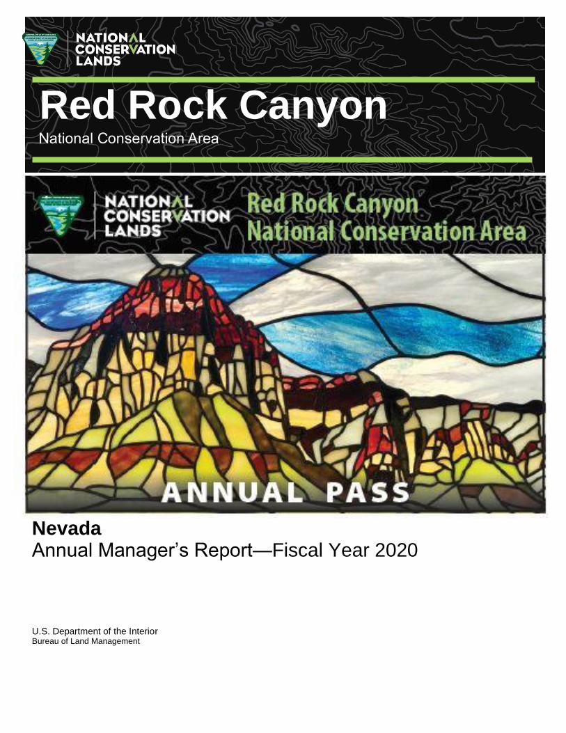
Nevada Annual Manager’s Report—Fiscal Year 2020 U.S. Department of the Interior Bureau of Land Management
Red Rock Canyon National Conservation Area
ii
Table of Contents
Red Rock Canyon Fact Sheet............................................................................................. ii
Red Rock Canyon Overview .............................................................................................. 1
Programs and Accomplishments ....................................................................................... 4
Science ............................................................................................................................. 12
Resources, Objects, Values and Stressors ..................................................................... 14
Summary of Performance Measure ................................................................................. 30
Manager’s Letter ............................................................................................................... 31
iii
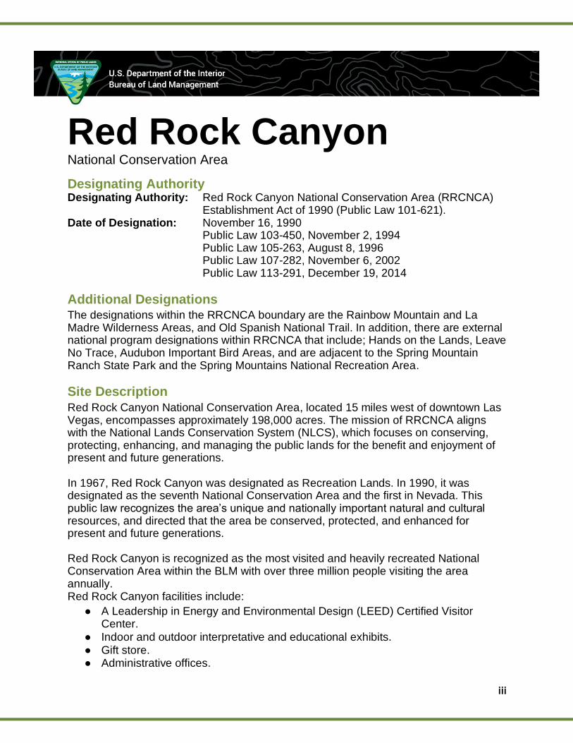
Red Rock Canyon National Conservation Area
Designating Authority Designating Authority: Red Rock Canyon National Conservation Area (RRCNCA)
Establishment Act of 1990 (Public Law 101-621). Date of Designation: November 16, 1990
Public Law 103-450, November 2, 1994 Public Law 105-263, August 8, 1996
Public Law 107-282, November 6, 2002 Public Law 113-291, December 19, 2014
Additional Designations The designations within the RRCNCA boundary are the Rainbow Mountain and La Madre Wilderness Areas, and Old Spanish National Trail. In addition, there are external national program designations within RRCNCA that include; Hands on the Lands, Leave No Trace, Audubon Important Bird Areas, and are adjacent to the Spring Mountain Ranch State Park and the Spring Mountains National Recreation Area.
Site Description Red Rock Canyon National Conservation Area, located 15 miles west of downtown Las Vegas, encompasses approximately 198,000 acres. The mission of RRCNCA aligns with the National Lands Conservation System (NLCS), which focuses on conserving, protecting, enhancing, and managing the public lands for the benefit and enjoyment of present and future generations. In 1967, Red Rock Canyon was designated as Recreation Lands. In 1990, it was designated as the seventh National Conservation Area and the first in Nevada. This public law recognizes the area’s unique and nationally important natural and cultural resources, and directed that the area be conserved, protected, and enhanced for present and future generations. Red Rock Canyon is recognized as the most visited and heavily recreated National Conservation Area within the BLM with over three million people visiting the area annually. Red Rock Canyon facilities include:
● A Leadership in Energy and Environmental Design (LEED) Certified Visitor Center.
● Indoor and outdoor interpretative and educational exhibits. ● Gift store. ● Administrative offices.

iv
● Improved campground area. ● A 13-mile scenic byway. ● Outdoor amphitheater. ● Group picnic areas. ● Full accessible nature and scenic boardwalk. ● Restroom facilities and other amenities throughout the core NCA area. ● 14 parking areas associated with just the Scenic Drive and two overlooks ● 60 miles of hiking trails. ● Four other areas of significant public interest for hiking, mountain biking,
equestrian use, OHV and hunting which include trail/roads, maintained parking areas and restrooms.
● Award-winning low water crossings along the Scenic Drive.
National Conservation Area Offerings The RRCNCA has a wide variety of recreational opportunities and visitor services. They include a LEED certified visitor center, and over 60 miles of trails that draw millions of visitors to the colorful and wonderfully eroded sandstone hills and cliffs, unique spring areas and riparian areas rarely found in the Mojave Desert. Activities in RRCNCA Include:
● Hiking/trail running. ● World Class rock climbing, caving, canyoneering, and high lining. ● Bicycling, including mountain biking, road bicycling and e-biking (electronic
biking). ● Horseback riding. ● OHV routes. ● Birdwatching/wildlife viewing. ● Scenic tours. ● Filming and photography. ● Nature observing. ● Historic and prehistoric resources including shelter caves, agave roasting pits
and rock art (petroglyphs and pictographs). ● Wilderness recreation. ● Mountaineering. ● Hunting. ● Backpacking. ● Educational experiences. ● Commercial, competitive, and organized activities and events which provide
challenging opportunities for all levels of visitors.
The area has historically been a popular location for public recreation and leisure due to the unique geological and ecological characteristics occurring in a natural setting close to a major population center and tourist destination. RRCNCA is home to fossilized dinosaur tracks made 180 to 190 million years ago and is also home to the first documented dinosaur track site in Nevada.
v
Year Accomplishments Fuels Management
• Completed herbicide pre-emergent treatment of invasive annual grass to reduce hazardous fuels and create fuel breaks in Wilderness Urban Interface areas at Calico Basin, Red Rock Visitor Center, Moenkopi Road, Red Rock Fire Station, and Red Rock Campground using NPS Lake Mead Invasive Plant Management Team and BLM Weed Program Staff.
• Completed riparian area inventories and treatments of tamarisk and Russian olive to reduce hazardous fuels and reduce wildfire risk at Ash Creek, Red Springs, and Oliver Ranch using BLM Weed Program Staff.
• Firefighters mowed invasive annual grass (red brome) along the 13-mile Scenic Loop to reduce the risk of roadside wildfires.
• Pine Creek Natural Area was evaluated for wildfire risk and the Red Rock Hazardous Fuel Plan Draft was updated and completed.
Weeds Management
• Weed inventories were completed throughout the Scenic Loop, in Calico Basin, Red Spring, Mormon Green and Oliver Ranch.
• Weed treatments of Sahara mustard, puncture vine, and woolly distaff thistle have continued.
Emergency Stabilization and Rehabilitation (ESR)
• Completed treatments for Pine Creek Fire ESR. Treatments included: Invasive annual grass herbicide treatment (30 acres), noxious weed inventory, manual treatment of Malta star thistle, and native seed collection with Seeds of Success crews.
• Completed ESR plan for Cottonwood Fire. Restoration
• The Carpenter 1 Fire – Harris Springs Watershed Restoration Project Blackbrush Monitoring Report was completed. Despite the difficulty of cultivating and successfully growing blackbrush (Coleogyne ramosissima), the BLM has achieved 70% survivorship of blackbrush transplanted on six acres in the burn scar resulting from the Carpenter 1 Fire in the RRCNCA.
• Carpenter 1 Fire – Harris Springs Watershed Restoration Status of Recreational Experience Improvements Monitoring Report was completed.
• The Carpenter 1 Fire – Harris Springs Watershed Restoration Project was transferred from the fire program to the Red Rock/Sloan Field Office (RRSFO)and is pending approval of a one-year extension as the project is set to expire May 2021.
Vegetation Surveys Approximately 20 acres of surveys for endemic plant species were completed in FY20. One of the surveyed species had never had a comprehensive survey done, and the other species had not been documented by BLM since the 1990s. Recreation
vi
Although the COVID-19 pandemic has drastically altered the demographics of the typical visitor, we have seen a steady stream of local and regional visitors throughout FY20. Even during the initial closure to motor vehicles on the Scenic Drive (response to local government orders to help lessen the spread of COVID-19) from mid-March through May 31, 2020, tens of thousands of visitors came to walk and bike on the drive and surrounding area. With assistance from Recreation.gov we were able to plan for a new reservation and timed entry system. The system, first of its kind for the BLM, spreads visitation over the course of the day and served successful in improving the BLMs ability to protect resources along the Scenic Drive, increase the recreation experience for visitors, as well as provide a safer environment for both visitors and BLM staff. Utilizing Recreation.gov more effectively for our campground has also increased revenue, reliability, security and enabled us to communicate with our users more effectively. The campground season in 2020 only included September 2019-Mid March 2020; however, we did reopen to a full contingent on September 1, 2020, for the fall season as visitors are seeking outdoor experiences even more during the pandemic. Wildlife
• Conducted springsnail (Pyrgulopsis sp.) surveys at multiple springs.
• Conducted rare plant surveys on Bridge Mountain and in Calico Basin for plants endemic to Red Rock Canyon.
• Surveyed a tinaja for invertebrates and set up a game camera to capture wildlife use of the tinaja.
• Completed a census of springs to collect and identify amphipod species living in RRCNCA.
• Worked with Friends of Red Rock Canyon on their captive tortoises.
vii
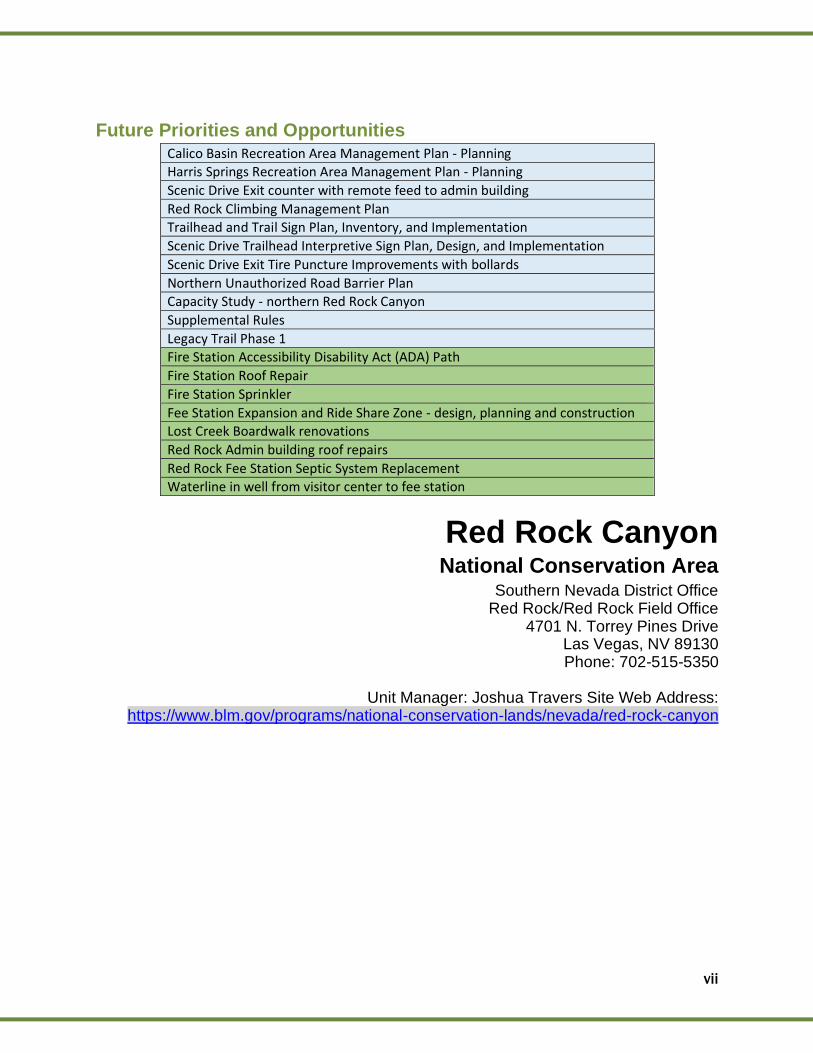
Future Priorities and Opportunities Calico Basin Recreation Area Management Plan - Planning Harris Springs Recreation Area Management Plan - Planning
Scenic Drive Exit counter with remote feed to admin building
Red Rock Climbing Management Plan Trailhead and Trail Sign Plan, Inventory, and Implementation
Scenic Drive Trailhead Interpretive Sign Plan, Design, and Implementation
Scenic Drive Exit Tire Puncture Improvements with bollards
Northern Unauthorized Road Barrier Plan Capacity Study - northern Red Rock Canyon
Supplemental Rules
Legacy Trail Phase 1 Fire Station Accessibility Disability Act (ADA) Path
Fire Station Roof Repair
Fire Station Sprinkler
Fee Station Expansion and Ride Share Zone - design, planning and construction Lost Creek Boardwalk renovations
Red Rock Admin building roof repairs
Red Rock Fee Station Septic System Replacement Waterline in well from visitor center to fee station
Red Rock Canyon National Conservation Area
Southern Nevada District Office Red Rock/Red Rock Field Office
4701 N. Torrey Pines Drive Las Vegas, NV 89130 Phone: 702-515-5350
Unit Manager: Joshua Travers Site Web Address:
https://www.blm.gov/programs/national-conservation-lands/nevada/red-rock-canyon
viii
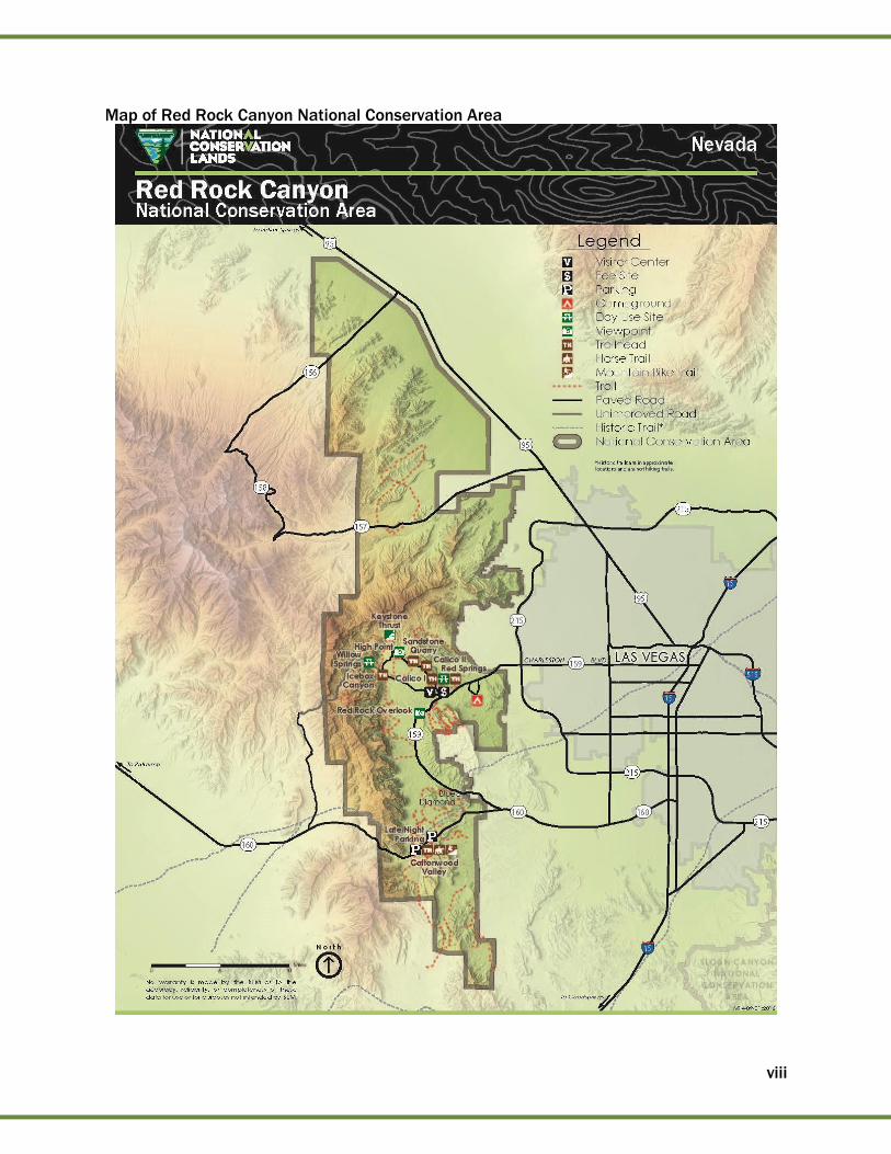
Map of Red Rock Canyon National Conservation Area

1
Red Rock Canyon Overview Acreage Total Acres in Unit *196,877 approx.. BLM Acres *196,877 approx. Other Federal Acres 0 State Acres* 0 Private Acres* 0
*Additional lands were added under Public Law 113-291, and total acres will be complete upon final cadastral survey. In addition, state and private acres are not part of the total unit acres
Budget
* This funding is allocated to law enforcement that help patrol the Red Rock/Sloan Field Office and is not included in the Red Rock Canyon total budget at this time.
Current Areas of Focus 2020 Cottonwood Fire: The lightning-caused Cottonwood Fire burned 2,817 acres, impacting about 450 acres in the NCA. The fire occurred in the 2005 Goodsprings Fire scar which consists of pinyon-juniper woodlands, Joshua tree woodlands, blackbrush scrub, creosote scrub, and invasive annual grasses. The area is an important recreational destination and has high visitor use. The burned area occurs within the Red Rock Herd Management Area (HMA). The BLM Burned Area Recovery Project is to the east and the south of the Cottonwood Fire. The burned area had previously been invaded by invasive annual grasses because of the 2005 Goodsprings Fire. Without intervention, the invasive annual grasses are expected to persist on the site and would contribute to the fine fuel load for years to come. Infestations of invasive and noxious weeds are located on the fire scars and on roads that lead directly to the fire where weed vectoring would be an issue. Noxious and invasive weeds that are on, or adjacent to the burned area are; silverleaf nightshade (Solanum elaeagnifolium), Sahara mustard (Brassica tournefortii), Spotted knapweed (Centaurea stoebe), puncturevine (Tribulus terrestris), and Russian thistle (Salsola spp.). There are no identified threatened, endangered, or sensitive species in the burned area, however, the burned area is less than a mile away from desert tortoise habitat and other sensitive species. The Desert tortoise is a threatened species under the Endangered Species Act. The fire did burn within the Red Rock HMA and treating weeds would benefit the HMA. Timed Entry: The BLM planned and implemented a timed entry and reservation management system for access into the Red Rock Canyon Scenic Drive. The implementation of this system provided a more even flow of visitors into the Scenic Drive, provides a better recreation experience to the public, a safer environment at trailheads and along the Scenic Drive and improves BLMs ability to manage traffic and congestion and other uses of the drive. The system also provides more resource protection in the most widely visited area within the NCA.
Budget Title Code Funding
FLREA Recreation Fees 1232 $3,990,185
National Monuments and Conservation Areas 1711 $667,650*
Total Budget
$3,990,185.00
1
2
Planning and NEPA Status of the Resource Management Plan The 2005 RRCNCA Resource Management Plan (RMP) was completed consistent with the mandate of its founding legislation. Management objectives in the RMP are designed to provide recreational opportunities for the public to enjoy and appreciate the unique natural setting with an emphasis on resource protection and conservation. Plan decisions address biodiversity and preservation, ecosystem management, wild horses and burros, interpretation/education, cultural resources and recreation. RMPs are evaluated every five years, with the RRCNCA RMP evaluated in 2010, 2015, and 2020. Status of Activity Plans
Fire Management Plans (FMP)
● BLM Southern Nevada District Spatial FMP and Story Map (2019), which includes RRCNCA, is available online at https://arcg.is/aHb48. The plan is reviewed annually.
● The Southern Nevada Wildland Fire Prevention Plan (2020) includes RRCNCA and is updated annually.
● The Southern Nevada Interagency National Fire Danger Operating Plan (2020) includes RRCNCA and is updated annually.
● The SNPLMA Spring Mountains Multi-Jurisdictional Fuel Reduction and Wildfire Prevention Strategy 10 Year Plan (2008) which includes RRCNCA is being revised by the United State Forest Service (USFS) Enterprise Team and the USFS Spring Mountains National Recreation Area. The USFS and Southern Nevada Public Land Management Act Division have redrawn the boundary and some areas in RRCNCA that had been included in the planning area are now excluded.
Red Rock Herd Management Area Plan (HMAP) The Spring Mountains Complex Herd Management Area Plan is an environmental assessment being conducted by the USFS with the BLM as a supporting agency. It has been developed and is in the final edit and review stage. Once finalized, a more specific herd management area plan will be developed to specifically address wild horse and burro populations residing within the Red Rock HMA. These projects are dependent upon program priorities and funding and are subject to approval. Weed Management Plan The Las Vegas Field Office Integrated Weed Management Plan (2006), which includes RRCNCA, is scheduled for a revision following completion of the Southern Nevada District RMP Revision. The weed plan post-dates the RRCNCA RMP (2005). Status of the RMP Implementation Strategy The 2013 Nevada Three Year NLCS Strategy, Unit Level Action Plan and subsequent 2013 and 2014 Annual Partner Work Plans serve as the revised RMP implementation strategy. For related additional information, refer to Section 3, Year’s Projects and Accomplishments.
3
Staffing The RRSFO is located at the administrative office within RRCNCA and is comprised of 18 BLM employees ranging in disciplines from program management, cultural, dispersed recreation, environmental planning, lands and realty, recreation, interpretation, desert education, wilderness, climbing and trails. Staff are assigned to either the Red Rock Canyon or Sloan Canyon NCAs, and also share some collateral duties due to workload and the need to maximize staff and resource efficiencies. The field office is also responsible for the management of Walking Box Ranch, a site listed on the National Register of Historic Places. The Southern Nevada District Office also supports the RRSFO’s operations, resource programs and projects. Operations and support include routine administrative, human resource, lands and realty actions, and budgetary functions. Assigned district resource staff (e.g. wildlife biologist, hydrologist, geologist, and botanist) also help support the field office’s on-going research and consultation activities, programs, and environmental review of National Environmental Policy Act (NEPA) projects. Four seasonal park rangers positions were staffed this year contributing approximately 250 hours in August and September, assisting in traffic control, enhancement, and repairs. There is always a law enforcement presence in and around the NCA to address land-urban interface issues, public safety issues, and high visitation seasons.
4
Programs and Accomplishments General Accomplishments Managing Healthy Landscapes
● Replaced the Red Spring boardwalk with Trex material and installed new interpretive signs matching the “new look and feel”.
● Working with the Federal Highway Administration, Nevada Department of Transportation and Clark County to develop a paved multi-use path (~6 miles) from the edge of the Summerlin community to the RRCNCA Fee Station. This will be funded by a Federal Lands Access Program grant.
● Performed numerous enhancement projects and improvements to the greater RRCNCA, including fencing and trail repairs.
Organizational Readiness
● Worked with the fire crew on developing and providing the public with additional
improvements to the area.
● RRCNCA interpretive staff reviewed, edited, and re-wrote the Long-Range
Interpretive Plan (LRIP) for the next three years (2021-2023).
● RRCNCA Interpretive staff created and wrote the Interpretive Implementation Plan for the LRIP.
● RRCNCA Interpretive staff created a database for tracking goals and
accomplishments in the LRIP.
Other
● Weddings at the NCA have increased by over 300% from 2019 with over 300 commercial and organized group ceremonies as our system of reservations has been made more efficient.
● Completed a Special Recreation Permit (SRP) prospectus for open permits for hiking, biking, and off-highway use of e-bikes.
● RRCNCA hosted several schools during the 2019-2020 school year before schools shut down due to COVID-19. School field trips occur on site at RRCNCA and consist of park ranger and teacher-led field trips and those solely facilitated by the school’s teacher. We were able to host 90 field trips from September 2019 through February 2020, reaching 4,755 students.
● Teachers who are interested in coming to RRCNCA to facilitate a field trip or to qualify for our transportation grant, funded by our partner Friends of Red Rock Canyon, are required to take a teacher workshop. These workshops help to further educate the teachers on natural and cultural histories of RRCNCA. Information taught, pertains to the biodiversity of RRCNCA, geologic history, wildland urban interface as well as the historic and indigenous peoples that came before us. We were able to host three teacher workshops reaching 54 teachers.
● RRCNCA is proud to take an active part in the Every Kid Outdoors (EKO) initiative. Not only can 4th graders download a voucher from the EveryKidOutdoors.gov website, but RRCNCA Park Rangers and partner
2
5
naturalists from the Southern Nevada Conservancy (SNC) go into the schools for presentations. These presentations are interactive with students, have a hands-on component and inquiry-based learning. From September 2019 to February 2020, there were 58 EKO programs with 2,997 students receiving EKO passes.
● RRCNCA has a strong volunteer program. One of the volunteer opportunities is to become a Volunteer Naturalist Educator. This program allows volunteers to meet and greet visitors and impart some knowledge about what makes RRCNCA so special. We have volunteers that host tabletop programs, volunteers that guide hikes as hike leaders, and volunteers that join on hikes as assistant hike leaders. This year our volunteers presented 93 programs reaching 8,910 visitors.
● Southern Nevada Conservancy (SNC) is a non-profit organization that partners with RRCNCA. One of the SNC obligations is to assist and present education and interpretative programs. SNC presented a variety of programs from tabletops, guided hikes, outreach events, after-school programs, and volunteer events totaling 372 programs and reaching 36,133 visitors from October 2019-February 2020.
Nevada NLCS Strategies
Collaboratively Managing the NLCS as Part of the Larger Landscape. Building a better conservation model through collaborative management
Enhanced partnerships with Southern Nevada Mountain Biking Association and
the Southern Nevada Climbers Coalition through monthly meetings and planned
stewardship events
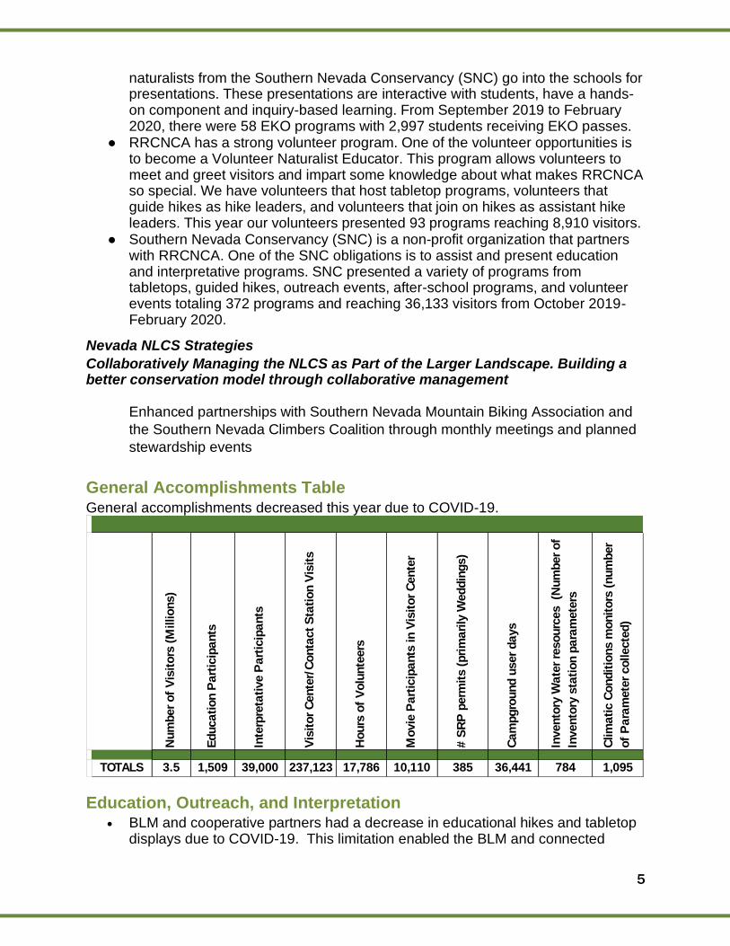
General Accomplishments Table General accomplishments decreased this year due to COVID-19.
Num
ber
of
Vis
itors
(M
illions)
Educati
on P
art
icip
ants
Inte
rpre
tati
ve P
art
icip
ants
Vis
itor
Cente
r/C
onta
ct
Sta
tion V
isit
s
Hours
of
Volu
nte
ers
Movie
Part
icip
ants
in V
isit
or
Cente
r
# S
RP
perm
its (
pri
mari
ly W
eddin
gs)
Cam
pgro
und u
ser
days
Invento
ry W
ate
r re
sourc
es (N
um
ber
of
Invento
ry s
tati
on p
ara
mete
rs
Clim
ati
c C
ondit
ions m
onit
ors
(num
ber
of
Para
mete
r collecte
d)
TOTALS 3.5 1,509 39,000 237,123 17,786 10,110 385 36,441 784 1,095
Education, Outreach, and Interpretation • BLM and cooperative partners had a decrease in educational hikes and tabletop
displays due to COVID-19. This limitation enabled the BLM and connected
6
partners to transition into a virtual platform for the education, outreach, and interpretation programs. Some of the virtual programs that were developed included the following:
o Social media videos o Virtual hikes o Virtual meetings
Partnerships Southern Nevada Conservancy (SNC) The mission of the SNC is “to enhance the recreational, educational and interpretive programs of the Bureau of Land Management, and other governmental agencies, by providing materials and services to the public which promote an understanding and appreciation of the natural history, cultural history and sciences of Southern Nevada and specifically, Red Rock Canyon National Conservation Area.” This is done through interpretation and education, retail sales, fee station staffing, and professional and financial support. Interpretation and Education Professional and Financial Support: SNC provides support in many ways, including the
design and purchase of interpretive signs, planning costs, trail development and
maintenance and other projects. BLM and partner-led education and interpretation
programs and outreach was limited this year, due to the temporary closure of our visitor
center due to COVID-19.
Elements Gift Shop
All net proceeds from purchases at the Elements Gift Shop support a wide variety of programs and activities at RRCNCA. Items offered include books, souvenirs, gifts and creations from local artists.
Fee Station
Through an assistance agreement with the BLM, SNC staffs the entrance station to RRCNCA.
Friends of Red Rock Canyon (FORRC) FORRC’s mission is the preservation, protection and enrichment of RRCNCA. Celebrating its 35th Anniversary in 2019, FORRC mobilizes and supports over 300 volunteers annually. Volunteers perform trail maintenance, Canyon cleanup, graffiti removal, staffing the Visitor Center’s information desk, documenting, protecting and monitoring wildlife, removing invasive species, building fences, repairing boardwalks, stripping parking lots, painting outdoor fixtures and furniture, and preserving and maintaining Native American cultural sites. In addition, FORRC supports and manages youth-focused programming including the Outdoor Adventures program and Title I school field trips to RRCNCA. Its members donate on average an impressive 22,000 hours of their time and talents to RRCNCA annually -- the equivalent of 13 full-time employees and valued at more than $500,000.
7
Fundraising efforts include: ● Dedication Walkway: Sandstone tiles can be personalized with the names of
loved ones and placed in an area near the visitor center.
● License Plates: FORRC receives yearly tax-deductible donations from the sales
and renewals of a Nevada Department of Motor Vehicles license plate depicting
Red Rock Canyon.
● Membership, collectible coin sales, and grants: FORRC is able to financially
support programs at RRCNCA.
FY20 Program Updates:
• Board Meetings: As of April 2020, monthly public board meetings were hosted virtually on Zoom.
• Membership Meeting: FORRC hosted two in-person and one virtual membership meeting during FY20. One of the in-person events was for volunteer appreciation.
• Transportation Grants: Twenty-five grant applications were received and approved by FORRC.
• Outdoor Adventures: Three outings were hosted for 15 to 20 participants. Two were hosted at RRCNCA and the remaining were at Spring Mountain Ranch State Park.
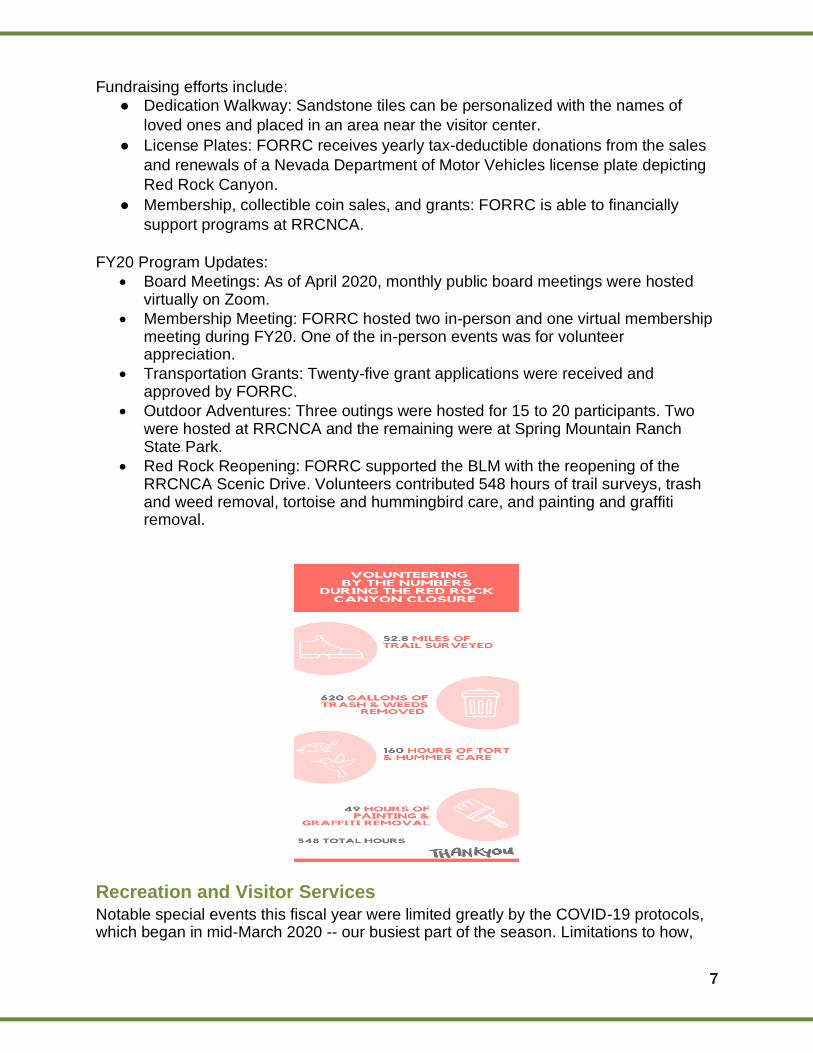
• Red Rock Reopening: FORRC supported the BLM with the reopening of the RRCNCA Scenic Drive. Volunteers contributed 548 hours of trail surveys, trash and weed removal, tortoise and hummingbird care, and painting and graffiti removal.
Recreation and Visitor Services Notable special events this fiscal year were limited greatly by the COVID-19 protocols, which began in mid-March 2020 -- our busiest part of the season. Limitations to how,
8
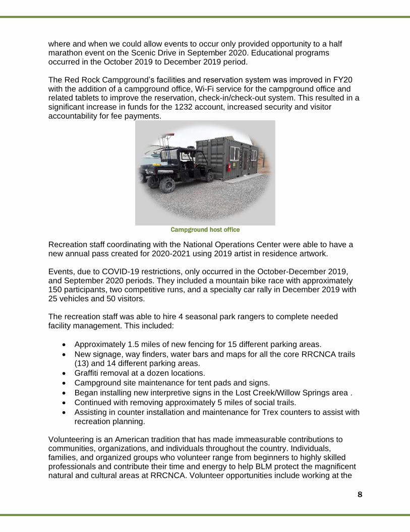
where and when we could allow events to occur only provided opportunity to a half marathon event on the Scenic Drive in September 2020. Educational programs occurred in the October 2019 to December 2019 period. The Red Rock Campground’s facilities and reservation system was improved in FY20 with the addition of a campground office, Wi-Fi service for the campground office and related tablets to improve the reservation, check-in/check-out system. This resulted in a significant increase in funds for the 1232 account, increased security and visitor accountability for fee payments.
Campground host office
Recreation staff coordinating with the National Operations Center were able to have a new annual pass created for 2020-2021 using 2019 artist in residence artwork. Events, due to COVID-19 restrictions, only occurred in the October-December 2019, and September 2020 periods. They included a mountain bike race with approximately 150 participants, two competitive runs, and a specialty car rally in December 2019 with 25 vehicles and 50 visitors. The recreation staff was able to hire 4 seasonal park rangers to complete needed facility management. This included:
• Approximately 1.5 miles of new fencing for 15 different parking areas.
• New signage, way finders, water bars and maps for all the core RRCNCA trails (13) and 14 different parking areas.
• Graffiti removal at a dozen locations.
• Campground site maintenance for tent pads and signs.
• Began installing new interpretive signs in the Lost Creek/Willow Springs area .
• Continued with removing approximately 5 miles of social trails.
• Assisting in counter installation and maintenance for Trex counters to assist with recreation planning.
Volunteering is an American tradition that has made immeasurable contributions to communities, organizations, and individuals throughout the country. Individuals, families, and organized groups who volunteer range from beginners to highly skilled professionals and contribute their time and energy to help BLM protect the magnificent natural and cultural areas at RRCNCA. Volunteer opportunities include working at the
9
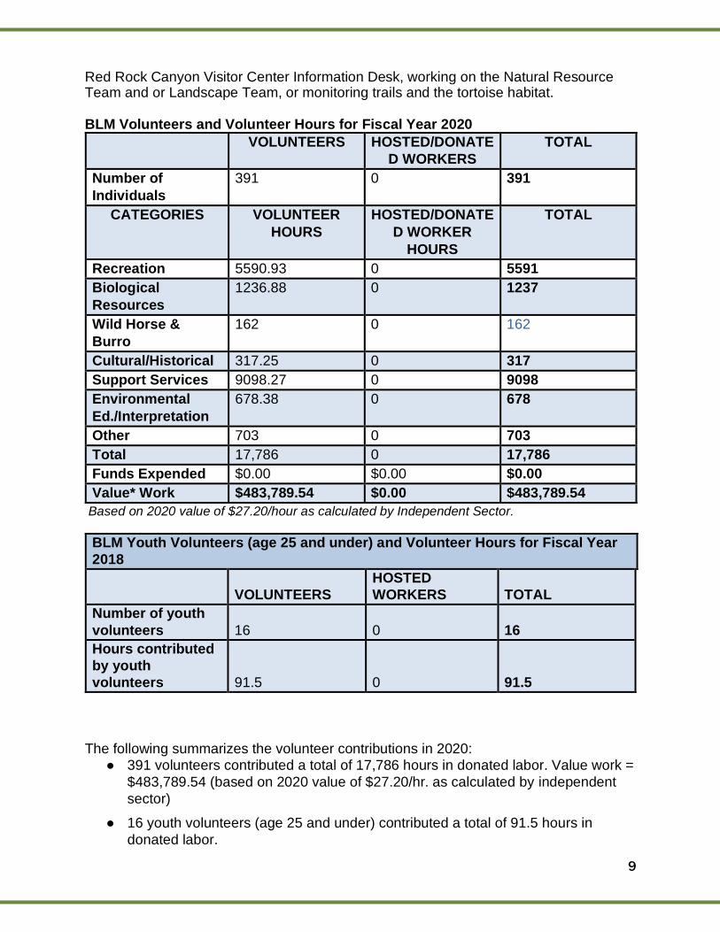
Red Rock Canyon Visitor Center Information Desk, working on the Natural Resource Team and or Landscape Team, or monitoring trails and the tortoise habitat. BLM Volunteers and Volunteer Hours for Fiscal Year 2020
VOLUNTEERS HOSTED/DONATE
D WORKERS
TOTAL
Number of
Individuals
391 0 391
CATEGORIES VOLUNTEER
HOURS
HOSTED/DONATE
D WORKER
HOURS
TOTAL
Recreation 5590.93 0 5591
Biological
Resources
1236.88 0 1237
Wild Horse &
Burro
162 0 162
Cultural/Historical 317.25 0 317
Support Services 9098.27 0 9098
Environmental
Ed./Interpretation
678.38 0 678
Other 703 0 703
Total 17,786 0 17,786
Funds Expended $0.00 $0.00 $0.00
Value* Work $483,789.54 $0.00 $483,789.54
Based on 2020 value of $27.20/hour as calculated by Independent Sector.
BLM Youth Volunteers (age 25 and under) and Volunteer Hours for Fiscal Year
2018
VOLUNTEERS
HOSTED
WORKERS TOTAL
Number of youth
volunteers 16 0 16
Hours contributed
by youth
volunteers 91.5 0 91.5
The following summarizes the volunteer contributions in 2020:
● 391 volunteers contributed a total of 17,786 hours in donated labor. Value work =
$483,789.54 (based on 2020 value of $27.20/hr. as calculated by independent
sector)
● 16 youth volunteers (age 25 and under) contributed a total of 91.5 hours in
donated labor.
10
In addition, RRCNCA hosted two volunteer events:
BLM Volunteers and Volunteer Hours for Fiscal Year 2020
VOLUNTEERS HOSTED
WORKERS
TOTAL
Number of
Individuals
391 0 391
CATEGORIES VOLUNTEER
HOURS
HOSTED
WORKER HOURS
TOTAL
Recreation 5590.93 0 5591
Biological
Resources
1236.88 0 1237
Wild Horse &
Burro
162 0 162
Cultural/Historical 317.25 0 317
Support Services 9098.27 0 9098
Environmental
Ed./Interpretation
678.38 0 678
Other 703 0 703
Total 17,786 0 17,786
Funds Expended $0.00 $0.00 $0.00
Value* Work $483,789.54 $0.00 $483,789.54
Based on 2020 value of $27.20/hour as calculated by Independent Sector.
BLM Youth Volunteers (age 25 and under) and Volunteer Hours for Fiscal Year
2018
VOLUNTEERS
HOSTED
WORKERS TOTAL
Number of youth
volunteers 16 0 16
Hours contributed 91.5 0 91.5
VOLUNTEER
EVENT
# of
VOLUNTEERS
VOLUNTEER
HOURS
ACCOMPLISHMENT
S
National Public
Lands Day 50 200
Fencing was sealed
at the Campground.
Make a Difference
Day
46
184
Fencing was sealed
around the Core
Area of the NCA.
11
by youth
volunteers
The following summarizes the volunteer contributions in 2020:
● 391 volunteers contributed a total of 17,786 hours in donated labor. Value work =
$483,789.54 (based on 2020 value of $27.20/hr. as calculated by independent sector)
● 16 youth volunteers (age 25 and under) contributed a total of 91.5 hours in
donated labor.
Wild Horses and Burros COVID-19 has postponed monitoring and census flights for the HMA.
Collaboration with USGS The USGS is collecting discharge information at the following springs at RRCNCA: Rainbow, Shoemaker, Grassy and Grapevine. This data is available online on the United States Geological Survey and National Waterway Information System Database. The link for rainbow:
https://waterdata.usgs.gov/nv/nwis/uv/?site_no=360310115303201&PARAmeter_cd=00065,00060
12
Science Science
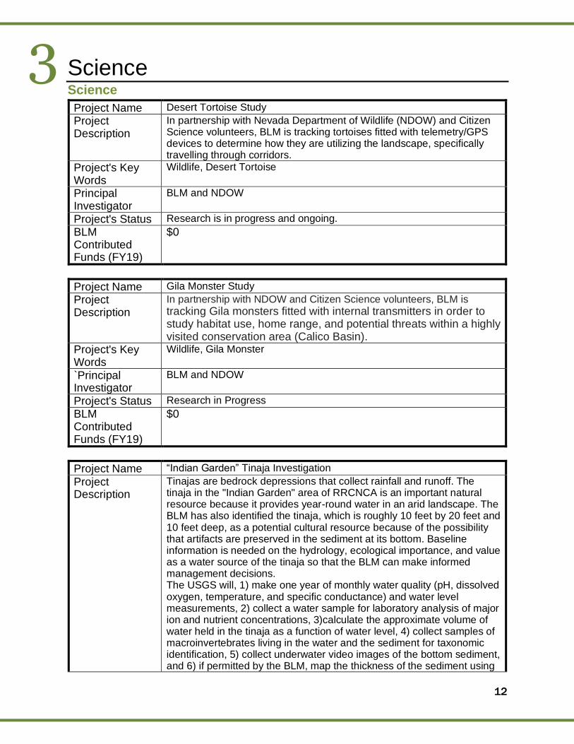
Project Name Desert Tortoise Study
Project Description
In partnership with Nevada Department of Wildlife (NDOW) and Citizen Science volunteers, BLM is tracking tortoises fitted with telemetry/GPS devices to determine how they are utilizing the landscape, specifically travelling through corridors.
Project's Key Words
Wildlife, Desert Tortoise
Principal Investigator
BLM and NDOW
Project's Status Research is in progress and ongoing.
BLM Contributed Funds (FY19)
$0
Project Name Gila Monster Study
Project Description
In partnership with NDOW and Citizen Science volunteers, BLM is
tracking Gila monsters fitted with internal transmitters in order to study habitat use, home range, and potential threats within a highly visited conservation area (Calico Basin).
Project's Key Words
Wildlife, Gila Monster
`Principal Investigator
BLM and NDOW
Project's Status Research in Progress
BLM Contributed Funds (FY19)
$0
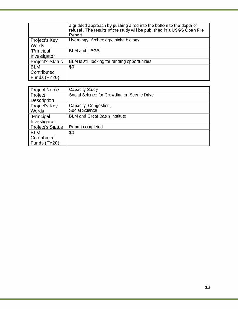
Project Name “Indian Garden” Tinaja Investigation
Project Description
Tinajas are bedrock depressions that collect rainfall and runoff. The tinaja in the "Indian Garden" area of RRCNCA is an important natural resource because it provides year-round water in an arid landscape. The BLM has also identified the tinaja, which is roughly 10 feet by 20 feet and 10 feet deep, as a potential cultural resource because of the possibility that artifacts are preserved in the sediment at its bottom. Baseline information is needed on the hydrology, ecological importance, and value as a water source of the tinaja so that the BLM can make informed management decisions. The USGS will, 1) make one year of monthly water quality (pH, dissolved oxygen, temperature, and specific conductance) and water level measurements, 2) collect a water sample for laboratory analysis of major ion and nutrient concentrations, 3)calculate the approximate volume of water held in the tinaja as a function of water level, 4) collect samples of macroinvertebrates living in the water and the sediment for taxonomic identification, 5) collect underwater video images of the bottom sediment, and 6) if permitted by the BLM, map the thickness of the sediment using
3
13
a gridded approach by pushing a rod into the bottom to the depth of refusal . The results of the study will be published in a USGS Open File Report.
Project's Key Words
Hydrology, Archeology, niche biology
`Principal Investigator
BLM and USGS
Project's Status BLM is still looking for funding opportunities
BLM Contributed Funds (FY20)
$0
Project Name Capacity Study
Project Description
Social Science for Crowding on Scenic Drive
Project's Key Words
Capacity, Congestion, Social Science
`Principal Investigator
BLM and Great Basin Institute
Project's Status Report completed
BLM Contributed Funds (FY20)
$0
14
Resources, Objects, Values and Stressors
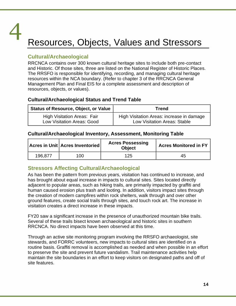
Cultural/Archaeological RRCNCA contains over 300 known cultural heritage sites to include both pre-contact and Historic. Of those sites, three are listed on the National Register of Historic Places. The RRSFO is responsible for identifying, recording, and managing cultural heritage resources within the NCA boundary. (Refer to chapter 3 of the RRCNCA General Management Plan and Final EIS for a complete assessment and description of resources, objects, or values).
Cultural/Archaeological Status and Trend Table
Status of Resource, Object, or Value Trend
High Visitation Areas: Fair Low Visitation Areas: Good
High Visitation Areas: increase in damage Low Visitation Areas: Stable
Cultural/Archaeological Inventory, Assessment, Monitoring Table
Acres in Unit Acres Inventoried Acres Possessing
Object Acres Monitored in FY
196,877 100 125 45
Stressors Affecting Cultural/Archaeological As has been the pattern from previous years, visitation has continued to increase, and has brought about equal increase in impacts to cultural sites. Sites located directly adjacent to popular areas, such as hiking trails, are primarily impacted by graffiti and human caused erosion plus trash and looting. In addition, visitors impact sites through the creation of modern campfires within rock shelters, walk through and over other ground features, create social trails through sites, and touch rock art. The increase in visitation creates a direct increase in these impacts. FY20 saw a significant increase in the presence of unauthorized mountain bike trails. Several of these trails bisect known archaeological and historic sites in southern RRCNCA. No direct impacts have been observed at this time. Through an active site monitoring program involving the RRSFO archaeologist, site stewards, and FORRC volunteers, new impacts to cultural sites are identified on a routine basis. Graffiti removal is accomplished as needed and when possible in an effort to preserve the site and prevent future vandalism. Trail maintenance activities help maintain the site boundaries in an effort to keep visitors on designated paths and off of site features.
4
15
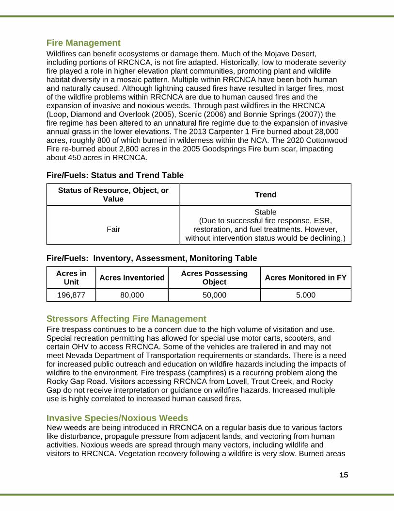
Fire Management Wildfires can benefit ecosystems or damage them. Much of the Mojave Desert, including portions of RRCNCA, is not fire adapted. Historically, low to moderate severity fire played a role in higher elevation plant communities, promoting plant and wildlife habitat diversity in a mosaic pattern. Multiple within RRCNCA have been both human and naturally caused. Although lightning caused fires have resulted in larger fires, most of the wildfire problems within RRCNCA are due to human caused fires and the expansion of invasive and noxious weeds. Through past wildfires in the RRCNCA (Loop, Diamond and Overlook (2005), Scenic (2006) and Bonnie Springs (2007)) the fire regime has been altered to an unnatural fire regime due to the expansion of invasive annual grass in the lower elevations. The 2013 Carpenter 1 Fire burned about 28,000 acres, roughly 800 of which burned in wilderness within the NCA. The 2020 Cottonwood Fire re-burned about 2,800 acres in the 2005 Goodsprings Fire burn scar, impacting about 450 acres in RRCNCA.
Fire/Fuels: Status and Trend Table
Status of Resource, Object, or Value
Trend
Fair
Stable (Due to successful fire response, ESR,
restoration, and fuel treatments. However, without intervention status would be declining.)
Fire/Fuels: Inventory, Assessment, Monitoring Table
Acres in Unit
Acres Inventoried Acres Possessing
Object Acres Monitored in FY
196,877 80,000 50,000 5.000
Stressors Affecting Fire Management Fire trespass continues to be a concern due to the high volume of visitation and use. Special recreation permitting has allowed for special use motor carts, scooters, and certain OHV to access RRCNCA. Some of the vehicles are trailered in and may not meet Nevada Department of Transportation requirements or standards. There is a need for increased public outreach and education on wildfire hazards including the impacts of wildfire to the environment. Fire trespass (campfires) is a recurring problem along the Rocky Gap Road. Visitors accessing RRCNCA from Lovell, Trout Creek, and Rocky Gap do not receive interpretation or guidance on wildfire hazards. Increased multiple use is highly correlated to increased human caused fires.
Invasive Species/Noxious Weeds New weeds are being introduced in RRCNCA on a regular basis due to various factors like disturbance, propagule pressure from adjacent lands, and vectoring from human activities. Noxious weeds are spread through many vectors, including wildlife and visitors to RRCNCA. Vegetation recovery following a wildfire is very slow. Burned areas
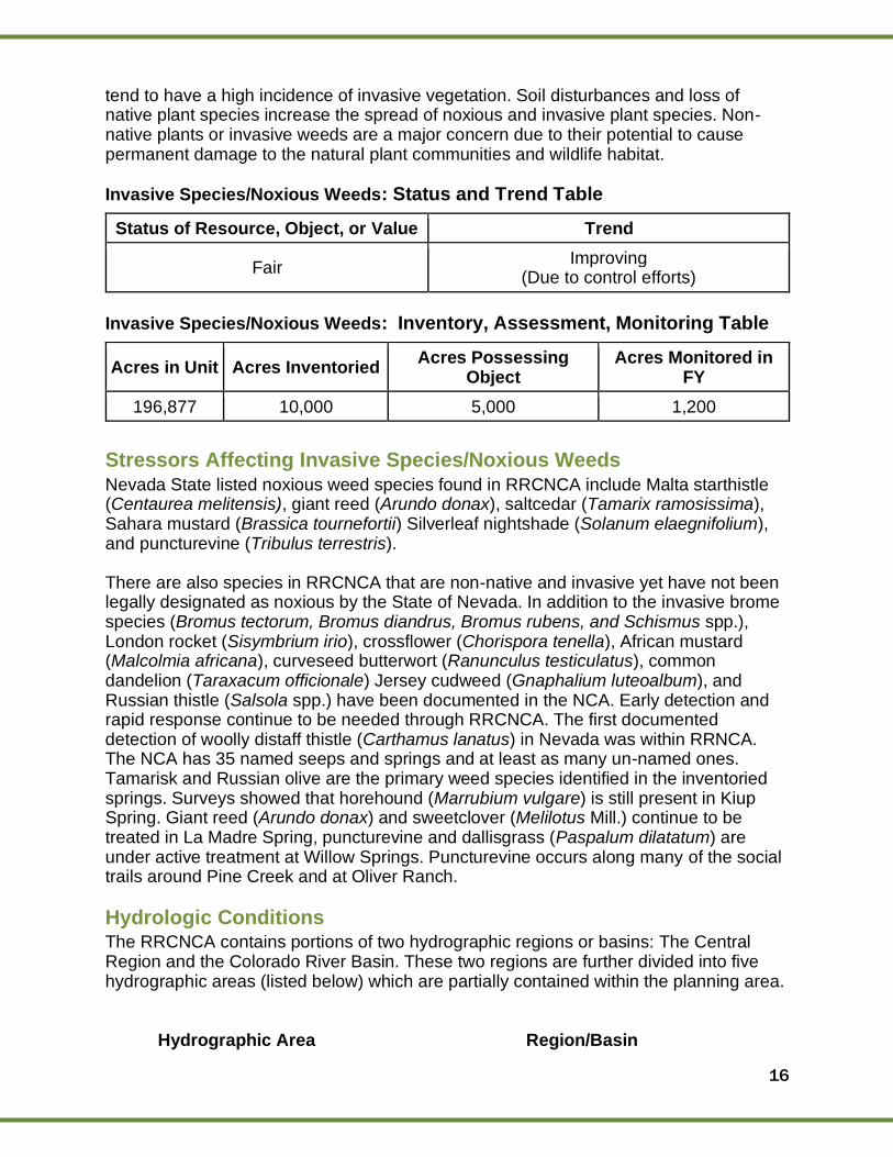
16
tend to have a high incidence of invasive vegetation. Soil disturbances and loss of native plant species increase the spread of noxious and invasive plant species. Non-native plants or invasive weeds are a major concern due to their potential to cause permanent damage to the natural plant communities and wildlife habitat.
Invasive Species/Noxious Weeds: Status and Trend Table
Status of Resource, Object, or Value Trend
Fair Improving
(Due to control efforts)
Invasive Species/Noxious Weeds: Inventory, Assessment, Monitoring Table
Acres in Unit Acres Inventoried Acres Possessing
Object Acres Monitored in
FY
196,877 10,000 5,000 1,200
Stressors Affecting Invasive Species/Noxious Weeds Nevada State listed noxious weed species found in RRCNCA include Malta starthistle (Centaurea melitensis), giant reed (Arundo donax), saltcedar (Tamarix ramosissima), Sahara mustard (Brassica tournefortii) Silverleaf nightshade (Solanum elaegnifolium), and puncturevine (Tribulus terrestris). There are also species in RRCNCA that are non-native and invasive yet have not been legally designated as noxious by the State of Nevada. In addition to the invasive brome species (Bromus tectorum, Bromus diandrus, Bromus rubens, and Schismus spp.), London rocket (Sisymbrium irio), crossflower (Chorispora tenella), African mustard (Malcolmia africana), curveseed butterwort (Ranunculus testiculatus), common dandelion (Taraxacum officionale) Jersey cudweed (Gnaphalium luteoalbum), and Russian thistle (Salsola spp.) have been documented in the NCA. Early detection and rapid response continue to be needed through RRCNCA. The first documented detection of woolly distaff thistle (Carthamus lanatus) in Nevada was within RRNCA. The NCA has 35 named seeps and springs and at least as many un-named ones. Tamarisk and Russian olive are the primary weed species identified in the inventoried springs. Surveys showed that horehound (Marrubium vulgare) is still present in Kiup Spring. Giant reed (Arundo donax) and sweetclover (Melilotus Mill.) continue to be treated in La Madre Spring, puncturevine and dallisgrass (Paspalum dilatatum) are under active treatment at Willow Springs. Puncturevine occurs along many of the social trails around Pine Creek and at Oliver Ranch.
Hydrologic Conditions The RRCNCA contains portions of two hydrographic regions or basins: The Central Region and the Colorado River Basin. These two regions are further divided into five hydrographic areas (listed below) which are partially contained within the planning area.
Hydrographic Area Region/Basin
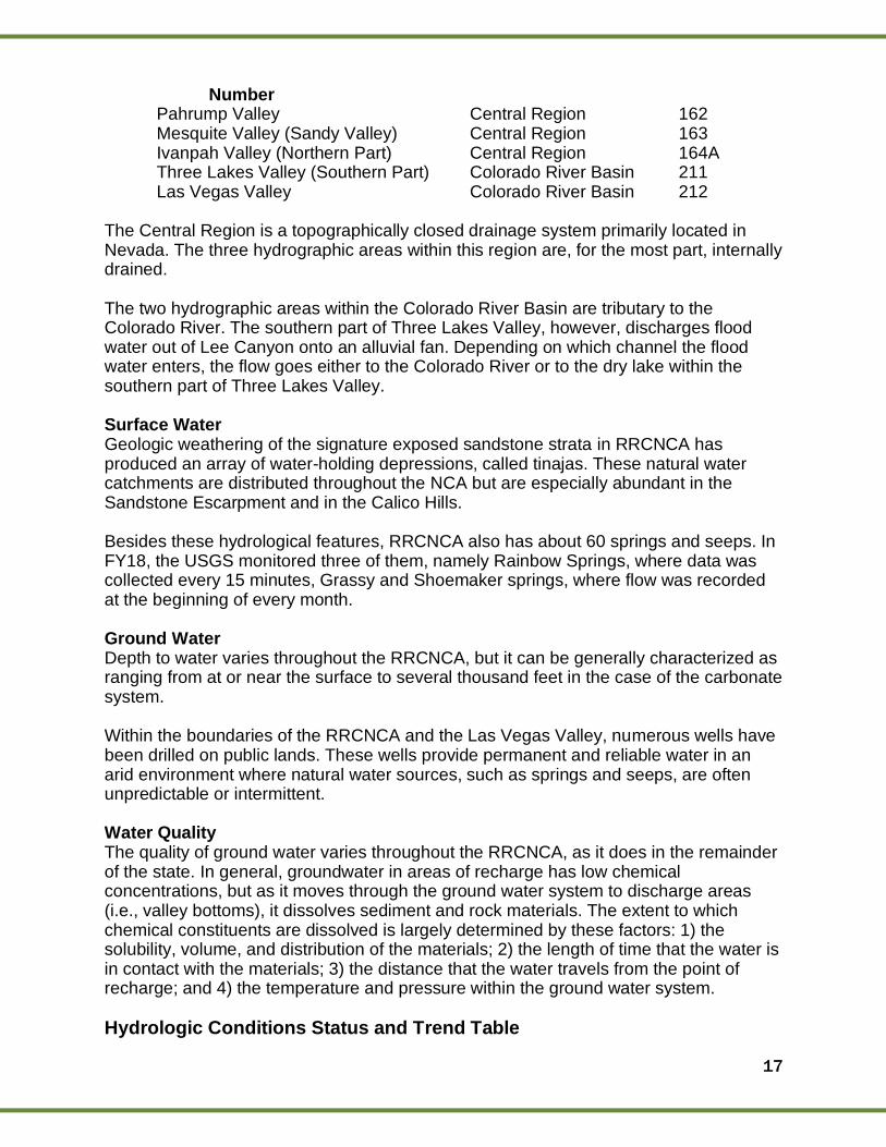
17
Number Pahrump Valley Central Region 162 Mesquite Valley (Sandy Valley) Central Region 163 Ivanpah Valley (Northern Part) Central Region 164A Three Lakes Valley (Southern Part) Colorado River Basin 211 Las Vegas Valley Colorado River Basin 212
The Central Region is a topographically closed drainage system primarily located in Nevada. The three hydrographic areas within this region are, for the most part, internally drained. The two hydrographic areas within the Colorado River Basin are tributary to the Colorado River. The southern part of Three Lakes Valley, however, discharges flood water out of Lee Canyon onto an alluvial fan. Depending on which channel the flood water enters, the flow goes either to the Colorado River or to the dry lake within the southern part of Three Lakes Valley. Surface Water Geologic weathering of the signature exposed sandstone strata in RRCNCA has produced an array of water-holding depressions, called tinajas. These natural water catchments are distributed throughout the NCA but are especially abundant in the Sandstone Escarpment and in the Calico Hills. Besides these hydrological features, RRCNCA also has about 60 springs and seeps. In FY18, the USGS monitored three of them, namely Rainbow Springs, where data was collected every 15 minutes, Grassy and Shoemaker springs, where flow was recorded at the beginning of every month. Ground Water Depth to water varies throughout the RRCNCA, but it can be generally characterized as ranging from at or near the surface to several thousand feet in the case of the carbonate system. Within the boundaries of the RRCNCA and the Las Vegas Valley, numerous wells have been drilled on public lands. These wells provide permanent and reliable water in an arid environment where natural water sources, such as springs and seeps, are often unpredictable or intermittent. Water Quality The quality of ground water varies throughout the RRCNCA, as it does in the remainder of the state. In general, groundwater in areas of recharge has low chemical concentrations, but as it moves through the ground water system to discharge areas (i.e., valley bottoms), it dissolves sediment and rock materials. The extent to which chemical constituents are dissolved is largely determined by these factors: 1) the solubility, volume, and distribution of the materials; 2) the length of time that the water is in contact with the materials; 3) the distance that the water travels from the point of recharge; and 4) the temperature and pressure within the ground water system.
Hydrologic Conditions Status and Trend Table
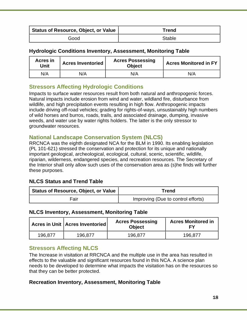
18
Status of Resource, Object, or Value Trend
Good Stable
Hydrologic Conditions Inventory, Assessment, Monitoring Table
Acres in Unit
Acres Inventoried Acres Possessing
Object Acres Monitored in FY
N/A N/A N/A N/A
Stressors Affecting Hydrologic Conditions Impacts to surface water resources result from both natural and anthropogenic forces. Natural impacts include erosion from wind and water, wildland fire, disturbance from wildlife, and high precipitation events resulting in high flow. Anthropogenic impacts include driving off-road vehicles; grading for rights-of-ways, unsustainably high numbers of wild horses and burros, roads, trails, and associated drainage, dumping, invasive weeds, and water use by water rights holders. The latter is the only stressor to groundwater resources.
National Landscape Conservation System (NLCS) RRCNCA was the eighth designated NCA for the BLM in 1990. Its enabling legislation (PL 101-621) stressed the conservation and protection for its unique and nationally important geological, archeological, ecological, cultural, scenic, scientific, wildlife, riparian, wilderness, endangered species, and recreation resources. The Secretary of the Interior shall only allow such uses of the conservation area as (s)he finds will further these purposes.
NLCS Status and Trend Table
Status of Resource, Object, or Value Trend
Fair Improving (Due to control efforts)
NLCS Inventory, Assessment, Monitoring Table
Acres in Unit Acres Inventoried Acres Possessing
Object Acres Monitored in
FY
196,877 196,877 196,877 196,877
Stressors Affecting NLCS The Increase in visitation at RRCNCA and the multiple use in the area has resulted in effects to the valuable and significant resources found in this NCA. A science plan needs to be developed to determine what impacts the visitation has on the resources so that they can be better protected.
Recreation Inventory, Assessment, Monitoring Table
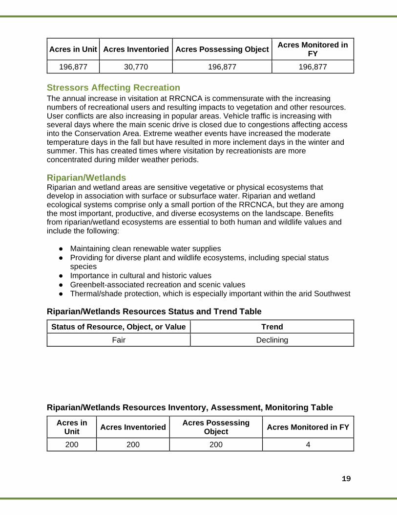
19
Acres in Unit Acres Inventoried Acres Possessing Object Acres Monitored in
FY
196,877 30,770 196,877 196,877
Stressors Affecting Recreation The annual increase in visitation at RRCNCA is commensurate with the increasing numbers of recreational users and resulting impacts to vegetation and other resources. User conflicts are also increasing in popular areas. Vehicle traffic is increasing with several days where the main scenic drive is closed due to congestions affecting access into the Conservation Area. Extreme weather events have increased the moderate temperature days in the fall but have resulted in more inclement days in the winter and summer. This has created times where visitation by recreationists are more concentrated during milder weather periods.
Riparian/Wetlands Riparian and wetland areas are sensitive vegetative or physical ecosystems that develop in association with surface or subsurface water. Riparian and wetland ecological systems comprise only a small portion of the RRCNCA, but they are among the most important, productive, and diverse ecosystems on the landscape. Benefits from riparian/wetland ecosystems are essential to both human and wildlife values and include the following:
● Maintaining clean renewable water supplies ● Providing for diverse plant and wildlife ecosystems, including special status
species ● Importance in cultural and historic values ● Greenbelt-associated recreation and scenic values ● Thermal/shade protection, which is especially important within the arid Southwest
Riparian/Wetlands Resources Status and Trend Table
Status of Resource, Object, or Value Trend
Fair Declining
Riparian/Wetlands Resources Inventory, Assessment, Monitoring Table
Acres in Unit
Acres Inventoried Acres Possessing
Object Acres Monitored in FY
200 200 200 4
20
Stressors Affecting Riparian/Wetlands Riparian resources within the NCA are extremely limited. These resources are managed for conservation and public use. Impacts to surface water resources result from both natural and anthropogenic forces. Natural impacts include erosion from wind and water, wildland fire, disturbance from wildlife, and high precipitation events resulting in high flow. Anthropogenic impacts include driving off-road vehicles; grading for rights-of-ways, unsustainably high numbers of wild horses and burros; roads, trails, and associated drainage, dumping, invasive weeds, and water use by water rights holders.
Soils Soils in the RRCNCA are primarily Entisols and Aridisols; a few Mollisols occur at the upper elevation of the Spring Mountains. These are described in detail below. The Entisols have little or no evidence of development of pedogenic horizons. They are located in areas where the soils are actively eroding (steep slopes) or receiving new deposits of soil materials (alluvial fans and floodplains). Soils in the RRCNCA have been surveyed previously by the Natural Resources Conservation Service (NRCS). Soils in the eastern one third adjacent to Las Vegas were mapped as a part of the Soil Survey of Las Vegas Valley Area Nevada, 1985. Soils in the western two thirds of the area adjacent to the mountains were mapped as a part of the Soil Survey of Clark County Area Nevada. The surveys contain detailed soils descriptions, supporting data, and maps. The published survey for the Las Vegas Area and advanced information on the unpublished survey for the Clark County Area are available through the Las Vegas NRCS office.
Soils Status and Trend Table
Status of Resource, Object, or Value Trend
Fair Declining
Soils Inventory, Assessment, Monitoring Table
Acres in Unit Acres Inventoried Acres Possessing
Object Acres Monitored in FY
196,877 196,877 196,877 0
Stressors Affecting Soils Impacts to soil resources result from both natural and anthropogenic forces. Natural impacts include erosion from wind and water, wildland fire, disturbance from wildlife, and high precipitation events resulting in high flow. Anthropogenic impacts include driving off-road vehicles, grading for rights-of-ways, unsustainably high numbers of wild horses and burros, roads, trails, and associated drainage, dumping, and invasive weeds preventing the formation of natural soil crust.
21
Vegetation Vegetation communities in RRCNCA are diverse and represent higher elevations that receive relatively high amounts of precipitation for the Mojave Desert. There are eight major plant community types: creosote bush, blackbrush, pinyon-juniper, pine-fir, riparian, desert wash, chapparal, and cliff/outcrop. There are two plant species that are endemic to RRCNCA – these species are found nowhere else in the world outside of this NCA. There are twelve species of plants found within the RRCNCA endemic to the Spring Mountain Range, which is a slightly larger mountain range to the west and north of the RRCNCA, and four species that are endemic to Clark County. The many springs and riparian areas within the RRCNCA, unique to the Mojave, also support extensive riparian vegetation and species that are found few other places in the Mojave. Cooler temperatures support a healthy population of Ponderosa pine trees in the Pine Creek drainage in RRCNCA.
Vegetation Status and Trend Table
Status of Resource, Object, or Value Trend
Poor to Good
Lower elevation plant communities such as creosote bush communities have still not recovered from large fires in 2005 and 2006, and these plant
communities have been invaded by invasive annual grasses. There are high impacts to riparian areas
and some endemic species habitats from high visitor use. Higher elevation plant populations seem
to be in better condition and experience fewer impacts from visitor use.
Stable
The trend of resource status appears to be stable. There has
been no meaningful improvement to burned areas within RRCNCA,
and visitor use continues to be high, while higher elevation
habitats are more protected from visitor use and weed infestations.
Vegetation Inventory, Assessment, Monitoring Table
Acres in Unit Acres Inventoried Acres Possessing
Object Acres Monitored in FY
196,877 20 196,877 5
Stressors Affecting Vegetation Wildlife scars from 2005 fires are still a dominant part of the scenery at RRCNCA. Much of the lower elevation creosote bush community type burned during these fires, which
22
represents a loss of the best tortoise habitat in the RRCNCA. Red brome and other invasive annual grasses dominate these fire scars, which limits the ability of native annual plants to grow in these areas (important tortoise forage) and increases the risk for future wildfires in RRCNCA. Plant communities in the desert are extremely slow to recover after fire, and blackbrush communities may never recover if burned severely. This pattern continues to repeat itself in RRCNCA, despite multiple efforts to treat weeds and restore this habitat. Currently, small scale vegetation loss occurs from expanding parking areas and turn-arounds around the Red Rock Scenic Drive. More vegetation loss occurs from social trails, which are both abundant and dense around parking areas, and on the routes to popular climbing areas. Multiple trails fragment vegetation and limit the potential for the remaining plant communities to provide effective habitat to wildlife species. Heavy use of more popular areas of the RRCNCA threatens endemic species populations and riparian habitats, which are disproportionately important for wildlife. Invasive species are also addressed in another section, but it is important to note here that invasive species introductions have become common in RRCNCA because of the high use and the disproportionately high use from out of state visitors. This had resulted in introductions of invasive species never identified in the state before. The high probability for new weeds introductions, combined with a weeds staff with little time to address these issues, introduces high risk of invasion of the NCA by new invasive species, and increases the likelihood of unchecked spread of other invasive species.
Scenic/Visual Resources The RMP assigned a Visual Resources Management (VRM) Classification of primarily Class II, with some areas of Class III, for the areas containing the Scenic Drive and the Visitor Center. The most critical variable affecting the sensitivity of the visual resources in this area is the NCA status of the area along with high levels of visibility of the natural landforms. The Spring Mountains in the vicinity of any proposed action illustrate banding from different geologic eras, showing reds, yellows, and grays within the mountainous landforms. They serve as the backdrop for western-looking views for motorists on the Scenic Drive. The mountains in the background are jagged and pronounced and create a dominant landform. By contrast, the landform inside of the Scenic Drive conveys smooth undulations.
Scenic/Visual Resources Inventory, Assessment, Monitoring Table
Acres in Unit Acres Inventoried Acres Possessing Object Acres Monitored in
FY
196,877 196,877 196,877 35,000
Stressors Affecting Scenic/Visual Resources Any land use authorization and new infrastructure, including development and improvements to roads and trails, could affect the visual resources.
23
Wild Horses and Burros Wild horses and burros can be found throughout 10 western states, including Nevada. The wild horses located within the RRCNCA are mostly the descendants of domesticated horses that had been released in the late 19th/early 20th centuries. The wild burros (burro is the term used for a wild donkey) are the descendants of donkeys that were released by miners who resided within the area during the late 19th/early 20th centuries.
Wild Horses and Burros Status and Trend Table
Status of Resource, Object, or Value Trend
Good
Current population estimates, as of September 2020, are 60 wild horses and 84 wild burros. These numbers only take into account animals that reside on Bureau of Land Management administered lands within the herd management area (HMA) and do not account for animals that may be residing on lands administered by the USFS or land outside of their HMA, either publicly or privately owned. The last
aerial population inventory of Red Rock HMA was conducted in May 2018.
Stable
Wild horse and burro populations on western rangelands have an 18-20% increase in population
every year. This accounts for the average annual mortality rate experienced by these animals.
Body conditions of these animals may begin to decrease due to
increased competition for forage and water resources.
24
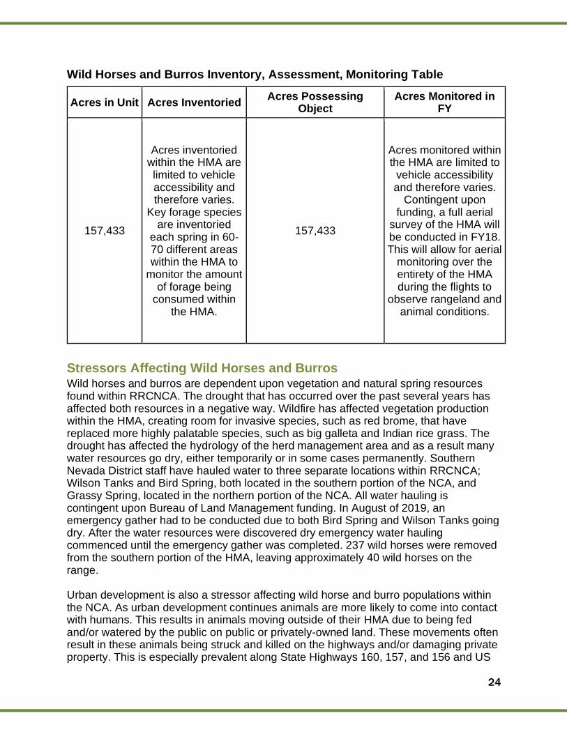
Wild Horses and Burros Inventory, Assessment, Monitoring Table
Acres in Unit Acres Inventoried Acres Possessing
Object Acres Monitored in
FY
157,433
Acres inventoried within the HMA are limited to vehicle accessibility and therefore varies.
Key forage species are inventoried
each spring in 60-70 different areas within the HMA to
monitor the amount of forage being
consumed within the HMA.
157,433
Acres monitored within the HMA are limited to
vehicle accessibility and therefore varies.
Contingent upon funding, a full aerial
survey of the HMA will be conducted in FY18. This will allow for aerial
monitoring over the entirety of the HMA during the flights to
observe rangeland and animal conditions.
Stressors Affecting Wild Horses and Burros Wild horses and burros are dependent upon vegetation and natural spring resources found within RRCNCA. The drought that has occurred over the past several years has affected both resources in a negative way. Wildfire has affected vegetation production within the HMA, creating room for invasive species, such as red brome, that have replaced more highly palatable species, such as big galleta and Indian rice grass. The drought has affected the hydrology of the herd management area and as a result many water resources go dry, either temporarily or in some cases permanently. Southern Nevada District staff have hauled water to three separate locations within RRCNCA; Wilson Tanks and Bird Spring, both located in the southern portion of the NCA, and Grassy Spring, located in the northern portion of the NCA. All water hauling is contingent upon Bureau of Land Management funding. In August of 2019, an emergency gather had to be conducted due to both Bird Spring and Wilson Tanks going dry. After the water resources were discovered dry emergency water hauling commenced until the emergency gather was completed. 237 wild horses were removed from the southern portion of the HMA, leaving approximately 40 wild horses on the range. Urban development is also a stressor affecting wild horse and burro populations within the NCA. As urban development continues animals are more likely to come into contact with humans. This results in animals moving outside of their HMA due to being fed and/or watered by the public on public or privately-owned land. These movements often result in these animals being struck and killed on the highways and/or damaging private property. This is especially prevalent along State Highways 160, 157, and 156 and US

25
Highway 95 from State Highway 157 to Cold Creek Road. Data for these occurrences prior to FY19 is being analyzed and current data is being collected to best determine if the number of wild horses and burros being struck on highways is increasing or remaining stable. Overpopulation is affecting wild horse and burro populations due to the limited resources that are present within the NCA. Wild horse and burro populations double every four years due to having very few natural predators and having a highly successful rate of raising foals. As herd numbers increase it puts further strain on the limited resources within the Mojave Desert ecosystem. Acceptable Management Levels (AML) were established in 2004 for the Red Rock HMA based off of modern rangeland monitoring and scientific methods. For wild horses, the AML is 16-27 animals. For wild burros, the AML is 29-49 animals.
Wilderness The Wilderness Act of 1964 established the National Wilderness Preservation System and officially designated wilderness as a resource. The BLM was originally not a wilderness managing agency; however, with the passage of the Federal Land Policy and Management Act of 1976 (FLPMA) the BLM became the 4th agency with wilderness management responsibilities under the Wilderness Act. The Wilderness Act mandates that each administering agency preserve or enhance the wilderness character of designated areas. The wilderness character is defined in the wilderness act and is composed of 4 mandatory qualities and a 5th optional quality:
1. Untrammeled: wilderness ecological systems are essentially unhindered and free from intentional actions of modern human control or manipulation.
2. Undeveloped: being without structures or installations, the use of motorized vehicles, motorized equipment, or mechanical travel. The area is retaining its primeval character of influence, without permanent improvements or human habitation, where the imprint of man’s work is substantially unnoticeable.
3. Natural: a place where ecological systems are substantially free from the effects of modern civilization.
4. Solitude or Primitive and Unconfined Recreation: wilderness provides opportunities for visitors to experience: natural sights and sounds, remote, isolated, unfrequented, or secluded places. There is freedom, risk, physical and emotional challenge, self-discovery, self-reliance, and lack modern societal pressures.
5. Other Features of Value: the area may contain ecological, geological, or other features of scientific, educational, scenic, or historical value. When these other values are present, they are part of the area’s wilderness character and must be preserved as such.
A more robust definition of wilderness character may be found in “Keeping It Wild 2, An Updated Interagency Strategy to Monitoring Trends in Wilderness Character across the National Wilderness Preservation System.” (https://www.fs.fed.us/rm/pubs/rmrs_gtr340.pdf)\
Within RRCNCA there are 3 congressionally designated wildernesses: La Madre Mountain, Rainbow Mountain, and Mt. Charleston Wilderness Areas. Mt. Charleston
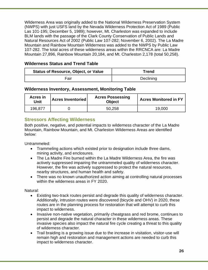
26
Wilderness Area was originally added to the National Wilderness Preservation System (NWPS) with just USFS land by the Nevada Wilderness Protection Act of 1989 (Public Las 101-195; December 5, 1989); however, Mt. Charleston was expanded to include BLM lands with the passage of the Clark County Conservation of Public Lands and Natural Resources Act of 2002 (Public Law 107-282; November 6, 2002). The La Madre Mountain and Rainbow Mountain Wilderness was added to the NWPS by Public Law 107-282. The total acres of these wilderness areas within the RRCNCA are: La Madre Mountain 27,896, Rainbow Mountain 20,184, and Mt. Charleston 2,178 (total 50,258).
Wilderness Status and Trend Table
Status of Resource, Object, or Value Trend
Fair Declining
Wilderness Inventory, Assessment, Monitoring Table
Acres in Unit
Acres Inventoried Acres Possessing
Object Acres Monitored in FY
196,877 0 50,258 19,000
Stressors Affecting Wilderness Both positive, negative, and potential impacts to wilderness character of the La Madre Mountain, Rainbow Mountain, and Mt. Charleston Wilderness Areas are identified below:
Untrammeled:
• Trammeling actions which existed prior to designation include three dams, mining activity, and enclosures.
• The La Madre Fire burned within the La Madre Wilderness Area, the fire was actively suppressed impairing the untrammeled quality of wilderness character. However, the fire was actively suppressed to protect the natural resources, nearby structures, and human health and safety.
• There was no known unauthorized action aiming at controlling natural processes within the wilderness areas in FY 2020.
Natural:
• Existing two-track routes persist and degrade this quality of wilderness character. Additionally, intrusion routes were discovered (bicycle and OHV) in 2020, these routes are in the planning process for restoration that will attempt to curb this impact to wilderness.
• Invasive non-native vegetation, primarily cheatgrass and red brome, continues to persist and degrade the natural character in these wilderness areas. These invasive species also impact the natural fire cycle creating a threat to this quality of wilderness character.
• Trail braiding is a growing issue due to the increase in visitation, visitor-use will remain high and restoration and management actions are needed to curb this impact to wilderness character.
27
• Vehicle intrusions remain present and a threat to the natural quality of wilderness character. As the RRCNCA continues to grow in popularity and Las Vegas development gets closer to RRCNCA the potential threat of vehicle intrusions also grows. Proactive management is needed to address this potential threat.
• The Bighorn sheep population in the wilderness areas remain viable and hunting continues; however, these species continue to have potential threats, primarily disease and water availability.
• Increasing visitation to the NCA has contributed to the loss of native vegetation from user created trails and unauthorized trail creation in the wilderness areas.
• Trail braiding associated with climbing area access is occurring in the Rainbow Mountain Wilderness. The BLM is currently planning on a restoration project in this wilderness area.
• Vandalism, including graffiti on Turtlehead peak in the La Madre Mountain Wilderness.
Undeveloped:
• Current known developments include: 19.25 miles of designated trails, three rock dams, developed springs, bench, interpretation signs, bolts related to climbing, mine activity, spring exclosures, and permanent fixed trails.
• The BLM installed 12 directional signs leading to Turtlehead Peak in FY20.
• Motorized or mechanized transportation trespass remains a threat to this quality of wilderness character for these areas. Roughly 4.5 miles of an unauthorized trail was discovered in the Rainbow Mountain Wilderness in FY20.
• Unauthorized facilities remain a threat to this quality of wilderness character. Threats derive from potential unauthorized recreational facilities; primarily trails and bolts.
• The potential for additional administrative recreational facilities remains a threat to this quality of wilderness character. As the visitor-use increases in RRCNCA the possibility of recreational facility developments also increases.
• Responding to the inundation to the cultural resources within RRCNCA remains a threat to this quality of wilderness character. Administrative developments become more likely as the degradation to the cultural resources continue.
• Search and rescue operations remains a possibility in the wilderness areas, potentially threatening this quality of wilderness character.
Opportunities for solitude or primitive and unconfined recreation:
Existing confinements in the wilderness areas include:
• Dogs are required to be on leash.
• No installation of fixed anchors for climbing.
• Hunting is limited to east of the Spring Mountain Escarpment.
• Collection of natural resources is prohibited.
• Target and recreational shooting are prohibited.
• Equestrian use is limited to designated trails or any area above the 5,000 ft escarpment.
• 14 day stay limit is in place.
• Waste is required to be packed out or buried.
28
• Group size is limited to 14 people.
• Campfires are prohibited.
• Camping is prohibited, besides anywhere above the 5,000 ft escarpment.
• Climbing is prohibited within 150 feet of cliff nesting sites and cultural rock art.
• The scenic loop charges an entrance fee and requires a parking permit. This is not directly inside the wilderness areas, but the scenic loop is how most visitors access the wilderness.
• A free permit is required for after hour access and late exit.
• A permit is required to replace fixed anchors.
• Certified weed-free hay is required for equestrian use.
• Seasonal fire restrictions are frequent confinements the wilderness. Other impacts to this quality of wilderness character that do not derive from an administrative confinement include:
• Due to the proximity to the Las Vegas Valley vehicle sounds, aircraft use, and the sight and sound of the city are prominent throughout the wilderness areas.
• Various unauthorized recreational facilities have been created, primarily mountain biking and vehicle routes, these unauthorized uses degrade this quality of wilderness character.
• Increasing visitation and popularity of RRCNCA diminish the opportunities for solitude.
The wilderness areas within RRCNCA offers pristine opportunities for solitude or primitive and unconfined recreation in few portions of the wilderness, but due to the proximity to Las Vegas Valley it does not afford this pristine opportunity throughout the entirety of the area. There are many administrative confinements in these wilderness areas; however, most of the confinements derive from the need to protect other components of wilderness character. Due to the growth of the Las Vegas Valley and the popularity of RRCNCA this quality of wilderness character is the most threatened. Supplemental/Unique Values: Interest in cultural resources and potential collection or destruction, continue to remain a threat to this wilderness character. When these threats manifest into incidents, management actions are performed immediately to mitigate the damage.
Wildlife RRCNCA is home to a very diverse and unique array of wildlife, including the federally listed (threatened) Mojave desert tortoise (Gopherus agassizii), as well as many other sensitive species. The 196,877-acre NCA provides excellent habitat for these species while also providing recreational opportunities for visitors. Ongoing projects continue to improve habitat conditions for several endemic springsnail species within Red, Willow, and Rainbow Springs. Mojave desert tortoise and Gila monster population, habitat, and movement studies are ongoing in collaboration with NDOW, BLM, and Citizen Science volunteers. Reptile “night cruising” surveys are conducted along the 13-mile scenic loop in warmer months to monitor reptile presence and populations.
Wildlife Status and Trend Table
29
Status of Resource, Object, or Value Trend
Fair Appears stable (ongoing monitoring)
Wildlife Inventory, Assessment, Monitoring Table
Acres in Unit Acres Inventoried Acres Possessing Object Acres Monitored in
FY
196,877
Inventoried by species
populations, not acreage.
196,877 N/A
Stressors Affecting Wildlife
Wildlife in the area can potentially be negatively impacted by visitor usage. Many wildlife species are sensitive to noise disturbance and foot traffic. For example, some ground nesting bird species will abandon a nest with viable eggs if they are disturbed or threatened by human presence. It is important for visitors to remain on designated trails to lessen the impacts to native wildlife. The Mojave desert tortoise, in particular, can be vulnerable to injury or death caused by vehicle traffic in the parking lots, 13-mile scenic loop, and off-road trails. Many other mammal and reptile species are vulnerable to traffic mortality, specifically along the scenic loop. Many snakes, lizards, and rodents are killed each year by vehicles on the scenic loop, as reptile surveys have shown. This is a particularly concerning problem during warmer months just before dusk and into the evening when reptiles and rodents are most active. The BLM has also been advised by NDOW staff that several raptor nests have failed and been abandoned in recent years due to climbers going off route and approaching the nests. It appears that none of those birds have returned. Raptors are highly sensitive to noise and human presence and they require very large buffer distances to offset such disturbance, as specified in the Southern Nevada Nesting Bird Management Plan 2019.
30
Summary of Performance Measure
Resources, Objects, and Values Status Summary Table
Resource, Object, or Value Status Trend
Cultural Resources Fair Declining
Fire/Fuels Fair Stable
Invasive Species/Native Weeds
Fair Improving
Fire Management Fair Stable
Hydrological Conditions Good Stable
NLCS Fair Stable
Recreation Fair Declining
Riparian/Wetlands Fair Stable
Soils Fair Declining
Vegetation Poor to Good Stable
Scenic/Visual Resource Good Stable
Wild Horse and Burro Good Stable
Wilderness Fair Declining
Wildlife Fair Stable
5
31
Manager’s Letter What an extraordinarily unprecedented year we had in 2020! Despite the challenges that this year brought to Red Rock Canyon NCA, BLM Staff, partners, and the community rose to the occasion to keep the NCA preserved, protected, and managed. The end of one year and the start of another seems to inspire us to reflect naturally. It typically is filled with wrapping up projects, planning strategic initiatives for the coming year while planning celebrations, and reflecting on accomplishments. Without stating the obvious, 2020 has been a challenging year marked by historical events and unforeseen changes to work and home lives; it has also been a year of learning for all of us, either at the team or individual level. With the many challenges, comes celebration. After much planning, Red Rock implemented a timed entry reservation system which has led to a safer visitor experience and has also allowed for better management of the Scenic Drive. In addition, a field ranger program was created to support maintenance, visitor use management initiatives, core recreation area improvement projects, and a visitor contact program. Significant improvements to the campground were made including a reservation system, installation of a camp host office, and many improvements to campsites and facilities. In addition, our interpretation, education, and outreach team developed a Long-Range Management Plan for programming delivered at Red Rock and within the community of Clark County. The team also developed a management plan for the Visitor Center providing management direction and that establishes a vision with objectives and goals that will complement the world-class destination Red Rock Canyon NCA serves as today. Our work would not be possible without our community of support. Our longstanding partnerships have always been critical to our success, but this year they were made stronger because of how we collaborated and navigated projects together. It is important to mention, our cooperative partner Southern Nevada Conservancy’s support to running the Red Rock Canyon Scenic Drive Fee Booth as well as the gift store located within the Red Rock Canyon Visitor Center. Friends of Red Rock Canyon members and volunteers, without hesitation, safely led the coordination and management of critical reopening work after the Scenic Drive had been closed for two and half months. We are grateful for both organization’s unwavering support during the most challenging of times. An important aspect of our work is to ensure that future generations can experience the majesty of Red Rock Canyon NCA. One program that makes this possible is the “Every Kid in a Park” program which brings school children and their families from Clark County to Red Rock Canyon. As we continue to work on exciting and critical projects next year, the focus areas will be on conservation management and visitor use. Projects include: Management Plan Finalization & Project Launch for:
• Calico Basin
• Harris Springs Road
• Climbing
• Volunteerism
• Interpretive & Digital Media
• Visitor Center
6

32
Use:
• Legacy Trail
• Brownstone Canyon
• Campground Improvements and expansion
• Rideshare system & fast pass lane
Again, we would like to recognize and thank our local partners, the community, and visitors for their help, interest, and support for Red Rock Canyon National Conservation Area.
“Your Public Lands, Your Heritage, Our Children’s Future“
Josh Travers Assistant Field Manager Red Rock/Sloan Field Office Southern Nevada District Office
Red Rock Canyon National Conservation Area Southern Nevada District Office Bureau of Land Management Red Rock/Red Rock Field Office 4701 N. Torrey Pines Drive Las Vegas, NV 89130 Phone: 702-515-5350
[01/14/2021] The mention of company names, trade names, or commercial products does not constitute endorsement or recommendation for use by the federal government.