Embed Size (px)
Citation preview

Proceedings World Geothermal Congress 2015
Melbourne, Australia, 19-25 April 2015
1
Recent Geological, Geochemical and Geophysical Surveys of the Roseau Valley, High-
Temperature Geothermal Field in Dominica, West Indies
Hervé Traineau1, Eric Lasne
1, Nicolas Coppo
2 and Jean-Michel Baltassat
2
1CFG Services - 3 Av. Claude Guillemin – BP6429 – 45064 Orléans cedex2, France
2BRGM – 3, Av. Claude Guillemin – BP6009 – 45060 Orléans cedex2, France
Keywords: Caribbean, Dominica, Roseau Valley, high-temperature reservoir, fluid geochemistry, MT survey, conceptual model,
exploratory drilling, resource assessment.
ABSTRACT
The Roseau Valley in Dominica (West Indies) is characterized by recent volcanic activity (less than 50,000 years BP) with several
eruptive centres and abundant surface manifestations, which are observed in two main spots distant of 4 kilometers: Wotten Waven
in the Roseau Valley and the adjacent Boiling Lake –Valley of Desolation area. Several types of thermal manifestations have been
recorded, including warm springs, hot springs, fumaroles and steam vents, cold gas discharges, solfatares, fossil alteration areas and
phreatic craters. Some of the hot springs discharge Na-Cl and Ca-rich Na-Cl waters, which point out the existence of a high
temperature geothermal reservoir. These waters might have a common origin, but would have evolved separately during their
ascent to the surface. They have experienced water-rock interactions at high temperature as indicated by their oxygen-18 shift. The
Na-Cl waters discharged in the Roseau Valley area have deep equilibrium temperature around 200-225°C. Ca-rich Na-Cl waters are
discharged in the Valley of Desolation and the vicinity of the Boiling Lake. Their higher contents of calcium and chloride could be
indicative of a strong degassing before they reach the surface. Na-K geothermometers indicate higher deep equilibrium
temperatures (up to 300°C).
A geophysical (magnetotelluric) survey has been carried out with 32 MT soundings. Unfortunately, the natural MT signal was very
low and the depth of penetration was limited (400 to 1000 m). However, most of the soundings record a shallow, highly conductive
layer (1-7 ohm.m) with a thickness of 250-350 m ascribed to an argillic cap-rock. A few soundings also record an underlying, less
conductive layer (15 to 80 ohm.m). This resistivity pattern is commonly observed in many high temperature geothermal reservoirs.
In addition, the MT soundings support the hypothesis of a connection at the reservoir depth between Wotten Waven and the Boiling
Lake –Valley of Desolation area.
The conceptual model which best fits in with the geological, geochemical and geophysical data is a deep Na-Cl reservoir extending
below the Micotrin recent lava dome. Its temperature is estimated to be in the range of 200-300°C. Lateral fluid outflows develop to
the southeast (Boiling Lake-Valley of Desolation) and to the southwest (Roseau Valley). The total size of the reservoir where high
temperature fluids are thought to be encountered is estimated to be about 18 km2. A preliminary assessment of the capacity of the
western half of the reservoir has been done with a preliminary figure of 100-120 MWe. This is in accordance with the average
power density of 10 MW per km2 observed for high temperature geothermal reservoir worldwide.
1. INTRODUCTION
Dominica is located in the central Lesser Antilles between the two French islands Guadeloupe and Martinique. It is about 45 km
long by 25 km wide and its area is about 800 km2. Its morphology shows a N-S trending axial ridge formed by several distinct
volcanic complexes and covered by dense tropical forests. Geothermal potential of Dominica has been first reported during an
UNDP visit (Barnea et al., 1969). First detailed exploration has been done by the French Geological Survey (BRGM) between 1982
and 1984. It included geology, geochemistry and geophysical (gravimetric, resistivity, magnetotelluric) methods (BRGM, 1984 and
1985). Two areas of interest had been investigated: Wotten Waven and Soufriere regions. Wotten Waven is located in the Roseau
River valley about 8 km ENE of the capital Roseau (Figure 1). Soufriere is located at the southern tip of the island. Later,
Geotermica Italiana (1992) carried out an assessment of geothermal resources in the Eastern Caribbean, funded by UN-DTCD and
CARICOM. Their report updated previous data gained by BRGM in 1982-84 and provided some conclusions on Dominica
geothermal potential and feasibility of power transmission via submarine cable systems to neighbour islands.
More recently, a new exploration survey including field geology and fluid geochemistry was done in the region of Wotten Waven
in the frame of the Eastern Caribbean Geothermal Development Programme "Geo-Caraïbes" funded by the OAS (Organisation of
American States). This survey updated previous data and provided a preliminary conceptual model of the reservoir (Lasne and
Traineau, 2005). In 2008, another programme called "Geothermal Energy in Caribbean Islands" or "Géothermie Caraïbes" was
initiated by the E.U., the Commonwealth of Dominica and France in the frame of the European INTERREG III-B Programme
"Espaces Caraïbes". It supported a prefeasibility study of the development of the Wotten Waven geothermal field, which is better
named “the Roseau Valley geothermal field” because it extends widely outside the area of Wotten Waven village (Figure 1). It
included additional field surveys in geology and fluid geochemistry (Traineau and Lasne, 2008; Traineau et al., 2008), and a new
MT survey done by BRGM (Baltassat et al., 2008).
This paper intends to present the results obtained during the 2005 survey and the 2008 prefeasibility study. Based on these surveys,
the Government of Dominica drilled five deep exploration wells between 2012 and 2014. Preliminary results, which are not in the
scope of this paper, would have confirmed the existence of a high temperature geothermal reservoir suitable for power generation.
Traineau et al.
2
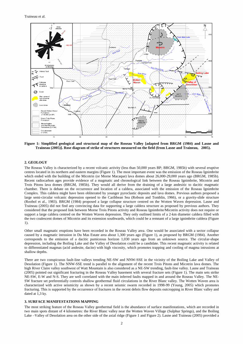
Figure 1: Simplified geological and structural map of the Roseau Valley [adapted from BRGM (1984) and Lasne and
Traineau (2005)]. Rose diagram of strike of structures measured on the field (from Lasne and Traineau, 2005).
2. GEOLOGY
The Roseau Valley is characterized by a recent volcanic activity (less than 50,000 years BP; BRGM, 1985b) with several eruptive
centres located in its northern and eastern margins (Figure 1). The most important event was the emission of the Roseau Ignimbrite
which ended with the building of the Micotrin (or Morne Macaque) lava domes about 26,000-29,000 years ago (BRGM, 1985b).
Recent radiocarbon ages provide evidence of a magmatic and chronological link between the Roseau Ignimbrite, Micotrin and
Trois Pitons lava domes (BRGM, 1985b). They would all derive from the draining of a large andesitic to dacitic magmatic
chamber. There is debate on the occurrence and location of a caldera, associated with the emission of the Roseau Ignimbrite
Complex. This caldera might have been obliterated by younger pyroclastic deposits and lava domes. Previous authors proposed a
large semi-circular volcanic depression opened to the Caribbean Sea (Robson and Tomblin, 1966), or a gravity-slide structure
(Roobol et al., 1983). BRGM (1984) proposed a large collapse structure centred on the Wotten Waven depression. Lasne and
Traineau (2005) did not find any convincing data for supporting a large caldera structure as proposed by previous authors. They
considered that the proposed link between Morne Trois Pitons activity and Roseau Ignimbrite/Micotrin activity does not require or
support a large caldera centred on the Wotten Waven depression. They only outlined limits of a 2-km diameter caldera filled with
the two coalescent domes of Micotrin and its extension southwards, which could be a remnant of a large ignimbrite caldera (Figure
1).
Other small magmatic eruptions have been recorded in the Roseau Valley area. One would be associated with a sector collapse
caused by a magmatic intrusion in Du Mas Estate area about 1,300 years ago (Figure 1), as proposed by BRGM (1984). Another
corresponds to the emission of a dacitic pumiceous horizon 1,030 years ago from an unknown source. The circular-shape
depression, including the Boiling Lake and the Valley of Desolation could be a candidate. This recent magmatic activity is related
to differentiated magmas (acid andesite, dacite) with high viscosity, which promotes trapping and cooling of magma intrusions at
shallow depths.
There are two conspicuous fault-line valleys trending NE-SW and NNW-SSE in the vicinity of the Boiling Lake and Valley of
Desolation (Figure 1). The NNW-SSE trend is parallel to the alignment of the recent Trois Pitons and Micotrin lava domes. The
high River Claire valley southwest of Watt Mountain is also considered as a NE-SW trending, fault-line valley. Lasne and Traineau
(2005) pointed out significant fracturing in the Roseau Valley basement with several fracture sets (Figure 1). The main sets strike
NE-SW, E-W and N-S. They are well correlated with the main inferred faults mapped in and around the Roseau Valley. The NE-
SW fracture set preferentially controls shallow geothermal fluid circulations in the River Blanc valley. The Wotten Waven area is
characterized with active seismicity as shown by a recent seismic swarm recorded in 1998-99 (Young, 2005) which promotes
fracturing. This is supported by the occurrence of fractures in the recent debris flow deposits outcropping in River Blanc valley and
dated at 1,3 ky.
3. SURFACE MANIFESTATIONS MAPPING
The most striking feature of the Roseau Valley geothermal field is the abundance of surface manifestations, which are recorded in
two main spots distant of 4 kilometres: the River Blanc valley near the Wotten Waven Village (Sulphur Springs), and the Boiling
Lake –Valley of Desolation area on the other side of the axial ridge (Figure 1 and Figure 2). Lasne and Traineau (2005) provided a

Traineau et al.
3
comprehensive map of the surface manifestations classified into eight types: warm spring, hot spring, mineralized-fluid hot spring,
fumaroles, cold gas discharge, solfatare and steam vent, fossil alteration area, phreatic crater.
Figure 2 : Type and location of the surface manifestations of the Roseau valley geothermal field compiled by Traineau and
Lasne (2008). Coordinates in UTM WGS84. Elevation in feet.
In River Blanc Valley, there is a clear zoning of surface manifestations with increasing elevation between 200 to 400 m.a.s.l.
(Figure 3). In the lower section of River Blanc (downstream the bridge) and to some extent in the Roseau River and Trois Pitons
River, there are several hot springs delivering Na-Cl waters and precipitating amorphous silica. Such hydrothermal surface
manifestations are often considered to represent the distal part of a lateral fluid outflow coming from a deep, high temperature,
sodium chloride reservoir. In the middle and upper sections of the River Blanc (upstream the bridge), in the River Camelia, there
are abundant steam vents, solfatares and springs delivering hot and warm, low-mineralized fluids. Hydrothermal alteration is
extensive with deposition of native sulphur, alunite, sulphates, Fe-sulphides, silica, clay material. It is ascribed to the advanced
argilic alteration type. The vicinity of the old Wotten Waven lodge is characterized with the occurrence of several small-size
phreatic vents associated with a low-intensity or fossil fumarolic activity. Several areas of cold gas discharges have been observed.
Figure 3 : Enlargement of Figure 2 showing a clear zoning of surface manifestations with increasing elevation in the River
Blanc Valley from 200 to 400 masl (from Traineau and Lasne, 2008).

Traineau et al.
4
Figure 4:The phreatic crater of Boiling Lake (left) and the Valley of Desolation (right) which was the site of phreatic
explosions in 1863 and 1880.
The Boiling Lake –Valley of Desolation area represents another main spot of surface manifestations (Figure 4). Its most prominent
feature is the Boiling Lake, considered as a recent but undated phreatic crater. The Valley of Desolation area has been the site of
phreatic explosions in 1863 and 1880. Today it is characterized mainly by solfataric activity, with several steam vents and hot
springs. Some of them discharge mineralized fluids, which derive from a high-temperature reservoir. The Boiling Lake – Valley of
Desolation hydrothermal area is located at an elevation of 700-800 metres within massive lavas belonging to Watt Mountain. A
structural control is considered for Boiling Lake with the proximity of a NNW-SSE trending fault.
Other surface manifestations are scattered in the Papilotte-Trafalgar Falls region and on the flanks of the Micotrin lava dome at
elevation of 740-780 m.a.s.l. (Sandringham Estate, Fresh Water Lake, Paix Bouche River; Figure 2). They are warm springs
discharging low-mineralized sodium-bicarbonate fluids. Warm springs on the flanks of the Micotrin lava domes are important
because they point out the existence of shallow bicarbonate aquifers which are often considered as peripheral waters developed
above deep high-temperature reservoirs.
The lack of thermal manifestation in the Roseau valley downstream of Wotten Waven (except one occurrence of warm fluid and
gas discharging in the Roseau River close to its junction with La Riviere Padu) is also striking. This suggests the existence of a
hidden permeability barrier as mentioned on Figure 2, which could be either a fault zone or a caldera border. The high valley of
River Blanc (Robinson Estate, Du Mas Estate) and the River Clair valley are also lacking thermal manifestation (Figure 2). Also
there is no known surface manifestation east of the Boiling Lake and Valley of Desolation area. This puts constraints in the location
of the deep geothermal reservoir which should be developed within a triangle defined by Micotrin northwards, Boiling Lake/Valley
of Desolation eastwards and Wotten Waven south-westwards (Figure 2).
3. FLUID GEOCHEMISTRY
About 35 warm and hot springs have been recorded in the Wotten Waven area and the Boiling Lake - Valley of Desolation area and
analysed by BRGM (1985), Lasne and Traineau (2005) and Traineau and Lasne (2008). The most representative fluid samples are
given in Table 1. They have been plotted in the Cl-SO4-HCO3 triangular diagram of Giggenbach (1988; Figure 5). They are without
any doubt indicative of the existence of a high temperature geothermal reservoir with neutral sodium chloride waters, bicarbonate
waters (Ca-Na-HCO3 type and Na-HCO3-SO4 type) and acid-sulphate waters. In addition, Ca-rich sodium chloride waters have
been identified in the Boiling Lake and Valley of Desolation area.
Table 1 : Selected chemical and isotopic data of Na-Cl waters and Ca-rich Na-Cl waters discharged by the thermal
manifestations of Wotten Waven and Boiling-Valley of Desolation areas in Dominica [from BRGM (1985), Lasne
and Traineau (2005), Traineau and Lasne (2008)].
Site date label T
(°C) pH
Cl
mg/l
HCO3
mg/l
SO4
mg/l
SiO2
mg/l
Na
mg/l
K
mg/l
Ca
mg/l
Mg
mg/l
B
mg/l
Br
mg/l
Li
mg/l
TDS
(g/l) δD δ18O 87Sr/86Sr
River Blanc 2005 RB2 70,3 6,79 595 153 74,6 156 360 46 38 4,5 1,17
River Blanc 2005 RB3 92,8 8,31 2450 49 45,8 194 1331 119 72 <0,5 28,8 9,1 2,55 4,22 10,1 5,3 0,70465
River Blanc 2005 RB4 72,5 4,3 443 <0,5 203 211 273 32 36 6,9 0,93
Roseau River 2005 RR1 84,5 7,3 1787 2005 25,3 184 1060 93 92 2 22,1 7,5 2,2 3,27 9,6 5 0,70467
Roseau River 2005 RR2 80,2 6,57 1182 305 29,5 221 745 59,9 58,6 10,3 14,4 4,2 1,72 2,4 -6,0 -1,0
Trois Pitons R. 2005 3PR 50,1 6,3 679 198 18,2 126 455 33,6 35,3 6,2 8,1 2,5 0,98 1,4
River Blanc 1985 DM15 96,6 7.97 2663 76,9 48 279 1579 202 52,9 0,48 9,7 -5,9 -0,1
River Blanc 1985 DM29 95,3 7,95 2627 49,4 27,9 291 1549 176 66,9 0,24 20,4 -4,7 0,1
Valley Desolation 2005 VD1 96,5 6,9 5892 32 93.8 291 868 208 1867 117 53,3 0.1 1.11 5.2 5.4 0,70456
Boiling Lake area 1985 DM17 85,6 3,6 1903 n.d. 68,2 279 851 178 260 21,6 27,5 6 3,6
Boiling Lake area 1985 DM26 96,6 6,45 6308 36,6 96 284 1039 286 2441 178 40,7 -4,4 3,2

Traineau et al.
5
Neutral sodium chloride waters (up to 93°C; 220 mg/l SiO2; 4 g/l TDS) are discharged in Lower River Blanc and close to its
junction with Roseau River and Trois Pitons River, i.e. at the lowest elevation in the field (Figure 3). They are mature waters and
some of them plot on the full equilibrium line in the Na-K-Mg diagram of Giggenbach (1988). The Na-K geothermometer
(Fournier, 1979) and the K-Mg geothermometer (Giggenbach, 1988) converge to a reservoir temperature of 200 -225°C (Figure 5).
Fluid-rock interactions at high temperature are also supported by their isotopic composition with a shift in δ18O from the local
WML (Figure 6) and their strontium isotopic ratio (87Sr/86Sr=0,7045-0,7049) which is similar with andesitic rocks. In the Cl-Na,
Cl-K, Cl-B, Cl-li and Cl-Br binary diagrams (Figure 6, Figure 7, Figure 8), these sodium chloride waters belong to a same trend
controlled by a mixing between a Cl-rich geothermal end-member and Cl-poor shallow groundwaters. In some diagrams, old
analyses from BRGM (1985) like DM15 and DM 29 have not been considered because they deviate from the general trend. The
chloride vs. magnesium binary plot shows a negative correlation, which is consistent with a progressive mixing and re-equilibration
upon cooling causing an increase in magnesium content (Figure 7). According to this diagram, the chloride concentration of the Cl-
rich geothermal end-member should be around 3000 mg/l. From the silica-chloride diagram (Figure 7), the silica concentration of
this Cl-rich geothermal end member having a chloride concentration of 3000 mg/l should be similar to the silica content of sample
DM29, i.e. about 291 mg/l. Based on the quartz geothermometer of Fournier (1977), the calculated quartz temperature of the Cl-
rich end-member (190°C) is lower than the temperature range estimated previously from the Na-K-Mg diagram of Giggenbach
(1988). It could be viewed as an evidence of cooling.
Figure 5 : Cl-SO4-HCO3 ternary diagram and Na-K-Mg ternary diagram of Giggenbach (1988) with full equilibrium line
based on the Na-K geothermometer of Fournier (1979). WW: Wotten Waven and Laudat area; BL-VoD: Boiling
Lake and Valley of Desolation area.
Figure 6 : δD-δ18O, δD-chloride, δ18O-chloride and Lithium-chloride binary diagrams of the surface thermal waters of the
Wotten-Laudat area (WW) and the Boiling Lake – Valley of Desolation area (BL-VoD).

Traineau et al.
6
The origin of the neutral sodium chloride water can be determined from the sodium-chloride and bromide chloride diagrams
(Figure 7 and Figure 8). Most of the analysed samples plot on the seawater mixing line suggesting that these waters derive from a
mixing between meteoric water and seawater. Moreover, their Cl/Br ratio is close to the seawater ratio (295; Figure 8). Based on
the bromide content, the ratio of seawater would be small and less than 10%. This is also consistent with the position of the Na-Cl
waters on the δD vs. chloride diagram (see Figure 6).
Figure 7 : Sodium-chloride, potassium-chloride, silica-chloride, magnesium-chloride, boron-chloride and calcium-chloride
binary diagrams of the compositions of waters from the Wotten Waven (WW) area and the Boiling Lake-Valley of
Desolation area (BL-VoD).
Figure 8 : Bromide-chloride and Cl/Br ratio vs. chloride binary diagrams of the composition of waters from the Wotten
Waven area (WW) and the Boiling Lake-Valley of Desolation area.
Uncommon Ca-rich sodium chloride waters are discharged by hot springs in the Valley of Desolation and in the vicinity of the
Boiling Lake. On the previous binary and ternary diagrams (Figure 5 to Figure 8), they differ from the Na-Cl waters discharged in
the Wotten Waven region. They are richer in calcium, chloride and boron and they are depleted in bromide. They also show a larger 18O shift. Their high calcium content might be indicative of strong degassing as observed in the Boiling Lake and as proposed by
Joseph et al. (2011). Their higher content in chloride and their shift in 18O could be also ascribed to a larger contribution of Cl-rich
magmatic waters, and they would appear more representative of a deep parent water. The chloride vs. boron and δ18O vs. chloride
Traineau et al.
7
diagrams (Figure 8 and Figure 6) suggest a possible relationship between the Wotten Waven Na-Cl waters and these Ca-rich Na-Cl
waters. The lack of equilibrium of the Ca-Na-Cl waters in the Na-K-Mg diagram (Figure 5) precludes the use of this graphic tool.
The quartz geothermometer of Fournier (1977) gives 190°C while the Na-K geothermometer of Fournier (1979) gives 305°C. The
lower temperature of the quartz geothermometer could be viewed as an evidence of cooling. The area of the Boiling Lake and
Valley of Desolation deserves additional geochemical surveying in order to better characterize the waters and gases discharged by
hot springs and steam vents and their relationships with Na-Cl waters discharged in Wotten Waven.
Bicarbonate waters are discharged as warm springs in River Camelia (Figure 3) and at greater distance from Wotten Waven
(Trafalgar, Titou Gorge, Micotrin). They are representative of shallow aquifers heated by gas (CO2) and steam above deep
geothermal reservoir. The most striking feature is probably the occurrence of warm springs discharging bicarbonate waters on the
flanks of the Micotrin lava dome at an elevation of 750-800 m.a.sl., i.e. 500 meters higher than the main area of surface
manifestations in River Blanc (Sulphur Springs). They could be indicative of a zone of fluid upflow from a deep geothermal
reservoir. Warm and hot springs discharging acid-sulphate waters are found in the two main areas of surface manifestations in
association with the solfataric activity (Sulphur Springs in Wotten Waven and Boiling Lake – Valley of Desolation).
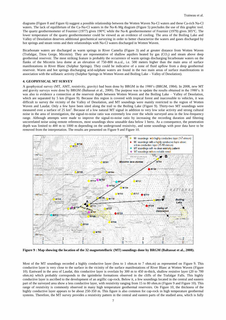
4. GEOPHYSICAL MT SURVEY
A geophysical survey (MT, AMT, resistivity, gravity) had been done by BRGM in the 1980’s (BRGM, 1984). In 2008, new MT
and gravity surveys were done by BRGM (Baltassat et al., 2008). The purpose was to update the results obtained in the 1980’s. It
was also to evidence a connection at the reservoir depth between Wotten Waven and the Boiling Lake – Valley of Desolation,
which are separated by 5 km (Figure 9). Because this region is covered with tropical forest and inaccessible to vehicles, it was
difficult to survey the vicinity of the Valley of Desolation, and MT soundings were mainly restricted to the region of Wotten
Waven and Laudat. Only a few have been sited along the trail to the Boiling Lake (Figure 9). Thirty-two MT soundings were
measured over a surface of 25 km2. Because of a low natural MT signal in addition to very low solar activity and strong cultural
noise in the area of investigation, the signal-to-noise ratio was extremely low over the whole surveyed area in the low-frequency
range. Although attempts were made to improve the signal-to-noise ratio by increasing the recording duration and filtering
uncorrelated noise using remote references, most soundings show unusable data below 1 hertz. As a consequence, the penetration
depth was limited to 400 m to 1000 m depending on the underground resistivity, and some soundings with poor data have to be
removed from the interpretation. The results are presented on Figure 9 and Figure 10.
Figure 9 : Map showing the location of the 32 magnetotelluric (MT) soundings done by BRGM (Baltassat et al., 2008).
Most of the MT soundings recorded a highly conductive layer (less to 1 ohm.m to 7 ohm.m) as represented on Figure 9. This
conductive layer is very close to the surface in the vicinity of the surface manifestations of River Blanc at Wotten Waven (Figure
10). Eastward in the area of Laudat, this conductive layer is overlain by 300 m to 450 m-thick, shallow resistive layer (20 to 700
ohm.m) which probably corresponds to the ignimbrite formations observed in the cliffs of the Trafalgar Falls. This highly
conductive layer is ascribed to the development of an argillic cap-rock. Below it, a few soundings located in the central and eastern
part of the surveyed area show a less conductive layer, with resistivity ranging from 15 to 80 ohm.m (Figure 9 and Figure 10). This
range of resistivity is commonly observed in many high temperature geothermal reservoirs. On Figure 10, the thickness of the
highly conductive layer appears to be about 250-350 m. This figure is also common for cap-rock in high temperature geothermal
systems. Therefore, the MT survey provides a resistivity pattern in the central and eastern parts of the studied area, which is fully

Traineau et al.
8
consistent with the existence of a high-temperature geothermal system. At soundings MT19 and MT29, the bottom of conductive
layer is at 500-600 m depth which corresponds to an elevation of 150-250 m.a.s.l.. In the areas of Laudat and Wotten Waven, the
limited depth of penetration of the MT soundings unfortunately prevents to observe the existence of the less conductive layer below
the highly conductive, argillic cap-rock. However, the abundance of surface manifestations is a good indicator of the existence of
the reservoir at depth below the argillic cap-rock.
Figure 10 : Cross-sections along the A-B and A-C profiles depicted on Figure 9 showing the pattern of resistivity along MT
soundings. TCL: top of conductive layer; BCL: bottom of conductive layer.
To the west and to the south of Wotten Waven, the limited depth of penetration also prevents from confirming the extension of the
less conductive layer ascribed to the reservoir. The lack of surface manifestations as previously discussed and indicated on Figure 2
suggests that the reservoir is lacking. There is a geoelectric discontinuity between the MT soundings MT28, MT10 on one hand, the
MT soundings MT02, MT32 and MT13 on the other (Figure 9), which suggests the existence of a N-S or NNW-SSE structure
(fault, caldera border?). This structure may act as the permeability barrier quoted previously, in order to explain the lack of surface
manifestation downstream of Wotten Waven. To the east, the results of the MT survey and especially the soundings MT19 an
MT29 clearly suggest a connection between Wotten Waven and Boiling Lake – Valley of Desolation. There is another feature
shown by the cross-section AB on Figure 10. The plunge of the Bottom of Conductive layer (BCL) between soundings MT31 and
MT05 suggests the existence of a fault or a caldera limit.
As a conclusion, the MT survey fails to image the boundary of the high temperature reservoir as is often required, but it supports
the model of a large reservoir extending between Micotrin lava dome, Wotten Waven, Boiling Lake and Valley of Desolation
(Figure 9).
5. PROPOSED CONCEPTUAL MODEL
Lasne and Traineau (2005) proposed a first conceptual model of the Roseau Valley geothermal field. They assumed the existence of
two distinct deep sodium chloride reservoirs (the Micotrin reservoir and the Boiling Lake reservoir) or a single large deep sodium
chloride reservoir subject to mixing with seawater on its western margin. This initial model has been updated by Traineau et Lasne
(2008) and Traineau et al. (2008), thanks to the additional data on fluid geochemistry and to the results of the MT survey. As
mentioned previously, the latter supports the hypothesis of a large reservoir extending from Wotten Waven to Boiling Lake –
Valley of Desolation. The Na-Cl waters and Ca-Na-Cl waters discharged in both areas might have a common origin, but would
have evolved separately during their ascent to the surface. The higher contents of calcium and chloride in the Ca-Na-Cl waters
discharged in the Boiling Lake –Valley of Desolation could be indicative of a strong degassing before they reach the surface.
The updated model which best fits with the results of the geological, geochemical and geophysical surveys is a deep sodium
chloride reservoir with an upflow zone below the recent Micotrin lava domes, and lateral outflow zones to the southwest (Wotten
Waven) and to the southeast (Boiling Lake – Valley of Desolation) as shown by Figure 11. The warm springs discharging
bicarbonate waters on the flanks of the Micotrin lava domes (see Figure 2) well support the existence of an upflow zone. In this
model, Wotten Waven is considered as the distal part of the southwest outflow zone and this is well consistent with the observed
zoning of the surface manifestations (see Figure 3). The existence of a shallow steam-cap below the River Blanc area, in addition to
the fluid ascent and its boiling is suggested in order to explain the abundance of surface manifestations. The existence of a shallow
steam-cap below the Valley of Desolation is also suggested but not assessed.

Traineau et al.
9
The Boiling Lake – Valley of Desolation hydrothermal area is located high up at an elevation of 700-800 metres. The discharged
Ca-Na-Cl waters appear to be less diluted and more representative of the deep Na-Cl parent fluid and it is consistent with a location
closer to the upflow zone. The lateral fluid outflow zone probably develops along the inferred caldera border and crosses the central
ridge thanks to a NNW-SSE fault (Figure 10).
The lack of surface manifestations in the Roseau valley west of Wotten Waven (except one occurrence of warm fluid and gas
discharging in the Roseau River close to its junction with La Riviere Padu; Figure 2) suggest the existence of a hidden permeability
barrier as reported on Figure 2, which could be either a fault zone or a caldera border. The extension of the reservoir to the south of
the surveyed area (Robinson Estate, Du Mas Estate; Figure 9) is not dismissed but it is not confirmed by surface manifestations.
Figure 11 : Map and cross-section of the conceptual model of the Roseau valley geothermal field as proposed by Traineau
and Lasne (2008).
6. RESOURCE ASSESSMENT
The estimated size of the reservoir is tentatively delineated on Figure 12. It corresponds to the area where high temperature fluids
are thought to be encountered at depth and represents about 18 km2. It is mainly based on the conceptual model. It includes the area

Traineau et al.
10
of the expected deep high temperature reservoir and upflow zone located below the Morne Micotrin lava dome. It includes also the
outflow zones towards southwest (Wotten Waven) and southeast (Boiling Lake and the Valley of Desolation). The depth of the
reservoir (as defined by the bottom of the conductive layer) has been estimated from the resistivity data provided by the MT survey
(Baltassat et al., 2008). The top of the reservoir is thought to be very shallow in the River Blanc valley (300 to 500 m deep). To the
northeast, it is increasing in parallel with the topography. In the vicinity of Laudat, the top of the reservoir is expected to be about
700-800 m deep. Around the Fresh Water Lake, it is assumed to be around 1000 m deep.
Temperature of the deep Na-Cl reservoir is not well constrained. According to the Na-K geothermometer of Fournier (1979)
applied to the Ca-Na-Cl waters of the Valley of Desolation (sample VD-1), its maximum temperature could be around 300°C. Na-
Cl waters discharged in Wotten Waven have been equilibrated at lower temperature (200-225°C).
Figure 12 proposes a preliminary design of the development of the Roseau Valley geothermal field. On a first basis, it is considered
that the development should be focused on the western half of the reservoir which has been delimited. The eastern half appears to
be located within the boundary of the National Park; it is a remote area without any existing road access. The main zone of interest
extends south of the Micotrin lava dome on a large, gentle-slope plateau covered with forest. It is accessible through the narrow
paved road linking Roseau to Laudat. It appears to be the most suitable area for siting production wells and large capacity power
plants. Its eastern border corresponds to the boundary of the National Park. Directional wells can be drilled to exploit the deep high
temperature fluids across the border if allowed by the Park regulations. Its southern border corresponds to the ignimbrite cliff
overhanging the River Blanc valley. The Trafalgar Falls represent its western boundary. The road from Laudat to Fresh Water Lake
lines it to the north. The elevation of this gentle-slope plateau ranges from 500 to 800 m.a.s.l. from west to east. At its south-
western margin, the right-hand side of the River Blanc valley (from Pachoute Estate to Robinson Estate; Figure 12) is considered as
the most suitable reinjection zone for brines produced at higher elevation in the Laudat-Micotrin plateau. It could also be viewed as
suitable for a small-size capacity power plant with a few production and reinjection wells. Its elevation ranges from 250 to 450
m.a.s.l. The Fond Cani-Casso area is considered to be at the margin of the high temperature reservoir. This area could be tentatively
ascribed to fluid reinjection. However, the benefits in terms of pressure recovery could be limited.
Figure 12: Estimated size of the Roseau valley geothermal reservoir and preliminary design proposed for the field
development (from Traineau et al., 2008).
A preliminary assessment of the reservoir capacity has been conducted, by estimating the number of wells that could be sited within
the western half of the reservoir. About 50 vertical and directional wells could be accommodated, if considering an average well
spacing of 500 m on a 15 km2 area. Assuming a ratio between production wells and reinjection/unsuccessful wells of 3:2, and
given an equivalent power capacity of 4 MWe per production well, a preliminary figure of 100-120 MWe is considered for the
reservoir capacity. It is in agreement with the rule of thumb of a power density of 10 MWe per km2, which is observed for
reservoirs with temperature around 250°C. At least sites for exploratory drilling have been proposed (Figure 12). They are scattered
all over the reservoir area in order to check potential for production and reinjection.
Even if a conceptual model of the Roseau Valley high temperature geothermal system has been proposed, there are still some
unknowns which have not been addressed by the successive surveys. The distribution and coverage of MT survey are incomplete.

Traineau et al.
11
Moreover, due to low natural MT signal, distribution of resistivity at depth remains unclear. An additional MT survey would be
beneficial to cover larger area and to investigate deeper. The geochemical survey was also incomplete. There is no data on gas in
fumaroles and solfataras. The structural analysis was not able to evidence main faults. As a consequence, it was not possible to
define clear drilling targets for exploratory wells.
6. CONCLUSIONS
The Roseau Valley geothermal field can be considered one of the high potential geothermal prospects in the Caribbean. The
abundance of surface manifestations and the chemistry of waters discharged are supporting the existence of a high temperature
reservoir with temperature ranging between 200°C to 300°C. Despite its limited depth of penetration, the MT survey provided a
clear resistivity pattern for some soundings which points out a highly conductive, argillic cap-rock and an underlying less
conductive reservoir. However, there are some uncertainties which still exist after the last survey done in 2008. First, the area of the
Boiling Lake and Valley of Desolation warrants an additional geochemical survey, in order to better characterize the waters and
gases discharged by hot springs and steam vents, and their relationships with Na-Cl waters discharged in Wotten Waven. This area,
together with the area north and east of the Micotrin lava domes, also deserves additional surveys (geological, geochemical,
geophysical) in order to check the extension of the reservoir on the “Atlantic side”. This is a remote area covered with tropical
forest and without vehicle access. According to the testimonies of local residents, there are no surface manifestations except the
Boiling Lake and Valley of Desolation.
Another challenge will be to combine the development of the geothermal field with the Dominican environmental constraints and
tourism. The Roseau valley is one of the most visited places in Dominica, thanks to the thermal manifestations of Sulphur Springs.
Some small-scale facilities for spas have been developed here in the last ten years. The exploitation of the geothermal reservoir in
the Wotten Waven area should take care of the flow rate of natural manifestations.
ACKNOWLEDGMENTS
This work has been carried in the framework of the Project “Géothermie Caraïbe” with the support of the European Programme
INTERREG III-B “Espaces Caraïbes”. The authors would like to thank the Government of Dominica (Ministry of Public Works,
Energy and Ports) and especially Mr. Michael Fadelle for their support during field surveys in Dominica. Mr. Arlington James
(Forestry Division) is also acknowledged for its support during field trips. Authors also acknowledge an anonymous reviewer who
helps to improve this paper.
REFERENCES
Baltassat, J.M., Coppo, N., Pajot, G., and Dupont, F.: Magnetotelluric and gravimetric investigations of the geothermal potential in
the Roseau Valley (Dominica, WI), Rapport BRGM/RP-56916-FR, (2008), 71p.
Barnea, J., Harkin, D., McNitt, J., MacDougall, H., and Harris, R.: Report on a United Nations Mission to Dominica, W.I./ January
4-11, 1969, Evaluation of Natural Resources: Mimeographed United Nations Report, (1969), 9 p.
BRGM: Geothermal prefeasibility study on Dominica Island, BRGM Report n° 84 SGN 101GTH, (1984).
BRGM: Geochemical study of Dominica island, BRGM Report n° 85 SGN 102GTH, (1985a), 36p.
BRGM: Volcano-structural history of southern part of Dominica island; BRGM Report ° 85 SGN 068 IRG-GTH (1985b).
Fournier, R.O.: Chemical geothermometer and mixing model for geothermal systems, Geothermics, 5, (1977), 41-50.
Fournier, R.O.: A revised equation for the Na/K geothermometer, Geotherm. Resources Council Trans., 3, (1979), 221-224.
Geotermica Italiana: Exploration for geothermal resources in the Eastern Caribbean. Final Report, Contract TCD CON 15/90 –
RLA/87/037, Pisa, Italy, UN-DTCD & CARICOM, (1992), 192p.
Giggenbach, W.F.: Geothermal solute equilibria. Derivation of Na-K-Mg-Ca geoindicators. Geochim Cosmochim Acta, 52, (1988),
2749-2765.
Joseph, E.P., Fournier, N., Lindsay, J.M., and Fisher, T.P.: Gas and water geochemistry of geothermal systems in Dominica, Lesser
Antilles island arc, J. Volcano. Geotherm. Res., 206, (2011), 1-14.
Lasne E., and Traineau H.: Field report on geothermal exploration in Wotten Waven, Dominica. OAS Eastern Caribbean
Geothermal Development Project (Geo-Caraïbes), Report 05 CFG Services 14, (2005), 111p., 2 plates.
Robson, G.R., and Tomblin, J.F.: Catalogue of the actives volcanoes of the World including solfatara fields, part 20, the West
Indies, International Association of Volcanology, (1966), 56p.
Roobol, M.J., Wright, J.V., and Smith, A.L.: Calderas or gravity-slide structures in the Lesser Antilles Island Arc, J. Volcanol.
Geoth. Res., 19, (1983), 121-134.
S.R.U.: Volcano hazard report for Southern Dominica : Interpretation of 1998-2000 earthquakes and hazard mapping results.
Report, Seismic Research Unit, UWI, Trinidad, (2000), 49p.
Traineau, H., and Lasne, E.: Geological and geochemical survey of the Wotten Waven geothermal field, Dominica, West Indies,
Final report 09CFG Services 40, (2008), 65p.
Traineau, H., Lasne, E., Herbrich, B., and Tournaye D.: The Wotten Waven geothermal field, Dominica, West Indies. Resource
assessment and exploratory drilling programme, Final Report 09CFG Services, (2008), 57p.
Young, S.: Review of local seismicity and other observations relevant to characterising the geothermal resources in Dominica.
GeoSYS Ltd unpublished Report, (2005), 8pp.