Embed Size (px)
Citation preview
RAP / HRRR weather guidance for Air Traffic Flow Management:
Progress and Challenges
Friends and Partners of Aviation Weather NBAA Convention, October 23-24, 2014
Stephen S. Weygandt Curtis Alexander, Stan Benjamin,
Geoff Manikin*, Tanya Smirnova, Ming Hu NOAA Earth System Research Laboratory
*NOAA National Centers for Environmental Prediction
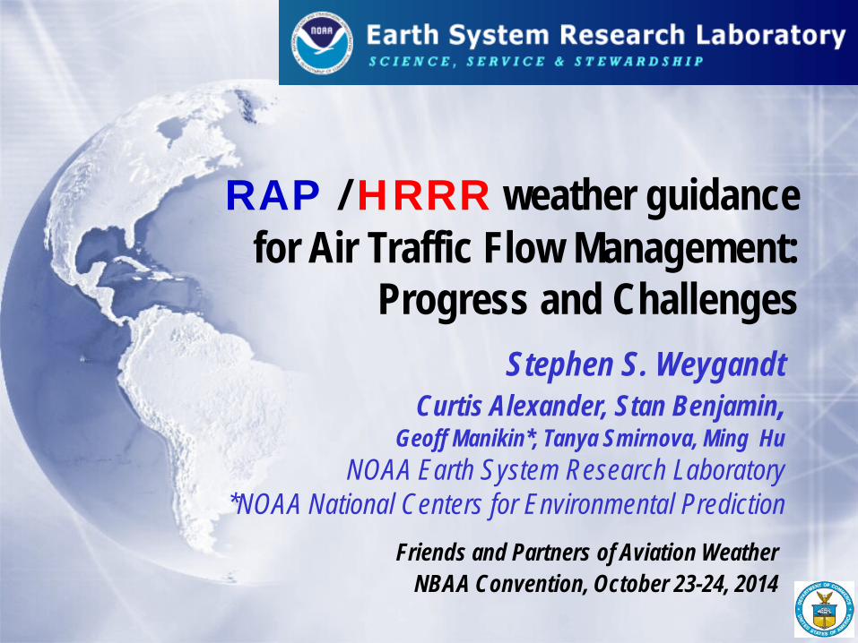
Rapid Refresh and HRRR NOAA hourly updated models
13km Rapid Refresh (RAP)
3km High Resolution Rapid Refresh (HRRR)
Version 2 -- NCEP implement 25 Feb 2014
Version 3 – GSD Planned NCEP -- 2015
RAP
HRRR Initial – NCEP implement 30 Sept 2014
Version 2 – GSD Planned NCEP --2015
GSD NCEP HRRR: MORE RELIABLE (now 99+%) AVAILABLE SOONER (1h fcst by +50 min, 15h fcst by +1:30
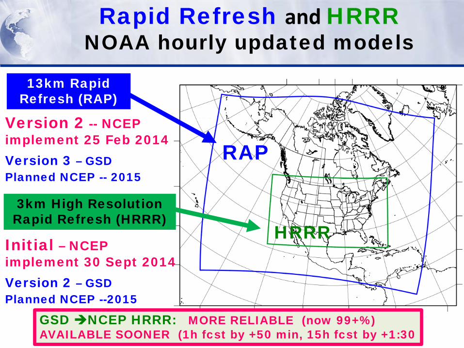
Higher resolution models
Rawins Satellite Aircraft Radar Surface Profiler
Accurate prediction of hazardous weather What are the key requirements?
Rapid updating
Use of all Observations (Data assimilation)
13-km Reality
ORD
LAX
ORD
3-hr forecast
LAX
6-hr forecast Wind
Errors
3-km
-- Fresher forecasts -- Time-lagged ensembles
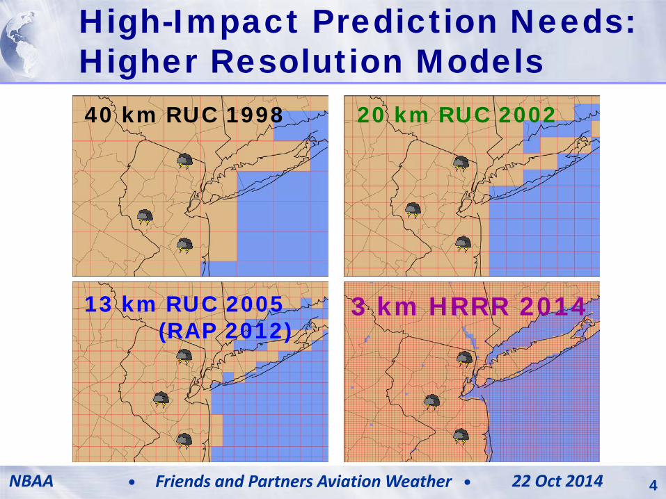
High-Impact Prediction Needs: Higher Resolution Models
20 km RUC 2002
13 km RUC 2005 (RAP 2012)
3 km HRRR 2014
40 km RUC 1998
AWRP PMR 11 June 2013 4 Model Development & Enhancement NBAA 22 Oct 2014 4 Friends and Partners Aviation Weather
13-km 6hr forecast HRRR 6hr forecast
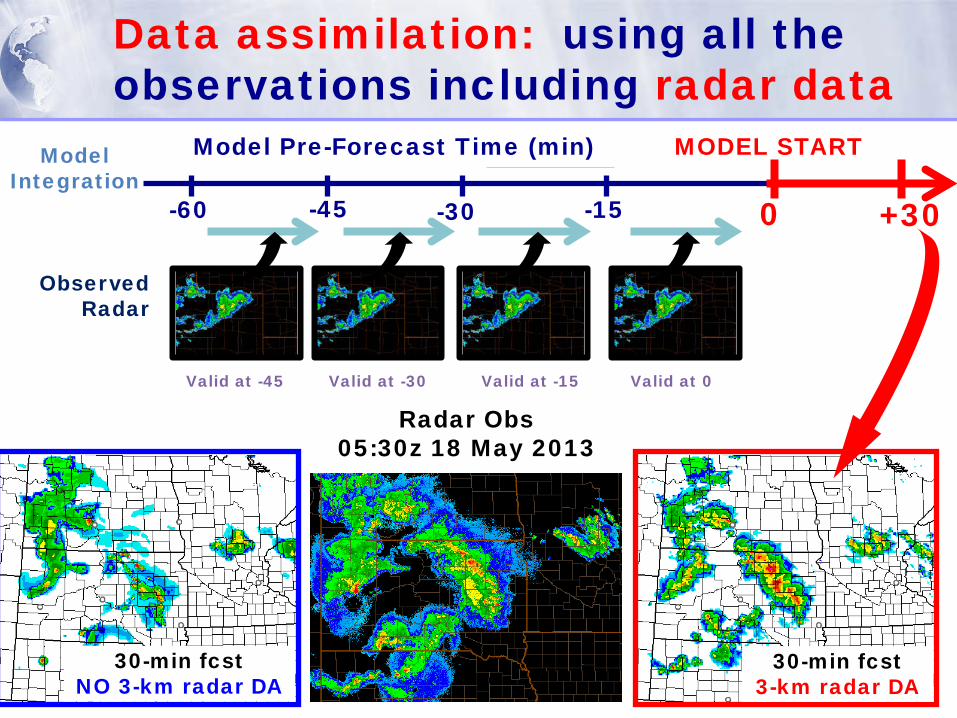
Observations Used Data assimilation: using all the observations including radar data
Model Pre-Forecast Time (min) MODEL START
-60 -15 -45 -30 0
Model Integration
Observed Radar
Valid at -45 Valid at -30 Valid at -15 Valid at 0
+30
30-min fcst 3-km radar DA
30-min fcst NO 3-km radar DA
Radar Obs 05:30z 18 May 2013
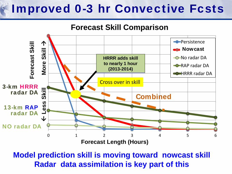
0 1 2 3 4 5 6
PersistenceExtrapolationNo radar DARAP radar DAHRRR radar DA
HRRR adds skill to nearly 1 hour
(2013-2014)
Cross over in skill
Forecast Skill Comparison
Forecast Length (Hours)
Fore
cast
Ski
ll
L
ess
Skill
M
ore
Skill
Improved 0-3 hr Convective Fcsts
Model prediction skill is moving toward nowcast skill Radar data assimilation is key part of this
NO radar DA
13-km RAP radar DA
3-km HRRR radar DA
Nowcast
Combined
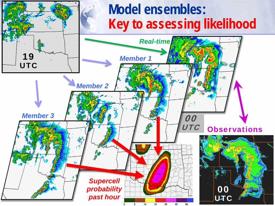
00 UTC
Real-time
Model ensembles: Key to assessing likelihood
Member 3
Observations
Member 2
Member 1
Supercell probability past hour
19 UTC
00 UTC
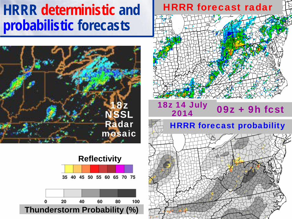
18z 14 July 2014 09z + 9h fcst 18z
NSSL Radar
mosaic
Thunderstorm Probability (%)
Reflectivity
HRRR forecast radar
HRRR forecast probability
HRRR deterministic and probabilistic forecasts
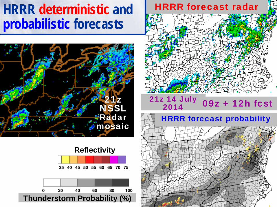
21z 14 July 2014 09z + 12h fcst 21z
NSSL Radar
mosaic
Thunderstorm Probability (%)
Reflectivity
HRRR forecast radar
HRRR forecast probability
HRRR deterministic and probabilistic forecasts
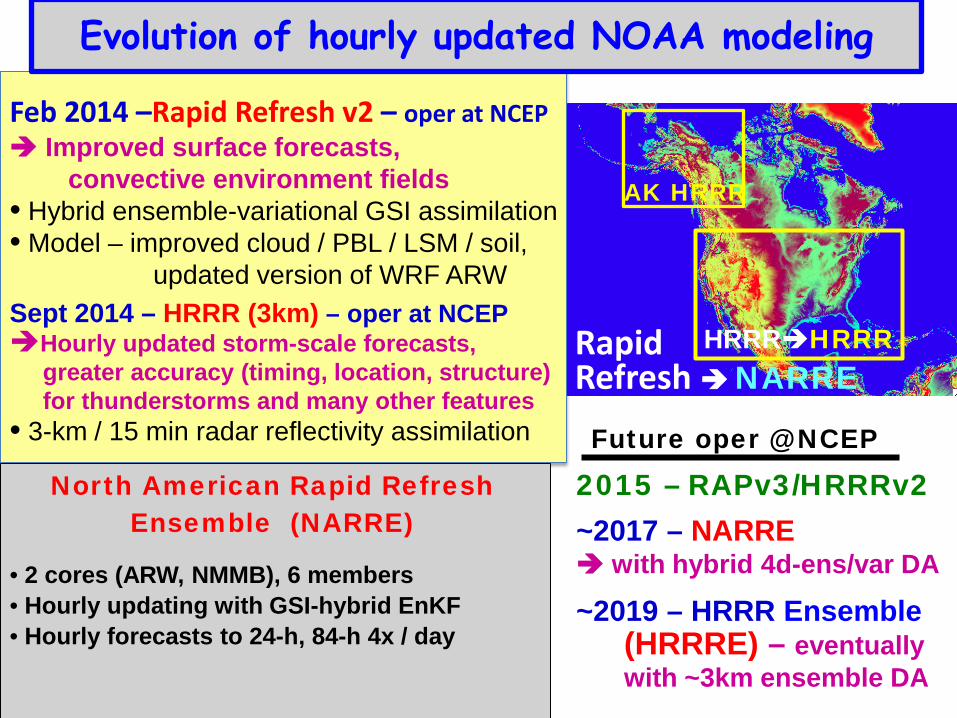
Evolution of hourly updated NOAA modeling
Feb 2014 –Rapid Refresh v2 – oper at NCEP Improved surface forecasts, convective environment fields • Hybrid ensemble-variational GSI assimilation • Model – improved cloud / PBL / LSM / soil, updated version of WRF ARW
Sept 2014 – HRRR (3km) – oper at NCEP Hourly updated storm-scale forecasts, greater accuracy (timing, location, structure) for thunderstorms and many other features • 3-km / 15 min radar reflectivity assimilation
North American Rapid Refresh Ensemble (NARRE)
• 2 cores (ARW, NMMB), 6 members
• Hourly updating with GSI-hybrid EnKF
• Hourly forecasts to 24-h, 84-h 4x / day
Rapid Refresh NARRE
2015 – RAPv3/HRRRv2
~2017 – NARRE with hybrid 4d-ens/var DA
~2019 – HRRR Ensemble (HRRRE) – eventually with ~3km ensemble DA
HRRRHRRR
Future oper @ NCEP
AK HRRR