Embed Size (px)
Citation preview
Impact of upper-air and near-surface observations on short-range forecasts
from NOAA hourly assimilation cycles
(RUC and Rapid Refresh)• aircraft • profiler • VAD winds • rawinsonde• GPS precipitable water• METARs• radar reflectivity• AMVs
http://rapidrefresh.noaa.gov
Wed 23 May 2012WMO Workshop on Impact of Obs on NWP
Stan BenjaminEric JamesHaidao Lin
Steve WeygandtSusan Sahm
Bill MoningerNOAA Earth System
Research Laboratory, Boulder, CO
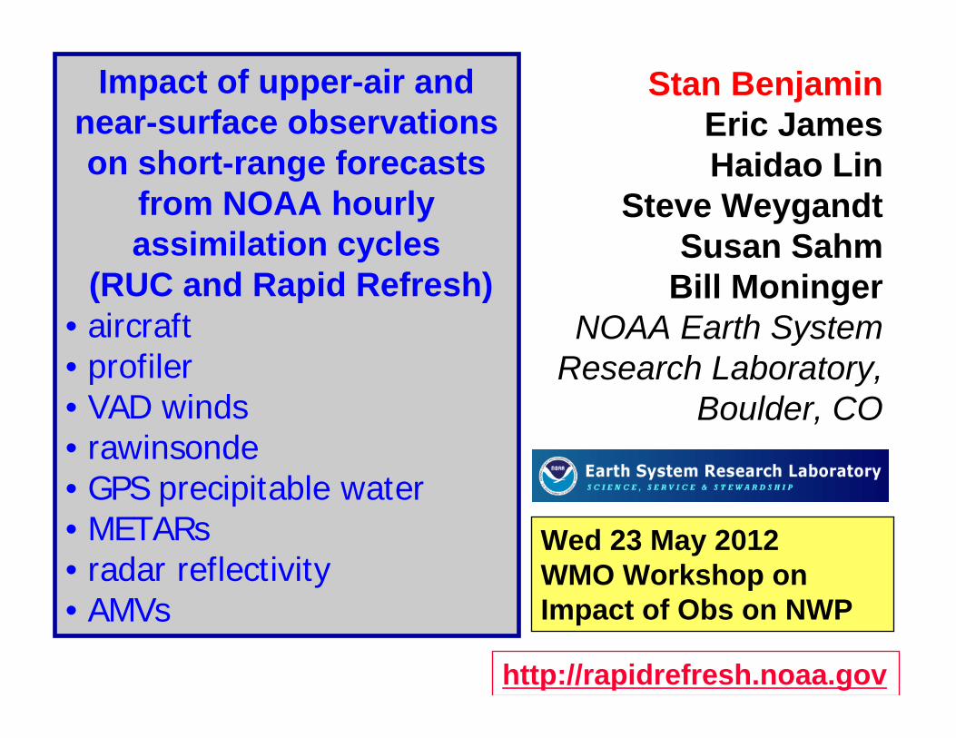
RUC / RAP hourly cycling
11 12 13Time (UTC)
AnalysisFields
3DVAR
Obs
3DVAR
Obs
Back-groundFields
18-h fcst18-h fcst
1-hrfcst
RadarDDFI
Initial ConditionFields
DDFI
1-hrfcst18-h fcst
1-hrfcst
HourlyRUC or RAP

Hourly Updated NOAA NWP Models
13km Rapid Refresh
13km RUCprior operational
model, new 18h fcst every hour
Rapid Refresh (RAP)replaced RUC at NCEP 1 May 12 Uses WRF, GSI with RUC features
new operationalmodel, new 18h fcst every hour

Community-based advanced model and analysis in RAP
- WRF-ARW: advanced numerics, non-hydrostatic- GSI: advanced satellite data assimilation
NOAA hourly updated modelsfrom RUC to Rapid Refresh RAP
Model DomainGrid Points
Grid Spacing
Vertical Levels
Vertical Coordinate
Pressure Top
Boundary Conditions
RUC CONUS 451 x 337 13 km 50Sigma/
Isentropic~50 mb NAM
RAP North America
758 x 567 13 km 50 Sigma 10 mb GFS
Model Assimilation DFICloud Analysis
Cloud micro‐physics
Radiation LW/SW
Convparam
PBL LSM
RUC RUC‐3DVARYes
w/radarYes
Thompson (2003) – 5 species
RRTM/Dudhia
Grell‐Devenyi
Burk Thompson
RUC 2003
RAP GSI w/ radiances
Yes w/radar
YesThompson (2008) – 6 species
RRTM/Goddard
Grell‐3d MYJRUC 2010
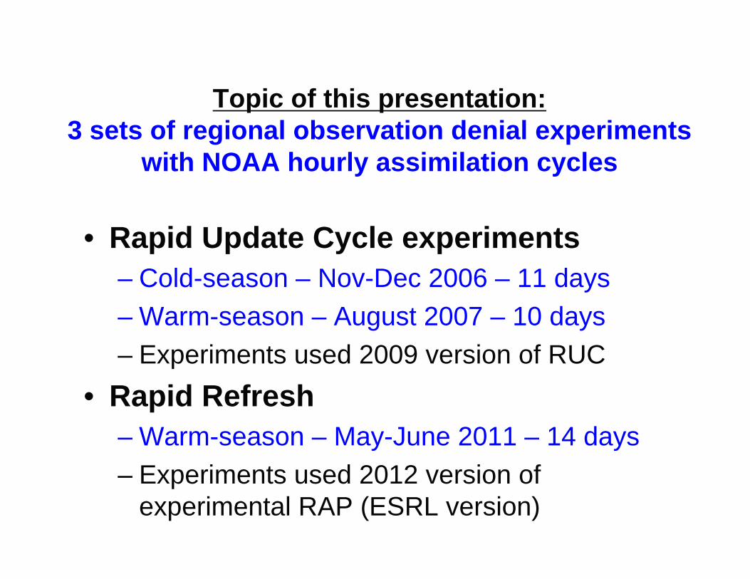
Topic of this presentation:3 sets of regional observation denial experiments
with NOAA hourly assimilation cycles
• Rapid Update Cycle experiments– Cold-season – Nov-Dec 2006 – 11 days– Warm-season – August 2007 – 10 days– Experiments used 2009 version of RUC
• Rapid Refresh– Warm-season – May-June 2011 – 14 days– Experiments used 2012 version of
experimental RAP (ESRL version)
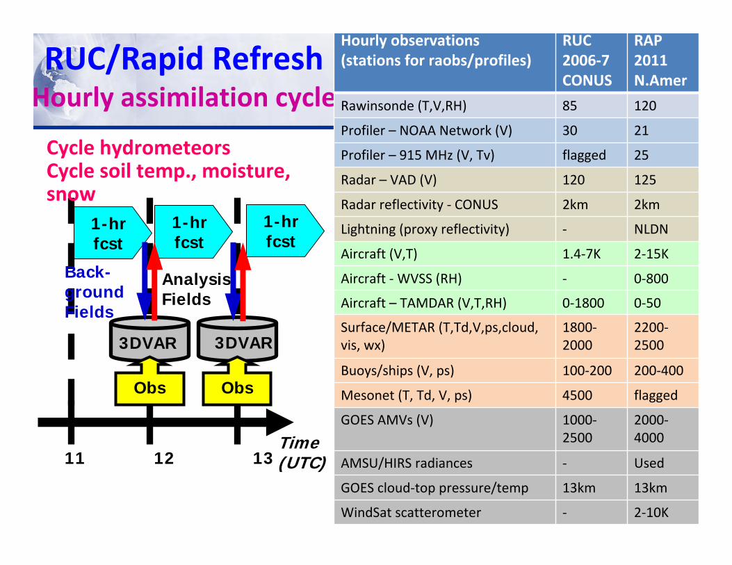
RUC/Rapid Refresh Hourly assimilation cycle
1-hrfcst
1-hrfcst
1-hrfcst
11 12 13Time (UTC)
AnalysisFields
3DVAR
Obs
3DVAR
Obs
Back-groundFields
Cycle hydrometeorsCycle soil temp., moisture, snow
Hourly observations (stations for raobs/profiles)
RUC2006‐7 CONUS
RAP 2011 N.Amer
Rawinsonde (T,V,RH) 85 120
Profiler – NOAA Network (V) 30 21
Profiler – 915 MHz (V, Tv) flagged 25
Radar – VAD (V) 120 125
Radar reflectivity ‐ CONUS 2km 2km
Lightning (proxy reflectivity) ‐ NLDN
Aircraft (V,T) 1.4‐7K 2‐15K
Aircraft ‐WVSS (RH) ‐ 0‐800
Aircraft – TAMDAR (V,T,RH) 0‐1800 0‐50
Surface/METAR (T,Td,V,ps,cloud, vis, wx)
1800‐2000
2200‐2500
Buoys/ships (V, ps) 100‐200 200‐400
Mesonet (T, Td, V, ps) 4500 flagged
GOES AMVs (V) 1000‐2500
2000‐4000
AMSU/HIRS radiances ‐ Used
GOES cloud‐top pressure/temp 13km 13km
WindSat scatterometer ‐ 2‐10K

Rapid Refresh obs counts (not counting radar reflectivity, GOES cloud, polar sat radiances)
NOAA ‐ Stan Benjamin ‐ 5/3/2012
METARs, buoys, ships, SYNOPsAircraft, profilers, raobs,VADs, AMVs
Aircraft, raobs, sfc
Sfc, aircraft, raobs

RUC/RAP observation denial experiments

Observations assimilated in hourly update models (RUC,
Rapid Refresh)
Radar reflectivity
NEXRAD VAD winds

RUC/RAP – specific analysis features
Special treatments for surface observations
Cloud and hydrometeor analysis
Digital filter‐based reflectivity assimilation
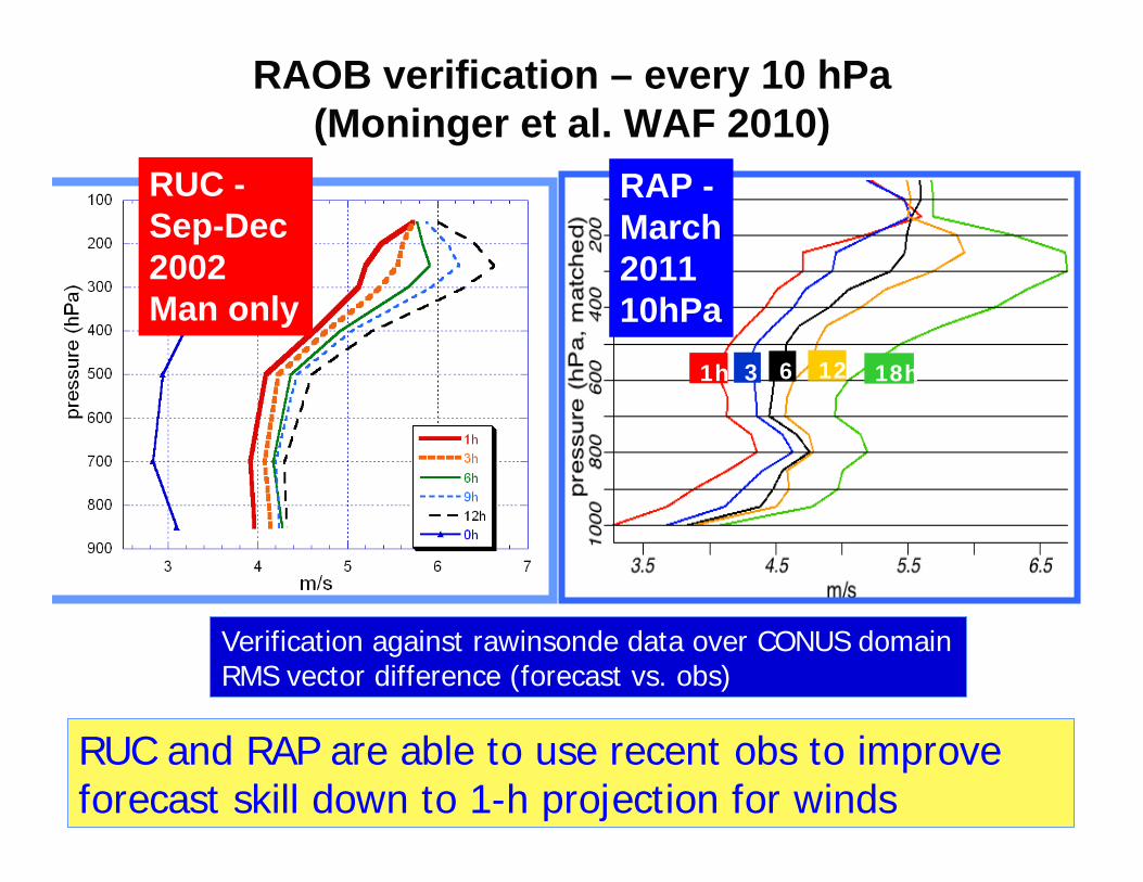
RAOB verification – every 10 hPa (Moninger et al. WAF 2010)
1h 3 6 12 18h
Verification against rawinsonde data over CONUS domainRMS vector difference (forecast vs. obs)
RUC and RAP are able to use recent obs to improve forecast skill down to 1-h projection for winds
RUC -Sep-Dec 2002Man only
RAP -March 201110hPa
12
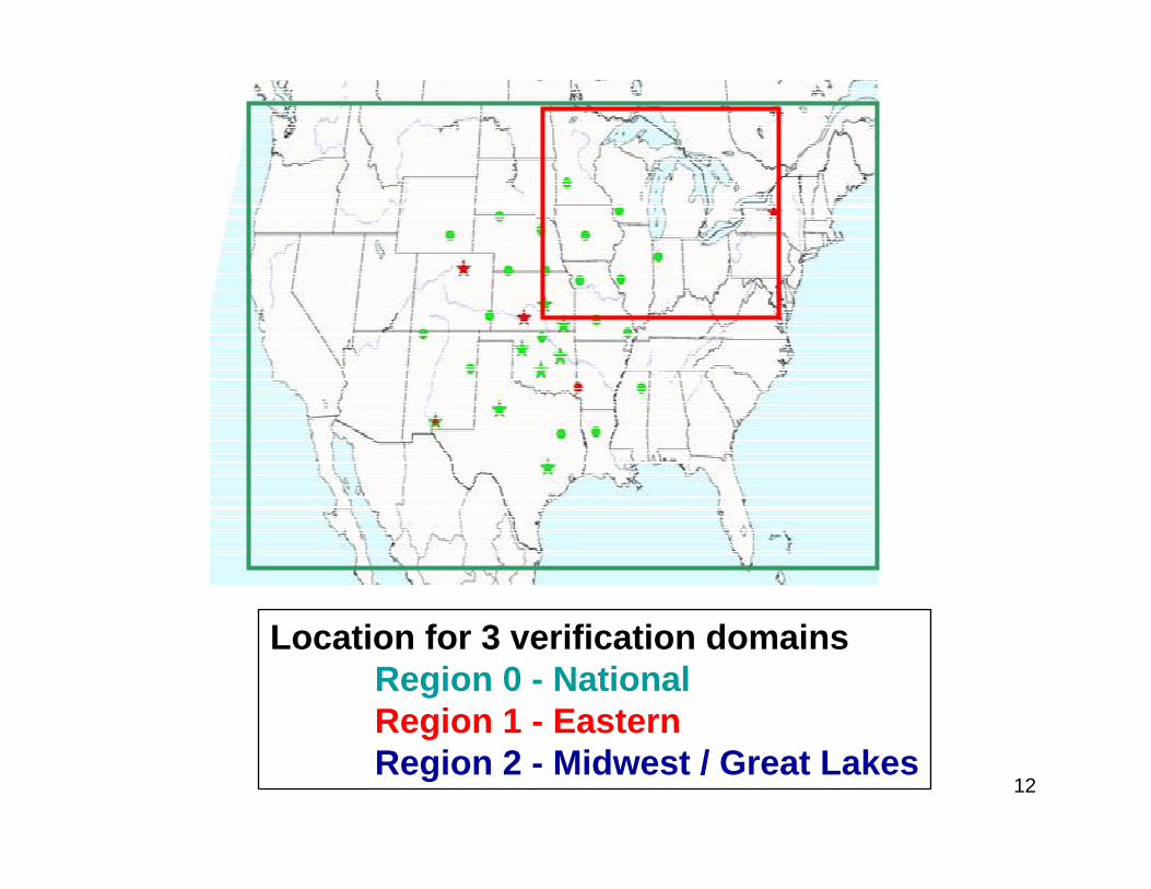
Location for 3 verification domains Region 0 - NationalRegion 1 - EasternRegion 2 - Midwest / Great Lakes
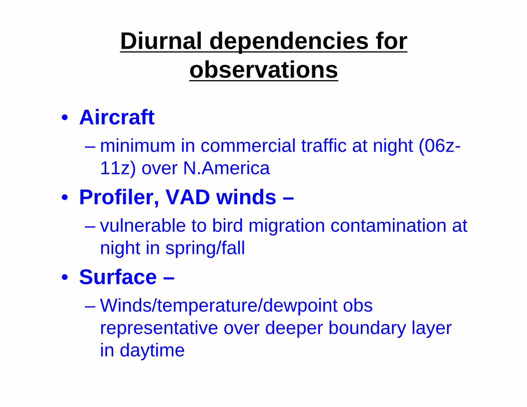
Diurnal dependencies for observations
• Aircraft– minimum in commercial traffic at night (06z-
11z) over N.America• Profiler, VAD winds –
– vulnerable to bird migration contamination at night in spring/fall
• Surface –– Winds/temperature/dewpoint obs
representative over deeper boundary layer in daytime
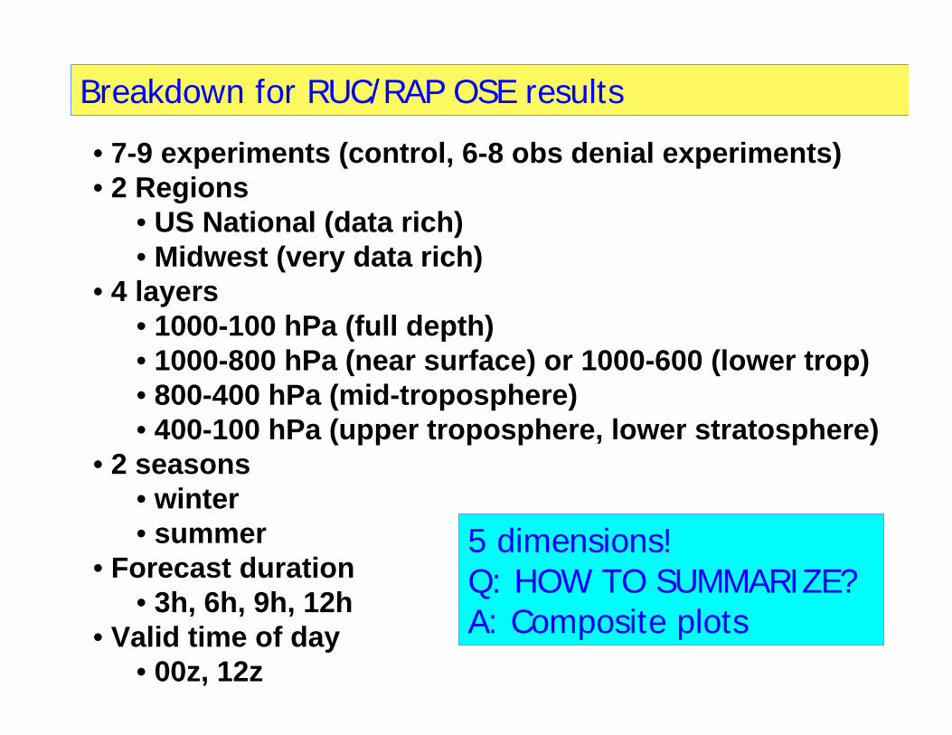
Breakdown for RUC/RAP OSE results
• 7-9 experiments (control, 6-8 obs denial experiments)• 2 Regions
• US National (data rich)• Midwest (very data rich)
• 4 layers• 1000-100 hPa (full depth)• 1000-800 hPa (near surface) or 1000-600 (lower trop)• 800-400 hPa (mid-troposphere)• 400-100 hPa (upper troposphere, lower stratosphere)
• 2 seasons• winter• summer
• Forecast duration• 3h, 6h, 9h, 12h
• Valid time of day• 00z, 12z
5 dimensions!Q: HOW TO SUMMARIZE?A: Composite plots

1st Breakdown for RUC OSE results
• 7-9 experiments (control, 6-8 obs denial experiments)• 2 Regions
• US National (data rich)• Midwest (very data rich)
• 4 layers• 1000-100 hPa (full depth)• 1000-800 hPa ( near surface)• 800-400 hPa (mid- troposphere)• 400-100 hPa (upper troposphere, lower stratosphere)
• 2 seasons• winter• summer
• Forecast duration• 3h, 6h, 12h
• Valid time of day• 00z, 12z
6 dimensions!Q: HOW TO SUMMARIZE?A: Composite plots
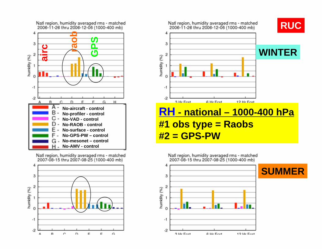
WINTER
SUMMER
RH - national – 1000-400 hPa#1 obs type = Raobs#2 = GPS-PW
No-aircraft - controlNo-profiler - controlNo-VAD - controlNo-RAOB - controlNo-surface - controlNo-GPS-PW – controlNo-mesonet – controlNo-AMV - control
RUC
raob
GPS
airc
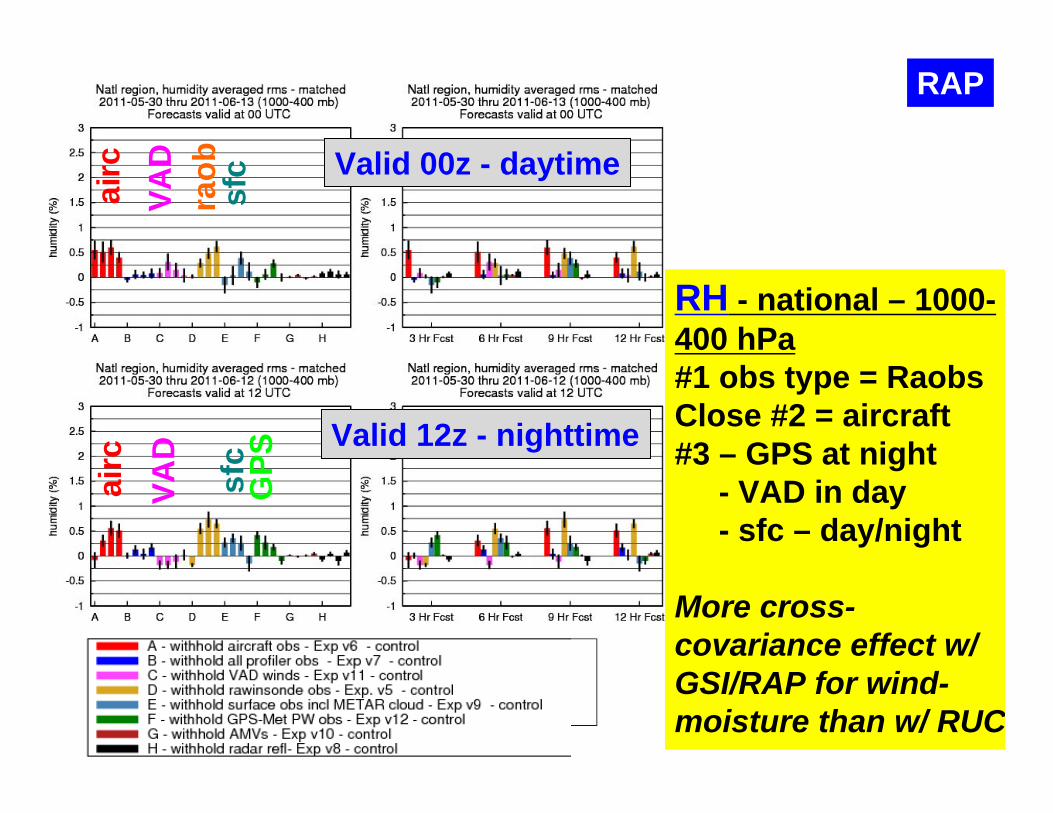
RAP
RH - national – 1000-400 hPa#1 obs type = RaobsClose #2 = aircraft#3 – GPS at night
- VAD in day- sfc – day/night
More cross-covariance effect w/ GSI/RAP for wind-moisture than w/ RUC
raob
airc
sfc
airc
sfc
GPS
VAD
Valid 00z - daytime
Valid 12z - nighttime
VAD

WINTER
SUMMER
Temp - national - 1000-100 hPaTie for #1 = Aircraft, RAOBsAircraft more at 3h, RAOB-12hSfc ~ aircraft, RAOB in summer(!)
No-aircraft - controlNo-profiler - controlNo-VAD - controlNo-RAOB - controlNo-surface - controlNo-GPS-PW – controlNo-mesonet – controlNo-AMV - control
RUCai
rc
raob
sfc
raob
airc

Temp - national -1000-100 hPa#1 = Aircraft#2 = RAOBsAircraft more at 3h, RAOB-12h
RAPai
rcai
rcValid 00z - daytime
Valid 12z - nighttime
raob

WINTER
SUMMER
Wind - national - 1000-100 hPa#1 = Aircraft#2 = RAOBs
No-aircraft - controlNo-profiler - controlNo-VAD - controlNo-RAOB - controlNo-surface - controlNo-GPS-PW – controlNo-mesonet – controlNo-AMV - control
RUC
airc
airc
raob
raob
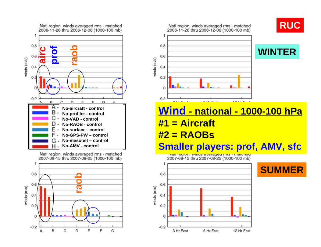
WINTER
SUMMER
Wind - national - 1000-100 hPa#1 = Aircraft#2 = RAOBs Smaller players: prof, AMV, sfc
No-aircraft - controlNo-profiler - controlNo-VAD - controlNo-RAOB - controlNo-surface - controlNo-GPS-PW – controlNo-mesonet – controlNo-AMV - control
RUCai
rc
raob
raob
prof

Wind - national -1000-100 hPa#1 = Aircraft#2 = RAOBs#3 = surface Smaller players: sfc, VADs
Valid 00z - daytime
RAP
Valid 12z - nighttime
airc
airc
raob

2nd Breakdown for RUC OSE results
• 7 experiments (control, 6 obs denial experiments)• 2 Regions
• US National (data rich)• Midwest (very data rich)
• 4 layers• 1000-100 hPa (full depth)• 1000-800 hPa ( near surface)• 800-400 hPa (mid- troposphere)• 400-100 hPa (upper troposphere, lower stratosphere)
• 2 seasons• winter• summer
• Forecast duration• 3h, 6h, 12h
Wind only

WINTER
SUMMER
Wind - national - 1000-800 hPaAircraft, VAD, sfc - 3h - winterSfc - 3h - summer
No-aircraft - controlNo-profiler - controlNo-VAD - controlNo-RAOB - controlNo-surface - controlNo-GPS-PW - control
RUCai
rc
VAD
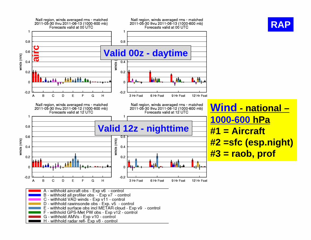
Wind - national –1000-600 hPa#1 = Aircraft#2 =sfc (esp.night)#3 = raob, prof
RAPai
rc Valid 00z - daytime
Valid 12z - nighttime

WINTER
SUMMER
Wind - national - 400-100 hPa#1 overall - Aircraft, by far#2 - RAOBS, distant #3- profiler
No-aircraft - controlNo-profiler - controlNo-VAD - controlNo-RAOB - controlNo-surface - controlNo-GPS-PW - control
RUCai
rcpr
of
raob
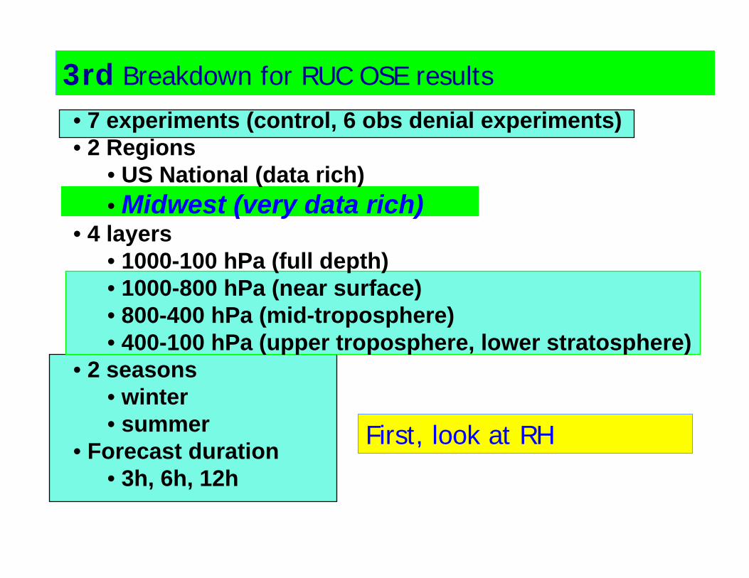
3rd Breakdown for RUC OSE results
First, look at RH
• 7 experiments (control, 6 obs denial experiments)• 2 Regions
• US National (data rich)• Midwest (very data rich)
• 4 layers• 1000-100 hPa (full depth)• 1000-800 hPa (near surface)• 800-400 hPa (mid-troposphere)• 400-100 hPa (upper troposphere, lower stratosphere)
• 2 seasons• winter• summer
• Forecast duration• 3h, 6h, 12h
WINTER
SUMMER
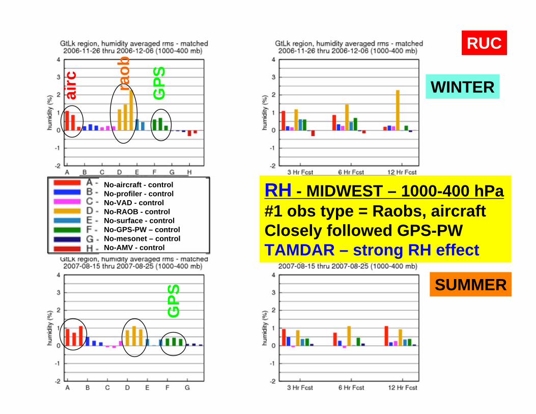
RH - MIDWEST – 1000-400 hPa#1 obs type = Raobs, aircraftClosely followed GPS-PW TAMDAR – strong RH effect
No-aircraft - controlNo-profiler - controlNo-VAD - controlNo-RAOB - controlNo-surface - controlNo-GPS-PW – controlNo-mesonet – controlNo-AMV - control
RUCai
rc
GPS
GPS
raob

RAP
RH - MIDWEST –1000-600 hPaDaytime#1 = sfc, aircraft#3 = GPS
NighttimeAircraft, prof, GPS
Negative impact- VAD at night (bird migration?)- Radar refl
airc
airc
prof
Valid 00z - daytime
Valid 12z - nighttime
VAD
GPS
GPS
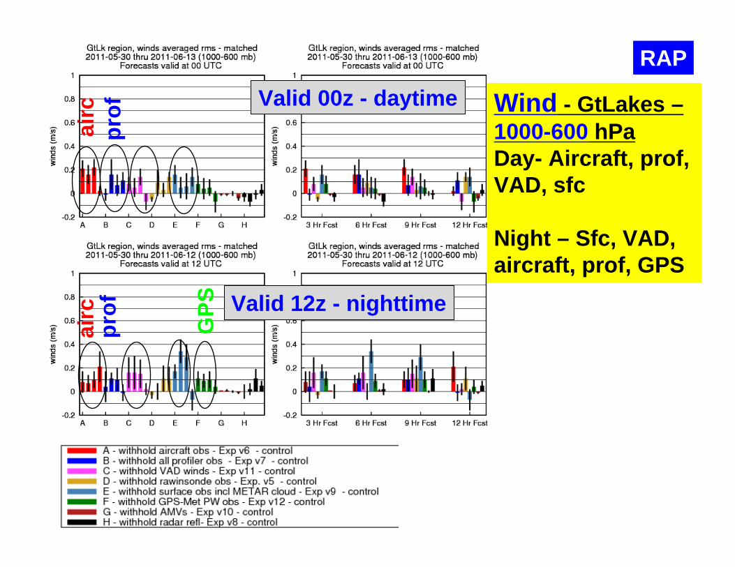
Wind - GtLakes –1000-600 hPaDay- Aircraft, prof, VAD, sfc
Night – Sfc, VAD, aircraft, prof, GPS
RAPai
rcai
rcpr
ofpr
of Valid 00z - daytime
Valid 12z - nighttime
GPS
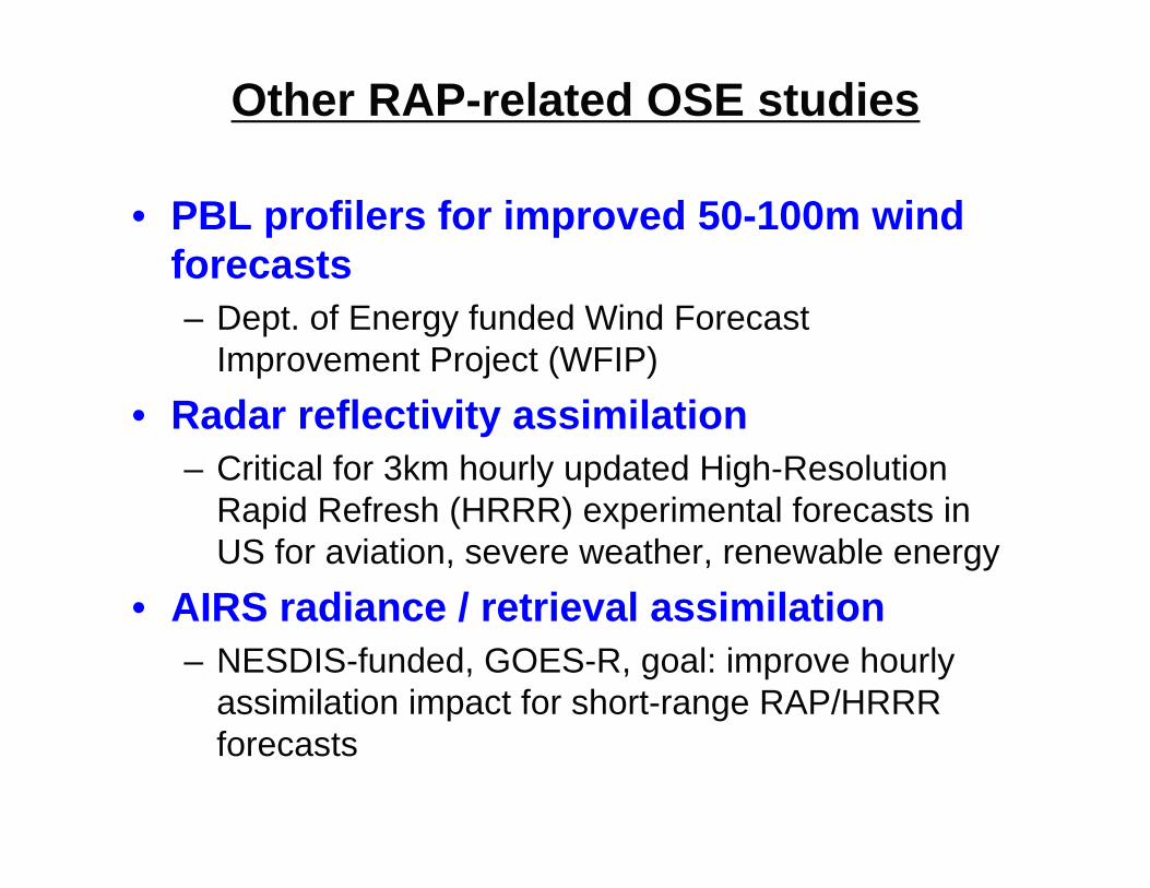
Other RAP-related OSE studies
• PBL profilers for improved 50-100m wind forecasts– Dept. of Energy funded Wind Forecast
Improvement Project (WFIP)• Radar reflectivity assimilation
– Critical for 3km hourly updated High-Resolution Rapid Refresh (HRRR) experimental forecasts in US for aviation, severe weather, renewable energy
• AIRS radiance / retrieval assimilation– NESDIS-funded, GOES-R, goal: improve hourly
assimilation impact for short-range RAP/HRRR forecasts

Eastern US, Reflectivity > 25 dBZ11‐21 August 2011
• 3km HRRR forecasts improve upon RAP 13km forecasts, especially at coarser scales much better upscaled skill
• Radar DDFI adds skill at both 13km and 3km
CSI 13 km CSI 40 km
RAP/HRRR Reflectivity Verification
32

Wind Forecast Improvement Projectvertically averaged wind profiler RMSE
w/WFIP data
w/WFIP data
Improvement in 500-2000m wind out to ~8h due to 10 extra 915 MHz wind profiler in n. central US – both in RUC and RAP (RR)
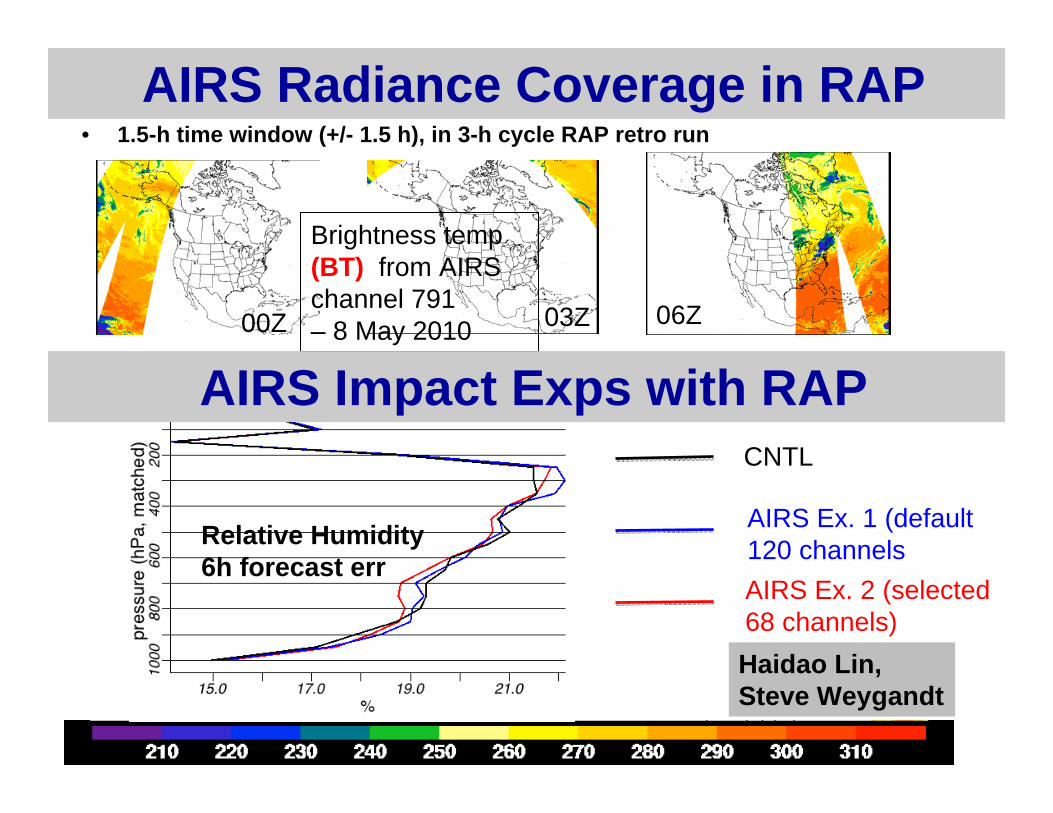
AIRS Radiance Coverage in RAP • 1.5-h time window (+/- 1.5 h), in 3-h cycle RAP retro run
00Z 03Z 06Z
Brightness temp (BT) from AIRS channel 791 – 8 May 2010
AIRS Ex. 2 (selected 68 channels)
CNTL
AIRS Ex. 1 (default 120 channelsRelative Humidity
6h forecast err
AIRS Impact Exps with RAP
Haidao Lin, Steve Weygandt
35
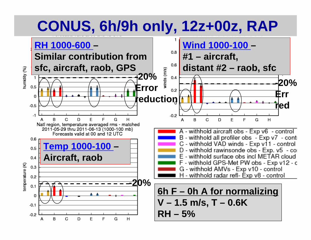
CONUS, 6h/9h only, 12z+00z, RAP RH 1000-600 –Similar contribution from sfc, aircraft, raob, GPS
Wind 1000-100 –#1 – aircraft, distant #2 – raob, sfc
Temp 1000-100 –Aircraft, raob
-20%Err red
-20%Errorreduction
-20%6h F – 0h A for normalizingV – 1.5 m/s, T – 0.6KRH – 5%
36
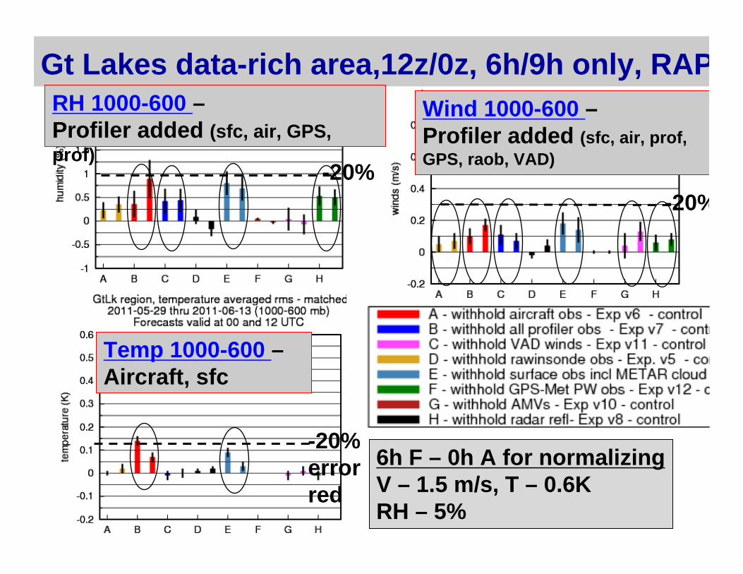
Gt Lakes data-rich area,12z/0z, 6h/9h only, RAPRH 1000-600 –Profiler added (sfc, air, GPS, prof)
Wind 1000-600 –Profiler added (sfc, air, prof, GPS, raob, VAD)
Temp 1000-600 –Aircraft, sfc
-20% error red
-20%-20%
6h F – 0h A for normalizingV – 1.5 m/s, T – 0.6KRH – 5%

37
Conclusions – RUC/RAP OSE exps• Extensive obs impact study performed for 1 winter and 2 summer retro periods using RUC/RAP for 3-12h forecast impact
• Heterogeneous observing system in US effective for short-range (3-12h) forecasts for tropospheric RH, temp, winds.
• Stronger wind-moisture cross-covariance with GSI in RAP than withRUC 3dVAR
• Aircraft data most important observation overall for short-range fcsts from troposphere-to-sfc (10-20% reduction for 6h fcst err for T/V/RH), butfar from sole key observing system.
• For RUC OSEs - RAOBs of #2 importance overall • For RAP OSEs (w/ GSI) – broader contribution evident from
different obs systems - GPS-PW, surface, RAOB• Data-rich Great Lakes area –
• profiler provides similar wind/RH impact• 6 of 8 systems provide at least 5% err reduction for winds • 4 of 8 do same for RH (aircraft, sfc, GPS-PW, profiler)
38
Conclusions – RUC/RAP OSE exps #2• Results needing follow-up
• No additional value from mesonet data in RUC exps. • ESRL, NCEP efforts underway to determine station/time/wind
direction-dependent biases to improve forward model• Test mesonet impact with RAP/GSI
• Little value added from AMVs in RUC or RAP experiments • high obs error in GSI/RAP? • Test U.Wisconsin AMVs
• VAD winds also show contribution but nighttime negative impact • need better bird migration QC?
• Other RAP denial experiments needed• WindSat, buoy, GOES-cloud
• Add cold-season retrospective impact tests for RAP/GSI• EnKF/hybrid/GSI efforts – hourly RAP, 6h for NOAA FIM global model
• RUC-OSEs - MWR article - June 2010 – Benjamin et al.• complements Moninger et al. 2010 W&F paper on TAMDAR impact
study

RAP
Control- All data
No profilerexperiment
No profilerMinusControl

RAP
Temp - national –1000-800 hPa#1 = Aircraft#2 = sfc#3 = raobs (night), VAD (day)
airc
aircValid 00z - daytime
Valid 12z - nighttime

WINTER
SUMMER
Temp - MIDWEST - 1000-800 hPa#1 = aircraft (incl. TAMDAR)#2 = surface (winter and summer)
No-aircraft - controlNo-profiler - controlNo-VAD - controlNo-RAOB - controlNo-surface - controlNo-GPS-PW – controlNo-mesonet – controlNo-AMV - control
RUC
airc

WINTER
SUMMER
Wind - national - 800-400 hPa#1 overall - AircraftRAOBs - #1 winter @ 12h
No-aircraft - controlNo-profiler - controlNo-VAD - controlNo-RAOB - controlNo-surface - controlNo-GPS-PW - control
RUCai
rc