Embed Size (px)
Citation preview
Quarry Development Plan – West Pine Quarry
Site C Clean Energy Project
Revision 1: June 5, 2015
Quarry Development Plan – West Pine Quarry Site C Clean Energy Project
Table of Contents
Revision History ........................................................................................................................... 2
1.0 Background.................................................................................................................... 3
1.1 The Site C Clean Energy Project ................................................................................... 3
1.2 West Pine Quarry........................................................................................................... 3
2.0 Purpose and Scope ........................................................................................................ 4
3.0 Development Plan Basis ................................................................................................. 4
4.0 West Pine Quarry – Operations ....................................................................................... 5
4.1 Production Plan .............................................................................................................. 5
4.2 Quarry Operations .......................................................................................................... 7
4.3 Access ........................................................................................................................... 8
4.4 Safety and Environmental Management ......................................................................... 8
4.5 Site Reclamation and Future Use ................................................................................... 9
5.0 References .................................................................................................................. 10
Figures ....................................................................................................................................... 11
Appendix A. Mines Act Notice of Work .........................................................................................
Appendix B. Agreement Between MOTI and BC Hydro ................................................................
Page 1 of 13 Revision 1: June 5, 2015
Quarry Development Plan – West Pine Quarry Site C Clean Energy Project
Revision History
Version Date Comments Draft 04-07-2015 Draft
Rev 0 05-19-2015 Final Plan
Rev 1 06-05-2015 Final Plan, Revision 1
Page 2 of 13 Revision 1: June 5, 2015
Quarry Development Plan – West Pine Quarry Site C Clean Energy Project
1.0 Background 1.1 The Site C Clean Energy Project The Site C Clean Energy Project (the Project) will be the third dam and generating station on the Peace River in northeast B.C. The Project will provide 1,100 megawatts of capacity and about 5,100 gigawatt hours of energy each year to the province’s integrated electricity system. The Project will be a source of clean, reliable and cost-effective electricity for BC Hydro’s customers for more than 100 years.
The key components of the Project are: • an earthfill dam, approximately 1,050 metres long and 60 metres high above the riverbed;
• an 83 kilometre long reservoir that will be, on average, two to three times the width of the current river;
• a generating station with six 183 MW generating units;
• two new 500 kilovolt AC transmission lines that will connect the Project facilities to the Peace Canyon Substation, along an existing right-of-way;
• realignment of six segments of Highway 29 over a total distance of approximately 30 kilometers; and
• construction of a berm at Hudson’s Hope.
The Project will also include the construction of temporary access roads, a temporary bridge across the Peace River, and worker accommodation at the dam site.
1.2 West Pine Quarry The British Columbia Ministry of Transportation and Infrastructure (MOTI) operates the West Pine Quarry on crown land under a map reserve, file number 8005674. The quarry can be accessed by Highway 97 and Canadian National Rail as both are parallel to its southern boundary. There is also a rail siding along the southern boundary of the quarry. The site location is shown in Figure 1.
Field investigations and evaluations identified the rock to be a highly metamorphosed limestone with high strength. The limestone unit contained two intersecting joint sets yielding a blocky appearance; dip and dip direction of the joint sets were approximately 70- 80°/090° and 30-35°/225°. Joint spacing ranged from 0.3 m to 3.0 m. The average rock density was about 2,700 kg/m³, which is an adequate density value for permanent riprap.
For the Site C Clean Energy Project (the Project), only the larger riprap product and a smaller amount of riprap bedding will be used. All other rock material will be considered a by-product of the riprap production. This material and the remaining intact bedrock, however, will be available for use by MOTI.
An agreement with MOTI allows BC Hydro to obtain temporary riprap material from the West Pine Quarry during Year 1 construction. Site C will require the material for the construction of the erosion protection for the temporary construction bridge across the Peace River
Page 3 of 13 Revision 1: June 5, 2015
Quarry Development Plan – West Pine Quarry Site C Clean Energy Project
and f or access road construction on the south bank of the Peace River. This volume of material will be produced within the existing boundaries of the MOTI quarry. The quarry site will remain an active quarry under the control of MOTI therefore the storage of the surplus material is an important consideration for them.
2.0 Purpose and Scope The Project will require riprap material for constructing the erosion protection for the temporary construction bridge across the Peace River and f or access road construction on the south bank of the Peace River.
West Pine Quarry, an existing riprap source operated by MOTI, has been identified as the preferred source of riprap for Year 1 (2015) construction requirements. The quarry is located on the north side of Highway 97 approximately 75km southwest of Chetwynd, BC and 162km south of the proposed Site C project site (via existing and proposed roads) as shown in Figure 1.
The purposes of this plan are to support permitting requirements; and to guide use of the quarry site during construction.
The scope of this plan is the first year of quarry use by the Project.
3.0 Development Plan Basis This Plan has been developed based on the following information:
• Approximately 20,000 m3 of high quality rock riprap will be required for Year 1 of the Project. No riprap bedding material will be required for Year 1.
• The yield of useable riprap is estimated to be 30% by weight. Therefore, on average, the total weight of rock excavated will be 3.33 times the weight of riprap required
• Riprap bedding materials will be screened from the coarser surplus material after riprap selection
• Bulking factors were applied to excavated and quarried volumes. A bulking factor represents the volume increase (expressed as a percent) that a material undergoes when removed from its natural state, and is applied to estimate the total volume of quarried or excavated material. Different materials have different bulking factors based on their ability to reconsolidate once excavated. A bulking factor of 1.2 means that a volume of naturally existing material will undergo an increase of 20 per cent once excavated and placed in its final location. Based on an understanding of similar materials within the province the following bulking factors were applied:
o Bedrock Bulking Factor = 1.6
Page 4 of 13 Revision 1: June 5, 2015
Quarry Development Plan – West Pine Quarry Site C Clean Energy Project
o Overburden Bulking Factor = 1.2
• Densities are estimated as: 2.70 tonne/m3 for in-situ rock; 1.9 tonne/m3 for riprap; 2.20 tonne/m3 for riprap bedding; and 2.0 tonne/m3 for surplus material
• Processed riprap will be hauled either by highway legal haul trucks or by Canadian National Rail. If hauled by rail to the dam site area, riprap will be unloaded and stockpiled at Septimus Siding. If hauled by trucks, it is expected that the riprap will be hauled directly to the construction areas for placement.
• Based on field observations, riprap up to 600 mm in diameter is stockpiled and large rock blocks, up to 1,200 mm in diameter, are available in limited supply.
• Based on field observations, the thickness of overburden is less than 500 mm deep.
• By-product material will be stockpiled at West Pine Quarry for future use by others.
4.0 West Pine Quarry – Operations
4.1 Production Plan The planned material volumes for quarry use by the Project throughout the construction period are shown in Table 1.
Table 1: Material Volumes for West Pine Quarry
In order to produce the amount of temporary riprap material that will be necessary for Year 1 road and bridge construction, areas for storage of surplus rock and overburden will be utilized in areas already intended for that use within the quarry site. Figure 2 illustrates the current development of West Pine Quarry and the boundaries of the property. An existing quarry face will be used to continue with the drilling and blasting required to produce the volumes needed for the project.
Benches will be mined through drilling and blasting of either 5 m benches using double benching technique or 10 m benches using single benching. Bulldozer work and ancillary drilling and blasting may be required to enable access to steep areas by tracked blast hole
Page 5 of 13 Revision 1: June 5, 2015
Quarry Development Plan – West Pine Quarry Site C Clean Energy Project
drills. Blasting will be undertaken and planned in such a manner to create level working surfaces for loading equipment. Table 2 - Planned Benching Detail
Loading will be done by either hydraulic excavators or wheel loaders. Pit haulage will be by dump truck or loader to a quarry run stockpile or directly offsite as product. Riprap and riprap bedding material and rock fill material may be stored in live stockpiles for haulage offsite though the preference will be to haul directly from the quarry to the construction sites.
Drilling and blasting will be required for excavation of the limestone rock in the quarry. A track mounted percussion drill rig capable of drilling holes from 75 mm up to 150 mm is suggested.
The details of the blast hole patterns, sub-drilling, blast hole inclination, etc. are subject to blasting tests to be carried out in the initial stages of the mining development. The contractor and their blast engineer must determine the blasting parameters to achieve the required riprap and rock embankment products.
In accordance with the quantity distance tables provided under the Explosives Act and Regulations, the D4 and D7 distances will be 175 m and 480 m respectively, for 10 tonnes of storage of ammonium nitrate prill and 140 m and 380 m respectively, for 5 tonnes of storage of ammonium nitrate prill. Ammonium nitrate prill will be stored off-site. The blasting operation will conform to the applicable laws and/or regulation (e.g. timing of blasts during the day, etc.).
Blasted rock will either be loaded by a wheeled loader or a tracked excavator. The use of a tracked excavator could enable some degree of sorting of blasted muck for riprap prior to loading trucks for hauling off site. To maximize the use of the mined rock from the quarry, it
Page 6 of 13 Revision 1: June 5, 2015
Quarry Development Plan – West Pine Quarry Site C Clean Energy Project
may be subject to screening to recover the riprap material classes required. This will be undertaken by tipping the mined material, either directly from the mine trucks or via a wheeled loader over a screen. The oversize material will then be stockpiled for transport off site for use in construction and the undersize portion may be further screened for reducing the fines or stockpiled on site.
Haulage off site will be done by highway legal trucks; on site haulage will be done using rock trucks up to 40 tonne capacity. Roads could be maintained into the quarry for highway legal trucks such that the required quantity of blasted rock can be hauled directly to the construction sites as opposed to re-handling from a quarry stockpile. An assumed minimum mining width of 25 m to allow trucks to turn within the pit, as well as a safety berm of roughly 3 m in width will be required.
4.2 Quarry Operations The quarry is an existing operation run by MOTI and will be operated in a consistent manner. The Province’s Aggregate Management Principles have been established to ensure that aggregate activities are undertaken in compliance with health and safety standards and environmental protection requirements. The reference documents are:
• Aggregate Operators Best Management Practices Handbook for British Columbia, 2002, Ministry of Energy and Mines (MOEM 2002)
• Health and Safety: A Practical Guide for Aggregate Operations, 2007, Ministry of Energy, Mines and Petroleum Resources, Mining and Minerals Division (MOEM 2007)
Following is a summary of quarry operation considerations:
• The main areas for excavation will be in the southern portion of the site and stockpiling will be in the northern half of the site as shown in Figure 2.
• The maximum volumes proposed for extraction will be based on the suitability and quality of the materials as they were processed. The materials unsuitable for use for dam construction will remain within the site and will be stockpiled for future use by MOTI
• The site may contain a trailer office, maintenance and storage area and will address sediment/erosion control measures.
• Potable water for the office and service area and water for dust control will be brought to the site from an offsite location
• Extraction requires drilling, blasting and processing, such as sorting, prior to riprap being removed from the site.
• Blasting materials will be commercially available. Delivery will be by bulk mix and loading pump trucks. No explosives will be stored on site. Blasting activities will be in
Page 7 of 13 Revision 1: June 5, 2015
Quarry Development Plan – West Pine Quarry Site C Clean Energy Project
accordance with WorksafeBC, the Mines Act (BC) the Explosives Act (Canada), the Transportation of Dangerous Goods Regulations (Canada) and the Motor Vehicle Act (BC)
• The material will be delivered to the dam site using highway-legal haul trucks. Haul trucks or loaders will move between the areas on the site, as required
• The equipment required for operations will be as follows with the number of equipment pieces to be determined at a later stage:
o Loaders (to loosen and remove material and process material at the screening and crushing plants, and stock pile)
o Bulldozers (to push material for stripping stockpiles and loosen blasted materials)
o Rock drills
o Highway legal haul trucks (to transport the material to the dam site)
o Water Trucks (to control dust as required)
o Personnel Site Pick-ups (for onsite mobility)
o Service vehicle (mechanic, fuel trucks)
• The facilities which may be located on site include:
o A small mobile office;
o Potable water storage;
o Mobile screen (500 tph)
4.3 Access The quarry can be accessed via Highway 97. Truck haul will be limited to the public roads between the quarry area to the dam site, namely Highway 97, Highway 29 and Jackfish Lake Road. Existing petroleum development and forest service resource roads on the Jackfish Lake Plateau will also be used for road transportation.
Access will be closed to the public during the length of the extraction operations.
4.4 Safety and Environmental Management The contractor will be expected to adhere to the environment and safety requirements described in the Construction Environmental Management Plan (CEMP) and the Construction Safety Management Plan (CSMP).
Page 8 of 13 Revision 1: June 5, 2015
Quarry Development Plan – West Pine Quarry Site C Clean Energy Project
Management measures to be implemented during quarry operation will include:
• Gate access will be maintained to control access
• Berms will be constructed at the top edges of excavations to control movement within the quarry
• Portable toilet facilities will be used within the quarry area and near the project site offices. These facilities will be maintained as required. If trailer type washroom stations were to be used onsite, the grey water created will be disposed of into a suitable tank and then pumped out and trucked to the municipal treatment location
o The planning and installation of a lighting system, if required, for the safe operation of the site will follow guidelines in the Aggregate Operators Best Management Practices Handbook (MOEM 2002). The goal will be to facilitate safe and secure operations for the extraction, processing and stockpiling locations while minimizing offsite visual nuisance. Lighting will be needed f o r the quarry property, inside buildings and their entrances, extraction faces, haul roads, stockpiles, equipment, and vehicles. Lighting will be directed downward or shielded by buildings to minimize off-site spill and glare. The lighting of road junctions and site entrances will be kept to the minimum required for safety purposes
• Other site management features will include:
o Sediment control, and oil control separation
o Control of noxious weeds through vegetation cover or seeding where required
o The provision of a truck wash for noxious weeds control
o Maintenance of road surfaces to reduce vibration
o Control of air emissions and wind generated dust
In order to manage the potential disturbance to caribou from quarry activities:
• Blasting is prohibited at the West Pine Quarry from January 1 to March 31.
• Blasting levels are limited at the West Pine Quarry to no greater than historical levels from May 15 to June 14.
4.5 Site Reclamation and Future Use West Pine Quarry will continue to operate as a rock quarry under the jurisdiction of the MOTI (reference Appendix B). Slopes will be stabilized and drainage features will be established to control drainage. Seeding to control noxious weeds will be done on soil slopes and overburden stockpiles.
Page 9 of 13 Revision 1: June 5, 2015
Quarry Development Plan – West Pine Quarry Site C Clean Energy Project
5.0 References Front Counter BC - Notice of Work – Tracking number 100115027 (Form)
Ministry of Transportation and Infrastructure (July 30, 2014) – Letter of Approval –MOTI Quarries: West Pine, Wuthrich and Del Rio (file:36835-3ProjMan) (Letter)
Ministry of Energy, Mines and Petroleum Resources, Mining and Minerals Division (MOEM). 2009. November 2009. Aggregate Management Principles, http://www.empr.gov.bc.ca/Mining/Aggregate/BMP/Pages/default.aspx
Ministry of Energy, Mines and Petroleum Resources (MOEM), Mining and Minerals Division, 2007. Health and Safety: A Practical Guide for Aggregate Operations
Ministry of Energy and Mines (MOEM), April 2002. Aggregate Operators Best Management Practices Handbook for British Columbia. Volumes 1 (Introduction and Planning) and Volume 2 Best Management Practices, http://www.empr.gov.bc.ca/Mining/Aggregate/BMP/Pages/default.aspx
Page 10 of 13 Revision 1: June 5, 2015
Quarry Development Plan – West Pine Quarry Site C Clean Energy Project
Figures Figure 1: Key Plan – Location of West Pine Quarry
Figure 2: Development Plan – West Pine Quarry
Page 11 of 13 Revision 1: June 5, 2015
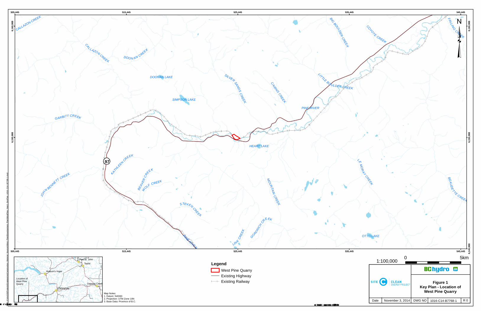
Figure 1Key Plan - Location of
West Pine Quarry1016-C14-B7768-1 R 0November 3, 2014
Map Notes:1. Datum: NAD832. Projection: UTM Zone 10N3. Base Data: Province of B.C.
Construction of the Site C Clean Energy Project is subject to required regulatory approvals including environmental certification
1:100,000
PINE RIVER
SIMPSON LAKE
OTTO LAKE
HEART LAKE
DOONAN LAKE
PINE RIVER LINK CREE
K
BEAUDETTE CREEK
LEMORAY CREEK
MOUNTAINCREEK
GARBITT CREEK
SILVER SANDSCREEK
DOON AN CREEK
JOHN BENNETT CREEK
CAIRNS CREEK
BIG BOULDERCREEK
FALLING CREEK
WOLF CREEK
STEVEN CREEK
KATHLEEN CREEK
BEAV
ERCR
EEK
CALLAZON CREEK
COYOTE CREEK
GOADRICH CREEK
LITTLE BO ULDER CREEK
CALLAZON CREEK
505,445
505,445
515,445
515,445
525,445
525,445
535,445
535,445
545,445
545,445 6,140
,988
6,150
,988
6,150
,988
6,160
,988
6,160
,988
LegendWest Pine QuarryExisting HighwayExisting Railway
³Pa
th: X
:\Arc
GIS
Pro
ject
s\E
ngin
eerin
g\C
onst
ruct
ion_
Mat
eria
l_So
urce
s\W
est_
Pin
e\D
evel
opm
ent_
Pla
n\W
estP
ine_
Year
1_D
evP
lan_
1016
_C14
_B77
68-1
.mxd
Date DWG NO© BC Hydro 2014 – all rights reserved. This map is for information purposes only and accuracy is not guaranteed.
!.
!.
!.
!.
!.Taylor
Chetwynd
Dawson Creek
Hudson's Hope
Fort St. John
97
0 5km
Location of West Pine Quarry
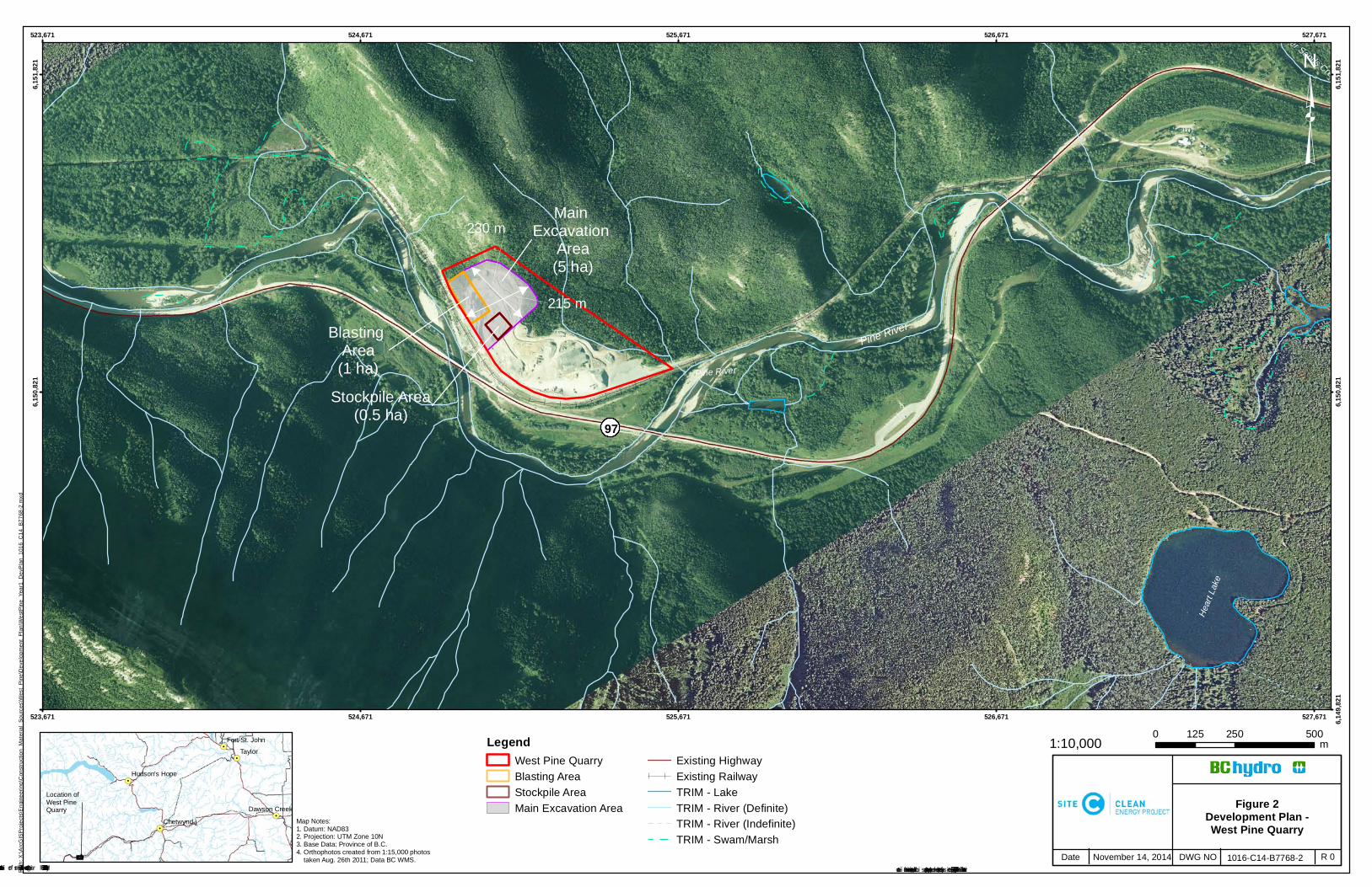
Figure 2Development Plan -West Pine Quarry
1016-C14-B7768-2 R 0November 14, 2014
Map Notes:1. Datum: NAD832. Projection: UTM Zone 10N3. Base Data: Province of B.C.4. Orthophotos created from 1:15,000 photos taken Aug. 26th 2011; Data BC WMS.
Construction of the Site C Clean Energy Project is subject to required regulatory approvals including environmental certification
1:10,000
230 m
215 m
Pine River
Main Excavation
Area(5 ha)
Blasting Area(1 ha)
Stockpile Area(0.5 ha)
Pine River
Heart
Lake
Silver Sands Creek
523,671
523,671
524,671
524,671
525,671
525,671
526,671
526,671
527,671
527,671 6,149
,821
6,150
,821
6,150
,821
6,151
,821
6,151
,821
LegendWest Pine QuarryBlasting AreaStockpile AreaMain Excavation Area
Existing HighwayExisting RailwayTRIM - LakeTRIM - River (Definite)TRIM - River (Indefinite)TRIM - Swam/Marsh
³Pa
th: X
:\Arc
GIS
Pro
ject
s\E
ngin
eerin
g\C
onst
ruct
ion_
Mat
eria
l_So
urce
s\W
est_
Pin
e\D
evel
opm
ent_
Pla
n\W
estP
ine_
Year
1_D
evP
lan_
1016
_C14
_B77
68-2
.mxd
Date DWG NO© BC Hydro 2014 – all rights reserved. This map is for information purposes only and accuracy is not guaranteed.
!.
!.
!.
!.
!.Taylor
Chetwynd
Dawson Creek
Hudson's Hope
Fort St. John
97
Location of West Pine Quarry
0 250 500125 m

Quarry Development Plan – West Pine Quarry Site C Clean Energy Project
Appendix A. Mines Act Notice of Work
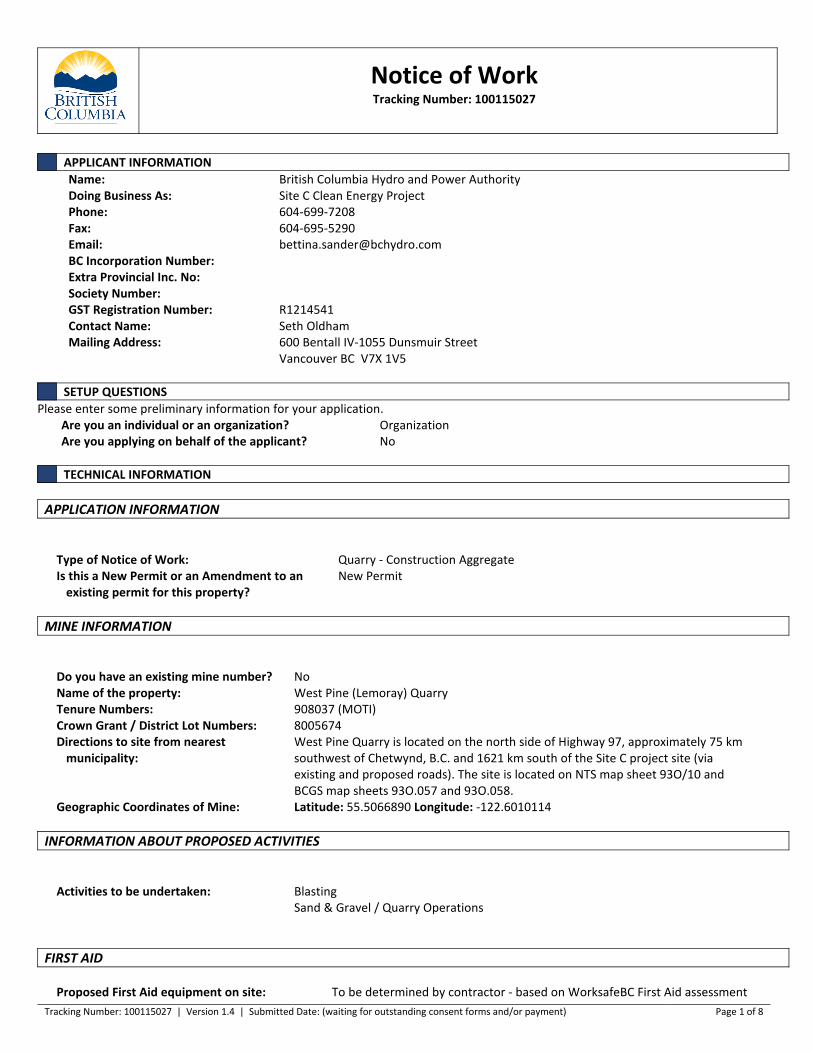
Notice of WorkTracking Number: 100115027
Tracking Number: 100115027 | Version 1.4 | Submitted Date: (waiting for outstanding consent forms and/or payment) Page 1 of 8
APPLICANT INFORMATIONName: British Columbia Hydro and Power AuthorityDoing Business As: Site C Clean Energy ProjectPhone: 604-699-7208Fax: 604-695-5290Email: [email protected] Incorporation Number:Extra Provincial Inc. No:Society Number:GST Registration Number: R1214541Contact Name: Seth OldhamMailing Address: 600 Bentall IV-1055 Dunsmuir Street
Vancouver BC V7X 1V5
SETUP QUESTIONSPlease enter some preliminary information for your application.
Are you an individual or an organization? OrganizationAre you applying on behalf of the applicant? No
TECHNICAL INFORMATION
APPLICATION INFORMATION
Type of Notice of Work: Quarry - Construction AggregateIs this a New Permit or an Amendment to an
existing permit for this property?New Permit
MINE INFORMATION
Do you have an existing mine number? NoName of the property: West Pine (Lemoray) QuarryTenure Numbers: 908037 (MOTI)Crown Grant / District Lot Numbers: 8005674Directions to site from nearest
municipality:West Pine Quarry is located on the north side of Highway 97, approximately 75 kmsouthwest of Chetwynd, B.C. and 1621 km south of the Site C project site (viaexisting and proposed roads). The site is located on NTS map sheet 93O/10 andBCGS map sheets 93O.057 and 93O.058.
Geographic Coordinates of Mine: Latitude: 55.5066890 Longitude: -122.6010114
INFORMATION ABOUT PROPOSED ACTIVITIES
Activities to be undertaken: BlastingSand & Gravel / Quarry Operations
FIRST AID
Proposed First Aid equipment on site: To be determined by contractor - based on WorksafeBC First Aid assessment
Tracking Number: 100115027 | Version 1.4 | Submitted Date: (waiting for outstanding consent forms and/or payment) Page 2 of 8
tool and any additional requirements by Min of MinesLevel of First Aid Certificate held by attendant: Occupational First Aid Level 2
DESCRIPTION OF WORK PROGRAMIf you prefer to upload a document, please enter "see attached document" and attach the document in the "Document Upload" steplater in the application under "Other".
Sufficient details of your work program to enable a good understanding of the types and scope of the activities that will beconducted:
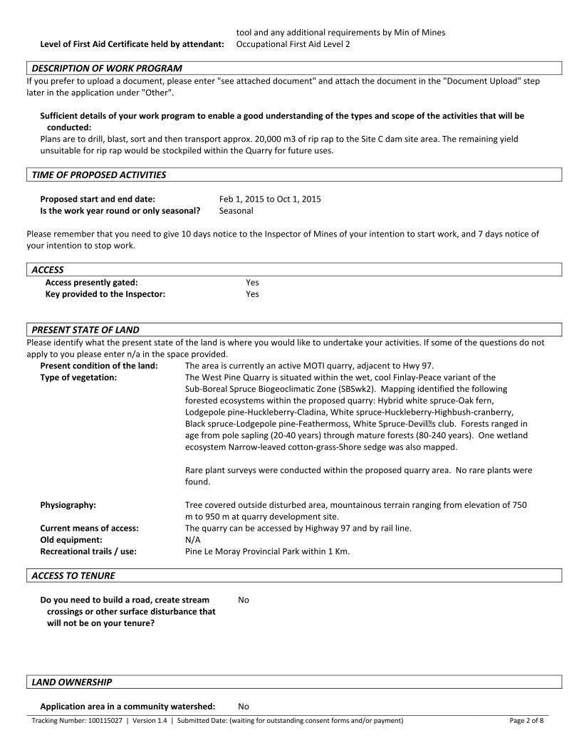
Plans are to drill, blast, sort and then transport approx. 20,000 m3 of rip rap to the Site C dam site area. The remaining yieldunsuitable for rip rap would be stockpiled within the Quarry for future uses.
TIME OF PROPOSED ACTIVITIES
Proposed start and end date: Feb 1, 2015 to Oct 1, 2015Is the work year round or only seasonal? Seasonal
Please remember that you need to give 10 days notice to the Inspector of Mines of your intention to start work, and 7 days notice ofyour intention to stop work.
ACCESSAccess presently gated: YesKey provided to the Inspector: Yes
PRESENT STATE OF LANDPlease identify what the present state of the land is where you would like to undertake your activities. If some of the questions do notapply to you please enter n/a in the space provided.
Present condition of the land: The area is currently an active MOTI quarry, adjacent to Hwy 97.Type of vegetation: The West Pine Quarry is situated within the wet, cool Finlay-Peace variant of the
Sub-Boreal Spruce Biogeoclimatic Zone (SBSwk2). Mapping identified the followingforested ecosystems within the proposed quarry: Hybrid white spruce-Oak fern,Lodgepole pine-Huckleberry-Cladina, White spruce-Huckleberry-Highbush-cranberry,Black spruce-Lodgepole pine-Feathermoss, White Spruce-Devil�s club. Forests ranged inage from pole sapling (20-40 years) through mature forests (80-240 years). One wetlandecosystem Narrow-leaved cotton-grass-Shore sedge was also mapped.
Rare plant surveys were conducted within the proposed quarry area. No rare plants werefound.
Physiography: Tree covered outside disturbed area, mountainous terrain ranging from elevation of 750m to 950 m at quarry development site.
Current means of access: The quarry can be accessed by Highway 97 and by rail line. Old equipment: N/ARecreational trails / use: Pine Le Moray Provincial Park within 1 Km.
ACCESS TO TENURE
Do you need to build a road, create streamcrossings or other surface disturbance thatwill not be on your tenure?
No
LAND OWNERSHIP
Application area in a community watershed: No
Tracking Number: 100115027 | Version 1.4 | Submitted Date: (waiting for outstanding consent forms and/or payment) Page 3 of 8
Proposed activities on private land: No
Proposed activities on Crown land: YesLicence of Occupation: No
Have you applied for a Licence of Occupation? YesFile number of application: Currently under screening review by Front Counter, no file number is
assigned
Activities in a park: No
CULTURAL HERITAGE RESOURCESCultural Heritage applies to a large spectrum of heritage resources that is defined as "an object, a site or the location of a traditionalsocietal practice that is of historical, cultural or archaeological significance to British Columbia, a community or an aboriginal people."
The Archaeology Branch of the Ministry of Forests, Land and Natural Resource Operations is responsible for the administration of theHeritage Conservation Act as it applies to archaeological sites. The Archaeology Branch has developed guidelines for companies engagedin natural resource extraction to aid in planning for and avoiding or managing impacts to protected archaeological sites.
Are you aware of any protected archaeological sitesthat may be affected by the proposed project?
No
FIRST NATIONS ENGAGEMENTIn making decisions on authorizations, the government will be fulfilling its responsibility to consult, and where appropriate,accommodate First Nations. The government takes this responsibility seriously and encourages the applicant to engage First Nationsearly and often as part of any planned development.
Establishing good relations with First Nations who might be affected by a proposed development is a key part of any successful miningoperation. The Ministry of Energy and Mines encourages applicants to engage and information share with First Nations that might beaffected by a proposed development prior to submitting an application. The earlier in the life of a proposed activity that the avenues ofcommunication are established the greater the likelihood that the relationships formed will be constructive and beneficial to all parties.A lack of information sharing and engagement by the applicant may result in extended timeframes for decision.
Applicants should keep a detailed record of information sharing and engagement with First Nations on their project in the event thegovernment needs to review it. Information on First Nations information sharing and engagement should include the following: a list ofFirst Nations contacted, whether the activity was modified based on feedback from First Nations, and whether the applicant hasentered into any informal or formal agreements with First Nations in connection with the project.
The Consultative Areas Database Public Map Service is an online, interactive mapping tool that allows you to identify First Nations whohave treaty rights or asserted or proven rights or title on the land base. More information can be found athttp://www.empr.gov.bc.ca/TITLES/MINERALTITLES/FIRSTNATION/Pages/CAD.aspx.
Have you shared information and engaged with FirstNations in the area of the proposed activity?
Yes
Please tell us about your engagements in the field below or attach a your record of engagement by uploading it at the "DocumentUpload" step later in the application process. If you are attaching your record later, please enter in the text box "See record attached".Please ensure your record does not contain an individual's personal information such as contact information.
Describe your First Nations engagement activities: First Nations engagement activities are described in Section 5.2 of theattached document titled "Component Application Package - WestPine Quarry", dated June 13, 2014.
The West Pine Quarry Component Application Package and
Tracking Number: 100115027 | Version 1.4 | Submitted Date: (waiting for outstanding consent forms and/or payment) Page 4 of 8
associated permit applications are currently under screening reviewwith FrontCounter BC, along with other Site C Clean Energy Projectpermit application packages. This NoW application is to be appendedto the West Pine Quarry application package.
As a result of the engagement, are you aware of anycultural heritage resources in the area where thework is proposed?
No
BLASTING
MAPSPlease mark the location(s) of the proposed magazine(s) on the map. Unless this is an area based application also mark the proposedlocations of the blast site(s) on the map. The maps will be uploaded at the document upload step later in the application process.
ACTIVITIES WHERE BLASTING WILL TAKE PLACE
Please select the activities to which blastingis related:
Sand & Gravel / Quarry Operations
ON SITE STORAGE OF EXPLOSIVES
Are you proposing to store explosives on site? NoDescribe how you will get the explosives to the site: The contractor will purchase explosives through an approved supplier
who will transport the explosives subject to requirements under theTransportation of Dangerous Goods Regulations.
ADDITIONAL INFORMATIONOnly a person with a valid certificate granted under Section 8.2.1 of the Code is permitted to conduct a blasting operation.
SAND & GRAVEL / QUARRY OPERATIONS
MAPSAll plans and sections must indicate the scale and orientation of the drawing and must include:
1) Plan View of Proposed Development illustrating:
- Property boundaries and set back of excavation from property boundary- Watercourses and drainage (wet, dry or intermittent) on the property and within 150 metres of its boundaries- All previous surface workings, the final boundaries of proposed excavation, and boundaries of excavation at the end of developmentdescribed in the Notice of Work- Access roads, including development roads within the pit and access to the public roads- All proposed and existing stockpiles (topsoil, overburden, product etc.)- All settling ponds (for both surface run off and process water) and source of process water- Buildings and other facilities (fuel/lubricant storage, sanitary facilities, weigh scale, etc.)- Sediment control structures and the location of any point discharges from the property- Fencing, berms and/or vegetative buffers.
2) Cross and longitudinal sections of Proposed Development illustrating:
- The orginial land surface and, if applicable, the groundwater table elevation- Typical configuration during mining, indicating angle of slope and, where applicable, bench locations- Proposed configuration on completion of reclamation
3) A copy of the land title/crown land tenure map must be provided.
Tracking Number: 100115027 | Version 1.4 | Submitted Date: (waiting for outstanding consent forms and/or payment) Page 5 of 8
SOIL CONSERVATION
Average depth of overburden: 0.00 mAverage depth of topsoil: 0.00 mMeasures to stabilize soil overburden
stockpiles and control noxious weeds:N/A
LAND USE
Is the site within the Agricultural Land Reserve? NoDoes the local government have a Soil Removal Bylaw? NoOfficial Community Plan for the site:Current land use zoning for the site: Existing MOTI quarryProposed end land use is: Perpetual MOTI quarryEstimate total minable reserves over the life of the mine:Estimate annual extraction from site: 20,000 m3/year
Application must be made to the Environmental Assessment Office if estimated extraction for sand/gravel production is 500,000tonnes/year or 1,000,000 tonnes over 4 years; or if estimated extraction is 250,000 tonnes/year for quarried product.
ACTIVITIESClick on the "Add Activity" button to add one or more activities. Select your activity out of the list and enter the tonnes, the totaldisturbed area and the total merchantable timber volume.
Please note that you must notify the Inspector at least two weeks before if you are planning to bring a crusher on site.
ActivityTotal Disturbed Area
(ha)Merchantable
timber volume (m³)Excavation of Pit Run 5.00 0.00Total: 5.00 0.00
Brief description of operation, includingproposed work schedule:
Drill, blast, sort and stockpile. 7am to 7pm, Monday to Friday
EQUIPMENTClick on the "Add Equipment" button to add one or more equipment.
Type Quantity Size / CapacityDrill 1 TBDExcavator 1 CAT 330 (or equivalent)Bulldozer/Crawler Tractors 1 CAT D9 (or equivalent)Loader 1 CAT 988 (or equivalent)
Will progressive reclamation be carried out? NoRECLAMATION PROGRAM
Describe the proposed reclamation and timing forthis specific activity:
West Pine Quarry will remain a Ministry of Transportation andInfrastructure (MOTI) quarry after Site C construction needs are met.MOTI has provided a letter indicating this (attached to the West PineQuarry Application Package as Appendix D), and will be responsible forthe reclamation of the pit as per the requirements of their tenure andgoverning legislation.
If backfilling of pits or pit slopes is proposed in thefinal configuration for reclamation, details ofmaterials to be used and placement procedures:
N/A
Estimated cost of reclamation activities describedabove:
$0.00
Tracking Number: 100115027 | Version 1.4 | Submitted Date: (waiting for outstanding consent forms and/or payment) Page 6 of 8
GROUNDWATER PROTECTION
Average depth to the high groundwater table at theproposed excavation:
Elevation of the groundwater table was determined from: Existing area wells Test pits Test wells drilled for this purpose Other: See below.
Measures proposed to protect groundwater frompotential impacts of the proposed mining activity:
Quarrying activities are to take place on a developed (i.e., existingquarry) rock/pit face.
IMPACT MINIMIZATION
Shortest distance between proposed excavationto nearest residence:
2,500 m
Shortest distance between proposed excavationto nearest residential water source:
2,500 m
Measures proposed to prevent inadvertentaccess of unauthorized persons to the minesite:
West Pine is currently gates with site security measures already in place.
Measures proposed to minimize noise impacts ofthe operation:
N/A: quarry operations will occur on weekdays between 7am and 7pm inan existing quarry.
Measures proposed to minimize the dustimpacts of the operation:
N/A: quarry operations will occur in an existing rock quarry with minimaldust potential.
Measures proposed to minimize visual impactsof the operation:
N/A: existing quarry
TIMBER CUTTING
Total merchantable timber volume: 0.00 m3
No TimberYou have indicated that there is no merchantable timber that will be cut. Therefore a Free Use Permit or a Licence to Cut isnot required. If this is not accurate, please correct your entries.
SUMMARY OF RECLAMATIONBased on the information you have provided on the previous screens the Summary of Reclamation is:
ActivityTotal Affected area
(ha)Estimated cost of
reclamation ($)Sand & Gravel / Quarry 5.00 0.00Subtotal: 5.00 0.00Unreclaimed disturbance from previous year: 0.00Disturbance planned for reclamation this year: 0.00Total: 5.00 0.00
OTHER CONTACTSPlease enter the contacts that are applicable to your application.
Contact Info Type of ContactName: Ministry of Transportation and Infrastructure Tenure HolderDoing Business As:
Tracking Number: 100115027 | Version 1.4 | Submitted Date: (waiting for outstanding consent forms and/or payment) Page 7 of 8
Phone: 250-565-4202Fax:Email:BC Inc. Number:GST Registration Number:Contact Name: Tony Bennett, Senior Project ManagerMailing Address: 213-2011 4th Avenue.
Prince George BC V2L 3H9
OTHER INFORMATION
Is there any other information youwould like us to know?
BC Hydro use of West Pine Quarry is with the written permission of the tenureholder, BC Ministry of Transportation and Infrastructure. BC Hydro has indicated thatno remediation works will be undertaken as MOTI will continue to use the quarry inperpetuity.
This application is part of the West Pine Quarry Component Application Package,submitted along with other permit applications and supporting documentation toFrontCounter BC starting on April 28, 2014. The application packages are currentlyunder screening review with FrontCounter BC.
The Environmental Impact Statement for the Site C Clean Energy Project is availablefor download athttp://a100.gov.bc.ca/appsdata/epic/html/deploy/epic_project_doc_list_371_r_app.html
Detailed information on the quarry can be found within the EIS (Volume 1, AppendixC4 Draft Construction Materials Development Plans Part 4 West Pine QuarryDevelopment Plan) on the BC Environmental Assessment Office website at thefollowing link:http://a100.gov.bc.ca/appsdata/epic/documents/p371/d35993/1377112565535_3f6818f00391108d24816e17b74b6b4dc04df98c77657ac56b1e7335f3fe1194.pdf
LOCATION INFORMATION
You are required to complete at least one of the following options for spatial information.
PRIVACY DECLARATIONPRIVACY NOTE FOR THE COLLECTION, USE AND DISCLOSURE OF PERSONAL INFORMATIONPersonal information is collected by FrontCounter BC under the legal authority of section 26 (c) and 27 (1) of the Freedom ofInformation and Protection of Privacy Act (the Act). The collection, use, and disclosure of personal information is subject to the provisions of the Act. The personal information collected byFrontCounter BC will be used to process your inquiry or application(s). It may also be shared when strictly necessary with partneragencies that are also subject to the provisions of the Act. The personal information supplied in the application package may be used forreferrals or notifications as required. Personal information may be used by FrontCounter BC for survey purposes.For more informationregarding the collection, use, and/or disclosure of your personal information by FrontCounter BC, please contact FrontCounter BC at1-877-855-3222 or at:FrontCounter BC Program DirectorFrontCounter BC, Provincial Operation441 Columbia StreetKamloops, BC V2C 2T3 Check here to indicate that you have read and agree to the privacy declaration stated above.
REFERRAL INFORMATION
Tracking Number: 100115027 | Version 1.4 | Submitted Date: (waiting for outstanding consent forms and/or payment) Page 8 of 8
Some applications may also be passed on to other agencies, ministries or other affected parties for referral or consultation purposes. Areferral or notification is necessary when the approval of your application might affect someone else's rights or resources or those ofthe citizens of BC. An example of someone who could receive your application for referral purposes is a habitat officer who looks afterthe fish and wildlife in the area of your application. This does not apply to all applications and is done only when required.
We have prepopulated some of the fields for your convenience but you can change in the information at any time. Please note that theinformation might become available to the public if required.
Company / Organization: British Columbia Hydro and Power Authority - Site C Clean Energy ProjectContact Name: Bettina Sander, Regulatory ManagerContact Address: Suite 600, Four Bentall Centre
1055 Dunsmuir StreetVancouver BC V7X 1V5
Contact Phone: 604-699-7208Contact Email: [email protected]
I hereby grant permission for the public release of the information provided above. This information will be used to fulfill, ifrequired, the referral and advertising requirements of my application.
OFFICE
Office to submit application to:
PROJECT INFORMATION
Is this application related to another application(s) orauthorization(s) you have previously submitted?
No
OFFICE USE ONLYOffice File Number Project Number
Disposition ID Client Number
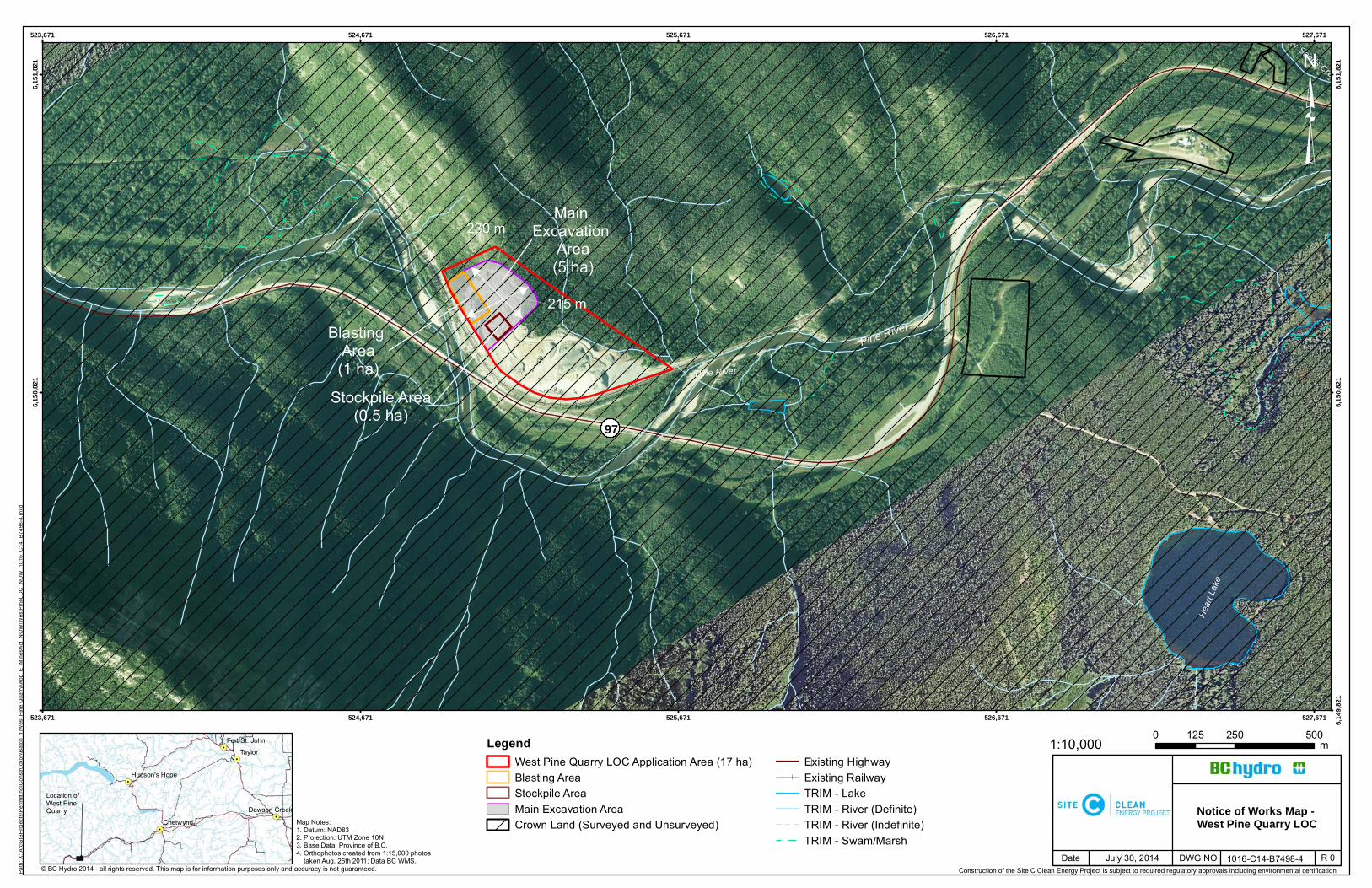
Notice of Works Map - West Pine Quarry LOC
1016-C14-B7498-4 R 0July 30, 2014
Map Notes:1. Datum: NAD832. Projection: UTM Zone 10N3. Base Data: Province of B.C.4. Orthophotos created from 1:15,000 photos taken Aug. 26th 2011; Data BC WMS.
Construction of the Site C Clean Energy Project is subject to required regulatory approvals including environmental certification
1:10,000
230 m
215 m
Pine River
Main Excavation
Area(5 ha)
Blasting Area(1 ha)
Stockpile Area(0.5 ha)
Pine River
Heart
Lake
Silver Sands Creek
523,671
523,671
524,671
524,671
525,671
525,671
526,671
526,671
527,671
527,671 6,149
,821
6,150
,821
6,150
,821
6,151
,821
6,151
,821
LegendWest Pine Quarry LOC Application Area (17 ha)Blasting AreaStockpile AreaMain Excavation AreaCrown Land (Surveyed and Unsurveyed)
Existing HighwayExisting RailwayTRIM - LakeTRIM - River (Definite)TRIM - River (Indefinite)TRIM - Swam/Marsh
³Pa
th: X
:\ArcG
ISPr
ojects
\Perm
itting
\Con
struc
tion\B
atch_
1\Wes
t Pine
Qua
rry\A
pp_E
_Mine
sAct_
NOW\
Wes
tPine
LOC_
NOW
_101
6_C1
4_B7
498-4
.mxd
Date DWG NO© BC Hydro 2014 – all rights reserved. This map is for information purposes only and accuracy is not guaranteed.
!.
!.
!.
!.
!.Taylor
ChetwyndDawson Creek
Hudson's Hope
Fort St. John
97
Location of West Pine Quarry
0 250 500125 m

Quarry Development Plan – West Pine Quarry Site C Clean Energy Project
Appendix B. Agreement Between MOTI and BC Hydro