Embed Size (px)
Citation preview

Public Fishing Rights Maps
East Branch of the Delaware RiverAbout Public Fishing Rights
Public Fishing Rights (PFR’s) are perma-nent easements purchased by the NYSDEC from willing landowners, giving anglers the right to fish and walk along the bank (usually a 33’ strip on one or both banks of the stream). This right is for the purpose of fishing only and no other purpose. Treat the land with respect to insure the continu-ation of this right and privilege. Fishing privileges may be available on some other private lands with permission of the land owner. Courtesy toward the land-owner and respect for their property will insure their continued use.
These generalized location maps are in-tended to aid anglers in finding PFR seg-ments and are not survey quality. Width of displayed PFR may be wider than reality to make it more visible on the maps. Please look for this PFR sign to ensure that you are in the right location and have legal ac-cess to the stream bank.
For more information on this creek or if you believe PFR marked areas on these maps are incorrect or missing PFR signs, please call the Region 4 Fisheries office: (607) 652-7366.
Fish Species Present
Description of Fishery
The East Branch of the Delaware River is divided into two sections by the Pepacton Reservoir. Below the Pepacton Reservoir, the East Branch is a tailwater fishery that supports wild populations of brown, rainbow, and oc-casional brook trout; plus seasonal anadromous runs of American shad with reports of occasional striped bass. The DEC stocks close to 3,000 brown trout annually in this stretch of river. Above the Pepecaton Reservoir, the DEC stocks a little over 5,000 brown trout annually in this section. Wild brown trout production exists. Public Fishing Access is granted by NYC via a DEP permit immediately upstream of the Pepacton Reservoir to the village of Margaretville ,but no Public Fishing Rights are available upstream of there except in one tributary stream, the Bush Kill.
Note:
Special regulations apply. See Fishing Regulations Guide.
Brown Trout
Rainbow Trout
Location
Delaware and SullivanCountiesBrook Trout
East Branch of the Delaware River

%
%
%
NY17
NY30
NY28
I88
SR17
SR97SULLIVAN
ULSTERDELAWARE
NEW YORK
PENNSYLVANIA
Walton
Hancock
Legend% City/Village
County BoundaryState BoundaryMajor RoadWaterbody
East Branch Delaware RiverPublic Fishing Rights
/0 5 10Miles
West Br
Delaw
are Ri
ver
Delaware River
East Br Delaw
are River
DepositPepacton Reservoir
Cannonsville Reservoir
Beaver KillMap 1 Map 2
Map 4
Map 3Map 5
Map 6

IA
IA
IA
Rt 268
Rt97
Peas Eddy Brook
Delaware River
Corn CreekHancock
Peas Eddy
j
j
j
j
Eas t Br Delaware River
Wes t Br Del aware River
East Br Delaware River
EastBr Dela
wareRiver
PENNSYLVANIA NEW YORK
State
Hwy 1
7
Peas Eddy Rd
Old State Rd
Stockport Rd
E Front St
Gree
n Flat
s Rd
Golf CS Rd
La B
arre S
t
Cadosia RdApex Rd
Leonard St
Bear
Broo
k Rd
Debresc
ia St
Driveway
Rhod
es R
d
Dillon St
NY17
SeeW
estB
rDela
ware
Rive
rMap
sEast Branch Delaware River
Map 1
0 10.5Miles
/*Right and Left Bank as you are looking downstream
LegendIA Angler Parking
Village/HamletLeft Bank PFRRight Bank PFRMajor RoadLocal Streets/RoadsStreams and PondsDEC Landsj Stream Flow

IA
IA
IA
IA
IA
Peas Eddy Brook
ReedCk
CornCreek
City
Bro
o k
TarH
o llo
wB
roo k
Whe
e le r
Hol
low
Bro
o k
Fish Creek
Nancokus
Brook
Peas Eddy
Fishs Eddyj
j
EastBr Delawar
e River
Old State Rd
State Hwy 17
Bodoit RdCounty Rte 28
Peas Eddy Rd
Tar Hollow Rd
City Brook Rd
S Main St
Gibson Rd
Jehu Mountain Rd
State Hwy 17
NY17
East Branch Delaware RiverMap 2
0 10.5Miles
/*Right and Left Bank as you are looking downstream
LegendIA Angler Parking
Village/Hamlet
Left Bank PFR
Right Bank PFR
Major Road
Local Streets/Roads
Streams and Ponds
DEC Landsj Stream Flow

IA
IA
IA
IA
IA
IA
IA
IA
IA
Reed Ck
Twad
el lBr
ook
BoltonBr ook
Twad
el lBro
ok
East Branch
Centerville
j j
j
j
East
BrDe
l aware
River
EastBr Delaware River
Beaver Kill
O and W Rd
State
Hwy 1
7
Old State Rd
Harvard Rd
County Highway 17
Bump Rd
Fish Rd
Signor Rd
McClu
rt St Ryder Ave
State Hwy 17
NY30
East Branch Delaware RiverMap 3
0 10.5Miles
/*Right and Left Bank as you are looking downstream
LegendIA Angler Parking
Village/HamletLeft Bank PFRRight Bank PFRMajor RoadLocal Streets/RoadsStreams and PondsDEC Landsj Stream Flow
SeeB
eave
rKill
Maps

IA
IA IA
IA
IA
IA
IA
Bax
ter B
rook
Mor
rison
Bro
ok
Dry Brook
Clauson
Brook
Trou
t Bro
ok
Ash Run
Harvard
Shinhopple
j
j
East Br Delaware River
State H
ighway
30
Harvard
Rd
Bump Rd
Hou
ck M
ount
ain
Rd
River Rd
Gee Brook Rd
Walz Rd
Trou
t Bro
ok R
d
Banker Rd
NY30
East Branch Delaware RiverMap 4
0 10.5Miles
/*Right and Left Bank as you are looking downstream
LegendIA Angler Parking
Village/Hamlet
Left Bank PFR
Right Bank PFR
Major Road
Local Streets/Roads
Streams and Ponds
DEC Landsj Stream Flow

IA
IA IA
IA
IA
IA
IA
IA
Dry Brook
Fuller Hollow Brook
Campbell Brook
Trou
t Bro
ok
Ash Run
Shinhopple
Gregorytown
Corbett
j
j
East Br Delaware River
East Br Delaware River
River R
d
State Highway 30
Fuller Hill Rd
Trout Brook Rd
Corbett Rd
Shin
hopp
le B
rook
Rd
Campbell Brook Rd
Airport
Rd
Banker Rd
Cor
nwal
NY
30East Branch Delaware River
Map 5
0 10.5Miles
/*Right and Left Bank as you are looking downstream
LegendIA Angler Parking
Village/Hamlet
Left Bank PFR
Right Bank PFR
Major Road
Local Streets/Roads
Streams and Ponds
DEC Landsj Stream Flow
IA
IAState Hwy 30/206
Down
sBr
ook
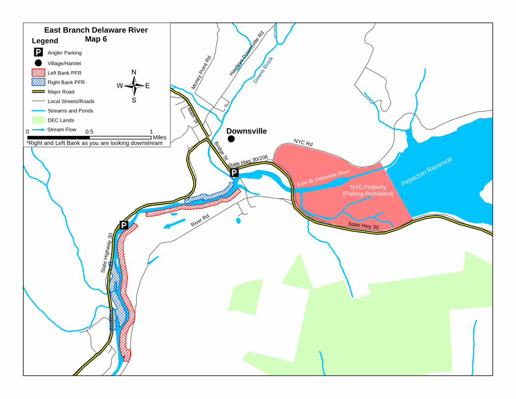
Downsville
jPepacton Reservoir
NYC Property(Fishing Prohibited)
East Br Delaware River
River Rd
NYC Rd
Tub Mill Rd
Stat
e H
ighw
ay 3
0
State Hwy 30
Bridge St
Main St
Mon
ey P
oint
Rd
State Highw
ay 206
Hawley
s-Dow
nsvil
le RdEast Branch Delaware River
Map 6
0 10.5Miles
/*Right and Left Bank as you are looking downstream
LegendIA Angler Parking
Village/Hamlet
Left Bank PFR
Right Bank PFR
Major Road
Local Streets/Roads
Streams and Ponds
DEC Landsj Stream Flow