Embed Size (px)
Citation preview

PROPOSED MIXED USE DEVELOPMENTPINFOLD TRADING ESTATE, NOTTINGHAM ROAD,
STAPLEFORD
Aldi Stores LtdTransport Assessment
February 2015
Connect Consultants, 78 Broad Street, Chipping Sodbury, Bristol BS37 6AG t:01454 320 220 f:01454 320 099 e:[email protected]
Proposed Mixed Use Development Pinfold Trading Estate, Nottingham Road, Stapleford
Contents
1.0 INTRODUCTION 1
2.0 SITE TRANSPORT CONTEXT 6
3.0 PROPOSED DEVELOPMENT 12
4.0 TRAFFIC ASSESSMENT 17
5.0 JUNCTION CAPACITY ANALYSIS 26
6.0 SUMMARY & CONCLUSIONS 31
Connect Consultants, 78 Broad Street, Chipping Sodbury, Bristol BS37 6AG t:01454 320 220 f:01454 320 099 e:[email protected]
Proposed Mixed Use Development Pinfold Trading Estate, Nottingham Road, Stapleford
List of Tables
Table 1 – Bus Service Details 9
Table 2 – Accident Data 11
Table 3 – TEMPRO Traffic Growth Rates 18
Table 4 – Existing Site Attraction 19
Table 5 – Existing Site Primary Distribution 20
Table 6 – TRICS Data – Residential 20
Table 7 – Modal Residential Attraction 21
Table 8 – TRICS Data – Foodstores 21
Table 9 – Modal Foodstore Attraction 21
Table 10 – TRICS Report 95/2 Report Summary 22
Table 11 – Pass-by and Diverted Ranges 22
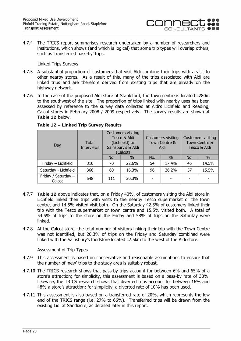
Table 12 – Linked Trip Survey Results 23
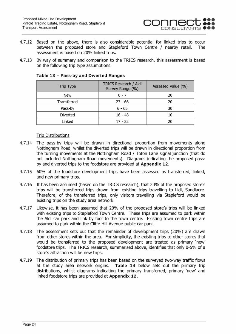
Table 13 – Pass-by and Diverted Ranges 24
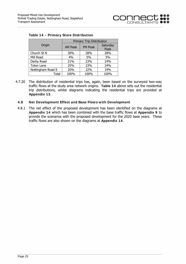
Table 14 – Primary Store Distribution 25
Table 15 – PICADY – B5010 Nottingham Road / Site Access Priority Junction 26
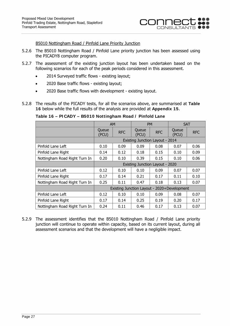
Table 16 – PICADY – B5010 Nottingham Road / Pinfold Lane 27
Table 17 – PICADY – Church Street / Pinfold Lane 28
Table 18 – Queue Comparison 29
Table 19 – LINSIG – B5010 Nottingham Road / Derby Road / Toton Lane 30
Connect Consultants, 78 Broad Street, Chipping Sodbury, Bristol BS37 6AG t:01454 320 220 f:01454 320 099 e:[email protected]
Proposed Mixed Use Development Pinfold Trading Estate, Nottingham Road, Stapleford
List of Appendices Appendix 1 Proposed Site Layout Appendix 2 Proposed Site Access Arrangements Appendix 3 Existing Highway Layout Plan Appendix 4 Bus Service Details Appendix 5 Accident Plan Appendix 6 Vehicular Swept Paths Appendix 7 Car Park Accumulation Assessment Appendix 8 Existing Traffic Flows and Raw Survey Data Appendix 9 TEMPRO, Committed Development Flows, and 2020 Base
Flows Appendix 10 Existing Site Attraction Appendix 11 TRICS and Modal Assessment Appendix 12 Foodstore Development Trip Types Appendix 13 Residential Trips Appendix 14 Net Development Effect and 2020 Base plus Development
Flows Appendix 15 Capacity Assessment

Proposed Mixed Use Development Pinfold Trading Estate, Nottingham Road, Stapleford Transport Assessment
Page 1
1.0 INTRODUCTION
1.1 Appointment of Connect Consultants
1.1.1 Connect Consultants Limited is a firm of transport planning and highway design consultants that have been instructed by Aldi Stores Limited in relation to their proposed mixed use residential and discount foodstore development at Pinfold Trading Estate, Nottingham Road, Stapleford.
1.2 Site Location
1.2.1 The site is located on B5010 Nottingham Road approximately 280m northeast of the Nottingham Road / Derby Road / Toton Lane signal junction and c1km west of the A52. The site is currently occupied by the Pinfold Business Park / Trading Estate and the Nags Head and Plough public house. B5010 Nottingham Road forms an arterial route for Stapleford and the location of the site, in the context of the urban area, is presented at Inset 1.1 below.
Inset 1.1 – Site Location Plan
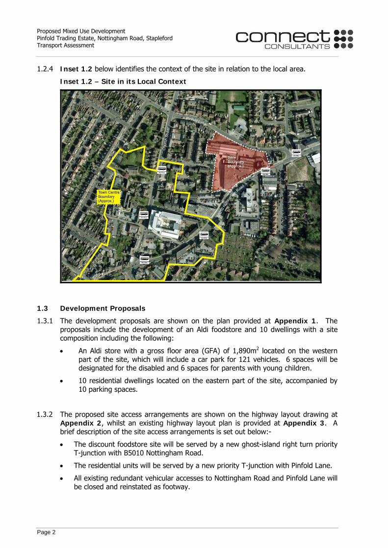
1.2.2 The site is located within a built up urban environment being located near to Stapleford Town Centre, and a large number of residential dwellings.
1.2.3 To the south, the site is bound by B5010 Nottingham Road, to the west and east the site is bound by residential and commercial properties, and to the north the site is bound by Pinfold Lane.
Proposed Mixed Use Development Pinfold Trading Estate, Nottingham Road, Stapleford Transport Assessment
Page 2
1.2.4 Inset 1.2 below identifies the context of the site in relation to the local area.
Inset 1.2 – Site in its Local Context
1.3 Development Proposals
1.3.1 The development proposals are shown on the plan provided at Appendix 1. The proposals include the development of an Aldi foodstore and 10 dwellings with a site composition including the following:
• An Aldi store with a gross floor area (GFA) of 1,890m2 located on the western part of the site, which will include a car park for 121 vehicles. 6 spaces will be designated for the disabled and 6 spaces for parents with young children.
• 10 residential dwellings located on the eastern part of the site, accompanied by 10 parking spaces.
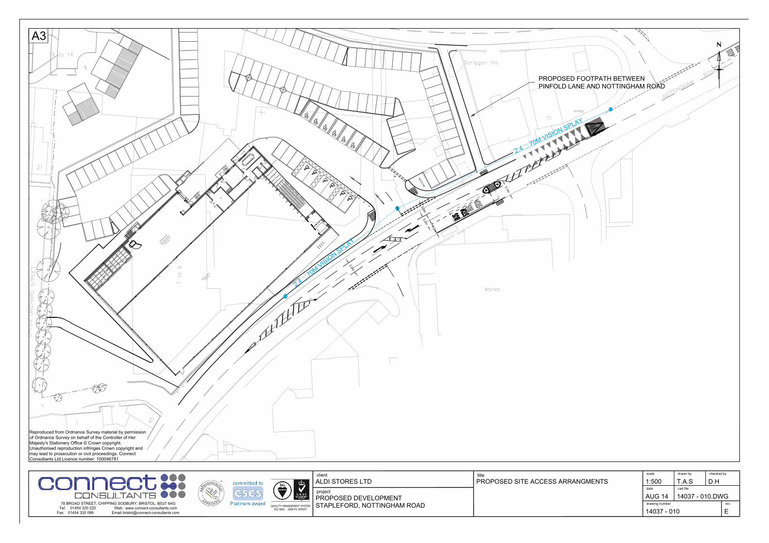
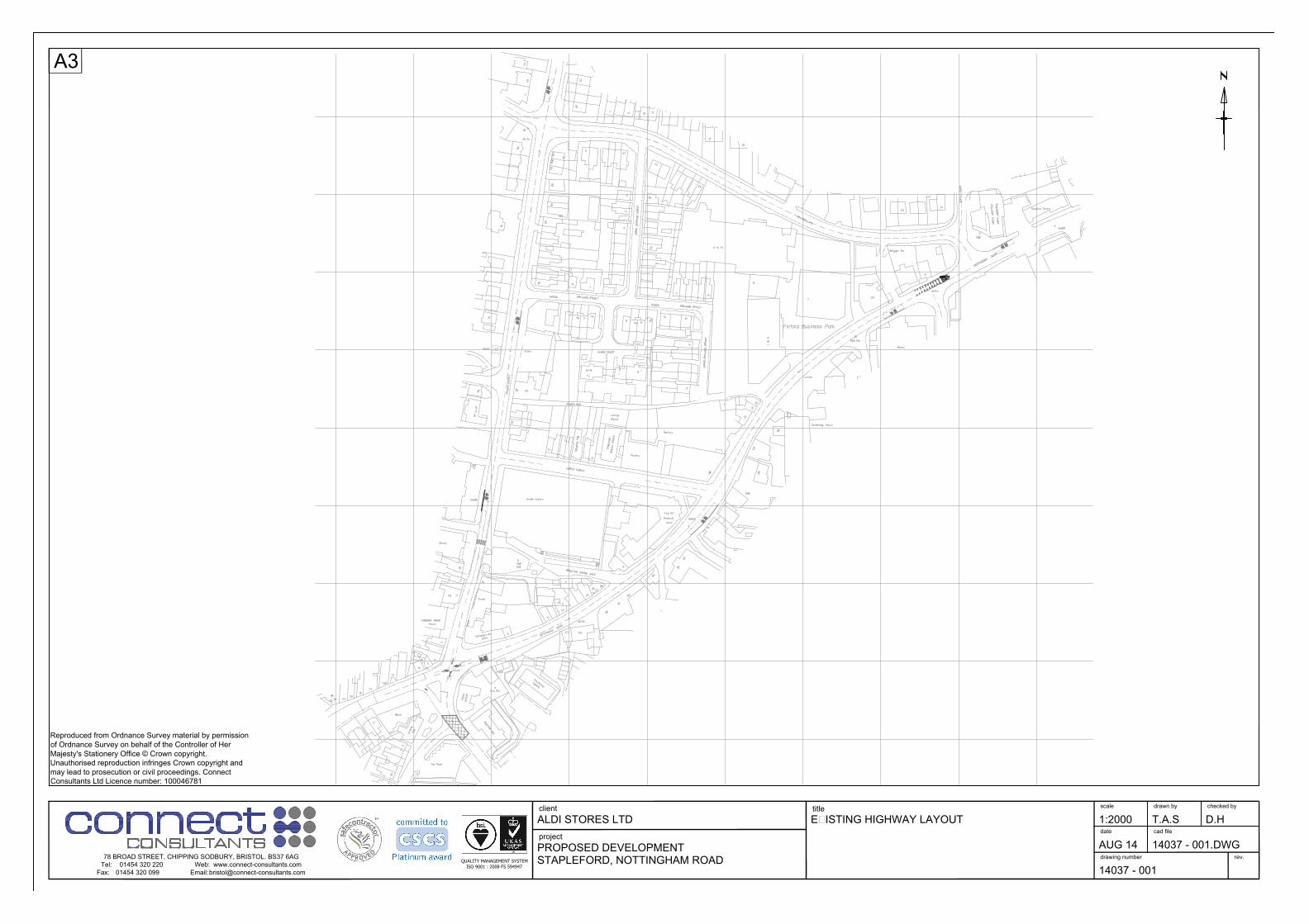
1.3.2 The proposed site access arrangements are shown on the highway layout drawing at Appendix 2, whilst an existing highway layout plan is provided at Appendix 3. A brief description of the site access arrangements is set out below:-
• The discount foodstore site will be served by a new ghost-island right turn priority T-junction with B5010 Nottingham Road.
• The residential units will be served by a new priority T-junction with Pinfold Lane.
• All existing redundant vehicular accesses to Nottingham Road and Pinfold Lane will be closed and reinstated as footway.

Proposed Mixed Use Development Pinfold Trading Estate, Nottingham Road, Stapleford Transport Assessment
Page 3
• There will be direct footway connections between the southern side of Pinfold Lane and the residential units and a direct connection between the northern side of Nottingham Road and the proposed foodstore.
• The existing footpath connection between Pinfold Lane and Nottingham Road will be relocated c20m east of its existing position and improved to provide a 2.5m wide footpath.
1.3.3 In addition to the physical highway improvement works described above, the proposed foodstore will be subject to a Travel Plan, which will seek to reduce car borne, particularly single occupancy, staff trips to/from the Aldi store.
1.3.4 Travel Plans are strategies for managing multi-modal access to a development that focus on maximising the potential for travel by sustainable modes. The Department for Transport has put a considerable amount of emphasis on the ability of Travel Plans to reduce congestion and research carried out into the impact of Travel Plans at places of work has shown that modal shifts of up to 30% or more can be achieved in some instances, with modal shifts of between 10% and 20% clearly evident throughout the UK1.
1.3.5 This Transport Assessment (TA) is accompanied by a Travel Plan for the proposed foodstore.
1 Source: ‘The Essential Guide to Travel Planning’ (March 2008) Department for Transport.

Proposed Mixed Use Development Pinfold Trading Estate, Nottingham Road, Stapleford Transport Assessment
Page 4
1.4 Background and Planning Policy
1.4.1 This report subsection provides a brief overview of national planning policy context and objectives.
National Planning Policy Framework (NPPF)
1.4.2 The National Planning Policy Framework (NPPF) published on the 27th March 2012, sets out the Government’s planning policies for England and sets out a framework for local authorities to produce their own local plans.
1.4.3 A key objective at paragraph 18 of the NPPF is the commitment to securing economic growth. Paragraph 19 further emphasises the importance of supporting economic growth through the planning system.
1.4.4 Paragraph 7 of the NPPF highlights that there are three dimensions to providing sustainable development, which includes economic, social and environmental roles. Socially, the residential requirements of a local community should be met by “accessible local services”.
1.4.5 Paragraph 29 of the NPPF highlights the needs for a sustainable transport system highlighting that “the transport system needs to be balanced in favour of sustainable transport modes, giving people a real choice about how they travel”.
1.4.6 These objectives are reiterated in paragraph 32 which is provided below:-
“All developments that generate significant amounts of movement should be supported by a Transport Statement or Transport Assessment. Plans and decisions should take account of whether:
• The opportunities for sustainable transport modes have been taken up depending on the nature and location of the site, to reduce the need for major transport infrastructure;
• Safe and suitable access to the site can be achieved for all people; and
• Improvements can be undertaken within the transport network that cost effectively limits the significant impacts of the development. Development should only be prevented or refused on transport grounds where the residual cumulative impacts of development are severe.”
Proposed Mixed Use Development Pinfold Trading Estate, Nottingham Road, Stapleford Transport Assessment
Page 5
1.5 Report Overview
1.5.1 This TA has been prepared in accordance with the Department for Transport’s March 2007 guidelines entitled ‘Guidance on Transport Assessment’. The scope of the Transport Assessment has been discussed with representatives of Nottinghamshire County Council, a scoping report was submitted to Nottinghamshire County Council on 11th July 2014, a draft Transport Assessment was submitted 1st August 2014, and access arrangement plans were submitted during November and December 2014. This Transport Assessment has been produced with full regard to the scoping discussions.
1.5.2 The remainder of this report is divided into five further sections, which are as follows:-
Section 2.0 Site Transport Context
This section of the report provides details of the site context, including its accessibility by all relevant transport modes and a review of local collision statistics.
Section 3.0 Proposed Development
The various components of the development proposal, including the site access arrangements and parking provision, are described within this section of the report.
Section 4.0 Traffic Assessment
This report section provides an assessment of vehicular attraction of the proposed store and residential dwellings along with their traffic effects.
Section 5.0 Junction Capacity Analysis
The results of the traffic assessment have been used to inform junction capacity analysis and the methodology and results are outlined in this section of the report.
Section 6.0 Summary & Conclusions
A summary and the conclusions of the report are provided in this section.

Proposed Mixed Use Development Pinfold Trading Estate, Nottingham Road, Stapleford Transport Assessment
Page 6
2.0 SITE TRANSPORT CONTEXT
2.1 Introduction
2.1.1 This section of the report considers the accessibility of the site in terms of a range of transport modes, as well as undertaking an accident analysis, which identifies the road safety context of the highway network local to the proposal site.
2.2 Pedestrian Access
2.2.1 The Department for Transport’s (DfT) document entitled ‘Manual for Streets’ dated 2007 provides guidance in relation to walk distances. Section 4.4 gives the following advice:-
“Walkable neighbourhoods are typically characterised by having a range of facilities within 10 minutes’ (up to about 800 m) walking distance of residential areas which residents may access comfortably on foot”.
2.2.2 Table 3.2 of The Institute of Highways and Transportation (IHT) guidance document entitled ‘Providing for Journeys on Foot’ identifies a maximum walk distance of 2.0km for commuter, school and sightseeing walk trips, 800m for town centre walk trips and 1.2km for trips elsewhere.
2.2.3 The actual distance that people will be prepared to walk will vary depending on the trip purpose and other factors such as the presence of road crossings and terrain. For retail / town centre trips, the likely maximum walk distance is 800m due to the fact that shoppers will be carrying bags on their return journey, while for work based trips, people are likely to be prepared to walk the full 2km referred to in ‘Providing for Journeys on Foot’.
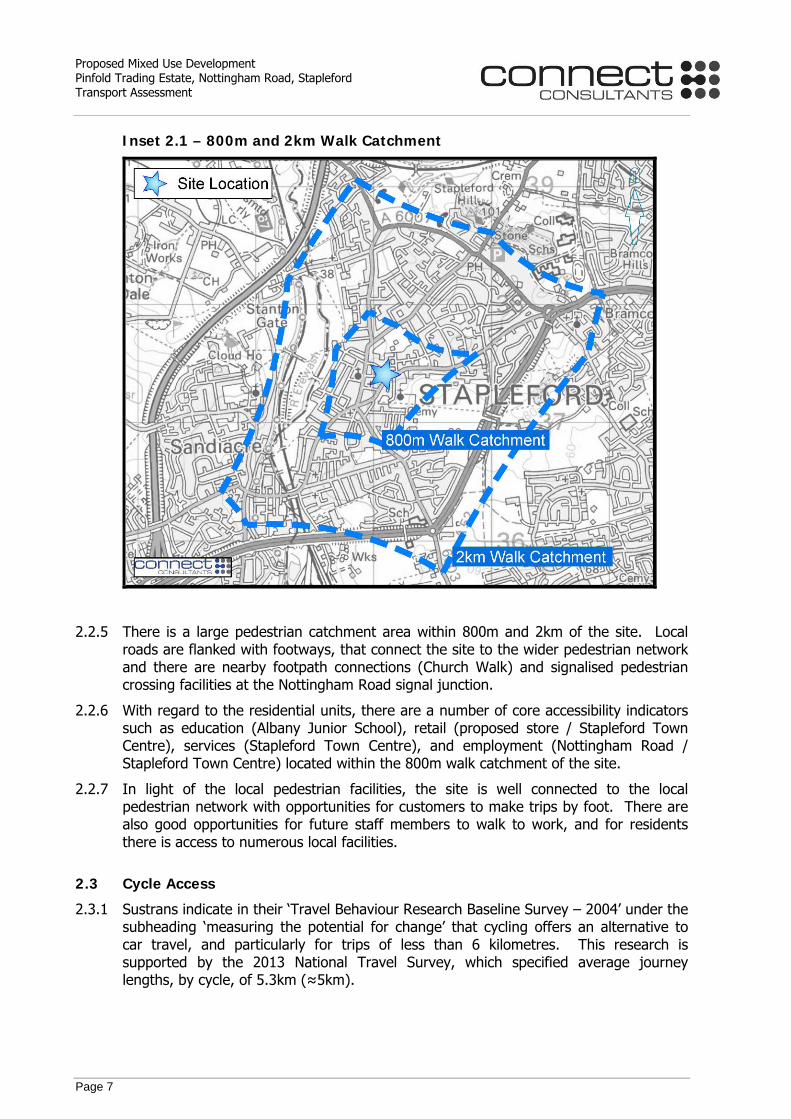
2.2.4 Based on a maximum walk distance of 800m for shoppers and 2km for commuters, the walk isochrones are shown at Inset 2.1 below.
Proposed Mixed Use Development Pinfold Trading Estate, Nottingham Road, Stapleford Transport Assessment
Page 7
Inset 2.1 – 800m and 2km Walk Catchment
2.2.5 There is a large pedestrian catchment area within 800m and 2km of the site. Local roads are flanked with footways, that connect the site to the wider pedestrian network and there are nearby footpath connections (Church Walk) and signalised pedestrian crossing facilities at the Nottingham Road signal junction.
2.2.6 With regard to the residential units, there are a number of core accessibility indicators such as education (Albany Junior School), retail (proposed store / Stapleford Town Centre), services (Stapleford Town Centre), and employment (Nottingham Road / Stapleford Town Centre) located within the 800m walk catchment of the site.
2.2.7 In light of the local pedestrian facilities, the site is well connected to the local pedestrian network with opportunities for customers to make trips by foot. There are also good opportunities for future staff members to walk to work, and for residents there is access to numerous local facilities.
2.3 Cycle Access
2.3.1 Sustrans indicate in their ‘Travel Behaviour Research Baseline Survey – 2004’ under the subheading ‘measuring the potential for change’ that cycling offers an alternative to car travel, and particularly for trips of less than 6 kilometres. This research is supported by the 2013 National Travel Survey, which specified average journey lengths, by cycle, of 5.3km (≈5km).
Proposed Mixed Use Development Pinfold Trading Estate, Nottingham Road, Stapleford Transport Assessment
Page 8
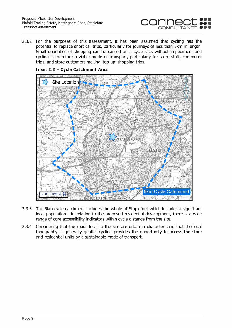
2.3.2 For the purposes of this assessment, it has been assumed that cycling has the potential to replace short car trips, particularly for journeys of less than 5km in length. Small quantities of shopping can be carried on a cycle rack without impediment and cycling is therefore a viable mode of transport, particularly for store staff, commuter trips, and store customers making ‘top-up’ shopping trips.
Inset 2.2 – Cycle Catchment Area
2.3.3 The 5km cycle catchment includes the whole of Stapleford which includes a significant local population. In relation to the proposed residential development, there is a wide range of core accessibility indicators within cycle distance from the site.
2.3.4 Considering that the roads local to the site are urban in character, and that the local topography is generally gentle, cycling provides the opportunity to access the store and residential units by a sustainable mode of transport.

Proposed Mixed Use Development Pinfold Trading Estate, Nottingham Road, Stapleford Transport Assessment
Page 9
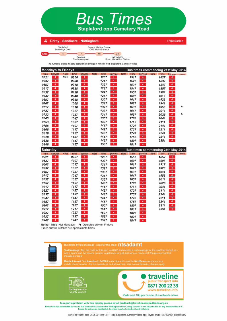
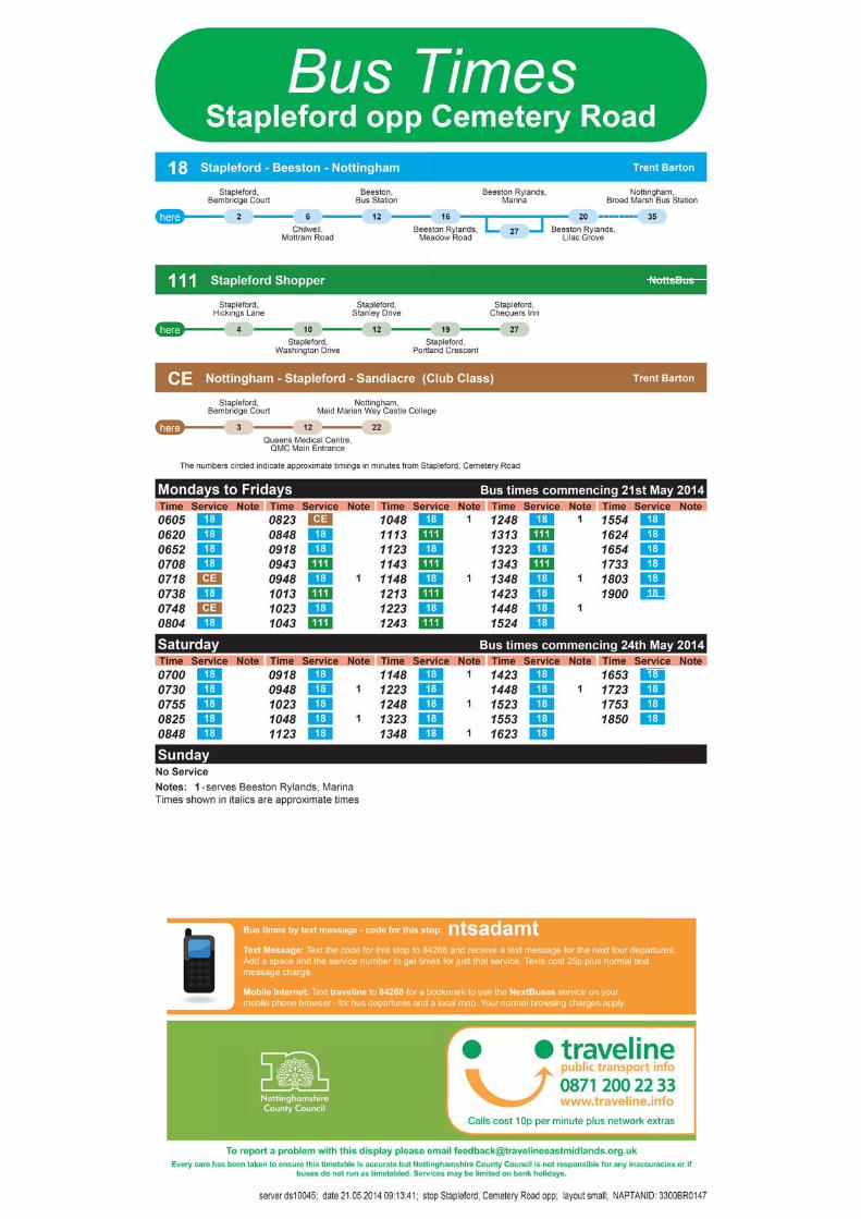
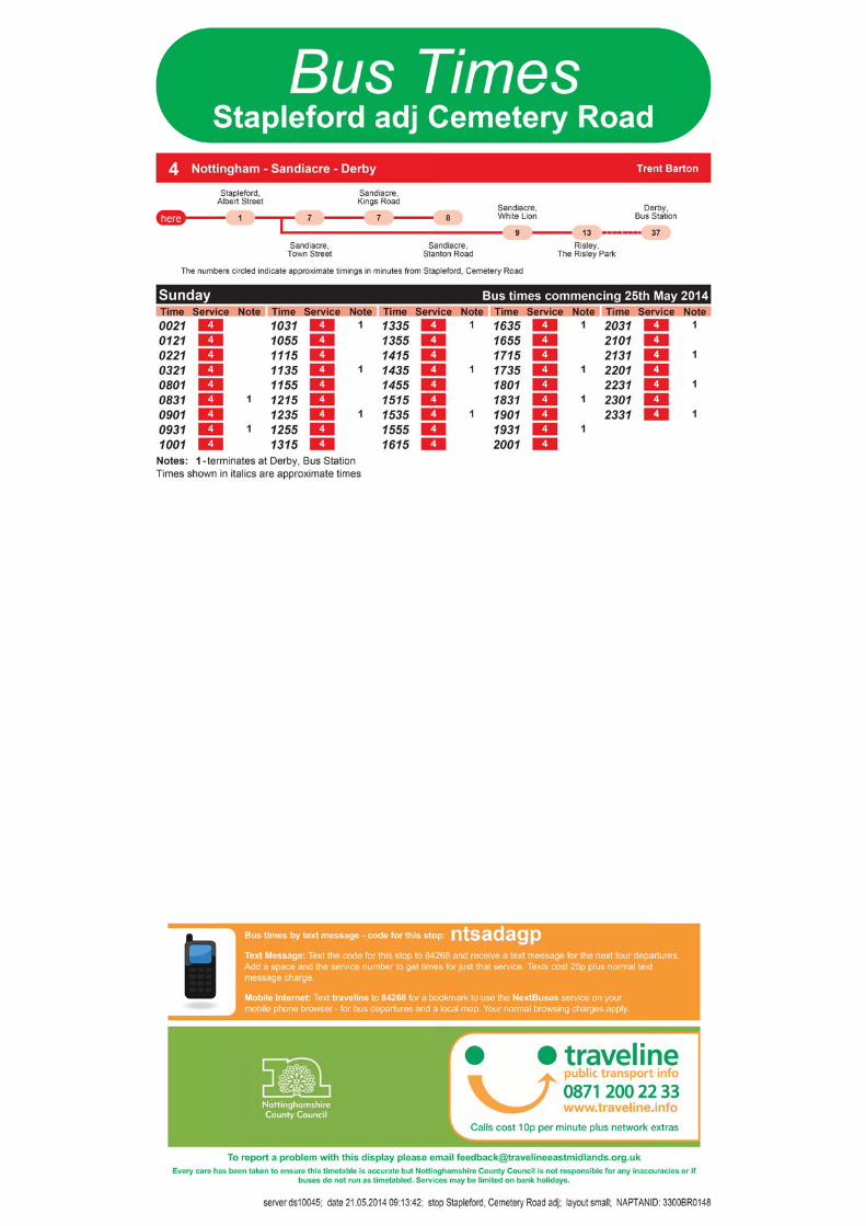
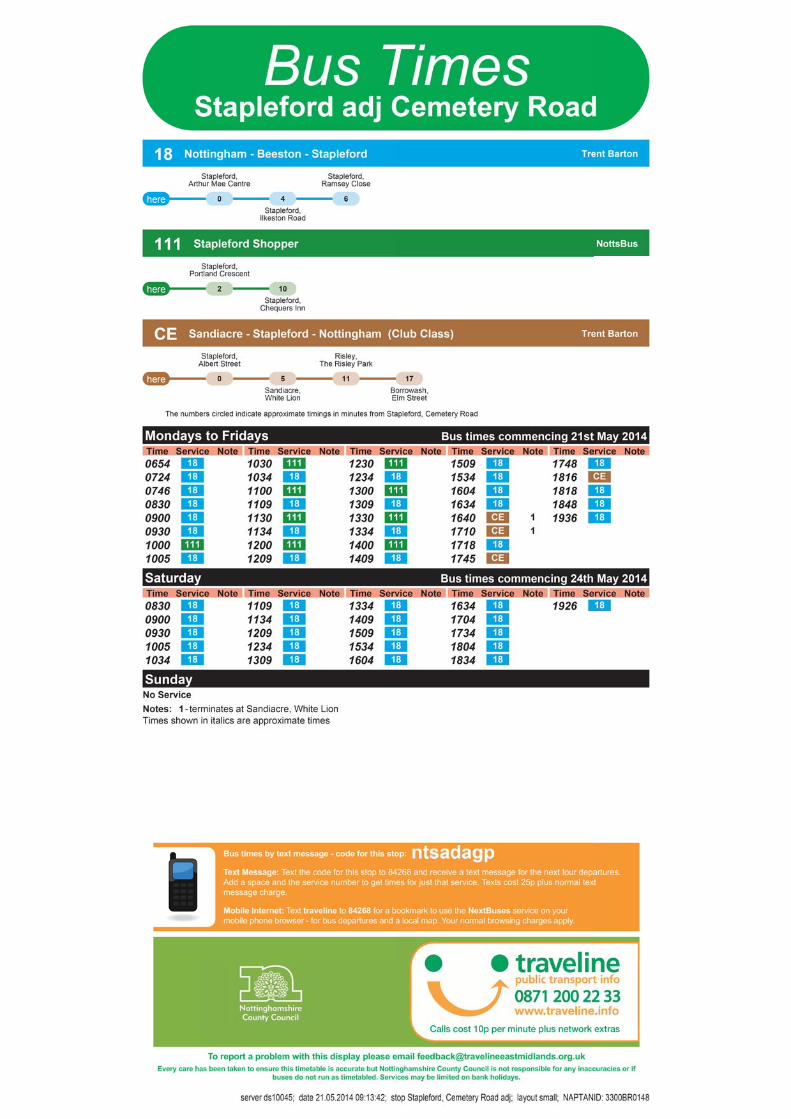
2.4 Bus Access
2.4.1 The publication ‘Planning for Public Transport in Developments’ produced by the Institution of Highways and Transportation (IHT) specifies that new developments should be located within 400m of the nearest bus stop.
2.4.2 There are bus stops located on Nottingham Road, which are adjacent to the site for southwest-bound buses, and c65m northeast of the site for northeast-bound buses. Both bus stops fall within the IHT maximum recommended walk distance of 400m to the nearest site bus stops. Both bus stops are served by raised kerbs, seating, shelters and timetable information.
2.4.3 Table 1 below summarises the routes that serve the bus stops, there is on average one bus every six minutes passing the site in each direction during the day. Full details of these services are provided at Appendix 4.
Table 1 – Bus Service Details
Service Route Approximate Frequency
Monday - Friday Saturday Sunday
4 Derby - Sandiacre - Nottingham Every 10 Minutes
Every 10 Minutes
Every 20 Minutes
18 Stapleford - Beeston - Nottingham
Every 30 Minutes
Every 30 Minutes -
111 Stapleford Shopper Every 30 Minutes - -
2.4.4 Having regard to the proximity of the bus stops, the frequency of buses and the areas that the existing local buses serve, the site is accessible by public transport.
2.5 Highways Access
2.5.1 Stapleford is bound to the west by the Midland Main railway line along with the M1 motorway, and is bound to the east by the A52, which provides an arterial route for Nottingham from the M1.
2.5.2 B5010 Nottingham Road provides an arterial route for Stapleford, which connects A52 at its eastern end with Stapleford, Sandiacre, Risley, and Spondon.
2.5.3 The proposal site is currently accessed from a number of simple priority T-junctions with B5010 Nottingham Road located c280m northeast of Stapleford Town Centre and c1.5km southwest of its junction with the A52.
2.5.4 Overall, the site has a prominent location in relation to the local road network from which it is easily accessible.

Proposed Mixed Use Development Pinfold Trading Estate, Nottingham Road, Stapleford Transport Assessment
Page 10
2.6 Accident Analysis
2.6.1 Accident data has been obtained for the road safety study area from Nottinghamshire County Council for the most recent 5 year period available. Data has been provided for the period between January 2009 and December 2013. A plan showing the details and location of the recorded personal injury accidents over this period, for the study area identified at Inset 2.3 below, is provided at Appendix 5.
Inset 2.3 – Accident Study Area
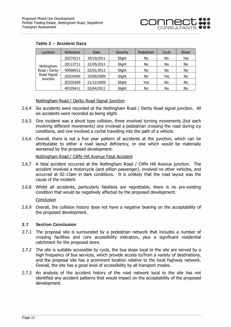
2.6.2 The accident plan shows that there were a total of 29 accidents within the study area. A summary of the locations where 5 or more accidents occurred over a 5 year period (i.e. 1 or more accidents per annum) is provided at Table 2 below.
2.6.3 There was also a fatal accident, which occurred at the Nottingham Road / Cliffe Hill Avenue junction, but did not form part of the 5 year locations shown below. However, this collision has also been considered separately below.
Proposed Mixed Use Development Pinfold Trading Estate, Nottingham Road, Stapleford Transport Assessment
Page 11
Table 2 – Accident Data
Location Reference Date Severity Pedestrian Cycle Shunt
Nottingham Road / Derby Road Signal
Junction
2D274211 29/10/2011 Slight No No Yes
2D113711 22/05/2011 Slight No No No
4D006912 02/01/2012 Slight No No No
2D235409 25/09/2009 Slight No Yes No
2D335209 21/12/2009 Slight Yes No No
4D105411 03/04/2011 Slight No No No
Nottingham Road / Derby Road Signal Junction
2.6.4 Six accidents were recorded at the Nottingham Road / Derby Road signal junction. All six accidents were recorded as being slight.
2.6.5 One incident was a shunt type collision, three involved turning movements (but each involving different movements) one involved a pedestrian crossing the road during icy conditions, and one involved a cyclist travelling into the path of a vehicle.
2.6.6 Overall, there is not a five year pattern of accidents at the junction, which can be attributable to either a road layout deficiency, or one which would be materially worsened by the proposed development.
Nottingham Road / Cliffe Hill Avenue Fatal Accident
2.6.7 A fatal accident occurred at the Nottingham Road / Cliffe Hill Avenue junction. The accident involved a motorcycle (and pillion passenger), involved no other vehicles, and occurred at 02:13am in dark conditions. It is unlikely that the road layout was the cause of the incident.
2.6.8 Whilst all accidents, particularly fatalities are regrettable, there is no pre-existing condition that would be negatively affected by the proposed development.
Conclusion
2.6.9 Overall, the collision history does not have a negative bearing on the acceptability of the proposed development.
2.7 Section Conclusion
2.7.1 The proposal site is surrounded by a pedestrian network that includes a number of crossing facilities and core accessibility indicators, plus a significant residential catchment for the proposed store.
2.7.2 The site is suitably accessible by cycle, the bus stops local to the site are served by a high frequency of bus services, which provide access to/from a variety of destinations, and the proposal site has a prominent location relative to the local highway network. Overall, the site has a good level of accessibility by all transport modes.
2.7.3 An analysis of the accident history of the road network local to the site has not identified any accident patterns that would impact on the acceptability of the proposed development.
Proposed Mixed Use Development Pinfold Trading Estate, Nottingham Road, Stapleford Transport Assessment
Page 12
3.0 PROPOSED DEVELOPMENT
3.1 Introduction
3.1.1 This report is based on a scheme comprising an Aldi foodstore with a gross floor area (GFA) of 1,890m2 plus 10 residential dwellings. The foodstore site includes a total car parking provision of 121 parking spaces, and the residential units will have 10 associated parking spaces.
3.1.2 The proposed site layout is identified on the plan provided at Appendix 1.
3.2 Proposed Site Access Arrangements
3.2.1 The foodstore site will be served by a ghost island right turn priority T-junction arrangement with B5010 Nottingham Road. Likewise, the residential units will be served by a simple priority T-junction with Pinfold Lane albeit that four of the residential units will have direct driveway access to/from Pinfold Lane.
3.2.2 All remaining existing accesses to the site will be closed and reinstated as footway.
3.2.3 The proposed site access arrangements are shown on the highway layout drawing at Appendix 2. Visibility splays of 2.4 x 43m, as identified as the stopping sight distance at Table 7.1 of MfS for vehicles travelling at 30mph, measured to the nearside kerb, are also shown on the drawing at Appendix 2.
3.2.4 There will be direct footway connections between the southern side of Pinfold Lane and the residential units and a direct connection between the northern side of Nottingham Road and the proposed foodstore. The existing footpath connection between Pinfold Lane and Nottingham Road will be relocated c20m east of its existing location and improved to provide a 2.5m wide footpath.
3.2.5 Additionally, a new pedestrian refuge island crossing will be located on Nottingham Road adjacent to the Pinfold Lane / Nottingham Road footpath link.
Safety Audit
3.2.6 The proposed site access arrangements shown on the drawings at Appendix 2 take account of the recommendations of a Stage 1 Road Safety Audit which was undertaken in December 2014 by Nottinghamshire County Council.
3.2.7 The procedure that has been followed in relation to the design of the site access arrangements and off-site highway improvements is as follows:-
A design was produced having regard to discussions with the local highway authority, the advice in the Design Manual for Roads and Bridges (DMRB) and Manual for Streets (2007 and 2011) along with traffic data, and the local site characteristics.
A road safety auditor (Nottinghamshire County Council) was commissioned to undertake a Stage 1 Road Safety Audit in accordance with the relevant DMRB guidance.
The Audit has raised no matters of principle in relation to the highway layout proposals.
3.2.8 Based on the above, the highway proposals have evolved having full regard to the
consideration of highway safety issues.

Proposed Mixed Use Development Pinfold Trading Estate, Nottingham Road, Stapleford Transport Assessment
Page 13
3.3 Servicing
3.3.1 Aldi Stores operate an efficient servicing regime that typically results in two 16.5m articulated delivery vehicles to a store per day from their regional distribution centre along with 1-2 local delivery vehicles for products such as milk.
3.3.2 Delivery vehicles will service the store via the proposed access, utilising the car park and access roads as a manoeuvring area. Aldi operate on this basis at the majority of their existing stores, including those in Nottinghamshire, where it has been found to be satisfactory.
3.3.3 The proposed site layout has been assessed for delivery vehicle manoeuvres and details of the swept path assessment are provided at Appendix 6. The track plots show that the service route through the car park is satisfactory, that service vehicles would be able to manoeuvre within the site, and that service vehicles will arrive and depart in forward gear.
3.4 Car Parking Provision
3.4.1 Paragraph 39 of the National Planning Policy Framework NPPF states:-
“If setting local parking standards for residential and non-residential development, local planning authorities should take into account:
• The accessibility of the development;
• The type, mix and use of the development;
• The availability of and opportunities for public transport;
• Local car ownership levels; and
• An overall need to reduce the use of high-emission vehicles.”
3.4.2 As previously mentioned, it is proposed to provide 121 spaces allocated to the
foodstore including 6 disabled spaces, plus 10 spaces for the proposed residential dwellings.
3.4.3 The car parking standards are set out at Appendix 4 of the 2004 Broxtowe Local Plan (reference Policy T11), which states a maximum provision of 1 space per 14sq.m of gross floor area for the proposed foodstore. This equates to 135 (1,890 / 14 = 135) spaces; the proposal for 121 spaces accords with this policy. The proposed provision of 6 disabled bays broadly accords with the 2004 Broxtowe Local Plan requirement for 6% provision within the store car park.
3.4.4 Appendix 4 of the Local Plan also states “In town and district centres (and within edge of centres), retail developments should be required to make their parking allocation available for general use to serve the centre.” Aldi will also comply with this requirement of the parking guidelines.
3.4.5 The 2004 Broxtowe Local Plan parking standard for residential dwellings is set at a maximum of 1 parking space per dwelling. The proposal for 10 spaces accords with this policy.
3.4.6 An operational assessment of the proposed discount foodstore’s car park is provided below.

Proposed Mixed Use Development Pinfold Trading Estate, Nottingham Road, Stapleford Transport Assessment
Page 14
3.5 Car Park Accumulation Assessment
TRICS Assessment
3.5.1 The operation of the foodstore car park has been assessed by reference to data contained within version 7 of the TRICS database. A dataset of trip rates for the discount foodstore has been derived using multimodal data from the category ‘Discount Foodstores’ using all stores located in England excluding Greater London from the year 2000 to present.
3.5.2 For each of the TRICS sites, the arrival and departure profiles have been determined and accumulation profiles have been calculated using arrival and departure data. The accumulation profiles have been scaled to the proposed GFA using the ratio of the GFA between the TRICS site and the proposal site so that the profiles are representative of a discount foodstore with a GFA of 1,890m2.
3.5.3 The weighted average foodstore parking accumulations, for both a weekday and a Saturday have been derived from these datasets as shown at Graph 3.1 and Graph 3.2 below.
3.5.4 The weighted average accumulation is calculated by determining the average parking profile and then applying a factor to increase the profile so that the peak parking accumulation accords with the average maximum peak accumulation from the profiles of each store. This means that the weighted average profile is representative of all of the store profiles and their peaks, which may have peaks occurring at different times.
Graph 3.1 – Weekday Parking Accumulation

Proposed Mixed Use Development Pinfold Trading Estate, Nottingham Road, Stapleford Transport Assessment
Page 15
Graph 3.2 – Saturday Parking Accumulation
3.5.5 Graph 3.1 shows a maximum weighted average accumulation of 42 vehicles on a weekday, which equates to an occupancy of 35%. On a Saturday, Graph 3.2 indicates a maximum of 64 parked vehicles, which equates to an occupancy of 53%. Overall, the assessment shows that the proposed car park is suitable to accommodate store demand.
3.5.6 Full details of the car park accumulation analysis are provided at Appendix 7.
Registration Plate Survey Data
3.5.7 A parking study was undertaken (in 2013) of Aldi stores located in East Anglia and the South East of England, which considered a number of operational characteristics, including car parks that operated near to, or over, capacity. Some of the main conclusions of the assessment were that:-
1. Some customers learn when a store is typically busy and choose to visit the store at earlier / later times of the day to ensure ease of parking.
2. Some customers arrive as it suits them, and wait in the car park aisles for a space (the turnaround of parking spaces is relatively quick, given average durations of stay. Therefore waiting times for spaces are low).
3. There were no perceivable negative off-site effects resulting from car parks where demand exceeds capacity.
Summary
3.5.8 Overall, the proposed on-site parking provision is acceptable.

Proposed Mixed Use Development Pinfold Trading Estate, Nottingham Road, Stapleford Transport Assessment
Page 16
3.6 Cycle Parking Provision
3.6.1 The proposed discount foodstore site will provide 10 cycle spaces in accordance with Local Plan Policy T7 (i.e. 1 cycle space per 200m2 gross floor area).
3.6.2 The development proposals include 5 Sheffield cycle stands and thus space for 10 cycles to be securely parked, which equates to c8% of the total car parking provision. Cycle parking will be covered and located adjacent to the store entrance.
3.6.3 Assuming that cyclists will be undertaking ‘top-up’ shopping trips this level of parking would support up to 24 arrivals and departures by cycle per hour during the day (assuming a 15 minute duration of stay and 4 spaces occupied by staff).
Proposed Mixed Use Development Pinfold Trading Estate, Nottingham Road, Stapleford Transport Assessment
Page 17
4.0 TRAFFIC ASSESSMENT
4.1 Introduction
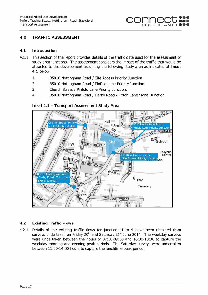
4.1.1 This section of the report provides details of the traffic data used for the assessment of study area junctions. The assessment considers the impact of the traffic that would be attracted to the development assuming the following study area as indicated at Inset 4.1 below.
1. B5010 Nottingham Road / Site Access Priority Junction. 2. B5010 Nottingham Road / Pinfold Lane Priority Junction. 3. Church Street / Pinfold Lane Priority Junction. 4. B5010 Nottingham Road / Derby Road / Toton Lane Signal Junction. Inset 4.1 – Transport Assessment Study Area
4.2 Existing Traffic Flows
4.2.1 Details of the existing traffic flows for junctions 1 to 4 have been obtained from surveys undertaken on Friday 20th and Saturday 21st June 2014. The weekday surveys were undertaken between the hours of 07:30-09:30 and 16:30-18:30 to capture the weekday morning and evening peak periods. The Saturday surveys were undertaken between 11:00-14:00 hours to capture the lunchtime peak period.

Proposed Mixed Use Development Pinfold Trading Estate, Nottingham Road, Stapleford Transport Assessment
Page 18
4.2.2 This report considers the peak periods during which the study area will be at its busiest and an assessment of the recorded traffic flows identifies that the peak periods are as set out below:-
Weekday AM Peak – 08:15 to 09:15 hours
Weekday PM Peak – 16:30 to 17:30 hours
Saturday Peak – 11:15 to 12:15 hours
4.2.3 Diagrams indicating the recorded June 2014 study area peak hour traffic flows are provided at Appendix 8 alongside the raw traffic survey data.
4.3 Base Year Traffic Flows
4.3.1 The assessment is based on a future assessment year of 2020 (Application year + 5 years). Growth factors have been applied to the 2014 traffic flows at Appendix 8 to represent the future year to account for projected economic growth and local development forecasts.
4.3.2 The growth factors have been derived based on the TEMPRO version6.2 database for the period between 2014 and 2020. This has been adjusted based on the TEMPRO output for car drivers for the geographical area of Beeston and Stapleford and the results of the assessment are summarised below at Table 3.
Table 3 – TEMPRO Traffic Growth Rates
Peak Period 2014 to 2020
Resultant Growth
Weekday AM Peak 1.0995
Weekday PM Peak 1.0951
Saturday Daily 1.0945
Note:- No adjustment has been made for the addition of committed developments considered separately below.
4.3.3 Full details of the TEMPRO assessment are contained at Appendix 9.
Committed Developments
4.3.4 As part of this assessment, and following discussions with Nottinghamshire County Council, allowances have been made for the trip attraction of other development proposals within the vicinity of the site. The assessment considers the traffic arising from the following development sites:-
• Field Farm Development (11/00758/OUT). • Land West of Toton Lane (12/00585/OUT). • Stanton Ironworks Development.
Proposed Mixed Use Development Pinfold Trading Estate, Nottingham Road, Stapleford Transport Assessment
Page 19
4.3.5 The source of traffic data / distribution of trips local to the site are set out below:-
• Field Farm Development (11/00758/OUT) – BSP November 2011 Transport Assessment capacity modelling for Nottingham Road / Toton Lane signal junction (AM/PM peaks). The Saturday peak traffic effects have been taken as the average of the AM and PM peak impacts at this junction.
• Land West of Toton Lane (12/00585/OUT) – BWB Technical Note 02, 6th February 2013. The northbound and southbound net impacts on Toton Lane have been determined from the A52 / Toton Lane junction modelling. It has been assumed that 50% of the net movements are associated with movements at the Nottingham Road / Toton Lane signal junction (AM/PM peaks). The Saturday peak traffic effects have been taken as the average of the AM and PM peak impacts at this junction.
• Stanton Ironworks Development – Vectos November 2012 Transport Assessment capacity modelling for Nottingham Road / Toton Lane signal junction (AM/PM peaks). The Saturday peak traffic effects have been taken as the average of the AM and PM peak impacts at this junction.
4.3.6 Traffic diagrams indicating the flows associated with the committed developments are
provided at Appendix 9.
4.3.7 Diagrams showing the projected 2020 base traffic flows with committed developments are provided at Appendix 9.
4.4 Existing Site Attraction
4.4.1 By reference to the Department for Transport’s ‘Guidance on Transport Assessments’, the Transport Assessment should take into account “trips which might realistically be generated by any extant planning permission or permitted uses” and also that the assessment of committed development “will typically include development sites that have extant planning permission as well as development plan allocations in an adopted or approved plan.”
4.4.2 As detailed above, the proposal site is currently used for a trading estate / business park and a public house.
4.4.3 The existing trip attraction of the current site use, as identified from the June 2014 traffic surveys is set out at Table 4 below.
Table 4 – Existing Site Attraction
Existing Site Trip Attraction
Peak Hour Arrivals Departures Total AM Peak 35 15 50 PM Peak 18 33 51 Sat Peak 10 14 24
4.4.4 For the purposes of this assessment, the existing site attraction is based on its recorded use and not its potential demand.
4.4.5 The distribution of existing trips has been based on the surveyed turning movements at the study area junctions. The resultant distribution of existing trips is identified at Table 5 below.
Proposed Mixed Use Development Pinfold Trading Estate, Nottingham Road, Stapleford Transport Assessment
Page 20
Table 5 – Existing Site Primary Distribution
Route Public House Industrial Estate
AM Peak Arrivals Departures Arrivals Departures
Church St N 19% 0% 6% 1% Mill Road 4% 0% 1% 1% Church St S 4% 0% 1% 1% Derby Road 6% 57% 29% 31% Toton Lane 3% 43% 13% 23% Nottingham Road E 64% 0% 50% 43%
Route PM Peak
Arrivals Departures Arrivals Departures Church St N 0% 16% 3% 3% Mill Road 0% 6% 1% 1% Church St S 0% 3% 1% 0% Derby Road 18% 16% 31% 45% Toton Lane 7% 9% 11% 27% Nottingham Road E 25% 50% 52% 24%
Route Saturday Peak
Arrivals Departures Arrivals Departures Church St N 0% 17% 5% 2% Mill Road 0% 10% 3% 1% Church St S 0% 6% 3% 1% Derby Road 23% 46% 10% 25% Toton Lane 10% 21% 4% 12% Nottingham Road E 67% 0% 75% 59%
4.4.6 Diagrams indicating the existing site attraction, which are present in the 2014 and 2020 base year flows, have been provided at Appendix 10.
4.5 Residential Trip Attraction
4.5.1 Details of the traffic attraction of the proposed residential dwellings have been investigated using the TRICS version 7 database. Trip rates have been derived using all multimodal ‘Residential – Houses Privately Owned’ sites, located in England excluding Greater London.
4.5.2 The resultant trip rates and trip attraction are set out at Table 6 below. The trip rates are stated per dwelling and TRICS outputs are provided at Appendix 11.
Table 6 – TRICS Data – Residential
Non-Food Trip Rates Residential Trip Attraction (10 dwellings)
Peak Hour Arrivals Departures Total Arrivals Departures Total AM Peak 0.155 0.406 0.561 2 4 6 PM Peak 0.388 0.224 0.612 4 2 6 Sat Peak 0.157 0.108 0.265 2 1 3

Proposed Mixed Use Development Pinfold Trading Estate, Nottingham Road, Stapleford Transport Assessment
Page 21
4.5.3 A multimodal assessment has been undertaken based on the TRICS data, which, based on the total (arrivals and departures) vehicle trips for the residential, will result in the following trips.
Table 7 – Modal Residential Attraction
Travel Mode – 2 way attraction Peak Walk Cycle Public Transport Car Driver Car Passenger Total People
AM Peak 2 0 0 6 2 10 PM Peak 1 0 0 6 2 9 Sat Peak 0 0 0 3 2 5
4.5.4 Details of the modal assessment are provided at Appendix 11.
4.6 Discount Foodstore Trip Attraction
4.6.1 Details of the traffic attraction of the proposed discount foodstore have been investigated using the TRICS version 7.1.1 database. Average trip rates have been derived for the discount foodstore using all multimodal discount foodstore sites located in England excluding Greater London from 2000 to present.
4.6.2 The resultant trip rates and trip attraction are set out at Table 8 below. The trip rates are stated per 100sq.m of gross floor area and TRICS outputs are provided at Appendix 11.
Table 8 – TRICS Data – Foodstores
Average Foodstore Trip Rates Average Foodstore Trip Attraction Peak Hour Arrivals Departures Total Arrivals Departures Total AM Peak 0.901 0.456 1.357 17 9 26 PM Peak 2.704 3.078 5.782 51 58 109 Sat Peak 6.694 6.899 13.593 127 130 257
4.6.3 A multimodal assessment has been undertaken based on the TRICS data, which, based on the total (arrivals and departures) vehicle trips for the foodstore, will result in the following trips.
Table 9 – Modal Foodstore Attraction
Travel Mode – 2 way attraction Peak Walk Cycle Public Transport Car Driver Car Passenger Total People
AM Peak 10 0 1 26 6 43 PM Peak 54 5 4 109 49 221 Sat Peak 85 5 0 257 223 570
4.6.4 Details of the modal assessment are provided at Appendix 11.

Proposed Mixed Use Development Pinfold Trading Estate, Nottingham Road, Stapleford Transport Assessment
Page 22
4.7 Trip Types
4.7.1 The traffic that will be attracted to the proposed foodstore will comprise the following trip types:-
• Pass by trips resulting from people who currently use the B5010 Nottingham Road for a trip involving another purpose who will visit the site while passing.
• Diverted trips derived from people who are using the road network close to the site (but not adjacent to the site) for another purpose who will divert their trips to visit the store while passing in the broad vicinity.
• Transferred trips by people who would change their destination from a competing attraction to the proposed foodstore.
• Linked trips undertaken by existing visitors to Stapleford who visit the proposed development as part of their trip.
• Primary trips made by people who visit Stapleford for the specific purpose of visiting the proposed development, and are not included in the above trip types.
TRICS Research
4.7.2 Reference has been made to the TRICS research report 95/2 entitled ‘Pass-by & Diverted – A Resume’ which provides details of the observed levels of new, pass-by, diverted and transferred trips to foodstore developments. The results identified within the TRICS report are provided at Table 10 below.
Table 10 – TRICS Report 95/2 Report Summary
Research Source Percentage Trip Type
New Transferred Pass-by Diverted
Dickinson and MacIver 0-7 27-56 9-65 24-44
Maclver & Dickinson - 55-66 6-19 21-35
Hazel & Maclver 1-3 27-47 8-33 28-48
Shaw 47-65 10-37 16-36
Harris & McCoy 40-61 6-30 19-33
JMP 62-64 36-38
4.7.3 Based on Table 10, Table 11 provides the broad approximations of the percentage of each trip type.
Table 11 – Pass-by and Diverted Ranges
Source Percentage
New 0 - 7
Transferred 27 - 66
Pass-by 6 - 65
Diverted 16 - 48
Proposed Mixed Use Development Pinfold Trading Estate, Nottingham Road, Stapleford Transport Assessment
Page 23
4.7.4 The TRICS report summarises research undertaken by a number of researchers and institutions, which shows (and which is logical) that some trip types will overlap others, such as ‘transferred pass-by’ trips.
Linked Trips Surveys
4.7.5 A substantial proportion of customers that visit Aldi combine their trips with a visit to other nearby stores. As a result of this, many of the trips associated with Aldi are linked trips and are therefore derived from existing trips that are already on the highway network.
4.7.6 In the case of the proposed Aldi store at Stapleford, the town centre is located c280m to the southwest of the site. The proportion of trips linked with nearby uses has been assessed by reference to the survey data collected at Aldi’s Lichfield and Reading, Calcot stores in February 2008 / 2009 respectively. The survey results are shown at Table 12 below.
Table 12 – Linked Trip Survey Results
Day Total Interviews
Customers visiting Tesco & Aldi (Lichfield) or
Sainsbury’s & Aldi (Calcot)
Customers visiting Town Centre &
Aldi
Customers visiting Town Centre & Tesco & Aldi
No. % No. % No. % Friday – Lichfield 310 70 22.6% 54 17.4% 45 14.5%
Saturday - Lichfield 366 60 16.3% 96 26.2% 57 15.5% Friday / Saturday –
Calcot 548 111 20.3% - - - -
4.7.7 Table 12 above indicates that, on a Friday 40%, of customers visiting the Aldi store in Lichfield linked their trips with visits to the nearby Tesco supermarket or the town centre, and 14.5% visited visit both. On the Saturday 42.5% of customers linked their trip with the Tesco supermarket or town centre and 15.5% visited both. A total of 54.5% of trips to the store on the Friday and 58% of trips on the Saturday were linked.
4.7.8 At the Calcot store, the total number of visitors linking their trip with the Town Centre was not identified, but 20.3% of trips on the Friday and Saturday combined were linked with the Sainsbury’s foodstore located c2.5km to the west of the Aldi store.
Assessment of Trip Types
4.7.9 This assessment is based on conservative and reasonable assumptions to ensure that the number of ‘new’ trips to the study area is suitably robust.
4.7.10 The TRICS research shows that pass-by trips account for between 6% and 65% of a store’s attraction; for simplicity, this assessment is based on a pass-by rate of 30%. Likewise, the TRICS research shows that diverted trips account for between 16% and 48% a store’s attraction; for simplicity, a diverted rate of 10% has been used.
4.7.11 This assessment is also based on a transferred rate of 20%, which represents the low end of the TRICS range (i.e. 27% to 66%). Transferred trips will be drawn from the existing Lidl at Sandiacre, as detailed later in this report.
Proposed Mixed Use Development Pinfold Trading Estate, Nottingham Road, Stapleford Transport Assessment
Page 24
4.7.12 Based on the above, there is also considerable potential for linked trips to occur between the proposed store and Stapleford Town Centre / nearby retail. The assessment is based on 20% linked trips.
4.7.13 By way of summary and comparison to the TRICS research, this assessment is based on the following trip type assumptions.
Table 13 – Pass-by and Diverted Ranges
Trip Type TRICS Research / Aldi Survey Range (%) Assessed Value (%)
New 0 - 7 20
Transferred 27 - 66 20
Pass-by 6 - 65 30
Diverted 16 - 48 10
Linked 17 - 22 20
Trip Distributions
4.7.14 The pass-by trips will be drawn in directional proportion from movements along Nottingham Road, whilst the diverted trips will be drawn in directional proportion from the turning movements at the Nottingham Road / Toton Lane signal junction (that do not included Nottingham Road movements). Diagrams indicating the proposed pass-by and diverted trips to the foodstore are provided at Appendix 12.
4.7.15 60% of the foodstore development trips have been assessed as transferred, linked, and new primary trips.
4.7.16 It has been assumed (based on the TRICS research), that 20% of the proposed store’s trips will be transferred trips drawn from existing trips travelling to Lidl, Sandiacre. Therefore, of the transferred trips, only visitors travelling via Stapleford would be existing trips on the study area network.
4.7.17 Likewise, it has been assumed that 20% of the proposed store’s trips will be linked with existing trips to Stapleford Town Centre. These trips are assumed to park within the Aldi car park and link by foot to the town centre. Existing town centre trips are assumed to park within the Cliffe Hill Avenue public car park.
4.7.18 The assessment sets out that the remainder of development trips (20%) are drawn from other stores within the area. For simplicity, the existing trips to other stores that would be transferred to the proposed development are treated as primary ‘new’ foodstore trips. The TRICS research, summarised above, identifies that only 0-5% of a store’s attraction will be new trips.
4.7.19 The distribution of primary trips has been based on the surveyed two-way traffic flows at the study area network origins. Table 14 below sets out the primary trip distributions, whilst diagrams indicating the primary transferred, primary ‘new’ and linked foodstore trips are provided at Appendix 12.
Proposed Mixed Use Development Pinfold Trading Estate, Nottingham Road, Stapleford Transport Assessment
Page 25
Table 14 – Primary Store Distribution
Origin Primary Trip Distribution
AM Peak PM Peak Saturday Peak
Church St N 30% 28% 28% Mill Road 4% 5% 5% Derby Road 21% 23% 24% Toton Lane 25% 23% 24% Nottingham Road E 20% 22% 19%
Total 100% 100% 100%
4.7.20 The distribution of residential trips has, again, been based on the surveyed two-way traffic flows at the study area network origins. Table 14 above sets out the residential trip distributions, whilst diagrams indicating the residential trips are provided at Appendix 13.
4.8 Net Development Effect and Base Flows with Development
4.8.1 The net effect of the proposed development has been identified on the diagrams at Appendix 14 which has been combined with the base traffic flows at Appendix 9 to provide the scenarios with the proposed development for the 2020 base years. These traffic flows are also shown on the diagrams at Appendix 14.

Proposed Mixed Use Development Pinfold Trading Estate, Nottingham Road, Stapleford Transport Assessment
Page 26
5.0 JUNCTION CAPACITY ANALYSIS
5.1 Introduction
5.1.1 The assessment identifies that the net development traffic effect of the proposed development is minimal, as identified at Appendix 14.
5.1.2 However as detailed at Section 4.0 above, traffic flow data has been collected for the study area junctions, and so for completeness, a capacity assessment is included in this report.
5.1.3 Therefore, junction capacity tests and analysis have been undertaken for the following study area junctions.
1. B5010 Nottingham Road / Site Access Priority Junction. 2. B5010 Nottingham Road / Pinfold Lane Priority Junction. 3. Church Street / Pinfold Lane Priority Junction. 4. B5010 Nottingham Road / Derby Road / Toton Lane Signal Junction.
5.2 Computer Modelling and Capacity Tests
B5010 Nottingham Road / Site Access Priority Junction – PICADY 8
5.2.1 The PICADY8 computer program has been used to assess the operation of the B5010 Nottingham Road / Site Access priority junction as this is an industry standard computer package for modelling the operation of priority junctions.
5.2.2 PICADY uses the geometry of the junction combined with traffic flow information to predict capacity. The software provides a number of results in its output, the most meaningful of which is the Ratio of Flow to Capacity (RFC), where an RFC of 1.00 reflects a demand equal to the theoretical capacity of the junction approach.
5.2.3 The operation of the junction has been assessed for the 2020 base traffic ‘with’ the proposed development (Weekday AM/PM and Saturday Peaks), based on the proposed junction geometry.
5.2.4 The results of the PICADY tests are set out at Table 15 below while the full results of the analysis are provided at Appendix 15.
Table 15 – PICADY – B5010 Nottingham Road / Site Access Priority Junction
AM PM SAT
Queue (Veh) RFC Queue
(Veh) RFC Queue (Veh) RFC
Proposed Junction Layout - 2020+Development Site Access 0.02 0.02 0.14 0.12 0.37 0.27 Nottingham Road Right Turn 0.02 0.02 0.05 0.05 0.12 0.11
5.2.5 The PICADY results indicate that the B5010 Nottingham Road / Site Access priority junction will operate comfortably within capacity in the future scenario ‘with development’.
Proposed Mixed Use Development Pinfold Trading Estate, Nottingham Road, Stapleford Transport Assessment
Page 27
B5010 Nottingham Road / Pinfold Lane Priority Junction
5.2.6 The B5010 Nottingham Road / Pinfold Lane priority junction has been assessed using the PICADY8 computer program.
5.2.7 The assessment of the existing junction layout has been undertaken based on the following scenarios for each of the peak periods considered in this assessment.
• 2014 Surveyed traffic flows - existing layout;
• 2020 Base traffic flows - existing layout;
• 2020 Base traffic flows with development - existing layout.
5.2.8 The results of the PICADY tests, for all the scenarios above, are summarised at Table
16 below while the full results of the analysis are provided at Appendix 15.
Table 16 – PICADY – B5010 Nottingham Road / Pinfold Lane
AM PM SAT
Queue (PCU) RFC Queue
(PCU) RFC Queue (PCU) RFC
Existing Junction Layout - 2014 Pinfold Lane Left 0.10 0.09 0.09 0.08 0.07 0.06 Pinfold Lane Right 0.14 0.12 0.18 0.15 0.10 0.09 Nottingham Road Right Turn In 0.20 0.10 0.39 0.15 0.10 0.06
Existing Junction Layout - 2020 Pinfold Lane Left 0.12 0.10 0.10 0.09 0.07 0.07 Pinfold Lane Right 0.17 0.14 0.21 0.17 0.11 0.10 Nottingham Road Right Turn In 0.25 0.11 0.47 0.18 0.13 0.07
Existing Junction Layout - 2020+Development Pinfold Lane Left 0.12 0.10 0.10 0.09 0.08 0.07 Pinfold Lane Right 0.17 0.14 0.25 0.19 0.20 0.17 Nottingham Road Right Turn In 0.24 0.11 0.46 0.17 0.13 0.07
5.2.9 The assessment identifies that the B5010 Nottingham Road / Pinfold Lane priority junction will continue to operate within capacity, based on its current layout, during all assessment scenarios and that the development will have a negligible impact.

Proposed Mixed Use Development Pinfold Trading Estate, Nottingham Road, Stapleford Transport Assessment
Page 28
Church Street / Pinfold Lane Priority Junction
5.2.10 The Church / Pinfold Lane priority junction has also been assessed using the PICADY8 computer program.
5.2.11 The assessment of the existing junction layout has been undertaken based on the following scenarios for each of the peak periods considered in this assessment.
• 2014 Surveyed traffic flows - existing layout;
• 2020 Base traffic flows - existing layout;
• 2020 Base traffic flows with development - existing layout.
5.2.12 The results of the PICADY tests, for all the scenarios above, are summarised at Table
17 below while the full results of the analysis are provided at Appendix 15.
Table 17 – PICADY – Church Street / Pinfold Lane
AM PM SAT
Queue (PCU) RFC Queue
(PCU) RFC Queue (PCU) RFC
Existing Junction Layout - 2014 Pinfold Lane Left 0.06 0.06 0.07 0.06 0.05 0.05 Pinfold Lane Right 0.09 0.08 0.27 0.21 0.13 0.11 Church Street SB 0.40 0.16 0.64 0.25 0.34 0.15 Mill Road 0.17 0.14 0.20 0.16 0.22 0.18 Church Street NB 0.04 0.03 0.14 0.07 0.09 0.06
Existing Junction Layout - 2020 Pinfold Lane Left 0.08 0.07 0.09 0.08 0.06 0.06 Pinfold Lane Right 0.12 0.11 0.36 0.26 0.16 0.14 Church Street SB 0.68 0.22 0.89 0.31 0.51 0.19 Mill Road 0.21 0.17 0.25 0.20 0.28 0.21 Church Street NB 0.05 0.04 0.18 0.09 0.13 0.07
Existing Junction Layout - 2020+Development Pinfold Lane Left 0.09 0.08 0.10 0.09 0.08 0.07 Pinfold Lane Right 0.13 0.12 0.42 0.29 0.27 0.22 Church Street SB 0.67 0.22 0.90 0.31 0.51 0.19 Mill Road 0.21 0.17 0.25 0.20 0.28 0.22 Church Street NB 0.06 0.04 0.21 0.10 0.13 0.07
5.2.13 The assessment identifies that the Church Street / Pinfold Lane priority junction will continue to operate within capacity, based on its current layout, during all assessment scenarios and that the development will have a negligible impact.

Proposed Mixed Use Development Pinfold Trading Estate, Nottingham Road, Stapleford Transport Assessment
Page 29
B5010 Nottingham Road / Derby Road / Toton Lane Signal Junction
5.2.14 The B5010 Nottingham Road / Derby Road / Toton Lane signal junction has been assessed using the LINSIGv3 computer program.
5.2.15 The assessment of the existing junction layout has been calibrated based on Nottinghamshire County Council signal controller specification for the following scenarios for each of the peak periods considered in this assessment.
• 2014 Surveyed traffic flows - existing layout;
• 2020 Base traffic flows - existing layout;
• 2020 Base traffic flows with development - existing layout.
5.2.16 The 2014 model results have been compared against queue survey results for each of
the junction approach lanes. Maximum and minimum queue lengths were surveyed on Friday 20th and Saturday 21st June 2014 for each five minute period during each peak hour and the results, along with the modelled queue lengths are summarised at Table 18 below.
Table 18 – Queue Comparison
Lane 2014 AM Peak
GEH Min Min Avg Min Max Max Avg Max Assessed
Church Street 0.0 0.0 13.0 5.4 9.1 1.37 Derby Road 0.0 0.0 10.0 5.2 8.5 1.28 Toton Lane Lane 1 0.0 0.0 1.0 0.3
7.8 0.02 Toton Lane Lane 2 0.0 0.0 13.0 7.5 Nottingham Road 0.0 0.0 10.0 5.7 5.5 0.07
Lane 2014 PM Peak
GEH Min Min Avg Min Max Max Avg Max Assessed
Church Street 0.0 0.0 23.0 15.0 10.5 1.26 Derby Road 0.0 0.0 20.0 8.9 11.4 0.78 Toton Lane Lane 1 0.0 0.0 2.0 0.6
8.0 0.51 Toton Lane Lane 2 0.0 0.0 15.0 8.9 Nottingham Road 0.0 0.0 17.0 6.3 8.2 0.73
Lane 2014 Saturday Peak
GEH Min Min Avg Min Max Max Avg Max Assessed
Church Street 0.0 0.0 19.0 10.4 8.8 0.52 Derby Road 0.0 0.0 14.0 8.5 8.8 0.10 Toton Lane Lane 1 0.0 0.0 4.0 0.8
6.8 0.01 Toton Lane Lane 2 0.0 0.0 11.0 6.1 Nottingham Road 0.0 0.0 10.0 5.7 5.6 0.03
GEH is a Chi-squared statistical measure set out in DMRB Vol12 Section2 Part1. Values of less than 5.0 are considered acceptable results.
5.2.17 Table 18 above shows that the model results are indicative of surveyed queue values and the model is therefore suitable for the purposes of this assessment.
5.2.18 The results of the LINSIG tests, for all the scenarios above, are summarised at Table 19 below while the full results of the analysis are provided at Appendix 15.

Proposed Mixed Use Development Pinfold Trading Estate, Nottingham Road, Stapleford Transport Assessment
Page 30
Table 19 – LINSIG – B5010 Nottingham Road / Derby Road / Toton Lane
Lane Description
AM Peak
2014 Surveyed 2020 Base 2020 Base + Development
Sat (%) MMQ Sat (%) MMQ Sat (%) MMQ Church Street Left Ahead Right 58.30% 9.1 72.10% 13.9 72.00% 13.9
Nottingham Road Right Left Ahead 39.00% 5.5 53.40% 7.3 51.90% 7
Toton Lane Ahead Right Left 49.3 : 49.3% 7.8 51.0 :
51.0% 8.5 50.8 : 50.8% 8.5
Derby Road Left Ahead Right 57.50% 8.5 73.20% 10.7 72.00% 10.4
Lane Description
PM Peak
2014 Surveyed 2020 Base 2020 Base + Development
Sat (%) MMQ Sat (%) MMQ Sat (%) MMQ Church Street Left Ahead Right 67.10% 10.5 75.60% 13 74.60% 12.8
Nottingham Road Right Left Ahead 52.80% 8.2 60.00% 9.4 59.90% 9.4
Toton Lane Ahead Right Left 51.6 : 51.6% 8 57.7 :
57.7% 9.9 57.3 : 57.3% 9.9
Derby Road Left Ahead Right 69.20% 11.4 80.40% 13.9 79.10% 13.5
Lane Description
Saturday Peak
2014 Surveyed 2020 Base 2020 Base + Development
Sat (%) MMQ Sat (%) MMQ Sat (%) MMQ Church Street Left Ahead Right 57.20% 8.8 69.80% 12.2 71.30% 12.1
Nottingham Road Right Left Ahead 38.80% 5.6 48.60% 6.9 52.30% 7.7
Toton Lane Ahead Right Left 47.6 : 47.6% 6.8 50.7 :
50.7% 8.2 51.9 : 51.9% 8.4
Derby Road Left Ahead Right 57.60% 8.8 71.90% 10.9 69.30% 10.5 Sat = Approach Saturation. MMQ = Mean Maximum Queue (PCUs).
5.2.19 The assessment identifies that the proposed development will only have a marginal effect on the 2020 base year operation.
5.3 Section Conclusions
5.3.1 Overall, the capacity assessment, shows that the impacts of the proposed development are minimal for all peak periods considered in this assessment, and the B5010 Nottingham Road / site access priority junction will operate within capacity for all peak periods.
5.3.2 Overall therefore, the impact of the proposed development is acceptable.
Proposed Mixed Use Development Pinfold Trading Estate, Nottingham Road, Stapleford Transport Assessment
Page 31
6.0 SUMMARY & CONCLUSIONS
6.1 Summary
6.1.1 Connect Consultants Limited have been instructed by Aldi Stores Limited in relation to their proposed residential and discount foodstore development at B5010 Nottingham Road, Stapleford.
6.1.2 The report is summarised as follows:-
• The site is accessible by a choice of travel modes and will reduce reliance on the private car consistent with national and local planning policy.
• The proposed development will be subject to a travel plan to promote non-car travel.
• The proposed development is well conceived in terms of its access arrangements, composition and layout.
• The proposed car parking provision is compliant with standards.
• It has been demonstrated that the service arrangements will be able to accommodate delivery traffic.
• The traffic assessment included in this report is based on a robust traffic impact scenario and demonstrates the development traffic effects will be acceptable.
• There are no highway safety issues which have a negative bearing on the acceptability of the proposals.
6.2 Conclusions
6.2.1 The results of this assessment highlight that the proposed development is acceptable from a transport perspective.

Appendix 1 Proposed Site Layout

BP
ALDI STORE1254m² RETAIL
CONCEPT II
STORE
Site Area
7929m²PA
TH
NOTTINGHAM R
OAD
+46.737
+46.937
47.062+
47.237+
47.437+
47.562+
+47.437
47.562+
46.970+
+46.620
f.f.l. 46.673
+46.290
45.373+
46.087+
46.087+
42.973+
42.833+
+
4
5
.
5
3
7
RETAINING WALL APPROX3.20 METRES HIGH WITH 1 METRE HIGH RAILINGS
44.900+
Wall with railings1m high
+
4
2
.
6
5
0
+45.583
121 Car ParkingSpaces
LAND FORRESIDENTIAL USESite Area Approx.
2824m²
Path
RETAINING WALL APPROX2.30 METRES HIGH
WITH 1 METRE HIGH RAILINGS
+46.673
+46.273
+46.506
+45.330
+46.230
+
4
6
.1
0
6
+45.280
+44.723
+45.923
+45.373
+45.723
+44.900
1
:
6
0
1
:
6
0
1
:
3
6
1
:
4
0
1
:
4
0
1
:4
0
1
:
4
0
1
:
4
0
1
:
4
0
RETAINING WALL APPROX2.300 METRES HIGH WITH 1 METRE HIGH RAILINGS
RETAINING WALL APPROX0.700 METRES HIGH WITH 1 METRE HIGH RAILINGS
+42.950
+40.950
1
:
3
0
+44.923
1:40
1
:
5
0
1
:
2
5
1
:2
5
+45.530
+45.481
1
:
4
0
1:40
TRIEF KERB(350mm LEVEL DIFFERENCE)
+46.673
1
:
4
0
+45.273
1
:
2
5
1:40
1:2
5
+44.230
+46.673
RETAINING WALL APPROX0.500 METRES HIGH WITH 1 METRE HIGH RAILINGS
RETAINING WALL APPROX1.100 METRES HIGH WITH 1 METRE HIGH RAILINGS
RETAINING WALL APPROX0.900 METRES HIGH WITH 1 METRE HIGH RAILINGS
Ex
isting p
ub
lic fou
l sew
er
P I N F O L D L A N E
U P
P E
R O
R C
H A
R D
S
T R
E E
T
ALDI totemsign
+
4
2
.
4
9
8
2
.
4
X
7
0
M
V
I
S
I
O
N
S
P
L
A
Y
3
.
0
m
3
.
0
m
2
.
4
X
7
0
M
V
I
S
I
O
N
S
P
L
A
Y
No Entry
Position and size of stormwater collection systemdetermined by specialist
1
2
3
4
5
6
7
8
9
R
E
T
A
I
L
A
R
E
A
1
2
5
4
s
q
m
W
A
R
E
H
O
U
S
E
(
i
n
c
l
u
d
i
n
g
L
o
a
d
i
n
g
B
a
y
&
F
r
e
e
z
e
r
s
)
4
7
2
s
q
m
F
1
2
3
4
5
6
7
8
9
A
E
F
B
I
N
S
T
O
R
E
L
O
A
D
I
N
G
B
A
Y
G
G
B
C
D
A
E
B
.
1
C
.
1
D
.
1
F
R
E
E
Z
E
R
S
T
O
R
E
N
I
G
H
T
C
H
I
L
L
E
R
(
2
0
P
a
l
l
e
t
s
)
(
2
0
P
a
l
l
e
t
s
)
A
R
C
T
I
C
C
I
R
C
L
E
P
L
A
N
T
P
L
A
N
T
R
O
O
M
M
A
N
A
G
E
R
S
O
F
F
I
C
E
W
E
L
F
A
R
E
B
L
O
C
K
(
i
n
c
l
u
d
i
n
g
P
l
a
n
t
R
m
)
1
2
6
m
²
0
E
M
E
T
E
R
b
a
i
l
e
r
E
X
I
T
L
O
B
B
Y
E
N
T
R
A
N
C
E
L
O
B
B
Y
L
O
B
B
Y
M
A
N
A
G
E
R
S
O
F
F
I
C
E
M
A
L
E
W
C
S
T
A
F
F
R
O
O
M
W
E
L
F
A
R
E
B
L
O
C
K
(
i
n
c
l
u
d
i
n
g
P
l
a
n
t
R
m
)
1
2
6
m
²
L
O
C
K
E
R
R
O
O
M
F
E
M
A
L
E
W
C
C
U
S
T
O
M
E
R
/
D
I
S
A
B
L
E
D
W
C
M
E
E
T
I
N
G
R
O
O
M
T
T
T T
T
T
T
T
BC
RK
HDB
HDB
RK
RK
RK
RK
RK
RK
RK
RK
RK
SSB
Wall with railings1m high
RETAINING WALL APPROX1.100 METRES HIGH WITH 1 METRE HIGH RAILINGS
DATE SCALE DRAWN CHECKED
NORTHDWG No. REVISION
CLIENT
PROJECT
TITLE
ALDI STORES LIMITED
NOTTINGHAM ROAD, STAPLEFORD
NOTTINGHAM
PROPOSED SITE PLAN
22/01/15 1:250 @ A1 JDH DM
V09A93 - P003 -
TACTILE PAVINGTP
BOUND GRAVEL
STAINLESS STEEL BOLLARD
HEAVY DUTY BOLLARD
BRUSHED CONCRETE
SSB
HDB
BG
BC
RAISED KERB
FLUSH KERB
DROP KERB
EDGING KERB
TRANSITION KERB
RK
FK
DK
TK
EK
LEGEND
TRIEF (SAFETY KERB) KERBTRK
TRIEF (SAFETY KERB) TRANSITION KERBTTK
BLOCK PAVINGBP
TELESCOPIC BOLLARDSTB
TARMACT
MARSHALLS CONSERVATION PAVING CP
NEW LOW LEVEL LANDSCAPING
PROPOSED LEVEL
EXISTING TREE
NEW TREE
SINGLE LIGHT LIGHTING COLUMN
EXISTING LEVEL
DOUBLE LIGHT LIGHTING COLUMN
CCTV CAMERA LOCATIONS
(CHARCOAL, SMOOTH GROUND FINISH 450x450mm).
ILLUMINATED BOLLARDSIB
ILLUMINATED BOLLARD
+60.000
GRAVEL INFILLGI

Appendix 2 Proposed Site Access
Arrangements
R
E
T
A
I
L
A
R
E
A
1
2
5
4
s
q
m
W
A
R
E
H
O
U
S
E
(
i
n
c
l
u
d
i
n
g
L
o
a
d
i
n
g
B
a
y
&
F
r
e
e
z
e
r
s
)
4
7
2
s
q
m
2
.
4
X
7
0
M
V
I
S
I
O
N
S
P
L
A
Y
2
.
4
X
7
0
M
V
I
S
I
O
N
S
P
L
A
Y
3
.
0
m
3
.
0
m
3
.
0
m
3
.
1
m
3
.
0
m
Reproduced from Ordnance Survey material by permission
of Ordnance Survey on behalf of the Controller of Her
Majesty's Stationery Office © Crown copyright.
Unauthorised reproduction infringes Crown copyright and
may lead to prosecution or civil proceedings. Connect
Consultants Ltd Licence number: 100046781
project
clienttitle
drawing number
cad file
scale
date
rev.
drawn by checked by
A3
78 BROAD STREET, CHIPPING SODBURY, BRISTOL. BS37 6AG
Tel: 01454 320 220 Web: www.connect-consultants.com
Fax: 01454 320 099 Email:[email protected]
QUALITY MANAGEMENT SYSTEM
ISO 9001 : 2008 FS 594947
ALDI STORES LTD
PROPOSED DEVELOPMENT
STAPLEFORD, NOTTINGHAM ROAD
PROPOSED SITE ACCESS ARRANGMENTS 1:500 T.A.S D.H
AUG 14 14037 - 010.DWG
14037 - 010 E
PROPOSED FOOTPATH BETWEEN
PINFOLD LANE AND NOTTINGHAM ROAD
Appendix 3 Existing Highway Layout
Plan
Reproduced from Ordnance Survey material by permission
of Ordnance Survey on behalf of the Controller of Her
Majesty's Stationery Office © Crown copyright.
Unauthorised reproduction infringes Crown copyright and
may lead to prosecution or civil proceedings. Connect
Consultants Ltd Licence number: 100046781
project
clienttitle
drawing number
cad file
scale
date
rev.
drawn by checked by
A3
78 BROAD STREET, CHIPPING SODBURY, BRISTOL. BS37 6AG
Tel: 01454 320 220 Web: www.connect-consultants.com
Fax: 01454 320 099 Email:[email protected]
QUALITY MANAGEMENT SYSTEM
ISO 9001 : 2008 FS 594947
ALDI STORES LTD
PROPOSED DEVELOPMENT
STAPLEFORD, NOTTINGHAM ROAD
EXISTING HIGHWAY LAYOUT 1:2000 T.A.S D.H
AUG 14 14037 - 001.DWG
14037 - 001

Appendix 4 Bus Service Details