Embed Size (px)
Citation preview
TETRA TECH, INC.1420 Fifth AvenueSuite 550,Seattle, WA 98101
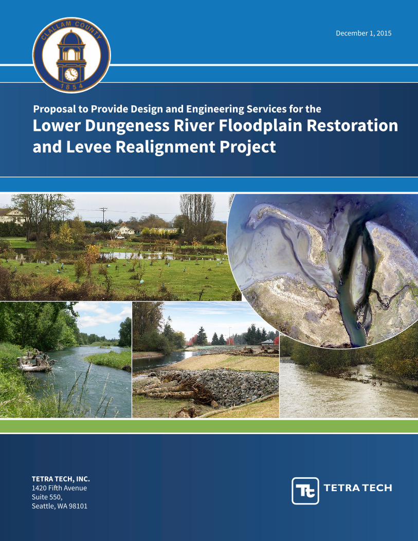
Lower Dungeness River Floodplain Restorationand Levee Realignment Project
Proposal to Provide Design and Engineering Services for the
December 1, 2015

Transmittal Letter
1420 5th Avenue, Ste 550, Seattle, WA 98101 | www.tetratech.com | 206-728-9655
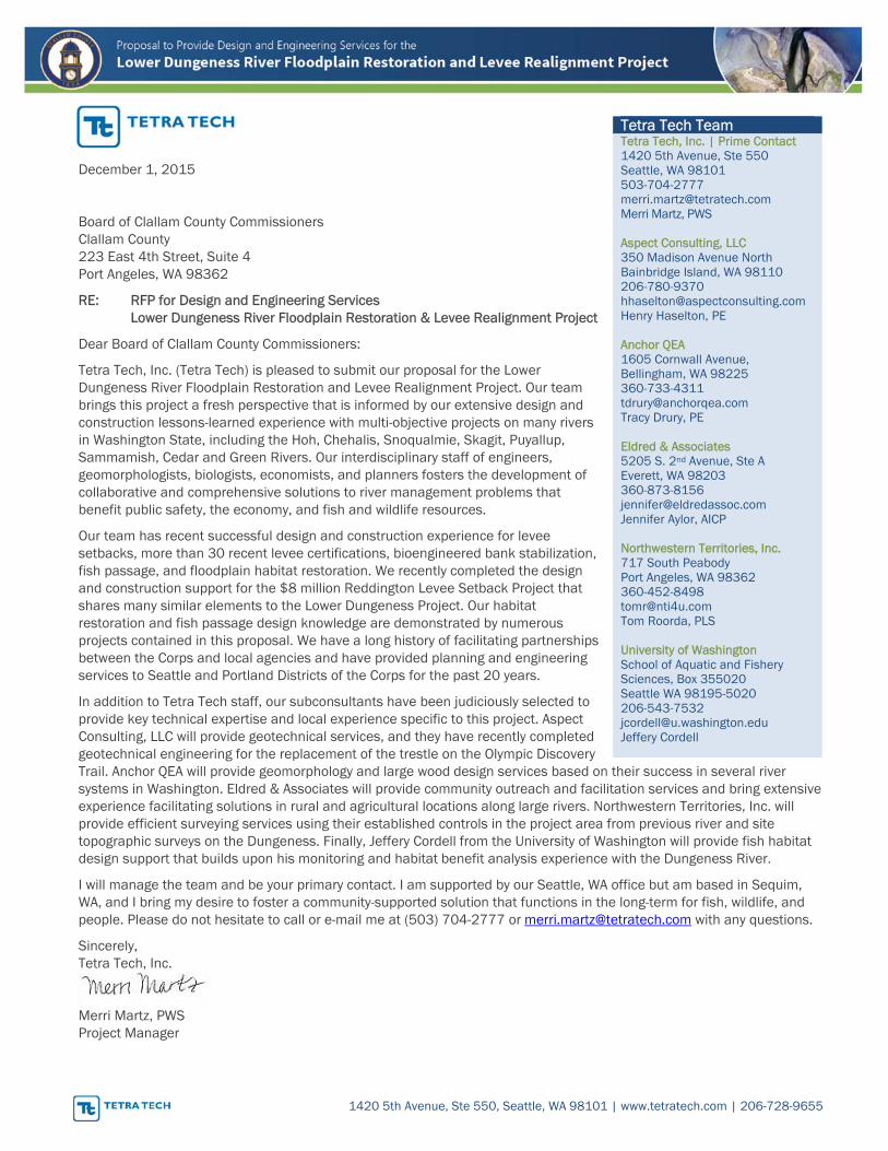
December 1, 2015
Board of Clallam County Commissioners Clallam County 223 East 4th Street, Suite 4 Port Angeles, WA 98362
RE: RFP for Design and Engineering Services Lower Dungeness River Floodplain Restoration & Levee Realignment Project
Dear Board of Clallam County Commissioners:
Tetra Tech, Inc. (Tetra Tech) is pleased to submit our proposal for the Lower Dungeness River Floodplain Restoration and Levee Realignment Project. Our team brings this project a fresh perspective that is informed by our extensive design and construction lessons-learned experience with multi-objective projects on many rivers in Washington State, including the Hoh, Chehalis, Snoqualmie, Skagit, Puyallup, Sammamish, Cedar and Green Rivers. Our interdisciplinary staff of engineers, geomorphologists, biologists, economists, and planners fosters the development of collaborative and comprehensive solutions to river management problems that benefit public safety, the economy, and fish and wildlife resources.
Our team has recent successful design and construction experience for levee setbacks, more than 30 recent levee certifications, bioengineered bank stabilization, fish passage, and floodplain habitat restoration. We recently completed the design and construction support for the $8 million Reddington Levee Setback Project that shares many similar elements to the Lower Dungeness Project. Our habitat restoration and fish passage design knowledge are demonstrated by numerous projects contained in this proposal. We have a long history of facilitating partnerships between the Corps and local agencies and have provided planning and engineering services to Seattle and Portland Districts of the Corps for the past 20 years.
In addition to Tetra Tech staff, our subconsultants have been judiciously selected to provide key technical expertise and local experience specific to this project. Aspect Consulting, LLC will provide geotechnical services, and they have recently completed geotechnical engineering for the replacement of the trestle on the Olympic Discovery Trail. Anchor QEA will provide geomorphology and large wood design services based on their success in several river systems in Washington. Eldred & Associates will provide community outreach and facilitation services and bring extensive experience facilitating solutions in rural and agricultural locations along large rivers. Northwestern Territories, Inc. will provide efficient surveying services using their established controls in the project area from previous river and site topographic surveys on the Dungeness. Finally, Jeffery Cordell from the University of Washington will provide fish habitat design support that builds upon his monitoring and habitat benefit analysis experience with the Dungeness River.
I will manage the team and be your primary contact. I am supported by our Seattle, WA office but am based in Sequim, WA, and I bring my desire to foster a community-supported solution that functions in the long-term for fish, wildlife, and people. Please do not hesitate to call or e-mail me at (503) 704-2777 or [email protected] with any questions.
Sincerely, Tetra Tech, Inc.
Merri Martz, PWS Project Manager
Tetra Tech Team Tetra Tech, Inc. | Prime Contact 1420 5th Avenue, Ste 550 Seattle, WA 98101 503-704-2777 [email protected] Merri Martz, PWS Aspect Consulting, LLC 350 Madison Avenue North Bainbridge Island, WA 98110 206-780-9370 [email protected] Henry Haselton, PE Anchor QEA 1605 Cornwall Avenue, Bellingham, WA 98225 360-733-4311 [email protected] Tracy Drury, PE Eldred & Associates 5205 S. 2nd Avenue, Ste A Everett, WA 98203 360-873-8156 [email protected] Jennifer Aylor, AICP Northwestern Territories, Inc. 717 South Peabody Port Angeles, WA 98362 360-452-8498 [email protected] Tom Roorda, PLS University of Washington School of Aquatic and Fishery Sciences, Box 355020 Seattle WA 98195-5020 206-543-7532 [email protected] Jeffery Cordell

Statement of Qualifications Certification
ATTACHMENT 2
STATEMENT OF QUALIFICATIONS CERTIFICATION
(Proposer must use this form – All other formats will be rejected and the Proposer will be considered non- responsive, and the proposal will not be evaluated by the County)
The undersigned is authorized to execute this certification on behalf of the Proposer and certifies on the Proposer’s behalf that the information presented in this Statement of Qualifications is a complete and accurate statement of facts and that the Proposer has the financial capability to perform the work which is the subject of this solicitation. The Proposer further certifies that it knows of no personal and/or organizational conflicts of interest prohibited under federal, state and local law.
The Proposer certifies that this Proposal is submitted in accordance with this solicitation and all issued addenda, and that the Proposer agrees to be bound by the same.
The Proposer’s Small Contractors and Suppliers (SCS) utilization as set forth in the Proposal constitutes the Proposer’s commitment, if awarded this contract by the County, to use certified and qualified SCSs firms as required by the Agreement.
The Proposer designates
(name)
(title)
(phone number)
as the person charged with carrying out and reporting the Proposer’s use of SCSs to perform Work under this Contract to meet the required percentage established for this Contract.
The Proposer certifies that it commits that % of the total price of the Contract, as amended, shall be performed by Clallam County Certified SCS firms over the duration of the Contract. Clallam County will not evaluate the proposal and will not execute a contract with a Proposer who does not commit to meeting at least the minimum SCS utilization requirement for this Contract.
Proposer
Signature
Title
Date
Response to Evaluation Criteria
Submittal 1
Criterion B – Experience & Past Performance of the Prime Consultant
a. Firm Experience Tetra Tech has extensive history in delivering design plans and specifications for complex multi-objective river projects in Washington and Oregon as well as other Western states. We have demonstrated our ability to successfully prepare design products that meet local objectives and state and federal design and regulatory requirements.
Experience Managing and Ensuring Quality Control for Complex, Multiple-Objective and Multi-Disciplinary River and Floodplain Restoration Projects Our Project Manager Merri Martz and Lead Engineer Selene Fisher have each successfully managed preparation of preliminary through final designs and bid documents for several recently constructed levee setback and floodplain restoration projects, including three key examples described below.
Management of multi-objective projects requires the project manager to have a broad general understanding of each of the key technical disciplines to guide the entire team to integrate their individual work into supporting other aspects of the design to achieve the project objectives. There will almost certainly be trade-offs that require decisions on optimizing between the objectives because maximizing one benefit could adversely affect another and the project manager’s role is to clearly explain these trade-offs to the client, stakeholders, and community. Project Manager Merri Martz has proven experience in successfully managing similar projects to deliver community supported engineering solutions from concept through construction.
Our successful management approach rests on frequent communication, transparency of all analyses and decisions, and identifying and resolving issues early to avoid delays and rework later.
We have an excellent track record of meeting project deadlines and budgets. Further, we have a rigorous quality control process that is not an “end of job” activity but is continuous throughout the project. Our senior quality control staff are available to guide staff from the initial stages, such as setup of models and to offer their experience addressing key project risks. Then, every analysis and design deliverable is reviewed for technical accuracy, compliance with the scope, and overall clarity.
Experience Managing Quantitative and Systematic Analysis of Alternative Design Solutions for Flood and Erosion Hazard Reduction Projects Our projects listed below and for the disciplines of work demonstrate our experience developing and analyzing both quantitative and qualitative information to evaluate
and compare benefits, effects, and costs of alternatives and thorough documentation of the decision process.
Experience Managing and Coordinating the Development of Design Plans and Contract Bid Documents The following projects illustrate Tetra Tech’s, and specifically, our proposed Project Manager and Lead Engineer’s experience managing and producing preliminary through final designs and bid documents that have led to the successful completion of floodplain restoration and levee realignment projects. The three projects also demonstrate our capability to produce documents to meet County standards and Corps and FEMA requirements. The Tetra Tech team will draw upon lessons learned in each of these projects to ensure the preparation of high quality documents that lead to successful construction with limited change orders.
b. Project Examples Reddington Levee Setback: Green River; King County, WA Located on the west bank of the Green River in Auburn, this project removed an existing levee and constructed a new setback levee to reconnect more than 20 acres of floodplain. Tetra Tech was the prime consultant and managed multiple subconsultants on the project. Tetra Tech initially conducted a feasibility study that outlined preliminary engineering design elements for the setback project. Technical studies conducted to support feasibility included geotechnical investigations, channel migration and scour analysis, hydraulic modeling and ecological benefit analysis. The final recommended plan included 4,800 feet of new setback levee improvements, 4,700 feet of existing levee removal, engineered log jams, and rock barbs to reduce near-bank velocities and control river scour. A paved maintenance road/bike trail was constructed on top of the levee, along with multiple access ramps. Tetra Tech prepared the design from 30 percent through final bid documents. The final design included removal of a portion of a water line and relocation of another segment of water line. The engineer’s estimate was within 7 percent of the average of the seven bidders, and the clarity of the design was proven by the lack of change orders during construction. All levee removal/ setback work was completed in one work season to ensure no risk to adjacent landowners during the winter season.
Staff Involved: Selene Fisher (Project Manager/Design Lead), Lois Loesch & Mark Hopkinson Start and End Dates: 2010-2013 Price: $1M Owner Contact: Erik Peters, 206-684-1787
Submittal 2
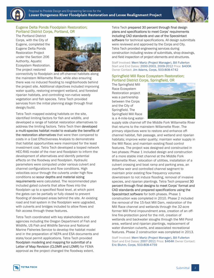
Eugene Delta Ponds Floodplain Restoration; Portland District Corps, Portland, OR The Portland District Corps, with the City of Eugene, completed the Eugene Delta Ponds Restoration Project under the Section 206 Authority, Aquatic Ecosystem Restoration. The project restored connectivity to floodplain and off-channel habitats along the mainstem Willamette River, while also ensuring there was no induced flooding to neighborhoods behind the project site. Additional objectives included improving water quality, restoring emergent wetland, and forested riparian habitats, and controlling non-native weedy vegetation and fish species. Tetra Tech provided services from the initial planning stage through final design/build.
Tetra Tech mapped existing habitats on the site, identified limiting factors for fish and wildlife, and developed a range of habitat restoration alternatives to address the limiting factors. Tetra Tech then developed a multi-species habitat model to evaluate the benefits of the restoration alternatives that were then compared to costs in a Cost Effectiveness Analysis to demonstrate that habitat opportunities were maximized for the least investment cost. Tetra Tech developed a looped network HEC-RAS model of the river and floodplain to inform the development of alternatives and identify potential effects on the floodway and floodplain. Hydraulic parameters were computed under various culvert and channel configurations and flow conditions. High velocities occur through the culverts under high flow conditions so scour depths and material sizing requirements were calculated. The recommended plan included gated culverts that allow flows into the floodplain up to a specified flood level, at which point the gates can be partially or fully closed to prevent flooding of developed areas behind the site. An existing road and trail system in the floodplain were upgraded, with culverts and bridges included to allow flows and fish access through these features.
Tetra Tech coordinated with key stakeholders and agencies including the Oregon Department of Fish and Wildlife, US Fish and Wildlife Service and National Marine Fisheries Service to develop the habitat model and in the preparation of NEPA and ESA documents and state/local permit applications. Tetra Tech provided floodplain modeling and mapping for submittal of a Letter of Map Revision (CLOMR and LOMR) for FEMA approval as the project changed the floodway extent.
Tetra Tech prepared 30 percent through final design plans and specifications to meet Corps’ requirements including CAD standards and use of the SpecsIntact software for technical specifications. All design submittals were reviewed and approved by the Corps and City. Tetra Tech provided engineering services during construction including review of submittals, shop drawings, and field inspection of project elements and structures.
Staff Involved: Merri Martz (Project Manager), Bill Fullerton Start and End Dates: 2000-2003, 2009-2012 Price: $400K Owner Contact: Jim Adams, Corps, 503-808-4742
Springfield Mill Race Ecosystem Restoration; Portland District Corps, Springfield, OR The Springfield Mill Race Ecosystem Restoration project was a partnership between the Corps and the City of Springfield. The Springfield Mill Race is a 4-mile-long water-supply side channel off the Middle Fork Willamette River that returns to the mainstem Willamette River. The primary objectives were to restore and enhance off-channel habitat, fish passage, and wetland and riparian habitats; improve water quality; maintain water supply in the Mill Race; and maintain existing flood control features. The project was designed and constructed in two phases: Phase 1 included design and construction of a more stable inlet channel at the Middle Fork Willamette River, relocation of utilities, installation of a culvert crossing and boat ramp and parking area, an overflow weir and controlled channel segment to maintain prior existing flow frequency volumes downstream to not induce flooding, removal of invasive species, and riparian plantings. Tetra Tech prepared 30 percent through final designs to meet Corps’ format and CAD standards and prepared specifications using the SpecsIntact software for both phases. Phase 1 construction was completed in 2010. Phase 2 included the removal of the 15-foot Mill Dam, restoration of the Mill Race channel and wetlands through the 32-acre former Mill Pond impoundment area, creation of an off-line fire-protection pond for the mill, creation of wetlands and backwater sloughs through the Mill Pond area, wetland and riparian plantings, replacement of water diversion culverts, and associated recreational features. Phase 2 construction was completed in 2013.
Staff Involved: Merri Martz (Project Manager), Bill Fullerton Start and End Dates: 2007-2011 Price: $464K Owner Contact: Eric Bluhm, Corps, 503-808-4759
Submittal 3
Criterion C – Firm’s Experience Performing Particular Disciplines of Work
a. Hydraulic Modeling and Scour Analysis – Tetra Tech
Tetra Tech hydraulic engineers have considerable experience in 1D and 2D hydraulic modeling, habitat restoration, and hydraulic design. Each project has unique issues, thus requiring a specific approach to the hydraulic analysis. The appropriate hydraulic model approach must be selected early in the project and depends on the complexity of the river system, the types of design features being considered, and the degree of risk. Scour analysis is one component of a hydraulic design, which our team has practical experience in evaluating. Specifically Bill Fullerton, PE and Lyle Zevenbergen, PhD, PE have extensive experience in scour analyses for site-specific needs. Tetra Tech staff have also beta tested HEC-RAS 2D on recent projects to support full release of the model.
The following projects demonstrate our experience in hydraulic modeling and scour analysis.
South Fork Snoqualmie River I-90 Flood Reduction Project; King County, WA Tetra Tech is completing hydraulic modeling and alternatives analysis for a leveed 1-mile reach of the South Fork Snoqualmie River adjacent to I-90 and North Bend for King County. Tetra Tech initially conducted an analysis of geotechnical and hydraulic issues contributing to existing flooding problems in a larger 4-mile reach, including development and calibration of FLO-2D and HEC-RAS hydraulic models for existing conditions. This preliminary analysis identified flood risk at I-90. Additional analyses include geomorphic assessment and channel migration analysis, sediment transport analysis, habitat mapping and wetland delineations, and geotechnical analysis. Tetra Tech then developed multi-objective flood reduction and floodplain habitat restoration alternatives including various levee raising and setback alignments, and in-channel options such as gravel removal and installation of large wood. The alternatives analysis included modeling each alternative for flood reduction benefits and levee scour protection needs, a qualitative evaluation of geotechnical considerations, habitat impacts and benefits, geomorphic and sediment retention benefits, permitting concerns, constructability issues, landowner concerns, and quantified costs. This transparent comparison of effects and benefits is the basis for the Flood Control District and King County to select a recommended plan.
Staff Involved: Jay Smith, Bill Fullerton, Merri Martz, Mark Hopkinson, Henry Haselton Start and End Dates: 2010-Present Price: $600K Owner Contact: Mark Ruebel, 206-477-4090
Big Quilcene River Feasibility Study and Action Plan, Jefferson County, WA Tetra Tech provided hydraulic, hydrologic and engineering support on this flood damage reduction and habitat restoration feasibility study on the Big Quilcene River. The study reach included the lower 2.2 miles of the river, which has been aggrading sediment to the point that the river channel was higher than the adjacent floodplain in several locations. The team developed seven comprehensive alternatives that include measures such as levee removal, levee setback, widened bridges, secondary and overflow bridge openings, floodplain reconnection, in-channel and off-channel restoration, removal of floodplain fill, and property acquisition.
Due to the complicated hydraulic conditions associated with the perched nature of the main channel and the split flow conditions upstream of the leveed reach, a 2D model (FLO-2D) was developed and calibrated. The 2D analysis was augmented with a HEC-RAS model of the main channel to evaluate hydraulic conditions at bridge locations. Hydraulic modeling results were used to develop a sediment routing model to predict future levels of channel aggradation and the potential for channel avulsion. Each alternative was modeled to identify flood reduction and habitat benefits. The results of this study were presented to the public and agencies for selecting a recommended plan.
Staff Involved: Jay Smith, Bill Fullerton Start and End Dates: 2004-2005 Price: $55K Owner Contact: Monte Reinders, 360-385-9242
b. Geomorphic Response Analysis – Anchor QEA One of Anchor QEA’s greatest strengths is salmonid habitat restoration design in Western Washington. Anchor QEA’s engineers and scientists have designed and implemented habitat restoration features including engineered log jams, side-channels, and floodplain habitat restoration. Anchor QEA’s project success is predicated on the understanding of natural processes as a basis for developing innovative solutions that provide long-term physical and ecological benefits.
Tucannon River Habitat Restoration Projects and Engineering Designs; Dayton, WA Anchor QEA worked with the Snake River Salmon Recovery Board and the Columbia Conservation District along with other project partners, including Washington State Department of Fish and Wildlife (WDFW) and the U.S. Forest Service, to improve habitat for ESA-listed fish species in the Tucannon River. They conducted a geomorphic and hydrodynamic analysis for more than
Submittal 4
50 miles of the river basin to evaluate hydrologic input locations and magnitudes, sediment supply, bedload grain size and transport capacity, floodplain connectivity and confinement, and human-derived stressors to the natural processes throughout the basin. The findings of these analyses were used to delineate reaches based primarily on physical process and infrastructure constraints.
They also collected available fish use data and coordinated with local practitioners to clarify existing areas of high use by targeted species during all life stages. Through this collaboration, they determined critical life history stages for target species and hydrologic conditions where restoration benefits should be targeted. This led to developing biological criteria to support identification and prioritization of restoration actions.
Reintroduction of wood to the system was a key element of the restoration process. Since 2010, more than 3,000 pieces of large wood have been reintroduced to the river and more than 300 large wood structures have been constructed. Wood placement has assisted in reconnecting more than 3 miles of side-channel habitat and more than 160 acres of floodplain connectivity.
Staff Involved: Tracy Drury Start and End Dates: 2009-Present Price: $870K Owner Contact: Terry Bruegman, 509-382-4473
Methow River Restoration Design; Okanogan County, WA Anchor QEA worked with the Bureau of Reclamation and other project partners, including WDFW, Department of Natural Resources, Okanogan County, and the Methow Salmon Recovery Foundation, to improve habitat for ESA-listed fish species in the Methow River. They conducted an alternative assessment for six project sites (sub-reaches) within the Upper Middle Methow Reach. They worked with Reclamation and the Methow Salmon Recovery Foundation to develop salmon habitat enhancement projects for two separate sites on the Middle Methow River, to enhance main channel and side-channel habitat conditions between the towns of Winthrop and Twisp. Anchor QEA investigated the feasibility of groundwater channels, and designed bank, island apex, and floodplain structures to improve habitat conditions throughout the main channel and side channel. The groundwater channel assessment evaluated conditions and opportunities for groundwater channel development and showed that development of groundwater channels was feasible; however, they were not carried forward as a design element based on other site and budget considerations. Construction of the two projects was completed during summer 2012, with follow-up construction (Phase 2) at one of the sites completed in summer 2013.
Collectively, the sites enhanced habitat along more than 3,500 feet of mainstem and 3,000 feet of side channel, removed 900 feet of levee, placed more than 2,000 pieces of large woody material (including more than 30 engineered log jams [ELJ]), reconnected several acres of off-channel wetlands, and planted numerous riparian species. Levees previously contained the 10-year flow event and removal has resulted in floodplain connectivity at the two-year return period. New culverts through an existing roadway reconnected valuable alcove and wetland habitat, and ESA-listed juvenile salmonids have flocked to these habitats during spring run-off flows.
Staff Involved: Tracy Drury Start and End Dates: 2010-2013 Price: $1.6M Owner Contact: Jennifer Molesworth, 509-997-0640
c. River Erosion Scour Protection Design – Tetra Tech Our team prides itself on the extent to which our multidisciplinary staff collaborates on erosion hazard reduction projects to achieve channel and bank protection objectives while also minimizing adverse effects to aquatic and riparian habitat, or even enhancing fish passage and cover through the use of large wood and other bioengineering techniques.
Nursery Bridge Channel Stabilization and Fish Passage; Milton-Freewater, OR The Walla Walla District Corps contracted with Tetra Tech to design grade control structures that meet strict ODFW and NOAA fish passage design criteria to address bed degradation downstream of the Nursery Bridge Fishway Facility. Tetra Tech conducted an initial assessment of the bed scour and sediment and debris problems, and identified potential alternatives to address the problems. Tetra Tech designed a series of 12 rock weirs that simulate a step-pool channel morphology, dissipate energy, stabilize the channel profile from further degradation, and provide fish passage. The design also accommodates future downstream channel degradation and prevents flanking of the weirs during high flows by constructing a buried roughened riffle and boulders that tie into the levees on each bank. Tetra Tech also developed a sediment management plan and an operation and maintenance and monitoring plan.
Staff Involved: Bill Fullerton, Eric Mendel Start and End Dates: 2012-2013 Price: $183K Owner Contact: Stan Heller, 509-527-7258
Submittal 5
South Fork Snoqualmie River I-90 Flood Reduction Project, King County, WA As described above, this project was an analysis of several alternatives to address flood risk at I-90. Levee setback alternatives were analyzed in the context of likely future channel migration, scour protection, and the potential for downstream erosion as flows from the floodplain re-enter the river. Scour protection alternatives included a buried rock toe along the majority of the setback levee; buried rock scour protection only at critical locations (i.e. downstream end of levee where flows return into main channel); a widened planting bench and wood along the base of the levee to resist future scour; delayed scour protection (only to be installed when the channel migrates to a critical threshold); and leaving portions of the toe of the existing levee in critical locations where channel migration would directly impinge upon the new setback levee. Bend scour, general scour, contraction scour, and pier scour were all evaluated using empirical equations and used to inform the design of embankment protection and engineered log jams.
Staff Involved: Jay Smith, Bill Fullerton, Merri Martz, Mark Hopkinson, Henry Haselton Start and End Dates: 2010-Present Price: $600K Owner Contact: Mark Ruebel, 206-477-4090
d. Alternatives Analysis – Tetra Tech The Tetra Tech team has extensive project experience in evaluating alternatives for flood protection and river restoration projects. At the feasibility level, a range of design solutions are formulated with input from staff biologists, geomorphologists, hydraulic and design engineers. The insights provided by each discipline ensure that the risks and benefits of each are thoroughly vetted. The key team members we bring to Clallam County have the breadth of experience to develop and evaluate alternatives that address stakeholder issues, and are feasible to design and construct.
Willowmoor Floodplain Restoration Alternatives Analysis, King County, WA King County is exploring alternatives for restoring habitat, reducing water temperatures and providing better control of lake levels and flows in the Sammamish River, while also reducing their maintenance requirements within this Corps’ constructed flood control facility (Sammamish Weir and downstream transition zone that controls Lake Sammamish levels and flow volumes to downstream reaches). The Tetra Tech team developed eight cold-water supplementation alternatives and four channel realignment and floodplain restoration alternatives. Tetra Tech further developed a cost and permitting rationale for the No Action (maintenance) alternative. The County and
Tetra Tech team conducted an alternatives screening charrette to screen down to the two most promising alternatives, based on a detailed matrix of quantitative flooding/hydraulic data, costs, habitat benefits, risks, and likely maintenance needs. Tetra Tech prepared draft and final technical memoranda and presented the on-going work and results over a series of public and agency stakeholder group meetings.
Staff Involved: Merri Martz, Mark Hopkinson Start and End Dates: 2014-2015 Price: $220K Owner Contact: Kate Akyuz, 206-477-4607
Willamette River Floodplain Restoration Study, Lane County, OR Tetra Tech conducted a feasibility study of large-scale floodplain restoration for the Portland District Corps and The Nature Conservancy. The project authority includes flood risk reduction, ecosystem restoration, and other improvements such as groundwater recharge. Due to the large size of the Willamette River watershed, this first phase focused on ecosystem restoration in the Coast and Middle Forks of the Willamette River below the Corps dams. Tetra Tech documented existing habitat conditions and limiting factors, developed a wide range of restoration alternatives, conducted a geomorphic assessment, developed and calibrated a HEC-RAS model that combined both rivers (based on an existing bankfull model developed by the Corps), developed a floodplain habitat model, conducted an alternatives analysis using the habitat benefits compared to costs, and prepared feasibility level designs and MCACES cost estimates, and prepared the feasibility and environmental documents for Corps’ review and approval. The alternatives analysis was conducted using a series of agency/stakeholder workshops and then running the alternatives through the Cost Effectiveness and Incremental Cost Analysis. The feasibility report was reviewed by and Independent External Peer Review and approved by Corps Headquarters and Congress in the Water Resources Development Act of 2014.
Staff Involved: Jay Smith, Bill Fullerton, Merri Martz, Tracy Drury (peer review) Start and End Dates: 2006-2013 Price: $600K Owner Contact: Christine Budai, 503-808-4725
e. Engineering Design – Tetra Tech Tetra Tech design engineers have an extensive portfolio of levee, bridge, and habitat restoration designs that represent standards for local cities and counties, WSDOT, the Corps and other agencies. We understand how to develop clear bid documents that minimize change orders during construction.
Hoh River Culverts; Jefferson County, WA Tetra Tech was contracted by Jefferson County to evaluate and design the replacement of three culverts on tributaries
Submittal 6
to the Hoh River along Upper Hoh Road. Two sites, Alder and Dismal Creek were mitigation for bank protection actions the County had built along the Hoh River and the third site, at Spruce Creek, was to replace a culvert that had been damaged by repeated flooding and sediment deposition. Each of the sites required either a large box culvert or single span bridge that met requirements for a federal, on-system road, and fish-passage requirements, and satisfied mitigation requirements. Tasks included hydrologic and hydraulic analyses, geomorphic assessment, preliminary through final designs, and permitting. The bed material and boulder grade controls were sized for consistency with WSDOT specifications and WDFW culvert guidelines. The design plans were prepared to meet Jefferson County standards and used WSDOT specifications. Tetra Tech provided construction support to the County during the construction of all three culverts, including review of submittals and geotechnical evaluation of footing soil conditions.
Staff Involved: Jay Smith, Bill Fullerton, Merri Martz Start and End Dates: 2009-2012 Price: $137K Owner Contact: Mark Thurston, 360-385-9210
Lower Massey Creek Floodwall and Creek Enhancement; City of Des Moines, WA The intersection of Kent-Des Moines Road and Marine View Drive floods frequently due to tidally-influenced backwater in Massey Creek. The city requested a flood containment berm, a floodwall, a small pump station, and stream conveyance improvements to mitigate the flooding problem. In addition, they requested stream enhancement elements for the upper half of the project reach bordered by Kent-Des Moines Road.
A hydraulic model was developed to identify the necessary capacity and to recommend elevations for the height of berm and floodwall. The berm was setback from the channel’s edge in the lower half of the project and the adjacent ground surface lowered to provide additional floodplain storage area.
The instream improvements included large wood and boulders for channel complexity. WDFW approved the proposed design with only one comment.
Plans, specifications, and quantity and cost estimates were prepared and submitted at the 30 percent, 60 percent, and 90 percent level. Additional documentation and analysis were performed to support the development by a subconsultant of the biological assessment, critical areas study & permit, cultural resources review, hydraulic permit approval, SEPA, and JARPA. The project is currently on hold awaiting city scheduling for final bid documents and construction.
Staff Involved: Selene Fisher Start and End Dates: 2013-2015 Price: $350K Owner Contact: Loren Reinhold, 206-870-6524
f. Professional Land Surveying – Northwestern Territories, Inc. Northwestern Territories, Inc. (NTI) has been providing land and bathymetric surveying in Northwest Washington since 1965. They have developed survey control in the project area and regularly install benchmarks and control points. Additionally, they prepare project base maps integrating LiDAR, topography, and bathymetry.
Lower Dungeness River Project Surveying; Clallam County, WA NTI surveyed river cross-sections from Woodcock Road to the mouth of the Dungeness River and provided land topographic survey along Towne Road for Clallam County as part of the feasibility study.
Staff Involved: Tom Roorda, Kent Robinson Start and End Dates: 2013 Price: $7K Owner Contact: Bob Martin, 360-417-2389
Three Crabs Nearshore and Estuary Restoration Project; Sequim, WA NTI performed a topographic survey of the site that included the floodplain, Meadowbrook Creek channel, roads, bridge, and beach area. The survey was integrated into a previous Ducks Unlimited survey. NTI also performed a geotechnical investigation including test pits and borings to determine suitable locations for road realignment and bridge replacement.
Staff Involved: Tom Roorda, Kent Robinson Start and End Dates: 2013 Price: $11K Owner Contact: Rebecca Benjamin, 360-379-8051
g. Transportation Design – Tetra Tech The Tetra Tech team has extensive experience with a variety of transportation projects. Our experience includes trail systems, local and arterial roadway design and connections, traffic design analysis, intersection treatments (signals and roundabouts), and new roadway design. All of our transportation projects start with conceptual design alternatives that are practical and sustainable. These solutions are then efficiently and quickly moved through to final design. Selecting a preferred alternative must be balanced between transportation use, public safety, and environmental concerns. This requires an efficient working relationship between transportation engineers, biologists, hydraulic engineers, geomorphologists, and structural engineers.
Boon Road Improvements; Island County, WA Tetra Tech prepared preliminary engineering for the 1.5-mile Boon Road corridor from SR 20 to Fort Nugent Road located near the City of Oak Harbor, WA. Tetra Tech is completing the right of way acquisitions and final design for the south half of the corridor, including wetland mitigation site for the entire corridor,
Submittal 7
for construction to begin in early 2015. The roadway is used for recreational purposes as well as farm and residential access. The roadway is a low volume road and the design met all AASHTO and County roadway standards. This project utilized multiple public outreach opportunities that helped the community understand the purpose and need for these improvements.
Staff Involved: Steve Olling, Merri Martz Start and End Dates: 2011-Present Price: $870K Owner Contact: Doug Holbert, 360-679-7958
Canyon Road East Northerly Extension; Pierce County, WA The purpose of this project was to extend and improve an existing two-lane road to provide a new north–south arterial connection for both improved general traffic and to improve farm to market access. Tetra Tech developed the final design for extending the arterial for approximately 0.7 miles from its existing northern terminus at the Canyon Road East/Pioneer Way East intersection. The new terminus extends to 62nd Avenue NE, across the Puyallup River floodplain, mainline railroad tracks and active farmland. The project included a realignment of Pioneer Way East, reconstruction of the
intersection and traffic signal at Pioneer Way East, relocation and enhancement of Canyon Creek, realignment of 52nd Street East connecting to the Canyon Road East extension, a grade separation structure over the Burlington Northern Santa Fe (BNSF) mainline railroad tracks, installation of enclosed stormwater conveyance systems, water quality/quantity treatment facilities, wetland mitigation, and floodplain mitigation.
The project was controversial and required extensive coordination with landowners, regulatory agencies, the Puyallup Tribe and County to address competing needs. Early stakeholder involvement was the key to an accelerated design and environmental documentation process. The project was delivered to 90 percent design level from conceptual design within 18 months. Scope of work included preliminary design, NEPA DCE (plus all the necessary discipline studies), and final design.
Staff Involved: Steve Olling Start and End Dates: 2005-2007 Price: $1.7M Owner Contact: Patrick Baughman, 253-798-3157
Criterion D – Qualifications and Experience of Key Personnel
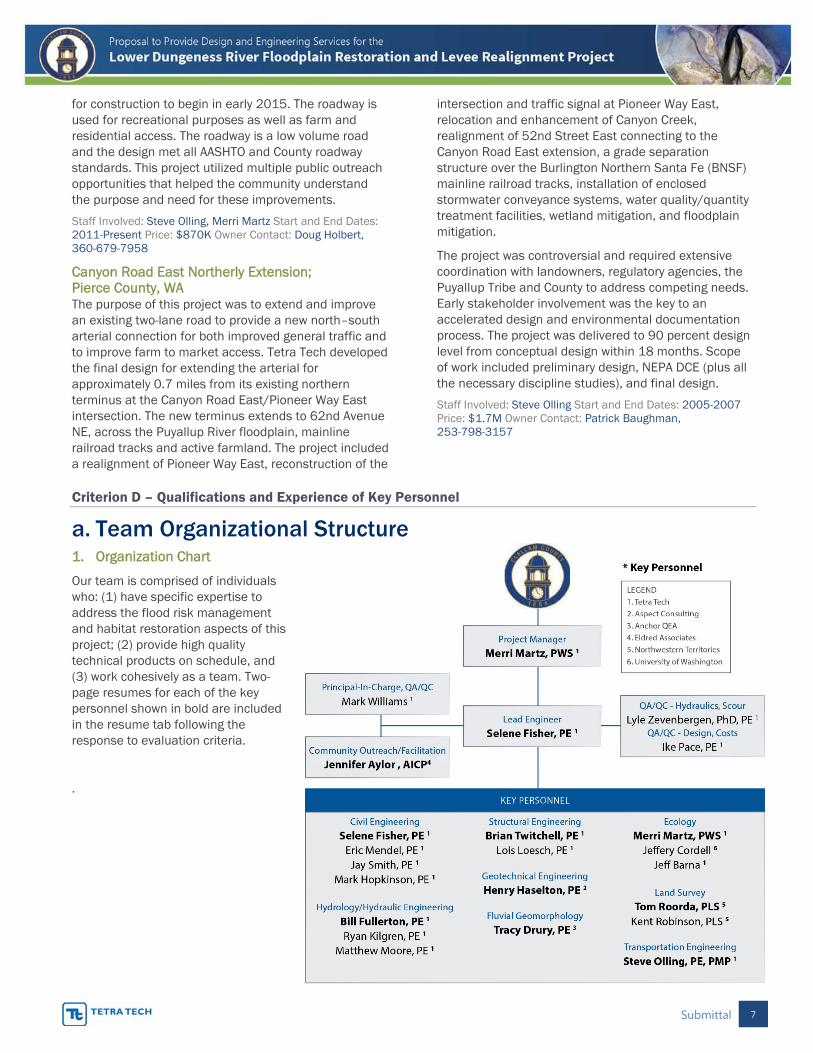
a. Team Organizational Structure 1. Organization Chart
Our team is comprised of individuals who: (1) have specific expertise to address the flood risk management and habitat restoration aspects of this project; (2) provide high quality technical products on schedule, and (3) work cohesively as a team. Two-page resumes for each of the key personnel shown in bold are included in the resume tab following the response to evaluation criteria.
.
Submittal 8
2. Team Organization Design
The Tetra Tech team is organized to efficiently manage the tasks in the scope of work to deliver high quality deliverables that match seamlessly with the County and/or Corps’ bid process. Our team is small and easily managed yet has sufficient depth to meet deadlines. Our team members have worked together on several past projects and bring this cohesion to our approach.
Project Manager – Merri Martz, PWS Merri has 24 years of experience in managing habitat restoration and flood/erosion reduction designs and working effectively with multi-disciplinary teams. She knows the requirements of Corps’ bid documents as well as design standards and specifications for local agencies and WSDOT. As project manager she brings her broad understanding of habitat restoration and flood risk reduction, federal partnering, successful on-time and on-budget management skills, and her stellar reputation for public, agency, and tribal coordination. She is locally based in Sequim and is readily available to the County and stakeholders throughout the project.
Lead Civil Engineer – Selene Fisher, PE Selene has 21 years of experience as a project manager and civil design engineer developing construction bid documents and technical specifications. She has been selected to lead this design due to her recent successful experience in completing the Reddington Levee Setback design and in her ability to effectively coordinate multiple subconsultant products into a cohesive and readily understandable set of bid documents.
Lead Hydraulic Engineer – Bill Fullerton, PE Bill has 35 years of experience in hydraulics, sediment transport, geomorphology, hydrology, stream restoration, flood risk reduction, and hydraulic structure design. He brings extensive practical experience from the oversight of numerous constructed projects including fish passage, river restoration, levees, floodwalls, and dam removal. He will guide our hydraulics and geomorphic team and ensure a cost-effective design that meets hydraulic and habitat needs.
Lead Structural Engineer – Brian Twitchell, PE Brian has 18 years of experience evaluating and designing a variety of structures from culverts to bridges, floodwalls, retaining walls, and foundations. He will provide analysis and input into the Towne Road realignment options and identify feasible structures such as culverts, bridges, or short causeways structures.
Lead Geotechnical Engineer – Henry Haselton, PE Henry’s 23-year engineering career includes geotechnical evaluation, design, project management and construction engineering for floodplain, levee, fish passage, and ecosystem restoration projects in
Washington State. He has been the lead geotechnical engineer for multiple designs involving levee construction, bank stabilization, culvert replacements, bridges, roads, stream, and shoreline protection. His knowledge of the state and federal regulatory environments for levees, dams, and embankments, helps Henry deliver optimum engineering designs that focus on clients’ objectives and risk tolerances.
Lead Fluvial Geomorphologist – Tracy Drury, PE Tracy is a professional civil engineer and applied geomorphologist with 17 years of experience. His areas of expertise include open-channel hydraulic engineering, fluvial geomorphology, channel migration zone analysis, sediment transport, and ELJ design. Tracy specializes in geomorphic analyses that support design of river management techniques that reintroduce and maintain ecological functions, all while minimizing risk to property and infrastructure. His understanding of hydrodynamics and geomorphology is crucial in developing plans and specifications that provide instant stability, yet allow for long-term geomorphic processes to prevail.
Lead Ecologist – Merri Martz, PWS Merri has extensive experience conducting stream habitat surveys; vegetation surveys; wetland delineations; and fisheries use and distribution studies. She has developed habitat evaluation models to support alternatives analyses. She is extraordinarily successful in obtaining permits on a fast-track basis and ensures the design can be permitted with few or no changes.
Professional Land Surveyor –Tom Roorda, PLS Tom has been NTI’s licensed surveyor since 2005. He has more than 40 years of experience including topographic surveying, boundary surveys, and construction staking. Tom led NTI’s previous work on this project and will provide cost-effective and efficient supplemental survey support.
Lead Transportation Engineer – Steve Olling, PE, PMP Steve has 28 years of transportation design and management experience. Steve designs both small and large roadway projects for a variety of clients throughout the Puget Sound Region. Steve is experienced in developing alternatives analyses and working with key stakeholders as part of this process in a variety of public forums from workshops to open houses.
Community Outreach Specialist – Jennifer Aylor, AICP Jennifer has 23 years of planning and facilitation experience. She has facilitated numerous stakeholder committees for watersheds in Western Washington. She has a proven track record in developing strong relationships with agency staff and citizens and has demonstrated resolution of issues in contentious situations, such as the Skagit River, where long-term disagreements had stalled floodplain management.
Submittal 9
Criterion E -- Project Approach
b. Technical Project Approach The scope provided in the RFP is both detailed and thorough. The effort outlined the RFP has been developed based on the knowledge gained from the large body of work that has been compiled in the various investigations of potential restoration actions on the Lower Dungeness River. The Tetra Tech team understands the scope for the project and believes we can take maximum advantage of past work to efficiently move the project forward to final design. Specific considerations are identified below for each task.
Task 1: Project Management Project management will be provided continuously throughout the project from project kick-off through final design stages and other services as necessary. The purpose of the project management effort will be focused on ensuring frequent communication with Clallam County and the Corps, overseeing the project team and subconsultants, ensuring that products are prepared to a high standard of quality, and ensuring that the work is accomplished on time and within the negotiated budget. Project manager Merri Martz will lead this effort and will be supported by the quality control staff. As the project manager is located in Clallam County, Merri can readily respond to County requests and meetings on short notice. A key challenge for this project will be ensuring timely coordination and reviews by the Corps to meet the 2017 construction schedule. It is of paramount importance to ensure the continued partnership with the Corps and our project manager’s experience in successfully designing projects for the Corps and achieving Corps approvals will facilitate this partnership.
The approach and level of effort for this task assumes the project manager, lead engineer, and additional technical staff, depending upon the technical topic of focus, will attend project coordination meetings and calls. We also propose to develop and maintain a design decision log to document all major decisions during the design phase.
This task includes quality management of all deliverables. Tetra Tech firmly believes that quality control is not an “end of job” effort but is applied throughout the job by providing key input on analysis methods, results, and design decisions, as well as supporting issue resolution and risk mitigation. This starts with a documented Quality Management program at Tetra Tech. Quality control is the responsibility of each employee. Work products are checked, back-checked, and documented for quality control. Our quality manager
will provide assurance that Quality Management procedures have been followed and identified issues addressed prior to completing Quality Certification for major deliverables. This is an auditable process that minimizes design risks. Quality checks are part of the overall schedule and enforced at Tetra Tech. No product is submitted to our clients without going through this documented process. This does not increase project costs because it prevents errors or missing information; thus, reducing change orders during construction, or worse, safety or environmental concerns.
Task 2: Project Planning and External Coordination Key members of the Tetra Tech team will participate in the initial project kick-off and planning as well as on-going community and stakeholder coordination. The project manager and community outreach/facilitation specialist will lead these activities and communicate frequently with County and Corps staff to incorporate this important feedback into the project analysis and design tasks. We propose developing a project risk register at the beginning of the project that identifies project schedule, budget, design, permitting, construction, performance, and operational risks with a risk mitigation plan to address each issue. Stakeholder input will feed directly into the plan for risk mitigation as the project proceeds.
All key staff will attend the kick-off meeting with Clallam County and the Corps to obtain and review available data and to also conduct an on-site reconnaissance to detail out the survey, geotechnical, and hydraulic modeling work and collect other pertinent site data. The kick-off meeting and site visit will be a one-day trip.
For community and stakeholder coordination, the project manager and community outreach/facilitator, will attend all meetings. As appropriate, the lead engineer or other key staff will attend meetings. We recommend developing a public and stakeholder contact and comment database with key words/organizations that can be readily searched by the project team. This database and other project documents will be housed in a password protected Sharepoint site accessible to the County, Corps, and consultant staff (and other key stakeholders as requested). We use this format regularly to make transferring and reviewing documents easy.
The stakeholder outreach must be perceived as fair and open to all participants and not simply justifying a pre-determined outcome. Tetra Tech will bring that open perspective and recognizes that there will be trade-offs and will convey those directly and honestly to the public.
Submittal 10
Task 3: Towne Road Reconfiguration It is our understanding that the selected roadway alignment in the current 30 percent design (Corps 2015) may present challenges to the County for continued maintenance and public safety and also needs further discussion and support in the community. This task includes developing and evaluating three roadway options to support the County in selecting a final plan that will then be used to refine the 30 percent design. Roadway realignment options affect floodplain restoration elements that may need refinement as well.
Key issues to be addressed for the Towne Road alignment include farm equipment, employee, and customer access to Dungeness Creamery and Delta Farm; noise, privacy/visibility, and trespass concerns of residents along Sequim-Dungeness Way; County road maintenance concerns and costs; utility relocations; fire/ambulance response times; public safety during flood events; recreational access/opportunities; and overall floodplain and habitat evolution associated with channel migration. Community/landowner feedback and coordination from Task 2 will be a critical component in developing and evaluating the three roadway concepts.
The roadway will need to meet sight distance standards and have adequate width to handle necessary uses (motorized and/or non-motorized) and allow enough space for errant vehicle recovery. Roadway design standards will be defined up-front and may vary depending on the alternative.
Tetra Tech will prepare a roadway feasibility memo with planning-level designs and costs for each of the alternatives with an analysis focused on the issues identified above with a comparison matrix to facilitate County decision-making. Tetra Tech will identify the difference in costs between the Corps’ 30 percent design and the new plan, if any. It will be important for the County’s plan selection to understand any changes in cost-sharing that could result. Both initial construction and life-cycle operation and maintenance costs will be considered in this design refinement.
We recommend installing a set of piezometers across the floodplain to identify the direction of groundwater flow to ensure that the levee and roadway alternatives do not cause an unacceptable rise in groundwater on adjacent properties. It will be important to be able to directly address this issue with the landowners. This data will also facilitate development of the road and levee subgrade design to account for water levels.
Task 4A: Survey and Base Map Development A detailed topographic base map of the entire project site will need to be developed for the design. Additionally, further river cross-section surveying and an extended LiDAR base map is required for hydraulic
modeling. We propose to use the AutoCAD existing base map and surface TIN from the County, to be supplemented with the most recent LiDAR data set available for the project area and supplemental surveying proposed below.
To collect supplemental mapping, we will use a combination of a mobile LiDAR mapping solution and traditional ground survey. Our mobile mapping solution is a vertical 360-degree high-end, vehicle-mounted system (Leica Pegasus 2), that provides design-level survey accuracy. This system not only provides the data to supplement the existing survey but also captures coordinated photography, which will assist in the necessary tree and other visual object inventories. The photos are synchronized with the survey information which allows the user to pick 3D coordinates from the photos and measure items within the photos, using a viewer application. The survey boundaries will extend to Sequim-Dungeness Way to the north and south of the Dungeness Creamery, east to the property boundaries adjacent to the proposed setback levy and west to the top west bank of the Dungeness River. The ground LiDAR collection will extend much further limited only by line of site.
Task 4B: Geotechnical Exploration and Laboratory Testing Previous geotechnical explorations completed by the Corps for the original levee design in 1962 and more recently in 2013 revealed generally soft, fine-grained alluvium deposits between the river and the proposed levee set back alignment. Design drawings from the 1962 levee construction indicate that the existing levees are composed of a zoned fill with a waterside zone of semi-pervious soil derived from a nearby borrow pit and a landside zone of pervious soil derived from local dredging activities within the Dungeness River. The numerous previous borings provide a good overview of the subsurface conditions at the site; however no geotechnical laboratory test results (which characterize the engineering properties of the soils) were reported, and several of the borings did not penetrate to an adequate depth to assess earthquake effects to the proposed levee system. Additionally, no groundwater monitoring wells have been installed to characterize shallow groundwater levels, flow patterns, and seasonal fluctuations.
The existing geotechnical data suggests that very soft, compressible foundation subgrades exist along the proposed levee setback alignment (including conditions that were too soft to support drilling equipment). Therefore, data collection would be focused on the key issues of foundation support and levee settlement to ensure that adequate freeboard would be maintained throughout the life of the project. Efforts will also be
Submittal 11
made to assess the suitability of the existing levee and site materials for re-use in the project, which is a critical cost driver. Finally, a groundwater assessment would be made to evaluate potential impacts of the project on local drainage.
Limited field and laboratory explorations would be performed to further characterize the subsurface, obtain soil samples for laboratory tests, and install shallow monitoring wells. It is envisioned that a one- or two-day program of hand-auger borings and backhoe test pits would be sufficient to investigate the composition of the existing levees for suitability of that material for re-use on the new levees; to characterize the shallow subsurface conditions, including excavatability, subgrade conditions, and construction equipment maneuverability; to collect soil samples for laboratory index testing; and to facilitate the installation of shallow groundwater monitoring wells. Using excavated test pits and hand tool explorations as the primary means for collecting additional data will allow for very efficient and targeted subsurface data collection and installation of shallow groundwater monitoring wells.
Shallow monitoring wells would also be proposed in the vicinity of Meadowbrook Creek and the WSDOT wetland to assess the local groundwater flow patterns, and possible effects that the project may have on them. Up to two machine-drilled borings would be drilled to depths of about 50 feet for the purpose of assessing seismic liquefaction potential and to collect relatively undisturbed soil samples for laboratory compressibility and strength testing. Deeper borings would also be used to assess foundation conditions in the event that bridge, trestle and/or culvert structures are planned.
Task 5: Geotechnical Engineering Analysis and Design Our geotechnical design approach will meet Corps’ and FEMA levee certification requirements. The soft ground present throughout the project site presents design and construction challenges, all of which can be overcome using techniques we have applied in similar circumstances. The challenges generally relate to foundation and subgrade conditions (the ability of the subgrade to support construction equipment, earth loads from the levee, and post-construction settlement), levee stability, earthwork operations and seismic response.
The field investigation program will inform constructability issues and special provisions that may be required to make the contractor aware of very soft ground conditions that could pose challenges for construction equipment and excavations for habitat enhancement areas such as side channels. Careful characterization of the subsurface conditions by our experienced engineering geologists will significantly
reduce the risk of change orders due to differing site conditions claims.
Subsurface explorations and laboratory testing will inform the design about settlement potential and the potential need to overbuild the levees to account for settlement to allow for required freeboard over flood levels. Stability analyses will follow Corps’ guidance in the evaluation of failure modes that should be considered throughout the design life of the levee, including end-of-construction, flood stage water levels, rapid drawdown and seismic conditions. Levee stability is often controlled by the “rapid drawdown” condition, where the levee becomes saturated during a flood event, followed by a relatively rapid lowering of water levels as the flood recedes. Typical mitigation measures include flatter levee slopes and/or strengthening measures, such as a stability berm, to provide greater durability. The weak foundation conditions could potentially make the levee vulnerable to stability problems at the end of construction, as the soil adjusts to the new loads being imposed. This can be mitigated using staged construction to allow the subgrade to consolidate and strengthen before completing the full height of the levee.
Corps’ standards require consideration of earthquake effects from a 100-year recurrence event. The primary earthquake effects include seismic levee stability and post-earthquake settlement. The effects of such a modest design-level earthquake event rarely controls the levee design, but this failure mode would be checked and mitigated in design as described above if deemed necessary.
In our experience, levees with side slopes of 3H to 1V usually satisfy the Corps’ stability criteria, and are advantageous for maintenance because sod surfaces can be readily mowed. Stability can be compromised from bank erosion and river scour that encroaches on the levees, and given the historical meandering nature of the Dungeness River, close coordination between the geomorphologist, the hydraulic engineer and the geotechnical engineer will be important to evaluate and mitigate for scour and erosion.
Corps’ standards also require attention to potential seepage through the new levees, seepage under the new levees, and potential seepage uplift pressure on the landside of the new levees. Seepage analyses will be completed to check if the standard requirements are met. Since the flood durations on the Dungeness River are relatively short, transient seepage analyses, as opposed to conservative steady state analyses, could be performed to verify that the design criteria are satisfied and optimize the levee configuration for greater efficiency and construction cost savings. If adverse
Submittal 12
seepage conditions control the design, mitigation measures such as a toe drain or seepage blanket would be implemented. In addition, an inspection trench is typically specified for Corps levees, which offers an opportunity to further inspect the shallow soils along the levee alignment for adverse seepage zones and soft subgrade conditions and then the opportunity to backfill the trench with relatively low permeability fill to create a seepage cutoff.
The source of levee fill is a major cost driver for any levee project, so it would be optimum to re-use soil from the existing levees and/or the greater project area. Geotechnical analyses would focus on the requirements necessary to re-use these materials, rather than deeming it unsuitable and requiring a more costly imported borrow source. If inadequate quantities of fill are available from the site, nearby, economical borrow sources would be identified and specified in the design. Zoned fill scenarios will be considered, if necessary, to optimize the use of available, cost effective fill materials.
The low-lying, relatively flat topography of the site requires attention to potential effects that the project could have on the existing, surrounding surface and near-surface drainages. Shallow groundwater monitoring wells would be installed at strategic locations within and near the site to complete a hydrogeologic evaluation of current groundwater flow patterns. Evaluations would then be made to assess impacts of the project on these flow patterns, and mitigation strategies would be developed to address them.
Finally, ancillary features of the project, such as roadways, culverts, bridges, and utilities, could be addressed using the data collected in Task 4B. Structures, if included, could require pile foundations, so pile types would be evaluated, and design and construction recommendations would be developed.
Task 6: Hydrologic, Hydraulic and Geomorphic Analysis and Design As mentioned above, the scope of work in the RFP is very thorough. However, we have expanded on some of the key items below, including the geomorphic basis of design, FEMA floodplain and floodway regulation issues, levee certification, addressing channel aggradation, a couple of key areas for hydraulic modeling and design, and thoughts on the optional tasks.
Understanding the geomorphic context of the site and how human impacts have affected natural processes is a key component of the initial design process. Our design will seek to work with not against natural geomorphic processes as it is the goal of this project to have a more naturally evolving fluvial system. We will draw from and update previous efforts to document historic channel positions, overbank and potential
avulsion locations, bank modifications, and chronic repair locations. We will conduct site investigations to confirm what is known and help identify likely channel response to levee setback and changed local hydraulic conditions. This assessment will also draw from the results of the hydraulic and sediment continuity modeling efforts as well as detailed analysis of site topography and soils information. The findings of the geomorphic assessment will help inform the design to be consistent with natural processes and plan for any long term issues that may arise as the site evolves.
In terms of the floodplain and floodway issue, Tetra Tech is confident we will develop a successful solution. In the existing reports, there are concerns about the ability to address the floodway issue or obtain a Conditional Letter of Map Revision (CLOMR) and references to “uncertainties” in the FEMA CLOMR requirements. Tetra Tech has submitted over two dozen CLOMRs/LOMRs in the past three years on levee certification and modification projects and have not had issues with satisfying FEMA requirements. It is our opinion that the best path forward for addressing the floodplain and floodway issue is 1) preparing a floodplain and floodway map based on existing conditions (including changed hydrology), 2) preparing a floodplain and floodway map for the proposed with-project condition, and 3) submit the package to FEMA as a CLOMR for approval.
The other aspect of FEMA floodplain regulations is the certification of the levee in order to receive accreditation by FEMA. The RFP scope mentions this issue only in the Geotechnical Engineering Analysis and Design task where it states, “The levee must be certified ACOE and the project design is expected to be in accordance with FEMA certification requirements.” Therefore, we assume that it is desired to submit the levee to FEMA for accreditation. If the CLOMR is developed and approved by FEMA, when project construction is completed, the as-built drawing, the MT-2 forms and supporting certification information would be submitted to FEMA to have the levee accredited
An important factor to consider in both the design of the setback levee and its accreditation by FEMA is long-term aggradation. As identified in existing reports, the setback of the levee will reduce the overall long-term rate of aggradation by allowing the Dungeness River to deposit sediments across an active channel area several times larger than currently exists. However, there is still likely to be significant long-term aggradation. To address future aggradation, we propose expanding the current analyses performed by Reclamation and the Corps that estimated aggradation rates based on comparing historical cross sections and mapping. We propose applying this information and a
Submittal 13
sediment transport equation that is consistent with the Reclamation measured sediment transport data to develop a sediment continuity model. The sediment continuity model would be calibrated to produce the aggradation rates previously determined by Reclamation and the Corps. The continuity model would predict sediment transport rates and associated aggradation for the hydraulic conditions associated with the restored channel system. We believe this methodology is a more appropriate and cost-effective approach than developing a sediment routing model due to the evolving nature of the restored channel. Since there is considerable uncertainty as to the existing long-term aggradation rate and the ability of the restored channel system to distribute sediment across the restored floodplain, a range of sedimentation scenarios will be modeled. An additional benefit of analyzing a range of sedimentation scenarios is the applicability for conducting a risk and uncertainty analysis to determine the channel’s ability to pass various floods and to meet FEMA freeboard requirements.
Project locations where the hydraulic modeling and design have unique aspects are at the upstream and downstream extents. Just below the upstream end of the levee removal, it is critical to understand and account for potential channel avulsion from its current perched position. As identified in the Corps DPR, control of this potential can be achieved by the use of ELJs and possibly some excavation. In combination, these measures can encourage the Dungeness River to adopt a location that will be beneficial to long-term habitat and channel restoration goals. At the downstream end of the project, erosion currently occurs as the flow changes direction and impinges on the Anderson Road bridge approach and abutments. The scour and erosion potential may be increased under the restored condition by the flows retuning from the floodplain. Accurate determination of the hydraulic conditions and the design of appropriate erosion and scour protection measures in this area are critical. Because of the complex hydraulics occurring in this area, the 2-D hydraulic model will be of particular use. Dr. Lyle Zevenbergen, who has written several of the bridge scour and protection manuals for the Federal Highways Administration and served as an expert for many complicated bridge problems across the US, will be a key resource for the design team.
The scope of work for the Hydrology and Hydraulics Task lists five optional tasks. We believe that performing at least two of these tasks, the high water mark surveys and cross section surveys, at the outset of the project would lead to efficiencies and a better product. We also propose to survey more than the 10 cross sections so that a higher density of topographic and bathymetric data to generate the 2-D channel grid are available.
Another value in performing these surveys is the repeat of previously surveyed cross section will provide one more estimate of the rate of aggradation in the project reach. To supplement high water mark surveys, Tetra Tech recommends installing several level loggers to record water surface elevations. Combined with the piezometers mentioned in Task 3, these can help in developing an understanding of the connection between river levels and groundwater.
Task 7: 65 Percent Design and Intermediate Design Evaluations The 30 percent design prepared for the preferred road alignment and any refined floodplain features will be the basis for developing the 65 percent design. The 65 percent design will expand to include all components of the anticipated final drawing package that is summarized in Table 1.
The 65 percent drawings will include all levee removal, levee setback, road alignment, and site grading components as well as many of the details of large wood, side channels, roadway, parking, construction access, and any privacy features required for adjacent landowners. The 65 percent drawing will also include the preliminary utility rerouting elements.
After the drawing development, quantities and a construction cost estimate will be prepared. Tetra Tech uses bid tabulations from recently constructed projects designed by Tetra Tech as well as tabulations developed
Table 1. Anticipated Drawing List
Sheet Description
1 Cover Sheet, Project Vicinity, and Location
2 Legend, Abbreviation, and Notes
3 Sheet Index and Layout
4-7 Levee and Road Removal Plans
8-11 Levee Setback Plans, Profiles, Sections, and Details (including interior drainage)
12-15 Habitat Restoration Plans
16-19 Roadway and Access Plans, Profiles, Roadway Sections and Details
20-26 Habitat Restoration Plans and details
27-28 Parking/Recreation Area Plans and details
29-30 Utility relocation / adjustment plans and details (1”=20 feet for plan, details are not to scale)
31-32 Site Restoration and Erosion Control Plan and Details
33-34 Traffic Control Plan and Construction Vehicle Site Access Plan
35-36 Temporary Erosion and Sedimentation Control
37 Materials Staging Plan
38-39 Details on privacy upgrades for adjacent homeowners
Submittal 14
by the County, Corps or other agencies such as WSDOT. We further estimate some elements of construction using resources such as Means estimating guides.
The 65 percent design level will include a first draft of the specifications in the desired format. Some detail may be lacking until the design progresses to the 95 percent completion level. Tetra Tech maintains a large library of construction special provisions from prior projects that are not covered in most standard specifications. These will be used as a resource to this project for similar items of construction. However, Tetra Tech always strives to use Standard Specifications where appropriate to simplify the construction contract and provide clarity to local contractors, which eliminates confusion and potential change orders. Our design packages are consistently well suited to the Design-Bid-Build process and easily understood by contractors. While it is advantageous for the engineer of record to provide services during construction, our designs are intended to be readily used by the client even without our further participation. We do not leave major elements open to interpretation and errors.
The Tetra Tech team has extensive ELJ design experience and has developed ELJ designs for the Corps as well as numerous other Federal, state, and local governments. Tracy Drury, P.E. conducted his Master’s thesis on “Stability and Pool Scour Associated with Engineered Log Jams” in the 1990’s and has pioneered the implementation and acceptance of ELJs as a key natural geomorphic and habitat forming component of functional fluvial systems. His design vision is to work with the natural system to maximize the natural habitat forming processes while achieving hydraulic goals such as flow routing and floodplain connectivity and maintaining human objectives of transportation, farming, and commerce.
As a Corps’ levee, the minimum configuration standards necessary for both certification and future maintenance will be integral to the design. In support of the levee design, geotechnical analysis will dictate considerations to prevent seepage through or under the levee. Layout or levee shape must provide vehicle access for inspection of both sides of the levee, both during dry conditions and while flooding. Minimum freeboard and side slope requirements will also be incorporated into the levee design. Finally, the levee design will incorporate appropriate scour protection for both the toe and slopes that reflects future, migrated river positions.
An initial constructability review at this stage will identify any potential areas to revise/improve as the design progresses to the 95 percent level. This includes construction equipment selection and access, material staging, in-water work windows and work area
isolation, tree removal and protection, and overall sequencing of removal/rebuild elements.
The analytical results and design decisions during this task will be documented in a Basis of Design Report. This report will be updated as direction is received from the County and Corps and design decisions are made during the course of the project. The report is intended to be brief, with reference made to other support documentation. It is extremely important that major design decisions are made at the 65 percent level; then the subsequent design fleshes out the details. This reduces risk and eliminates any re-design (that could delay the schedule) during later stages of the design.
Typically at this stage, calculation of quantities, and descriptions of construction methods are developed for input into the permit submittal.
Task 8: 95 Percent Design The 95 percent level of design represents essentially a complete design package. The drawings will contain all design features proposed for implementation. The drawings will reflect comments received on the 65 percent submittal. All construction notes and drawing details will be developed and included. The quantities and construction cost estimate will be updated to reflect the components of the 95 percent design. At the 95 percent level, the design allowance will be eliminated and only the construction contingency will remain to represent unknowns that may occur at the time of construction, such as fuel or material price variability. The Bid Table will be generated based on the items listed in the construction cost estimate.
Typical changes between the 65 percent and 95 percent designs include updates to the levee cross section based on geotechnical stability analyses, updates to scour protection methods based on geomorphic analysis of river movement, or updated habitat elements or placement based on agency review and input.
Additional developments incorporated at this level inform the design, such as alternate sources of materials (e.g. large wood or rock) that can affect project cost or short construction windows necessitating pre-order of any precast structural elements or dictating construction vehicle routes.
The specifications will contain all text describing the special provisions as they relate to the project at this level of design. The Basis of Design Report will be updated to reflect the final design decisions.
Task 9: 100 Percent Design – Bid Ready The 100 percent level of design represents a bid-ready package. Comments received from the 95 percent submittal will be addressed. The drawings will be
Submittal 15
finalized, with the seal and signature of the designer(s) included, and delivered to Clallam County.
The specifications will be completed, ready for insertion into the full contract package. The final construction cost estimate and bid table will be updated accordingly.
Task 10: Bidder Inquiry Support Bidders may have questions about technical aspects of the design. We would plan that the Lead Civil Engineer, Lead Geomorphologist, Lead Geotechnical Engineer, and Lead Transportation Engineer could be called upon to answer questions. This effort is not typically time consuming but at least two hours might be required from each.
Task 11: Permitting Support Key elements of the design that will need to be included in permit applications include a subset of the design drawings (typically permits submitted at about 60 percent design level) that show the primary planviews and representative cross-sections. Additionally, quantities and material types for all fill removed or placed in wetlands or waterbodies is required. The agencies may also have specific questions and we typically anticipate hydraulic or geomorphic questions during the permitting process.
Optional: Task 12: Engineering Monitoring Plan If requested, we will prepare a monitoring plan to address key engineering or geomorphic parameters and can also develop a monitoring plan for biological parameters. It is fairly common for agencies to require a monitoring plan as part of the permit approval process and we have had excellent success in developing plans with clear targets, metrics that can be measured in the field, and clear success criteria. We would further recommend including adaptive management measures or a process for determining adaptive management actions if success criteria are not achieved.
Task 13: Support During Construction If requested, we will develop a scope for support during construction. On this project, the key elements that would be important for us to support are for large wood installation, geotechnical observations and review of subgrade conditions and levee materials, and during installation of scour protection. These are all elements that can be open to interpretation or vary based on conditions during construction and having the engineer of record on-site to render a determination is the most efficient way to expedite construction.
c. Project Approach Chart The allocation and commitment of key personnel to the specific tasks outlined in the scope of work are shown in the Project Approach Chart.
Criterion F. Approach to Quality Assurance and Quality Control
Tetra Tech strongly believes that effective and efficient quality control management is a continuous process throughout the lifecycle of a project. It is very important to start the project off with clear, mutually agreed upon objectives based upon expectations and outcomes clearly documented in the project scope and contract. High quality project delivery begins from that point and includes planning for and scheduling QA/QC, and documenting decisions, risks, and budget and schedule status. Our procedures will all be documented clearly up front with the Project Management Plan (PMP). Our team recognizes the importance of this step and ensures that this is accomplished prior to project execution. The PMP is the first deliverable and is completed before any substantial work begins and is used by our project manager and the client’s project manager to guide team management and communications.
Assigning staff with the appropriate skills and experience is another key component of our lifecycle of quality control management. Our quality control reviewers, Dr. Lyle Zevenbergen, PE and Ike Pace, PE will be actively engaged at all levels of the project and work with the project manager to ensure assigned staff have the appropriate level of support to quickly identify and address any scope, schedule, budget, or quality issues. The QA/QC process for specific task deliverables includes at least three key steps – 1) guidance and answering questions by senior staff, 2) technical review and 3) back check of responses to comments. We have a standard procedure for technical review, corrections, and back check for each deliverable that is documented with comments, responses, and signed approval prior to submittal to the client. We also frequently use the Corps’ Dr. Checks system when working with federal clients and can integrate our QC reviews with the Corps. We require that our subconsultants adhere to the same standards of quality and work with them to achieve the most efficient review – either by internal subconsultant staff or Tetra Tech staff. The Tetra Tech quality program is modeled after ISO 9000 guidance documents and produces a consistent and auditable process to ensure that the County receives deliverables that completely meet expectations.
Ask our references about the quality and timeliness of our documents and design deliverables. We receive commendations with regular frequency.
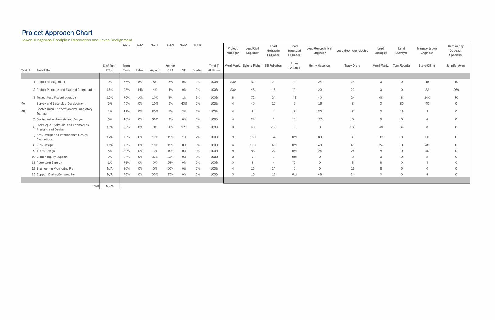
Project Approach ChartLower Dungeness Floodplain Restoration and Levee Realignment
Prime Sub1 Sub2 Sub3 Sub4 Sub5Project
ManagerLead Civil Engineer
Lead Hydraulic Engineer
Lead Structural Engineer
Lead Geotechnical Engineer
Lead GeomorphologistLead
EcologistLand
SurveyorTransportation
Engineer
Community Outreach Specialist
Task # Task Title% of Total
EffortTetra Tech Eldred Aspect
Anchor QEA NTI Cordell
Total %All Firms
Merri Martz Selene Fisher Bill FullertonBrian
TwitchellHenry Haselton Tracy Drury Merri Martz Tom Roorda Steve Olling Jennifer Aylor
1 Project Management 9% 76% 8% 8% 8% 0% 0% 100% 200 32 24 0 24 24 0 0 16 40
2 Project Planning and External Coordination 15% 48% 44% 4% 4% 0% 0% 100% 200 48 16 0 20 20 0 0 32 260
3 Towne Road Reconfiguration 12% 70% 10% 10% 6% 1% 3% 100% 8 72 24 48 40 24 48 8 100 40
4A Survey and Base Map Development 5% 45% 0% 10% 5% 40% 0% 100% 4 40 16 0 16 8 0 80 40 0
4BGeotechnical Exploration and Laboratory Testing
4% 17% 0% 80% 1% 2% 0% 100% 4 8 4 8 80 8 0 16 8 0
5 Geotechnical Analysis and Design 5% 18% 0% 80% 2% 0% 0% 100% 4 24 8 8 120 8 0 0 4 0
6Hydrologic, Hydraulic, and Geomorphic Analysis and Design
16% 55% 0% 0% 30% 12% 3% 100% 8 48 200 8 0 160 40 64 0 0
765% Design and Intermediate Design Evaluations
17% 70% 0% 12% 15% 1% 2% 100% 8 160 64 tbd 80 80 32 8 60 0
8 95% Design 11% 75% 0% 10% 15% 0% 0% 100% 4 120 48 tbd 48 48 24 0 48 0
9 100% Design 5% 80% 0% 10% 10% 0% 0% 100% 8 88 24 tbd 24 24 8 0 40 0
10 Bidder Inquiry Support 0% 34% 0% 33% 33% 0% 0% 100% 0 2 0 tbd 0 2 0 0 2 0
11 Permitting Support 1% 75% 0% 0% 25% 0% 0% 100% 0 8 4 0 0 8 8 0 4 0
12 Engineering Monitoring Plan N/A 80% 0% 0% 20% 0% 0% 100% 4 16 24 0 0 16 8 0 0 0
13 Support During Construction N/A 40% 0% 35% 25% 0% 0% 100% 0 16 16 tbd 48 24 0 0 8 0
Total 100%

Resumes
Resumes 1
Criterion D – Qualifications and Experience of Key Personnel
a. Project Manager: Merri Martz, PWS Merri has 24 years of biological and habitat restoration design experience; first with the U.S. Army Corps of Engineers, Seattle District, for nine years and now with Tetra Tech for 15 years. She has managed numerous ongoing and successfully constructed fish passage, habitat restoration and flood control plans and projects. Recently, she completed designs and construction oversight for small dam removal and floodplain restoration projects for the Portland District Corps in Oregon and fish passage projects in Washington. She has experience on major river systems and estuaries throughout the U.S. including the Columbia, Willamette, Chehalis, Puget Sound, Sacramento, Colorado, Rio Grande, Platte, Missouri, Mississippi, and Chesapeake Bay. Ms. Martz brings extensive experience in riparian and wetland ecology and fisheries biology to bear in managing multi-purpose projects that accomplish fish recovery goals and provide cost-effective flood and erosion risk management as well as providing other features such as trails and educational opportunities. While at the Corps, she managed the design and construction of two habitat restoration projects combined with existing flood control facilities, the Sammamish Weir and a levee along the Middle Green River. She also has worked intensively with technical working groups and public stakeholder groups on multiple projects to develop habitat evaluation criteria and metrics and evaluate restoration and flood risk management alternatives.
Willamette Confluence Restoration Project; Lane County, OR, 2014-2015 Ms. Martz is the project manager and senior biologist on this project for The Nature Conservancy to develop construction bid documents for the restoration of ~250 acres of floodplain habitats at the confluence of the Coast and Middle Forks of the Willamette River. Tasks include development and evaluation of alternatives, SRH2-D and HEC-RAS no-rise modeling, geomorphic assessment, 30 percent, 60 percent, 90 percent, and final designs, costs and specifications, and permitting. The project will be constructed in two phases, and Tetra Tech is currently submitting final bid documents for Phase I for construction in 2016. Phase II final bid documents will be completed in January 2016 for construction in 2017.
Willowmoor Floodplain Restoration Project; King County, WA, 2014-2015 Ms. Martz was the project manager and senior biologist for this project for King County to document the existing conditions along the Upper Sammamish River in Marymoor Park for aquatic, wetland, fish, and wildlife habitats and to develop conceptual alternatives for a cold-water supplementation project to reduce high water temperatures in the Sammamish River. Tasks included preparation of an aquatic, fish and wildlife habitat literature review and memo, a wetland delineation and functional assessment, vegetation mapping, stakeholder working group presentations, and development of alternatives and costs for cold-water supplementation to reduce fish mortality and allow unhindered passage into Lake Sammamish. Following this first phase, Ms. Martz managed the second phase of the project to develop alternatives for restoring floodplain habitat and improving flood management in the existing Corps Sammamish River flood control facility (Sammamish Weir and upper river). Tasks included developing alternatives and costs, hydraulic modeling support, evaluation of alternatives for multiple objectives, and further stakeholder coordination and agency coordination.
Firm Name Tetra Tech
Years of Experience 24 years
Years with Current Firm 15 years
Education MMA, Wetland Ecology, University of Washington (1993)
MS, Marine Chemistry, University of California, Santa Cruz (1990)
BS, Chemistry/Biology, Pacific Union College (1988)
Registration Professional Wetland Scientist (#1503)
Resumes 2
Green River System-wide Improvement Framework; King County, WA, 2014-2015 Ms. Martz provided senior biological support on this project to comprehensively evaluate the levee system on the Green River in King County, Washington and develop a system-wide management framework for the future operation and maintenance of the system. The County and Flood Control District’s goals include increasing the reliability of the levee system, reducing maintenance needs, and improving habitat and water quality in the Lower Green River. Tasks included documentation of existing aquatic, floodplain, and riparian conditions, development of aquatic and riparian enhancement strategies, development of levee vegetation management strategies, development of high priority capital projects and costs to improve levee reliability and meet habitat goals, and stakeholder outreach.
Winter Lake Estuary Restoration; Coos County, OR, 2014-2015 Ms. Martz is the project manager and senior biologist for this project for The Nature Conservancy and Beaver Slough Drainage District to provide fish access into and habitat improvement on a 400-acre tidal floodplain site along the Coquille River in southwestern Oregon. The project area includes approximately 1,200 acres of agricultural floodplain. The floodplain is managed by the Beaver Slough Drainage District to drain the system out in spring for cattle grazing and other agricultural uses during the summer/fall months. The entire area typically flood during the rainy season. Tasks included site data collection, wetland delineation, cultural resources survey, SRH2-D and HEC-RAS no-rise hydraulic modeling of existing and proposed conditions, development of conceptual through final designs, specifications, and costs, permitting, and stakeholder and agency presentations and coordination.
Oaks Bottom Habitat Restoration Design; Portland, OR, Ongoing Ms. Martz is the project manager for this project with the City of Portland and the Portland District Corps to restore tidal hydrology and fish passage into floodplain and riparian habitats within Oaks Bottom Wildlife Refuge. Tasks included project management, public involvement, 30 percent through final designs, costs, and specifications, hydraulic modeling, and construction oversight. Currently, the 100 percent designs are being completed. The key element of this project is ensuring fish passage into and out of the refuge during the majority of tidal cycles and highly variable Willamette River flows.
Elliott Bay Seawall Replacement Project; Seattle, WA, 2010-2015 Ms. Martz was the consultant team environmental and habitat restoration lead on this project to replace the aging seawall along Seattle’s downtown waterfront for seismic stabilization and protection from coastal erosion. The objectives for habitat restoration are to restore an effective salmon migratory corridor along the urban waterfront and improve the nearshore ecosystem. Ms. Martz developed and evaluated restoration alternatives with a technical advisory group, managed the design of the restoration features, conducted the ESA consultation, marine mammal consultation, oversaw and provided QC for the NEPA/SEPA EIS process and all other environmental products and permitting submittals. She additionally provided stakeholder and public involvement technical assistance. All permits were received in record time (14 months) and construction will be complete in 2016.
Willamette Floodplain Restoration Study; Lane County, OR, 2007-2008, 2009-2013 Ms. Martz was the project manager for this feasibility study for the Portland District Corps evaluating large-scale floodplain restoration opportunities along the Coast and Middle Forks of the Willamette River upstream of Eugene, Oregon for Chinook, steelhead and cutthroat habitat. Key tasks include bathymetric surveys, HEC-RAS hydraulic modeling, formulation of restoration alternatives, development and use of a multi-species habitat evaluation model, selection of a recommended plan, and feasibility level designs and cost estimates. Floodplain reconnections include fish passable channels and culverts, restoration of formerly gravel mined ponds, removal of non-native species, and riparian and floodplain revegetation. The feasibility report was approved by the Civil Works Review Board and approved in the Water Resources Development Act of 2014.
Carpenter Creek Fish Passage Bridge; Kitsap County, WA, 2011-2012 Ms. Martz was the senior biologist supporting the design on this project to replace a fish barrier culvert with a bridge to allow full tidal exchange into Carpenter Creek and its estuary in Kitsap County, WA. Provided multiple technical services since 2002 including baseline habitat mapping, surveying, hydraulic modeling, evaluation of alternatives, preliminary through final designs, cost estimates, and specifications.
Resumes 3
b. Lead Civil Design Engineer – Selene Fisher, PE Selene has 20 years of experience as a civil engineer with a specialty in hydraulics and hydrology for a variety of water resources engineering projects in urban, estuarine, and riverine settings in Washington and Oregon. Selene’s expertise in hydrologic and hydraulic modeling includes HSPF, HEC-RAS and XP-SWMM applied to stream rehabilitation, flood hazard and stormwater management plans, environmental assessments, and conveyance and detention facility designs. She has extensive project experience in evaluating the impacts of urbanizing watersheds and has proficiency in surface water construction bid documents and technical specifications.
Reddington Setback Levee and Extension; King County, WA, 2010-2013 In order to provide added flood protection and improve riverine habitat, this project will remove an existing levee at river’s edge and construct a new levee further back from the river and extending farther downstream. Lead project engineer for feasibility study documenting hydraulic analysis, environmental considerations, and developing planning level construction cost estimates. Oversaw development of an archaeological site assessment of project area because of the proximity of a recorded ethnographic location. Provided engineering for development of final design documents for the levee, including plans, specifications, and cost estimates as well as coordinated with and incorporated elements designed by others.
South Fork Snoqualmie River Levee Study, King County, WA, 2010-2014 This project is conducting a comprehensive evaluation of levee condition and flooding issues in the South Fork Snoqualmie River study area and to proposing planning level design recommendations. The levee system in the study area has known hydraulic and geotechnical deficiencies and the area experiences flooding due to overtopping, seepage and conveyance of tributary flows. Provided hydraulic analysis of the tributary contributions using historical gages in the area, USGS regional regression equations, basin transfer methods, and evaluation of the tributary flow timing.
Fletcher Creek Culvert Replacement; Jefferson County, WA, 2011 Developed contract documents for installation of a twenty-foot wide, bottomless arch culvert to enable fish passage on a tributary to the Hoh River. Specifications included provisions for pre-purchased construction elements, stream bypass during construction, road reconstruction, traffic control, stream stabilization, and endangered species considerations.
180th to 200th Street Levee Setback Study; King County, WA, 2010-2013 King County wanted an evaluation of the impacts and benefits associated with several levee alignments consistent with the County’s 2006 Flood Plan and recommendations of the Green River External Advisory Review Panel. Performed hydraulic analysis of impacts caused by the flood levels associated with different levels of operation and storage capacity at Howard Hanson Dam. Developed cost estimates for construction of each levee alternative as well as the costs associated with removing or relocating utilities and roadways inside the setback levee corridor. Coordinated with multiple subconsultants to produce a report document that included the environmental impacts of three levee alignments considered (varying setback distances), estimated the costs and benefits of the ecological services attainable in each levee alignment, and calculated flood damage costs due to a range of floods occurring within the three levee alignment.
Firm Name Tetra Tech
Years of Experience 21 years
Years with Current Firm 20 years
Education MSE, Civil and Environmental Engineering, University of Washington (1993)
BS, Aerospace Engineering, California State Polytechnic University - Pomona (1985)
Registration Professional Engineer, Civil: WA License No. 32773 (1995)
Resumes 4
Fluvial Geomorphology for River Restoration, Middle Fork Snoqualmie River Channel Migration Update; King County, WA, 2010 Project engineer for this study to update the report on geomorphic characteristics of the lower reaches of the Middle Fork Snoqualmie River. Fourteen years after the initial report was completed, a lot of data had been collected that could be used to update the report. Responsibilities included updating the flood frequency analysis with additional years of peak annual flow, analysis of the longitudinal thalweg profile changes over time, photo documentation of significant reach features, and mapping of reach classifications, alluvial fan morphology, existing county-owned revetments and levees, and channel migration patterns.
Ochoco Creek Bridge Replacement Hydraulic Analysis; Oregon Department of Transportation, Prineville, OR, 2007 In Prineville, Oregon, one highway bridge was identified for replacement. This bridge and creek is highly constrained by adjacent infrastructure and is located in a FEMA floodplain. As a member of the replacement design team, provided hydraulic modeling (HEC-RAS) of bridges in existing, and future configurations and produced initial Hydraulic Assessment Memo.
Dungeness River Geomorphic Reach Analysis; Jamestown S'Klallam Tribe, WA, 2002 Project manager and engineer for this salmon habitat restoration study. A two-mile stretch of river upstream of the Sequim Bay estuary has been identified as potentially viable salmonid habitat. Conducted field reconnaissance, analyzed geomorphic characteristics of river, developed design criteria, and provided documentation for a conceptual plan to re-establish log jams in the channel migration zone. These log jams will improve channel complexity by increasing pools and cover and enhancing side channel development.
Stillaguamish River Comprehensive Flood Hazard Management Plan; Snohomish County, WA, 2000 In an effort to begin addressing flood hazards on a watershed scale, Snohomish County initiated a comprehensive study of the Stillaguamish River. As project engineer for the first phase, responsible for completely revising the report to make it more accessible to non-engineering members of the advisory committee. This included developing sections to discuss how flooding and erosion happen, climate effects in the watershed, flood plain terminology, and statistical flood studies. Additional chapters included historical flooding events in the river, a review of past flood management proposals and practices, and an overview of regulatory and funding requirements.
Resumes 5
c. Lead Hydraulic Engineer – Bill Fullerton, PE Bill has over 30 years of experience in the field of hydraulics and its application to the solution of civil engineering and environmental problems. His primary expertise is in the areas of hydraulics, sediment transport, geomorphology, hydrology, stream restoration, wetland creation, and hydrologic data collection in river systems. As project manager or engineer, he has completed numerous projects involving the geomorphic and sediment transport analysis of river systems, water and sediment routing from watershed systems, reservoir sedimentation studies, river stability analysis, design of stream restoration, floodplain determination, design of channel stabilization measures, design of wetlands restoration/creation, the hydraulic design of structures in the river environment, and the design of erosion control measures. He has also managed numerous projects consisting of extensive hydrologic data collection efforts including sediment transport measurements, reservoir sediment surveys, aquatic habitat surveys, water quality sampling, channel cross-section surveys, river discharge measurements, and the installation and maintenance of flow measurement stations.
Green River System Wide Improvement Framework (SWIF); King County, WA, 2014-2015 Tetra Tech is providing planning and engineering services to assist the County in completing the SWIF, a planning effort focused on addressing levee deficiencies, level of protection and vegetation management issues. Bill has provided senior technical review of hydraulic, geomorphology and levee protection analyses and deliverables.
Willamette Confluence Restoration Project Design; The Nature Conservancy, 2014-2015 Mr. Fullerton is the lead QC reviewer on this project with The Nature Conservancy to develop alternatives for and prepare preliminary through final designs to restore a large area of floodplain at the confluence of the Coast and Middle Forks of the Willamette River.
Green River Fish Habitat Restoration Pilot Project; USACE, Seattle District, 2004 Mr. Fullerton was the Principal Hydraulic Engineer for this effort. The project involved an interdisciplinary site investigation, design and construction, development and implementation of a monitoring plan for gravel nourishment berms, engineered log jams and large woody debris placement to provide beneficial habitat to Chinook salmon. Mr. Fullerton provided project guidance and performed QA/QC on hydraulic and geomorphic design issues and well as review of engineering design plans and specs. To date the pilot project has been highly successful in meeting and documenting habitat restoration goals for an Endangered Species, as well as providing lessons learned and technical feedback for other large woody debris and gravel nourishment projects throughout the nation.
Design Services for South Fork Snoqualmie River Levee Repair and Reconstruction Phase Two Geomorphology and Sediment Transport; King County Department of Natural Resources, 2014-2015 Principle-in-Charge for the development of a levee characterization report for a 4-mile urban/rural reach of the South Fork Snoqualmie River in North Bend, WA. Levee characterization included problem identification, geotechnical analysis, scour analysis, sediment transport analysis, 2-D floodplain hydraulic analysis, and ecological assessment of existing levee and alternatives analysis. The current phase of the project includes development of a concept design report that identifies alternatives to resolving widespread roadway overtopping and residential structure
Firm Name Tetra Tech
Years of Experience 32 years
Years with Current Firm 30 years
Education MS, Civil Engineering, Colorado State University (1983)
BS, Civil Engineering, Colorado State University (1979)
Registration Professional Engineer, Civil: WA License No. 48036 (2011)
Resumes 6
inundation while addressing geotechnical and geomorphic goals and improving the ecological function in the river corridor.
Fisher Slough Site Assessment and Restoration Design Plan; Skagit County, WA, Ongoing Mr. Fullerton is the Principal hydraulic engineer on this effort to restore the estuary functions to Fisher Slough. The project involves levee setback, design and installation of improved tidegates, replacement of an inverted siphon and creation of estuarine habitat. The ultimate goals of the project are improvement of Chinook juvenile rearing habitat conditions and improvement of flood storage for tributaries to the South Fork Skagit River. The complex project involved a detailed site assessment and hydrodynamic modeling (MIKE21) to support design of a 4,000-ft levee setback structure for an additional 50 acres of flood storage, floodgate structural modifications, several thousand feet of channel realignment, floodplain reconnection and reconstruction, habitat feature installation and marsh and riparian plantings. The project was recently awarded a $5.2M grant for implementation in 2010 and 2011 through NOAA, ARRA funding.
Portland Levee Periodic Inspections; USACE, Portland District, 34 Levee Systems in OR and WA, 2011 Mr. Fullerton is the Project Manager and lead Hydraulic Engineer for the levee safety Periodic Inspection (PI) on several levee systems throughout the Portland District boundaries. The purpose of the PIs is to verify proper operation and maintenance, evaluate operational adequacy and structural stability, review design criteria to identify changes in current design standards, identify features to monitor over time, and improve the ability to communicate the overall condition. As part of the effort to inspect levees, Tetra Tech attended the USACE Workshop to review USACE policies, guidance, and design criteria and obtain training on software tools developed by the USACE for levee inspection. Completion of the workshop is required nationwide for each inspection team prior to accomplishing the field inspection. The Levee Periodic Inspections of 34 levee systems includes design criteria review to assess if the systems meet current design standards including risk and uncertainty principles as outlined in EM 1110-2-1619.
Feasibility Study of Re-regulation and/or Modification of Upper and Lower Baker Dams for Skagit River Flood Damage Reduction and PMF; Puget Sound Energy, Concrete, WA, 2004 Mr. Fullerton was the project manager and senior hydraulic engineer on this project to conduct an incremental evaluation of flood storage volume optimization at the Baker River Hydroelectric Project. The flood control storage is dedicated to and operated by the Corps of Engineers’ Seattle District. In performing the effort, Mr. Fullerton was responsible for supervising the application of HEC-FDA, HEC-5 and UNET. Using these technical tools, Tetra Tech assessed and identified the potential benefits and costs associated with each reoperation alternative The effort has been conducted in accordance with Corps policies and guidelines. A PMF analysis using HEC-1 and HEC-5 is also being performed.
Missouri River, A-3 Site Bank Protection Demonstration Project; USACE, Dixon County NE, 2005 Mr. Fullerton was the Project Manager and Principal Hydraulic Engineer for the bank stabilization project that involved development of an array of conceptual designs, screening and selection of a recommended alternative. Project designs included traditional “riprap” stabilization and a variety of large wood debris structures (vanes, dikes, and spurs) to protect the bank. The recommended alternative based on incremental cost effectiveness analysis is a series of offshore large wood debris vanes, with nearshore debris field to provide high levels of habitat and bank protection.
Resumes 7
d. Lead Structural Engineer – Brian Twitchell, PE Brian has 19 years engineering experience that includes project management, structural design and analysis, condition assessment, construction inspection and engineering support during construction. Brian’s structural design experience includes bridges, tunnels, retaining walls, floodwalls, drilled shaft foundations, hydraulic structures, navigation lock structures, soil structure interaction, seismic analysis and detailing. Much of Brian’s design work has been for United States Army Corps of Engineers (USACE) projects that require special design and construction methods to account for extreme loads, harsh environmental conditions and construction constraints due to proximity of existing structures and minimal disruption of navigation traffic. Brian has experience using lift-in and pre-cast concrete construction methods that allow fabrication to occur off-site and minimize construction time at the site. Brian is familiar with AASHTO, FHWA, ACI, AISC, and USACE design manuals including the Hurricane and Storm Damage Risk Reduction System design guidelines.
Upper Hoh Road and Alder Creek Culvert Replacement; Jefferson County; Jefferson County, WA, 2009-2013 Brian was the Project Manager for the modeling and a load rating analysis for a single-span bridge with a variable roadway fill depth. The analysis was unique because the bridge was topped with a thick layer of soil, making the use of conventional load rating software impractical. An Excel spreadsheet, per LRFR design method, was designed to independently calculate bridge load rating and generated a load rating report for the client. The load rating was completed in accordance with the AASHTO Manual for Bridge Evaluation MBE and the WSDOT Bridge Design Manual. The bridge was load rated based on the Load and Resistance Factor Rating LRFR method per the MBE.
Savannah Harbor Expansion Project; USACE, Savannah District, GA, 2012-2014 Design Manager and Structural Lead responsible for coordination of the civil, geotechnical, structural, mechanical and electrical engineering discipline leads to develop the contract plans, specifications and cost estimates for the gate modifications and fish passage at New Savannah Lock and Dam and the revetment walls and diversion structure at McCoy’s Cut. Also responsible for the design of the structural elements of the project including auger cast piles and the fish viewing platform at the fish passage, concrete modifications at the dam gate sills, and a 275-foot-long underwater sheet pile diversion structure and almost 940 feet of sheet pile revetment walls.
West Kingston Road/Carpenter Creek Bridge; Kitsap County, Port Orchard WA, 2015 This project replaced an existing five foot diameter culvert conveying Carpenter Creek under West Kingston Road with a 150 foot two span bridge to provide salmon smolt access to the Carpenter Creek Estuary. Brian is the lead engineer responsible for bridge design, structural plans, specifications and estimate. The bridge superstructure consists of precast prestressed concrete girders and a cast-in-place concrete deck slab. The abutments and multi-column intermediate pier are founded on drilled shafts. The bridge was designed according to the WSDOT Bridge Design Manual, AASHTO LRFD Bridge Design Specifications and AASHTO LRFD Seismic Bridge Design Guide Specifications.
Firm Name Tetra Tech
Years of Experience 19 years
Years with Current Firm 15 years
Education MS, Civil emphasizing Structures Washington State University (1998)
BS, Civil emphasizing Structures, Washington State University (1996)
Registration Professional Engineer, Civil: WA License No. 40905 (2004)
Resumes 8
Redmond Way Soldier Pile Wall; City of Redmond, WA, 2013-2014 This project provided a permeable concrete sidewalk on the north side of Redmond Way which required a new soldier pile retaining wall constructed on a substantial slope to provide sufficient space for the sidewalk and vehicle guard rails. Brian was the lead engineer responsible for the soldier pile wall design and structural plans. The wall design utilized permanent precast concrete lagging to minimize construction on or near the slope. The steel solider piles provided a corrosion allowance to ensure a 7- year design life. The wall was designed according to the WSDOT Bridge Design Manual and AASHTO LRFD Bridge Design Specifications.
Naples Seawall Repair; City of Long Beach, CA, 2011-2012 The existing concrete sheet piling in the northeast segment of the Rivo Alto Canal, in Naples California, between Ravenna Drive and The Toledo Street is deteriorating and leaning toward the canal. To replace this wall without doing harm to the adjacent homes a water side replacement wall has been constructed consisting of partial removal of the existing concrete cap beam and providing a new steel sheet pile wall and concrete cap beam. Phase 1 consists of approximately 2,000 linear feet of new wall lining both sides of the approximately 60 feet wide channel. Brian was the structural design lead for the seawall design, drawings, specifications and estimate and engineering support during construction.
East Levee Certification Phase Two; South Louisiana Flood Protection Authority, LA, 2013-2015 Tetra Tech was selected by SLFPA-E to provide the analyses, engineering and design required to support the certification effort of the 40 Arpent, Florida Avenue, Maxent, and Paris Road Levees. These levee segments total approximately 20 miles of levee, five miles of floodwall, nine pump stations and multiple closure structures. Brian was the design lead for two pile supported concrete closure structures required as part of the 40 Arpent Levee. The closure structures included a steel sheet pile cutoff wall and details for tying into the adjacent earthen levee. Slots were provided in the concrete structure for installing aluminum stop logs prior to storm events. Brian provided structural design reviews and coordinated with the civil and geotechnical engineers. The closure structures were designed based on Hurricane and Storm Damage Risk Reduction System design guidelines.
Calcasieu Ship Channel Salinity Control Measures Louisiana Coastal Protection and Restoration Authority, LA, 2013-2014 This project developed to a conceptual level measures to reduce the rate of wetland loss by managing saltwater introduced into Calcasieu Lake through the Calcasieu Ship Channel, a Federal deep draft waterway. The project required hydraulic modeling and navigation studies to determine the beneficial and adverse impacts of the proposed concepts. Concepts considered include gates, locks, sills, channelization, and perimeter control. Each concept was evaluated based on salinity management, land area sustained, change in water levels, impacts to navigation, construction and O&M costs and channel sediment. As design manager and structural lead, coordinated with hydraulic, geotechnical, civil, navigation and structural engineers to develop and evaluate the concepts, produce concept level drawings and construction cost estimates and documented the concept development and evaluation in a report. Concepts developed included a 406 foot wide buoyant sector gate and appurtenant structures, approximately 10 miles of channelization berms and closure structures at East Pass and West Pass.
Rio Puerto Nuevo Contract 2D/2E; USACE, Jacksonville District USACE; San Juan, PR, 2007-2010 Brian was the structural design engineer for 11.2 miles of flood walls and channel improvements for the Rio Puerto Nuevo/Rio Piedras drainage basin. Responsible for the structural design of the flood walls that consist of secant pile walls and cantilevered and braced sheet pile walls. When completed, the channel improvements will provide 100-year flood protection.
Resumes 9
e. Lead Geotechnical Engineer – Henry Haselton, PE
Henry’s 23-year engineering career includes geotechnical evaluation, design, project management and construction engineering for floodplain, levee, fish passage, and ecosystem restoration projects in Washington State. He has been the lead geotechnical engineer for multiple investigations and design involving levee and bank stabilization, culvert replacements, bridges, roads, stream, and shoreline protection. His experience on levee and restoration projects, and knowledge of the state and federal regulatory environments for levees, dams, and embankments, helps Henry deliver optimum engineering designs that focus on clients’ objectives and risk tolerances. Henry is also a certified project management professional (PMP) with years of experience managing diverse, multi-disciplinary teams to deliver projects on time and on budget.
Green River Lower Russell Road Levee Setback Project; King County Department of Water and Land Resources, Kent, WA, 2014-Ongoing Henry is the lead geotechnical engineer for the replacement and setback of a levee and river revetment for approximately 1.4 miles of the Lower Russell Road flood protection system along the east bank of the Green River. The primary project goal is to replace the existing flood containment system with a system designed to current engineering standards and improve riparian and aquatic habitat. Design and construction of a FEMA-certifiable levee system is a project requirement. Henry provided geotechnical support for alternative analyses and is completing seepage and slope stability analyses for detailed levee design, and providing geotechnical recommendations for levee embankment materials, roads, utilities, and habitat features. He and his team evaluated subsurface conditions by way of a site exploration plan, geotechnical laboratory testing and review of existing subsurface data. This project represents the latest state-of-practice for County levee setback projects, and Henry’s contributions include the development of geotechnical requirements for appropriate risk management of projects of this magnitude.
South Fork Snoqualmie River Corridor Evaluation and Early Action Plans; King County Dept. of Water and Land Resources, North Bend, WA, 2014-Ongoing Henry is leading geotechnical efforts to evaluate the suitability of bank and levee scour protection, and to analyze levee stability along a several mile long corridor that extends from I-90 and through the City of North Bend. His team is working closely with a multi-disciplinary team led by Tetra Tech, which is effectively helping the County navigate floodplain management issues in this increasingly urban area. An early action that resulted from previous characterization is a levee setback to reduce the likelihood of flooding and improve ecosystem conditions for the upstream segment of the corridor. The project is focused on avoiding flooding of I-90, an important transportation corridor in the Seattle area. Henry is supporting the geotechnical aspects of alternative analysis and concept design. Henry recently developed a focused subsurface investigation plan that will support the design and construction of the preferred alternative.
Dungeness River Trestle Replacement; Jamestown S’Klallam Tribe, Sequim, WA, 2015-Ongoing Henry is providing senior geotechnical guidance and review for this project to replace a trestle damaged by flooding and enhance habitat at river mile 5.8 on the Dungeness River at the Olympic Discovery Trail. Collaborating with a multi-disciplinary design and construction team under an accelerated schedule, Aspect provided preliminary geotechnical recommendations for the multi-use (pedestrian, equestrian and bicycles) trestle’s steel pipe pile foundations based on nearby data
Firm Name Aspect Consulting, LLC
Years of Experience 23 years
Years with Current Firm Aspect Consulting, LLC (2) Tetra Tech, Inc. (3) Aspect Consulting, LLC (1) Seattle Public Utilities (8)
Education MSCE, Geotechnical Engineering, University of Washington (1995)
BSCE, Civil Engineering, University of Washington (1992)
Registration Professional Engineer, Civil: WA License No. 33194 (1996)
Resumes 10
and recent experience in the area. Funding required that the subsurface investigations be performed during the construction phase. This allowed for cost savings, since the contractor was able to facilitate access for a drill rig with no additional impacts to the site. The drilling, along with a test pile program that utilized dynamic testing, allowed them to verify the preliminary design recommendations and adapt the design to the observed conditions. This approach required proactive and dynamic collaboration with the design team and stakeholders, which played well to Henry’s and Aspect’s strengths as skilled communicators and advisors. The piles were successfully driven and all design requirements were met. The bridge has high capacity foundations, allowing for minimal supports that will limit the project’s impact on the floodplain, helping to restore ecosystem processes for native salmon and char in the river reach.
Horseshoe Bend Levee; City of Kent, Kent, WA, 2011 Henry was the expert reviewer for a subsurface characterization and stability analysis for The Horseshoe Bend Levee. This analysis evaluated the sensitivity of the stability of the levee slope with regard to the addition of fill to the levee crest. The sensitivity analysis evaluated the change in factor of safety for end of construction and rapid drawdown conditions based on the addition of fill above the baseline (pre-construction) condition. Henry provided geotechnical peer review of a levee design, including subsurface characterization, earthquake engineering, and detailed slope stability analyses, and summarized the results of his review in a recommendations report.
Riverview Park Ecosystem Restoration Project; USACE, Kent, WA, 2012 Henry provided geotechnical engineering and project management for the final design of a new side channel on the Green River, while employed at Tetra Tech. The multi-disciplinary effort for the Corps of Engineers involved excavation of the approximately 20-foot-deep new channel into soft alluvial sediments, installation of a pile-supported vehicular bridge, in-stream habitat structures (log clusters and rock) and “soft bank” revetment using reinforced soil slopes, rock, large woody debris and engineered log jams (ELJ). Pile-supported ELJs were used at the points of diversion and exit of the side channel from the Green River, where concentrated erosion potential exists. Maintaining the stability of the side-channel slopes was a critical measure of project success since the project lies within a public park. Henry worked closely with the construction management team to review submittals, address requests for information, and provide in-the-field design modifications and support.
Stream Bank and Fish Passage Improvements; Seattle Public Utilities, Seattle, WA, 2001-2009 As the Principal Geotechnical Engineer for the City of Seattle, Henry was the lead geotechnical engineer for several urban and remote creek and river projects that were aimed at bank stabilization, water retention (levees and dams), erosion and sedimentation control, and infrastructure and private property protection, and habitat improvement. These included stream bank improvements to major urban streams such as Thornton Creek, Taylor Creek, Pipers Creek, Mapes Creek, and Longfellow Creek. Henry was also the lead geotechnical engineer for several culvert replacements for fish passage on urban waterways, which included stream bank stabilization components. The stream bank improvement projects typically involved attenuating stream flows, armoring creek beds, and stabilizing stream banks in an urban environment. Typical geotechnical issues for these projects include assessing existing stream bank stability, characterizing geologic hazards, evaluating the suitability of on-site soil for re-use as fill, and developing stabilization measures that are appropriate for both the project objectives and setting.
Resumes 11
f. Lead Fluvial Geomorphologist – Tracy Drury, PE Tracy is a professional civil engineer and applied geomorphologist with 17 years of experience providing client service, project management, and technical services delivery to both the public and private sector. His areas of expertise include open-channel hydraulic engineering, fluvial geomorphology, channel migration zone (CMZ) analysis and evaluation, sediment transport, and engineered log jam (ELJ) design. In addition, he brings 10 years of experience in the construction industry. He is a proven project manager with excellent written and verbal communication skills.
Tracy specializes in geomorphic analyses that support development of river management techniques that in turn reintroduce and maintain ecological functions, all while minimizing risk to property and infrastructure and emulating natural conditions within these site constraints. In addition, his design approach incorporates a variety of river management applications that target multidisciplinary objectives. His understanding of open channel hydrodynamics and fluvial geomorphology is crucial in developing plans and specifications that provide instant stability, yet allow for long-term geomorphic processes to prevail.
Tucannon River Geomorphic Assessment and Restoration Design, WA, 2010-2015 Project Manager and technical lead for conducting a hydraulic and geomorphic assessment for 51 miles of the Tucannon River (tributary to the Snake River) and prioritizing restoration treatments through 50 miles of the river basin. He led the design team in developing a HEC-RAS model of existing conditions (at a basin scale and project-site scale) used to evaluate side channel development opportunities, main channel hydraulic conditions, and large woody material structure stability. River reaches were delineated based on fish habitat restoration potential using criteria including floodplain connectivity, channel migration character, confinement, planform freedom, hydrologic inputs, and sediment transport capacity in preparation for identifying discreet projects throughout the basin. Tracy oversaw the delineation of 48 discrete projects in the basin ranging in length from 4 miles to less than 1 mile.
Subsequently, Tracy led the development of 100 percent designs for seven miles of restoration. Habitat restoration actions include removing and breaching levees, increasing off-channel habitat and side channel availability, improving floodplain connectivity and riparian habitat conditions, re-establishing floodplain processes, and installing large woody debris. Construction continued in the summer of 2015 at two project sites along the main stem.
Methow River Geomorphic Assessment and Restoration Design, WA, 2010-2013 Project Manager and technical lead contracted to work with the U.S. Bureau of Reclamation to improve habitat for Endangered Species Act-listed fish species in the Middle Methow River (M2). Anchor QEA’s analyses focused on developing restoration actions to benefit listed salmonid species that address limiting factors and are based on the reach-scale evaluation of physical and ecological processes. Anchor QEA developed a habitat evaluation matrix for salmonid, terrestrial, and avian species to compare project alternatives and to document the benefits of the preferred alternative. Tracy led a team that conducted geomorphic analysis and evaluated future habitat benefits for six project sites (subreaches) within the Upper M2 Reach from river miles 47 to 51, approximately. Habitat restoration actions included removing levees, installing LWD, increasing off-channel habitat and side channel availability, improving riparian habitat conditions, re-establishing floodplain processes, and promoting retention of LWD and spawning gravel. The first phase of construction was completed in the summer and fall of 2012; the second phase was completed in the summer and fall of 2013.
Firm Name Anchor QEA
Years of Experience 18 years
Years with Current Firm Anchor QEQ (9) GeoEngineers (1)
Education MS, Civil and Environmental Engineering, University of Washington (1999) BS, Civil and Environmental Engineering, University of Washington (1997)
Registration Professional Engineer, Civil: WA License No. 40808 (2004)
Resumes 12
North Fork Stillaguamish Restoration Prioritization Project, WA, 2003-Present Project Manager and technical lead for restoration prioritization of approximately 38 miles of the North Fork Stillaguamish River. Physical and biological data were compiled into a GIS database for analysis, and sixteen site-specific locations per mile were evaluated and assigned a scoring value for each criteria evaluated. Specific habitat-related data evaluated included redd, pool, and tributary data. Riparian areas were evaluated by using the LiDAR digital elevation model (DEM) for the tree canopy and converting it to vector point data for the raster cells in the DEM. Bank modification data were used to evaluate available migration area. At each of the more than 600 sites evaluated, a value (representing habitat quality) for pools, spawning use, tributary value, riparian quality, and available channel migration area was calculated. These data can be queried and have been used in a variety of ways to assist in restoration and acquisition decision making. The results of the prioritization identified the primary sites to install ELJs and side channels that would generate the greatest benefits for fish and riparian habitat.
Tracy has been designing and implementing restoration measures in the North Fork Stillaguamish since the middle 1990s, installing ELJs, reconnecting side-channel habitat, and promoting floodplain connectivity. The initial phase of implementation based upon the results of the prioritization occurred in 2009–2010, when a former railroad grade was modified to reconnect off-channel slough habitat, and five ELJs were constructed. A 9-foot-diameter culvert was installed on the downstream end of a 0.5-mile side channel (former main channel) and a 6-foot-diameter culvert was installed at the upstream end. The side channel itself was excavated and wood placement occurred throughout the 0.5-mile channel. Subsequently, four ELJs were installed in 2011 and five additional ELJs were placed in 2013 targeting in-stream complexity, cover, and retention of wood and sediment. An additional four ELJs were constructed in 2014 and six in 2015.These placements targeted maintaining connection to side channels and improving floodplain connectivity.
Dungeness Hatchery Intake Modifications Design, WA, 2015 Project Manager and technical lead for Anchor QEA is contracted with WDFW to assist in upgrading the existing intake system to the Dungeness Hatchery. Our role is to evaluate hydraulic and geomorphic conditions near the hatchery intake and help determine the most cost-effective way to improve the inlet of the Agnew Ditch and reduce the need for regular maintenance (dredging) of the channel to maintain flow to the hatchery during low flow conditions.
Anchor QEA conducted a site assessment, looking at river conditions near the intake and ditch inlet as well as upstream and downstream of the inlet. They also developed a hydraulic model to assess velocities and water surface elevations and proposed several alternatives to be evaluated further during alternatives evaluation.
In addition, Anchor QEA developed a technical memo documenting site conditions and the benefits and concerns with six potential management actions. The results of this memo have been integrated into the pre-design report developed for the project. Next steps are to conduct an alternatives elevation and conduct the hydraulic design. They will develop permitting documentation.
McDonald Creek Fish Passage, Pipeline, and Channel Restoration Design, WA, 2014-2015 Anchor QEA prepared design documentation under the guidance of the Jamestown S’Klallam Tribe for a project that would remove the existing diversion dam and irrigation infrastructure from the McDonald Creek Channel, restore the channel, and provide for irrigation deliveries through a bypass pipeline. The design work included evaluation of alternative concepts, selection of a preferred alternative, and development of detailed drawings, specifications, and an opinion of probable construction costs for the project. The finished project will restore approximately 450 feet of the existing McDonald Creek channel by removing irrigation infrastructure, moving approximately 600 cubic yards of channel material, and placing large wood debris. Approximately 7,500 feet of 16-inch irrigation pipeline will also be installed. The project will remove anthropogenic stressors and improve fish habitat and passage conditions.
Resumes 13
g. Lead Ecologist – Merri Martz, PWS Ms. Martz has twenty-four years of biological and habitat restoration design experience; first with the U.S. Army Corps of Engineers, Seattle District, for nine years and now with Tetra Tech for 15 years. Ms. Martz has extensive experience in designing and conducting environmental field studies; riparian and wetland plant community surveys; wetland delineations and functional assessments; aquatic habitat assessments; limiting factors analysis; fisheries use and distribution studies; spawning surveys; and other fisheries surveys. Her areas of expertise include wetland ecology; mitigation and restoration design; salmon and trout fish passage and habitat requirements; geomorphic process analysis; and construction oversight of habitat restoration features. Additionally, her experience includes preparing environmental documentation (NEPA, Clean Water Act, ESA, etc.) consistent with federal and state policies and procedures and developing comparisons and crediting of pre- and post-project conditions as required for determination of mitigation requirements. She has extensive experience in coordinating with resource agencies, tribes, and stakeholders and has conducted numerous consultations under the Endangered Species Act (ESA) with the National Marine Fisheries Service (NMFS) and the U.S. Fish and Wildlife Service (USFWS).
Willowmoor Floodplain Restoration Project; King County, WA, 2014-2015 Ms. Martz was the project manager and senior biologist for this project with King County to document the existing conditions along the Upper Sammamish River and in Marymoor Park for aquatic, wetland, fish, and wildlife habitats and vegetation communities and develop conceptual designs for a cold-water supplementation project to reduce high water temperatures in the Sammamish River. Tasks included preparation of an aquatic and fish habitat literature review and memo, conducting a wetland delineation and functional assessment, vegetation community mapping, wildlife habitat memo, stakeholder presentations, and development of conceptual alternatives, designs, and costs for cold-water supplementation to reduce fish mortality and allow unhindered passage into Lake Sammamish.
Farrel-McWhirter Park Critical Area Mapping; Redmond, WA, 2014 Ms. Martz was the senior biologist on this project to delineate all wetlands, streams, and other critical areas within the City of Redmond’s Farrel-McWhirter Park. Tasks included wetland delineation, functional assessments, stream habitat mapping, delineation of Ordinary High Water, descriptions of wildlife habitat areas, wellhead protection zones, and other critical areas. A draft and final report was prepared and Tetra Tech included recommendations on potential enhancements to wetlands and streams as part of the City’s Master Plan that could serve as mitigation for other planned activities.
Green River System-Wide Improvement Framework; King County, WA, 2014-2015 Ms. Martz provided senior biological support on this project to evaluate the levee system on the Green River in King County, Washington and develop a system-wide management framework for the future operation and maintenance of the system. The County and Flood Control District’s goals include increasing the reliability of the levee system, reducing maintenance needs, and improving habitat and water quality in the Lower Green River. Tasks included documentation of existing aquatic, floodplain, and riparian conditions, development of aquatic and riparian enhancement strategies, development of levee vegetation management strategies, and overall framework preparation and stakeholder outreach.
Winter Lake Estuary Restoration; Coos County, OR, 2014-2015 Ms. Martz is the project manager and senior biologist for this project to provide fish access into and habitat improvement on a 400-acre tidal floodplain site along the
Firm Name Tetra Tech
Years of Experience 24 years
Years with Current Firm 15 years
Education MMA, Wetland Ecology, University of Washington (1993)
MS, Marine Chemistry, University of California, Santa Cruz (1990)
BS, Chemistry/Biology, Pacific Union College (1988)
Registration Professional Wetland Scientist (#1503)
Resumes 14
Coquille River in southwestern Oregon. The project area includes approximately 1,200 acres of agricultural floodplain. The floodplain is managed by the Beaver Slough Drainage District to drain the system out in spring for cattle grazing and other agricultural uses during the summer/fall months. The entire area typically floods during the rainy season. Tasks include site data collection, hydraulic modeling of existing and proposed conditions, development of conceptual through final designs, specifications, and costs, preparation of all permit applications and documents, and stakeholder and agency presentations and coordination.
City of Puyallup On-Call Services; WA, 2013-2014 Ms. Martz has provided or managed a variety of on-call biological and permitting services for the City of Puyallup including wetland delineations, wetland functional assessments and ratings, determination of buffer requirements, identification of mitigation needs, documentation of existing aquatic and riparian habitat conditions at City-owned parks, Mazama pocket gopher surveys, and development of a mitigation and monitoring plan for the removal of sediment from Clarks Creek.
Upper Hoh Culvert Replacements; Jefferson County, WA, 2009-2010 Ms. Martz conducted initial fish passage assessment and agency coordination for this project to replace three fish barrier culverts on tributaries to the Hoh River in Jefferson County, WA. She then provided QC of the environmental documents and permit applications.
Elliott Bay Seawall Replacement Project; Seattle, WA, 2010-2013 Ms. Martz was the consultant team environmental and habitat restoration lead on this project to replace the aging seawall along Seattle’s downtown waterfront. The objectives for habitat restoration are to restore an effective salmon migratory corridor along the urban waterfront and improve the nearshore ecosystem. Ms. Martz has provided development and evaluation of restoration alternatives, design of the recommended features, ESA consultation, marine mammal consultation, NEPA support, and QC of all environmental products and permitting submittals. She has additionally provided stakeholder and public involvement technical assistance. All permits were received in record time and construction began in November 2013.
Carpenter Creek Fish Passage Bridge; Kitsap County, WA 2011-2012 Ms. Martz was the senior biologist on this project to replace a fish barrier culvert with a bridge to allow full tidal exchange into Carpenter Creek and its estuary in Kitsap County, WA. Tetra Tech provided multiple technical services since 2002 including baseline habitat mapping, surveying, hydraulic modeling, evaluation of alternatives, preliminary through final designs, cost estimates, and specifications.
Willamette Floodplain Restoration Study; Lane County, OR, 2007-2008, 2009-2013 Ms. Martz was the project manager for this feasibility study evaluating large-scale floodplain reconnection/restoration sites along the Coast and Middle Forks of the Willamette River upstream of Eugene, Oregon for Chinook, steelhead and cutthroat habitat. Key tasks include bathymetric surveys, hydraulic modeling, formulation of restoration measures/alternatives, development and use of a multi-species habitat evaluation model, selection of a recommended plan, and feasibility level designs and cost estimates. Floodplain reconnections include fish passable channels and culverts, restoration of formerly gravel mined ponds, removal of non-native species, and riparian and floodplain revegetation. The feasibility report has been approved by the Civil Works Review Board and is currently in the queue for approval by Congress.
Oaks Bottom Habitat Restoration Design; Portland, OR, 2008-2010, 2015 Ms. Martz is the Project Manager for this project with the City of Portland to reconnect tidal hydrology and fish passage into and restore floodplain and riparian habitats within Oaks Bottom Wildlife Refuge. Tasks include project management, public involvement, 30 percent through final designs, costs, and specifications, technical analyses, and construction oversight. Currently, the 100 percent designs are being completed. The key element of this project is ensuring fish passage into and out of the refuge during the majority of tidal cycles and highly variable Willamette River flows.
Green Island Floodplain and Side Channel Restoration; Lane County, OR, 2012 Ms. Martz was the project manager for Tetra Tech (as subconsultant to River Design Group) on this project to restore gravel mined ponds in the floodplain and provide access and continuous fish passage throughout the upper mile of the Historic McKenzie River Channel downstream of Eugene, OR. Tasks included hydraulic modeling, design support, fish passage design criteria, conducting a wetland delineation, preparation of all permit applications and documents, and revegetation design.
.
Resumes 15
h. Professional Land Surveyor – Tom Roorda, PLS Tom has been NTI’s Licensed Surveyor since 2005. He has more than 40 years of experience in the field of land surveying. He has gained vast experience in topographic surveys, boundary surveys and construction staking. He is a licensed pilot and has substantial experience in aerial photography and mapping. Tom is also proficient in the use of current survey equipment including GPS. He is responsible for the daily survey operations for NTI ensuring that surveys are performed within applicable laws, regulations, and codes as set forth by local, county, state and federal authorities.
Lower Dungeness River Project Design Data Acquisition; Clallam County, WA, 2013 Cross sections from Woodcock Road to the mouth of the Dungeness River and topographic survey downstream from the creamery adjacent to Town Road.
Three Crabs Near-shore and Estuary Restoration Project; Sequim, WA, 2013 The NTI survey team led by Tom Roorda, performed a topographic survey of the site which was integrated into a previous Ducks Unlimited survey as well as locating tidal probes along the shoreline. NTI also performed a geotechnical investigation including test pits and borings to determine suitable locations for road alignment and bridge replacement.
Elwha River Dam Removal Project; Port Angeles, WA, 2011-2013 Provided surveying services for the removal of the Lower Elwha and Glines Canyon dams. This work included construction staking for the extensive sediment filtration facilities, survey control and post construction topographic surveys necessary for what was the largest dam removal project in the world to date.
Marine Terminal 1 & 7 & Surge Area Topographic Survey; Port of Port Angeles, WA, 2014 Topographic surveying for Port of Port Angeles’ Marine Terminal & Marine Terminal Surge Area and delivered a contour map showing site topography with one-half foot contour intervals. Also mapped were all surface features within the survey limits including utility structure locations, manholes, trench drains, and utility poles.
K-Ply Topographic Survey & Concrete Material Estimate; Port of Port Angeles, WA, 2015 Topographic surveying for Port of Port Angeles of the former K-Ply mill site on the Port Angeles waterfront. Deliverables included a contour map showing site topography with one-half foot contour intervals. NTI also mapped all concrete footing, foundations, and debris piles along with surface features within the survey limits including utility structure locations, manholes, trench drains, and utility poles. Tom also worked with onsite Port operated excavator to estimate depth of all concrete structures below ground surface and the Port operated excavator that crushed concrete at a number of sample locations to visually estimate steel reinforcement density.
8th Street Bridge Replacement, City of Port Angeles, WA, 2011-2012 NTI’s survey crews performed all construction surveying for two major multi -pan pre-stressed concrete beam bridges for the City of Port Angeles under the direction of Tom Roorda. This included the layout of bridge pier location, repeated checks on vertical and horizontal alignment of the rising columns and elevations and position surveys for the individual beams and deck for the bridges. The work was performed for Parsons Construction under the personal supervision and the on-site presence of Tom.
Firm Name Northwestern Territories, Inc.
Years of Experience 40 years
Years with Current Firm 10 years
Education N/A
Registration Professional Land Surveyor, WA License No. 36825 (2000)
Resumes 16
Port Angeles Landfill Stabilization Project; City of Port Angeles, WA, 2014-Ongoing NTI provided the grade staking and topographic survey for quantity estimating on this project. This project consisted of relocating approximately 400,000 cubic yards of material to enable stabilization of the bluff adjoining the Strait of Juan de Fuca. Prior to this work NTI had performed multiple topographic surveys on the entire landfill site for the City of Port Angeles.
Select Additional Project Experience: United States Coast Guard Station, Port Angeles – Topographic surveying & construction staking.
Nippon Paper Industries – Cogeneration Project, Port Angeles, - Topographic surveying & construction staking.
City of Port Angeles – Topographic and construction surveying for Dry Creek Bridge.
City of Port Angeles – Surveying services for landfill cut slope and sea wall.
Jamestown S’Klallam Tribe – Jimmy Come Lately Creek topographic survey.
Resumes 17
i. Transportation Engineer – Steve Olling, PE, PMP Steve has 28 years of transportation design and management experience. He has a valuable balance of private and public experience, including 16 years with WSDOT and the Port of Seattle. Steve manages both small and large roadway improvement and preservation projects for a variety of public agency clients throughout the Puget Sound Region. He has extensive experience in utility coordination and relocation assessment by working with utility owners (public and private) early in the design process and developing clear and continuous documentation of the coordination process. As part of managing similar projects, Steve is experienced in developing and documenting the alternatives analysis and working with key stakeholders as part of this process in a variety of public forums from workshops to open houses. Steve has managed the design for similar projects from conceptual design, through PS&E, and through construction.
Boon Road Improvements Project; Island County; Oak Harbor, WA, 2011-2012 Steve is the Project Manager for this roadway safety improvement project. The roadway to be improved is approximately 1.5 miles in length. The improvements are safety related, which include vertical profile adjustment to improve site distance and the addition of 4-foot paved shoulders top allow for better recovery for vehicles that may lose control. The work includes preliminary design for the entire 1.5 miles, final design for approximately half of the project (the south end), SEPA environmental documentation, wetland delineation assessment and impacts mitigation, stormwater analysis and design (using low impact development and natural drainage practices), geotechnical analysis, right of way assessment and acquisition, and public outreach.
Elliott Bay Seawall Project; City of Seattle; Seattle, WA, 2010-2015 Steve is the Deputy Project Manager for the preliminary design Draft, and final EIS for the replacement of the Elliott Bay Seawall along Alaskan Way from the South Washington Street vicinity to the Broad Street vicinity (approximately 7,000 feet). Steve's role is manage the project delivery and monitor and control the project schedule, budget (including forecast), and overall quality of all project deliverables.
SW 312th Street from 14th Avenue SW to SR 509 Street Improvements Project; City of Federal Way, WA, 2011-2014 Steve was the Project Manager for this connector roadway and intersection operation improvements by adding additional capacity and signal upgrade to the SR 509 (Dash Point Road) and SW 312th Street. This project includes survey, stormwater analysis and design (using low impact development), geotechnical analysis, traffic analysis, signal and illumination design, utility relocation coordination of high power electrical lines, retaining wall design, landscape and irrigation design, full PS&E, SEPA environmental documentation, and permit support.
ITS Deployment: 16th Ave SW; King County, Department of Transportation; King County, WA, 2009-2012 Steve managed the preliminary and final design to deploy ITS communications infrastructure and equipment on an approximately one mile section of County Road between Seattle and Burien to enable remote traffic control operations and gather real time traffic information from the King County Traffic Control Center. The project was constructed in 2011.
Firm Name Tetra Tech
Years of Experience 28 years
Years with Current Firm 12 years
Education BS, Forestry Resources, University of Washington (1986)
Registration Professional Engineer, Civil: WA License No. 29696 (1993)
Project Management Professional (2006)
Resumes 18
Pioneer Way East and Waller Road East; Pierce County; Tacoma, WA, 2008 Project Manager for preliminary and final design for improving the Pioneer Way East/Waller Road East intersection in Pierce County, near Tacoma. The proposed improvements include providing improved channelization and a traffic signal system in order to increase the capacity and the safety of the intersection. This project began with an alternatives analysis that defined several varied alternatives in order to solve the mobility and safety deficiencies at this intersection. The preferred alternative was further developed to a preliminary design level approximately 30 percent and then on to a 90 percent design. The design included an alternatives analysis, preliminary design report, detailed design decisions, preliminary and final right-of-way plans, geotechnical and pavement design analysis report, drainage report, and final PS&E to the 90 percent level.
120th Avenue NE and NE 8th Street Stage Two; City of Bellevue; Bellevue, WA, 2010-2014 Steve was the Project Manager for the preliminary design of this important missing link in the 120th Avenue NE corridor from NE 7th Street to NE 12th Street. The preliminary design included the design documentation, plans and estimates, geotechnical report, surveying and base mapping, and coordination with the final design consultants.
South 344th Way at Weyerhaeuser Way South Roundabout Intersection Improvements; City of Federal Way, WA, 2011-2013 Steve is the Project Manager for the preliminary and final design for this intersection improvement. The improvement is to construct a roundabout at this three-legged intersection in order to improve operations and increase safety. This project includes survey, stormwater analysis and design using low impact development, geotechnical analysis, traffic analysis, retaining wall design, landscape and irrigation design, full PS&E, SEPA environmental documentation, wetland delineation and mitigation assessment, right-of-way acquisition support, and permit support.
SR 520 Bridge Replacement and HOV Constructability Review; WSDOT; King County, WA, 2008-2012 Steve managed a variety of constructability reviews for projects at various design stages for the SR 520 west side HOV and floating bridge replacement program. Each project review was at various design levels. The reviews were designed to provide independent assessment of constructability, phasing and risk assessment. This is a highly complex and congested corridor. Construction will need to occur while the corridor remains in use increasing the complexity and risk of construction. These are key factors involved with each review. Steve managed each independent review with a variety of expert engineering staff. He built each review team based on the needs of the project that allows for very streamlined, efficient and comprehensive scalable reviews. Most of the reviews were within a very short time period and he was highly responsive in planning and executing each review to meet the needs of this highly visible and accelerated delivery program of projects.
Resumes 19
j. Community Outreach Specialist – Jennifer Aylor, AICP Jennifer is a strategic leader with a strong background in, environmental policy, land use planning, tribal affairs, and facilitation services. She has effectively facilitated dozens of committees in her 23-year career and has extensive experience coordinating with multiple agencies and tribes. She has a proven track record in developing strong relationships with commissioners, councils, staff, and citizens.
Jennifer has facilitated the following community groups and committees:
Whatcom WRIA 1 Planning Unit
Skagit PL84-99 2011 Levee Repairs Agency Technical Group
City of Mount Vernon Stormwater Advisory Committee for the Stormwater Plan Update
Skagit County Clean Water District Citizens Advisory Committee
Skagit County Clean Water District Technical Advisory Committee
Skagit Environmental Bank; Clear Valley Environmental, Inc.; Mount Vernon, WA, 2012-Ongoing Skagit Environmental Bank is a 396-acre wetland mitigation bank located in Skagit County, adjacent to the Mount Vernon city limits. The site is owned by Clear Valley Environmental Farm. Eldred & Associates is under contract to help the Clear Valley Environmental Bank obtain regulatory approval as an endangered species act (ESA) fisheries bank, negotiate tribal support for ESA credits, and to facilitate credit sales. Eldred & Associates expanded their teaming efforts to partnering with project owner (the client), interested agencies (the U.S. Army Corps of Engineers Mitigation Banking program), and affected third parties (agencies which included NOAA, US Fish and Wildlife, WDFW, and Ecology). In their Partnering process, Eldred & Associates helped the two parties better understand the others’ position. By being a neutral go between, they became an effective and meaningful communicator between the differing parties, helping to avoid controversy. Jennifer is the principal planner.
Tribal Mitigation Strategy and Land Use Planning; Swinomish Indian Tribal Community; La Conner, WA, 2014–2016 Jennifer is the principal planner working with the Swinomish Tribe as part of a comprehensive, inter-disciplinary planning effort to develop short and long range land use/management strategies and recommendations for a portion of the Swinomish Indian Reservation. In consultation with Tribal staff and the Corps of Engineers, Eldred & Associates is developing a proposed wetlands mitigation strategy and program to meet federal requirements for mitigation of development impacts. Eldred & Associates will also prepare an implementation plan for effective administration of the proposed wetlands mitigation strategy and program. This project requires coordination with Tribal members, staff, and planning officials and the Corps.
WRIA 1 Planning Unit Facilitation; Whatcom County Public Works, Bellingham, WA, 2013–2014 Jennifer is working with Whatcom County to facilitate a series of contentious water resource meetings focusing on the needs, interests, and positions of a series of caucuses identified by the County, including the City of Bellingham, Whatcom County, PUD, Port, small cities, diking/drainage districts, non-municipal water systems, and representatives of Agriculture, Environment, Fishers, Forestry, Land
Firm Name Eldred & Associates
Years of Experience 22 years
Years with Current Firm Eldred & Associates (6) Cherry Creek Environmental (1) Wildlands, Inc. (4)
Education BS, Environmental Sciences, Social Impact and Policy, Western Washington University (1992)
Registration American Institute of Certified Planners, License No. 014070 (1998)
Resumes 20
Development and Private Well Owners. E&A worked closely with Whatcom County staff and the WRIA 1 Planning Unit to develop a draft work plan, budget, and multi-year agenda.
Levee Repair Permitting, Dike, Drainage, and Irrigation Districts; Skagit County, WA, 2009–2011 Jennifer worked closely with the U.S. Army Corps of Engineers Seattle District, NOAA Fisheries, U.S. Fish and Wildlife, and local tribes on behalf of five dike and drainage districts. Eldred & Associates staff negotiated mitigation solutions for $8 million in levee repairs on the Skagit River. The Skagit River contains all five anadromous fish species and is a critical system for Puget Sound Chinook salmon recovery. Eldred & Associates worked collaboratively with agency and tribal staff to quantify mitigation impacts for over 60 dike repair projects, and developed an innovative mitigation ratio table for current and future impact assessments and quantifications. The project resulted in significant levee repair design changes that incorporate fisheries benefits within the levee repair design. Perhaps as important as the levee repairs (constructed summer 2011) this project is a start in repairing damaged relationships within Skagit Valley between many entities; parties of differing interests are now able to work collaboratively together and reach meaningful solutions.
Blue Heron Slough Conservation Bank; Port of Everett and Wildlands, Marysville, WA, 2006-2010 Jennifer provided a feasibility assessment supporting the position that the project not be required to obtain a Shoreline Substantial Development Permit as required by Snohomish County. A Shoreline CUP would have cost the public project years in delays and millions of dollars, and would open the project to significant challenges from opposing parties. Eldred & Associates staff was retained by the Port of Everett to continue work that Ms. Aylor had led as a Restoration Planner with Wildlands, providing leadership and strategic planning for mitigation use and environmental permitting. Ms. Aylor authored all permit applications including the SEPA Checklist, Joint Aquatic Resource Permit Application (JARPA), shoreline exemption requests, etc. and managed multiple consultant contracts and work products. Ms. Aylor worked closely with NOAA staff to develop an innovative approach to mitigation and salmon recovery. She facilitated working meetings with resource agency staff and developed solutions for navigating the environmental process, including a shoreline exemption. This project was the first conservation bank in Washington State, fostering salmon recovery through mitigation.
Blackjack Creek Offsite Consolidated Mitigation; Client: Wildlands; Port Orchard, WA, 2006–2008 As a Principal Planner for Wildlands, Inc., Ms. Aylor created a new permitting technique, which preserved a contractual relationship with WSDOT allowing WSDOT to utilize the site for environmental impacts from the Burley Olalla Interchange Project in Kitsap County. She developed a project to allow a series of separate impacts occurring near each other to be mitigated for at one consolidated site. This approach realized the benefits of mitigation banking while eliminating the lengthy and cumbersome entitlement process required for banks in Washington State. Ms. Aylor identified an ideal mitigation site for a specific client, then began acquisition negotiations and restructured the original offering. She worked closely with the regulatory agency and created a new working regulatory template for private entrepreneurial consolidated mitigation sites. She also provided senior technical oversight and direction during entitlement and authored permit applications including SEPA, Joint Aquatic Resource Permit Application (JARPA), Critical Areas Review, Fill and Grade, etc.
Surface Water Management Plan Update; City of Mount Vernon, WA, 2001-2004 As Surface Water Manager for the City, Ms. Aylor, using the City of Mount Vernon Planning Commission as the Citizen Advisory Committee, facilitated a monthly update and discussion forum where the Planning Commission oversaw the city’s shift from a conveyance based drainage plan to a policy based surface water management plan that incorporated the goals of the Clean Water Act, the Endangered Species Act, and the Growth Management Act.
Hazard Mitigation Program; City Of Waitsburg, WA, 1996-1998 As a Contract Planner for the City of Waitsburg, Jennifer coordinated Walla Walla County’s initial immersion into geographical information systems (GIS) by demonstrating a floodplain application in the City of Waitsburg. Waitsburg then contracted with Walla Walla County to have Ms. Aylor author more than $2 million in flood-related grant applications, including applications for funds from the Community Development Block Grant, Flood Control Assistance Account programs, and Hazard Mitigation funds. She developed a detailed ranking system for acquiring property, and ensured that acquisitions met the requirements of the different funding sources. She negotiated the purchase of 14 acres and 12 homes from citizens, effectively communicating the complex requirements of the acquisition and relocation funding sources. She was responsible for all aspects of project management and implementation.
www.tetratech.com