Embed Size (px)
Citation preview
Project 17- Developing Next-Generation Seismic Design Value Maps
A Preliminary Planning Report
Prepared for the Federal Emergency Management Agency and U.S. Geological Survey by the Project 17 Planning Committee of National Institute Building Sciences Building Seismic
Safety Council
September 28, 2015

NOTICE: Any opinions, findings, conclusions, or recommendations expressed in this publication do not necessarily reflect the views of the Federal Emergency Management Agency. Additionally, neither FEMA nor any of its employees make any warranty, expressed or implied, nor assume any legal liability or responsibility for the accuracy, completeness, or usefulness of any information, product, or process included in this publication.
The Building Seismic Safety Council (BSSC) was established in 1979 under the auspices of the National Institute of Building Sciences as a forum-based mechanism for dealing with the complex regulatory, technical, social, and economic issues involved in developing and promulgating building earthquake hazard mitigation regulatory provisions that are national in scope. By bringing together in the BSSC all of the needed expertise and all relevant public and private interests, it was believed that issues related to the seismic safety of the built environment could be resolved and jurisdictional problems overcome through authoritative guidance and assistance backed by a broad consensus.
The BSSC is an independent, voluntary membership body representing a wide variety of building community interests. Its fundamental purpose is to enhance public safety by providing a national forum that fosters improved seismic safety provisions for use by the building community in the planning, design, construction, regulation, and utilization of buildings.
This report was prepared under Contract HSFEHQ-09-D-0417 between the Federal Emergency Management Agency and the National Institute of Building Sciences.
For further information on Building Seismic Safety Council activities and products, see the Council’s website (www.bssconline.org) or contact the Building Seismic Safety Council, National Institute of Building Sciences, 1090 Vermont, Avenue, N.W., Suite 700, Washington, D.C. 20005; phone 202-289-7800; fax 202-289-1092; e-mail [email protected].
The National Institute of Building Sciences and its Building Seismic Safety Council caution users of this document to be alert to patent and copyright concerns especially when applying prescriptive requirements.
Project 17 Preliminary Planning Report September 28, 2015
2
TABLE OF CONTENTS
1. EXECUTIVE SUMMARY ................................................................................................................. 4
2. INTRODUCTION .............................................................................................................................. 5
2.1 Purpose ..................................................................................................................................................... 5
2.2 Background ............................................................................................................................................... 5
2.3 Project Participants ................................................................................................................................... 7
2.4 Process ...................................................................................................................................................... 8
3. ISSUES ................................................................................................................................................ 8
4. RECOMMENDATIONS ................................................................................................................. 10
4.1 Primary Issues ......................................................................................................................................... 10 4.1.1 Balancing Precision and Uncertainty .......................................................................................................... 10 4.1.2 Acceptable Risk .......................................................................................................................................... 11 4.1.3 Multi-Period Spectral Values ...................................................................................................................... 12 4.1.4 Deterministic Values .................................................................................................................................. 13
4.2 Other Issues ............................................................................................................................................ 13 4.2.1 Combined Issues ........................................................................................................................................ 13 4.2.2 BSSC Specific Issues .................................................................................................................................... 13 4.2.3 USGS-specific Issues ................................................................................................................................... 14 4.2.4 Duration as a Mapped Parameter .............................................................................................................. 14 4.2.5 Vertical Motion Parameters ....................................................................................................................... 15
4.3 Level of Effort .......................................................................................................................................... 15
5. APPENDIX A - WEBINAR PRESENTATIONS ......................................................................... 17
6. APPENDIX B - PARTICIPANT POLL RESULTS ................................................................... 109
7. APPENDIX C - ISSUE SUMMARIES ........................................................................................ 111
Project 17 Preliminary Planning Report September 28, 2015
3

1. EXECUTIVE SUMMARY
During the period January to September 2015, a joint committee of United States Geological Survey (USGS) representatives, and Building Seismic Safety Council (BSSC) volunteers and staff formed a committee to conduct planning for Project 17. Project 17 is envisioned as a joint USGS-BSSC effort intended to facilitate the coordination of practicing engineers and USGS scientists engaged in formulating the rules by which next-generation seismic design value maps will be developed. These seismic design value maps are different from the hazard maps produced by USGS in that they modify the hazard to values deemed appropriate as a basis for structural design. The Project 17 effort must be completed in sufficient time to facilitate balloting and inclusion of the new maps in the 2020 NEHRP Recommended Provisions for New Buildings and Other Structures.
The committee conducted two meetings and several teleconferences, and conducted public outreach. During the course of its initial meeting, the Committee identified a series of 13 issues that should be considered in the Project 17 effort. These ranged from procedural issues associated with the timing of map production, and means of delivery of mapped seismic hazards data, to technical issues associated with the underlying risk basis for the map and detailed issues of seismic hazard calculation. Following development of these issues, the Committee prepared a series of written issue summaries, which it then presented in a series of 3 webinars to interested and invited members of the public including practicing engineers, state and local geologists, regulators and academics. Interested participants were invited to provide oral and written comment and were also asked to participate in a poll to rank the importance of the issues. Following receipt of public comment the committee met a final time to review the information received and develop a consolidated of recommendations for the conduct of Project 17.
The committee envisions an effort of approximately 30-month duration during which the USGS will develop draft maps based on the rules proposed, to allow evaluation and refinement of the recommendations. The committee will be comprised of a main committee and four task committees tasked with evaluating each of the key issues identified in the planning effort:
• Balancing uncertainty and precision in the maps.
• Definition of acceptable risk.
• Development of multi-period spectral parameter data and spectra.
• Definition of procedures for computing deterministic maps.
The main committee and each of the task committees should plan to meet once per quarter throughout the duration of the project to resolve these issues and develop their recommendations for the technical basis and procedures to be followed in preparing next-generation seismic design value maps for inclusion in the NEHRP Provisions.
Project 17 Preliminary Planning Report September 28, 2015
4

2. INTRODUCTION
2.1 Purpose
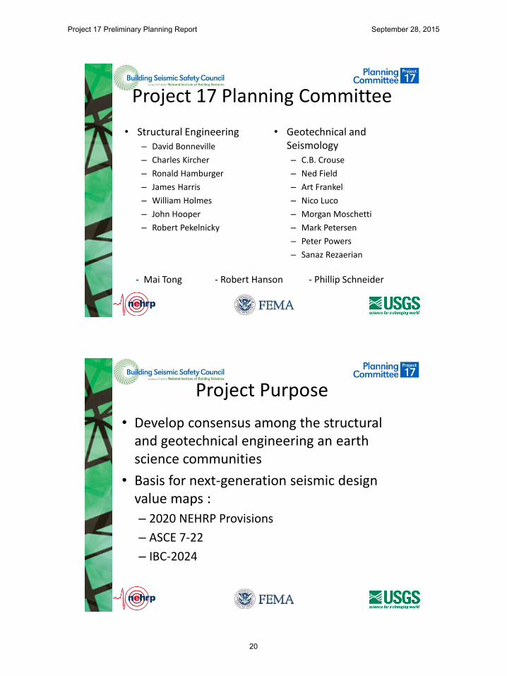
This report presents the recommended scope of a joint United States Geological Survey (USGS) and Federal Emergency Management Agency (FEMA) project (Project 17) to develop a consensus basis for next-generation seismic design value maps and/or tools for adoption by the 2020 NEHRP Recommended Seismic Provisions for New Buildings and Other Structures (NEHRP Provisions), the ASCE 7-22 Minimum Design Loads and Criteria for Buildings and Other Structures, and the 2024 series of I-Codes. These recommendations were prepared by a joint committee of volunteer engineers empaneled by the Building Seismic Safety Council (BSSC) and USGS engineers and earth scientists. BSSC provided secretariat functions for this joint committee. The purpose of these recommendations is to provide FEMA guidance in planning for the Project 17 effort.
2.2 Background
An important goal of the National Earthquake Hazards Reduction Program (NEHRP) is to promote the development, improvement, and adoption of reliable, nationally applicable, building code requirements for earthquake-resistant construction. In furtherance of this goal, FEMA has supported the BSSC’s periodic development and update of the NEHRP Provisions. Since 1992 the NEHRP Provisions has been the primary resource document for seismic design criteria contained in the ASCE-7 standard, and more recently, the International Building Code. The NEHRP Provisions assign seismic loading through reference to a series of national seismic design value maps produced by the United States Geological Survey (USGS) in cooperation with BSSC. In this process, BSSC typically defines the rules by which the maps are produced (e.g. designation of parameters, hazard levels, etc.) while the USGS has applied the science necessary to produce the maps.
The USGS has periodically updated the national seismic design value maps in support of updates to the NEHRP Provisions. Typically, the updated maps have followed rules established by BSSC in prior editions of the NERHP Provisions, but with updated scientific basis (fault locations, activity rates, ground motion prediction models, etc.) applied to produce more current values for the mapped parameters. Approximately one time each decade, BSSC and USGS have collaborated to re-examine the basis for the maps, and the rules under which they are produced, resulting in major change to the basis and values contained on the maps.
Under the 1997 Provisions update cycle, BSSC and USGS performed Project 97. Project 97 included a group of more than 30 leading engineers and earth scientists representing private practice and government research and regulatory agencies, who over a period of two years formed a series of subcommittees to explore a variety of topics associated with seismic design procedures and design seismic hazards. In conjunction with this evolution in the national seismic hazard maps, BSSC made major revision to the seismic design procedures contained in the NEHRP Provisions. As a result of the Project 97 recommendations, the 1997 NEHPR Provisions adopted a series of innovations into the seismic design procedures referenced by the building codes including:
Project 17 Preliminary Planning Report September 28, 2015
5
• Definition of a Maximum Considered Earthquake shaking hazard level (MCE) for whichmapped values would be provided.
• • Establishment of a 2%-50 year exceedance probability for MCE shaking, except in areas
near major active faults, where deterministic limits were placed on mapped values.
• Establishment of MCE spectral response acceleration for a reference site class condition(SS and S1) as the mapped parameters.
• Establishment of rules for setting a deterministically derived limit on the mapped valuesof Ss and S1.
• Establishment of site-adjusted design spectral acceleration values SDS and SD1, taken as2/3 of the MCE values, following adjustment for Site Class effects, as the parametersused to determine required seismic strength.
The resulting maps formed the basis for the 1997, 2000 and 2003 editions of the NEHRP Provisions; ASCE 7-98, ASCE 7-02 and ASCE 7-05; and, the 2000, 2003, 2006 and 2009 editions of the International Building Code and International Residential Code.
During the 2009 NEHRP Provisions update cycle, BSSC and USGS collaborated in an effort known as Project 07, again resulting in substantive changes to the design basis underlying the NEHRP Provisions and the design value maps referenced by the Provisions. Significant changes included:
• Establishment of probabilistic MCE shaking hazards on a uniform risk, rather thanuniform hazard basis.
• Selection of a notional 1%-50 year collapse risk as the primary design goal for ordinaryoccupancy structures located in regions where design seismic values areprobabilistically rather than deterministically based.
• Selection of maximum direction, as opposed to geomean values for mappedparameters.
• Adjustment of the deterministic caps to a true 84th percentile rather than 150% of themedian.
During development of the 2015 NEHRP Provisions the BSSC Provisions Update Committee (PUC) considered a proposal to adopt new maps developed by USGS. USGS had produced the new maps using the basic rules established previously by the Project 97 and Project 07 efforts, but incorporating updated databases on source activity rates and segmentation, and updated ground motion prediction equations. As would be anticipated, mapped values in some locations increased and in others decreased, with the amplitude of change generally falling under 20%, but sometimes reversing directional trends observed in recent prior map revisions. Of particular note was the creation of a number of new deterministic zones associated with faults having low activity rate. After initial rejection of the maps, the PUC suggested revision of the deterministic zone definitions, the USGS revised the maps, and the PUC adopted the
Project 17 Preliminary Planning Report September 28, 2015
6

revised maps. However, this adoption was not by unanimous vote and several PUC members expressed dissatisfaction with the process for developing the maps and the lack of opportunity for the structural engineering community to provide input to map development. This dissatisfaction carried over into the ASCE-7 committee, which as of the time of preparation of this report, had rejected the new maps for inclusion in ASCE 7-16. FEMA conceived of the concept for Project 17 to address these concerns and authorized the planning effort which resulted in this report.
2.3 Project Participants
The Project 17 Planning Committee included a group of structural and geotechnical engineers, who have been active in the BSSC Provisions Update process together with USGS engineers and earth scientists, together with FEMA representatives and a secretary provided by BSSC. Table 1 below presents the project participants.
Table 1 Project 17 Planning Committee Participants
Name Affiliation David Bonneville1,3 Degenkolb Engineers C.B. Crouse2,3,5,6 AECOM Ned Field United States Geological Survey Art Frankel6 United States Geological Survey Ronald Hamburger2,3,4,6,7 Simpson Gumpertz & Heger Inc. Robert Hanson3,11 University of Michigan (Emeritus) James Harris2,3,5,6 J.R. Harris and Associates William Holmes2,5,6 Rutherford & Chekene John Hooper2,5,8 Magnusson Klemencic Associates Charles Kircher2,3,4,6 Kircher & Associates Nico Luco2,3,5 United States Geological Survey Morgan Moschetti United States Geological Survey Robert Pekelnicky2,3,9 Degenkolb Engineers Mark Petersen United States Geological Survey Peter Powers United States Geological Survey Sanaz Razaeian3 United States Geological Survey Phillip Schneider10 Building Seismic Safety Council Mai Tong12 Federal Emergency Management Agency
Notes: 1. Chair 2015 Provisions Update Committee2. Member 2015 Provisions Update Committee3. Member ASCE-7 Seismic Subcommittee4. Chair Project 075. Member Project 07 Committee6. Member Project 97 Committee7. Chair, Project 17 Planning Committee8. Chair, ASCE-7 Seismic Subcommittee9. Chair, ASCE-41 Committee10. Executive Director, BSSC11. Consultant to FEMA12. FEMA Project Officer
Project 17 Preliminary Planning Report September 28, 2015
7

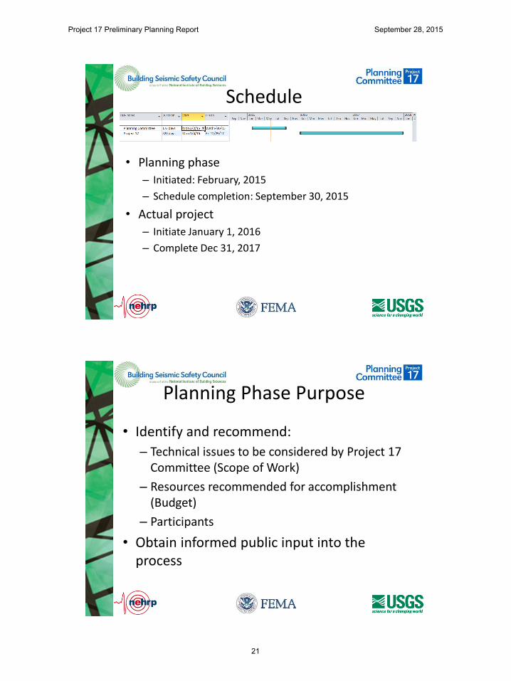
2.4 Process
The Project 17 Planning Committee was formed in January 2015 with a teleconference. The committee first met on 12 February to talk through the project intent, and to identify key issues that the committee members believed should be addressed by the Project 17 effort. Team members then produced a series of summary write-ups for each issue that described the particular issue, why it was important, and approximately, the preferred means of resolving the issue, and required resources. These were combined into a consolidated document, reviewed by the team as a whole and edited, based on team member comments.
The committee met by teleconference several times in April and May 2015 to plan for a limited effort of public outreach in which knowledgeable and interested members of the public were invited to provide input to the committee as to additional issues that should be considered, and the relative priority of the various issues. The committee then held a series of three webinars on June 25, July 20 and July 27, 2015. The first of these webinars provided a broad overview of the Project 17 goals, and an overview of the issues identified by the planning committee. Participation in this webinar was made widely available. The two follow-on webinars, in which participation was by invitation, presented focused and more detailed discussion of the individual issues. Participants were invited to ask questions on the materials presented, and to provide input to the committee. Following the webinars, invited participants were asked to participate in a poll to assist in prioritizing the issues. Appendix A to this report includes the slides used by the webinar presenters. (Double-click a slide to access a presentation. Press Esc to exit.) Appendix B to this report summarizes the participant poll results.
On 12 August 2015, the planning committee met again to review public input, and to formulate its recommendations for the Project 17 effort, as documented herein.
3. ISSUES
The Project 17 Planning Committee initially identified the following issues as important for consideration in the Project 17 effort:
1. Timing for Updated Map Publication2. Design Value Conveyance3. Precision and Uncertainty4. Acceptable Collapse Risk5. Collapse Risk Definition6. Maximum Direction Ground Motion Components7. Multi-Period Spectral Values8. Duration as a Mapped Parameter9. Damping Levels10. Vertical Motion Parameters11. Use and Definition of Deterministic Parameters12. Basin Effects13. Use of 3-D Simulation to Develop Long Period Parameters
These range from procedural issues, such as how often updates to the maps should be made; to design procedure issues such as the acceptable risk levels upon which the maps should be
Project 17 Preliminary Planning Report September 28, 2015
8

based; to detailed technical issues as to how hazards analysis should be conducted in support of the maps. Appendix C presents a brief summary of each issue describing the issue itself, reasons why the issue should be considered, potential disadvantages to incorporation of the issue in the project, and assessment on a preliminary basis of the needed resources.
In addition to the above issues, the Planning Committee also considered several other potential issues including:
1. Providing Mapped Parameters for additional levels of hazard including potential Serviceand/or Function Level earthquakes.
2. Decoupling Seismic Design Categories from site class effects.3. Inclusion of induced seismicity in seismic hazard calculation.
After initial discussion, the committee elected not to continue further discussion of these three additional issues, and did not develop summary write-ups for them. The committee decided not to continue consideration of additional mapped hazard levels, or seismic design category determination within the Project 17 scope because it observed that the BSSC Provisions Update Committee is the more appropriate body to evaluate these issues.
The committee acknowledged that induced seismicity, e.g., seismicity associated with human activity, including deep ground water injection and fracturing of oil-bearing rock formations, is an important concern because earthquakes associated with these activities are increasing in some regions that have not historically had significant seismicity, causing both damage and significant concern in some communities. However, the committee did not consider it appropriate to include this effect in national seismic hazard maps intended for reference by the building codes because the present understanding of this phenomena is immature, resulting in great uncertainty as to hazard severity; and, the regions in which induced seismicity may occur in the future can be quite transitory, depending on the economic effectiveness of this particular extraction technique and life of specific production fields.
During the committee’s deliberations it was noted that the ASCE 41 standard also references seismic design value maps and that these maps have a somewhat different basis than do the maps referenced by the ASCE 7 standard and the building codes. Consideration was given to expanding the scope of Project 17 to address the additional maps referenced by ASCE 41. The committee acknowledged the importance of this standard, and also a need for an appropriate group to establish the rules by which design value maps for existing buildings are developed. However, after much discussion, the committee decided that this would represent an expansion of the project scope for which there were not adequate resources. Instead, the committee recommends establishment of strong liaison between the Project 17 Committee and the ASCE 41 standards committee so that the ASCE 41 Committee has knowledge of and can benefit from the Committee’s work.
Project 17 Preliminary Planning Report September 28, 2015
9

4. RECOMMENDATIONS
4.1 Primary Issues
The Project 17 Planning Committee recommends that Project 17 be charged with consideration of the following issues.
• Balancing uncertainty and precision in the maps.
• Definition of acceptable risk.
• Development of multi-period spectral parameter data and spectra.
• Definition of procedures for computing deterministic maps.
Brief discussion of these issues, why they are deemed important, and preliminary insights into possible resolution of these issues follows.
4.1.1 Balancing Precision and Uncertainty
Prior to publication of the 1997 NEHRP Provisions, seismic design value maps referenced by U.S. building codes portrayed design values imprecisely, either in the form of seismic zones or Ca and Cv coefficients. The seismic zones assigned uniform values of the mapped seismic design value to broad regions, using single digit values of the mapped parameters (e.g. 0.4g, 0.3g etc). Ca and Cv coefficients also were portrayed, with limited precision, to cover broad regions. Commentary to the building codes suggested that the mapped values represented in an approximate manner the intensity of shaking having a 10% probability of exceedance in 50 years, but that there was considerable uncertainty and variability associated with the values at any site relative to the mapped value. Most engineers understood that the mapped values represented approximations of the true seismic hazard at a site, that there was considerable probability that actual ground motions experienced would be either greater or less than the mapped value, and that the mapped value simply represented a minimum value deemed acceptable for design. In part because the maps portrayed seismic hazard in an imprecise manner, and in part because research progress in seismic hazards was limited, the maps were stable from one building code edition to the next, with relatively few changes in the specified design values. This enabled engineers to be comfortable with the values, regardless of their accuracy, and more important, the detailing and structural system requirements prescribed by the building code, which are inherently tied to the ground motion design values, also remained stable.
Following the publication of the 1997 NEHRP Provisions, the maps presented design values in the form of parameter contour lines, where contour values were indicated with two or in some cases three digit values. Despite the publication of design values to three significant figures, the uncertainties inherent in the parameter values are quite high, typically having coefficients of variation in excess of 50%. The apparent precision in the contour values masks these high uncertainties. Further, small changes in the science basis underlying the maps, from edition to edition, creates significant changes in contour values, sometimes up, sometimes down, when often these changes in values are not statistically significant. These seemingly small changes
Project 17 Preliminary Planning Report September 28, 2015
10

in mapped values can have significant effect on design requirements, and create loss of confidence among the design populace that the maps are believable and suitable for use.
Under this task, the Project 17 Committee should seek to develop engineering interpretation of the computed values based on science that can be portrayed as design values having precision appropriate to the uncertainty associated with their calculation, potentially allowing for increased stability of the values in future map editions. This can be accomplished through a return to the use of zones, through plotting of contours on a coarser gradation, or other means.
4.1.2 Acceptable Risk
Prior to publication of the 1997 NEHRP Provisions, design seismic value maps contained in the building codes portrayed hazards approximating mean ground motion parameters having a 10% probability of exceedance in 50 years (475 year mean return period). The 1997 NEHRP Provisions adopted seismic design value maps portraying parameters having a 2% probability of exceedance in 50 years with deterministic caps in some regions, because it was felt necessary to go to this exceedance probability to capture large events in the eastern U.S. that had occurred in historic times, such as the 1811-1812 New Madrid series of events and the 1886 Charleston earthquake. The deterministic caps were necessary to limit design ground motions in areas close to major active faults, such as some sites in Los Angeles, Salt Lake City and San Francisco to credible values approximating those that had been actually recorded, and having reasonably small probability of exceedance considering what was thought to be the maximum magnitude earthquakes that could occur on the controlling faults. In order to retain the use of the R values, historically used to adjust design ground motions to required design force levels for different systems, the 1997 NEHRP Provisions simultaneously adopted a philosophy that the mapped values represented Maximum Considered values, for which collapse avoidance was desired, and that design values, for which Life Safety performance was desired could be taken as 2/3 the mapped values.
The 2009 NEHRP Provisions adopted a revised basis for the MCE maps consisting of ground motions that would results in a 1% collapse risk in 50 years for buildings having a fragility with a 10% probability of collapse given the occurrence of MCE motion. This definition resulted in somewhat different probabilities of exceedance for ground motion across the U.S. depending on the slope of the hazard curve, that is, the rate of change of shaking intensity with increasing probability of exceedance. Generally, however, the exceedance probability remains at approximately 2% in 50 years. Deterministic caps were retained.
Since the 1997 NEHRP Provisions were developed, earth scientists have developed different understanding of the likely recurrence interval for large magnitude earthquakes in the New Madrid seismic zone. Current thinking suggests that exceedance probabilities on the order of 5% in 50 years would adequately capture recurrence of the New Madrid events. Had this 5%- 50 year exceedance probability been selected originally, this may have avoided the need to adopt deterministic caps on mapped ground motion parameter values.
Under this issue, the Project 17 Committee is charged with evaluating whether it would be advisable at this time, to adopt the 5%-50 year hazards, or other exceedance probability as the basis for the MCE maps, whether or not the values are adjusted to achieve uniform collapse risk, as was done in the 2009 NEHRP Provisions. Assuming that it is decided to adopt a
Project 17 Preliminary Planning Report September 28, 2015
11
reduced hazard level for the MCE maps, determination should be made whether deterministic caps need still be applied.
Consideration should also be given to whether adjustment of the mapped values to obtain uniform collapse risk is appropriate. This was done in part to moderate the values of design ground motions in the eastern U.S., something which may not be desirable or necessary if an alternative hazard level is selected. Advantages of retaining the uniform collapse risk definition would provide a measure of stability in the code-specified procedures. However, return to a uniform hazard definition would considerably simplify both the hazard calculation procedures and engineers’ ability to explain the ground motion basis to other stakeholders.
Finally, if the uniform collapse risk definition is retained, the way this is portrayed in commentary should be revisited. While the 1%-50 year collapse risk, which underlies the current maps, is consistent with the FEMA P-695 procedure, this procedure was not really developed specifically for that purpose. Knowledgeable engineers generally believe that the FEMA P-695 procedures significantly overestimate the collapse risk of most real buildings. Improved discussion of these issues or alternatively, use of somewhat different fragility definitions to perform the collapse risk evaluation, would reduce the current incongruity between code commentary, map basis, and actual expectations for building performance.
4.1.3 Multi-Period Spectral Values
During the closing months of the 2015 PUC cycle, study was undertaken of compatibility of current Site Class coefficients, Fa and Fv with the NGA ground motion prediction equations (GMPEs) used by USGS to produce the design maps. In the course of this study, it was discovered that the standard spectral shape derived from the SDS, SD1, and TL parameters is not appropriate for soft soil sites (Site Class D or softer) where hazard is dominated by large magnitude events. Specifically, on such sites, the standard spectral shape overstates the spectral demands for short period structures, and substantially understates spectral demand for moderately long period structures. The PUC initiated a proposal to move to specification of spectral acceleration values over a range of periods, abandoning the present three parameter format, as this would provide better definition of likely ground motion demands. However, this proposal was ultimately not adopted due to both the complexity of implementing such a revision in the design procedure and time constraints. Instead, the PUC adopted a proposal prohibiting the use of the general three-parameter spectrum, and instead requiring site-specific hazard determination for longer period structures on soft soil sites.
Project 17 is charged with re-evaluating the use of multi-period spectra as a replacement or supplement to the present three-parameter spectral definition. If the multi-period spectral definition is indeed adopted, then Project 17 should also evaluate whether basin effects, near field effects and other effects typically included in site-specific studies should be considered in development of the maps. It also will be necessary for the Project 17 Committee to consider how the basic design procedures embedded in ASCE 7 should be modified for compatibility with the multi-period spectra.
Project 17 Preliminary Planning Report September 28, 2015
12
4.1.4 Deterministic Values
If, in the consideration of acceptable risk, an acceptable risk is selected that requires the continued use of deterministic caps, the Project 17 Committee is charged with development of an updated definition of these caps. Project 97 defined the deterministic caps in terms of characteristic earthquakes on controlling faults. Seismologic practice has recently evolved away from the definition of characteristic earthquakes. Thus, a new definition of the “maximum considered” deterministic event is necessary.
4.2 Other Issues
The Planning Committee combined several of the issues in the original list together and included them in the recommendations contained above. In addition the Committee determined that several of the issues it originally identified as important to development of next-generation seismic design value maps need not be part of the Project 17 scope. Generally this was either because the Planning Committee observed that other organizations could better deal with the specific issue, or that insufficient knowledge is presently available to allow satisfactory resolution of the issue and inclusion of the needed technology into map generation. In a few cases, the committee observed that there was insufficient need to warrant the expenditure of effort necessary to respond to the issue. The following sections describe the committee’s recommendations with regard to these remaining issues.
4.2.1 Combined Issues
The issue of collapse risk definition was combined with the issue of acceptable risk, presented in Section 4.1.2. The issue on consideration of basin effects was combined into the development of multi-period spectral values. The Planning Committee wishes to note concern that presently, well defined models necessary for inclusion of basin effects are available for the Puget Sound region, and presently under development for the Los Angeles region. Many other regions have such basins. The Planning Committee believes that explicit inclusion of these effects in some regions, and exclusion elsewhere, can be problematic for implementation and enforcement of the building code requirements.
The issue associated with use of 3-D simulations was not directly combined with other issues, nor was it rejected. The Planning Committee has no objection to USGS using such simulations to inform its development of the maps and notes that this will likely be very helpful in the inclusion of basin effects, should the Project 17 Committee elect to proceed with inclusion of these effects.
4.2.2 BSSC Specific Issues
The Planning Committee recommends that BSSC again reconsider two issues previously considered in prior PUC cycles. Specifically, the Planning Committee recommends that the PUC reconsider the use of maximum direction components of ground motion in mapping, and the use of alternative hazard levels associated with functionality, or other performance goals. The decision to use maximum direction component ground motions, as opposed to geomean was undertaken as part of the Project 07 effort, and included in the 2009 NEHRP Provisions. Despite achieving consensus in the BSSC process, this proposal drew heavy criticism from BSSC member organizations, and from many individual geotechnical engineers and earth
Project 17 Preliminary Planning Report September 28, 2015
13

scientists. The argument against use of maximum direction ground motions is that it is unlikely that a structure will be oriented such that it will be fully sensitive to this component of motion, and consequently, use of this component, as opposed to geomean motion, represents an increase in the exceedance probability of MCE and design motions. The Planning Committee recommends that the PUC review this argument, and either elect to stay with maximum direction motions; apply a directionality coefficient, similar to wind criteria; or, revert to geomean motions; as deemed most appropriate.
In the 2015 Provisions Update Cycle, two issue teams, IT-02 - Evaluation of Performance Objectives and Re-evaluation of Seismic Design Categories and IT-07 - System Exclusions and Height Limits and SDCs, evaluated extension of the performance objectives inherent in the Provisions to address issues other than structural collapse, including post-earthquake functionality and the performance of nonstructural components in general. The issue teams evaluated materials developed in the ATC-84 project, but could not come to consensus on supplemental performance objectives. In the event that the 2020 PUC does come to such consensus, USGS can proceed to develop maps for the any additional hazard levels required.
In addition to the above two issues, the Planning Committee recommends that BSSC consider evaluation of recent research suggesting improved methods of developing response spectra for damping values other than 5%. It may be appropriate for the PUC to develop a proposal to update damping adjustment factors compatible with the findings of this research.
The Planning Committee also believes that the issue of design value conveyance is one that can be resolved by BSSC without reliance on the Project 17 Committee. If the Project 17 committee moves forward with multi-period spectral values, it will not be practical to convey the information in the form of printed maps. BSSC will need to develop a procedure for appropriate reference of an archive-worthy electronic database with version control which can be referenced. Some concern was expressed that it will be necessary to provide means of verification for any such database and/or tools that are adopted to use such a database.
4.2.3 USGS-specific Issues
One of the several issues explored by the Planning Committee related to timing for production of the maps. This issue considered whether USGS should publish design maps at more frequent intervals than required for Provisions updates, or not. The Planning Committee ultimately decided that USGS may elect, on its own, to publish maps at any interval it deems appropriate, and it was not the business of the Project 17 Committee to make recommendations on this. However, the Committee did note that in order for updated maps to be referenced by the building code, they would need to be produced in sufficient time to permit the BSSC Provisions Update Committee to review them. For the upcoming cycle, this will require a draft hazard model in 2018 and completion of the maps by mid-2019. Close coordination and communication with the Provisions Update Committee through the development process is recommended.
4.2.4 Duration as a Mapped Parameter
The Planning Committee unanimously agreed that duration is likely a significant factor affecting the destructive intensity of earthquake shaking, and should ultimately be considered in design
Project 17 Preliminary Planning Report September 28, 2015
14
procedures. However, the Committee noted that significant research into quantification of duration effects on structures will be needed before design procedures can be modified to address this parameter, or maps can be developed that allow appropriate consideration in design. Accordingly, the Committee felt it would be premature to consider a duration parameter at this time in the mapping effort.
4.2.5 Vertical Motion Parameters
Except for seismic design of large storage tanks and some other non-building structures, the NEHRP Provisions consider the effects of vertical ground shaking in an approximate way that does not require quantification of vertical spectral response ordinates. Given the present limited requirement for use of vertical response spectrum parameters in design, and the ability for projects having this need to use site specific study to obtain these parameters, the Planning Committee observed that further consideration of this issue is not warranted at this time.
4.3 Level of Effort
The Project 17 Planning Committee envisions a Project 17 effort involving a main committee, together with 4 supporting task committees, one for each of the issues indicated in Section 4.1 above, that will meet over a period 30 months beginning in approximately January 2016.
A committee structure is envisioned as follows:
Main Committee – In addition to USGS-designated participants, the committee should consist of approximately 12 to 14 participants comprising practicing structural and geotechnical engineers and building officials with expertise in seismic design, and representation of all major regions of the U.S. with significant seismic issues. The Planning Committee envisions that the Main Committee will meet approximately one time each quarter throughout the 30-month project duration, or until the project’s tasks are completed. The Main Committee should include individuals selected to provide liaison and coordination with both the Provisions Update Committee and the ASCE 7 Seismic Subcommittee.
Task Committee on Precision and Uncertainty: This committee should include approximately 7 persons including practicing structural and geotechnical engineers; a building official from an agency located in a region of high seismicity; U.S.G.S. liaisons; and, potentially, representatives of community planning and/or insurance organizations. It is envisioned that this task committee will meet once per quarter for a period of 18 months, then twice per year for the remaining project duration.
Task Committee Multi-Period Spectral Values: This committee should include approximately 7 persons including practicing structural and geotechnical engineers; and, USGS representatives. It is envisioned that this task committee will meet once per quarter for a period of 18 months, then twice per year for the remaining project duration.
Task Committee on Acceptable Risk: This task committee should include approximately 8 members including USGS representatives, structural engineers familiar with the risk basis inherent in the present NERHP Provisions, and persons suggested in the ATC-84 report. Representatives should have understanding of the cost impact of design for various intensities of ground shaking. An economist with an ability to provide information on cost-benefit tradeoffs
Project 17 Preliminary Planning Report September 28, 2015
15

associated with design for better performance should also be included. It is envisioned that this task committee will meet once per quarter for a period of 18 months then twice per year for the remainder of the project.
Task Committee on Deterministic Caps: In as much as alteration of the Acceptable Risk target inherent in the Provisions may negate, or substantially alter the need for deterministic caps we recommend this committee not commence its work until the second year, assuming a continuing need for deterministic caps is established. Envisioned is a task committee of three engineers with knowledge of structural/seismic design together with three companion USGS representatives with knowledge of present models for definition of possible rupture events on faults. This task committee will meet quarterly for a period of approximately 12 months to develop its recommendations.
Project 17 Preliminary Planning Report September 28, 2015
16
5. APPENDIX A - WEBINAR PRESENTATIONS
Project 17 Preliminary Planning Report September 28, 2015
17

June 25, 2015 Webinar
Project 17 Preliminary Planning Report September 28, 2015
18

An Introduction to Project 17 Development of Next-Generation
Seismic Design Value Maps
Ronald O. Hamburger, SE, SECB Senior Principal
Simpson Gumpertz & Heger Inc.
Chair Project 17 Planning Committee
Topics
• Planning Committee
• Project purpose and schedule
• Past milestones in map development
– Project 97
– Project 07
• Issues Presently Under Consideration
• How do I participate?
Project 17 Preliminary Planning Report September 28, 2015
19
Project 17 Planning Committee
• Structural Engineering – David Bonneville
– Charles Kircher
– Ronald Hamburger
– James Harris
– William Holmes
– John Hooper
– Robert Pekelnicky
• Geotechnical and Seismology – C.B. Crouse
– Ned Field
– Art Frankel
– Nico Luco
– Morgan Moschetti
– Mark Petersen
– Peter Powers
– Sanaz Rezaerian
- Mai Tong - Robert Hanson - Phillip Schneider
Project Purpose
• Develop consensus among the structural and geotechnical engineering an earth science communities
• Basis for next-generation seismic design value maps :
– 2020 NEHRP Provisions
– ASCE 7-22
– IBC-2024
Project 17 Preliminary Planning Report September 28, 2015
20
Schedule
• Planning phase
– Initiated: February, 2015
– Schedule completion: September 30, 2015
• Actual project
– Initiate January 1, 2016
– Complete Dec 31, 2017
Planning Phase Purpose
• Identify and recommend:
– Technical issues to be considered by Project 17 Committee (Scope of Work)
– Resources recommended for accomplishment (Budget)
– Participants
• Obtain informed public input into the process
Project 17 Preliminary Planning Report September 28, 2015
21
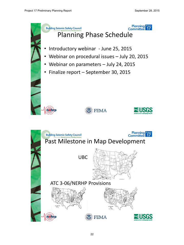
Planning Phase Schedule
• Introductory webinar - June 25, 2015
• Webinar on procedural issues – July 20, 2015
• Webinar on parameters – July 24, 2015
• Finalize report – September 30, 2015
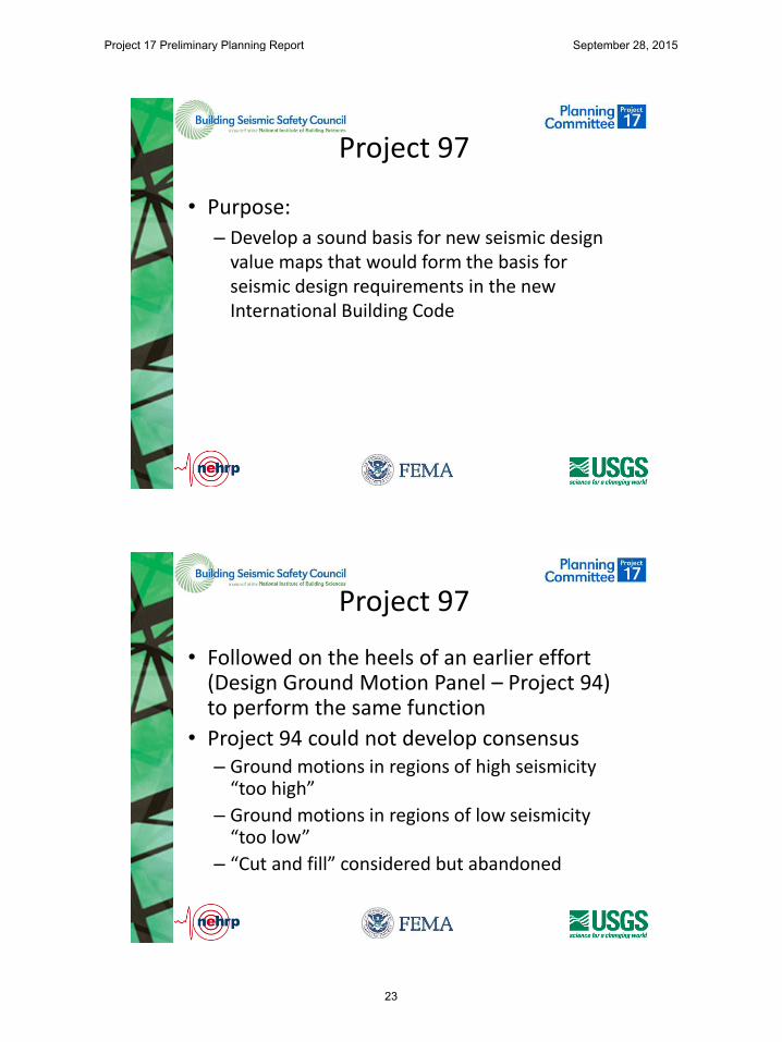
Past Milestone in Map Development
UBC
ATC 3-06/NERHP Provisions
Project 17 Preliminary Planning Report September 28, 2015
22
Project 97
• Purpose:
– Develop a sound basis for new seismic design value maps that would form the basis for seismic design requirements in the new International Building Code
Project 97
• Followed on the heels of an earlier effort (Design Ground Motion Panel – Project 94) to perform the same function
• Project 94 could not develop consensus – Ground motions in regions of high seismicity
“too high”
– Ground motions in regions of low seismicity “too low”
– “Cut and fill” considered but abandoned
Project 17 Preliminary Planning Report September 28, 2015
23

Project 97
• Joint BSSC/USGS panel (30 persons, numerous subcommittees) met over a period of two years to identify: – New earth science knowledge and its potential
application
– Means of providing adequate seismic protection for eastern and western U.S. regions
• USGS held series of regional workshops to obtain input from the earth science community
Major Achievements
• Introduction of MCE and DE shaking – MCE defined as 2%/50 year motion with deterministic caps – DE defined as 2/3 of MCE motion, adjusted for site class
effects
• Adoption of SDS and SD1 as primary seismic design parameters
• Introduction of MCE spectral parameter contour maps • Parsing of country into
– Probabilistic regions – Deterministic regions
• New design procedure tailored to use of the MCE maps
Project 17 Preliminary Planning Report September 28, 2015
24

Project 97 Maps
SS S1
Major Impacts
• Development by USGS of web-based applet to determine MCE and DE values for seismic hazard parameters
Project 17 Preliminary Planning Report September 28, 2015
25
Project 97 Effect
• Basis for:
– 1997 NEHRP Provisions
• ASCE 7-98, 7-02
• IBC-2000, 2003
• USGS developed updated design maps in 2002, using Project 97 criteria
– 2003 NEHRP Provisions
• ASCE 7-05
• IBC 2006, 2009
Project 07
• Purpose
– Determine how best to use the substantial advances in ground motion prediction made possible by the Next Generation Attenuation (NGA) project and other work by USGS and academia
Project 17 Preliminary Planning Report September 28, 2015
26
Project 07
• Smaller joint USGS/BSSC panel met over a period of 2 years to evaluate the impacts of adopting NGA on the seismic design values and how best to incorporate the updated science into design procedures
• Project 07 panel: – C.B. Crouse, James Harris, Ronald Hamburger,
William Holmes, John Hooper, Charles Kircher, E.V. Leyendecker, Nico Luco, Andrew Whittaker
– R.D. Hanson, Mike Mahoney
Major Achievements
• Adoption of NGA models for map development
• Development of Risk-Targeted Maximum Considered Earthquake Concept (MCER)
– Risk category II structures should have not less than a 10% chance of collapse given MCER shaking
– MCER shaking consists of:
• Ground motion resulting in a 1%-50 year collapse probability (for Risk Category II structures)
• Preservation of deterministic cap zones
Project 17 Preliminary Planning Report September 28, 2015
27

Major Achievements
• Adoption of “maximum direction” component definition of MCER and DE ground motions
Project 07 Effects
• Basis for: – 2009 NEHRP Provisions
– ASCE 7-10
– IBC 2012, 2015
• USGS developed updated design maps in 2014, using Project 07 criteria – 2014 NEHRP Provisions
– ASCE 7-16
– IBC 2018
Project 17 Preliminary Planning Report September 28, 2015
28
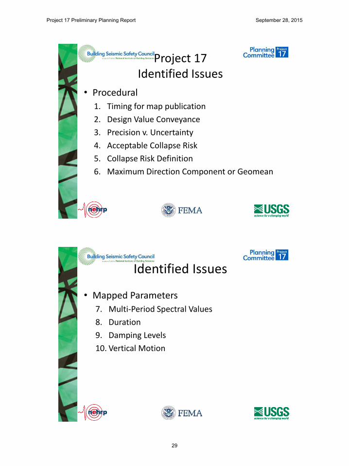
Project 17 Identified Issues
• Procedural
1. Timing for map publication
2. Design Value Conveyance
3. Precision v. Uncertainty
4. Acceptable Collapse Risk
5. Collapse Risk Definition
6. Maximum Direction Component or Geomean
Identified Issues
• Mapped Parameters
7. Multi-Period Spectral Values
8. Duration
9. Damping Levels
10. Vertical Motion
Project 17 Preliminary Planning Report September 28, 2015
29

Identified Issues
• Value Derivation
11. Deterministic Parameter Derivation
12. Basin Effects
13. Use of 3-D Numerical Simulation in Seismic Hazard Models
Timing for Map Publication
• From 1997 through 2003, USGS updated the seismic design value maps on a 3-year cycle – Timed to allow adoption in successive IBC editions
– Changes from map edition to edition were generally small
• Since 2003 USGS has gone to a 6-year cycle, coinciding with publication of ASCE-7 – Changes to maps tend to be more pronounced
– Little time is available for review and building consensus and acceptance of the new maps
Project 17 Preliminary Planning Report September 28, 2015
30
Design Value Conveyance
1991 1 Map
Design Value Conveyance
Project 17 Preliminary Planning Report September 28, 2015
31

Design Value Conveyance
• Maps for:
– 0 sec, 0.2 sec, 0.5 sed, 1 sec, 2sec, 2.5 sec, 3 sec….9 sec, 10sec.
– Vs30: <200m/s, 300m/s, 400 m/s, 500 m/s, 1000 m/s, >2000m/s
– Damping .5%, 2.5%, 5%, 10%, 15%, 20%, 25%
2022
Precision vs. Uncertainty
• Contours are in 0.05 g gradations
• Uncertainties are on the order of 0.6 or higher
Ss Contours Middle U.S.
Project 17 Preliminary Planning Report September 28, 2015
32

Acceptable Collapse Risk
• Collapse Risk =
– Probability of collapse given that MCE intensity occurs
X
– Probability that earthquake MCE will occur
Acceptable Collapse Risk
Project 17 Preliminary Planning Report September 28, 2015
33
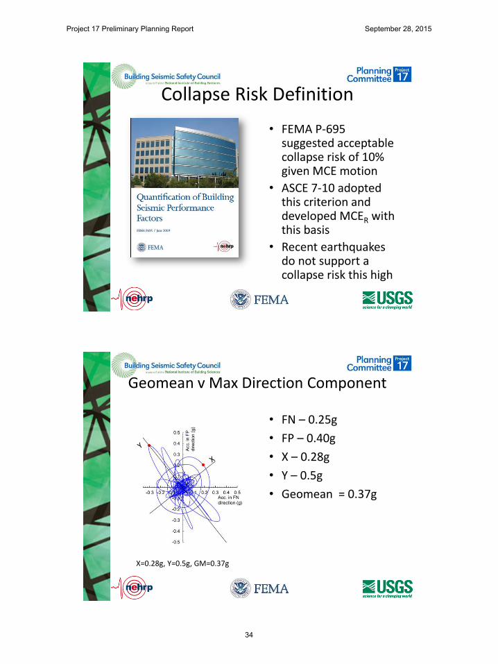
Collapse Risk Definition
• FEMA P-695 suggested acceptable collapse risk of 10% given MCE motion
• ASCE 7-10 adopted this criterion and developed MCER with this basis
• Recent earthquakes do not support a collapse risk this high
Geomean v Max Direction Component
• FN – 0.25g
• FP – 0.40g
• X – 0.28g
• Y – 0.5g
• Geomean = 0.37g
X=0.28g, Y=0.5g, GM=0.37g
Project 17 Preliminary Planning Report September 28, 2015
34

Multi Period Spectra
Acceleration Domain
Velocity Domain
Displacement Domain
SDS = 2/3 x SMS = 2/3 x Fa x Ss
TS = SD1/SDS
SD1 = 2/3 x SM1 = 2/3 x Fv x S1
Cs = SDS/(R/Ie)T ≤ Ts
Cs = SD1/T(R/Ie)Ts < T ≤ TL
0.0
0.2
0.4
0.6
0.8
1.0
1.2
1.4
1.6
1.8
2.0
2.2
0.1 1.0 10.0S
pect
ral A
ccel
erat
ion
(g)
Period (seconds)
84th percentile response spectra of an M8.0, strike-slip, earthquake at R = 5 km for Site Class A (1,520 mps), B (760 mps - Ss = 1.84g, S1 = 0.77g), C (530 mps), D (260 mps) and E (130 mps)
site conditions (2008 NGA relations)
A - Vs,30 = 1,520 mps
B - Vs,30 = 760 mps
C - Vs,30 = 530 mps
D - Vs,30 = 260 mps
E - Vs,30 = 130 mps
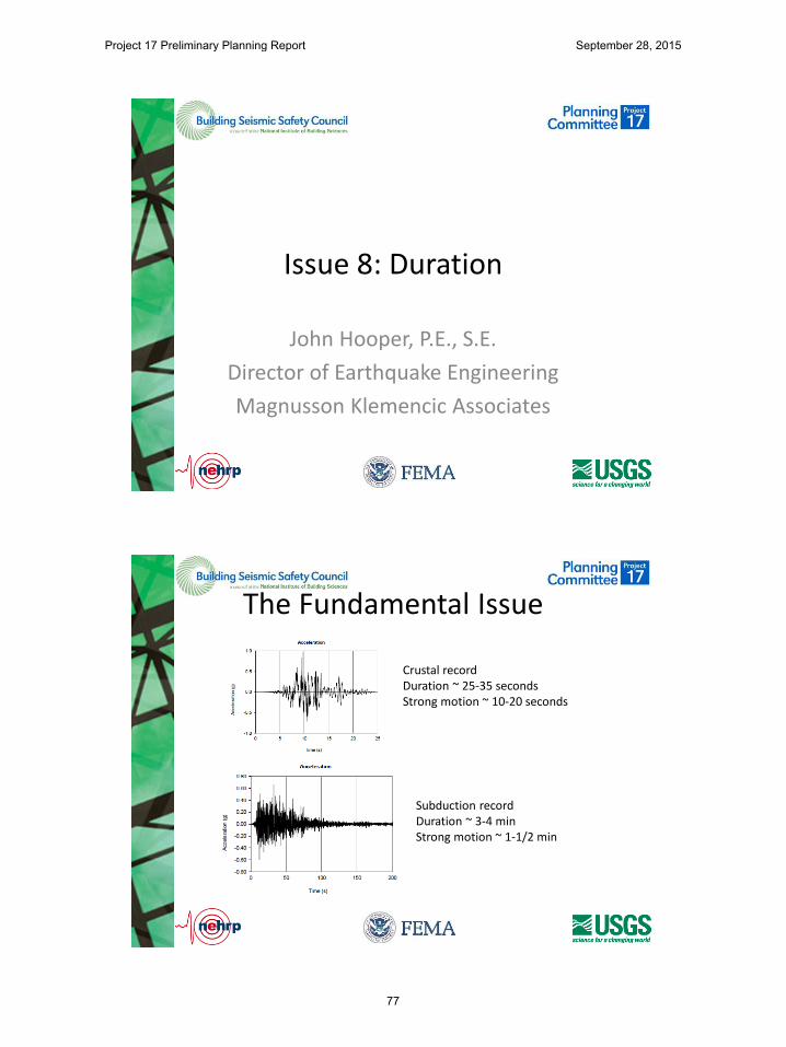
Duration
Crustal record duration ~ 25 seconds Strong motion ~ 10 seconds
Subduction record duration ~ 3-4 min Strong motion ~ 1-1/2 min.
Project 17 Preliminary Planning Report September 28, 2015
35
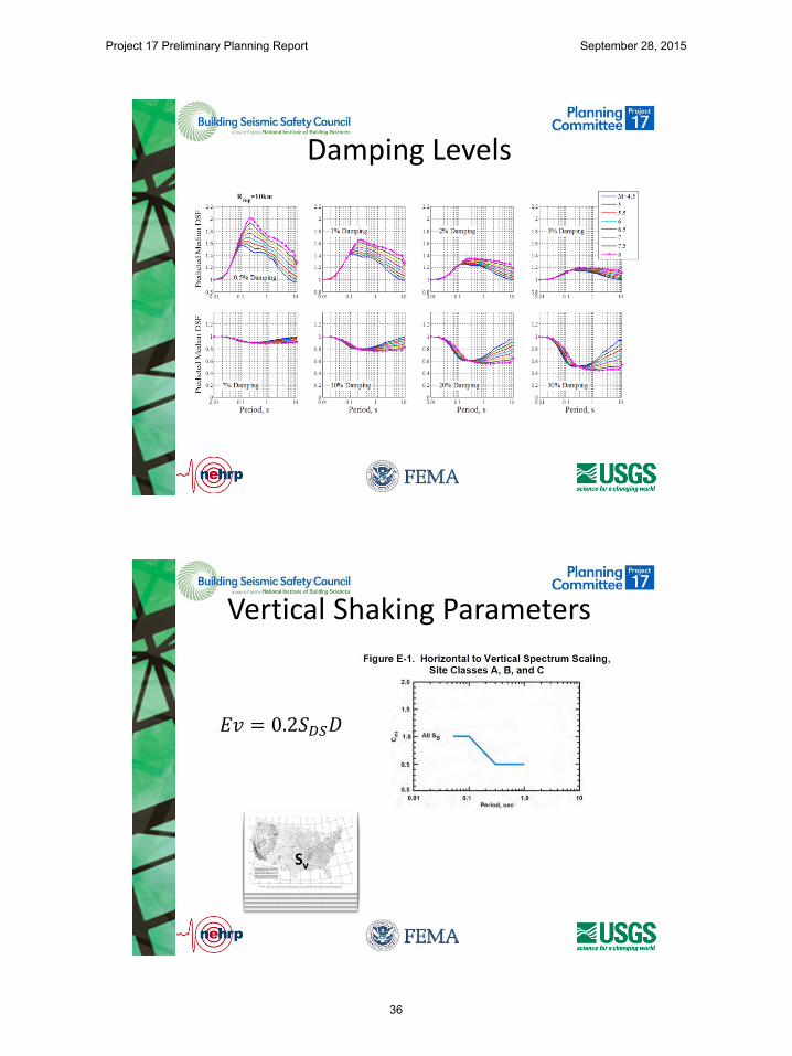
Damping Levels
Vertical Shaking Parameters
𝐸𝑣 = 0.2𝑆𝐷𝑆𝐷
Sv
Project 17 Preliminary Planning Report September 28, 2015
36
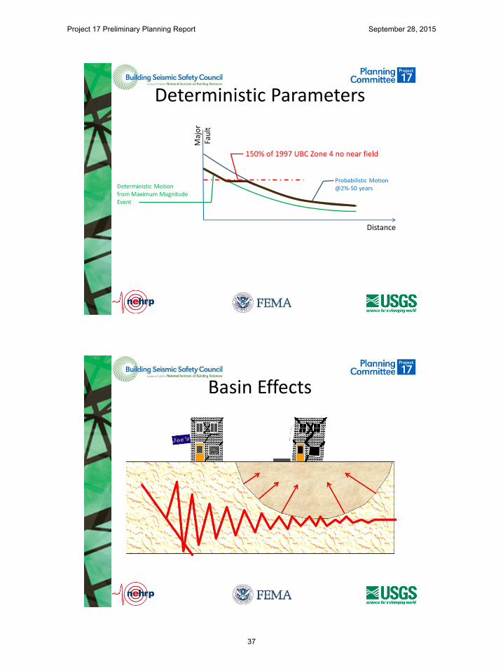
Deterministic Parameters
Maj
or
Fau
lt
Distance
Probabilistic Motion @2%-50 years Deterministic Motion
from Maximum Magnitude Event
150% of 1997 UBC Zone 4 no near field
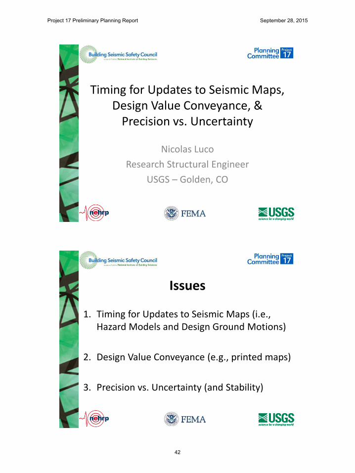
Basin Effects
Project 17 Preliminary Planning Report September 28, 2015
37

3D Simulation
How do I participate
• View detailed issue presentations
• Suggest additional issues or Provide Comment on Initial Issues
– Email to: [email protected] copy to: [email protected]
• Deadline for comment: August 1, 2015
Project 17 Preliminary Planning Report September 28, 2015
38

Questions
Project 17 Preliminary Planning Report September 28, 2015
39

July 20, 2015 Webinar
Project 17 Preliminary Planning Report September 28, 2015
40

Issues 1, 2 & 3
Project 17 Preliminary Planning Report September 28, 2015
41
Timing for Updates to Seismic Maps, Design Value Conveyance, &
Precision vs. Uncertainty
Nicolas Luco
Research Structural Engineer
USGS – Golden, CO
1. Timing for Updates to Seismic Maps (i.e., Hazard Models and Design Ground Motions)
2. Design Value Conveyance (e.g., printed maps)
3. Precision vs. Uncertainty (and Stability)
Issues
Project 17 Preliminary Planning Report September 28, 2015
42
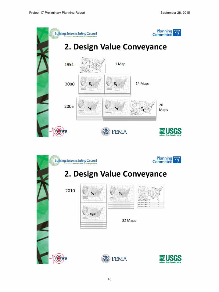
USGS NSHM NEHRP Provisions ASCE 7 Standard IBC
1996 1997, 2000 1998, 2002 2000, 20003
2002 2003 2005 2006, 2009
2008 2009 2010 2012, 2015
2014 2015 2016 2018
10
7-10
1. Timing for Updates
1. Timing for Updates • During development of 2015 Provisions, …
• “The updates are generating significant fluctuations in seismic design criteria. These fluctuations imply to the design community that criteria are being set without adequate rigor. The fluctuations also create significant hardship for building owners who make significant structural changes and find that a building adequate under a previous code become substantially inadequate under the new code. Further discussion of the overall seismic map direction and its impact on users is needed.”
• For next update of National Seismic Hazard Model, USGS is considering 2017 (3-yr cycle).
Project 17 Preliminary Planning Report September 28, 2015
43

1. Timing for Updates • After 2017, USGS debating whether to update
NSHM every 3 years.
• Pro – Reduced amount of modeling changes in each update.
• Pro – More frequent opportunities for external contributors to submit information.
• Con – More overhead, e.g., documentation.
• Con – Existence of “interim” updates not incorporated into NEHRP Provisions, etc.
1. Timing for Updates • Importance – Updated NSHM needed for
several other potential Project 17 issues (e.g., multi-period spectra), so timing must be coordinated between USGS, its external contributors, and NEHRP Provisions.
• Risks – Only of not coordinating.
• Resources – Small issue team of managers, web conferences.
• Schedule – Beginning of Project ‘17.
Project 17 Preliminary Planning Report September 28, 2015
44
2. Design Value Conveyance
2. Design Value Conveyance
Project 17 Preliminary Planning Report September 28, 2015
45
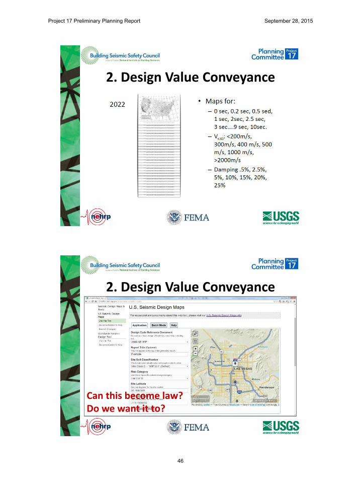
2. Design Value Conveyance
2. Design Value Conveyance
Can this become law? Do we want it to?
Project 17 Preliminary Planning Report September 28, 2015
46
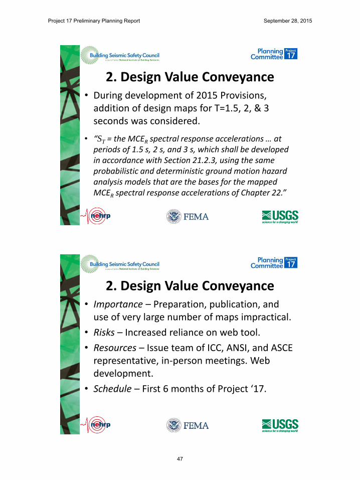
2. Design Value Conveyance • During development of 2015 Provisions,
addition of design maps for T=1.5, 2, & 3 seconds was considered.
• “ST = the MCER spectral response accelerations … at periods of 1.5 s, 2 s, and 3 s, which shall be developed in accordance with Section 21.2.3, using the same probabilistic and deterministic ground motion hazard analysis models that are the bases for the mapped MCER spectral response accelerations of Chapter 22.”
2. Design Value Conveyance • Importance – Preparation, publication, and
use of very large number of maps impractical.
• Risks – Increased reliance on web tool.
• Resources – Issue team of ICC, ANSI, and ASCE representative, in-person meetings. Web development.
• Schedule – First 6 months of Project ‘17.
Project 17 Preliminary Planning Report September 28, 2015
47

3. Precision vs. Uncertainty
3. Precision vs. Uncertainty
Project 17 Preliminary Planning Report September 28, 2015
48

3. Precision vs. Uncertainty
3. Precision vs. Uncertainty
Project 17 Preliminary Planning Report September 28, 2015
49
3. Precision vs. Uncertainty
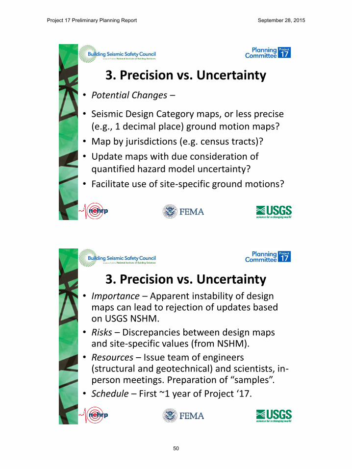
• Potential Changes –
• Seismic Design Category maps, or less precise (e.g., 1 decimal place) ground motion maps?
• Map by jurisdictions (e.g. census tracts)?
• Update maps with due consideration of quantified hazard model uncertainty?
• Facilitate use of site-specific ground motions?
3. Precision vs. Uncertainty • Importance – Apparent instability of design
maps can lead to rejection of updates based on USGS NSHM.
• Risks – Discrepancies between design maps and site-specific values (from NSHM).
• Resources – Issue team of engineers (structural and geotechnical) and scientists, in-person meetings. Preparation of “samples”.
• Schedule – First ~1 year of Project ‘17.
Project 17 Preliminary Planning Report September 28, 2015
50

1. Timing for Updates to Seismic Maps (i.e., Hazard Models and Design Ground Motions)
2. Design Value Conveyance (e.g., printed maps)
3. Precision vs. Uncertainty (and Stability)
Issues
Project 17 Preliminary Planning Report September 28, 2015
51

Issue 4
Project 17 Preliminary Planning Report September 28, 2015
52

Issue 4: Acceptable Collapse Risk
Robert Pekelnicky, SE
Overview • This issue focuses on absolute risk target
of 1% collapse risk in 50 years where the probabilistic, risk targeted hazard parameters govern.
• In regions where the deterministic hazard governs over the probabilistic, the absolute risk of collapse is greater than 1%.
Project 17 Preliminary Planning Report September 28, 2015
53
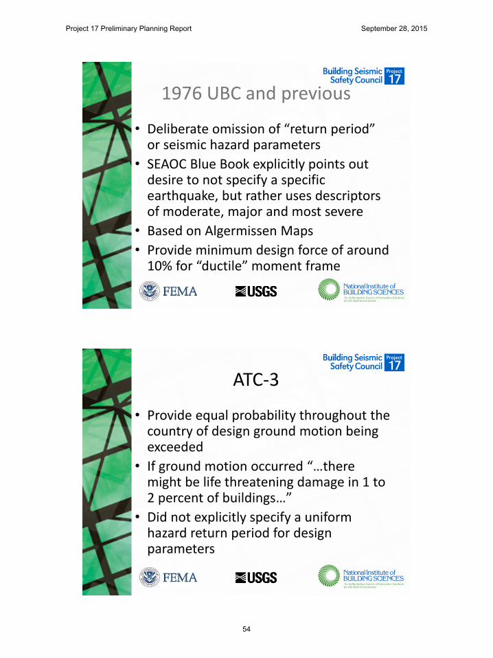
1976 UBC and previous
• Deliberate omission of “return period” or seismic hazard parameters
• SEAOC Blue Book explicitly points out desire to not specify a specific earthquake, but rather uses descriptors of moderate, major and most severe
• Based on Algermissen Maps
• Provide minimum design force of around 10% for “ductile” moment frame
ATC-3
• Provide equal probability throughout the country of design ground motion being exceeded
• If ground motion occurred “…there might be life threatening damage in 1 to 2 percent of buildings…”
• Did not explicitly specify a uniform hazard return period for design parameters
Project 17 Preliminary Planning Report September 28, 2015
54
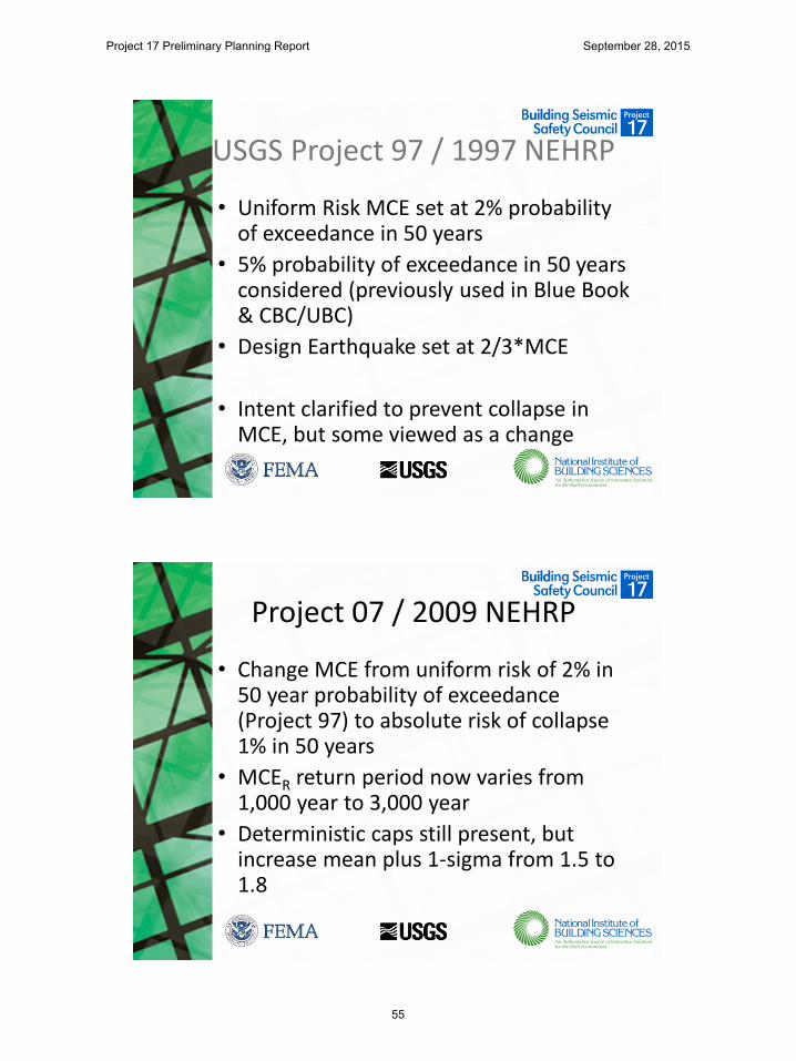
USGS Project 97 / 1997 NEHRP
• Uniform Risk MCE set at 2% probability of exceedance in 50 years
• 5% probability of exceedance in 50 years considered (previously used in Blue Book & CBC/UBC)
• Design Earthquake set at 2/3*MCE
• Intent clarified to prevent collapse in MCE, but some viewed as a change
Project 07 / 2009 NEHRP
• Change MCE from uniform risk of 2% in 50 year probability of exceedance (Project 97) to absolute risk of collapse 1% in 50 years
• MCER return period now varies from 1,000 year to 3,000 year
• Deterministic caps still present, but increase mean plus 1-sigma from 1.5 to 1.8
Project 17 Preliminary Planning Report September 28, 2015
55

0 1 2 3 4 5 6 7 8 9 10 11 12 13 14 15 16 17 18 19 20 21 22 23 24 25 26 27 28 29 30 31 32 33 34 350.005
0.01
0.015
0.02
0.025
0.03
0.035
0.04
0.045
0.05
0.055
2%-50yr
City Sequence #
Pro
babili
ty o
f C
olla
pse in 5
0yrs
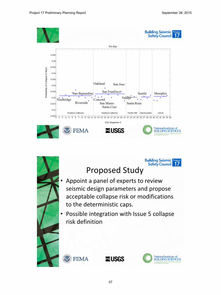
Southern California Northern California Pacific NW Intermountain CEUS
Collapse Risk w/ Uniform Hazard
Northridge Riverside
San Bernardino
San Jose
Concord
San Francisco
San Mateo Santa Cruz
Vallejo
Santa Rosa
Seattle Memphis
0 1 2 3 4 5 6 7 8 9 10 11 12 13 14 15 16 17 18 19 20 21 22 23 24 25 26 27 28 29 30 31 32 33 34 350.005
0.01
0.015
0.02
0.025
0.03
0.035
0.04
0.045
0.05
0.055
MCER
City Sequence #
Pro
babili
ty o
f C
olla
pse in 5
0yrs
Southern California Northern California Pacific NW Intermountain CEUS
Northridge Riverside
San Bernardino
Oakland San Jose
Concord
San Francisco
San Mateo Santa Cruz
Vallejo
Santa Rosa
Collapse Risk of MCER
Seattle Memphis
Project 17 Preliminary Planning Report September 28, 2015
56
0 1 2 3 4 5 6 7 8 9 10 11 12 13 14 15 16 17 18 19 20 21 22 23 24 25 26 27 28 29 30 31 32 33 34 350.005
0.01
0.015
0.02
0.025
0.03
0.035
0.04
0.045
0.05
0.055
5%-50yr
City Sequence #
Pro
babili
ty o
f C
olla
pse in 5
0yrs
Southern California Northern California Pacific NW Intermountain CEUS
Northridge Riverside
San Bernardino
Oakland San Jose
Concord
San Francisco
San Mateo Santa Cruz
Vallejo
Santa Rosa
Seattle Memphis
Proposed Study • Appoint a panel of experts to review
seismic design parameters and propose acceptable collapse risk or modifications to the deterministic caps.
• Possible integration with Issue 5 collapse risk definition
Project 17 Preliminary Planning Report September 28, 2015
57
Risks
• Major changes to the absolute risk to collapse or the deterministic caps may cause significant sways in the seismic design forces and seismic design category assignments for many regions.
Project 17 Preliminary Planning Report September 28, 2015
58

Issue 5
Project 17 Preliminary Planning Report September 28, 2015
59
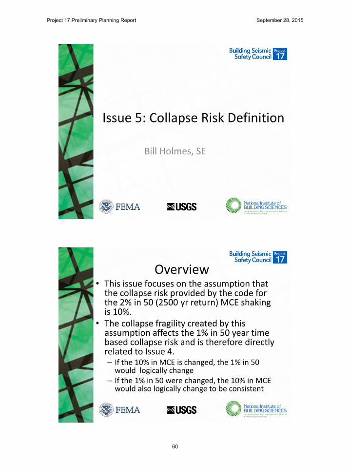
Issue 5: Collapse Risk Definition
Bill Holmes, SE
Overview • This issue focuses on the assumption that
the collapse risk provided by the code for the 2% in 50 (2500 yr return) MCE shaking is 10%.
• The collapse fragility created by this assumption affects the 1% in 50 year time based collapse risk and is therefore directly related to Issue 4. – If the 10% in MCE is changed, the 1% in 50
would logically change – If the 1% in 50 were changed, the 10% in MCE
would also logically change to be consistent
Project 17 Preliminary Planning Report September 28, 2015
60
Relationship to FEMA P 695 • FEMA P 695 was developed as a standardized means
of establishing design coefficients (primary R factors) for structural systems proposed for adoption into the code, and secondarily, making existing systems more consistent
• The acceptance criteria was set based on analyses of several traditional structural systems. However, definition of collapse in these analyses is limited, and, in addition, several conservative assumptions are made.
• P 695 succeeds in providing more consistent R factors but was not intended to establish the probable risk of collapse of code complying buildings
Use of P(C)=10% in Risk Targeted Maps
• Regardless of the intent of P 695, the 10% probability of collapse in MCE was used to set collapse fragilities for development of risk targeted maps.
• Based on observations of earthquake damage and the opinion of at least some experienced earthquake engineers, this probability of collapse is high, certainly for “average” conditions.
Project 17 Preliminary Planning Report September 28, 2015
61
Proposed Study • Appoint a panel of experts to review
available data (from field and analysis) and set a different (expected to be lower) probable collapse risk resulting from use of traditional modern U.S. codes.
Risks • Current analysis methods to predict
collapse (particularly the large number of runs and conditions to get statistical results) are not available.
• Very little statistical damage data from earthquakes, particularly regarding collapse and US modern construction practice, is available.
• A new expected performance level would probably be set by expert judgement.
Project 17 Preliminary Planning Report September 28, 2015
62

Risks
• A new expected performance level would cascade through the risk targeting mapping procedure, potentially making many changes to mapped values, further exacerbating the map “instability” discussed in Issue 3.
Project 17 Preliminary Planning Report September 28, 2015
63

Issue 6
Project 17 Preliminary Planning Report September 28, 2015
64

Project 17 Development of Next-Generation
Seismic Design Value Maps Issue Webinar
Maximum Direction Motions
Ronald O. Hamburger, SE, SECB Senior Principal
Simpson Gumpertz & Heger Inc.
Chair Project 17 Planning Committee
GMPEs (or attenuation relationships)
• GMPEs, statistical “fits” of recorded ground motion data to various parameters are a key input to seismic hazard analysis
• The data can be organized in different ways, and give different answers
Project 17 Preliminary Planning Report September 28, 2015
65

Typical Recordings
• Two data points for each instrument
– Treat independently
– Combine as SRSS
– Combine as geomean
– Compute at each azimuth and take a statistic (Rot-50. Rot-90, etc)
– Max direction
1994 Northridge Earthquake Santa Monica City Hall
90o and 360o compoonents
Ground Motion Directionality • Prior to 2007, most Ground
Motion Prediction Models used “geomean”
• For this motion: X=0.28g, Y=0.5g, GM=0.37g
• The Project 07 team felt geomean had no particular relevance and felt more comfortable with a max direction definition as being more consistent with designing for a target probability of collapse
4
𝑆𝑎−𝑔𝑚 = 𝑆𝑎−𝑋 𝑆𝑎−𝑌
Project 17 Preliminary Planning Report September 28, 2015
66
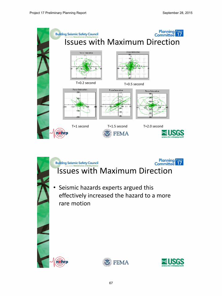
Issues with Maximum Direction
T=1 second T=1.5 second T=2.0 second
T=0.5 second T=0.2 second
Issues with Maximum Direction
• Seismic hazards experts argued this effectively increased the hazard to a more rare motion
Project 17 Preliminary Planning Report September 28, 2015
67
Potential Resolutions
• Retain maximum direction
• Use geomean or other measure
• Apply a “direction” coefficient similar to wind loads, to account for the probability that maximum direction will align with a building’s vulnerable direction
Project 17 Preliminary Planning Report September 28, 2015
68

July 27, 2015 Webinar
Project 17 Preliminary Planning Report September 28, 2015
69

Issue 7
Project 17 Preliminary Planning Report September 28, 2015
70

Charlie Kircher Kircher & Associates Palo Alto, California
Multi-Period Spectra
Design Response Spectrum (Figure 11.4-1, ASCE 7-10 with annotation)
Acceleration Domain
Velocity Domain
Displacement Domain
SDS = 2/3 x SMS = 2/3 x Fa x Ss
TS = SD1/SDS
SD1 = 2/3 x SM1 = 2/3 x Fv x S1
Cs = SDS/(R/Ie)
T ≤ Ts
Cs = SD1/T(R/Ie)
Ts < T ≤ TL
Project 17 Preliminary Planning Report September 28, 2015
71
Example ELF “Design Spectrum” based on ASCE 7-16 Criteria
M7.0 earthquake ground motions at RX = 6.5 km, Site Class C
0.0
0.2
0.4
0.6
0.8
1.0
1.2
1.4
1.6
1.8
2.0
2.2
2.4
2.6
0.1 1.0 10.0
Res
pons
e Sp
ectra
l Acc
eler
tatio
n (g
)
Period (seconds)
MCEr Multi-Period Response Spectrum - Site Class BCMCEr Multi-Period Response Spectrum - Site Class CDesign Multi-Period Response Spectrum - Site Class CELF Design Spectrum (Cs x R/Ie) - Current ASCE 7-16 Criteria
Example ELF “Design Spectrum” based on ASCE 7-16 Criteria
M7.0 earthquake ground motions at RX = 6.5 km, Site Class D
0.0
0.2
0.4
0.6
0.8
1.0
1.2
1.4
1.6
1.8
2.0
2.2
2.4
2.6
0.1 1.0 10.0
Res
pons
e Sp
ectra
l Acc
eler
tatio
n (g
)
Period (seconds)
MCEr Multi-Period Response Spectrum - Site Class BCMCEr Multi-Period Response Spectrum - Site Class DDesign Multi-Period Response Spectrum - Site Class DELF Design Spectrum (Cs x R/Ie) - Current ASCE 7-16 Criteria
Project 17 Preliminary Planning Report September 28, 2015
72
Example ELF “Design Spectrum” based on ASCE 7-16 Criteria
M7.0 earthquake ground motions at RX = 6.5 km, Site Class E
0.0
0.2
0.4
0.6
0.8
1.0
1.2
1.4
1.6
1.8
2.0
2.2
2.4
2.6
0.1 1.0 10.0
Res
pons
e Sp
ectra
l Acc
eler
tatio
n (g
)
Period (seconds)
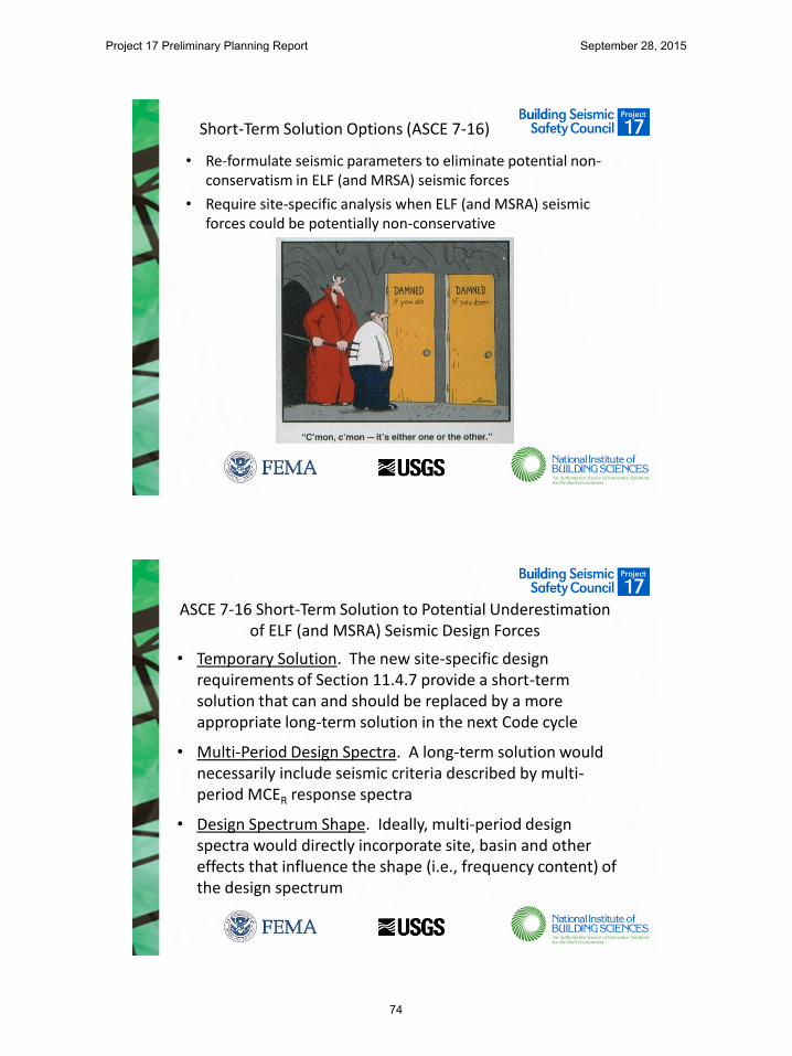
MCEr Multi-Period Response Spectrum - Site Class BCMCEr Multi-Period Response Spectrum - Site Class EDesign Multi-Period Response Spectrum - Site Class EELF Design Spectrum (Cs x R/Ie) - Current ASCE 7-16 Criteria
Root Cause of the “Problem”
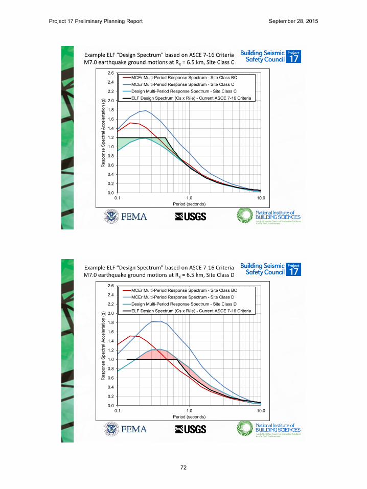
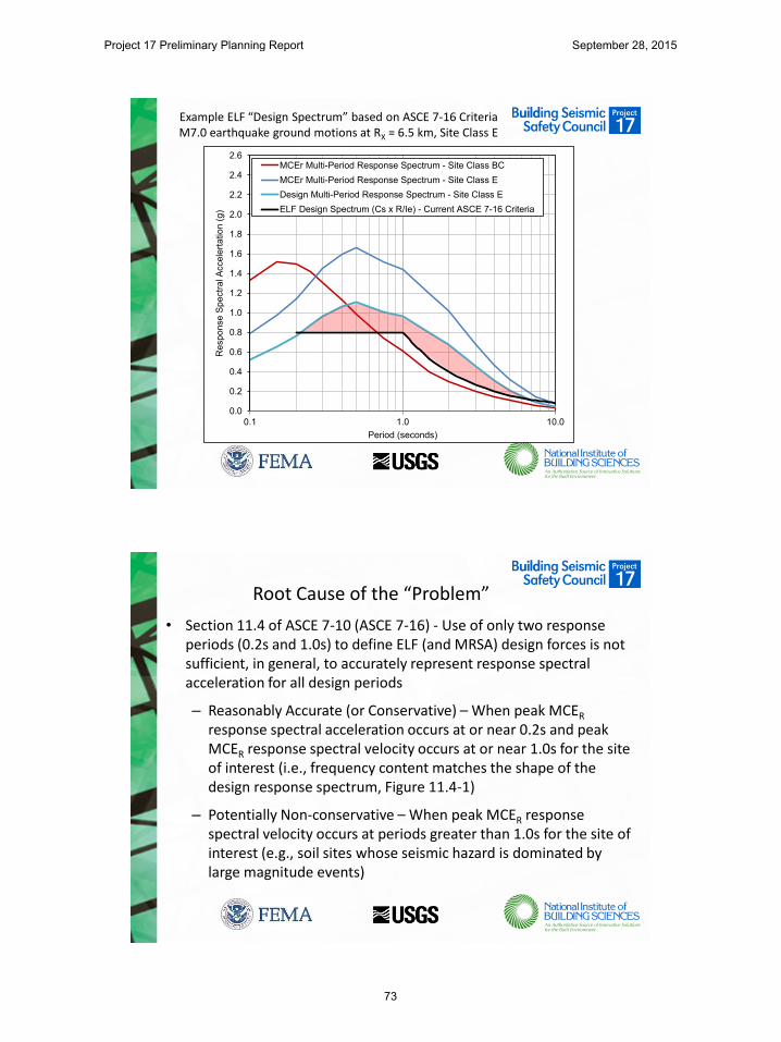
• Section 11.4 of ASCE 7-10 (ASCE 7-16) - Use of only two response periods (0.2s and 1.0s) to define ELF (and MRSA) design forces is not sufficient, in general, to accurately represent response spectral acceleration for all design periods
– Reasonably Accurate (or Conservative) – When peak MCER response spectral acceleration occurs at or near 0.2s and peak MCER response spectral velocity occurs at or near 1.0s for the site of interest (i.e., frequency content matches the shape of the design response spectrum, Figure 11.4-1)
– Potentially Non-conservative – When peak MCER response spectral velocity occurs at periods greater than 1.0s for the site of interest (e.g., soil sites whose seismic hazard is dominated by large magnitude events)
Project 17 Preliminary Planning Report September 28, 2015
73
Short-Term Solution Options (ASCE 7-16)
• Re-formulate seismic parameters to eliminate potential non-conservatism in ELF (and MRSA) seismic forces
• Require site-specific analysis when ELF (and MSRA) seismic forces could be potentially non-conservative
ASCE 7-16 Short-Term Solution to Potential Underestimation of ELF (and MSRA) Seismic Design Forces
• Temporary Solution. The new site-specific design requirements of Section 11.4.7 provide a short-term solution that can and should be replaced by a more appropriate long-term solution in the next Code cycle
• Multi-Period Design Spectra. A long-term solution would necessarily include seismic criteria described by multi-period MCER response spectra
• Design Spectrum Shape. Ideally, multi-period design spectra would directly incorporate site, basin and other effects that influence the shape (i.e., frequency content) of the design spectrum
Project 17 Preliminary Planning Report September 28, 2015
74

Summary of Multi-Period Spectra Issue
• Develop and adopt multi-period design spectrum approach
– Tentative Framework for the Development of Advanced Seismic Design Criteria for New Buildings – NIST GCR 12-917-20
• Risks - Multi-period spectrum approach would require:
– Major reworking of seismic design requirements and criteria now based on two response periods (e.g., Tables 11.6-1/2, Seismic Design Categories, etc.)
– Development of new ground motion design values maps (by the USGS) for each new response period of interest
– Development of new site factor tables for each new response period of interest (or site effects embedded directly in ground motion design values maps)
• Resources – Major, multi-year projects by USGS and a Seismic Code-development team(s)
Project 17 Preliminary Planning Report September 28, 2015
75

Issue 8
Project 17 Preliminary Planning Report September 28, 2015
76
Issue 8: Duration
John Hooper, P.E., S.E.
Director of Earthquake Engineering
Magnusson Klemencic Associates
The Fundamental Issue
Crustal record Duration ~ 25-35 seconds Strong motion ~ 10-20 seconds
Subduction record Duration ~ 3-4 min Strong motion ~ 1-1/2 min
Project 17 Preliminary Planning Report September 28, 2015
77
Current Design Procedures
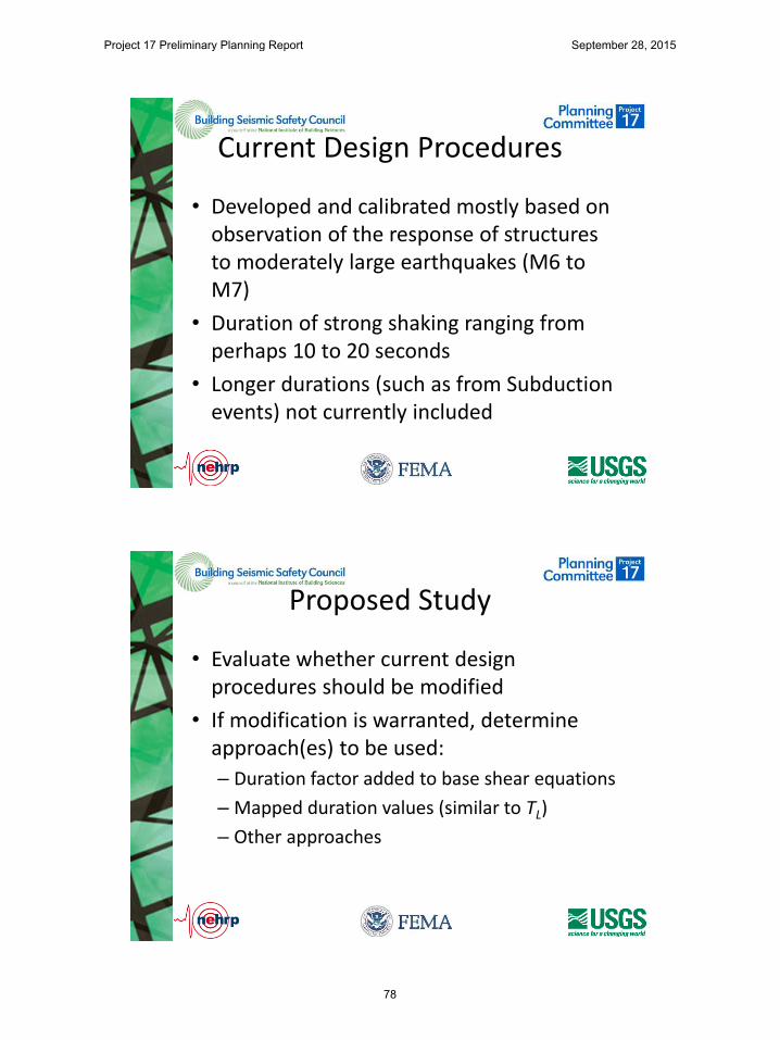
• Developed and calibrated mostly based on observation of the response of structures to moderately large earthquakes (M6 to M7)
• Duration of strong shaking ranging from perhaps 10 to 20 seconds
• Longer durations (such as from Subduction events) not currently included
Proposed Study
• Evaluate whether current design procedures should be modified
• If modification is warranted, determine approach(es) to be used:
– Duration factor added to base shear equations
– Mapped duration values (similar to TL)
– Other approaches
Project 17 Preliminary Planning Report September 28, 2015
78

Risks
• Present technology and test data may not be adequate to allow proper characterization of the effects of duration
• May required use of subjective criteria in the near team until better capability and data is available
Importance
• Current design procedures may not provide targeted safety for buildings subjected to very long duration motions
Project 17 Preliminary Planning Report September 28, 2015
79

Resources • Research to evaluate behavior of buildings
designed to present code requirements, when subjected to very long duration motion
• As a minimum, literature review to determine – Availability of hysteretic data based on “long
duration” shaking
– Appropriateness of analytical modeling to predict the long duration effects
• If hysteretic data is not available, testing of components would be required
Schedule
• If long duration hysteretic response data is available
– ~2 years of study would be required to develop recommendations
• If data is not available
– ~3-5 years would be required
Project 17 Preliminary Planning Report September 28, 2015
80

Issue 9
Project 17 Preliminary Planning Report September 28, 2015
81
Alternative Damping Levels
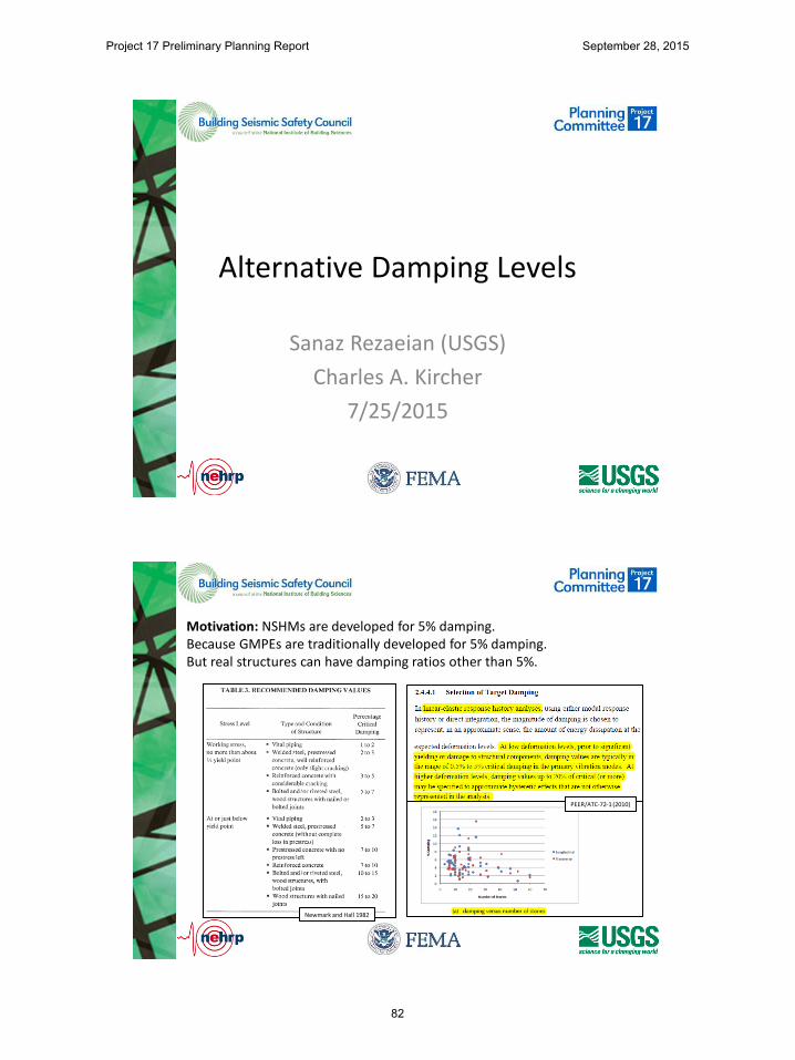
Sanaz Rezaeian (USGS)
Charles A. Kircher
7/25/2015
Motivation: NSHMs are developed for 5% damping. Because GMPEs are traditionally developed for 5% damping. But real structures can have damping ratios other than 5%.
𝐷𝑆𝐹𝑊 =𝑃𝑆𝐴 (𝛽)
𝑃𝑆𝐴 (5%)
Newmark and Hall 1982
PEER/ATC-72-1 (2010)
Project 17 Preliminary Planning Report September 28, 2015
82
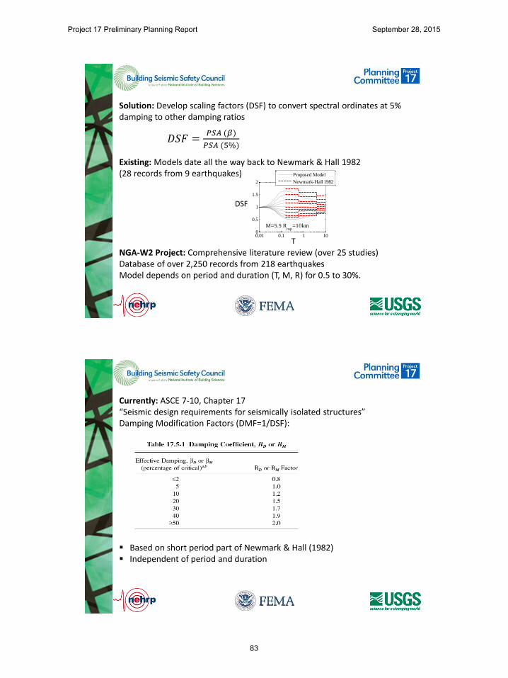
Solution: Develop scaling factors (DSF) to convert spectral ordinates at 5% damping to other damping ratios
Existing: Models date all the way back to Newmark & Hall 1982 (28 records from 9 earthquakes)
NGA-W2 Project: Comprehensive literature review (over 25 studies) Database of over 2,250 records from 218 earthquakes Model depends on period and duration (T, M, R) for 0.5 to 30%.
𝐷𝑆𝐹 =𝑃𝑆𝐴 (𝛽)
𝑃𝑆𝐴 (5%)
0.01 0.1 1 100
0.5
1
1.5
2
Med
ian
DS
F
M=5.5 Rrup
=5km
0.01 0.1 1 100
0.5
1
1.5
2
M=5.5 Rrup
=10km
Proposed Model
Newmark-Hall 1982
0.01 0.1 1 100
0.5
1
1.5
2
Med
ian
DS
F
M=6.5 Rrup
=5km
0.01 0.1 1 100
0.5
1
1.5
2
M=6.5 Rrup
=10km
0.01 0.1 1 100
0.5
1
1.5
2
Period, s
Med
ian
DS
F
M=7.5 Rrup
=5km
0.01 0.1 1 100
0.5
1
1.5
2
Period, s
M=7.5 Rrup
=10km
DSF
T
Currently: ASCE 7-10, Chapter 17 “Seismic design requirements for seismically isolated structures” Damping Modification Factors (DMF=1/DSF): Based on short period part of Newmark & Hall (1982) Independent of period and duration
Project 17 Preliminary Planning Report September 28, 2015
83

From top to bottom: New model is for β=0.5,1,2,3,5,7,10,15,20,25,30% Newmark&Hall (1982) is for β=0.5,1,2,3,5,7,10,15,20%
Variation with Period: significant variation between 0.2 to 7 sec ASCE 7 factors not accurate (unconservative) for longer periods
0.01 0.1 1 10 0.8
1
1.2
1.4
1.6
1.8
2
2.2
Pre
dic
ted M
edia
n D
SF
Rrup
=10km
0.5% Damping
0.01 0.1 1 10 0.8
1
1.2
1.4
1.6
1.8
2
2.2
1% Damping
0.01 0.1 1 10 0.8
1
1.2
1.4
1.6
1.8
2
2.2
2% Damping
0.01 0.1 1 10 0.8
1
1.2
1.4
1.6
1.8
2
2.2
3% Damping
M=4.5
5
5.5
6
6.5
7
7.5
8
0.01 0.1 1 10 0
0.2
0.4
0.6
0.8
1
1.2
Period, s
Pre
dic
ted M
edia
n D
SF
7% Damping
0.01 0.1 1 10 0
0.2
0.4
0.6
0.8
1
1.2
Period, s
10% Damping
0.01 0.1 1 10 0
0.2
0.4
0.6
0.8
1
1.2
Period, s
20% Damping
0.01 0.1 1 10 0
0.2
0.4
0.6
0.8
1
1.2
Period, s
30% Damping
Variation with Magnitude (Duration): Can be significant at long periods
Project 17 Preliminary Planning Report September 28, 2015
84
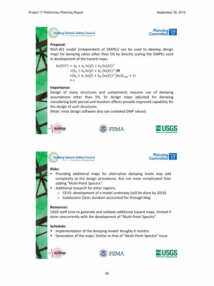
Proposal: NGA-W2 model (independent of GMPEs) can be used to develop design maps for damping ratios other than 5% by directly scaling the GMPEs used in development of the hazard maps. Importance: Design of many structures and components requires use of damping assumptions other than 5%. So design maps adjusted for damping considering both period and duration effects provide improved capability for the design of such structures. (Note: most design software also use outdated DMF values)
ln 𝐷𝑆𝐹 = 𝑏0 + 𝑏1 ln 𝛽 + 𝑏2(ln 𝛽 )2
+ 𝑏3 + 𝑏4 ln 𝛽 + 𝑏5 (ln 𝛽 )2 𝐌
+ 𝑏6 + 𝑏7 ln 𝛽 + 𝑏8 (ln 𝛽 )2 ln(𝑅𝑟𝑢𝑝 + 1)
+ 𝜖
Risks: Providing additional maps for alternative damping levels may add
complexity to the design procedures. But not more complicated than adding “Multi-Point Spectra”.
Additional research for other regions: o CEUS: development of a model underway (will be done by 2016) o Subduction Zone: duration accounted for through Mag
Resources: USGS staff time to generate and validate additional hazard maps, limited if done concurrently with the development of “Multi-Point Spectra”. Schedule: Implementation of the damping model: Roughly 6 months Generation of the maps: Similar to that of “Multi-Point Spectra” Issue
Project 17 Preliminary Planning Report September 28, 2015
85

Issue 10
Project 17 Preliminary Planning Report September 28, 2015
87

Issue 10: Vertical Shaking
John Hooper, P.E., S.E.
Director of Earthquake Engineering
Magnusson Klemencic Associates
Current Design Approach
• For Buildings and most nonbuilding structures, vertical shaking accounted for using:
Project 17 Preliminary Planning Report September 28, 2015
88
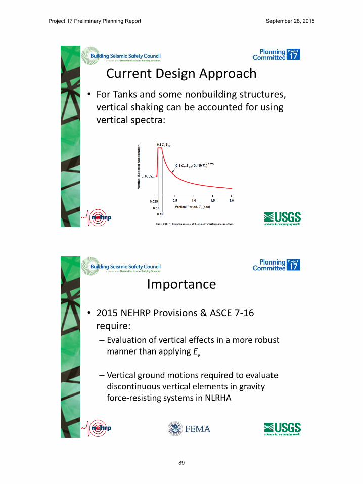
Current Design Approach
• For Tanks and some nonbuilding structures, vertical shaking can be accounted for using vertical spectra:
Importance
• 2015 NEHRP Provisions & ASCE 7-16 require:
– Evaluation of vertical effects in a more robust manner than applying Ev
– Vertical ground motions required to evaluate discontinuous vertical elements in gravity force-resisting systems in NLRHA
Project 17 Preliminary Planning Report September 28, 2015
89
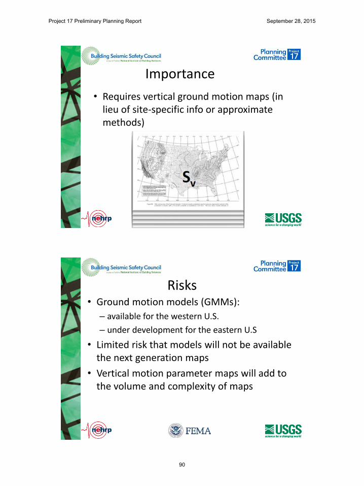
Importance
• Requires vertical ground motion maps (in lieu of site-specific info or approximate methods)
Risks • Ground motion models (GMMs):
– available for the western U.S.
– under development for the eastern U.S
• Limited risk that models will not be available the next generation maps
• Vertical motion parameter maps will add to the volume and complexity of maps
Project 17 Preliminary Planning Report September 28, 2015
90
Resources • Development of vertical ground motion maps
is a USGS effort
– needs to be included in their work plan
• PUC (and an associated IT) needs to develop the necessary requirements to include in the 2020 NEHRP Provisions.
Schedule
• Once the vertical ground motion maps are complete:
– will take ~12 months to develop the associated design requirements
• Work could be done in parallel once the basic framework of the USGS product is defined
Project 17 Preliminary Planning Report September 28, 2015
91

Issue 11
Project 17 Preliminary Planning Report September 28, 2015
92

Charlie Kircher Kircher & Associates Palo Alto, California
Use and Definition of Deterministic Parameters
Summary Definition of Deterministic MCER Ground Motions (Section 21.2.2)
• 5%-damped response spectral acceleration, maximum direction response at the period of interest (e.g. 0.2s and 1.0s for defining values of SMS and SM1)
• Largest response of characteristic (?) earthquakes on all known active faults within the region
• 84th percentile response (e.g., 1.8 x median response)
• Not less than “lower limit” (plateau region) based on design spectrum shape (Fig. 21.2-1) shape anchored to:
– SMS = 1.5Fa at short-periods (SS = 1.5) and
– SM1 = 0.6Fv at a period of 1-second (S1 = 0.6)
Project 17 Preliminary Planning Report September 28, 2015
93

0
0.2
0.4
0.6
0.8
1
1.2
1.4
1.6
1 10 100 1000
Source Distance (km)
Sp
ec
tra
l A
cc
ele
rati
on
(g
)
2/3 x Probabilistic [2% in 50 years]
2/3 x 1.5 x Deterministic [Median Mmax]
2/3 x 1.5 x 1994 UBC (S1)1994 UBC (S1) - - - 1997 UBC (SB) 1
-Se
con
d S
pe
ctra
l Acc
ele
rati
on
(g)
Notional Illustration of Design Earthquake (Project 97)
UBC Zone 4
Probabilistic (Mod./Low Seismicity)
Deterministic (Near-Source)
0
0.2
0.4
0.6
0.8
1
1.2
1.4
1.6
1 10 100 1000
Source Distance (km)
Sp
ec
tra
l A
cc
ele
rati
on
(g
)
2/3 x Probabilistic [2% in 50 years]
2/3 x 1.5 x Deterministic [Median Mmax]
2/3 x 1.5 x 1994 UBC (S1)1994 UBC (S1) - - - 1997 UBC (SB)
1-S
eco
nd
Sp
ect
ral A
cce
lera
tio
n (
g)
Notional Illustration of Design Earthquake (Project 97)
UBC Zone 4
Probabilistic (Mod./Low Seismicity)
Deterministic (Near-Source)
(Project ’07)
1% in 50-year risk
1.8
Max
imu
m D
ire
ctio
n
Project 17 Preliminary Planning Report September 28, 2015
94
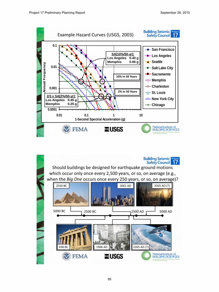
Example Hazard Curves (USGS, 2003)
0.0001
0.001
0.01
0.1
0.01 0.1 1 101-Second Spectral Acceleration (g)
An
nu
al F
req
ue
ncy
San Francisco
Los Angeles
Seattle
Salt Lake City
Sacramento
Memphis
Charleston
St. Louis
New York City
Chicago
10% in 50 Years
2% in 50 Years
SA[10%/50-yr]:
Los Angeles 0.40 g
Memphis 0.06 g
2/3 x SA[2%/50-yr]:
Los Angeles 0.45 g
Memphis 0.25 g
Should buildings be designed for earthquake ground motions which occur only once every 2,500 years, or so, on average (e.g.,
when the Big One occurs once every 250 years, or so, on average)? 2550 BC 2001 AD 3265 AD (?)
438 BC 1906 AD 2265 AD (?)
5000 BC 2500 BC 2500 AD 5000 AD
Project 17 Preliminary Planning Report September 28, 2015
95

Comparison of Notional Collapse Risk for Frequent (250-yr MAF) and Infrequent (1,250-yr MAF) Deterministic MCE Ground Motions
2015 AD 2265 AD 2515 AD 2765 AD 3015 AD 3265 AD
MCE Occurs 10% Collapse
MCE Occurs 10% Collapse
MCE Occurs 10% Collapse
MCE Occurs 10% Collapse
MCE Occurs 10% Collapse
MCE Occurs 10% Collapse
(The Empire just struck back)
(Starship Enterprise boldly going where no man has gone before)
If deterministic MCE ground motions occur every 1,250 years, or so, on average, then: Collapse Risk (MCE only) = 0.4% probability of collapse in 50 years (i.e., 10% x 50/1,250)
If deterministic MCE ground motions occur every 250 years, or so, on average, then: Collapse Risk (MCE only) = 2.0% probability of collapse in 50 years (i.e., 10% x 50/250)
Site A
Site B
Apparent Collapse Risk
Project 17 Preliminary Planning Report September 28, 2015
96
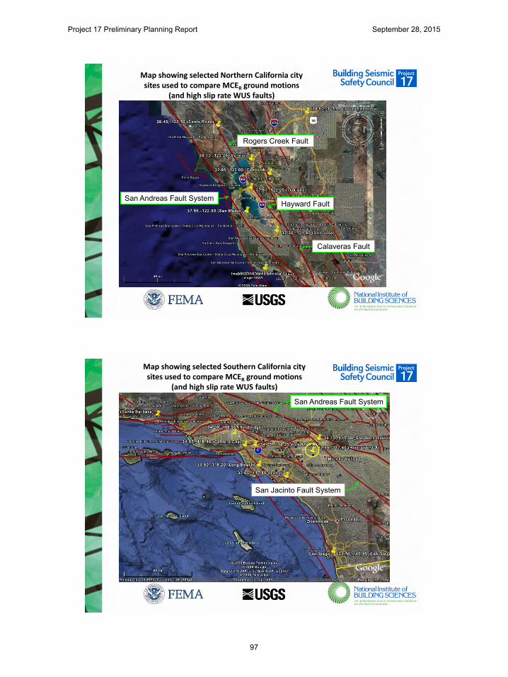
Map showing selected Northern California city sites used to compare MCER ground motions
(and high slip rate WUS faults)
Hayward Fault
Rogers Creek Fault
Calaveras Fault
San Andreas Fault System
Map showing selected Southern California city sites used to compare MCER ground motions
(and high slip rate WUS faults)
San Andreas Fault System
San Jacinto Fault System
Project 17 Preliminary Planning Report September 28, 2015
97

De-aggregation of 2,475-year mean annual return period seismic hazard at the SCEC
Riverside site - 1s response (USGS)
San Jacinto Fault (San Bernardino Segment)
San Andreas Fault (San Bernardino Segment)
Comparison of Probabilistic and Deterministic MCER Response Spectra - SCEC Riverside Site
0.00
0.25
0.50
0.75
1.00
1.25
1.50
1.75
2.00
2.25
2.50
2.75
3.00
0 0.2 0.4 0.6 0.8 1 1.2 1.4 1.6 1.8 2
Res
pons
e S
pect
ral A
ccel
erat
ion
(g)
Period (seconds)
SCEC Riverside Site Response Spectra - Vs,30 = 1,200 fps (CD) - RotD100
MCE Probabilistic - 2%-50yr Uniform HazardMCEr Probabilistic - 1%-50yr Uniform Collapse RiskMCEr Deterministic - 'Lower-Limit' Ground MotionsMCEr Deterministic - M7.8 84th %ile Ground MotionsMedian M7.8 Earthquake Ground Motions at Rx = 18 km
Likely ground motions due to the next M7.8 earthquake on the San Jacinto Fault
SMS
SM1
Probabilistic MCER ≈ 3 x median response of
an M7.8 earthquake
Project 17 Preliminary Planning Report September 28, 2015
98
Summary of Deterministic MCER Issue
• Eliminate Deterministic MCER Ground Motions: – Use probabilistic MCER ground motions (only) for all seismic
regions with consistent 1% in 50-year collapse risk objective – Risk - Overly conservative seismic loads for design of
buildings in regions of very high seismicity
• Retain Deterministic MCER: – Avoid unwarranted over conservatism in seismic design loads – Risk - In consistent with 1% in 50-year risk objective in
regions of very high seismicity – Resources (USGS with practitioner oversight) – Develop (and
vet) site-specific (mapped) values of M and R (and other) deterministic MCER ground motion criteria
Project 17 Preliminary Planning Report September 28, 2015
99

Issue 12
Project 17 Preliminary Planning Report September 28, 2015
100
Issue 12 Basin Effects – WUS & CEUS
C.B. Crouse
Issue Statement
• Basins affect duration & intensity of ground motion
• Empirical & simulation methods available to implement effects of basins nationally
• Same methods for all regions or region-specific methods?
Project 17 Preliminary Planning Report September 28, 2015
101

Importance
• Site amplification factors, Fa & Fv, included in seismic codes to account for local geology
• Codes do not have similar factors or maps to account for regional basin geology
• Goal: Improved estimates of long period ground motions in basins throughout US
Risks
• Time & resources (funds & manpower)
USGS may be able begin mapping US basins & obtain basin parameters required for ground-motion calculation
• Min requirement: Basin Depth, z
z = f(lat., long.)
Project 17 Preliminary Planning Report September 28, 2015
102

Resources
• USGS could begin gathering basin data if manpower is available
• State geological surveys may have data in oil/gas producing regions
Schedule
• Not clear if inclusion of basin effects in ground-motion maps can be accomplished this cycle
• Progress could be made if USGS can commit resources
Project 17 Preliminary Planning Report September 28, 2015
103

Issue 13
Project 17 Preliminary Planning Report September 28, 2015
104
ISSUE 13 Use of 3-D Numerical Simulations for Long Period
Ground Motions
C.B. Crouse, Art Frankel, Morgan Moschetti
Issues
• Limitations of current empirical GMPEs
– Lack of strong ground motions recorded in WUS cities
– Basin effects modeled with only depth parameters in NGA West2
– Basin effects not modeled in Subduction-zone GMPEs or NGA East
Project 17 Preliminary Planning Report September 28, 2015
105

Issues (cont.)
• Advantages of 3-D Simulations
– Models finite fault ruptures
– Captures directivity effects
– Accounts for 3-D velocity structure of region including basins
– Can be used PSHA/DSHA procedures that USGS uses for National maps
– Feasibility of 3-D simulations has been demonstrated (e.g., L.A., Seattle, SLC)
Importance
• Structures with T > 1 sec
– high rise buildings
– base-isolated structures
– long span bridges
– liquid storage tanks (sloshing)
3-D simulations suggest long period motions may be underestimated in some cases
Project 17 Preliminary Planning Report September 28, 2015
106
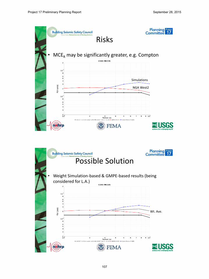
Risks
• MCER may be significantly greater, e.g. Compton
Simulations
NGA West2
Possible Solution
• Weight Simulation-based & GMPE-based results (being considered for L.A.)
Wt. Ave.
Project 17 Preliminary Planning Report September 28, 2015
107
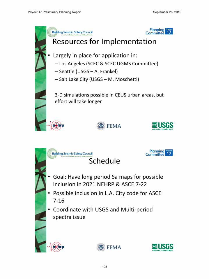
Resources for Implementation
• Largely in place for application in:
– Los Angeles (SCEC & SCEC UGMS Committee)
– Seattle (USGS – A. Frankel)
– Salt Lake City (USGS – M. Moschetti)
3-D simulations possible in CEUS urban areas, but effort will take longer
Schedule
• Goal: Have long period Sa maps for possible inclusion in 2021 NEHRP & ASCE 7-22
• Possible inclusion in L.A. City code for ASCE 7-16
• Coordinate with USGS and Multi-period spectra issue
Project 17 Preliminary Planning Report September 28, 2015
108

6. APPENDIX B - PARTICIPANT POLL RESULTS
Project 17 Preliminary Planning Report September 28, 2015
109
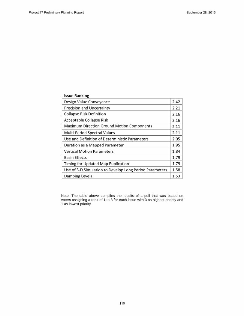
Issue Ranking Design Value Conveyance 2.42
Precision and Uncertainty 2.21 Collapse Risk Definition 2.16 Acceptable Collapse Risk 2.16 Maximum Direction Ground Motion Components 2.11 Multi-Period Spectral Values 2.11 Use and Definition of Deterministic Parameters 2.05 Duration as a Mapped Parameter 1.95 Vertical Motion Parameters 1.84 Basin Effects 1.79 Timing for Updated Map Publication 1.79 Use of 3-D Simulation to Develop Long Period Parameters 1.58 Damping Levels 1.53
Note: The table above compiles the results of a poll that was based on voters assigning a rank of 1 to 3 for each issue with 3 as highest priority and 1 as lowest priority.
Project 17 Preliminary Planning Report September 28, 2015
110

7. APPENDIX C - ISSUE SUMMARIES
Project 17 Preliminary Planning Report September 28, 2015
111

Issue 1 Timing for Updates to Seismic Maps
Description: Since 1996, the USGS has updated its National Seismic Hazard Model (NSHM) one year before publication of the subsequent (e.g., 1997) NEHRP Recommended Seismic Provisions, on a six-year cycle. The Provisions Update Committee for the 2015 Provisions, however, indicated that more time for review is desired between future updates of the USGS NSHM and subsequent publication of the Provisions. Accordingly, the USGS is considering 2017, rather than 2020, for its next update of the NSHM. Furthermore, the USGS is considering updating its NSHM every three (rather than six) years, in order to reduce the amount of modeling changes in each update, and also to provide more frequent opportunities for external contributors (e.g., Next Generation Attenuation projects) to submit their information for potential incorporation into the NSHM. Historically, the current six-year cycle has resulted in numerous modeling changes in each NSHM update, in part because external contributors try to avoid missing an update and letting twelve year pass between submissions of their information. Before they can be set, both the timing of the next USGS NSHM update and the frequency of future updates require coordination with the Provisions.
Importance: The next update of the USGS NSHM is needed for several of the potential
Project 17 issues (e.g., multi-period spectra), and thus it is essential that its timing be coordinated with plans for the next edition of the Provisions. The timing must also be coordinated with important external contributions to the USGS NHSM that have already been scheduled (e.g., NGA-East). Moreover, the timing of the next update should soon be announced to the community of external contributors, for their planning purposes. If not coordinated, the frequency of future updates could result in conflicts between the latest editions of the USGS NSHM and Provisions, as well as with the latest editions of the ASCE 7 Standard and International Building Code that are based on the Provisions.
Risks: It is not clear that maps published on a 3-year cycle would see wide usage.
Presently, the IBC and other building codes adopt seismic design maps based on inclusion of updated maps in the NEHRP Provisions and also ASCE 7 and ASCE 41 standards. Presently, both the NEHPR Provisions and ASCE 7 standard are published on a 6-year cycle. Thus, maps produced on a 3-year cycle would not have a direct path to the building codes, unless introduced directly by USGS, and may see little adoption or use. If introduced directly by the USGS without prior BSSC and ASCE consensus, it is not clear that such maps would receive acceptance.
Resources: To ensure that the timing of the next and future updates of the USGS NSHM
meets the needs of Project 17 and future editions of the Provisions, it should be discussed with all of the Project 17 issue teams, but a small team of managers of the USGS NSHM, of important external contributors to the USGS NSHM, and of
Project 17 Preliminary Planning Report September 28, 2015
112

the Provisions can lead this issue. Meetings of the small team can be held via web conferences.
Schedule: The timing of the next update of the USGS NSHM, for incorporation into the next
edition of the Provisions, should be decided at the beginning of Project 17. Final decisions on the frequency of future updates may need to wait until Project 17 reestablishes the technical method of incorporating the USGS NSHM into the Provisions.
Project 17 Preliminary Planning Report September 28, 2015
113
Issue 2 Design Value Conveyance
Description: Historically, the building codes and their referenced standards assigned seismic hazard-related parameters through reference to a series of printed maps. Prior to the 1990s design seismic hazards for building codes were conveyed through reference to a single map depicting the locations of seismic zones defining broad regions having uniform specified design effective peak ground acceleration. In 1993, based on the 1991 NEHRP Provisions, some building codes adopted two separately mapped parameters effective peak ground acceleration, Aa and effective peak velocity-related acceleration Av, shown in the form of mapped contours. Mapped contour values were limited to a single significant figure and distance between contours generally remained broad, comparable to the size of earlier seismic zones. In 1997, the Uniform Building Code, which retained seismic zones, also adopted a volume of street-level maps that allowed identification of distance from major active faults for California sites. The 1997 NEHRP Provisions, revised the Aa and Av contour maps to reference newly defined parameters, S1 (MCE spectral response acceleration on soft rock sites at 1-second period) and SS (MCE spectral response acceleration on soft rock sties at short periods), shown to two significant figures. Contours near major active faults were separated by small distance rendering the maps impractical for use in many locations and spurring USGS development of a web-based application to provide the “mapped” values based on input of site coordinates. More recent editions of the NEHRP Provisions, IBC, and ASCE 7 standard have adopted additional maps including values of TL (long period spectral transition point) and peak ground acceleration. On a preliminary basis Project 17 is considering specification of numerous additional design parameters including spectral acceleration parameters at numerous periods (e.g. 0.2, 0.5, 1, 2, 3, 4, 5 seconds), vertical spectral response parameters and values of these parameters for multiple site conditions as well as damping values. This will result in a proliferation of maps many of which will not be useable without web applications. The purpose of this issue is to determine the appropriate form for conveyance of design values of “mapped” parameters. Alternative forms of conveyance include digital databases and applications designed to reference these databases.
Importance: The USGS and BSSC must be able to adopt portrayal of seismic design values
in ways that are both adoptable by the building codes and reference standards, and also be practically useful. This is paramount to the successful publication by USGS and BSSC of design values.
Risks: If proper selection of a means for conveyance of design values is not found,
building codes and standards may not adopt the new design value recommendations (maps). While digital databases have been the most common way for design professionals to obtain “mapped” seismic design parameter values for more than 10 years, the codes and standards have not actually adopted these databases, but rather the maps developed from them. These databases are not directly code-enforceable. If a practical and code-acceptable
Project 17 Preliminary Planning Report September 28, 2015
114

means of conveying the large number of parameters currently being considered, the codes and standards may not be able to adopt the new values recommended by USGS and BSSC.
Resources A Project 17 Subcommittee that includes representatives of the International
Code Council, ANSI, and ASCE should be impaneled to review potential alternative means of design parameter conveyance and portrayal that are acceptable for code and standards adoption as well as useful. A committee of approximately 8 persons with budget for 4 meetings, as well as supporting staff time is needed.
Schedule: This work should be implementable in a 6 month period, which should be
undertaken at the beginning of Project 17, so as to provide guidance to the committee in developing its ultimate recommendations for products.
Project 17 Preliminary Planning Report September 28, 2015
115
Issue 3 Precision vs. Uncertainty
Description: Seismic zone maps adopted by early building codes lacked precision and
represented uniform design ground motion values over broad regions. Users and developers of these maps generally understood that the maps were not precise and that there was actually considerable uncertainty associated with the actual values of ground motion that could occur in a design event relative to the mapped values. Because these maps were not precise, they changed relatively little over the years, even as scientific knowledge of seismic hazards progressed. With adoption in the 1990s of contour maps depicting finely graduated values of ground motion design parameters, design values took on precise values (to three significant figures). Despite the precision implied by the contour maps, the values themselves are highly uncertain. The degree of uncertainty associated with the portrayed values is significant with dispersions as large as 0.6 or more depending on the region of interest. Despite these large uncertainties, as the design seismic maps are revised in response to improved scientific knowledge, statistically insignificant changes to the design values are made which have can have significant impact on design. To many users these changes appear “unstable” with values at given site going first up then down in successive cycles of map production, generating distrust in the underlying science as well as premature obsolescence of recently designed code-conforming structures, both causing distress on the part of design professionals. In this issue, alternative means of representing design seismic hazards, which are more in line with the uncertainty underlying the derived values will be evaluated and if practical recommended as the basis for next-generation maps.
Importance: Community acceptance of future editions of the maps may be jeopardized by
apparent instability in specified design values. This could ultimately result in rejection of next-generation maps by the building codes, and future failure of designers to use appropriate design values for design in some regions. This could result either in excessive cost of seismic compliance or ineffective seismic compliance.
Risks: Use of digital databases and applications to derive design seismic parameters
inherently lead to the derivation of precise values. Adoption of rounded values, while perhaps truer to the accuracy with which seismic hazards can be forecast, could result in sharp steps in portrayal of design seismic hazard at borders of zones containing specified values. Further, rounded values of derived parameters could be inconsistent with values derived using site specific study. These factors could also result in designer distrust of the “maps” and barriers to adoption.
Resources: A Project 17 subcommittee comprising structural engineers, geotechnical
engineers and USGS scientists should explore alternative means of portrayal of present design values (e.g. broader contours, zones, etc) to determine the workability and usefulness of this approach. This will require internal USGS support to develop “sample” maps for alternative means of data specification. A
Project 17 Preliminary Planning Report September 28, 2015
116

preferred approach should be recommended based on recommendation of this subcommittee and consensus of the Project 17 committee, after receiving input from key stakeholders including BSSC and ASCE committee members and other practicing design professionals.
Schedule A period of approximately 1 year of study is envisaged for this task, in which the
subcommittee first “brainstorms” alternative means of mapping/delivering specified design values, USGS produces sample maps, public input is received and recommendations made.
Project 17 Preliminary Planning Report September 28, 2015
117
Issue 4 Acceptable Collapse Risk
Description: Project 07 revised maximum considered earthquake (MCE) shaking hazard, from
a uniform return period with deterministic caps to a uniform notional collapse risk with deterministic caps (MCER). This shift was based in part on a desire to provide more uniform protection of life safety across the U.S. Because the slope of the hazard curve differs across the country, design for ground motions with uniform hazard produces higher risk of collapse in some regions than others. Risk adjustment of the MCE is intended to eliminate this inequity. Project 07 elected to adopt a notional target collapse risk of 1% in 50 years, which approximate that calculated in many regions assuming structures have a 10% conditional probability of collapse given MCE shaking and that MCE has a 2%-50 year exceedance probability, the basis for prior MCE maps.
One issue with the present MCER is that the deterministic caps result in
substantially higher risk at site close to major active faults than is used as the risk basis elsewhere, belying the claim of uniform collapse risk. Many sites in the San Francisco Bay area and parts of Los Angeles, the absolute risk to collapse is over 2% because the hazard parameters are capped. This creates a significant potential inconsistency in the seismic design of buildings and other structures. In regions where the damaging earthquakes have occurred, a higher risk to collapse and less conservative design is accepted than other parts of the country. Despite the intent, our current means of defining MCER does not truly providing uniform risk. However, selection of a target collapse risk comparable to that actually achieved in regions such as San Francisco and Los Angeles, approximating 2% in 50 years would allow elimination of deterministic zones, establishment of a true uniform risk basis and also result in substantial reduction in seismic design forces in most regions, yet remaining consistent with risk deemed acceptable in San Francisco and Los Angeles. Alternatively, adoption of a uniform hazard of 1% in 50 years could also accomplish essentially the same goal and have the added advantage of lesser complexity.
Importance: The way in which the MCER is determined is one of the most significant aspects
of seismic design. This affects all areas of the country and all new structures designed in the United States. It is vitally important to have truth in advertising (e.g. true uniform risk, or at least closer to it), and if possible simple methods that can be understood by the users of the maps.
Risks: The most significant risk is that change in the MCER definition will have
substantial impact on mapped values, further eroding confidence in the validity of the provisions and the maps.
Resources: This would require establishment of a steering committee to review the mapped
values resulting from alternative definitions of MCER as well as USGS staff
Project 17 Preliminary Planning Report September 28, 2015
118

support time associated with generation of draft maps using different definitions for review and consideration.
Schedule: Six months to one year to prepare studies of the effects on final design forces for
a significant number of sites throughout the country.
Project 17 Preliminary Planning Report September 28, 2015
119

Issue 5 Collapse Risk Definition
Description: Project 2007 revised the definition of MCER to be that ground motion which results in a notional 1% - 50 year collapse risk assuming that structures have a conditional probability of collapse of 10% given exposure to MCER shaking. The genesis of calculating risk in this manner is based on procedures developed and studies performed in the development of the FEMA P-695. While this methodology represents the present state of the art in determining collapse fragility of structures, many informed engineers believe the method significantly over-predicts the collapse probability of real structures and point to the low collapse rate observed in recent earthquakes, even for structures that do not conform to current code requirements. The purpose of this task would be to determine if the 10% conditional probability given MCE shaking should continue as the standard assumption of structural fragility for buildings designed to the present code requirements and if appropriate, develop alternative criteria.
Importance: Based on the FEMA P-695 and Project 07 work, as well as historic studies that
underlie the LRFD procedures used to design for loadings other than seismic, ASCE 7-10 published the anticipated reliabilities for code conforming structures subject to various loading. The seismic reliabilities are orders of magnitude smaller than those deemed acceptable for failures under other loads, and which have less severe consequences. This creates disbelief among users, regulators and the public as to the appropriateness of the performance goals and also the veracity of the assumptions employed.
Risks: It is conceivable that study of this issue would not result in improved definition of
the collapse risk of present code-conforming structures, resulting in continuance of the present situation.
Resources Empanel an independent committee of structural reliability experts to critically
review the FEMA P695 procedures and the veracity of the advertised 10% conditional probability of collapse derived based on application of that method to archetype structures; and to recommend improvements in the technique and target reliability if appropriate.
Schedule: It is envisaged that approximately 1 year of effort will be required potentially
including performance of reliability studies of representative archetypes, review of the results and formation of consensus as to alternative reliability goals.
Project 17 Preliminary Planning Report September 28, 2015
120

Issue 6 Maximum Direction v. Geomean
Description: During Project 07, the ASCE 7 ground motion response parameter was defined
(for the first time in any seismic code) as the “spectral response acceleration in the direction of maximum horizontal response.” This so-called “maximum direction response” parameter represents the peak response in the horizontal plane at the response period of interest (e.g., peak displacement of an isolated structure at the effective isolated period, TM). Prior to this definition, ground motion relations were typically based on “geomean” response calculated as the square root of the product of the peak responses calculated separately for two orthogonal horizontal components of an earthquake record. The geomean response calculation, while convenient, has no physical meaning since peak response does not occur, in general, at the same point in time for the two orthogonal components, and does not produce a unique value for a given ground motion record since peak response depends on the arbitrary orientation of the axes of the horizontal components of the record (e.g., arbitrary orientation of the strong-motion recording instrument).
Project 07 adopted the maximum direction response parameter for consistency
with the then new concepts of risk-targeted MCER ground motions which were defined by Project 07 as having 1% in 50-year probability of collapse for idealized structural systems that have a 10% probability of collapse given MCER ground motions occur. Proponents of the use of maximum direction response stated that this parameter better correlates with the direction of collapse of structures which can fail in any direction (e.g., base-isolated structures). Originally considered for near-source sites which can have significantly stronger response in the FN direction (i.e., more likely direction of collapse), the maximum direction response parameter was adopted universally for consistency and simplicity of ground motion definitions. A study was performed by Huang et al. (2008) as part of Project 07 to develop the necessary relationship for converting geomean response to maximum direction response.
During adoption of maximum direction, as opposed to geomean motion, many in
the structural and geotechnical communities argued that this approach constituted an artificial increase in the hazard structures are designed to resist and was inappropriate. The Project 07 committee acknowledged in discussion that maximum direction motions do not necessarily align with primary axes of buildings and it would probably be appropriate to adopt a directionality coefficient, similar to that used in wind, to account for this effect, and more appropriately maintain the stated design risk, however, this was not done. Under this issue, the Project 2017 Committee would revisit the issue and either recommend retention or modification of the maximum direction approach.
Importance: Adoption of maximum direction motions is still not well received by many in the
design community who feel their concerns were not appropriately evaluated by
Project 17 Preliminary Planning Report September 28, 2015
121

the BSSC in adopting this parameter. Given the strong opinion on this matter, maintenance of the process integrity suggests that a second look be taken and the approach either validated or modified as appropriate.
Risks: Revision of the design procedure to eliminate or modify maximum direction would
like other repeated changes that reverse the effects of prior change create discontent in users of the design provisions, and distrust as to their validity.
Resources: This issue could be addressed by sponsoring a researcher to conduct three-
dimensional collapse probability studies (almost all studies to date have been 2D) using a variety of ground motions, to explore whether the maximum direction motion appropriately characterizes the collapse risk adopted by the Provisions and to form the basis for modification proposals, if appropriate.
Schedule: Study would require from 1 year to 18 months to complete including development
of recommendations.
Project 17 Preliminary Planning Report September 28, 2015
122
Issue 7 Multi-period Spectral Definition
Description: For nearly 20 years, ASCE 7 has defined a general design response spectrum
tied to a standard spectral shape anchored to three mapped parameters: SDS, SD1 and TL. Based on work by Newmark many years ago, the assumed spectral shape encompasses three domains of response: constant response acceleration, velocity and displacement respectively. The standard spectral shape based on these parameters is generally valid for stiffer sites governed by smaller magnitude events (M6 – M7), but not so for softer sites (Site Class D and E) governed by larger magnitude earthquakes. For such sites, the standard spectral shape significantly under-estimates actual seismic demands, and therefore, required seismic design forces. The Provisions Update Committee discovered this issue late in the 2015 seismic-code-update cycle (Kircher & Associates 2015) and recommended changes to ASCE 7 requiring site-specific analysis in lieu of use of the generalized response spectrum when seismic this is not reliable (i.e., Site Class E sites when SS ≥ 1.0 and Site Classes D and E sites when S1 ≥ 0.2). Requiring site specific study is not desirable and provides only a short-term solution to a problem that would be better addressed by adoption of design requirements based on multi-period MCER response spectra. Further, multi-period MCER response spectra would improve the accuracy and frequency content of ground motions required for seismic design, as described in the Tentative Framework for Development of Advanced Seismic Design Criteria for New Buildings (NIST GCR 12-917-20).
Importance: This issue is of significant importance to Project 17. Multi-period response
spectra would circumvent potential short-comings with the use of generalized spectra and design procedures that use these spectra and eliminate a need for site-specific analysis for softer sites governed by larger magnitude earthquakes. Multi-period spectra would also better incorporate site class, basin and other effects directly in the frequency content of design ground motions for regions of the United States with ground motion relations that capture such effects (e.g., PEER NGA-West2 GMPEs).
Risks: Incorporation of multi-period spectra in future editions of ASCE 7 is complicated
by differences in the maturity of the earth science for different regions of the United States and territories of interest and would require multiple technical and administrative efforts, as summarized below.
ASCE 7 Format. Substantial revision of the format and parameters of ASCE 7
could be required to accommodate multi-period MCER response spectra and related new criteria. As a result of these changes, the relatively simple ELF method, which has served the profession well for more than 50 years might need to be substantially reformed, and potentially replaced by far more complex and less intuitive procedures.
Implementation. For the above technical changes to be efficiently implemented
in future editions of ASCE 7, a fundamental change must occur to the process
Project 17 Preliminary Planning Report September 28, 2015
123

used to provide designers with “maps” of MCER ground motion design values and related design criteria. While the USGS has provided seismic design values via web sites, the official (legal) version of maps of MCER ground motion maps and related criteria remains the print copies of Chapter 22 of ASCE 7. Print copies of maps of MCER ground motion maps and related criteria of Chapter 22 of ASCE 7-16 are unreadable and already unwieldy for two response periods. Print copies of maps for 20 (or more) response periods would not be practical (and they would still be unreadable). A new, web-based, paradigm is required for providing multi-period MCER ground motions and related criteria to designers and other users of ASCE 7 which would be both user-friendly and legally enforceable.
Resources: Seismic Design Values Maps (USGS). Presumably, the scope of work required
by the USGS to develop multi-period MCER response spectra and related criteria will be supported by the USGS as part of their regular participation in the update of the NEHRP Provisions. A considerable amount of additional time will be required by the USGS to extend the development of hazard functions and ground motions from the two response periods of current methods to an estimated 20 (or more) response periods.
Site Amplification. The scope of work required for development of site
amplification curves will require a separate 2-year project and necessarily consider the potential need for different sets of multi-period site amplification curves for different regions.
ASCE 7 Format. The scope of work required for re-formulation of ASCE 7 for
incorporation of multi-period MCER response spectra and possibly other re-formulation improvements as recommended by NIST GCR 12-917-20 or other sources is potentially quite large and would require a multi-period project. Ideally substantial re-formulation of ASCE 7 requirements would involve a comprehensive effort similar to the ATC-3 project that provided the basis for the original NEHRP Provisions.
Implementation. The scope of work required for changing the implementation
process includes initial development of a new or improved web-based approach and subsequent development of requisite enhanced web sites and databases.
Schedule: Seismic Design Values Maps (USGS). USGS will require the full 5-year cycle. Site Amplification. Project(s) will require 2 years. ASCE 7 Format. Project(s) will require at least 3 years and must be initiated
immediately to provide BSSC PUC (ASCE 7 SSC) with tentative re-formulation of ASCE 7 requirements in time for consideration and adoption in ASCE 7-22.
Implementation. Project(s) to develop enhanced web sites will require 2 years.
Project 17 Preliminary Planning Report September 28, 2015
124
Issue 8 Duration as a Mapped Parameter
Description: The design procedures contained in the NERHP Provisions and ASCE 7 have
been developed and calibrated mostly based on observation of the response of structures to moderately large earthquakes (M6 to M7) and laboratory and analytical study of structural behavior for similar motions. Such motions may duration of strong shaking ranging from perhaps 10 to 20 seconds. It is generally believed that larger magnitude events, producing longer durations of strong motion, which for subduction events can extend to several minutes, are far more destructive of structures. However, current structural modeling techniques do not account for duration effects well and current design procedures ignore these effects. This task would evaluate whether current design procedures should be modified to include consideration of duration effects and potentially resulting in more conservative or robust design for structures subject to long duration MCE events, like many regions of the Pacific Northwest and other subduction zones.
Importance Our present design procedures may not provide targeted safety when applied to
design of buildings that can be subjected to very long duration motions. Risks: Present analytical technology and available test data may not be adequate to
allow proper characterization of the effects of duration on structural fragility. This may force use of subjective criteria, which would have to be revised in the future when better capability to assess duration effects is available.
Resources Supported research to evaluate the behavior of representative structures
designed to present code requirements, when subjected to very long duration motion. This would as a minimum include literature review to determine if hysteretic data based on “long duration” shaking is available, as well as analytical modeling to predict the long duration effects. If no adequate hysteretic data is available, testing of components that simulates long duration behavior would be required.
Schedule: Assuming availability of appropriate long duration hysteretic response data, at
least 2 years of study would be required to develop recommendations of this type. Failing this, longer duration (3-5 years) would be necessary to enable the necessary testing to occur.
Project 17 Preliminary Planning Report September 28, 2015
125
Issue 9 Alternative Damping Levels
Description: Seismic design maps referenced by ASCE 7 and the building code have typically
specified spectral parameters assuming a 5% damping ratio. In reality, structures and nonstructural components can have damping ratios other than 5%. ASCE 7- criteria for design of damping and isolation systems provides damping modification factors to adjust 5%-damped spectra for other effective damping ratios. These factors are based on the mid-period range of the Newmark and Hall (1982) model, which was based on only 28 records from 9 earthquakes. They are independent of period and duration of motion (which is related to the magnitude of earthquake). Several studies revisited these factors, the findings of which were examined to confirm that the factors of ASCE 7-10 were acceptable. But these studies did not address the influence of duration or evaluate the factors for longer periods. Recent studies have updated the Newmark and Hall relationships using a large database of over 2,250 records from 218 earthquakes, and provided damping scaling factors (DSF=1/DMF) for periods up to 10 s, considering the influence of duration by including magnitude and distance as surrogate parameters.
The new model can be used to re-evaluate the outdated damping modification
factors presently specified by ASCE 7. This model can be used to develop USGS design maps for damping ratios other than 5% by directly scaling the ground motion prediction equations used in developing the maps.
Importance: Design of many structures and components requires use of damping
assumptions other than 5%, particularly structures with passive energy dissipation systems and/or seismic isolation systems. Provision of design maps adjusted for damping considering both period and duration effects would provide improved capability for the design of such structures.
Risks: Providing additional “maps” for alternative damping levels will add complexity to
the design procedures contained in the NEHRP Provisions and ASCE 7 and potentially lead to use of inappropriate damping assumptions in design of some structures as a result of designer error in referencing incorrect maps.
Resources: If implemented, this will require limited USGS staff involvement to update and
validate the hazard model to include damping and to produce additional data sets and maps for various damping levels.
Schedule: We estimate roughly 6 months for implementation of the damping model.
Project 17 Preliminary Planning Report September 28, 2015
126
Issue 10 Vertical Shaking
Description: Effects of vertical earthquake shaking are required to be considered in design of
tanks and some other nonbuilding structures, as well as buildings with certain features sensitive to vertical response effects, such as discontinuous vertical elements of gravity force-resisting systems. The 2015 NEHRP Provisions include procedures for developing design vertical response spectra; presently used for the design of tanks. For most other buildings and nonbuilding structures vertical seismic forces are approximately accounted for by applying a factor of 0.2SDS to dead load effects. Currently, mapped ground motion parameters for vertical shaking are not provided by the USGS.
Importance: Requirements are included in the 2015 NEHRP Provisions and ASCE 7-16 to
evaluate vertical effects in a more robust manner than applying the vertical load effect, Ev. Vertical ground motions are required to evaluate conditions such discontinuous vertical elements in gravity force-resisting systems. For these conditions, vertical ground motion maps are not readily available. Having this information in the next generation of seismic design maps will facilitate a consistent implementation of these effects, rather than requiring either site specific study, or present approximate methods already contained in ASCE 7.
Risks: Ground motion models (GMMs) are presently available for the western U.S. but
are still under development for the eastern U.S.. There is limited risk that appropriate models will not be available for inclusion in the next generation maps. Additional risk associated with development of vertical motion parameter maps is that this will add to the volume and complexity of material referenced by the code, potentially leading to inappropriate use of the data and design errors.
Resources: The development of vertical ground motion maps is a USGS effort and needs to
be included in their work plan. Once their work is completed, a concerted effort by either the PUC (and an associated IT) or Project ’17 could develop the necessary requirements to include in the 2020 NEHRP Provisions.
Schedule: Once the vertical ground motion maps are complete, it will take 9-12 months to
develop the associated design requirements. This work could be done in parallel once the basic framework of the USGS product is defined.
Project 17 Preliminary Planning Report September 28, 2015
127
Issue 11
Use and Definition of Deterministic Parameters
Description: Since the 1997 NEHRP Provisions, probabilistically determined ground motions used to construct the design hazard maps have been capped at sites located close to major active faults through deterministic caps. Deterministic caps have historically been computed to represent +1 sigma motions resulting from a characteristic earthquake on the nearby major active fault. Recently, earth scientists have moved away from the specification of characteristic earthquakes and adopted models that probabilistically evaluate multi-segment fault ruptures. This approach is not compatible with present procedures used to evaluate deterministic motions.
Importance Deterministically derived motions control the values portrayed in design seismic
maps in regions of highest seismic risk, where design for seismic risk is arguably most important. This includes portions of the Los Angeles, San Francisco, and Salt Lake City metropolitan regions. Consensus rules for evaluating deterministic caps that are consistent with present earth science representation of rupture probabilities are needed to allow meaningful determination of these deterministic caps.
Risks If this issue is not addressed, ground motions in those regions of the country
most likely to experience destructive shaking will continue to be developed based on outdated or ad hoc models.
Resources A Project 17 subcommittee composed of earth scientists and engineers should
review present fault rupture models for those major faults which control the present deterministic zones and evaluate alternative means of representing events that will result in similar bounding as that obtained from the prior use of characteristic events.
Schedule: It is estimated this can be completed in a 6-month period.
Project 17 Preliminary Planning Report September 28, 2015
128
Issue 12 Basin Effects
Description: Basins can have great effect on the duration and intensity of ground shaking in
some regions including Los Angeles and Seattle. Earth scientists are developing the tools to account for these effects in some, but not all regions where these effects are or may be significant. While it is clearly desirable to incorporate basin effects, which can lead to ground shaking amplification on the order of 2 or higher at some long periods, non-uniform incorporation in the national maps could be problematic in regions where the effects exist but models comparable to those in Seattle and Los Angeles are not yet available for implementation.
Importance: Accounting for the effects of basins can result in improved estimates of the long
period ground-motion hazard throughout the US. Risks: The potential risks of including this issue are the (1) large amount of time
required to conduct the surveys to map the 3-D seismic velocity structure of basins on a national scale, (2) the funds and manpower required for such an effort, and (3) the additional time required for development of models to account for basin effects in the CEUS and their incorporation in the ground-motion prediction equations for the region.
Resources: The time alone required to do the surveys, necessary to obtain the data to do this
work, probably does not fit within the time frame of this cycle. Schedule: The time to do the work depends on a significant amount of funding and human
resource commitment.
Project 17 Preliminary Planning Report September 28, 2015
129
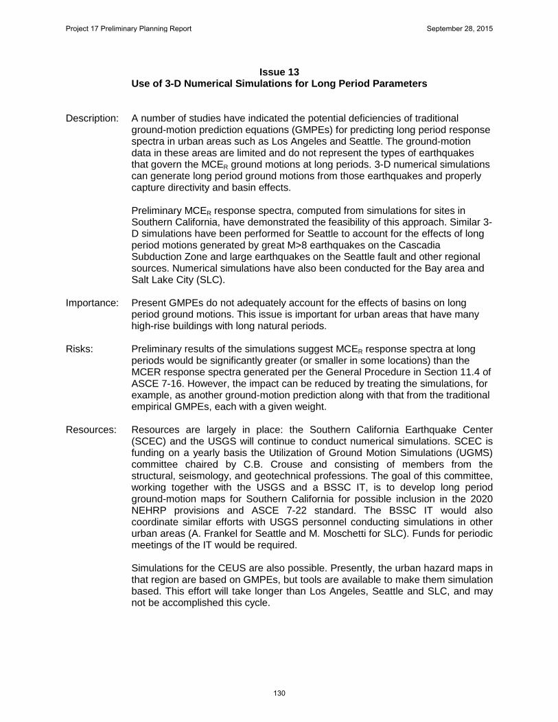
Issue 13 Use of 3-D Numerical Simulations for Long Period Parameters
Description: A number of studies have indicated the potential deficiencies of traditional
ground-motion prediction equations (GMPEs) for predicting long period response spectra in urban areas such as Los Angeles and Seattle. The ground-motion data in these areas are limited and do not represent the types of earthquakes that govern the MCER ground motions at long periods. 3-D numerical simulations can generate long period ground motions from those earthquakes and properly capture directivity and basin effects.
Preliminary MCER response spectra, computed from simulations for sites in
Southern California, have demonstrated the feasibility of this approach. Similar 3-D simulations have been performed for Seattle to account for the effects of long period motions generated by great M>8 earthquakes on the Cascadia Subduction Zone and large earthquakes on the Seattle fault and other regional sources. Numerical simulations have also been conducted for the Bay area and Salt Lake City (SLC).
Importance: Present GMPEs do not adequately account for the effects of basins on long
period ground motions. This issue is important for urban areas that have many high-rise buildings with long natural periods.
Risks: Preliminary results of the simulations suggest MCER response spectra at long
periods would be significantly greater (or smaller in some locations) than the MCER response spectra generated per the General Procedure in Section 11.4 of ASCE 7-16. However, the impact can be reduced by treating the simulations, for example, as another ground-motion prediction along with that from the traditional empirical GMPEs, each with a given weight.
Resources: Resources are largely in place: the Southern California Earthquake Center
(SCEC) and the USGS will continue to conduct numerical simulations. SCEC is funding on a yearly basis the Utilization of Ground Motion Simulations (UGMS) committee chaired by C.B. Crouse and consisting of members from the structural, seismology, and geotechnical professions. The goal of this committee, working together with the USGS and a BSSC IT, is to develop long period ground-motion maps for Southern California for possible inclusion in the 2020 NEHRP provisions and ASCE 7-22 standard. The BSSC IT would also coordinate similar efforts with USGS personnel conducting simulations in other urban areas (A. Frankel for Seattle and M. Moschetti for SLC). Funds for periodic meetings of the IT would be required.
Simulations for the CEUS are also possible. Presently, the urban hazard maps in that region are based on GMPEs, but tools are available to make them simulation based. This effort will take longer than Los Angeles, Seattle and SLC, and may not be accomplished this cycle.
Project 17 Preliminary Planning Report September 28, 2015
130

This effort would need to be closely coordinated with the development of Multi-
Period Spectra. Schedule: At its 1st meeting in the spring of 2013, the SCEC UGMS committee set a
schedule aimed at providing the necessary 3-D simulation results for the production of long period ground motion maps for the Los Angeles region for possible inclusion in the 2020 NEHRP provisions and ASCE 7-22 standard. Schedules for Seattle and SLC would need to be coordinated with the USGS, which is supporting the 3-D simulation studies in these cities.
Project 17 Preliminary Planning Report September 28, 2015
131