Embed Size (px)
Citation preview
Friday 15 th and Saturday 16th, November 2019
LOC :
TEAM MANUALRev. October 17th, 2019
Official Collaborator:
2
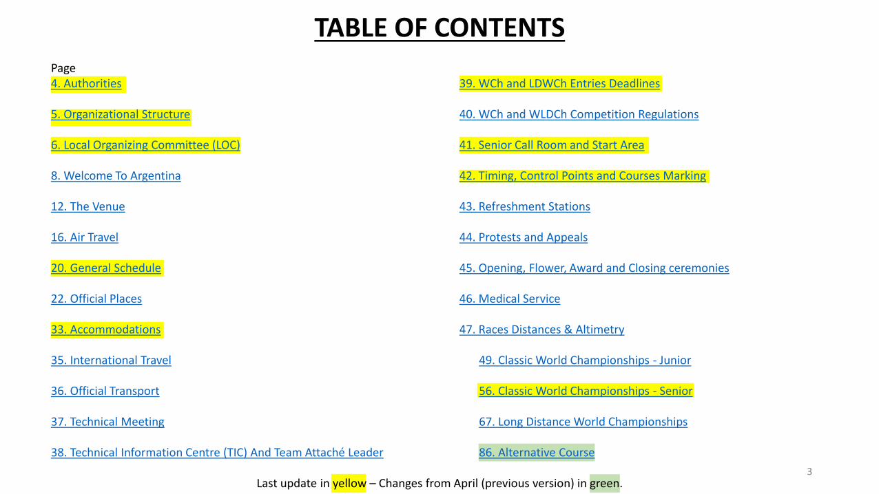
TABLE OF CONTENTS
3Last update in yellow – Changes from April (previous version) in green.
Page4. Authorities
5. Organizational Structure
6. Local Organizing Committee (LOC)
8. Welcome To Argentina
12. The Venue
16. Air Travel
20. General Schedule
22. Official Places
33. Accommodations
35. International Travel
36. Official Transport
37. Technical Meeting
38. Technical Information Centre (TIC) And Team Attaché Leader
39. WCh and LDWCh Entries Deadlines
40. WCh and WLDCh Competition Regulations
41. Senior Call Room and Start Area
42. Timing, Control Points and Courses Marking
43. Refreshment Stations
44. Protests and Appeals
45. Opening, Flower, Award and Closing ceremonies
46. Medical Service
47. Races Distances & Altimetry
49. Classic World Championships - Junior
56. Classic World Championships - Senior
67. Long Distance World Championships
86. Alternative Course
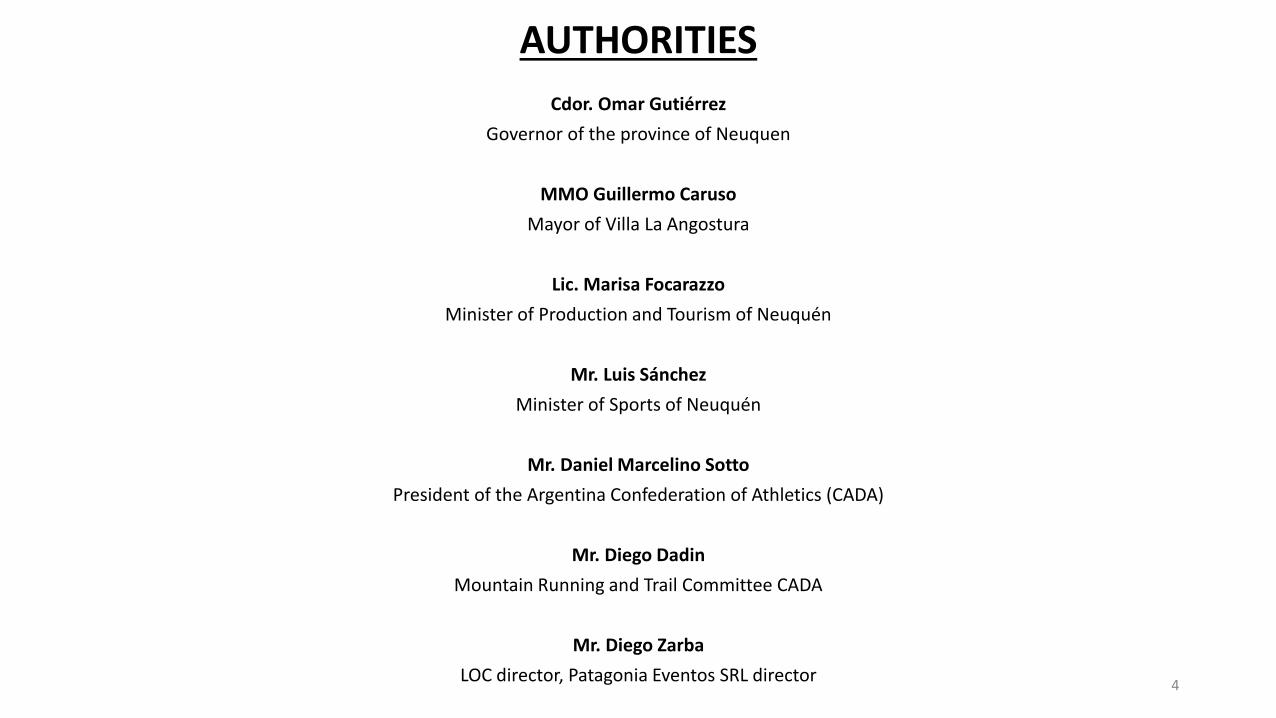
Cdor. Omar Gutiérrez
Governor of the province of Neuquen
MMO Guillermo Caruso
Mayor of Villa La Angostura
Lic. Marisa Focarazzo
Minister of Production and Tourism of Neuquén
Mr. Luis Sánchez
Minister of Sports of Neuquén
Mr. Daniel Marcelino Sotto
President of the Argentina Confederation of Athletics (CADA)
Mr. Diego Dadin
Mountain Running and Trail Committee CADA
Mr. Diego Zarba
LOC director, Patagonia Eventos SRL director
AUTHORITIES
4
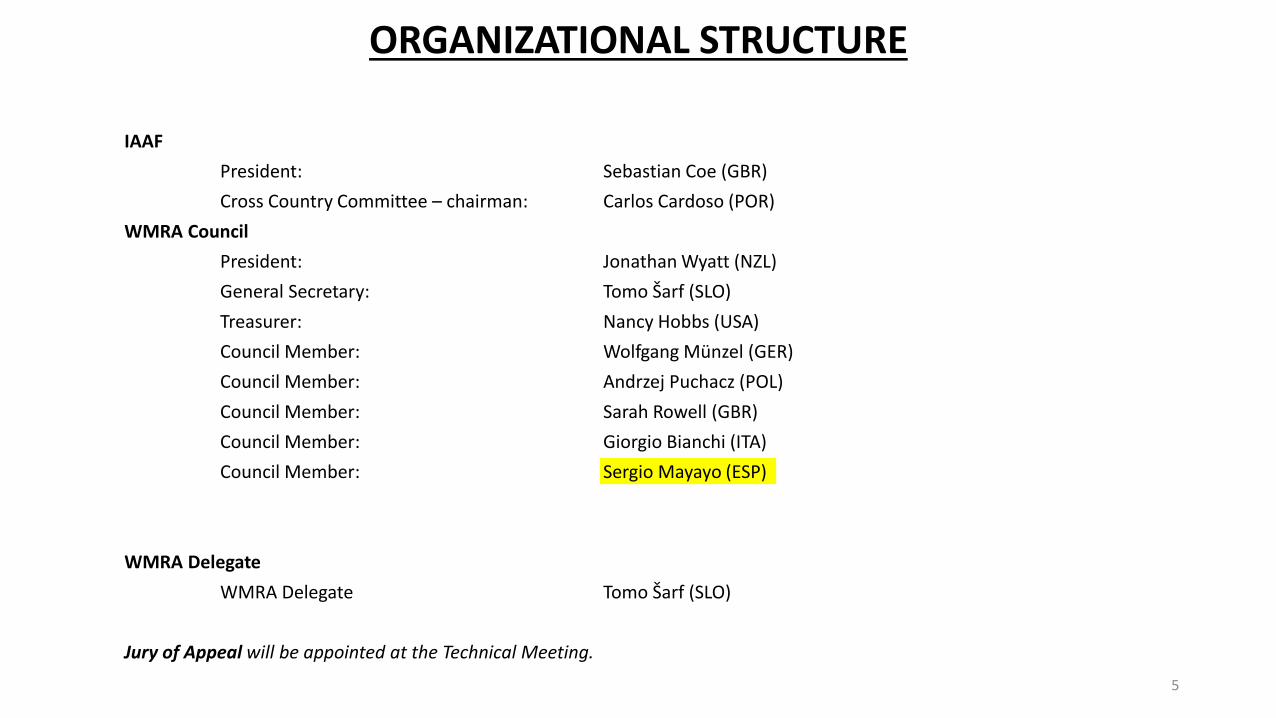
ORGANIZATIONAL STRUCTURE
5
IAAF
President: Sebastian Coe (GBR)
Cross Country Committee – chairman: Carlos Cardoso (POR)
WMRA Council
President: Jonathan Wyatt (NZL)
General Secretary: Tomo Šarf (SLO)
Treasurer: Nancy Hobbs (USA)
Council Member: Wolfgang Münzel (GER)
Council Member: Andrzej Puchacz (POL)
Council Member: Sarah Rowell (GBR)
Council Member: Giorgio Bianchi (ITA)
Council Member: Sergio Mayayo (ESP)
WMRA Delegate
WMRA Delegate Tomo Šarf (SLO)
Jury of Appeal will be appointed at the Technical Meeting.
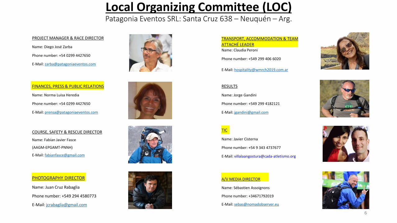
Local Organizing Committee (LOC)Patagonia Eventos SRL: Santa Cruz 638 – Neuquén – Arg.
6
TIC
Name: Javier Cisterna
Phone number: +54 9 343 4737677
E-Mail: [email protected]
TRANSPORT, ACCOMMODATION & TEAM
ATTACHÉ LEADERName: Claudia Peroni
Phone number: +549 299 406 6020
E-Mail: [email protected]
RESULTS
Name: Jorge Gandini
Phone number: +549 299 4182121
E-Mail: [email protected]
A/V MEDIA DIRECTOR
Name: Sébastien Assoignons
Phone number: +34671792019
E-Mail: [email protected]
COURSE, SAFETY & RESCUE DIRECTOR
Name: Fabian Javier Fasce
(AAGM-EPGAMT-PNNH)
E-Mail: [email protected]
PHOTOGRAPHY DIRECTOR
Name: Juan Cruz Rabaglia
Phone number: +549 294 4580773
E-Mail: [email protected]
PROJECT MANAGER & RACE DIRECTOR
Name: Diego José Zarba
Phone number: +54 0299 4427650
E-Mail: [email protected]
FINANCES, PRESS & PUBLIC RELATIONS
Name: Norma Luisa Heredia
Phone number: +54 0299 4427650
E-Mail: [email protected]
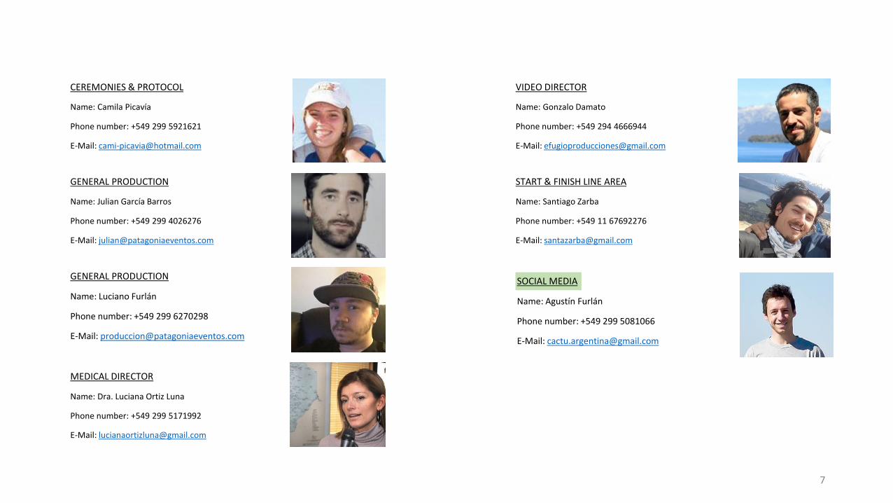
START & FINISH LINE AREA
Name: Santiago Zarba
Phone number: +549 11 67692276
E-Mail: [email protected]
VIDEO DIRECTOR
Name: Gonzalo Damato
Phone number: +549 294 4666944
E-Mail: [email protected]
SOCIAL MEDIA
Name: Agustín Furlán
Phone number: +549 299 5081066
E-Mail: [email protected]
CEREMONIES & PROTOCOL
Name: Camila Picavía
Phone number: +549 299 5921621
E-Mail: [email protected]
GENERAL PRODUCTION
Name: Julian García Barros
Phone number: +549 299 4026276
E-Mail: [email protected]
GENERAL PRODUCTION
Name: Luciano Furlán
Phone number: +549 299 6270298
E-Mail: [email protected]
7
MEDICAL DIRECTOR
Name: Dra. Luciana Ortiz Luna
Phone number: +549 299 5171992
E-Mail: [email protected]
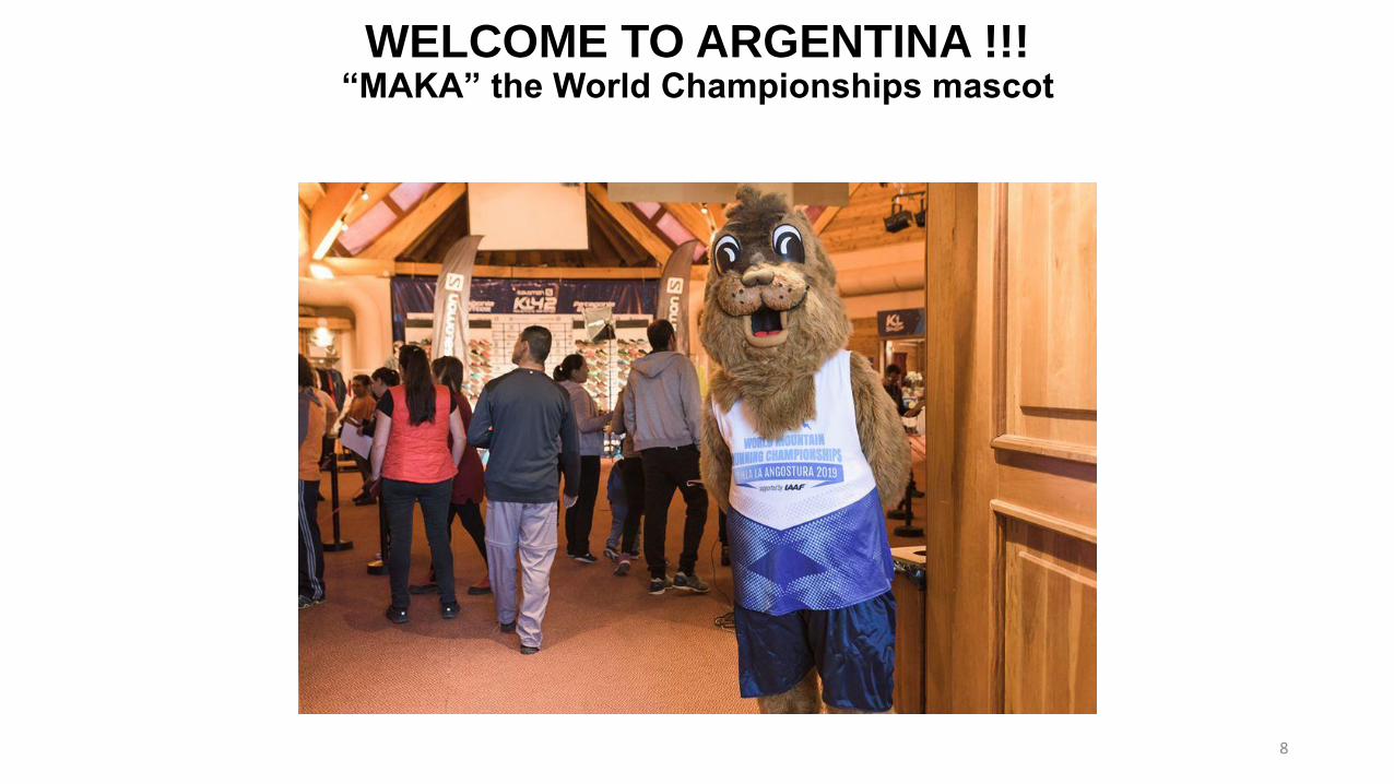
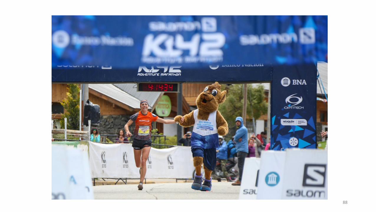
WELCOME TO ARGENTINA !!!“MAKA” the World Championships mascot
8
WELCOME TO VILLA LA ANGOSTURAProvince of Neuquén – Patagonia - Argentina
9
Argentina
ARGENTINE IDENTITY
Argentina has many peculiarities that have traveled the world by word of mouth with the people who have visited the country. The outgoing personality of its people, who are friendly, fun and effusive; the typical cuisine which includes asado, mate, regional dishes, and dulce de lechetreats; the traditional dances like tango, a couples dance with a 2 x 4 rhythm, which was born in Buenos Aires during the 19th century and today has reached an international level, or folklore, with different choreographic forms, according to each area; the passion for football, and the fanaticism for the major players and clubs, Boca Juniors and River Plate being the most popular ones, and the ones that fill their stadiums and cause proliferating displays of excitement every time they play; typical games like truco, a card game in which luck and the ability to trick or deceive the opponent are the most important things, or horse riding games in the outskirts of the city which reveal the powerful Spanish influence and the persistence of old traditions; and, of course, the personality that each special region knows how to maintain and strengthen as time goes by.
LOCATION
The Argentine Republic, with an area of almost 3.8 million square kilometers (1,468,000 square miles), is located in the Southern Hemisphere of the American continent. Its 3,800 kilometers (2,361 miles) in length stretch from 22º to 55º south latitude. The country borders on Uruguay, Paraguay, Brazil, Bolivia and Chile, and on the Atlantic Ocean to the East. The country is touristically divided in 6 regions, and politically divided in 24 provinces.
Official language: Spanish
Telephone code: +54
Time zone: UTC -3
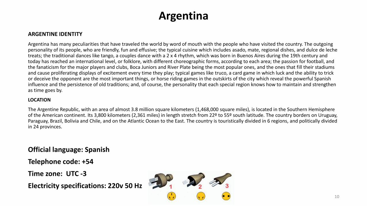
Electricity specifications: 220v 50 Hz
10
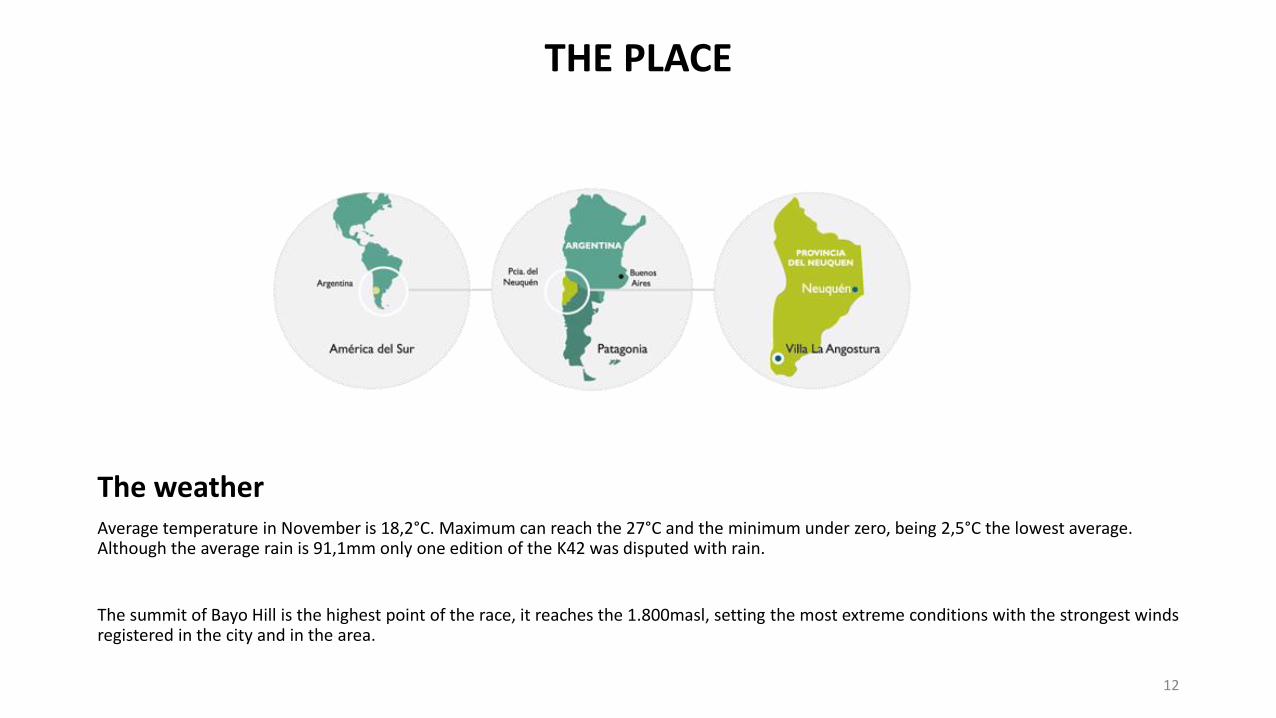
Neuquén Province is located in the southwest of Argentina, in the Patagonia, more specifically in the northwest of this region. It is between 36 and 41 parallel south latitude and between the meridians 68 and 71 west longitude.
Tourism is for the Province of Neuquén, a state policy, and also the second activity in the generation of employment. It is the flag together with production, industrial development, trade and construction, which will allow us to realize the diversification of the economic matrix, increasing the gross regional product through the participation of tourism.
Therefore, to strengthen it from the roots, was made the Provincial Tourism Plan 2015-2019, with the objective of defining lines that are necessary for the development of tourism in a sustainable way in the Province of Neuquén.
We are aware that tourists are looking forward to find direct contact with the different cultures and with its uniqueness. As Pope Francis says, when a city is chosen, it is not just to look but to pinch her to get involved, to feel being at home. Tourism is a tool of social justice, equity in territorial development in the geography of the Province of Neuquén, and there is no one town, one inhabitant, one neighborhood in a city across the whole province that not embraces the cause of tourism to strengthen economic development and welfare of each habitant of this province.
In this context the 2019 World Mountain Running Championship, will allow showing the beauty and hospitality of the habitants from Neuquén and Argentina to the world.
From the sport, it is a historic event for the province and will allow the competitive development of mountain athletics through the incorporation of athletes, who are outside the national and South American sports circuit, within the mountain athletics sports programs. Neuquén is a province that opens to the world and to a horizon that has no limit, allowing us to improve our quality of life.
About Neuquén Province
11
THE PLACE
The weatherAverage temperature in November is 18,2°C. Maximum can reach the 27°C and the minimum under zero, being 2,5°C the lowest average. Although the average rain is 91,1mm only one edition of the K42 was disputed with rain.
The summit of Bayo Hill is the highest point of the race, it reaches the 1.800masl, setting the most extreme conditions with the strongest winds registered in the city and in the area.
12
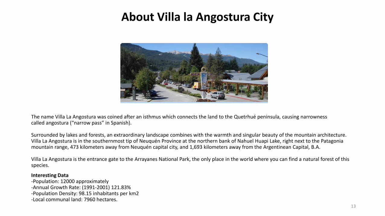
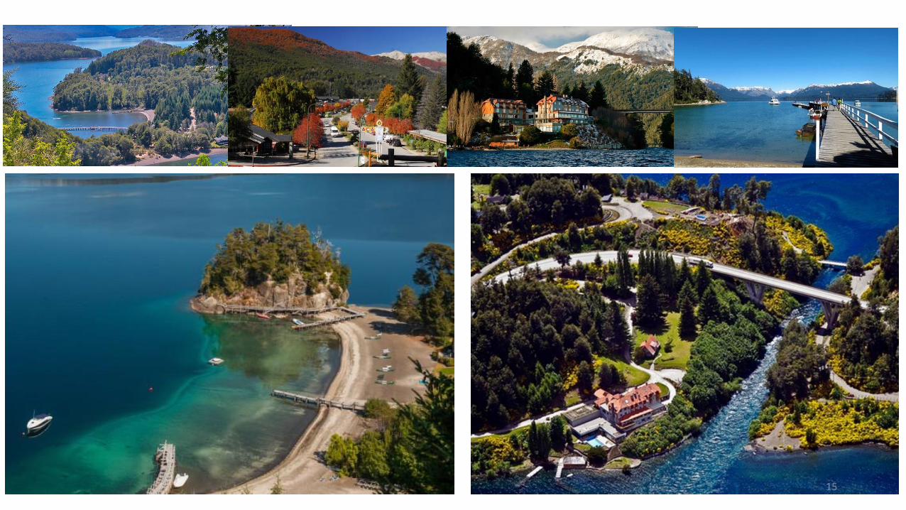
The name Villa La Angostura was coined after an isthmus which connects the land to the Quetrhué peninsula, causing narrowness called angostura (“narrow pass” in Spanish).
Surrounded by lakes and forests, an extraordinary landscape combines with the warmth and singular beauty of the mountain architecture.Villa La Angostura is in the southernmost tip of Neuquén Province at the northern bank of Nahuel Huapi Lake, right next to the Patagonia mountain range, 473 kilometers away from Neuquén capital city, and 1,693 kilometers away from the Argentinean Capital, B.A.
Villa La Angostura is the entrance gate to the Arrayanes National Park, the only place in the world where you can find a natural forest of this species.
Interesting Data-Population: 12000 approximately-Annual Growth Rate: (1991-2001) 121.83%-Population Density: 98.15 inhabitants per km2-Local communal land: 7960 hectares.
About Villa la Angostura City
13
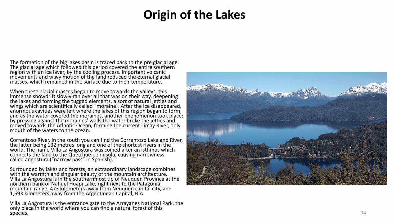
The formation of the big lakes basin is traced back to the pre glacial age. The glacial age which followed this period covered the entire southern region with an ice layer, by the cooling process. Important volcanic movements and wavy motion of the land reduced the eternal glacial masses, which remained in the surface due to their temperature.
When these glacial masses began to move towards the valleys, this immense snowdrift slowly ran over all that was on their way, deepening the lakes and forming the tugged elements, a sort of natural jetties and wings which are scientifically called “moraine”. After the ice disappeared, enormous cavities were left where the lakes of this region began to form, and as the water covered the moraines, another phenomenon took place: by pressing against the moraines’ walls the water broke the jetties and moved towards the Atlantic Ocean, forming the current Limay River, only mouth of the waters to the ocean.
Correntoso River. In the south you can find the Correntoso Lake and River, the latter being 132 metres long and one of the shortest rivers in the world. The name Villa La Angostura was coined after an isthmus which connects the land to the Quetrhué peninsula, causing narrowness called angostura (“narrow pass” in Spanish).
Surrounded by lakes and forests, an extraordinary landscape combines with the warmth and singular beauty of the mountain architecture.Villa La Angostura is in the southernmost tip of Neuquén Province at the northern bank of Nahuel Huapi Lake, right next to the Patagonia mountain range, 473 kilometers away from Neuquén capital city, and 1,693 kilometers away from the Argentinean Capital, B.A.
Villa La Angostura is the entrance gate to the Arrayanes National Park, the only place in the world where you can find a natural forest of this species.
Origin of the Lakes
14
15
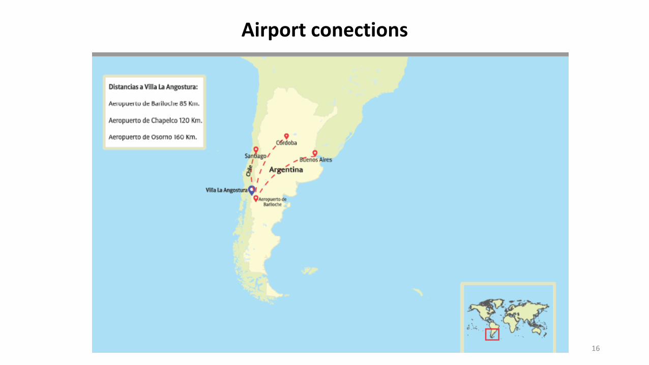
Airport conections
16
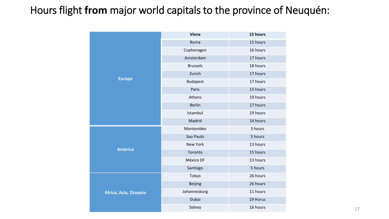
Hours flight from major world capitals to the province of Neuquén:
Europe
Viena 15 hours
Roma 15 hours
Cophenagen 16 hours
Amsterdam 17 hours
Brussels 18 hours
Zurich 17 hours
Budapest 17 hours
Paris 15 hours
Athens 19 hours
Berlin 17 hours
Istambul 19 hours
Madrid 14 hours
América
Montevideo 3 hours
Sao Paulo 5 hours
New York 13 hours
Toronto 15 hours
México DF 13 hours
Santiago 5 hours
África, Asia, Oceania
Tokyo 26 hours
Beijing 26 hours
Johannesburg 11 hours
Dubai 19 Horus
Sidney 16 hours 17
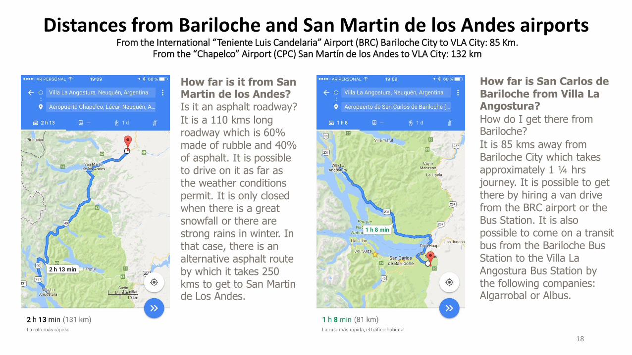
Distances from Bariloche and San Martin de los Andes airportsFrom the International “Teniente Luis Candelaria” Airport (BRC) Bariloche City to VLA City: 85 Km.
From the “Chapelco” Airport (CPC) San Martín de los Andes to VLA City: 132 km
How far is it from San Martin de los Andes?Is it an asphalt roadway?
It is a 110 kms long roadway which is 60% made of rubble and 40% of asphalt. It is possible to drive on it as far as the weather conditions permit. It is only closed when there is a great snowfall or there are strong rains in winter. In that case, there is an alternative asphalt route by which it takes 250 kms to get to San Martin de Los Andes.
How far is San Carlos de Bariloche from Villa La Angostura?
How do I get there from Bariloche?
It is 85 kms away from Bariloche City which takes approximately 1 ¼ hrsjourney. It is possible to get there by hiring a van drive from the BRC airport or the Bus Station. It is also possible to come on a transit bus from the Bariloche Bus Station to the Villa La Angostura Bus Station by the following companies: Algarrobal or Albus.
18
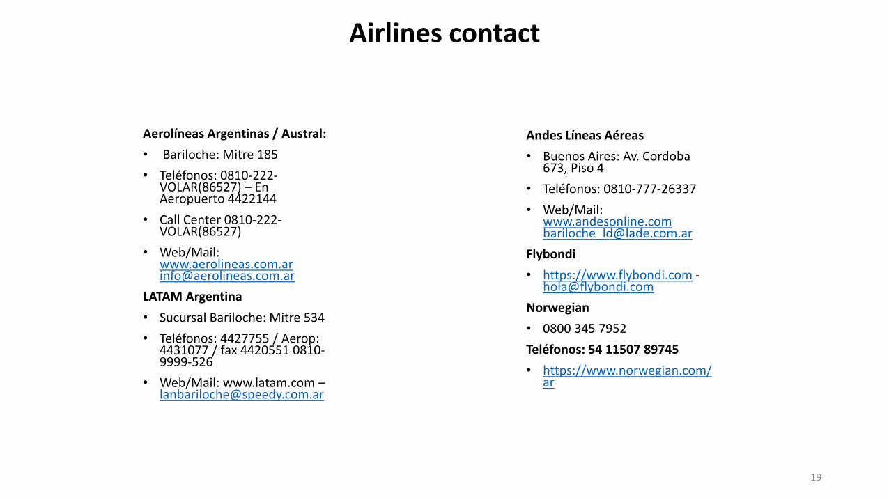
Airlines contact
Aerolíneas Argentinas / Austral:
• Bariloche: Mitre 185
• Teléfonos: 0810-222-VOLAR(86527) – En Aeropuerto 4422144
• Call Center 0810-222-VOLAR(86527)
• Web/Mail: [email protected]
LATAM Argentina
• Sucursal Bariloche: Mitre 534
• Teléfonos: 4427755 / Aerop: 4431077 / fax 4420551 0810-9999-526
• Web/Mail: www.latam.com –[email protected]
Andes Líneas Aéreas
• Buenos Aires: Av. Cordoba673, Piso 4
• Teléfonos: 0810-777-26337
• Web/Mail: [email protected]
Flybondi
• https://www.flybondi.com [email protected]
Norwegian
• 0800 345 7952
Teléfonos: 54 11507 89745
• https://www.norwegian.com/ar
19
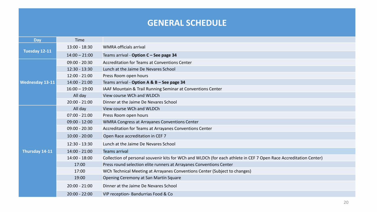
GENERAL SCHEDULE
Day Time
Tuesday 12-1113:00 - 18:30 WMRA officials arrival
14:00 – 21:00 Teams arrival - Option C – See page 34
Wednesday 13-11
09:00 - 20:30 Accreditation for Teams at Conventions Center
12:30 - 13:30 Lunch at the Jaime De Nevares School
12:00 - 21:00 Press Room open hours
14:00 - 21:00 Teams arrival - Option A & B – See page 34
16:00 – 19:00 IAAF Mountain & Trail Running Seminar at Conventions Center
All day View course WCh and WLDCh
20:00 - 21:00 Dinner at the Jaime De Nevares School
Thursday 14-11
All day View course WCh and WLDCh
07:00 - 21:00 Press Room open hours
09:00 - 12:00 WMRA Congress at Arrayanes Conventions Center
09:00 - 20:30 Accreditation for Teams at Arrayanes Conventions Center
10:00 - 20:00 Open Race accreditation in CEF 7
12:30 - 13:30 Lunch at the Jaime De Nevares School
14:00 - 21:00 Teams arrival
14:00 - 18:00 Collection of personal souvenir kits for WCh and WLDCh (for each athlete in CEF 7 Open Race Accreditation Center)
17:00 Press round selection elite runners at Arrayanes Conventions Center
17:00 WCh Technical Meeting at Arrayanes Conventions Center (Subject to changes)
19:00 Opening Ceremony at San Martín Square
20:00 - 21:00 Dinner at the Jaime De Nevares School
20:00 - 22:00 VIP reception- Bandurrias Food & Co
20
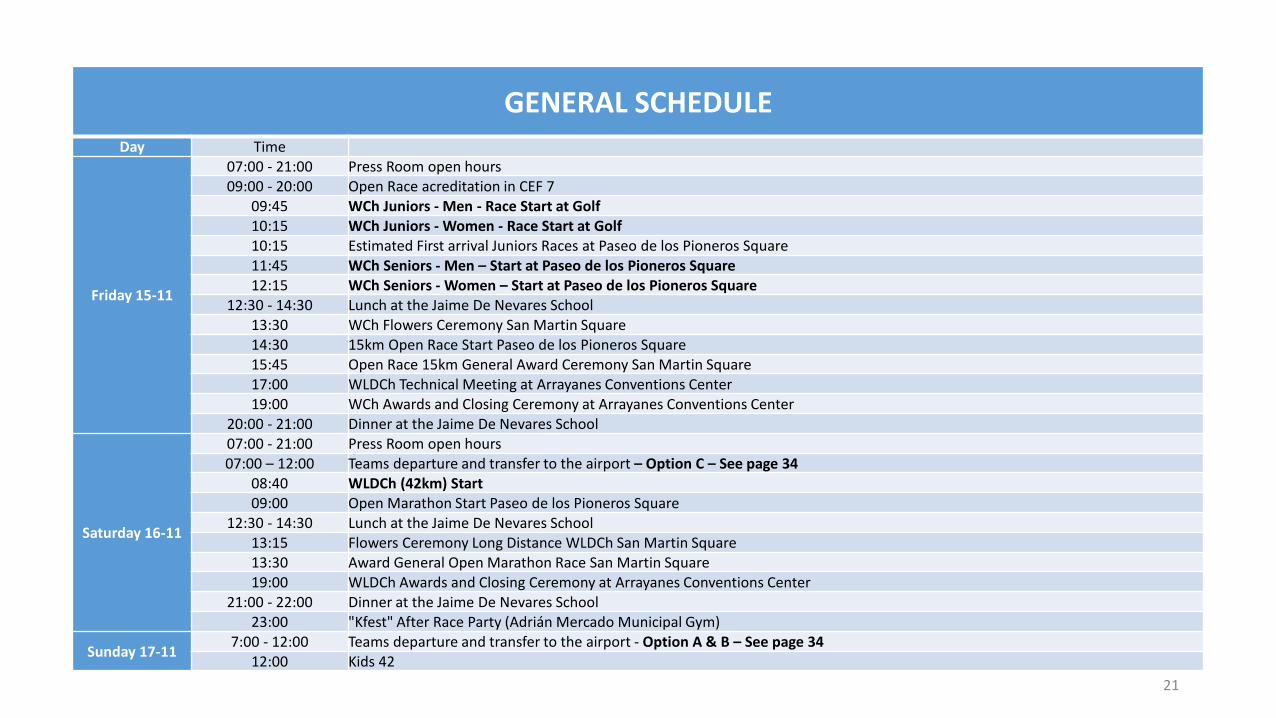
GENERAL SCHEDULEDay Time
Friday 15-11
07:00 - 21:00 Press Room open hours09:00 - 20:00 Open Race acreditation in CEF 7
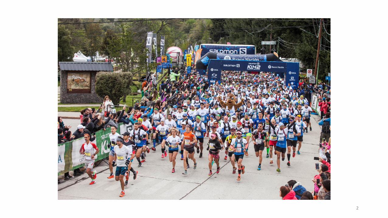
09:45 WCh Juniors - Men - Race Start at Golf10:15 WCh Juniors - Women - Race Start at Golf10:15 Estimated First arrival Juniors Races at Paseo de los Pioneros Square11:45 WCh Seniors - Men – Start at Paseo de los Pioneros Square12:15 WCh Seniors - Women – Start at Paseo de los Pioneros Square
12:30 - 14:30 Lunch at the Jaime De Nevares School13:30 WCh Flowers Ceremony San Martin Square14:30 15km Open Race Start Paseo de los Pioneros Square15:45 Open Race 15km General Award Ceremony San Martin Square17:00 WLDCh Technical Meeting at Arrayanes Conventions Center19:00 WCh Awards and Closing Ceremony at Arrayanes Conventions Center
20:00 - 21:00 Dinner at the Jaime De Nevares School
Saturday 16-11
07:00 - 21:00 Press Room open hours07:00 – 12:00 Teams departure and transfer to the airport – Option C – See page 34
08:40 WLDCh (42km) Start09:00 Open Marathon Start Paseo de los Pioneros Square
12:30 - 14:30 Lunch at the Jaime De Nevares School13:15 Flowers Ceremony Long Distance WLDCh San Martin Square13:30 Award General Open Marathon Race San Martin Square19:00 WLDCh Awards and Closing Ceremony at Arrayanes Conventions Center
21:00 - 22:00 Dinner at the Jaime De Nevares School23:00 "Kfest" After Race Party (Adrián Mercado Municipal Gym)
Sunday 17-117:00 - 12:00 Teams departure and transfer to the airport - Option A & B – See page 34
12:00 Kids 42
21

OFFICIAL PLACES
22
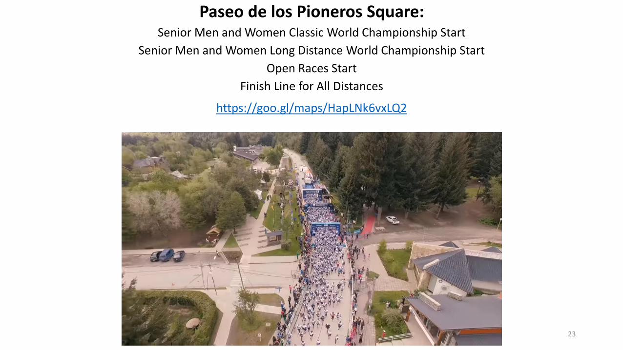
Paseo de los Pioneros Square:Senior Men and Women Classic World Championship Start
Senior Men and Women Long Distance World Championship Start
Open Races Start
Finish Line for All Distances
https://goo.gl/maps/HapLNk6vxLQ2
23
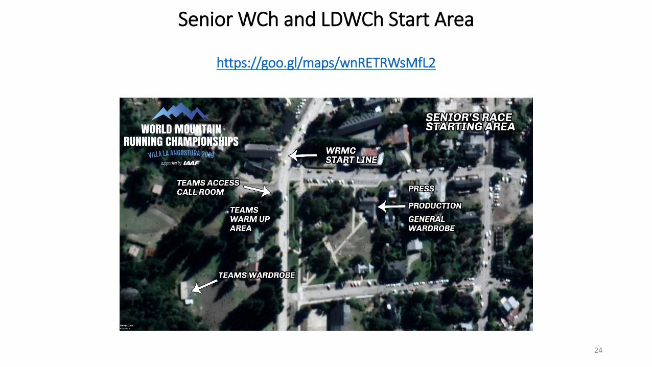
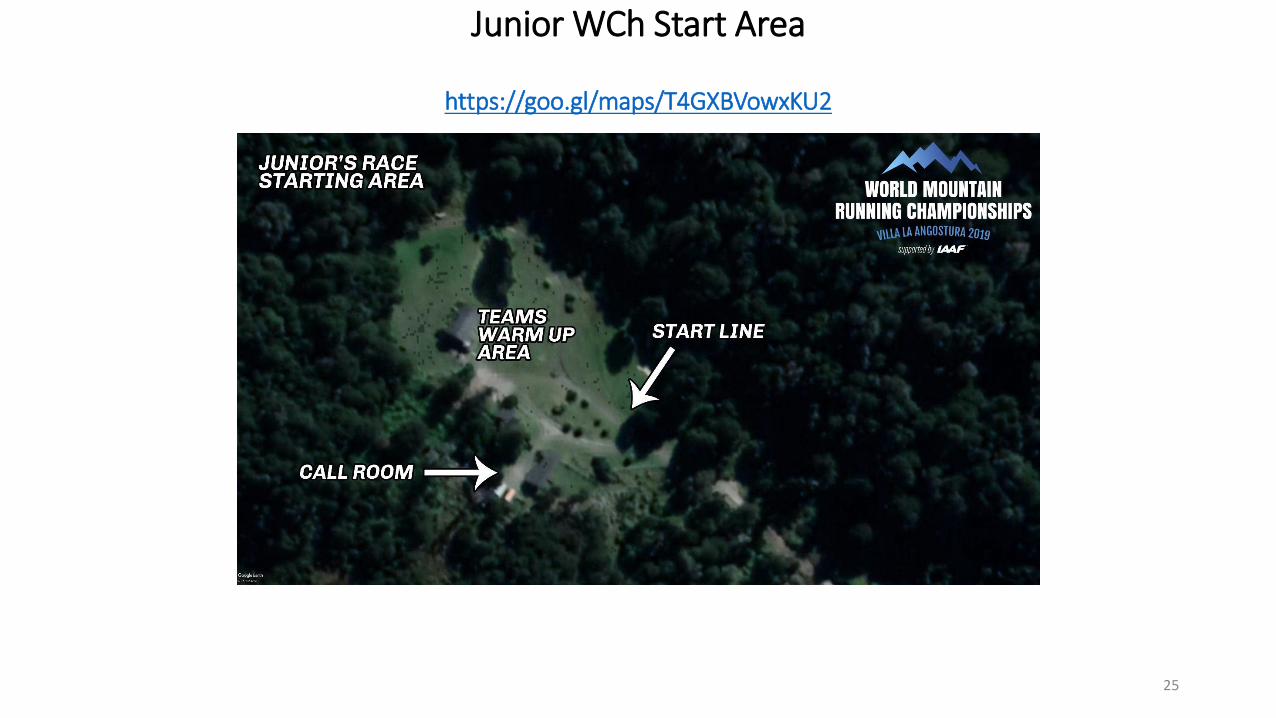
Senior WCh and LDWCh Start Area
https://goo.gl/maps/wnRETRWsMfL2
24
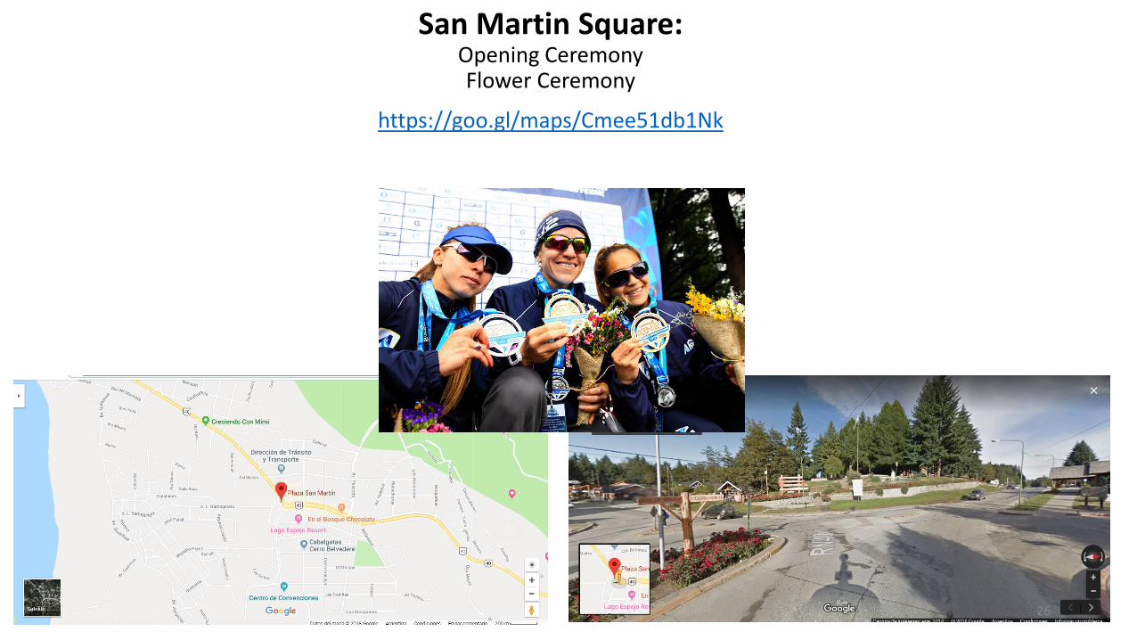
San Martin Square:Opening CeremonyFlower Ceremony
https://goo.gl/maps/Cmee51db1Nk
26
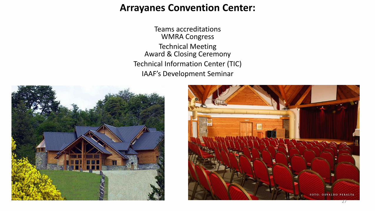
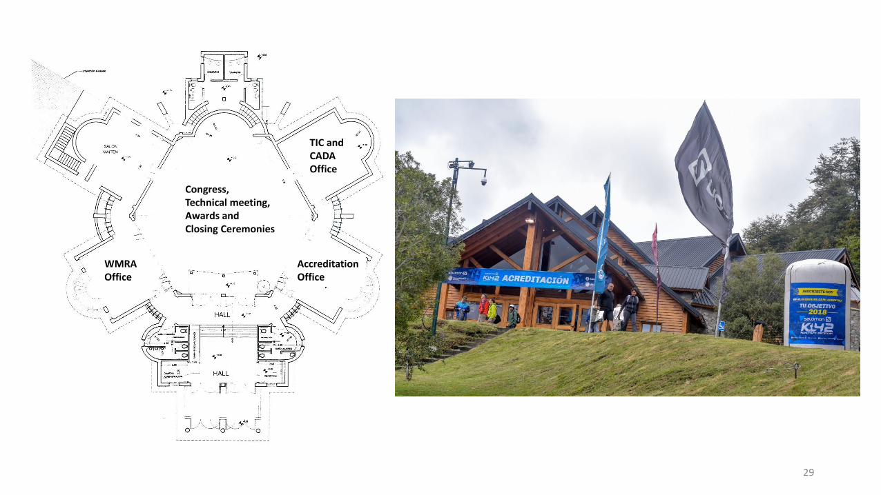
Arrayanes Convention Center:
Teams accreditationsWMRA Congress
Technical MeetingAward & Closing Ceremony
Technical Information Center (TIC)
IAAF’s Development Seminar
27
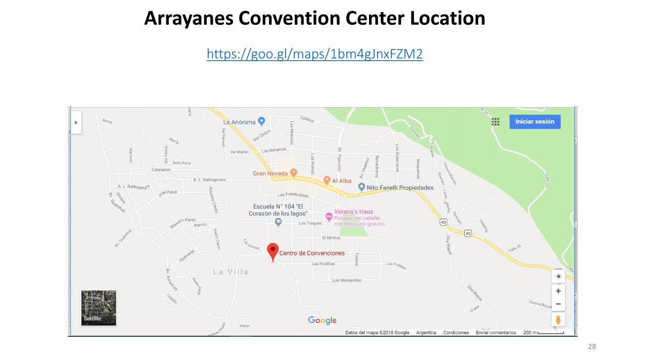
Arrayanes Convention Center Location
https://goo.gl/maps/1bm4gJnxFZM2
28
29
TIC and CADAOffice
Congress, Technical meeting, Awards and Closing Ceremonies
AccreditationOffice
WMRAOffice
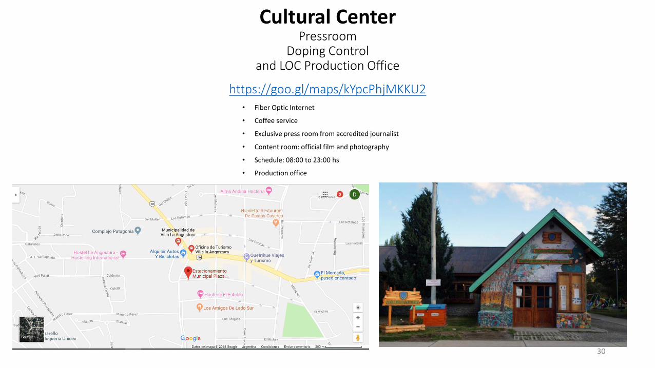
Cultural CenterPressroom
Doping Controland LOC Production Office
https://goo.gl/maps/kYpcPhjMKKU2
30
• Fiber Optic Internet
• Coffee service
• Exclusive press room from accredited journalist
• Content room: official film and photography
• Schedule: 08:00 to 23:00 hs
• Production office
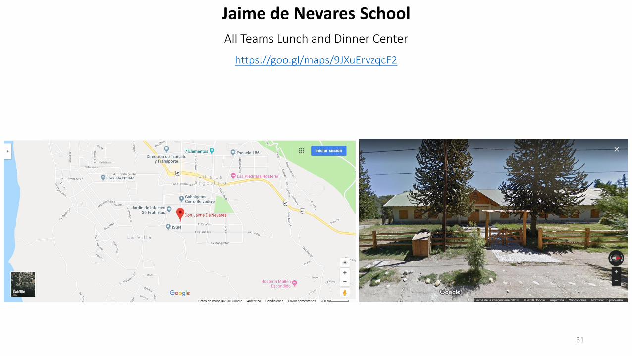
Jaime de Nevares School
All Teams Lunch and Dinner Center
https://goo.gl/maps/9JXuErvzqcF2
31
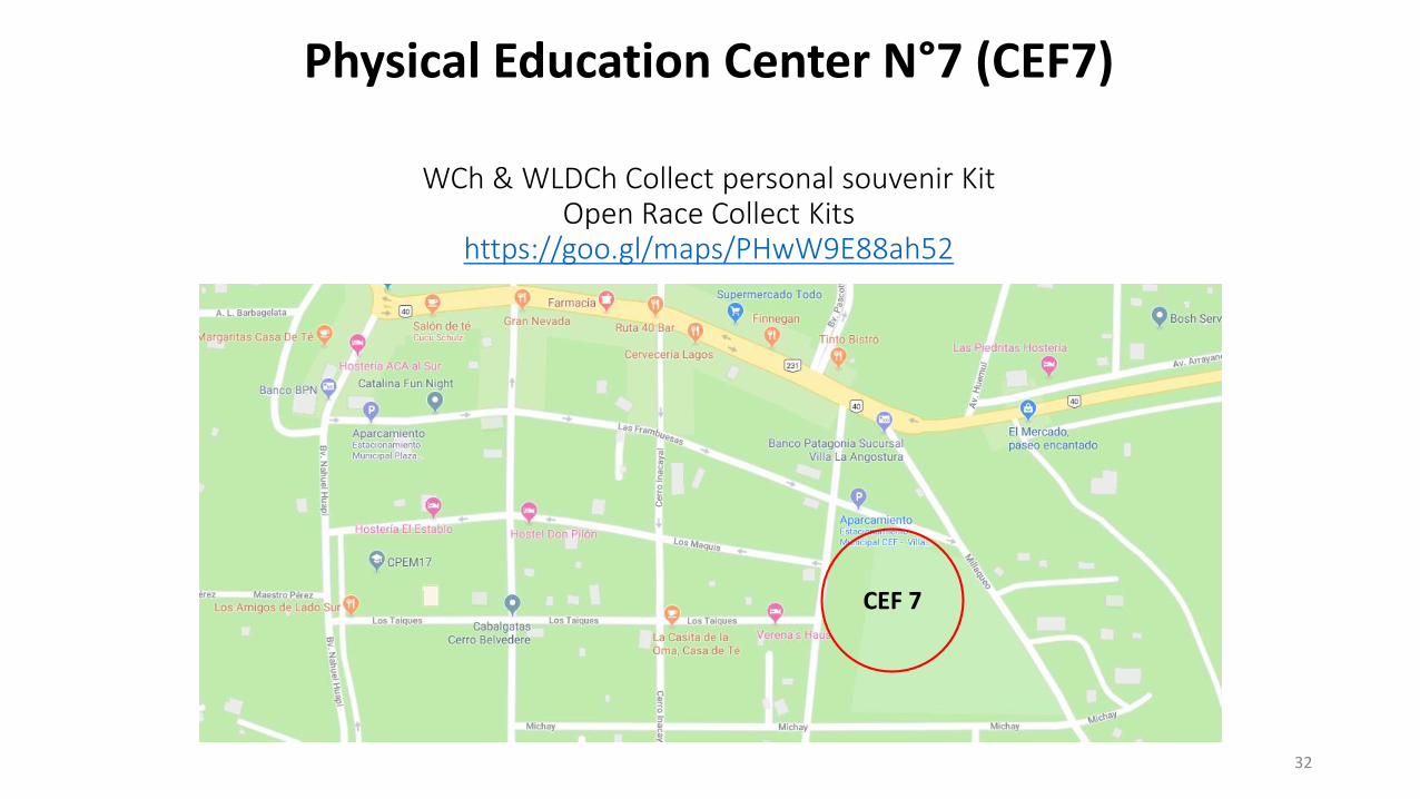
Physical Education Center N°7 (CEF7)
WCh & WLDCh Collect personal souvenir Kit Open Race Collect Kits
https://goo.gl/maps/PHwW9E88ah52
32
CEF 7
Accommodations
33
The committee (LOC) is responsible for providing accommodations for four nights, from 14:00 o’clock on Wednesday 13-11. Optionally, teams that request it in the Preliminary and Final Entry Form, may enter on Tuesday 12-11. Accommodations for:
• Long distance:
• 3 male and 3 female runners for the LD
• one official per team (two per team competing with two teams of 3 runners)
• Classic:
• 4 male and 4 female senior runners
• 4 male and 4 female junior runners
• One official for less than 5 runners, 2 for 6-10 runners, 3 for 11 or more runners.
• Meals are due from the lunch of Wednesday 13-11 until breakfast of Sunday 17-11 (departure day). (From lunch of Tuesday 12-11 until breakfast of Saturday 16-11, if requested).
All participants should be listed in the Final Entry form in order to secure proper accommodation for everyone.
The LOC will define accommodation for each delegation based on the amount of team members and in/out dates. Given the defined place,prices for extra nights and/or additional team members will go up to a maximum of USD$ 50. These are per person in a double/triple roomand includes lunch and dinner. The final amount will be sent directly to each delegation. Any additional will be paid directly in the selectedhotel at the moment of check-in. In some cases, a down payment may be requested.
Transport from/to the airport: Per passenger, for groups larger than 5, USD$ 15 (each way).
Teams arriving earlier than 12-11, and/or leaving later than 17-11, may book transport directly via email at: [email protected](cc [email protected]).
Accommodations
34
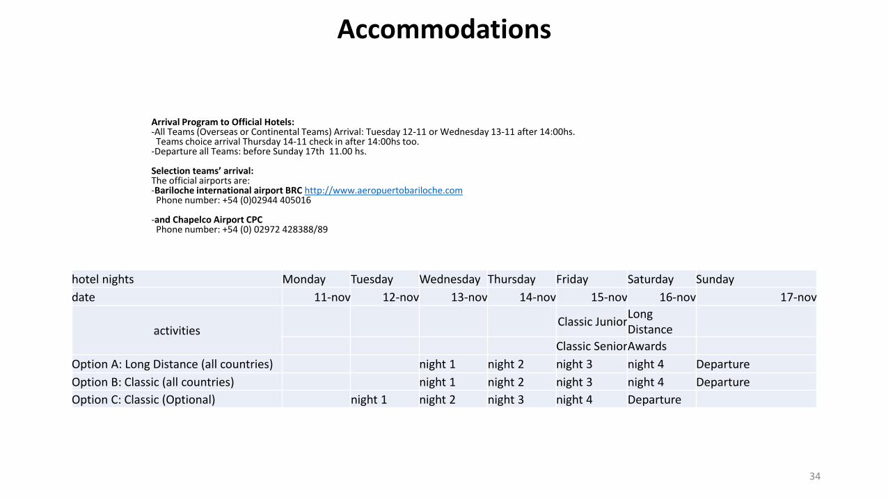
hotel nights Monday Tuesday Wednesday Thursday Friday Saturday Sunday
date 11-nov 12-nov 13-nov 14-nov 15-nov 16-nov 17-nov
activitiesClassic Junior
Long Distance
Classic SeniorAwards
Option A: Long Distance (all countries) night 1 night 2 night 3 night 4 Departure
Option B: Classic (all countries) night 1 night 2 night 3 night 4 Departure
Option C: Classic (Optional) night 1 night 2 night 3 night 4 Departure
Arrival Program to Official Hotels:-All Teams (Overseas or Continental Teams) Arrival: Tuesday 12-11 or Wednesday 13-11 after 14:00hs.
Teams choice arrival Thursday 14-11 check in after 14:00hs too. -Departure all Teams: before Sunday 17th 11.00 hs.
Selection teams’ arrival:The official airports are: -Bariloche international airport BRC http://www.aeropuertobariloche.com
Phone number: +54 (0)02944 405016
-and Chapelco Airport CPC Phone number: +54 (0) 02972 428388/89
International TravelThe LOC reached an agreement with Air Europa offering a 15% discount for international flights operated by the airline.
A discount code will be sent privately. Flights must be purchased through Air Europa official website.
Those who consult with an executive, may add internal flights. However, the discount won’t apply. The fare is only guaranteed with the emission/purchase of the ticket
Any federation who wants to assure seats and fare must do the following:
• Make the purchase as a “group” with a minimum of 10 passengers.
• In the same routes and dates.
• Making a down payment
Payment Conditions:
120 days before departure, a 20% of the total group fare must be paid.
65 days before departure, 40% of the total group fare must be paid.
30 days before departure, the total amount of the group fare must be paid.
This way, Federations may purchase group tickets without indicating the names the passengers. They will have up to 20 days before the flight to indicate the name of the passengers.
The group fare will be indicated and sustained by Air Europa. Subject to availability, according to group, itinerary and number of passengers.
It is not mandatory to fly with Air Europa. Federations may choose to flight with other airlines if they get better fares or deals.
Federations must request the code by email to: [email protected]
Contact for group sales: [email protected]
35
Official TransportLocal Transportation
Bus Service Official will operate only:
Arriving Tuesday 12th, Wednesday 13th or Thursday 14th. LOC will do its best effort not to make the teams wait for more than 1 hour
Departures Saturday 16 or Sunday 17-08:00 hs-12:00 hs
In their final entry, Teams must inform whether they'll land and departure in Bariloche or Chapelco Airport, flight number, date, hour and number of people who need transportation.
For teams arriving out of these dates, LOC will do its best to organize transportation at Teams expense (the same applies for departures after the 17th )
The Selections can request to get support with the coordination of transport to the Organization (with a cost according to each delegation) (*)
Local transport includes the following transport:
a) All Teams: Service from/to the international airport (Bariloche or Chapelco Airport) to Hotel
b) For Teams housed more 3km to city center:• Delegates to the Technical Meeting
• Teams delegates to the VIP reception
• For attendance to the Press Conference
• To the Opening Ceremony
• To the competition (teams and delegates)
• To the Award & Closing Ceremony and Final Banquet
• To lunches and dinners
Additional options:
Andes Angostura Car Rental: http://www.andesangostura.com.ar/es/
Transfer: http://www.rucanturismo.com/
Accommodations, Travel and meals:
Contact for each delegation: [email protected]
Additional team members and officials will meet accommodation expenses themselves. This should be requested in the Preliminary and/or Final Entry Form. 36
Technical Meetings
The Technical Meeting will be held on Thursday 14th at 17:00 for the Classic, and Friday 15th also at 17:00, for the Long Distance WCh, at the Arrayanes Convention Center.
The Meeting will be held in English. Each team may be represented by a maximum of 2 (two) team delegates and, if necessary, an interpreter. It is very important that all teams are represented at the Technical Meeting.
All questions related to the Technical Meeting must be presented in writing, in English, at the venue of the Meeting, at least 1 hour before the beginning.
The Technical Meeting will be attended by:
• LOC and the WMRA Representatives
• Doping Control Delegate
• Representatives of the Organizing Committee
• National Competition Officials
• Teams that are not able to attend the Technical Meeting, under extreme circumstances, can collect their information material from the TIC after the technical meeting.
Technical Meeting Agenda
The preliminary agenda of the Technical Meeting includes:
• Welcome by the LOC and the WMRA Representatives Presentation of the Competition Officials
• Information briefing by the WMRA Delegate on matters not covered by the Team Manual Presentation of the competition and warm-up venues Ceremonies
• Presentation of Jury of Appeal
• Answering questions submitted in writing by federations
Competition Bibs and TAG
Immediately after the Technical Meeting Teams Delegates will receive: 2 competition bibs (+ 1 for bags) and 2 transpoders for each runners, for both shoes. The bibs shall be worn according to IAAF Rule 143. The competition bibs may not been cut, bent or covered in any way.
37
Technical Information Centre (TIC), and Team Attaché Leader will provide assistance from Wednesday 13th to Saturday 16th in a in a Information Desk to will be set up in the ArrayanesConvention Center.
The main function of the TIC is to ensure smooth communication among each Team Delegation, the LOC and the Competition Management of the Championships regarding technical matters, such as: - Handing out the results (one for team) - Collecting protest forms.
For any other need or information, the Team Attaché Leader will be the contact will be available at any time during the event.
See contact in “Local Organizing Committee (LOC)”: Javier Cisterna (TIC) Phone number Phone number: +54 9 343 4737677, E-Mail: [email protected] or Claudia PeroniPhone number: +549 299 406 6020, E-Mail: [email protected].
Technical Information Centre (TIC) AND Team Attaché Leader
AccreditationThe accreditation center will be located in the Arrayanes Convention Center.Each team member will receive an accreditation card, which must be worn at all times and should be clearly visible. Photos are not required for the accreditation card system.Accreditation ProcedureAccreditation cards will be prepared in advance, based on the information provided by the participating federation in the final entries. The Team Leader will be responsible for collecting the accreditation cards of all team members.Team Leaders are requested to collect all the athletes’ passports or IDs and take them to Accreditation Centre in order to allow verification of the participants’ age and nationality.Access Areas for TeamsAll team accreditation cards will allow access to the warm-up area, changing facilities and shuttle bus service. Only athletes who are directly involved in the competition will have access to the call room and to the course.Separate cards will be issued for the Team Leaders, for access to the information available in the Technical Information Centre (TIC).Loss of AccreditationAny lost or damaged accreditation cards should be reported to LOC or to the team reference person. Duplicate cards can be obtained where proof of identity can be established.INFORMATION DESKAn Information Desk will be set up at Arrayanes Convention Center on Wednesday to Saturday.For any need or information the Team Attaché, will be available at any time during the event on thephone number +549 299 406 6020
The final account for accommodation attributable to each Member Federation shall be based on the numbers declared in the Final Entries and this shall be paid in full, no allowance being made for any subsequent reduction in the actual numbers of athletes and/or officials. 38
WCh and LDWCh Entries Deadlines
The Preliminary and Final Entries should be made by IAAF and WMRA federation members using the respective forms, and sent to WMRA and the LOC.
The only Official documents are:
• the PEF (Preliminary Entry Form),
• the FEF (Final Entry Form).
The PEF and the FEF with all requested details shall be sent by the IAAF - WMRA member to the LOC, at CADA and WMRA Secretary according the following deadline:
• Deadline for the Preliminary Entries (PEF): From July 10th to September 15th, 2019
• Deadline for the Final Entries (FEF): From October 10th to November 4th, 2019
All form must be sent to [email protected]
Final Entries
The form will also request the National Federations a guarantee that all athletes will respect the IAAF Rules in term of doping controls. The Final Entry Form shall include the following sentence: “We confirm that all the athletes will respect and abide by the IAAF Anti-Doping Rules and Regulations”
Final Confirmation
Team Leaders or their representatives must confirm, at the accreditation, the athletes who are present and will actually take part in the competition.
Final start lists will be ready for collection after the Technical Meeting.
Competition Bibs and TAG
Each competitor will receive 2 competition bibs (to be used at the front and back, + 1 for bags) and 2 TAGs 1 for each shoes. The bibs shall be worn according to IAAF Rule 143. The competition bibs must not be cut, bent or covered in any way. The competition bibs and TAGs will be distributed immediately after the Technical Meeting.
Competition Clothing
Competitors must wear the Federation’s official team clothing. IAAF Rule 8 & 143 will be strictly applied. Please make sure to follow the latest version of the IAAF Advertising Regulations in force at the time of the event. Clothing and items not conforming to this rule and the current IAAF Advertising Regulations will be removed or taped at the Call Room.
Team clothing must be uniform. A competitor wearing any other clothing will have no access to the competition area and will not be allowed to compete. This rule applies both to competition clothing (vest, shorts and tights) as well as to tracksuits.
39
WCh and WLDCh COMPETITION REGULATIONSCitizenship (WCh and WLDCh )
All IAAF Member federation s and all WMRA members are eligible to compete.
WCh Teams composition
Each member federation could be represented by one male and one female, junior or senior team. Juniors under 16 years of age in the year of competition are not allo-wed to start. Junior categories under 18 years of age in the year of competition are not allowed to start the senior’s race.
• Each team will consist of a maximum of 5 athletes, including 1 as alternate (only 4 can start).
WLDCh Teams composition
Each member federation could be represented by one male and one female team. Juniors under 18 years of age in the year of competition are not allowed to start
• Each team will consist of a maximum of 6 athletes, including 1 as alternate (only 5 can start).
The passports of ALL athletes (WCh and LDWCh) will be collected and photocopied upon Accreditation.
Team Scoring (WCh and WLDCh)
The team results shall be decided by the aggregate of places recorded by the three best competitors of each team. The team with the lowest aggregate of points will be judged the winner. In assessing the aggregate, no adjustment to the scoring placing of the finishing teams shall be made in respect of any non-scoring team runners or of individual entries.
If a team fails to finish with a complete scoring team, the runners finishing shall be counted as individuals in the race result and be eligible for the individual awards.
Any tie will be decided in favor of the team whose last scoring member finishes nearer the first place.
Competition Uniform (WCh and LDWch)
All athletes of the team shall wear the same color competition uniform during the competition and in all ceremonies. 40
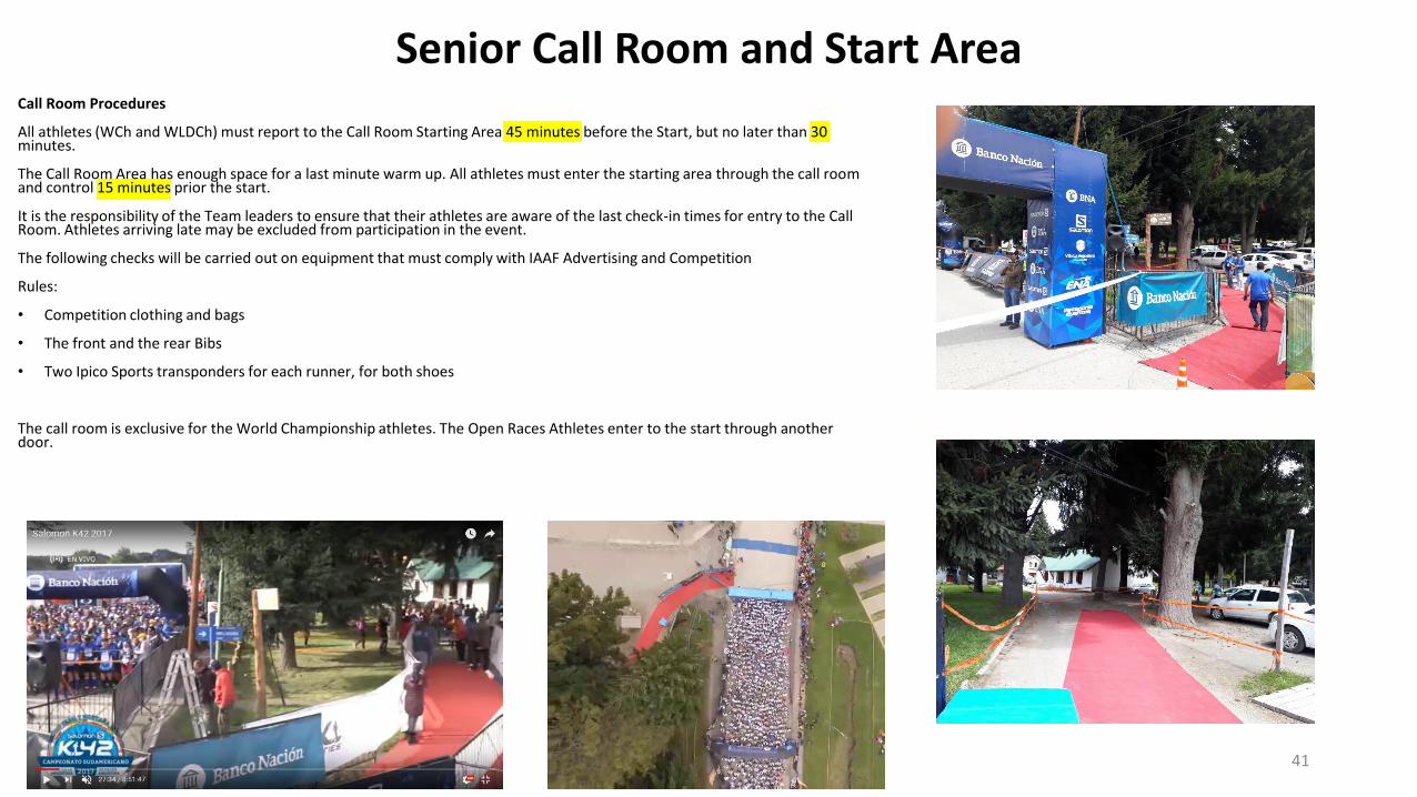
Senior Call Room and Start Area
41
Call Room Procedures
All athletes (WCh and WLDCh) must report to the Call Room Starting Area 45 minutes before the Start, but no later than 30 minutes.
The Call Room Area has enough space for a last minute warm up. All athletes must enter the starting area through the call room and control 15 minutes prior the start.
It is the responsibility of the Team leaders to ensure that their athletes are aware of the last check-in times for entry to the Call Room. Athletes arriving late may be excluded from participation in the event.
The following checks will be carried out on equipment that must comply with IAAF Advertising and Competition
Rules:
• Competition clothing and bags
• The front and the rear Bibs
• Two Ipico Sports transponders for each runner, for both shoes
The call room is exclusive for the World Championship athletes. The Open Races Athletes enter to the start through another door.
Timing, control points and courses marking
42
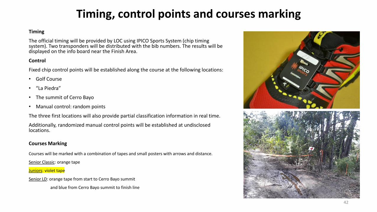
Timing
The official timing will be provided by LOC using IPICO Sports System (chip timing system). Two transponders will be distributed with the bib numbers. The results will be displayed on the info board near the Finish Area.
Control
Fixed chip control points will be established along the course at the following locations:
• Golf Course
• “La Piedra”
• The summit of Cerro Bayo
• Manual control: random points
The three first locations will also provide partial classification information in real time.
Additionally, randomized manual control points will be established at undisclosed locations.
Courses Marking
Courses will be marked with a combination of tapes and small posters with arrows and distance.
Senior Classic: orange tape
Juniors: violet tape
Senior LD: orange tape from start to Cerro Bayo summit
and blue from Cerro Bayo summit to finish line
Refreshment Stations
There will be several Refreshment Stations with water, food and isotonic along the course, plus refreshment points arranged close to the arrival area. Accord detall. They will be presented on a map during the Technical Meeting.
Personal refreshment may be handed over to athletes by their coaches or other team members on the official Refreshment Stations only.
An athlete who collects refreshment from a place other than the refreshment stations renders himself liable to disqualification by the Referee.
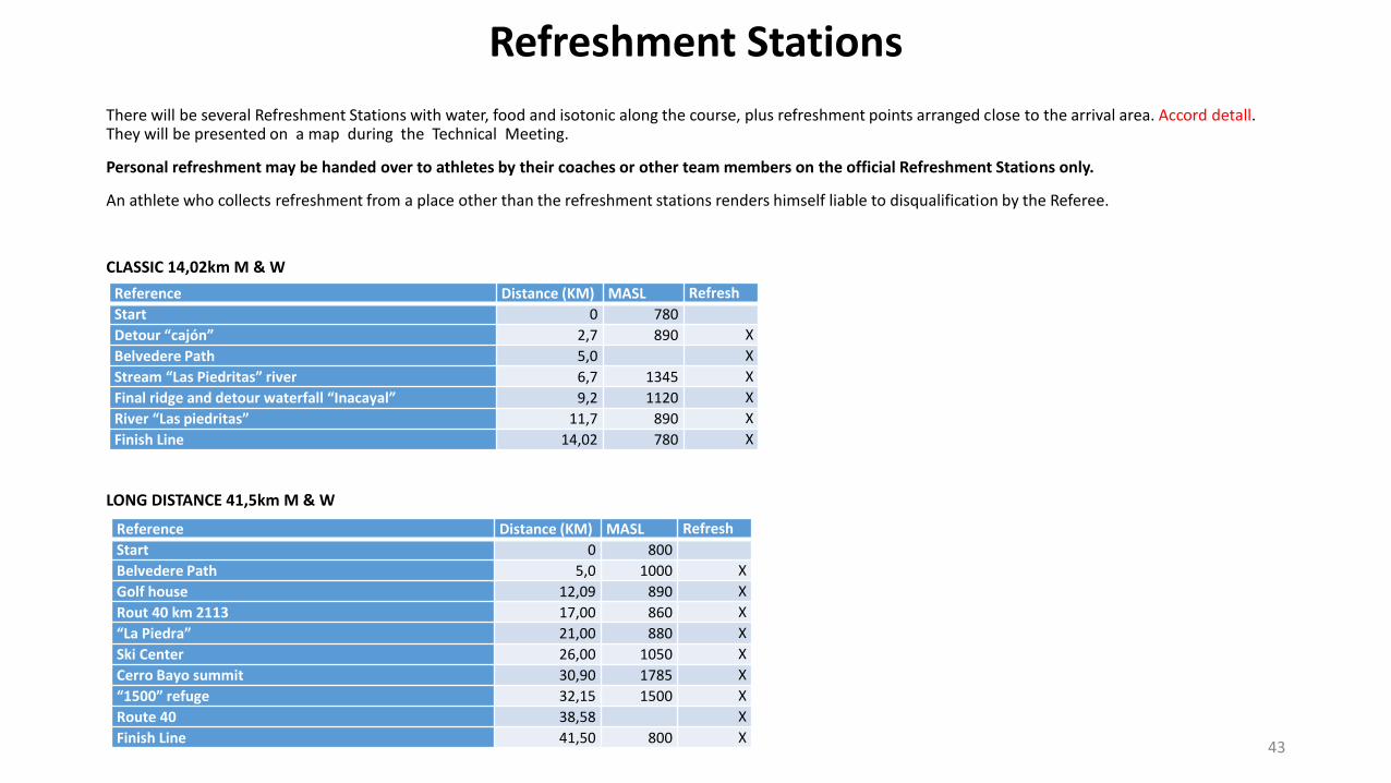
CLASSIC 14,02km M & W
LONG DISTANCE 41,5km M & W
43
Reference Distance (KM) MASL Refresh
Start 0 780
Detour “cajón” 2,7 890 X
Belvedere Path 5,0 X
Stream “Las Piedritas” river 6,7 1345 X
Final ridge and detour waterfall “Inacayal” 9,2 1120 X
River “Las piedritas” 11,7 890 X
Finish Line 14,02 780 X
Reference Distance (KM) MASL Refresh
Start 0 800
Belvedere Path 5,0 1000 X
Golf house 12,09 890 X
Rout 40 km 2113 17,00 860 X
“La Piedra” 21,00 880 X
Ski Center 26,00 1050 X
Cerro Bayo summit 30,90 1785 X
“1500” refuge 32,15 1500 X
Route 40 38,58 X
Finish Line 41,50 800 X
Protests and Appeals Protests will be processed in accordance with IAAF Rule 146.
In the first instance, protests must be made orally to the Referee by the athlete himself/herself or by a responsible official acting on his/her behalf (Rule 146.3). Protests concerning the result or conduct of an event shall be made within 30 minutes of the official announcement of the result of that event (posted on the official Information board).
Any written appeal to the Jury of Appeal must be signed by a responsible official on behalf of the athlete and submitted to TIC / TID within 30 minutes after the official announcement of the decision made by the Referee.
When submitting an appeal form, a deposit of 100 USD or 90 EUR must be paid. If the protest is unsuccessful, the deposit will not be returned. The Jury’s decision will be provided in writing at the TIC.
44
General Information
Doping control shall be conducted in accordance with IAAF Rules and Regulations under the supervision of the Doping Control Delegate. Both urine and blood samples may be collected immediately before, during or after the Championships.
Athletes selected for doping control shall be informed by anti doping officials. Athletes will be required to sign a confirmation of notification. Athletes who are to be tested may invite a team official to accompany them to the Doping Control Station (DCS) in the Cultural Center.
Selection of Athletes
The selection of athletes for control will be made by the Doping Control Delegate.
A selected athlete should report immediately to the DCS unless there are valid reasons for delay. All selected athletes will be accompanied by a trained chaperone or Doping Control Officer from the time of notification until arrival at the DCC. Athletes are reminded that refusal to provide a sample can render them liable to disqualification and may lead to further disciplinary action.
Athletes who are required to use prescribed medication for the treatment of a medical condition should ensure that they have registered their medication, where necessary, through the Therapeutic Use Exemption system prior to attending the Championships.
Doping Control
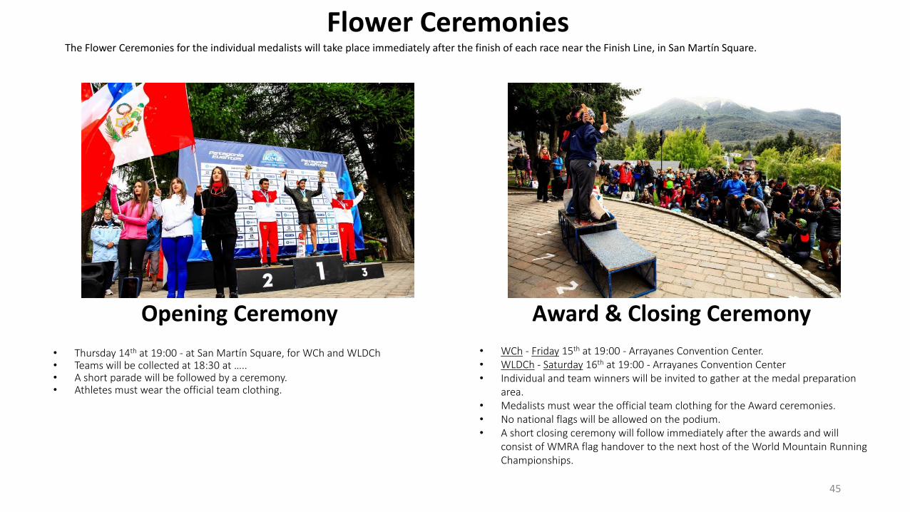
The Flower Ceremonies for the individual medalists will take place immediately after the finish of each race near the Finish Line, in San Martín Square.
45
Flower Ceremonies
Award & Closing Ceremony
• Thursday 14th at 19:00 - at San Martín Square, for WCh and WLDCh• Teams will be collected at 18:30 at …..• A short parade will be followed by a ceremony.• Athletes must wear the official team clothing.
Opening Ceremony
• WCh - Friday 15th at 19:00 - Arrayanes Convention Center. • WLDCh - Saturday 16th at 19:00 - Arrayanes Convention Center • Individual and team winners will be invited to gather at the medal preparation
area.• Medalists must wear the official team clothing for the Award ceremonies. • No national flags will be allowed on the podium. • A short closing ceremony will follow immediately after the awards and will
consist of WMRA flag handover to the next host of the World Mountain Running Championships.
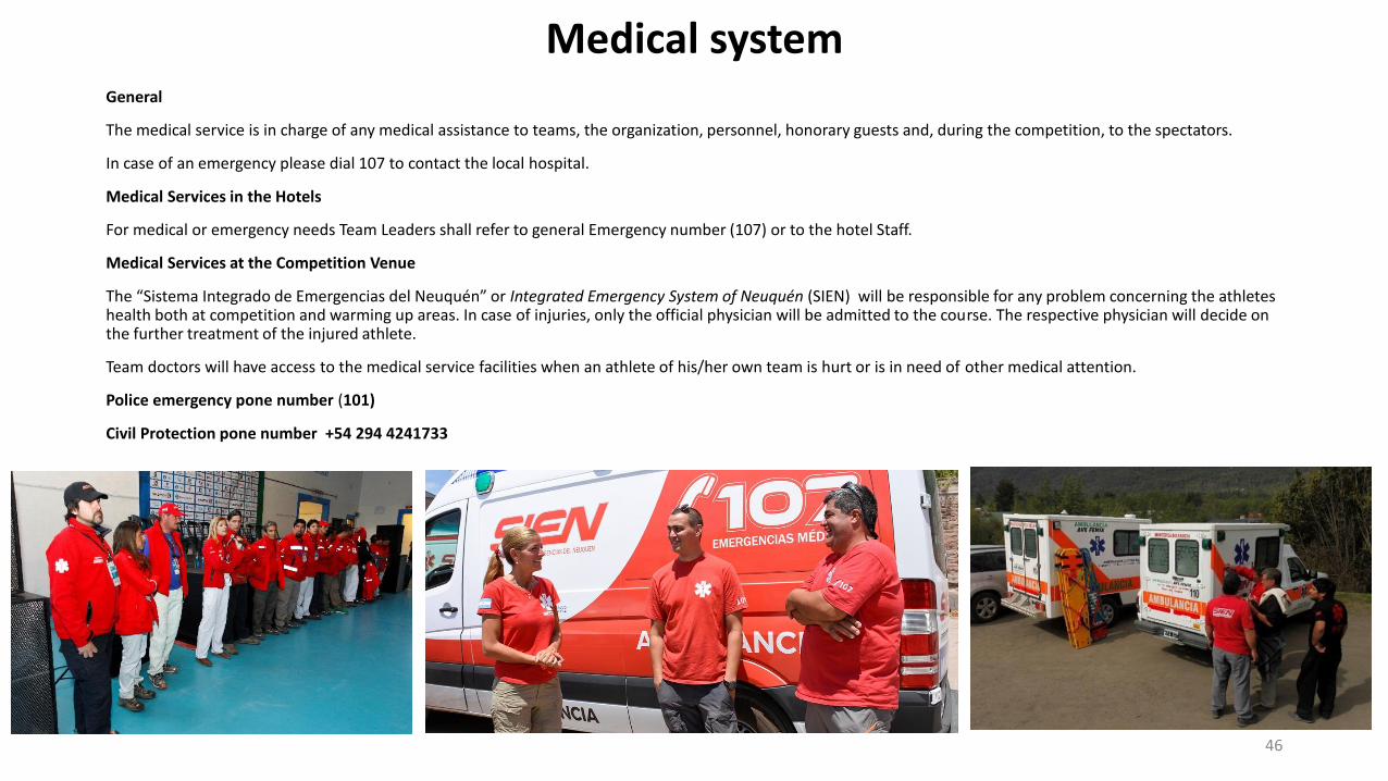
Medical systemGeneral
The medical service is in charge of any medical assistance to teams, the organization, personnel, honorary guests and, during the competition, to the spectators.
In case of an emergency please dial 107 to contact the local hospital.
Medical Services in the Hotels
For medical or emergency needs Team Leaders shall refer to general Emergency number (107) or to the hotel Staff.
Medical Services at the Competition Venue
The “Sistema Integrado de Emergencias del Neuquén” or Integrated Emergency System of Neuquén (SIEN) will be responsible for any problem concerning the athletes health both at competition and warming up areas. In case of injuries, only the official physician will be admitted to the course. The respective physician will decide on the further treatment of the injured athlete.
Team doctors will have access to the medical service facilities when an athlete of his/her own team is hurt or is in need of other medical attention.
Police emergency pone number (101)
Civil Protection pone number +54 294 4241733
46
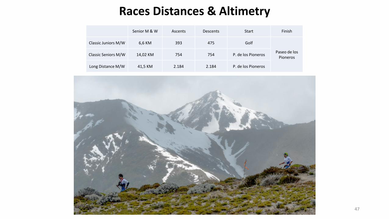
Races Distances & Altimetry
Senior M & W Ascents Descents Start Finish
Classic Juniors M/W 6,6 KM 393 475 Golf
Paseo de los Pioneros
Classic Seniors M/W 14,02 KM 754 754 P. de los Pioneros
Long Distance M/W 41,5 KM 2.184 2.184 P. de los Pioneros
47
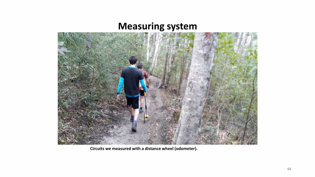
Measuring system
48
Circuits we measured with a distance wheel (odometer).
49
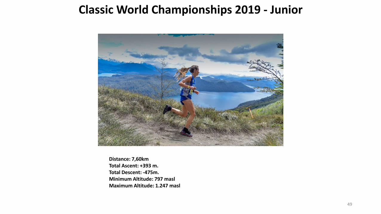
Classic World Championships 2019 - Junior
Distance: 7,60kmTotal Ascent: +393 m. Total Descent: -475m.Minimum Altitude: 797 maslMaximum Altitude: 1.247 masl
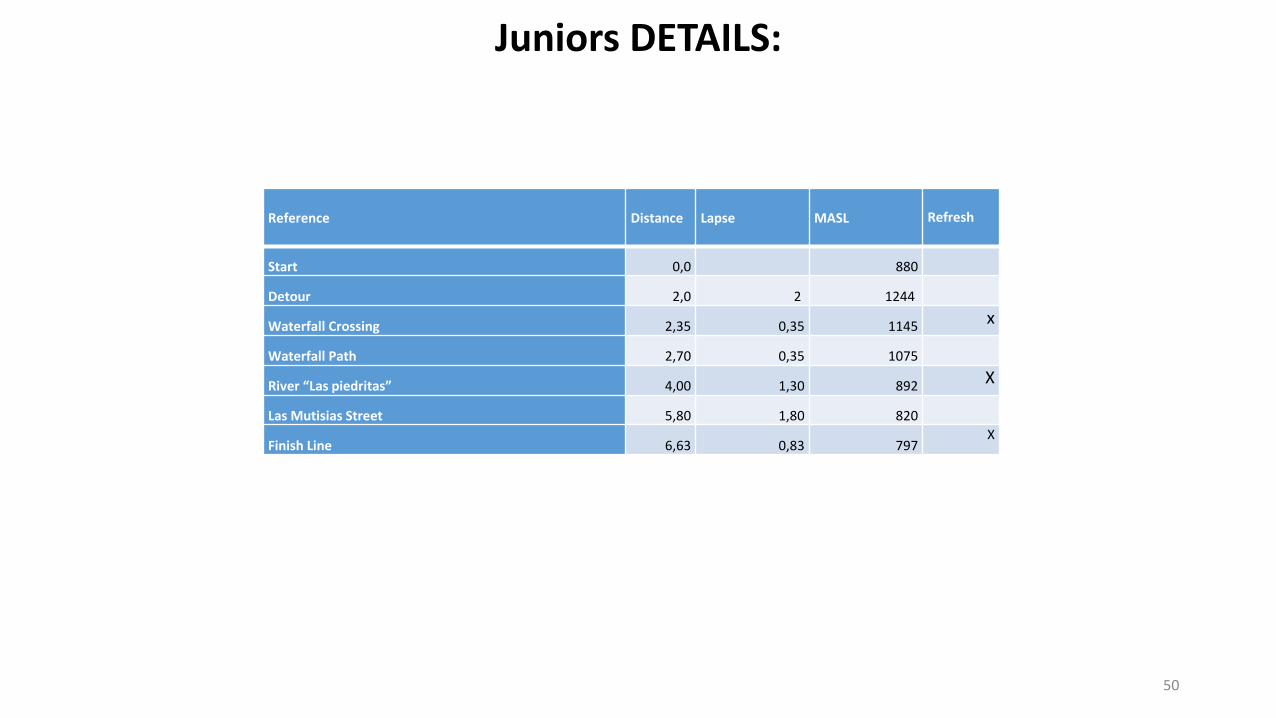
Reference Distance Lapse MASL Refresh
Start 0,0 880
Detour 2,0 2 1244
Waterfall Crossing 2,35 0,35 1145 x
Waterfall Path 2,70 0,35 1075
River “Las piedritas” 4,00 1,30 892 X
Las Mutisias Street 5,80 1,80 820
Finish Line 6,63 0,83 797X
50
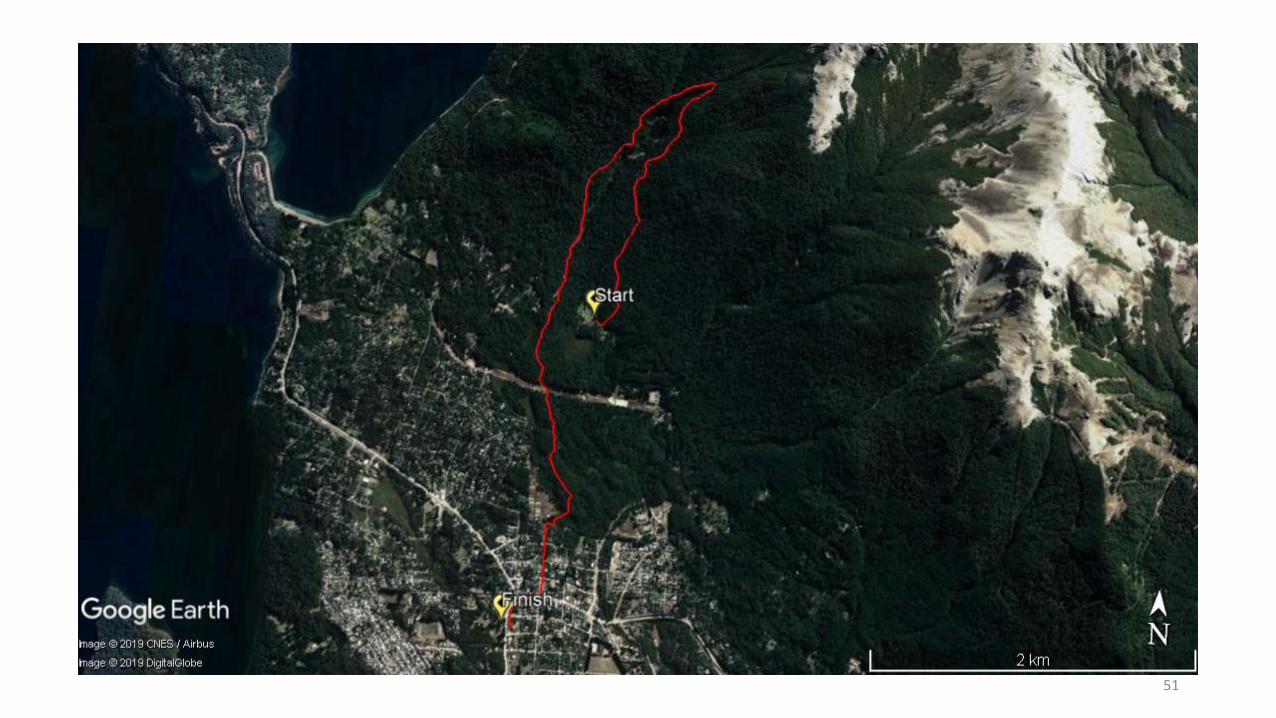
Juniors DETAILS:
51
52
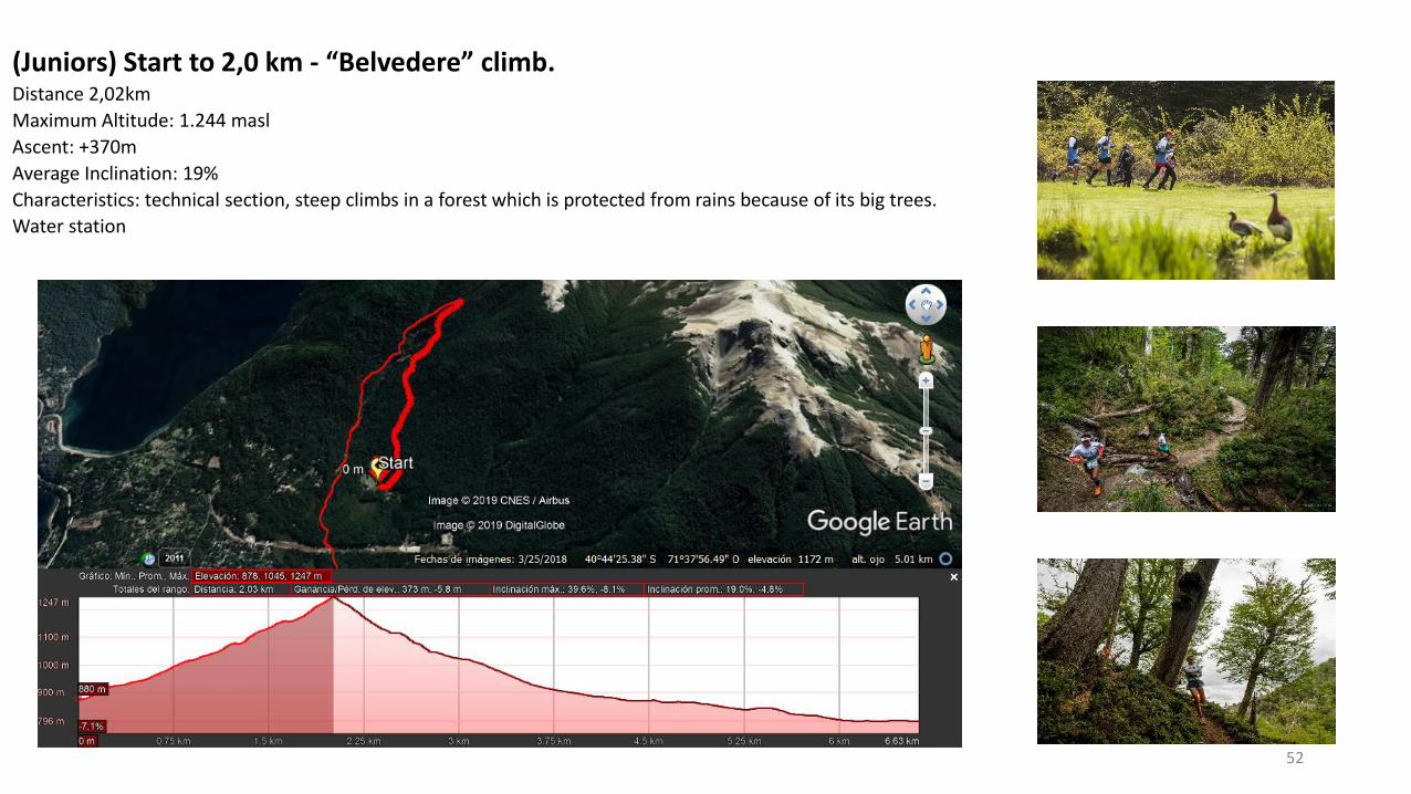
(Juniors) Start to 2,0 km - “Belvedere” climb.Distance 2,02km
Maximum Altitude: 1.244 masl
Ascent: +370m
Average Inclination: 19%
Characteristics: technical section, steep climbs in a forest which is protected from rains because of its big trees.
Water station
53
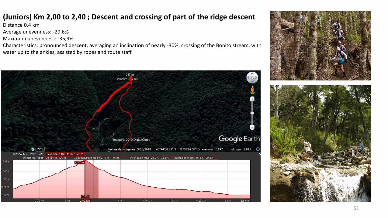
(Juniors) Km 2,00 to 2,40 ; Descent and crossing of part of the ridge descent Distance 0,4 kmAverage unevenness: -29,6%Maximum unevenness: -35,9% Characteristics: pronounced descent, averaging an inclination of nearly -30%, crossing of the Bonito stream, withwater up to the ankles, assisted by ropes and route staff.
54
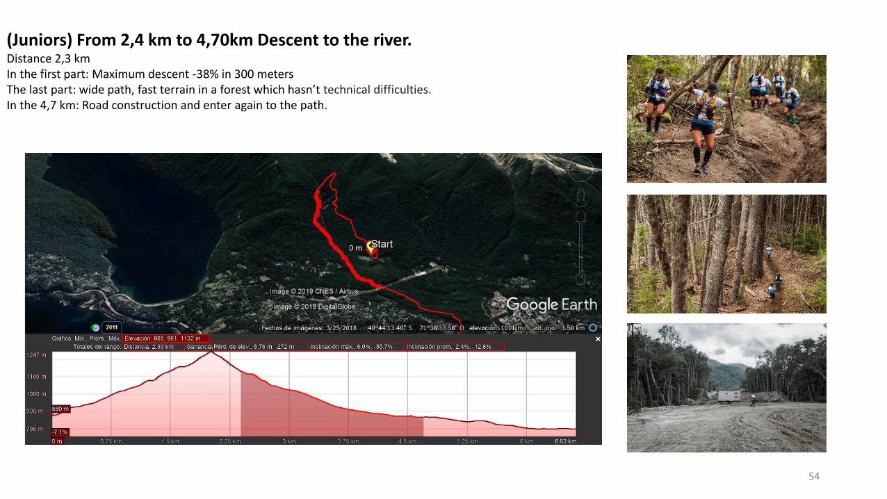
(Juniors) From 2,4 km to 4,70km Descent to the river. Distance 2,3 kmIn the first part: Maximum descent -38% in 300 metersThe last part: wide path, fast terrain in a forest which hasn’t technical difficulties. In the 4,7 km: Road construction and enter again to the path.
55
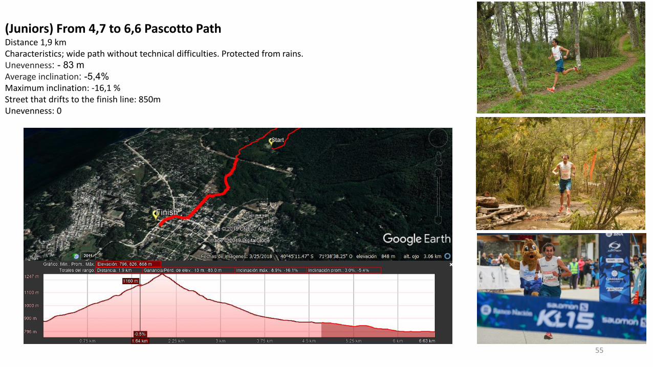
(Juniors) From 4,7 to 6,6 Pascotto PathDistance 1,9 kmCharacteristics; wide path without technical difficulties. Protected from rains.Unevenness: - 83 m
Average inclination: -5,4%
Maximum inclination: -16,1 %Street that drifts to the finish line: 850mUnevenness: 0
56
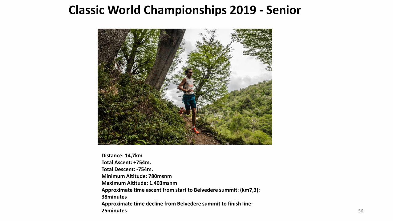
Classic World Championships 2019 - Senior
Distance: 14,7kmTotal Ascent: +754m. Total Descent: -754m.Minimum Altitude: 780msnmMaximum Altitude: 1.403msnmApproximate time ascent from start to Belvedere summit: (km7,3): 38minutesApproximate time decline from Belvedere summit to finish line: 25minutes
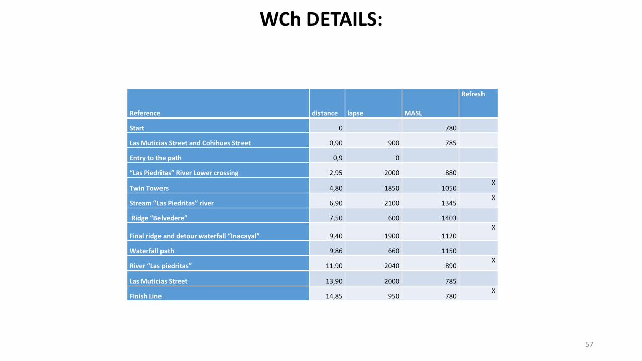
Reference distance lapse MASL
Refresh
Start 0 780
Las Muticias Street and Cohihues Street 0,90 900 785
Entry to the path 0,9 0
“Las Piedritas” River Lower crossing 2,95 2000 880
Twin Towers 4,80 1850 1050X
Stream “Las Piedritas” river 6,90 2100 1345X
Ridge “Belvedere” 7,50 600 1403
Final ridge and detour waterfall “Inacayal” 9,40 1900 1120X
Waterfall path 9,86 660 1150
River “Las piedritas” 11,90 2040 890X
Las Muticias Street 13,90 2000 785
Finish Line 14,85 950 780X
57
WCh DETAILS:
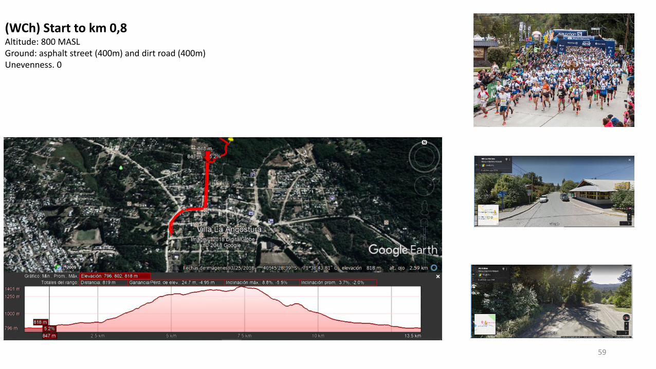
(WCh) Start to km 0,8 Altitude: 800 MASLGround: asphalt street (400m) and dirt road (400m)Unevenness. 0
59
60
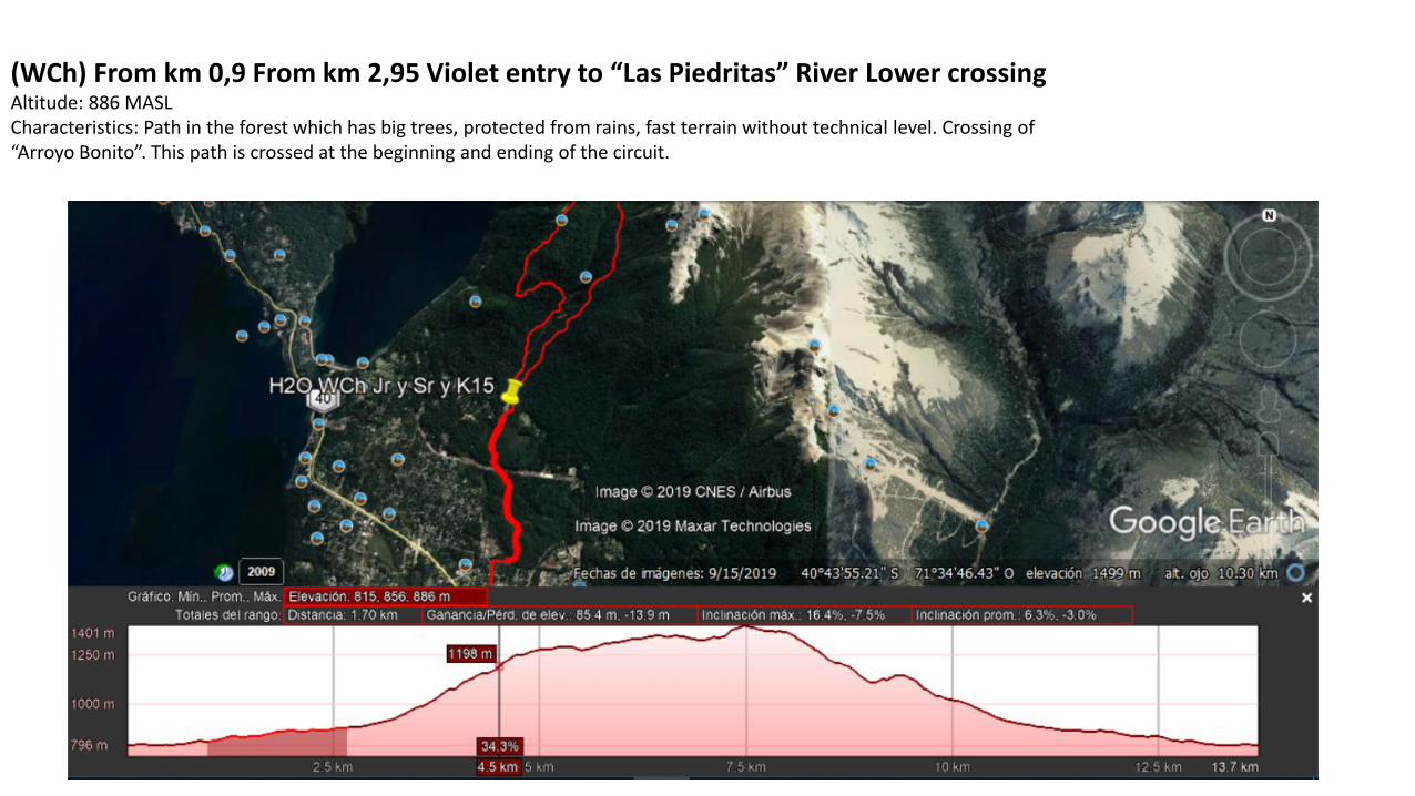
(WCh) From km 0,9 From km 2,95 Violet entry to “Las Piedritas” River Lower crossingAltitude: 886 MASLCharacteristics: Path in the forest which has big trees, protected from rains, fast terrain without technical level. Crossing of“Arroyo Bonito”. This path is crossed at the beginning and ending of the circuit.
61
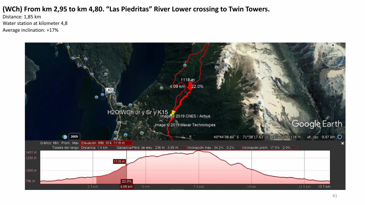
(WCh) From km 2,95 to km 4,80. “Las Piedritas” River Lower crossing to Twin Towers.Distance: 1,85 kmWater station at kilometer 4,8
Average inclination: +17%
62
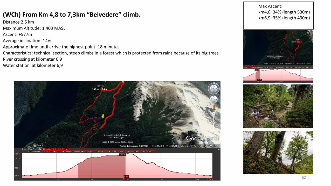
(WCh) From Km 4,8 to 7,3km “Belvedere” climb.Distance 2,5 km
Maximum Altitude: 1.403 MASL
Ascent: +577m
Average inclination: 14%
Approximate time until arrive the highest point: 18 minutes.
Characteristics: technical section, steep climbs in a forest which is protected from rains because of its big trees.
River crossing at kilometer 6,9
Water station at kilometer 6,9
Max Ascent: km4,6: 34% (length 530m)km6,9: 35% (length 490m)
63
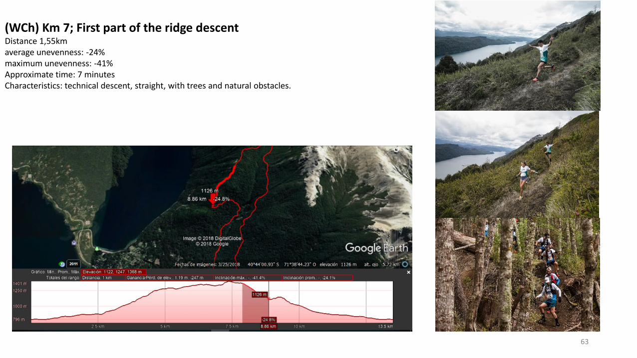
(WCh) Km 7; First part of the ridge descent Distance 1,55kmaverage unevenness: -24%maximum unevenness: -41%Approximate time: 7 minutesCharacteristics: technical descent, straight, with trees and natural obstacles.
64
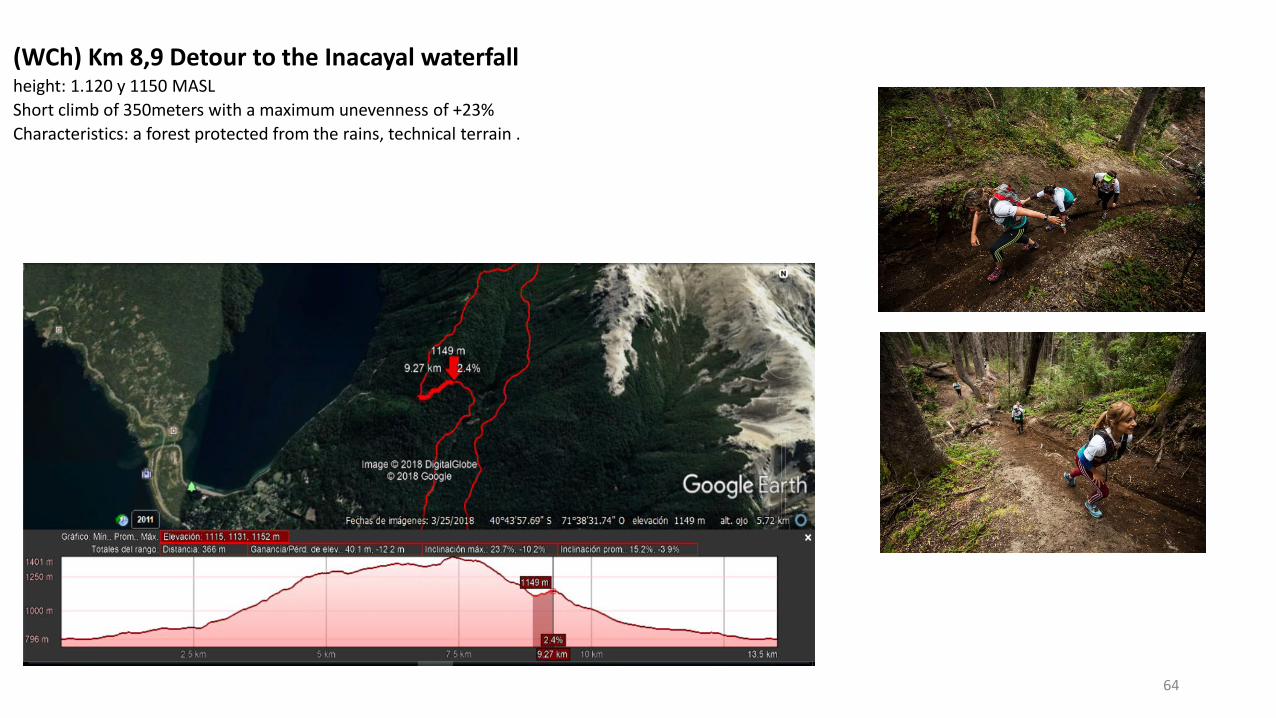
(WCh) Km 8,9 Detour to the Inacayal waterfallheight: 1.120 y 1150 MASL
Short climb of 350meters with a maximum unevenness of +23%
Characteristics: a forest protected from the rains, technical terrain .
65
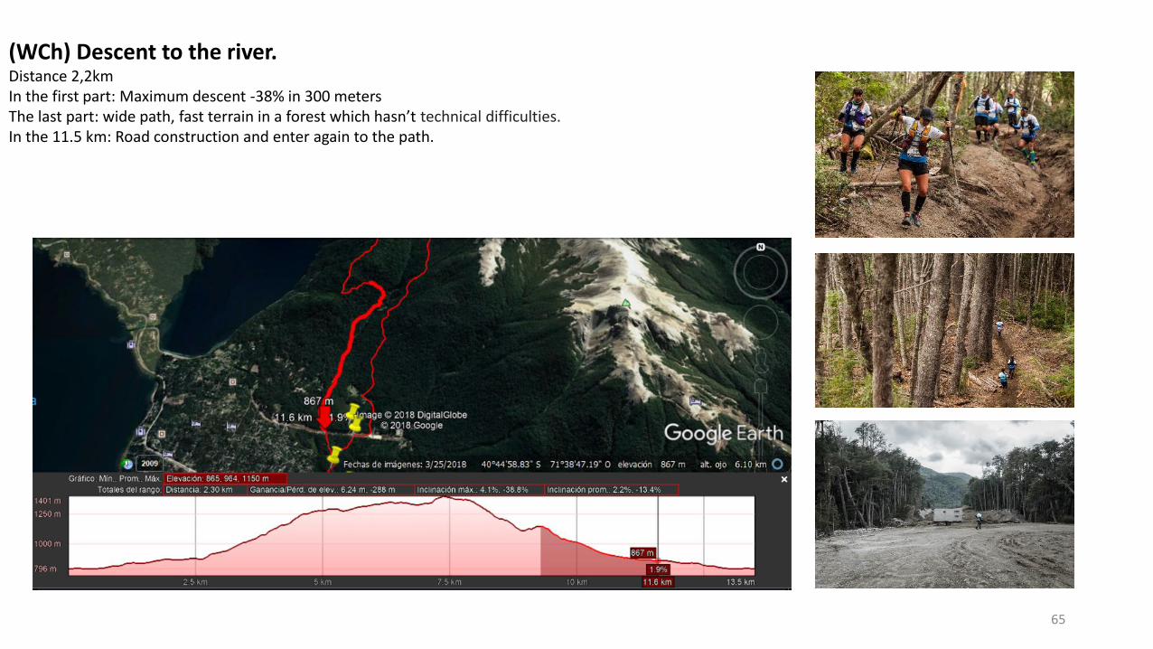
(WCh) Descent to the river. Distance 2,2kmIn the first part: Maximum descent -38% in 300 metersThe last part: wide path, fast terrain in a forest which hasn’t technical difficulties. In the 11.5 km: Road construction and enter again to the path.
66
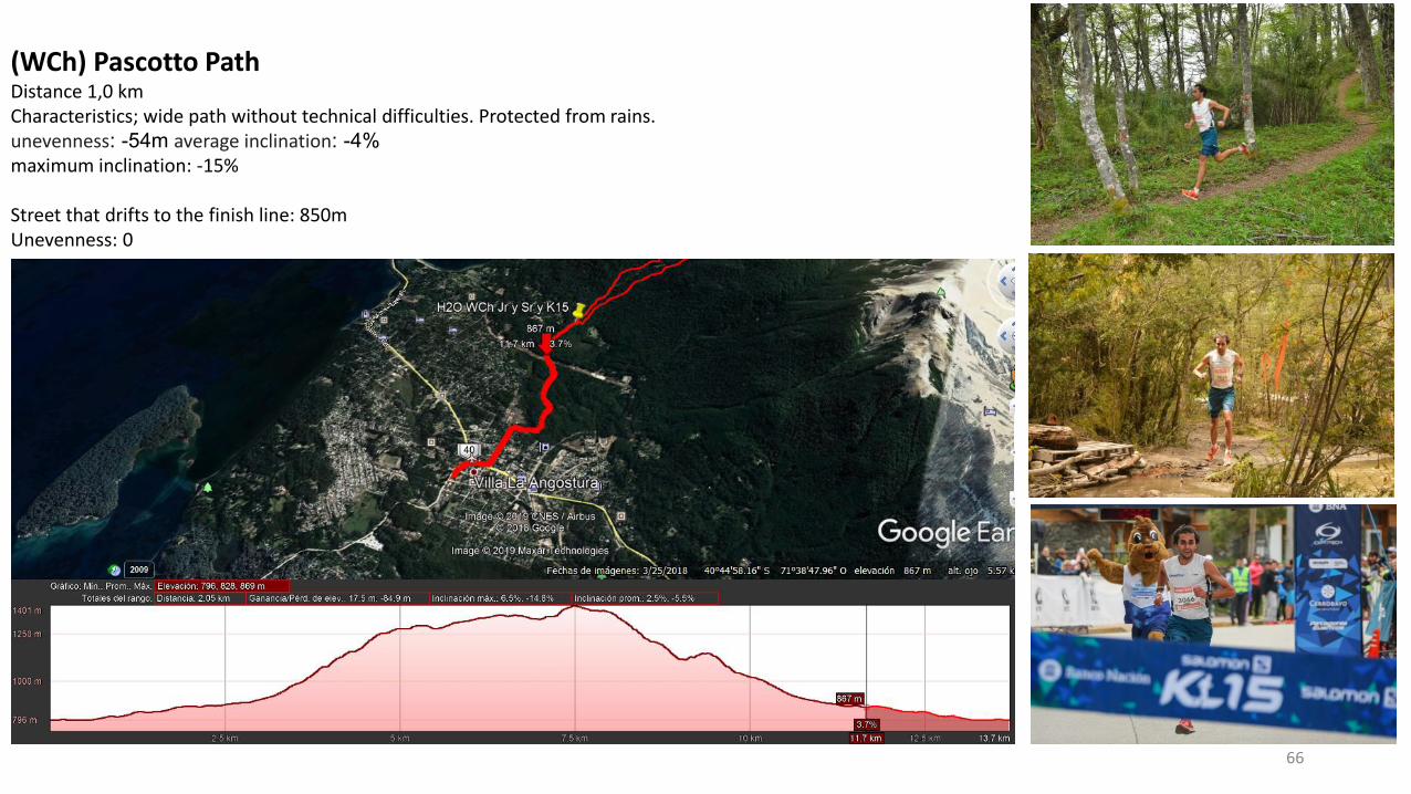
(WCh) Pascotto PathDistance 1,0 kmCharacteristics; wide path without technical difficulties. Protected from rains.unevenness: -54m average inclination: -4%
maximum inclination: -15%
Street that drifts to the finish line: 850mUnevenness: 0
Distance: 41,5 km
Gradient: +2.184m. -2.184m.
Minimum Altitude: 800 MASL
Maximum Altitude: 1.778 MASL
67
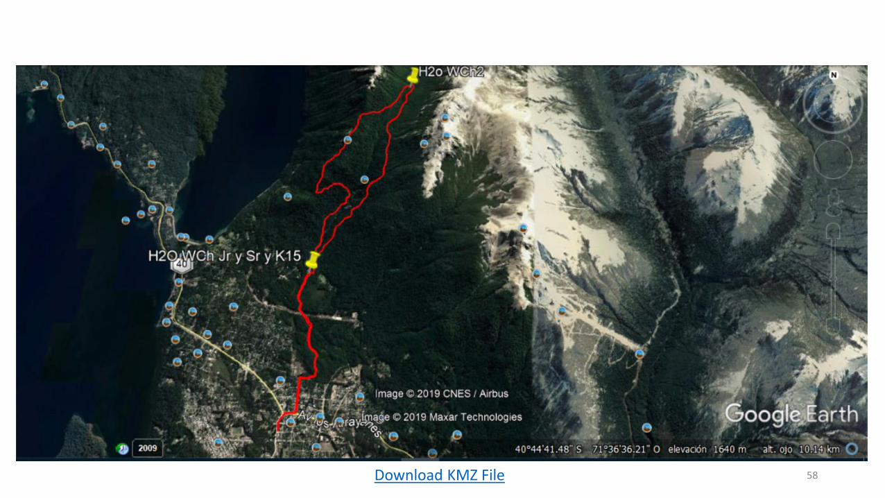
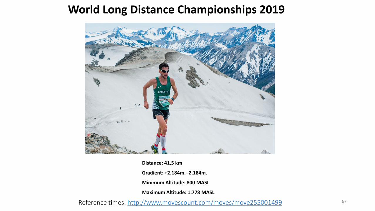
World Long Distance Championships 2019
Reference times: http://www.movescount.com/moves/move255001499
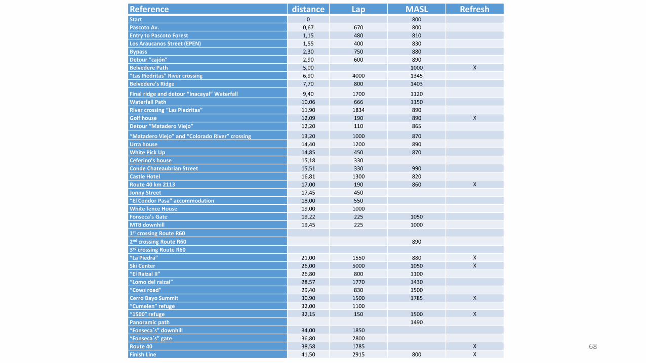
Reference distance Lap MASL RefreshStart 0 800
Pascoto Av. 0,67 670 800
Entry to Pascoto Forest 1,15 480 810
Los Araucanos Street (EPEN) 1,55 400 830
Bypass 2,30 750 880
Detour “cajón” 2,90 600 890
Belvedere Path 5,00 1000 X
“Las Piedritas” River crossing 6,90 4000 1345
Belvedere’s Ridge 7,70 800 1403
Final ridge and detour “Inacayal” Waterfall 9,40 1700 1120
Waterfall Path 10,06 666 1150
River crossing “Las Piedritas” 11,90 1834 890
Golf house 12,09 190 890 X
Detour “Matadero Viejo” 12,20 110 865
“Matadero Viejo” and “Colorado River” crossing 13,20 1000 870
Urra house 14,40 1200 890
White Pick Up 14,85 450 870
Ceferino’s house 15,18 330
Conde Chateaubrian Street 15,51 330 990
Castle Hotel 16,81 1300 820
Route 40 km 2113 17,00 190 860 X
Jonny Street 17,45 450
“El Condor Pasa” accommodation 18,00 550
White fence House 19,00 1000
Fonseca’s Gate 19,22 225 1050
MTB downhill 19,45 225 1000
1st crossing Route R60
2nd crossing Route R60 890
3rd crossing Route R60
“La Piedra” 21,00 1550 880 X
Ski Center 26,00 5000 1050 X
“El Raizal II” 26,80 800 1100
“Lomo del raizal” 28,57 1770 1430
“Cows road” 29,40 830 1500
Cerro Bayo Summit 30,90 1500 1785 X
“Cumelen” refuge 32,00 1100
“1500” refuge 32,15 150 1500 X
Panoramic path 1490
“Fonseca´s” downhill 34,00 1850
“Fonseca´s” gate 36,80 2800
Route 40 38,58 1785 X
Finish Line 41,50 2915 800 X68
70
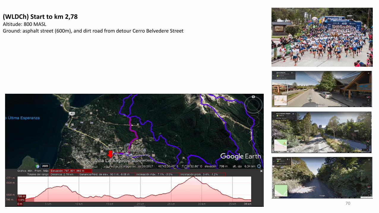
(WLDCh) Start to km 2,78 Altitude: 800 MASL Ground: asphalt street (600m), and dirt road from detour Cerro Belvedere Street
71
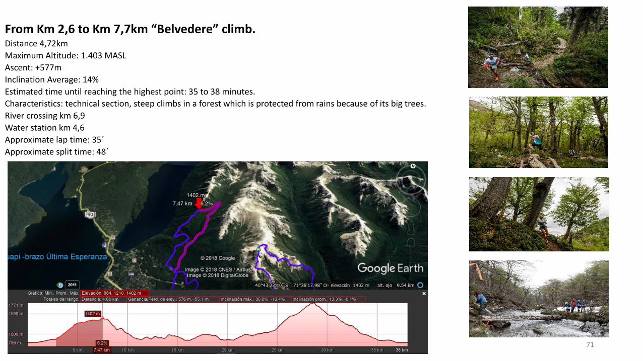
From Km 2,6 to Km 7,7km “Belvedere” climb.Distance 4,72km
Maximum Altitude: 1.403 MASL
Ascent: +577m
Inclination Average: 14%
Estimated time until reaching the highest point: 35 to 38 minutes.
Characteristics: technical section, steep climbs in a forest which is protected from rains because of its big trees.
River crossing km 6,9
Water station km 4,6
Approximate lap time: 35´
Approximate split time: 48´
72
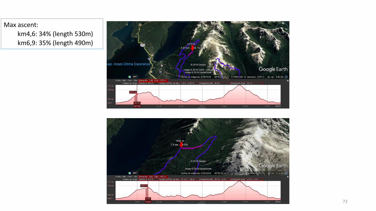
Max ascent:
km4,6: 34% (length 530m)
km6,9: 35% (length 490m)
73
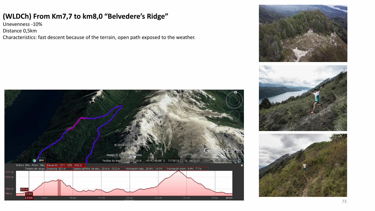
(WLDCh) From Km7,7 to km8,0 “Belvedere’s Ridge”Unevenness -10%Distance 0,5km Characteristics: fast descent because of the terrain, open path exposed to the weather.
74
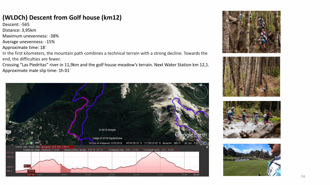
(WLDCh) Descent from Golf house (km12)Descent: -565 Distance: 3,95kmMaximum unevenness: -38% Average unevenness: -15%Approximate time: 18´In the first kilometers, the mountain path combines a technical terrain with a strong decline. Towards the end, the difficulties are fewer. Crossing “Las Piedritas” river in 11,9km and the golf house meadow’s terrain. Next Water Station km 12,1.Approximate male slip time: 1h 01´
75
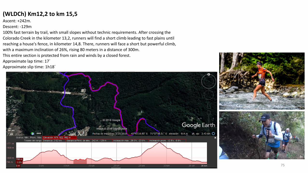
(WLDCh) Km12,2 to km 15,5Ascent: +242m.
Descent: -129m
100% fast terrain by trail, with small slopes without technic requirements. After crossing the
Colorado Creek in the kilometer 13,2, runners will find a short climb leading to fast plains until
reaching a house's fence, in kilometer 14,8. There, runners will face a short but powerful climb,
with a maximum inclination of 26%, rising 80 meters in a distance of 300m.
This entire section is protected from rain and winds by a closed forest.
Approximate lap time: 17´
Approximate slip time: 1h18´
76
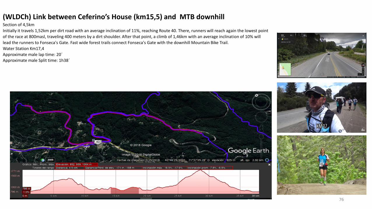
(WLDCh) Link between Ceferino’s House (km15,5) and MTB downhillSection of 4,5km
Initially it travels 1,52km per dirt road with an average inclination of 11%, reaching Route 40. There, runners will reach again the lowest point
of the race at 800masl, traveling 400 meters by a dirt shoulder. After that point, a climb of 1,46km with an average inclination of 10% will
lead the runners to Fonseca's Gate. Fast wide forest trails connect Fonseca's Gate with the downhill Mountain Bike Trail.
Water Station Km17,4
Approximate male lap time: 20´
Approximate male Split time: 1h38´
77
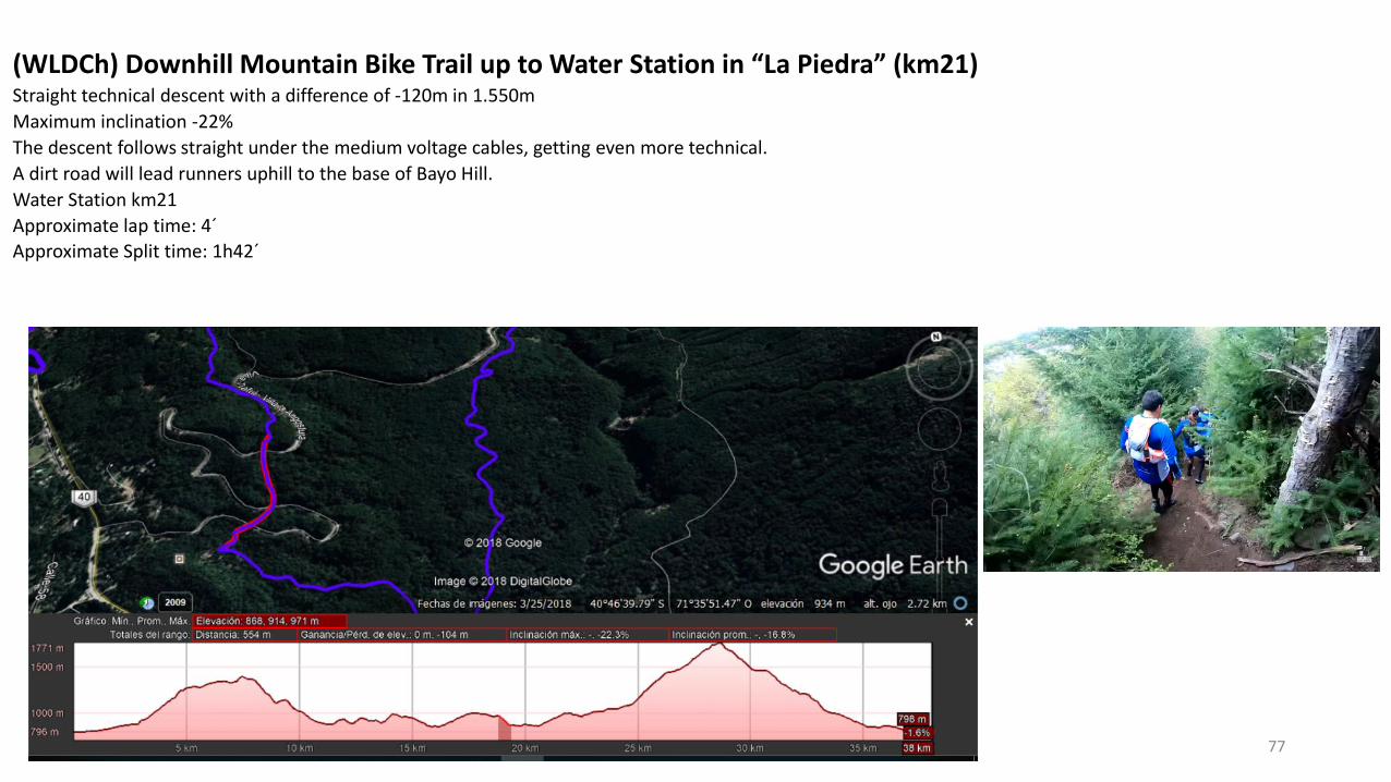
(WLDCh) Downhill Mountain Bike Trail up to Water Station in “La Piedra” (km21)Straight technical descent with a difference of -120m in 1.550m
Maximum inclination -22%
The descent follows straight under the medium voltage cables, getting even more technical.
A dirt road will lead runners uphill to the base of Bayo Hill.
Water Station km21
Approximate lap time: 4´
Approximate Split time: 1h42´
78
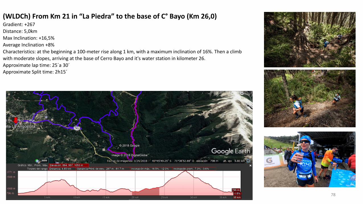
(WLDCh) From Km 21 in “La Piedra” to the base of C° Bayo (Km 26,0)Gradient: +267
Distance: 5,0km
Max Inclination: +16,5%
Average Inclination +8%
Characteristics: at the beginning a 100-meter rise along 1 km, with a maximum inclination of 16%. Then a climb
with moderate slopes, arriving at the base of Cerro Bayo and it's water station in kilometer 26.
Approximate lap time: 25´a 30´
Approximate Split time: 2h15´
79
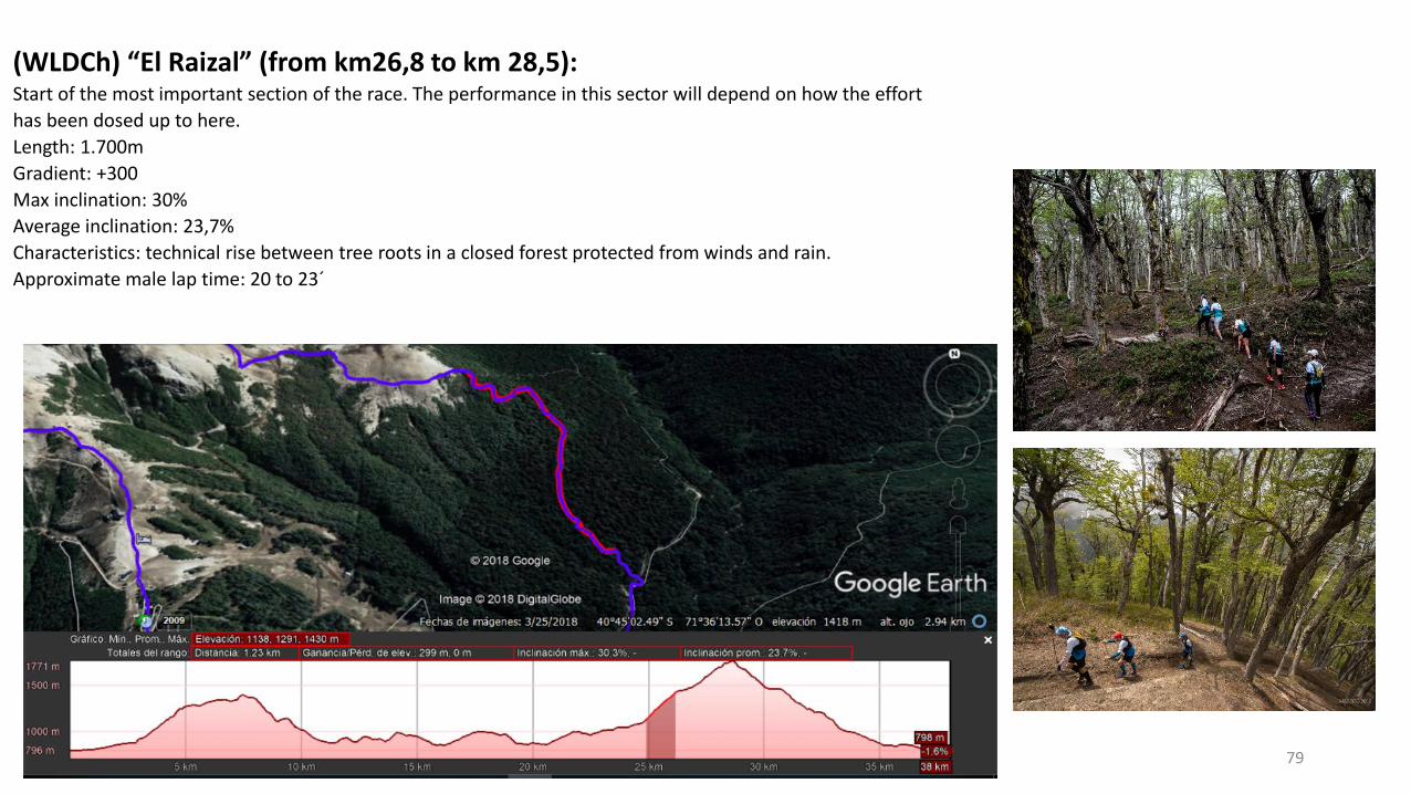
(WLDCh) “El Raizal” (from km26,8 to km 28,5):Start of the most important section of the race. The performance in this sector will depend on how the effort
has been dosed up to here.
Length: 1.700m
Gradient: +300
Max inclination: 30%
Average inclination: 23,7%
Characteristics: technical rise between tree roots in a closed forest protected from winds and rain.
Approximate male lap time: 20 to 23´
80
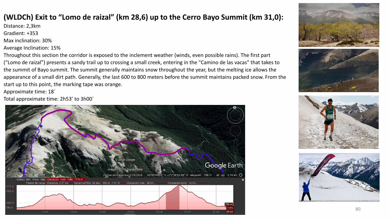
(WLDCh) Exit to “Lomo de raizal” (km 28,6) up to the Cerro Bayo Summit (km 31,0):Distance: 2,3km
Gradient: +353
Max inclination: 30%
Average Inclination: 15%
Throughout this section the corridor is exposed to the inclement weather (winds, even possible rains). The first part
(“Lomo de raizal”) presents a sandy trail up to crossing a small creek, entering in the "Camino de las vacas" that takes to
the summit of Bayo summit. The summit generally maintains snow throughout the year, but the melting ice allows the
appearance of a small dirt path. Generally, the last 600 to 800 meters before the summit maintains packed snow. From the
start up to this point, the marking tape was orange.
Approximate time: 18´
Total approximate time: 2h53’ to 3h00´

Cerro Bayo Summit
81
82
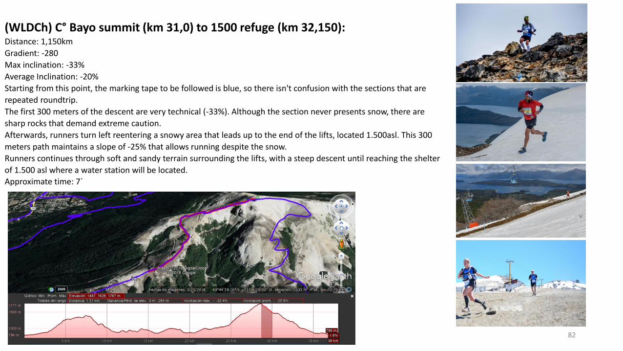
(WLDCh) C° Bayo summit (km 31,0) to 1500 refuge (km 32,150):Distance: 1,150km
Gradient: -280
Max inclination: -33%
Average Inclination: -20%
Starting from this point, the marking tape to be followed is blue, so there isn't confusion with the sections that are
repeated roundtrip.
The first 300 meters of the descent are very technical (-33%). Although the section never presents snow, there are
sharp rocks that demand extreme caution.
Afterwards, runners turn left reentering a snowy area that leads up to the end of the lifts, located 1.500asl. This 300
meters path maintains a slope of -25% that allows running despite the snow.
Runners continues through soft and sandy terrain surrounding the lifts, with a steep descent until reaching the shelter
of 1.500 asl where a water station will be located.
Approximate time: 7´
83
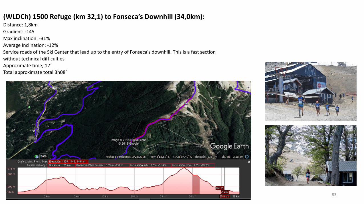
(WLDCh) 1500 Refuge (km 32,1) to Fonseca’s Downhill (34,0km):Distance: 1,8km
Gradient: -145
Max inclination: -31%
Average Inclination: -12%
Service roads of the Ski Center that lead up to the entry of Fonseca's downhill. This is a fast section
without technical difficulties.
Approximate time; 12´
Total approximate total 3h08´
84
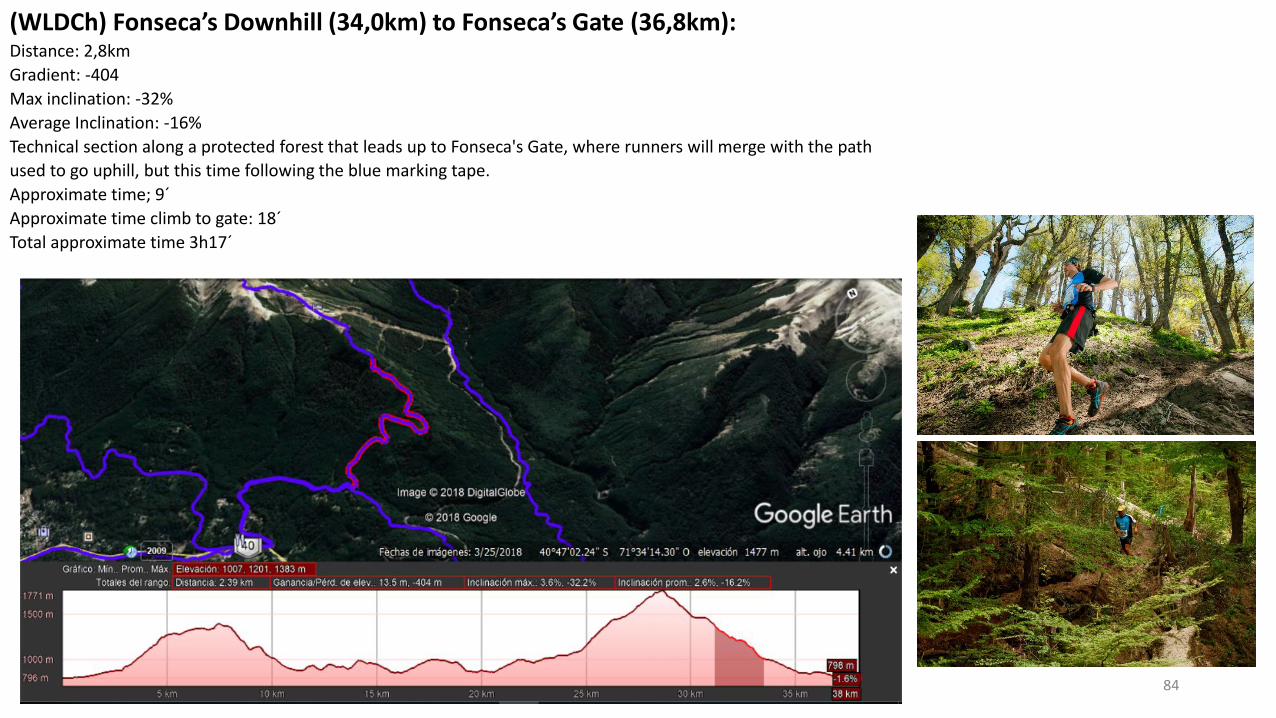
(WLDCh) Fonseca’s Downhill (34,0km) to Fonseca’s Gate (36,8km):Distance: 2,8km
Gradient: -404
Max inclination: -32%
Average Inclination: -16%
Technical section along a protected forest that leads up to Fonseca's Gate, where runners will merge with the path
used to go uphill, but this time following the blue marking tape.
Approximate time; 9´
Approximate time climb to gate: 18´
Total approximate time 3h17´
85
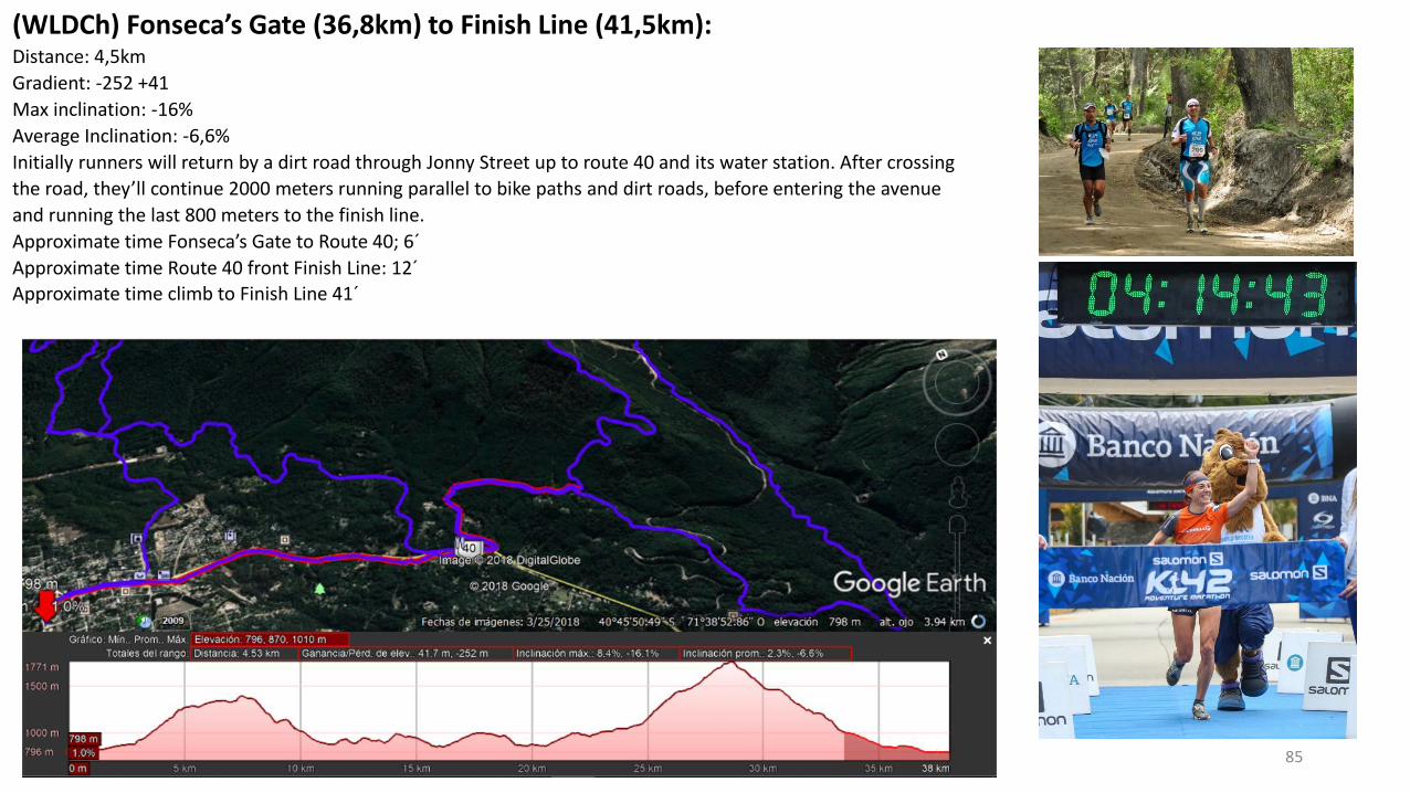
(WLDCh) Fonseca’s Gate (36,8km) to Finish Line (41,5km):Distance: 4,5km
Gradient: -252 +41
Max inclination: -16%
Average Inclination: -6,6%
Initially runners will return by a dirt road through Jonny Street up to route 40 and its water station. After crossing
the road, they’ll continue 2000 meters running parallel to bike paths and dirt roads, before entering the avenue
and running the last 800 meters to the finish line.
Approximate time Fonseca’s Gate to Route 40; 6´
Approximate time Route 40 front Finish Line: 12´Approximate time climb to Finish Line 41´
86
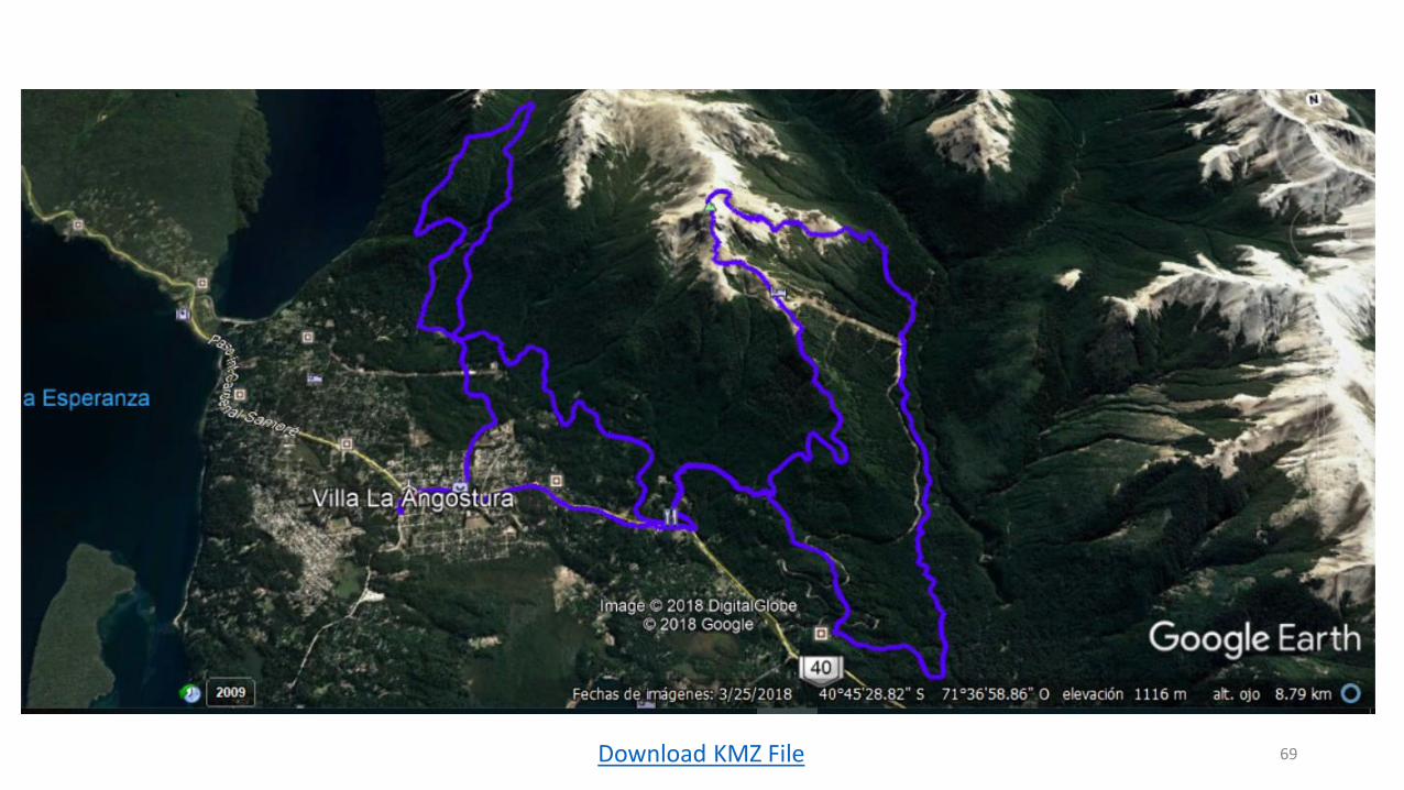
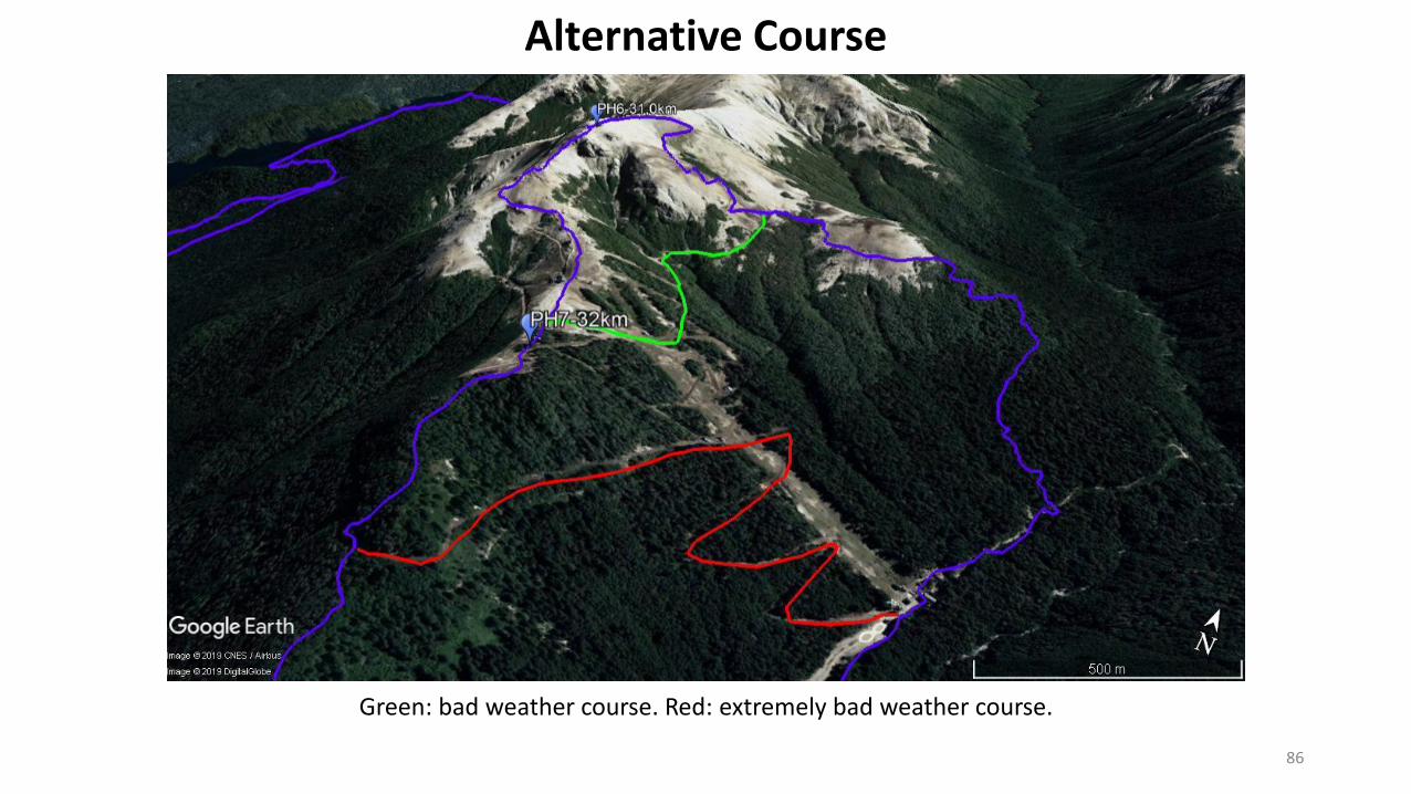
Green: bad weather course. Red: extremely bad weather course.
Alternative Course
87
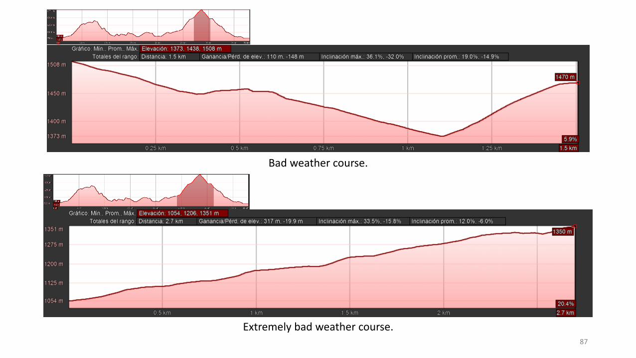
Bad weather course.
Extremely bad weather course.
88