Embed Size (px)
Citation preview
ft E P O H T " A "
3ID09NE00P? 63A.223 BURLEIGH 010
Hll'OHT ON
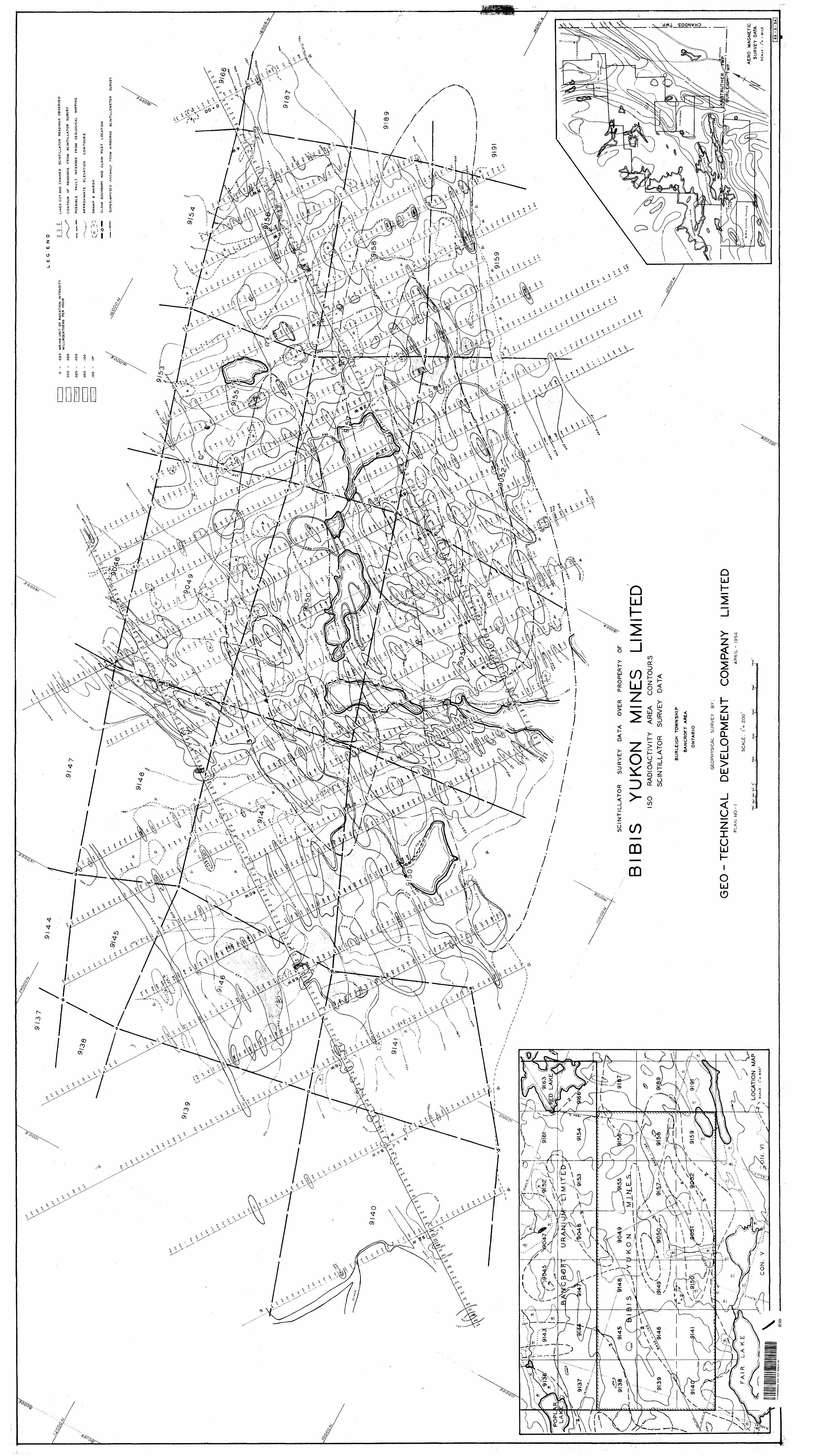
SCINTILLATOR R1HVEY
ON rKOJ'KHTY O P1
BUM B Y (IKON MINlvfJ LIMITiiD
COUNTY
ONTAitlO
Prepared byt
S. s, fteetu, Ph.B*, Oeologlut for
OKO-ThCHNICAL DEVKLOi"MKNT COMPANY LTD. PJ,| WELLINGTON STHEiST VfKST TOiiONTO, OKTAHIO
BED -TECHNICAL O rVELOPME NT COMPANY LIMtlECi

Bible Yukon Minos Limited, 100 Adelaide Street Voet, Toronto, Ontario.
Ctantlemeni
Tho following report describes the rouults of a
ground scintillator survey conducted over your property
located in burleigh Township, Peterborough County, Ontario.
T h o survey was conducted by Otto-Technical Develop*
mont Company 1,1 ml ted during cho period from April let to
Hay lOth, 19.1^1 and tho results are depleted on Plan No. l
ac company. l nrr this report.
and
Tho detailed ground scintillator survey conducted
over your property showed that the two continuous Eonos of
radioactivity outlined by an airborne scintillometer survey
broke down into a BorloB of radioactive high epotst These
highs occurred over roasBes of pegmatite, pegmatitic granite
and granite p.noiss with pegmatite dykes or allls. It appears
that tho continuous radioactive anomalies outlined by the
airborne scintillometer survey were the result of the Bllghtly
radioactive masses mentioned above plus the effect of mass*
The two Eoneuj raontJonod above ar-o separated by a series of
beaver pondtf.
Tho hlgheet reading obtained by this survey (0.168
KK/hr) i s from the northwest sorlop which corresponds roughly
to the nortliwest anomaly outlined by tho airborne survey.
BED -TECHNICAL DEVELOPMENT COMPANY LIMITED
-2-
mapping and spot check sampling have
shown that there le no promising geological occurrence in
the property and th concentration of uranium In the rocks
is low*
The property of Bible i'ukon Ml rio s Limit od located
in Barleifth Township, Potorborojgh Co.anty, Ontario, consists
of lb unpatentod claims In Lots PI to 23 Inclusive, Concessions
V and VI. Claims arc numbered as follow* i
.0, 901|9 to 90iJ2 inol. 9138 to 9114.1 loci. 91H5* 91146, 91'^i 911^5 to 91^9 incl,
'fho property is situated approximately ?1\ wllee
southwest of the town of Apsley, Ontario. It IB bounded
by Pair Lake and its eoni^ootin^ swamps and u anitt'Jl lake to
the south. Fair -i-uke lo abaut ono mile north of Louck's
Luke wblch i:? connected to the woat end of Long Lake by a
struit.
ACCOSB to the proJ>er^/y is best made by automobile
from Highway Mo. i?0 throui^h a Bid ft road to Long Lake, arid by
motor bout from Long Lake to Loack's Lake* A hunt! tig trail
loads from Louck's Lake to Fair Lake and to the property*
i'ho property is hilly due to the troraondous amount
of outcrops expoftod. However, the relief of the property Is
only moderate, A bow-shaped chain of beaver ponde ia located
BE D -TECHNICAL DEVELDF'MENT COMPANY L l M l l E t-
-3-
the centre of tho property* A long tjwampy roursh covers
tho south boundary* 'i'hls swa;apy aroa connects with Pair Lake
v;hlch le located rnovo-or-lesfi to the southwest corner of the
property.
Ovorb'U-doj! found In this area 10 very thin. Large
boulder r- ar-o not uncommonly fuinvi sitting on bare rocks,
Poro&t growth coni-slntm wu Inly of enoondT.rowth hardwood,
jnuple, birch and onk covorlnn "'"- hin;hor ^roimd, and poplar*
ash RH'.l alders ^rowSng in Uio low and swampy areas* AB a
rule, forost growth fin uhlu proj^erty IB comparjitlvaly thin
as oowpti.rod with aroun nour A])siey.
Goolo^y
'I'ho northern part, of Burloigh TownaVilp Is underlain
by rocks of Pro-Cambrian ajje (Ontwio Department of M i ne c Hap
No. .b'#-ft "liuliburton Area"). Tho property Is located well
within fi large mass of Fro-Cambrian granitic complex,
DotRilod jieologlottl majjj*ln^ of the property carried
out by Ooo-Tcchnloal Developroent Company Limited hua shown
the reparation of thin granStlo complex Into the following
rook types i pegmatite, pegmatitic complex, granite and
pegmatitic granite, granite ynclee unci biotite gnolas. The
descriptions of those rook types are included In a geological
report. Ho.t of tho property Is covered by granite gneiss.
The pegmatite) and granite fuund in this property ara, In
general, as lit-par-lit injections In the granite gneiss and
BE O -TECHNICAL DEVELOPMENT COMPANY LIMITEC'

occasionally tiB X urge und broull Hills, dykes and plugs cutting
the ('.runite f!,uelnR. r*pot cheeks uhovmd that tho pegmatite,
pegmatitic granite and granite gnedse with pegmatite dykea
or sUlo are, ac a rule, slightly mor o rudioaotive than
(-runite {/nel&s and biotite f'.noJns*
The property It locukod on a fi] Ijjhtly disturbed
monocline, Local v Mr- 5 n l Ion e j re due to tl\c injections of
T j it- or] -' J 'CJaU; l t*a ^.^^^gLij;^^
Tills f;;round sclntillutor Burvoy v;as curried out
following un airborne BOintlllomotei* survey which outlined
two anomalous y, one B nour tho centre of the property, Tho
ground scintillator inirvoy picked up ft aerloe of highs with
reading 7 to 19 tS.moa hl^hox* than background. The hlRh^st
rcadinp (0,168 iW/hr) obtained by this survey IB from the
north-wast nor! os which corresponds approximately to the north-
weot anomaly outlined by the airborne scintillometer survey,
'.Hie two KonoR outlined by the airborne survey ore separated
by ti fser.lets of beaver ponds which gave comparatively low
rei-dlni',*:. It tippoure tliat tlie continuous radioactive
CinoT:itlit)B outlined by thft airborne survey arc the result of
the slightly radioactive manaeo irjentlonod above plus the
of fee t of mesa,
Zoological mappinfr, and spot check sarqpllnr; have
Bliown that thoro lo no promS eluf? geological occurrence In
this property and the concentration of uranlurc in the rooks
Is low*
GEO-TrOHNICAL DrVELDPMFNT t:OMPANY LIMITED

-5-
T ho instrument ueod for recording radioactivity
was a ".Portable Scintillator Counter" Model lil with ranges
of ,0?Jj| ,0!j, .25', .^, 2. X fcnd f), O milllroentgens per hour.
The instrument hue an accuracy of 5*^ of three-quartera full
ecale. Standard procedure was to calibrate the Instrument
with a standard radlofictlve chip of 0.19 mllllroentgene per
hour. Chock readings were wade eoveral times each day to
determine possible changes in the instrument during the
traverse run. This cheek also served to establish a back
ground count for the area being surveyed,
A ground scintillator survey wae conducted over
your property located in Burleigh Township, Peterborough
County, Ontario*
The survey was curried out by Oeo-Toohnloal Develop
ment Company Mm* ted during the period from April 1st to
Hay 8th, 19^1* and the results are depicted on Plan No. l
accompanying this report.
A base line with a bearing N 3l| 0K was cut across
the south anomalous zone outlined by the airborne survey.
An auxllliar.v base lino was out parallel and located P,6I|0
feet north of the above base line. Picket lines were cut at
right angles to these bat- e lines at 200, JfOO and 800 foot
Intervals to cover the property.
GEO -TECHNICAL DEVflOPMENI COMPANY LIMITED

-6-
Scintillator readings were taken at JjQ foot Intervals
along the picket linos and base linea. Where high radioactivity
was* encountered, readings vere taken at ?~5 foot intervals*
The readings are expressed In milllroentgens per hour and are
plotted on the accompanying plan. Contour/} wore made on the
bafiie of even mult i pie B of readings obtained.
A total of Pit. 9 miles of line was traversed by the
ground scintillator survey, requiring 2JJ7U station readings.
The number of eight-hour man-days required to
complete this work le as follows i
Line cutting and chaining
Operating Scintillator iiurvey
Calculation i.: Interpretation
Drafting
Office typing fe Supervision
Total B
(8 hour) Attributable to|ian Jjayjt A BS BBS roe i nt Wo rk
86 K h
60 x
15 x
i?Jj. x
.^2 x
U
k
k
u
3HI4
PltO
60
96
.J6
776
Heapeotfully submitted,
r^liT C'JMFANSf LTD.
Toronto, Ontario December 9,
-c M v
S. 3. Szetu, Ph.D., Geologist
BE D -TECHNICAL D EVELOPMENT COMPANY I.IMITEC'
R E F O K T " B
31D09NEP02? 6 3A.P?3 B URLEIGH
T ON
OKUMKHCALr SUHVKY
OK PHOJ'l'lHTy OF
BlliJS YU'KON MJNK.'i LIMIT}'.!)
ii.JHLjilOJ] TOWN SI fi P
(m COUNTY
F j -ej) j*r o d by i
*H, ; ; . S2et,u, Ph.J),, Ocolo/il.et for
GHO-TJiCllKICAL DKVKLOP11BNT CO;*lPAIiy LTD,2)j WED,:nmjx)N SITTOKOK'J'O, OHTAK10
BEO-ltC:HNICAL O fVILOF'MENT t: DM P ANY LIMITED

31D09NKeB22 BURLEIGH0P0C
li F. i 1 O H 'S l li J ) K X
l ntr-oduction .t******.....**.**.***..*...*.*...** l age X
Summary and OoncluRiona ••••**..4**************** Fuge l
J'ropoi'ty, Location and Access ••••••••••*******.* Page Z
Topography ....t...*...,..*...*.......**.*....*.. Page 2, 3
Oeneral Geology t..*...**.............****....**. ?ago 3
Hock Typen .,..........,......,.................. Pago )|, ^
Structural Fouturee .•••••••••****..***t********* J "a f, e 5* 6
Economic Geology .., (Assny Results) *...*......* J age 6 , 7
Survey Data ,............... *.,,....,.. *.,,.,, *. * Page 7, 8
it i r W ir tt tt tt
j L/.U 1)0, 3 ...*t... M. an allowing geology arid topogra])hy
(Drawing M or. No. 70-ll-*il|)
i- ir -:,- i!- {J tt tt
BEO-1Et:HNICAL DFVELOPMEN1 t: DM f ANY LIMITED
tibis Xaktm Mines LI mi tod* 100 Adelaide Street Vest, Toronto* Ontario
Gentlemen t
The following report describee the results of a
geological survey conducted over yoar property located In
Burleigh Township, Peterborough County, Ontario.
Tho survey was conducted by Qeo~Teehrdo*l Develop
ment Company Limited during the period from November Oth to
30th, 1 9 #4. and the results are shown on Plan No. l accompanying
t hi e report, plotted to a scale of one Inch equals 200 feet.
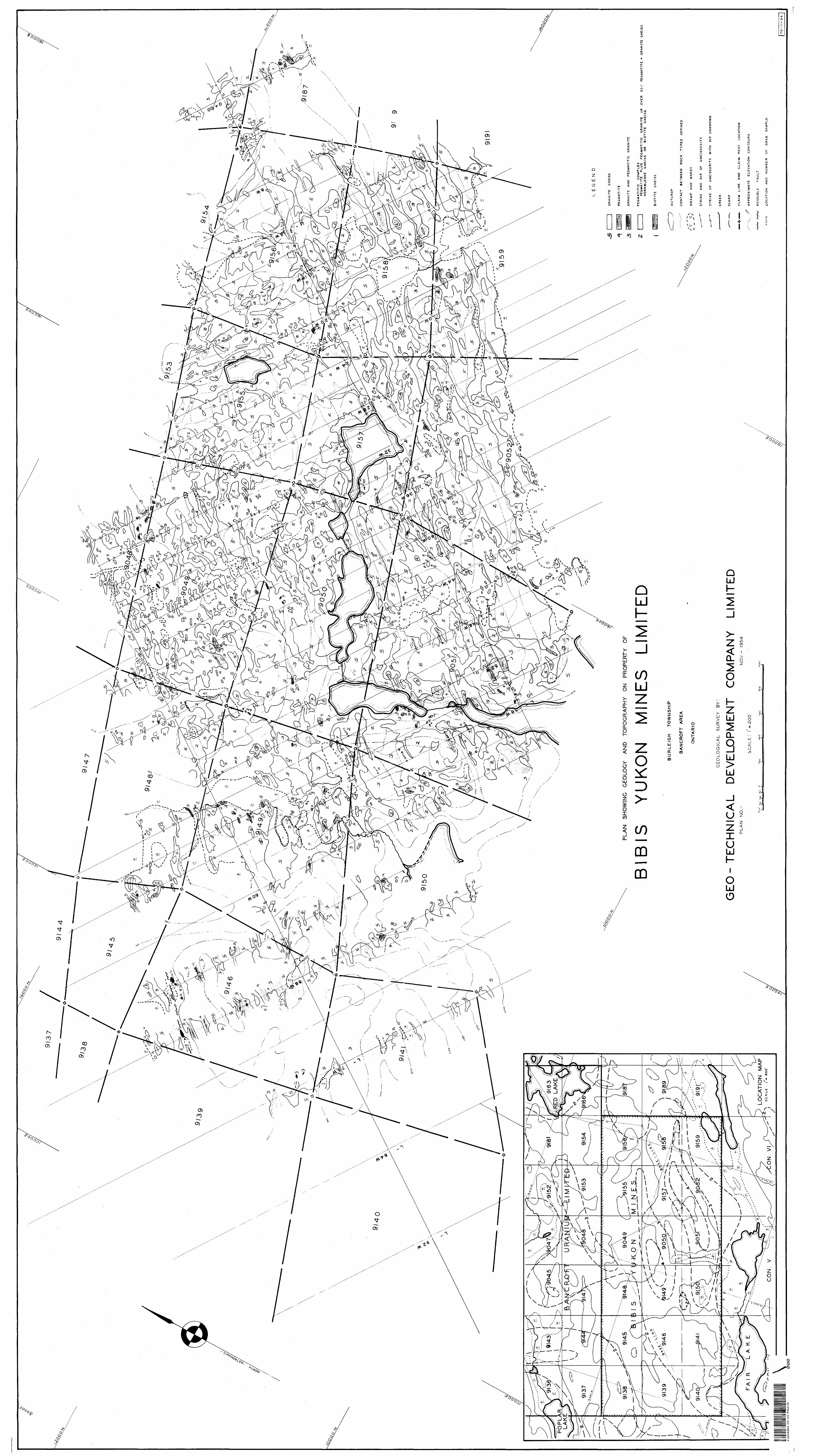
Tho following rook types are found in the property i
1. Pegmatite.2. Granite and pegmatitic granite.3. Pegmatitic complex.J|, Oranite* gneiss,5. Biotite gneiss.
A comparatively simple geological structure has boon
indicated* Local complications are due to the injections of
pegmatite.
Tho points of high radioactivity detected by A
ground scintillator survey appear to be underlain by pegmatite
and pegmatitic granite. Grab samples taken by means of spot
chocks give ctssuy reoultu which indicate a low concentration
of uranium. There is no promising geological occurrence dis
covered in this property*
BED -TECHNICAL DEVELOPMENT COMPANY LIMITED
-2-
Tr off oy r t y , L o c at l ojijxn (1. jVoo ess
The property of Bibis Yukon Mines Ltd, discussed In
this report cone l st s of a group of 18 claims located In
Burleigh "Township, Peterborough County, Ontario. The claims
aro located Jn hots 21 to *?3 inclusive, ConcosBlons V and VI
and are numbered as follows i
l-.. O. 901*9 to 905-2 Inol., 9130 to 91)|1 Inol., 91lj5, 911*6, 911] ti, 9l!|9, 9150, ti.'Ki 915*5 to 9159 Inolualva.
The geological mapping was conduotod over fourteen
of the so claims number o d as follows t
.'..o, 91J|1, 91t|.6* 91NO to 9150 Inol., 9155 to 9159 iuol, 90U9 to 9052 Inol.
The property IB situated approximately i?l± miles
southwest of tho town of Apsley, Ontario. It la bounded by
Fair Lake au d ita e on- looting swarnps and a small lako to the
south, Pair Lake 10 about a rollo north of Louck'B Luke which
is connected to tho wo&t end of Long Lake by a strait.
AOCOS.M to tho property 5s beat made by automobile
from Highway No,?0 through a side road to Long Lake and by
motor boat from Long Lake to Louck's Lake, A hunting trail
loade from Louck's Luke to Fair Lake and to th© property.
Tho property ie hilly due to tho tremendous
of outcropo oxpimod. However, tho relief of t h© property is
only moderate ac Indicated by tho approximate elevation .
contours shown on the accompanying map.
BED -TECHNICAL DEVELOPMENT COMPANY LIMITED
A t'ow-shapod chain of nine beaver ponds IB located
near- tho centre of the property, A long swampy marsh covers
the couth boundary. Tills swampy area connects with Pair Lake
will oh IK located morc-or-lees to tho southwest corn o r of the
area mapped*
Overburden found In this aren IB very thin. Large
boulders of usually pegmatite or pegmatitic granite are not
uncommonly found :"n the property sitting on bare rocks,
Forest growth consists tna'nly of second-growth
hardwood, MAP lo i birch and oak covering the higher ground,
and poplw, ash and aiders growing In the low and swampy
areue. A e tt rulo forest growth In thin property is compara
tively thin at* compared with areas near Apsloy*
The nor thorn part of Burleigh Township Is underlain
by rocks of iTo-Gambrlim a o (Ontario Department of Mines Map
Mo, ^2-a), The I're-Ouw.'rlan rocks in this township and the
township of Anstruther consist of a granitic complex * granite,
granite Rnolfcs, pegmatite - and paraftuelsfies, llmoBtone and
dolomite. Tlio property is located well within a lurgd mass
of rocks of the granitic complex.
an airborne eolntillomoter survey has outlined two
radioactive anomalies In t Vi i s property, A ground solntlllutor
survey has picked up a fow points with readings over 0,1 MK/hr,
ftecent discoveries of favourable concentrations of uranium
near Bancroft, 2 (j miles north of Apsloy, have aroused widespread
interest In the area*
GEO -TECHNICAL D EVELOPMENT COMPANY LIMITED
The* foil owing rook typos have boon encountered In
the area mapped. It uhould. b© noted here that the terms ft
are field twns a'vl no thin saotlon work has boon carried out,
-1-* il^Ji.'S^JJL'tfi.* '•i' n9 p9{5-U'.ttit9 Is granite pegmatite.
l to feldspar- .1 rt generally p.lnkl'sh, probably orthoolano.
Quartz IB f/msrully white* (ir-u^hle intergrowth of feldspar
quar t ts \ 'i not well evoloped, Hiotite is, as a rule, very
In 85 xo, Gruphile and tourmaline have boon recognifcod
in w few occurrence s, 'i-no slso of tho crystals found In this
pegmatite i s so.tdom over tliroo Inches In dlamotor. Comnionly
the grain sly.Q tleoreusea to 108B than 1/4 inch in diameter1
in place* and givas that part of tho rook a granite texture*
When tlile gr-nnite textui'e is found in au outcrop of pegmatite
tho outcrop IB classified ais pogmatitlo complex, which i*
d bolow.
?. arunlte ,.^.d,J;ej^i^^^iup...(3ran^tei| fi'he granite
und pogrnatitio granite are generally slightly pinkish in
colour. Thb granite bodios found in this property are, as
a rule, riiediuw-grained, and in many casee pegmatitic.
li©oauB6 of the fact that the granite and pegmatitic granite
found in this property grade into granite gneiss on one hand
and pegmatite on U4O other, it is believed that these rooke
are formed by the process of granitization in altu rather
them S 1.710 cm b intrusion* Vhe manner of the injection of the
solution for f/ranlti aation it. similar to that of the pegmatite*
BED -TECHNICAL DEVELOPMENT CI O M P A N V LIMITED

3* ^fjnjB^lM.0.-JLTJSfii^J* 1 This unit actually Includes
two characteristic rock structures* all of granite composition*
One is tt pegmatite* with textures of pegmatitic granite and
granite. Another structure is a pegmatite with xenollths or
bands of granite gneiss, hornblende gneiss or biotite gneiss
where pegmatite is over 5*0/1 in an outcrop* However, this
last mentioned com)) 1 nation if* comparatively much less than
the first.
^ * PJ'J.V-ll^l Jtfl^JL?, 1 ^he granite gneiss Is a banded
fine to medium and seldom coarse-grained granitic rock with a
light pinkish colour. Small pegmatitic veinletfi are not
uncommonly found cutting thin rock, The coarse grained
variety of p;ran1te gneisa does have the appearance of an
ortho-gneiss. How*vor, since this pao&es into fine-grained
well-bunded granite gneiss, It Is believed that granite gno?BS
found in thin property le not an ortho-gneiss,
^'* Mj^^.^,5..flil0J-JlS J Only throe outcrops of b5otlte
gneiss have been foam! in this property. The rock Is well-
banded and contains''about 30^ or more biotite. The other
major mineral** are feldspar and quart?;. A possible fault
hue been located parallel to these outcrops. It is not aure
whether this biotite lw introduced and the rock wow originally
ff.ran5.te f'.ne i t) s*
The pegmatite and granite found in this property are,
In general, as lit-par-lit injections In the granite gneiss and
BED -TECHNICAL DEVELOPMENT COMPANY LIMITED
-6-
occaelonally as largo ttfld small fcills, dykes and plugs cutting
the (jranlte ({noise* The lit-par-lit structure is wall demon
strated along linea south of the base lino. The rocks hore,
ae a rule* dip fi) to 20 degrees suith and the slopes are dip
slopoc. This gentle dipping .structure extends to approxi
mately 1600 foet north of the base line In the eastern part
of the property where the rocks undulate a little and in
placets dip 15 to 30 degrees north. The general trend of
strikes of gneissosity is north JJO to 70 degrees oast*
The structure in the northwest part of the property
is somewhat wore complicated. Tho dips of gneissosity art
as much as #0 degrees to the north and the south, indicating
a moderately folded area* The axle of thie folding appears
to be also north 5*0 to ?0 degrees eaet. A possible fault
has boon located further north, near the northwest corner
of the surveyed area. From the above data, it is suggested
that the map area in located on a slightly disturbed mono
cline. Tho general disturbance appears to have come from
the northwest} locul variations are due to the injections
of pegmatite*
Tho pointe of high radioactivity detected by the
ground scintillator survey appear to bo underlain by
pegmatite and pegmatitic granite.
Grab Sample e talcen by moans of spot checks give
the following at say i
BE CI -TECHNICAL DEVELOPMENT COMPANY L IMITED
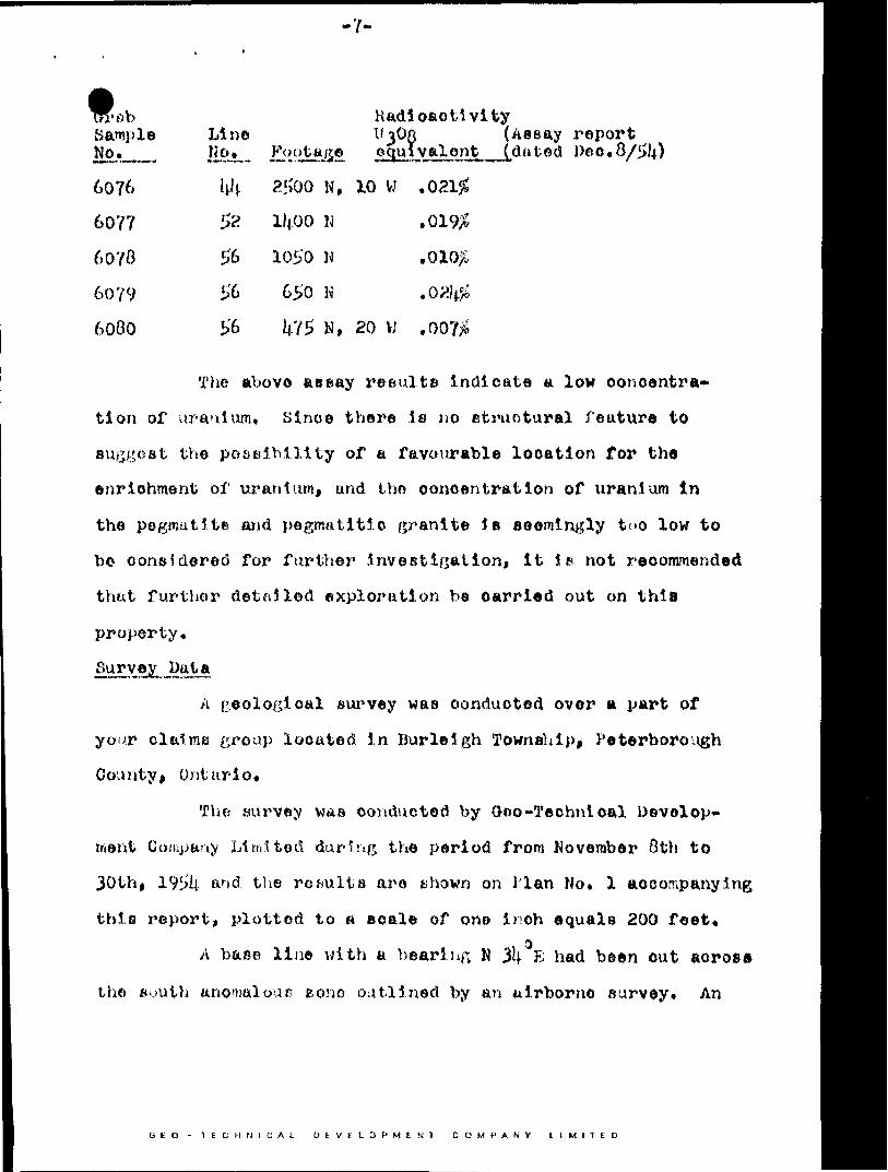
Trrflb Sample No.
6076
6077
6070
6079
6000
Line li0..*..
hh
5*6
56
56
Radioactivity0308 (Assay reportt^u ̂ val an t J,d a ted Pec.O/^U)
2500 N, 10 W ,Q21jC
0102;lljOO l i
1050 w650 K
N, 20 W .00?^
The above ae Bay results Indicate a low concentra
tion of uranium, Since there is no structural feature to
suggest the possibility of a favourable location for the
enrichment of uranium, and the concentration of uranium in
the pegmatite and pegmatitic granite J s seemingly too low to
b© considered for further .Investigation, it is not recommended
that further detailed exploration be carried out on thla
property.
A geological survey was conducted over a part of
your claims group located in Burleigh Township, Peterborough
Count y i Ontario,
The survey was conducted by Goo-Technical Develop
ment Company Limited during the period from Kovember 8th to
30th, 19i)lj ar)(S the results aro shown on i'lan No. l accompanying
this report, plotted to a scale of one inch equals 200 feet,"*)
A base line with a bearing M 3lj- E had been out across
the south anomalous sono outlined by an airborne survey* An
GEO -TEC UN (CAL D EVFLDPMEN1 C OMPANY L IMITED

-8-
aaxllliary base line wati cut parallel and located #,6ljO feet
north of the above base linet** Picket lines were out at
riftht angles to these base linos at 200, i|00 and 000 foot
intervals to cover the property* I'his line grid had been
previtmely established for a ground scintillator aurvoy and
the geological mapping was curried out over the same line
grid*
A total of 20.1| ml 10o of lino was geologically
mapped.
The number of eight-hour man-days requlr*d to
complete thifc. work Is as followst
(6 hour) Attributable to
Geological mapping 1(0 x l.\.
Calculation and interpretation 10 x ^
Drafting 21 x I+
Office tyj)in;; and supervision _9 x l)
Totals 00
160
HO
3^0
Kespectfully Bubmiliod,
OEO-TKCiiNlCAL
Toronto, Ontario
December 1^,
Geologist
BED - TECHNICAL D EVEL D P M f H i CCI ANV L IMITED
9137
v\4* \^*
**r-
~\
11
.^2?
\
"w
o ^5
-K)
L*KW^
\ t
4P
OP
LA
R
GR
AN
ITE
G
NE
ISS
PLAN SHOWING GEOLOGY AND TOPOGRAPHY ON PROPERTY OF
GR
AN
ITE
A
ND
P
EG
MA
TIT
IC
GR
AN
ITE
B
BIS
YU
KO
NM
INE
SL
MIT
ED
P E
G M
AT
IT
IC
CO
MP
LE
XP
EG
MA
TIT
E
PLU
S
PE
GM
AT
ITIC
G
RA
NIT
E
OR
O
VE
R
50
/ P
EG
MA
TIT
E
-*-
GR
AN
ITE
G
NE
ISS
H
OR
NB
LE
ND
E
GN
EIS
S
OR
B
IOT
ITE
G
NE
ISS
^9146
BU
RLE
IGH
T
OW
NS
HIP
BA
NC
RO
FT
A
RE
AC
ON
TA
CT
B
ET
WE
EN
R
OC
K
TY
PE
S
DE
FIN
ED
SW
AM
P
AN
D
MA
RS
H
/,...9
J57
9140
//'
iS
TR
IKE
A
ND
D
IP
OF
G
NE
ISS
OS
ITY
ST
RIK
E
OF
G
NE
ISS
OS
ITY
W
ITH
D
IP
UN
KN
OW
N
GE
OLO
GIC
AL
SU
RV
EY
B
Y!
GE
O-
HN
ICA
L
DE
VE
LO
PM
EN
T
CO
MP
AN
Y
LIM
ITE
DP
LA
N
NO
.-
NO
V.-
19
54
SC
ALE
: i"
^
^ 0
-^M
C
LA
IM
LIN
E
AN
D
CLA
IM
PO
ST
L
OC
AT
ION
eo
/vV
AP
PR
OX
IMA
TE
E
LE
VA
TIO
N
CO
NT
OU
RS
PO
SS
IBLE
F
AU
LT
LO
CA
TIO
N
MA
PLO
CA
TIO
N
AN
D
NU
MB
ER
O
F
GR
AB
S
AM
PL
EC
ON
. V
17
0-1
1-5
4
31D09NE0022
63A.223 BURLEIGH
LE
G
EN
D
LIN
ES
C
UT
A
ND
C
HA
INE
D
SC
INT
ILLA
TO
R
RE
AD
ING
S
OB
SE
RV
ED
O
- .0
20
M
R/H
R U
NIT
O
F
RA
DIA
TIO
N
INT
EN
SIT
Y
MJL
LIR
OE
NT
GE
NS
P
ER
H
OU
R
CO
NT
OU
R
OF
R
EA
DIN
GS
F
RO
M
SC
INT
ILL
AT
OR
S
UR
VE
Y
PO
SS
IBL
E
FA
ULT
IN
FE
RR
ED
F
RO
M
GE
OL
OG
ICA
L
MA
PP
ING
AP
PR
OX
IMA
TE
E
LE
VA
TIO
N
CO
NT
OU
RS
SW
AM
P i
MA
RS
H
CLA
IM
BO
UN
DA
RY
A
ND
C
LA
IM
PO
ST
L
OC
AT
ION
SU
PE
RIM
PO
SE
D
AN
OM
ALY
F
RO
M
AIR
BO
RN
E
SC
INT
ILL
OM
ET
ER
S
UR
VE
Y
\ V
V \ \
.x
9/8
7
9/4
0^Jfy^
\
-
' y.O'
feV
V,
l M I
T E
D
SC
INT
JL
LA
TO
R
K O
N
l fi l
S
BIB
ISY
UK
ON
LIM
ITE
DIS
O
RA
DIO
AC
TIV
ITY
A
RE
A
CO
NT
OU
RS
SC
INT
ILLA
TO
R
SU
RV
EY
D
AT
A91
49x^
_-
BU
RLE
IGH
T
OW
NS
HIP
BA
NC
RO
FT
A
RE
A
ON
TA
RIO
* '""
' t
,T
. j^
C..
. \
S f
S S
*
S^Z
* * .
*G
EO
PH
YS
ICA
L
SU
RV
EY
B
Y i
GE
O-T
EC
HN
ICA
L
DE
VE
LO
PM
EN
T
CO
MP
AN
Y
LIM
ITE
DAWATRUTHER
*',1
,,A
PR
fL -
1
95
4
FA
IR
LA
KE
SCAL
E: i*
200
AE
RO
M
AG
NE
TIC
SU
RV
EY
D
AT
A
SC
AL
E
-. l"
*
l M
ILE
LO
CA
TIO
N
MA
PSC
ALE
: i"
- ao
o1
CO
N.
V
31D09NE0022
63A.223 BURLEIGH