Embed Size (px)
Citation preview

Meghalaya Basin Development Authority
Meghalaya State
Republic of India
Preparatory Study on
Project for Community–Based Forest
Management and Livelihoods Improvement
in Meghalaya
Final Report
Advanced Version
August 2019
Japan International Cooperation Agency (JICA)
Kokusai Kogyo Co., Ltd.
IC Net Limited
4R
JR (P)
19-015

Preparatory Study on Project for Community-Based Forest Management and Livelihoods Improvement in Meghalaya Final Report
i
Location Map
(Forest Distribution in Meghalaya State)

Preparatory Study on Project for Community-Based Forest Management and Livelihoods Improvement in Meghalaya Final Report
ii
Photographs of the Study
Jhum cultivation area in Reng Deng village, West
Garo Hills District
Degraded forest area due to forest fire in West Khasi
Hills District
Forest degradation area due to quarry in West Jaintia
Hills District
Village Reserve Forest targeting a natural forest in
good conditions in Sasargre village, West Garo
Hills District
Logging site for domestic purpose on Community
Forest in Wahiajer village, West Jaintia Hills District
Saw mill using simple sawing machines in Khliehtyrshi Industrial Estate, West Jaintia District

Preparatory Study on Project for Community-Based Forest Management and Livelihoods Improvement in Meghalaya Final Report
iii
Hi-Tech Nursery managed Silviculture Division, FED
in Ri-Bhoi District
Rill erosion caused by heavy rainwater on the bare
land in Sohmynting Village, West Jaintia Hills
District
Utilization of eroded soil and spring water collected
by check dam as paddy field in Mawshut Village,
West Khasi Hills District
Agroforestry practiced in private land in Mawlyngbna
Village, East Khasi Hills District
Strawberry cultivation with local materials &
scientific techniques in Rural Resource & Training
Center (RRTC), Umran
Fisheries & duck rearing under Integrated Farming
System (IFS) in Rural Resource & Training Center
(RRTC), Umran

Preparatory Study on Project for Community-Based Forest Management and Livelihoods Improvement in Meghalaya Final Report
iv
Turmeric being dried before shipment in Longpohdon
Village, Ri-Bhoi District
A shawl woven of natural-dyed silk & silkworms in
Khweng Village, Ri-Bhoi District
Mushroom cultivation in Khweng Village, Ri-Bhoi
District
Apiculture with cement-made bee boxes in
Mawlyngbna Village, East Khasi Hills District
Pig-rearing with ‘Bokashi’in Bethany Society training
center, West Garo Hills District
Training on how to make vermi-compost in Bethany
Society training center, West Garo Hills

Preparatory Study on Project for Community-Based Forest Management and Livelihoods Improvement in Meghalaya Final Report
v
Rain water harvesting tank collecting water from roof
top in Bethany Society training center, West Garo
Hills District
Exterior of Enterprise Facilitation Center building of
Megha-LAMP in Mawshynrut CR&D Block, West
Khasi Hills District
Enterprise Facilitation Center of Megha-LAMP in
Mawshynrut CR&D Block, West Khasi Hills District
Demonstration of how to interpret satellite imagery
and how to use GPS for Megha-LAMP village in
Chibongre Village, West Garo Hills District
Interview about GIS&MIS facilities, human
resources, management structure and others in GIS
laboratory, Shillong, East Khashi Hills District
Lecture to trainees of Soil and Water Conservation
Department in Conservation Training Institute (CTI)
of Soil and Water Conservation Department, Byrnihat

Preparatory Study on Project for Community-Based Forest Management and Livelihoods Improvement in Meghalaya Final Report
vi
Kick-off meeting at Forest and Environment
Department in Shillong, East Khasi Hills District
Explanation of the survey overview at the courtesy
visit in Tura, West Garo Hills District
Explanation of the survey overview to Deputy
Commissioner and other concerned officers in
Nongstoin, West Khasi Hills District
The 11th Annual National Seminar cum Workshop in
Kodaikanal, Tamil Nadu State
Fact Finding Mission 1 explaining the overview of the
Project in Shillong, East Khasi Hills District
Fact Finding Mission 2 explaining the proposed
activities in Shillong, East Khasi Hills District

vii
Table of Contents
Location Map .......................................................................................................... i Photographs of the Study .................................................................................... ii Table of Contents ............................................................................................... vii List of Tables......................................................................................................... x
List of Figures .................................................................................................... xiii Abbreviations ..................................................................................................... xiv
List of Local Words Used in the Report ........................................................... xxi Executive Summary .......................................................................................... xxii Chapter 1. Introduction ................................................................................... 1-1
1.1. Background and Objectives .................................................................................... 1-1
1.2. Methodology and Approach ................................................................................... 1-2
1.3. Report Structure ..................................................................................................... 1-2
Chapter 2. The Study Area: Meghalaya ......................................................... 2-1
2.1. Area, Location, and Physiography ......................................................................... 2-1
2.2. Administrative System of the State ........................................................................ 2-1
2.2.1. Administrative Structure ............................................................................ 2-1
2.2.2. Autonomous District Councils .................................................................. 2-1
2.3. Population, Economy, and Social Conditions of the State ..................................... 2-2
2.3.1. Demography and Scheduled Tribes ........................................................... 2-2
2.3.2. Socio-economic Conditions and Poverty Level ........................................ 2-3
2.3.3. Traditional Decision-making Structures .................................................... 2-6
2.3.4. Gender Issues ............................................................................................. 2-8
2.3.5. State Economy ......................................................................................... 2-10
2.4. Natural Conditions of the State ............................................................................ 2-15
2.4.1. Meteorology and Hydrological Condition ............................................... 2-15
2.4.2. Land Use and Land Resources ................................................................ 2-18
2.4.3. Soil Types ................................................................................................ 2-24
2.4.4. Drainage and the Catchments .................................................................. 2-28
2.4.5. Natural Disasters and Disaster Management ........................................... 2-28
2.5. Development Plans, Programs and Projects in the State ...................................... 2-30
2.5.1. State and Regional Development Plans (including Meghalaya
Vision 2030) ............................................................................................ 2-30
2.5.2. Poverty Alleviation Programs ................................................................. 2-36
2.5.3. Watershed Management Programs .......................................................... 2-36
2.5.4. Central Sponsored Programs ................................................................... 2-38
2.5.5. Externally Assisted Projects .................................................................... 2-41
Chapter 3. Forests and Forest Management of the State ............................ 3-1
3.1. Forests of the State ................................................................................................. 3-1
3.1.1. Forest types & Flora of Garo, Khasi and Jaintia Hills Districts ................ 3-1
3.1.2. Forest Cover in the State ........................................................................... 3-2
3.2. Forest Management in the State ............................................................................. 3-5
3.2.1. Forest Acts and Policies ............................................................................ 3-5
3.2.2. Forest Classification ................................................................................ 3-15
3.2.3. Forest Management System ..................................................................... 3-16
3.2.4. Forest Nursery in Meghalaya .................................................................. 3-26
3.2.5. Forest Produces and Marketing ............................................................... 3-27
3.3. Biodiversity .......................................................................................................... 3-30
3.3.1. Biodiversity Profile of the State .............................................................. 3-30
3.3.2. Man-Animal Conflicts ............................................................................. 3-32
3.4. REDD+ Pilot Projects in Meghalaya .................................................................... 3-33
3.4.1. Raid Umket REDD+ Pilot Project ........................................................... 3-33

viii
3.4.2. Khasi Hills Community REDD+ Project ................................................. 3-34
Chapter 4. Approaches to Livelihood Improvement in the State ................ 4-1
4.1. Holistic Livelihood Improvement .......................................................................... 4-1
4.1.1. Agroforestry and NTFPs ........................................................................... 4-1
4.1.2. Integrated Farming System ........................................................................ 4-4
4.1.3. Horticulture and Floriculture ..................................................................... 4-5
4.1.4. Livestock Management .............................................................................. 4-7
4.1.5. Sericulture .................................................................................................. 4-8
4.1.6. Apiculture (Bee-keeping) .......................................................................... 4-9
4.1.7. Extension Services and Training Opportunities ........................................ 4-9
4.1.8. Group Formation and Access to Financial Services ................................ 4-10
4.2. Enterprise Development ....................................................................................... 4-12
4.2.1. Bamboo .................................................................................................... 4-13
4.2.2. Rural Tourism .......................................................................................... 4-14
Chapter 5. Institutional Arrangement of the State ........................................ 5-1
5.1. Capacity of Implementing Agencies ...................................................................... 5-1
5.1.1. Forest and Environment Department (FED) .............................................. 5-1
5.1.2. Meghalaya Basin Development Authority (MBDA) ................................. 5-4
5.1.3. Soil and Water Conservation Department (SWCD) .................................. 5-6
5.1.4. Autonomous District Councils .................................................................. 5-7
5.1.5. GIS Capacity of Implementing Agencies and ADCs ................................ 5-8
5.2. Existing Monitoring and Evaluation Systems ...................................................... 5-15
5.2.1. MIS in Megha-LAMP ............................................................................. 5-16
5.2.2. MIS in MCLLMP .................................................................................... 5-17
5.2.3. Other Existing MIS .................................................................................. 5-17
Chapter 6. Review of the Pre-Detailed Project Report (Pre-DPR) ............... 6-1
6.1. Outline of the Pre-DPR .......................................................................................... 6-1
6.2. Methodology of the Review ................................................................................... 6-1
6.3. Pre-DPR Review .................................................................................................... 6-1
6.3.1. Chapter 1: Background .............................................................................. 6-1
6.3.2. Chapter 2: Necessity and Priority of the Project........................................ 6-2
6.3.3. Chapter 3: Project Rationale and Objectives ............................................. 6-2
6.3.4. Chapter 4: Project Implementation ............................................................ 6-3
6.3.5. Chapter 5: Project Components ................................................................. 6-6
6.3.6. Selection Criteria ..................................................................................... 6-10
6.4. Concluding Observations ..................................................................................... 6-11
Chapter 7. Proposed Project Outline and Scope of Work ........................... 7-1
7.1. Project Needs and Rationale ................................................................................... 7-1
7.1.1. Relevance and Linkage with Government Policies ................................... 7-1
7.1.2. Necessity of Restoration and Conservation of Forest ................................ 7-3
7.1.3. Significant Effects of the Proposed Project Activities for
Restoration and Conservation of Forests ................................................... 7-3
7.1.4. Necessity of Enhancement of Community-based Forest
Management .............................................................................................. 7-4
7.2. Project Objective and Approaches ......................................................................... 7-4
Project Objective ....................................................................................... 7-4 7.2.1.
Project Approaches .................................................................................... 7-4 7.2.2.
7.3. Prioritization of Project Sites .................................................................................. 7-8
Target Area and Potential Beneficiaries .................................................... 7-8 7.3.1.
Selection Method ....................................................................................... 7-9 7.3.2.
Prioritized Project Sites ........................................................................... 7-11 7.3.3.
7.4. Overview of the Proposed Project ........................................................................ 7-12
Logical Framework.................................................................................. 7-12 7.4.1.
Project Phase............................................................................................ 7-16 7.4.2.
ix
Implementation by Batches ..................................................................... 7-18 7.4.3.
Preparatory Works for Participatory Approach ....................................... 7-18 7.4.4.
7.5. Project Components ............................................................................................. 7-18
Component 1: Sustainable Forest Management ...................................... 7-21 7.5.1.
Component 2: Community Development and Livelihood 7.5.2.
Improvement ............................................................................................ 7-38
Component 3: Institutional Strengthening ............................................... 7-47 7.5.3.
Supplemental Component: Project Management Consultants ................. 7-60 7.5.4.
7.6. Implementation Structure ..................................................................................... 7-61
Implementing Bodies ............................................................................... 7-62 7.6.1.
Management of the Project ...................................................................... 7-66 7.6.2.
Coordination with Oher Departments ...................................................... 7-67 7.6.3.
Involvement of Other Major Stakeholders .............................................. 7-67 7.6.4.
Fund Management ................................................................................... 7-68 7.6.5.
Project Management Consultant (PMC) .................................................. 7-71 7.6.6.
7.7. Environmental and Social Considerations ............................................................ 7-71
Overview of the Present State of Meghalaya State ................................. 7-71 7.7.1.
System/Organizations related to Environmental and Social 7.7.2.
Considerations ......................................................................................... 7-85
7.7.3. Environmental and Social Management System Framework
(ESMSF) ................................................................................................ 7-102
7.7.4. Resettlement Plan Framework (RPF) .................................................... 7-103
7.7.5. Scheduled Tribe and Forest Dependents Plan Framework
(STFDPF) .............................................................................................. 7-103
7.8. Gender Mainstreaming ....................................................................................... 7-104
7.8.1. Rationale and Methodology ................................................................... 7-104
7.8.2. Gender Mainstreaming to the Organizational Structural of the
Project .................................................................................................... 7-104
7.8.3. Gender Mainstreaming to the Project Operation ................................... 7-106
7.9. Project Cost Estimate ......................................................................................... 7-108
7.9.1. Conditions and Assumptions ................................................................. 7-108
7.9.2. Project Cost ........................................................................................... 7-109
7.10. Project Evaluation .............................................................................................. 7-111
7.10.1. Economic Analysis ................................................................................ 7-111
7.10.2. Reduction of CO2 Emission ................................................................... 7-122
7.11. Risk Management ............................................................................................... 7-125
7.12. Security Management ......................................................................................... 7-126
7.12.1. Overview of Crime Situation in Meghalaya State ................................. 7-126
7.12.2. Security Management Survey ................................................................ 7-127
7.12.3. Measures against Insecurities ................................................................ 7-128
7.13. Possibility of Introduction of Japanese Technologies ........................................ 7-129
ANNEXURE 1
Annexure 1. List of Target Villages for Megha-LAMP ................................................ A-1
Annexure 2. List of Target Villages for MCLLMP .................................................... A-12
Annexure 3. REDD+ in India ...................................................................................... A-17
Annexure 4. Selection of Blocks ................................................................................. A-21
Annexure 5. Strategies for Making the Project Gender-Responsive ........................... A-23
Annexure 6. Attachment for Environment and Social Consideration ......................... A-28
Annexure 7. Operation and Effect Indicators and Their Monitoring Plan .................. A-97
Annexure 8. Institutional Arrangements ..................................................................... A-99
Annexure 9. Operation and Maintenance Structure .................................................. A-113
Annexure 10. Project Cost Estimation ........................................................................ A-116
Annexure 11. Risk Management ................................................................................. A-129
Annexure 12. List of Materials Collected in Meghalaya State ................................... A-141

x
List of Tables
Table 1.1: Profile of Meghalaya State ................................................................................................. 1
Table 2.1: ADCs and District Administrations ................................................................................ 2-2
Table 2.2: Population by Sex, Area, and District ............................................................................. 2-3
Table 2.3: Ratio of ST and SC Population ....................................................................................... 2-3
Table 2.4: Literacy Rate of ST by Sex, Area, and District (2011) ................................................... 2-4
Table 2.5: Number of Farmers Holding and Operating Land Area for the Year 2010-2011 ........... 2-5
Table 2.6: State-wise PPP per capita in North-eastern States and Other States in India ................. 2-5
Table 2.7: Trend of GSDP 2009-2010 to 2014-2015 ..................................................................... 2-11
Table 2.8: Area, Production, and Yield of Main Food Grain and Horticulture Crops ................... 2-12
Table 2.9: Area, Production and Yield of Main Tuber and Spices Crops and Fruits ..................... 2-13
Table 2.10: Area, Production and Yield of Fruits and Plantation Crops........................................ 2-13
Table 2.11: Livestock Population as per the 2012 Census and Growth Rate as Compared
to the 2007 Census ....................................................................................................... 2-13
Table 2.12: Percentage of Households Managing Livestock by Season in 2016-2017 ................. 2-14
Table 2.13: Estimated Number of Productive Cows, Yield per Day, and Production in the
Year of 2016-2017 and 2017-2018 .............................................................................. 2-14
Table 2.14: Meat Production by Category ..................................................................................... 2-14
Table 2.15: Various Mineral Resources of Meghalaya State ......................................................... 2-15
Table 2.16: Minimum and Maximum Monthly Temperatures in Meghalaya State ....................... 2-16
Table 2.17: Rainfall Data for the Year 2016 in Millimeters (mm) ................................................ 2-17
Table 2.18: Land Use in Meghalaya State ..................................................................................... 2-18
Table 2.19: District-wise Land Use Patterns in 2013..................................................................... 2-21
Table 2.20: Soil Distribution in Meghalaya State .......................................................................... 2-24
Table 2.21: Selection Criteria of Megha-LAMP ............................................................................ 2-41
Table 2.22: Megha-LAMP Target Village Distribution by Block ................................................. 2-42
Table 2.23: Priority Class Based on NESAC Vulnerability Analysis ............................................ 2-43
Table 2.24: MCLLMP Target Village Distribution by Block ........................................................ 2-43
Table 3.1: Forest Types in Meghalaya State .................................................................................... 3-1
Table 3.2: Forest Cover Change through Years in India and Meghalaya State ............................... 3-3
Table 3.3: District-wise Forest Cover Area in Meghalaya State in 2017 ......................................... 3-4
Table 3.4: Forest Acts and Rules in India ........................................................................................ 3-5
Table 3.5: Major Forest Policies in India ......................................................................................... 3-7
Table 3.6: Wildlife and Biodiversity Acts and Rules in India ......................................................... 3-9
Table 3.7: Legal Characteristics of the Four Categories of Protected Areas ................................. 3-10
Table 3.8: Forest Acts and Rules in Meghalaya State .................................................................... 3-11
Table 3.9: Forest Related Acts and Rules in ADCs ....................................................................... 3-14
Table 3.10: Legal Classification of Recorded Forest Areas ........................................................... 3-15
Table 3.11: Forest Cover Change through Years in India and Meghalaya State ........................... 3-15
Table 3.12: Approved Working Plans ............................................................................................ 3-16
Table 3.13: National Park and Wildlife Sanctuary ........................................................................ 3-17
Table 3.14: Community Owned or Private Forests ........................................................................ 3-17
Table 3.15: Features of Each ADC regarding Forest Management ............................................... 3-17
Table 3.16: JFMCs in Meghalaya State ......................................................................................... 3-19
Table 3.17: Community Forest Management Schemes in Meghalaya State .................................. 3-20
Table 3.18: District Council-owned Plantation/Forest ................................................................... 3-22
Table 3.19: Current Status of the Preparation of Working Schemes ............................................. 3-24
Table 3.20: Production of Broom Grass in Khasi Hills, Garo Hills, and Jaintia Hills Areas ........ 3-28
Table 3.21: Production of Timber in the State during 2005-06 to 2009-10 ................................... 3-29
Table 3.22: ADC Wise Timber Production .................................................................................... 3-29
Table 3.23: Royalty of NTFPs in Jaintia Hills ADC...................................................................... 3-29
Table 3.24: Royalty of Major Timber Species in Jaintia Hills ADC ............................................. 3-30
Table 3.25: Man-Animal Conflicts in the Last Five Years ............................................................ 3-32

xi
Table 4.1: Production of Commercially Valuable NTFPs by Area ................................................. 4-2
Table 4.2: Yield of Mixed Agricultural Cropping Pattern under Fruit Tree Species ....................... 4-2
Table 4.3: Status and Constraints Facing Major NTFPs in Meghalaya ........................................... 4-3
Table 4.4: Agro-climatic Zone-wise Fruits and Other Crops ........................................................... 4-5
Table 4.5: District-wise Number of Cooperative Societies ............................................................ 4-11
Table 4.6: Number of Enterprises in the State as per 6th Economic Census (Provisional) ............ 4-12
Table 5.1: Ranges of FED ................................................................................................................ 5-1
Table 5.2: Human Resources of FED .............................................................................................. 5-2
Table 5.3 : Budget and Expenditure of FED .................................................................................... 5-4
Table 5.4 : Human Resources of SWCD ......................................................................................... 5-6
Table 5.5: Budget and Expenditure of SWCD ................................................................................. 5-7
Table 5.6: Human Resources of FD of ADCs .................................................................................. 5-7
Table 5.7: Capacity Assessment of ADCs ....................................................................................... 5-8
Table 5.8: Data Layers and Maps Available in FED GIS Lab ......................................................... 5-9
Table 5.9: Data Layers Available in FED GIS Lab ....................................................................... 5-10
Table 5.10: GIS and RS Software Available at FED GIS Lab....................................................... 5-11
Table 5.11: Hardware Available at FED GIS Lab ......................................................................... 5-11
Table 5.12: Data Layers Available at MBDA GIS Lab ................................................................. 5-12
Table 5.13: Data Layers Available at MBDA GIS Lab ................................................................. 5-12
Table 5.14: GIS and RS Software Available at MBDA GIS Lab .................................................. 5-12
Table 5.15: Hardware Available in MBDA GIS Lab ..................................................................... 5-13
Table 5.16: Data Layers and Map Available at SLNA .................................................................. 5-13
Table 5.17: GIS and RS Software Available at SLNA .................................................................. 5-14
Table 5.18: Hardware Available in SLNA ..................................................................................... 5-14
Table 5.19: Current GIS Capacity in ADC Forest Department ..................................................... 5-15
Table 6.1: Types and Models of Core Forest Activities Proposed in Pre-DPR ............................... 6-6
Table 7.1: Different Features of the First and Second Groups Villages .......................................... 7-8
Table 7.2: Project Target Districts and Blocks ................................................................................ 7-9
Table 7.3: Selection Criteria for Target Blocks and Villages/Village Clusters ............................. 7-10
Table 7.4: Tentative Project Phases and Activities ........................................................................ 7-17
Table 7.5: Image of Batch-wise Target Outputs ............................................................................ 7-18
Table 7.6: Outline of the Project .................................................................................................... 7-19
Table 7.7: Activities for Sustainable Forest Management ............................................................. 7-21
Table 7.8: Steps of Facilitation for PLUP ...................................................................................... 7-23
Table 7.9: Steps and Methods of Restoration of Timber Resources .............................................. 7-25
Table 7.10: Steps and Methods of Seedling Production ................................................................ 7-30
Table 7.11: Soil and Water Conservation Activities ...................................................................... 7-33
Table 7.12: Check Dams Applied in the Project ............................................................................ 7-35
Table 7.13: Steps to Make a Micro Plan ........................................................................................ 7-40
Table 7.14: Soil and Water Conservation Activities for Livelihood Improvement ....................... 7-45
Table 7.15: Frequency of Concurrent Monitoring ......................................................................... 7-49
Table 7.16: Types of Drones and Weight of the Aircraft ............................................................... 7-50
Table 7.17: Expected Roles and Responsibilities of the Proposed PMU Staff .............................. 7-54
Table 7.18: Example of High-resolution Satellite Imagery Specifications .................................... 7-56
Table 7.19: PMC Team Composition ............................................................................................ 7-60
Table 7.20: Composition of Governing Body ................................................................................ 7-66
Table 7.21: Composition of Executive Committee ........................................................................ 7-67
Table 7.22: National Ambient Air Quality Standards of India ...................................................... 7-72
Table 7.23: Ambient Air Quality in Meghalaya State ................................................................... 7-72
Table 7.24: Results of Vehicular Monitoring ................................................................................ 7-74
Table 7.25: National Water Quality Standards .............................................................................. 7-76
Table 7.26: Water Quality in Meghalaya State .............................................................................. 7-77
Table 7.27: National Standards of Ambient Noise ........................................................................ 7-79
Table 7.28: Results of Noise Monitoring in Meghalaya State ....................................................... 7-80

xii
Table 7.29: Soil/Sediment and Solid Waste Monitoring by MSPCB ............................................ 7-81
Table 7.30: Protected Areas in Meghalaya .................................................................................... 7-82
Table 7.31: Scheduled Caste Population, 2001 Census ................................................................. 7-84
Table 7.32: Indian Federal Statutes regarding Environmental Protection ..................................... 7-85
Table 7.33: Comparison between JICA Guidelines and EIA Notification in India ....................... 7-94
Table 7.34: Current List of MSPCB Members (as of February 2019) ........................................... 7-99
Table 7.35: Interventions Necessary for Mainstreaming a Gender Perspective in the
Organizational Structure of the Project ...................................................................... 7-105
Table 7.36: Necessary Interventions to Mainstream Gender in the Operation of the Project ...... 7-107
Table 7.37: Price Indices to Adjust for 2019 Price ...................................................................... 7-109
Table 7.38: Summary of Project Cost .......................................................................................... 7-109
Table 7.39: Annual Fund Requirement ........................................................................................ 7-110
Table 7.40: Currency Components of Project Cost...................................................................... 7-110
Table 7.41: Summary of Financial Plan by Components............................................................. 7-111
Table 7.42: Financial and Economic Cost by Component and Item ............................................ 7-112
Table 7.43: Major Activities for Benefit Evaluation .................................................................... 7-113
Table 7.44: Major Species and Area to Be Planted ...................................................................... 7-113
Table 7.45: Assumptions for Value Calculation (Sal) ................................................................. 7-114
Table 7.46: Assumptions for Value Calculation (Fuel Wood) ..................................................... 7-114
Table 7.47: Assumptions for Value Calculation (Pine) ............................................................... 7-114
Table 7.48: Assumptions for Value Calculation (NTFP: Emblica officinalis) ............................ 7-114
Table 7.49: Assumptions for Value Calculation (Jack Fruit) ....................................................... 7-115
Table 7.50: Value Calculation for Prevention of Soil Erosion .................................................... 7-115
Table 7.51: Value Calculation for Aquaculture in Check Dam ................................................... 7-116
Table 7.52: Value Calculation for Aquaculture in Conservation Pond ........................................ 7-116
Table 7.53: Value Calculation for Living Water in Check Dam.................................................. 7-116
Table 7.54: Value Calculation for Living Water in Conservation Pond ...................................... 7-117
Table 7.55: Value Calculation for Living Water in RCC Tank/Chamber .................................... 7-117
Table 7.56: Value Calculation for Living Water in Water Tank.................................................. 7-117
Table 7.57: Value Calculation for Piggery .................................................................................. 7-118
Table 7.58: Value Calculation for Mushroom ............................................................................. 7-118
Table 7.59: Value Calculation for Weaving................................................................................. 7-119
Table 7.60: Value Calculation for CO2 Reduction ....................................................................... 7-119
Table 7.61: Sensitivity Analysis of EIRR .................................................................................... 7-120
Table 7.62: Result of the Cost-benefit Analysis .......................................................................... 7-121
Table 7.63: Activities and Tree Species for the CO2 Sequestration Estimation .......................... 7-123
Table 7.64: Specie-wise Equations .............................................................................................. 7-123
Table 7.65: Variables Used for Estimation .................................................................................. 7-124
Table 7.66: CO2 Sequestration and Emission Reduction in the Project ....................................... 7-124

xiii
List of Figures
Figure 2.1: Trend of Sex-wise Literacy Late (1981-2011) .............................................................. 2-4
Figure 2.2: Sector-wise GSDP of Meghalaya for 2011-12 and 2016-17 ....................................... 2-11
Figure 2.3: Cumulative Monthly Rainfall in the State for the Past Five Years ............................. 2-17
Figure 2.4: Parent Materials (Gneissic Complex) .......................................................................... 2-24
Figure 2.5: Soil Survey .................................................................................................................. 2-26
Figure 2.6: Relationship between Topo-sequence & Soil Distribution (Case of Nongrmai
Village, West Khasi Hills District) .............................................................................. 2-26
Figure 2.7: Soil Condition of Jhum Cultivation Area (the Case of Garo Hills ADC Area) ........... 2-27
Figure 2.8: Soil Condition of Bun Cultivation Area (the Case of West Jaintia Hills
District) ........................................................................................................................ 2-28
Figure 3.1: Forest Cover Change and Proportion of Forest Classification Based on
Canopy Density in Meghalaya State from 2003 to 2017 ............................................... 3-4
Figure 3.2: District-wise Forest Cover Area in Meghalaya State in 2017 ....................................... 3-5
Figure 3.3: Procedure of Preparation of Working Schemes ........................................................... 3-25
Figure 4.1: Area with Cut Flowers under Production in 2009-2010 and 2016-2017 ....................... 4-7
Figure 4.2: Trend of the Number of Foreign and Indian Tourists Visiting Meghalaya ................. 4-14
Figure 5.1: Organizational Structure of FED ................................................................................... 5-1
Figure 5.2: Organizational Structure of MBDA/MBMA ................................................................. 5-4
Figure 5.3: Organizational Structure of SWCD ............................................................................... 5-6
Figure 6.1: Phasing of the Project Mentioned in Pre-DPR .............................................................. 6-4
Figure 7.1: Target Blocks of the Project ........................................................................................ 7-11
Figure 7.2: Organizations of Project Components and Flow of Three Phases ............................... 7-16
Figure 7.3: Bench Terracing .......................................................................................................... 7-34
Figure 7.4: Earthen/Loose Boulder Contour Bund ........................................................................ 7-34
Figure 7.5: Loose Boulder Box Terracing ..................................................................................... 7-34
Figure 7.6: Conservation Pond (for Fishery) ................................................................................. 7-37
Figure 7.7: Conservation Pond/Dug-out Pond ............................................................................... 7-37
Figure 7.8: RCC Water Storage Tank for Drinking Water ............................................................ 7-37
Figure 7.9: Spring Tapped Chamber .............................................................................................. 7-37
Figure 7.10: Water Conservation Pond for Livelihood Improvement ........................................... 7-45
Figure 7.11: RWH Technique ........................................................................................................ 7-46
Figure 7.12: Drinking Water Tank ................................................................................................. 7-47
Figure 7.13: Tentative GIS Monitoring Schedule Using Drones ................................................... 7-50
Figure 7.14: Proposed Organization Structure of GIS/MIS Unit ................................................... 7-53
Figure 7.15: Implementation Structure .......................................................................................... 7-62
Figure 7.16: Structure of SPMU .................................................................................................... 7-63
Figure 7.17: District Level Implementation Structure ................................................................... 7-64
Figure 7.18: Community Level Implementation Structure ............................................................ 7-65
Figure 7.19: Fund Flow .................................................................................................................. 7-69
Figure 7.20: Traffic Situation in Police Bazar, Shillong ................................................................ 7-73
Figure 7.21: Flow of Obtaining Environmental Clearance ............................................................ 7-89
Figure 7.22: Acquisition Flow of Forest Clearance ....................................................................... 7-93
Figure 7.23: Organization Chart of CPCB ..................................................................................... 7-96
Figure 7.24: Organization Chart of MSPCB .................................................................................. 7-98
Figure 7.25: District-wise Crime Rate ......................................................................................... 7-126

xiv
Abbreviations
Abbreviation Name
AD Activity Data
ADB Asian Development Bank
ADC Autonomous District Council
ANR Assisted Natural Regeneration
APCCF Additional Principal Chief Conservator of Forests
APO Annual Plan of Operation
AR Artificial Regeneration
ATMA Agriculture Technology Management Agency
B Boron
B/C Cost-Benefit Ratio
BCDI Bamboo and Cane Development Institute
BDA Biological Diversity Act, 2002
BDO Block Development Officer
BDU Basin Development Unit
BHS Biodiversity Heritage Sites
BIS Bureau of Indian Standards
BMC Biodiversity Management Committee
BOD Bio-Chemical Oxygen Demand
BPL Below Poverty Line
Ca Calcium
CAAA Controller of Aids, Accounts and Audit
CAGR Compound Annual Growth Rate
CAMPA Compensatory Afforestation Fund Management and Planning Authority
CBEC Central Board of Excise and Customs
CBO Community Based Organization
CCEA Cabinet Committee on Economic Affairs
Cd Cadmium
CEDAW Convention on the Elimination of All Forms of Discrimination against
Women
CFI Community Forestry International
CFO Chief Forest Officer
CFM Community Forest Management
CGST Central Goods and Services Tax
CHDS Comprehensive Handloom Development Scheme’
CIG Community Interest Group
CIG Common Interest Group ch-7
Cl Chloride
COD Chemical Oxygen Demand
CO2 Carbon dioxide
COP Conference of the Parties
C/P Counterpart
CPCB Central Pollution Control Board
CPI Consumer Price Index
CR Community Reserve
CRMC Community Reserve Management Committee

xv
Abbreviation Name
Cr Chromium
CSR Corporate Social Responsibility
CTI Conservation Training Institute
Cu Copper
DAY-NRLM Deendayal Antodaya Yojana – National Rural Livelihoods Mission
DC Deputy Commissioner
DDU-GKY Deen Dayal Upadhyaya Grameen Kaushalya Yojana
DFO Divisional Forest Officer
DF/R Draft Final Report
DIPA Diethylene Triamine Penta Acetic Acid
DLAC District Level Advisory Committee
DM Disaster Management
DO Dissolved Oxygen
DPM District Project Manager
DPR Detailed Project Report
DPIU District Project Implementation Unit
EAC Expert Appraisal Committee
EC Executive Committee
EF Emission Factor
EFC Enterprise Facilitation Centers
EIA Environmental Impact Assessment
EIRR Equity Internal Rate of Return
EMP Environmental Management Plan
EOI Expression of Interest
EPAs Entry Point Activities
ESC Environmental Social Considerations
ESMSF Environmental and Social Management System Framework
EUR Euro
F Fluoride
FAO Food and Agriculture Organization of the United Nations
FD Forest Department
FDA Forest Development Agency
Fe Iron
FED Forest and Environment Department
FLRC Forest-based Livelihood Resource Center
FPC Farmer Producer Company
FPO Farmer Producer Organizations
F/R Final Report
FRL Forest Refference Level
FY Fiscal Year
FSA Farming Systems Approach
FSI Forest Survey of India
GB General Body
GBV Gender-Based Violence
GCF Green Climate Fund
GDP Gross Domestic Products
xvi
Abbreviation Name
GeM Government e-Market place
GHADC Garo Hills Autonomous District Council
GHCA Garo Hills Conservation Area
GHG Greenhouse Gas
GIM Green India Mission
GIS Geographic Information System
GIZ Gesellschaft für Internationale Zusammenarbeit
GNLA Garo National Liberation Army
GoJ Government of Japan
GoI Government of India
GoM Government of Meghalaya
GP Gram Panchayat
GPS Global Positioning Syste
GSDP Gross State Domestic Product
GSHAP Global Seismic Hazard Assessment Program
GST Goods and Services Tax
GWA Green-Wash Area
Hg Mercury
HLM High Low Medium
HMM High Medium Medium
HMNEH Horticulture Mission for North East and Himalayan Region
HNLC Hynniewtrep National Liberation Council
HPC High Power Committee
HTN Hi Tech Nurseries
IAS Indian Administrative Service
IAY Indira Awaas Yojana
IBDLP Integrated Basin Development and Livelihood Promotion Programme
IBEF India Brand Equity Foundation
ICAR Indian Council of Agricultural Research
IFAD International Fund for Agricultural Development
IFS Indian Forest Statistics/Integrated Farming System
IGNDPS Indira Gandhi National Disability Pension Scheme
IGNOAPS Indira Gandhi National Old Age Pension Scheme
IGNWPS Indira Gandhi National Widows Pension Scheme
IGST Integrated Goods and Services Tax
ILRT Institute of Livelihood Research and Traing
INM Integrated Nutrient Management
INR Indian Rupee
INRM Integrated Natural Resources Management
IPC Indian Penal Code
IPCC Intergovernmental Panel on Climate Change
IPM Integrated Pest Management
ISDP Integrated Sericulture Development Project
IVCS Integrated village Cooperative Society
IWDP Integrated Wasteland Development Programme
IWMP Integrated Watershed Management Programme

xvii
Abbreviation Name
JFM Joint Forest Management
JFMC Joint Forest Management Committee
JGSY Jawahar Gram Samridhi Yojana
JHADC Jaintia Hills Autonomous District Council
JICA Japan International Cooperation Agency
JICS Japan International Cooperation System
JJ-FAST JICA-JAXA Forest Early Warning System in the Tropics
JPY Japanese Yen
K Potassium
KfW Kreditanstalt für Wiederaufbau
KHADC Khasi Hills Autonomous District Council
LEISA Low External Input Sustainable Agriculture
LMV Light Motor Vehicles
LPG Liquefied Petroleum Gas
LULC Land Use Land Cover
LULUCF Land use, Land use Change and Forestry
MBDA Meghalaya Basin Development Authority
MCLLMP Meghalaya Community Led Landscape Management project
MDF Moderately Dense Forest
MDoNER Ministry of Development of North Eastern Region
M&E Monitoring and Evaluation
Megha-LAMP Meghalaya Livelihoods and Access to Markets Project
MFF Multi-tranche Financing Facility
Mg Magnesium
MGNREGS Mahatma Gandhi National Rural Employment Guarantee Scheme
MIDH Mission for Integrated Development of Horticulture
MIE Meghalaya Institute of Entrepreneurship
MIP’s Minor Irrigation Projects
MIS Management Information System
MLM Medium Low Medium
M/M Man/Months
MML Medium Medium Low
MMR Maternal Mortality Rate
Mn Manganese
Mo Molybdenum
MoEF Ministry of Environment and Forests
MoEF&CC Ministry of Environment, Forest and Climate Change
MOU Memorandum of Understanding
MP Members of Parliament
MRV Measurement, Reporting and Verificatio
MSME Micro, Small and Medium Enterprise
MSPCB Meghalaya State Pollution Control Board
MSRLS Meghalaya State Rural Livelihood Society
Na Sodium
NAP National Afforestation Program
NAMP National Air Monitoring Programme

xviii
Abbreviation Name
NBA National Biodiversity Authority
NDC Nationally Determined Contribution
NDP Net Domestic Product
NEHU North Eastern Hill University
NERTPS North Eastern Region Textile Promotion Schemes
NESRIP North Eastern States Roads Investment Programme
NFBS National Family Benefit Scheme
NFI National Forest Inventories
NFMS National Forest Monitoring Systems
NGO Non-Governmental Organization
Ni Nickel
NIC National Information Centre
NH4-N Ammonia Nitrogen
NO2-N Nitrite Nitrogen
NO3-N Nitrate Nitrogen
NPs National Parks
NPV Net Present Value
NR Natural regeneration
NRLM National Rural Livelihood Mission
NRS National REDD+ Strategy
NRSC National Remote Sensing Centre
NSAP The National Social Assistance Programme
NSDP Net State Domestic Product
NSS National Sample Survey
NTFP Non Timber Forest Produce
NWDPRA National Watershed Development Project for Rain-fed Areas
NWMP National Water Monitoring Programme
NWQM National Water Quality Monitoring
ODA Official Development Assistance
O&M Operation and Maintenance
OF Open Forest
NOx Oxides of Nitrogen
PAH Polycyclic Aromatic Hydrocarbon
Pb Lead
PBR Peoples' Biodiversity Register
PCCF Principal Chief Conservator of Forests
PDA Personal Digital Assistant
PES Payments for Ecosystem Service
PF Protected Forest
PIM Participatory Irrigation Management
PLUP Participatory Land Use Planning
PM Particulate Matter
PMAY-G Pradhan Mantri Awaas Yojana - Gramin
PMC Project Management Consultants
PMGSY Pradhan Mantri Gram Sadak Yojana
PMRY Prime Minister Rozgar Yojana

xix
Abbreviation Name
PMU Project Management Unit
PPP Per Capita Purchasing Power Parity
PPVFR Protection of Plant Varieties and Farmers' Rights
PRA Participatory Rural Appraisal
pre-DPR pre-Detailed Project Report
PRRIE Participatory Rural Development and Resource Management by Integrated Training for Equal Opportunity
QCBS Quality and Cost Based Selection
QPM Quality Planting Materials
RCC Roller Compacted Concrete
RDCF Restoration of Degraded Community Forests
REDD+ Reducing Emissions from Deforestation and Forest Degradation and the
role of conservation of forests and enhancement of forest carbon stocks
RELs Reference Emission Levels
RF Reserved Forest
RFA Recorded Forest Area
RfP Inviting Technical and Financial Proposals through Request for Proposal
RFRI Rain Forest Research Institute
RIDF Rural Infrastructure Development Fund
RLs Forest Reference Levels
RPA Remotely Piloted Aircraft
RPF Resettlement Plan Framework
RPIU Range Project Implementation Unit
RRTC Rural Resources and Training Center
RS Remote Sensing
RSCA Reclamation of Shifting Cultivation Area
SAGY Sansad Adarsh Gram Yojana
SAPROF Special Assistance for Project Formation
SBB State Biodiversity Board
SC Scheduled Caste
SEAC State level Expert Appraisal Committee
SECC Socio Economic and Caste Census 2011
SEIAA State Environment Impact Assessment Authority
SFM Sustainable Forest Management
SGSY Swarna Jayanti gram Swrozgar Yojana
SHG Self Help Group
SIA Social Impact Assessment
SIRD State Institute of Rural Development
SLL Special and Local Laws
SO2 Sulfur Dioxide
SO4 Sulphate
SOEs Statement of Expenditures
SOP Standard Operation Procedure
SP Superintendent of Police
SPA Seed Production Area
SPCB State Pollution Control Board
SPMU State Level Project Management Unit

xx
Abbreviation Name
SPV Special Purpose Vehicle
SRES State Rural Employment Society
ST Scheduled Tribe
STFDPF Scheduled Tribe and Forest Dependents Plan Framework
SWCD Soil and Water Conservation Department
TA Technical Assessment
TDS Total dissolved solids
TFIPAP Tripura Forest Environment Improvement and Poverty Alleviation Project
TNA Training Needs Assessment
TOR Terms of Reference
UAOP Unmanned Aircraft Operator Permit
UAV Unmanned Aerial Vehicle
UF Unclassed Government Forest
UIN Unique Identification Number
UN United Nations
UNESCO United Nations Educational, Scientific and Cultural Organization
UNFCCC United Nations Framework Convention on Climate Change
USD United States Dollar
UTs Union Territories
UTPCC UT Pollution Control Committee
VDF Very Dense Forest
VEC Village Employment Council
VLEC Village Level Executive Committee
VO Village Organization
VPIC Village Project Implementation Committee
VRC Village Reserve Committee
VRF Village Reserve Forest
WB The World Bank
WDP Watershed Development Project
WHO World Health Organization
WLSs Wildlife Sanctuaries
WP Working Plan
WPI Wholesale Price Index
WRD Water Resource Department
WTI Wildlife Trust of India
WUA Water Users' Association
Zn Zinc

xxi
List of Local Words Used in the Report
Local Word Explanation in English
A’khing Land owned by the clans (in Garo)
A’khing Nokma
A female head, as well as her husband, who has the custodianship of the land owned by the clan (A’khing land), but the land is managed by her husband and Chra/Mahari with the consensus of people belonging to the same clan (in Garo)
Chra A group of Nokma’s maternal uncles and brothers (in Garo)
Doloi A chief of Elaka (in Jaintia)
Dorbar Village Council
Elaka Province (in Jaintia)
Hima A cluster of several villages that is responsible for making policy and regulations of forests and other land issues in the area covered
Jhum Shifting Cultivation
Jhumia Shifting Cultivator
Jote Private land owned by individual
Khas Land Revenue Land
Kur Clan
Law Adong Sacred Grove/Village Restricted Forest
Law Kyntang Religious Forest/Sacred Grove
Law Lyngdoh Sacred Grove (Forest belonging to priest of traditional religion)
Law Niam Religious Forest
Law-Ri Sumar Private Forest
Law Shonong Village Supply Forests
Mahari A group of members who are closely related to each other based on the common motherhood (in Garo)
Mouja Revenue Village
Panchayat Village Council (in Hindi)
Panchayat Samitti Block Council
Para Hamlet
Patta Title equal to the property
Raid A cluster of a couple of villages that is responsible for making regulations on forests and other land issues in the area covered
Raid Forests Forests belonging to a group of villages
Rangbah Headman
Shnong Village
Sordar A head of village council (in Khasi)

Preparatory Study on Project for Community-Based Forest Management and Livelihoods Improvement in Meghalaya Final Report
xxii
Executive Summary
1. Introduction
Meghalaya is a small state located in the north-eastern region of India sharing borders on the north
and east by Assam and on the west and south by Bangladesh. Meghalaya State covers a
geographical area of 22,429 km2, with elevation ranging from 60 to 1,950 m. Meghalaya is broadly
divided into three major hill regions, named Garo Hills, Khasi Hills, and Jaintia Hills. Meghalaya
State has three main tribes, named the Khasi, Garo and Jaintia. The state is divided into eleven
administrative districts, which are further subdivided into 46 community development blocks. The
number of villages is 6,851 according to the Socio Economic and Caste Census 2011. The
population of the state as of 2011 is 2.96 million, of which 86.15 % is Scheduled Tribe (ST).
According to the Sixth Schedule of the Constitution of India, recognizing the need to protect tribal
traditions and societies, Meghalaya State has three Autonomous District Councils (ADCs), namely
the Khasi Hills ADC, Garo Hills ADC, and Jaintia Hills ADC. The ADCs are vested with
legislative, executive, and judicial functions, as well as local administration in some areas —
including lands and resources other than Reserved Forests and shifting cultivation. In the state,
more than 80% of the population depends on agriculture for their livelihoods. Approximately 15 %
of total cultivated land is used for shifting cultivation, and more than 0.25 million people are
engaged in shifting cultivation.
Forest cover of Meghalaya State in 2017 was estimated at approximately 76 % of the entire state
with 42% of tha being open forest, implying the occurrence of deforestation and forest degradation.
As a response to this, the Government of India (GoI) requested a Japanese ODA Loan project on
community-based forest management and livelihood improvement from the Government of Japan.
Upon this request, the preparatory study for the project (hereinafter referred to as “the Study”) has
been conducted by a study team dispatched by JICA (hereinafter referred to as “Study Team”) to
gather information necessary for the appraisal and examine the outline, cost, implementation
structure, operation and maintenance system of the new project. The Study commenced its field
survey in January 2019 and completed in June 2019. Based on the Study, the new project named the
“Project for Community-Based Forest Management and Livelihoods Improvement in Meghalaya”
(hereinafter the “Project”) was designed. This report describes major outcomes of the Study
including Introduction (Chapter 1), the Study Area (Chapter 2), Forests and Forest Management of
the State (Chapter 3), Approaches to Livelihood Improvement (Chapter 4), Institutional
Arrangement (Chapter 5), Review of the Pre-Detailed Project Report (Chapter 6), and Project
Outline and Scope of Work (Chapter 7).
2. Project Needs and Rationale
2.1 Relevance and Linkage with Government Policies
The Project is consistent with the state government development policy as well as the regional and
central government forest policies, including Meghalaya Vision 2030, North Eastern Region Vision
2030, Green India Mission, and Mission on Shifting Cultivation. The Project is in conformity with
the strategies of the visions, such as empowerment of the people through participatory planning,
sustainable development, and development of the capacity of people and institutions for
accelerating growth. The Project will also contribute to the realization of the missions that aim to
restore forest vegetation by planting trees and conducting agroforestry as well as land use planning
at village level involving communities and concerned officials.
2.2 Necessity of Restoration and Conservation of Forest
Meghalaya State is rich in forest with a forest cover ratio of 75.6 %. However, 42.6 % of the total
forest area is open forest in 2017 and its area increased by 157 km2 between 2013 and 2017, while
the total forest area decreased by 142 km2 during the same time period. This trend implies that
forest degradation has increasingly progressed in the state. Forest degradation causes social and

Preparatory Study on Project for Community-Based Forest Management and Livelihoods Improvement in Meghalaya Final Report
xxiii
environmental problems such as soil erosion, loss of access to non-timber forest products (NTFPs),
shortage of water for domestic and agriculture purposes, and increase in human-animal conflicts.
Therefore, this situation requires interventions to mitigate the negative impacts on the local
communities’ livelihood as well as biodiversity.
2.3 Significant Effects of the Proposed Project Activities for Restoration and
Conservation of Forests
The proposed project activities such as livelihood enhancement and land use planning will
effectively contribute to the aforementioned required restoration and conservation of forests
because these activities can potentially reduce pressure on forests and prevent disordered
conversion from forest to other land use. If alternative livelihood means are provided to local
people, for example, they can become less dependent on shifting cultivation, which is one of the
major drivers of forest degradation. Participatory land use planning at the community level may
work to prevent uncontrolled changes from forest to other land use especially on individually
owned land.
2.4 Necessity of Enhancement of Community-based Forest Management
The state has unique characteristics in terms of forest tenure. Around 90 % of the forest belongs to
communities, individuals, or clans. According to the Sixth Schedule of the Constitution of India and
other relevant acts of the concerned ADCs, such forests are supposed to be managed by the ADCs
administratively. Meanwhile, the Forest and Environment Department (FED) has made
interventions in the management of community-owned or private forests through government
schemes, such as Joint Forest Management and Community Reserve. In practice, communities have
managed their forests following their customary rules for a long time. However, their traditional
forest management has become less effective in recent years due to the increasing pressure on forest
lands and forest resources from current population growth and economic development. Thus, the
community-based forest management needs to increase its efficiency through capacity development
for the communities and concerned institutions and the introduction of new, advanced scientific
techniques.
3. Project Objectives and Approaches
3.1 Project Objective
The objective of the Project is to restore and conserve natural resources within the villages by
sustainable forest management, livelihood improvement, and institutional strengthening, thereby
contributing to conservation of environment, biodiversity, and uplifting of socio-economic
conditions of people in the State of Meghalaya.
3.2 Project Approaches
Based on the analysis of causes of forest degradation in Meghalaya State described below, the
following approaches are developed and adopted in the Project to achieve the project objective.
3.2.1 Causes of Forest Degradation
Causes of forest degradation and/or deforestation in the state are categorized into two groups
depending on their relationship to forest changes: 1) direct causes; and 2) root causes. Direct causes
include shifting cultivation with short rotation cycle, quarrying, forest fire, forest fragmentation due
to economic development, conversion to monoculture plantations, and over-extraction of forest
products, including timber and NTFPs.
On the other hand, root causes include a lack of land use planning at the community level, a lack of
alternative livelihood means, and weak institutional arrangements due to a change to individualism
in communities in the context of economic development. A lack of land use planning likely leads to

Preparatory Study on Project for Community-Based Forest Management and Livelihoods Improvement in Meghalaya Final Report
xxiv
disordered conversion from forests to monoculture plantations, quarrying, and shifting cultivation
with short rotation cycle. A lack of alternative livelihood means also leads to dependence on
shifting cultivation and quarrying. Hence, both direct and root causes need to be approached to
achieve the project objective.
3.2.2 Approaches
(1) Measures to Address Direct Causes
1) Site Specific Approach in Designing and Implementation of Project Activities
Direct causes of forest degradation and deforestation, and the surrounding natural and social
conditions, vary depending on ADCs. For example, major drivers of forest degradation in Jaintia
Hills ADC are listed in order of the degree of impact as follows; forest fire, charcoal burning,
quarrying, and shifting cultivation, while shifting cultivation, quarrying, conversion to monoculture
plantations, and illegal felling are known as major causes of forest degradation in Garo Hills ADC.
Forest management systems are also unique in each ADC. Garo Hills ADC, for example, has its
own scheme to support community-based forest management known as Village Reserve Forest.
Therefore, project interventions to address the existing causes of forest degradation will be designed
and implemented in accordance with the unique local situations in each ADC.
2) Harmonization among Project Interventions in Different Components
The harmonization of project interventions in each component is important since activities on
sustainable forest management, soil and water conservation, and livelihood improvement are
closely related to each other. Thus, the activities carried out on the ground will be designed and
implemented while maintaining harmonization among the different components.
(2) Measures to Address Root Causes
1) Participatory Land Use Planning Using GIS
Land use planning at the community level is necessary to prevent further forest fragmentation,
disorder quarrying, and conversion to monoculture plantations. The community-based land use
planning should be conducted in a participatory manner because most of the lands belong to
communities or individuals or clans. GIS plays a key role in implementing community-based
participatory land use planning. Meghalaya State has an advantage that many kinds of spatial data
and necessary equipment were already procured by past or ongoing projects. Unlike the existing
paper-based, community social and resource maps prepared based on the community members’
subjective perception, the existing spatial data can provide them with objective information
obtained from the sky. The use of GIS as well as the spatial information will make it possible for
communities to prepare scientific land use plans and share the information between not only
community members but also officials of concerned institutions.
2) Enhancement of Livelihoods through Promotion of Women’s Motivation and
Participation
In order to reduce pressure on forest lands and forest resources, new livelihood means or improved
productivity of existing livelihoods need to be introduced. For this reason, enhancement of
women’s participation in decision making in the practice of new livelihood means or methods is
essential since women are main actors of livelihood activities. In Meghalaya State, women play an
important role in maintaining household livelihoods, but their involvement in decision making in
public situations is limited. Without their participation in decision making regarding planning and
benefit sharing, it is difficult for women to have motivation for introducing new livelihood means
or methods. The Project will promote women’s participation in the decision-making process
through the enhancement of women’s capacity and leadership while changing unequal gender
relations and gender roles rooted in the target areas.

Preparatory Study on Project for Community-Based Forest Management and Livelihoods Improvement in Meghalaya Final Report
xxv
(3) Institutional Strengthening
Institutional strengthening also plays an essential role in addressing the root causes of forest
degradation and deforestation. The following three sub-approaches will be undertaken.
1) Facilitation to Implement the Existing Schemes
Various schemes regarding forest management and livelihood improvement, which were developed
by the central government or ADCs, are adopted in the state. For example, there is a centrally
sponsored scheme, called “Mission for Integrated Development of Horticulture (MIDH)”, which
helps community members improve their livelihoods in an integrated and comprehensive way by
not only increasing productivity of cash crops, but also enhancing their marketing skills. Utilizing
such existing schemes is more efficient and effective than creating new schemes or systems to
improve livelihoods or forest conditions. Thus, the Project facilitates the implementation of the
existing schemes.
2) Capacity Development of Communities and Institutions Concerned
Capacity development for the communities and institutions concerned including Project
Management Unit (PMU), ADC, Forest and Environment Department (FED) and Soil and Water
Conservation Department (SWCD) of the State Government is essential for smooth implementation
of the project activities and ensuring sustainability of the Project. Thematic trainings on conceptual
and practical knowledge and skills regarding gender, financial management, and land use planning
will be provided for community members and officials of the concerned institutions. Moreover,
mechanisms of decision making and reporting within one institution or between multiple
institutions need to be improved at each level for proper planning and monitoring of the Project
activities.
3) Introduction of Advanced Scientific Techniques for Data Collection and Monitoring
New advanced techniques will be introduced to effectively conduct project activities and finally
achieve the project objective. In particular, GIS-related technologies will be effective for not only
planning, but also for monitoring at the community level in a quantitative manner. Spatial data,
newly collected using new advanced technologies, will be used in combination with the existing
data, and various thematic maps will be effectively prepared. The prepared thematic maps and their
attribute information will be further displayed online, and this will make it possible for major
stakeholders to conduct efficient planning, monitoring, and evaluation of the project activities.
4. Prioritization of Proejct Site
4.1 Target Area and Potential Beneficiaries
As the Project shall be implemented in a participatory manner, the target area is selected on village
basis. The villages which need to improve degraded forests and raise people’s levels of living
conditions shall be prioritized in the Project. The Project will also select villages which shall
become models for other villages. The table below shows the different features of the first group
(Group 1) and second group (Group 2) villages/village clusters and the proportion of each group.
Table ES- 1: Different Features of the First and Second Groups Villages
Group 1 Group 2
Purpose To enhance the quality of forest and
reduce risks of soil erosion in degraded
areas.
To improve poor living conditions due
to the above environment.
To create a model for Group 1
villages/village clusters that are
backwards in respect to project
interventions.
Typical Features Physical/Natural:
- Low vegetation cover Physical/Natural:

Preparatory Study on Project for Community-Based Forest Management and Livelihoods Improvement in Meghalaya Final Report
xxvi
Group 1 Group 2
- High exposure of soil surface
- Steep slope
- Degradation of forest
Socioeconomic:
- High rate of deprivation
- Rich vegetation cover
Socioeconomic:
- Registered forests to a government
scheme or ADC
- High accessibility to road networks
and market
Expected
Interventions
Conservation activities:
- Development of community forests
- Soil and water conservation
- Catchment area protection
Advanced interventions:
- Agroforestry
- Non-Timber Forest Products
- Supply chain development
Proportion (%) 90 10 Source: developed by Study Team
Further, in order to implement the Project interventions effectively, the Project shall be
implemented by Block because all villages/village clusters are located within one of any of the
block boundaries that also match ADC boundaries.
4.2 Selection Method
4.2.1 Block Selection
Blocks are prioritized based on soil erosion and forest degradation by criteria of vulnerability to soil
erosion and forest degradation rate, as shown in the table below (step 1). For efficient
implementation of the Project, Blocks, where the number of eligible villages is less than 25, are
excluded. Furthermore, for appropriate regional distribution, adjustments should be made in order
to include all the three ADCs.
4.2.2 Village Selection
In prioritized Blocks, villages/village clusters shall be selected by following step 2, step 3, and step
4 shown in the table below.
Table ES- 2: Selection Criteria for Target Blocks and Village/Village Clusters
No. Criteria
Step 1: Selection of Blocks
1
Select Blocks based on vulnerability to soil erosion:
1) Blocks whose total of ‘very highly vulnerable’, ‘highly vulnerable’ and ‘medium’ rate of
vulnerability to soil erosion areas are 70 % and above.
Prioritize Blocks based on degradation rate:
2) Blocks whose rate of change of total areas from ‘Medium Dense Forest’ to ‘Open
Forest’, and from ‘Very Dense Forest’ to ‘Open Forest’ are 1 km2 and above.
Exclude Blocks based on the number of villages supported by other donor projects:
3) Exclude Blocks which have below 25 villages which have not been supported by IFAD
and World Bank projects.
Include Blocks under all ADCs’ jurisdiction:
4) Include ‘Thadlaskein’ and ‘Saipung’ Blocks which are closest to threshold (for which the
total of ‘very highly vulnerable’, ‘highly vulnerable’ and ‘medium’ rate of vulnerability
to soil erosion are 70 % and above) from Jaintia Hills Blocks because there is no Jaintia
Hills Block among those selected.
Step 2: Exclusion of villages/village clusters
2
Exclude villages/village clusters previously supported by Megha-LAMP or MCLLMP.
Exclude villages/village clusters in unsecured/land conflict areas (if applicable)
Exclude villages/village clusters in areas where relocation is required.
Step 3: Selection/Prioritization of villages/village clusters for Group 1

Preparatory Study on Project for Community-Based Forest Management and Livelihoods Improvement in Meghalaya Final Report
xxvii
3
Select villages based on deprivation rate:
- Prioritize villages in descending order of deprivation rate from selected Blocks.
- Conduct site verification.
- Exclude villages/village clusters that do not meet requirement in local environment and
conditions.
- Exclude village/village clusters that do not express willingness to participate in the Project.
- Select 20 ~ 25 villages per one Block.
Step 4: Selection/Prioritization of villages/village clusters for Group 2
4
Prioritize Blocks based on vulnerability to soil erosion:
- Prioritize Blocks in descending order of total areas of vulnerability to soil erosion are ‘Very
Low’ or ‘Low’ from selected Blocks.
Select villages with forest conservation schemes and accessibility to road networks
- Select 50 villages with village forest, private forest, or community reserve registered to state
government or ADC and distance up to 2 km from village roads. Source: developed by Study Team
As a result of Block selection, 22 Blocks from 11 Districts are identified for the project target
shown in the table below.
Table ES- 3: Project Target Districts and Blocks
District Block
1. West Garo Hills
Dalu
Rongram
Tikrikilla
Gambegre
2. South West Garo Hills Zikzak
Betasing
3. North Garo Hills Resubelpara
Kharkutta
4. East Garo Hills
Songsak
Rongjeng
Samanda
5. South Garo Hills
Rongra
Baghmara
Gasuapara
6. West Khasi Hills Mairang
7. South West Khasi Hills Mawkyrwat
8. Ri-Bhoi Umsning
Umling
9. East Khasi Hills Mawryngkneng
Mawkynrew
10. West Jaintia Hills Thadlaskein
11. East Jaintia Hills Saipung
Total 11 Districts Total 22 Blocks
Source: developed by Study Team
5. Project Outline
5.1 Logical Framework
A logical framework of the Project is presented on the following page. The Project was designed
according to this logical framework. Monitoring and evaluation of the Project will be conducted by
the operation and effect indicators shown in the logical framework.

Preparatory Study on Project for Community-Based Forest Management and Livelihoods Improvement in Meghalaya Final Report
xxviii
Logical Framework
Project for Community-Based Forest Management and Livelihoods Improvement in Meghalaya
Original Draft (Prepared on 2019.07.16) Project Duration: 2019 to 2029
Version history: Version 0 Target Group: Communities in Meghalaya State
NARRATIVE SUMMARY OPERATION AND EFFECT INDICATORS MEANS OF
VERIFICATION
IMPORTANT
ASSUMPTIONS
Overall GOAL
To contribute to conservation of environment and biodiversity, and
uplifting of socio-economic conditions of people in Meghalaya State.
PROJECT PURPOSE
To restore and conserve natural resources within the target villages in
Meghalaya State.
1. Accessibility to water is increased by 40 %
2. Soil erosion is decreased by 50 %
1. Baseline survey and impact
assessment
3. Baseline survey and impact
survey
4.Records of FD of ADCs
budget and interviews to
ADCs
There is no major
natural disaster that
adversely affect the
project areas.
OUTPUTS
1. Restoration of degraded forest areas and forest conservation is
implemented through sustainable community forest management.
1.1 500 of CR/VRF/CF are registered
1.2 22,500 ha of forests are managed. 1.3 22,500 ha of community/privately owned
forests are demarcated with maps
1.1 Baseline survey and
records of FD of ADCs
1.2 Record of FED/FD of
ADCs
1.3 Record of FED/FD of
ADCs
- There is continuing
commitment from the
Government of
Meghalaya and Jaintia
Hills, Khasi Hills, and
Garo Hills Autonomous
District Councils
‐ Laws and policies
related to the project are
not changed adversely
- Security and political
conditions are stable

Preparatory Study on Project for Community-Based Forest Management and Livelihoods Improvement in Meghalaya Final Report
xxix
2. Inclusive community development is promoted by facilitating
women and youths’ active participation and livelihoods of
community people is improved by providing alternative
livelihood means.
2.1 Women occupy more than 33 % of the
project sub-committee members,
specifically chairperson and vice
chairperson on average.
2.2 The portion of women and youths’
participants in the project activities,
including forest management, GIS
mapping, micro-planning, IGA, etc. is
increased.Target will be decided in the time
of baseline survey.
2.3 Average number of household income
sources are increased and annual total
household income of target villages is
increased by 30 %
2.4 On at least 22 kinds of enterprise,
feasibility study and market research are
conducted, based on which enterprise
development are promoted.
2.1 Record of Village
Implementation
Committees
2.2 Baseline survey and impact
assessment
2.3 Baseline survey and impact
assessment
2.3 Impact assessment
3. Capability and capacity of community and governmental
institutions is strengthened.
3.1 100 % of concerned institutions uses GIS
related techniques for planning and
monitoring
3.1 Report of
SPMU/DPMU/BPMU
Source: developed by Study Team

Preparatory Study on Project for Community-Based Forest Management and Livelihoods Improvement in Meghalaya Final Report
xxx
5.2 Project Phases and Components
The Project is planned so that it has an implementation period of ten years, which is divided into
three phases: Preparatory Phase (24 months), Implementation Phase (72 months), and
Consolidation Phase (Phase out) (24 months). During the implementation phase, activities
conducted by communities will be carried out in three batches.
Source: developed by Study Team
Figure ES-1: Project Phase
5.3 Project Components
The Project has three key components: (1) Sustainable Forest Management, (2) Community
Development and Livelihood Improvement, and (3) Institutional Strengthening. A supplemental
component to the Project is Project Management Consultant. Key work quantities and
components/sub-components of the Project are shown below.
Year 1 2 3 4 5 6 7 8 9 10
Project Period: 2019/20 - 2029/30
Preparatory Phase2 years
・Establish SPMU and other units
・Select PMC
・Select NGOs and community facilitator
・Prepare Operation Manuals,
and other manuals
・Conduct site verification and select
target villages
・Conduct baseine survey
・Implement EPA
・Provide necessary facilities
Consulting Services by PMCInternational/ National/ Supporting
・Internalize knowledge, experience,
good practice, and lessons learned
・Transfer charges of all assets and
document
Implementation Phase6 years
Consolidation Phase2 years
Batch 12 years
Batch 22 years
Batch 32 years
Preparatory Activities Activities for SustainabilityComponent 1: Sustainable Forest Management
Component 2: Community Development & Livelihood Improvement
Component 3: Institutional Strengthening
Key Work Quantities
District: 11
Block: 22
Target Village: 500
Target Area of Sustainable Forest Management: 22,500 ha
SHGs to be Covered: 1,000
1. Sustainable Forest Management
1.1 Participatory Land Use Planning
1.1.1 Land Use Planning of Selected Sites at 1:10,000 Scale
1.1.2 Facilitation of Participatory Land Use Planning at Communities
1.2 Restoration of Degraded Forest Areas
1.2.1 Constitution of JFMC and Preparation for JFMC Micro-Plan
1.2.2 Registration of VRF/CF and Preparation for Resolution
1.2.3 Restoration of Timber Resources (ANR with Enrichment Plantation)
1.2.4 Restoration of Natural Vegetation (ANR)
1.2.5 Afforestation on Barren Land (AR)
1.2.6 Restoration of Shifting Cultivation Areas (ANR)

Preparatory Study on Project for Community-Based Forest Management and Livelihoods Improvement in Meghalaya Final Report
xxxi
1.2.7 Restoration of Degraded Lands due to Quarrying (ANR)
1.2.8 Improvement of Corridors (ANR)
1.3 Forestry Nursery
1.3.1 Creation of Permanent Nurseries
1.3.2 Improvement of Existing Nurseries
1.3.3 Creation of Community Nurseries
1.4 Conservation of Forests in Good Conditions
1.4.1 Constitution of Community Reserve and Preparation for Community Reserve Management Plan
1.4.2 Preparation for Working Schemes
1.4.3 Establishment of New Check Points
1.5 Forest Research
1.6 Soil and Water Conservation for Forest Management
1.6.1 Bench Terracing (Earthen Structures)
1.6.2 Earthen/Loose Boulder Contour Bunds
1.6.3 Earthen/Loose Boulder Box Terracing
1.6.4 Construction of RCC Check Dam
1.6.5 Construction of Minor Irrigation Check Dam
1.6.6 Construction of Conservation Pond (which can be also used for fishery)
1.6.7 Construction of Conservation Pond/Dug out Pond
1.6.8 Construction of RCC Water Storage Tank for Drinking Water
1.6.9 Construction of Spring Tapped Chamber
2. Community Development and Livelihood Improvement
2.1 Community Mobilization and Gender Sensitization
2.1.1 Community Mobilization Workshops
2.1.2 Gender-sensitization Workshop/Gender Training
2.2 Micro-planning
2.2.1 Training/Workshops on How to Make a Micro Plan
2.2.2 Conducting PRA
2.2.3 Planning a Micro Plan Converged with Available National/State Schemes
2.3 Entry Point Activities (EPAs)
2.3.1 Prioritization of EPAs
2.3.2 Conducting EPAs
2.4 SHG Activities
2.4.1 Selection of SHGs in Each Selected Village
2.4.2 Micro-credit Activity
2.4.2.1 Providing Revolving Fund per Village
2.4.2.2 Training/Workshop on Micro-credit Activity
2.4.3 Income Generation Activities (IGAs)
2.4.3.1 Training Needs Assessment/Market Research
2.4.3.2 Training and Exposure Visits
2.4.3.3 Provision of Seed Money for Each Selected SHG
2.4.3.4 Construction of Facility/Infrastructure Necessary for IGAs
2.4.4 Enterprise Development Activities
2.4.4.1 Feasibility Studies & Pilot Projects for Enterprise Development
2.5 Soil and Water Conservation for Livelihood Improvement
2.5.1 Construction of Rainwater Harvesting Structure
2.5.2 Construction of Drinking Water Tank
3. Institutional Strengthening
3.1 Capacity Development
3.1.1 Training Needs Analysis
3.1.2 Training, Exposure Visits and Workshops
3.1.3 JICA Forestry Sector Annual Workshop
3.1.4 NGOs/Resource Organizations
3.2 Monitoring and Evaluation
3.2.1 Baseline Survey
3.2.2 Setting Target for the Operation and Effect Indicators
3.2.3 Annual Planning and Review Meetings
3.2.4 Concurrent Monitoring

Preparatory Study on Project for Community-Based Forest Management and Livelihoods Improvement in Meghalaya Final Report
xxxii
6. Implementatoin Structure
Project Management Unit (PMU) will be formed using the existing structure of MBDA, which
already has experience in implementing externally-aided projects, particularly those requiring
coordination with various government departments and institutions. The Project will be headed by
the Project Director. In order to support the Project Director, an Additional Project Director shall be
posted on a full-time basis. The overall implementation structure for the Project is shown below.
Implementing bodies consist of a State Level Project Management Unit (SPMU), District Level
Project Management Unit (DPMU), Block Level Project Management Unit (BPMU), and
Community Level Organization named the Village Project Implementation Committee (VPIC),
which will be established under Village Employment Council (VEC).
The Project fund will be distributed through two channels; a) for procurement and operations at
respective department/institutions, the fund will be transferred from SPMU to respective
department/institutions, while b) the fund for activities implemented by VPIC will be transferred
from SPMU to DPMU, and then to DPMU to VPIC.
3.2.5 Statutory Audit
3.2.6 Mid-term Evaluation
3.2.7 Terminal Evaluation
3.2.8 MIS and GIS Monitoring
3.3 Infrastructure and Mobility
3.3.1 Office Buildings
3.3.2 Vehicles and Motorbikes
3.3.3 GIS/MIS
3.3.3.1 Enhancement of GIS/MIS Facilities
3.3.3.2 Map Preparation
3.4 PR and Publicity
3.5 PMU Establishment
3.5.1 Establishment of SPMU/DPMU/BPMU
3.5.2 Deployment and Recruitment of Staff
3.5.3 Establishment of Management Bodies
3.5.3.1 Governing Body
3.5.3.2 Executive Committee
3.5.3.3 External Advisory Committee
3.5.4 Preparation of Manuals and Accounting Systems
3.6 Procurement of PMC
3.7 Overseas Training
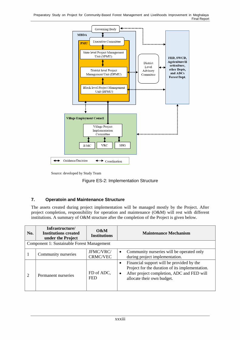
Preparatory Study on Project for Community-Based Forest Management and Livelihoods Improvement in Meghalaya Final Report
xxxiii
Source: developed by Study Team
Figure ES-2: Implementation Structure
7. Operatoin and Maintenance Structure
The assets created during project implementation will be managed mostly by the Project. After
project completion, responsibility for operation and maintenance (O&M) will rest with different
institutions. A summary of O&M structure after the completion of the Project is given below.
No. Infrastructure/
Institutions created under the Project
O&M Institutions
Maintenance Mechanism
Component 1: Sustainable Forest Management
1 Community nurseries JFMC/VRC/
CRMC/VEC
Community nurseries will be operated only
during project implementation.
2 Permanent nurseries FD of ADC,
FED
Financial support will be provided by the
Project for the duration of its implementation.
After project completion, ADC and FED will
allocate their own budget.

Preparatory Study on Project for Community-Based Forest Management and Livelihoods Improvement in Meghalaya Final Report
xxxiv
No. Infrastructure/
Institutions created under the Project
O&M Institutions
Maintenance Mechanism
3
Private forest where
interventions are made by
the Project
Individuals
Funds for maintenance for the first five years
will be provided by the Project. Thereafter,
individual landowners will be responsible for
the maintenance of the forest. In case timbers
are produced for commercial purposes, profits
from timber harvesting will be used for
maintenance activities and replanting of trees.
4
Community forest where
interventions are made by
the Project
Community/
Custodian
of the
forest/ADC
Funds for maintenance for the first five years
will be provided by the Project. Thereafter, the
community that owns the forest will be
responsible for maintenance.
6 Barren lands where
afforestation is created
Community/
FED/ADC
Funds for maintenance for the first five years
will be provided by the Project. Thereafter,
JFMC or communities will be responsible for
maintenance of the forest.
7 Restored shifting
cultivation area
Community/
ADC
Communities who own the land will be
responsible for maintenance.
8
Soil and water
conservation structures
for forest management
VEC/MBDA/
SWCD
O&M for the first two years will be taken care
by the Project fund.
User fees will be collected from the
beneficiaries.
Some funds for maintenance will be leveraged
by scheme convergence in particular NREGA.
Component 2: Community Development and Livelihood Improvement
9
Infrastructure/assets
created under Entry Point
Activities (EPA)
VEC/MBDA
User fees will be collected from the
beneficiaries and utilized for maintenance and
other purposes under the leadership of user
group’s committee if necessary.
Some funds for maintenance will be leveraged
by scheme convergence in particular NREGA.
10 Revolving fund for
micro-credit
SHG/VEC/
MBDA
Revolving fund will be managed by VEC, and
will be loaned to members of SHGs with
interest for IGA.
Guidelines will be developed to select
borrowers and provide them with loans.
Guidelines for managing Revolving fund and
adequate trainings would be ensured by the
Project during consolidation phase.
11 Livelihood activities by
SHGs
SHG/VEC/
MBDA/
Department of
Agriculture/
Horticulture
MBDA will coordinate with concerned
department in case SHGs need support.
Technical support for agriculture activities will
be provided by Department of Agriculture.

Preparatory Study on Project for Community-Based Forest Management and Livelihoods Improvement in Meghalaya Final Report
xxxv
No. Infrastructure/
Institutions created under the Project
O&M Institutions
Maintenance Mechanism
12
Soil and water
conservation structures
for livelihood
improvement
VEC/
Beneficiaries
O&M for the first two years will be taken care
by the Project fund.
User fees will be collected from the
beneficiaries.
Some funds for maintenance will be leveraged
by scheme convergence in particular
MGNREGA.
13
Cooperative societies
established for enterprise
development
MSMEs/
Cooperative
societies/
MBDA
Cooperative society will be responsible for
operation and maintenance for its business
activity.
Component 3: Institutional Strengthening
14 GIS/MIS MBDA/ADCs Systems and equipment will be transferred fully
to MBDA before the project completion.
15 Project Management Unit
(PMU)
Assets handover manual shall be prepared and
accordingly assets shall be handed over by the
Project to MBDA.
16
Village Project
Implementation
Committee of VEC
The committees will function for the duration of
the Project.
17 Office buildings MBDA The property will be transferred to MBDA
before project completion.
8. Environmental and Social Considerations
The Project may not include any sub-projects that will make major environmental and social
impacts; however, certain potential impacts and risks may arise during project implementation.
Therefore, the Environment and Social Management System Framework (ESMSF) and the
Scheduled Tribe and Forest Dependents Plan Framework (STFDPF) are prepared in accordance
with the JICA Guidelines for Environmental and Social Considerations 2010 and the World Bank
Operational Policy 4.10 (OP4.10). Draft Environmental Checklist and draft Environmental and
Social Management System (ESMS) Checklist are also prepared.
Crucial points on Environmental and Social Considerations were agreed to by the Planning
Department on behalf of MBDA and the Study Team during the Study. The agreement includes the
following points: that no components/activities of the Project fall under “Category A”; that MBDA
and JICA shall disclose information on environmental and social considerations in order to ensure
accountability and to promote the participation of various stakeholders.
9. Gender Mainstreaming
Gender mainstreaming is essential for making sure that women are involved in the decision-making
processes of the Project, and that their interests and needs based on their roles in maintaining their
livelihoods and managing natural resources are reflected in the planning of the project’s activities.
For gender mainstreaming, a gender perspective should be integrated into both the organizational
structure of the Project and project operation through the whole of each process of planning,
implementation, and monitoring and evaluation. Interventions which need to be taken for
mainstreaming a gender perspective in the organizational structure, such as conducting gender
analysis and setting up a Gender Committee and the appointment of gender focal points are
proposed. Interventions that are necessary for gender mainstreaming to the project operation,
including the implementation of gender sensitization workshops and provision of training on

Preparatory Study on Project for Community-Based Forest Management and Livelihoods Improvement in Meghalaya Final Report
xxxvi
communication skills and leadership for women, are proposed.
10. Project Cost Estimation
The total project cost is estimated to be approximately 9,289 million INR. A summary of cost
components is shown in the table below.
Table ES- 4: Summary of Project Cost
(million INR)
Close to the public
Source: developed by Study Team based on JICA Cost Estimate Kit
11. Project Evaluation
The economic internal rate of return (EIRR), net present value (NPV), and cost-benefit ratio (B/C)
of the Project were calculated to assess the economic viability of the Project based on the projected
economic cash flow: these are shown in the table below. The EIRR is 15.5 %, which is higher than
the discount ratio of 12 %, and the NPV and B/C are 1,350.4 million INR and 1.27, so that the
Project is economically viable.
Table ES- 5: Summary of Conditions and Results of the Project Evaluation
Basic Assumptions Economic life 50 years
Standard conversion
factor
0.9
Discount rate 12 %
Project Costs Financial Cost 9,288 million INR
Economic Cost 6,855 million INR
Project Beneficial
Activities
Forestry Production Production from AR, ANR, ANR Mix
(NTFP, Fuelwood, and pine)
Prevention of Soil
Erosion
Prevention of soil erosion by increase of
vegetative cover
Water Use Aquaculture in the check dams and
conservation pond, and water usage for living
by the check dams, conservation pond and
water tank
Income Generation
Activities
Income generation by production of piggery,
mushrooms and weaving.
CO2 Reduction Increment of CO2 stock by forestry
production with the Project and without.

Preparatory Study on Project for Community-Based Forest Management and Livelihoods Improvement in Meghalaya Final Report
xxxvii
Cost Benefit
Analysis Results
NPV 1,350.4 million INR
B/C 1.27
EIRR 15.5 %
Sensitivity Analysis of
EIRR
Cost increase (10%): 14.0 %
Cost Increase (20%): 12.8 %
Benefit decrease (10 %): 13.9 %
Cost (+10%) & Benefit (-10%): 12.6 % Source: developed by Study Team
12. Implementation Schedule
The implementation schedule of the Project is presented on the following pages.
13. Risk and Secutiry Management
There are several risks that would hamper progress and achievement of the Project. A Risk
Management Framework, in which potential risks are analyzed and mitigation measures against
them are presented, was prepared during the Study. In conclusion, it was assessed that the overall
risk for the Project was low. However, since various departments and organizations are involved in
Project implementation at multiple levels, close coordination and efficient management are required.
Moreover, because this is the first Japanese ODA loan project in the forestry sector for Meghalaya
State, sufficient support and capacity building need to be provided to the executive agency and
other concerned institutions.
Meghalaya State has a lower crime rate compared with other states in India and relative to national
crime rates. In the past, two rebel groups were active; however, they are inactive now. Overall, it is
concluded that there will be no serious security risks in the state for the implementation of the
Project.

Preparatory Study on Project for Community-Based Forest Management and Livelihoods Improvement in Meghalaya Final Report
xxxviii
Implementation Schedule of the Project
4 5 6 7 8 9 10 11 12 1 2 3 4 5 6 7 8 9 10 11 12 1 2 3 4 5 6 7 8 9 10 11 12 1 2 3 4 5 6 7 8 9 10 11 12 1 2 3 4 5 6 7 8 9 10 11 12 1 2 3 4 5 6 7 8 9 10 11 12 1 2 3 4 5 6 7 8 9 10 11 12 1 2 3 4 5 6 7 8 9 10 11 12 1 2 3 4 5 6 7 8 9 10 11 12 1 2 3 4 5 6 7 8 9 10 11 12 1 2 3 4 5 6 7 8 9 10 11 12 1 2 3
1
1
1
1 1
1
1
1 1
1
1 1
1
1
1
1 1 1 1 1 1 1 1 1 1 1 1 1 1 1 1 1 1 1 1 1 1 1 1 1 1 1 1 1 1 1 1 1 1 1 1 1 1 1 1 1 1 1 1 1 1 1 1 1 1 1 1 1 1 1 1 1 1 1 1 1 1 1 1 1 1 1 1 1 1 1 1 1 1 1 1 1 1 1 1 1 1 1 1 1 1 1 1 1 1 1 1 1 1 1 1 1 1 1 1 1 1 1 1 1 1 1 1
1 1 1 1 1 1 1 1 1 1 1 1
1 1 1 1 1 1 1 1 1 1 1 1 1 1 1 1 1 1 1 1 1 1 1 1 1 1 1 1 1 1 1 1 1 1 1 1 1 1 1 1 1 1 1 1 1 1 1 1 1 1 1 1 1 1 1 1 1 1 1 1 1 1 1 1 1 1 1 1 1 1 1 1 1 1 1 1 1 1 1 1 1 1 1 1 1 1 1 1 1 1 1 1 1 1 1 1
1 1 1 1 1 1 1 1 1 1 1 1 1 1 1 1 1 1 1 1 1 1 1 1 1 1 1 1 1 1 1 1 1 1 1 1 1 1 1 1 1 1 1 1 1 1 1 1 1 1 1 1 1 1 1 1 1 1 1 1 1 1 1 1 1 1 1 1 1 1 1 1 1 1 1 1 1 1 1 1 1 1 1 1 1 1 1 1 1 1 1 1 1 1 1 1 1 1 1 1 1 1 1 1 1 1 1 1
1.1 Participatory land use planning
1.1.1 Land use planning of selected sites at 1:10,000 scale 1 1 1 1 1 1 1 1 1 1 1 1 1 1 1 1 1 1
1.1.2 Facilitation of participatory land use planning at communities 1 1 1 1 1 1 1 1 1 1 1 1 1 1 1 1 1 1 1 1 1 1 1 1 1 1 1 1 1 1 1 1 1 1 1 1
1.2 Restoration of degraded forests
1.2.1 Constitution of JFMC and preparation for JFMC micro-pan 1 1 1 1 1 1
1.2.2 Registration of VRF/CF and prepraration for resolution 1 1 1 1 1 1
1.2.3 Restoration of timber resources (ANR with enrichment planting) 1 1 1 1 1 1 1 1 1 1 1 1 1 1 1 1 1 1 1 1 1 1 1 1 1 1 1 1 1 1 1 1 1 1 1 1 1 1 1 1 1 1 1 1 1 1 1 1 1 1 1 1 1 1 1 1 1 1 1 1 1 1 1 1 1 1 1 1 1 1 1 1
1.2.4 Restoration of natural vegetation (ANR) 1 1 1 1 1 1 1 1 1 1 1 1 1 1 1 1 1 1 1 1 1 1 1 1 1 1 1 1 1 1 1 1 1 1 1 1 1 1 1 1 1 1 1 1 1 1 1 1 1 1 1 1 1 1 1 1 1 1 1 1 1 1 1 1 1 1 1 1 1 1 1 1
1.2.5 Afforestation on barren land (AR) 1 1 1 1 1 1 1 1 1 1 1 1 1 1 1 1 1 1 1 1 1 1 1 1 1 1 1 1 1 1 1 1 1 1 1 1 1 1 1 1 1 1 1 1 1 1 1 1 1 1 1 1 1 1 1 1 1 1 1 1 1 1 1 1 1 1 1 1 1 1 1 1
1.2.6 Restoration of shifting cultivation area (ANR) 1 1 1 1 1 1 1 1 1 1 1 1 1 1 1 1 1 1 1 1 1 1 1 1 1 1 1 1 1 1 1 1 1 1 1 1 1 1 1 1 1 1 1 1 1 1 1 1 1 1 1 1 1 1 1 1 1 1 1 1 1 1 1 1 1 1 1 1 1 1 1 1
1.2.7 Restoration of degraded lands due to quarrying (Mixed Plantation) 1 1 1 1 1 1 1 1 1 1 1 1 1 1 1 1 1 1 1 1 1 1 1 1 1 1 1 1 1 1 1 1 1 1 1 1 1 1 1 1 1 1 1 1 1 1 1 1 1 1 1 1 1 1 1 1 1 1 1 1 1 1 1 1 1 1 1 1 1 1 1 1
1.2.8 Improvement of corridors (ANR) 1 1 1 1 1 1 1 1 1 1 1 1 1 1 1 1 1 1 1 1 1 1 1 1 1 1 1 1 1 1 1 1 1 1 1 1 1 1 1 1 1 1 1 1 1 1 1 1 1 1 1 1 1 1 1 1 1 1 1 1 1 1 1 1 1 1 1 1 1 1 1 1
1.3 Forestry Nurseries
1.3.1 Creation of new permanent nurseries 1 1 1 1 1 1 1 1 1 1 1 1 1 1 1 1 1 1 1 1 1 1 1 1 1 1 1 1 1 1 1 1 1 1 1 1 1 1 1 1 1 1 1 1 1 1 1 1 1 1 1 1 1 1 1 1 1 1 1 1 1 1 1 1 1 1 1 1 1 1 1 1
1.3.2 Improvement of existing permanent nurseries 1 1 1 1 1 1 1 1 1 1 1 1 1 1 1 1 1 1 1 1 1 1 1 1 1 1 1 1 1 1 1 1 1 1 1 1 1 1 1 1 1 1 1 1 1 1 1 1 1 1 1 1 1 1 1 1 1 1 1 1 1 1 1 1 1 1 1 1 1 1 1 1
1.3.3 Community nurseries 1 1 1 1 1 1 1 1 1 1 1 1 1 1 1 1 1 1 1 1 1 1 1 1 1 1 1 1 1 1 1 1 1 1 1 1 1 1 1 1 1 1 1 1 1 1 1 1 1 1 1 1 1 1 1 1 1 1 1 1 1 1 1 1 1 1 1 1 1 1 1 1
1.4 Conservation of Forests in Good Conditions
1.4.1 Constitution of CR and preparation for CR management plan 1 1 1 1 1 1 1 1 1 1 1 1 1 1 1 1 1 1 1 1 1 1 1 1 1 1 1 1 1 1 1 1 1 1 1 1
1.4.2 Peparation for working schemes 1 1 1 1 1 1 1 1 1 1 1 1 1 1 1 1 1 1 1 1 1 1 1 1 1 1 1 1 1 1 1 1 1 1 1 1
1.5 Forest Research 1 1 1 1 1 1 1 1 1 1 1 1 1 1 1 1 1 1 1 1 1 1 1 1 1 1 1 1 1 1 1 1 1 1 1 1
1.6 Soil & Water Conservation for Forest
1.6.1 Bench terracing (Earthern Structures) 1 1 1 1 1 1 1 1 1 1 1 1 1 1 1 1 1 1 1 1 1 1 1 1 1 1 1 1 1 1 1 1 1 1 1 1
1.6.2 Loose boulder contour bunds 1 1 1 1 1 1 1 1 1 1 1 1 1 1 1 1 1 1 1 1 1 1 1 1 1 1 1 1 1 1 1 1 1 1 1 1
1.6.3 Loose boulder box terrcing.planting) 1 1 1 1 1 1 1 1 1 1 1 1 1 1 1 1 1 1 1 1 1 1 1 1 1 1 1 1 1 1 1 1 1 1 1 1
1.6.4 Construction of check dam 1 1 1 1 1 1 1 1 1 1 1 1 1 1 1 1 1 1 1 1 1 1 1 1 1 1 1 1 1 1 1 1 1 1 1 1
1.6.5 Construction of minor irrigation check dam 1 1 1 1 1 1 1 1 1 1 1 1 1 1 1 1 1 1 1 1 1 1 1 1 1 1 1 1 1 1 1 1 1 1 1 1
1.6.6 Construction of conservation pond (which can also be used for fishery) 1 1 1 1 1 1 1 1 1 1 1 1 1 1 1 1 1 1 1 1 1 1 1 1 1 1 1 1 1 1 1 1 1 1 1 1
1.6.7 Construction of conservation pond/dug out pond 1 1 1 1 1 1 1 1 1 1 1 1 1 1 1 1 1 1 1 1 1 1 1 1 1 1 1 1 1 1 1 1 1 1 1 1
1.6.8 Construction of RCC water storage tank for drinking water 1 1 1 1 1 1 1 1 1 1 1 1 1 1 1 1 1 1 1 1 1 1 1 1 1 1 1 1 1 1 1 1 1 1 1 1
1.6.9 Construction of spring tapped chamber 1 1 1 1 1 1 1 1 1 1 1 1 1 1 1 1 1 1 1 1 1 1 1 1 1 1 1 1 1 1 1 1 1 1 1 1
2022 2023
1
1
1
2024 2025 2026 2027 2028 2029Month
2019 2020 2021
1
1
- Contract Negotiation
- No Objection by JICA
1
2
1
- No Objection by JICA
- Price Bid Evaluation
- No Objection by JICA
1
1
2 - Technical Bid Evaluation
0
0
2
0 0 0 0 0 00
0 0Land Acquisition
108
12
96
Consulting Services
Preparation & Study
Project Management
Defect Notification Period (DNP)
12 12 12 12 12108
0 6 12 12
0 0 0
612
0 0 0 0
Component 1: Sustainable Forest Management
Appreisal
Pledge
Signing of Loan Agreement
Procurement of Consultant
- Preparation of RFP
- No Objection by JICA
- Advertising
0 0
0 0 12 0 12 0 12 0
0 0 0 0 0
0 6 12 0 0
0 0 0 0 0 0
0 0 0 0
0
0 0 0 0 00 6 0 0 0 0
0 0 0
0 0 0 0 0 0 0
0 0
0 0 6 12 12 12 12 12
0
0 0 6 12 12 12 12 12 6
0 0 6 0 0 0
6 0 0
0 0 0
12 12 6 0 0
12 12 6 0 0
0 0 6 12 12
0 0 6 12 12 12
12 12 6 0 0
12 12 6 0 0
0 0 6 12 12
0 0 6 12 12 12
12 12 6 0 0
0 0 0 0 0
0 0 6 12 12
0 0 0 0 0 0
72
72
72
72
36
36
36
18
36
6
6
72
72
12
12
12
36
36
36
36
36
36
72
72
72
36
36
12
0
6
0
0 0 0 0 0 0 0 0 0
12 12 12 12 6 0
0 0 0 12 0 12 0
12 12 6 0 00 0 6 12 12
0 0 6 12
0 0 0
0 0
0 0 12 0 12 0 12 0
0 0 0 0 0
12 0 0 0 0
0 0 0 0 0
12 0 0 0
0 0 12 0 12 0
6 6 6 0 0
6 6 6 0 0
0 0 0 6 6
0 0 0 6 6 6
6 6 6 6 0 0
6 6 6 0 0
0 0 0 6 6
0 0 0 6 6 6
6 6 6 6 0 0
6 6 6 0 0
0 0 0 6 6
0 0 0 6 6 6
6 6 6 6 0 0
6 6 6 0 0
0 0 0 6 6
0 0 0 6 6 6
6 6 6 0 00 0 0 6 6 636

Preparatory Study on Project for Community-Based Forest Management and Livelihoods Improvement in Meghalaya Final Report
xxxix
1 1 1 1 1 1 1 1 1 1 1 1 1 1 1 1 1 1 1 1 1 1 1 1 1 1 1 1 1 1 1 1 1 1 1 1 1 1 1 1 1 1 1 1 1 1 1 1 1 1 1 1 1 1 1 1 1 1 1 1 1 1 1 1 1 1 1 1 1 1 1 1 1 1 1 1 1 1 1 1 1 1 1 1 1 1 1 1 1 1 1 1 1 1 1 1 1 1 1 1 1 1 1 1 1 1 1 1
2.1 Commnity Mobilization & Gender Sensitization 1 1 1 1 1 1 1 1 1 1 1 1 1 1 1 1 1 1
2.1.1 Community mobilization workshops (mobilized by NGO) 1 1 1 1 1 1
2.1.2 Gender-sensitization workshop/gender training (by NGO) 1 1 1 1 1 1
2.2 Micro Planning 1 1 1 1 1 1 1 1 1 1 1 1 1 1 1 1 1 1
2.2.1 Training/workshops on how to make a micro plan (by NGO) 1 1 1
2.2.2 Conducting PRA (facilitated by NGO) 1 1 1 1 1 1 1 1 1
2.2.3 Planning on IGAs and convergence with available national/state schemes 1 1 1 1 1 1 1 1 1
2.3 Entry Point Activities (EPAs) 1 1 1 1 1 1 1 1 1 1 1 1 1 1 1 1 1 1
2.3.1 Workshops to prioritize/determine EPA and decide village's contribution 1 1 1 1 1 1
2.3.2 Conducting EPA 1 1 1 1 1 1 1 1 1 1 1 1
2.4 SHG Activities 1 1 1 1 1 1 1 1 1 1 1 1 1 1 1 1 1 1 1 1 1 1 1 1 1 1 1 1 1 1 1 1 1 1 1 1 1 1 1 1 1 1 1 1 1 1 1 1 1 1 1 1 1 1
2.4.1 Meetings to select 2 SHGs (facilitated by NGO) 1 1 1 1 1 1 1 1 1
2.4.2 Micro-credit activity 1 1 1 1 1 1 1 1 1 1 1 1 1 1 1 1 1 1 1 1 1 1 1 1 1 1 1 1 1 1 1 1 1 1 1 1 1 1 1 1 1 1 1 1 1
2.4.3 Income Generation Activities (IGAs) 1 1 1 1 1 1 1 1 1 1 1 1 1 1 1 1 1 1 1 1 1 1 1 1 1 1 1 1 1 1 1 1 1 1 1 1 1 1 1 1 1 1 1 1 1
2.5 Enterprise Development Activities
2.5.1 Feasibility studies & pilot projects for enterprise development 1 1 1 1 1 1 1 1 1 1 1 1 1 1 1 1 1 1 1 1 1 1 1 1 1 1 1 1 1 1 1 1 1 1 1 1 1 1 1 1 1 1 1 1 1 1 1 1 1 1 1 1 1 1 1 1 1 1 1 1
2.6 Soil & Water Conservation for Livelihood Improvement
2.6.1 Construction of rainwater harvesting structure 1 1 1 1 1 1 1 1 1 1 1 1 1 1 1 1 1 1 1 1 1 1 1 1 1 1 1 1 1 1 1 1 1 1 1 1
2.6.2 Construction of drinking water tank 1 1 1 1 1 1 1 1 1 1 1 1 1 1 1 1 1 1 1 1 1 1 1 1 1 1 1 1 1 1 1 1 1 1 1 1
1 1 1 1 1 1 1 1 1 1 1 1 1 1 1 1 1 1 1 1 1 1 1 1 1 1 1 1 1 1 1 1 1 1 1 1 1 1 1 1 1 1 1 1 1 1 1 1 1 1 1 1 1 1 1 1 1 1 1 1 1 1 1 1 1 1 1 1 1 1 1 1 1 1 1 1 1 1 1 1 1 1 1 1 1 1 1 1 1 1 1 1 1 1 1 1 1 1 1 1 1 1 1 1 1 1 1 1 1 1 1 1 1 1 1 1 1 1 1 1
3.1 Capacity Development
3.1.1 Training Need Analysis 1 1 1 1 1 1
3.1.2 Training, Exposure Visits and Workshops 1 1 1 1 1 1 1 1 1 1 1 1 1 1 1 1 1 1
3.1.3 JICA Forestry Sector Annual Workshop 1 1 1 1 1 1 1 1 1 1 1 1 1 1 1 1 1 1
3.1.4 NGO/resource Persons, 2 per district @ Rs 1.25 lakh pm for 84 months 1 1 1 1 1 1 1 1 1 1 1 1 1 1 1 1 1 1 1 1 1 1 1 1 1 1 1 1 1 1 1 1 1 1 1 1
3.2 Monitoring and Evaluation
3.2.1 Baseline survey 1 1 1 1 1 1 1 1 1 1 1 1 1 1 1 1 1 1 1 1 1 1 1 1 1 1 1 1 1 1 1 1 1 1 1 1
3.2.2 Annual planning and review meetings 1 1 1 1 1 1 1 1 1 1 1 1 1 1 1 1 1 1 1 1 1 1 1 1 1 1 1 1 1 1 1 1 1 1 1 1
3.2.3 Annual statutory audit 1 1 1 1 1 1 1 1 1 1 1 1 1 1 1 1 1 1 1 1 1 1 1 1 1 1 1
3.2.4 Mid-term evaluation 1 1 1 1 1 1 1 1 1 1 1 1 1 1 1 1 1 1 1 1 1 1 1 1 1 1 1
3.2.5 Terminal evaluation 1 1 1 1 1 1 1 1 1 1 1 1 1 1 1 1 1 1 1 1 1 1 1 1 1 1 1
3.2.6 MIS and GIS monitoring 1 1 1 1 1 1 1 1 1 1 1 1 1 1 1 1 1 1 1 1 1 1 1 1 1 1 1 1 1 1 1 1 1 1 1 1 1 1 1 1 1 1 1 1 1 1 1 1 1 1 1 1 1 1 1 1 1 1 1 1 1 1 1 1 1 1 1 1 1 1 1 1 1 1 1
3.3 Infrastructure and Mobility
3.3.1 Office buildings 1 1 1 1 1 1 1 1 1 1 1 1
3.3.2 Vehicle/motorbikes 1 1 1 1 1 1 1 1 1 1 1 1
3.3.3 GIS/MIS
3.3.3.1 Enhancement of GIS/MIS Facilities 1 1 1 1 1 1
3.3.3.2 Map preparation 1 1 1 1 1 1 1 1 1 1 1 1 1 1 1 1 1 1 1 1 1 1 1 1 1 1 1 1 1 1 1 1 1 1 1 1
3.4 PR and Publicity 1 1 1 1 1 1 1 1 1 1 1 1 1 1 1 1 1 1 1 1 1 1 1 1
3.5 PMU Establishment
3.5.1 Preparation of manuals and computerized system 1 1 1 1 1 1 1 1 1 1 1 1
1 1 1 1 1 1 1 1 1 1 1 1 1 1 1 1 1 1 1 1 1 1 1 1 1 1 1 1 1 1 1 1 1 1 1 1 1 1 1 1 1 1 1 1 1 1 1 1 1 1 1 1 1 1 1 1 1 1 1 1 1 1 1 1 1 1 1 1 1 1 1 1 1 1 1 1 1 1 1 1 1 1 1 1 1 1 1 1 1 1 1 1 1 1 1 1 1 1 1 1 1 1 1 1 1 1 1 1
1 1 1 1 1 1 1 1 1 1 1 1 1 1 1 1 1 1 1 1 1 1 1 1 1 1 1 1 1 1 1 1 1 1 1 1 1 1 1 1 1 1 1 1 1 1 1 1 1 1 1 1 1 1 1 1 1 1 1 1 1 1 1 1 1 1 1 1 1 1 1 1 1 1 1 1 1 1 1 1 1 1 1 1 1 1 1 1 1 1 1 1 1 1 1 1 1 1 1 1 1 1 1 1 1 1 1 1 1 1 1 1 1 1 1 1 1 1 1 1
12 12 6108
0 6 12 12 12 12
1080 6 12 12 12 12
612 12 12 12 12
12 12 12 12 12 12120
6 12 12 12
12 12 12 12 6
12120
6 12 12 12
12 12
Component 2: Community Development and Livelihood Improvement
Component 3: Institutional Strengthening
Component 4: Project Management Consultant
Component 5: Meghalaya Government
6
0 6 0 0 0
60 3 0 3 0 0
0 6 0 6 0 0
0
0
6 0 0
0 0 0 0 0 0
0 0 0 0
60 3 0 3
0 3 0 0 0 0
0 0 0 0
90 0 3 0 3
0 0
30 0 1 0 1 0 1
0 0 6 0 6 0
3 0 0 0
6
12
0 3 3 3
0 3 0 0 0 09
0 0 3 0 3
0 0 0
0 0
0 1 3 1 3 1 3 0
0
0 2 0 2 0
9 9 9 0 0 054
0 0 9 9 9
18
18
2 0 0 0
3 3
9 6 9 0 0 045
0 0 6 9 6
0 3 0 0 0 09
0 0 3 0 3
9 6 9 0 0 045
0 0 6 9 6
0 0 0 0 0 00 0 0 0 0
0 0 0 0 0 00
0 0 0 0 0
12 12 0 0 0 060
0 3 9 12 12
3 9 3 0 0 036
0 0 9 3 9
3 9 3 0 0 036
0 0 9 3 9
12
27
27
0 0 0
0 0 0
0
12
0
6
36
0
36
36
27
75
12
6
18
18
36
0
0 0 0
0 0 6 0 6 0 6
0 0
0 6 0 0 0 0 0 0
0 0 0 0 0 0
6 6 0 0 0 0
6 0 0 0 0
0 6 6 6 6
0 0 0 0
0 0 6 0 6 0
0 0 0
0 6 6 6 6 6 6
0 0
0 6 6 6 6 6 6 0
0 0 0 0 0 0
6 3 6 3 0
0 0 0 0 6
0 0 0 0
0 0 0 0 6 3
9 0 9 0
0 0 0 0 9 12
0 0 0 0 9 0
3 6 3 6 3 0
0 0 0 0 0
6 6 0 0 0
0 0 0 0 0 0
12 12 12 12 6
0 0 0 0 0
0 0 0 0 0
6 6 0 0 0 0
0 0 0 0 0 0
0 0 0 0 0
0 6 12 12 6
0 6 0 0 0 0
0 0 0 0 0 0
6 0 6 0 0
0 0 0 0 0
0 0 6 0 6 0
0 0 0 0 0 0
0 0 0 0 06 6 0 0 0 0
0 0 0 0 0 0

Preparatory Study on Project for Community-Based Forest Management and Livelihoods Improvement in Meghalaya Final Report
1-1
Chapter 1. Introduction
1.1. Background and Objectives
Meghalaya is a small state located in a hill
area in northeast India, bounded in the
north and east by Assam State and in the
south and west by Bangladesh. This state
has approximately three million people
(2011), a high rate of which (12.5%) is
Below Poverty Line (BPL), and had a high
population growth rate recorded in 2016
(9.7%)1
. Meghalaya State covers a
geographical area of 22,429 km2, with
elevation ranging from 60 to 1,950 m2. The
climate conditions are also varied,
depending on the region. For example, the
average temperature ranges from 5 o
C to 32 oC, and the average annual precipitation varies
depending on regions. For example, the average annual rainfalls over western Meghalaya, northern
Meghalaya, and south-eastern Meghalaya are about 2,600 mm, between 2,500 and 3,000 mm, and
about 4,000 mm respectively3. The state is divided into eleven administrative districts, which are
further subdivided into 39 C&RD Blocks4.
Forest land in India as a whole has been increasing in area since the 1990s. In Meghalaya State, on
the other hand, illegal logging, intensive exploitation, and the aforementioned population increase
have caused deforestation and forest degradation. Many poor people still live in and around forests,
relying on forest ecosystems for their livelihood, such as for fodder, firewood, and materials for
their lives. Deforestation and forest degradation threaten local people, as well as weaken the forest
ecosystem function to store water in the soil and to keep the soil in place. They further cause natural
disasters, such as flooding, and various issues including insufficient irrigation water. Under these
circumstances, there is an urgent need for forest conservation to be addressed in order to sustain
local people’s lives, local communities, and the natural environment.
Considering these circumstances, the Government of India (GoI) launched “Green India Mission”
in 2014. This program aims at sustainable forest management and ecosystem conservation. The
Green India Mission targets an expansion of five million ha in forest area, improving the quality of
forests, conducting biodiversity and watershed conservation in ten million ha, and improving the
livelihoods of three million households in the vicinity of forests, all within ten years. Further, it
intends to develop the capacity of the Joint Forest Management Committee (JFMC) and establish a
participatory forest management system in collaboration with community-based organizations and
government agencies.
In Meghalaya State, while forest cover was estimated at approximately 76% in 2017, the rate of
open forest was 42% of the whole forest areas, implying the occurrence of deforestation and
degradation. In these circumstances, GoI requested a project named the “Project for
Community-Based Forest Management and Livelihoods Improvement in Meghalaya” (the Project)
to Government of Japan. Upon this request, the preparatory study for the Project (the Study) has
been conducted to gather information necessary for the appraisal, such as the Project’s background
objectives and overview, as well as to help provide cost estimation, an implementation structure,
1 Pre-DPR
2 “State of Environment Report, 2005, Meghalaya” prepared by Department of Environment and Forests, Government of
Meghalaya 3 http://meghalaya.gov.in/megportal/stateprofile 4 Pre-DPR
Table 1.1: Profile of Meghalaya State
Item Data
Area 22,429 km2
Population 2,964,007
Capital Shillong
Official
language
Khasi, Pnar, Garo & English
Temperature 5 oC – 32
oC
Literacy 75.48% Source: Meghalaya State Web Portal and Pre-DPR

Preparatory Study on Project for Community-Based Forest Management and Livelihoods Improvement in Meghalaya Final Report
1-2
operation and management system, and environmental and social considerations. This information
will be further used to examine the appropriateness of the implementation of the Project as a
Japanese ODA Loan project. In this regard, the Study plays an important role in planning and
designing the Project.
1.2. Methodology and Approach
The Study has been conducted by a study team formed by a Joint Venture of Kokusai Kogyo Co.,
Ltd. and IC NET (the Study Team). This final report is an output of the Study as per literature
reviews, a series of meetings with implementing agencies (MBDA, FED, SWCD, and ADCs) and
other relevant stakeholders, field visits, subcontracted surveys, workshops and technical meetings,
and discussions during the JICA missions. During the study period, the following subcontracted
survey, JICA mission, workshop/technical meeting, and field visits were conducted.
Workshop and technical meetings:
Kick off meeting: 21 January, 2019
Field visits:
West Jaintia Hills District: 22 January, 2019
Ri-Bhoi District: 23 January, 2019
West Khasi Hills District: 31 January – 1 February, 2019
West Garo Hills and East Gallo Hills Districts: 4 February – 7 February, 2019
West Jaintia Hills District: 15 February, 2019
Jaintia Hills ADC area: 29 April, 2019
Garo Hills ADC area: 1 May – 3 May, 2019
East Khasi Hills District: 6 May, 2019
Ri-Bhoi District: 7 May, 2019
Guwahati, Assam State: 7 May, 2019
East Khasi Hills District: 9 May, 2019
East Khasi Hills District: 8 June, 2019
Subcontracted survey:
Living Conditions Survey: January – March 2019
JICA missions
JICA The First Fact Finding Mission: April, 2019
JICA The Second Fact Finding Mission: June, 2019
JICA Detailed Fact Finding Mission: July, 2019
1.3. Report Structure
This final report is structured in the following order: (1) Examination of the present status, (2)
Problem analysis, (3) Review of the pre-Detailed Project Report (Pre-DPR), and (4) Proposal for a
new project. Chapter 2 presents information about Meghalaya State, focusing on geography,
demography, socio-economic characteristics, natural conditions, and a development plan and
cooperation. Chapter 3 describes forest and forest management in the state. Chapter 4 highlights
approaches to livelihood improvement in the state. Chapter 5 examines the institutional
arrangements of the state. Chapter 6 reviews and assesses the Pre-DPR submitted by the state
government. Chapter 7 presents the final output of the outline of the Project, as well as the scope of
its work.

Preparatory Study on Project for Community-Based Forest Management and Livelihoods Improvement in Meghalaya Final Report
2-1
Chapter 2. The Study Area: Meghalaya
2.1. Area, Location, and Physiography
Meghalaya is one of 29 states of the Indian Union, with Shillong as its state capital. Meghalaya is
located in the north-eastern region of India, along with the states of Assam, Arunachal Pradesh,
Manipur, Mizoram, Nagaland, Tripura, and Sikkim. The total area of Meghalaya is approximately
22,429 km², and it stretches from 25° 02’N to 26° 07’N in a north-south direction and from 84°
49’E to 92° 50’E in an east-west direction. Its elevation ranges from 60 to 1,950 m above sea level.
Meghalaya is bordered on the north and east by Assam State and on the west and south by
Bangladesh, sharing an approximately 496-km-long international boundary.
Meghalaya has predominantly hilly terrain with foothills and plain, flood prone areas. It is broadly
divided into three major hill regions, named Garo Hills, Khasi Hills, and Jaintia Hills, with three
types of landforms. Examples of these types are the Meghalaya Plateau, the young fold mountains,
and alluvial plains. The Meghalaya Plateau is the detached north-eastern extension of Indian
Peninsular shield, a part of which lies under the alluvium deposited by the Ganga Brahmaputra
system of rivers. The rivers of the State are rain-fed in nature, and their discharge remains low
during the summer. Major rivers include the Daring, Sanda, Bugi, Dareng, Simsang, Umkhri,
Digaru, Umngot, and Myntdu Rivers.
2.2. Administrative System of the State
Each of the three main tribes of Meghalaya, the Khasi, Garo and Jaintia, had their own kingdom
until they came under colonial rule in the 19th century and were incorporated into Assam. In April
1970, Meghalaya was carved as a semi-autonomous state out of Assam, consisting of two districts:
the United Khasi Hills and Jaintia Hills, and the Garo Hills. In January 1972, Meghalaya gained
full-fledged status as state.
Currently, the Governor is the constitutional head of the State government. State administration is
run in the name of the Governor, while executive power is exercised by the Council of Ministers,
with the Chief Minister as its head.
There are numerous government departments dealing with various sectors, such as agriculture,
animal husbandry, finance, forest and environment, fisheries, health and family welfare, labour, and
public works.
2.2.1. Administrative Structure
As of March 2019, Meghalaya State is divided into eleven administrative districts, where earlier
there were seven. In 2012, East Garo Hills was divided into the East Garo Hills and North Garo
Hills Districts, Jaintia Hills was divided into the East Jaintia Hills and West Jaintia Hills Districts,
West Khasi Hills was divided into the West Khasi Hills and South West Khasi Hills Districts, and
West Garo Hills was divided into the West Garo Hills and South West Garo Hills Districts. There
are 46 community development blocks, and the number of rural villages shown in the Socio
Economic and Caste Census 2011 is 6,8515. Each of the eleven districts is headed by a Deputy
Commissioner (DC), and the DCs are officers of the Indian Administrative Service.
2.2.2. Autonomous District Councils
Before Meghalaya gained statehood from Assam, the tribal population existed in pockets which
constituted minority populations. Recognizing the need to protect tribal traditions and society, Sixth
Schedule of Indian Constitution, special provisions are made for the administration of tribal
dominated area under the Sixth Schedule of Indian Constitution. Accordingly, Meghalaya State has
5 Village here refers to census village.

Preparatory Study on Project for Community-Based Forest Management and Livelihoods Improvement in Meghalaya Final Report
2-2
three elected Autonomous District Councils (ADCs), namely the Khasi Hills ADC, Garo Hills ADC,
and Jaintia Hills ADC. The ADCs are vested with legislative, executive, and judicial functions and
local administration, despite tribal population being the majority in the state. The areas over which
the ADCs are given authority are:
Lands and resources other than Reserved Forests
Water courses for agricultural purposes
Shifting cultivation
Establishment of village and town administration
Public health and sanitation
Appointment and succession of chiefs and their authority
Marriage
Social customs, traditional practices, and customary laws
District administrations within the purview of each of ADC are shown in the table below.
Table 2.1: ADCs and District Administrations
ADC District
Khasi Hills ADC
East Khasi Hills
West Khasi Hills
South West Khasi Hills
Ri-Bhoi
Jaintia Hills ADC East Jaintia Hills
West Jaintia Hills
Garo Hills ADC
East Garo Hills
West Garo Hills
South Garo Hills
North Garo Hills
South West Garo Hills Source: MBDA
In ADCs, policy decisions are made its Cabinet, which is an elected body. To link ADCs and the
state government, there is a Department of District Council Affairs, which is a state department.
However, the department plays nominal roles such as facilitating between ADCs and the state for
obtaining any approval (such as ADC rules) from the state Governor and assisting ADCs in
conducting elections.
Annual budget for each ADC is individually prepared. Because of limited revenues for ADCs, they
are supposed to receive some grant-in-aid from both state and central governments. However, such
fund provision is neither fixed in terms of amount or frequency, and in reality, ADCs get limited
grants. According to a government official, the average annual expenditure for ADC is around Rs
500 million. In fact, total expenditure for JHADC was about Rs 764 million in FY 2015, out of
which only Rs 0.8 million was grant from the government.
2.3. Population, Economy, and Social Conditions of the State
2.3.1. Demography and Scheduled Tribes
The population of Meghalaya State as of 2011 is 2,966,889, of which the male population is
1,491,832 and female population is 1,475,0576. The total population comprises 79.93% rural
population (2,371,439) and 20.07% urban population (595,450), detailed in Table 2.16: The state
recorded the highest decadal population growth, at 27.82%, among all seven of the north-eastern
6 Government of Meghalaya. 2016. Statistical Abstract Meghalaya 2016. Shillong: GoM.

Preparatory Study on Project for Community-Based Forest Management and Livelihoods Improvement in Meghalaya Final Report
2-3
states of India, as per the 2011 Census of India.
Table 2.2: Population by Sex, Area, and District
Source: Statistical Abstract Meghalaya 2016
Based on the 2011 Census, the total number of households in Meghalaya State is 538,299, of which
78.42% reside in rural areas7. The average household size in the state, specifically in rural areas, is
relatively large compared to other states of the entire country, except for northern and north-eastern
states. Meghalaya State, as well as Arunachal Pradesh, Manipur, and Nagaland States, is one of 11
states of which the average household size is five or more8. In Meghalaya State, households that
have ‘six to eight members’ and ‘nine members or more’ make up 33.75% and 10.73% of the total
rural households, respectively9.
The state is inhabited largely by Scheduled Tribes (ST) groups of people, which make up 86.15%
of the total state population (Table 2.3) whereas the total population of ST in the entire country
make up only 8.6% of the total national population. On the other hand, the population of Schedule
Castes (SC) in Meghalaya account for 0.58% of its total population, whereas the population of SC
in the entire country makes up 16.6% of the total national population (Table 2.3). In the state, there
are three major ST, namely the Khasis, the Jaintias, and the Garos, which account for 34%, 18.5 %,
and 30.5 % of the total population, respectively. The remaining 17 % includes minor tribal groups
of Hajong (1.2%), Biate (1.1%), Koch (1.0%), and Tiwa (0.9%), as well as immigrants from
Bangladesh (7.5%) and Nepal (3.5%).
Table 2.3: Ratio of ST and SC Population
Source: Statistical Abstract Meghalaya 2016
2.3.2. Socio-economic Conditions and Poverty Level
(1) Literacy Rate
7 Government of Meghalaya. 2016. Statistical Abstract Meghalaya 2016. Shillong: GoM. 8 https://www.itnext.in/article/2015/09/30/census-2011-india-average-household-size (last access Feb. 28, 2019) 9 ibid.
Male Female Total Male Female Total Male Female Total
Jaintia Hills 182,610 184,084 366,694 13,675 14,755 28,430 196,285 198,839 395,124
East Khasi Hills 228,409 231,032 459,441 182,340 184,141 366,481 410,749 415,173 825,922
Ri Bhoi 118,705 114,882 233,587 13,826 11,427 25,253 132,531 126,309 258,840
West Khasi Hills 172,380 167,976 340,356 21,335 21,770 43,105 193,775 189,746 383,461
East Garo Hills 138,763 134,962 273,725 22,460 21,732 44,192 161,223 156,694 317,917
West Garo Hills 286,923 281,510 568,433 37,236 37,622 74,858 324,159 319,132 643,291
South Garo Hills 66,470 62,733 129,203 6,700 6,431 13,131 73,170 69,164 142,334
Meghalaya 1,194,260 1,177,179 2,371,439 297,572 297,878 595,450 1,491,832 1,475,057 2,966,889
DistrictRural Urban Total
DistrictTotal
Population
Total ST
Population
% of ST
Population
% of Rural
ST
% of Urban
ST
Total SC
Population
% of SC
Population
% of Rural
SC
% of Urban
SC
Jaintia Hills 395,124 376,099 95.20 93.10 6.90 1,317 0.33 92.30 7.70
East Khasi Hills 825,922 661,158 80.10 65.40 34.60 5,642 0.68 54.10 45.90
Ri-Bhoi 258,840 230,081 88.90 92.30 7.70 590 0.23 85.40 14.60
West Khasi Hills 383,461 375,097 97.80 88.60 11.40 168 0.04 86.30 13.70
East Garo Hills 317,917 305,180 96.00 87.20 12.80 509 0.16 42.20 57.80
West Garo Hills 643,291 474,009 73.70 88.70 11.30 8,810 1.37 70.90 29.10
South Garo Hills 142,334 134,237 94.30 91.70 8.30 319 0.22 59.90 40.10
Meghalaya 2,966,889 2,555,861 86.15 83.60 16.40 17,355 0.58 66.70 33.30

Preparatory Study on Project for Community-Based Forest Management and Livelihoods Improvement in Meghalaya Final Report
2-4
The literacy rate of Meghalaya has drastically improved from 34.08% in 1981 to 74.43% in 201110
,
shown in Figure 2.1.
Source: Statistical Abstract Meghalaya 2016
Figure 2.1: Trend of Sex-wise Literacy Late (1981-2011)
There is quite a huge disparity in the literacy rate between ST men and ST women in rural areas,
specifically in Garo Hills District, while the gender disparity in urban areas of all districts is less
than 3.35 percent points (Table 2.4).
Table 2.4: Literacy Rate of ST by Sex, Area, and District (2011)
Source: Statistical Abstract Meghalaya 2016
(2) Tenure of Farm land
A majority of the state population, specifically the rural population, is engaged more in rain-fed
agriculture, including bun cultivation and shifting cultivation or jhum, than it is in agriculture that
uses irrigation. This has made marginal and small farmers, as well as landless sharecroppers,
vulnerable to risks related to food and livelihood insecurity due to such phenomena as increasing
population, changing climate, soil erosion, and low productivity11
. In Meghalaya, marginal farmers
and small farmers account for 76.57% out of a total number of 209,561 farmers who hold and
operate land (Table 2.5)12
. The average sizes of land holdings for marginal farmers and small
farmers are 0.45 ha and 1.33 ha, respectively13
. Furthermore, there is a certain proportion of the
landless sharecroppers who rent small land from a landowner on an annual basis; specifically, this
10 ibid. 11 Nair, Malini et al. 2013. “Poverty index as a tool for adaptation intervention to climate change in northeast India” The
LSE Research Online (available at http://eprints.lse.ac.uk/31061/, last access Feb.27, 2019). 12 Government of Meghalaya. 2016. Statistical Abstract Meghalaya 2016. Shillong: GoM. 13 ibid.
ST Male ST Female ST Male ST Female
Jaintia Hills 54.99 62.92 92.31 90.61 57.74 65.16
East Khasi Hills 76.75 79.51 93.34 91.23 82.58 83.99
Ri-Bhoi 75.23 74.46 84.94 83.22 75.98 75.18
West Khasi Hills 77.54 76.05 88.01 88.11 78.74 77.49
East Garo Hills 75.30 66.99 92.93 90.24 77.64 70.2
West Garo Hills 72.80 61.62 93.32 90.48 75.17 65.19
South Garo Hills 74.18 64.62 91.48 88.13 75.63 66.66
Meghalaya 72.19 69.78 92.30 90.33 75.54 73.54
Total ST FemaleDistrictsST Rural ST Urban
Total ST Male

Preparatory Study on Project for Community-Based Forest Management and Livelihoods Improvement in Meghalaya Final Report
2-5
is the case in East Khasi Hills, Ri-Bhoi, and Jaintia Hills where much land has been privatized14
.
These landless, marginal, and small farmers have more difficulty in improving their livelihoods by
selling surplus cash crops or even meeting food self-sufficiency because of not only very limited
land holding/operations, but also a lack of water resources during dry season, fertile soil,
technology, access to the market, etc.
Table 2.5: Number of Farmers Holding and Operating Land Area for the Year 2010-2011
Farmers’
Category
No. of Farmers
Holding &
Operating
% of Farmers Area (ha)
Average
holding Size
(ha)
% of Area
Marginal
Farmers 102,714 40.00 46,196 0.45 16.08
Small Farmers 57,755 27.56 76,833 1.33 26.75
Small-Medium
Farmers 40,542 19.35 113,174 2.79 39.40
Medium
Farmers 8,312 3.97 47,132 5.67 16.41
Large Farmers 218 0.11 3,923 16.48 1.37
Total 209,561 100.00 287,258 1.37 100.00 Source: Statistical Abstract Meghalaya 2016
(3) Basic-life Supporting Infrastructure
The accessibility of a household to infrastructure and facilities, such as drinking water, electricity,
and liquefied petroleum gas (LPG), is closely related to basic human life. Thus, it tends to
determine the living conditions of household members. The accessibility varies by residential area
and the economic status of a household. In Meghalaya State, 30.17% of total rural households use
wells and 21.75% use springs for drinking water, while rural households using taps make up only
28.72%. On the other hand, 77.59% of total urban households use taps, while the total urban
households using springs make up only 8.82 %15
. Similarly, the majority of total urban households
(94.93%) have access to electricity while only 51.57% of total rural households do16
. The
population of the state that uses LPG is only 0.2 million out of 5.6 million in all seven north-eastern
states of India. Many households in the state, specifically those living in rural areas, still rely on
firewood for cooking and other purposes.
(4) Poverty Level
The economic condition of people in Meghalaya State is lower than their counterparts in other
states in the north-eastern region and the entire country. The Per Capita Purchasing Power Parity
(PPP) of Meghalaya State in 2017 is USD 4,845, ranking fifth out of the seven north-eastern states
and 28th of all 33 states in India17
, shown in Table 2.6. This is about USD 1,000 less than the
average PPP of the entire country.
Table 2.6: State-wise PPP per capita in North-eastern States and Other States in India
State/Area PPP (Int. $) Rank among 7
Northeastern States
Rank among All 33
States
Goa 17,644.48 - 1
Delhi 17,317.08 - 2
Arunachal Pradesh 6,728.17 1 16
14 Based on the Study Team’s interview with official of Directorate of Horticulture on Feb. 15, 2019. 15 ibid. 16 ibid. 17 Available at https://statisticstimes.com/economy/comparing-indian-states-and-countries-by-gdp-capita.php (last access
Feb. 27, 2019)

Preparatory Study on Project for Community-Based Forest Management and Livelihoods Improvement in Meghalaya Final Report
2-6
Nagaland 6,303.20 2 19
Mizoram 5,992.28 3 20
Tripura 5,487.28 4 22
Meghalaya 4,845.15 5 24
Assam 3,484.45 6 30
Manipur 3,272.69 7 31
India 5,855.31 - - Source: https://statisticstimes.com/economy/comparing-indian-states-and-countries-by-gdp-capita.php (last access Feb.
27, 2019)
More than 80% of total population in Meghalaya State depend their livelihoods on agriculture.
However, agriculture in the state is characterized with limited land holding/operation, low
productivity due to soil erosion, limited use of agricultural inputs and scientific farming technology,
and inappropriate market system. According to the 2011 census, around 12.5% of total rural
population are below poverty line. As mentioned previously, landless sharecroppers and marginal
and small farmers, in particular, are placed in difficult circumstances and exposed to the risk of
further food and income deficit.
The survival or ability of those who live below the poverty line to escape from poverty depend
largely on whether they can diversify their income sources by having a couple of sources that are
alternatives to jhum or sharecropping which is not reliable at all. The household income structure in
2012-2013 in the north eastern hill region of India shows that the households derive their income
from crop production (47.85%) and other income from livestock rearing (21.56%), off farm
businesses (17.99%), and wages and salaries (12.60%)18
. According to the result of National
Sample Survey (NSS) in 2016, the increase rate of the income from crop production, livestock
rearing, off farm businesses, and wages and salaries was 1.18, 7.30, 8.20, and 1.81 times,
respectively, over the period from 2002-03 to 2012-1319
. This trend shows that livestock rearing
played important role to enhance income.
Based on these analyses, livestock rearing is one of the reliable income sources found in Meghalaya
State, as well as in other north-eastern states. Taking this point into account, Nair, Malini. et al.
analyzed the relative poverty status of all districts in the north-eastern states by developing their
own poverty index, consisted of indicators of ‘urban-rural population ratio’, ‘per-capita income’,
‘number of livestock owned per household’, ‘Gini Coefficient of income’, and ‘literacy rates’. In
their analysis, West Garo Hills, Ri-Bhoi, and South Garo Hills Districts are categorized as ‘Very
High’ in their poverty index20
. Similarly, Jaintia Hills District is categorized as ‘High’, while East
Garo Hills and West Khasi Hills Districts are ‘Moderate’ and East Khasi Hills District is ‘Very
Low’21
.
2.3.3. Traditional Decision-making Structures
Meghalaya State is consisted of 11 districts with 46 blocks. In each district, the state government
sets up line departments’ offices at the district and block levels, and a deputy commissioner takes
up a role of administrative governance of such line-departments’ offices.
Parallel to this state government’s administrative structure, there are hierarchical, traditional
decision-making structures, from the district level to the family level, that are mainly responsible
for forests, other land, and natural resource issues. Under these structures, total 11 districts are
18 Datta, K.K. “Towards Enhancing the Farm Income in the Relatively Disadvantaged Areas in India: the North
East Hill Region of India.” available at http://www.isaeindia.org/wp-content/uploads/2017/06/keynote%20paper%2
0-Theme%20IV%20-%20Dr%20KK%20Datta.pdf (last access May 5, 2019) 19 ibid. 20 Nair, Malini et al. 2013. “Poverty index as a tool for adaptation intervention to climate change in northeast India.” in
the LSE Research Online (available at http://eprints.lse.ac.uk/31061/, last access Feb.27, 2019). 21 ibid.

Preparatory Study on Project for Community-Based Forest Management and Livelihoods Improvement in Meghalaya Final Report
2-7
divided into three ADC areas: 1) Khasi Hills ADC looks after four districts of East Khasi Hills,
West Khasi Hills, South West Khasi Hills, and Ri-Bhoi Districts; 2) Jaintia Hills ADC looks after
two districts of East Jaintia Hills and West Jaintia Hills Districts; and 3) Garo Hills ADC looks after
five districts of East Garo Hills, West Garo Hills, North Garo Hills, Southwest Garo Hills, and
South Garo Hills Districts. As mentioned previously, each of ADCs had been established in late
1950’s due to the demand of tribal people for autonomy while Meghalaya was still belonging to
Assam. Even after the establishment of Meghalaya State in 1972, the system of ADCs has been
maintained to date. ADC, specifically Department of Forest within ADC, is mandated mainly to
make policies and regulations on forests, other land, and natural resources. All ADCs in Khasi,
Jaintia, and Garo Hills are not in the relation of reporting to or collaboration with a deputy
commissioner at the district level or line department offices at the district and block levels.
However, ADCs are in a hierarchical relation only with the State Governor, and they have to get an
approval from the State Governor whenever they developed a new act and law.
In each of three hill areas, including Khasi, Jaintia, and Garo Hills, there are hierarchical, traditional
decision-making structures, under ADC, that are supposed to fill a decision-making role and dealt
with common property and natural resource issues based on their customary laws, regulations, and
traditional practices22
. The reason why several hierarchical, traditional decision-making structures,
instead of the lowest administrative unit of a village or Shnong23
, look after forests, other land, and
natural resources is that the boundary of forests, agricultural land, and watershed is often unclear
between neighbouring villages, and the common property without clear boundary at the village
level is managed and looked after by the hierarchical, traditional institutions under ADC. However,
the hierarchical systems of such traditional institutions vary by hill area and tribe, while ADC is
common to all three hill areas.
First, Khasi Hills has a system of a larger territory cluster consisted of several villages, called Hima,
which functions as the second highest decision-making body under ADC24
. In a Hima, policies and
regulations on the communal property of forests and other land are exclusively determined by its
executive committee, which comprises a head of the Hima or Syiem Hima, a secretary, vice
secretary, treasurer, vice treasurer, and representatives of each village belonging to the Hima25
.
Under Hima, there is a smaller territory cluster composing a few villages, called Raid. Similarly,
Raid has its own executive committee, for the purpose of decision-making, which is headed by
Syiem Raid26
. At the village level, every villag has a village council or Dorbar Shnong that takes
responsibility for village-owned forest and other land issues, under the leadership of its head of a
village or Rangbah Shnong27
. In addition to village-owned property and natural resources, Rangbah
Shnong often takes up a role of decision-making for community development. If there are more
than one clan in a village, each clan or Kur may have an elder who acts as a head of the clan, or
Rangbah Kur28
.
Secondly, in Jaintia Hills, there are provinces or Elakas as the second highest level or structure
under ADC. Each of Elakas is headed by Doloi. The lowest level or structure in Jaintia Hills is a
village, called Chrong or Shnong, which is headed by Wheh Chrong or Ranbah Shnong. Power and
22 Tiwari, B.K. et al. 2010. “Forest management practices of the tribal people of Meghalaya, north-east India.” Journal
of Tropical Forest Science 22 (3): pp. 329-342. 23
According to Khasi Hills District Autonomous Council Village Administrative Bill, 2014, ‘village’ is defined as “an
area of human habitation having definite contiguous boundary where a number of houses has been grouped together under
one village for administrative purposes and recognized as such by the Elaka under which the village falls and by the
Executive Committee”. In Meghalaya, as well as in other states, MGNREGA is implemented at the ‘village’ level. 24 Tiwari, B.K. et al. 2010. “Forest management practices of the tribal people of Meghalaya, north-east India.” Journal
of Tropical Forest Science 22 (3): pp. 329-342. 25 ibid. 26 ibid. 27 ibid. 28 ibid.

Preparatory Study on Project for Community-Based Forest Management and Livelihoods Improvement in Meghalaya Final Report
2-8
functions of Dolois and Wheh Chrong have been given on a basis of Elaka Act 2015. These are
generally similar to those of Siem Hima and Rangbah Shnong in Khasi Hills. This is mainly
because the forest management of Khasi Hills and Jaintia Hills is based on United Khasi and Jaintia
Hills Autonomous District Act of 1958.
Lastly, in Garo Hills, there is no system of Hima, Raid, Eleka, or Dorbar Shnong under ADC. In
Garo Hills, not much land has been prioritized yet, but rather has remained as clan-owned or
A’khing land, which tends to spread across multiple villages. This is because the boundaries of land
in Garo Hills are also not determined by villages’ boundaries, but A’khing Nokma’s boundaries.
A’khing land is allotted to each household belonging to the same clan on an annual basis in the case
of jhum cultivation and for an almost permanent term in the case of plantations29
. The land is under
the custodianship of A’khing Nokma, any daughter who has been selected so and inherited A’khing
land from her mother. For actual decision-making on land allotment and other clan-related issues,
however, the husband of A’khing Nokma takes the role and acts on her behalf30
. Members of the
A’khing Nokma’s clan do not have the right to sell or have control over the land allotted to them,
but have access to use. A’khing Nokma often looks after several villages and each village of them or
each clan at the village level is looked after by a clan’s head or Nokma and its Nokma Council.
There are Chra comprising the maternal uncles and brothers of the Nokma and Mahari comprising
male relatives from the same motherhood of the Nokma31
.
In all of the traditional institutions mentioned, only men are usually entitled to membership, based
on traditions and social norms, except Dorbar Shnong in Jaintia Hills where that women are
supposed to be involved in the executive committee of Dorbar Shnong is regulated by ‘Village
Administration Bill’. While the members of traditional institutions in Khasi Hills and Jaintia Hills
are both elected or selected periodically, the same persons tend to continuously be selected and take
up the same roles for a quite long time. On the other hand, there is no regular election or selection
for the members of traditional institutions in Garo Hills. Instead, those in Garo Hills assume roles
indefinitely on the basis of their age and consanguineous or affinal relationship with the Nokma.
Regardless of the different way of selecting members between Khasi Hills and Jaintia Hills and
Garo Hills, all of these traditional institutions (except Dorbar Shnong in Jaintia Hills) exclude
women from their decision-making processes. There are some villages in not only Jaintia Hills, but
also Khasi Hills where women Dorbar Shnong members are elected due to the encouragement of
and interventions made by NGOs, including North East Network that is devoted to the promotion of
gender equality. However, these are still rare cases. Moreover, in most villages even general
meetings are held and important issues are discussed without the presence of women, in addition to
their absence from the membership of the executive committee.
2.3.4. Gender Issues
(1) Women’s Status in India
In India, women and girls are generally more disadvantaged than men and boys in all aspects of life,
including access to social services, economic opportunities, property ownership, and political
participation although gender equality is ensured by the constitution.. This is mainly due to
socio-cultural and religious values and patriarchal norms. The Government of India signed the UN
Convention on the Elimination of All Forms of Discrimination against Women (CEDAW) in July
1980 and ratified it in July 1993. Since ratification, the Government has submitted progress reports,
up to the 4th and 5
th joint progress report in 2012. In response to the latest report, the CEDAW
Committee based in Geneva pointed out the shortcomings of Government’s efforts in addressing
certain issues, including among others gender-based violence (GBV), women’s limited
participation in politics, women’s limited labor force participation and land ownership, the still high
maternal mortality rate (MMR), and child marriage. In Global Gender Gap Index 2018, India
29 MBDA and AFC India Ltd. 2014. Report on Land Tenure and Livelihoods in Meghalaya. Shillong: MBDA. 30 Pre-DPR. 31 Pre-DPR

Preparatory Study on Project for Community-Based Forest Management and Livelihoods Improvement in Meghalaya Final Report
2-9
ranked 108 out of 149 countries. Of the four elements of the Index, each of which are composed of
multiple sub-indicators, India ranked 142 in the element of ‘economic participation and opportunity’
and 147 in ‘health and survival’.
(2) Critical Gender Issues in Meghalaya State
Apart from the majority of Hinduism-based society in India, tribal society in Meghalaya State is
matrilineal, where the youngest or any daughter inherits land from her mother and takes care of her
parents, female siblings’ families, and other relatives as the head of the family or clan. Thus, people
have no obvious preference for boys over girls; infanticide is not practiced, nor are girls
discriminated against, relative to the rest of the country, in regards to food and nutrition intake,
health care, and school enrolment. This can be proved by the state’s sex ratio for the age group of 0
to 6 years, which is 973, versus 927 for India as a whole. It can also be seen in the state’s female
literacy rate, which is 73.78%, versus 65.45% for India as a whole.
Matrilineal society in the state, however, does not necessarily mean that gender equality is ensured,
or that women are empowered and enjoy equal opportunities and rights. Rather, based on its
socio-cultural norms and traditions, unequal gender relations and gender division of labor have been
deeply embedded in the society32
. This is not different from other Hindu and patriarchal societies in
other parts of India. Though women inherit land and have ownership under their names, they do not
have control over it or make any decisions about it. Rather, their uncles or husbands do33
. Similarly,
due to traditional social norms, in the past, women were not allowed even to attend public meetings
and are still excluded from membership in traditional hierarchical institutions, such as village
councils or Dorbar Shnong, Raid, Hima, etc., as previously mentioned. Women’s representation in
the Meghalaya Legislative Assembly has also been non-existent or very limited, with its highest
total being 5 out of 60 total members elected for the period of 2013 to 201834
.
Such unequal gender relationships have reinforced gender division of labor/role and led to certain
problems in the state. The problems include husbands’ abandoning wives and children, the
feminization of poverty, and GBV. Based on social norms and traditions, women mainly take
responsibility for household chores and child care, whereas men work outside and earn a living. In
rural areas, however, women take more roles, such as fetching water, collecting firewood,
cultivating crops, and taking care of livestock, in addition to household chores and child-care
wherease men mainly cultivate crops and are engaged in labor work. Due to a lack of male
landownership, men tend to be less motivated to invest their hard work in cultivation35
, and due to
the tradition of cohabitation, men tend to easily abandon their wives and children for other women,
without paying alimony or child support36
. This causes an increasing number of female-headed
households and the feminization of poverty, both in rural and urban areas37
. In contrast to
Hinduism-based society, women in tribal society are not restricted by social norms from working
outside or doing daily labor work38
. Due to gender-discriminating wage rates, however, doing daily
labor work does not necessarily contribute to the survival and livelihoods of women and their
families. Furthermore, Meghalaya State recorded the highest in domestic violence rate in the
32 UNDP. 2009. “Chapter 8 Women’s Empowerment in Meghalaya”, in Meghalaya Human Development Report 2008.
Delhi: UNDP. 33 ibid. 34 https://www.thequint.com/voices/opinion/opinion-meghalaya-assembly-elections-northeast-few-women-politicians-bjp
-cong (latest access March 2, 2019) 35 UNDP. 2009. “Chapter 8 Women’s Empowerment in Meghalaya”, in Meghalaya Human Development Report 2008.
Delhi: UNDP. 36 https://www.thequint.com/voices/opinion/opinion-meghalaya-assembly-elections-northeast-few-women-politicians-bjp
-cong (last access March 2, 2019) 37 ibid. 38 ibid.

Preparatory Study on Project for Community-Based Forest Management and Livelihoods Improvement in Meghalaya Final Report
2-10
country, as per the National Family Health Survey (1998-99)39
, and is one of the country’s top ten
states in regards to its percentage of child marriage for both girls and boys40
. Thus, many women
suffer from gender inequality despite it being a matrilineal society, as their counterparts in
Hinduism- and Muslim-based societies do.
The Meghalaya State Commission for Women was established in accordance with the Meghalaya
State Commission of Women Act, 2005. In collaboration with the Commission, the Government of
Meghalaya, specifically the Department of Social Welfare Department, is mandated to empower
women in the state and eliminate all forms of discrimination against women. However, its
intervention is limited to the implementation of centrally-sponsored schemes which focus on skill
training and income generation through self-help groups (SHGs). It does not, however, address the
need to foster women’s strategic gender needs, namely agency and decision-making power, nor
does it address GBV through political and legislative intervention, advocacy, and practices. The
centrally-sponsored schemes implemented by the Department of Community and Rural
Development include Swarna Jayanti Gram Swrozgar Yojana (SGSY), Jawahar Gram Samridhi
Yojana (JGSY), Indira Awaas Yojana (IAY), among others. The Department of Labour has
provided vocational training for women under the “Women’s Vocational Training Programme”.
Similarly, Meghalaya State Rural Livelihood Society, under the Department, has implemented
National Rural Livelihood Mission (NRLM) which target exclusively women. Other departments,
such as the Department of Agriculture, involve women farmers in their activities and training
programs, setting up the quota of more than 30% of total participants for women under
centrally-sponsored schemes in particular.
2.3.5. State Economy
(1) Gross State Domestic Product
Like other north-eastern states, Meghalaya State has had slow economic growth and development.
Its gross state domestic product (GSDP) for 2016-2017 was about Rs 272.28 billion, with a
compound annual growth rate (CAGR) of 6.8% between 2011-2012 and 2016-201741
.
Meghalaya State is predominantly an agricultural economy, as the agriculture sector engages about
two-thirds of its total workforce42
. However, the GSDP of the sectors of ‘agriculture’, ‘forestry &
logging’, and ‘fishery’ was about Rs. 38.19 billion in 2014-2015, which accounts for only 15% of
the total GSDP (Table 2.7).
39 UNDP. 2009. “Chapter 8 Women’s Empowerment in Meghalaya”, in Meghalaya Human Development Report 2008.
Delhi: UNDP. 40 The Shillong Times dated Aug. 11, 2018. 41 https://www.ibef.org/download/Meghalaya-March-2018.pdf (last access March 5, 2019). 42 JICA. 2015. Republic of India Data Collection Survey on Agriculture Sector in Northeast India Final Report 2015.
Tokyo: JICA.

Preparatory Study on Project for Community-Based Forest Management and Livelihoods Improvement in Meghalaya Final Report
2-11
Table 2.7: Trend of GSDP 2009-2010 to 2014-2015
P: Provisional, Q: Quick Estimates, and Adv.: Advanced Estimates
Unit: in Rs 100,000
Source: GoM. 2016. Statistical Abstract Meghalaya 2016. Shillong: GoM.
Similarly, based on India Brand Equity Foundation (IBEF)’s analysis, the contribution of the
primary sectors of agriculture and related sectors to the GSDP in 2016-2017 was 20.27% with a
CAGR of 4.4% between 2011-2012 and 2016-201743
as shown in Figure 2.2. In contrast, tertiary
sectors grew at a CAGR of 9.61% during 2011-2012 and 2016-17, and raised its proportion of the
GSDP from 44.72% in 2011-2012 to 51.79% in 2016-2017. On the other hand, the proportion of
GDSP made up by secondary sectors, including ‘manufacturing’, ‘mining & quarrying’, and
‘construction’, declined from 32.97% in 2011-2012 to 27.95% in 2016-2017, with a CAGR of
2.98%.
Source: https://www.ibef.org/download/Meghalaya-March-2018.pdf (last access March 5, 2019).
Figure 2.2: Sector-wise GSDP of Meghalaya for 2011-12 and 2016-17
(2) Agriculture
In Meghalaya State, more than 80% of the population depends entirely on agriculture for their
livelihoods44
. However, agriculture in the state is characterized by marginal or small holding and
operation, as well as no or limited use of scientific or modern techniques, low productivity, and low
production. Land under cultivation as of 2013-2014 was only 12.7% of the total area of the state,
43 https://www.ibef.org/download/Meghalaya-March-2018.pdf (accessed March 5, 2019). 44 Tiwari, B.K. and Lynser, M.B. 2010. “Forest management practices of the tribal people of Meghalaya, north-east
India.” Journal of Tropical Forest Science, 22(3): pp. 329-342.
2009-10 2010-11 2011-12 2012-13 (P) 2013-14(Q) 2014-15(Adv)
Agriculture 174,935 183,955 204,115 240,000 271,271 299,169
Forestry & Logging 50,566 56,444 60,087 64,039 68,891 73,651
Fishing 3,670 3,859 4,083 6,582 7,638 9,030
Sub-total 229,171 244,258 268,285 310,621 347,800 381,850
Manufacturing 70,689 95,253 114,443 125,315 130,095 151,544
Mining & Quarrying 86,701 105,743 115,234 93,109 95,920 98,051
Construction 210,830 231,059 331,810 366,205 449,012 490,563
Electricity, Gas & Water Supply 32,863 22,732 15,656 32,471 31,956 36,751
Sub-total 401,083 454,787 577,143 617,100 706,983 776,909
Transport, Storage & Communication 88,098 104,580 117,621 140,100 164,376 194,762
Trade, Hotel & Restaurant 129,471 154,202 178,162 182,938 205,957 231,962
Banking & Insurance 30,494 42,869 54,902 55,280 58,160 68,348
Real Estate, Ownership of Dwelling &
Business Services98,524 103,350 111,547 115,748 125,314 130,036
Public Administration 176,828 200,583 223,191 238,158 262,836 302,597
Other Services 117,241 153,627 189,006 240,961 320,781 446,876
Sub-total 640,656 759,211 874,429 973,185 1,137,424 1,374,581
Total SGDP 1,270,910 1,458,256 1,719,857 1,900,906 2,192,207 2,533,340

Preparatory Study on Project for Community-Based Forest Management and Livelihoods Improvement in Meghalaya Final Report
2-12
out of which land cultivated more than once per year was only 20%45
. This is mainly because
farmers graze their cattle in their paddy field during dry season, instead of cultivating vegetables.
Low productivity and low production are attributed not only to no or limited use of agricultural
inputs and scientific or modern techniques, but also to soil erosion caused by heavy rainfall and the
shortened cycles of jhum cultivation, due to an increase in population.
In Meghalaya State, 43,200 ha, which accounts for about 15% of total cultivated land, is used for
jhum cultivation, and more than 0.25 million people are still involved and depend on jhum
cultivation for their livelihoods46
. Farmers cultivate dry rice, maize, finger millet, yam, tapioca,
sweet potatoes, ginger, chilies, etc. under jhum cultivation47
. According to Swami, the cycle for
jhum cultivation has been shortened from 10 to 20 years to 5 to 7 years48
. Furthermore, “the Report
on Land and Tenure and Livelihoods in Meghalaya” by AFC India Ltd. shows that the cycle for
jhum cultivation was already shortened to 5 to 7 years in 1983, based on “1983 Task Force Report”,
and 2 to 3 years in 2014, based on “2014 Information of State Agriculture and Soil Conservation
Department”49
. The shortened cycle for jhum cultivation has led to soil erosion and a drastic decline
in productivity50
. Due to this critical reason, as well as the reason that jhum cultivation has caused
deforestation, many farmers have already partially converted jhum land to plantations’. Based on an
interview with individual farmers and focus groups discussion conducted in West Garo Hills in
February and May 2019, they have no intention to make jhum cultivation completely replaced by
plantation farming because they depend on jhum cultivation as a way of getting food grains and
vegetables for domestic consumption. In reality, however, participants in the focus groups
discussion conducted in Selbalgre Village, West Garo Hills District in May 2019 said that around
75% of the total jhum land has already been converted to areca nuts’ plantations’ which deprives
most of their cash income.
In the state, various types of food grain and horticulture crops are cultivated. These vary by altitude-
and climatic eco-zones and farming methods, namely settled cultivation, plantation farming, jhum
cultivation, and agro-forestry51
. The most dominant food grain crop in the state is rice, including
dry rice cultivated in upland through jhum cultivation, which accounts for 72.88% of the total food
grain production in the state (Table 2.8). Other food grain crops are maize, wheat, and small millets.
Main tuber and spices crops, cultivated through both settled and jhum cultivation and agro-forestry,
include potatoes, sweet potatoes, tapioca, ginger, turmeric, chilies, and black pepper (Table 2.9). On
the other hand, main fruits, cultivated in tropical and sub-tropical areas, are mandarin oranges,
pineapple, bananas, papaya, and strawberries, while main plantation crops in those areas are tea,
areca nuts, cashew nuts, rubber, and coffee (Table 2.10).
Table 2.8: Area, Production, and Yield of Main Food Grain and Horticulture Crops
Rice Wheat Maize
Total
Small
Millets
Total
Pulses
Total
Food
Grains Autumn Winter Spring Total
Area in ha 33,310 63,834 13,747 110,891 489 29,533 2,942 8,304 152,159
Production
( metric tons) 88,818 175,689 35,885 330,392 1,012 71,056 3,058 12,687 418,205
Average
Yield (kg/ha) 2,666 2,752 4,793 2,979 2,070 2,406 1,039 1,528 2,748
Source: data provided by Directorate of Horticulture, Government of Meghalaya
45 Government of Meghalaya. 2016. Statistical Abstract Meghalaya 2016. Shillong: GoM. 46 Pre-DPR. 47 Swami, Sanjay. 2018. “Shifting cultivation: A tribal way of life in north east India and alternative approaches for
increasing productivity.” in The Pharma Innovation Journal, 7 (3), pp. 300-385. 48 ibid. 49 AFC India Ltd. 2014. Report on Land Tenure and Livelihoods in Meghalaya. Shillong: MBDA. 50 Swami, Sanjay. 2018. “Shifting cultivation: A tribal way of life in north east India and alternative approaches for
increasing productivity.” in The Pharma Innovation Journal, 7 (3), pp. 300-385. 51 Based on the Study Team’s interview with officials of the Directorate of Horticulture on Feb. 15, 2019.

Preparatory Study on Project for Community-Based Forest Management and Livelihoods Improvement in Meghalaya Final Report
2-13
Table 2.9: Area, Production and Yield of Main Tuber and Spices Crops and Fruits
Tuber Crops Spice Crops
Potato Sweet Potato
Tapioca Total Ginger Turmeric Chilly Garlic Black Pepper
Tezpata Total
Area in ha 19,449 4,690 6,353 30,452 10,363 3,281 2,743 417 1,032 3,956 21,792
Production 214,620 17,847 40,351 272,618 74,893 23,823 2,628 1,282 766 11,904 115,296
Average Yield
( kg/ha)
11,035 3,838 6,320 8,952 7,227 7,261 1,282 3,074 742 3,009 5,291
Source: data provided by Directorate of Horticulture, Government of Meghalaya
Table 2.10: Area, Production and Yield of Fruits and Plantation Crops
Source: data provided by Directorate of Horticulture, Government of Meghalaya
(3) Livestock Management/Animal Husbandry
In Meghalaya State, animal husbandry is an important industry contributing to the GSDP of the
agriculture sector, while most animals that are reared in the state are indigenous. Improved or
crossbred animals are very limited (Table 2.11). Commonly-managed livestock include cattle,
buffalo, goats, pigs, sheep, and poultry; this last of which includes fowl (chicken) and duck, as
shown in Table 2.11.
Table 2.11: Livestock Population as per the 2012 Census and Growth Rate as Compared to the 2007 Census
Population (Number) Growth Rate (%)
Cattle Crossbred 26,458 -1.45
Indigenous 879,295 2.20
Buffalo Indigenous 24,894 10.02
Goat Indigenous 47,233 29.23
Pig Exotic/Crossbred 137,984 96.68
Indigenous 431,317 -5.04
Sheep Exotic/Crossbred 805 232.64
Indigenous 20,186 -2.95
Poultry (Fowl) Improved 344,157 25.84
Desi 3,197,559 16.15
Poultry (Duck) Improved 514 -93.56
Desi 22,331 -61.76 Source: Department of Animal Husbandry & Veterinary, GoM. 2019. Report on Integrated Sample Survey for Estimation of Production Milk, Egg and Meat. Shillong: GoM.
Based on the sample surveys conducted, a greater percentage of households rear poultry and pigs
throughout the year (Table 2.12)52
.
52 Department of Animal Husbandry & Veterinary, GoM. 2019. Report on Integrated Sample Survey for Estimation of
Production Milk, Egg and Meat. Shillong: GoM.
Total
Citrus
Fruits
Pineapple Banana PapayaStraw-
berry
Template
FruitsOthers
Total
FruitsTea Arecanut
Cashew-
nutRubber Coffee Total
Area in ha 12,558 12,162 7,242 962 144 1,316 3,588 37,972 2,955 18,571 10,459 5,260 416 37,661
Production
in MT57,764 140,945 94,320 7,783 1,057 10,986 134,417 447,272 18,001 31,478 22,686 3,188 455 75,808
Average
Yield
in kg/ha
4,600 11,589 13,024 8,090 7,340 8,348 37,463 11,779 6,092 1,695 2,169 606 1,094 2,013
Fruits Plantation Crops

Preparatory Study on Project for Community-Based Forest Management and Livelihoods Improvement in Meghalaya Final Report
2-14
Table 2.12: Percentage of Households Managing Livestock by Season in 2016-2017
Unit: % Summer Monsoon Winter Annual
Cattle 48.59 46.15 44.56 46.31
Poultry 82.08 81.65 85.16 82.98
Sheep 0.06 0.97 0.42 0.01
Goat 28.39 22.01 17.07 22.16
Pig 59.02 65.04 67.62 64.18 Source: Department of Animal Husbandry & Veterinary, GoM. 2019. Report on Integrated Sample Survey for Estimation of Production Milk, Egg and Meat. Shillong: GoM.
In terms of livestock management for commercial purposes, cattle are often managed for the
purpose of using its manure for cultivation and producing meat, while milk production is very low.
Furthermore, the majority of productive cows in the state are indigenous, while crossbred cows, of
which dairy yield is much higher than that of indigenous ones, are limited (Table 2.13)53
.
Table 2.13: Estimated Number of Productive Cows, Yield per Day, and Production in the Year of 2016-2017 and 2017-2018
Status Year 2016-2017 Year 2017-2018
No. Yield per
day in kg
Production
in 1000
tons
No. Yield per
day in kg
Production
in 1000
tons
Indigenous
Cows
in Milk 122,200 0.762 34.112
122,800 0.774 34.681
Milch 235,000 0.297 220,600 0.430
Crossbred
Cows
in Milk 15,000 8.888 48.771
15,200 8.951 49.654
Milch 17,700 7.542 17,500 7.746 Source: Department of Animal Husbandry & Veterinary, GoM. 2019. Report on Integrated Sample Survey for Estimation
of Production Milk, Egg and Meat. Shillong: GoM.
In Meghalaya State, where the majority of the population believes in Christianity and has the
practice of eating beef, beef production makes up over a half of the total meat production in the
state, as seen in Table 2.14.
Table 2.14: Meat Production by Category
Total Production
(in ton)
Proportion of Total Meat
Production (in %)
Yield per Animal
(in kg)
Cattle 23,171 53,74 89.86
Buffalo 570 1.32 117.89
Pig 14,414 33.43 43.35
Sheep & Goat 1,348 3.13 10.32
Poultry 3,615 8.38 1.32
Total 43,118 100.00 - Source: Department of Animal Husbandry & Veterinary, GoM. 2019. Report on Integrated Sample Survey for Estimation
of Production Milk, Egg and Meat. Shillong: GoM.
(4) Mining
The state is endowed with large deposits of a number of valuable minerals, such as coal, limestone,
clay, granite, kaolin, glass-sand, and uranium, among others, as shown in Table 2.15.
53 ibid.

Preparatory Study on Project for Community-Based Forest Management and Livelihoods Improvement in Meghalaya Final Report
2-15
Table 2.15: Various Mineral Resources of Meghalaya State
Type of
Mineral
Total Reserve in
million ton Use Major Places of Occurrences
Limestone 15,100.00 Cement, metallurgical,
and chemical
Khasi Hills: Cherrapunjee,
Mawlong, etc.
Jaintia Hills: Lakadong,
Lumshonong, etc.
Garo Hills: Darrang Era-Aning,
Siju, etc.
Coal 976.48
Sub-bituminous with
medium to high sulphur
Khasi Hills: Langrin and East
Darrangiri
Jaintia Hills: Bapung
Garo hills: Darranggiri
Clay 97.00
Whiteware, earthenware,
furnace lining, curing
soap, etc.
Khasi Hills: Cherrapunjee and
Mahadek
Jaintia Hills: Tongseng
Garo Hills: Rongrenggiri
Granite 50 million ㎥ Table top, wall cladding,
etc.
Ri-Bhoi: Nongpoh
Khasi Hills: Mylliem and
Mawkyrwat
Garo Hills: Rongjeng
Kaolin 5.24 Whiteware
Khasi Hills: Mawphlang, Smit,
etc.
Jaintia Hills: Thadlaskein,
Mulieh Shangpung, etc.
Garo Hills: Darugiri
Glass sand 3.00 Ordinary glassware
Khasi Hills: Laitryngew,
Umstew, etc.
Garo Hills: Tura Source: website of the Department of Mining and Geology in Meghalaya State.
Though the ‘mining and quarrying’ sector in the year of 2016-2017 was worth about Rs 7.96 billion,
accounting for only 3.6% of the total GSDP in the same year54
, mining activities have brought in
the desired effect of economic growth in the state55
. Due to the difficulty in maintaining their
livelihoods through agriculture, many rural people and even migrants from neighbouring states and
other countries, such as Bangladesh and Nepal, have started mining to survive and earn income56
.
Besides this, coal and limestone are important minerals found in Meghalaya State. Total coal and
limestone reserves in the state are 976.48 million tons and 15,100 million tons, respectively. NSS’s
data for 2011-2012 shows the percentage of workers engaged in coal mining in Meghalaya State
was about 1.5 percent of total of one million workers. In 2012-2013, revenue from this sector in the
form of mineral concession fees, rents, and royalties was around Rs 3.57 billion, which constituted
about 27% of the state’s own revenue receipts.
2.4. Natural Conditions of the State
2.4.1. Meteorology and Hydrological Condition
(1) Climate Condition of the State
Meghalaya State gets hit with the southwest monsoon and northeast wind in the winter. Its summer
54
Government of Meghalaya. 2018. Statistical Handbook Meghalaya 2017. Shillong: GoM. 55 Sarma, K. and Yadav., P.K. 2013. Relentless Mining in Meghalaya, India. Conservation Science, 1 (2013), pp. 5-12. 56 ibid.

Preparatory Study on Project for Community-Based Forest Management and Livelihoods Improvement in Meghalaya Final Report
2-16
rainy season lasts for 5 months, from May to September57
. The temperature in the western part of
the state is warmer, ranging between 13 ℃ to 32 ℃, while the central upland is relatively cooler
with a minimum temperature that goes down to around 5 ℃ and a maximum temperature at
around 25 ℃58. Table 2.16 presents the minimum and maximum mean monthly temperatures in the
state.
Table 2.16: Minimum and Maximum Monthly Temperatures in Meghalaya State
Month Mean Maximum (℃) Mean Minimum (℃)
Jan 15.7 7.2
Feb 17.3 8.9
Mar 20.5 12.5
Apr 21.7 14.5
May 22.4 16.1
Jun 22.7 17.9
Jul 22.0 18.1
Aug 22.9 18.2
Sep 22.7 17.5
Oct 22.7 15.8
Nov 20.4 12.3
Dec 17.0 8.3
Source: https://www.yr.no/sted/India/Meghalaya/Shillong/statistikk.html
The state is covered by a warm per-humid agro-ecoregion and is divided into two distinct sub
eco-regions, namely thermic temperature and hyperthermic temperature regimes59
.
The warm per-humid agro-ecoregion with thermic temperature is characterized by the warm
summers and cold winters belonging to semi-temperate climates. It comprises the central plateau
region of East Khasi, West Khasi, and Jaintia Hills Districts. It occupies 6,420 km2, representing
30.1% of the total geographical area of the state. The mean annual rainfall ranges from 2,415 to
11,418 mm, and potential evapotranspiration (PE) ranges from 889 to 961 mm, resulting in a water
deficit of 25 to 132 mm during the dry spells that occur in the post-monsoon period.
The warm per-humid agro-ecoregion with hyperthermic temperature is characterized by the hot and
moist summers and cool winters belonging to sub-tropical climates. It covers the an area from the
middle and lower plateau region to the central plateau of East and West Garo Hills and part of East
and West Khasi Hills and Jaintia Hills. It occupies an area of 14,920 km2, accounting for 69.9% of
the total geographical area of the state. The mean annual rainfall varies from 2000 to 3,362 mm, and
potential evapotranspiration (PE) ranges from 1,000 to 1,299 mm. This eco-region experiences a
short water deficit of 300-350 mm in the seasonal dry spells that follow the monsoon season59
.
57
The Official Web Portal of Government of Meghalaya.: http://meghalaya.gov.in/megportal/stateprofile 58
Government of Meghalaya, Department of Agriculture. Temperature Statistics in Meghalaya.:
http://www.megagriculture.gov.in/PUBLIC/agri_scenario_TempStats.aspx 59 Government of Meghalaya, Soil and Water Conservation Department. Meghalaya Basic Information.:
http://megsoil.gov.in/soil1.html

Preparatory Study on Project for Community-Based Forest Management and Livelihoods Improvement in Meghalaya Final Report
2-17
(2) Rainfall of the State
Rainfall in Meghalaya varies by place and altitude. At Cherrapunjee in East Khasi Hills District, the
average annual rainfall is as high as 12,000 mm, but in Shillong, located at about 50 km away from
Cherrapunjee, the average annual rainfall is 2,200 mm57
. In the last five years, East Khasi Hills
District has had significant rainfall, about 7,000 mm annually. On the other hand, Ri-Bhoi District
received relatively moderate annual rainfall, with around 1,500 mm. Figure 2.3 depicts cumulative
monthly rainfall in the state for the past five years60
. As seen in the figure, heavy rain is observed in
the summer season, with the highest rainfall in August 2015, amounting to 6,797 mm. Meanwhile,
almost no rain is observed between November and February of each year. The total annual rainfall
in the state ranged between 13,247 mm in 2013 and 25,205 mm in 2015. In addition to these figures,
rainfall data for 2016 are given in Table 2.17.
Source: Data compiled by Study Team from IMD (2019)
Figure 2.3: Cumulative Monthly Rainfall in the State for the Past Five Years
Table 2.17: Rainfall Data for the Year 2016 in Millimeters (mm)
(1) South West Garo Hills
(2) South West Khasi Hills
(3) East Jaintia Hills
(4) North Garo Hills
60 India Meteorological Department Ministry Of Earth Sciences.: http://hydro.imd.gov.in/hydrometweb/(S(4h1qv1b
mddygbt3wsq4lyd32))/DistrictRaifall.aspx
STATION JAN FEB MAR APR MAY JUN JUL AUG SEP OCT NOV DEC Total
Ampati 1 0.2 33.6 34.4 256.8 307.6 242.8 48.6 110.2 N/A N/A N/A 1,035.2
STATION JAN FEB MAR APR MAY JUN JUL AUG SEP OCT NOV DEC Total
Mawkyrwat 27.2 2.2 45.4 352.8 505.6 664.4 2570.7 142.4 670.4 N/A N/A N/A 4,981.1
STATION JAN FEB MAR APR MAY JUN JUL AUG SEP OCT NOV DEC Total
Khliehriat N/A N/A N/A 15.4 2,221.4 3.6 2.4 2,173.6 N/A N/A N/A N/A 4,416.4
STATION JAN FEB MAR APR MAY JUN JUL AUG SEP OCT NOV DEC Total
Resubelpara 0.3 0.1 28.2 8.1 12.7 6.1 15.4 6.6 4.1 N/A N/A N/A 81.6

Preparatory Study on Project for Community-Based Forest Management and Livelihoods Improvement in Meghalaya Final Report
2-18
(5) South Garo Hills
(6) West Garo Hills
(7) East Garo Hills
(8) West Jaintia Hills
(9) West Khasi Hills
(10) East Khasi Hills
(11) Ri-Bhoi District
All Data Source in the Tables: Department of Agriculture (http://www.megagriculture.gov.in/PUBLIC/agri_scenario_ RainFallStats.aspx; accessed in February 2019)
2.4.2. Land Use and Land Resources
(1) Land Use
The total geographical land area of Meghalaya is 2.2 million ha, of which 0.9 million ha is forest
area (42.2% of the geographical area) and 0.3 million ha (15.1%) is cropped area that includes
shifting cultivation. Cultivable wasteland in the State is 0.4 million ha (17.4%)61
.
Table 2.18 presents land use patterns for the whole Meghalaya State. The remarkable point is the
high percentage of cultivable land area and fallow land area (24.7% and 9.6% of the geographical
area, respectively). The potential net sown area could be increased when the fallow land is used for
cultivation purposes61
.
Table 2.18: Land Use in Meghalaya State
Item Meghalaya
ha %
Geographical Area 2,242,900 100
Forests (Classed and Unclassed) 946,127 42.2
Area not available for Cultivation
(i) Area under non-agricultural uses
61 Government of Meghalaya Department of Agriculture. Land Use Pattern.: http://www.megagriculture.gov.in/PU
BLIC/agri_scenario_landuse_pattern.aspx
STATION JAN FEB MAR APR MAY JUN JUL AUG SEP OCT NOV DEC Total
Baghmara 15 N/A 154.2 168.4 382.6 354.2 950.2 148.2 383.6 N/A N/A N/A 2,556.4
STATION JAN FEB MAR APR MAY JUN JUL AUG SEP OCT NOV DEC Total
Tura 21.2 N/A 213.6 207.4 413.4 431 642.2 190.2 297.2 N/A N/A N/A 2,416.2
STATION JAN FEB MAR APR MAY JUN JUL AUG SEP OCT NOV DEC Total
Williamnagar 12.6 N/A 169.95 217.42 513.36 114.89 1,015.8 59 236.8 N/A N/A N/A 2,339.82
STATION JAN FEB MAR APR MAY JUN JUL AUG SEP OCT NOV DEC Total
Jowai 28 9.6 46.2 94.4 320.9 353.6 7,889.6 87.2 272 N/A N/A N/A 9,101.5
STATION JAN FEB MAR APR MAY JUN JUL AUG SEP OCT NOV DEC Total
Nongstoin 22.6 14.6 67 172.2 314.4 310.9 1,417.2 184.6 N/A N/A N/A N/A 2,503.5
STATION JAN FEB MAR APR MAY JUN JUL AUG SEP OCT NOV DEC Total
Shillong 49.4 60.5 284.14 4142.8 3,115.1 2,949.2 9,866.5 715.52 943.8 0 0 0 2,2127.0
STATION JAN FEB MAR APR MAY JUN JUL AUG SEP OCT NOV DEC Total
Nongpoh 29.66 0.8 66.4 76 43.2 3 33.4 11.8 N/A N/A N/A N/A 264.26

Preparatory Study on Project for Community-Based Forest Management and Livelihoods Improvement in Meghalaya Final Report
2-19
Item Meghalaya
ha %
a. Waterlogged land 1,022 42
b. Social forestry 19,203 0.9
c. Land under still water 28,973 1.3
d. Other land 58,416 2.6
Total (a to d) 107,614 4.8
(ii) Barren and Uncultivable Land 131,734 5.9
Total Area not available for cultivation
(i) + (ii) 239,348 10.7
Other Uncultivated Lands
a. Permanent pastures and other
grazing lands - -
b. Land under misc. tree crops and
grooves, etc. 164,295 7.3
c. Cultivable wasteland 390,744 17.4
Total - Other Uncultivated Land (a+b+c) 555,039 24.7
Fallow Lands
a. Fallow lands other than currently
fallow 155,193 6.9
b. Currently fallow land 60,048 2.7
Total - Fallow Lands (a + b) 215,241 9.6
Cropped Area
Net Area Sown 285,499 12.7
Area Sown More than Once 54,226 2.4
Total Cropped Area (Sown Area) 339,725 15.1
Source: Study Team from and Department of Agriculture: http://www.megagriculture.gov.in/PUBLIC/agri_ scenario_LandUseStats.aspx
Table 2.19 on the following page shows the district-wise land use patterns in the state in 2013. West
Garo Hills District and South Garo Hills District have relatively low percentage of cultivable land
area compared with other districts and the whole state.
Of the total agricultural land in Meghalaya, it is reported that 62% is used for food grains, 25% for
cash crops, and 9% for horticultural crops, with the remaining 4% is for miscellaneous crops62
.With
the high variety of its topography, Meghalaya State cultivates a variety of agricultural crops. Rice
and maize are the major staple crops, and widely grown kinds of fruit are oranges, pineapple,
lemons, guava, jack fruit, and bananas. The commercial crops cultivate by people there are potatoes,
jute, cotton, areca nuts, ginger, turmeric, betel leaves, and black pepper. Jhum or traditional shifting
cultivation, and terrace cultivation are predominantly done by local people in the state, which leads
to lands being permanently cultivated62
.
The relatively high proportion of non-cultivated land area, especially “Cultivable wasteland” is
likely due to land degradation caused by shifting cultivation62,63
. Shifting cultivation in these
degraded areas exploits land with its short cycles without taking care of soil health, which
deteriorates land much faster than natural remediation process. This erosion from shifting
cultivation is found particularly in Garo Hills64
.
62
Solomon Retna Dhas Nadar Jeeva, Roytre Christopher Laloo and Bhanu Prakash Mishra. (2005). Traditional
agricultural practices in Meghalaya, North East India. 63
Patiram and R. Kumar. (2005). Land Husbandry for Restoration of Degradation in North Eastern Hills. 64
Sukanya Sharma. (2017). The Third Perspective on Shifting Cultivation.

Preparatory Study on Project for Community-Based Forest Management and Livelihoods Improvement in Meghalaya Final Report
2-20
Other causes of uncultivated land are reported as coal mining in such as Jaintia Hills63
and soil
acidity65
. Regarding soil in Meghalaya State, it is affected to get acid by significant amount of
rainfall. High rainfall leads excessive leaching of cations, resulting low soil pH65
. Acid soil was
observed by the Study Team.
Some studies reported a trend showing a decrease in forest area, depending on the districts.66, 67
One cause of the decrease in forest area is mining. According to one report, forest cover decreased
by 12.5%, while there was about a three-fold increase in mining area from 1975 to 200767
.
65
Indian Council of Agricultural Research. (2005). Degraded and Wastelands of India Status and Spatial Distribution. 66 Pallabi Deka, P. K. Ryngnga and S. J. Deka. (2016). Landuse/Landcover Change Detection in Umshing-Mawkynroh of
East Khasi Hills District, Meghalaya Using Spatial Information Technology. 67 Sarma, Kiranmay and Kushwaha, Satya. (2019). Coal mining impact on land use/land cover in Jaintia Hills District of Meghalaya, India using remote sensing and GIS technique.
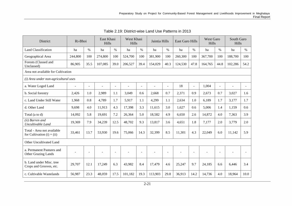
Preparatory Study on Project for Community-Based Forest Management and Livelihoods Improvement in Meghalaya Final Report
2-21
Table 2.19: District-wise Land Use Patterns in 2013
District Ri-Bhoi East Khasi
Hills
West Khasi
Hills Jaintia Hills East Garo Hills
West Garo
Hills
South Garo
Hills
Land Classification ha % ha % ha % ha % ha % ha % ha %
Geographical Area 244,800 100 274,800 100 524,700 100 381,900 100 260,300 100 367,700 100 188,700 100
Forests (Classed and
Unclassed) 86,905 35.5 107,085 39.0 206,527 39.4 154,029 40.3 124,530 47.8 164,765 44.8 102,286 54.2
Area not available for Cultivation
(i) Area under non-agricultural uses
a. Water Loged Land - - - - - - - - 18 - 1,004 - - -
b. Social forestry 2,426 1.0 2,989 1.1 3,049 0.6 2,668 0.7 2,371 0.9 2,673 0.7 3,027 1.6
c. Land Under Still Water 1,968 0.8 4,789 1.7 5,917 1.1 4,299 1.1 2,634 1.0 6,189 1.7 3,177 1.7
d. Other Land 9,698 4.0 11,913 4.3 17,398 3.3 11,615 3.0 1,627 0.6 5,006 1.4 1,159 0.6
Total (a to d) 14,092 5.8 19,691 7.2 26,364 5.0 18,582 4.9 6,650 2.6 14,872 4.0 7,363 3.9
(ii) Barren and
Uncultivable Land 19,369 7.9 34,239 12.5 48,702 9.3 13,817 3.6 4,651 1.8 7,177 2.0 3,779 2.0
Total - Area not available
for Cultivation (i) + (ii) 33,461 13.7 53,930 19.6 75,066 14.3 32,399 8.5 11,301 4.3 22,049 6.0 11,142 5.9
Other Uncultivated Land
a. Permanent Pastures and
Other Grazing Lands - - - - - - - - - - - - - -
b. Land under Misc. tree
Crops and Grooves, etc. 29,707 12.1 17,249 6.3 43,982 8.4 17,479 4.6 25,247 9.7 24,185 6.6 6,446 3.4
c. Cultivable Wastelands 56,987 23.3 48,059 17.5 101,182 19.3 113,903 29.8 36,913 14.2 14,736 4.0 18,964 10.0

Preparatory Study on Project for Community-Based Forest Management and Livelihoods Improvement in Meghalaya Final Report
2-22
District Ri-Bhoi East Khasi
Hills
West Khasi
Hills Jaintia Hills East Garo Hills
West Garo
Hills
South Garo
Hills
Total - Other Uncultivated
Land (a+b+c) 86,694 35.4 65,308 23.8 145,164 27.7 131,382 34.4 62,160 23.9 38,921 10.6 25,410 13.5
Fallow Lands
a. Fallow Lands other than
Currently Fallow 8,847 3.6 5,921 2.2 47,759 9.1 17,611 4.6 20,240 7.8 35,267 9.6 19,548 10.4
b. Currently Fallows 6,181 2.5 4,778 1.7 18,933 3.6 9,755 2.6 4,901 1.9 10,674 2.9 4,826 2.6
Total - Fallow Lands (a + b) 15,028 6.1 10,699 3.9 66,692 12.7 27,366 7.2 25,141 9.7 45,941 12.5 24,374 12.9
Cropped Area
Net Area Sown 22,286 9.1 37,834 13.8 31,212 5.9 36,065 9.4 37,020 14.2 95,644 26.0 25,438 13.5
Area Sown More than Once 2,947 1.2 7,811 2.8 6,861 1.3 414 0.1 5,339 2.1 25,355 6.9 5,499 2.9
Total Cropped Area (Sown
Area) 25,233 10.3 45,345 16.5 38,073 7.3 36,479 9.6 42,359 16.3 120,999 32.9 30,937 16.4
Source: Department of Agriculture.: http://www.megagriculture.gov.in/PUBLIC/agri_scenario_LandUseStats.aspx

Preparatory Study on Project for Community-Based Forest Management and Livelihoods Improvement in Meghalaya Final Report
2-23
(2) Land Resources
1) Mineral Production in the State
Meghalaya State is endowed with a large amount of mineral deposits, especially coal. Coal
production is an important industry in the state68
. The estimated coal reserve there is 559 million
tonnes spreading over an area of 214 km2, which accounts for approximately 1% of the total
geographical area of the state. The Garo Hills District has the highest coal reserves, with 390
million tonnes, followed by West Khasi Hills (98 million tonnes), Jaintia Hills (39 million tonnes),
and East Khasi Hills Districts (31 million tonnes)69
. Production is the highest in Jaintia Hills, with
1.6 million tonnes in 2015.68
The total mineral production value in the state was Rs 39.4 billion, of
which coal amounted to Rs 37.4 billion (95%) in 2012-1370
.
2) Environmental Concerns in Mining
Although mineral production in Meghalaya has huge economic potential, particularly the
production of coal, there are pressing environmental issues. The challenge lies in private lands in
the state. Coal mining is carried out by ‘rat-hole’ method, which devastates forests and the
surrounding environment, with serious consequences for resources such as water71
.To avoid
environmental destruction, the state government applies existing environmental laws, such as the
Forest (Conservation) Act, 1980, to protect forests and rivers. Based on these regulations, no
mining activity is allowed near rivers, and mining applicants must obtain clearance from the
Pollution Control Board and Forest and Environment Department by submitting an application to
the state government through the Deputy Commissioner of the District. On receipt of the
application, the Deputy Commissioner examines it in consultation with, among others, the land
owner and traditional institutions like the ADC and Dorbars72
. In the application, an environment
management plan should be provided, and after mining exploitation, environmental restoration such
as afforestation is required. Restoration, however, is done “as far as practicable”72
. In addition,
unlike other states in India, mining in the Meghalaya State predominantly takes place on private
lands69,73
. Regulating such lands is challenging, as it is written in the Mineral Policy 2012 that the
policy is not applicable to extraction of minor minerals from private land72
. It is also reported that
most mining is done after merely obtaining no-objection certificates from the ADC and bypassing
mandatory forest and environmental clearances and regulatory checks74
.
68
Government of Meghalaya, Department of Mining and Geology. (2017).: http://www.megdmg.gov.in/minerals.html 69
Department of Environment and Forests, Government of Meghalaya. (2005). State of the Environment Report,
2005 70
Government of India Ministry of Mines. (2015). Indian Minerals Yearbook 2013 (Part- I) 52nd Edition STATE
REVIEWS (Meghalaya). 71 Kiranmay Sarma1 and Pramod K. Yadav. (2013). Relentless Mining in Meghalaya, India. 72
Government of Meghalaya, Department of Mining and Geology. (2012). The Gazette of Meghalaya, Extraordinary
Published by Authority PART-IIA the Meghalaya Mines and Minerals Policy, 2012. 73
R. E. Lamare and O. P. Sing. (2016). Limestone Mining and ITS Environmental Implications in Meghalaya, India. 74
Rajkamal Goswami, Muneeswaran Mariappan1, Thangjam Somendro Singh, and T. Ganesh. (2016). Conservation
effectiveness across state and community forests: the case of Jaintia Hills, Meghalaya, India.

Preparatory Study on Project for Community-Based Forest Management and Livelihoods Improvement in Meghalaya Final Report
2-24
2.4.3. Soil Types
(1) General Characteristics
The soils in the hills are derived from gneissic
complex parent materials (Figure 2.4); they are dark
brown to dark reddish-brown in colour, and vary in
depth from 50-200 cm. Soil texture varies from
loamy to fine loamy. The soils of the alluvial plains
adjacent to the northwest and southern plateau are
very deep, dark brown to reddish-brown in colour
and sandy-loam to silty-clay in texture. Meghalaya
soils are rich in organic carbon, which is a measure
of their nitrogen-supplying potential, and deficient
in available phosphorous and medium to low in
available potassium. The reaction of the soils varies
from acidic (pH 5.0 to 6.0) to strongly acidic (pH
4.5 to 5.0). Most of the soils occurring on higher
altitudes under the high rainfall belt are strongly
acidic due to intense leaching. Base saturation of
these soils is less than 35%. These soils are not suitable for intensive crop production. There is not
much difference in the fertility classes of the soils in the state. Four soil fertility classes, namely,
High Low Medium (HLM), High Medium Medium (HMM), Medium Medium Low (MML), and
Medium Low Medium (MLM), have been established from the soil test data so far compiled in the
state Soil Testing Laboratory. Regarding micronutrient status, it has been observed that almost all
the acid soils of the North-Eastern region of the country are deficient in available boron (B) and
molybdenum (Mo). Acid soils in Meghalaya are rated low in available B and Mo. The total zinc,
copper, and manganese contents of these soils vary from 10.00 to 17.25, 17.00 to 71.00, and 110 to
770 ppm (parts per million), respectively, while the diethylenetriamine penta-acetic acid (DIPA),
extractable zinc, copper, and manganese content of these soils ranges from 0.72 to 3.20, 0.6 to 2.8
and 3.0 to 162.0 ppm, respectively. A study conducted by the Indian Council of Agricultural
Research (ICAR) Complex, Shillong, revealed that about 40% of state soils contain micronutrients
below the critical level75
.
(2) Soil Distribution
According to the Soil Map of Meghalaya State76
, four types of soil order in the United States
Department of Agriculture soil taxonomy and 20 subgroups are distributed in the state. Details and
descriptions are given in Table 2.20.
Table 2.20: Soil Distribution in Meghalaya State
Order Subgroup Description
Ultisol
Typic Kandiudults
Deep, excessively drained, fine soils on moderately sloping
side-slopes of hills having loamy surface with moderate erosion
hazard
Typic
Haplohumults
Deep, poorly drained, fine-loamy soils in very gently sloping
valleys with very slight erosion hazard and groundwater table
below one metre depth of the surface
Typic
Kandihumults
Deep, excessively drained, fine soils on moderately sloping
side-slopes of hills having loamy surface with moderate erosion
hazard and slight stoniness
Typic Paleudults Deep, somewhat excessively drained, fine soils on moderately
75 Department of Agriculture (http://www.megagriculture.gov.in/PUBLIC/agri_scenario_soil.aspx; accessed in February
2019) 76 http://megsoil.gov.in/images/meghalaya_soil_map.jpg; accessed in January 2019
Source: Study Team, January 2019
Figure 2.4: Parent Materials (Gneissic
Complex)

Preparatory Study on Project for Community-Based Forest Management and Livelihoods Improvement in Meghalaya Final Report
2-25
Order Subgroup Description
sloping side-slopes of hills having loamy surface with moderate
erosion hazard
Humic Hapludults Deep, well drained, fine soils on very gently sloping plains
having loamy surface with slight erosion hazard
Typic
Kanhapludults
Moderately deep, excessively drained, fine soils on moderately
sloping side-slopes of hills with severe erosion hazard and slight
stoniness
Alfisols Ultic Hapludalf
Moderately deep, excessively drained, fine-loamy soils on
steeply sloping side-slopes of hills having loamy surface with
severe erosion hazard and moderate stoniness
Inceptisols
Typic
Dystrochrepts
Moderately deep, excessively drained, loamy-skeletal soils on
gently sloping hill tops with very severe erosion hazard and
strong stoniness
Humic
Haplaquepts
Deep, poorly drained, fine-loamy soils on very gently sloping
valleys with very slight erosion hazard and ground water table
below one metre depth of the surface
Umbric
Dystrochrepts
Moderately shallow, excessively drained, fine-loamy soils on
moderately steep side slopes of hills having loamy surface with
severe erosion hazard and strong stoniness.
Typic
Haplumbrepts
Deep, somewhat excessively drained, fine-loamy soils on
moderately steep side-slopes of hills with slight erosion hazard
Dystric
Eutrochrepts
Moderately deep, excessively drained fine soils on moderately
steep side slopes of hills with moderate erosion hazard
Aquic
Eutrochrepts
Deep, moderately well drained, fine soils on very gently sloping
upland having loamy surface with slight erosion and slight flood
hazards
Aeric Haplaquepts Deep, imperfectly drained, fine soils on nearly level plains with
slight erosion and slight flood hazards
Cumulic
Humaquepts
Deep, poorly drained fine soils on nearly level valley bottom with
very slight erosion hazard and ground water table below one
metre depth of the surface
Typic Haplaquepts
Deep, very poorly drained, fine soils in nearly level valley having
clayey surface with very slight erosion ground water table
between one to two metres of the surface and moderate flood
hazards
Aeric Haptaquepts
Deep, poorly drained fine soils in nearly level valley with slight
erosion ground water table between one to two metres of the
surface and slight flood hazards
Pachic
Haplumbrepts
Moderately deep, excessively drained loamy-skeletal soils on
moderately steep side-slopes of hills having loamy surface with
very severe erosion hazard and strong stoniness
Entisols
Typic Udorthents Deep, excessively drained, coarse-loamy soils on steeply sloping
hill tops with severe erosion hazard and strong stoniness
Lithic Udorthents
Shallow, excessively drained, loamy-skeletal soils on moderately
steep side-slopes of hills with very severe erosion hazard and
strong stoniness Source: compiled by Study Team based on the existing soil map mentioned above.

Preparatory Study on Project for Community-Based Forest Management and Livelihoods Improvement in Meghalaya Final Report
2-26
(3) Relationship between Topo-sequence
and Soil Distribution
The Study Team conducted a field soil survey in
Nongrmai Village, West Khasi Hills District, in January
2019 in order to reveal the relationship between
micro-topography and distributed soils. In addition,
some soil physical properties were also tested by
portable test kits (Figure 2.5). As a result, oxisols were
found on the crest flat and it was recognized that the
series of soil distribution colour varied depending on
height, with reddish, yellowish, and grayish colours. The
Study Team has identified the cause of the soil variation
as being moisture conditions, which in turn were caused
by surface water that drifted along the topo-sequence (Figure 2.6).
Figure 2.6: Relationship between
Topo-sequence & Soil Distribution
(Case of Nongrmai Village, West
Khasi Hills District)
Source: Study Team
(4) Current State of Agricultural Soils
1) Jhum Cultivation Soil
Jhum cultivation, also known as shifting cultivation, is one of the oldest types of cultivation
practices; it is practiced mainly in the north-eastern states of India, where Meghalaya State is
located. Jhum cultivation is generally practiced on hills located on slopes ranging from gentle to
steep. The cultivation method usually begins by selecting a forest patch and clearing the vegetation
usually in December and January. The small cut trunks portion and roots are usually not removed,
and slashed vegetation dries up on hill slopes for one to two months or is burnt in February and
March. Ploughing and cultivation of crops begin in April and May, and the cultivation continues for
a few years until the soil loses its fertility. The site is cultivated for food crops, such as maize,
paddy, finger millet, green gram, black gram, rice bean, rajma, tomato, cucurbits, colocasia, sweet
potato, ginger, and turmeric. Moreover, the site becomes fallow-land and starts to regain its natural
Source: Study Team, January 2019
Figure 2.5: Soil Survey
❶
➋
➌❹
❺❻
❶ ➋ ➌ ❹ ❺ ❻
Bottomland
Crest flat
Crest slope
Upper head hollow
Vally slope
Lower head hollow
Geomorphic surface
Ultisol EntisolAlfisolOxisol
Inceptisol

Preparatory Study on Project for Community-Based Forest Management and Livelihoods Improvement in Meghalaya Final Report
2-27
forest once the final crop is harvested77
.
As many studies have pointed out, the cultivation cycle in jhum cultivation is very important and
varies considerably. In past years, a cycle of fifty years or more was needed to adequately maintain
ecological balance. At present, jhum cycle has been reduced to 4-6 years; however, this cycle period
is very short for the appropriate recuperation of the site and for repairing ecological damage. This
kind of cultivation in short cycles decreases soil productivity due to the excessive loss of soil
nutrients and socio-economic imbalances in the village communities. A longer cycle period is ideal
for restoring soil fertility and stopping soil erosion.
Socioeconomically, jhum cultivation practice has a lot to do with the production of agricultural
crops in Meghalaya. There is no other alternative means of livelihood for the ethnic people of the
area because of their poor economic conditions, and this situation makes them continue practicing
cultivation short cycle and perhaps further reducing the jhum cycle according to their needs78
.
Figure 2.7 illustrates three types of soil conditions in jhum cultivation areas.
a) Overview of jhum area
b) Soil profile of jhum area
c) Close-up of the soil surface
The slope angle is 30-50˚. Food
cultivation started one year ago
and various crop seeds are
planted directly on the ground.
The surface layer (until about 15
cm deep) is gravelly and very
poor in organic materials and clay
which can retain soil nutrients.
Particle diameter of the gravels
are 1-3 cm and various kinds of
rock break into rubble. Water
retention capacity is very poor.
Source: Study Team
Figure 2.7: Soil Condition of Jhum Cultivation Area (the Case of Garo Hills ADC Area)
2) Bun Cultivation Soil
Bun cultivation is a farming system of Meghalaya; it is also called a modified jhum system. This
system is an indigenous practice mainly in the Khasi Hills and Ri-Bhoi Districts for the cultivation
of crops such as potato, sweet potato, ginger, and vegetables on a series of beds formed along the
slopes of the hills. This system involves: the cutting of shrubs and grasses, putting of dried
vegetation in the form of raised beds along the slopes and covering it with soil collected from its
surroundings, the burning of the covered vegetation and planting in the soil afterwards. Although
good crops yields have been obtained in the system, it leads to large amount of soil erosion. Such
bun fields usually accommodate two or three cropping seasons in a year.
77 Yadav, P.K. (2013), "Slash-and-burn agriculture in north-east India", Expert opinion on Environmental Biology 78 National Informatics Centre, Meghalaya State Centre (2001, http://megsoil.nic.in/shifting_cul.htm; accessed in May
2019)

Preparatory Study on Project for Community-Based Forest Management and Livelihoods Improvement in Meghalaya Final Report
2-28
a) Furrow of bun cultivation
b) Surface of the furrow
c) Close-up of the soil structure
The slope angle was around 20˚
and the ridge height was 15 cm.
Potato cultivation started two
years ago.
Subsoil is exposed by drainage
water, but the ridge soil still
gretains organic materials and
clay.
Although not rich in organic
materials, it maintains aggregate
structures and functions for water
retention and drainage.
Source: Study Team
Figure 2.8: Soil Condition of Bun Cultivation Area (the Case of West Jaintia Hills District)
2.4.4. Drainage and the Catchments79
The drainage pattern of Meghalaya State represents a most spectacular feature revealing the
extraordinarily straight courses of the rivers and streams along the joints and faults. The
magnificent gorges scooped out by the rivers in the southern Khasi and Jaintia Hills are the result of
massive headword erosion by antecedent streams along joints of the sedimentary rocks over the
block, experiences relatively great uplift. Westward in the Garo Hills, the consequent streams are
mostly controlled by the structures, faults and monoclines in the sedimentary rock. The northern
part of the plateau, devoid of any sedimentary cover, is marked by a long incisive valley formed
due to head ward erosion along joints in the gneissic rocks and granites. The limestone-covered
country over southern Garo, Khasi, and Jaintia Hills represent typical karst topography. The present
physiographic configuration of the plateau was attained through different geological events since
the Mesozoic to present day, as indicated by polycyclic surface at various levels. Eight main rivers
in the north and five main rivers in the south drain the state. Rivers in the north and south are
tributaries of Brahmaputra and Meghna respectively.
2.4.5. Natural Disasters and Disaster Management80
Meghalaya State is a multi-hazard state and is prone to disasters such as earthquakes, floods,
cyclonic storms, among others. Flash floods, fire, landslides, cyclonic storms, coal mine collapse,
and flooding are recurrent phenomena in recent years which led to the loss of many lives and
extensive damage to properties in the state. It is therefore obvious that the state is in need of a
Disaster Management (DM) Plan to direct all aspects of DM (including disaster preparedness,
post-disaster response, short and medium-term physical reconstruction, social rehabilitation, and
long-term disaster mitigation). Following the enactment of ‘The Disaster Management Act, 2005’,
by the Government of India (GoI), the Government of Meghalaya formulated a set of DM Rules
2010 under the provisions of DM Act, 2005. The state also brought out a revised DM Policy in
2013.
(1) Vulnerability to Earthquakes
Meghalaya State witnessed a seismic event of ‘8.7 magnitude in 189781
’. This region has been
identified as a potential site of a future catastrophic earthquake. With the growth of population and
79 Soil & Water Conservation Department, Government of Meghalaya (2017, http://megsoil.gov.in/basic_info.html;
accessed in February 2019) 80
MEGHALAYA STATE DISASTER MANAGEMENT PLAN, 2016 (http://megrevenuedm.gov.in/reports/ Meghalaya
_State_Disaster_Management_Plan_Volume1.pdf; accessed in February 2019) 81
H. W. Roehler (1987), "Paleoenvironments and Sedimentology", U.S. Geological Survey Professional Paper, 1314-C,
pp. 40, U.S. Government Printing Office, Washington, D.C.

Preparatory Study on Project for Community-Based Forest Management and Livelihoods Improvement in Meghalaya Final Report
2-29
infrastructure, seismic vulnerability has increased and previous earthquakes have provided a
glimpse of the devastating potential of seismic tremors. According to Global Seismic Hazard
Assessment Program (GSHAP) data, Meghalaya falls in a region of high to very high seismic
hazard. As per the 2002 Bureau of Indian Standards (BIS) map, this state also falls in Zone V.
(2) Vulnerability to Cyclones
Meghalaya is situated in northeastern India, on the border of Bangladesh, which is highly prone to
cyclones and high winds. Every year about 60% of the area is affected by a cyclone in Bangladesh.
West Jaintia Hills and East Jaintia Hills Districts may experience wind speeds of up to 55m/s.
Occasional cyclones do occur in western Meghalaya, with their severity increasing during the
monsoon season. The Districts closest to Bangladesh, like South West Garo Hills, South Garo Hills,
South West Khasi Hills, and West Khasi Hills, fall in a very high cyclonic zone due to their close
proximity to the Bay of Bengal (which is a cyclone basin). In this zone, wind speed can reach up to
50 m/s, which can cause large scale damage. The Bay of Bengal accounts for seven percent of the
annual tropical cyclone activity worldwide; the recorded frequency of cyclones along the Bay of
Bengal is four per year and inevitably one of these four transforms into a severe cyclone, causing
human and property losses.
(3) Vulnerability to Floods
In Meghalaya, floods occur in river valleys, when water flow exceeds the capacity of the river
channel, particularly at bends or points where a river meanders. The plains in areas of Meghalaya,
adjoining Assam, are affected by flooding due to the back flow of water from the River
Brahmaputra during the flood season, between June and October. Tributaries such as Krishnai,
Jinari, Jingjiram, Rongai, Dudhnoi, Ringgi, Gohai, and Dilni cause flooding in the plain areas of the
state. The flood-prone areas of Meghalaya Sate include:
Western part of Meghalaya, in places like Tikrikilla, Phulbari, Rajabala, Garobadha,
Hallidaygunj, Bhaitbari, Fersakandi, Magurmari, Silkata, Mahendraganj, etc.
Plain areas near Bangladesh, like Baghmara, Balat, Shella, Dawki, etc.
Urban flooding in localized areas of Shillong, Williamnagar, Tura, etc.
Localised areas of West Khasi Hills, South West Khasi Hills, East Khasi Hills, and Jaintia
Hillsand in Ri-Bhoi Districts
(4) Vulnerability to Landsides
Meghalaya, being a hilly terrain, is prone to landslides. Every year a number of landslides have
been reported in various localities. These cause a lot of misery to the public, resulting in the loss of
lives and property, the disruption of communication networks, in addition to causing economic
burdens on society. Landslides are primarily attributed to high slopes, immature geology,
neo-tectonic activity, heavy rainfall, and unplanned and improper land use practice in the state.
Landslides generally occur during heavy rains, that is, during the months of June to October in
Meghalaya.
(5) Vulnerability in Prone Areas
The southern part of Meghalaya is more susceptible to landslides than the northern part. National
Highways like Bajengdoba-Tura-Dalu, Damra-Siju-Baghmara, Guwahati-Shillong-Tamabil, and
Shillong-Jowai-Badarpur are prone to landslides. Landslides used to occur frequently at Sonapur on
Shillong-Jowai-Badarpur Road, but now the problem has been mitigated by the construction of a
tunnel for vehicular traffic. The urban areas of Shillong, Tura, and Jowai are also prone to
landslides due to the faulty construction of houses and rapid urbanization.

Preparatory Study on Project for Community-Based Forest Management and Livelihoods Improvement in Meghalaya Final Report
2-30
(6) Vulnerability to Fires
Urban areas in Meghalaya are vulnerable to accidents involving fire for various reasons, most of
which have been attributed to accidents caused by careless human activities, leading to outbreaks of
fire. Most of the urban areas have a high density of population and narrow lanes, making them
highly vulnerable to fire. Approximately 76% of the geographic area of the state is covered by
forests, which are very vulnerable to forest fires during the dry season from February to April.
Every year a large stretch of these forests is destroyed, either by forest fires or by shifting
cultivation, or jhum, which is practiced in parts of the state in which large areas of forests are burnt
down for cultivation purposes. Such types of slash-and-burn or burn-and-plant methods of shifting
cultivation destroy not only forest cover, but also cause adverse effects on the people living close to
the forests by polluting the environment. Financial institutions, NGOs and government agencies
have had some measure of success in enlightening farmers on the ill effects of jhum agriculture and
so new innovations, such as firefighting equipment and technologies, have been incorporated with
traditional methods for higher yield.
(7) Lightning and Hailstorms
Lightning occurs during the monsoon months and can strike at any place. Hailstorms generally
occur in the pre- and post-monsoon months. Some losses of crops, lives, and property due to
lightning and hailstorms have been reported in the state.
(8) Mining related vulnerability of the State
Most of the coal mining in the state is done un-scientifically, i.e. through rat-hole mining. Coal
mine accidents, such as the collapse of mine walls or mine flooding, cause several deaths annually.
The Government of Meghalaya has passed the Meghalaya Minerals and Mining Policy of 2012 to
regulate mining activity in the state.
2.5. Development Plans, Programs and Projects in the State
2.5.1. State and Regional Development Plans (including Meghalaya Vision 2030)
(1) Meghalaya Vision 2030
1) Background
Meghalaya State is facing the development problems of high poverty rates and slow growth in per
capita GDP. According to the Planning Commission’s report in 2012, population below the poverty
line in the state was about 12% at that time.82
Another survey conducted by the Government of
Meghalaya State in 2002, however, gave an estimate that 48.9% of population in the state is below
the poverty line, varying from 39.5% in the Jaintia Hills to 55.9% in the East Garo Hills83
. The
main causes of the high poverty rate are limited employment and income generation opportunities,
poor linkage with the market, and low agricultural productivity due to traditional jhum cultivation
practiced in rural areas.
The Net State Domestic Product (NSDP) of the state is below the averages of both north-eastern
states and all states in India. The gap in the average NSDP between Meghalaya State and all states
in the country steadily increased from 2003 to 2012, and the state’s per capita NSDP, which was Rs
55,306 in 2011-2012, was lower than the average per capita NSDP of all states, which was Rs
60,972. The state has to achieve a 9% of annual growth rate in its NSDP to catch up with the
average NSDP of all states in India from 2015-2016 to 2029-2030.
82
Government of India Planning Commission. (2013). Press Note on Poverty Estimates, 2011-12. 83
M Govinda Rao Anuradha Bhasin Alokesh Barua Mukesh Anand Rita Pandey R Srinivasan. (2013). A Vision
Document for the State of Meghalaya 2030.

Preparatory Study on Project for Community-Based Forest Management and Livelihoods Improvement in Meghalaya Final Report
2-31
2) Seven Strategic Initiatives
To address the aforementioned challenges, the state has put forward ‘A Vision Document for the
State of Meghalaya 2030’ (Vision 2030), which includes a set of seven strategic initiatives. The
strategies are aimed at poverty alleviation and economic growth, as well as development of a
participatory or demand-driven model, where all stakeholders participate in planning,
implementation, and monitoring processes for their own programs instead of a state-centric or
top-down model.
The seven strategic initiatives for the development of the state are as follows:
Empowerment of people through participatory planning and inclusive governance
Development of institutions and systems to establish markets in the state
Sustainable development by protecting natural resources and harnessing the benefits of people
Development of infrastructure to establish markets and attract investment to the state
Expansion of trade and investment opportunities for the state in a globalized world
Development of the capacities of people and institutions
Development of main sectors, including access to education, healthcare, and employment
opportunities
Vision 2030 reviews the state’s critical situations in the following key sectors and proposes some
strategies to improve them, as shown below.
3) Agriculture
Meghalaya has a high percentage of cultivable wasteland compared to the total net sown area, as
explained in the section 2.4.2. All districts in the state, except for West Garo Hills (9.4%) and South
Garo Hills (12%), have more than 20% of cultivable wasteland on average. The total percentage of
fallow land in the state is reported to be 10.3%. This situation indicates that the state is able to
expand crop cultivation area. The critical problems for the state, however, are low agricultural
productivity and dependence on imported food, such as cereals, pulses, eggs, and meat. In order to
make up for this situation, Vision 2030 suggests exporting the products for which the state has
relative competitive power. The crops expected to increase production and be exported to
neighbouring north-eastern and other states are rice, maize, ginger, turmeric, and pineapple.
Processing these crops and exporting them are also a suggested strategy, as explained in the section
of 5) Small Scale Industry below. To produce these crops efficiently, jhum cultivation should be
replaced with the practice of settled cultivation. Conversion to settled cultivation would also
contribute to more use of fallow lands.
4) Livestock Products
The state has a large number of livestock in terms of per capita availability, compared to other
north-eastern states, as well as whole of India. Since the state depends on imported products for
meat and eggs, the development of value-added products, such as meat processing and milk
production, are recommended.
5) Small Scale Industry
Small-scale industry (SSI), including the processing of agricultural crops and the making of wood
furniture, handicrafts, and other items, is an important economic opportunity. Fruits grown in the
state, such as oranges, peaches, and pineapple, can be processed as jams, squash, facial scrubs, and
various other products for sale in the market. Turmeric and a variety of medicinal herbs can be
processed into herbal and health-based products. Other natural resources, such as bamboo, silk, and
forestry products, are also good local-resource-based products. To promote processed products is
commercially important and can solve the problem of loss caused by the long length of time
transportation and poor transportation infrastructure.

Preparatory Study on Project for Community-Based Forest Management and Livelihoods Improvement in Meghalaya Final Report
2-32
In Meghalaya State, there are a great deal of proven deposits of valuable minerals, including
limestone and coal. The mining industry can create a good opportunity for the state and districts for
economic development. The method of mining, however, should be cautiously investigated in order
to protect the environment and human health.
The critical problem of SSI faced by local people is a lack of skill and financial support, inadequate
capital investment, and limited access to or linkage with the main markets. First, training on
modern methods and technology for efficient production is required. In particular, farmers who
have to cultivate cash crops would need support in technical training and the marketing of their
products. The inability to expand business scale and control optimal volume of production also
needs to be improved. Secondly, credits are not available for most local people. The credit-deposit
ratio of commercial banks was only 30% in 2006. Thirdly, the main markets in Assam State,
Kolkata, and Delhi, are far from Meghalaya. Besides, there is no sufficient reliable transportation
infrastructure to deliver products. It is also not easy to find new markets for local people because of
a lack of knowledge and experience.
The solution suggested in Vision 2030 is to form a cluster of local SHGs or common interest groups
(CIGs). A cluster system will function effectively in the way that a cooperative society or
enterprises produce the same, similar, or interrelated products using the same resources solving
common problems, and shipping a large amount of products together. Thus, limited access to
credit and markets would be dealt by creating a cluster of several SHGs or CIGs.
6) Improvement in Marketing
Enhancing marketing is a key to economic and livelihood development. Linking with the market
and creating a value chain are important strategies for enhancing marketing. To develop a value
chain, robust infrastructure facilities are vital. For this, the private sector would play a crucial role
by investing in them.
7) Water Supply Management
In spite of a tremendous amount of rainfall, Meghalaya State experiences a water deficit. Therefore,
a water harvesting technique and effective water use are crucial. Having hilly slopes and a
mountainous terrain in the state, water is severely run-off, and multiple-cropping in a year is almost
impossible. Thus, an irrigation facility based on river and stream water would be a salient measure
for agricultural development. The construction of a rain water harvesting facility is also important
for households to secure domestic water.
8) Tourism
Meghalaya State has a potential for tourism. The number of foreign tourists who visited the state in
2006 was 4,177 and that of domestic tourists was 652,756. The potential areas and subjects of
tourism are water sports, wildlife, trekking, adventure tourism, and eco-tourism. Eco-tourism could
close regional disparities in income. Furthermore, village-based enterprises based on tourism could
diversify sources of income, creating employment opportunities. To promote tourism, training for
government officials and tour operators and the development of resort facilities and trails are
required. A fundamental task for the State Government to promote tourism is to create a reliable
database that its officials can use to do detailed analyses of trends, seasonality, and other related
matters, and to routinely update it. Such a database will allow the government to do appropriate
planning and set up policy measures. It is also important to ensure by law that tourism be
economically, socially, and environmentally sustainable. The government first needs to ensure that
relevant regulations and rules be in place to promote the development of environmentally
sustainable tourism.

Preparatory Study on Project for Community-Based Forest Management and Livelihoods Improvement in Meghalaya Final Report
2-33
9) Forest and Environment Conservation
As a necessary environmental intervention, first, jhum cultivation should be improved so that soil
erosion can be minimized. Others types of intervention include facilitating sustainable land
planning and management concerning the environment, and regulating mining, irrespective of the
size of mines, in order to reduce environmental degradation. For areas where jhum cultivation is
practiced, introducing organic agriculture is recommended, as is starting horticulture and
agro-forestry, and adopting other better agricultural practices. In terms of rehabilitation for
mining-affected areas, technology should be developed. Applicable existing technologies should
also be applied immediately. In addition, policy and judicial arrangements might be required for
effective forest management, such as land use policy. A reward system, similar to compensation
mechanisms, is expected to be worked out.
Regarding forest conservation, an intervention necessary for community forests includes carefully
identifying specific areas: the extent of the intervention also needs to be determined. In addition, it
is necessary to consider where facilitation is required and where regulatory mechanisms are to be
instituted. Caution should be taken to protect local people’s lives, which depend on the forest, and
to ensure the autonomy of traditional institutions. To plan and implement forest resource
management, a set of digital data about the state and districts is vital. Such a data set will enable
policy makers and local people to understand forest changes and trends, based on which they can
create a policy or plan and implement it. Non-spatial data, such as land ownership and local
customs, is also important and should be user-friendly.
10) Capacity Building
In general, building institutional and administrative capacity among public entities is an explicit
goal of a development policy. Public entities need to develop their capacity to build a good
partnership with community-based organizations (CBOs) and the private sector, so that these two
can assume a role in planning, monitoring of projects, and evaluation. Their capacity for statistical
analysis is also important to generate more accurate and timely data from primary sources. From
this point of view, Information Technology (IT) is a key technology for rapid monitoring and
improving evaluation. IT can combat a wide range of problems, especially those faced by the state,
including the geographical isolation of the state from other parts of the country and the lack of
access to the market faced by many remote communities, social and financial services, and other
issues.
It is also important to involve local decision-making bodies in centrally sponsored and
state-sponsored schemes. Local decision-making bodies, such as ADCs, Sordar, and Dorbar
Shnong, should participate in the activities involved in such schemes, including awareness- raising
and the strengthening of knowledge and skills. CBOs and NGOs working in the same area are
supposed to have important roles in linking local people with government agencies.
(2) Data Collection Survey on Agriculture Sector in Northeast India
The GDP of the agriculture sector in the north-eastern states, accounting for 23.9% of the total GDP,
was higher than that of all states in the country (as of 2008/09). In the north-eastern states, 80% of
the total population lives in rural area, where agriculture is the main source of income and
livelihoods; other industries, including manufacturing, are limited. As a result, the dependency of
people on agriculture is high, so it is important to improve and strengthen the agricultural sector.
Given this situation, a survey was conducted in 2015 in order to collect data and information, as
well as analyze critical issues and possible counter-measures in the agriculture and allied sectors in
north-eastern states, including Meghalaya State. In the study, the following interventions were
identified to improve matters on each key issue.

Preparatory Study on Project for Community-Based Forest Management and Livelihoods Improvement in Meghalaya Final Report
2-34
1) Market
Meghalaya State has faced disadvantages in terms of its access to the market and marketing, due to
its topography and low capacity (skills) in marketing among the people there. These impede the
economic development of the state. According to the report of the 2015 survey, about one-third of
the villages in the state were not connected to a main road, and therefore farmers had to carry their
products on their backs and walk to the market. This limited their access to the market and the
amount of the products they can sell in the market. Farmers in West Garo Hills said in the interview
that there are four major constraints in terms of marketing, namely the low price for agricultural
products, fluctuation of prices, lack of market information, and lack of knowledge about marketing.
Although the topography of the state does not make it easy to ship products, the report mentions
that Guwahati Market is one of the most important markets for Meghalaya State that can link
people with the markets of mainland India. On the other hand, Shillong, the capital of the state, has
difficulty in selling products. The main market in Shillong, called Bada Bazar, is too crowded
without enough space, and there is no more area to expand the space set aside for selling. It is also
difficult to move to a new place because it is difficult to get an agreement from the Syiem and
Durbar that control and manage the market.
2) Agriculture Production
Many farmers in Meghalaya State depend on jhum cultivation, which causes soil degradation when
it is conducted with a short rotation cycle. To promote sustainable agricultural systems, the report
says that it is necessary to do the following things:
To increase cropping intensity by introducing short-duration and high-yield varieties
To introduce proper nutrient management practices
To make the most use of available water sources for irrigation, including the creation of an
extensive rain water harvest facility to reduce runoff loss and soil erosion.
To reduce the time required for agricultural operations through efficient farming practice and
meet labour demand for agriculture
For better marketing and productivity, the report proposed the following three components:
To produce agricultural products, focusing on market demand based on market research
To increase productivity and expand cultivation area for larger production
To conduct capacity development necessary for above-mentioned two components in a timely
manner
These three components are implemented through the promotion of a topo-sequential integrated
farming system (IFS) and the improvement of farmers’ livelihood through the linkage of farmers
with market demands.
Topo-sequential IFS can improve productivity and natural resources management through: 1)
selected micro watersheds; 2) the recovery of the water holding capacity of forests; 3) the
construction of check dams and ponds; 4) the development of irrigation facilities; 5) the provision
of technical training on farming, horticulture, livestock, and fisheries; and 6) linkage with the
market for agricultural produce and processed products. The report also recommends supplying
quality seedlings for horticultural crops by producing them at tissue culture laboratories.
3) Horticulture
Along with a broad variety of topography and climate conditions within the state, it is possible to
cultivate a wide range of horticultural crops which have the potential for improving the livelihoods
of local people. High potential crops include fruits, flowers, spices, and medicinal and aromatic
plants. Exotic crops like strawberries are expected to increase farmers' incomes because of high

Preparatory Study on Project for Community-Based Forest Management and Livelihoods Improvement in Meghalaya Final Report
2-35
demand in local and international markets. The promotion and commercialisation of horticulture
would be accelerated by value-addition and through the formation of CIGs or SHGs.
4) Agro-business
Agro-business is one of the sectors in which the state should promote and improve its enterprises.
Critical needs for the sector are the improvement of basic technical skills related to enterprises and
the creation of business opportunities for agricultural products. Unlike training courses provided by
agriculture-related departments, the Meghalaya Institute of Entrepreneurship (MIE) emphasizes
looking at the agriculture value chain. As people engaged in agriculture are not so familiar with
business, it is a challenge for the MIE to provide such a training program for them.
5) Irrigation
Irrigation is an important facility for improving agricultural productivity in the state. Although
Meghalaya State has the largest amount of rainfall in the world, water is sometimes insufficient
during the dry season. Irrigation facilities, however, have not been well developed in the state.
Based on findings from an interview with farmers conducted in West Garo Hills District in 2015, a
major constraint on agricultural production was a 'lack of [an] irrigation facility”, a response
received by 42% of the farmers interviewed. In addition, 6% of the respondents raised the issue of
“lack of irrigation water”.
6) Environmental Concerns
Along with the promotion of agricultural production, the protection of existing forest areas is highly
important for forest-dependent people and the ecosystem. As effective measures, conducting an
awareness-rising program targeting local communities and planting fast-growing species of fruit
trees in jhum areas are suggested in the report of the study in 2015. To avert the further pressure of
encroachment on existing forests, crop cultivation should be encouraged in wasteland or other
marginal lands.
7) Animal Husbandry and Dairy Farming
Meat processing and dairy products would be good activities for income generation in the state. For
this, pigs, poultry, and small ruminants should be raised. The following points are recommended
measures to be done to increase meat and dairy-product production:
To establish dairy cooperative societies/ SHGs/CIGs for easy marketing
To initiate small-scale and value-added milk product processing industries
To promote fodder harvesting
To consolidate animal-health-care program
8) Fishery
The report of the study conducted in 2015 expresses the potential for fisheries as a means for
income generation in the state. The following interventions are recommended for their promotion.
To transform low-lying area to an aquaculture pond
To introduce aquaculture in paddy fields, specifically in low-lying paddy fields
To cultivate and supply in a timely manner quality fish fingerlings based on demands
To improve infrastructure for transporting fish to the distant markets
To produce quality- and nutritious fish feeds
9) SHG
The report of the study in 2015 shows that 24.6% of the total number of registered cooperative
societies was non-active as of 2014. Many of these organizations were dependent on external

Preparatory Study on Project for Community-Based Forest Management and Livelihoods Improvement in Meghalaya Final Report
2-36
support to run their activities. A majority of the business done by the societies was heavily
subsidized and did not follow any business model. While a majority of the societies did not make
profits, some societies did. The Strawberry Growers Association in Ri-Bhoi District was one of
such successful cooperative societies. It significantly contributed to the growth of strawberry
cultivation.
A possible cause for the inactivity of the societies would be financial constraints. Not a small
number of SHGs in Meghalaya State have faced a challenge in managing their finances. As of 31st
March 2014, 3,075 SHGs in the state recorded outstanding loans amounting to Rs 127 million. This
was because the bank transaction cost for accessing financial and other supporting services was
very costly due to geographical reasons and the limited presence of service providers. Many of the
borrowers became defaulters not because of laziness about making repayments, but because of the
burden of the high cost and time required to reach the bank. On the other hand, the positive side of
cooperative societies is the formation of clusters. A cluster approach is effective, especially for
marginal and small farmers in remote areas. By forming a cluster composed of several SHGs,
members living and farming in a scattered area can ship their products jointly to newly established
production centres.
2.5.2. Poverty Alleviation Programs
The Government of India has implemented various programs in order to reduce poverty. Based on
“Mahatma Gandhi National Rural Employment Guarantee Act” (MGNREGA), an Indian labor law,
and social security measures aiming to guarantee the right to work, the Ministry of Rural
Development has implemented the Mahatma Gandhi National Rural Employment Guarantee
Scheme (MGNREGS) since 2006. This scheme mainly aims to enhance livelihood security in rural
areas by providing at least 100 days of wage employment in a financial year to every household
whose adult members volunteer to do unskilled manual work. Another objective of the scheme is to
create durable assets, such as roads, canals, ponds, and wells. Since April 2008, the MGNREGS has
covered all districts of India, so it is called “the largest and most ambitious social security and
public works program in the world.”
Another large-scale national scheme focused on poverty reduction is the Deendayal Antodaya
Yojana - National Rural Livelihoods Mission (DAY-NRLM), which is also implemented by the
Ministry of Rural Development. The DAY-NRLM is aimed at alleviating rural poverty through
building sustainable community institutions by the poor. It seeks to mobilize about 90 million
households into SHGs and link them to sustainable livelihood opportunities by building their skills
and enabling them to access formal sources of finance, entitlements, and services from both public
and private sectors. It is envisaged that the intensive and continuous capacity building of rural poor
women will ensure their social, economic, and political empowerment and development. The
Mission has been implemented in 5,123 blocks spread across 612 districts of 29 states, including
Meghalaya, and 5 Union Territories (UTs). From April 2014 to November 2018, 30 million rural
poor women have been mobilized into 2.69 million SHGs across the country. Under the Start-up
Village Entrepreneurship Program of the Mission, training was provided for 30,352 enterprises in
17 states during 2016 and 2017.
2.5.3. Watershed Management Programs
(1) National Watershed Development Project for Rain-fed Areas (NWDPRA)84
The NWDPRA has been restructured by retaining the technical strengths of the older programme
and incorporating the lessons learnt from successful projects, especially on community participation.
It is now mandatory for “watershed development” to be planned, implemented, monitored, and
maintained by the watershed communities themselves. Moreover, to bring about uniformity in
approach between the watershed-based programmes being implemented by various agencies, the
84 http://www.megagriculture.gov.in/PUBLIC/watershed_management_Default.aspx (accessed in February 2019)
Preparatory Study on Project for Community-Based Forest Management and Livelihoods Improvement in Meghalaya Final Report
2-37
revised Guidelines of NWDPRA are in conformity with the common approach for watershed
development, jointly formulated and adopted by the Ministries of Agriculture and Rural
Development. It is expected that the revised NWDPRA will truly become a people’s movement for
the development of land and water resources and for enhancing productivity in rain-fed areas on a
sustainable basis.
Management of land resources under the watershed programme includes both rain-fed cultivated
land and uncultivated land under ownership of private land owners, panchayat, the revenue
department, among other owners. This is being done with a view to increasing food production as
well as diversifying the existing farming system, particularly of small and marginal farmers,
through the sustainable enhancement of productivity of various commodities. Hence special focus
is proposed on aspects such as Integrated Pest Management (IPM), Integrated Nutrient
Management (INM), Farming Systems Approach (FSA), Low External Input Sustainable
Agriculture (LEISA), agro-forestry, agri-horticulture, silvi-pasture, and animal husbandry. The
watershed approach would result in improving the productivity not only of agriculture and allied
commodities but also the overall production of bio-mass for the enhancement of self-employment
opportunities and thus the overall incomes of rural households.
Conservation and management of rainwater holds the key for sustainable agriculture in rain-fed
areas. In the case of water resource management, the focus is not merely on the development of
new water resources but also on efficient utilization of already developed resources, particularly
based on indigenous systems. This is to be attempted through the substitution of crops that require
high amounts of water with those that require low amounts, and also through the adoption of
efficient methods of irrigation (e.g. micro-irrigation systems).
(2) Water Management of Minor Irrigation Schemes85
The need for adopting the participatory approach for management of irrigation projects is crucial
for conserving resources and their optimal utilization, since Participatory Irrigation Management
(PIM) refers to the involvement of Irrigation users in all aspects of Irrigation Management and at all
levels. The aspects include the initial planning and design of new Minor Irrigation Projects (MIP’s),
their construction, supervision as well as improvement, and for decision making, operation and
maintenance (O&M), and the monitoring and evaluation of the system. The irrigation system in the
country, especially in Meghalaya State, has so far been largely constructed and managed by the
government, so introducing PIM requires a new paradigm in Irrigation Management. The Water
Users' Association (WUA) has also been registered in various districts of the state. The objectives
of PIM can thus be summarized as follows:
To inculcate a sense of ownership and responsibility among the farmers.
To resolve differences or conflicts regarding implementation, water distribution, operation and
maintenance, or any other related issue.
To improve service through better operation and maintenance.
To achieve optimum utilization of available resources through improved systems of water
delivery, matching to the greatest extent possible the needs of crops.
To achieve equity in water distribution.
To make optimum use of natural precipitation as ground water in conjunction with flow
irrigation.
To increase production per unit of water or per unit of land as the case may be.
To help the farmers to have a greater choice of crop sequences and timing, period and
frequency of water supply, depending on soils, climate and other infrastructure facilities
available in the area, such as transport of produce, marketing of produce, etc., such as to
maximize the income and returns.
To develop professional relationship between the irrigation officers and staff with farmers.
85 http://www.megagriculture.gov.in/PUBLIC/water_management_Default.aspx (accessed in February 2019)

Preparatory Study on Project for Community-Based Forest Management and Livelihoods Improvement in Meghalaya Final Report
2-38
To promote economy in the use of water.
To mobilize local resources in cash or kind or in terms of labour towards meeting the O&M
charges.
To branch out into activities other than the distribution of water for the purpose of raising
resources, so long as they are consistent with the basic responsibilities of the WUAs, for
example to assist farmers in a tie up with agro industries, etc.
In Meghalaya State, the maintenance of completed Minor Irrigation schemes is being looked after
by the Irrigation Department. The need for PIM is being felt now, but progress towards the
implementation of the PIM is still in its infant stage. As the system is yet to be fully evolved, the
achievements so far made in this respect are only to the extent of formation and registration of
WUAs in the completed project areas. At present, the formation of WUAs for MI projects is in
progress and, in most of the project areas, the WUAs have been formed and duly registered under
the Society Act. The draft Memorandum of Understanding (MOU) between the WUAs and the
Department for handing over the operation, maintenance, and management of MIPs to the WUAs
has been submitted to the government. The cabinet’s approval in this regard is being awaited.
Regarding the realization of water rates, being a policy matter, the government's approval in this
regard is needed.
2.5.4. Central Sponsored Programs
(1) Mahatma Gandhi National Rural Employment Guarantee Act (MGNREGA) 86
To address poverty issues in rural areas, GoI passed the Mahatma Gandhi National Rural
Employment Guarantee Act (MGNREGA), 2005 in September 2005. This act gives legally
guarantees one hundred days of wage employment in a financial year for a rural household whose
adult members are willing to do unskilled manual work. This act is implemented, requiring the
formulation of National Rural Employment Guarantee Schemes by the state government. Under this
act, the state government has accordingly implemented the scheme, named the Meghalaya Rural
Employment Guarantee Scheme, in July 28, 2006. The scheme has made a major difference all the
previous employment programmes. As per instructions by GoI, in the year 2011, the state had created
a society named the State Rural Employment Society (SRES), headed by the Mission Director to
oversee the overall implementation of the scheme. This scheme is being implemented as the
Centrally Sponsored Scheme on a cost sharing basis between GoI and the State Government, with a
ratio of 90 to 10.
(2) Indira Awaas Yojana (IAY)/Pradhan Mantri Awaas Yojana - Gramin (PMAY-G)
87
Indira Awaas Yojana (IAY) is a scheme that provides funds between Rs 70,000 and 75,000 per unit
to SC/ST and people living below the poverty line, for the construction of new houses. In the year
2016-17, IAY was restructured to a new scheme, “Pradhan Mantri Awaas Yojana-Gramin
(PMAY-G),”that aims at providing high quality houses to all houseless households and households
that live in low quality and old houses in rural areas, as per the SECC 2011 by 2022. In this scheme,
essential infrastructure such as toilets, LPGs, electricity, and drinking water can be also provided.
The unit cost of assistance under this scheme is Rs 130,000 per house. Funds for this scheme are
provided jointly by GoI and the state government at a ratio of 90 to 10.
(3) National Rural Livelihood Mission (NRLM)88
National Rural Livelihood Mission (NRLM), formerly known as Swarnajayanti Grameen Swarojgar
Yojana (SGSY) or Deen Dayal Antyodaya Yojana (DAY), is a scheme launched by GoI in 2011. Its
86
http://meghalaya.gov.in/megportal/scheme/data_view1/35084 and http://nrega.nic.in/netnrega/home.aspx 87
http://meghalaya.gov.in/megportal/scheme/data_view1/35085 and https://pmayg.nic.in/netiay/home.aspx 88
http://meghalaya.gov.in/megportal/scheme/data_view1/35086 and https://aajeevika.gov.in/

Preparatory Study on Project for Community-Based Forest Management and Livelihoods Improvement in Meghalaya Final Report
2-39
objective is to reduce poverty by building strong institutions for the poor, particularly organising Self
Help Groups (SHGs) for women, and further enabling low-income households to access
opportunities for gainful self-employment and skilled wage employment to improve their livelihoods
on a sustainable basis. For implementation of this scheme, an autonomous society named Meghalaya
State Rural Livelihood Society (MSRLS), headed by the Chief Executive Officer, was established in
2012. This scheme was first implemented in four pilot blocks, including Dalu, Rongram, Mairang,
and Mawkyrwat C and R.D. Blocks. During the years 2016 and 2017, the implementation of the
scheme was further expanded to four other blocks, including Umsning, Mawkynrew, Resubelpara,
and Laskein C and R.D. Blocks. Funds for the scheme are provided jointly by GoI and the state
government at a ratio of 90 to 10.
(4) Deen Dayal Upadhyaya Grameen Kaushalya Yojana (DDU-GKY)89
Deen Dayal Upadhyaya Grameen Kaushalya Yojana (DDU-GKY) was launched by GoI in 2014 as a
part of the aforementioned NRLM. This aims to enable poor rural youths for becoming economically
independent through training and providing them with jobs with monthly minimal wages. It is one of
the initiatives of GoI that intends to promote rural livelihoods and diversify income sources. As a part
of the Skill India campaign, this scheme plays a key role in supporting the government-run social and
economic programs, such as the Make in India, Digital India, Smart Cities Mission, Start-Up India,
and Stand-Up India campaigns. Partners of the scheme are supported through investment, capacity
building, strategies for retention, linkages to international placement, and technology support for
training purposes. This scheme is implemented by State Institute of Rural Development (SIRD).
(5) Shyama Prasad Mukherji Rurban Mission90
Shyama Prasad Mukherji Rurban Mission was launched by GoI in 2016 in order to establish
well-designed rurban clusters of villages in rural areas and provide economic, social, and physical
infrastructure facilities and services on site. For focused development of these rurban clusters, the
provisions of aforementioned facilities and services are made through convergence of various
schemes and missions. GoI determined to establish a total of 300 rurban clusters by 2021. The Chisim
Apal cluster in North Garo Hills District was approved by GoI as the first phase of this mission in
2015-16. The first phase had different developmental activities. Of a total of Rs 500 million, Rs 150
million is supported by the Ministry of Rural Development (MoRD) as a critical gap funding. In the
context of Meghalaya, two other clusters have also been approved for the first phase, namely
Mawlangwir in South West Khasi Hills District and Sohkha in West Jaintia Hills District.
(6) National Social Assistance Programme (NSAP)91
The National Social Assistance Programme (NSAP) was launched by GoI in 1995 to introduce a
National Policy for Social Assistance for the poor. This programme has five components, including:
the Indira Gandhi National Old Age Pension Scheme (IGNOAPS), Indira Gandhi National Widows
Pension Scheme (IGNWPS), Indira Gandhi National Disability Pension Scheme (IGNDPS),
National Family Benefit Scheme (NFBS), and Annapurna. IGNOAPS provides financial assistance
to BPL persons. People aged 60 years or over receive Rs 500 per month per beneficiary, while people
aged 80 years and over receive Rs 550 per month per beneficiary. Under IGNWPS, assistance is
given to BPL widows between 40 and 79 years of age, with the maximum assistance being Rs 500 per
month per beneficiary. Under IGNDPS, assistance is given to BPL persons with severe or multiple
disabilities between 18 and 79 years of age, with the maximum assistance being Rs 500 per month per
beneficiary. NFBS provides one-time assistance (Rs 20,000), extending financial assistance to BPL
families when a person between the ages of 18 and 59 who supported his/her whole family by earning
money dies. Annarpurna scheme provides food security to meet the requirement of those senior
citizens who remain uncovered. In this scheme, 10 kg of rice is provided to each beneficiary for free
89
http://meghalaya.gov.in/megportal/scheme/data_view1/35099 and http://ddugky.gov.in/ 90
http://meghalaya.gov.in/megportal/scheme/data_view1/35100 and http://rurban.gov.in/ 91
http://meghalaya.gov.in/megportal/scheme/data_view1/35101 and http://www.nsap.nic.in/
Preparatory Study on Project for Community-Based Forest Management and Livelihoods Improvement in Meghalaya Final Report
2-40
of charge every month.
(7) Sansad Adarsh Gram Yojana (SAGY)92
The Sansad Adarsh Gram Yojana (SAGY) was launched in 2014 by the Hon’ble Prime Minister of
India. This is a rural development scheme focusing on village development by conducting social and
cultural development activities and supporting village people for their social mobilization. Under this
scheme, each Member of Parliament (MP) or Sansad chooses one village from their own
constituency, excluding their own village and related villages, and instil certain values of villages to
transform the selected village members as a model by 2019. Meghalaya has taken the initiative to
implement SAGY within the state. This scheme is implemented by SIRD. Initially, three Gram
Panchayats (GPs) were selected by the fourMPs representing Meghalaya. The GPs are:
Chengalma GP Village under Resulbepara C & R.D. Block in North Garo Hills District was
selected by Mr. Purno A. Sangma, M.P Lok Sabha.
Shangpung GP under Laskein C & R.D. Block in West Jaintia Hills District was selected by Mr.
Vincent H. Pala.
Iewrynghep GP under Mawkynrew C & R.D. Block in East Khasi Hills District was selected by
Ms. Wansuk Syiem.
Nongbah Myrdon Village under Umsning C & R.D. Block in Ri-Bhoi District was selected as a
model village by Mr. KTS Tulsi, a nominated member to the Rajya Sabha.
(8) Integrated Wasteland Development Programme (IWDP)
The Integrated Wasteland Development Programme (IWDP) is funded by the Department of Land
Resources, Ministry of Rural Development, GoI, with the ratio of 91.66% and 8.34% between GoI
and the state government. With the intention of involving village communities in the implementation
of Watershed Development Projects (WDP) under IWDP, MoRD of GoI adopted the WDP
Guidelines (1995), which was subsequently revised in 2001 (WDP Revised Guidelines, 2001) and
later evolved into the New Guidelines for Hariyali in 2003, which has been implemented since April
1, 2003. In the country, the total 112 projects were sanctioned for treatment in 439 micro-watersheds
covering a total area of 221,225 ha with approximately Rs 1.3 billion in total.
(9) Integrated Watershed Management Programme (IWMP)93
During the year 2009-10, GoI, the Ministry of Rural Development, and the Department of Land
Resources approved the treatment of 30,000 ha in 18 watershed projects of Meghalaya. The main
objectives of the programme are to check soil and water erosion and surface run-off, rain water
harvesting, soil moisture enhancement, and groundwater recharge. It also intends to promote
employment opportunities as a result of the above-mentioned interventions. They further approved
52,000, 37,500, and 38,870 ha worth of treatment areas during the years 2010-11, 2011-12, and
2012-13, respectively. The central and state share for the IWMP projects is at a ratio of 90 to 10.
(10) National Bamboo Mission
The National Bamboo Mission was once launched as a central sponsored scheme in 2006-07 and
integrated into Mission for Integrated Development of Horticulture (MIDH) during 2014-15 and
continued till 2015-162. After that, restructured National Bamboo Mission was approved by the
Cabinet Committee on Economic Affairs in April 201894
. The main objectives of the Mission are
first to promote a holistic growth of the bamboo sector by increasing bamboo plantation areas and
promoting bamboo processing and marketing, to provide supplemental income for farmers engaged
in bamboo production and processing, and contribute to the enhancement of resilience to climate
change. Target areas for increasing bamboo plantation are non-forest areas, such as farm land,
92
http://meghalaya.gov.in/megportal/scheme/data_view1/35102 and http://saanjhi.gov.in/ 93
http://meghalaya.gov.in/megportal/scheme/data_view1/15818 and http://megsoil.gov.in/major_prog.html 94
https://nbm.nic.in/ (last access July 12, 2019)

Preparatory Study on Project for Community-Based Forest Management and Livelihoods Improvement in Meghalaya Final Report
2-41
homesteads, community lands, and arable wastelands95
. The Mission is supposed to target and
cover the states which have social, commercial, and economical advantages, including Madhya
Pradesh, Maharashtra, Chhattisgarh, Odisha, Karnataka, Uttarakhand, Bihar, Jharkhand, Andhra
Pradesh, Telangana, Gujarat, Tamil Nadu and Kerala. Meghalaya State is not included among the
target states of the Mission though the Mission states that other states with a potential may be
considered for inclusion96
.
2.5.5. Externally Assisted Projects
(1) Meghalaya Livelihoods and Access to Markets Project (Megha-LAMP)97
Meghalaya Livelihoods and Access to Markets Project (Megha-LAMP) has been implemented
under Meghalaya Basin Development Authority (MBDA) since September, 2015, as part of the
Integrated Basin Development and Livelihoods Programme (IBDLP). Megha-LAMP has been
supported from the International Fund for Agricultural Development (IFAD) with an objective of
improving household incomes and quality of life in the rural areas of Meghalaya, through the
development of markets and value chains for sustainable livelihoods. The project budget is USD
174 million; USD 50 million was funded by loan assistance with technical assistance from IFAD,
while another USD 50 million was covered from the state government. The remaining cost was
covered by bank loans, convergence funds, and some contributions from participating households.
Megha-LAMP is implemented in eighteen C & R.D. Blocks in all eleven districts of the state. The
project has a target of 1,350 project villages in these eighteen blocks and supports a total of 47,400
enterprises. Three major components of this project are: (1) integrated natural resources
management and food security, (2) rural finance, and (3) inclusive supply chain and enterprise
development. The target villages were selected based on five criteria such as access to market,
average product score, the number of CLF of MRDS, presence of past interventions by IFAD
projects, and the number of BPL households98
(Table 2.21).
Table 2.21: Selection Criteria of Megha-LAMP
No. Criteria Descriptions
1 Access to market Access to markets is a key criterion in the selection process, and Blocks
with the higher number of markets were given priority. The information
were collected by preliminary interviews with local villages.
2 Average Product
Score Marketable product scoring was conducted in a participatory manner.
Scores were based on the perception of the importance of key products in
each Block by key stakeholders in the respective Blocks. Key
stakeholders included local farmers, traders, extension agents, and
government officers. Three top products out of each of the 29 Blocks
were identified from a total of 87 products shortlisted for the selection
process.
3 Number of CLF
of MRDS
The number and performance of CLFs were graded by Block. Under MRDS,
a number of CLFs had been formed which are still operational.
4 Presence of Past
Interventions by
IFAD Projects
To ensure equity of development, Blocks where no past IFAD projects had
been implemented were prioritized over those that had already had past
interventions.
5 Number of BPL
Households
Blocks with the higher number of households below poverty line (BPL)
were given priority. The information regarding poverty were acquired from
the 2011 Census. Source: MBDA
95
ibid. 96
https://nbm.nic.in/Documents/pdf/NBM_Revised_Guidelines.pdf(last access July 12, 2019) 97
http://www.mbda.gov.in/megha-lamp and Final Project Design Report, 2014, Meghalaya Livelihoods and
Access to Markets Project, IFAD 98
Interviews with MBDA

Preparatory Study on Project for Community-Based Forest Management and Livelihoods Improvement in Meghalaya Final Report
2-42
Blocks with the highest accumulated score per district on the above five criteria were proposed as
project targets. Further, site verification was conducted in villages within the proposed Blocks, and
target villages were finally determined.
Based on the above criteria, Megha-LAMP selected a total of 1,350 target villages in the state.
Table 2.22 shows the block-wise numbers and distribution patterns of target villages, and a list of
the target villages are shown in Annexure 1.
Table 2.22: Megha-LAMP Target Village Distribution by Block
No. ADC District Block No. of Villages
Total Phase 1 Phase 2 Phase 3
1 Jaintia
Hills
East Jaintia Hills Khliehriat 15 32 21 68
2 West Jaintia Hills
Amlarem 15 31 21 67
3 Thadlaskein 14 31 21 66
Subtotal 201
4
Khasi
Hills
East Khasi Hills
Khatarshnong 15 33 18 66
5 Mawphlang 15 32 20 67
6 Shella 15 31 21 67
7 Ri-Bhoi Umling 36 58 3 97
8 South West Khasi Hills
Ranikor 15 31 21 67
9 Zikzak 15 32 21 68
10 West Khasi Hills Mawshynrut 15 32 21 68
Subtotal 500
11
Garo Hills
East Garo Hills
Dambo
Ronjeng 12 38 20 70
12 Songsak 20 30 20 70
13 North Garo Hills Kharkutta 15 32 20 67
14 South Garo Hills
Baghmara 29 61 20 110
15 Chokpot 29 62 20 111
16
West Garo Hills
Tikrikilla 15 37 21 73
17 Dadenggre 20 31 23 74
18 Selsella 15 36 23 74
Subtotal 649
Total 325 670 355 1,350 Source: compiled by Study Team based on information from MBDA
(2) Meghalaya Community Led Landscape Management Project (MCLLMP)99
Meghalaya Community Led Landscape Management project (MCLLMP) is being implemented
under MBDA as a part of IBDLP, with support from the World Bank, for a period of five years
from 2018 to 2023. The project budget is USD 260 million; USD 48 million is funded by the World
Bank, while USD 12 million is covered by the Government of Meghalaya. The rest will be covered
by the convergence of state and centrally sponsored schemes. The project aims to strengthen
community-led natural resource management in different landscapes in Meghalaya, focusing on the
following three components:
Strengthening of knowledge and the capacity of communities for improved natural resource
management
Planning and investments in activities for sustainable natural resource management
Project management and governance
The focused activities of the project are the restoration of degraded forest, soil and water
99
http://www.mcllmp.com/ and Project Implementation Plan, 2017, Meghalaya Community Led Landscape
Management Project (CLLMP), World Bank

Preparatory Study on Project for Community-Based Forest Management and Livelihoods Improvement in Meghalaya Final Report
2-43
conservation, the restoration of springs and water bodies, eco-tourism, agroforestry, and homestead
forestry.
In MCLLMP, which aims to strengthen community-led natural resources management with
landscape approach, the results of analysis for vulnerability to soil erosion by NESAC was first
used. In Meghalaya State, natural resources including forests, bio-diversity, water sources and soils
are high state of degradation due to anthropogenic and climate factors. Therefore, MCLLMP
included areas that have acute water shortage, high degradation of forests, and soils with high
incidence of poverty of resource dependent villages.
The vulnerability analysis was conducted based on three parameters including vegetation cover
(Normalized Difference Vegetation Index, NDVI), soil conditions (Soil Brightness Index, SBI), and
slope by sub-watersheds, and each sub-watershed was scored based on specific weights. Table 2.23
shows the results of vulnerability analysis by NESAC.
Table 2.23: Priority Class Based on NESAC Vulnerability Analysis
Very highly
vulnerable
Highly
vulnerable Medium Low Very low Total
Number of
sub-watersheds 30 29 77 13 30 179
Area (%) 17 16 43 7 17 100 Source: Prepared by the Study Team based on data from MBDA
Of all the existing villages, 1,931 villages in sub-watersheds classified as “Very highly vulnerable”
or “Highly vulnerable” by the vulnerability analysis were selected for the Project. From the selected
villages, villages were further narrowed down based on the following criteria, and the number of
villages decreased from 1,931 to 579.
Villages that are not supported under Megha-LAMP
Village with greater than or equal to 60 households from the 2011 Census
In addition to the selected villages, villages that Deputy Commissioners in each region
recommendations and/or reports from district field team members were added to the list of target
villages. The added villages were also visited for confirmation of on-site conditions.
Based on the above criteria, MCLLMP selected a total of 579 target villages in the state. Table 2.24
shows the block-wise distribution patterns of target villages in MCLLMP, and a list of the target
villages are shown in Annexure 2.
Table 2.24: MCLLMP Target Village Distribution by Block
No. ADC District Block Total
1
Jaintia Hills
East Jaintia Hills Khliehriat 17
2 West Jaintia Hills
Lakein 11
3 Thadlaskein 7
Subtotal 35
4
Khasi Hills East Khasi Hills
Khatarshnong Laitkroh 1
5 Mawkynrew 30
6 Mawphlang 53
7 Mawryngkneng 12
8 Mawsynram 29
9 Mylliem 49
10 Pynursla 2
11 Shella Bholaganj 14
17 Ri-Bhoi Jirang 1

Preparatory Study on Project for Community-Based Forest Management and Livelihoods Improvement in Meghalaya Final Report
2-44
No. ADC District Block Total
18 Umling 18
19 Umsning 4
12 South West Khasi Hills
Mawkyrwat 44
13 Ranikor 13
14
West Khasi Hills
Mairang 27
15 Mawshynrut 6
16 Nongstoin 17
Subtotal 320
20
Garo Hills
East Garo Hills
Dambo Rongjeng 36
21 Samanda 2
22 Songsak 14
23 North Garo Hills Resubelpara 6
24 South Garo Hills
Baghmara 15
25 Chokpot 16
26 South West Garo Hills
Betasing 32
27 Zikzak 54
28
West Garo Hills
Amlarem 7
29 Dadenggiri 2
30 Dalu 28
31 Rongram 12
Subtotal 224
Total 579 Source: compiled by Study Team based on information from MCLLMP
MCLLMP visited 579 villages for site verification to examine villages’ willingness. As of February
2019, the site verification has been completed for 128 villages. After all the site verifications,
MCLLMP aims to decrease the number of target villages from 579 to 400.
(3) North Eastern States Roads Investment Programme (NESRIP)100
The North Eastern States Roads Investment Programme (NESRIP) is a Centrally Sponsored
Scheme of the Ministry of Development of North Eastern Region (MDoNER) and is assisted by the
Asian Development Bank (ADB). Total project cost is approximately Rs 13.5 billion (USD298.2
million (Converted with USD1 = Rs 45.4, as of the year 2011). ADB will cover USD200 million,
GoI will cover USD83.3 million, and the State Government will cover the remaining USD 14.9
million.
ADB provides a loan assistance of at maximum of USD200 million (Rs 9.08 billion, converted with
USD1 = Rs 45.4) under the Multitranche Financing Facility (MFF) in two tranches. Tranche I, a
loan agreement for USD74.8 million, was signed on July 9, 2012 and became effective on October
22, 2012. Tranche II, a loan agreement for USD125.2 million, was signed between GoI and ADB
on February 17, 2014 and became effective on May 20, 2014. This program was executed during a
period of 5 years as per approved by Cabinet Committee on Economic Affairs (CCEA) on May 19,
2011. The last disbursement date under any Tranche will be June 30, 2021.
NESRIP envisaged the construction/improvement of a total of 433.4-km-long roads in six
north-eastern states namely Assam, Manipur, Meghalaya, Mizoram, Sikkim, and Tripura States.
Five roads (197.3-km-long in total) were covered in Tranche I, and other six roads (236.1-km-long
in total) were covered in Tranche II. With regard to Meghalaya State, it is expected to complete the
construction of the road between Garobada and Dalu (93.4 km) by June 2019 as a part of Tranche I.
100
http://mdoner.gov.in/

Preparatory Study on Project for Community-Based Forest Management and Livelihoods Improvement in Meghalaya Final Report
3-1
Chapter 3. Forests and Forest Management of the State
3.1. Forests of the State
3.1.1. Forest types & Flora of Garo, Khasi and Jaintia Hills Districts
(1) Major Forest Types
Major types of forest vegetation in Meghalaya State are categorized into five forest types, shown in
Table 3.1 as per the Champion & Seth classification system (1968).
Table 3.1: Forest Types in Meghalaya State
Type Proportion (%)
Tropical Wet Evergreen 10.45
Tropical Semi-Evergreen 1.93
Tropical Moist & Dry Deciduous 61.62
Subtropical Broad-Leaved Hill Forests 17.71
Subtropical Pine Forests 8.29
Total 100.00 Source: Meghalaya Biodiversity Board
(2) Features and Major Flora of each Forest Types
1) Tropical Wet Evergreen Forests
This forest type spreads over the lower reaches of Khasi Hills, up to 1,200 m, and is usually found
in high rainfall areas as well as near catchment areas.
The dominant tree species include Castanopsis indica, C. Tribuloides, Dysoxylum sp, Elaeocarpus
sp, Engelhardtia spicata, Syzygium spp., etc.
The ground flora of undershrubs and herbs include Dracaena elliptica, Leea edgeworthia,
Phlogacanthus sp., and other species belonging to the family Acanthaceae, Rubiaceae,
Balsaminaceae and Asteraceae. There are also abundant epiphytic Orchids, Ferns, Gesneriads,
Piper, mosses, and many others.
2) Tropical Semi Evergreen Forests
This forest type occupies the north and north-eastern slopes of the Khasi Hills up to an elevation of
1,200 m and with an annual rainfall of 1,500-2,000 mm. There are deciduous elements along with
evergreen types.
Major deciduous species include Careya arborea, Dillenia pentagyna, Callicarpa arborea,
Tetrameles spp. Other dominant species include Elaeocarpus floribundus, Dillenia indica,
Symplocos paniculata, and Sapindus rarak.
The ground flora is also very seasonal, with greater representation from the Zingiberaceae family.
3) Tropical Moist and Dry Deciduous Forest
This is very prominent vegetation in Meghalaya, covering a large part of East and West Garo Hills
Districts, Ri-Bhoi District, and other districts, in areas that receive an annual rainfall of less than
1,500mm and have high temperatures. These forests are characterized by seasonal leaf shedding
and profuse flowering.
The dominant tree species which are valued economically include Shorea robusta, Tectona grandis,
Terminalia myriocarpa, Gmelina arborea, Artocarpus chapsala, Lagerstroemia parviflora, and

Preparatory Study on Project for Community-Based Forest Management and Livelihoods Improvement in Meghalaya Final Report
3-2
Maorus laevigata. Other associated species include Schima wallichii, Toona ciliata, Albizzia
lebbeck, and Dillenia pentagyna.
There is less epiphytic flora, but orchids, ferns, and members of the Asclepidaiceae family are often
seen.
Bamboo forests are not natural, but occur sporadically in patches in jhum fallows. The common
bamboo species are Dendrocalamus hamiltonii and Melocanna bambusoides. Some other species
that are less frequently found include Bambusa pallida, Bambusa tulda, Chimonobambusa
khasiana.
4) Subtropical Broad Leaved Forests
The temperate forests occupy the higher elevations (>1,000m) with very high rainfall (2,000-5,000
mm) along the Southern slopes of Khasi and Jaintia Hills. The sacred groves largely fall under this
category and these types of trees are relics that have evolved over millions of years.
The common trees include Lithocarpus fenestratus, Castanopsis kurzii, Quercus griffithii, Q.
semiserrata, Schima khasiana, Myrica esculenta, Symplocos glomerata, Photinia arguta, Ficus
nemoralis, Manglietia caveana, Acer spp., Exbucklandia populnea, Engelhardtia spicata, Betula
alnoides, and Rhododendron arboretum.
These forests are exceptionally rich in epiphytic flora, comprising ferns, lichens, mosses, orchids,
and zingibers, among other examples.
5) Subtropical Pine forests
The pine forests are confined to the higher reaches (900-1,500 m) of the Shillong plateau in Khasi
and Jaintia Hills.
Pinus kesiya is the principal species that forms pure stands. In certain places the pines are
associated with a few broad leaved species like Schima wallichii, Myrica esculenta, Erythrina
arborescence, Rhus javanica, Rhododendron arboretum, and Quercus spp.
Shrubs include Rubus, Osbeckia, Spirea and Artemesia. During the rainy season there is a profuse
herbaceous undergrowth that includes Chrysanthemum, Aster, Hypochaeris, Prunella, Plectranthus,
Desmodium, Ranunculus, Anemone, Potentilla, Clinopodium, Polygonum, and Elsholtzia.
6) Subtropical Grasslands and Savannahs
In addition to the five forest types mentioned above, grasslands are observed in Meghalaya State as
a form of secondary vegetation. They are prevalent in higher altitudes as a result of the removal of
pristine forests.
The dominant grass genera in these grasslands are Panicum, Paspalum, Imperata, Axonopus,
Neyraudia, Sporobolus, Saccharum, Chrysopogon, Oplismenus and others, along with sedges.
3.1.2. Forest Cover in the State
(1) Categories of Forest Cover in India
In 2003, forest cover in India was classified into three categories based on canopy density, namely
Very Dense Forest (VDF), at more than 70%, Moderately Dense Forest (MDF), at more than 40%
and less than 70%, and Open Forest (OF), at more than 10% and less than 40 %. Forest lands with
less than 10% canopy density are categorized as Scrub, which is not regarded as forest. Other lands
are categorized as Non-forest.

Preparatory Study on Project for Community-Based Forest Management and Livelihoods Improvement in Meghalaya Final Report
3-3
The forest cover has been assessed by an interpretation of satellite image data since 2001. India
uses LISS-III sensor data for interpretation with a 23.5 m by 23.5 m resolution. Because the
digitized boundary of Recorded Forest Area (RFA) has not been available in all states in India,
except for 16 states101
, it is not possible to assess forest cover change within recorded forests in
those states. Therefore, “Green-Wash Area (GWA)” has been adopted for the assessment of forest
cover in those states for which there are no available digitized RFA boundaries. GWA represents
forest area at the time the Survey of India was carried out in preparation of topographic maps in the
1980s. The area of GWA on the topographic maps corresponds to the RFA of the country, and
GWA was digitized based on the map at a 1: 250,000 scale. GWA accounts for 22.39% of the total
geographical area in the country102
. The data in the following table presents forest cover change
including areas both within and outside GWA.
(2) Forest Cover Area in Meghalaya State
Table 3.2 presents forest cover change through the years indicated in the whole of India and within
Meghalaya State.
Table 3.2: Forest Cover Change through Years in India and Meghalaya State
2007 2013 2017
India Meghalaya India Meghalaya India Meghalaya
km2 % km2 % km2 % km2 % km2 % km2 %
VDF 51,285 7.6 410 2.4 83,502 12.0 449 2.6 98,158 13.9 453 2.6
MDF 339,279 50.0 9,501 54.9 318,745 45.7 9689 56.0 308,318 43.5 9,386 54.7
OF 287,769 42.4 7,410 42.8 295,651 42.4 7150 41.4 301,797 42.6 7,307 42.6
Total
Forest
Cover
678,333 100 17,321 100 697,898 100 17,288 100 708,273 100 17,146 100
Scrub 40,269 1.2 211 0.9 41,383 1.3 372 1.7 45,797 1.4 505 2.3
Total
Geo
Area
3,287,263 - 22,429 - 3,287,263 - 22,429 - 3,287,469 - 22,429 -
Ratio
Forest
Cover/
Geo
Area
- 20.6 - 77.2 - 21.2 - 77.1 - 21.5 - 76.4
Source: India State of Forest Report 2009 (data for 2007), 2013 and 2017
Note: Percentage of Scrub is ratio to the total geographical area
Figure 3.1 below depicts forest cover change and the proportion of canopy density in the state from
2003 to 2017. As shown in Figure 3.1, the total forest cover area in Meghalaya State was nearly
stable through these years. In particular, MDF showed a great increase in 2007 compared with the
previous assessment, by 2,693 km2. According to the India State of Forest Report 2013, the reason
for the increase in forest cover was because of the regeneration of shifting cultivation and better
protection.103,104
Other research in Garo Hills found that there was a trend toward an increase in
dense forest, mostly in moderate and high altitude and slope areas. This increase was because of
regeneration efforts conducted by the government and other organizations. Areas of dense forest
concentrate in mostly moderate and high altitude and slope areas, which are difficult to access. On
the other hand, open forest and non-forest areas expanded due to shifting cultivation, in especially
easily accessible areas105
.
101
Andhra Pradesh, Chhattisgarh, Goa, Gujarat, Jharkhand, Karnataka, Kerala, Madhya Pradesh, Maharashtra, Odisha,
Rajasthan, Tamilnadu, Telangana, Uttarakhand, West Bengal, A&N Island 102
Forest Survey of India. (2013). India State of Forest Report 2013. 103
Forest Survey of India. (2003). India State of Forest Report 2003. 104
Forest Survey of India. (2005). India State of Forest Report 2005. 105
Sarma, K. Yadav, P.K and Sarmah, R.K. (2013). Landscape Dynamics in Relation to Slope and Elevation in Garo
Hills of Meghalaya, India using Geospatial Technology.

Preparatory Study on Project for Community-Based Forest Management and Livelihoods Improvement in Meghalaya Final Report
3-4
Source: India State of Forest Report from 2003 to 2017
Figure 3.1: Forest Cover Change and Proportion of Forest Classification Based on Canopy Density in Meghalaya State from 2003 to 2017
In the district-wise analysis for forest cover area in the India State of Forest Report 2017 (Table 3.3
and Figure 3.2), the total forest cover area varies among districts. West Khasi Hills District has the
largest forest cover with 3,958 km2, while South Garo Hills District has almost half of that, with
1,887 km2. Most districts have larger MDF area than OF area, ranging from 1,244 km
2 (43.8% of
the total forest cover) in West Garo Hills to 1,014 km2 (60.1%) in South Garo Hills District.
Regarding OF, West Garo Hills has the highest proportion (56.2%), followed by East Garo Hills
(49.8%) and Ri-Bhoi (42.7%) Districts. In West Garo Hills District, no VDF is reported.
Table 3.3: District-wise Forest Cover Area in Meghalaya State in 2017
East Garo East Khasi Jaintia Ri-Bhoi South Garo West Garo West Khasi
km2 % km
2 % km
2 % km
2 % km
2 % km
2 % km
2 %
VDF 63 2.8 3 0.2 100 4.0 132 6.2 45 2.7 0 0.0 110 2.8
MDF 1,075 47.4 1,012 57.8 1,488 59.4 1,096 51.1 1,014 60.1 1,244 43.8 2457 62.1
OF 1,128 49.8 736 42.0 915 36.6 915 42.7 629 37.3 1,593 56.2 1391 35.1
Total
Forest
cover
2,266 100 1,751 100 2,503 100 2,143 100 1,688 100 2,837 100 3,958 100
Scrub 53 2.0 106 3.9 86 2.3 35 1.4 12 0.6 63 1.7 146 2.8
Total
Geo
Area
2,603 - 2,748 - 3,819 - 2,448 - 1,887 - 3,677 - 5,247 -
Ratio
Forest
Cover/
Geo
Area
- 87.1 - 63.7 - 65.5 - 87.5 - 89.5 - 77.2 - 75.4
Note: Percentage of Scrub is ratio to the total geographical area
Source: India State of Forest Report 2017
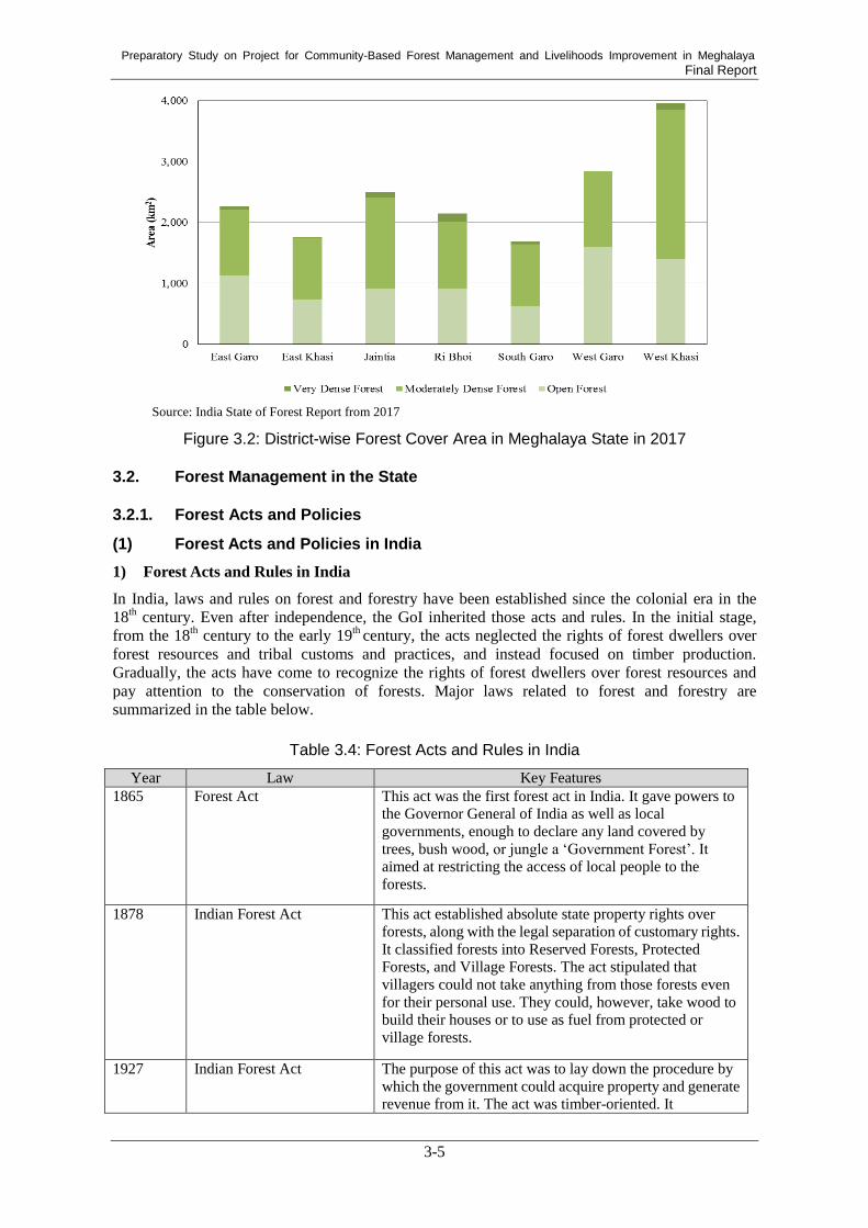
Preparatory Study on Project for Community-Based Forest Management and Livelihoods Improvement in Meghalaya Final Report
3-5
Source: India State of Forest Report from 2017
Figure 3.2: District-wise Forest Cover Area in Meghalaya State in 2017
3.2. Forest Management in the State
3.2.1. Forest Acts and Policies
(1) Forest Acts and Policies in India
1) Forest Acts and Rules in India
In India, laws and rules on forest and forestry have been established since the colonial era in the
18th century. Even after independence, the GoI inherited those acts and rules. In the initial stage,
from the 18th century to the early 19
th century, the acts neglected the rights of forest dwellers over
forest resources and tribal customs and practices, and instead focused on timber production.
Gradually, the acts have come to recognize the rights of forest dwellers over forest resources and
pay attention to the conservation of forests. Major laws related to forest and forestry are
summarized in the table below.
Table 3.4: Forest Acts and Rules in India
Year Law Key Features
1865 Forest Act This act was the first forest act in India. It gave powers to
the Governor General of India as well as local
governments, enough to declare any land covered by
trees, bush wood, or jungle a ‘Government Forest’. It
aimed at restricting the access of local people to the
forests.
1878 Indian Forest Act This act established absolute state property rights over
forests, along with the legal separation of customary rights.
It classified forests into Reserved Forests, Protected
Forests, and Village Forests. The act stipulated that
villagers could not take anything from those forests even
for their personal use. They could, however, take wood to
build their houses or to use as fuel from protected or
village forests.
1927 Indian Forest Act The purpose of this act was to lay down the procedure by
which the government could acquire property and generate
revenue from it. The act was timber-oriented. It

Preparatory Study on Project for Community-Based Forest Management and Livelihoods Improvement in Meghalaya Final Report
3-6
Year Law Key Features
consolidated the law relating to forests, the transit of
timber and other forest-produce. Forest conservation is not
discussed. This act remains the legislative basis for today’s
state forest management.
1980 Forest Conservation Act This act restricts the state government’s power to
de-reserve a forest, and it restricts the use of forest land for
non-forestry purposes without the prior approval of the
central government.
1996 Supreme Court Order 1996 The court redefined the scope of the Forest Conservation
Act 1980 as it applied to all forests, regardless of their
legal status or ownership. The order suspended tree
felling across the entire country, except in accordance
with working plans approved by the central government.
2010 National Green Tribunal
Act 2010
This act was established for the effective and expeditious
disposal of cases relating to environmental protection and
the conservation of forests and other natural resources,
including the enforcement of any legal right relating to the
environment and giving relief and compensation for
damages to persons, property, and for matters connected
therewith or incidental thereto.
Source: MOEF. Compiled by Study Team
Of all the acts and policies summarized in the above table, the Indian Forest Act 1927, Forest
Conservation Act 1980, and Supreme Court Order 1996 are further discussed in the following
sections, because they are the foundation of current forest management in India.
a. Indian Forest Act 1927106
The Indian Forest Act 1927 still provides the legal foundation for forest management in the state
even today. The act aims to consolidate and conserve forests and wildlife, regulate transference of
timber and other forest-produce. The act regulates constitution of Reserved Forests (RF) and
Protected Forests (PF). It defines the procedure by which a state government can declare an area of
a RF, a PF, or a village forest. It also defines forest offences, prohibited actions inside a RF, and
penalties for violation of the provisions of the Act.
b. Forest Conservation Act 1980107
The Forest Conservation Act 1980 restricts the state government’s power to de-reserve forests and
the use of forest land for non-forest purposes without the prior approval of the central government.
The basic objective of this act is to regulate the indiscriminate diversion of forest lands for
non-forestry uses and to maintain a logical balance between the country’s need for development and
the conservation of natural heritage. An amendment was added in 1988, and restrictions on the
de-reservation of forests or the use of forest land for non-forest purposes were created. In the
context of this act, “Non-forest purpose” means the breaking up or clearing of any land or portion
thereof for (1) the cultivation of such products as tea, coffee, spices, rubber, palms, oil-bearing
plants, horticultural crops, and medicinal plants and (2) any purposes other than re-afforestation.
106
https://www.forestlegality.org.risk-tool/country/india (Accessed on 3rd March 2018) 107
Forest (Conservation) Act, 1980 with Amendments Made in 1988.
http://chandigarh.gov.in/pdf/forest-acts.pdf

Preparatory Study on Project for Community-Based Forest Management and Livelihoods Improvement in Meghalaya Final Report
3-7
c. Supreme Court Order 1996108
On 12 December, 1996, the court, among other things, redefined the scope of the Forest
Conservation Act 1980, and suspended tree felling across the entire country. The Forest
Conservation Act 1980 essentially requires central government approval for the conversion of forest
land to non-forest purposes. Until 1996, it was assumed that the act applied only to reserve forests.
However, the Supreme Court said the act applied to all forests regardless of their legal status or
ownership. It also redefined what constituted “non-forest purposes” to include not just mining but
also the operation of sawmills. The court also suspended tree felling everywhere, except in
accordance with working plans approved by the central government.
2) Forest Policies in India
Forest policies were developed at the national level to ensure that forests would be properly
managed and conserved based on the forest acts mentioned in Section 3.2.1 (1) 1) Major forest
policies at the national level are summarized in the table below. As this table shows, the forest
policies in India have gradually recognised the rights of forest dwellers over forest resources and
enhanced their participation in forest management. The policies also aim at increasing forest cover
through afforestation and protecting ecosystems.
Table 3.5: Major Forest Policies in India
Year Policy Key Features
1952 National Forest Policy
This policy sets out guidelines which were directed towards the
supply of cheap timber and non-timber forest products for
state-sponsored industrialization and modernization. The policy
added a dimension of increasing forest cover. It envisaged a tree
cover of 33% of the total geographical area.
1988 The National Forest
Policy
This policy aims at the preservation and restoration of the
ecological balance of forests negatively affected by human and
development activities. The policy envisages people’s
involvement in the development and protection of forests for the
first time. It also gives priority to meeting the requirements of
forest dwellers, including those related to fuelwood, fodder, and
small timber.
2006 National Afforestation
Program (NAP)
This NAP scheme aims to support the process of devolving
forest protection, and management and development functions to
the decentralized institutions of JFMCs at the village level, and
Forest Development Agencies (FDAs) at the forest division
level. The overall objective of the scheme is to develop forest
resources with people’s participation, focusing on improving the
livelihood of forest-fringe communities, especially those of poor
people.
2009
Compensatory
Afforestation Fund
Management and
Planning Authority
(CAMPA)
CAMPA was established as a national Advisory Council under
the chairmanship of the Union Minister of Environment &
Forests for the monitoring of technical assistance and evaluation
of compensatory afforestation activities. It is meant to promote
afforestation and regeneration activities as a way of
compensating for forest land diverted to non-forest uses. The
fund was constituted based on the Supreme Court of India’s
order in 2006 and was authorized to disburse funds in 2009,
endowed with around USD 5 billion109
.
2014 Green India Mission
(GIM)
GIM aimed at improving the quality of five million hectares of
degraded forest and bringing another five million hectares of
non-forest areas under forest cover through social and farm
108
http://www.indiaenvironmentportal.org.in/files/epw1.pdf (Accessed on 3rd
March 2018) 109
https://forestlegality.org/risk-tool/country/India (accessed on 2018/3/3)

Preparatory Study on Project for Community-Based Forest Management and Livelihoods Improvement in Meghalaya Final Report
3-8
Year Policy Key Features
forestry in order to realize sustainable forest management and
eco-system conservation.
2014
Guidelines for Felling and
Transit Regulations for
Tree Species Grown on
Non-Forest Private Lands
This guideline was established to create an enabling environment
for motivating people, and facilitating their ability, to plant trees
on non-forest and/or private lands that will supplement and
partner the effort of the government to increase forest and tree
cover in the country.
2014 National Agroforestry
Policy
The value and role of agroforestry is ambiguous and undervalued
despite the fact that agroforestry is beneficial in numerous ways
and because the mandate of agroforestry falls through the cracks
in various ministries and departments. The policy was established
to encourage and expand tree plantation in a complementary and
integrated manner with crops and livestock to improve
productivity, employment, income, and the livelihoods of rural
households.
2018
National REDD+
Strategy in India
This strategy was created to facilitate REDD+ programme in the
country. It analyzes drivers of deforestation and forest
degradation, proposes strategies against deforestation and forest
degradation, overviews national related policies for forestry, and
considers institutional mechanism involving both government
and community entities for the implementation of REDD+ India. Source: compiled by Study Team
Of all the acts and policies summarized in the above table, the National Forest Policy 1988,
National Afforestation Programme (NAP), and Green India Mission are further discussed in the
following sections because these policies are closely related to the Project.
a. National Forest Policy 1988
The National Forestry Policy 1988 provides the foundation of current forest management with
people’s participation through Joint Forest Management (JFM). Before the promulgation of the
National Forestry Policy 1988, the objective of forest management by the government was to
produce timber and generate revenue. The National Forest Policy 1988 shifted the objective to the
improvement of the livelihoods of local communities that depend on forests. This policy also
governs the maintenance of environmental stability through the preservation and restoration of
ecological balance. The main objectives of this policy are as follows:
To maintain environmental stability.
To meet the requirements of fuelwood, fodder, and minor forest products.
To create a massive people’s movement for achieving these objectives and to minimize
pressure on existing forests.
To check soil erosion and denudation in the catchment area for the mitigation of flooding and
drought and for the retardation of the siltation of reservoirs.
The policy emphasizes the necessity of increasing forest and vegetation cover on hill slopes in
catchment areas. It also stipulates the industrial need for wood should be met increasingly by farm
forestry.
b. National Afforestation Program (NAP)
The NAP scheme aims to support the process of devolving forest protection, management, and
development functions to the decentralized institutions of JFMCs at the village level, and the Forest
Development Agencies (FDAs) at the forest division level. The overall objective of the scheme is to
develop forest resources with people’s participation, focusing on improving the livelihoods of the
forest-fringe communities, especially those of poor people.

Preparatory Study on Project for Community-Based Forest Management and Livelihoods Improvement in Meghalaya Final Report
3-9
c. Green Indian Mission
The Green Indian Mission (GIM) was established in 2014 as one of the eight national missions of
the government under its National Action on Climate Change. GIM aims at increasing five million
hectares of forest areas in ten years and improving the quality of forest to realize sustainable forest
management and eco-system conservation.
d. National REDD+ Strategy in India
India issued the national REDD+ strategy in 2018. It overviews deforestation drivers, country’s
relevant law and forest management structure such as JFMC, and it explains countermeasure to
address deforestation and forest degradation.
The National REDD+ Strategy (NRS) categorized deforestation drivers into two categories, namely
Planned drivers which are driver in legal framework, and Unplanned Drivers which are beyond
public control such as traditional cultivation. The NRS focuses on addressing Unplanned Drivers,
with providing local people alternative livelihood. The NRS also explains fuction of existing forest
laws and forest protection structure such as JFM. These forest laws and JFM scheme contribute to
making women involve in forest amangement and ensuring traditional rights. Details are explained
in Annexure 3.
3) Wildlife and Biodiversity Acts and Rules
The commitment to protect wildlife and the natural environment is embodied in India’s
post-Independence Constitution. Article 48A of the Constitution requires states to endeavour to
“safeguard the forests and wildlife of the country”, while the Article 51A (g) makes it the duty of
every citizen to protect and improve the natural environment, including forests, lakes, rivers and
wildlife.
There are multiple laws related to wildlife and biodiversity in the country and implemented in
Meghalaya State, as listed in the table below.
Table 3.6: Wildlife and Biodiversity Acts and Rules in India
Year Law Key features
1972 The Wildlife (Protection)
Act
Sanctuaries and national parks are established under this law.
A 2003 amendment introduced two new categories, namely,
community reserves and conservation reserves. Hunting of all
species is banned except for vermin listed in Schedule V. Strict
protection of sanctuaries and national parks. Community use is
not permitted.
2002 Wildlife (Protection)
Amendment Act
Conservation Reserves and Community Reserves are
introduced in this amendment act. It also provides the
establishment of management committees for both of these
categories of reserves. The state government may, after having
consultations with the local communities, declare any area
owned by the government, particularly areas adjacent to
existing Protected Areas (PA) and corridor sites between PA,
as a conservation reserve for protecting landscapes, seascapes,
biodiversity, and habitats. Community Reserves are declared in
community or private lands, outside the existing PA, where the
community or an individual has volunteered to conserve
wildlife and its habitat, to protect fauna, flora, and for
traditional conservation practices.
2002 The Biological Diversity
Act
This act has the triple objectives of conservation, sustainable use, and benefit sharing. Regulates access to biodiversity and
traditional knowledge and for benefit sharing. Provisions for

Preparatory Study on Project for Community-Based Forest Management and Livelihoods Improvement in Meghalaya Final Report
3-10
Year Law Key features
the establishment of village level Biodiversity Management
Committee, Local Biodiversity Fund, and role for the
community in the management of biodiversity. Introduces a
provision for Biodiversity Heritage sites.
2010 Wetlands (Conservation
and Management) Rules
These rules aim at the protection of Ramsar sites and other
important wetlands. The central government’s prior permission
is mandatory for the conversion of wetlands. Establishment of
the Central Wetland Management Authority.
Source: compiled by Study Team
Of all the acts and policies summarized in the above table, the Wildlife Protection Act 1972 is
further discussed in the following section because the act constitutes Community Reserves, which
is an important scheme for community forest management.
a. Wildlife Protection Act 1972
The Wildlife Protection Act 1972, with its amendments, is the focal legislation governing the
management of biodiversity and habitats in the country. PA are established through this act. It also
prohibits the hunting, catching, and trapping of all species, except those listed as vermin or pests in
Schedule V of the Act (Section 9), both inside PA and outside of them. State governments shall
designate PA through notification, and claims of rights by any person in the case of sanctuaries and
national parks are to be examined and settled expeditiously by the District Collector. According to
the 2003 amendment to the act, the sanctuary status of an area shall take effect immediately upon
notification (Section 18A.1). The law provides a firm basis for the protection of biodiversity,
although it does not provide enabling provisions for the community use of biodiversity.
The act provides four categories of PA: (1) Sanctuary, (2) National Park, (3) Conservation Reserve,
and (4) Community Reserve. No exploitative use or habitat alteration is permitted within
sanctuaries; the prior permission of the Chief Wildlife Warden is be required when such activities
are to be undertaken for the improvement of wildlife. In the case of National Parks, the approval of
the National Board for Wildlife is be required for such interventions. The act also prescribes
penalties for violations. The legal character of each category of PA is given in the table below.
Table 3.7: Legal Characteristics of the Four Categories of Protected Areas
Categories Statutory features
Sanctuary
No consumptive use and/or habitat alteration is allowed except with the prior
permission of the Chief Wildlife Warden with the approval of the state government,
and should be intended to improve habitat management.
Cattle grazing and the movement of cattle may be permitted. Provision to establish a
local advisory committee for each sanctuary.
National Park
Stricter controls than sanctuaries; no grazing or cattle movement allowed; habitat
alterations for management purposes, if any, should be made with the approval of
the Chief Wildlife Warden in consultation with the National Wildlife Board.
No continuation of rights permitted. No alteration of boundaries without the
approval of the National Board of Wildlife.
Conservation
Reserve
Declared on any area owned by the government, particularly areas close to existing
PA. Management by the Chief Wildlife Warden, on the advice of a management
committee established for the site.
Community
Reserve
On community land or private land with the voluntary consent of the community or
the private individual. Management committee formed by the government,
composed of five representatives nominated by the community and one member
from the state forest or wildlife department. A management plan shall be prepared
by the committee and approved by the government. Source: compiled by Study Team

Preparatory Study on Project for Community-Based Forest Management and Livelihoods Improvement in Meghalaya Final Report
3-11
(2) Forest Acts and Policies in Meghalaya
Major acts and rules regarding forests in Meghalaya are categorized and summarized in the table
below.
Table 3.8: Forest Acts and Rules in Meghalaya State
Act & Rule Outline
Forest Management & Forestry
Assam Reorganization
(Meghalaya) Act, 1969 –
Section 66
Section 66 indicates the continuance of existing laws and their
adaptations. All laws in force immediately before the appointed day in
the autonomous state shall continue to be in force therein until altered,
repealed, or amended by a competent legislature or other competent
authority.
Assam Forest Regulation,
1891
A regulation to amend and consolidate the law related to forests, the
transit of forest produce and the duty leviable on timber and other
forest produce. In this regulation, It regulates constitution of a
reserved forest and acts prohibited in reserved forests as well as
penalties for damage in the forests. It also provides a power to the
state government to constitute a village forest for benefits for village
communities. Bamboo and canes were regarded as “tree” in this
regulation.
The Meghalaya Forest
Regulation, 1973
A regulation to amend the law relating to forest, forest-produce, and
duties leviable on timber in Meghalaya. It provides the state
government power to constitute a reserved forest and to create village
forests. It also prescribes the general protection of forests and forest
produce. It also regulates duties on imported forest produce and makes
rules to regulate the transit of forest produce.
The Meghalaya Forest
Regulation (Application and
Amendment) Act, 1973
An act to provide for the extension and application of, and to amend,
the Assam Forest Regulation, 1891, and the Meghalaya Forest
Regulation, and for matters connected therewith or incidental thereto.
By virtue of this act, the Assam Forest Regulation, 1891, was
extended in its application to the State of Meghalaya, the Assam Act
being named as the Meghalaya Forest Regulation.
Meghalaya Forest (Ejectment
of Unauthorized Person from
Reserved Forests) Rules, 1979
Rules empowers Divisional Forest Officers to eject any person who
has entered into unauthorized occupation of land in a reserved forest
or order him to vacate such unauthorized occupancy, including the
power to sell, confiscate, or destroy any crops raised, or building or
construction erected on the land without authority.
The Meghalaya Forest
(Removal of Timber)
(Regulation) Act, 1981
An act to regulate and control the removal of timber outside the state
for preservation of forests and to prevent their indiscriminate
destruction, and for matters connected therewith and incidental
thereto.
Meghalaya Forest (Removal of
Timber) (Regulation) Rules
1982
Rules frames to ensure the carrying out of various provisions
contained in the Meghalaya Forest (Removal of Timber) (Regulation)
Act, 1981, containing a detailed provision related to the grant of
licenses for the removal of timber outside the state, the establishment
of trading depots within the state, payable license fees, records to be
maintained and furnished for the license holder, verification by the
competent authority, etc.
The Meghalaya Forest
Authority Act, 1991
An act to provide for the constitution of authority for unified control of
forests in Meghalaya.
The Meghalaya Forest
Regulation (Amendment) Act,
1998
An act amends clause (l) of sub-section (2) in Section 40 of the
Meghalaya Forest Regulation (Assam Regulation No.7 of 1891 as
applied and amended by Meghalaya) as follows: the establishment of
not only saw mills but also saw pits, veneer mills, plywood factories
and any kind of forests-based industries are prohibited absolutely, or subject to conditions, rules, within specified local limits.

Preparatory Study on Project for Community-Based Forest Management and Livelihoods Improvement in Meghalaya Final Report
3-12
Act & Rule Outline
Meghalaya Forest Based
Industries (Establishment &
Regulation) Rules, 1998
Rules frames in compliance with the interim orders passed by the
Hon’ble Supreme Court of India in the Writ Petition (Civil) 202/95 to
regulate the establishment and operation of forest-based industries in
other words. saw mills, saw pits, veneer mills, plywood mills, etc.
Meghalaya Tree Felling
(Non-Forest Areas) Rules 2006
Rules to regulate the felling of trees in non-forest areas, including the
procedure for permission to fell trees from registered tree plantations.
All permissions granted for the felling of trees from registered social
forestry plantations or plantations raised by other government
departments subject to payment of afforestation or regeneration costs.
Application for felling of trees from registered private plantations
raised without government funding shall be made by the authorized
person to the Chief Forest Officer of the ADCs or the Divisional
Forest Officer, depending upon the jurisdiction. Horticultural tree
species, including bamboo shall not require permission for felling.
The transit of timber from non-forest land shall be under transit
passes, and as per provisions of relevant acts and rules.
The Meghalaya Charcoal
(Control of Production,
Storage, Trade and Transit)
Rules, 2008
The rules restrict that charcoal production should follow the rules
and charcoal shall be produced only from wood obtained from legal
sources. The amount of charcoal produced and storage shall be
specified by DFO and only producers and stockist registered to DFO
are allowed to produce or storage charcoal. No charcoal shall be
transported unless covered by a transit pass issued by Forest Officers
authorized by DFO.
The Meghalaya Forest
Regulation (Amendment) Act,
2012
An act to amend the Meghalaya Forest Regulation Act, (Assam
Regulation 7 of 1891 as adapted and amended by Meghalaya).
Section 3 of the regulation stipulates that a new clause (10) shall be
inserted after clause (9), which defins “forest” as an area if it is a
compact or continuous tract of a minimum of 4 hectares of land,
irrespective of ownership, and where more than 250 trees or 100
bamboo clumps grow naturally per hectare.
Green Highways (Plantation,
Transplantation, Beautification
& Maintenance) Policy-2015
A policy that evolves a framework for plantations along with National
Highways to reduce the impact of air pollution and dust by
establishing trees and shrubs, to provide shade, to arrest soil erosion of
embankment slopes, to moderate the effect of wind, and to create
employment opportunities for local people. The policy prescribes
institutional arrangements, financing patterns, land requirements, and
plantation agencies. It encourages the involvement of local institutions
like Joint Forest Management Committee (JFMCs) and Self-Help
Groups (SHGs) in roadside plantations, including for the maintenance
and use of trees. Convergence with schemes of other government
departments and agencies is also encouraged. It includes a plantation
scheme that involves tree species selection, plantation pattern, and
technical specification.
Wood Based industries
(Establishment and
Regulation) Guidelines, 2016
Guidelines that extend to the whole of India. Each state shall
constitute a State Level Committee which assesses the availability of
timber and the quantity of different raw materials for wood-based
industrial units in the state. The Committee shall also assess the annual
requirement of timber and other forest produce in the domestic
markets in the state and maintain a database of timber and other raw
materials utilized by each wood-based industrial unit. In Meghalaya,
the establishment of wood-based industries shall be permitted within
the industrial estates. The establishment and operation of a furniture
unit shall not require a license. A furniture unit shall not use converted
round logs. It shall use only sawn timber sourced from licensed saw
mills and may use bamboo, reeds and canes.

Preparatory Study on Project for Community-Based Forest Management and Livelihoods Improvement in Meghalaya Final Report
3-13
Act & Rule Outline
Catchment Protection
The Meghalaya Tree
(Preservation) Act, 1976
An act to make provisions for regulating the felling of trees for the
purpose of protecting catchment areas and soil from erosion and to
preserve the special characteristics of the hilly areas as regards
landscape, vegetal cover and climate, and to provide for matter
connected therewith and incidental thereto.
The Meghalaya Tree
(Preservation) Rules, 1976
Rules that prescribe the procedure of application to obtain permission
to fell tree(s) from Divisional Forest Officer. They also prescribe how
appeals are to be made and offenses to be dealt with.
The Meghalaya Protection of
Catchment Area Act, 1990
An act to provide for the protection of catchment areas with a view to
preserve water sources and to make provisions for matter connected
therewith. The Act regulates the constitution of the Meghalaya
Catchment Areas Advisory Board, whose main function is to advise
the Government on matters connected with the catchment areas and
their protection, including the declaration of catchment areas and
appropriate methods of management of the areas. In the case of a
critical catchment area, tree felling, jhum, quarrying of sand or stone,
and the excavation of earth shall be prohibited therein or within a
distance not exceeding two hundred meters from the periphery.
Wildlife and Biodiversity
The Wildlife (Protection)
(Meghalaya) Rules, 1977
Rules that regulate the constitution of the Wild Life Advisory Board.
They also regulate hunting of wild animals, including game hunting
and hunting licenses and wild animal trapping licenses. They also
prescribe entry in sanctuaries or National Parks in terms of permits,
vehicles, and fees for operating a camera. Trade or commerce in wild
animals is also regulated by the rules.
Meghalaya Biological
Diversity Rules, 2010
Rules that regulate the constitution of the Meghalaya Biodiversity
Board, whose main function is to advise the State Government on
matters concerning conservation of bio-diversity, sustainable use of its
components, and fair and equitable sharing of benefits arising out of
the use of biological resource and knowledge. The rules also prescribe
the operation of the State Bio-diversity Fund and the establishment
and management of the Bio-diversity Heritage Site. They request that
every local body constitute a Biodiversity Management Committee. Source: compiled by Study Team
Apart from the acts and rules constituted by the Meghalaya State Government mentioned in the
above table, the ADC also constituted their own acts or rules related to forest management as
described in the table below.

Preparatory Study on Project for Community-Based Forest Management and Livelihoods Improvement in Meghalaya Final Report
3-14
Table 3.9: Forest Related Acts and Rules in ADCs
Name Outline
The Garo Hills District (Jhum)
Regulation, 1954
The regulation aims to provide the regulation and control of the
practice of shifting cultivation or jhum. It prohibits practice of jhum
in certain areas such as the radius of 400 m of any water source or
catchment area declared by an order of the Executive Committee
and area which is covered by sal and other valuable trees. The
Executive Committee shall be competent to fix the cycle of shifting
cultivation and direct jhumers to plant fast growing trees in jhum
areas. Individual jhumers who plant trees shall acquire exclusive
right to use the trees and the right to conduct shifting cultivation
again on the land which recovers the fertility. The Executive
Committee can also give directions that shifting cultivation areas in
which fast growing tree species has been planted shall not be used
for shifting cultivation for such number of years. The Executive
Committee may pay subsidies approved by the District Council to
the individual jhumers for planting trees in their shifting cultivatoin
land. The regulation also introduces permanent cultivation and
terraced form of cultivation and horticulture.
The United Khasi-Jaintia Hills
Autonomous District
(Management and Control of
Forest) Act, 1958
To provide for the management and control of forests in the United
Khasi – Jaintia Hills Autonomous District. Classification of forest to
which this act applies and methods of management of each category
are described.
The Garo Hills District
(Forest) Act, 1958
To provides for the management of any forest not being a reserved
forest in the Autonomous District of Garo Hills and for the levy and
collection of forest revenue.
The United Khasi-Jaintia Hills
Autonomous District
(Management and Control of
Forests) Rules, 1960
The act classified forests to which the act applies into seven
categories; Private Forest, Law Lyngdoh, Law Kyntang, Law Niam;
Law adong and Law Shnoung; Protected Forests; Green Block; Raid
Forests; and District Council Reserved Forests, and Unclassed
Forest. The act regulates each type of forest should be managed by
who and based on what.
The Garo Hills Autonomous
District (Constitution and
Management of Village
Forest) Rules 1976
The rule was prepared to exercise the powers conferred by section
17 and 18 of Chapter II of the Garo Hills District (forest) Act 1958.
The rule regulates the process of constitution of Village Forest and
management and control of Village Forest including formation of
Village Forest Committee, banned items, and limitation of forest
produces used by each household
The Khasi Hills Autonomous
District (Protection and
Promotion of Khasi
Traditional Medicine) Act,
2011
The act was prepared to codify indigenous knowledge of traditional
medicine and make provisions for the protection and promotion of
Khasi traditional medicine and use under the background which
traditional medicine is under threat from depletion of medicinal
plants, inadequate documentation and transmission. It aims to
conserve medicinal plants through declaration of medicinal plant
sanctuaries and regulations on entry to and prohibited activities in
the sanctuaries.
The Khasi Hills Autonomous
District (Protection and
Promotion of Khasi
Traditional Medicine) Rules,
2013
In order to enforcement of the Khasi Hills Autonomous District
(Protection and Promotion of Khasi Traditional Medicine) Act,
2011, the rules regulate details of declaration of medicinal plant
sanctuaries and formulation of rules and guidelines for collection of
medicinal plants by individuals and organizations regarding
medicinal plants management.
Source: compiled by Study Team

Preparatory Study on Project for Community-Based Forest Management and Livelihoods Improvement in Meghalaya Final Report
3-15
3.2.2. Forest Classification
Meghalaya State has 9,496km2 (42.3% of the total geographical area) of the Recorded Forest Area
(RFA)110
which is designated as per legal classification111
. RFAs are classified into three
categories: Reserved Forest (RF), Protected Forest (PF), and Unclassed Forest (UF), which are
constituted under the Indian Forest Act 1972. Meghalaya State has two National Parks and three
Sanctuaries, and these are categorized as RF112
. For each classification, there are certain restrictions
on activities as shown in Table 3.10.
Table 3.10: Legal Classification of Recorded Forest Areas
Category Restrictions on activities
Reserved Forest
An area notified under the provisions of Indian Forest Act or the State Forest
Acts having full degree of protection. In Reserved Forests all activities are prohibited
unless permitted.
Protected Forest
An area notified under the provisions of Indian Forest Act or the State Forest
Acts having limited degree of protection. In Protected Forests all activities are
permitted unless prohibited.
Unclassed Forest An area recorded as forest but not included in reserved or protected forest category.
Ownership status of such forests varies from state to state.
Source: India State of Forest Report 2001
The area of each classed and unclassed forest in India and Meghalaya State is presented in Table
3.11. As seen in the Table, the ratios of both RF and PF are very low in Meghalaya State compared
with those of the whole of India. On the other hand, UF in Meghalaya State is much higher than
that of the country.
Table 3.11: Forest Cover Change through Years in India and Meghalaya State
Area (km2) Ratio to Total Recorded
Forest Area (%) Ratio to Total Geographical
Area (%)
India Meghalaya India Meghalaya India Meghalaya
Reserved Forests 434,705 1,113 56.65 11.72 13.22 4.96
Protected Forests 219,432 12 28.59 0.13 6.67 0.054
Unclassed Forest 113,881 8,371 14.84 88.15 3.46 37.32
Total Recorded Forest Areas
767,419 9,496 100 100 23.34 42.34
Geographical Area 3,287,469 22,429 - - 100 100
Source: India State of Forest Report 2017
RF are used and managed exclusively by the state Forest Department. Local people have no rights
to use RF for activities such as felling trees, collecting forest products, grazing, hunting, and
shifting cultivation. Only acts permitted by the state are allowed by local people.
PF targets forest land other than RF. They are also managed by the state Forest Department, and
local people are basically prohibited from using PF to collect forest products and having their
livestock for graze and other activities. Yet local individuals and communities have certain rights to
use PF under acts permitted and licensed by state forest officers, such as collecting minor forest
products for household use.
110
‘Record Forest Area (forest area) refers to all the geographic areas recorded as ‘forests’ in government records (India
State of Forest Report 2015). 111
Forest Survey of India. (2017). India State of Forest Report 2017 112
Joy Dasgupta and H. J. Symlieh. (2006). Trends in tenure arrangements for forest and their implications for
sustainable forest management: the need for a more unified regime. In: Understanding forest tenure in South and
Southeast Asia.

Preparatory Study on Project for Community-Based Forest Management and Livelihoods Improvement in Meghalaya Final Report
3-16
UF are any kind of forest and forested wasteland, but they are not notified in the government
gazette as “Reserved” or “Protected” Forests under the Indian Forest Act, 1927. In the north-east
region, including Meghalaya State, most areas of UF are owned by local communities and clans112.
3.2.3. Forest Management System
Forest management in Meghalaya can be divided into two categories. One covers the management
of RFAs and the other covers non-forest recorded areas. The former is under responsibility of FED
and the latter is under responsibility of ADCs in principle. However, in practice, FED sometimes
conducts interventions in management of non-forest recorded areas adopting national schemes or
acts such as Joint Forest Management (JFM) and the Wild Life (Protection) Amendment Act that
regulates constitution of Community Reserve. Furthermore, under the administrative management
by the ADCs, non-forest recorded areas are practically managed by local communities or traditional
institutions according to their customary rules113
. Traditional institutions have developed their own
rules and norms for protection of their own forests from biotic interferences like illegal logging and
fire, and monitor on the implementation of the rules114
.
(1) Management of Recorded Forest Areas
As mentioned earlier, RFA, including RF and (PF occupies only less than 10% of total forest area
in Meghalaya State. All government-owned forests, in other words, RF and PF, are managed
according to scientific Working Plans (WP) prepared by FED. As of February 2019, there were four
approved WP under three territorial Divisions as shown in Table 3.12. All four WPs include five
working circles, namely a plantation working circle, forest protection working circle, JFM working
circle, an NTFP working circle, and a Wildlife Management working circle. The period covered by
the plans is ten years, from 2012-13 to 2022-23. Mid-term revision of the WP was initiated in July
2018.
Table 3.12: Approved Working Plans
Territorial Division Working Plan (WP) Covered Areas
Khasi Hills Territorial
Division
WP on the RF & PF in and around Shillong 8 RFs, 1,810.59 ha
WP of Nonogkhyllem & Umsaw RF 2 RFs, 9,054.75 ha
Garo Hills Division WP of Garo Hills Division 16 RFs, 278,0123 ha
WP of Jaintia Hills Division WP of Jaintih a Hills Division 2 RFs, 31,633.27 ha
Source: FED
Regarding the plantation working circle, the achievement of establishing a plantation was well
beyond the targets of most of the WP. On the other hand, information on the achievements of other
working circles is not available.
The main objective in the management of RFA is to conserve forests. Timber production is not
conducted in RF or PF.
Wildlife Protected Areas, which are under government control, such as National Parks (NP),
Wildlife Sanctuaries (WLSs, and Biosphere Reserves, area managed under scientific Management
Plans formulated by the Wildlife Wing of the FED. There are two NP and four WS in the state
(Table 3.13).
113
Tiwari, B.K. et al. 2008. Forest products of Meghalaya present status and future perspective (available at
www.researchgate.net/publication/320164337, latest access March 11, 2019 114
Final Report, Living condition survey for preparatory study on project for sustainable community forest amangement
in Meghalya (2019)

Preparatory Study on Project for Community-Based Forest Management and Livelihoods Improvement in Meghalaya Final Report
3-17
Table 3.13: National Park and Wildlife Sanctuary
NP/WLS Area (km2)
Balpakram NP 352.00
Nokrek NP 47.48
Nongkhyllem WLS 35.64
Siju WLS 5.18
Baghmara WLS 0.02
Narpuh WLS 59.90
Source: FED
(2) Management of Non-Recorded Forest Areas
As mentioned earlier, more than 90% of forest areas are non-recorded forest areas that belong to
communities, individuals or clans. However, the data of those non-recorded forest areas are very
limited. As shown in the table below, only 54,200 ha of non-recorded forest areas is covered with
the data in total, which is equivalent to only 3.4% of Unclassed Forest and Non-forest areas with
forest cover in the state. Without the data, it is difficult to manage the forests in accordance with the
regulations or policeis preparead by the stage governemnet as well as the ADCs. Generation of
accurate and comprehensive data on community owned or private forests is one of the fundamental
challenges in terms of forest management on non-recorded forest areas.
Table 3.14: Community Owned or Private Forests
ADC
Community forest
(Registered)
Individual owned
forest (Registered)
Clan owned forest
(Identified)
No. Ha No. Ha No. Ha
Jaintia Hills 89 19,956 173 14,200 20 508
Khasi Hills N/A N/A 79 18,135 N/A N/A
Garo Hills 61 1401 - - - - Source: Jaintia Hills ADC, Khasi Hills ADC, and Garo Hills ADC
1) Feature of Each ADC Regarding Forest Management
As mentioned earlier, forests belonging to communities, individuals, or clans are administered by
an ADC. Practically, such forests are managed by communities, individuals, or clans. Each ADC
has a unique land tenure and forest management system, forest vegetation, and landscape. Major
drivers of deforestation and/or forest degradation are also different depending on the ADC.
According to the results of the Living Condition Survey115
, not only shifting cultivation but also
forest fire and illegal felling were recognized as major dirvers. The features of each ADC are
summarized in Table 3.15.
In accordance with the unique social and natural conditions forest management systems also vary
depending on the ADC. Forest management systems and their background in each ADC are
described below.
Table 3.15: Features of Each ADC regarding Forest Management
ADC Land tenure Forest vegetation
Major drivers of
forest degradation/
deforestation
Forest management
Jaintia
Hills Three categories
of land;
non-transferable
land, private
land, and land for
Tropical Wet
Evergreen Forest,
Northern Tropical
Semi-Evergreen
Forest,
1) Forest fire
2) Charcoal burning
3) Quarrying of
stone/ limestone
4) Shifting
According to the United
Khasi Jaintia Hills
Autonomous District Act
1958, the forests are
classified into six
115
Ibid.

Preparatory Study on Project for Community-Based Forest Management and Livelihoods Improvement in Meghalaya Final Report
3-18
ADC Land tenure Forest vegetation
Major drivers of
forest degradation/
deforestation
Forest management
services rendered
to government
Subtropical
Broad-Leaved Hill
Forest, Subtropical
Pine Forest, East
Himalayan Wet
Temperate Forest
cultivation categories and methods of
management are
regulated in each
category. Community
forests and private forests
can be registered to the
ADC.
Khasi
Hills
Four categories
of major land
owenership;
private land,
group and clan
land, community
land, and
government land.
Major part of
land is individual
owned land.
Tropical Wet
Evergreen Forest,
Northern Tropical
Semi-Evergreen
Forest, North India
Tropical Moist
Deciduous Forest,
Subtropical Pine
Forest, East
Himalayan Wet
Temperate Forest,
Northern Subtropical
Broad-Leaved Hill
Forest
1) Forest fire
2) Quarrying of
stone/ limestone
3) Charcoal burning
Community forests and
Priavte forests can be
registered to the ADC.
Communtiy forests are
accessible for all
community members.
Private forests, on the
other hand, are accessible
for the owners. However,
in some cases, collection
of NTFPs including fuel
wood in private forests
are allowed for other
community members.
Garo
Hills
All lands/forests
owned by Nokma
/Aking Nokma in
principle.
However, the
introduction of
wet-rice
cultivation has
promoted private
ownership.
Northern Tropical
Semi-Evergreen
Forest, North India
Tropical Moist
Deciduous Forest,
Northern Subtropical
Broad-Leaved Hill
Forest
1) Shifting
cultivation
2) Quarrying of
stone/limestone
3) Conversion to
monoculture
plantation
4) Illegal felling
According to the Garo
Hills ADC Act 1958,
forests owned by
communities can be
registered as Village
Reserve Forest.
Source: Interviews with official concerned by Study Team in January and Februalry 2019. Tiwari, B.K. et al. 2008. Forest products of Meghalaya present status and future perspective (available at www.researchgate.net/publication/320164337, latest access March 11, 2019
2) Community-led Forest Management
a. JFM
Joint Forest Management (JFM) is one of the major schemes for forest management involving
communities across the country. Based on the JFM Circular issued by GoI in 1990 and the JFM
guidelines subsequently issued in 2000 and 2002, JFM was introduced to Meghalaya State in 2003
by promulgation of the notification No. FOR. 64/99/186. In Meghalaya State, in which more than
90 % of forest area belongs to communities or individuals or clans, JFM targets forests owned by
them.
As of February 2019, there are 366 JFMCs in the state covering 30,741 ha (Table 3.16). JFMCs
were developed by Forest Development Agencies (FDAs) as implementation agencies of the
National Afforestation Programme (NAP) at the village level in Meghalaya. Recently, JFMCs are
also regarded as the implementation agencies of GIM.

Preparatory Study on Project for Community-Based Forest Management and Livelihoods Improvement in Meghalaya Final Report
3-19
Table 3.16: JFMCs in Meghalaya State
FDAs No. of JFMCs Target Areas (ha)
Jaintia Hills 32 2,627
East Khasi Hills 48 3,365
West Khasi Hills 53 5,753
Ri-Bhoi District 80 3,656
East Garo Hills 45 3,772
West Garo Hills 44 4,477
South Garo Hills 29 3,452
Jaintia Hills Territorial Division, Jowasi 19 1,050
Khasi Hills Wildlife Division, Shillong 16 2,589
Total 366 30,741 Source: FED
Based on the MOU made between Forest Development Agency (FDA) and the JFMCs, tree
planting is conducted for five years, including maintenance of a given forest owned by a
community or individuals with sanction or financial support from FED. After the five years, the
planted land is handed over to the owners and is thereafter managed under the provision of the
Meghalaya Tree Felling (Non-Forest Areas) Rules 2006 that regulates tree felling and replanting in
the land116
.
According to the notification No.FOR.64/99/86, it is stipulated that more than one member of the
Executive Committee (EC) shall be a person nominated by the ADC. In reality, however, some
JFMCs do not include members nominated by the ADC. Even in cases in which JFMCs have
members nominated by the ADC, the members do not participate in decision-making, since budget
matters are controlled by FED.
b. Community Reserve
Based on Section 36 of the Wild Life (Protection) Amendment Act, 2002, the state government has
declared sixty four Community Reserves (CRs), which cover 6,170.41 ha in total, by February 2019.
The purpose of declaring CR is to protect fauna, flora, and traditional or cultural conservation
values and practices. In accordance with the purposes of constitution of CR, some sacred groves are
declared as CR in the state. With the issue of the notifications on declaration of CRs, land use
patterns cannot be changed within CR. With the declaration of CR, Community Reserve
Management Committees shall be constituted, consisting of five representatives, to manage CR
through preparation and implementation of a management plan for CR.
Though the target areas of CR are made up of land owned by communities or individuals in the
state, the Wildlife Division of FED has been responsible for declaration of CR. It conducts a survey
on fauna and flora, demarcates boundaries, and establishes boundary pillars. The Division also
supports the construction of infrastructure in community reserves such as pavement trails, toilets,
and signboards. Moreover, it supports tree planting in community reserves through the provision of
seedlings and wages for work done planting trees. However, in case FED does not have enough
money budgeted, communities conduct tree planting voluntarily. The ADCs does not play any role
in the establishment and management of CR except registration of CR to ADC concerned.
c. Village Reserve Forest
According to section 17, Chapter II of the Garo Hills ADC (Forest) Act 1958, communities can
register their community forests as a “Village Forest” to the ADC. Rules for constitution and
management of the Village Forest are regulated by the Garo Hills Autonomous District
(Constitution and Managmenet of Village Forest) Rules 1976. Among the Village Forests, those to
116
FED (2017) Sylvan Mosaic.

Preparatory Study on Project for Community-Based Forest Management and Livelihoods Improvement in Meghalaya Final Report
3-20
be conserved carefully shall be registered as “Village Reserve Forest (VRF)”117
. Use of forest
resources in VRF is strictly restricted in comparison with that of Village Forests. By being
registered to the ADC, the forests are legally protected and the communities which own the forests
can get incentives from the ADC to reserve the forests. Various types of incentives such as support
for black pepper or cardamom cultivation, provision of solar ramp, construction of bench terraces or
a bridge have been provided. There is no guideline or rules to decide what kinds of support are
provided as incentives. Incentives provided are decided from two aspects of feasibility and benefit
for communities by Forest Department of the ADC. A VRF is managed by a Village Forest
Committee constituted by the Executive Committee of the Garo Hills District Council, which is
chaired by Nokma. After the registration, each village needs to develop a village resolution to
regulate use and management of the forest. The Forest Department (FD) of the ADC supports
enforcement of the village resolution. If there are actions against the resolution, a fine is imposed.
d. Registration as “Community Forest”
The Khasi Hills ADC and Jaintia Hills ADC do not have any specific schemes like the VRF in
Garo Hills ADC. In these ADCs, community owned forests can be registered to the ADCs as a
“Community Forest”. Even though communities register their own forests to the ADCs, they do not
obtain any financial support from the ADCs due to financial constraints. However, as being
registered to the ADCs, the status of the forest can be secured and legalized. This benefits
communities. In the case of Jaintia Hills ADC, a certificate with a map of the forest is prepared by
FD is issued in the name of the Chief Forest Officer (CFO). Table 3.17 shows the main features of
CFM schemes in Meghalaya State.
Table 3.17: Community Forest Management Schemes in Meghalaya State
Scheme Joint Forest Management Community Reserve Village Reserve Forest
Area All ADCs All ADCs Garo Hills ADC
Target Site - Bare land
- Individually-owned forest
- Community-owned forest
(no JFMC in Reserved/
Protected Forests)
- Community or private
lands with wildlife and its
habitat conserved by
communities or individuals
voluntarily
- Sacred groves
- Natural forests owned
by communities
Implementation
organization
Joint Forest Management
Committee
Community Reserve
Management Committee
Village Resource
Committee
Purposes - Increase forest cover by
planting trees (from the
viewpoint of FED)
- Conserve community forest
in order to increase wild
animals and retain water
(from the viewpoint of
communities)
- Protect fauna, flora, and
traditional or cultural
conservation values and
practices
- Conserve biodiversity
- Conserve forests
- Use forest resource
Use &
Management
- NTFP can be extracted for
domestic purposes
- However, some JFMCs are
not allowed to extract NTFP
from their JFM project area
- Land use pattern cannot
be changed
- Detail management and
use are decided by the
committees
- Basically no extraction of
forest resources
- Each village develops
a village resolution to
regulate use and
management
117
Interview with CFO of the Garo Hills ADC on April 25, 2019.
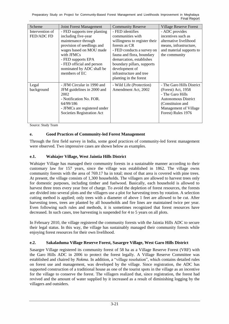
Preparatory Study on Project for Community-Based Forest Management and Livelihoods Improvement in Meghalaya Final Report
3-21
Scheme Joint Forest Management Community Reserve Village Reserve Forest
Intervention of
FED/ADC FD
- FED supports tree planting
including five-year
maintenance through
provision of seedlings and
wages based on MOU made
with JFMCs
- FED supports EPA
- FED official and person
nominated by ADC shall be
members of EC
- FED identifies
communities with
willingness to register their
forests as CR
- FED conducts a survey on
fauna and flora, boundary
demarcation, establishes
boundary pillars, supports
development of
infrastructure and tree
planting in the forest
- ADC provides
incentives such as
alternative livelihood
means, infrastructure,
and material supports to
the community
Legal
background
- JFM Circular in 1990 and
JFM guidelines in 2000 and
2002
- Notification No. FOR.
64/99/186
- JFMCs are registered under
Societies Registration Act
- Wild Life (Protection)
Amendment Act, 2002
- The Garo Hills District
(Forest) Act, 1958
- The Garo Hills
Autonomous District
(Constituion and
Management of Village
Forest) Rules 1976
Source: Study Team
e. Good Practices of Community-led Forest Management
Through the first field survey in India, some good practices of community-led forest management
were observed. Two impressive cases are shown below as examples.
e.1. Wahiajer Village, West Jaintia Hills District
Wahiajer Village has managed their community forests in a sustainable manner according to their
customary law for 157 years, since the village was established in 1862. The village owns
community forests with the area of 769.17 ha in total; most of that area is covered with pine trees.
At present, the village consists of 1,300 households. The villagers are allowed to harvest trees only
for domestic purposes, including timber and fuelwood. Basically, each household is allowed to
harvest three trees every year free of charge. To avoid the depletion of forest resources, the forests
are divided into several plots and the villagers use a plot for harvesting trees by rotation. A selection
cutting method is applied; only trees with a diameter of above 1 feet are allowed to be cut. After
harvesting trees, trees are planted by all households and fire lines are maintained twice per year.
Even following such rules and methods, it is sometimes recognized that forest resources have
decreased. In such cases, tree harvesting is suspended for 4 to 5 years on all plots.
In February 2010, the village registered the community forests with the Jaintia Hills ADC to secure
their legal status. In this way, the village has sustainably managed their community forests while
enjoying forest resources for their own livelihood.
e.2. Sakaladuma Village Reserve Forest, Sasargre Village, West Garo Hills District
Sasargre Village registered its community forest of 58 ha as a Village Reserve Forest (VRF) with
the Garo Hills ADC in 2006 to protect the forest legally. A Village Reserve Committee was
established and chaired by Nokma. In addition, a “village resolution”, which contains detailed rules
on forest use and management, was developed by the village. Since registration, the ADC has
supported construction of a traditional house as one of the tourist spots in the village as an incentive
for the village to conserve the forest. The villagers realized that, since registration, the forest had
revived and the amount of water supplied by it increased as a result of diminishing logging by the
villagers and outsiders.

Preparatory Study on Project for Community-Based Forest Management and Livelihoods Improvement in Meghalaya Final Report
3-22
3) Private Forest Management118
The United Khasi-Jaintia Hills Autonomous District (Management and Control of Forest) Rule,
1960 regulates registration of Private Forest and Law-Ri Sumar in accordance with Section 4 (a) of
Chapter I. Private or individual forest owners can register his or her own forest as “Private Forest”
at their respective ADC. Once a forest is registered as “Private Forest”, the land owners must
manage the forests following the management rule described in section 4 (a) of Chapter II.
According to the Rule, the owners do not have any right to the sale, mortgage, leasing, fit, barter
Private Forests without the previous approval of CFO of each ADC. In other words, the owner
cannot freely change the land’s use as a forest to other uses. Moreover, when the owners want to
fell or remove trees from their own forests, they need to request the Forest Department of the
concerned ADC to mark trees to be harvested in accordance with the direction issued by the CFO.
Unless the owners register their forests as “Private Forest”, the forests cannot be included in the
Working Scheme. Thus, if the forest owners want to harvest timber for commercial purposes, they
must register their own forests as “Private Forest”.
4) Impacts of intervention of FED and/or ADC
The first field survey results revealed that intervention by FED or the ADCs worked well for
supporting proper community forest management. Although communities had managed their
community forests according to customary rules, all of the communities interviewed during the first
field survey mentioned that intervention of FED or the local ADC enhanced the conservation of
their forests in the following ways. First, though the rules of forest management and use did not
change much before and after the establishment of JFM, CR, or VRF, villagers came to follow the
rules better than before since they had a deeper understanding of the importance of the forest by
having this explained to them by forest officials of FED or the ADC; another possible reason is that
they are afraid of power of the authorities. Second, boundary demarcation was conducted and
boundary pillars were established with the support of FED or the ADC. This makes villagers and
outsiders recognize that the forest should be protected. As a result, entering the forests or
conducting illegal activities in the forests was reduced. Third, when a conflict happens within a
community or between communities (e.g. Nokma), the ADCs can act as a third party to help resolve
the conflict. In Garo Hills ADC, for example, boundaries of two villages were close to the boundary
of a VRF, but they were not clear, so that conflict occurred between the communities. The Forest
Department of the ADC notified the Revenue Department of the ADC which has responsible for
demarcating boundaries of villages in order to solve the conflict. Communities reported that forest
resources and wild animals were revived, the amount of water increased, and seasonal streams
became permanent as a result of the intervention of FED or the ADC.
5) District Council-owned Plantations and Forests
Apart from forests belonging to communities, individuals, or clans, there are District
Council-owned Plantations and/or District Council-owned Forests which are managed by the Forest
Department (FD) of the ADC, as shown in Table 3.18. The purposes and uses of the plantations and
forests by the ADC are various.
Table 3.18: District Council-owned Plantation/Forest
ADC District Council-owned Plantations District Council-owned Forests
Jaintia Hills Around 300 ha 18 nos., 2,442 ha
Khasi Hills 12 nos., 954.97 ha 0
Garo Hills (data being requested) N/A Source: Jaintia Hills ADC, Khasi Hills ADC, and Garo Hills ADC
118
The United Khasi-Jaintia Hills Autonomous District (Management and Control of Forest) Rule, 1960.

Preparatory Study on Project for Community-Based Forest Management and Livelihoods Improvement in Meghalaya Final Report
3-23
a. Jaintia Hills ADC
At the Jaintia Hills ADC, the main purpose of the District Council-owned Plantations is to protect
the environment and conserve water sources. If necessary, timber harvest is allowed on the
Plantations. In particular, when a new village is established and the villagers need timber for the
construction of their houses, they can request permission to cut timber, since a new village does not
have any community forests. When such a request is accepted by the ADC, the villagers are
allowed to cut up to three trees per household.
Apart from the District Council-owned Plantations, Jaintia Hills ADC has 18 District
Council-owned Forests covering 2,442 hectors in total. These forests are called Protected Forests.
Their main purpose is to conserve forest and water and to protect the environment. Most of these
are natural forests, but some are artificial forests. The FD of the ADC manages the forests following
decisions made by the Executive Committee of the ADC. Villagers are allowed to harvest timber
and fuelwood for domestic purposes. The FD of the ADC conducts patrols to prevent encroachment.
Due to financial constraints, it is difficult for the FD of the ADC to sufficiently conduct
maintenance activities, such as forest fire prevention and tree planting. As a result, most District
Council-owned Forests, or Protected Forests, became bare land.
b. Khasi Hills ADC
The Khasi Hills ADC has 12 District Council-owned Plantations covering 954.97 ha. The main
purpose of the Plantations is to conserve forests and offer them as an example of conserving forests
to communities, to help them understand the importance of forests for water conservation and other
services. Timber production is not a main purpose even through tree species such as teak and pine
that are planted on the Plantations are useful for timber. When villagers make a request to the ADC
to allow timber harvesting for domestic purposes, they are allowed to harvest timber. When illegal
logging happens on a Plantation, seized timber is sold through auction and the revenue from it
becomes ADC revenue. Since the Plantations were established three to four decades ago and are
covered by trees, there is no space for tree planting at this time. Hence, the FD of the ADC just
conducts maintenance activities, such as thinning and removing tree affected by diseases or insects.
The Khasi Hills ADC does not have any District Council-owned Forests separately from these
Plantations.
c. Garo Hills ADC
Most of all range and beat offices of the Forest Department of the Garo Hills ADC have District
Council-owned Plantations. Each plantation is 20 to 30 ha, thus, the total area is not large.
According to the CFO, there are around 300 hectors; hence, it is not so important for catchment
protection. The main purpose of the Plantations is to produce timber and generate revenue through
the sales of timber for the ADC. For this sake, timber tree species such as teak and sal are planted.
On the other hand, the Garo Hills ADC has a huge area of District Council-owned Forests, with
tens of thousands of hectares. The Revenue Department of the ADC conducted a survey to measure
the area about five to six years ago; however, the survey was not completed. The CFO of the Garo
Hills ADC intends to make the use of forests which have huge potential. People illegally live in the
forests and conduct shifting cultivation or establish monoculture plantations of plants such as areca
nuts and rubber. Due to illegal living, there is no water or electricity. If they are registered as
“Forest Villagers”, the ADC will support their lives and sustainable forest management by shifting
monoculture plantations to agroforestry in the forests.
6) Working Scheme
Working Schemes shall be prepared in compliance with the interim Supreme Court Order of 1996
and various subsequent orders that ban the felling of trees in any forests — excluding forests that
have a Working Scheme which is scientifically-prepared and duly approved by GoI. In other words,

Preparatory Study on Project for Community-Based Forest Management and Livelihoods Improvement in Meghalaya Final Report
3-24
trees in community or individually-owned forests cannot be harvested for commercial purposes
without a Working Scheme. The Working Schemes aim not only to provide legal permission for
timber harvest for commercial purposes but also to ensure sustainable forest management by
restricting the amount of annual yield under that of growth of trees.
The current status of the preparation of Working Schemes is summarized in the table below. As the
table shows, no valid Working Scheme is available as of May 2019. In the case of the Jaintia Hills
ADC, the latest Working Scheme was valid from 2012 to 2017, and a new Working Scheme is
pending approval. This Working Scheme covers only 32 plots of private or community-owned
forest with a total area of 521.78 ha within Thadlaskein C & R.D. Block. The Working Scheme of
the Khasi Hills ADC for 2014-2019 is still in draft stage. The Working Scheme of the Garo Hills
ADC is under preparation.
Table 3.19: Current Status of the Preparation of Working Schemes
ADC Status of Working
Scheme
Valid year of
Working
Scheme
Area and number of
plots covered by
Working Scheme
Permissible
sustainable yield
Jaintia
Hills
Expired 2012-2017 8,553 ha, 308 plots 75,110 m3/5 years
Pending approval - 521.78 ha, 32 plots,
(Thadlaskein C &
R.D. Block only)
1,222 m3/year for Pine
WC
Khasi Hills Under draft 2014-2019 5,196 ha, 72 plots Pine: 262 m3/year
Mixed: 347 m3/year
Garo Hills Under preparation - - - Source: Jaintia Hills Working Scheme 2012-2017, Draft of Jaintia Hills Working Scheme, Draft of Khasi Hills Working Scheme 2014-2019
The Working Schemes consist of several working circles which will be described in this section. In
case of the new Jaintia Hills Working Scheme, it includes three working circles, namely the Pine
Working Circle, Afforestation Working Circle, and Wildlife Working Circle (overlapping circle).
The prescription for each Working Circle is based on the principle of ‘sustained yield’ and suggests
a precautionary measure to prevent depletion of forest resources. For example, for the new Jaintia
Hills Working Scheme, a sustainable annual yield of 2443.09 m3/year is prescribed for the Pine
Working Circle. However, considering the need for the conservation of forests and compensating
losses due to undetected theft and natural calamities, the permissible annual yield is limited to 50 %
of that sustainable annual yield. Hence, the permissible annual yield prescribes for the Pine
Working Circle is 1,221.55 m3/year.
According to the latest Working Scheme of the Jaintia Hills ADC from 2012 to 2017, the total
permitted yield was 75,110 m3. Of that, only 64,882 m
3 were extracted within the five-year period.
The main reasons for this were that the forest owners did not come forward to receive permission
due to the factor of low prices and the inability of the Jaintia Hills ADC and FED authorities to
undertake the timely marking of trees to be felled for harvesting.
The Working Schemes also prescribe silvicultural operations for harvesting, planting, and the
maintenance of the forests, such as selection cutting, and weeding and cleaning operations to
protect the growing stock from accidental forest fires. The prescription of the Working Scheme will
be applicable for a time period of five years from the date of its approval.
ADCs are responsible for preparing Working Schemes based on the willingness of forest owners
with the support of FED, especially the GIS Lab and Working Plan Division,119
following the
procedure shown in Figure 3.3. As this figure shows, the process of preparing a Working Scheme
consists of many steps, and the preparation of a Working Scheme for entire forest areas under the
119
Working Scheme for private/community forests under Thadlaskein C & RD Block of JHADC

Preparatory Study on Project for Community-Based Forest Management and Livelihoods Improvement in Meghalaya Final Report
3-25
administrative control of each ADC requires many tasks, which usually takes a very long time due
to limited human resources.
Such a complicated process of preparation of a Working Scheme, which requires substantial costs
from the ADCs, is one of the reasons for insufficient implementation of Working Scheme. In case
of Khasi Hills ADC, only some forest owners have applied to a Working Scheme. Under such
circumstances, the ADC cannnot expect to obtain enough royalty for covering the cost for preparing
a Working Scheme. Some forest owners may hesitate to apply to a Working Scheme worring about
losing some of the beneifts generated through the sales of timber by the ADC120
.
Source: Working Scheme for private/community forests under Thadlaskein C & RD Block of JHADC
Figure 3.3: Procedure of Preparation of Working Schemes
Working Schemes also describe the expected revenue for each ADC from the collection of royalties.
For example, it is estimated to be Rs 845,610 annually in the new Working Scheme for Jaintia Hills.
From the aspect of sustainability of forest management, 30% of the royalties will be kept separately
as a fund called ‘green cess’, which will be used for the implementation of artificial regeneration in
blank patches of forests.
As described above, a Working Scheme can contribute to the realization of sustainable forest
management if timber harvest is conducted following the plan described in the scheme. However,
according to the information provided by a former private forest owner whose forest was included
in a former Working Scheme in the Khasi Hills ADC, the Working Scheme was not fully enforced.
Some forest owners harvested even small trees which were not allowed to be harvested according to
the scheme121
. This suggests that not only preparation of a Working Scheme but also its
enforcement should be enhanced.
120
Interview with a FD official of Khasi Hills ADC on May 13, 2019. 121
Based on the Study Team’s Interview with the former forest owner in East Khasi Hills District on May 13, 2019.
Collect list of w illing owners of
private/community forests
< ADC>
GPS boundaries of all the
forests in shape file to be
provided to FED
< ADC>
Overlay of forest boundary on
the forest strata layer
< GIS lab, FED>
Remove area above 25 degree
slope from the strata layer
< GIS, FED>
Calculate area of forest strata
in each forest polygon
< GIS lab, FED>
Com pute grow ing stock and
yield for each forest area
(polygon)
< W orking Plan Div., FED>
Generate stratified random
sam ple plots for each forest
< GIS lab, FED>
Forest Inventory on the sam ple
plots
< ADC/W P Div., FED>
Send the grow ing stock, yield &
prescription to ADC < W P Div.,
FED>
Prepare W orking Schem e
< ADC>
Scrutiny W orking Scheme
< FED>
Subm it W orking Schem e to
Regional Office of M oEF & CC,
GoI for approval through FED
< FED>

Preparatory Study on Project for Community-Based Forest Management and Livelihoods Improvement in Meghalaya Final Report
3-26
3.2.4. Forest Nursery in Meghalaya
(1) Hi Tech Nurseries
FED has two hi tech nurseries (HTNs): one in East Garo Hills District and the other in Ri-Bhoi
District. The HTN in East Garo Hills District was established by a state government scheme in
2010-11 with 1.87 crore. The nursery has the capacity to produce 3 lahk seedlings and its
germination bed is equipped with two heaters and an exhaust fan. The germination bed is also
equipped with root containers. According to an official of FED, when the seeds of some indigenous
tree species were sown, a 95% germination rate was recorded, which was much higher than the
usual germination rate. This HTN is not functioning as of February 2019. Since the termination of
the state government project in 2014, it has not been used officially.
Another HTN in Ri-Bhoi District is managed by the Silviculture Division of FED. An existing
nursery was upgraded as an HTN by installing three mist chambers with sprinklers in 2016 which
cost Rs 14 lakh. Excluding the mist chambers, other facilities or equipment are almost the same as
those of ordinary permanent nurseries. The area of the nursery is approximately 2 ha and the
production capacity is 3 to 4 lakh of seedlings. Though root containers were installed, they were not
used properly. A Range Officer in charge of the nursery has not received any training on how to
manage an HTN. He has tried to develop some technologies of seedling production through trial
and error.
The purpose of the HTN is to produce seedlings for the conservation of endangered tree species
including Podecarpus neriifolius. In addition to seedlings of seven endangered tree species,
seedlings of thirty tree species including both indigenous and exotic species and some bamboo
species are produced in the nursery. Seeds are collected from RFs or PFs and private forests across
the state. Seedlings produced in the nursery were planted on a plot of land purchased from a
community to conserve endangered species. To procure high quality seeds stably, a seed orchard of
15 ha was established in 2017 on other place of the nursery.
(2) Permanent Nurseries
Apart from the HTNs, FED has a total of four central nurseries in East Garo Hills District, East
Khasi Hills District, and West Khasi Hills District. In addition, 29 range level nurseries, and 7 beat
level nurseries are managed under the Social Forestry Division122
. The purpose of those permanent
nurseries managed by the Social Forestry Division is to produce seedlings and distribute them to
community members or community organizations such as schools and churches. Tree species
whose seedlings are produced at the nurseries vary depending on the nursery. Commonly produced
species include Delonix regia, Michelia champaca, Terminalia spp., Cedrela toona, and Schima
wallichii.
In case of the nursery managed by the Social Forestry Division in Kyrdemkulai Range, Ri-Bhoi
District, which was established in 1984-85, seedlings of five tree species including Pinus kesia
were produced and distributed to communities. Before 2015, seedlings were distributed by free of
charge, however, seedlings are sold by Rs 2 per seedling with a subsidy of Rs 6 per seedling as of
May 2019. Seeds are locally collected from mother trees identified by a skilled staff member of the
nursery. The area of the nursery is 2 ha and production capacity is 2 lakh. However, as of May 2019,
only approximately 1 lakh of seedlings are produced due to a limited financial budget.
Apart from the nurseries managed by FED, the Forest Department of the Jaintia Hills ADC has one
permanent nursery. The Forest Departments of the Khasi Hills ADC and the Garo Hills ADC do not
have any nurseries.
122
Social Forestry Division, FED

Preparatory Study on Project for Community-Based Forest Management and Livelihoods Improvement in Meghalaya Final Report
3-27
(3) Community Nurseries
In Meghalaya, many community nurseries have been established by the Community Nursery and
Afforestation Project under the Integrated Basin Development and Livelihoods Programme
(IBDLP). As of August 2018, 209 community nurseries were established by this project. According
to the instructions given for them, each nursery produces 25,000 seedlings, out of which 10,000
seedlings are tree species used for planting for catchment protection and 15,000 seedlings are
horticulture species for sale to generate income. Each nursery has 25 beds, with one bed having
1,000 or 1,500 seedlings. Some nurseries produce more than 25,000 seedlings based on their
experience of earning money through the sales of seedlings. IBDLP provides 1 lakh to a community
group for the procurement of materials such as poles, shade, and polytubes. The community group
decides which species to plant and collect seeds locally.
In reality, the number of seedlings produced as well as the ratio of the number of tree species to that
of horticulture species varies depending on the nursery. According to the results of analysis of the
data of 122 nurseries as of August 2018, approximately 14,000 seedlings were produced per
nursery on average. The maximum number of seedlings produced was 158,000 in Umket Villages
in Ri-Bhoi District and the minimum one was 350 in Mawrongland Village in South West Khasi
Hills District. Out of 122, 62 nurseries produced less than 10,000 seedlings. Some nurseries
produced only forest tree species and others produced only horticulture species. Tree species
produced in those nurseries include Azadirachta indica, Gmelina arborea, Tamarindus indica,
sandal wood, and indigenous forest tree species. Regarding horticulture species, seedlings of
arecanut, mango, and jack fruit were commonly produced. Out of 122 nurseries, only 24 nurseries
have data on selling seedlings. The results of the analysis show that there is a gap between the plan
and practice of establishing community nurseries and producing seedlings at the nurseries.
Apart from the community nurseries established under IBDLP, JFMCs are supposed to establish
their own nurseries and produce seedlings. In reality, however, some JFMCs did not establish their
own nurseries and used seedlings provided by FED or purchased from others for the establishment
of plantations123
. A range officer of FED who is in charge of nursery management stated that
seedling production at JFMC nurseries has the possibility of failure due to a lack of technical skills.
Thus, it may be better to produce seedlings not at nurseries managed by JFMCs but those managed
by FED even though there is a risk of damaging seedlings while transferring them from nurseries to
planting sites124
.
3.2.5. Forest Produces and Marketing
The forests of the state are the source of the livelihoods for many poor and landless people, who
reside in and around the forests. The majority of the population, who live in the vicinity of the
forests in rural areas, rely solely on the collection and commercialization of timber, fuel wood, and
many other NTFPs for their livelihoods.
(1) NTFPs
Bamboo, cane, and wood-based handicraft and furniture units are key livelihood means for most of
the poor in rural areas. According to a study, there are about 380 different types of NTFPs which
are collected by the people of the state125
. The forests of the state are very rich in NTFP and there is
enough space to increase income by using scientific management techniques in the harvesting,
cultivation, processing, value addition, and marketing of these products. Some important causes of
low benefits accruing to people from forests include: the nonexistence of any management plan for
the forests outside of the jurisdiction of the State Forest Department and poor mechanisms for the
123
Interview with Dieng Syiang JFMC in West Khasi Hills District on February 1, 2019. 124
Interview with the range officer in Ri-Bhoi Distrcit on May 7, 2019. 125
Tiwari, B.K. 2002. Traditional system of Bay Leaf (C. tamal) management by West Khasi Communty of Meghalya,
India. Center of Environmental Studies, North-Eastern Hill University, Shillong

Preparatory Study on Project for Community-Based Forest Management and Livelihoods Improvement in Meghalaya Final Report
3-28
transfer of technology and management skills to forest-owning communities.
The following NTFPs are ready for market and important for providing income to the poor in the
state:
Broom Grass (Thysanolaena maxima)
Bay Leaf (Cinnamomum tamala)
Dalchini (Cinnamomum zeynalicum)
Bamboo
Packing Leaf (Phyrnium puvinerve)
Wild Pepper (Piper peepuloides)
Wood Lichen (Usnea sp.)
Charcoal
Fuel Wood
1) Broom Grass
Broom grass has a very good market. The brooms produced in the Khasi Hill, Jaintia Hills, and
Ri-Bhoi areas are exported by way of Guwahati, while those produced from Garo Hills are exported
through Dhudnei to other states, such as West Bengal and Orrisa. The production of broom grass in
each ADC area is shown in the table below.
Table 3.20: Production of Broom Grass in Khasi Hills, Garo Hills, and Jaintia Hills Areas
ADC Annural Production (t)
Khasi Hills 345.97(1)
Garo Hills 2353(2)
Jaintia Hills 2353.3 Source: CFOs of Khasi Hills ADC, Garo Hills ADC, and Jaintia Hills ADC
Note: (1) Average of last three years production (2015-16, 2016-17, and 2017-18)
(2) As per recent export records
2) Bay Leaf (Cinnamomum tamala)
The production of bay leaf from small trees ranges from 30-40 kg/tree/harvest and form the bigger
trees it ranges from 55-65 kg/tree/harvest. Maximum production is recorded in Garo Hills followed
by Khasi Hills while Jayantia hills record very small production126
.
3) Dalchini (Cinnamomum zeynalicum)
Dalchini, a type of well-known spices, is found in plenty in the Ri-Bhoi District. People there grow
this tree on a large scale. Dalchini is also found in the Khasi Hills and Garo Hills areas.
As per the statistical statement of the Khasi Hills ADC, 96.55 tonnes of Dalchini was produced and
transported from the state during the period of 2000-2005. According to the forest resource survey
of Meghalaya, the total amount of Dalchini produced and transported to other areas of the country
during the same period was 445.25 tons127
.
Dalchini is often produced by private growers. It is a preferred species as it takes only about four
years to mature. The trunk and branches are used as fuelwood after the bark has been peeled off for
commercial sale. If grown at a spacing of 1 m on the margins of farmland it also serves as a fence
and prevents cattle from entering farmland.
126
Tiwari, B.K. et al. 2008. Forest products of Meghalaya present status and future perspective (available at
www.researchgate.net/publication/320164337, latest access March 11, 2019 127
ibid.

Preparatory Study on Project for Community-Based Forest Management and Livelihoods Improvement in Meghalaya Final Report
3-29
(2) Timber
Regarding timber production, forests in Meghalaya State are rich in useful timber species, such as
sal (Shorea robusta), pine (Pinus kesiya), and teak (Tectona grandis). In particular, huge areas of
pine forests spread throughout the Jaintia Hills and Khasi Hills areas, and rich Sal forests spread
throughout the Garo Hill area. The volume of timber produced in the state during the period of
2005-06 to 2009-10 is shown in the table below.
Table 3.21: Production of Timber in the State during 2005-06 to 2009-10
Year 2005-06 2006-07 2007-08 2008-09 2009-10 Average
Volume
(1,000 m3)
0.08 0.98 1.02 0.88 0.52 0.70
Source: Basic Statistics 2015
ADC wise timber production in recent years is shown in the table below.
Table 3.22: ADC Wise Timber Production
ADC Annual Production (m3)
Khasi Hills 204,817.98(1)
Garo Hills N/A(2)
Jaintia Hills 10,366.52 Source: CFOs of Khasi Hills ADC, Garo Hills ADC, and Jaintia Hills ADC
Note: (1) Average of last two years production (2017-18 and 2018-19) (2) Timber harvesting was prohibited by the Supreme Court order and ADC’s policy128
Yet, according to the statistics on the northeast region of India in 2015, forestry and logging in
proportion to the GDP of the state is as low as 3.36%, which indicates that the abundant forest
resources are not fully used. According to the Basic Statistics of North Eastern Region 2015129
,
potential production of timber in the state is estimated 0.421million m³.
At the same time, few communities or individuals, which own forests, interviewed by the Study
Team during the first and second field surveys showed their intentions to harvest timber for
commercial purposes. Particulary, communities in Garo Hills ADC, where all forests belong to
communities, showed little intentions to harvest timber for commercial purposes. According to the
results of the Living Condition Survey, all sample villages under Garo Hills ADC and Khasi Hills
ADC, except one village under Khasi Hills ADC in which all lands belong to private owners,
strictly prohibited timber harvesting for commercial purposes.
(3) Royalties
NTFPs and timber provide revenue to the government through royalties. As an example, the
royalties for NTFP and major timber species in the Jaintia Hills ADC is shown in the tables below.
Table 3.23: Royalty of NTFPs in Jaintia Hills ADC
Sl. No. Name of NTFP Rate of Royalty (Rs)
1 Tejpatta 30/- per quintal (100 kg)
2 Wild pepper 220/- per quintal (100 kg)
3 Broomstick 40/- per quintal (100 kg)
4 Pine dhoop wood 18/- per quintal (100 kg)
5 Cinnamon 150/- per quintal (100 kg)
6 CP bark 120/- per quintal (100 kg)
128
Interveiw with CFO of the Garo Hills ADC on February 6, 2019. 129
North Eastern Council Secretariat (2015). Basic Statistics of North Eastern Region 2015.
http://necouncil.gov.in/sites/default/files/uploadfiles/BasicStatistic2015-min.pdf

Preparatory Study on Project for Community-Based Forest Management and Livelihoods Improvement in Meghalaya Final Report
3-30
Sl. No. Name of NTFP Rate of Royalty (Rs)
7 Wood lichen 70/- per quintal (100 kg)
8 Firewood 120/- per MT
9 Topchini 750/- per MT
10 Wood charcoal 210/- per MT
11 Amla 70/- per MT
12 Cane 10/- per running meter
13 Bamboo 6/- each Source: Secretary, Jaintia Hill ADC, 2012 vide memo no. JHADC/FOR/99/2005/481-91 DATED 31/3/2012
Table 3.24: Royalty of Major Timber Species in Jaintia Hills ADC
Species Specification Rate of Royalty (Rs per m3)
Tectona grandis a) 0.61 to 1.22M
b) 1.22 and above
1120/- per cubic meter
1350/- per cubic meter
Shorea robusta
Michelia champaca Phoeche goal parensis
a) 0.61 to 1.22M
b) 1.22 and above
150/- per cubic meter
300/- per cubic meter
Pinus khasiana
Permilia mynocarpa Cassia fistula
a) 0.61 to 1.22M
b) 1.22 and above
130/- per cubic meter
250/- per cubic meter
Betula alnoides
Albizia procera Albizia lebbek
Artocarpus chaplasa
a) 0.61 to 1.22M
b) 1.22 and above
70/- per cubic meter
120/- per cubic meter
Vitex peduncularis Mangifera indica
Adina cordifolia
a) 0.61 to 1.22M
b) 1.22 and above
60/- per cubic meter
90/- per cubic meter
Source: Jaintia Hills ADC, 2012 vide memo no. JHADC/FOR/99/2005/481-91 DATED 31/3/2012
3.3. Biodiversity
3.3.1. Biodiversity Profile of the State
(1) Biodiversity Description
Meghalaya State is endowed with rich biodiversity, representing an important part of the
Indo-Myanmar biodiversity hotspot, which is one of the four biodiversity hotspots in India and 34
in the world.130
The state has great diversity of flora and fauna. Floral diversity is very rich, with 3,128 species of
flowering plants, contributing to 18% of the total flora of the country; moreover, 1,237 of these
species are endemic.131
In particular, Khasi Hills and Jaintia Hills are major habitat areas for flora
and important survival areas for the tertiary flora of eastern Asia.132
The faunal diversity of the state constitutes 5,538 species, accounting for 62% of the total faunal
species known in India.132
It includes 139 species of mammals, 540 species of birds, 94 species of
reptiles, 55 species of amphibian and 152 species of fishes. Of all these species, 35 species of
mammals, ten species of birds, and nine species of reptiles are endangered or vulnerable.132
130 Meghalaya Biodiversity Board. (2017). http://megbiodiversity.nic.in/biodiversity-meghalaya 131
Department of Environment and Forests, Government of Meghalaya. (2005). State of the Environment Report, 2005. 132
Meghalaya Biodiversity Board and Wildlife Institute of India. (2017). The Meghalaya State Biodiversity Strategy and
Action Plan.

Preparatory Study on Project for Community-Based Forest Management and Livelihoods Improvement in Meghalaya Final Report
3-31
(2) Areas for Biodiversity Protection
Despite its importance as a biodiversity hotspot, many species in Meghalaya State are facing the
threat of extinction and thus it is highly important to protect and conserve species. The causes of the
endangerment of wildlife have resulted from various pressures, such as overexploitation,
deforestation, and habitat destruction130
.
Overexploitation of wild animal is driven by market force and hunting for domestic consumption.
Demand for animal parts and live animal induces poaching to trade these animals. For example,
Asian Black Bear’s bile and Tokay gecko are used for medicine in some countries
includingChina132,133
. Emma Gray's forest lizard is traded for pet132
. In Garo Hills, Asian Elephant is
hunted by militants for its tusk and it is sold in Assam and even in Bangladesh132
. Elephant is also
hunted for its meat and meat is sold in local market134
.
To protect and conserve important flora and fauna, the government of Meghalaya has established
the Protected Area Network, which constitutes 2 National Parks, 4 Wildlife Sanctuaries and 1
Biosphere Reserve. The Protected Area Network occupies 1,134 km2 in the state, constituting about
5.1% of the state’s geographical area135
.
The state government also establishes Biodiversity Heritage Sites (BHS) where unique,
ecologically fragile ecosystems with rich biodiversity and domesticated species exist136
. BHS are
established under the Biological Diversity Act, 2002, and are operated by the State Biodiversity
Board (SBB).
Besides the government-owned areas, sacred groves that are managed by local communities are
also an important bio-reserve area. Meghalaya State revealed that 514 species representing 340
genera and 131 families are present in these sacred forests137
. Local communities are reported to be
protecting sacred groves well137
.
(3) Organization Structure for Biodiversity Conservation
Under the Biological Diversity Act, 2002, National Biodiversity Authority (NBA) was assigned and
established by the Central Government, and the SBB was also established by the state government.
The Act bans the collection, commercial utilization, and research of biodiversity resources. NBA
examines applications for the use of biological resources and decides whom to give permission
regarding its use. There is, however, an exemption for local communities in the utilization of
biodiversity resources.
The SBB functions in advising the state government in matters related to biodiversity conservation,
receives and examines applications for the utilization of biological resources before NBA does, and
caries out other tasks related to the Act. In addition, the SBB investigates and proposes establishing
BHS in consultation with local people, NGOs, and other relevant bodies before making a decision.
After scrutiny studies, the SBB declares the establishment of BHS. This process is defined in the
guidelines issued by NBA138
.
Besides NBA and the SBB, local communities constitute a Biodiversity Management Committee
(BMC) for the purpose of promoting conservation and the sustainable use of biological diversity by
133
Choudhury, A. U. (2013). Records of Asiatic black bear in North East India. 134
The Ruffor Small Grants Foundation. Wildlife Distribution and Hunting South Garo Hills. 135
Meghalaya Biodiversity Board. (2017). Protected Areas. http://megbiodiversity.nic.in/protected-areas 136
Meghalaya Biodiversity Board. (2017). Biodiversity Heritage Sites. http://megbiodiversity.nic.in/biodiversity-her
itage-sites 137 B. K. Tiwari, Beautiqueen Shylla, Carielyne Kharsyntiew, Wanrapbok Syiemlieh, and Queenie Syngkrem. (2017).
Meghalaya Community Led Landscape Management Project Environmental Management Framework. 138
Ministry of Law. (2002). The Biological Diversity Act, 2002

Preparatory Study on Project for Community-Based Forest Management and Livelihoods Improvement in Meghalaya Final Report
3-32
local people and institutions in potentially rich areas. Pursuant to the guidelines of NBA, a
permanent staff from the state government is nominated to be an ex-officio secretary in BMC. NBA
and SBB consult with BMC before any decision making. There were 263 BMCs in Meghalaya
State recorded in 2018139
.
3.3.2. Man-Animal Conflicts
Despite the fact that Meghalaya State is rich in biodiversity, due to the rapid increase of the human
population and excessive expansion of human settlement, human-animal conflict sometimes occurs
in the state. There were 8,087 cases of man-animal conflict reported during the last five years,
including 7,383 instances of crop raiding and 47 of human injury or death in the state (Table 3.25).
Table 3.25: Man-Animal Conflicts in the Last Five Years
Unit: Number of cases
Type 2013-14 2014-15 2015-16 2016-17 2017-18 Total
Human death 6 3 9 4 5 27
Human injury 3 3 9 3 2 20
Damage to
houses
262 59 113 135 44 613
Crop damage 1684 1183 2085 1446 986 7384
Livestock killed 39 1 3 0 0 43
Total 1994 1249 2219 1588 1037 8087 Source: FED
Such conflicts in the state mostly involve wild elephants. It was estimated that there are
approximately 1,700 elephants in Meghalaya140
. A main cause of the conflict is the fragmentation
of forests due to economic development, such as the construction of highways or universities,
mining, and the expansion of shifting cultivation areas. In order to address this issue, FED has
undertaken the following measures.
Ex-gratia payment to victims
Construction of elephant proof trenches
Engagement of volunteers to scare away the elephants
Protection and improvement of the core habitats (viz. national parks, wildlife sanctuaries,
community reserves, reserve forests etc.) of elephants and other wild animals by planting
species preferred by wild animals
Improvements in corridors linking core habitats by the planting of species preferred by wild
animals in the blank areas that fall in such corridors.
Regarding the improvement in corridors, FED has provided 50 to 100 seedlings of jackfruit which
is preferred by elephants and villagers to around 25 households in a few villages in the elephant
corridors every year for last 10 to 15 years. FED encourages them to plant not only jackfruit but
also other species such as bay leave and bamboo in the corridors to create canopies for movement
of elephants.
FED has been negotiating with communities to purchase of part of their land in a corridor, however,
it has not been succeeded. Thus, FED is planning to register the land as Community Reserve.
The major habitats of elephants are located in Southwest Garo Hills District, West Garo Hills
District, and East Garo Hills District. In addition, a part of West Khasi Hills District is also a habitat
of wild elephants.
139
Meghalaya Biodiversity Board. (2018). http://megbiodiversity.nic.in/bmc-district-wise 140
MoEF&CC (2010) Gajah, Securing the Future for Elephants in India, The report of the Elephant Task Force,
http://www.moef.nic.in/downloads/public-information/ETF_REPORT_FINAL.pdf (last access March 13, 2019)

Preparatory Study on Project for Community-Based Forest Management and Livelihoods Improvement in Meghalaya Final Report
3-33
Regarding the improvement of the linkages of corridors, five elephant corridors have been
identified in the Garo Hills ADC jurisdiction area as follows141,142
.
Baghmara National Park to Balpakram Reserve Forest (6 km long and 4.5 km wide)
Siju Wildlife Sanctuary to Rewak Reserve Forest (1.6 km long and 0.5 km wide)
Rewak Reserve Forest to Imangiri Reserve Forest (6.5-8.4 km long and 1.7-2.8 km wide)
Nokrek National Park to Imangiri Reserve Forest (4-5 km long and 3-4 km wide)
Rnggira Reserve Forest to Nokrek National Park (7-8 km long and 1.5-2 km wide)
Not only FED, but the FD of the Garo Hills ADC also addresses this issue of improving corridor
linking by promoting the registration of community forests as Village Reserve Forests in the
corridors. For example, at the corridor between Rewak Reserve Forest and Imangiri Reserve Forest,
the Garo Hills ADC’s FD is working with Wildlife Trust of India (WTI), Nokma, and villagers to
secure the corridor by declaring 230 ha of the community forest in the corridor to be Village
Reserve Forest. The improvement of corridor linking in such a way contributes not only to the
protection of elephants but also to the improvement of the livelihoods of community members,
since they can obtain incentives such as black pepper cultivation by registering their community
forests as VRFs. The improvement of corridor linking also prevents elephants from straying into
human residential areas or farm land, so that community assets, including houses and farms, can be
protected.
3.4. REDD+ Pilot Projects in Meghalaya
Two REDD+ pilot projects which were discussed in the Pre-DPR are examined in this section. The
current progress status of REDD+ in India as well as the technical requirements of REDD+ are
summarized in Annexure 3.
3.4.1. Raid Umket REDD+ Pilot Project
(1) Project Overview
Raid Umket in Ri-Bhoi District is one of the traditional culsters of villages in the Khasi Hills area,
comprising a total of seven villages. The Raid Umket REDD+ Pilot Project was initiated by FED in
2015 for six of these villages. Aiming to enhance the carbon sequenstration of forest for the
subsequent 20 years. However, for the community where the forest has been degraded for the last
few decades, the main reasons for participation in the REDD+ Pilot Project has been to restore the
number of wild animals and recharge water in the ground. The project targets only Raid
(community) forest and village forests that are owned by communities. The target forests comprise
24.2 ha of dense forest and 32.0 ha of open forest. The implementation methodology for the pilot
project basically followed the “Source Book of by GOCF-GOLD, COP 22 Version 1”.
In Raid Umket, project activities include tree plantations, the creation of fire lines, fire watches, the
introduction of improved chulhas, and capacity building in bamboo processing for the villagers.
The project also involves private forest owners in setting rules about the use of private forest and
can further involve them in the REDD+ pilot project. The rules for private forests were prepared
together with the private forest owners and the Pilot Project Management Committee.
(2) Carbon Stock
The reference level in the Raid Umket REDD+ Pilot Project forest area in 2010 and 2015 was 4,541
and 4,422 tC respectively. At the same time, comparisons of inventories in 2015 and 2017 showed
141
Menon, V., Tiwari, S.K., Ramkumar, K., Kyarong, S., Ganguly, U., and Sukumar, R. (2017). Right of passage,
Elephants Corridors of India. 142
Presentation materials prepared by CFO, Garo Hills ADC

Preparatory Study on Project for Community-Based Forest Management and Livelihoods Improvement in Meghalaya Final Report
3-34
an increase in the total forest carbon stocks by 165 tC in the project area143
.
3.4.2. Khasi Hills Community REDD+ Project
(1) Project Overview
The Khasi Hills Community REDD+ Project is India’s first community-based REDD+ project. The
project was initiated by the Community Forestry International (CFI) in 2010 and is presently
managed and implemented by local communities with support from CFI, the Bethany Society, the
Khasi Hills ADC, Planet Action, and the Waterloo Foundation144
. This project is located in the
Umiam River Watershed, and the target area covers 27,139 ha, comprising of 9,270 ha of dense
forest and 5,947 ha of open forest in 2010. It involves ten traditional institutions (Hima), which is a
territorial cluster of several villages, as discussed in Chapter 2. The Hima in this REDD+ project
consists of 62 villages.
This project was designed to slow, halt and reverse the loss of community forests and sacred groves
over a period of 30 years, beginning in 2010, by providing institutional support, new technologies,
and financial incentives to conserve existing forests and regenerate patchy, degraded forests. The
project also targets poverty in the communities. The Plan Vivo Standard, based on which this
project was designed, has the following eight requirements145
:
A project intervention area with clear land tenure for local people
Project activities that generate ecosystem service benefits and maintain or enhance biodiversity
Transparency and accountability with the engagement of relevant stakeholders and in
compliance with the law
Participatory project design and implementation by the community to attain local needs
Credible quantification and monitoring of ecosystem service benefits generated by the project
Concrete risk management
Positive livelihood and socioeconomic impact
Equitable benefit sharing and transaction of ecosystem services through Payments for
Ecosystem Services (PES) Agreements
For REDD+ mitigation purposes, this project focuses on regenerating target forest through the
technique of Assisted Natural Regeneration (ANR), reducing the number and severity of forest fires
by establishing fire lines, reducing the amount of fuel wood collected from the target forest while
establishing fast-growing woodlots, and installing fuel-efficient cook stoves.
In addition to forest protection, the project also implements socio-economic activities including
piggery, poultry, community nursery, as well as empowerment of women’s SHGs. The SHGs are
trained in bookkeeping, micro-finance and small enterprise, and they are also involved in activities
such as the use of fuel efficient stove, stopping jhum farming, and ecotourism strategy
development.
The project director stated that it is necessary to implement not only forest protection activities but
also socio-economic activities to maintain beneficiaries’ interest in the project along with
improving people’s livelihood.
The outcome of project activities was outstanding as presented by several reports. In October 2016,
Plan Vivo conducted a monitoring visit to the carbon certified plot. Compared with the monitoring
results of two reference sites from 2011 and 2016, there was an increase in open forest by 37%
143
Working Plan Division Climate Change, Research & Training Wing Forests and Environment Department
Government of Meghalaya. (2018). Raid Umket REDD+ Pilot Project Project Design Document (PDD). 144 CFI. (2017). Project Design Document. 145
The Plan Vivo Foundation. (2013). The Plan Vivo Standard.

Preparatory Study on Project for Community-Based Forest Management and Livelihoods Improvement in Meghalaya Final Report
3-35
from shrub vegetation, as well as dense forest by 9% at the target site. At the same time, forest fires
had been reduced, and the amount of charcoal produced had also decreased146
. Further, according to
the annual forest inventory conducted by the Synjuk Federation in 2014, it was reported that in the
10 ANR plots, there was an increase of carbon stocks by 2.7 tC/ha/year in open forest through ANR,
which is much higher compared with open forest without ANR (0.28 tC/ha/year).147
(2) Carbon Profit and Project Progress
In 2017, the technical specifications for the Khasi Hills REDD+ Project’s first five-year verification
(2011-2016) was prepared to analyse the impact of project activity on the mitigation of
deforestation and regeneration through ANR. That same year, the project design document was
updated. Based on its specifications, it is expected that CO2 emissions will be reduced by 364,616
tons between 2010 and 2021 through community-based forest management. During the period of
2013 to 2015, the project sold 10,000 to 20,000 tCO2 each year. The funds from these sales have
been deposited into the federation account.
Carbon benefits arising from the project are wholly owned by the Synjuk Federation and are used
for mitigation activities, the management of project activities, and the monitoring of these activities,
as well as for the distribution of carbon revenue to the 62 villages within the ten Himas. All carbon
revenue is deposited in a designated project account.
The Synjuk Federation also has responsibility for marketing carbon credits with support from a
number of international NGOs and GoI. CFI has assisted the federation in raising funds through
carbon credit sales since 2015. The Synjuk Federation is currently exploring the long-term sale of
carbon offsets to a private company, INFOSYS.
(3) Organization
The Khasi Hills REDD+ Project also aims to create community institutional capacity for a
thirty-year climate adaptation strategy for their watershed. As mentioned above, the project area is
comprised of ten Hima and forms a federation to coordinate the management of their forest. The
project involves 25 community facilitators and 124 volunteers from each village. The volunteers are
youths who are engaged in organizing SHGs and participate in forest monitoring for the project.
Forest monitoring is conducted through the participation of the volunteers and SHGs. The project
provides the volunteers with GPS, who then give the location data of forest changes collected using
that GPS to the project staff. Since using GPS does not require high-level technical skills,
volunteers can easily use it and report data. SHGs are also encouraged to do forest monitoring. This
villager reporting system enables the project to capture forest change at the ground level, while the
project staff members monitor forest change by looking at satellite images. In addition, this
cooperative monitoring system maintains villagers’ interests in their forest.
(4) Key for the Project
The project director stated that, overall, it is important to ensure the following elements for the
achievement of the community forest management project.
To involve community members in decision-making and activity planning.
To ensure “Convergence” with all community organizations, including villages and Himas.
To select motivated participants.
To build trust between the project and community.
146
WeForest. (2016). Supporting Khasi Communities to Regenerate their Forest November 2016 Report. 147
Mark Poffenberger. (2015). Restoring and Conserving Khasi Forests: A Community-Based REDD Strategy from
Northeast India. Forests 6 (12), 4477-4494.

Preparatory Study on Project for Community-Based Forest Management and Livelihoods Improvement in Meghalaya Final Report
3-36
The project emphasizes building the project in a community-oriented way. It listens to what
community wants, makes micro plans on the basis of each cluster’s situation, and provides
opportunities to all beneficiaries including women who conventionally have less power. At the
same time, since the project involves various community organizations and people, the success of
the project depends on their commitment, and the arrangement of all of these participants. The
building of beneficiaries’ trust and the increase in their commitment to the project require a certain
amount of time. In the preparation stage, the project focused on building community trust; this took
five to six years.
The project director stated that although this is a REDD+ project, financial rewards from carbon
credits did not necessarily work as a major incentive for forest conservation to villagers. The
achievement of the project has come from communities’ willingness to restore their forest and
improve their livelihoods.

Preparatory Study on Project for Community-Based Forest Management and Livelihoods Improvement in Meghalaya Final Report
4-1
Chapter 4. Approaches to Livelihood Improvement in the State
4.1. Holistic Livelihood Improvement
In rural Meghalaya, it is crucial to seek a holistic approach in order to improve the livelihoods of
poor people who have suffered from food and livelihood insecurity. First, such a holistic approach
is to be aimed at the diversification of income sources, not only to reduce risk, but to accumulate
income from several sources. This is because the rural poor may not be able to earn sufficient
income from only one source due to the lack or limited availability of natural resources, such as
land, soil, and water, in quantity and of quality. They also face problems in terms of accessibility to
infrastructure for transportation, scientific techniques and business skills, market information, social
networks, and financial services. Thus, the problems faced by the rural poor need to be addressed in
a holistic way, focusing on the introduction of alternative income sources and income generation
activities. Since a certain portion of rural population, specifically in Khasi and Jaintia Hills, is the
landless or sharecroppers, income generation activities should not be confined to farming activities,
but non-farming activities which do not require private agricultural land.
The following sections discuss effective methodologies to improve the livelihoods of rural poor
people or farmers through possible alternative income sources and income generation activities in
the state.
4.1.1. Agroforestry and NTFPs
Agroforestry should be effective for addressing soil restoration, plant regeneration, and biodiversity,
as well as an increase in agricultural productivity, by planting multiple crops and Non-Timber
Forest Products (NTFPs) among trees and shrubs. NTFPs for substantial use, such as firewood,
mushrooms, and edible wild plants, as well as more commercially valuable NTFPs, such as broom
grass, bay leaf, wild/black pepper, cardamoms, jack fruits, and coffee, may contribute to the
improvement of the livelihoods which have been insecure due to a degraded environment and a
decline in agricultural productivity. In order to avoid the inconvenience of lead time until such
economically-valuable spice and fruits tree seedlings grow to be harvested, mixed cropping with
fast-growing species, such as broom grass, bamboo, packing leafs, and tuber crops through
agroforestry is effective.
NTFPs are vital to the rural life of the state in terms of not only income generation, but also
subsistence. Based on the results of a study conducted by Lynser, M.B. and Tiwari, B.K, people in
the study area of rural Meghalaya use 172 species of NTFPs mainly as food (40%), medicine (18%),
and fuelwood (18%), and to a lesser extent for construction, handicrafts, and ornamental purposes.
Edible wild leaf vegetables like Houttuynia cordata and Oenanthe javanicaare are collected by
people there in large quantities for domestic consumption and sale in the market, while edible wild
fruits like Myrica esculenta, Castanopsis purpurella, and Rubus spp, and medicinal plants, with the
exception of Panax pseudoginseng, are collected mainly for domestic consumption only. Thus,
protection and regeneration of such plants as edible wild plants and mushroom through agroforestry
can directly contribute to the food security of the rural poor, although income generation from them
might be minimal.
On the other hand, bay leaf, black/wild pepper, and cardamons are commercially valuable NTFPs in
the state. If rural people also work on by-products from these NTFPs, such as by collecting seeds
and growing seedlings, they can also benefit from them as additional income sources. The trend in
bay leaf and wild pepper production from 2000-2001 to 2004-2005 is shown in Table 4.1.

Preparatory Study on Project for Community-Based Forest Management and Livelihoods Improvement in Meghalaya Final Report
4-2
Table 4.1: Production of Commercially Valuable NTFPs by Area
Year
Bay Leaf
(in Metric Tons)
Wild Pepper
(in Metric Tons)
Khasi Hills Jaintia Hills Garo Hills Total Khasi Hills
2000-2001 6,860.0 0.0 61,200.0 68,060.0 18.5
2001-2002 5,680.0 4.0 110,000.0 115,684.0 13,1
2002-2003 7,291.0 9.0 0.0 7,300.0 13.0
2003-2004 6,780.0 0.0 51,400.0 58,180.0 9.9
2004-2005 7,380.0 0.0 18,000.0 25,380.0 14.9
Total 33,991.0 13.0 240,600.0 274,604.0 69.4 Source: Tiwari, B.K. et al. 2008. Forest Products of Meghalaya: Present Status and Future Perspective. (The name of the journal/publisher is not stated).
In Meghalaya, agroforestry is widely practiced. However, its patterns vary by the climatic and
geographical conditions of a place. For example, in South Meghalaya with extreme rainfall (>6,000
mm) and steep slopes (40 to 60 degrees), people grow multi-crops, through agroforestry, such as
bay leaf, betel leaf, wild pepper, jack fruit, leechi, pineapple, packing leaf, and broom grass which
are mostly economically important plants and cash crops148
. Similarly, in the foothills of the state,
various agricultural crops are grown in combination with multi-purpose tree species, including
Anthocephalus cadamba, Bombax ceiba, Dipterocarpus retusus, Gmelina arborea, Machilus
bombycina, etc. This is mainly because people in Meghalaya traditionally put priority on
multi-purpose trees and shrubs. Through ‘alder-based faming practice’, for example, people grow
multi-purpose tree species together with ginger, maize, potato, sweet potato, and turmeric. In the
case of ‘aquilaria-based farming practice’, people grow areca nut, bamboo, banana, and black
pepper with Aquilaria. This is a common practice in all parts of the state. In lower altitude of the
state, such as Khasi and Garo Hills, people grow black pepper, ginger, maize, and turmerice in the
inter spaces through ‘arecanut and coconut-based farming practice’.
Indian Council of Agricultural Resaerch (ICAR), Umium has developed a number of agroforestry
models for Meghalaya State with the estimates of the yield and income of each crop and tree.
Table 4.2: Yield of Mixed Agricultural Cropping Pattern under Fruit Tree Species
Tree Species Crop
composition
Density
(ha-1
± S.D.)
Yield
(qha-1
±S.D.)
Musa paradisica Pineapple 6333.33 ± 20824.51 45.34 ± 69.74
Pyrus communis
Ginger
Maize
Turmeric
21568.63 ± 648.32
1428.57±125.41
15686.27±210.51
18.02±4.32
0.23±0.51
26.94±5.33
Citrus grandis
Maize
Turmeric
Cauliflower
Mustard leaf
1500.00±117.00
13725.49±2,407.07
966.67±305.43
740.74±218.83
0.27±0.07
9.66±3.39
16.60±9.12
4.85±3.54
Psidium guajava Maize
Turmeric
694.44±102.33
13725.49±1410.20
0.10±0.11
24.10±10.26
Acreca catechu Pineapple 6666.67 ± 2084.15 29.74 ±29.60
148 Tiwari et al. 2010. “Forest Management Practices of the Tribal People of Meghalaya, North-east India”. Journal of
Tropical Forest Science, 22(3): pp. 329-342.

Preparatory Study on Project for Community-Based Forest Management and Livelihoods Improvement in Meghalaya Final Report
4-3
Tree Species Crop
composition
Density
(ha-1
± S.D.)
Yield
(qha-1
±S.D.)
Citrus reticulata
Maize
Cabbage
Cauliflower
Ginger
836.21±11,690.33
1333.33±926.11
1026.67±666.66
17824.37±326.87
0.11±0.21
22.09±4.32
16.52±7.69
15.98±4.20
Artocarpus heterophyllus
+Litchi chinensis
Ginger
Colocasia
Maize
Bottle gourd
10344.83±16610.54
526.31±128.84
1333.33±526.39
503.70±310.25
14.21±9.48
1.96±0.59
0.18±0.53
5.39±2.13
Artocarpus heterophyllus +Areca catechu
+Litchi chinensis
Betel vine 333.27±222.31 25.40±10.54
Source: Bhatt, B.P. et al. 2005. “Production Potential of Traditional Agroforestry Sytems of Meghalaya: A Case Study”.
Agroforestry in North East India: Opportunities and Challenges. Eds. by Bhatt et al., pp. 337-349. Umium, Meghalaya State: ICAR.
In spite of agroforestry being widely practiced across the state, there is a lack of data and
information about the status of NTFPs, including the volume and value of supply and demand for
certain products, as well as who the major market players are149
. As shown in Table 4.3, status and
constraints facing 10 major NTFPs were roughly identificed through CIFOR’s study in 2008.
Table 4.3: Status and Constraints Facing Major NTFPs in Meghalaya
NTFP Status Highlights Constraints (Opportunities for
Interventions and invetstments)
1 Bamboo State has 12 genera & 43
species of bamboo, used for
handicrafts, plywood, and
paper manufacturing,
construction purposes, food
(bamboo shoots), fodder, and
firewood.
Estimate volume of production
marketed is 38,568MT/yr;
value around Rs 49.2 million
Limited value-addition:
tonnes are exported outside
the state for processing
Bamboo handicrafts, as well
as Bamboo shoot processing,
remain mostly micro-scale
2 Charcoal Fuel for domestic and
industrial use
Volume of production
marketed is 9,673 MT/yr;
value around Rs. 66.5 million
Inefficient processing
technology
Strict but las implementation
of rules leads to uncertainity
and unsustainable practices
3 Dalchini Bark is used as a spice in food,
incense, perfume,
pharmaceuticals, and soaps
Annual production is around
89 MT; valueing around Rs
84,500
Very low price for producers
(market information distorted
by traders)
Regulation and royalty
collection as it is considered a
forest product
4 Fuel Wood For cooking and other heating
needs
Estimated annual production
marketed is 491,635 MT;
valuing around Rs 614.5
High transport costs limit
buyers who require large
volume
Unsustainable harvesting
149 Center for International Forestry Research (CIFR). 2008. “Developping Forest-based Enterprises in Meghalaya.”
Livelihood Brief. August 2008, Number 11, pp.1-4.

Preparatory Study on Project for Community-Based Forest Management and Livelihoods Improvement in Meghalaya Final Report
4-4
NTFP Status Highlights Constraints (Opportunities for
Interventions and invetstments)
million
5 Bay Leaf Used for making spices and
condiments (Masala)
Estimate volume of production
marketed annually 44,370 MT;
valuing around Rs 576.8
million
Lack of storage and drying
facilities, price information,
and credit facilities
Lack of proper storage and
drying facilities result in
leaves truning brown and thus
lower prices
6 Broom Grass Estimate volume of production
marketed annually 135,803
MT; valuing around Rs 1.8
billion
Lack of credit and strage
facilities
Local traders distort prices
Royalties, taxes, and illegal
collections in check gates
7 Medicinal
Plants
There are more than 100
medicinal plants in Meghalaya,
but mostly for household
purposes only with very few
being sold
Lack of data on existing
market (e.g. volume and
value of production and
sources)
Limited selling or processing
8 Packing Leaf
(Phymium
Puvinerve)
Grows abundantly and a
popular wrapping and
packaging material in the state
and is source of cash for many
rural poor
Bulky and low price
Presence of substitute in the
form of plastics and
polythene bags
9 Wild Pepper Used in a variety of Ayurvedic
medicines
Estimate volume of production
marketed annually 123 MT;
valuing around Rs 8.6 million
Price fixed by traders
Royalties, taxes, and illegal
collections in check gates
10 Wood Lichen Used mainly in making spices
Estimate volume of production
marketed annually 127 MT;
valuing around Rs 7.2 million
Sold as raw product; limited
value-addition, and low price
Source: CIFOR. 2008. “Developing Forest-based Enterprises in Meghalaya.” Livelihood Briefs. Augst 2008, Number 11,
pp.1-4.
4.1.2. Integrated Farming System
Integrated Farming System (IFS) is a cost-effective and sustainable farming system. The
Department of Agriculture in the state has introduced IFS to farmers through training conducted by
District Training Centere and demonstration in farmers’ schools conducted by the Agriculture
Technology Management Agency (ATMA), as well as on-farm trial and training conducted by
Krishi Vigyan Kendra (KVK). This system fits the demand of a place like Meghalaya State well,
where the majority of farmers are marginal or small farmers holding less than 1.5 ha of land, and
the quality of soil and manure is poor. With efficient soil, water, and pest management under IFS,
the waste of one enterprise becomes the input of another, making for a better use of resources.
Under the integrated crop and livestock farming of IFS, crop residues can be used for animal feed
while manure can be used as feed for fish and enhance agricultural productivity. As one of its major
training programs, the Rural Resources and Training Centere (RRTC) in Umran also provides an
IFS program. Furthermore, Bethany Society, as well as seven other NGOs/Societies, have been
contracted to provide about 2,000 youths with a one-month-long training on IFS-based
agro-business, including piggery, poultry, horticulture, food processing, beekeeping, and mushroom
cultivation under an ADB-sponsored project, named ‘Supporting Human Capital Development in
Meghalaya’ (2014-2020).

Preparatory Study on Project for Community-Based Forest Management and Livelihoods Improvement in Meghalaya Final Report
4-5
In relation to IFS, the Department of Agriculture, as well as other training institutes and NGOs,
have tried to disseminate vermi-compost and organic pesticide through training and demonstrations
for farmers. In Meghalaya State, state government does not provide any subsidy for chemical
fertilizer, and it encourages farmers to use organic compost, especially vermi compost, as well as
organic pesticide. Vermi compost can contribute to not only the improvement of soil fertility and
productivity of crops in farmers’ own land, but also income generation by selling it to other farmers.
Vermi compost can be produced in a few month, and it can be sold at around Rs 20 per kg.
Similarly, bamboo bineger as organic pesticide can be produced by farmers and can be sold at
around Rs 300 for a bottle of 750 ml in the market. Under ADB-sponsored skill development
project, Bethany Society and other training partner organizations have conducted training on
piggery and poulty with organic ‘bokashi’ compost. Bokashi compost can last 8 years and can be
sold as well.
As mentioned above, the strength of IFS is the effective and efficient utilization of waste from one
animal/crop for another, which can result in an increase in productivity of each. Manure from pigs
and poultry can be used as feed for fish if a pond is constructed nearby and young fish is released
there. Similarly, the manure can be also used for horticulture, specifically vegetable cultivation.
Waste of crops post-harvest can be used as feed for animals. IFS, combining horticulture with
livestock management and aquaculture, might more benefit small farmers who hold and operate
around 1 ha.
4.1.3. Horticulture and Floriculture
In Meghalaya State, horticulture and floriculture are key sectors with high potential because of
relatively higher quality of certain crops and flowers and increasing demand for these, especially
inside the state. For example, turmeric production in the state is considered one of the best in the
world as it contains 7.5% of curcumin. Similarly, mandarin orange and pineapple production in the
state is well recognized even by people outside the state. Carnations, which are popular among
people in the state, are sold at a high price of Rs 15 to 20 per piece (one flower) at florist shops in
Shillong. Roses, gerbera, and orchid are also popular and traded at a high price.
It is important to target or select not only commercially valuable crops, but crops that are
climatically and geographically suitable, on which a SHG or farmers’ group work to generate
income, since available crops vary by the state’s agro-climatic zones (Table 4.4).
Table 4.4: Agro-climatic Zone-wise Fruits and Other Crops
Tropical Zone (100-300m)
Sub-tropical Zone (300-1,000m)
Temperate Zone (1,100-2,000m)
Litchi, Papaya, Lemon Orange, Pineapple Banana, Guava Areca nut, Black pepper Betel leaf, Coconut Turmeric, Cinnamon Chilly, Potato, Sweet Potato
Litchi, Lemon Orange, Guava Grape fruit, Pineapple Ginger, Turmeric Cinnamon, Chilly Potato, Sweet Potato Vegetables
Plum, Peach Pear, Apricot Chestnut, Potato Spices, Off season vegetables
Source: Department of Agriculture. 2006. Meghalaya Agriculture Profile 2006. Shillong: DoA.
In the case of the IFAD-sponsored project, Megha-LAMP, the following horticultural and other
crops and products are targeted, based on geographical and economical competitiveness: 1)
vegetables (maily potato); 2) pineapple; 3) ginger; 4) turmeric; 5) black pepper; 6) piggery; and 7)
niches, including honey, sericulture, aromatic rice, etc.; as well as 8) non-farming activities, such as
handicrafts & handlooms.
Among centrally-sponsored schemes, there is a major scheme called the ‘Mission for Integrated
Development of Horticulture (MIDH)’ under which there is a sub-scheme called the ‘Horticulture

Preparatory Study on Project for Community-Based Forest Management and Livelihoods Improvement in Meghalaya Final Report
4-6
Mission for North East and Himalayan Region (HMNEH)’. First, MIDH/HMNEH is aimed at the
following: 1) to promote holistic growth in the horticulture sector through promotion, extension,
post-harvest management, processing, and marketing; 2) to encourage farmers to form Farmer
Producer Companies (FPCs) and Farmer Producer Organizations (FPOs) as clusters to enhance
their horticulture production, sales, and income; and 3) to improve productivity by using quality
inputs and efficient water use through micro-irrigation, as well as through technical support for
rural youth in horticulture and post-harvest management. Under MIDH/HMNEH, there are various
components focused on the development of priority crops, such as tuber crops, fruits, spices,
plantation crops, flower, mushrooms, and bamboo, through which agricultural inputs, such as
quality seeds, are provided for farmers in order to expand the area of land cultivating these crops.
The Directorate of Horticulture under the Department of Agriculture prioritizes marketing and food
processing in order to promote the horticulture sector. As a marketing strategy, it encourages
farmers to form a FPC and FPO under MIDH/HMNEH and ‘Organic Mission’, and to provide the
FPOs/FPCs formed with business and marketing assistance through service providers who are hired
for each scheme or mission by the Directorate/Department. Under a state-sponsored scheme
focused on marketing, the Department has just constructed 12 ‘Lay-by Markets’ across the state. In
each of the Markets, a ‘Marketing Committee’ composed of Dorbar Shnong, farmers, and an
official of Divisional Horticulture Office, will be established at the village level, and the committee
will locate a store among farmers.
Other outstanding marketing support by the state government is “1917 iTEMS”, a toll-free service
for linking farmers with traders/retailers across the state, which was commenced in 2017. Under
this service, whenever farmers produce any amount of any crops, they can call ‘1917’ and request
Meghalaya Institute of Entreprenurship (MIE) to link them with possible traders/retailers who
demand the crops. MIE contacts with all relevant traders/retalers with whom it has network and
give the prices offered by the traiders/retailers contacted to the farmer. Then, the farmer can choose
a trader/retailer whom he/she likes most based on the price offered. MIE sends a truck to pick up
the crops produced and send them to the trader/retailer with a minimal cost of petrol and driver’s
wage. MIE increased the number of trucks from 16 in the beginning to 200 at present. To date,
“1917 iTEMS” has been utilized by 17,000 farmers.
In terms of food processing, MIDH/HMNEH also covers processing, as well as storage and cold
chain, under the component of post-harvesting management. In addition, 13 projects under the
‘National Mission for Food Processing’ and 12 projects under the ‘Technology
Up-gradation/Establishment and Modernization of Food Processing Industries Scheme’ have been
sanctioned by the state government. In order to promote food processing, specifically that of juice,
jam, pickles, and canned food, in May 2018, the government has upgraded and merged two
pre-existing units working on fruit processing under the Department of Agriculture into the
Directorate of Food Processing. However, this is under preparation for upgradation as of February
2019. Furthermore, the Directorate of Horticulture has a processing factory, but it has faced
difficulties in marketing. In this regard, MIE has supported the Directorate in terms of
policy-making.
During 2009-2010 and 2016-2017, the area in the state in which cut flowers are under production
has increased from 35 ha to 60 ha, with a CAGR of 8% as shown in Figure 4.1.

Preparatory Study on Project for Community-Based Forest Management and Livelihoods Improvement in Meghalaya Final Report
4-7
Source: https://www.ibef.org/download/Meghalaya-March-2018.pdf. (last access March 6, 2019).
Figure 4.1: Area with Cut Flowers under Production in 2009-2010 and 2016-2017
The Directorate of Horticulture has schemes focused mainly on the development of floriculture,
including a state-sponsored scheme, the ‘Floriculture Development Scheme’, and the
centrally-sponsored ‘Technology Mission Scheme on Horticulture’, both of which promote
commercial floriculture in the state. At Horticulture HUB in West Khasi Hills District, which is
located in a temperate zone (at 1,100 to 2,000 m elevation) and is suitable for flower cultivation.
At the HUB, seedlings of a few varieties of flower are sold to farmers; it also buys flowers from
farmers. The HUB links farmers with traders and buyers, and without taking any marginal charge
from farmers, it gives the flowers bought from farmers to traders and buyers at the same price it
pays to farmers. The HUB also provides each farmer who starts floriculture and constructs a
greenhouse with some necessary inputs and subsidies supported by the schemes for constructing a
greenhouse. However, it costs a farmer about Rs 170,000 to construct a 100 m² green house, so
floriculture is only available for those who have knowledge and can afford to make such an initial
investment by taking on some risk.
4.1.4. Livestock Management
In the state, livestock management or animal husbandry is one of the most reliable strategies for
diversifying income sources and enhancing household livelihoods. This is also a good source of
stable income for the landless who have only backyard in their residential area. However, most
people in the state rear indigenous species of livestock and rear them in a traditional way, so the
productivity and production of meat, milk, or eggs are very low. In this light, the Animal
Husbandry and Veterinary Department has planned to start a new state-sponsored scheme, the
‘Meghalaya Pig Mission’, in which 100 exotic pigs will be imported from the UK and will then be
bred at 13 “Multiplier Farms” across the state, until there are 569,000 pigs. The target is to provide
300 cooperative societies with the new pigs. Another aim of the mission is to promote a value chain
for processing pork meat. The Department has proposed Rs 2 billion for the mission.
As mentioned previously, dairy production is very limited in Meghalaya State. Therefore, the
Department has implemented a state-sponsored scheme, the ‘Meghalaya Milk Mission’, since
December 2018, with a budget of Rs 2.5 billion. Under the mission, 50 to 60 Milk/Dairy
Cooperative Societies have already been formed. The mission targets the formation of 300
cooperative societies and will financially assist members of the societies formed for purchasing
cows. Through this mission, the Department aims to increase annual dairy production from its
current level of 84,000 tons to 100,000 tons, as well as increase per capita per day milk intake from
its current level of 77g to 110g by 2024.
One of the active cooperative societies, the ‘Umlyngka Primary Milk Producer Cooperative
Society’, with 125 members (107 men and 18 women), produces around 5,000 litters of milk per

Preparatory Study on Project for Community-Based Forest Management and Livelihoods Improvement in Meghalaya Final Report
4-8
day which is the largest amount of daily milk production in Shillong. Based on the data collected
every 6 months, the members rear 1,355 cows in total as of May 2019 and each of the members
might rear around 10 cows. These cows are crossbred and produce around 10 to 20 litters of milk
per day. Each member brings milk to the collection center established by the cooperative society
every morning and the milk collected is shipped to Milk Union which covers the area of East Khasi
Hills and Ri-Bhoi Districts. The society buys milk from its members at the price of Rs 41.25 per
litter and sells it to Milk Union at the price of Rs 42. The amount of Rs 0.75 per litter is the profit of
the cooperative society, which is used for salaries for two employees and vaccination fees for the
members’ cows. The Union has 14 cooperative societies as members and collects 14,000 to 15,000
litters of milk from these societies every morning. It produces 24,000 bags of milk per day, each of
which contains 0.5 litters, and sells them to 10 to 20 distributers at the price of Rs 23.35 per bag or
Rs 47 per litter. If the quality of the milk shipped is not good enough for the national standard, the
Union rejects the milk or buys it at a lower price for a processing purpose. Thus, quality control is
one of the most critical challenges for the members of the societies.
4.1.5. Sericulture
In Meghalaya State, entrepreneurship in sericulture and weaving is actively promoted by the
Directorate of Sericulture and Weaving. According to the Directorate, about 16,000 households in
the state are involved in sericulture farming and 15,900 households in weaving. Raw silk
production increased from 517 metric tons in 2012-2013 to 927 metric tons in 2016-2017. Under
the 2018-2019 budget, the State Government proposed an outlay of USD 5.59 million for the sector,
as the Directorate has implemented several statewide schemes, as well as regional north-eastern and
centrally sponsored schemes. Statewide schemes include the ‘Upgradation of Existing Mulberry,
Eri, and Muga Departmental Seed Farm’, aimed at the modernization of seed preparation,
disinfection of terrace making, ploughing, weeding, etc. and renovation of old facilities, the
‘Strengthening of Silk Reeling Unit’, focused on the provision of marketing support for farmers by
purchasing silk cocoons from farmers, and the ‘Promotion and Upgradation of Sericulture Training
Program’.
Under the ‘North Eastern Region Textile Promotion Schemes (NERTPS)’ for both the sericulture
and handloom sectors, funds to benefit 1,000 sericulture farmers through the ‘Intensive Bivoltine
Sericulture Development Project (IBSDP)’ and 2,300 sericulture farmers through the ‘Integrated
Sericulture Development Project (ISDP)’, including 72 handloom clusters, have already been
approved . Based on the 2016-2017 budget, 75 handloom clusters were organized in Khasi and
Garo Hills. On the other hand, through the centrally sponsored ‘Comprehensive Handloom
Development Scheme’ (CHDS), the Central Government is assisting handloom manufacturers in
the setting up of a yarn depot for the production of handloom products and product development
and diversification centers.
The production of silk cocoons tends to be limited to monsoon season (May to October), when
mulberry is quite available and silkworms are active due to relatively hot temperatures. According
to a member of the self-help group (SHG) engaged in sericulture in Nonglwai Village, in West
Khasi Hills District, the production of silk cocoons in 2018 was 125 kg, all of which were
transported to and sold at Rs 300 per kg by the Directorate of Sericulture and Weaving . A profit of
Rs 37,500 in total was distributed among all 10 members of the SHG. In 2012, the Directorate
provided all of these members with a one-week training of ‘Beneficiaries Empowerment Training’
in their village. On the other hand, a certain family engaged in the silk handloom business in
Khweng Village, in Ri-Bhoi District sells over Rs 200,000 annually. This family, has successfully
linked with buyers/retails not only inside the state, but also in other states and even outside India,
including in Italy and Japan, through family members’ marketing activities in the big fairs and
exhibitions held in Delhi and other big cities in India.

Preparatory Study on Project for Community-Based Forest Management and Livelihoods Improvement in Meghalaya Final Report
4-9
4.1.6. Apiculture (Bee-keeping)
Apiculture is traditionally practiced in Meghalaya State. The dominant species of the state are Apis
florea and Apis cerana. While Apis mellifera was introduced currently, it is reported that they were
not adopted well. Honey production of the state is approximately 500 MT annually. This is less
than one percent of the total production in the entire country. The average yield per colony in the
sate was found to be 10 kg which is lower than the national average of 15.32 kg per year. East
Khasi Hills and South Garo Hills Districts are potential areas for honey production. The major
markets for honey are located in East Khasi Hills, West Jaintia Hills, Ri-Bhoi, and South Garo Hills
Districts. The honey produced in the state is mainly consumed locally. Around 80 % of honey is
sold as unprocessed or producer-level processed honey in the open market. The price of wild honey
ranges from Rs 350 to Rs 600 per kg. The honey is packed in used glass bottles and sold either in
the local markets along the roadside or from the farmer’s doorstep.
Most of beekeepers in the sate are marginal or small farmers who have a keen interest in apiculture.
Apiculture is not necessarily a main source of household income. Around 1,000 to 1,200
beekeepers are located in different parts of the state, but concentrated in pockets closer to flora in
East Khasi Hills, South Garo Hills, and Ri-Bhoi Districts. Based on an interview with a beekeeper
in Mawlyngbna Village, East Khasi Hills District in January 2019, he learned apiculture from his
father and started apiculture in 2017. He collected bees from a forest nearby and rear them in 52
boxes set up in the backyard of his house. According to him, apiculture is available from December
to March in his place, and he can collect 4 to 5 kg of honey per box per day and sell honey at
around Rs 500 per kg. There are around 10 beekeepers in his village and all sell honey to the same
middleman without negotiation.
The state government has tried to promote apiculture through the following projects: 1) Apiculture
Mission by MBDA and 2) Scheme of Fund for Regeneration of Traditional Industries (SFRTI). In
addition, Meghalaya Khadi Village Industries Board (MKVIB) and MEI support a cluster of
bee-keepers and entrepreneurs across the state for a technical and marketing purpose. First, MKVIB
provided 305 target bee-keepers with a awareness program and technical training and 10 boxes for
bee-keeping per trainee in 2017/2018 through Khadi and Village Industries Commission (KVIC)
while it originally targeted 950. MIE technically and financially supports around 30 entreproneurs
who produce and sell honey and specifically two of them who try to export their honey to such
countries/regions as Europian countries, Singapore, and UAE/Dubai, which require a certificate of
the quality of the honey. MIE bears the cost for testing the quality of smaples and issuing a
certificate by a company in Germany.
4.1.7. Extension Services and Training Opportunities
The Department of Agriculture has Agriculture and Horticulture Offices and District Training
Centere at the district level, where District Agriculture Officers, District Horticulture Officers, and
District Training Officers are stationed. In addition, ATMA and HUB are established at every
district to provide agricultural inputs and extension services, including demonstrations and training.
The ATMAs conducts farmer schools at the block level, where a common interest group/SHG of
women and men farmers get together at a demonstration plot and learn the latest techniques for
farming horticulture and food crops and IFS, specifically organic compost and pesticide, through a
series of six-day training sessions over a period of a few months.
The Department also sends farmers to training programs provided by RRTC, which has fixed
training programs on such topics as IFS (15 days), organic farming (15 days), vermi-ccompost (3
days), preparation of bio-pesticide/bio-solution (3 days), kitchen gardening (5 days), livestock
management (15 days), pig farming (5 days), poultry (5 days), dairy (5 days), sustainable
agriculture (15 days-one month), beekeeping (5 days), food processing (5 days), floriculture (5
days), and horticulture (5 days). Every training program includes a session of a ‘rural
entrepreneurship development program’ which aims to foster farmers’ business–mind setting. Each
of the training programs is composed of 5% theory and 95% practice. RRTC has an

Preparatory Study on Project for Community-Based Forest Management and Livelihoods Improvement in Meghalaya Final Report
4-10
accommodation facility where both women and men trainees can stay overnight, instead of
commuting each day.
In addition, KVK under ICAR also conducts On-Farm-Trial (OFT) targeting a small number of
farmers to introduce new species of animals and crops and test if they can be adopted well in a
place. If the test of OFT is successful, the ways of cultivating new species of crops and of rearing
new species of animals are disseminated to a larger number of farmers through fron-line
demonstration (FLD) and farmers’ Day. KVK also provides training programs for farmers, based
on the results of OFT and FLD. In the state, there are seven KVKs of which KVKs in Jaintia Hills,
East Khasi Hills, and West Khasi Hills are hosted by the Department of Agriculture in the state and
others are hosted by ICAR or Central Agriculture University. The areas covered by KVKs include
mainly agronomy, horticulture, plant breeding & genetics, and soil science.
4.1.8. Group Formation and Access to Financial Services
Based on the policy of the central government, the Department of Agriculture encourages farmers
to form a SHG, cluster, or FPC/FPO under any of the centrally-sponsored or state-sponsored
schemes, as mentioned previously. Similarly, an IFAD-sponsored project, called Megha-LAMP,
targets the formation of three clusters per block, in 18 blocks across the state. The main objective in
forming such clusters is to make farmers competitive by purchasing agricultural inputs at lower cost
by ordering larger quantities and shipping products in larger quantities than a single farmer can do
so.
In addition to the key component of ‘Supply Chain and Enterprise Development’, Megha-LAMP
has a component called ‘Integrated Village Cooperative Society’ (IVCS), which targets the
formation of 300 IVCSs composed of 100 members in each one across all 18 target blocks. Under
this component, the IVCS formed are supposed to open a bank account in the beginning and raise a
capital/share from the members of each IVCS. If an IVCS raises more than Rs 50,000, it can
receive Rs 125,000 as corpus fund from Megha-Lamp whereas if one raises more than Rs 100,000,
it can receive Rs 250,000. As of June 2019, there are 21 IVCSs that have raised more than Rs
50,000, and out of them, 4 IVCSs have raised more than Rs 100,000. Any member of each IVCS
can get a loan of up to Rs 200,000 to start a business if her or his business plan is accepted. The
formation of an IVCS at the block level, however, is not user-friendly because members have to
travel long distances to get together. The IVCSs should have been formed at the village level
instead.
Forming a SHG and working in the group may benefit the members of the SHG in many ways. First,
the members can learn from each other and supplement one’s weakness with other’s strength, by
which members can get empowered. If the leadership and other roles within the group are rotated
among the members, the members can be empowered and become self-confident with leadership
skills and other specific knowledge. Moreover, if a farmer individually cultivates multi-crops, rears
animals, and goes to the market to sell them by herself or himself, she or he cannot afford a time
and might end up earning limited income. However, ‘Nonglwai Iamonglang SHG’ in Nonglwai
Village, West Khasi Hills has made five pairs out of ten members and rotate the role of taking care
of the poultry and pigs owned by the SHG for every month and of going to the market to sell the
crops cultivated by the SHG for every week. On the other hand, SHGs often face a conflict among
members on the unequal contribution of labor to SHG activities. The existence of a leader with
strong leadership or a reliable care-taker-type leader might be a key to success in maintaining a
SHG and making decent profits through SHG activities.
There is a centrally-sponsored ‘National Rural Livelihood Mission’ (NRLM), focused on the
formation of SHGs with women’s members and micro-credit activities. However, this mission was
commenced in 2016 and has been implemented in 27 blocks out of 46 blocks as of June 2019.
Therefore, the number of women having access to micro-credit or other financial services, such as a
bank loan, is still limited in the state. Under NRLM, women members of SHGs have access to

Preparatory Study on Project for Community-Based Forest Management and Livelihoods Improvement in Meghalaya Final Report
4-11
financial services, such as savings and micro-credit, and are able to borrow a small amount of loan
money from their own savings accounts and a large amount from the Community Investment Fund
(Rs 110,000 per SHG) or Vulnerability Reduction Fund (Rs 70,000 per village) managed by a
Village Organization (VO) established as an operational unit at the village level. A member of a
SHG who wants to get a loan is supposed to make a business plan (Micro Credit Plan) and get a
permission from all members of the SHG or from the VO. Meghalaya State Rural Livelihood
Society (MSRLS) which implements NRLM in the state provides the SHGs with an awareness
program and training on how to run micro-credit activities, as well as skill training for income
generation activities. MSRLS hires local youth as village cadres who help SHGs manage
micro-credit activities and local micro-credit planners who help them make Micro Credit Plans.
Nongrmai Village in West Khasi Hills District is one of the NRLM target villages in the state. A
very poor woman who is a single mother living in the village borrowed money from the Fund, with
which she has started a trading business by buying vegetables from farmers and selling them at the
market. She has earned a sufficient living through this business and has sent her children to school.
Another woman in the same SHG also received a loan of Rs 75,000 from the Fund in 2017 to open
a small shop where she sells her vegetables and other living ware and serves tea, snacks, and meals.
She paid back the loan in 2018 and earns Rs 15,000 per month by managing the shop. These two
women are very satisfied with their current living conditions, which were brought about by their
having access to these financial services.
In addition, Department of Cooperation promotes the formation of cooperative societies. By
registering as a cooperative society under the Department, its members are able to receive a loan up
to Rs 500,000 without collateral from Meghalaya Cooperative Apex Bank. There are 1,649
cooperative societies registered as of March 2018, of which 1,227 are functioning, as shown in
Table 4.5.
Table 4.5: District-wise Number of Cooperative Societies
District Functioning Non-functioning Total East Khasi Hills 251 55 306 West Khasi Hills 130 57 187 Jaintia Hills 140 57 197 Ri-Bhoi 184 80 264 East Garo Hills 65 19 84
West Garo Hills 168 48 216 South Garo Hills 40 21 61 South West Khasi Hills
104 59 163
Amlarem Sub-division
72 14 86
Sohra Sub-division 73 12 85 Total 1,227 422 1,649
Source: Department of Cooperation
Based on the interview conducted by Study Team, a woman entrepreneur, a member of the
cooperative society comprised 20 members, has managed a handloom business in Nongston, West
Khasi Hills District, for about two decades. After she took a three-month training on handloom in
Bangalore, she started her business with a machine provided by the Department of Sericulture and
Weaving. She received three loan, one of Rs 130,000 before starting the business, another of Rs
200,000, and finally a Rs 200, 000 loan later. These came from the Cooperative Apex Bank in order
for her to start the business, procure raw materials, and invest in machines. She has already paid
back all the loans.
Having access to financial services, including a micro-credit program and bank loans, is a
pre-condition for women and men to start their own businesses. In a state where women are
relatively literate and are not disturbed by their husbands about their borrowing money, if they have

Preparatory Study on Project for Community-Based Forest Management and Livelihoods Improvement in Meghalaya Final Report
4-12
access to such services, they can take the opportunity and might manage their businesses well.
4.2. Enterprise Development
As per the 6th Economic Census (provisional), 106,758 enterprises have been established across the
state, as shown in Table 4.6. In all the districts for which data is available, more enterprises are
located in rural areas than in urban areas. Similarly, some proportion of the enterprises in all
districts does not have their premises or physical locations.
Table 4.6: Number of Enterprises in the State as per 6th Economic Census (Provisional)
District Enterprise
With Premises
Without Premises
Total Rural Urban Total
East Khasi Hills
31,122 4,038 35,160 14,548 20,612 35,160
Ri-Bhoi 9,412 2,844 12,256 11,397 859 12,256 West Khasi Hills
9,022 1,686 10,708 8,435 2,273 10,708
South West Khasi Hills
- - - - - -
East Jaintia Hills
- - - - - -
West Jaintia Hills
11,090 3,578 14,668 12,647 2,021 14,668
West Garo Hills
15,735 5,403 21,138 17,280 3,858 21,138
South West Garo Hills
- - - - - -
East Garo Hills
6,498 1,768 8,266 5,263 3,003 8,266
North Garo Hills
- - - - - -
South Garo Hills
3,748 814 4,562 3,595 967 4,562
Total 86,627 20,131 106,758 73,165 33,593 106,758 Source: Government of Meghalaya. 2016. Statistical Abstract Meghalaya 2016. Shillong: GoM.
Commerce and Industries Department under the state government is mandated to promote the development of micro, small, and medium enterprises (MSME) based on Meghalaya Industrial and Investment Policy (MIIP) 2012 and North East Industrial Development Schemes (NEIDS). The Department defines a micro enterprise as one that has invested less than Rs 1 million in the case of it engaging in the service sector and less than Rs 2.5 million in the case of it engaging in the manufacturing sector. Under Package Scheme of Incentives for Micro and Small Enterprises, the Department provides any micro enterprise with subsidy up to 35% and additional 10%, for women, of the total amount (up to Rs 700,000) the enterprise has already invested. The Department also supports those individuals or entreprenuers who try to start their businesses through Prime Minister Employment Generation Program (PMEGP). Under PMEGP, they can first borrow a bank loan amounting up to Rs 100,000 if they are engaged in the service sector and up to Rs 250,000 in the manufacturing sector. Then, if they keep running the businesses after 3 years, they can be provided subsidy of 35% of the total loan amount. After using such a bank loan as investment, they can apply for Package Scheme of Incentives and get subsidy of further 35%. Based on Pre- Detailed Project Report (Pre-DPR) and results of the first field survey in India, the possibility of bamboo, rural tourism, and milk production as a means of local enterprise development in the state are examined in the following sections (The possibilities of milk production is already described abov).

Preparatory Study on Project for Community-Based Forest Management and Livelihoods Improvement in Meghalaya Final Report
4-13
4.2.1. Bamboo
In Meghalaya State, bamboo is one of the NTFPs with the most potential, about which
entrepreneurship and enterprise development can be promoted, since it grows all over the state.
Specifically, it grows in Garo Hills, Ri-Bhoi, and West Khasi Hills Districts. The area of bamboo
forests, which is about 586,300 ha, accounts for 26% of the total area of the state. More importantly,
bamboo is in high demand, as both a raw material and in processed products. It varies by use,
including for making fences, furniture, mats, baskets, other handicrafts, panels as construction
material, and charcoal, as well as bamboo shoots. In Meghalaya State, 5,073,258 bamboo stems and
shoots were produced during the period of 2000-2004. The amount of bamboo produced in Khasi
Hills between 1995 and 2005 was 12,370,947, whereas that in Garo Hills during the same period
was 4,674,500.
Out of the various uses of bamboo, a large quantity is sold to the paper mills in neighboring Assam
State. According to data obtained from the paper mills, about 50,000 tons of bamboo were sold to
the Nagaon Paper Mill in Jagirod in 2006 and another 20,000 tons were sold to the Cachar Paper
Mill in the Hailakandi District of Assam State in 2005. The total annual return gained by exporting
bamboo in raw form alone was about Rs 50 million.
In East Garo Hills District, there used to be a bamboo-chip factory, as well as a bamboo-processing
factory, both of which were established in 1977 and run by the Meghalaya Industry Development
Corporation under the Department of Industry. Due to production and marketing problems,
however, they were closed in 2010. In order to meet the demand for mass production, about 750
households were engaged in bamboo production on their own land and produced about 500 tons per
month in total, made up of not only naturally-grown bamboo, but also planted bamboo. Currently, a
private company in Ri-Bhoi District runs a bamboo-chip factory and manages it well.
In Ri-Bhoi and East Khasi Hills Districts, bamboo handicrafts are traditionally produced. Artisans
who make bamboo handicrafts have acquired skills from generation to generation. In Syntian
Village, Mawsynram Block, East Khasi Hills District which is famous for bamboo crafts, both
women and men are engaged in making of bamboo crafts. These artisans, except some members of
a SHG engaged in innovative bamboo crafts, exclusively make traditional crafts, such as ‘Knup’
and ‘Prah’ which are used as an ambrella for farmers and a tool for sorting rice at home,
respectively. RRTC, Umran and Indian Institute of Technology (IIT), Guwahati have tried to
promote more innovative-designed crafts which have value-addition by providing these artisans
with skill training and tools, such as molds. The state government, including Commerce and
Industries Department and Meghalaya Handlooms and Handicrafts Development Corporation Ltd.
(MHHDC), has supported artisans who make handlooms and handicrafts, including bamboo crafts,
in terms of marketing. Around 200 bamboo-craft artisans across the state was formed as a cluster,
named “Shken, in”, in 2015/2016 and can borrow a loan from the revolving fund of Rs 100,000.
MHHDC has provided the members with skill development training and molds in cooperation with
IIT. MHHDC orders and buys products from artisans across the state and sell them at Meghalaya
Handicraft Government Emporium Shop located in Police Bazar.
Bamboo-related enterprise development has both good points and constraints in the state. As
mentioned above, bamboo grows all over the state and it can be utilized in many ways. It is fast
growing, which is also one of the strengths of bamboo. On the other hand, challenges for
bamboo-related enterprise development include a lack of the latest data, so it is not uncertain
whether or not existing bamboo species are industrially valuable, how much of industrially valuable
species are available, and where as well as who the major market players are. First, there is a needs
to conduct the detailed study and market research on bamboo in the state, including current status of
production volume and value and SWOT analysis for business potential. More critically, since the
number of bamboo enterprises in the state is yet limited, this sector has not reached to the level at
which it can attract investors to support a newly developed enterprise both in financial and technical
aspects. Since there are a couple of villages in East khasi Hills and Ri-Bhoi Districts where people

Preparatory Study on Project for Community-Based Forest Management and Livelihoods Improvement in Meghalaya Final Report
4-14
have traditionally made bamboo crafts in a small scale and sold them in local markets, the Project
might consider to start with the promotion of entreprenurship by providing these people with skill
training in terms of innovative designed and value-added handicrafts.
4.2.2. Rural Tourism
Meghalaya State is characterized by a unique climate and very abundant nature, composed of
diverse flora and wildlife, large-scale waterfalls, and other things that fully attract tourists both from
inside and outside of India. There are around 100 tourist spots across the state, including
Cherrapunj Living Root Bridge. Over the decade from 2004 to 2014, the number of tourists visiting
the state increased from 445,902 to 726,453 people (Figure 4.2). Out of the total number of tourists
in 2014, 8,664 were foreign tourists.
Source: GoM. 2016. Statistical Abstract Meghalaya 2016. Shillong: GoM.
Figure 4.2: Trend of the Number of Foreign and Indian Tourists Visiting Meghalaya
Department of Tourism under the state government has developed “Meghalaya Tourism
Development and Investment Promotion Scheme 2012” to promote rural tourism or eco-tourism.
This scheme provides entreprenuers engaged in rural tourism or eco-tourism with financial supports
while the supports are limited to the consutruction of homestay and resort facilities. In the case of
homestays, the state government subsidides 30 % of the total cost of up to Rs 1.6 million and in the
case of resorts, it subsides 30 % of the total cost of up to Rs 10 million. Those entreprenuers are
also supposed to contribute 2 % of the total cost. As a conditionality, the mission requires the
entreprenures who apply for the scheme to register with the Department and sign for a formal
agreement so that they won’t misuse a newly created infrastructure for other purposes before the
disbursement of a loan they will take through the mission.
Under the 2018-2019 budget, the state government sanctioned USD 14.41 million for the
development of the tourism sector, and established two recreational parks in Mairang and Marngar
during that period150
. To enhance skills and build the capacities of the local people who will be
engaged in the tourism sector, 15 training programs were conducted in 2016-2017, and 749 persons
were trained in such tourism-related areas as hospitality, food and beverages services, housekeeping,
food and beverages production, and basic reception work.151
In addition to this state-level activity, many local villages have developed rural tourism or
eco-tourism on their own by establishing cooperative societies and collecting shares/donations from
the members of the cooperative societies. Pre-existing nature, such as a waterfall, or a
150 https://www.ibef.org/download/Meghalaya-March-2018.pdf. (last access March 6, 2019). 151 ibid.

Preparatory Study on Project for Community-Based Forest Management and Livelihoods Improvement in Meghalaya Final Report
4-15
newly-constructed reservoir in the village, tend to be utilized as tourist attractions. In order to
attract more tourists, these villages have invested in additional entertaining activities and adventure
sports, such as canoeing and rafting. Electricity, generated by using hydropower from the waterfall
or reservoir, is used to operate the eco-park at night time. Although the villages collect an entrance
fee of Rs 40 from each adult tourist and an additional fee for the activities, the profit gained from
the fees seems to be sufficient only for paying the salaries of the local youth employed. How to
raise funds or receive a loan in order to make further investments is a challenge faced by most of
the villages152
.
152 Based on Study Team’s interviews with representatives of several villages engaged in eco-tourism in Ri-Bhoi on Jan.
22, 2019, in East Khasi Hills on Jan. 30, 2019, in East Garo Hills on Feb. 5, 2019, and in West Garo Hills on Feb. 6,
2019.

Preparatory Study on Project for Community-Based Forest Management and Livelihoods Improvement in Meghalaya Final Report
5-1
Chapter 5. Institutional Arrangement of the State
5.1. Capacity of Implementing Agencies
To assess the existing capacity of the agencies related to the Project, each agency’s human
resources, available technical training, and budgetary provisions were examined.
5.1.1. Forest and Environment Department (FED)
FED has its headquarters located in Shillong. At the headquarters level, there are four main wings,
namely territorial, social forestry, wildlife, and research and training. Organizational structure of
FED is shown below.
Source: FED
Figure 5.1: Organizational Structure of FED
There are 20 Divisional offices, 55 Range offices, and 147 Beat offices. The Territorial Division of
FED mainly deals with protected and reserved forests, whereas the Social Forestry Division is
entrusted with degraded forest and works related to plantation. These two divisions have separate
field offices at the Division, Range, and Beat levels. Ranges under each Division is listed in Table
5.1.
Table 5.1: Ranges of FED
Sl.
No. Wing Division Range
Sl.
No. Wing Division Range
1
Territorial
Khasi Hills
Umtasor 28
Social
Forestry
West
Garo
Hills
Tura
2 Shillong (Park
Territorial) 29
Dadenggre
3 Shillong (Protection
Territorial) 30
Betasing
4 Jaintia
Hills
Saipung 31
West
Khasi
Hills
Mawkyrwat
5 Umkiang 32 Mairang
6 Passadwar 33 Riangdo
7
Garo Hills Kharkutta
34 Urban Beat
Nongstoin
8 Baghmara 35 North
Khasi
Nongpoh
9 Simsanggre 36 Byrnihat

Preparatory Study on Project for Community-Based Forest Management and Livelihoods Improvement in Meghalaya Final Report
5-2
Sl.
No. Wing Division Range
Sl.
No. Wing Division Range
10 Dainadubi 37 Hills Kyrdemkulai
11 Darugre 38 Umsning
12
Wildlife
Khasi Hills
Nongpoh 39 East
Garo
Hills
Williamnagar
13 Nongstoin 40 Rongjeng
14 *** 41 Bajengdoba
15 Lum Nehru Park 42
East
Khasi
Hills
Shillong
16 Jaintia
Hills
Jowai 43 Cherrapunjee
17 Umkiang 44 Pynursla
18
Garo Hills
Nokrek Northern 45 Mawkynrew
19 Williamnagar 46 Mawkyrwat
20 Nokrek Southern 47 Mawsynram
21 Dadenggiri 48
Jaintia
Hills
Jowai
22
BNP
Baghmara 49 Shangpung
23 Rongara 50 Namdong
24 Siju 51 Kliehriat
25 Mahadeo 52 Amlarem
26 R&T Silviculture Umsaw 53 South
Garo
Hills
Baghmara
27 Rongrenggiri 54 Masighat
55 Khondok Source: FED
FED’s manpower availability is shown in Table 5.2.
Table 5.2: Human Resources of FED
Designation Sanctioned post Man in position Vacancy
Principal Chief Conservator of Forests 1 4
Addl. Principal Chief Conservator of Forests 1 5
Chief Conservator of Forests 3 4
Conservator of Forests 9 6 3
Deputy Conservator of Forests 14 13 1
Assistant Conservator of Forests 19 14 5
Environment Planning Officer 1 1
Statistical Officer 1 1
Biometrician 1 1
Forest Ranger 81 56 25
Deputy Ranger 14 9 5
Forester – I 203 171 32
Forester – II 51 51
Forest Guard 446 338 108
Registrar 1 1
Superintendent 7 7
Upper Division Assistant 22 22
Accountant 2 2
Lower Division Assistant 30 17 13
Statistical Assistant 1 1
Analytical Assistant 1 1
Environmental Planning & Protection Assistant 2 2
Typist 14 9 5
Stenographer 8 6 2
Draftsman 1 0 1
Driver 10 8 2
Duftry 3 3 0

Preparatory Study on Project for Community-Based Forest Management and Livelihoods Improvement in Meghalaya Final Report
5-3
Designation Sanctioned post Man in position Vacancy
Grade-IV 40 38 2
Head Assistant 14 8 6
Accountant 17 1 16
UDA 24 20 4
LDA 105 95 10
Grade-IV (Executive) 192 178 14
Grade-IV (Ministerial) 173 171 2
Driver 45 39 6
Civil Overseer 1 0 1
Surveyor 2 1 1
Draftsman 7 7
Museum Caretaker 1 1
Electrician 1 0 1
Pump Operator 1 1
Plumber 1 1
Lab Attendant 1 1
Orchid Keeper 2 2
Orchid Watcher 2 2
Total 1,576 1,319 265
Note: PCCF, APCCF and CCF staff strength exceeds the sanctioned number of posts because of posts created under State
Deputation Reserve and temporary addition in the cadre.
Source: FED
Vacancies in FED are less than 20%. Although they do not seem to have a shortage of staff, at the Deputy Conservator of Forests (DCF) and Assistant Conservator of Forests (ACF) levels, there are some vacancies and allotting personnel from these ranks to the Project on a full-time basis may prove to be difficult. Preliminary discussions with the Territorial Division and Social Forestry Division indicate that field staff from the Social Forestry Division may be able to allocate time for Project implementation.
As regards capacity building of FED personnel, training of Indian Forest Service (IFS) officers,
Meghalaya Forest Service officers, and forest rangers is mostly sponsored and conducted by the
Ministry of Environment, Forest and Climate Change (MoEF&CC). However, according to FED,
the training quota given to the state is comparatively small and therefore only a limited number of
officers get an opportunity to attend the trainings. FED also has its own training school where
foresters and forest guards are trained.
The training school at Baiza was established in 1994 (originally in Darugiri). In 2015, a GIS
training lab was also set up in the Training Division of the Department. Apart from a one-year
course offered to foresters and forest guards, the school also conducts short-term courses on
subjects like forest accounts, GPS, and nursery techniques. Refresher courses are also conducted by
the training school.
The sanctioned budget and expenditure in the fiscal years from 2015 to 2018 are summarized in
Table 5.3. In all years, there is a significant discrepancy between budget allocation and actual
expenditure. Because budget estimates and proposal are prepared including anticipated allocation
from central schemes, and this is reflected in the sanctioned budget. However, only portion of the
request is actually sanctioned. For FY 2018, Rs 75 million was included in the budget in
anticipation of the proposed Project.

Preparatory Study on Project for Community-Based Forest Management and Livelihoods Improvement in Meghalaya Final Report
5-4
Table 5.3 : Budget and Expenditure of FED
Unit: Rs million
FY Allocated Budget Expenditure
2015 594 291
2016 393 297
2017 480 292
2018 1249 345 Source: FED
5.1.2. Meghalaya Basin Development Authority (MBDA)
The Meghalaya Basin Development Authority (MBDA) is an autonomous society set up in 2012
under the Planning Department. While its main focus is on the sustainable management of river
basin resources, the other mandate is to create convergence among different government
departments. The Chairman of MBDA is the Chief Secretary of the State while the Chief Executive
Officer is an Indian Administrative Service (IAS) officer. Organizational structure of MBDA and
Meghalaya Basin Management Agency (MBMA) is shown below. MBDA also has field units at
district level in the form of BDU and at block level as EFC.
Source: MBDA
Figure 5.2: Organizational Structure of MBDA/MBMA

Preparatory Study on Project for Community-Based Forest Management and Livelihoods Improvement in Meghalaya Final Report
5-5
Currently, MBDA has two externally-aided projects that are being implemented by its sister
organization, MBMA153
. Details of these projects are described in Chapter 2.
The Governing Council (Governing Body) of MBDA consists of following government officials as
members:
Chief Secretary (Chairperson)
Additional Chief Secretary, Labour Department and SWCD
Additional Chief Secretary, Finance/Power Department
Principal Secretary, Planning Department
Principal Secretary, Forest Department
Commissioner and Secretary, Public Health and Engineering Department
Commissioner and Secretary, Water Resources Department, SWCD, FED and Planning
Department
Commissioner and Secretary, Agriculture/Fisheries Department
Commissioner and Secretary, Personnel Department
In addition to the Governing Council, MBDA has constituted a State Level Project Management
Committee (SPMC) for overseeing the implementation of Mega-LAMP in 2015. The members of
SPMC are:
Development Commissioner/Principal Secretary, Planning Department (Chairman)
Principal Secretary/Commissioner and Secretary, FED/SWCD/Water Resources/
Agriculture/Sericulture & Weaving/Community and Rural Development/Fisheries/Public
Health Engineering/Animal Husbandry and Veterinary/Cooperation/Industries/Finance/Public
Works/IT
Project Director
General Manager, NABARD
General Manager, RBI
Two representatives from civil societies
District Project Manager (on a rotational basis)
Additional Project Director
While its headquarters are located in Shillong, MBDA has offices in each district in the form of the
Basin Development Unit (BDU). BDU is headed by the Deputy Commissioner of the district, while
its operation is managed by the District Project Manager, who is recruited for the IFAD-funded
Mega-LAMP project. MBDA also has Enterprise Facilitation Centers (EFC) at the block level.
There are about 360 staff members working for MBDA across the state. There are no regular
training programmes offered to its employees, as training is conducted on an on-demand basis.
For MBDA, as far as the last several years of finance is concerned, the full amount of its sanctioned
budget has been released, and the institution does not have seem to have a shortage of funds.
Apart from most of its staff recruited on contractual basis, some other characteristics of MBDA are;
its ability to coordinate with different departments and government agencies in Meghalaya; and its
experience in implementing two Externally Aided Projects (EAP) through MBMA. As Section 8 of
the Companies Act, 2013, MBMA is regulated by the same Act, which may mean there is higher
degree of transparency as the Companies Act has more strict rules on compliance.
153
Registered under Section 8 of Company Act.

Preparatory Study on Project for Community-Based Forest Management and Livelihoods Improvement in Meghalaya Final Report
5-6
5.1.3. Soil and Water Conservation Department (SWCD)
SWCD’s organizational structure and manpower availability are shown in Figure 5.3 and Table 5.4
respectively.
Source: SWCD
Figure 5.3: Organizational Structure of SWCD
Table 5.4 : Human Resources of SWCD
Designation Sanctioned post Man in position Vacancy
Director 1 1 -
Additional Director 1 1 -
Joint Director 3 3 -
Monitoring and Evaluation Officer 2 2 --
Planning Officer 1 1 -
Divisional SWC Officer 21 21 -
Senior Assistant SWC Officer 11 11 -
Assistant SWC Officer 41 12 29
Ranger 80 74 6
SWC Demonstrator (Senior) 65 65 -
SWC Demonstrator (Junior I) 279 235 44
SWC Demonstrator (Junior II) 12 2 10
SWC Field Worker 156 100 56
Plantation Mali 56 50 6
Total 729 578 151 Source: SWCD
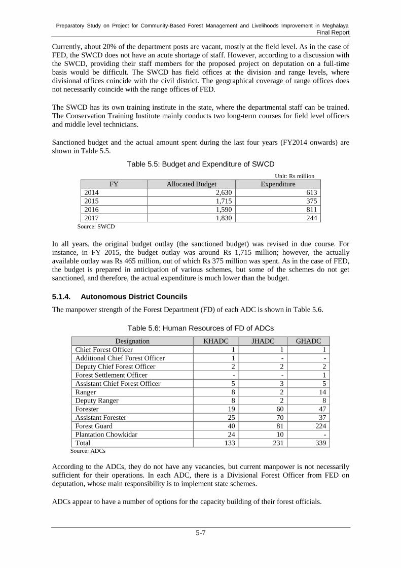
Preparatory Study on Project for Community-Based Forest Management and Livelihoods Improvement in Meghalaya Final Report
5-7
Currently, about 20% of the department posts are vacant, mostly at the field level. As in the case of
FED, the SWCD does not have an acute shortage of staff. However, according to a discussion with
the SWCD, providing their staff members for the proposed project on deputation on a full-time
basis would be difficult. The SWCD has field offices at the division and range levels, where
divisional offices coincide with the civil district. The geographical coverage of range offices does
not necessarily coincide with the range offices of FED.
The SWCD has its own training institute in the state, where the departmental staff can be trained.
The Conservation Training Institute mainly conducts two long-term courses for field level officers
and middle level technicians.
Sanctioned budget and the actual amount spent during the last four years (FY2014 onwards) are
shown in Table 5.5.
Table 5.5: Budget and Expenditure of SWCD
Unit: Rs million FY Allocated Budget Expenditure
2014 2,630 613
2015 1,715 375
2016 1,590 811
2017 1,830 244 Source: SWCD
In all years, the original budget outlay (the sanctioned budget) was revised in due course. For
instance, in FY 2015, the budget outlay was around Rs 1,715 million; however, the actually
available outlay was Rs 465 million, out of which Rs 375 million was spent. As in the case of FED,
the budget is prepared in anticipation of various schemes, but some of the schemes do not get
sanctioned, and therefore, the actual expenditure is much lower than the budget.
5.1.4. Autonomous District Councils
The manpower strength of the Forest Department (FD) of each ADC is shown in Table 5.6.
Table 5.6: Human Resources of FD of ADCs
Designation KHADC JHADC GHADC
Chief Forest Officer 1 1 1
Additional Chief Forest Officer 1 - -
Deputy Chief Forest Officer 2 2 2
Forest Settlement Officer - - 1
Assistant Chief Forest Officer 5 3 5
Ranger 8 2 14
Deputy Ranger 8 2 8
Forester 19 60 47
Assistant Forester 25 70 37
Forest Guard 40 81 224
Plantation Chowkidar 24 10 -
Total 133 231 339 Source: ADCs
According to the ADCs, they do not have any vacancies, but current manpower is not necessarily
sufficient for their operations. In each ADC, there is a Divisional Forest Officer from FED on
deputation, whose main responsibility is to implement state schemes.
ADCs appear to have a number of options for the capacity building of their forest officials.

Preparatory Study on Project for Community-Based Forest Management and Livelihoods Improvement in Meghalaya Final Report
5-8
According to the ADCs, the budgetary provision to the FDs is limited. Particularly in the case of
KHADC, it has hardly received any grants from the state government. For instance, KHADC
explains that, on average, KHADC receives funds for forest protection of around Rs 800,000
annually from the state government. JHADC seems to be in a better position – on average, their
budget estimates for plantation work are around Rs 2,900,000 and as of the FY 2015 record they
had received around Rs 2,800,000. The situation in GHADC is similar as there has been no funding
under central schemes to date, while the grant from the state government was received last in FY
2013. For GHADC, they have been making annual budget to the tune of Rs 180 million for last
three years; however, the actual spending has been around Rs 100 million.
Other resources are also limited in the ADCs. For instance, the FDs of KHADC and JHADC have
one or two vehicles for the department to manage the entire ADC areas. The situation is slightly
better for GHADC as they have total of three vehicles in the department.
Assessment of ADCs’ organizational capacity was conducted using organizational capacity
assessment tool. Questionnaire covering core aspects of organizational capacity was distributed to
ADCs and CFOs were requested to make self-assessment of their department. Responses from each
ADC are shown below. The questionnaire contained ten questions, and the respondents were asked
to choose one out of four situations that best describe their organization. Responses are in grade of
A, B, C and D, “A” representing better degree of management.
Table 5.7: Capacity Assessment of ADCs
Core aspect GHADC JHADC KHADC
Administration
Operational policies, procedures and systems B B C
Procurement policies and procedures B A C
Human Resource
Job descriptions A B C
Staff performance management B B C
Financial management
Accounting system B A C
Financial planning and budget monitoring B A C
Financial reporting system B A B
Audit A A B
Organizational management
Annual operational plan B A A
Decision making A A A Source: developed by Study Team
As seen in the table, GHADC and JHADC appear to have acceptable capacity across core aspects
of organizational capacity. KHADC, on the other hand, requires concerted effort to improve its
situation, particularly matters related to administration, human resource management and financial
management. Particularly, it appears to have a basic accounting system which requires better
practice or strengthening of personnel in charge.
5.1.5. GIS Capacity of Implementing Agencies and ADCs
In the context of the Project, GIS plays a key role in various project interventions in different
components. In this regard, the existing GIS capacity of the implementing agencies (FED, MBDA,
and SWCD) and three ADCs were examined.

Preparatory Study on Project for Community-Based Forest Management and Livelihoods Improvement in Meghalaya Final Report
5-9
(1) FED GIS Lab
The GIS Lab of FED (FED GIS Lab) was set up in 2013 to provide spatial information services to
the department. FED originally hired three people who had enough GIS knowledge to conduct daily
Lab activities as Project Assistants. After the Lab’s establishment in 2013, some personnel
relocation took place, but the original staff members are still deputed to the GIS Lab to prepare
maps on demand. The Conservator of Forest (CF) in the Research & Training Wing is the nodal
officer of the GIS Lab and its operations.
The FED GIS Lab prepared plantation boundary maps for the Social Forestry Wing, a Community
Reserved Forest (CRF) Map for the Wildlife Wing, Pre-survey Maps to collect information about
Tree Enumeration and Growing Stock for the Working Plan Division. The FED GIS Lab also
conducted the preparation of infrastructure maps, forest fire analysis, NDVI, supervised and
unsupervised classification, and forest inventory maps. The survey was done by FED field staff at
the division level. The GPS devices used are sent to the GIS Lab, and the export of collected data
and map-making are conducted by GIS Lab staff members. For the forest inventory, the FED GIS
Lab procured LISS- IV images and prepared forest inventory maps for the Khasi Hill ADC area.
The FED GIS Lab prepares maps for the FD of the ADC on request, for example for the CRF
boundary map.
In addition to this GIS Lab, FED has another GIS Lab in the Training Division, and two
contract-based, designated GIS officers are placed to conduct GPS training for local foresters.
Resource people in the Training Division receive help from the North Eastern Space Application
Centre (NESAC) and the FED GIS Lab described in the previous paragraph. The Training Division
manages one forest training school in Baiza in East Garo Hills District, to provide necessary
training for forest guards and foresters of FED. The principal of the training school is a person who
has attained Additional Chief Forester (ACF) level and is supervised by the Divisional Forest
Officer (DFO) of the Training Division. Besides the forest training school, the Training Division
also provides outreach training programs on demand.
Further, under the MOU, the GIS Lab is supported by NESAC. For example, NESAC provides
training for the GIS Lab for capacity building. The GIS Lab also acquires raw data from NESAC,
for example village location data. Map-making tasks are also sometimes outsourced to NESAC.
To understand the current GIS capacity of FED, the data layers, maps, and equipment, including
software and hardware, that are available to the FED GIS Lab, are summarized in the following
sections.
1) Data Layers and Maps
The FED GIS Lab also has satellite imagery. Table 5.8 shows the six main data layers and five
maps currently available at the GIS Lab.
Table 5.8: Data Layers and Maps Available in FED GIS Lab
No. Name Coverage Remarks
1 Administrative
boundary (state,
district &
community & rural
development
(C&RD) block)
State -Prepared in 2015 by digitizing from existing
georeferenced maps.
-Used for the preparation of forest fire risk
assessment map
2 Government-owned
Forest Land
(Reserve Forests
(RF) and Protected
Forests (PF))
RF & PF within the
state.
-Prepared in 2014 by digitizing from the Survey of
India Toposheet Maps (georeferenced).
-Used for the preparation of forest cover map, forest
change detection map, and thematic map.

Preparatory Study on Project for Community-Based Forest Management and Livelihoods Improvement in Meghalaya Final Report
5-10
No. Name Coverage Remarks
3 Community
Reserve Forests
(CRF), Plantation
Sites
Said areas within
the state
-Prepared in 2014 or later by GPS demarcation
(field survey).
-Used for the preparation of the said areas’
boundary demarcation map.
4 Sacred Groves Said areas within
the state
-Prepared in 2014 by field survey.
-Used for the preparation of the sacred groves
boundary map along with the distribution/position
of species (flora) within the boundary.
5 Road & Drainage State -Acquired from NESAC in 2014.
-Used for the preparation of the water catchment
map and as an integrated layer for location maps.
6 Settlement /
Villages
State -Acquired from NESAC in 2014.
-Used for the preparation of the impact assessment
map in relation to forest fire points.
7 Forest density
cover classification
map (Within RF
and PF)
Said areas within
the state
-Prepared in 2012 based on Resourcesat-2 LISS III
satellite imagery.
-Used at a scale of 1:8,000.
-Shows four different forest density categories: (1)
Dense forest, (2) Moderate forest, (3) Open forest,
and (4) Waterbody.
8 Forest Fire Risk
assessment Map
(District and
C&RD Block)
Districts and
Blocks within the
state
-Prepared in 2005-2014 (10 years) based on
Resourcesat-2 LISS III satellite imagery.
-Used at a scale of 1:10,000 for blocks and
1:200,000 for districts
-Shows four fire vulnerability zones: (1) Very High,
(2) High, (3) Moderate, and (4) Low.
9 Forest Fire
Incidence Map
(District-wise)
Districts within the
state
-Developed in 2013 and 2014 (2 years) based on
fire points data acquired from FSI.
-Used at a scale of 1:200,000 for districts
-Shows distribution of forest fire points.
10 Forest Change
Detection Map (For
RF & PF)
RF and PF within
the state
-Developed for the years 2004, 2006, and 2012
based on Resourcesat-2 LISS III (Multi-spectral)
satellite imagery.
-Used at a scale of 1:200,000 for districts.
-Shows forest changes in two categories: (1) Forest
to degraded forest and (2) Degraded forest to
regenerated forest.
11 Endemic Species
Distribution Map
Entire State (Partial
Distribution)
-Developed in 2015 based on collected field data.
-Used at a scale of 1:300,000 for districts
-Shows the distribution of endemic species on the
basis of village location. Source: compiled by Study Team based on interviews with officers of FED GIS Lab
The FED GIS Lab also has satellite imagery. Table 5.9 shows the satellite imagery currently
available at the GIS Lab.
Table 5.9: Data Layers Available in FED GIS Lab
No. Name Type Coverage Remarks
1 Resourcesat 2
LISS IV
Multi-spectral State -Observed in 2017
-5.8m spatial resolution
-Used for forest inventory mapping.
-Forest cover mapping for FED-owned forest
land including RF and PF.
2 Resourcesat 2
LISS III
Multi-spectral State -Observed in 2004, 2006, 2012
-23.5m spatial resolution
-Used for forest change detection within

Preparatory Study on Project for Community-Based Forest Management and Livelihoods Improvement in Meghalaya Final Report
5-11
No. Name Type Coverage Remarks
FED-owned forest land including RF and PF.
3 Cartosat I Panchromatic State -Observed in 2008
-2.5m spatial resolution
-Used as an integrated layer for various
forest resource mapping. Source: compiled by Study Team based on interviews with officers of FED GIS Lab
2) Equipment
In addition to the data layers discussed above, GIS Lab has software and hardware to conduct
spatial data preparation and analysis. Table 5.10 and Table 5.11 show the GIS and RS software and
hardware, respectively, that are currently available at the GIS Lab.
Table 5.10: GIS and RS Software Available at FED GIS Lab
No. Name Quantity Remarks
1 ESRI ArcInfo 2 GIS for image processing and vector analysis
2 ESRI ArcView 1 GIS for vector analysis
3 Erdas Imagine 9.2 2 For image processing Source: compiled by Study Team based on interviews with officers of FED GIS Lab
Table 5.11: Hardware Available at FED GIS Lab
No. Name Quantity Remarks
1 Workstation 1 HP Z820 Workstation, Intel®Zeon®CPU E5-2670 v2 @
2.5GHz (2 processor), RAM 32GB, 2TB HDD, 64 bit,
Windows 7 professional (Stand Alone)
2 Workstation 2 HP Compaq Elite 8300 , Intel® Core i7 CPU @3.40GHz,
RAM 4GB, 500GB HDD, 64bit Windows 8.1 Pro (Stand
Alone)
3 Plotter 1 HP Designjet T1200 HD MFP, Scanner cum Plotter
4 Printer 1 HP Color LaserJet CP5225 Printer
5 GPS 3 Garmin Etrex 30 (2) and Garmin Etrex Vista (1) Source: compiled by Study Team based on interviews with officers of FED GIS Lab
(2) MBDA GIS Unit
The MBDA GIS Lab was set up for creating a comprehensive spatial database comprising all
possible spatial layers relevant to forest management and natural resource management in the state
and also providing spatial information services to MBDA and other line departments. Currently,
The MBDA GIS Lab has six experts and mainly supports activities with the Compensatory
Afforestation Fund Management and Planning Authority (CAMPA), the Government of India’s
Scheme, which deals with forest land diversification, KfW, and the Climate Change Centre of
MBDA, as well as Megha-LAMP and MCCLMP. In the context of Megha-LAMP, for example, the
experts prepared village-wise resource maps and LULC classification for target villages and
provided training to MBDA field staff and staff from other line departments.
To understand the current GIS capacity of MBDA, data layers and equipment, including software
and hardware, that is available at MBDA GIS Lab are summarized in the following sections.
1) Data Layers
MBDA GIS Lab has a total of 32 data layers, some of which were obtained from various state and
national agencies. Data preparation is an ongoing exercise, and these data layers are updated
periodically. Table 5.12 shows the data layers for the entire state currently available at MBDA GIS
Lab.

Preparatory Study on Project for Community-Based Forest Management and Livelihoods Improvement in Meghalaya Final Report
5-12
Table 5.12: Data Layers Available at MBDA GIS Lab
No. Layer Description No. Layer Description
1 Administrative boundaries (state, district,
and block)
17 Mini-watershed
2 Land use and land cover map 18 Micro-watershed
3 Forest cover 19 Agro-ecological regions
4 Forest type 20 Temperature
5 Reserved forests and protected areas 21 Rainfall
6 Forest fire points 22 Catchment area for afforestation
7 Drainage network 23 Community nurseries
8 Soil 24 Automatic weather stations
9 Geology 25 Water quality at monitoring locations
10 Road network 26 Mosaic of Landsat
11 Village locations 27 Mosaic of IRS LISS IV
12 Digital Terrain Model 28 Mosaic of merged IRS LISS IV and
Cartosat 1
13 Slope 29 Mosaic of Toposheets (1:25,000 and
1:50,000 scales)
14 Aspect 30 College and school locations
15 Watershed 31 Spring locations
16 Sub-watershed 32 Sacred groves Source: MBDA GIS Lab
MBDA GIS Lab also has satellite imagery. Table 5.13 shows satellite imagery currently available
there.
Table 5.13: Data Layers Available at MBDA GIS Lab
No. Name Type Coverage Remarks
1 Landsat Multi-spectral State 30m, for free of charge
2 Landsat Panchromatic State 15m, for free of charge
3 LISS III Multi-spectral 23m, Indian satellite
4 LISS IV Multi-spectral 5.8m, Indian satellite
5 SPOT 7 Multi-spectral 6m
6 Quickbird Multi-spectral 2.44m
7 Quickbird Panchromatic 0.61m
8 Cartosat Panchromatic 2.5m, Indian satellite
9 SRTM Digital Elevation
Model (DEM)
State 90m, for free of charge
10 CartoDEM DEM Indian satellite
11 ASTER DEM State 30m, for free of charge
12 Hyperion Hyperspectral 30m, 220 bands Source: compiled by Study Team based on interviews with officers of MBDA GIS Lab
2) Equipment
In addition to the data layers discussed above, MBDA GIS Lab has software and hardware to
conduct spatial data preparation and analysis. Table 5.14 and Table 5.15 show the GIS and RS
software and hardware, respectively, which is currently available at MBDA GIS Lab.
Table 5.14: GIS and RS Software Available at MBDA GIS Lab
No. Name Quantity Remarks
1 ERDAS Imagine 2 For image processing
2 ENVI 1 For image processing
3 ESRI 2 GIS for image processing and vector analysis
4 Map Info 1 GIS for vector analysis
5 QGIS 7 GIS for vector analysis, free of charge

Preparatory Study on Project for Community-Based Forest Management and Livelihoods Improvement in Meghalaya Final Report
5-13
No. Name Quantity Remarks
6 GRASS 2 GIS for vector analysis, free of charge
7 ILWIS 2 GIS for vector analysis, free of charge
8 Diva 1 GIS for vector analysis, free of charge Source: compiled by Study Team based on interviews with officers of MBDA GIS Lab
Table 5.15: Hardware Available in MBDA GIS Lab
No. Name Quantity Remarks
1 Workstation 2 N/A
2 Desktop PC 2 N/A
3 Plotter 1 N/A
4 Multi-purpose 1 N/A Source: compiled by Study Team based on interviews with officers of MBDA GIS Lab
(3) SWCD GIS Unit
SWCD has a GIS Unit that is responsible for the spatial data and information of the department;
this unit is called the State Level Nodal Agency (SLNA). Two technicians belong to SLNA; they
prepare maps using GIS and conduct classification analysis of satellite imagery. SLNA closely
worked with NESAC for the preparation of the Watershed Atlas of Meghalaya 2013. SLNA also
works with the Meghalaya Information Technology for the centralized GIS server.
To understand the current GIS capacity of SWCD, the data layers and equipment, including
software and hardware, available at SLNA are summarized in the following sections.
1) Data Layers and Maps
SLNA has three data layers and one map with different specifications. Table 5.16 shows the three
main data layers and one map for the entire state currently available at SLNA.
Table 5.16: Data Layers and Map Available at SLNA
No. Layer Description Year Coverage Scale Layer Description
1 State administrative
boundaries
2013 State 1:25,000 -Prepared in the format of shp.
-Provided by Central GIS Centre of
MITS.
2 Micro watershed 2013 State 1:50,000 -Prepared in the format of shp.
-Delineated based on Toposheet
map by Survey of India and
CartoDEM.
-Prepared by SWCD under
supervision of NESAC.
3 Micro watershed
coded and prioritized
2013 State 1:50,000 -Prepared in the format of shp.
-Delineated based on Toposheet
map by Survey of India and
CartoDEM.
-Prepared by SWCD under
supervision of NESAC.
4 Watershed Atlas of
Meghalaya
2013 State 1:50,000 -Prepared in the format of shp.
-Delineated based on Toposheet
map by Survey of India and
CartoDEM.
-Divided the entire state into 2,776
micro watersheds and accordingly
coded them as per the guidelines
of National Bureau of Soil Sciences and Land Use Planning.
Source: compiled by Study Team based on interviews with officers of SLNA

Preparatory Study on Project for Community-Based Forest Management and Livelihoods Improvement in Meghalaya Final Report
5-14
2) Equipment
In addition to the data layers and map just discussed, SLNA has software and hardware to conduct
spatial data preparation and analysis. Table 5.17 and Table 5.18 show the GIS and RS software and
hardware, respectively, currently available at SLNA.
Table 5.17: GIS and RS Software Available at SLNA
No. Name Quantity Remarks
1 Supermap
iDesktop 7C
2 GIS software for vector analysis.
2 ERDAS Imagine
2010
1 RS software for image processing and analysis.
Source: compiled by Study Team based on interviews with officers of SLNA
Table 5.18: Hardware Available in SLNA
No. Name Quantity Remarks
1 Workstation 1 HP Z600 Workstation
Intel ® Xeon CPU @ 2.00 GHz
Ram 8.00 Gb, 1TB HDD
64-bit OS, Windows 7 Professional (Standalone)
2 Workstation 1 HP WX460 Workstation
Intel ® Core 2 Duo CPU @ 3.00 GHz
Ram 4.00 Gb, 1TB HDD (1TB Extended)
64-bit OS, Windows 10 Professional (Standalone)
3 Printer 1 HP Color LaserJet CP 5225
4 Scanner 1 Cortex XD 2490 Scanner
5 Internet (in SLNA) 1 set Provided by NIC
6 Internet (Field) 1 set 3G or 4G Long Term Evolution (LTE)
Source: compiled by Study Team based on interviews with officers of SLNA
(4) ADCs
Three ADCs (Jaintia Hills ADC, Khasi Hills ADC, and Garo Hills) have very limited GIS capacity.
First, the Jaintia Hills ADC has no GIS capacity. The Forest Department has five handheld GPS
devices, and seven surveyors who are ranked in the Forester category can use them. The Forest
Department has surveyed about 500 registered community reserved forests, a certain number of
private/individual forests, sacred groves, and PFs, which exist only in Jaintia Hills area. The
collected coordinates are sent to FED in Shillong, along with the GPS devices, and maps are
prepared by FED free of charge. As a result, the surveyors of Jaintia Hills ADC do not know how
the data are processed and how maps are prepared.
Second, the Khasi Hills ADC does not have GIS capacity, either. Within the FD, only two or three
staff members can use handheld GPS devices, and GPS surveys are rarely conducted. Further,
mapping based on coordinates collected by GPS surveys are usually outsourced to private
companies. The IT Department of the Khasi Hills ADC uses several kinds of software, such as
AutoCAD, Expert GPS, and MapSource, for mapping of land boundaries only.
Lastly, the Garo Hills ADC has very limited GIS capacity. The FD has five handheld GPS devices
donated by FED and has completed GPS surveys for around 60 Village Reserve Forest (VRF) out
of 200 to 300 villages. The FD has no designated surveyors or GIS operators. Only one officer
ranked as Forester was involved in the GPS surveys and GIS mapping of the VRF. The FD uses
open source GIS software for data downloading and map preparation and has made simple
boundary maps for around 60 VRF only. Table 5.19 shows the summary of current GIS capacity in
ADC Forest Departments.

Preparatory Study on Project for Community-Based Forest Management and Livelihoods Improvement in Meghalaya Final Report
5-15
Table 5.19: Current GIS Capacity in ADC Forest Department
Name GIS
Capacity Human
Resources Equipment Boundary Data Remarks
JHADC ×
- 7
surveyors
in
Forester
category
- 5
Handheld
GPS
- Approx. 500 registered
community forests. - Some
private/individual
forests - Some sacred groves - Some protected forests
- The collected coordinates
with GPS devices are sent to
FED. - All maps are prepared by
FED.
KHADC × - 2 to 3
surveyors N/a
- Some plantations - Some sacred groves - Some community
forests
- GPS surveys are usually
outsourced to private
companies.
GHADC △
- 1 officer
in
Forester
category
- 1 Open
source GIS - 5
Handheld
GPS
- Approx. 60 Village
Reserve Forest (VR-)
- Simple boundary mapping
for VRF is conducted using
open source GIS software
internally.
Source: compiled by Study Team based on interviews with officers of ADCs
To sum up, in FED, MBDA, and SWCD altogether, many data and maps are currently available.
Besides, not only the data and information sharing between the agencies, but also the means of data
acquisition from other institutions, such as FSI and NESAC, were also identified. Therefore, the
existing data and maps will be utilized for the Project, recent data will be also acquired from
relevant institutions smoothly. On the other hand, the majority of data and maps are available at
state level, and community level data, such as village boundaries and community forests, are quite
limited. At the same time, when it comes to human resources, except the MBDA GIS Unit, FED
and SWCD GIS Units and their local offices are quite limited, and GIS capacities of ADC Forest
Departments are practically nothing. In this regard, the Project shall intend to achieve the
preparation of timely community level data and the capacity development for the implementing
agencies at both the headquarters and local offices.
Further, the JICA annual forestry workshop was held in Tamil Nadu in March 2019, and various
case examples in the utilization of GIS for forest planning and monitoring were discussed. Of all
the discussions at the workshop, two case examples appeared to be relevant to the Project and also
improve the capacities of the existing GIS Units. They included (1) data collection using drones and
mobile application and (2) village boundary surveys using differential GPS (DGPS). First, Forest
Departments in some other states developed mobile applications and also introduced drones to
collect filed data in a timely manner. In the Project, these devices can be also introduced to collect
data in the field and prepare community level data through monitoring activities. In Meghalaya
State, access to internet is not available in many parts of the state. It is also important to develop the
mobile application that can be used for entering and saving data in offline environment. Second, in
some other states, DGPS, which can improve locational accuracy compared with regular handheld
GPS, were commonly used to conduct boundary surveys. In the Project, village boundary surveys
are also needed during the preparatory phase, and surveys with DGPS can enable for improving the
accuracy of village boundaries.
5.2. Existing Monitoring and Evaluation Systems
Monitoring and Evaluation (M&E) systems play an important role in organisations to efficiently
monitor the progress of activities and achieve targets. M&E systems also enable organizational
management to make strategic decisions and correction measures. MBDA has an M&E system to
collect data and information and analyse the performance of activities at various levels. MBDA
developed its Management Information System (MIS) as part of the M&E system to record the

Preparatory Study on Project for Community-Based Forest Management and Livelihoods Improvement in Meghalaya Final Report
5-16
progress of activities from field level to state level. The MIS enables MBDA’s
management/authority to make appropriate decisions at various levels based on information
available in the MIS. As of March 2019, the M&E systems are managed by the Deputy CEO of
MBDA.
MBDA established an MIS team at its headquarters in Shillong, staffed with five technical officers,
including computer programmers, MIS officers, and an MIS analyst, for the overall monitoring of
work progress. This MIS team is responsible for collecting data from field level officers and
analysing and monitoring performance and progress. Using external agencies, MBDA also
collected baseline information from approximately 1,700 households in both project and
non-project villages in 2017, and these data can be used as the basis of future activities. MBDA
hired one expert to conceptualise the dataflow process, draw the outlines of the MIS, and set up the
MIS team.
Currently, MBDA is implementing two projects, namely Megha-LAMP and MCLLMP, and has
two separate M&E teams at the district and block levels to collect, compile, and upload data into
MIS. In this section, the MIS in these two projects and other existing MIS are discussed, focusing
on (1) current usage situations, (2) challenges and issues, and (3) future possibilities.
5.2.1. MIS in Megha-LAMP
(1) Current Usage Situations
The MIS team at MBDA headquarters is responsible for the MIS of Megha-LAMP, which has been
integrated with the overall MBDA management information system. This MIS was developed by
following an M&E framework in the Project Implementation Manual. The Megha-LAMP hired one
M&E consultant to develop M&E plans and initiate a rapid assessment survey (pre-baseline). At
present, the Megha-LAMP MIS team has four staff members at MBDA headquarters in Shillong
and one M&E Program Associate at each BDU, as well as a few Project Associates at each
Enterprise Facilitation Centre (EFC). Megha-LAMP has separate reporting systems by component.
They include (1) Enterprise development, (2) Integrated Village Cooperative Society (IVCS) and
Bank linkage, (3) Capacity building, and (4) INRM progress. For database development and
programming of MIS, MBDA is supported by the National Information Centre (NIC) in Shillong.
With respect to the hosting of applications, MBDA uses the services of a third party through
Government E-Market (GeM).
The EFC Reporting tool is an offline MS Access-based application for the enterprise development
component. It consists of three major sections: (1) Partner Registration, (2) Social, Economic, and
Psychological Profile, and (3) Service Provided and Enterprise Development. For the Psychological
Profile, a separate questionnaire is used to examine the characteristics of interviewees and possible
support for their future enterprises.
Using the EFC Reporting Tool, data are transferred from EFCs to headquarters. At EFCs, data are
collected from community members by Program Associates in the form of hard copy. Usually,
Program Associates visit target villages to conduct interviews. Sometimes, community members
come to EFCs and participate in interviews on a voluntary basis. The collected data are compiled
and then entered into an off-line MIS application. The entered data are exported in a form of
an .xml file from the application. The exported files are sent by email to headquarters and the
responsible BDU. The M&E Experts of BDUs are responsible for data collection through Program
Associates and uploading the data into the EFC Reporting Tool. Although Program Associates at
EFCs can enter data, they are often busy with other duties in the field and cannot spare sufficient
time for data entry. In such cases, the M&E Experts at BDUs enter the data. The BDUs’ M&E
Experts have access to data from all blocks, while Program Associates at EFCs have access only to
data from blocks for which he or she is responsible. If any errors are found in the data, the M&E
Expert receives information from headquarters and accordingly arranges for correction measures at
the district level.

Preparatory Study on Project for Community-Based Forest Management and Livelihoods Improvement in Meghalaya Final Report
5-17
(2) Challenges and Issues
In the context of Meghalaya, the initial conceptualisation and mapping of indicators for data
collection, standardisation of formats, and design of data flow take a lot of time due to a lack of
specialised local human resources. For example, common indicators include profile information,
name, age, village name, and household, which need to be collected every time, while specific
indicators are specific to the component and need to be collected on demand only. Existing
computers and internet connections are also not available in all places across the state. This
situation requires training for operators, the procurement of new equipment such as computers, and
internet connectivity. Further, the support of other government agencies, like the National
Information Centre (NIC), is also very limited, because these government agencies are often
overloaded with work requested by other agencies.
(3) Future Possibilities
Megha-LAMP is currently developing online web-based MIS, and this web-based MIS will be
composed of the existing three reporting tools and also integrate the MIS with GIS. With the
implementation of this new MIS, data uploading, visualisation, and reporting can be completed
online regardless of time and place. At the same time, data analysis is currently conducted only at
headquarters. It is desirable to enable BDUs to conduct data analysis for reporting purposes on
demand.
5.2.2. MIS in MCLLMP
MCLLMP has a component of monitoring, learning, and reporting for MIS. An MIS-based
performance tracking system was recently developed to track implementation progress and other
aspects of MCLLMP activities. The structure, indicators, and information flow of the MIS were
designed and established by the MBDA’s MIS team, and a vendor will be engaged in the
development of MIS. This MIS is intended to allow villagers, traditional leaders, farmers,
government officials, project team members, and facilitating NGOs to understand their roles and
responsibilities for more efficient natural resource management. It is expected that this MIS will
result in linkages with other MIS of different departments, because other state and central
government schemes are being digitized for future data verification and information sharing.
Because this MIS was recently developed, information about the features of data flow, such as
where data will be generated, who will enter the data, and who will verify the data, are still under
examination. However, an online Android-based application is being developed in house for further
integration into the mainframe MIS.
5.2.3. Other Existing MIS
Central government schemes like the Mahatma Gandhi National Rural Employment Guarantee Act
(MGNREGA), the Prime Minister Rozgar Yojana (PMRY), the National Social Assistance
Programme (NSAP), the National Rural Livelihood Mission (NRLM), and the Pradhan Mantri
Gram Sadak Yojana (PMGSY) each have their own MIS. Data and information is being collected
directly from blocks and district offices, and the maintenance of their MIS are supported by NIC.
The Soil and Water Conservation Department also has MIS for M&E purposes as a part of the
IWMP. District level officers, including demonstrators and watershed development team members,
collect field data using mobile applications developed by the Ministry of Rural Development. The
data include information about financial and physical progress in target micro watersheds.
Collected data are entered into the MIS at district level and sent directly to the Ministry of Rural
Development database. When it comes to FED, monitoring and evaluation systems do not exist.

Preparatory Study on Project for Community-Based Forest Management and Livelihoods Improvement in Meghalaya Final Report
6-1
Chapter 6. Review of the Pre-Detailed Project Report (Pre-DPR)
6.1. Outline of the Pre-DPR
The Pre-Detailed Project Report (Pre-DPR) consists of five chapters, (1) Background, (2)
Necessities and Priority of the Project, (3) Project Rational and Objectives, (4) Project
Implementation and Organization, and (5) Project Components, followed by supportive information
in eight relevant annexures, namely (1) Land tenure system in Meghalaya, (2) Categories and
management of community forest in Meghalaya, (3) Selection criteria, (4) Project management
consultancy, (5) Megha-LAMP, (6) Terms of reference for developing operational manual &
accounting procedure, (7) Consultancy studies on commodities by Institute of Livelihood Research
and Training (ILRT) for MBDA, and (8) Some important medicinal plants of Meghalaya.
6.2. Methodology of the Review
At the beginning of the Study, the Pre-DPR was initially examined as a part of the domestic work
done in Japan in order to understand the overall picture of the Project. After the first field survey,
which included a series of discussions with implementing agencies and other relevant agencies, as
well as field visits, the Pre-DPR was further examined based on the outcomes of these activities.
This chapter shows the results of the Pre-DPR review, by chapter, from Section 6.3.1 to 6.3.5. At
the same time, the development of selection criteria plays a vital role in the preparation of the
Project. Thus, the review about Annexure (3) in particular is summarized in Section 6.3.6.
6.3. Pre-DPR Review
6.3.1. Chapter 1: Background
The Pre-DPR discusses basic information about Meghalaya to illustrate current physical and
socioeconomic conditions of the state. These include geography, demography, socioeconomic
status, administrative system, forest areas, biodiversity, and livelihood. Although this chapter
describes the current situations in the state in detail, based on the observations made during the first
field survey, it seems that an examination of the following points is also needed, because they have
much influence on Project objectives, as well as its design. These points include (1) data
availability, including data about the number of villages, (2) regional differences between ADCs,
and (3) possible causes of land degradation.
First, the number of villages needs to be determined in order to correctly select target villages.
Throughout this chapter, the number of villages appears several times, but these numbers vary each
time. For example, the Census 2011 states that the number of villages is 6,839, while the table
“Meghalaya at a Glance” shows the number of villages at 7,800. At the same time, the third page of
this chapter gives the number of villages at 5,780. In the context of this Project, the number of
villages is critical because target area selection will be conducted by village. Therefore, it is
important to determine and refer to the most up-to-date and correct number of villages for future
discussions.
Second, regional differences within the state need to be considered. Meghalaya consists of three
ADCs, and each ADC has unique features in many aspects. During the first field survey in India, it
was observed that each ADC has unique land tenure and forest management systems, as well as
unique causes of forest degradation and deforestation. At the same time, although the Pre-DPR
discusses literacy rates in this chapter, according to the field observations in the three ADC areas,
literacy rates also vary depending on the ADC; moreover, this situation results in different
socioeconomic conditions for each ADC. These features further imply that regional differences
between the three ADCs need to be understood and that different local issues need to be addressed
accordingly.

Preparatory Study on Project for Community-Based Forest Management and Livelihoods Improvement in Meghalaya Final Report
6-2
Third, monoculture plantation can be a driving factor in land degradation in Meghalaya. Shifting
cultivation is discussed in Pre-DPR as one of the major driving factors of forest degradation, and it
has been largely replaced by monoculture plantation (e.g. areca nuts). As the Pre-DPR indicates,
monoculture plantation is commonly conducted in some areas of the state. In the short term,
monoculture plantation can become an important income source for local people. In the long term,
however, monoculture plantation can have negative impacts, such as the degradation of soil, on the
local environment. For this, it is important to address not only those areas with degradation for new
development work, but also areas that have Project interventions, including monoculture plantations
for further improvement.
6.3.2. Chapter 2: Necessity and Priority of the Project
The Pre-DPR discusses the key environmental concerns. They include deforestation; the
fragmentation of forests; soil degradation; biodiversity loss; and the contamination and silting of
water bodies caused by unregulated and unscientific mining, deforestation, and unsustainable short
cycles of shifting cultivation, or jhum. Due to the number of unfavourable conditions, the Project
should be implemented urgently. It is also important to understand that these unfavourable
conditions are closely linked with each other by cause-and-effect relationships. Because
socioeconomic conditions, including livelihood, have much to do with the above unfavourable
conditions, they are also evidence of the necessity and priority of the Project.
The Pre-DPR proposes a participatory site specific forest development approach. From the first
field survey in India, it was clear that physical conditions, as well as management systems, vary
depending on the region. Therefore, this approach seems appropriate to the Project in Meghalaya.
6.3.3. Chapter 3: Project Rationale and Objectives
The Project is consistent with the directions shown in the following state development policies.
Meghalaya Vision 2030 emphasizes the necessity of promoting scientific forest management in
community- and privately-owned forests. The Meghalaya Human Development Report 2008
suggests the necessity of intervention to check the further degradation of natural resources through
persuasion and regulations that encourage land- and resource-owning communities to become
involved in conservation programmes in which government agencies participate. The Project aims
at embodying these state policies.
The principal goal of the Project is “to conserve and develop forests and biodiversity resources of
the state through preparation and execution of area specific management plan by the concerned
communities/individuals (forest owners) and enhancing their capability in sustainable management
of forest and biodiversity along with natural streams and springs and poverty alleviation of local
communities”. This goal has been developed to address the issues of environmental degradation
based on circumstances in the state. Though Meghalaya State has a forest cover rate of as high as
76.5%, 42.6% of the total forest area is open forest; moreover, total forest area decreased by 142
km², in comparison with 2013, according to the FSI Report 2017. As a result, soil erosion and water
scarcity for domestic and agricultural purposes have become major problems there154
. In order to
prevent further degradation of forests and mitigate the adverse impact of forest degradation on local
community livelihood, forest conservation is urgently needed. On the other hand, the state has
unique conditions in terms of its land tenure and forest management systems, in that over 90% of
forest land belongs to communities or individuals and that strong traditional community
organizations exist and manage land and natural resources. In these circumstances, a focus on
community-led forest management is adequate. From the aforementioned points of view, the
Project seems to be rational.
On the other hand, the following points have weaknesses as regards their rationality.
154
Department of Environment and Forest, Government of Meghalaya (2005) Sate of the Environment Report 2005:
Meghalaya. http://www.moef.nic.in/soer/state/SoE%20report%20of%20Meghalaya.pdf

Preparatory Study on Project for Community-Based Forest Management and Livelihoods Improvement in Meghalaya Final Report
6-3
The rationality of forest management by concerned communities/individuals, through
enhancement of their capabilities, is explained by the shortage of FED staff. However, it
is stipulated by regulations that the management of forests belonging to communities or
individuals is a mandate of the ADCs, although in practice FED intervenes in
community forest management through such schemes as JFM and Community Reserve.
Therefore, the Project shall include the ADCs as targets of capacity development for the
strengthening of community forest management.
Four points, namely those about how (1) to restore ecological balance, (2) to enhance
ecosystem services, (3) to enhance livelihood and income-generating opportunities, and
(4) to adapt to climate change, which are shown in a box in Chapter 3 of the Pre-DPR,
under the title of “Rationale”, sound too general and hardly explain the relationship
between these four points and the Project. Further explanation is needed as to how these
four points support the rationality of the Project.
Poverty alleviation is listed as a long-term goal of the project. On the other hand,
biodiversity conservation has been set as one of the project objectives. The logical
consequence of how biodiversity conservation contributes to poverty alleviation is not
clear. In Chapter 2 of the Pre-DPR, it is explained that the root causes of poverty are
pre-dominantly small and marginal operational land holdings, rain-fed cultivation,
stagnant agricultural production, soil erosion, low level of skill development, and poor
infrastructure. It needs to be explained how biodiversity conservation will be helpful in
addressing these causes.
6.3.4. Chapter 4: Project Implementation
In Chapter 4 of the Pre-DPR, the phasing of the Project and overall framework of Project
implementation arrangement are discussed. A summary of these two topic and observations is given
below.
(1) Phasing of the Project
The Project is proposed for a duration of ten years divided into three phases. The different
phases of the Project, along with major tasks to be undertaken in each, are indicated in
Source: Pre-DPR
Figure 6.1.

Preparatory Study on Project for Community-Based Forest Management and Livelihoods Improvement in Meghalaya Final Report
6-4
Source: Pre-DPR
Figure 6.1: Phasing of the Project Mentioned in Pre-DPR
Considering the experience of other forestry projects in India, the phasing of the Project appears to
be practical. Given that the Project will be the first Japanese ODA Loan project in this sector in
Meghalaya State, sufficient time should be given for each of its phases. Particularly, more time may
be required for the preparatory phase. For instance, in the case of the IFAD-funded Mega-LAMP, it
has taken about two years to kick-start the project, despite having some personnel who earlier were
part of IBDLP. Therefore, it is probably practical to allocate at least two years for the preparation
phase. From this perspective, ten years for project implementation would be a minimum
requirement for the Project.
(2) Overall Framework of Project Implementation
The institutional arrangement for the Project is discussed both in Chapter 4 and Chapter 6 of the
Pre-DPR. The Project is to be implemented in a society-mode by establishing a Project
Management Unit (PMU). However, instead of creating a new society, it is proposed that the PMU
be housed in the Meghalaya Basin Development Authority (MBDA). A separate by-law for the
PMU will be drafted and operation and accounting manuals and procedures will be prepared. In
other states in India where forestry projects have been implemented with a Japanese ODA Loan, the
executing agency is the FD, and the PMU is established as an autonomous society thereunder. In
Meghalaya, however, while the executing agency is FED, the PMU for this Project will be attached
to an existing society that is an entity separate from FED. Therefore, the flow of project funds and
commands of instruction needs to be given due consideration. In the Government of Meghalaya,
budget outlays for each department are decided between the Finance and Planning Departments in
consultation with each other, and the funds are released from the Finance Department to each
department through the Planning Department. Because MBDA is a subordinate organization of the
Planning Department, it appears practical to follow this fund flow process.
The Pre-DPR also proposes the constitution of a High Power Committee (HPC) headed by a Chief
Secretary, which makes policy-level decisions and coordinates among the government departments.
The Pre-DPR also proposes the constitution of a separate Governing Body (Governing Council) for
the PMU. However, the PMU would be a division in MBDA and should be administered by the
same Governing Body. According to the requirement of the project, some members may need to be
added to the Governing Body. In addition, the Governing Body of MBDA is already headed by a

Preparatory Study on Project for Community-Based Forest Management and Livelihoods Improvement in Meghalaya Final Report
6-5
Chief Secretary, with representation from various departments (see Chapter 5 for the list of
members in the Governing Council of MBDA). Therefore, the necessity of an HPC needs to be
carefully examined.
The Project Director would be responsible for the overall management and implementation of the
Project. Four Joint Project Directors in the fields of administration and finance, forestry, livelihood
improvement and enterprise development and monitoring and evaluation would be posted at
headquarters. While MBDA plays a critical role in coordination with various departments, the
Project is that of the forestry sector. Therefore, as suggested in the Pre-DPR, appointing a
PCCF/APCCF-rank forest official as Project Director is appropriate, especially if the district level
project implementation unit is headed by Divisional Forest Officers (DFOs).
The Pre-DPR suggests having district-level implementation units for the project, which would be
attached FED DFO office. The Pre-DPR mentions only a requirement for the District Project
Manager to have domain expertise in forestry, and who in turn would be assisted by one or two
Project Assistants. Because the Project requires the involvement of ADCs and the SWCD, apart
from FED, representation from these as well as MBDA at the district level needs to be considered.
A District Level Advisory Committee, (DLAC), chaired by the District Collector in each district,
can act as a forum for various departments to come together and coordinate. A DLAC appears to be
functional in most of the districts, so the existing structure can be utilized.
Below the district level, there is no mention of a Project Implementation Unit. In order for
communities to have better access to the Project implementation body, as well as the Project itself
to monitor the ground level situation on regular basis, it is necessary to have field presence below
district level.
At the community level, the formation of a Village Level Executive Committee (VLEC) for the
purpose of Project implementation and monitoring is proposed. Eight to ten office bearers are
suggested, out of which 50% would be reserved for women. Because representation of women in
village level institution appears limited, despite many of the communities being matrilineal, having
a quota system for the representation of women is important. VLEC will also have a representative
from the Project side. As there are a number of village level institutions, such as JFMC, the
Watershed Development Committee, and the Village Employment Council, that are already in
existence, the possibility of utilizing such institutions needs to be considered, along with the
creation of new institutions. The Pre-DPR also suggests that local youth will be appointed and
trained to be the interface between the target communities and the Project. Having an animator or
facilitator at the village level who is versed in the concerns of the respective communities is
essential.
The Project will require extensive social mobilization at the community level. To meet this
requirement, the involvement of NGOs and/or other resource organizations is suggested. The
availability and capacities of NGOs and other resource organizations need to be assessed, and areas
in which their services can be utilized need to be given due consideration.
Project Management Consultants (PMC) would be hired to assist the PMU in Project
implementation. Although the Pre-DPR indicates requirements for international consultants in the
fields of biodiversity, eco-tourism, REDD+/carbon finance and community development for the
total of 20 man/months (M/M), the fields of expertise to be provided by the international
consultants should be examined in line with Project components and particular requirements related
to the scopes of the various aspects of the Project. A total of 272 M/M is also indicated for the
national consultants.
In addition to PMC, the Pre-DPR suggests hiring short-term consultants at the beginning of Project
implementation to develop accounting procedures for the PMU. MBDA has its own accounting
manuals, so the short-term consultants can review the existing manuals and also develop

Preparatory Study on Project for Community-Based Forest Management and Livelihoods Improvement in Meghalaya Final Report
6-6
operational manuals for the PMU.
6.3.5. Chapter 5: Project Components
In this section, four major Project components are reviewed, and the outcomes from each
examination are summarized below.
(1) Core Forest Activities
1) Overall Review
First of all, although some causes of forest degradation, such as shifting cultivation and forest fires,
are mentioned in Chapter 2, a driver analysis of forest degradation and deforestation has not been
sufficiently conducted in the Pre-DPR. Without the driver analysis, it is difficult to propose
effective forest activities for the achievement of the Project goals.
Through the first field survey in India, it was observed that each ADC has unique land tenure and
forest management systems and unique causes of forest degradation and/or deforestation. Thus,
core forest activities should be designed according to causes in line with the land tenure and the
forest management systems in each ADC.
2) Review of Each Activity
The Pre-DPR proposes two types of forest activities: A1 (Reclamation of shifting cultivation areas)
and A2 (Restoration of degraded community forests). Under these two types of activities, two and
four models are proposed respectively, as shown in the table below.
Table 6.1: Types and Models of Core Forest Activities Proposed in Pre-DPR
Type Model
A1: Reclamation of shifting
cultivation area
RSCA Model 1: Agroforestry in current jhum lands
RSCA Model 2: Conversion of jhum lands to forests
A2: Restoration of Degraded
Community Forests
RDCF Model 1: Assisted Natural Regeneration
RDCF Model 2: Assisted Natural Regeneration with enrichment
plantations
RDCF Model 3: Improvement/Revitalization of bamboo brakes
RDCF Model 4: Fuel wood & fodder plantation Source: Pre-DPR
With the two types and six models above, it is difficult to deal with some types of forest
degradation and deforestation caused by certain drivers. For example, the restoration of vast
deforestation areas, caused by forest fires coupled with grazing that has been observed in the Khasi
Hills ADC jurisdiction area, is difficult to accomplish with Assisted Natural Regeneration (ANR),
which is proposed as RDCF Model 1. Other models are also not applicable for dealing with this
type of deforestation. Stone quarrying largely conducted on private lands is another major driver of
deforestation in the same ADC area. However, the Pre-DPR does not propose any measurement to
restore this type of deforestation.
In the first place, it seems that Type A2 was designed based on an insufficient understanding of the
reasons for the degradation of community forests. The Pre-DPR mentions that a lack of scientific
and technological input and adequate investment, coupled with over harvesting, have resulted in the
degradation of community forests. Although this may be true in some cases, as a result of the first
field survey in India, it has been suggested that weak enforcement of customary rules of forest
management and regulations to control the conversion of forests to other kinds of land use was one
of the major reasons for forest degradation or deforestation. Therefore, activities to strengthen
forest management or land use management by communities shall be included in the Project. For
example, the facilitation of registering community forests in existing schemes, such as Village

Preparatory Study on Project for Community-Based Forest Management and Livelihoods Improvement in Meghalaya Final Report
6-7
Reserve Forest (VRF) and Community Reserve (CR), shall be included to prevent further
degradation and restore forest vegetation. In order to mitigate the conversion of forests to other
kinds of land uses on private lands, to take another example, participatory land use planning shall
be included as one of the Core Forest Activities though a similar activity, village micro planning, is
described as one of the Community Development Activities.
Regarding Type A3: Biodiversity conservation, as pointed out in Section 6.3.3 of this report, logical
consequence between the proposed activities for biodiversity conservation and the long-term goal,
poverty alleviation, is weak. In particular, among the proposed activities, (i) Identification of core
areas for conservation of unique bio-diversity with MSBB, and (ii) Preparation of peoples’
biodiversity registers hardly contributes to poverty alleviation. Pertaining to Activity III (Expansion
of existing sacred groves), it may be difficult to practically expand the area of existing sacred
groves. Rather than do this, it is effective to facilitate the registration of existing sacred groves as
CR for maintaining biodiversity across the state. Regarding Activity V (Identification and mapping
the gaps in the corridor connecting the Protected Areas), five corridors of elephants in the Garo
Hills ADC jurisdiction area have already been identified, and maps have already been prepared.
Thus, as the next step, activities to link the corridors should be introduced in the Project.
3) REDD+/Carbon Finance
In Meghalaya State, two REDD+ pilot projects has been carried out as described in the section 3.4.
One is the Khasi Hills Community REDD+ Pilot Project at Mawphlang Village, East Khasi Hills
District, initiated by Hima and NGO, and the other is the Community REDD+ Pilot Project at
Umket Village, Ri-Bhoi District, initiated by FED.
Against this background, the Pre-DPR proposed to formulate a state REDD+ strategy in accordance
with the National REDD+ Strategy and develop REDD+ methodologies including MRV and
Safeguards that involve communities. Moreover, it proposed to conduct at least two REDD+ pilot
projects in each district to raise awareness about REDD+ in the state.
However, GoI only recently announced the National REDD+ Strategy in August 2018, and it does
not mention REDD+ methodologies such as MRV or Safeguards. In these circumstances, it is
assumed that it takes a substantial amount of time to develop MRV methodologies and Safeguards
at the national level. If GoM developed the REDD+ methodologies prior to their development at the
national level, it would cause many conflicts, and the methodologies developed at the state level
would accordingly need to be adjusted to those at the national level in the future. Hence, it is
difficult to incorporate REDD+ related activities in the Project considering the aforementioned
limited time frame.
In addition, it has been pointed out that the introduction of REDD+ in Meghalaya State needs to be
considered carefully, since the trend in forest cover change in the state is different from that in India
as a whole. If the results-based payment apprioach is adapted to Meghalaya State as well as the rest
of India, it is likely that Meghalaya State will not receive much profits.
Considering the situations detailed above, it appeared to be inappropriate to incorporate REDD+
related activities into the Project.
(2) Water Resource Augmentation
Water Resource Augmentation (Section 2 in Chapter 5) has not yet been described in the Pre-DPR
(as of February 2019). However, the significance of water resources in Meghalaya is emphasized in
various places throughout the Pre-DPR. For example, “To offset the adverse impact of
developmental activities, [the] need [for] conservation of natural resources, basically forest & water
resources, are of paramount importance.”, “There seems to have been no attempt to objectively
[assess] … the changes in the availability of utilizable water resources in the state.” It continues by
stating the important of, “particularly, revitalizing the streams and springs to augment the depleting

Preparatory Study on Project for Community-Based Forest Management and Livelihoods Improvement in Meghalaya Final Report
6-8
[of] water resources and to provide enhanced livelihood opportunities to the forest dependent tribal
communities.” The quotations exemplify the significance of water resources. Furthermore, at the
outset of formulating Selection criteria (in Annexure 3) also implies their significance by explaining
that “The first step towards identification of project target villages will be prioritisation/selection of
landscapes, comprising mini watersheds, through an objective analysis of Remote Sensing satellite
and other ancillary data related to forest degradation status and [the] rate of change of forest
degradation, [the] overall situation of water stress, and [the] potential to augment water resources.”
Because the augmentation of water resources is certainly an essential issue for the improvement of
the living environment for local residents through forest management activities, strategies and
measures should be considered during the Study based on discussions with stakeholders.
(3) Community Development and Livelihood Improvement
The Pre-DPR proposes community development comprising the following activities: 1) Entry Point
Activities (EPAs); 2) micro-planning; 3) income generation; and 4) enterprise development. First,
in the Pre-DPR, EPAs are considered as a tool for mobilizing villagers and involving them with the
Project up to its commencement. Since the process by which a micro plan is made in a participatory
way at the village level and approved by the Project is very long, EPAs should work out as
expected in the Pre-DPR.
Apart from the Pre-DPR, however, EPAs should not be focused only on community mobilization,
but should also be pre-conditions to create an enabling environment for the target groups of people,
specifically women, to easily join income generation activities or enterprise development, in spite
of the gender-based division of labor, such as fetching water, collecting firewood, and carrying
agricultural products to the nearby market and selling them there. Though the Pre-DPR proposes
EPAs to include even not-directly related activities, such as primary health care and primary
education, EPAs should be confined to more directly-related activities, such as drinking water,
energy-efficient smokeless cooking stoves, and rural connectivity.
Secondly, the Pre-DPR suggests that the Project provide each selected village with technical
assistance from resource organizations/contracted NGO teams, a large-scale (1:5,000) land use and
vegetation/forest map of the village area, and “micro-planning manuals” in order to facilitate people
in the selected villages to make micro plans in a participatory manner. Micro-planning might
function as a learning process by which people in the selected villages can learn about participatory
problem identification, problem prioritization, and micro plan decision-making. However, this will
largely depend on the quality of the assistance and interventions given by resource
organizations/contracted NGO teams. The resource organizations/contracted NGO teams should
keep in mind that in the pre-existing decision-making structure at the village level, women are often
excluded from decision-making processes. Based on this recognition, they should ensure that all
villagers, including women and other marginalized groups of people, be involved in the process of
micro-planning and that their voices be heard and reflected in micro-planning. For this, the Project
needs to carefully select and contract with resource organizations/NGOs which have sufficient
expertise and experience with participatory community development.
For micro-planning, the Pre-DPR suggests that the selected villages take five steps: 1) forming a
community working group by the VEC with assistance by resource organizations/contracted NGO
teams; 2) conducting a baseline survey comprising socio-economic and forest resources surveys; 3)
collecting necessary information on special plans, including a pre-existing land use plan, forest
development plan, potential income generation activities, and a village perspective plan; 4) making
a plan on income generation activities, based on existing/available infrastructure, resources,
SHG/cluster, etc.; and 5) making a micro plan in a converged/integrated manner. As to Step 1,
forming a community working group, the group should not necessarily be newly-formed if there is
a pre-existing group or committee, such as JFMC and VEC. However, if a pre-existing committee
comprises only men or elderly men, it should be reformed to become more diverse by adding a
certain number of active women and youth. This should also be facilitated by the contracted NGOs

Preparatory Study on Project for Community-Based Forest Management and Livelihoods Improvement in Meghalaya Final Report
6-9
in an appropriate way. Within Step 2, the survey should include gender analysis in terms of
gender-based division of labor, daily and annual activities, accessibilities to and decision-making
power over resources, networking with government organizations and NGOs, etc. Based on the
results of gender analysis, the Project should address both women’s practical and strategic gender
needs and reflect them in the planning for the Project, Furthermore, Step 5, convergence with the
Government’s relevant schemes, such as the construction of a watershed and irrigation, and a road
to the nearby market, will be essential for promoting income generation.
Thirdly, the Pre-DPR proposes to implement income generation activities through existing SHGs or
common interest groups (CIGs), or newly formed SHGs/CIGs. According to the Pre-DPR, the
Project will provide each selected village with Rs 200,000 as a source for the revolving fund, to be
used for providing loans to members of the SHGs and ICGs. As the members’ accessibility to a
financial service is one of the crucial pre-conditions for their starting income generation and
entrepreneurship, this micro-credit activity should be appropriate. However, the Project should
make sure that the funds, as well as micro-credit activities, are properly managed
The Pre-DPR suggests that out of existing and newly-formed SHGs and ICGs in each selected
village, two SHGs/ICGs will be selected as a target for the Project in accordance with the eligibility
criteria. According to the Pre-DPR, the Project will facilitate the selected SHGs/ICGs to select a
product (NTFP, farm- or non-farm product) for income generation, and closely monitor their
activities for the first two years. The Pre-DPR also suggests that the Project organize the cluster of
SHGs/ICGs working on the same product and promote their business by assisting them in receiving
further loans from financial institutions. Here, the Project should not allow selected SHGs or CIGs
to work on whatever they like for income generation activities. Instead, it should strategically select
more commercially valuable and potential NTFPs, farm-products, or non-farm activities which are
context-specific. This will be the way by which the Project can let the selected SHGs/CIGs working
on the same product or same activity form a cluster by which they can promote marketing through
large-scale shipment.
Finally, the Pre-DPR proposes enterprise development as a sub-component. The demarcation of
enterprise development for income generation activities within the same component can be
determined by the formation of cooperative societies for enterprise development, while SHGs and
CIGs are targeted for income generation activities. By registering as a cooperative society, it can
apply for a large loan from the Cooperative Apex Bank.
The Pre-DPR proposes to focus on bamboo for enterprise development because of its availability in
a large area of the state. For this, the Pre-DPR suggests that the PMU hire a special agency and let it
conduct relevant studies to assess the feasibility of introducing new bamboo species and
establishing bamboo enterprises in the state, by collecting information on bamboo resource
availability, potential for value-added bamboo products, technology required for such intervention,
and the marketing linkages required. The Pre-DPR also mentions the possibility of studies to be
conducted on other natural resource-based enterprise development, if there is potential for them.
However, it is important to carefully consider the feasibility of planting and growing valuable
species of bamboo, because existing bamboo that is available all over the state might not
necessarily be economically valuable species. Furthermore, since there are only a few cases in
which private bamboo enterprises have been developed and functioned in the state, the Project
should carefully examine the feasibility of bamboo enterprise development. The Project also needs
to explore other potential activities, including eco-tourism and floriculture.
To sustain these income generation and enterprise development activities, the Pre-DPR proposes to
establish a Forest-based Livelihood Resource Center (FLRC) in the second or third year. First, this
is problematic in terms of limiting income generation activities and enterprise development to
forest-based products or activities. There might be a high possibility that no NTFPs, except for
some commercially valuable plantation spices, will be selected as a target product for income
generation activities or enterprise development, based on the result of the first field survey in India.

Preparatory Study on Project for Community-Based Forest Management and Livelihoods Improvement in Meghalaya Final Report
6-10
According to respondents to the interviews conducted during the survey, they do not sell firewood,
bamboo, edible wild plants or fruits, or medicinal plants; rather, they are only for domestic use.
Respondents said they depend for their cash income exclusively on some spices, such as bay leaf,
cardamom, cinnamon, and black pepper, and other plantation crops. Thus, it might not be
appropriate for the Project to focus on NTFPs for income generation activities and enterprise
development.
Furthermore, it seems problematic from a sustainability perspective to newly establish an FLRC. In
addition, there are similar supporting structures, such as Enterprise Facilitation Centers, established
for IBDLP and still utilized at the block level. According to the Pre-DPR, FLRC is supposed to take
responsibility for capacity building/training programs focused on livelihood improvement and
convergence with other relevant sectors and other government schemes/programs. However, these
might be taken up by the team in charge of relevant departments, including the Department of Soil
and Water Conservation, Department of Agriculture, and their divisional offices. Though the
Pre-DPR proposes setting up a livelihood development fund and others and to let FLRC manage the
funds, it also should be carefully examined whether they are really needed and sustainable.
(4) Institutional Arrangement and Strengthening
Capacity building, monitoring and evaluation, publicity and communication, and research comprise
the institutional strengthening of the component.
Capacity building will be a continuous effort during the Project both for the officials associated
with Project implementation and for beneficiaries. At the beginning of the Project, a training needs
assessment will be conducted by PMC, followed by the preparation of training modules and
materials. An overseas training and tour for Project officials is also proposed, the details of which
need to be worked out by PMC.
Since the Project is the first Japanese ODA Loan project in the state and involves several different
agencies, a strong monitoring system will be required. In the Pre-DPR, the importance of having a
sound monitoring and evaluation system is recognized, and it proposes to have a GIS-enabled
system in place. An Annual Plan of Operation (APO) will be prepared each year. At the beginning
of the Project, formats will be developed for quarterly and annual monitoring to track physical and
financial progress.
In publicity and communication, it is proposed that knowledge management, internal and external
communications be focused on. For this purpose, a dedicated website will be designed, while
quarterly newsletters will be also prepared and circulated.
Research is another activity proposed. Research on the development of nursery technologies such as
adopting root-trainers and raising quality planting stock, including NTFP spp., and a package of
agroforestry systems are proposed in the Pre-DPR. Research topics shall be consistent with
activities and approaches implemented in the Project.
6.3.6. Selection Criteria
Selection criteria plays a vital role in the preparation of the Project. The Pre-DPR proposes three
criteria for excluding inappropriate areas and nine criteria for selecting target villages. Although the
proposed selection criteria seem to be appropriate as a whole, some modifications can be made.
From previous experience in other states, the following four points to note are summarized below.
First, data availability has much to do with the finalization of selection criteria. Target areas need to
be selected fairly using objective data and information. To exclude arbitrary selections, it is
important to check the availability of data that properly express indicators used in criteria and to use
authentic and objective information whenever possible.

Preparatory Study on Project for Community-Based Forest Management and Livelihoods Improvement in Meghalaya Final Report
6-11
Second, as the Pre-DPR proposes, a step-wise approach enables the selection of appropriate target
areas. To select target areas, various criteria are used, and these criteria have different weights
depending on their importance. In this regard, it may not be appropriate to use the criteria all at
once. In those cases, target areas can first be narrowed down by major criteria, and then target sites
can be selected from only the narrowed target areas. For example, target areas that need Project
interventions for development (e.g. areas with degradation) and preservation and conservation (e.g.
areas that have already initiated and can become models for other villages) can be appropriately
selected.
Third, the block is a possible unit to select candidate villages because all villages correspond to
blocks. Watershed boundaries completely depend on physical conditions and do not correspond to
any administrative boundaries. At the same time, in the context of Meghalaya, village boundaries
are not available. Under these circumstances, the use of block boundaries can make it possible for
relevant agencies to efficiently operate and manage Project interventions.
Lastly, to finalize target area selection, site verification is required before the commencement of
Project implementation. This site verification is conducted separately from the other steps because
its outcomes are subjective data from communities. During the site verification, the willingness of
candidate villages is examined because Project interventions cannot be conducted without the
communities’ active participation and commitment. At the same time, land conflicts and disputes
are also checked to avoid unsecured situstions for the project activities.
6.4. Concluding Observations
All chapters and annexures of the Pre-DPR were reviewed based on the preliminary analysis as a
part of the first domestic work done in Japan as well as the first and second field surveys in India.
Although the major part of the Pre-DPR was tentatively agreed upon by the Study Team, further
discussion is still needed with the implementing agencies and other relevant organizations, as is,
accordingly, improvement to the contents of the Pre-DPR.

Preparatory Study on Project for Community-Based Forest Management and Livelihoods Improvement in Meghalaya Final Report
7-1
Chapter 7. Proposed Project Outline and Scope of Work
7.1. Project Needs and Rationale
7.1.1. Relevance and Linkage with Government Policies
The proposed project (the Project) is consistent with the state government development policy as
well as the regional and central government forest policies, including Meghalaya Vision 2030,
North Eastern Region Vision 2030, and Green India Mission. The relevance of these policies is
examined below.
(1) Meghalaya Vision 2030
Meghalaya Vision 2030155
, which was issued by the state government in 2012, puts forward a set of
seven strategic initiatives to accelerate economic growth, alleviate poverty, enhance human
development, and bring peace and prosperity to the people of the state in a sustainable manner,
while considering their traditions and cultures. The seven strategic initiatives are as follows;
1. Empowerment of the people through participatory planning and inclusive governance
2. Development of institutions and systems to promote markets in the state
3. Sustainable development based on comparative advantage, so that the natural resources
are harnessed for the benefit of the population in the state
4. Infrastructure development to promote markets and attract investment into the region
5. Expanding trade and investment opportunities within the region, with neighbouring
countries, and beyond
6. Development of the capacity of people and institutions for accelerating growth and
ensuring employment security to the people.
7. Inclusive development to provide access to education, healthcare, and employment
opportunities to vulnerable sections of the population, such as youth and women.
The Project is in conformity with these strategic initiatives, especially the first, third, and sixth
initiatives, since the Project aims at sustainable community forest management through
participatory planning and inclusive governance, while developing the capacities of the people and
institutions concerned.
(2) North Eastern Region Vision 2020
North Eastern Region Vision 2020156
, which was developed by the North Eastern Council in 2008,
also aims to alleviate poverty from the region by 2020 and emphasizes inclusive and sustainable
development. The vision has the following six development strategies, most of which are similar to
those of Meghalaya Vision 2030.
Empowerment of the people by maximizing self-governance and participatory
development through grass-roots planning.
Rural development with a focus on improving agricultural productivity and the creation
of non-farm avocations and employment.
Development of sectors with comparative advantage agro-processing industries.
155
National Institute of Public Finance and Policy (2013) A Vision Document for the State of Meghalaya 2030 (available
at http://megplanning.gov.in/report/vision2030/vision2030.pdf (last access 2019/03/21) 156
North Eastern Council, Ministry of Development of North Eastern Region (2008) North Eastern Region Vision 2020
(available at http://www.satp.org/satporgtp/countries/India/document/papers/Vision_2020.pdf (last access 2019/02/23)

Preparatory Study on Project for Community-Based Forest Management and Livelihoods Improvement in Meghalaya Final Report
7-2
Maximising self-governance, introduction of participatory planning, rural development
and development of capacity of the people and institutions both in the government and
private sector.
Augmenting infrastructure including rail, road, inland water and air transportation
facility.
Ensuring adequate flow of resources for public investments.
As shown above, the strategies stress the empowerment of people by participatory development
through grassroots planning and also prioritize rural development by improving agricultural
productivity and generating non-farm employment opportunities. They also include the capacity
development of people and institutions both in the government and the private sector.
(3) Green India Mission
Green India Mission, one of the eight missions outlined under the National Action Plan on Climate
Change formulated in 2014, aims to increase five million ha of forest areas to restore forest cover
and another five million ha to improve forest quality in ten years throughout the nation. Green India
Mission in Meghalaya was constituted by government notification No.Env.1/2012/155 in March
2012, and FED created the Green India Mission cell in the office of the PCCF & HoFF Meghalaya.
The first phase perspective plan was prepared along with sub-missions such as quality enhancement,
ecosystem restoration, increase in forest cover, and agroforestry. These activities have been
implemented by JFMCs. The implementation of Green India Mission in Meghalaya is still in its
initial stage.
The Project will contribute to realization of the aforementioned policies, aiming at sustainable
development, the empowerment of rural people, and the improvement of forest quality through
participatory planning, inclusive governance, and capacity development for the people and
institutions concerned.
(4) Mission on Shifting Cultivation157
Mission on Shifting Cultivation prepared by the central government in 2018 shows a direction to
transform from shifting cultivation to other agriculture practices or other land use gradually while
respecting practice of shifting cultivation. It encourages promotion of home gardens and
agroforestry which secure food and nutrition of households practicing shifting cultivation while
reducing dependency on shifting cultivation. At the same time, it proposes combining traditional
knowledge on agriculture or natural resource management and modern scientific approaches to
improve the productivity of the existing practices.
The Mission also points out contradiction of the forestry policy and agriculture polices in terms of
shifting cultivation. Forest Policy, 1988 aims to stop or reduce shifting cultivation and restore forest
vegetation by planting trees on shifting cultivation lands through the implementation of the schemes
including National Afforestation Programmes. However, it is pointed out that tree plantations
returned to shifting cultivation areas after the termination of the schemes in most cases. On the
other hand, agriculture departments in many states including Meghalaya State intend to promote
conversion of shifting cultivation to settled agriculture. However, it is not necessarily suitable for
hilly areas because it requires fertilizers, high yield varieties, and irrigation which are not accessible
for most households practicing sifting cultivation. Under these circumstances, the Mission proposes
development of an institutional mechanism that ensures inter-ministerial convergence involving
MoEF&CC and other related ministries. It also proposes land use planning at village level
involving community representatives and concerned officials.
157
NITI Aayog (2018) Report of Working Group III . Shiftnig Cultivation: Towards a Transformational Approa
ch (available at https://niti.gov.in/writereaddata/files/document_publication/doc3.pdf (last access 2019/05/03))

Preparatory Study on Project for Community-Based Forest Management and Livelihoods Improvement in Meghalaya Final Report
7-3
In Meghalaya State, Garo Hills ADC issued the Garo Hills District (Jhum) Regulation, 1954 that
prescribes the Executive Committee to instruct proper ways of shifting cultivation in terms of
location and rotation cycles. The enforcement of the regulation is urgently needed to rectify shifting
cultivation practice with short rotation cycle which causes decrease in soil fertility and forest
degradation.
7.1.2. Necessity of Restoration and Conservation of Forest
Meghalaya State is rich in forest with a forest cover ratio of 75.6%. However, 42.6% of the total
forest area is open forest in 2017 and its area increased by 157 km² between 2013 and 2017, while
the total forest area decreased by 142 km² during the same time period. This trend implies that
forest degradation has been increasingly progressed in the state158
and this situation requires
interventions to mitigate the negative impacts on the local communities’ livelihood and
biodiversity.
Forest degradation causes social and environmental problems because it impairs those functions of
the forest that prevent soil erosion and recharge water. Since 80% of the population live in rural
areas and rely for their livelihoods on forest resources and agriculture, such forest degradation or
deforestation adversely affect their lives through the loss of access to NTFPs, shortages of water for
domestic and agriculture purposes, and soil erosion. For instance, it is estimated that 120 tons of
soil per ha are eroded every year in the state, as discussed in the Pre-DPR. It is also reported that
communities have realized that there has been a deterioration in the availability of water in streams
and springs in many areas. Those problems make community members, especially the poor,
increasingly vulnerable to the loss of their livelihoods.
Such forest degradation also damages local biodiversity and causes human-animal conflicts in the
state, especially in the western part, which is recognized as a core habitat of elephants. The state is
rich in biodiversity, and 47 threatened fauna, including Western Hoolock Gibbon and Asiatic
Elephant, and 1,237 endemic plant species, can be found in the state. Due to forest degradation,
however, most of the endemic and threatened species are now confined to protected forests and
sacred groves. At the same time, it is reported that 8,087 cases of man-animal conflicts including
7,384 cases of crop raiding, 613 cases of damage to houses, and 47 cases of human injury or death
occurred during the last five years159
.
Under these circumstances, in order to prevent the aforementioned social and environmental
problems, mitigate their negative impact on local conditions, and conserve biodiversity, the
restoration and conservation of forests is urgently needed in the state.
7.1.3. Significant Effects of the Proposed Project Activities for Restoration and
Conservation of Forests
The proposed project activities such as livelihood enhancement and land use planning will
effectively contribute to the aforementioned required restoration and conservation of forests
because these activities can potentially reduce pressure on forests and prevent disordered
conversion from forest to other land use. In Meghalaya State, approximately 52,000 households
make a living by shifting cultivation160
, which is one of the major drivers of forest degradation. If
alternative livelihood means are provided to the local people, they can become less dependent on
shifting cultivation. At the same time, the proposed project activities can also potentially enable for
effectively controlling land use changes especially on private lands in rural areas. Most of forest
lands belong to individuals in the state, especially in Jaintia Hills ADC and Khasi Hills ADC161
, and
158
FSI report 2013, 2017 159
Data provided by FED 160
North Eastern Council Secretariat, Government of India (2015) Basic Statistics of North Eastern Region 2015.
http://necouncil.gov.in/sites/default/files/uploadfiles/BasicStatistic2015-min.pdf 161
Information provided by some officials of Jaintia Hills ADC and Khasi Hills ADC

Preparatory Study on Project for Community-Based Forest Management and Livelihoods Improvement in Meghalaya Final Report
7-4
the land owners can decide how to use their own land freely. In these lands, forests are frequently
converted to other land use such as monoculture plantations and quarries in a disorderly manner. In
this regard, participatory land use planning at community level may work to prevent uncontrolled
changes from forest to other land use with consensus of community members.
7.1.4. Necessity of Enhancement of Community-based Forest Management
The state has unique characteristics in terms of forest tenure. Around 90% of the forest belongs to
communities, individuals, or clans. According to the Sixth Schedule of the Constitution of India,
the Garo Hills District (Forest) Act, 1958, and the United Khasi Hills and Jaintia Hills Autonomous
District (Management and Control of Forest) Act 1958, these forests shall be managed by ADCs
administratively. In this regard, the Forest Departments (FDs) of the ADCs control and support
management of the forests by communities or individuals through such interventions as the
registration of the forests to the ADCs, the preparation of working schemes, and the provision of
incentives to the communities.
In the past, communities have managed their forests following their customary rules for a long time.
With the increasing pressure on forest lands and forest resources from current population growth
and economic development, however, their traditional forest management has become less effective
in recent years. In this situation, not only ADCs but also FED has made interventions in the
management of community-owned or private forests through government schemes such as Joint
Forest Management and Community Reserve. In practice, the interventions by FED as well as the
ADCs have contributed to the enhancement of the community-based forest management and, as a
consequence, to the improvement of forest conditions and revival of wild animals.
In such ways, though both communities and the institutions concerned have been involved in the
implementation of forest management for community-owned or private forests, there is still room
for increasing efficiency and ensuring sustainability of the forest management through capacity
development for the communities and concerned institutions and the introduction of new, advanced
scientific techniques.
7.2. Project Objective and Approaches
Project Objective 7.2.1.
Project Title: Project for Community-Based Forest Management and Livelihoods Improvement in
Meghalaya
Project objective: To restore and conserve natural resources within the villages by sustainable forest
management, livelihood improvement, and institutional strengthening, thereby contributing to
conservation of environment, biodiversity, and uplifting of socio-economic conditions of people in
the State of Meghalaya.
Project Approaches 7.2.2.
Based on the analysis of causes of forest degradation in the state, the following approaches are
developed and adopted in the Project to achieve the project objective. In the following section, the
causes of forest degradation in the state are, firstly, analysed and categorized into direct causes and
root causes, which lead to the direct causes. Secondly, approaches to addressing each group of
causes are presented.
(1) Causes of Forest Degradation
Causes of forest degradation and/or deforestation in the state are categorized into two groups
depending on their relationship to forest changes: direct causes and root causes. The direct causes
include shifting cultivation with short rotation cycle, stone quarrying, forest fires, forest
fragmentation due to disorderly and excessive economic development, conversion to monoculture

Preparatory Study on Project for Community-Based Forest Management and Livelihoods Improvement in Meghalaya Final Report
7-5
plantations, and over-extraction of forest products, including timber and NTFPs.
On the other hand, root causes include a lack of land use planning at the community level, a lack of
alternative livelihood means, and weak institutional arrangements due to change to individualism in
communities on the background of economic development. Among the direct causes, conversion to
monoculture plantation, stone quarrying, shifting cultivation with short rotation cycle, and forest
fragmentation by economic development happen due to a lack of land use planning at the
community level. Forest fires caused by lighting fires to regenerate grasses for grazing also partially
owe to a lack of land use planning. Conversion to monoculture plantations, shifting cultivation with
short rotation cycles, and stone quarrying also have a lot to do with a lack of alternative livelihood
means. Insufficient enforcement of customary rules, uncontrolled forest fires that occur by lighting
fires for fun, and unscientific forest management result from inappropriate institutional
arrangements.
(2) Approaches
1) Measures for Direct Causes
First of all, the Project will deal with the direct causes identified above and existing problems such
as forest degradation, soil erosion, and shortages of water. Measurements to deal with these shall be
developed and undertaken following the approaches below.
a. Site Specific Approach in Designing and Implementation of Project Activities
Direct causes of forest degradation and deforestation, and the surrounding natural and social
conditions vary depending on ADCs. For example, major drivers of forest degradation in Jaintia
Hills ADC are listed in order of the degree of impact as follows; forest fire, charcoal burning,
quarrying, and shifting cultivation, while shifting cultivation, quarrying, conversion to monoculture
plantations, and illegal felling are known as major causes of forest degradation in Garo Hills ADC.
In case of Khasi Hills ADC, major drivers are forest fire, quarrying, and charcoal burning. Basic
mechanisms of forest degradation caused by these drivers are as follows. First, these drivers
damage primary forest vegetation, and this decreases forest cover rate and also changes tree species
composition. Subsequently, in case of forest fire and shifting cultivation with a short rotation cycle,
natural root-stock is also damaged, and sometimes soil fertility are deteriorated. This makes it
difficult for forests to regenerate primary tree species while allowing successional weed-dominated
vegetation to grow. At the same time, quarrying and monoculture plantations will cause
fragmentation of forest areas. Small patches of forest are vulnerable to environmental changes and
human intervention due to their narrow buffer zones.
Forest management systems are also unique in each ADC. In Jaintia Hills ADC, for instance,
community forests are categorized into six forest types including Protected Forest, Community
Forest, Sacred Grove, Religious Forest, Clan Forest, and Private Forest, and each forest type is
managed under different specific rules. Garo Hills ADC, on the other hand, has its own scheme to
support community-based forest management known as Village Reserved Forest (VRF). Under
these circumstances, project interventions for the existing causes of forest degradation will be
designed and implemented in accordance with the unique local situations in each ADC.
b. Harmonization among Project Interventions in Different Components
The harmonization of project interventions in each component is important since activities on
sustainable forest management, soil and water conservation, and livelihood improvement are
closely related to each other. Thus, the activities carried out on the ground will be designed and
implemented while maintaining harmonization among the different components. Soil and water
conservation measures, for example, will be designed and carried out focusing on farm lands that
contribute not only to environmental conservation, but also to livelihood improvement by
increasing agricultural productivity. Soil and water conservation measures will mitigate risks of soil
erosion and surface runoff, and as a result, soil fertility of farm lands is maintained. In the same

Preparatory Study on Project for Community-Based Forest Management and Livelihoods Improvement in Meghalaya Final Report
7-6
manner, agroforestry will be designed and conducted from both viewpoints of forest restoration and
livelihood improvement. By carrying out these project interventions in different components in a
harmonized manner, the project objective will be achieved more efficiently.
2) Measures to Address Root Causes
Measures to address root causes can be categorized into the following three approaches: (a)
participatory land use planning by using GIS, (b) enhancement of livelihood through promoting
women’s motivation and participation, and (c) institutional strengthening. Details of each approach
are explained below.
a. Participatory Land Use Planning Using GIS
Land use planning at community level is necessary to prevent forest fragmentation, disorder
quarrying, and conversion to monoculture plantations. The community-based land use planning
should be conducted in a participatory manner because most of the lands belong to communities or
individuals or clans. Through the exercise of the participatory land use planning, it is expected that
proper land use plan will be prepared with the agreement between community members including
individual land owners. The land use planning may provide benefits to not only an entire
community but also land owners since there is possibility that soil and water conservation measures,
such as construction of irrigation facilities and establishment of contour terraces, are undertaken as
a result of the land use planning. This may work as an incentive for land owners to participate in the
land use planning because such measures contribute to maintenance and improvement of
productivity of their own lands.
GIS plays a key role to implement community-based participatory land use planning. In Meghalaya
State, many kinds of spatial data, such as satellite images and land use and land cover maps (LULC
maps) were prepared, and necessary equipment were procured by the past or ongoing projects.
Further, in the Project, more updated and detailed data such as land use and land cover maps, forest
density maps, forest/vegetation type maps, and topographic maps along with necessary equipment
will be also prepared. Unlike the existing paper-based, community social and resource maps
prepared based on the community members’ subjective perception, these existing spatial data can
provide community members with objective information obtained from the sky. The Project will
make the best use of the aforementioned spatial data to initiate community-level land use planning
and monitoring interventions. Accordingly, the use of GIS as well as spatial information will make
it possible for communities to prepare scientific land use plans and share the information between
not only community members but also officials of concerned institutions.
b. Enhancement of Livelihoods through Promotion of Women’s Motivation and
Participation
In order to reduce pressure on forest lands and forest resources, it is needed to introduce new
livelihood means or improve productivity of the existing livelihoods including clustering producers
and marketing. Enhancement of women’s participation in decision making on practice of new
livelihood means or methods is essential since women are main actors of livelihood activities. In
Meghalaya State, shifting cultivation is one of major livelihood means, particularly in Garo Hills
ADC, and shifting cultivation with a short rotation cycle often results in forest degradation. As of
2008, approximately 53,000 ha of land was used for shifting cultivation with 5-7 year rotation
cycle162
. Therefore, alternative livelihood means to shifting cultivation such as horticulture and
agroforestry will need to be introduced to local communities. Monoculture plantations of such
products as rubber and areca nut have become popular as livelihood means in the state. The total
area of rubber plantations increased from 4,029 ha in 2000-01 to 9,196 ha in 2009-10. The total area
of areca nut plantations increased from 14,611 ha in 2010-11 to 16,768 ha in 2014-15163
. However,
162
North Eastern Council Secretariat, Government of India (2015) Basic Statistics of North Eastern Region 2015.
http.//necouncil.gov.in/sites/default/files/uploadfliles/BasicStatistic2015-min.pdf 163
Directorate of Economics & Statistics, Government of Meghalaya (2017) Statistical Hand Book Meghalaya 2017

Preparatory Study on Project for Community-Based Forest Management and Livelihoods Improvement in Meghalaya Final Report
7-7
it is pointed out that monoculture plantations lose the richness in biodiversity and also decrease soil
capacity for water retention. This is supported by the analysis results of the State of the
Environment Report 2005164
. To mitigate these negative impacts, monoculture plantation sites
should be improved through mixed planting that plant other tree species among the single dominant
plants. For example, forest tree species such as Albizia sp. and Eucalptus sp. may be planted
between areca nut trees165
.
In Meghalaya State, women play an important role in maintaining household livelihoods, but their
involvement in decision making in public situations is limited. According to the assessment reports
on the past forestry projects conducted in other states of India166,167
, although women participated in
implementation of project activities, particularly income generation activities, their participation in
decision making was insufficient. Without their participation in decision making regarding planning
and benefit sharing, it is difficult for women to have a motivation for introducing new livelihood
means or improving methods of the current livelihoods. In order to address the issue effectively, the
Project will promote women’s participation in decision making process through the enhancement of
women’s capacity and leadership while transferring unequal gender relations and gender roles
rooted in the target areas. In the state, although women inherit land, they do not have control over
those inherited land. Besides, women are excluded from membership in traditional hierarchical
institutions, such as village councils or Dorbar, Raid/Sordor, and Hima. Under these circumstances,
such unequal gender relations need to be addressed.
c. Institutional Strengthening
Institutional strengthening also plays an essential role to address the root causes of forest
degradation and deforestation. Institutional strengthening includes three sub-approaches: (1)
facilitation to implement the existing schemes, (2) capacity development for communities and
institutions concerned, and (3) introduction of advanced scientific techniques for data collection and
monitoring.
c.1 Facilitation to Implement the Existing Schemes
Various schemes regarding forest management and livelihood improvement, which were developed
by the central governments or ADCs, are adopted in the state. The existing schemes can be used as
powerful tools to realize sustainable forest management and livelihood improvement. Thus, the
Project facilitates the implementation of the existing schemes. In terms of livelihood improvement,
for example, there is a centrally sponsored scheme, called “Mission for Integrated Development of
Horticulture” (MIDH). It is important to address livelihood improvement in an integrated and
comprehensive way. For this, local people need to not only increase the productivity of cash crops
with the inputs of irrigation, quality seeds and other agricultural inputs, but also enhance their
marketing skills. MIDH covers these areas holistically. Utilizing such existing schemes is more
efficient and effective than creating new schemes or systems to improve livelihoods or forest
conditions and eventually contribute to the achievement of the project objective.
c.2 Capacity Development of Communities and Institutions Concerned
Capacity development for the communities and institutions concerned including PMU in MBDA,
the Forest Departments of ADCs, and FED and SWCD of the State Government is essential for
smooth implementation of project activities and ensuring sustainability of the Project after the
http://megplanning.gov.in/handbook/2017.pdf 164
Department of Environment and Forest, Government of Meghalaya (2005) State of the Environment Report 2005:
Meghalaya. http://www.moef.nic.in/soer/state/SoE%20report%20of%20Meghalaya.pdf 165
Singha, S. et al. 2018. “Homestead Agroforestry Systems Practiced at Kamalgani Upazila of Moulvibazar District in
Bangladesh”. Asian Journal of Research in Agriculture and Forestry 2 (2):1-8. 166
JICA. 2017. Gender Mainstreaming into JICA's Loan Programs Focused on Forest Resource Management. Tokyo:
JICA. 167
JICA. 2015. Country Gender Profile for Republic of India. Tokyo: JICA.

Preparatory Study on Project for Community-Based Forest Management and Livelihoods Improvement in Meghalaya Final Report
7-8
project period. Thematic trainings on conceptual and practical knowledge and skills regarding
gender, financial management, and land use planning will be provided to community members and
officials of institutions concerned. Moreover, mechanisms of decision-making and a reporting
within one institution or between multiple institutions need to be improved at each level for proper
planning and monitoring of the project activities.
c.3 Introduction of Advanced Scientific Techniques for Data Collection and Monitoring
As a part of the capacity development for the communities and institutions concerned, new
advanced techniques will be introduced to effectively conduct project activities and finally achieve
the project objective. In particular, GIS related technologies will be a powerful tool for the
implementation of participatory land use planning. They will be also effective for not only planning,
but also monitoring and evaluating project activities at community level in a quantitative manner.
Spatial data newly collected using new advanced technologies and existing data in the database
established by the ongoing projects will be used in combination, and various thematic maps will be
effectively prepared. The prepared thematic maps and their attribute information will be further
displayed online, and this will make it possible for major stakeholders to conduct efficient planning,
monitoring, and evaluation of the project activities.
7.3. Prioritization of Project Sites
Target Area and Potential Beneficiaries 7.3.1.
The Project aims to restore and conserve natural resources within the villages by sustainable forest
management, livelihood improvement, and institutional strengthening, thereby contributing to
conservation of environment, biodiversity, and uplifting of socio-economic conditions of people in
the State of Meghalaya. As the Project shall be implemented in a participatory manner, target area
is selected on village basis. The villages which needs to improve degraded forests and to raise
people’s level of living conditions shall be prioritized in the Project. These areas/villages can be
characterized by low vegetation cover, high exposure of soil surface, steep slope, and forest
degradation. Therefore, target area shall be selected based on high level of degradation, high level
of vulnerability to soil erosion and severity of socio-economic conditions. These villages will
require basic infrastructure including water supply facilities and livelihood activities due to
unfavourable living conditions, in addition to conservation activities such as the development of
community forests, water conservation, and catchment area protection.
The Project will also select villages which shall become models for other villages. Villages that
have already initiated forest conservation activities shall be selected as model in the Project.
Villages/village clusters with community forests and private forests registered to ADC shall
become the project target, and advanced interventions including agroforestry and horticulture shall
be conducted. Table 7.1 shows different features of the first group (Group 1) and second group
(Group 2) villages/village clusters respectively. This table also shows proportion of the number of
villages/village clusters between the two groups.
Table 7.1: Different Features of the First and Second Groups Villages
Group 1 Group 2
Purpose To enhance the quality of forest and
reduce risks of soil erosion in degraded
areas.
To improve poor living conditions due
to the above environment.
To create a model for Group 1
villages/village clusters that are
backwards in respect of project
interventions.
Typical Features Physical/Natural:
- Low vegetation cover
- High exposure of soil surface - Steep slope
Physical/Natural:
- Rich vegetation cover
Socioeconomic:
- Registered forests to a government
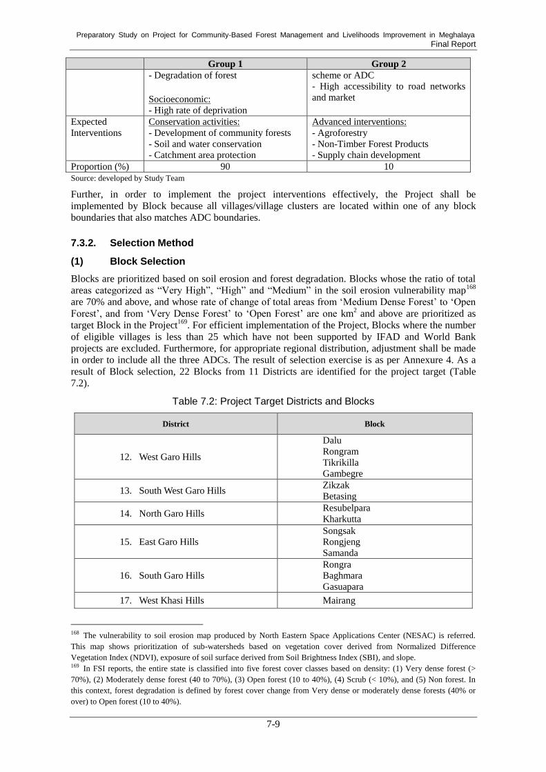
Preparatory Study on Project for Community-Based Forest Management and Livelihoods Improvement in Meghalaya Final Report
7-9
Group 1 Group 2
- Degradation of forest
Socioeconomic:
- High rate of deprivation
scheme or ADC
- High accessibility to road networks
and market
Expected
Interventions
Conservation activities:
- Development of community forests
- Soil and water conservation
- Catchment area protection
Advanced interventions:
- Agroforestry
- Non-Timber Forest Products
- Supply chain development
Proportion (%) 90 10 Source: developed by Study Team
Further, in order to implement the project interventions effectively, the Project shall be
implemented by Block because all villages/village clusters are located within one of any block
boundaries that also matches ADC boundaries.
Selection Method 7.3.2.
(1) Block Selection
Blocks are prioritized based on soil erosion and forest degradation. Blocks whose the ratio of total
areas categorized as “Very High”, “High” and “Medium” in the soil erosion vulnerability map168
are 70% and above, and whose rate of change of total areas from ‘Medium Dense Forest’ to ‘Open
Forest’, and from ‘Very Dense Forest’ to ‘Open Forest’ are one km2 and above are prioritized as
target Block in the Project169
. For efficient implementation of the Project, Blocks where the number
of eligible villages is less than 25 which have not been supported by IFAD and World Bank
projects are excluded. Furthermore, for appropriate regional distribution, adjustment shall be made
in order to include all the three ADCs. The result of selection exercise is as per Annexure 4. As a
result of Block selection, 22 Blocks from 11 Districts are identified for the project target (Table
7.2).
Table 7.2: Project Target Districts and Blocks
District Block
12. West Garo Hills
Dalu
Rongram
Tikrikilla
Gambegre
13. South West Garo Hills Zikzak
Betasing
14. North Garo Hills Resubelpara
Kharkutta
15. East Garo Hills
Songsak
Rongjeng
Samanda
16. South Garo Hills
Rongra
Baghmara
Gasuapara
17. West Khasi Hills Mairang
168 The vulnerability to soil erosion map produced by North Eastern Space Applications Center (NESAC) is referred.
This map shows prioritization of sub-watersheds based on vegetation cover derived from Normalized Difference
Vegetation Index (NDVI), exposure of soil surface derived from Soil Brightness Index (SBI), and slope. 169 In FSI reports, the entire state is classified into five forest cover classes based on density: (1) Very dense forest (>
70%), (2) Moderately dense forest (40 to 70%), (3) Open forest (10 to 40%), (4) Scrub (< 10%), and (5) Non forest. In
this context, forest degradation is defined by forest cover change from Very dense or moderately dense forests (40% or
over) to Open forest (10 to 40%).

Preparatory Study on Project for Community-Based Forest Management and Livelihoods Improvement in Meghalaya Final Report
7-10
District Block
18. South West Khasi Hills Mawkyrwat
19. Ri-Bhoi Umsning
Umling
20. East Khasi Hills Mawryngkneng
Mawkynrew
21. West Jaintia Hills Thadlaskein
22. East Jaintia Hills Saipung
Total 11 Districts Total 22 Blocks
Source: developed by Study Team
(2) Village Selection
Villages/village clusters that have already been supported by the other external programs namely
Megha-LAMP and MCLLMP shall be excluded from the selection target. At the same time,
whenever applicable, villages/village clusters in unsecured/land conflict areas and those located in
areas where relocation is required are also excluded from the selection target. Village/village
clusters for the first group are prioritized based on the deprivation rate using the latest census170
. For
the second group, villages with community forests and private forests registered to ADC and
distance up to 2 km from village roads are selected from the Blocks prioritized according to ratio of
area categorized as “Low” and “Very Low” in the soil erosion vulnerability map. Adjustment shall
be made in order to select villages/village clusters from all three ADCs. Finally, site verification is
conducted in candidate villages/village clusters. In the site verification, villages/village clusters that
do not meet requirements in terms of the local physical/natural environment and socioeconomic
conditions are excluded from the project target. At the same time, villages/village clusters that do
not express willingness to participate in the project are also excluded from the project target (Table
7.3).
Table 7.3: Selection Criteria for Target Blocks and Villages/Village Clusters
No. Criteria
Step 1: Selection of Blocks
1
Select blocks based on vulnerability to soil erosion:
1) Blocks whose total ‘very highly vulnerable’, ‘highly vulnerable’ and ‘medium’
rate of vulnerability to soil erosion areas are 70 % and above.
Prioritize blocks based on degradation rate:
2) Blocks whose rate of change of total areas from ‘Medium Dense Forest’ to
‘Open Forest’, and from ‘Very Dense Forest’ to ‘Open Forest’ are 1 km2 and
above.
Exclude blocks based on the number of villages supported by other donor projects:
3) Exclude the block which has below 25 number of villages which have not been
supported by IFAD and World Bank projects.
Include blocks under all ADC’s jurisdiction:
4) Include ‘Thadlaskein’ and ‘Saipung’ blocks which are closest to threshold (the
total ‘very highly vulnerable’, ‘highly vulnerable’ and ‘medium’ rate of
vulnerability to soil erosion are 70 % and above) from Jaintia Hills Blocks
because there is no Jaintia Hills block in the selected blocks.
170
In this site selection, deprivation is described by all or some of the following parameters: (1) households with only
one room, kuccha walls and kuccha roof, (2) No adult member in household between age 18 and 59, (3) Female headed
household with no adult male member between 16 and 59, (4) Households with differently able member with no other
able bodied adult member, (5) Households with no literate adult above age 25 years, and (6) Landless households deriving
a major part of their income from manual labour.

Preparatory Study on Project for Community-Based Forest Management and Livelihoods Improvement in Meghalaya Final Report
7-11
No. Criteria
Step 2: Exclusion of villages/village clusters
2
Exclude villages/village clusters previously supported by Megha-LAMP or MCLLMP.
Exclude villages/village clusters in unsecured/land conflict areas (if applicable)
Exclude villages/village clusters in areas where relocation is required.
Step 3: Selection/Prioritization of villages/village clusters for Group 1
3
Select villages based on deprivation rate:
- Prioritize villages in descending order of deprivation rate from selected Blocks.
- Conduct site verification.
- Exclude villages/village clusters that do not meet requirements in local environment
and conditions.
- Exclude villages/village clusters that do not express willingness to participate in the
Project.
- Select 20 ~ 25 villages per one Block in descending order of deprivation rate from
selected Blocks.
Step 4: Selection/Prioritization of villages/village clusters for Group 2
4
Prioritize Blocks based on vulnerability to soil erosion:
- Prioritize Blocks in descending order of total areas of vulnerability to soil erosion
are ‘Very Low’ or ‘Low’ from selected Blocks.
Select villages with forest conservation schemes and accessibility to road networks
- Select 50 villages with community forests and private forests registered to ADC and
distance up to 2 km from village roads.
Source: developed by Study Team
Prioritized Project Sites 7.3.3.
Figure 7.1 illust rates the selected target Blocks of the Project.
Source: developed by Study Team
Figure 7.1: Target Blocks of the Project
JICA Blocks (22)
(GH: 14, KH: 6, JH: 2)

Preparatory Study on Project for Community-Based Forest Management and Livelihoods Improvement in Meghalaya Final Report
7-12
7.4. Overview of the Proposed Project
Logical Framework 7.4.1.
Logical framework of the entire scope of the Project is presented in the following page. The Project
will be designed according to this logical framework.

Preparatory Study on Project for Community-Based Forest Management and Livelihoods Improvement in Meghalaya Final Report
7-13
Logical Framework
Project for Community-Based Forest Management and Livelihoods Improvement in Meghalaya
Original Draft (Prepared on 2019.07.16) Project Duration: 2019 to 2029
Version history: Version 0 Target Group: Communities in Meghalaya State
NARRATIVE SUMMARY OPERATION AND EFFECT INDICATORS MEANS OF
VERIFICATION
IMPORTANT
ASSUMPTIONS
Overall GOAL
To contribute to conservation of environment and biodiversity, and
uplifting of socio-economic conditions of people in Meghalaya State.
PROJECT PURPOSE
To restore and conserve natural resources within the target villages in
Meghalaya State.
1. Accessibility to water is increased by 40 %
2. Soil erosion is decreased by 50 %
1. Baseline survey and
impact assessment
2. Records of FD of ADCs
budget and interviews to
ADCs
There is no major
natural disaster that
adversely affect the
project areas.
OUTPUTS
1. Restoration of degraded forest areas and forest conservation is
implemented through sustainable community forest management.
1.1 500 of CR/VRF/CF are registered
1.2 22,500 ha of forests are managed. 1.3 22,500 ha of community/privately owned
forests are demarcated with maps
1.1 Baseline survey and
records of FD of ADCs
1.2 Records of FED/FD of
ADCs
1.3 Records of FED/FD of
ADCs
- There is continuing
commitment from the
Government of
Meghalaya and Jaintia
Hills, Khasi Hills, and
Garo Hills Autonomous
District Councils
‐ Laws and policies
related to the project are
not changed adversely
- Security and political
conditions are stable

Preparatory Study on Project for Community-Based Forest Management and Livelihoods Improvement in Meghalaya Final Report
7-14
2. Inclusive community development is promoted by facilitating
women and youths’ active participation and livelihoods of
community people is improved by providing alternative
livelihood means.
2.1 Women occupy more than 33 % of the
project sub-committee members,
specifically chairperson and vice
chairperson on average.
2.2 The portion of women and youths’
participants in the project activities,
including forest management, GIS
mapping, micro-planning, IGA, etc. is
increased.Target will be decided in the time
of baseline survey.
2.3 Average number of household income
sources are increased and annual total
household income of target villages is
increased by 30 %
2.4 On at least 22 kinds of enterprise,
feasibility study and market research are
conducted, based on which enterprise
development are promoted.
2.1 Record of Village
Implementation
Committees
2.2 Baseline survey and impact
assessment
2.3 Baseline survey and impact
assessment
2.4 Impact assessment
3. Capability and capacity of community and governmental
institutions is strengthened.
3.1 100 % of concerned institutions uses GIS
related techniques for planning and
monitoring
3.1 Report of
SPMU/DPMU/BPMU

Preparatory Study on Project for Community-Based Forest Management and Livelihoods Improvement in Meghalaya Final Report
7-15
Activities
0. Preparation
0.1 Setting up State Project Management Unit (SPMU) and other
required units.
0.2 Selection of Project Management Consultant (PMC)
0.3 Preparation of all manuals including O&A, procurement, and
micro-planning
0.4 Selection of NGOs and community facilitators
0.5 Site verification and selection of target villages
1. Sustainable Forest Management (Component 1)
1.1 Participatory land use planning
1.2 Restoration of degraded forest areas
1.3 Forestry nursery 1.4 Conservation and protection of existing forests and biodiversity
1.5 Forest research
1.6 Soil and water conservation for forest management
2. Community Development and Livelihood Improvement
(Component 2)
2.1 Community mobilization and gender sensitization
2.2 Micro planning
2.3 Entry Point Activities (EPAs)
2.4 SHG Activities
2.5 Soil and water conservation for livelihood improvement
3. Institutional Strengthening (Component 3)
3.1 Capacity development
3.2 Monitoring and evaluation
3.3 Infrastructure and mobility
3.4 PR and publicity
3.5 PMU establishment
Inputs
1. International Experts in the following field:
1) Co-Team Leader/Community Forestry
(16M/M)
2) GIS & Remote Sensing (7M/M)
Sub-Total: 23M/M
2. National Experts in the following field:
3) Team Leader/Livelihood (47M/M)
4) Capacity Development and Gender (26M/M)
5) MIS and M&E (20M/M)
6) Forestry and Biodiversity (14M/M)
7) Soil and Water Conservation (11M/M)
8) Marketing (16M/M)
9) Community-based Enterprise Development
or Ecotourism (11M/M)
10) Agriculture/Agforestry (21 M/M) Sub-Total: 166M/M
3. Equipment:
Equipment necessary for the project
implementation such as office equipment
4. Trainings/Workshops:
Source: developed by Study Team

Preparatory Study on Project for Community-Based Forest Management and Livelihoods Improvement in Meghalaya Final Report
7-16
Project Phase 7.4.2.
Figure 7.2 shows the organizations of project components and flow of three phases. The Project
under formulation is planned to have implementation period of 10 years, whereas the loan agreement
period will be 13 years after the loan agreement becomes effective. The entire project implementation
period will consist of three phases including: Preparatory Phase (24 months), Implementation Phase
(72 months), and Consolidation Phase (Phase out) (24 months).
The Project has three key components including: (1) Sustainable Forest Management, (2)
Community Development and Livelihood Improvement, and (3) Institutional Strengthening. A
supplemental component to the Project is Project Management Consultant.
Source: developed by Study Team
Figure 7.2: Organizations of Project Components and Flow of Three Phases
Preparatory Phase
The Preparatory phase is crucial for successful implementation of the Project and involves various
activities. This phase will start with institutional arrangement. State Project Management Unit
(SPMU) and other required units including District Level Project Management Unit (DPMU) and
Block Level Project Management Unit (BPMU) will be established. Orientation for SPMU and the
other units will be conducted. Project Management Consultants (PMC) and NGOs will be selected.
Target villages/village clusters will be selected through site verification by batch. Community
mobilization workshops will be conducted at the selected villages/village clusters in prior to
preparing for land use plans and micro plans. Entry Point Activity (EPA) will be conducted while
waiting for approval of the micro plans. All manuals including Operation & Accounting procedure,
procurement and micro planning manuals, and compendium of on-going government
programmes/schemes will be prepared. Remote sensing satellite data will be also procured, and
necessary maps will be prepared using the remote sensing satellite data.
Implementation Phase
In the Implementation phase, activities for all components including sustainable forest management
and community development and livelihood improvement will be carried out. Based on the land use
plans and micro plans, forest management activities, livelihood improvement and enterprise
Year 1 2 3 4 5 6 7 8 9 10
Project Period: 2019/20 - 2029/30
Preparatory Phase2 years
・Establish SPMU and other units
・Select PMC
・Select NGOs and community facilitator
・Prepare Operation Manuals,
and other manuals
・Conduct site verification and select
target villages
・Conduct baseine survey
・Implement EPA
・Provide necessary facilities
Consulting Services by PMCInternational/ National/ Supporting
・Internalize knowledge, experience,
good practice, and lessons learned
・Transfer charges of all assets and
document
Implementation Phase6 years
Consolidation Phase2 years
Batch 12 years
Batch 22 years
Batch 32 years
Preparatory Activities Activities for SustainabilityComponent 1: Sustainable Forest Management
Component 2: Community Development & Livelihood Improvement
Component 3: Institutional Strengthening

Preparatory Study on Project for Community-Based Forest Management and Livelihoods Improvement in Meghalaya Final Report
7-17
development activities, and soil and water conservation activities will be conducted in the first batch
of villages. These project activities will be also conducted in subsequent batches of target villages in
a phased manner. Moreover, monitoring and evaluation of the progress of the project activities will
be conducted in this phase.
Consolidation Phase (Phase-out)
In the Consolidation phase, the sustainability of assets created under the Project will be ensured by
internalizing lessons learnt from the project activities, experiences, and procedures, and transferring
charges of all assets and documents.
Table 7.4 shows tentative project phases and main activities during each phase.
Table 7.4: Tentative Project Phases and Activities
Phase Year Project Activities
Preparatory phase 2019/20-2021/22 (two
years)
Setting up State Project Management Unit (SPMU)
and other required units, selection of Project
Management Consultants (PMC), preparation of all
manuals including Operational & Accounting
procedures (Operation Manual providing detailed
guidelines for project implementation), procurement
and micro planning manuals, compendium of
on-going government programs/schemes, selection
of resource organizations/teams of NGOs, detailed
remote sensing satellite data based mapping and
analysis, finalization of selection criteria, orientation
of SPMU and other required units, finalization of the
first batch of target villages, initiating required
strengthening/development of infrastructure, site
preparation, and selection of sites for raising
nurseries for quality planting material and baseline
surveys in the first batch.
Implementation phase 2021/22-2027/28 (six
years)
Preparing implementation plans in the first batch of
villages and activities, including forestry
interventions as well as community development and
IGAs (livelihood improvement and enterprise
development), selection of remaining project village,
and implementing project activities in subsequent
batch of villages in phased manner.
Consolidation phase 2028/29-2029/30 (two
years)
Ensuring sustainability of assets created under the
Project, internalizing project learning, experiences,
procedures, and best practices evolved in the course
of project implementation, and transferring charges
of all assets created under the Project and documents. Source: Pre-DPR

Preparatory Study on Project for Community-Based Forest Management and Livelihoods Improvement in Meghalaya Final Report
7-18
Implementation by Batches 7.4.3.
Considering the other states’ cases, the implementation phase will be tentatively divided into
several batches; each batch has a two-year period.
Table 7.5: Image of Batch-wise Target Outputs
Batch 1 Batch 2 Batch 3
Year 2019/20-2021/22 2021/22-2023/24 2023/24-2025/26
Implementation
activities conducted 30 % 40 % 30 %
Source: developed by Study Team
Preparatory Works for Participatory Approach 7.4.4.
Activities under the Project are site-specific in order to address the diverse needs which differ from
one village to another. Therefore, the Project will apply a participatory approach throughout the life
of the Project starting from planning, implementing, and operating to maintenance by sensitizing
and engaging people. Preparatory works will be conducted in the following order in the two-year
preparatory phase.
Community Mobilization and Constitution of Committee for the Project (Component 2.1)
The first step of preparatory works to engage people is community mobilization. Block Project
Management Unit (BPMU) will invite village elders and Village Employment Council (VEC) for
the first contact and explain the Project. Once they show willingness to participate in the Project,
BPMU will support communities to formulate Village Project Implementation Committee (VPIC)
as a sub-committee of VEC.
BPMU will conduct sensitization workshops to ensure that all the stakeholders including minor
groups such as women and youth.
Participatory Land Use Planning (Component 1.1)
Once VPIC is formulated in a village, NGOs and BPMU will facilitate VPIC to develop
participatory land use plan. Officers from FED, SWCD and ADCs, who are members of VPIC will
also provide technical support for participatory land use planning. Land use plan is a fundamental
document based on which all the project activities will be planned and carried out.
Micro Planning (Component 1.1 and 2.2)
VPIC will make Micro Plan in a participatory manner based on participatory land use plan. NGOs
and BPMU will provide VPIC with technical support to formulate Micro Plan. Micro Plan under
the Project is an integrated plan comprising three plans, namely forest management plan, watershed
conservation plan and income generation plan. In making Micro Plan, VPIC may choose
implementing mode in terms of sustainable forest management and create appropriate
sub-committee depending on the objectives. In case VPIC choose to implement sustainable forest
management by Joint Forest Management supported by FED, VPIC will formulate JFM Committee
and prepare micro plan according to relevant guidelines and Government Order. VPIC will
constitute Community Reserve Management Committee (CRMC) in case they decide to register the
forest to Community Reserve. If VPIC will decide to register their forests to ADCs’ conservation
schemes, they will constitute required committee including Village Reserve Committee (VRC)
7.5. Project Components
The Project has three core project components and one supplemental component to achieve the
project objective.

Preparatory Study on Project for Community-Based Forest Management and Livelihoods Improvement in Meghalaya Final Report
7-19
Component 1. Sustainable Forest Management
Component 2. Community Development and Livelihood Improvement
Component 3. Institutional Strengthening
Supplemental Component. Project Management Consultant
The overview of the components of the Project for Community-Based Forest Management and
Livelihoods Improvement in Meghalaya is as given below (Table 7.6).
Table 7.6: Outline of the Project
Key Work Quantities
District: 11
Block: 22
Target Village: 500
Target Area of Sustainable Forest Management: 22,500 ha
SHGs to be Covered: 1,000
1. Sustainable Forest Management
1.1 Participatory Land Use Planning
1.1.1 Land Use Planning of Selected Sites at 1:10,000 Scale
1.1.2 Facilitation of Participatory Land Use Planning at Communities
1.2 Restoration of Degraded Forest Areas
1.2.1 Constitution of JFMC and Preparation for JFMC Micro-Plan
1.2.2 Registration of VRF/CF and Preparation for Resolution
1.2.3 Restoration of Timber Resources (ANR with Enrichment Plantation)
1.2.4 Restoration of Natural Vegetation (ANR)
1.2.5 Afforestation on Barren Land (AR)
1.2.6 Restoration of Shifting Cultivation Areas (ANR)
1.2.7 Restoration of Degraded Lands due to Quarrying (ANR)
1.2.8 Improvement of Corridors (ANR)
1.3 Forestry Nursery
1.3.1 Creation of Permanent Nurseries
1.3.2 Improvement of Existing Nurseries
1.3.3 Creation of Community Nurseries
1.4 Conservation of Forests in Good Conditions
1.4.1 Constitution of Community Reserve and Preparation for Community Reserve Management Plan
1.4.2 Preparation for Working Schemes
1.4.3 Establishment of New Check Points
1.5 Forest Research
1.6 Soil and Water Conservation for Forest Management
1.6.1 Bench Terracing (Eathen Structures)
1.6.2 Earthen/Loose Boulder Contour Bunds
1.6.3 Earthen/Loose Boulder Box Terracing
1.6.4 Construction of RCC Check Dam
1.6.5 Construction of Minor Irrigation Check Dam
1.6.6 Construction of Conservation Pond (which can be also used for fishery)
1.6.7 Construction of Conservation Pond/Dug out Pond
1.6.8 Construction of RCC Water Storage Tank for Drinking Water
1.6.9 Construction of Spring Tapped Chamber
2. Community Development and Livelihood Improvement
2.1 Community Mobilization and Gender Sensitization
2.1.1 Community Mobilization Workshops
2.1.2 Gender-sensitization Workshop/Gender Training
2.2 Micro-planning
2.2.1 Training/Workshops on How to Make a Micro Plan
2.2.2 Conducting PRA
2.2.3 Planning a Micro Plan Converged with Available National/State Schemes

Preparatory Study on Project for Community-Based Forest Management and Livelihoods Improvement in Meghalaya Final Report
7-20
Source: developed by Study Team
2.3 Entry Point Activities (EPAs)
2.3.1 Prioritization of EPAs
2.3.2 Conducting EPAs
2.4 SHG Activities
2.4.1 Selection of SHGs in Each Selected Village
2.4.2 Micro-credit Activity
2.4.2.1 Providing Revolving Fund per Village
2.4.2.2 Training/Workshop on Micro-credit Activity
2.4.3 Income Generation Activities (IGAs)
2.4.3.1 Training Needs Assessment/Market Research
2.4.3.2 Training and Exposure Visits
2.4.3.3 Provision of Seed Money for Each Selected SHG
2.4.3.4 Construction of Facility/Infrastructure Necessary for IGAs
2.4.4 Enterprise Development Activities
2.4.4.1 Feasibility Studies & Pilot Projects for Enterprise Development
2.5 Soil and Water Conservation for Livelihood Improvement
2.5.1 Construction of Rainwater Harvesting Structure
2.5.2 Construction of Drinking Water Tank
3. Institutional Strengthening
3.1 Capacity Development
3.1.1 Training Needs Analysis
3.1.2 Training, Exposure Visits and Workshops
3.1.3 JICA Forestry Sector Annual Workshop
3.1.4 NGOs/Resource Organizations
3.2 Monitoring and Evaluation
3.2.1 Baseline Survey
3.2.2 Setting Target for the Operation and Effect Indicators
3.2.3 Annual Planning and Review Meetings
3.2.4 Concurrent Monitoring
3.2.5 Statutory Audit
3.2.6 Mid-term Evaluation
3.2.7 Terminal Evaluation
3.2.8 MIS and GIS Monitoring
3.3 Infrastructure and Mobility
3.3.1 Office Buildings
3.3.2 Vehicles and Motorbikes
3.3.3 GIS/MIS
3.3.3.1 Enhancement of GIS/MIS Facilities
3.3.3.2 Map Preparation
3.4 PR and Publicity
3.5 PMU Establishment
3.5.1 Establishment of SPMU/DPMU/BPMU
3.5.2 Deployment and Recruitment of Staff
3.5.3 Establishment of Management Bodies
3.5.3.1 Governing Body
3.5.3.2 Executive Committee
3.5.3.4 External Advisory Committee
3.5.4 Preparation of Manuals and Accounting Systems
3.6 Procurement of PMC
3.7 Overseas Training

Preparatory Study on Project for Community-Based Forest Management and Livelihoods Improvement in Meghalaya Final Report
7-21
Component 1: Sustainable Forest Management 7.5.1.
To restore and conserve natural resources within villages aiming at conserving the environment and
biodiversity and improving socio-economic conditions of community members, the following
activities will be conducted under Component 1. Sustainable Forest Management during the project
period (Table 7.7).
Table 7.7: Activities for Sustainable Forest Management
Sec. No. Activity Site
selection Survey/ design Construction/ O&M
C1.1 Participatory Land Use Planning
C1.1.1 Land Use Planning of selected
site at 1:10,000 Scale FED/ADC FED/ADC FED/ADC
C.1.1.2 Facilitation of Land Use
Planning at Communities FED/ADC
Community
with support
from NGO
Community
C1.2 Restoration of Degraded Forest Areas
C1.2.1
Constitution of JFMC and
Preparation for JFMC
Micro-plan
FED/ADC/ JFMC
FED/ JFMC
JFMC
C1.2.2 Registration of VRF/CF and
Preparation for Resolutions Community ADC Community
C1.2.3
Restoration of Timber
Resources (ANR with Enrichment Planting)
FED/ADC/ Community
FED/ADC/ Community
Community
C1.2.4 Restoration of Natural
Vegetation (ANR) FED/ADC/ Community
FED/ADC/ Community
Community
C1.2.5 Afforestation of Barren Land
(AR) FED/ADC/ Community
FED/ADC/ Community
Community
C1.2.6 Restoration of Shifting
Cultivation FED/ADC/ Community
FED/ADC/ Community
Community
C1.2.7 Restoration of Degraded Lands
due to Quarrying FED/ADC/ Community
FED/ADC/ Community
Community
C1.2.8 Improvement of Corridors FED/ADC/ Community
FED/ADC/ Community
VRC
C1.3 Forestry Nursery
C1.3.1 Creation of New Permanent
Nurseries ADC ADC ADC
C1.3.2 Improvement of Existing
Permanent Nurseries FED FED FED
C1.3.3 Creation of Community Nurseries
FED/ADC FED/ADC Community
C1.4 Conservation of Forests in Good Conditions
C1.4.1
Constitution of Community
Reserve and Preparation for
Community Reserve
Management Plan
FED FED CR Management Committee
C1.4.2 Preparation for Working
Schemes
ADC/Forest
owner
ADC with support from
FED
Forest owner under
supervision of ADC
C.1.4.3 Establishment of New Check
Points ADC ADC ADC
C1.5 Forest Research FED FED FED Source: developed by Study Team
“Community” in Table 7.7 indicates either VPIC, JFMC, CRMC or VRC depending on the
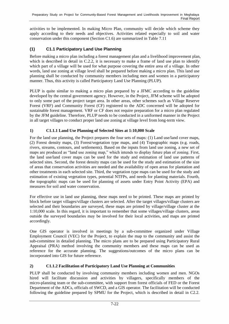
Preparatory Study on Project for Community-Based Forest Management and Livelihoods Improvement in Meghalaya Final Report
7-22
activities to be implemented. In making Micro Plan, community will decide which scheme they
apply according to their needs and objectives. Activities related especially to soil and water
conservation under this component (Section C1.6) are summarized in Table 7.11
(1) C1.1 Participatory Land Use Planning
Before making a micro plan including a forest management plan and a livelihood improvement plan,
which is described in detail in C.2.2, it is necessary to make a frame of land use plan to identify
which part of a village will be used for what purpose covering the entire area of a village. In other
words, land use zoning at village level shall be prepared before making a micro plan. This land use
planning shall be conducted by community members including men and women in a participatory
manner. Thus, this activity is called Participatory Land Use Planning (PLUP).
PLUP is quite similar to making a micro plan prepared by a JFMC according to the guideline
developed by the central government agency. However, in the Project, JFM scheme will be adopted
to only some part of the project target area. In other areas, other schemes such as Village Reserve
Forest (VRF) and Community Forest (CF) registered to the ADC concerned will be adopted for
sustainable forest management. VRF or CF does not require preparation for a micro plan regulated
by the JFM guideline. Therefore, PLUP needs to be conducted in a uniformed manner in the Project
in all target villages to conduct proper land use zoning at village level from long-term view.
1) C1.1.1 Land Use Planning of Selected Sites at 1:10,000 Scale
For the land use planning, the Project prepares the four sets of maps: (1) Land use/land cover maps,
(2) Forest density maps, (3) Forest/vegetation type maps, and (4) Topographic maps (e.g. roads,
rivers, streams, contours, and settlements). Based on the inputs from land use zoning, a new set of
maps are produced as “land use zoning map,” which intends to display future plan of zoning. First,
the land use/land cover maps can be used for the study and estimation of land use patterns of
selected sites. Second, the forest density maps can be used for the study and estimation of the size
of areas that conservation activities are needed and the availability of open areas for plantation and
other treatments in each selected site. Third, the vegetation type maps can be used for the study and
estimation of existing vegetation types, potential NTFPs, and needs for planting materials. Fourth,
the topographic maps can be used for planning of assets under Entry Point Activity (EPA) and
measures for soil and water conservation.
For effective use in land use planning, these maps need to be printed. These maps are printed by
block before target villages/village clusters are selected. After the target villages/village clusters are
selected and their boundaries are surveyed, these maps are printed by village/village cluster at the
1:10,000 scale. In this regard, it is important to remember that some villages/village clusters, areas
outside the surveyed boundaries may be involved for their local activities, and maps are printed
accordingly.
One GIS operator is involved in meetings by a sub-committee organized under Village
Employment Council (VEC) for the Project, to explain the map to the community and assist the
sub-committee in detailed planning. The micro plans are to be prepared using Participatory Rural
Appraisal (PRA) method involving the community members and these maps can be used as
reference for the accurate planning. The suggestions/outcomes of the micro plans can be
incorporated into GIS for future reference.
2) C1.1.2 Facilitation of Participatory Land Use Planning at Communities
PLUP shall be conducted by involving community members including women and men. NGOs
hired will facilitate discussion and activities by villagers, specifically members of the
micro-planning team or the sub-committee, with support from forest officials of FED or the Forest
Department of the ADCs, officials of SWCD, and a GIS operator. The facilitation will be conducted
following the guideline prepared by SPMU for the Project, which is described in detail in C2.2.

Preparatory Study on Project for Community-Based Forest Management and Livelihoods Improvement in Meghalaya Final Report
7-23
Major steps of the facilitation of PLUP are shown in Table 7.8.
Table 7.8: Steps of Facilitation for PLUP
Step Work Item Activities
1 Preparatory meeting BPMU officers and NGO concerned will organize a preparatory meeting
with the village head and other representatives of the village to explain
the purpose and outlines of PLUP.
2 Orientation meeting NGO will hold an orientation meeting for villagers, especially the
members of the sub-committee, to explain the objective, procedure, and
methods of each activity for PLUP. During the meeting, the villagers
will also discuss a vision of the village, including what kind of the
environment and livelihood they want to have in 30 years.
3 Community sketch map
preparation
Villagers, mainly the sub-committee members, will prepare a community
sketch map including information on current land use, forest conditions,
water resources, and farm lands in order to understand the current land
use and natural resources and develop a shared understanding on them
among villagers.
4 Comparison between the
community sketch map
and the map prepared
using GIS
The community sketch map will be compared to the 1:10,000 scale map
prepared using GIS in order to understand the current land use, forest
conditions, and natural resources objectively in terms of area and
location.
5 Land use zoning Based on the objective understanding and spatial information visualized
on the land use base map, villagers will discuss appropriate land use
zoning to achieve their vision while maximizing benefits for the entire
community including land owners from long-term view. If there is
possibility for land owners to receive negative impacts of the land use
zoning, measures to avoid them will be discussed. Finally, a land use
zoning map will be prepared.
6 Identification of sites for
the project intervention
Based on the land use zoning map, the villagers will identify target areas
of the Project for sustainable forest management, soil and water
conservation, and livelihood improvement.
Source: developed by Study Team
(2) C1.2 Restoration of Degraded Forest Areas
To achieve the project objective, degraded forest areas shall be restored through forest operations
such as assisted natural regeneration (ANR) and artificial regeneration (AR). Since most of forests
in the state belong to communities or individuals, such forest operations will be conducted by
communities with support from FED or the Forest Departments of the ADCs. In this regard, an
agency or committee for the implementation of forest restoration activities at village level shall be
first constituted. The constituted agency or committee will prepare a plan of forest management
including use. In the following sections, organization of the agency or committee and preparation
for the management plan will be first explained. Next, detail implementation plans of each type of
restoration activity categorized by the drivers of forest degradation will be described.
1) C1.2.1 Constitution of JFMC and Preparation for JFMC Micro-Plan
Justification and Objectives
According to the Joint Forest Management (JFM) Circular issued by the Government of India (GoI)
in 1990 and the JFM guidelines subsequently issued in 2000 and 2002, the Government of
Meghalaya introduced JFM in 2003 by promulgation of the notification No. FOR. 64/99/186. As of
February 2019, 366 Joint Forest Management Committees (JFMCs) were developed covering
30,741 ha of forests in total. This achievement implies that JFM is applicable in the state and that
FED has enough experience for implementation of JFM, so that it is reasonable to adopt JFM as
one of schemes for the implementation of community-based forest management in the Project.

Preparatory Study on Project for Community-Based Forest Management and Livelihoods Improvement in Meghalaya Final Report
7-24
JFMCs will be constituted for the implementation of restoration of degraded forests conducted by
FED’s initiatives.
Steps and Method
A JFMC will be constituted in target villages of the Project according to the aforementioned
notification by the Divisional Forest Officer in consultation with ADC concerned. JFMC shall
consist of General Body (GB) and Executive Committee (EC). The former consists of an adult
member from each household and the latter consists of a chairman, a vice chairman and seven other
members. Out of seven, five members shall be elected by GB, one member shall be nominated by
the ADC concerned, and another member shall be nominated by FED, who shall be the member
secretary of EC as well as the secretary of the GB.
After the constitution, JFMC shall prepare a micro plan according to the JFM guidelines issued by
Ministry of Environment and Forest in 2000. In the Project, detail methods and procedure of
making a micro-plan shall follow the guideline prepared by the Project for keeping uniformity in all
target villages including those which manage forest by other schemes. The methods and procedure
are described in C2.2 in detail.
Responsibility
FED will be responsible for constitution of JFMCs. Active participation of ADCs will be required
in constitution of JFMCs. Regarding the preparation for a micro-plan, JFMCs will primarily be
responsible for formulation of a JFMC micro plan, which replaces a forest management plan of a
micro plan uniformly prepared in the Proejct, but other members of the sub-committee or the
micro-planning team will also be responsible for making a micro plan including a livelihood
improvement plan and a soil and water conservation plan. Forest officials of Beat office and NGOs
will facilitate preparation of a JFMC micro-plan by the JFMC and other members of the
sub-committee with support from other officials concerned.
2) C1.2.2 Registration VRF/CF and Preparation for Resolution
Justification and Objective
More than 90 % of forest areas belong to communities or individuals in the state and such forest
area is administered by the ADCs. According to the Garo Hills ADC (Forest) Act 1958,
communities can register their community forest as a Village Reserve Forest (VRF) to the ADC.
Although the Khasi Hills ADC and Jaintia Hills ADC do not have any specific schemes like VRF in
Garo Hills ADC, communities can register their own forests to the ADCs as “Community Forest
(CF)”. Communities which have registered their own forests as either VRF or CF to the ADCs will
be used as an implementation agency at village level for the implementation of restoration of
degraded forests in the Project.
Steps and Method
Registration of VRF or CF and preparation for resolution in each VRF or CF will be proceeded
following steps and methods. Major steps of constitution of VRF in Garo Hills ADC are described
below:
Step 1: The Forest Department of Garo Hills ADC will explain target villages of the Project
about constitution of VRF, and identify target villages for the restoration of forest
vegetation.
Step 2: The Forest Department of the ADC will make a survey and demarcate the target area in
collaboration with communities concerned and prepare a digital map of the area with
support from FED upon necessity.
Step 3: A Village Reserve Committee (VRC) shall be organized chaired by Nokma for
management of the VRF.

Preparatory Study on Project for Community-Based Forest Management and Livelihoods Improvement in Meghalaya Final Report
7-25
Step 4: The VRC prepares a resolution to manage the VRF.
At the same time, the procedure for the registration of CF in Jaintia Hills ADC and Khasi Hills
ADC is as follows:
Step 1: The Village Head fills out an application form for the registration of community forest.
Step 2: Traditional Authority, Dolloi (Aking), which is a vested authority from the District
Council, approves the application.
Step 3: The Forest Department of ADCs dispatches their staff to the site and conduct survey and
inquiry.
Step 4: After the survey, the Forest Department issues a letter of claim and objection within 30
days.
Step 5: The Forest Department issues a certificate with TOR on forest management which the
village needs to follow. The village also prepares their own detailed rules of forest use.
Step 6: Village Head implements forest management with the Executive Committee. Village
Head holds a village meeting, Dorbar, with all villagers once per year and discuss the
implementation of forest management activities
3) C1.2.3 Restoration of Timber Resources (ANR with Enrichment Planning)
Justification and Objectives
ANR with enrichment planning shall be applied to degraded areas by illegal felling or over felling
in order to restore timber resources either for domestic or commercial purposes for the future. In
case an owner of the forest is willing to fell trees for commercial purpose, the forest shall be
registered to Working Scheme.
Steps and Method
ANR with Enrichment Planting will be conducted following the below steps and methods every
year (Table 7.9).
Table 7.9: Steps and Methods of Restoration of Timber Resources
Step Work Item Method
Preliminary Year
1 Site selection A site for ANR with enrichment planting will be selected through
discussion among community members by the following criteria: (i) a
site degraded due to illegal felling, or disordered or over felling for
timber production, and (ii) a site will be used for timber production
either for domestic or commercial purposes.
2 Tree species selection Tree species suitable for timber will be selected considering natural
conditions in the planting site by community members with advice
from forest officials. Major candidate species are Piunus kesiya for
Jaintia Hills and Khasi Hills ADCs’ areas, and Sal (Sorea robusta)
for Garo Hills ADC area.
3 Survey and demarcation The selected site will be surveyed using GPS, and the boundary will
be marked at strategic points.
4 Jungle clearance and land
preparation
Unnecessary trees and shrubs will be cut and removed to create space
for planting timber species. Pits of 30 cm x 30 cm x 30 cm size will
be dug in blank areas for planting seedlings. In case of ANR, 200
seedlings will be planted per ha.

Preparatory Study on Project for Community-Based Forest Management and Livelihoods Improvement in Meghalaya Final Report
7-26
Step Work Item Method
5 Fencing A fence will be made along the boundary with peripheral earthen
bunds and local materials such as bamboo and timber.
First Year of Plantation
1 Vacancy filling Mortality areas will be identified and new seedlings will be planted in
the areas.
2 Weeding Weeding will be conducted three times in the same manner as the
first year.
3 Fire protection Fire line clearance and fire watch will be conducted in the same
manner as the first year.
Second Year of Plantation
1 Vacancy filling Mortality areas will be identified and new seedlings will be planted in
the areas.
2 Weeding Weeding will be conducted three times in the same manner as the
first year.
3 Fire protection Fire line clearance and fire watch will be conducted in the same
manner as the first year.
Third Year of Plantation
1 Vacancy filling Vacancy filling will be conducted whenever necessary in the same
manner as the second year.
2 Weeding Weeding will be conducted two times in the same manner as the first
year.
3 Fire protection Fire line clearance and fire watch will be conducted in the same
manner as the first year.
Fourth Year of Plantation
1 Weeding Weeding will be conducted one time in the same manner as the first
year.
2 Fire protection Fire line clearance and fire watch will be conducted in the same
manner as the first year.
Fifth Year of Plantation
1 Weeding Weeding will be conducted one time in the same manner as the first
year.
2 Fire protection Fire line clearance and fire watch will be conducted in the same
manner as the first year.
3 Singling Out Singling out will be conducted to provide proper spacing from one
plant to another. Source: developed by Study Team
Responsibility
Community members in target villages play a main role to create and maintain the plantation with
technical advice and support from forest officials of FED or the Forest Department of ADCs.
4) C1.2.4 Restoration of Natural Vegetation (ANR)
Justification and Objective
Vast areas in the state are degraded due to over extraction of forest resources including firewood,
materials for charcoal making, and other NTFPs. Such degraded forests need to be restored and
conserved in order to fulfil communities’ needs and wishes. Although the areas are degraded, they
still have some trees and high potential of natural regeneration. Thus, ANR by planting indigenous
tree species including bamboo and NTFP species shall be adopted to restore natural vegetation on

Preparatory Study on Project for Community-Based Forest Management and Livelihoods Improvement in Meghalaya Final Report
7-27
the degraded forest areas. Communities are encouraged to register the forest to conservation
schemes including VRF and CF.
Steps and Method
ANR for restoration of natural vegetation will be implemented in the same manner as those
mentioned in C1.2.1 except tree species to be planted. Instead of timber species, indigenous tree
species including bamboos and NTFP species will be planted in this activity. Tree species to be
planted will be decided by communities.
Responsibility
In the same manner as C1.2.1, the community members play a main role to create and maintain the
plantation with technical advice and support from forest officials of FED or the Forest Department
of ADCs.
5) C1.2.5 Afforestation on Barren Land (AR)
Justification and Objective
There are vast barren lands in the state, especially in Khasi Hills ADC areas, which are caused by
forest fires, sometimes coupled with over grazing. Under these circumstances, natural regeneration
of tree species is hardly expected since grass is infested and soil is compacted. Thus, AR shall be
adopted to re-generate forests on such barren lands. Communities are encouraged to register the
forest to conservation schemes including VRF and CF.
Steps and Method
Following the Cost Norms for creation and maintenance of Plantations & Nurseries 2018-2019, the
steps and method for the implementation of AR for afforestation on barren lands are basically the
same as those mentioned in C1.2.1 except the number of trees planted per hectare, spacing of tree
planting, and selection of tree species. In case of AR, 1,100 seedlings will be planted per hectare
with spacing of 3m by 3m. Tree species to be planted will be selected by community members and
vary depending on their needs.
Responsibility
In the same manner as C1.2.1, community members play a main role to create and maintain the
plantation with technical advice and support from forest officials of FED or the Forest Department
of ADCs.
6) C1.2.6 Restoration of Shifting Cultivation Areas (ANR)
Justification and Objective
Shifting cultivation with a short rotation cycles (e.g. 3 to 5 years) is one of major drivers of forest
degradation in the state, especially in the Garo Hills ADC area. If fallow lands will be left alone,
forest vegetation will naturally revive under the climate of Meghalaya, since root stocks remain on
the land, and seeds will be provided from surrounding forests. In order to accelerate restoration of
forest vegetation and introduce tree species useful for livelihood improvement, ANR will be further
adopted to restore fallow lands or degraded forest areas in the Project. Communities are encouraged
to register the forest to conservation schemes including VRF and CF.
Agroforestry will be another option to improve the forest ecosystem on fallow land and support the
livelihoods of local communities. In the Project, agroforestry will be carried out under Component
2 in the Project.

Preparatory Study on Project for Community-Based Forest Management and Livelihoods Improvement in Meghalaya Final Report
7-28
Steps and Method
Steps and methods for the implementation of ANR for restoration of shifting cultivation are the
same as those mentioned in C1.2.1 except tree species to be planted. Tree species will be selected
by community members and vary depending on their needs and wishes. They include bamboos and
NTFP species.
Responsibility
In the same manner as C1.2.1, community members play a main role to create and maintain the
plantation with technical advice and support from forest officials. However, in case of restoration of
shifting cultivation areas, forest officials of the Forest Department of Garo Hills ADC play a
particularly important role to support communities since shifting cultivation is conducted mainly in
the Garo Hills ADC areas as mentioned above.
7) C1.2.7 Restoration of Degraded Lands due to Quarrying (ANR)
Justification and Objective
Quarrying is another major driver of deforestation and land degradation in the state, especially in
the Khasi Hills ADC area. Though surface soil is removed in quarrying, pioneer trees such as pine
can grow naturally under such conditions. Fortunately, in the Khasi Hills ADC area, vast pine
forests are expanding and, in fact, it was observed that pine trees naturally grew on denuded land
after quarrying in some areas. However, in order to accelerate or ensure the restoration of forest
cover, ANR will be adopted in the Project. Communities are encouraged to register the forest to
conservation schemes including VRF and CF.
Steps and Method
ANR for restoration of degraded lands due to quarrying are implemented basically in the same
manner as those mentioned in C1.2.1 following the Cost Norms for creation and maintenance of
Plantations & Nurseries 2018-2019. However, considering unique conditions of the areas where
surface soil was removed, pioneer trees such as pine will be planted at the initial stage. Several
years after growing pine trees, mixed trees species will be planted among pine trees.
Responsibility
Basically, the community members play a main role to create and maintain the plantation with
technical advice and support from forest officials of FED or the Forest Department of the ADCs
like C1.2.1. At the same time, because it is supposed that the majority of degraded lands due to
quarrying belong to individuals, individual land owners also play a major role to restore forest
vegetation through ANR. In this regard, particularly forest officials of the ADCs need to approach
and encourage individual land owners to restore forest vegetation on the degraded areas.
8) C1.2.8 Improvement of Corridors (ANR)
Justification and Objective
Man-animal conflicts, wild elephants in most cases, are one of major issues to be addressed in the
state. A main cause of the conflicts is the fragmentation of forests due to economic development
and the expansion of shifting cultivation areas. In order to mitigate negative impacts of the conflicts,
the linkages of elephant corridors need to be improved. Specifically, forests within the corridors
shall be improved by planting tree species preferred by wild elephants, such as jackfruit, which
provide canopies for wild elephants to move and prevent wild elephants from straying into
residential areas or farm lands. Jackfruit will also contribute to improvement of livelihood of local
people by providing fruit and timber.

Preparatory Study on Project for Community-Based Forest Management and Livelihoods Improvement in Meghalaya Final Report
7-29
Steps and Method
Steps and methods for the improvement of corridors are basically the same as those mentioned in
C1.2.1 since it is carried out through ANR. Obviously, sites for this activity shall be selected in
five elephant corridors already identified in Garo Hills ADC areas.
Responsibility
Communities in target corridors take a responsibility for planting trees. As of May 2009, the five
elephant corridors have been identified in Garo Hills ADC area, and as a result, the Forest
Department of Garo Hills ADC plays a vital role to support the communities for this activity. In
addition, since both ends of each corridor are located within a National Park, Reserve Forest, or
Wildlife Sanctuary, which are managed by FED, the collaboration between the Forest Department
of the ADC and FED is required.
(3) C1.3 Forestry Nursery
To meet demands for seedlings required for the implementation of aforementioned forest
restoration or afforestation through ANR and AR, new permanent forestry nurseries will be created
under management of the ADCs and existing permanent nurseries managed by FED will be
improved. According to the policy of using quality planting materials (QPM) by FED, seedlings
with a certain quality will be produced at permanent nurseries managed by FED or the ADCs in
order to ensure high survival rate and vigorous growth of seedlings after being planted in the field.
However, because it is difficult to procure all necessary seedlings for the plantations from the
permanent nurseries and transport seedlings to all plantation sites, community nurseries will be also
established near plantation sites in some areas where nurseries can be established
1) C1.3.1 Creation of Permanent Nurseries
As of May 2019, out of three ADCs in the state, only Jaintia Hills ADC has a permanent nursery.
Based on the proposal of the ADCs and upon necessity of producing seedlings for the
implementation of aforementioned ANR and AR in forests registered as VRF or CF to the ADCs,
permanent nurseries shall be established under the ADCs. Tentative target is the establishment of
eight nurseries in the ADCs: one in Khasi Hills ADC, one in Jaintia Hills ADC, and six in Garo
Hills ADC in accordance with the estimated ratio of plantation areas in each ADC area and based
on the proposal of nursery establishment from each ADC.
Land availability and conditions of candidate sites will be examined from the following aspects:
accessibility to road, permanent water supply, proper drainage with gentle slope, supply of suitable
soil materials, and low possibility of flooding.
The specifications of the permanent nurseries are as follows: permanent nursery beds, manure
mixing space, frame and shade for protection of seedlings from frost during winter and direct
sunlight in warm areas, and fence. They correspond to the specifications indicated in the Cost
Norms for Creation and Maintenance of Plantations & Nurseries 2018-2019 prepared by FED and
also adopted in the Forest Department of the ADCs.
At the permanent nurseries newly constructed under the ADCs, seedlings will be produced by the
staff of the Forest Department of each ADC. In case of Khasi Hills ADC and Garo Hills ADC,
which do not have any nurseries at this moment, technical support may be provided by FED upon
necessity. Steps and methods of the seedling production in the first and second years are shown in
Table 7.10.

Preparatory Study on Project for Community-Based Forest Management and Livelihoods Improvement in Meghalaya Final Report
7-30
Table 7.10: Steps and Methods of Seedling Production
Step Work Item Activities
First Year
1 Preparation for seeds Collect or procure seeds from reliable sources.
2 Preparation for nursery beds Prepare standard-sized nursey beds (13 m x 1.3 m) for
placing the polythene bags.
3 Construction of fence Construct fence with posts made from wood or bamboo.
4 Preparation for mother beds Prepare mother beds including breaking clods, removing
foreign materials, mixing sand with decomposed cow
dung/compost, and sow seeds and make watering.
5 Preparation for polythene bags Collect top soil, break clods, remove foreign materials,
mix soil with sand and manure, and fill up poly bags
with the mixed soil.
6 Construction of shade Construct shade for protecting seedlings from frost
during winter and direct sunlight during summer.
7 Pricking out Prick out seedlings from mother beds and transplanting
in poly bags, and make watering.
8 Maintenance Conduct weeding and make watering.
Second Year
1 Weeding Conduct weeding three times.
2 Watering Conduct watering during dry season. Source: developed by Study Team
2) C1.3.2 Improvement of Existing Nurseries
Seedlings required for the implementation of aforementioned ANR and AR on JFM target areas
will be produced mainly at nurseries managed by FED. As of May 2019, there are 4 permanent
nurseries (central nurseries) in 3 divisions, two high tech nurseries (HTNs) in East Garo Hills
District and Ri-Bhoi District, 29 range level nurseries, and 7 beat level nurseries. In order to meet
increasing demands of seedlings for the implementation of aforementioned ANR and AR, it is
necessary to improve some of the existing nurseries by installing new facilities including a mist
chamber, vermi-compost, and sprinklers.
A tentative target is the improvement of 15 nurseries in 7 Division Forest Offices. This means that
2 to 3 existing nurseries will be upgraded in each division. DFOs will choose candidate nurseries to
be improved and decide in consultation with the FED Headquarters.
In the improved nurseries, Range Officers will be responsible mainly for seedling production under
supervision of DFO. Steps and methods of seedling production in improved nurseries are the same
as those at the newly constructed nurseries described in C1.3.1.
3) C1.3.3 Creation of Community Nurseries
Community nurseries will be established to complement shortfall of seedlings produced at the
nurseries managed by the ADCs or FED. Location of community nurseries shall be decided from
the following aspects: accessibility to road, permanent water supply, proper drainage with gentle
slope, supply of suitable soil materials, and low possibility of flooding. The location will be decided
by communities in consultation with forest officials of the ADCs or FED.
The specifications of a community nursery are as follows: temporary nursey beds, manure mixing
space, shed, mother beds, and fencing. Community nurseries will be established by community
members, especially members of committees in charge of restoration of forest vegetation, such as
JFMC and VRC, with technical support by forest officials of the ADCs or FED.
Seedling production at community nurseries will be also conducted by the community members
with technical support by forest officials of the ADCs or FED. Steps and methods of seedlings

Preparatory Study on Project for Community-Based Forest Management and Livelihoods Improvement in Meghalaya Final Report
7-31
production at community nurseries are the same as those at the permanent nurseries described in
C1.3.1.
(4) C1.4 Conservation of Forests in Good Conditions
To achieve the project objective, it is necessary to conserve forests in good conditions while
planting trees in degraded forests or barren lands to restore forest vegetation. Because more than
90 % of forests in the state belong to communities or individuals, the following three activities will
be appropriate measures for conservation of forests in good conditions.
1) C1.4.1 Constitution of Community Reserve and Preparation for Community Reserve
Management Plan
Based on section 36 of the Wildlife (Protection) Amendment Act, 2002, Community Reserve (CR)
can be constituted to protect fauna and flora, and traditional or cultural conservation rules and
practices. As of February 2019, 64 CRs have been declared by the state government.
The Wildlife Division of FED has responsibility for constitution and declaration of CR and ADCs
have responsibility for the registration. In order to constitute CR, the Wildlife Division first
conducts awareness raising for communities. Next, upon interest of a community in constitution of
CR, the Wildlife Division facilitates the procedure of CR constitution. Specifically, the Division
conducts a survey on fauna and flora, demarcates boundaries, and establishes boundary pillars.
After the declaration of CR, Community Reserve Management Committees (CRMC) shall be
organised by five representatives of the community to manage CR. CRMC needs to prepare and
implement a management plan for CR with support from the Wildlife Division. The Division also
provides incentives to the communities including construction of infrastructure in CR such as paved
trails, toilets, and signboards.
2) C1.4.2 Preparation for Working Schemes
Working Schemes need to be prepared for timber harvesting for commercial purposes according to
the Supreme Court Order of 1996 that bans the felling of trees in any forests, except as per the
prescriptions of a scientifically-prepared Working Scheme approved by GoI. At the same time,
Working Scheme contributes to realization of sustainable forest management since it identifies
sustainable annual yield in a scientific manner and restricts permittable annual yield to half of the
sustainable annual yield. It also regulates that trees with the girth of its trunk less than 90 cm should
not be harvested.
In principle, the ADCs have a responsibility for preparing Working Schemes. In practice, Working
Schemes are prepared by collaboration with forest owners and FED, particularly the GIS laboratory
and Working Plan Division. The procedure and main actors of preparation for Working Schemes
are shown in Figure 3.3.
Though a new Working Scheme of Jaintia Hills ADC that is pending approval covers only one
block due to financial constraints, in principle, a Working Scheme covering the entire ADC area
shall be prepared at each ADC. Thus, it is expected to prepare three Working Schemes in total in
three ADCs during the project period.
3) C.1.4.3 Establishment of New Check Points
Illegal logging is one of the major drivers of forest degradation. The Forest Departments of the
ADCs have several check points to inspect whether logs or timber transferred was legally harvested.
The number of the existing check points is not enough to control illegal logging and transferring. In
case of Jaintia Hills ADC, there are only three check points in its jurisdiction areas. Thus, new
check points will be established in three ADCs’ jurisdiction areas. The location of new check points

Preparatory Study on Project for Community-Based Forest Management and Livelihoods Improvement in Meghalaya Final Report
7-32
will be strategically decided by the Forest Department of the ADCs. Design and construction of
new check points will be conducted by the Forest Departments of the ADCs.
(5) C1.5 Forest Research
FED has very limited experience with forest research except orchard and pitcher plant propagation
due to insufficient human and financial resources. It is necessary to enhance research or thematic
study and develop new technologies on forest management in order to restore forest vegetation and
conserve forest and biodiversity efficiently. There are many potential themes, such as inventory of
NTFPs including medicinal plants, value addition of NTFPs, effective charcoal making methods,
and bamboo charcoal making.
Regarding charcoal making, at present, though villagers can make charcoal by a conventional and
primitive method by mounding soil on woods placed on the ground, there is still room for
improvement of the method with modern technologies. Charcoal making from bamboo also has
possibility to be developed since some experiment on charcoal making from bamboo was tried in
the state171
. If charcoal can be made from bamboo, this contributes to minimizing use of wood for
charcoal making.
Another potential theme is to develop restoration technologies of degraded areas due to coal mining.
Top soil was removed, and remaining soil was compacted in such areas, therefore, special
technologies are required to restore ecosystem of the areas. For example, a small scale experimental
plot for restoration of ecosystem of post coal mining land will be established to develop methods of
the restoration.
Research themes to be treated under the Project will be decided by FED in consultation with SPMU
and the Forest Departments of the ADCs in the preparatory phase of the Project. Tangible or
measurable outputs shall be set when research themes are decided. Research activities should be
action-oriented. Thus, although FED will be mainly responsible for implementation of the research,
collaboration with relevant departments or institutions and involvement of communities, if possible,
will be required.
In addition to the above potential themes, the following research topics shall also be prioritized.
Biological Control of Invasive Weed
In fact, the research on biological control of invasive weed has just begun by FED in collaboration
with Rain Forest Research Institute (RFRI). Since the state has huge areas affected by forest fires
and covered with invasive weeds that prevent natural regeneration of tree species, it is urgently
needed to enhance and promote this research. In case that this topic is addressed in the Project, this
research will be conducted continuously in collaboration with RFRI. Especially, Silviculture
Division of FED will be responsible for making a plan and coordination with RFRI in
implementation of this research.
Establishment of Experimental Seed Production Area (SPA)
Establishment of Seed Production Area (SPA) such as seed orchards is important to secure supply
of genetically superior seeds for production of high quality seedlings which is essential for success
of restoration of forest vegetation by tree planting through ANR or AR. At present, seedlings
purchased from suppliers in Assam State are frequently used for tree planting in Meghalaya State,
but their genetic resources are unknown. Most of FED’s nurseries use seeds collected locally
including those collected from mother trees in Reserved Forests or community forests. This
situation does not ensure stable supply of high quality seeds. Under such circumstances, it is useful
to establish an experimental SPA and study proper methods of establishment and management of
SPA or a seed orchard. Silviculture Division of FED will be responsible for this research in
171 Results of interview with DFO Territorial on 18th June, 2019.

Preparatory Study on Project for Community-Based Forest Management and Livelihoods Improvement in Meghalaya Final Report
7-33
collaboration with Divisional Forest Office in which an experimental SPA is established.
Conservation of Endangered and Threatened Species
Though Meghalaya is rich in biodiversity, 47 species of fauna and 436 species of flora are
endangered and threatened or rare species. In order to conserve the rich biodiversity in the state,
research on endangered and threatened species shall be conducted. First, target species for the
research will be identified considering priority of protection. Then, natural habitat mapping for the
species will be conducted. This research shall be conducted by involving communities since most
of endangered species are confined to sacred groves that are protected and managed by
communities. At the same time, community people are sometimes engaged in exploitation of
endangered species for selling them to traders from some neighbouring countries without proper
understanding on the species. Therefore, it is important to involve communities particularly in this
research and conservation of endangered and threatened species. Wildlife Division of FED will be
responsible for the implementation of this research.
(6) C1.6 Soil and Water Conservation for Forest Management
Meghalaya State has extremely erosive soil with intensive rainfall. Soil erosion is deemed as one of
the most contributing factors of forest degradation and sediment disasters in streams and rivers.
Therefore, intensive countermeasures for the soil and water conservation are required in addition to
the sustainable forest management activities in the Project. To contribute sustainable forest
management in the target areas, the following activities for the soil and water conservation will be
conducted as one of the Component 1 of the Project (Table 7.11).
Table 7.11: Soil and Water Conservation Activities
Sec. No. Activity Site
Selection
Survey/
Design
Construction/
O&M C1.6.1 Bench Terracing (Earthen Structures)
SWCD and
DPMU
DPMU
Construction:
DPMU
O&M: BPMU &
Communities
C1.6.2 Earthen/Loose Boulder Contour Bunds
C1.6.3 Earthen/Loose Boulder Box Terracing
C1.6.4 Construction of Check Dam
C1.6.5 Construction of Minor Irrigation Check
Dam
C1.6.6
Construction of Conservation Pond (which
can be also used for fishery)
DPMU (in
consultation
with WRD*)
C1.6.7 Construction of Conservation Pond/Dug
Out Pond
DPMU C1.6.8
Construction of RCC Water Storage Tank
for Drinking Water
C1.6.9 Construction of Spring Tapped Chamber *WRD: Water Resources Department, Government of Meghalaya
Source: developed by Study Team
Respective activities as listed above are described and provided examples of existing projects
hereunder:
1) C1.6.1 Bench Terracing (Earthen Structures)
Bench terraces (Figure 7.3) are series of flat beds constructed across the hill slope separated at
regular intervals in a step like formation. Manual labour as well as bulldozer can be engaged to
form bench terraces. Bench terraces with inward slopes should be adopted in the high rainfall areas
such as Meghalaya State. The alignment of bench terraces on slope should be made to obtain
convenient width making deviations wherever necessary for depressions; sharp turn’s field
boundaries and so forth. However, the loss of surface area due to bench levelling under bunds,
risers’ outlets is by far the largest loss in terracing. Such measures are normally adopted where soil
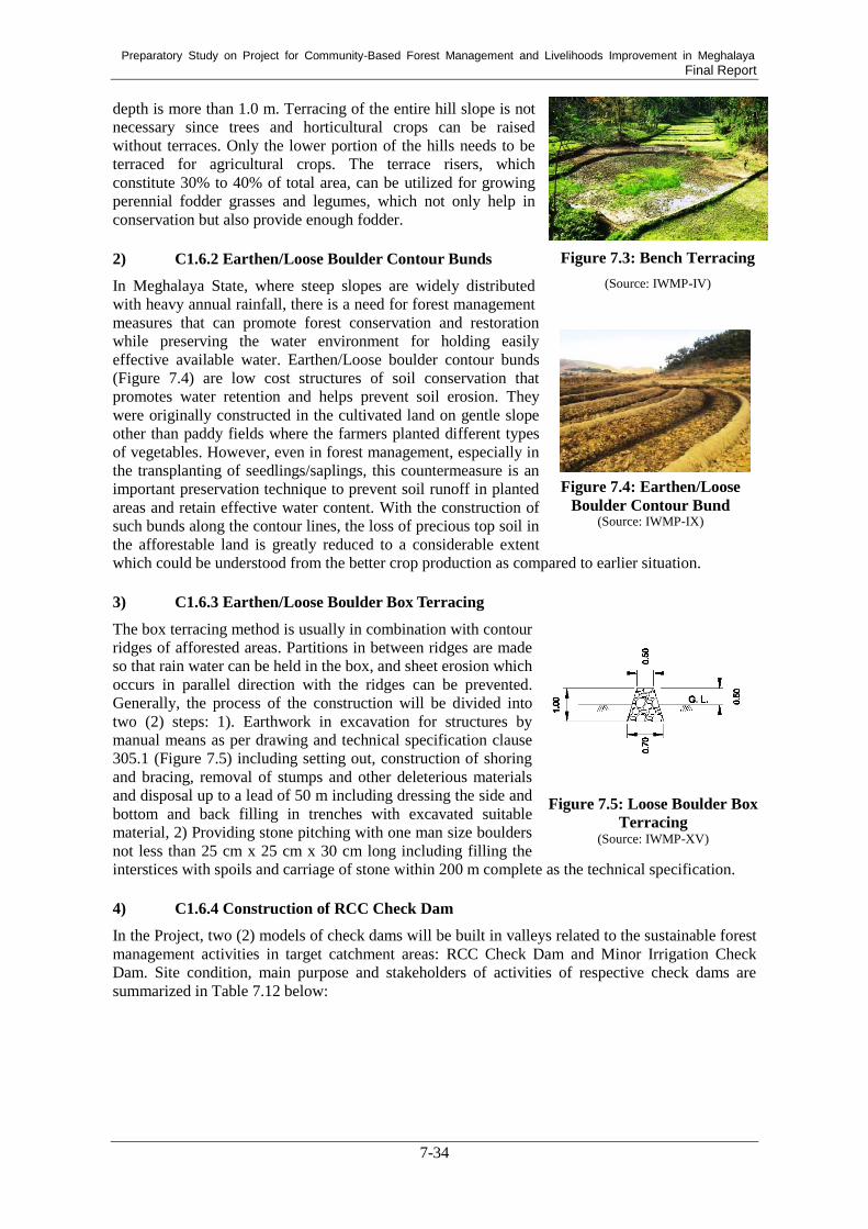
Preparatory Study on Project for Community-Based Forest Management and Livelihoods Improvement in Meghalaya Final Report
7-34
depth is more than 1.0 m. Terracing of the entire hill slope is not
necessary since trees and horticultural crops can be raised
without terraces. Only the lower portion of the hills needs to be
terraced for agricultural crops. The terrace risers, which
constitute 30% to 40% of total area, can be utilized for growing
perennial fodder grasses and legumes, which not only help in
conservation but also provide enough fodder.
2) C1.6.2 Earthen/Loose Boulder Contour Bunds
In Meghalaya State, where steep slopes are widely distributed
with heavy annual rainfall, there is a need for forest management
measures that can promote forest conservation and restoration
while preserving the water environment for holding easily
effective available water. Earthen/Loose boulder contour bunds
(Figure 7.4) are low cost structures of soil conservation that
promotes water retention and helps prevent soil erosion. They
were originally constructed in the cultivated land on gentle slope
other than paddy fields where the farmers planted different types
of vegetables. However, even in forest management, especially in
the transplanting of seedlings/saplings, this countermeasure is an
important preservation technique to prevent soil runoff in planted
areas and retain effective water content. With the construction of
such bunds along the contour lines, the loss of precious top soil in
the afforestable land is greatly reduced to a considerable extent
which could be understood from the better crop production as compared to earlier situation.
3) C1.6.3 Earthen/Loose Boulder Box Terracing
The box terracing method is usually in combination with contour
ridges of afforested areas. Partitions in between ridges are made
so that rain water can be held in the box, and sheet erosion which
occurs in parallel direction with the ridges can be prevented.
Generally, the process of the construction will be divided into
two (2) steps: 1). Earthwork in excavation for structures by
manual means as per drawing and technical specification clause
305.1 (Figure 7.5) including setting out, construction of shoring
and bracing, removal of stumps and other deleterious materials
and disposal up to a lead of 50 m including dressing the side and
bottom and back filling in trenches with excavated suitable
material, 2) Providing stone pitching with one man size boulders
not less than 25 cm x 25 cm x 30 cm long including filling the
interstices with spoils and carriage of stone within 200 m complete as the technical specification.
4) C1.6.4 Construction of RCC Check Dam
In the Project, two (2) models of check dams will be built in valleys related to the sustainable forest
management activities in target catchment areas: RCC Check Dam and Minor Irrigation Check
Dam. Site condition, main purpose and stakeholders of activities of respective check dams are
summarized in Table 7.12 below:
Figure 7.3: Bench Terracing
(Source: IWMP-IV)
Figure 7.4: Earthen/Loose
Boulder Contour Bund (Source: IWMP-IX)
Figure 7.5: Loose Boulder Box
Terracing (Source: IWMP-XV)

Preparatory Study on Project for Community-Based Forest Management and Livelihoods Improvement in Meghalaya Final Report
7-35
Table 7.12: Check Dams Applied in the Project
Type
RCC Check Dam (C1.6.4)
(Source: IWMP-XI)
Minor Irrigation Check Dam (C1.6.5)
(Source: IWMP-I)
Proposed site
condition
Lower part
Terrain: wide valley
Slope: gentle, less than 10%
Catchment less than 20 ha (less than 447 m
square), with water spread area around 2
ha
Upper part
Terrain: narrow valley (just downstream
site of gully)
Slope: 10-20 % or > 20%
Catchment less than 5 ha (less than 223 m
square)
Main purpose Water conservation in the forest and
plantation areas
Water conservation and domestic water
use
Site selection DPMU in consultation with SWCD
Survey/design DPMU under assistance of SWCD and BPMU
Construction Construction by VPIC and SWCD under supervison of DPMU
Operation Communities with technical support of SWCD
Maintenance Communities with technical support of SWCD
There are many remarkable bank erosion sites along streams in the forest. The bank erosion is not
only cause of the excessive sediment discharge, but also cause of loss of cropland for villagers’
livelihood and risk of slope failure. According to the existing report172
, the procedure of site
selection, survey and design, construction, operation and maintenance of the check dams are as
follows:
Site selection
Step 1: To screen small catchments by area (<5ha, <10ha, and <20 ha) with points where are the
streams related to the sustainable forest management activities using satellite
imagery/aerial photos and GIS by SWCD and DPMU of the Project.
Step 2: To identify the potential sites by DPMU of the Project, in consultation with BPMU and
representative members of the target community, in consideration of the following
matters:
- The water storage area of the check dam should be as large as possible.
- The length of the check dam (the width of valley) should be as short as possible.
- Soil materials should be available on site.
- Sites should be with appropriate accessibility from villages.
- Sites should be appropriate for the proposed activities.
172
JICA. 2018. Interim Report of Preparatory Study on Tripura Sustainable Forest Management Project in Republic of
India

Preparatory Study on Project for Community-Based Forest Management and Livelihoods Improvement in Meghalaya Final Report
7-36
Step 3: To confirm the potential sites and to finalise proposed check dam sites by the joint
inspection of BPMU and representative members of the target community, in
consideration of the numbers of respective check dams per a community and the
characteristics in the area.
Survey and design
Topographic survey of the check dam sites of the target community shall be conducted by DPMU.
Design of each check dam shall be prepared by SWCD in accordance with the revised guideline for
the soil and water conservation. Base on the design, required cost shall be estimated by the SWCD
under the assistance of DPMU. DPMU will approve the proposed design and amount sanctioned,
and minutes of understandings shall be signed between DPMU and VPIC as occasion arises.
Construction
Construction of the each check dam shall be conducted by sub-division level SWCD with
communities under the supervision of district level SWCD.
Operation/monitoring
Each check dam will be operated and monitored by SWCD and the community under assistance of
DPMU.
Maintenance
Meghalaya has extremely erosive soil with intensive rainfall. Due to this condition, the earthen
part of the check dams, especially downstream slope of embankment, will deteriorate. Therefore,
periodical maintenance works are indispensable to maintain the function of the check dams.
Required repair works of the periodical maintenance will be conducted once in every two years
with repair of embankment slope and its vegetation cover, especially downstream slope of the
check dam, and removal of sediment in the pond. Design of the maintenance works of all models
shall be prepared by DPMU. The Periodical maintenance works for each check dam will be
conducted by BPMU and community under the technical assistance of DPMU.
In addition to the periodical maintenance works of the check dams, repair of the vegetation cover of
the embankment slope shall be conducted at any time.
5) C1.6.5 Construction of Minor Irrigation Check Dam
While the purpose of the RCC Check Dam is to irrigate to a certain area, this type of dam mainly
intends to conduct water into small-scale plantation areas with low water retention capacity. In
addition, it is a secondary effect that it provides water sources for the daily life of the local residents.
The construction procedure of the dam is as described in C1.6.4.
6) C1.6.6 Construction of Conservation Pond (which can be also used for fishery)
The water conservation ponds managed by communities help in lifting water supply for forest areas
and irrigation for cultivation of vegetables such as cabbage, carrot, potato and ginger. It also can be
used for pisciculture and as a breeding centre of local fish varieties (Figure 7.6). Invariably, the
pond has an impact on the micro-climatic condition of the catchment besides increasing the water
table status and filtration rate of water movement. The community can derive optimum benefits
from the conservation pond on a sustainable basis. Besides, a concrete example of benefit that the
fishery pond brought is described in C2.5.
7) C1.6.7 Construction of Conservation Pond/Dug-out Pond
Conservation Pond/Dug-out ponds (Figure 7.7) are constructed by excavating soil from an area to
form a hole which is then filled with water. They are usually undrainable and fed by rainfall, surface
runoff or groundwater. Dug-out ponds can sometimes be built near a flowing stream or river to utilize

Preparatory Study on Project for Community-Based Forest Management and Livelihoods Improvement in Meghalaya Final Report
7-37
groundwater, instead of surface water. The excavated soil can then be used to make a berm around the
dug-out if the area is prone to flooding, reducing the chance of unwanted fish entering the pond.
The ponds usually aim at providing irrigation water to seedlings and crops particularly during the dry
periods between rains. They are low cost and highly efficient structures and enable the farmers to
earn extra income. These are also in good working condition, and some have been further improved
and renovated by the beneficiaries themselves.
Figure 7.6: Conservation Pond (for Fishery)
(Source: IWMP-I)
Figure 7.7: Conservation Pond/Dug-out Pond
(Source: IWMP-VII)
8) C1.6.8 Construction of RCC Water Storage Tank for Drinking Water
This storage tank can be stored drinking water for local residents
(Figure 7.8), but it can also be used as extinguishing water in the
event of a forest fire to minimize the damage. Especially, RCC
water tanks can always withstand bushfire, it is known for the
best option for fire-prone area in dense forests. Thus, it is so
important to install this type of reservoir in the forest area to
achieve sustainable forest management.
At sites for the RCC reservoirs, the ground will be levelled and
excavated for foundation with cement concrete. Walls and floor
will be constructed with RCC. Roof slab will also be provided
with RCC. Boundary wall will be constructed with bricks and
plastered with cement plaster, and gate will be provided for all the
reservoirs. All the excavations will be conducted manually, and
the excavated soil will be used for levelling the reservoir
compound. The force analysis of the reservoirs or tanks is about the same irrespective of the chemical
properties of the product173
.
9) C1.6.9 Construction of Spring Tapped Chamber
The Spring Tappd Chambers which serve as a major water source
is usually a part of the entry level activities in most watershed
programs (see Figure 7.9 as an example). The chambers can be
used as drinking water source for local people as well as the
above-mentioned RCC water storage tanks. It is also functioned
as a sprinkle-water over for transplanting sites of seedlings
especially during the drought period.
In Meghalaya State, there are two departments of the government,
SWCD and the Public Health Engineering (PHED), providing
facilities for ensuring water for forest/agricultural area and
173
Department of Civil Engineering, Gokaraju Rangaraju Institute of Engineering and Technology. 2012.
DESIGN OF R.C.C. OVER HEAD TANK.
Figure 7.8: RCC Water
Storage Tank for Drinking
Water
(Source: IWMP-IV)
Figure 7.9: Spring Tapped
Chamber (Source: Megha-LAMP, MBDA)

Preparatory Study on Project for Community-Based Forest Management and Livelihoods Improvement in Meghalaya Final Report
7-38
communities. While the PHED constructed gravity based piped water supply schemes for the local
communities, SWCD promoted spring tapped chambers which also play a major role in ensuring
water conservation for fields.
Incidentally, the unfavorable terrain features and the high labour cost in laying pipelines make the
capital investment high in the piped water supply schemes. According to results of the existing
study , the annual operating expenditure is about Rs 51 per person in the case of the best practice at
the state level and both departments work intensively at capital investment hardware, in building
the necessary infrastructure for the community. However, there is no software input at the
implementation or pre-implementation stage to involve the community or to educate them about the
operation and maintenance of the facilities. If the systems remain unchanged, the community can
manage by themselves. This may not be the case when they have to adopt new technologies such as
using an electric pump to lift water from the source that is unavoidable if the service is to meet the
growing demand for water associated with the changing life-styles. This will necessitate
incorporating a software component at the preparation and implementation stages of capital
investment.
Component 2: Community Development and Livelihood Improvement 7.5.2.
Under this component, the Project aims at promoting inclusive community development and
improving the livelihoods of people in selected villages. To achieve these objectives, the Project
will need to actively involve women and youths in the Project, who have often been excluded from
the decision-making processes of existing traditional community institutions, as well as introducing
alternative income sources to people in selected villages and providing them with skill development,
marketing, and financial supports. The Project will hire external resource organizations or NGOs to
promote inclusive community development and income generation activities. The details of each
activity to address the objectives are described below.
(1) C2.1 Community Mobilization and Gender Sensitization
In the preparatory process of the Project, community mobilization and gender sensitization are the
most important processes because these are essential for the success of the Project. In order to
involve and motivate people in selected villages, specifically women and youths, in the activities of
the Project, the Project will need to mobilize these people and sensitize them in terms of gender by
breaking their stereotyped ideas on gender roles through village-based workshops.
Based on the uniqueness of existing traditional community institutions in Meghalaya State, the
Project should first approach to a village head of each selected village in Khasi and Jaintia Hills and
Nokma of each selected village/cluster in Garo Hills, explain the details of the Project to him, and
get his acceptance of the Project to work in the village. Only after getting his acceptance, the
Project can start the preparatory processes of the Project, including community mobilization and
gender sensitization workshops, as described below.
1) C2.1.1 Community Mobilization Workshops
Community mobilization will target all people of selected villages, including women and youths.
Therefore, the Project should first request the village head or Nokma of each selected village/cluster
to call all villagers for the first meeting in particular. Otherwise, he might decide all, including the
contents of activities to be undertaken in the Project and who will participate in these activities, by
himself or with the members of existing traditional community institutions. Many people of
selected villages have never participated in any foreign donor’s project or even central or state
scheme and might not know what a participatory development approach means. Therefore, BPMU
will need to conduct the meetings and workshops at the initial stage of the Project and thoroughly
explain to participants in the meetings and workshops what the Project will provide them, what they
might be able to benefit from the Project’s interventions, and what they are supposed to do. Main
objective of these meetings and workshops are to encourage and motivate them to actively
participate in the activities of the Project. Through their active participation, they can not only

Preparatory Study on Project for Community-Based Forest Management and Livelihoods Improvement in Meghalaya Final Report
7-39
benefit from the Project, but also contribute to inclusive community development and income
generation by themselves. To continuously encourage and motivate the people, specifically at the
initial stage of the Project, the Project will utilize local women and men, including youths, as
community facilitators.
2) C2.1.2 Gender-sensitization Workshop/Gender Training
In Meghalaya State, there is the strict gender-based division of labor and sphere deeply embedded
in tribal societies of all Khasi, Jaintia, and Garo Hills. Based on such social norms, women are
supposed to do household chores and child care at home and not to participate in public meetings or
take up a decision-making role there because these are men’s sphere and men’s roles. As a result,
women tend to be excluded from the decision-making processes of existing community/village
institutions, such as Hima, Raid, Dorbar, and Nokma council. As a matter of a fact, women in rural
areas play an important role not only in doing household chores and child care, but also in
maintaining their household livelihoods by taking responsibilities for agriculture, animal rearing,
and forest management work. For example, they do land preparation, sow, weed, harvest, do
post-harvest treatments, and carry products to the market and sell them in the market. In terms of
forestry, they have community forests and their own forests, and they collect firewood as well as
mushroom and edible wild leaves for a domestic or commercial purpose. They also help men build
fire line. Unfortunately, such women’s roles and contribution are usually ignored or overlooked,
and women tend to be deprived of an opportunity to raise their voice or integrate their needs in the
planning processes of community development led by existing traditional community institutions.
Based on a right-based approach and the critical roles played by women, the Project should involve
women from the planning process to implementation and monitoring & evaluation processes of the
Project. However, the strict social norms might make women hesitate to actively participate in the
decision-making processes of the Project and its activities. Moreover, as many women in rural areas
take multiple responsibilities on a daily and yearly basis, they might not be able to spare a time to
participate in the activities of the Project. Thus, the Project should make strategic interventions to
promote not only women’s active participation, but also their taking a leading role, not an assisting
role for men. From the initial stage of the Project, it is important for the Project to approach to both
women and men in each selected village and break their stereotyped ideas of gender-based division
of labor/role and sphere through gender sensitization workshops. They will need to persuade both
the women and men that women are also main actors for community development, so the men will
need to assist the women to actively participate in the activities of the Project by sharing the
household chores and child care taken up by women.
In order to involve women in the decision-making processes of the Project and promote inclusive
community development, the Project’s staff members also need to be free from stereotyped ideas of
gender-based division of role and sphere and become more gender responsive. For this purpose, the
Project needs to provide them with gender training in the beginning of the Project in particular.
Gender training should be focused on how to integrate a gender perspective in the processes of
planning, implementation, and monitoring & evaluation and how to ensure women’s participation
in decision-making processes of the Project in terms of not only quantity, but also quality. The
Project’s staff members should not be satisfied with the ratio of women selected or involved in the
committees developed in each selected village, but make it sure that women’s voice be heard in the
decision-making processes of the Project and their needs be integrated in the planning of the Project
at the village level. Each staff member should learn from gender training the importance of
integrating such a gender perspective in all processes of the Project.
(2) C2.2 Micro-Planning
The NGOs hired by the Project will undertake the activity of making a Micro Plan as a learning
process of participatory community development in all selected villages. This Micro Plan is an
integrated development plan of each selected village, composing forest management plan,
watershed conservation plan, and income generation plan. As described previously, the
Project/SPMU will make and provide necessary maps of each selected village as a pre-condition for

Preparatory Study on Project for Community-Based Forest Management and Livelihoods Improvement in Meghalaya Final Report
7-40
micro-planning. Based on the maps provided, each selected village is supposed to make a land-use
plan in a participatory way. Within the process of micro-planning, the Project, specifically the
NGOs hired, should prevent a village head/Nokma, members of traditional community institutions,
or other village authority from dominating the decision-making processes of making a Micro Plan.
For this purpose, the NGO hired first needs to facilitate each selected village to newly establish a
sub-committee under Village Employment Council (VEC) developed for Mahatma Gandhi
National Rural Employment Guarantee Act (MGNREGA) in all villages of the state and the entire
country. The sub-committee should be consisted of representatives of diverse groups in each
selected village, specifically socio-economically disadvantaged groups, such as women, youths,
landless people, and a minor clan.
The necessary steps for making a Micro Plan to be taken by each selected village are as shown in
Table 7.13 below:
Table 7.13: Steps to Make a Micro Plan
Step Contents Time to Spend
1 To select members and form a sub-committee in a participatory way
with the assistance of a hired resource organization/NGO.
through 1 or 2 meetings
2 To conduct a PRA, as well as village socio-economic survey if
necessary, as a baseline survey, to identify the types of existing
forests, the condition of forest and other natural resources, gender
roles and gender relations, and problems/needs faced by the village.
for 1 month, including
the time to conduct
training/workshops at
the village level
3 To make a forest management plan, identifying forests to be
intervened by the Project and adopting proper forest operation to the
forests for maximizing ecological and economical benefit for the
entire village.
through 1 or 2 meetings
4 To make a watershed conservation plan, based on the land-use plan
made, the results of the PRA conducted, land condition such as
degree of slope and depth of soil, available labour and others.
through 1 or 2 meetings
5 To make an income generation plan, considering the potential of
possible activities which fit in the climate and other conditions of a
village, as well as the availability of relevant central or state on-going
schemes/missions, and referring to the land-use plan made and the
results of the PRA conducted.
through 1 or 2 meetings
6 To make an integrated micro plan, composing of a forest
management plan, watershed conservation plan, and income
generation plan each of which converges with any relevant central or
state on-going schemes/missions.
through 1 or 2 meetings
Source: developed by Study Team
Most of people in selected villages might not be familiar with micro-planning or participatory
development planning. Thus, the Project will provide them with some technical supports and
facilitate them to make an appropriate integrated development plan in a participatory manner as
described below.
1) C2.2.1 Training/Workshops on How to Make a Micro Plan
The Project will first prepare for the guidelines or manual for making a Micro Plan and the GIS maps
of each selected village/cluster and provide such materials for each selected village/cluster. By
utilizing these materials, the members of the sub-committee established in each selected village, as
well as other villagers if necessary, are supposed to make a Micro Plan at the initial stage of the
Project. The Project will hire two NGOs per district and 22 NGOs in total as external resource
organizations that are mandated to facilitate the villages selected in the district to first mobilize
people and make a Micro Plan, as well as to conduct the activities planned, by giving necessary
technical supports. The NGOs are also supposed to conduct training or workshops, at the village level,
on how to make a Micro Plan, specifically how to make an income generation plan by converging

Preparatory Study on Project for Community-Based Forest Management and Livelihoods Improvement in Meghalaya Final Report
7-41
with relevant on-going schemes/missions based on the information provided and the land-use plan
made.
2) C2.2.2 Conducting PRA
Within the activity of making a Micro Plan, the Project will suggest that each selected village conduct
a PRA, as well as a socio-economic survey if necessary. If a village is large, composing a couple of
localities, the Project needs to suggest that the village conduct a PRA in a couple of places. Through
PRA, the Project can expect people of each selected village to recognize and share with other
participants’ ideas on the present border, land-use pattern, changes in the availability of natural
resources, gender-based access to/control over natural resources, daily and seasonal calendar by
gender, social networks available for women and men, and prioritized problems/needs. The result of
the PRA conducted in each selected village can be utilized for its people’s making a Micro Plan,
composing a forest management plan, watershed conservation plan, and income generation plan, as
well as for prioritizing Entry Point Activities (EPA) of which details are described in C2.3.
3) C2.2.3 Planning a Micro Plan Converged with Available National/State Schemes
The Project needs to prepare the guidelines for micro-panning in advance as mentioned previously.
The guidelines are mainly on how to make a Micro Plan in a participatory manner with the assistance
of the NGO hired. They should also include information on available national and state
schemes/missions provided by relevant departments so that each selected village can consider the
convergence of such schemes/missions with their forest management, watershed conservation, and
income generation activities. The departments which implement relevant schemes/missions include
Forest & Environment Department, Department of Agriculture, including Directorate of Horticulture,
Animal Husbandry & Veterinary Department, Soil & Water Conservation Department, Fisheries
Department, Department of Sericulture & Weaving, Cooperation Department, Department of
Tourism, Community and Rural Development Department, Commerce & Industries Department, and
Meghalaya Institute of Entrepreneurship.
(3) C2.3 Entry Point Activities (EPAs)
It will take a certain period of time until the Micro Plan of each selected village gets approved by the
Project/SPMU. To prevent people in selected villages from losing their interest in the Project and
keep them involved in the Project, the Project will provide each selected village with EPAs. EPAs
should not be any activities, but confined to the activities relevant to the contents of the Project. For
example, construction or repair of a canal/irrigation, multi-purpose pond/reservoir, energy-efficient
smokeless stoves, and drinking water facility are directly or indirectly relevant. A canal or irrigation
can promote agricultural cultivation more than two times in a year while multi-purpose
pond/reservoir can enable people to practice both agriculture and fisheries through Integrated
Farming System (IFS). On the other hand, energy-efficient smokeless stoves and drinking water
facility can reduce the time women spend for collecting firewood and fetching water and enable
women to spend more time for income generation activities.
1) C2.3.1 Prioritization of EPAs
The NGOs hired by the Project should facilitate each selected village to identify critical problems
faced by the village through a PRA and prioritize one or two most critical problems to be addressed as
EPAs through discussion among participants in the meetings or workshops. As described in C2.3, the
NGOs will need to lead the participants to prioritize among only EPAs candidates which are relevant
to the contents of the Project. As the Project will equally allocate a certain amount of budget for each
selected village, each selected village can choose any number of activities within the budget.
2) C2.3.2 Conducting EPA
The Project/SPMU will send a technical team, composing at least one engineer, to each selected
village and let the team to check if each of the EPAs proposed is technically and financially feasible.
If it is feasible, the team will make a cost estimate for the EPAs. The NGOs hired are supposed to

Preparatory Study on Project for Community-Based Forest Management and Livelihoods Improvement in Meghalaya Final Report
7-42
persuade each selected village to contribute to EPAs from the village side by providing unskilled
labor work and locally available materials. The NGO can also suggest that each selected village
should consider the possibility of converging with relevant central or state schemes/missions, such as
MGNREGA and Pradhan Mantri Gram Sadak Yojana (PMGSY), so that the village can save the cost.
(4) C2.4 SHG Activities
The Project will undertake Self-help Group (SHG) activities which are consisted of two types of
activities: 1) micro-credit activities; and 2) income generation activities (IGAs). The details of each
activity are described below.
1) C2.4.1 Selection of SHGs in Each Selected Village
Both micro-credit and income generation activities will be undertaken by the SHGs selected by the
Project. The Project will need to make the guidelines, including selection criteria for SHGs, in prior
to the implementation of SHG activities. The SHGs which work on potential crops or products and
have expertise and skills might be more preferable as target groups. However, in the case there is no
existing SHG in the selected village and SHGs will be newly established, the Project should suggest
that socio-economically disadvantaged groups of people, such as widows and people with disability,
should be involved in the SHG. Under the SHG activities, the Project will select two SHGs per
village.
2) C2.4.2 Micro-credit Activity
Accessibility to financial services, including micro-credits, is essential for anyone to start up or scale
up her/his business. Thus, the Project will undertake micro-credit activities for the members of
selected SHGs at the village level. Selected SHGs are supposed to open their bank account where
they will save the deposit collected by themselves on a weekly or monthly basis. After the deposit
reaches a certain amount, any member of the SHG will be able to take a loan from their deposit if
she/he makes a business plan and other members accept it. The Project/BPMU and community
facilitators will need to carefully check if the money borrowed is really used for a member’s business,
not for her family’s living cost or for her husband’s or son’s sake.
a. C2.4.2.1 Providing Revolving Fund per Village
In addition to the money saved by each selected SHG, the Project will enable the members of selected
SHGs to borrow a larger amount of money from the revolving fund set up at the village level. For this,
the Project will provide a certain amount of money as a revolving fund for each selected village.
Similar to the loan from the deposited money, the member of selected SHGs are supposed to make a
business plan and get an approval from not only other members, but also the Project/BPMU or
anyone who is in charge of micro-credit activities at the village level. However, the revolving fund
should not be provided all at one time for each selected SHG. The Project should set up a few levels
by years when each selected SHG has spent for micro-credit activity and been functional as a SHG: 1)
6 months; 2) 1 year; and 3) 2 years. Then, the Project can give a part of the revolving fund allocated
for each selected SHG only if it reaches the level 1, level 2, and level 3. How to manage the
micro-credit activity is described below.
b. C2.4.2.2 Training/Workshop on Micro-credit Activity
The Project will need to develop guidelines on how to operate micro-credit activities in advance. The
guidelines should include the conditions or levels which each selected SHG will need to clear and
reach to receive all the revolving fund, as described above. Based on the guidelines, the Project will
provide the members of selected SHGs with training or workshops in prior to their starting the
activities so that the members can operate the activities by themselves or with a little assistance by
community facilitators hired by the Project at the village level.

Preparatory Study on Project for Community-Based Forest Management and Livelihoods Improvement in Meghalaya Final Report
7-43
3) C2.4.3 Income Generation Activities (IGAs)
The types of IGAs can vary by selected SHGs. However, the Project should narrow down the focus
to some crops and products which are available in Meghalaya State and more potential. This is
because the Project can suggest that the selected SHGs which are located nearby and work on the
same crop or product should form a cluster so that members of all these SHGs can ship their crops
or products together and sell at a higher price to traders/middlemen. For that purpose, the Project
will conduct market research to identify profitable crops. This is critically important in case the
beneficiaries intend to switch from shifting cultivation to settled agriculture. Alternative livelihoods
need to be sustainably profitable, otherwise they will restart shifting cultivation. Moreover, the
Project can conduct skill and business training in one place, targeting the members of all SHGs
which form a cluster.
Based on the characteristics of agriculture and land tenure system in the state, the Project can
categorize the possible types of IGAs into following three models. The BPMU or NGO hired can
introduce them to selected SHGs and facilitate them to select any if any of these models can well fit
a selected SHG based on the background of the members of the SHG and climatic and market
conditions around the SHG. These are just possible models, so the Project can let each selected
SHG consider and choose what they want to do and they can do, as well as what is potential.
Model 1 (Forest-based activities): SHGs whose members have access to an individual or
community forest are target of this model. In addition to SHG members, VPIC members who are
interested in the activities are also able to participate. They are supposed to plant seedlings of
multi-purpose tree species, fast growing species, and fruits trees/cash crops all together in forest
area as agroforestry. Agroforestry is also recommended for the replacement of shifting cultivation,
as this can contribute to restoring soil fertility and regenerating plants in the forest. They can earn
income by selling seedlings if they make a nursery. Production of non-Timber Forest Products
(NTFP) is another activity under Model 1.
Model 2 (Integrated Farming System: IFS): IFS, a combination of cultivation of cash crops, animal
rearing, and aquaculture, targets members of a SHG who own some land. Under IFS, the members
of a SHG can utilize waste of harvested crops as feed for animals, and manure of animals can be
utilized as organic compost for cultivating cash crops and as feed for fish. This can also contribute
to an increase in productivity of the crops.
Model 3 (Non-land based activities): Landless people are the target of this model. Activities which
do not require land are introduced. The activities include mushroom cultivation, apiculture,
animal-rearing, weaving, and handloom/handicraft-making.
The Project/BPMU or NGO hired should regularly monitor and evaluate the processes and
outcomes/impacts of each selected SHG’s activities. Drawing from the results of monitoring and
evaluation, the Project/SPMU also should make a report on case studies on good practices and bad
practices, focusing on the difficulty or constraints of group work and leadership, technical skills,
and logistics/marketing. Such a report and lessons learnt from the experiences of the SHGs which
the Project initially supported should be incorporated or reflected in the plans on training and
exposure visits for the next batches of SHGs.
a. C2.4.3.1 Training Needs Assessment/Market Research
Based on the types of IGAs on which selected SHGs work, the Project/SPMU will need to conduct
training needs assessment and market research in the beginning. The training needs assessment
should be made from the aspects of selected SHGs’ members’ technical skills, business skills,
bargaining power, marketing, and leadership. In terms of the aspect of technical skills, the
Project/SPMU should analyze the level of their knowledge and skills on scientific technology, as
well as that of their indigenous knowledge. As to the aspect of business skills, the Project/SPMU
will need to identify the level of their mind-set-up for business and their ability to make a business
plan. Regarding the aspect of marketing, the Project/SPMU should thoroughly look into the present

Preparatory Study on Project for Community-Based Forest Management and Livelihoods Improvement in Meghalaya Final Report
7-44
situation of selected SHGs, specifically their logistics ability, including connectivity to the market,
availability of transportation to the market or traders, access to the market’s information, packaging,
and value addition. In addition to these training needs assessment, the Project/SPMU should
conduct market research in order to identify profitable crops and products. SHGs will decide the
crops to cultivate, when the Project informs SHGs of the result of market research.
Drawing from the results of the training needs assessment and market research, the Project/SPMU
can make a plan on training and exposure visits for selected SHGs. The Project/SPMU will need to
list up the possible training institutes and places for exposure visits which can provide relevant
training programs for the members of selected SHGs and show them the cases of good practices as
role models. Similarly, the Project/SPMU and DPMU should consider the possibility of
convergence with relevant national or state schemes/missions which provide training and exposure
visits. Taking into account that value chain enhancement is required for sustainable alternative
livelihoods, training should be considered along with value chains of selected products.
b. C2.4.3.2 Training and Exposure Visits
Based on the plan on training and exposure visits, the Project/DPMU/BPMU will conduct them for
selected SHGs. The training and exposure visits should be provided mainly in the initial stage of
IGAs. However, in accordance with necessity, follow-up training and advanced training courses can
be provided in the middle stage of IGAs. In particular, when it comes to agriculture activities
technical support and training by Department of Agriculture is critically important for sustainability
of the Project. SHGs performing better than others may be considered for an oversea exposure visit
to be sensitized by advanced technology.
c. C2.4.3.3 Provision of Seed Money for Each Selected SHG
In order for the members of selected SHGs to begin their businesses, they will need some seed
money to buy start-up tools and materials. For such a purpose, the Project should provide a certain
amount of money as seed money equally for each selected SHG. How to use the seed money will
depend on the choice of each selected SHG. However, the Project/BPMU and NGO hired can give
an advice in terms of effectively using it by utilizing existing national or state schemes/missions
which provide start-up tools.
d. C2.4.3.4 Construction of Facility/Infrastructure Necessary for IGAs
In addition to start-up tools and materials, SHGs might need some facility and infrastructure to
begin their businesses or IGAs. For example, they might need to construct a nursery, pig pen,
henhouse, hut for mushroom cultivation, sericulture, or weaving, storehouse for crops, or
pond/reservoir/water tank. The Project can allocate some budget for the construction of such facility
and infrastructure. The Project/BPMU and NGO hired will also suggest selected SHGs to utilize or
converge with available national or state schemes/missions since the Project’ budget might not be
sufficient.
4) C2.4.4 Enterprise Development Activities
The Project/SPMU will consider the possibility of micro, small, and medium enterprise (MSME)
development. If there is potential for any field, the Project/SPMU will promote to develop MSME
in that field. The possible fields and procedure for MSME development are described below.
a. C2.4.4.1 Feasibility Studies & Pilot Projects for Enterprise Development
In addition to IGAs, the Project/SPMU will consider the potential of MSME development in a couple
of possible fields, including bamboo processing or crafts, rural tourism, and milk production.
Bamboos are available across over the state, and bamboos in a processed and raw condition are
utilized in diverse ways, such as for a fence, construction material, furniture, baskets, and other crafts.
Similarly, there are many spots with outstanding nature which have not been developed, but can be

Preparatory Study on Project for Community-Based Forest Management and Livelihoods Improvement in Meghalaya Final Report
7-45
utilized for rural tourism or ecotourism in the state. Moreover, potential for enterprise development in
milk production is high because demands for milk are high, but production is limited.
In order to develop MSMEs and/or societies in any of these fields, the Project/SPMU will need to
conduct feasibility study and market research on each possible field at the initial stage of the Project.
Since detailed data on present conditions are not available in any field, the Project/SPMU should
first conduct a detailed study and look into the feasibility of any possible field for the
implementation of pilot projects in any two to three villages where villagers have access to raw
materials, skills and knowledge, and connectivity to the market. Through market research, the
Project/SPMU will do SWOT analysis of the state, that is strengths, weaknesses, opportunities, and
threats, in each of the possible fields for MSME development. The Project/SPMU will also need to
search available national or state schemes/missions in terms of not only technical supports, but also
investment opportunities or financial supports by Commerce and
Industries Department and Cooperative Apex Bank or private
banks.
Based on the results of the feasibility study and market research,
the Project/SPMU will make a plan and undertake a pilot project
per one Block. Pilot project’s sites can be selected based on the
availability of raw materials and supply chain, existing SHGs or
skilled persons, and connectivity to the village road or motorable
road as mentioned above. The pilot project can be implemented
mainly by the Project/BPMU for two to three years and during the
pilot project period, the Project/BPMU will facilitate the people
of pilot sites to form and register as an enterprise under
Commerce and Industries Department or as a cooperative society
under Department of Cooperation, depending on the purpose, size and feature of the business, and
make a business plan at the initial stage of the pilot project on each field. In accordance with
technical and financial needs assessment on each field for villagers in pilot sites, the
Project/SPMU/DPMU/BPMU will also connect the villagers of the pilot sites to training institutions
and the market, including traders, middlemen, and retailers/whole salers. The Project/BPMU and
DPMU will monitor the process of MSME development in each field and make a report on case
studies about good and bad practices and the lessons learnt from them.
(5) C2.5 Soil and Moisture Conservation for Livelihood Improvement
Water conservation is essential for livelihood improvement in the Project. For example, according to
the Annual Report 2016-17 of SWCD, one of the beneficiaries of water harvesting pond constructed
under Rural Infrastructure Development Fund (RIDF) scheme during 2015-16 said that they have
received 15 kg of fingerlings from the scheme on that very year. The community has been rearing fish
for the last two years and harvested more than 75 kg of fish from the Water Harvesting Farm Pond
constructed under RIDF scheme. By selling them by Rs 200-250 per kg, the community people of
that area have earned about Rs 15,000-16,000 in the first catch in that year (Figure 7.10).
Now, to contribute livelihood improvement in the target areas, the following activities for the soil
water conservation will be conducted as part of the Component 2 of the project (Table 7.14).
Table 7.14: Soil and Water Conservation Activities for Livelihood Improvement
Sec. No. Activity Site
Selection Survey/ Design
Construction/ O&M
C2.5.1 Construction of Rainwater
Harvesting Structure
SWCD and
DPMU DPMU
Construction: DPMU
O&M: BPMU &
Communities
C2.5.2 Construction of Drinking Water
Tank
SWCD and
DPMU DPMU
Construction: DPMU
O&M: BPMU &
Communities Source: developed by Study Team
Figure 7.10: Water
Conservation Pond for
Livelihood Improvement (Source: NABARD RIDF,SWCD)

Preparatory Study on Project for Community-Based Forest Management and Livelihoods Improvement in Meghalaya Final Report
7-46
1) C2.5.1 Construction of Rainwater Harvesting Structure
Rainwater harvesting (RWH) is a simple method by which
rainfall is collected for the dry season. The collected rainwater
may be stored, utilised in different ways or directly used for
recharge purposes. With depleting groundwater levels and
fluctuating climate conditions, RWH can go a long way to help
mitigate these effects. Capturing the rainwater can help recharge
local aquifers, reduce urban flooding and most importantly ensure
water availability in water-scarce zones. Figure 7.11 shows an
example of RWH by Indian Council of Agricultural Research
(ICAR) in the Ri-Bhoi District.
In Meghalaya State, despite having a sufficient rain in summer, there is acute shortage of drinking
water. Although collecting rainwater from the roof is widespread, an appropriate management plan
with required knowledge and skills of RWH system is not enough. Hence, massive awareness and
efficient planning for RWH, conservation and watershed management is the necessity of the region.
The traditional water harvesting system in the region can be modified using appropriate techniques.
Appropriate water resource planning needs to be executed for proper use of the huge water bodies
of the region. Watershed management in Meghalaya has been defined as rational utilization of land
and water resources for optimum and sustained production with minimum hazards to natural
resources. It is essentially related to soil and water conservation. It involves proper land use,
protecting land from all forms of degradations, building and maintaining soil fertility, conserving
water for agricultural use, proper management of water for drainage, flood protection, sediment
reduction, and increasing the productivity of land use.
In the Project, various types of RWH ponds will be constructed for livelihood improvement. Size of
a pond is usually determined by the availability of adequate land in the vicinity of the village.
Besides, desired size and design can meet the water requirements of the community. Unless
otherwise prescribed for an area, the following general guidelines174
developed by PHED may be
used to determine the water requirements of a village community and the gross storage capacity of
the pond.
1) Irrigation Needs: About 0.67 metric ton for a hectare of irrigation.
2) Animal Needs:
Beef cattle: 54-68 litres/day, Dairy cows (drinking): 68 litres/day, Dairy cows (drinking and
barn needs): 158 litres/day, Pigs: 18 litres/day, Sheep: 9 litres/day
3) Domestic Water Needs: 40 litres per head per day
4) Fish Culture Needs: Ensure about 1.85 m depth to provide proper temperature environments.
All structures will be constructed by DPMU, and operation and maintenance will be conducted by
BPMU and communities.
2) C2.5.2 Construction of Drinking Water Tank
In Meghalaya, the traditional water harvesting system of tapping flowing streams and spring water
for use in irrigation is popular. Many villages of Ri-Bhoi District collect flowing stream water
through bamboo pads for domestic use. In Jowai, West Jaintia Hills District, the flowing stream water
are stored in small cement plastered pond through bamboo which is used by the whole community,
and the overflowing water is used in the catchments areas for farming. Several water harvesting
systems are practiced in some parts of the state which combines water conservation and forestry
using local topographical chain. For example, certain system has forest land at the top of the hill,
174
http://megphed.gov.in/RWHManual.htm (cited 03 June, 2019)
Figure 7.11: RWH Technique (Source: RWH Program by ICAR)

Preparatory Study on Project for Community-Based Forest Management and Livelihoods Improvement in Meghalaya Final Report
7-47
water harvesting tanks for drinking further down the hill slope, followed
by livestock enclosures and then terraced rice fields at the foot of the hill.
The forerst area on the hilltop serves as a small catchment to supply the
tank with rainwater and is hardly loss of soil through erosion due to
permanently under vegetation even though the slope in the area is steep.
The system is a unique combination of forest, agriculture, livestock and
fisheries with a water and soil conservation base, which encourages the
sustainability of the environment, besides increasing crop productivity.
In reference to this type of the practice,, drinking water tanks (an
example is shown in (Figure 7.12) will be introduced to communities as
one of the component for improvement of livelihood and hygiene
environment in Meghalaya..
Component 3: Institutional Strengthening 7.5.3.
Institutional strengthening will be a vital part of project implementation. This includes infrastructure
required for project implementation, building capacity of personnel who implement and monitor the
Project (capacity building of beneficiaries are discussed in Component 2), system of monitoring and
evaluation, and publicity for the Project.
(1) C3.1 Capacity Development
1) C3.1.1 Training Needs Analysis
Training Needs Analysis (TNA) will be conducted at the beginning of the project, either by
outsourcing the contract or by PMC (if PMC commences its work without delay). TNA should
consider the capacity development requirements of different stakeholders as well as different
components of the Project based on the available competencies. Once the gap analysis is conducted
and requirement becomes clear, consultants who are in charge of conducting TNA and SPMU’s
capacity development officer should work in collaboration to develop a capacity development plan
that details how and where the stakeholders should be trained, what would be the expected outcome,
and how to measure the impact (on a sample basis). It should be kept in mind that capacity
development needs to change over the time.
2) C3.1.2 Training, Exposure Visits and Workshops
Capacity building in the forms of training, workshops, and exposure visits addresses issues
associated with inadequate knowledge, skills, and awareness. Trainings for project personnel will
be organized in the areas of management, technical skills, community mobilization, GIS and MIS,
remote sensing, M&E, and gender. Some trainings will be conducted in-house while others can be
conducted with specialized agencies. Most of the training courses will be conducted for the duration
of several days so the project personnel will not be away from the Project for a prolong time period.
However, for some of the specialized trainings such as remote sensing where a standard short-term
course is offered by external agency, the duration may be up to two months.
At the same time, a short trip in the form of exposure visits will be planned for the project staff
outside the state to get acquainted to similar projects. Workshops, particularly for project
orientation for new recruits for the Project and gender related workshops will be further conducted.
3) C3.1.3 JICA Forestry Sector Annual Workshop
As has been the practice in other JICA assisted forestry projects, the Project may consider hosting
an annual workshop in the latter stage of the project implementation when there are some
achievements from the Project to share with other government departments and institutions
implementing JICA forestry projects.
Figure 7.12: Drinking Water
Tank (Source: IWMP VI)

Preparatory Study on Project for Community-Based Forest Management and Livelihoods Improvement in Meghalaya Final Report
7-48
4) C3.1.4 NGO/Resource Organizations
The Project will need to hire two NGOs per district, in other words 22 NGOs in total, as resource
organizations to mainly implement the component of community development and support
communities to conduct income generation activities under the Project. The period when the Project
might continuously contract with each of NGOs might be 84 months. These NGOs hired are
mandated to mobilize the people of selected villages, conduct gender sensitization workshops
which target both women and men in the selected villages, and facilitate them to make a micro plan,
prioritize and undertake EPAs, and undertake IGAs, including training and exposure visits.
Through these activities, the NGOs are supposed to lead the selected villages to the achievement of
inclusive community development and the improvement of livelihoods.
As selection criteria for the NGOs, the Project should prioritize the experiences and expertise of a
NGO in terms of community mobilization, gender sensitization, and skill development for income
generation. Since the Project targets around 500 villages across over the state, one selected NGO
will need to cover around 22 villages in total through three batches within the district on which each
NGO is supposed to work. In order for the NGOs to proceed necessary activities efficiently and
effectively, the NGOs hired should be familiar with the ways of a foreign donor’s project and have
the sufficient number of staff members who have expertise and experiences on the subjects raised
above. This is because the NGOs hired might need to form a couple of teams, each of which is
consisted of a key expert/facilitator and non-key expert/facilitator, to work together on three or four
villages during each of three batches.
The performance of each NGO should be monitored and evaluated regularly by the Project and
beneficiaries of the Project. Based on the results of monitoring and evaluation, the Project should
consider and replace the NGOs of which performance is lower than the Project’s or beneficiaries’
expectation with better ones.
(2) C3.2 Monitoring and Evaluation
Monitoring and evaluation of project progress and achievement will mainly involve the following
events:
Baseline survey
Annual planning and review meeting
Concurrent monitoring
Annual statutory audit
Mid-term evaluation
Terminal evaluation
Thematic studies and documentation
1) C3.2.1 Baseline Survey
To grasp the starting point of the Project in terms of physical and economic conditions, and the
status of the target area, a baseline survey would be conducted. The types of data to be collected
and the method for collection to be used need to be decided in accordance with the operation and
effect indicators of the Project. The baseline survey should be designed and conducted in such a
manner that the data captured in it can be used for future assessment of the Project. About 10% of
the beneficiaries, households or villages should constitute the samples for the baseline survey.
2) C3.2.2 Setting Target for the Operation and Effect Indicators
The operation and effect indicators for the Project are shown in Annexure 7. For each of the
indicators, target value needs to be set at the beginning of the project implementation. These
indicators and their target values will be the basis on which the Project will be eventually evaluated
for its effectiveness. Therefore, the targets should be not only realistic and achievable, but also
reasonable considering the size of investment being made.

Preparatory Study on Project for Community-Based Forest Management and Livelihoods Improvement in Meghalaya Final Report
7-49
3) C3.2.3 Annual Planning and Review Meetings
To plan for the operation in the year ahead, with due consideration to the previous year’s
performance, annual planning and review meetings will be convened each year. The meetings
should be held at the SPMU level, but a requirement for the meetings at district/divisional level will
be also considered based on the geographical spread of the Project target villages. Progress and
specific achievements for the year will be reviewed in the meeting, while any issues and challenges
may be identified. Based on the progress review, the implementation plan for the following year
will be worked out. However, during the first 2 to 3 years of the Project, emphasis should be given
on laying the foundation of the Project, for example, motivating communities and establishing
relationships between Project personnel and the communities, rather than simply meeting physical
and financial targets. Therefore, the realistic targets should be set for the initial years of the Project.
4) C3.2.4 Concurrent Monitoring
Regular monitoring of project progress is necessary to ensure that implementation of project
activities is on right track. Output-related parameters for monitoring to indicate physical and
financial progress should be established. The following Table 7.15 shows an indicative interval of
concurrent monitoring at different levels of the Project implementation.
Table 7.15: Frequency of Concurrent Monitoring
Implementing/Monitoring Body Frequency
Governing Body Half yearly
Executive Committee Quarterly
DPMU Monthly
BPMU Monthly
Community Monthly Source: developed by Study Team
Frequency mentioned in above table is the minimum recommendation. When the project activities
are at its busiest, and/or the particular body are having issues to resolve, the frequency can be
increased as per the requirement.
5) C3.2.5 Statutory Audit
Transparency, particularly related to the utilization of project funds, is important. Implementation
bodies of all levels in the Project must have statutory financial audit conducted every year. There
will be both internal and external audits. MBDA already has audit practice in place, so the Project
will also follow the same practice. Internal audits will be conducted half-yearly while the external
audit will be conducted annually. A qualified chartered accounting firm should be identified and
appointed for this purpose.
6) C3.2.6 Mid-term Evaluation
In some projects, mid-term evaluation is conducted to monitor the progress up to that point. A
mid-term evaluation will identify issues and constraints faced by the Project and chart a way
forward for the remaining duration of the Project. In this Project, since it is the first Japanese ODA
Loan project in the forestry sector in the state and has a different pattern of implementation from
other forestry sector projects funded by JICA, conducting a mid-term evaluation is highly
recommended. The evaluation should be conducted by a third party around the fifth year of the
Project. Timing and terms of reference for the third party evaluation shall be discussed between
SPMU and JICA.
7) C3.2.7 Terminal Evaluation
Towards the end or at the end of the Project, a terminal evaluation may also be conducted. An
evaluation study at the end of the Project can take stock of project outputs and achievements in

Preparatory Study on Project for Community-Based Forest Management and Livelihoods Improvement in Meghalaya Final Report
7-50
quantitative and qualitative terms. It can also obtain lessons learnt from the experience of project
implementation and document them. Data collected and organized through the terminal evaluation
can help prepare the Project Completion Report, a requirement for Japanese ODA Loan projects.
The same information can also be referred to when ex-post evaluation is conducted by JICA two to
three years after the project completion.
8) C3.2.8 MIS and GIS Monitoring
Besides the above monitoring, to understand spatial changes over the project period, each target site
is monitored using drones and tablets periodically. Data or image collected by a sensor mounted on
drones are orthorectified and superimposed on the base dataset for change/progress monitoring. The
monitoring team composes the drone expert (the leader), district level GIS operator, program
associate, two community members, and implementing officer. The drone expert needs to prepare
monitoring reports for each target site after each visit for future reference. GIS monitoring using
drones is conducted at least at the beginning and end of the project period, and supplementary
surveys are conducted once every two years. The periodic monitoring makes it possible for the
Project to implement activities smoothly and make necessary correction in a timely manner. Figure
7.13 illustrates tentative monitoring cycles for three batches throughout the entire project period. In
this figure, blue indicates survey periods before project activities while light blue indicates survey
periods after the project activities.
Source: developed by Study Team
Figure 7.13: Tentative GIS Monitoring Schedule Using Drones
Drones and Tablets used for Monitoring
Drones are used for data collection and monitoring of project activities only. For flying drones,
Unmanned Arial Vehicle (UAV), or Remotely Piloted Aircraft (RPA), the Director General of Civil
Aviation, GoI, issued the guidelines named as “Civil Aviation Requirements” vide F. No.
05-13/2014-AED Vol. IV in August 27, 2018 and became effective in December 1, 2018. As per
the guidelines, the drones, UAVs, or RPAs are categorised into five types based on the weight of
aircraft as follows (Table 7.16):
Table 7.16: Types of Drones and Weight of the Aircraft
Type Weight of the Aircraft
Nano Less than or equal to 250 g
Micro Greater than 250 g and less than or equal to 2 kg
Small Greater than 2 kg and less than or equal to 25 kg
Medium Greater than 25 kg and less than or equal to 150 kg
Large Greater than 150 kg Source: DGCA Guidelines “Civil Aviation Requirements”
Before flying or using drones or RPAs, PMU needs to obtain the Unique Identification Number
(UIN) and Unmanned Aircraft Operator Permit (UAOP) along with permission for flying based on
the size of category of drone by submitting all required documents shown on the guidelines. The
requirements and restrictions regarding the use of drones or RPAs mentioned in the guidelines need
to be followed by drone operators. In the context of the Project, the operators are trained at NESAC

Preparatory Study on Project for Community-Based Forest Management and Livelihoods Improvement in Meghalaya Final Report
7-51
before handling drones or RPAs. The images collected by a sensor mounted on drones are
orthorectified in SPMU to use the data for further analyses.
During the phase-out period (after implementation of activities), site wise maps are prepared based
on data obtained by drones and from the latest satellite imagery to examine changes or impacts of
the Project in target sites by comparing these maps with those prepared before the project
implementation.
In addition to the GIS monitoring using drones and tablets, MIS based monitoring for each site is
conducted once a quarter for regular data collection using tablets or specific forms. The MIS
monitoring will be conducted at a block level. One program associate and two community members
are involved in a monitoring team. Collected data are uploaded into the MIS application using
tablets on site. If the application is unavailable while offline in remote areas, the collected data are
tentatively saved and then entered and uploaded to the MIS application immediately after the
application becomes available online. A dash board in the MIS application displays the progress
and outcomes of monitoring and update them every three months for all stakeholders.
Standard Operation Procedure
The collected data and information are organized in the form of Standard Operation Procedure
(SOP). SOP is developed to monitor the progress of project activities and understand the outcomes
from the Project. SOP includes not only observations and information of target sites, but also
photos taken on site at the beginning and end of the Project. The template will be prepared, and
division of roles, including authors, modifiers, and approvers, will be discussed between key
stakeholders in advance in order to maintain and standardize SOP.
(3) C3.3 Infrastructure and Mobility
Availability of infrastructure and mobility is a basic requirement for efficient project
implementation. The necessity of office buildings and means of transport need careful consideration
at all levels.
1) C3.3.1 Office Buildings
Since SPMU will be housed in MBDA, it would be good to have SPMU physically located on
MBDA’s existing office premises, particularly where Mega-LAMP and MCLLMP projects are
located. This allows all the projects to facilitate better communication among the projects. The
availability of sufficient space in the MBDA building needs to be examined in synchronization with
the number of personnel that will be working at SPMU headquarters in Shillong.
In case sufficient space cannot be secured in existing MBDA office in Shillong, either renting of
alternative space or construction of MBDA office in a government land may be considered.
At district level, existing BDU offices do not necessarily have extra space to accommodate DPMU
as they housed in existing government buildings of other departments/agencies. This would be case
for block level offices for BPMU. Situation for each BDU and EFC offices should be examined and
the Executive Committee should determine accordingly which DPMU/BPMU should get office
space on lease or make construction to existing offices for additional space. In addition, proper
accommodation facilities are required at Block level in order to ensure effective monotoring. For
that purpose the Project will extend existing accommodation facilites of concerned departments at
Block level.
As the Project will be implemented in a phased manner, the DPMU and BPMU offices which have
the first batch of implementation should be given priority in giving orders for construction work, in
case that construction is needed.

Preparatory Study on Project for Community-Based Forest Management and Livelihoods Improvement in Meghalaya Final Report
7-52
2) C3.3.2 Vehicles/Motorbikes
In terms of mobility, enhancing the existing fleet of vehicles and motorbikes needs to be considered.
Several vehicles need to be procured for SPMU, while at least one vehicle should be allocated to
each DPMU and BPMU office. The ADCs also require one for each ADC.
The exact number of vehicles and their types to be procured should be decided by the Executive
Committee of SPMU in the first year of the Project. This should be also approved by the Governing
Body. At the same time, the maintenance of vehicles procured for the Project should be borne by
the Project during the duration of its implementation.
3) C3.3.3 GIS and MIS Enhancement
To strengthen GIS/MIS capacities for the Project, two major activities are conducted: (1) the
enhancement of GIS/MIS facilities focusing on equipment and human resources and (2) map
preparation.
a. C3.3.3.1 Enhancement of GIS/MIS Facilities
GIS and MIS play a key role to support the proposed project activities and attain various objectives
such as spatial visualization, documentation of progress, and long-term impact assessment. To
efficiently introduce new GIS and MIS technologies and enhance GIS and MIS facilities/capacities,
existing GIS and MIS need to be strengthened particularly in (a) equipment and (b) human
resources. In the Project, GIS/MIS Unit will be established under the Knowledge Management
Division of the SPMU.
Equipment
The GIS/MIS Unit is set up with an entire set of hardware and software for smooth implementation
of project activities. Workstations are used by the GIS/RS operators to prepare data and maps and
conduct spatial analysis. Server is used for storage, sharing and webhosting of the data. LAN/Wi-Fi
facility is used for better communication using systems. Other equipment such as DGPS, GPS,
drones, plotters, scanners, MFP, and ADF are also the part of proposed equipment for the GIS/MIS
unit.
The set of equipment can be procured from the Government e-Marketplace (GeM). GeM is the
National Public Procurement Portal and an end-to-end online marketplace for Central and State
Government Ministries/Departments, Central and State Public Sector Undertakings (CPSUs and
SPSUs), Autonomous institutions and Local bodies, for procurement of common use goods &
services. The portal is owned and managed by the GeM Special Purpose Vehicle (SPV) which is a
Section 8 (Non-Profit) Company registered under the Companies Act, 2013. The GeM SPV
operates, monitors, and supervises all the business transactions on the portal through the managed
service provider as per roles and responsibilities defined in the legal framework document available
on the GeM portal. The state government of Meghalaya also signed a Memorandum of
Understanding (MoU) with GeM in July 9, 2018 for the use of GeM facility by state government
offices.
Human Resources
To implement the Project, various officers with different expertise are needed in the GIS/MIS Unit
of PMU (Figure 7.14).

Preparatory Study on Project for Community-Based Forest Management and Livelihoods Improvement in Meghalaya Final Report
7-53
Source: developed by Study Team
Figure 7.14: Proposed Organization Structure of GIS/MIS Unit
As per the proposed organisation structure of GIS/MIS unit, the proposed officials have different
roles and responsibilities (Table 7.17). For GIS, the proposed officials with technically sound
knowledge are deputed or hired from the market or combination of both for expected project
activities. The above mentioned base maps such as land use/land cover maps, forest density maps,
forest/vegetation type maps, and topographic maps need to be prepared using the latest satellite
image during the preparatory phase. These maps are used as base for micro-planning and to have
the GIS ready micro plans of all the sites for future project activities. For this, a team of experts
from an outside specialised agency need to be hired for 12 to 18 months to increase the speed and
efficiency of proposed map making. The experts from the outside specialized agency and officials
from the SPMU at state level (GIS/RS operators) and district level (GIS operators) work together at
SPMU for timely production of base maps, and the works include data acquisition, data preparation,
ground verification, attribute updating, and final map preparation. After the preparation of base
maps, the in-house team conducts boundary survey and prepares site specific land use base map.
The role of drone expert is limited to monitoring of assets and infrastructure using procured drones
and produces monitoring reports for each site, produce GIS/RS inputs, and assist the GIS/RS expert
for monitoring.
For MIS, the Web-based MIS application is developed during the preparatory phase. This makes it
possible for PMU to utilise the MIS application from the beginning of the project implementation
and also avoid back log of data collection and data entry. For this, an outside specialized agency is
hired for the development of MIS application. The design and process need to be finalised in
consultation of all the divisions/sections of PMU before the assignment of the work. The MIS
expert can conduct a need assessment study together with a programmer and a data manager and
design the MIS process accordingly. Considering the local conditions in the state, both online and
offline modes of MIS application are developed. After the development and the launch of MIS
application, the programmer and the data manager are responsible for the maintenance of the
application for smooth functioning. The programme associates collect the data from field and enter
in the application, while the monitoring and evaluation officials supervise the process and help the

Preparatory Study on Project for Community-Based Forest Management and Livelihoods Improvement in Meghalaya Final Report
7-54
programme associates for the collection of data.
Table 7.17: Expected Roles and Responsibilities of the Proposed PMU Staff
Position Level Expected Roles and Responsibilities
GIS/RS Expert
SPMU
・ Conduct needs assessment on the GIS-based systems.
・ Assess available data (availability in geographical extent, frequency,
etc.).
・ Supervise GIS/RS unit operators under direction of PMC in
cooperation with GIS and MIS experts.
・ Plan and design outsourcing works for mapping agencies.
・ Manage mapping agencies to complete proposed map preparation on
time.
・ Provide GIS training with GIS/RS unit operators periodically at
demand.
・ Prepare GIS operation manuals and monitoring guidelines.
・ Give technical advice to the Division Head for their project
activities.
・ Standardize the quality controls of outputs.
・ Provide technical support and assist in site boundary survey and
ground verification
・ Coordinate and monitor the activities of district-level GIS operators.
・ Conduct monitoring the assets and infrastructure created in the
Project using GIS/RS.
・ Lead the GIS and MIS team at SPMU and report progress to
Division the Head of Knowledge Management Division.
Drone Expert SPMU
・ Conduct field survey using a drone for monitoring of the assets and
infrastructure created under project.
・ Process the drone data.
・ Prepare site wise reports on monitoring outputs.
MIS Expert SPMU
・ Coordinate with the Software development agency to monitor the
progress of outsourced work related to the development of web
enabled software application.
・ Conduct roll out and implementation of the developed MIS software
through SPMU and other departments and daily activities and
maintenance.
・ Coordinate with GIS/RS Unit (GIS/RS Expert) in data/information
integration with developed MIS.
・ Carry out daily activities in MIS, including report generations.
・ Organize training and capacity building for field officers.
・ Assist and submit updated information to the Division Head in
Management and supervision of the MIS-related activities.
・ Procure IT related equipment.
・ Coordinate with Forest officials other than PMU for utilization of
MIS & GIS Units for various activities of the department.
・ Prepare the MIS forms for data collection in coordination with
different section in SPMU and PMC experts.
・ Prepare the MIS based monitoring guidelines.
・ Monitor entire MIS activities and coordinate with the field level
MIS operators/program associates.

Preparatory Study on Project for Community-Based Forest Management and Livelihoods Improvement in Meghalaya Final Report
7-55
Position Level Expected Roles and Responsibilities
GIS/RS
Technicians (short term)
Outside Agency work at PMU
・Prepare GIS/RS data for land use/land cover maps, forest density
maps, forest/vegetation type maps, and topographic maps using high
resolution satellite imagery at 1:10,000 scale.
・Conduct satellite imagery data processing ・Carry out ground verification.
Programmer
SPMU
・Report to the MIS expert in daily activities for update of the modules,
reports by updating the developed software codes.
・Carry out daily activities from record update to report generation.
・Carry out field visits to solve issues and smooth running of the
system.
・Assist the MIS Expert in maintenance & administration of MIS
developed under the project, coordinate and monitor the smooth
warning of the system. ・Coordinate with the software development agency who is responsible
for its development and maintenance. ・Write and edit codes.
M&E Operator
SPMU ・Maintain/improve MIS system under the direction of the MIS Expert
and Programmer.
Data Manager
SPMU
・Maintain overall data coverage, quality for MIS data to ensure the
relevance and usability of the systems and forestry data integrated to
the platform.
・Maintain and upgrade the database activities whenever required.
・Assist MIS Expert and coordinate with the GIS Unit for the
integration and verification of the data.
・Maintain the quality of data received from field offices at district and
block levels. ・Coordinate and monitor the data entry in MIS.
GIS Operator SPMU
・Undertake daily GIS operations for data preparation, data processing,
and data analysis, and report generation.
・Process the satellite data, DGPS data, and drone data.
・Supervise GIS operators at district level and program associates at
block level.
・Assist GIS/RS Expert to provide GIS training to Working Plan
Division staff at demand.
・Assist GIS Expert for preparing GIS operation manuals, training
manual and guidelines.
・Assist quality control of GIS outputs.
・Assist site boundary surveys and ground verification.
・Assist microplanning teams and prepare microplanning maps.
・Prepare post-treatment maps.
・Coordinate and monitor the activities at district level. ・Conduct monitoring for the assets and infrastructure created in the
Project using GIS/RS.
GIS Operator
DPMU
・Analyze the data received from the field/departments.
・Maintain quality of field level data.
・Develop mechanisms for data verification based on the findings.
・Ensure that the data received from the field are properly entered into
the system (Validation and verification).
・Conduct follow-ups for pending or discrepancy of the
data/information.
・Coordinate the field level operators under districts/divisions.
・Assist site boundary survey and ground verification.

Preparatory Study on Project for Community-Based Forest Management and Livelihoods Improvement in Meghalaya Final Report
7-56
Position Level Expected Roles and Responsibilities
・Assist monitoring the assets and infrastructure under Project.
・Assist preparation of microplanning maps.
・Assist preparation of post-treatment maps. ・Carry out field visits and collect GIS information.
M&E Operator DPMU
・Ensure timely data collection from blocks and monitor the progress.
・Ensure the quality of MIS data.
・Coordinate between MIS Expert and Program Associates.
・Assist MIS Expert for solving the data collection issues.
・Conduct follow-ups for pending or discrepancy of the data. ・Carry out field visits for verification of MIS data if necessary.
Program Associate
BPMU
・Compile and input data to MIS.
・Assist site boundary survey and ground verification.
・Assist monitoring the assets and infrastructure under the Project.
・Collect primary data for MIS.
・Assist GIS/M&E operator during field visits. ・Carry out field visits.
Source: developed by Study Team
b. C3.3.3.2 Map Preparation
Satellite imagery are utilized for many project activities. In the Project, to conduct land cover/land
use classification, multispectral satellite imagery are needed. To interpret detailed land features
including streams and roads, very high resolution optical satellite imagery are needed. To prepare
contour maps and conduct watershed analysis, high resolution digital elevation model data are
required. Table 7.17 shows an example of Indian high-resolution satellite imagery available at the
National Remote Sensing Centre (NRSC), and considering the data availability and their conditions,
the following satellite imagery are examined as target satellite imagery by SPMU. In this regard,
SPMU is responsible for the selection of satellite imagery as well as their procurement, and the end
user license of the satellite imagery is owned by SPMU. In addition to the above satellite imagery,
freely available very high resolution satellite imagery on Google Earth are also used for visual
interpretation using designated applications.
Further, the first procurement needs to be scheduled at the beginning of the Preparatory Phase in
2020 because these data are used in base map preparation work. Other satellite imagery are
procured in multiple batches to monitor forest cover conditions periodically. With regard to NRSC,
satellite imagery are obtained by advance payment only, and the time required for ordering satellite
imagery usually varies from one day to a few days
Table 7.18: Example of High-resolution Satellite Imagery Specifications
Sensor Spatial
Resolution Application example in the Project
Indian Satellite
Examples
Panchromatic/Pan-sharpened imagery
2.5m or similar
・Visual interpretation of forest density for forest base map making, field survey planning, and digitalization of surface features such as road and narrow streams and roads and residential/settlement areas for land use zoning maps and microplans.
CartoSat-1

Preparatory Study on Project for Community-Based Forest Management and Livelihoods Improvement in Meghalaya Final Report
7-57
Sensor Spatial
Resolution Application example in the Project
Indian Satellite
Examples
Multi-band imagery
5 m or similar
・Land use/land cover classification,
forest canopy density and
forest/vegetation type classification
for selected blocks and state and
detection of forest cover changes
using multiple datasets for
monitoring.
・Visual interpretation for land use zoning maps and micro-plans.
LISS-4
Digital Elevation Model 2.5m or similar
・Contour map (5m interval) making, slope analysis, and watershed analysis.
CartoDEM
Source: developed by Study Team
Four data sets of entire state, including land use/land cover, forest density, forest/vegetation type, and
topographic maps with such features as roads, rivers, streams, contours, and slope, are prepared at
1:10,000 scale using high resolution satellite data during the preparatory phase. After site selection,
site boundaries are surveyed and then overlaid on these data sets for site wise map preparation. These
site wise maps (land use base maps) are used for participatory land use planning, and become land use
zoning maps after adding information on planning to the land use base maps. Currently, some of the
data available with the line department are very old, and the scales vary from map to map. In view of
size of site, accuracy and consistency, all data sets are prepared at the same scale.
After the preparation of various required map data, thematic maps are produced by combining the
above mentioned map data at block and selected site levels. These maps are printed and stored at
SPMU, DPMU, BPMU, and villages for future reference and use.
(4) C3.4 Public Relations and Publicity
Orientation workshops should be conducted by the core members of SPMU for other project
personnel. Personnel from FED, MBDA, SWCD, the ADCs and those recruited for the Project who
will be vital parts of project implementation should know that the quality of service delivery
depends on them. None of them should think they are implementing the Project on behalf of
someone else. In this regard, project personnel should also be aware that they are the PR agents for
the Project, especially those who work in the field and act as the interface between the Project and
beneficiaries. Orientation workshops should be conducted several times as Project personnel may
be recruited in batches.
A series of orientations or workshops for the communities is also required. When project
implementation is initiated before community mobilization and gender sensitization workshops are
conducted, there should be community awareness programmes to acquaint beneficiaries as well as
other people in the locality with the Project. Particularly, because the benefits of forestry projects
may only be reaped in years to come, people should be aware of and must be reminded of the
long-term benefits of the Project.
Apart from the above activities, the following should be undertaken as part of communication and
PR for the Project:
Development of Project website
Preparation of brochures and leaflets
Preparation of Annual Report

Preparatory Study on Project for Community-Based Forest Management and Livelihoods Improvement in Meghalaya Final Report
7-58
(5) C3.5 PMU Establishment
The first thing that needs to be done in the Project is to establish bodies that will drive the project.
This will include establishing offices of SPMU, DPMU and BPMU, as well as deploying and
recruiting personnel. Constituting management bodies as per the requirement of the project is
another important task. In addition, manuals and accounting systems for the project also need to be
prepared.
Implementation structure of the Project is detailed in Annexure 8.
1) C3.5.1 Establishment of SPMU/DPMU/BPMU
SPMU for the Project will be established and located in Shillong. As the SPMU will be embedded
in MBDA, it will make use of existing structure. Some of the administrative personnel, particularly
those related to finance, general administration, human resources and procurement will have
multiple duties among the Project and other MBDA projects.
At district level, DPMU will be established. At the very beginning, the DPMU may temporarily
operate out of the BDU space. While the project personnel are recruited, suitable space for DPMU
must be identified at district headquarters. Deputy Commissioner of the respective district may be
consulted for the identification of office space.
Similarly, BPMU will be established at block level, which can be operated out of EFC until it finds
a suitable space. There will be the large number of BPMU to be established; the offices should be
established in accordance with the batch-wise implementation plan. For instance, priority should be
given to the block that has more number of target villages in a block.
The formation of SPMU, DPMU, and BPMU should be notified by MBDA, and the offices should
be provided with facilities required for smooth implementation of the Project.
2) C3.5.2 Deployment and Recruitment of Staff
In the Project, some of the personnel will be posted to the project from the Government of Meghalaya
while some others need to be recruited on contract basis from the open market. A list of suggested
personnel is found in Annexure 8.
Project Director of SPMU shall be Secretary to GoM or above rank level official. Leadership of the
project director makes a lasting change on the pace and course of the project implementation.
Therefore, an individual who has high commitment to his/her work, strong leadership skill, and good
interpersonal skill should be appointed to Project Director. In addition to Project Director, an
Additional Project Director shall be posted on full-time basis.
Wherever possible, preference should be given to depute civil servant for director level position in
SPMU. Personnel posted in these key positions should be full-time, especially in the preparatory
stage of the Project and during the peak of project implementation. Posting personnel who are
holding multiple offices/duties out of the Project should be avoided as it will hamper the project
implementation. They should also be able to work for the Project in the long term, for example, four
to five years without transfer.
Other positions in the Project will be recruited through advertisement from open market on
contractual basis renewable each year after performance evaluation. Personnel for key positions of
DPMU and BPMU such as district project managers and block managers should be selected by
SPMU. Support staff of DPMU and BPMU may be selected by each office manager.
Community facilitators for the community level institutions will be engaged on short-term basis.
These individuals should be youth from target villages. Minimum educational qualifications of the
university are required, with the recommendation of the village that he/she belongs to. Community

Preparatory Study on Project for Community-Based Forest Management and Livelihoods Improvement in Meghalaya Final Report
7-59
facilitators shall assist in organizing meeting, record keeping, and implementation of activities at
village level.
3) C3.5.3 Establishment of Management Bodies
a. C3.5.3.1 Governing Body
As there is an existing Governing Body in MBDA, SPMU will be governed by the same governing
body. At the same time, MBDA has its own mandate and the objective, and requirement in the
project may not be fully aligned to that of MBDA. Since the Governing Body will be the highest
decision-making body for the Project, the Project Director should be included in the Governing
Body to represent the Project. At the same time, as the Project attempts to involve ADCs, a
representative from the Department of District Council Affairs should be also included in the
member of the Governing Body. A decision must be made in the Governing Body at the beginning
of the Project to include new members to the Council.
b. C3.5.3.2 Executive Committee
While the Governing Body looks after the entire MBDA, a separate committee will be formed
specifically to look after the day to day operation of the Project. The Executive Committee will
ensure efficient management of the Project such as quick decision making, trouble shooting, close
supervision etc. The Executive Committee shall be formed at the state level at the beginning of the
Project and shall function until the completion of the Project.
In addition, an Executive Committee shall also be established at the district level to provide
technical advice to District Project Manager and review the reports from technical points of view
and so forth. The members of the Executive Committee are district level officers of concerned
departments.
c. C3.5.3.3 External Advisory Committee
To help smooth project implementation, establishing External Advisory Committee may be
considered in the Project. The committee is expected to review the implementation arrangement of
the Project, its strategies and actual practices on the ground and provide suggestions and
recommendations impartially. The committee may have three to five experts in and out of the state
who have either substantial knowledge of local situations in Meghalaya and/or experience in other
forestry projects.
4) C3.5.4 Preparation of Manuals and Accounting System
MBDA has draft Administrative and Financial Rules that are pending the approval of its Governing
Body. These rules are expected to be approved by the Governing Body by the middle of 2019.
Since the Project will be spearheaded by MBDA, the same rules will be applied to SPMU. The
rules should be reviewed, and amendments should be made in the context of the Project if required.
A financial manual pertaining to the Project needs to be prepared separately. Specific requirements
in terms of JICA procedure should be addressed in the manual. Short-term consultant(s) may be
appointed to develop the manual along with other operation manuals at the onset of the Project.
This task should be completed within the first five months of the Project.
At the same time, accounting system for the Project will be set up. Based on the requirement,
customization of accounting system can be outsourced to an external agent.
SPMU will open a separate bank account from MBDA, exclusively for the Project. DPMU and
BPMU will also open a bank account for the purpose of the Project as their offices are established.
The assets created during the project implementation will be managed most by the Project. After the
project completion, the responsibility of operation and maintenance (O&M) will be transferred to
different relevant institutions (Annexure 9).

Preparatory Study on Project for Community-Based Forest Management and Livelihoods Improvement in Meghalaya Final Report
7-60
Supplemental Component: Project Management Consultants 7.5.4.
To assist SPMU in project management, PMC will be hired. PMC will be procured following the
JICA guidelines. The main tasks of PMC are envisaged as follows:
Assist SPMU in managing the project in an effective and efficient manner.
Assist SPMU in periodically monitoring the project activities with the monitoring formats and
improving the project design, framework, and systems based on the monitoring data stored in
the MIS/GIS-based monitoring system.
Assist SPMU in preparing annual work and budget plans based on the appropriate estimation
of work quantity as well as unit costs of the respective inputs.
Assist SPMU in enhancing the capacity of stakeholders in sustainable forest, soil and water
conservation, and community development and livelihood improvement
Assist SPMU in proper fund management and smooth communication/coordination with JICA
and preparing reports for submission to JICA and other stakeholders.
Assist SPMU in developing a GIS- and MIS- based monitoring system and operationalize at
the SPMU/ DPMU/ BPMU level with a user friendly database and simplified monitoring
formats necessary for regular monitoring.
Assist SPMU in monitoring the process of microplanning by community organizations.
Assist DPMU/ BPMU to strengthen their technical, managerial, and administrative capacities
for implementation and management of the project.
Facilitate implementation of Environmental and Social Management System Framework
(ESMSF) and Scheduled Tribe and Forest Dependents Plan Framework (STFDPF)
(1) C3.6 Procurement of PMC
Preparation for procurement of PMC must start at the earliest possible. Team composition of the
PMC is given below. Team leader of the PMC is expected to be particularly strong in project
management to effectively assist SPMU. Suggested man-months (M/M) and a list of supporting
staff for the PMC is indicated in Table 7.19.
Table 7.19: PMC Team Composition
Sl no. Position M/M
Pro A (International)
1 Co-Team Leader/Community Forestry 16
2 GIS and Remote Sensing 7
Pro B (National)
3 Team Leader/Livelihood 47
4 Capacity Development and Gender 26
5 MIS and M&E 20
6 Forestry and Biodiversity 14
7 Soil and Water Conservation 11
8 Marketing 16
9 Community-based Enterprise Development or Ecotourism* 11
10 Agriculture/Agroforestry 21
Supporting Staffs
11 Field Coordinator 1 66
12 Field Coordinator 2 66
13 Field Coordinator 3 66
14 Office Manager 68
15 Office Assistant 68 *Requirement for community-based enterprise development or ecotourism expert will be determined after enterprise development scoping study. Source: developed by Study Team

Preparatory Study on Project for Community-Based Forest Management and Livelihoods Improvement in Meghalaya Final Report
7-61
(2) C3.7 Overseas Training
The necessity of overseas training or exposure visit will be considered by PMC in consultation with
SPMU. The purpose of having such opportunity for the project personnel is to get exposure to the
latest technological and management interventions in the field relevant to the Project. During the
implementation phase of the Project, PMC will determine the requirement for such
training/exposure visit, and plan and organize the training/exposure visit. Participants of overseas
training/exposure visit are expected to learn new technologies and practices, share their learning
with the rest of project personnel and stakeholders upon their return, and put them into practice.
Therefore, the participants should be selected from those who have been working for the project on
full-time basis at least two years before the selection and have willingness and commitment to stay
on the position for the remaining duration of the project.
7.6. Implementation Structure
For the Project for Community-Based Forest Management and Livelihoods Improvement in
Meghalaya, a tripartite agreement has been made earlier among the MoEF&CC, JICA, and the
Government of Meghalaya, that the executing agency would be MBDA and the SPMU will be
housed in MBDA.
MBDA already has experience in implementing externally-aided projects, particularly those
requiring coordination with various government departments and institutions, it is an organization
established under the Planning Department. The strength of MBDA lays in its authority and ability
to strike synergies with other stakeholders. On the other hand, keeping in mind that it is a forestry
sector Project and that there will be a need for the operation and maintenance of various assets
created in the Project beyond its implementation period, FED’s (as well as the ADC’s and
communities’) ownership in the project will be most essential. Therefore, a primary role will be
given to FED viz-a-viz the other line departments in project implementation.
In addition, securing an institutional structure for efficient decision making and fund flow is
essential for the smooth implementation of the Project. It has been seen in other development
projects that autonomous societies facilitate an efficient management process. MBDA is an
autonomous society registered under the Meghalaya Societies Registration Act, and therefore,
Project can be implemented through this society. Because the Project has its own goals, targets, and
plans to meet, a separate PMU will be established within MBDA.
Considering these circumstances, the following is the proposed implementation structure for the
Project. Fund flow among the different implementing bodies is discussed below.
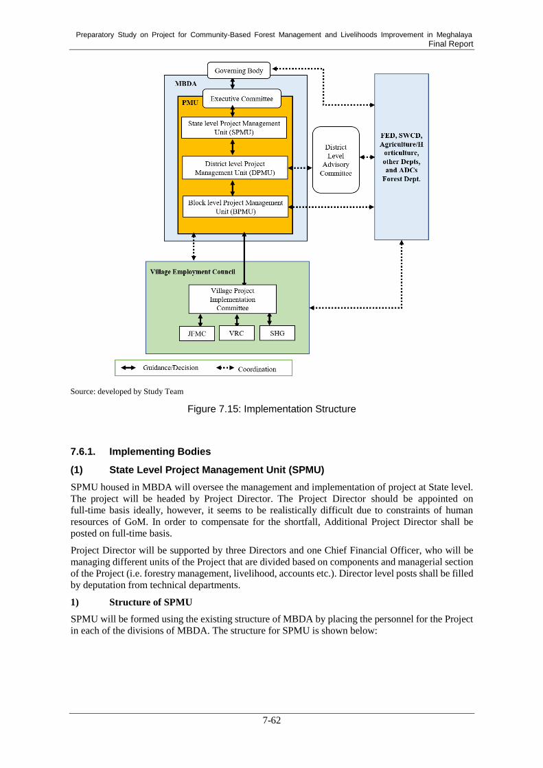
Preparatory Study on Project for Community-Based Forest Management and Livelihoods Improvement in Meghalaya Final Report
7-62
Source: developed by Study Team
Figure 7.15: Implementation Structure
Implementing Bodies 7.6.1.
(1) State Level Project Management Unit (SPMU)
SPMU housed in MBDA will oversee the management and implementation of project at State level.
The project will be headed by Project Director. The Project Director should be appointed on
full-time basis ideally, however, it seems to be realistically difficult due to constraints of human
resources of GoM. In order to compensate for the shortfall, Additional Project Director shall be
posted on full-time basis.
Project Director will be supported by three Directors and one Chief Financial Officer, who will be
managing different units of the Project that are divided based on components and managerial section
of the Project (i.e. forestry management, livelihood, accounts etc.). Director level posts shall be filled
by deputation from technical departments.
1) Structure of SPMU
SPMU will be formed using the existing structure of MBDA by placing the personnel for the Project
in each of the divisions of MBDA. The structure for SPMU is shown below:

Preparatory Study on Project for Community-Based Forest Management and Livelihoods Improvement in Meghalaya Final Report
7-63
Source: developed by Study Team
Figure 7.16: Structure of SPMU
Some of the existing personnel in MBDA will hold multiple duties, allocating part of their duty
time to the Project. One of such position will be Chief Financial Officer. In Finance and
Administration Division, there will be several existing officers who will divide their time for the
Project and other duties.
(2) District Level Project Management Unit (DPMU)
DPMU shall be established at District level. Keeping in mind that the Project requires coordination
with various stakeholders, the Project will be chaired by Deputy Commissioner at District level.
Deputy Commissioners are already heading the Mega-LAMP and CCLAMP at respective district and
are also the chairperson for District Level Advisory Committee. The actual implementation will be
spearheaded by District Project Director, who will work as a nodal officer under the Deputy
Commissioner. District Head of a line department will be appointed as District Project Director.
District Project Manager (DPM) will be in-charge of day to day operation of the Project under the
guidance of Deputy Commissioner and District Project Director, as and when necessary. DPMU will
also establish Executive Committee, which will approve and sanction activities posed by District
Project Director. Executive Committee will coordinate with concerned departments through District
Level Advisory Committee, when technical support is required. A structure of district level
implementation is shown below.

Preparatory Study on Project for Community-Based Forest Management and Livelihoods Improvement in Meghalaya Final Report
7-64
Source: developed by Study Team
Figure 7.17: District Level Implementation Structure
(3) Block Level Project ManagementUnit (BPMU)
Office at block level called Block Level Project Management Unit (BPMU) shall be established at at
Block level, where frontline officers of the project are stationed. BPMU will be chaired by Block
Development Officer (BDO). BDO may appoint a Block Manager, to manage day-to-day operation
of the BPMU. While BDO will be responsible to make the decision and coordinate between the
Project and government departments, actual implementation at Block level will be taken care by the
Block Manager.
(4) Community Level Organization
Slight variation among Khasi Hills, Jaintia Hills and Garo Hills areas may be made as each of these
ADC areas has different degree of traditional community organization exercising their power and
have different relationship between the people and the land. In general, Village Council/Dorbar or
village headman (Rangbah Shnong or Nokma) should be the first point of contact at the onset of the
project implementation. Since they are important traditional institutions, they need to be kept
informed of developments in the Project whenever the village is selected for the Project. Village
Council or its headman can guide the project team in convening public meetings, identifying
potential beneficiaries and resources. However, they are not the implementing body for the project
activities.
Village Employment Council (VEC) is a body to implement the Mahatma Gandhi National Rural
Employment Guarantee Act (NREGA) in Meghalaya State, and has been established in every
village across the State. The Project shall utilize VEC for project implementation. A sub-committee
of VEC will be created known as Village Project Implementation Committee (VPIC). The mandate
of VPIC is to guide and supervise the project implementation in the respective village and to
manage the project account which will be opened exclusively for the Project. Members of the
committee are suggested below; however, adjustment may be made based on the size, demography,
and condition of each selected village.
Village headman
Field officer of FED (Forester)
Field officer of MBDA (Programme Associate for EFC)

Preparatory Study on Project for Community-Based Forest Management and Livelihoods Improvement in Meghalaya Final Report
7-65
Field officer of concerned ADC (Forester)
Filed officer of SWCD (Soil and Water Conservation Demonstrator)
Field officer of Agriculture (Assistant Agriculture Inspector)
Community facilitator of the project
Woman
Youth
Representative of SHGs in the village
Landless
Landholding beneficiary
Sub-headman (in case the target village is large in size)
To empower women in decision-making, 50% of VPIC members represented by villagers shall be
reserved for women.
Apart from VPIC, community facilitator shall be appointed to motivate the community, guide and
assist the community in project activities and act as a link between the project and the community.
Community facilitator will work following instruction by BPMU and report the progress of
activities conducted in the villages to BPMU. Community facilitators shall assist in organizing
meeting, record keeping, and implementation of activities at village level. These individuals should
be youth from the target village. Minimum educational qualification of matriculate is required, with
the recommendation of the village he/she belongs to. Community facilitators for the community
level institutions will be engaged on short-term basis.
VPIC may have different committees in order to accommodate various activities to be implemented
in the village. Committees such as JFMC and Watershed Committee may be required to be created
under VPIC for implementation and maintenance of village level activities. For livelihood related
activities, SHG shall be identified or formulated through the VPIC. In some villages Micro, Small
and Medium Enterprises (MSMEs) /Societies are also established. Once the Project makes entry to
the community, potential beneficiaries or promising entrepreneurs can be identified in other ways as
well. General structure for community level project implementation is shown below.
Source: developed by Study Team
Figure 7.18: Community Level Implementation Structure

Preparatory Study on Project for Community-Based Forest Management and Livelihoods Improvement in Meghalaya Final Report
7-66
Management of the Project 7.6.2.
(1) Governing Body
According to the Societies Registration Act of 1860, management of a society is vested with the
Governing Body, which exercises its power and functions as decision-making body. Governing
Body is the highest decision-making body within the society. In the case of MBDA, there is an
existing GB, and since SPMU will be formed within an existing society, it will be governed by the
same Governing Body. At the same time, MBDA has its own mandate and the objective, and
requirement in the Project may not be fully aligned to that of MBDA. Therefore, following officers
are to be added to the members of the Governing Body in addition to existing Governing Body
members, when Governing Body makes decision on the Project.
A representative from the Department of District Council Affairs
Project Director of JICA funded Project for Community-Based Forest Management and
Livelihoods Improvement in Meghalaya
Composition of Governing Body shall be as follow:
Table 7.20: Composition of Governing Body
Sl. No. Rank of Officers and Department Membership
1 Chief Secretary Chairperson
2 Additional Chief Secretary, Labour Department and
SWCD
Member
3 Additional Chief Secretary, Finance/Power
Department
Member
4 Principal Secretary, Planning Department Member
5 Principal Secretary, Forest Department Member
6 Commissioner and Secretary, Public Health and
Engineering Department
Member
7 Commissioner and Secretary, Water Resources
Department, SWCD, FED, Planning Department, and
Community & Rural Development Department
Member
8 Commissioner and Secretary, Agriculture/Fisheries
Department
Member
9 Commissioner and Secretary, Personnel Department Member
10 Commissioner and Secretary, District Council Affairs
Department
Member (new)
11 Project Director (JICA project) Member (new)
12 JICA representative Invitee Source: developed by Study Team
The Governing Body meeting shall be convened half yearly or more frequently, as it has been doing
so. More frequency of meeting may be required particularly in the initial stage of the project. A
minimum of two-thirds of the members will form the quorum for the Governing Body meetings..
(2) Executive Committee of PMU
While the Governing Body’s responsibility is to look after overall management of MBDA, day to day
operation of the project will be entrusted to Executive Committee (EC) created specifically catering
for the PMU. The EC will ensure efficient management of the project such as quick decision making,
trouble shooting, close supervision etc. Composition for the EC is shown below. The composition
may be adjusted based on the executive positions created in the SPMU and other government
departments/agencies that may have significant association to the Project.

Preparatory Study on Project for Community-Based Forest Management and Livelihoods Improvement in Meghalaya Final Report
7-67
Table 7.21: Composition of Executive Committee
Sl. No. Rank of Officers and Department Membership
1 Project Director Chairperson
2 Additional Project Director Member Secretary
3 All Division’s chairperson of SPMU Members
4 Director, SWCD Member
5 Chief Forest Officer (CFO), JHADC Member
6 CFO, KHADC Member
7 CFO, GHADC Member Source: developed by Study Team
The committee will be exclusively for the project and should meet at least once every month, or
more frequently if the need arises, particularly during preparatory phase of the project. In case the
members are not available on the day of the meeting, they may nominate senior rank officers in the
department/section as their representatives to attend the meetings with authorization for decision
making.
As far as possible efforts will be made that meetings are organized when all of the members can
participate in EC meetings, however minimum of 2/3rd members will form the quorum of the EC
meetings. Agenda of the meeting and proposals will be circulated by the Member-Secretary well in
advance to all members, at least three days ahead of the meeting date. Proceedings of the EC
meetings will be circulated to all the members/ attendees within reasonable timeframe, after the
meeting is concluded.
Coordination with Oher Departments 7.6.3.
(1) District Level Advisory Committee (DLAC)
While Governing Body has function of coordinating with other departments and agencies, at field
level, DLAC will be a forum where DPMU can make convergence with other government schemes
and coordination. DLAC chaired by respective Deputy Commissioner is already in existence across
the State, dealing with convergence issues among various departments. The project can make use of
this existing body as a forum to coordinate with other departments at district level, as and when
required.
Involvement of Other Major Stakeholders 7.6.4.
(1) Forest and Environment Department (FED)
Because the Project is a forestry sector project, involvement of FED is essential. Deputation of
forest officials to SPMU and DPMU, and working together in areas where FED is operating shall
be arranged. Involvement of FED will be important not only in the implementation of the Project,
but also to provide support to the communities in the operation and maintenance stage.
(2) Autonomous District Councils (ADCs)
As a link between the project and community, ADCs will have important role to play. However, in
some places, ADCs have had limited involvement due to paucity of funds and other resources.
Empowering ADCs through active participation will be a key. To do so, components of the project
where ADCs can take leadership must be first identified. As each ADC’s authority and relationship
with communities are unique, their intervention will not be necessarily the same. Kind of
intervention and quantum of work to be carried out by ADCs will be determined individually.
(3) Soil and Water Conservation Department (SWCD)
Another major stakeholder to the project implementation is SWCD. In relation to the volume of
work implemented by SWCD, deputation of officer(s) from the department to SPMU needs to be

Preparatory Study on Project for Community-Based Forest Management and Livelihoods Improvement in Meghalaya Final Report
7-68
considered.
For all the stakeholders where the project fund will be channelized from SPMU/DPMU to
respective office, they will be responsible in keeping records of and reporting the fund utilization to
the SPMU/DPMU on regular basis. Fund flow is discussed in subsequent section.
(4) Agriculture/Horticulture Department
Agriculture and agroforestry is one of major livelihood activities in the Project.
Agriculture/Horticulture Department is expected to provide technical support to beneficiaries.
Training on agroforestry for SHG members can be conducted at an experimental farms of the
department.
Fund Management 7.6.5.
(1) Budgetary Provision
For smooth implementation, the Government of Meghalaya will make sure that required fund is
secured and released on time. This applies to not only Japanese ODA loan portion but also for State
share. At SPMU and its field offices, exclusive bank accounts for the project will be opened.
(2) Annual Plan of Operation (APO)
SPMU will prepare APO for each financial year starting from first year, and get it approved by the
Governing Body prior to commencement of new financial year. SPMU will guide, capacitate and
make efforts to ensure that the plans are prepared in timely manner through a consultative process
starting from the lowest level of project implementation. An orientation workshops should be held
by SPMU in first two to three years of the Project to acquit ant filed functionaries on how to draft
APO at Block and District levels.
(3) Fund Flow
From SPMU, fund flow will have two channels; a) fund for procurement and operations at
respective departments/institutions, the fund will be transferred to respective
departments/institutions, while b) the fund for activities implemented by VPIC will be transferred
from SPMU to DPMU, and then to DPMU to VPIC of VEC. Among the various levels and bodies
of project implementation, following shows the direction of fund flow.
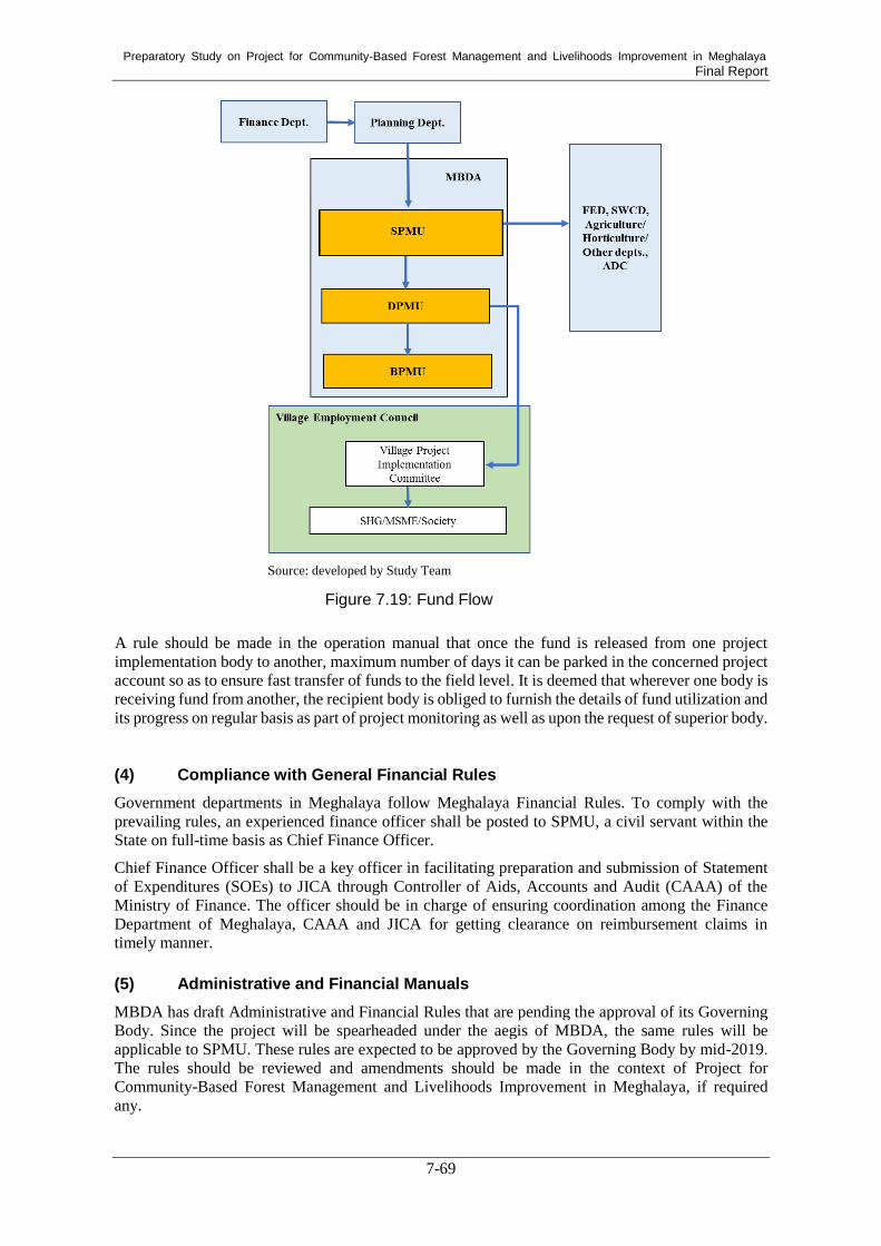
Preparatory Study on Project for Community-Based Forest Management and Livelihoods Improvement in Meghalaya Final Report
7-69
Source: developed by Study Team
A rule should be made in the operation manual that once the fund is released from one project
implementation body to another, maximum number of days it can be parked in the concerned project
account so as to ensure fast transfer of funds to the field level. It is deemed that wherever one body is
receiving fund from another, the recipient body is obliged to furnish the details of fund utilization and
its progress on regular basis as part of project monitoring as well as upon the request of superior body.
(4) Compliance with General Financial Rules
Government departments in Meghalaya follow Meghalaya Financial Rules. To comply with the
prevailing rules, an experienced finance officer shall be posted to SPMU, a civil servant within the
State on full-time basis as Chief Finance Officer.
Chief Finance Officer shall be a key officer in facilitating preparation and submission of Statement
of Expenditures (SOEs) to JICA through Controller of Aids, Accounts and Audit (CAAA) of the
Ministry of Finance. The officer should be in charge of ensuring coordination among the Finance
Department of Meghalaya, CAAA and JICA for getting clearance on reimbursement claims in
timely manner.
(5) Administrative and Financial Manuals
MBDA has draft Administrative and Financial Rules that are pending the approval of its Governing
Body. Since the project will be spearheaded under the aegis of MBDA, the same rules will be
applicable to SPMU. These rules are expected to be approved by the Governing Body by mid-2019.
The rules should be reviewed and amendments should be made in the context of Project for
Community-Based Forest Management and Livelihoods Improvement in Meghalaya, if required
any.
Figure 7.19: Fund Flow

Preparatory Study on Project for Community-Based Forest Management and Livelihoods Improvement in Meghalaya Final Report
7-70
Finance and accounting manual need to be prepared separately pertaining to the project. Specific
requirement in terms of JICA procedure should be addressed in the manual. Short-term
consultant(s) may be appointed to develop the manual along with other operation manuals at the
onset of the project.
(6) Accounting Procedures Accounting Procedures
As mentioned in 7.5.3(5)4), SPMU, ADC, DPMU will have exclusive bank account for the Project.
Similarly, separate bank account should be opened for VPIC as well, if they don’t have existing
account. For the community level implementation bodies, in addition to the committee’s president,
treasurer and secretary a member-secretary represented by an officer from BPMU should be one of
signers for the bank account.
Accounting procedure will be unified based on double accounting system at SPMU and all its field
offices. Finance and accounting manuals for the Project should be prepared with first six months of
the Project from the signing of the Loan Agreement.
Funds for the Project will be released from SPMU to respective departments/institutions as well as
to DPMU on regular basis, based on APO. The fund from SPMU to concerned departments will be
transferred to the Director of the department, while the fund from SPMU to ADCs will be in the
project account of Chief Forest Officer. DPMU will release fund to VPIC of VEC.
The funds from the state government to SPMU, as well as its field offices, ADC, concerned
department and VPIC of VEC are provided as grant-in-aid. None of the fund reserved for the
Project must be used or diverted by SPMU or any of its field offices for purpose other than the
Project.
Utilization certificated and Statement of Expenditures (SOE) will be submitted from community
level institution to DPMU, ADC or concerned departments depending on the nature of work. The
same will be submitted from DPMU to SPMU on the regular basis. Utilization certificates and SOE
of any funds released to and utilized by ADCs and concerned departments will be submitted by
each institution to SPMU. Preparation and submission of utilization certificates and SOE will be
made on regular basis.
(7) Audits
Transparency, particularly related to utilization of project fund, is important. All levels of
implementation bodies (SPMU, DPMU and VPIC of VEC) in the proposed project must have
annual statutory financial audit conducted each year. Qualified chartered accountant firm should be
identified and appointed for this purpose. This will be done in compliance with Comptroller and
Audit General’s (Duties, Powers and Conditions of Services) Act, 1971.
(8) Procurement
Procurement of goods and services for the Project will be done in accordance with the “Guidelines
for Procurement under Japanese ODA Loans” dated April 2012 and project management
consultants will be selected in accordance with “Guidelines for Employment of Consultants under
Japanese ODA Loans” dated April 2012. The PMU may make use of the state procurement rules,
but JICA’s guidelines shall overrule whenever such procurement rules are in conflict.
Quality and Cost Based Selection (QCBS) method will be adopted by PMU that generally has
following stages of selection, viz., a) Notice publication and invitation for Expression of Interest
(EOI), b) Screening of proposals and preparing Short-list, c) Inviting Technical and Financial
Proposals through Request for Proposal (RfP), d) Evaluation of Technical proposals, e) Opening
and evaluation of Financial Proposal based on the qualifying Technical Score, and f) Inviting top
Preparatory Study on Project for Community-Based Forest Management and Livelihoods Improvement in Meghalaya Final Report
7-71
ranked agency/organization of Negotiations abased on the combined Technical and Finance Score.
Before, evaluation of technical proposals, sometimes presentation on the Technical Proposal is also
required by the Client, and accordingly reflected in the ‘Special Conditions’ of the RfP.
(9) Revolving Fund
SPMU shall develop elaborate policy and system of accessing and utilizing of revolving funds to be
created under the Project. The policy will also spell out to deal with the interests earned out of such
revolving funds and include it as a section in the Operation Manual. The policy will be approved by
the GB, and systematic record of utilization of such funds will be maintained at SPMU and at field
offices, as well as community level whenever applicable. The guidelines based on the approved
policy will be published and disseminated amongst stakeholders to facilitate access to these funds
as well as to keep transparency.
Project Management Consultant (PMC) 7.6.6.
To assist SPMU in project management, PMC will be hired. PMC will be procured following the
JICA guideline. Main tasks of PMC are envisaged as follow:
Assist SPMU in managing the Project in an effective and efficient manner.
Assist SPMU in periodically monitoring the project activities with the monitoring
formats and improving the project design, framework, and systems based on the
monitoring data stored in the MIS/GIS-based monitoring system. Assist SPMU in preparing annual work and budget plans based on the appropriate
estimation of work quantity as well as unit costs of the respective inputs.
Assist SPMU in enhancing the capacity of stakeholders in sustainable forest, soil and
water conservation, and community development and livelihood improvement
Assist SPMU in undertaking works and procuring the necessary equipment, goods &
services for the project implementation.
Assist DPMU/ BPMU to strengthen their technical, managerial, and administrative
capacities for implementation and management of the Project.
Assist DPMU/ DPMU/ BPMU in providing orientation, technical guidance, and advice to
community organizations for the effective implementation of the project activities.
Facilitation of implementation of Environmental and Social Management System
Framework (ESMSF) and Scheduled Tribe and Forest Dependents Plan Framework
(STFDPF)
7.7. Environmental and Social Considerations
Overview of the Present State of Meghalaya State 7.7.1.
(1) Pollution Control
1) Air Quality
a. Ambient Air Quality
The National Ambient Air Quality Standards of India and guideline values of World Health
Organization (WHO) are given in Table 7.22.

Preparatory Study on Project for Community-Based Forest Management and Livelihoods Improvement in Meghalaya Final Report
7-72
Table 7.22: National Ambient Air Quality Standards of India
Pollutants
Time
Weighted
Average
Industrial,
Residential, Rural
and Other Area*
Ecologically
Sensitive Area Method
SO2
(μg m-3
)
Annual 50 (20) 20 - Improved west & Gacke method
- Ultraviolet fluorescence method 24 hours 80 (500) 80
NO2
(μg m-3
)
Annual 40 (40) 30 - Modified Jacab&Hochheister method
- Chemiluminescene method 24 hours 80 (200) 80
PM10
(μg m-3
)
Annual 60 (20) 60 - Gravimetric method
- TEM
- Beta attenuation method
24 hours 100 (50) 100
PM2.5
(μg m-3
)
Annual 40 (10) 40
24 hours 60 (25) 60 *Note: Numbers in parentheses indicate WHO Guideline Values (2017)
Source: NATIONAL AMBIENT AIR QUALITY STATUS & TRENDS (2012), CPCB
The Meghalaya State Pollution Control Board (MSPCB) is monitoring the Ambient Air Quality at
seven stations in the state under the National Air Monitoring Programme (NAMP), sponsored by
the Central Pollution Control Board (CPCB). The frequency of monitoring is twice a week.
Particulate Matter (PM10), Sulphur Dioxide (SO2), Oxides of Nitrogen (NOx), and meteorological
parameters viz. such matters as wind speed, wind direction, ambient air temperature, and humidity
were monitored at these stations. The observations are presented below in Table 7.23. The
permissible limits of PM10, SO2 and NOx are 60 µg m-3
, 50 µg m-3
and 40 µg m-3
, respectively.
Monitoring results which exceeded the limits are indicated in bold.
Table 7.23: Ambient Air Quality in Meghalaya State
(1) Board’s Office Premises, Lumpyngngad, Shillong (Station 1)
(2) MUDA Complex, Police Bazar, Shillong (Station 2)
(3) Export Promotion Industrial Park (EPIP), Byrnihat, Ri-Bhoi District (Station 3)
Period Jan Feb Mar Apr May Jun Jul Aug Sep Oct Nov Dec Avg.
PM10
(µg m-3
) 49.1 45.9 48.9 36.8 40 39.7 37.7 37.6 36.1 32.1 39.5 39.2 40.2
SO2
(µg m-3
) 2 2 2 2 2 2 2 2 2 2 2 2 2.0
NOx
(µg m-3
) 4.7 4.5 4.7 4.5 4.5 4.5 4.5 4.5 4.5 4.5 4.5 4.5 4.5
Period Jan Feb Mar Apr May Jun Jul Aug Sep Oct Nov Dec Avg.
PM10
(µg m-3
) 92.3 93.2 94.7 93.2 87.5 89.2 88.6 85.3 86.7 85.3 85.8 82.9 88.7
SO2
(µg m-3
) 2.1 2.7 2.3 2.4 4.9 3.8 3.7 3.2 2.8 2.3 2.2 2.5 2.9
NOx
(µg m-3
) 18.0 17.6 18.1 18.6 18.1 16.9 16.1 17 16.9 16.6 13.8 13.8 16.7
Period Jan Feb Mar Apr May Jun Jul Aug Sep Oct Nov Dec Avg.
PM10
(µg m-3
) 149.1 140.1 125.6 139.4 92.9 115.4 116.3 121.4 119.4 135.2 99.5 98.3 121.0
SO2
(µg m-3
) 28.9 25.0 20.3 16.7 16.8 14.4 17.9 18.3 16.8 17.1 38 26.3 21.3
NOx
(µg m-3
) 19.0 13.7 16.3 14.5 14.2 13 15 14.9 12.6 13.2 13 13.3 14.3

Preparatory Study on Project for Community-Based Forest Management and Livelihoods Improvement in Meghalaya Final Report
7-73
(4) Dawki, West Jaintia Hills District (Station 4)
(5) Tura, West Garo Hills District (Station 5)
(6) Khliehriat, Jaintia Hills District (Station 6)
(7) Nongstoin, West Khasi Hills District (Station 7)
All Data Sources in the Tables: Meghalaya State Pollution Control Board Annual Report 2013-2014
Ambient air quality monitoring data during 2013
monitored at the seven stations revealed that the
Annual Average concentrations of SO2 and NOx
were within the prescribed standards of the
National Ambient Air Quality standards. On the
other hand, PM10 levels in Police Bazar, Shillong
(Station 2) and Byrnihat, Ri-Bhoi District (Station
3) exceed the standard substantially due to heavy
traffic, even at night (Figure 7.20).
(Source: Study Team)
Figure 7.20: Traffic Situation in Police Bazar,
Shillong
Period Jan Feb Mar Apr May Jun Jul Aug Sep Oct Nov Dec Avg.
PM10
(µg m-3
) 49.8 47.5 48.0 41 26.7 32.5 34.2 39.1 43.8 46.7 46.4 46.4 41.8
SO2
(µg m-3
) 2 2 2 2.4 2 2 3.1 2.7 2 2.3 2 2.1 2.5
NOx
(µg m-3
) 13.0 9.1 10.6 9.9 7.7 8.3 8.4 9.4 12.6 10.1 10.9 8.9 9.9
Period Jan Feb Mar Apr May Jun Jul Aug Sep Oct Nov Dec Avg.
PM10
(µg m-3
) 55.1 46.7 34.3 31.8 33.8 35 24.4 37.9 34.1 36.4 49 31.5 37.5
SO2
(µg m-3
) 2 2 2 2 2 2 2 2 2 2 2 2 2.0
NOx
(µg m-3
) 4.5 4.5 4.5 4.5 4.5 4.5 4.5 4.5 4.5 4.5 4.5 4.5 4.5
Period Jan Feb Mar Apr May Jun Jul Aug Sep Oct Nov Dec Avg.
PM10
(µg m-3
) 52.2 51.2 47.7 42.6 40.4 40.7 19.6 16.4 27.2 33 39.9 48.3 38.2
SO2
(µg m-3
) 2 2 2 2 2 2 2 2 2 2 2 2 2.0
NOx
(µg m-3
) 11.3 11.0 10.4 9 8.7 5.8 4.5 4.5 4.5 6.6 4.5 4.5 7.1
Period Jan Feb Mar Apr May Jun Jul Aug Sep Oct Nov Dec Avg.
PM10
(µg m-3
) 29.3 31.0 30.3 27.2 27.2 25.3 24 23.2 22.8 21.3 22.9 21.1 25.4
SO2
(µg m-3
) 2 2 2 2 2 2 2 2 2 2 2 2 2.3
NOx
(µg m-3
) 4.9 5.9 5.5 5.9 5.1 6.5 8.4 8.2 7.8 6.6 5.2 4.5 6.2

Preparatory Study on Project for Community-Based Forest Management and Livelihoods Improvement in Meghalaya Final Report
7-74
b. Assessment of Vehicular Pollution
MSPCB is operating a fixed/permanent Vehicular Emission Testing Station on its office premises,
Lumpyngngad, Shillong, which was established in 1994 for testing of Petrol- and Diesel-driven
vehicles (Light Motor Vehicles: LMV). This was done only at the request of the Transport
Department for the purpose of obtaining an exhaust emission certificate, as required by the
Transport Authority for the granting and renewal of registrations and permits. Mostly, commercial
driven vehicles (LMV) are tested at this station. Vehicular testing is as shown below:
Table 7.24: Results of Vehicular Monitoring
Period 01/04/2012 -
31/03/2013
01/04/2013 -
31/03/2014
01/04/2014 -
31/03/2015
01/04/2015 -
31/03/2016
01/04/2016 -
31/03/2017
Type of vehicles Petrol Diesel Petrol Diesel Petrol Diesel Petrol Diesel Petrol Diesel
Total no. of vehicles tested 2,231 1,497 3,725 1,473 3,506 1,428 6,524 2,399 8,085 2,573
Percentage of vehicles
complying to emission
standards
93.00
%
91.60
%
95.00
%
92.90
%
98.80
%
95.40
%
99.00
%
93.20
%
99.00
%
97.40
%
Percentage not complying
to emission standards
6.90
%
8.40
%
5.00
%
7.00
%
1.20
%
4.60
%
1.00
%
6.80
%
1.00
%
2.60
% Source: http://megspcb.gov.in/vehicular.html (as of February 2019)
2) Water Quality
Meghalaya State is endowed generously by nature as far as water resources are concerned. A
number of perennial rivers, lakes, and waterfalls grace this land with eternal charm and beauty.
There are several rivers and streams, which have comparatively smaller stretches but which are
quite important for water utilization, as most of these are exploited for the such things as drinking
water, irrigation, industries, and waste disposal. For the last few decades or so the state has started
facing serious problems of surface and groundwater pollution due to the indiscriminate discharge of
untreated municipal effluents, industries, and agricultural runoff. Open defecation and dumping of
solid wastes on river banks also contribute to water pollution. Unorganized mining activities on a
large scale in almost all the parts of the state, mainly of coal, is another major source of water
pollution. In order to obtain information regarding the overall health and general environmental
state of the rivers and ground water resources in the state, MSPCB is monitoring on a regular basis
the water quality of selected water bodies in the state under National Water Monitoring Programme
(NWMP). This monitoring covers 20 rivers and streams, four lakes, and seven springs/wells. A
total of 54 sampling locations (47 points of surface water and 7 points of ground water) are
monitored. The monitoring of water quality is one of the purposes of prevention and control of
water pollution and maintaining or restoring the wholesomeness of water, as indicated in the Water
(Prevention and Control of Pollution) Act 1974. Monitoring is done on monthly basis for surface
water and on a half-yearly basis for ground water. The regular parameters analyzed include pH,
Conductivity, Turbidity, Total Suspended Solids, Total Dissolved Solids, Nitrite Nitrogen (NO2-N),
Nitrate Nitrogen (NO3-N), Ammonia Nitrogen (NH4-N), Kjeldahl Nitrogen (as total N), Sulphate
(as SO4), Chloride (Cl), Hardness, Calcium (Ca), Magnesium (Mg), Sodium (Na), Potassium (K),
Total Phosphate, Acidity, Alkalinity, Fluoride (F), Dissolved Oxygen (DO), Bio-Chemical Oxygen
Demand (BOD), Chemical Oxygen Demand (COD), Total Coliform, and Fecal Coliform. The
metals, namely Iron (Fe), Zinc (Zn), Manganese (Mn), Copper (Cu), Lead (Pb), Cadmium (Cd),
Chromium (Cr), and Nickel (Ni) are analyzed once a year in April. The National Water Quality
Standards of India, with international reference values, and details of monitoring stations with
regard to location, is as mentioned in Table 7.25 and Table 7.26, respectively.
Based on the monitoring data, the water quality of the sampling stations district-wise is as described
below.

Preparatory Study on Project for Community-Based Forest Management and Livelihoods Improvement in Meghalaya Final Report
7-75
a. Water Quality of Rivers in East Khasi Hills District
Seventeen sampling stations are located in East Khasi Hills. In all monitored locations, pH levels
were observed to be in the normal range of 6.5 to 8.5. Dissolved Oxygen was found to be very low
in the rivers of Umkhrah and Umshyrpi, with a minimum value of Nil recorded at Umshyrpi River
(Law college) and Umkhrah River (Demthring, near a slaughter house and Mawpdang) during the
dry winter months of February and March. In contrast, concentration in other rivers was always
above 4 mg L-1
, which is the minimum oxygen requirement for the propagation of, among other
things, wildlife and fisheries. The Bio-chemical Oxygen Demand was observed to be above 3 mg
L-1
in Ward’s Lake, Umkhrah and Umshyrpi Rivers. The total coliform count was observed to be
above 5000mpn/100ml in Umkhrah and Umshyrpi Rivers. The Ammonia Nitrogen concentration
was observed to be above 1.2 mg L-1
in the same rivers, which is the maximum limit for
propagation of wildlife and fisheries. The monitoring results indicated that organic materials and
Bacteria are the main pollutants in the water bodies. This is mainly due to direct discharge of waste
water in an untreated form from residential and commercial centres. The amount of waste received
by the two rivers, namely Umkhrah and Umshyrpi, is much beyond their assimilative capacity and
thus has water quality has deteriorated to the extent that the water in these two rivers cannot be put
to any beneficial uses. The water quality of Ward’s Lake meets the criteria for propagation of
wildlife and fisheries. The water quality of other water bodies is relatively good and can still be
used for various beneficial purposes, although it is not recommended for direct use as drinking
water, unless first treated and disinfected by an organized water supply system.
b. Water Quality of Rivers in West Khasi Hills District
Eight sampling stations are located in West Khasi Hills. In all monitored locations, pH levels were
observed to be in the normal range of 6.5 to 8.5.The dissolved Oxygen content in all monitored
rivers was always above 4 mg L-1
, which is the minimum oxygen requirement for the propagation
of wildlife and fisheries. The Bio-chemical Oxygen Demand was observed to be above 3 mg L-1
and total coliform count above 500 mpn/100 ml in Nanbah River at Nongstoin. Located in the
centre of district headquarters, this river is also subjected to pollution arising out of such sources as
the direct disposal of solid and liquid waste from residential & commercial areas, automobile
workshops and servicing centres, as well as agricultural runoff. However, the water of this river can
be used for the propagation of wildlife and fisheries, and for irrigation purposes. The water quality
of other water bodies is relatively good and can still be used for various beneficial purposes,
although it is not recommended for direct use as drinking water, unless first treated and disinfected
by an organized water supply system.
c. Water Quality of Rivers in Ri-Bhoi District
Six sampling stations are located in Ri-Bhoi. In all monitored locations, pH levels were observed to
be in the normal range of 6.5 to 8.5. The dissolved Oxygen content in all the stations was found to
be above 4 mg L-1
, which is the minimum oxygen requirement for propagation of wildlife and
fisheries. The Bio-chemical Oxygen Demand was observed to be above 3 mg L-1
in Umiam Lake
and Umtrew River at Byrnihat. The total coliform count in these water bodies was also observed to
be high. Umiam Lake received waste that is generated in the Shillong through Umkhrah and
Umshyrpi Rivers, whereas the Umtrew River is subjected to pollution originating from residential,
commercial, and industrial areas. The water of Umiam Lake and Umtrew river can be used for
propagation of wildlife and fisheries, and irrigation purposes. The water quality of other water
bodies is relatively good and can still be used for various beneficial purposes, although it is not
recommended for direct use as drinking water, unless first treated and disinfected by an organized
water supply system.

Preparatory Study on Project for Community-Based Forest Management and Livelihoods Improvement in Meghalaya Final Report
7-76
Table 7.25: National Water Quality Standards
Item Acceptable Cause for Rejection WHO (2011) USEPA (1996)
Turbidity (JTU scale) 2.5 10 ― 1 (NTU)
Color (Pt-Co scale) 5.0 25 ― 5 (color units)
Taste & Odor (mg L-1) Unobjectionable 3 (TON)
pH 7.0 - 8.5 6.5 - 9.2 ― 6.5 – 8.5
TDS (mg L-1) 500 1500 500 1,000
Total hardness (mg L-1) 200 600 ― ―
Cl (mg L-1) 200 1000 ― ―
SO4 (mg L-1) 200 400 250 250
F (mg L-1) 1.0 1.5 1.5 2.0
NO3 (mg L-1) 45 45 50 10
Ca (mg L-1) 75 200 ― 250
Mg (mg L-1) 30 150 ― ―
Fe (mg L-1) 0.1 1.0 0.3
Mn (mg L-1) 0.05 0.5 ― 0.05
Cu (mg L-1) 0.05 1.5 2.0 1.0
Zn (mg L-1) 5.0 15.0 ― 5
Phenol (mg L-1) 0.001 0.002 ― ―
MBAS (mg L-1) 0.2 1.0 ― 0.5
Oil (mg L-1) 0.01 0.3 ― ―
As (mg L-1) 0.05 0.05 0.01 0.01
Cd (mg L-1) 0.01 0.01 0.003 0.005
Cr+6 (mg L-1) 0.05 0.05 0.05* 0.1*
CN (mg L-1) 0.05 0.05 ― 0.2
Pb (mg L-1) 0.1 0.1 0.01 0.015
Se (mg L-1) 0.01 0.01 0.04 0.05
Hg total (mg L-1) 0.001 0.001 0.006** 0.002
PAH (μg L-1) 0.2 0.2 ― ―
DO (mg L-1) 5 mg L-1 or more ― ―
BOD (mg L-1) 30-100 ― ―
COD (mg L-1) 250 250 ― ―
Ammonia (mg L-1) 0.5*** 0.5*** ― ―
Total Coliform
(MPN 100 mL-1) Must not be detectable
(see marginal
note****)
Note: * as total Cr. ** as inorganic Hg. *** as NH4+
**** A system collecting fewer than 40 samples per month, has greater than 1 ROUTINE/REPEAT sample per
month which is total coliform-positive. A system collecting at least 40 samples per month, has greater than
5.0 percent of the ROUTINE/REPEAT samples in a month total coliform-positive.
Source: http://www.mdws.gov.in/sites/default/files/Drinking_water_quality_standards.pdf (as of February 2019)

Preparatory Study on Project for Community-Based Forest Management and Livelihoods Improvement in Meghalaya Final Report
7-77
Table 7.26: Water Quality in Meghalaya State
Districts Name of
River Location
pH DO
(mg L-1)
BOD
(mg L-1)
Total Coliform
(MPN 100 mL-1) NH4
+
(mg L-1)
min. max. avg. min. max. avg. min. max. avg. min. max. avg. min. max. avg.
East
Khasi
Hills
Umiam
Mawphlang
River
Nongkrem 6.7 7.1 6.9 5.5 7.7 6.4 1.5 2.8 2.4 39 84 63 0.28 0.5 0.36
Umtyngngar 6.9 7.3 7.13 6.8 8.4 7.57 1.0 2.2 1.7 29 70 53 0.13 0.35 0.23
Mawphlang 6.8 7.3 7.0 7.2 8.3 7.8 0.8 2.0 1.36 23 46 35 0.1 0.22 0.15
Shella 7.2 7,8 7.5 6.8 8.5 7.7 1.0 2.2 1.56 25 93 56 0.12 0.32 0.21
Umngot
River
Smit 6.7 7.0 6.8 6.6 8.8 7.3 0.85 2.3 1.65 30 84 55 0.10 0.36 0.24
Dawki 6.9 7.3 7.1 7.2 9.0 7.9 0.8 1.5 1.2 32 70 50 0.1 0.3 0.2
Umkhen
River
Wah Kdait 6.8 7.2 7.0 6.5 9.0 7.1 0.9 2.2 1.7 26 59 44 0.2 0.35 0.27
Ksehpongdeng 6.7 7.2 7.0 6.5 9.2 7.5 0.9 2.2 1.6 27 53 38 0.17 0.27 0.21
Diengpasoh 7.0 7.5 7.24 6.6 9.2 7.5 1.0 2.25 1.69 33 70 47 0.2 0.30 0.25
Ward’s Lake Shillong 7.1 7.7 7.4 6.0 8.0 6.9 6.0 9.6 7.6 2,900 5,000 4,025 0.21 0.5 0.35
Umkhrah
River
Demthring, Shillong 6.8 7.4 7.15 0 5.2 2.7 11.8 45.0 22.6 20×103 30×103 32×103 5.2 20.0 11.0
Umkaliar, Shillong 7.0 7.4 7.15 3.0 6.0 4.55 10.2 20.5 14.2 12×103 29×103 20×103 2.5 8.0 4.94
Mawlai, Slaughter, Shillong 7.0 7.4 7.15 3.0 6.0 4.55 10.2 20.5 14.2 34×103 112×103 68×103 4.0 19.2 10.9
Mawpdang, Shillong 7.0 7.5 7.2 0 3.3 1.6 17.5 72.0 40.9 63×103 170×103 102×103 6.6 30.6 15.0
Umshyrpi
River
Risa colony, Shillong 6.7 7.5 7.15 0 2.8 1.6 23.2 78.4 43.4 30 59 46 0.12 0.30 0.21
Law college, Dhanketi, Shillong 6.7 7.2 6.19 5.6 8.4 6.85 0.6 2.7 1.82 53×103 140×103 92×103 5.4 18.0 10.5
Umshyrpi, Bridge, Shillong 6.8 7.2 7.0 0.2 4.0 1.73 21.0 58.2 36.1 20×103 84×103 45×103 2.4 10.2 5.7
West
Khasi
Hills
River Kynshi
Sohiong 6.8 7.4 7.1 7.0 8.5 7.3 1.0 1.5 1.3 21 56 36 0.1 0.3 0.2
Nongkhnum 6.8 7.5 7.17 7.2 8.8 7.64 1.0 1.8 1.2 22 55 37 0.03 0.31 0.21
Ranikor 6.6 7.3 6.88 7.2 9.0 8.0 1.0 2.8 1.8 33 67 50 0.16 0.4 0.31
River Rilang Mawkyrwat 7.2 7.4 7.25 7.4 8.8 7.85 0.6 1.8 1.4 20 40 29 0.14 0.25 0.22
River
Nanbah
Nongstoin, Market 6.7 7.1 6.9 3.4 6.8 5.5 2.4 4.2 3.2 190 1,200 525 0.27 0.48 0.38
Phod sohsat 7.0 7.5 7.2 6.8 8.8 7.5 1.2 2.0 1.38 19 46 33.2 0.03 0.28 0.17
River
Wahblei
Riangdo 7.1 7.5 7.27 5.8 8.5 7.4 1.0 2.5 1.82 17 44 32 0.17 0.34 0.25
Shdaddkhar 6.9 7.5 7.3 7.2 8.4 7.7 1.0 2.3 1.67 16 53 35 0.15 0.35 0.24
Ri-Bhoi
Umiam Lake
Outfall of Umiam river into lake 6.5 7.5 7.2 2.0 6.2 5.1 8.8 12.5 10.0 3,400 5,500 4,700 0.35 1.4 0.61
Middle point 6.8 7.6 7.3 6 7.7 6.5 6 9.5 8.35 2,800 4,400 3,608 0.3 0.45 0.39
Near United Christian College 7.0 7.5 7.3 5.8 7.5 6.4 6.2 10.2 8.5 2,700 4,400 3,641 0.27 0.5 0.39
Exit point 6.9 7.5 7.2 5.5 7.4 6.35 6.4 10.4 9.0 2,900 5,300 4,108 0.28 0.45 0.39
River
Umtrew
Umran 6.8 7.2 7.0 6.6 8.8 7.5 0.8 2.8 2.0 53 220 110 0.17 0.34 0.23
Byrnihat 6.9 7.4 7.1 6.8 8.2 7.46 6 7.2 6.75 330 750 505 0.17 0.47 0.29
Jaintia
Hills
River Lukha Lunar at Myndihati 2.2 3.2 2.6 6.2 8.4 6.88 1.4 4.2 3.1 4 20 10 0.2 0.42 0.3
Sunapur 4.5 7.8 6.4 7.0 8.0 7.4 1.0 3.0 2.41 220 600 378 0.21 0.35 0.27
River
Myntang
Nartiang 6.6 7.3 7.0 6.5 8.0 7.4 1.2 2.4 1.7 27 63 48 0.14 0.28 0.19
Mynso 6.8 7.3 7.0 6.4 8.2 7.4 1 2.5 1.73 24 60 45 0.1 0.3 0.20

Preparatory Study on Project for Community-Based Forest Management and Livelihoods Improvement in Meghalaya Final Report
7-78
Districts Name of
River Location
pH DO
(mg L-1)
BOD
(mg L-1)
Total Coliform
(MPN 100 mL-1) NH4
+
(mg L-1)
min. max. avg. min. max. avg. min. max. avg. min. max. avg. min. max. avg.
Jaintia
Hills
(cont.)
River
Myntdu
Jowai 6.2 7.6 7.0 5.6 7.2 6.4 2.4 3.1 2.77 1,900 3,500 2,825 0.09 0.36 0.26
Leshka 4.5 7.2 5.6 7 8.2 7.5 1 2 1.55 14 40 22 0.08 0.27 0.19
Thadlaskein
Lake Mukhla 6.6 7 6.8 6.8 8 7.28 1.4 2.4 1.9 35 75 58 0.03 0.25 0.14
River
Kyrhukhla Khliehriat 2.5 3.3 2.8 3 6.8 4.97 5.8 11.2 8.1 20 50 33 0.13 0.4 0.26
Garo
Hills
Damring
River
(Krishnei)
Resubelpara 7 7.5 7.3 7 8.2 7.57 1.1 4.5 1.85 32 93 60. 0.2 0.4 0.27
Manda
(Dudhnai)
River
Jampa 6.5 7.6 7.2 7 8.4 7.6 1.2 3.5 1.68 20 63 44 0.18 0.32 0.225
Wagaisi 7.1 7.7 7.4 6.4 8 7.26 1.2 2.6 2.0 24 79 50 0.03 0.38 0.24
Tasek Lake Songsak (Naphak) 6.9 8 7.4 6.8 8 7.34 1.2 2.5 1.7 21 53 39 0.15 0.26 0.22
Simsang
River Williamnagar 7 7.5 7.3 7.2 8 7.72 1.5 2.4 1.95 290 630 470 0.2 0.35 0.28
Bugi River Mibanpara 7 7.9 7.4 6.8 8 7.2 1.2 2.6 2.15 32 84 60 0.16 0.4 0.29
Dalu 7.2 7.8 7.4 6.8 7.8 7.2 1.3 2.7 2.2 28 87 59 0.12 0.36 0.29
Ganol River Tura 7.4 7.8 7.5 7 8.5 7.5 1.5 2.6 2.24 240 600 440 0.2 0.32 0.26 All Data Sources in the Tables: Meghalaya State Pollution Control Board Annual Report 2013-2014

Preparatory Study on Project for Community-Based Forest Management and Livelihoods Improvement in Meghalaya Final Report
7-79
d. Water Quality of Rivers in Jaintia Hills District
Eight sampling stations are located in Jaintia Hills. The pH in Myntdu River at Leshka, Lunar River
at Myndihati, Kyrhukhla River at Lad-Rymbai, and Lukha River in Sonapur was observed to be
very low, with a minimum value of 2.2 recorded at Lunar River in Myndihati during the dry month
of April. Low pH indicates that water is acidic in nature, which is mainly due to acid effluent from
coal mines located on the catchment. On the upstream side, the dissolved Oxygen in all monitored
rivers was always above 4 mg L-1
, which is the minimum oxygen requirement for propagation of
wildlife and fisheries. The Bio-chemical Oxygen Demand was observed to be above 3 mg L-1
in
Kyrhukhla River and Lunar River at Myndihati the total coliform count was observed to be above
500mpn/100 ml in Myntdu River mainly due to contamination from the domestic waste
water/sewage. Due to low pH, the water of Myntdu River in Leshka, Lukha River in Sonapur,
Lunar River in Myndihati, and Kyrhukhla River at Lad-Rymbai cannot be put to any beneficial uses.
The water quality of other water bodies is relatively good and can still be used for various
beneficial purposes, although it is not recommended for direct use as drinking water, unless first
treated and disinfected by an organized water supply system.
e. Water Quality of Rivers in Garo Hills District
Eight sampling stations are located in Garo Hills. In all monitored locations, pH levels were
observed to be in the normal range of 6.5 to 8.5. The dissolved Oxygen content in all the stations
was found to be above 4 mg L-1
, which is the minimum oxygen requirement for propagation of
wildlife and fisheries. The Bio-chemical Oxygen Demand was observed to be below 3 mg L-1
in all
monitored water bodies. The total coliform count was observed to be moderately high in Simsang
and Ganol Rivers. The water quality of all monitored water bodies is relatively good and can still be
used for various beneficial purposes, although it is not recommended for direct use as drinking
water, unless first treated and disinfected by an organized water supply system.
3) Noise Environment
The ambient noise standards for various categories are given in Table 7.27.
Table 7.27: National Standards of Ambient Noise
Category of Area Limits in dB (A) Leq
Day time* Night time**
Industrial Area 75 70
Commercial Area 65 55
Residential Area 55 45
Silence Zone*** 50 40
Note: * Daytime 6 AM and 10 PM ** Night time is 10 PM and 6 AM
*** Defined as Environment (Protection) Third Amendment Rules, 2000 Gazettee notification,
Government of India, date 14.2.2000.
Source: Status of Ambient Noise Level in India, CPCB (2016)
MSPCB conducted Ambient Noise Level tests during the Diwali festival on the 25th October (for
pre-Diwali) and on the 3rd November, 2013 (on Diwali Day).The monitoring was in pursuance to a
Government of India Notification and the interim directions of the Hon’ble Supreme Court. The
city selected for this monitoring was Shillong, being the largest city and capital of Meghalaya. The
city is cosmopolitan, with a sizeable portion of its residents celebrating Diwali. The two locations
selected in the city were the Police Bazar (on the Meghalaya Legislative Assembly premises;
hereinafter called “Location-A”) and Lumpyngngad (on the Meghalaya State Pollution Control
Board’s premises; hereinafter called “Location-B”). The monitoring team was equipped with a
Larson-Davis DSP 80 Sound Level Meter. The noise levels were measured in dB (A), i.e. the level
of sound in decibels on scale – A, as per human ear sensitivity requirements. The result was
expressed in Lmin, Lmax and Leq, wherein Lmin indicates the minimum value of the sound level

Preparatory Study on Project for Community-Based Forest Management and Livelihoods Improvement in Meghalaya Final Report
7-80
in decibels and Lmax the maximum value of sound level in decibels occurring during the single
event, and Leq denotes the A weighted energy mean of the noise level averaged over the
measurement period. The noise level was monitored for a continuous 6 hour duration, i.e. from
18:00 hours (i.e. 6:00 P.M.) to 24:00 hours (i.e. 12:00 A.M.), where Lmin, Lmax and Leq readings
were recorded at every hourly interval. This was as per the Protocol specified by the CPCB, Delhi.
The findings of the monitoring are detailed in Table 7.28 and in the discussion below:
Table 7.28: Results of Noise Monitoring in Meghalaya State
(1) Lumpyngngad (Location-A)
Time duration Normal Day Diwali Day
Lmin Lmax Leq dB(A) Lmin Lmax Leq dB(A)
18:00 to 19:00 Hr. 44.4 95.3 45.4 47.2 110.0 68.7
19:00 to 20:00 Hr. 44.7 97.0 47.4 48.2 113.4 69.0
20:00 to 21:00 Hr. 48.4 93.3 48.9 46.7 109.5 66.5
21:00 to 22:00 Hr. 48.1 89.9 49.1 48.5 106.3 63.8
22:00 to 23:00 Hr. 39.3 91.1 41.7 47.8 108.5 59.4
23:00 to 24:00 Hr. 38.5 88.2 39.1 42.4 98.9 51.2
(2) Police Bazar (Location-B)
Time duration Normal Day Diwali Day
Lmin Lmax Leq dB(A) Lmin Lmax Leq dB(A)
18:00 to 19:00 Hr. 63.5 110.8 69.9 60.6 115.8 70.8
19:00 to 20:00 Hr. 62.2 107.6 65.6 66.7 118.1 72.4
20:00 to 21:00 Hr. 61.8 108.1 63.8 68.1 116.7 72.1
21:00 to 22:00 Hr. 57.5 103.5 59.8 72.0 119.0 73.5
22:00 to 23:00 Hr. 56.2 104.9 59.7 80.1 118.9 81.5
23:00 to 24:00 Hr. 57.0 99.3 58.2 76.9 112.2 80.3 All Data Sources in the Tables: Meghalaya State Pollution Control Board Annual Report 2013-2014
a. Location-A: Lumpyngngad (MSPCB’s Office Premises)
The monitored Ambient Noise Level on a normal day (i.e. the 25th of October, 2013) from 18:00
Hrs. to 22:00 Hrs. (6:00 pm to 10:00 pm) was well within the Ambient Noise Level standard of
55.0 dB (A) Leq for daytime in residential areas. The night time noise level from 22:00 Hrs. up to
24:00 Hrs. (10:00 pm to 12:00 midnight) was also well below the night time Ambient Noise Level
standard of 45.0 dB (A) Leq. On Diwali day (i.e. 3rd of November 2013), however, it was observed
that there was an overall increase in the Ambient Noise Level at the location. The average
equivalent noise level (Leq) was comparatively higher as compared to that on the normal day (again,
the 25th October, 2013). As per monitored observations, the noise level exceeded the ambient noise
standards at all times falling within daytime as well as night time durations. It can be seen that the
level is above 55.0 dB(A) standard at all measured hourly intervals, with the minimum monitored
level being 63.8 dB(A), monitored from 21:00 Hr. to 22:00 Hr. (9:00 pm to 10:00 pm). The highest
or maximum monitored Leq value of 69.0 dB(A) was measured during the time slot from 19:00 Hr.
to 20:00 Hr. (7:00 pm to 8:00 pm). This is the time when such activities as the burning and bursting
of firecrackers was at its peak. During the night time period from 22:00 Hr. to 24:00 Hr. (10:00 pm
up to 12:00 midnight), it was found that the noise is very much above the night time residential
standard of 45.0 dB(A) Leq. The measured values are above the said standard during both daytime
and night time monitored hourly intervals. The maximum level during the night watch was 59.4

Preparatory Study on Project for Community-Based Forest Management and Livelihoods Improvement in Meghalaya Final Report
7-81
dB(A), measured during the hourly interval from 22:00 Hr. to 23:00 Hr. (10:00 pm to 11:00 pm).
The higher level of noise monitored at the location during Diwali Day is attributed to activities such
as the bursting of firecrackers and burning of sparklers on the occasion.
b. Location-B: Police Bazar (Meghalaya Legislative Assembly Office’s Premises)
The noise level at Location-B (Police Bazar), on a normal day (i.e. on the 25th of October, 2013)
was above the standard limits of 65.0 dB (A) Leq (for daytime) during the periods from 18:00 to
19:00 Hrs. (6:00 pm to 7:00 pm) and 19:00 to 20:00 Hrs. (7:00 pm to 8:00 pm), while it was within
the same standard during the durations of 20:00 to 21:00 Hrs. (8:00 pm to 9:00 pm) and 21:00 to
22:00 Hrs. (9:00 pm to 10:00 pm). During the night time duration of 22:00 Hrs. to 23:00 Hrs.
(10:00 pm to 11:00 pm) and 23:00 Hr. to 24:00 Hr. (11:00 pm to 12:00 midnight), the noise level
was above the night time standard limit of 55.0 dB(A) Leq. The higher level of sound monitored
was due mainly to vehicular noise, including horn noise. On Diwali Day (i.e. the 13th of November,
2013), it was observed that the overall average equivalent noise level (Leq) was comparatively
higher than that on the normal day. For all durations between 18:00 Hrs. and 24:00 Hrs. (6:00 pm
until 12:00 midnight), the monitored sound level was above the standard limits of 65.0 dB(A) Leq
for daytime (up to 22:00 Hrs.) and 55.0 dB(A) Leq for night time (from 22:00 Hrs. onwards). As
noted from the Leq, Lmin and Lmax, it can therefore be inferred that the cause for the higher
ambient noise level monitored at the location on Diwali Day is due to such activities as the bursting
and burning of firecrackers and sparklers on the occasion.
4) Soil Pollution
According to its website175
, MSPCB also carried out an analysis of soil and solid wastes, including
hazardous wastes. The details of the samples analysed are stated in Table 7.29.
Table 7.29: Soil/Sediment and Solid Waste Monitoring by MSPCB
Monitoring stations/sampling source Purpose Parameters Analysed
Mawiong Municipal dumping ground, Shillong Quality of the Compost Heavy Metals
National Water Monitoring Programme (NWMP) Quality of the Sediment Heavy Metals
Umtrew River Quality of the Sediment Heavy Metals
Kyrhukhla River Quality of the Sediment Heavy Metals
Umiam Lake Quality of the Sediment Heavy Metals
Ward's Lake Quality of the Sediment Heavy Metals
Thadlaskein Lake Quality of the Sediment Heavy Metals
Myntdu River Quality of the Sediment Heavy Metals
Ganol River Quality of the Sediment Heavy Metals
Simsang River Quality of the Sediment Heavy Metals Source: http://megspcb.gov.in/soil.html (accessed in February 2019)
(2) Natural Environment
1) Protected Areas
The Protected Area (PA) Networks in Meghalaya occupy 1133.9 km2 area, which constitute about
5.06 % of the State’s Geographical Area. The Protected Area Network includes four National Parks,
four wildlife Sanctuaries, and one Biosphere Reserve, playing an important role in in-situ
conservation of Biodiversity (Table 7.30).
The PA Networks still support a viable population of the Endangered Western Hoolock Gibbon
(Hoolock hoolock); the Bengal Slow Loris (Nycticebus coucang; Vulnerable on the IUCN Red List)
on the other hand is patchily distributed. Primates include the Stumped tail macaque (Macaca
arctoides; Vulnerable), Assamese Macaque (Macaca assamensis; Near Threatened), Northern Pig
tail Macaque (Macaca leonina; Vulnerable), Rhesus macaque (Macaca mulatta; Least Concern),
175
http://megspcb.gov.in/soil.html

Preparatory Study on Project for Community-Based Forest Management and Livelihoods Improvement in Meghalaya Final Report
7-82
capped langur (Trachypithecus pileatus; Vulnerable) and the blonde bellied langur (Trachypithecus
p. pileatus; Vulnerable). Among the carnivores the Bengal Tiger (Panthera tigris tigris;
Endangered) and the Clouded Leopard (Neofelis nebulosa; Vulnerable) have become extremely rare
while the adaptable leopard is still widely distributed. Bears include Sun Bear (Helarctos
malayanus; Vulnerable), Asiatic Black Bear (Ursus thibetanus; Vulnerable), and the sloth bear
(Melursus ursinus; Vulnerable). Smaller cats like the jungle cat (Felis chaus; Least Concern),
marbled cat (Pardofelis marmorata Near Threatened), and leopard cat (Prionailurus bengalensis;
Least Concern) are still found in these PAs. Smaller carnivores also abound, among them
mongoose (Herpestidae), badger (Meles), binturong (Arctictis binturong), dhole (Cuon alpinus),
jackle (Canis aureus), weasel (Mustela), otter (Lutrinae), fox (Vulpes) and marten (Martes).
Nokrek Ridge National Park is the core of the Nokrek Biosphere Reserve and is located on the Tura
Mountain Range. Nokrek Peak (1418 m Asl) is the tallest in the range. Nokrek National Park
covers an area of 47.48 Km2. The buffer zone is about 227.92 Km
2 and the transition zone is about
544.60 Km2. Located in the buffer zone is the first gene sanctuary set up to preserve the rare citrus,
Citrus indica, commonly known to the locals as Memang Narang.
The Indian elephant (Elephas maximus) population in Meghalaya is 1181 in 2007. The Garo Hills
Elephant Reserve covers a total area of 3500 Km2, which includes 402 Km
2 of Protected Area
sustaining a population of about 1047 elephants, according to the Elephant Task Force Report of
MoEF, August 2010.
Table 7.30: Protected Areas in Meghalaya
Protected Areas Area in Sq. Km District Est.
Siju Wildlife Sanctuary 5.81 South Garo Hills 1979
Nongkhyllem Wildlife Sanctuary 29 Ri-Bhoi District 1981
Baghmara Pitcher Plant Sanctuary 0.02 South Garo Hills 1984
Balpakram National Park 220 South Garo Hills 1985
Nokrek Ridge National Park 47.78 East Garo Hills 1986
Nokrek Biosphere Reserve 820 East, West and South Garo Hills 1988
Narpuh Wildlife Sanctuary 59.90 East Jaintia Hills 2014 Source: Official Website of Meghalaya Biodiversity Board, http://megbiodiversity.nic.in/protected-areas (accessed in
February 2019)
2) Biodiversity
Meghalaya is situated in the North East India Bio-geographic zone (along with Assam, Nagaland,
Manipur, Mizoram and Tripura) which is a significant region, as it represents a transition zone
between the Indian, Indo-Malayan, and Indo-Chinese bio-geographic regions, as well as a meeting
place of the Himalaya Mountains and Peninsular India. The region is one of the richest in biological
value, with vegetation types ranging from tropical rain forest in the foothills to Alpine meadows
and cold deserts. The state also represents an important part of the Indo-Burma biodiversity hotspot,
which is one of the four bio-diversity hotspots present in India and 34 in the world (see the Official
Website of Meghalaya Biodiversity Board). Meghalaya State has been identified as a key area for
biodiversity conservation, due to its high species diversity and high level of endemism.
(3) Social Environment
1) Cultural Heritage: Garo Hills Conservation Area (GHCA)
The permanent delegation of the Indian government to the United Nations Educational, Scientific
and Cultural Organization (UNESCO) nominated, in July 2018, the Garo Hills Conservation Area
for a place as the World Heritage Site in the mixed-site category, opening the doors for a major
conservation movement of the selected site, which lies in the West and South Garo Hills Districts.

Preparatory Study on Project for Community-Based Forest Management and Livelihoods Improvement in Meghalaya Final Report
7-83
The criteria for selection and justification of outstanding universal values176
are as follows:
I. Criterion (v): to be an outstanding example of a traditional human settlement, land-use, or
sea-use which is representative of a culture (or cultures), or human interaction with the
environment especially when it has become vulnerable under the impact of irreversible change
The Garos are an indigenous tribe, the majority of whom inhabit the Garo Hills of Meghalaya,
while some live in parts of Assam and in a few pockets in Bangladesh adjoining Meghalaya. Their
language is Tibeto-Burman in origin, with several dialects, and was exclusively oral until set to
Roman Script in the 1800s. They are also one of the few matrilineal societies. Their traditional
method of agriculture is called jhum, i.e. slash and burn shifting agriculture, best suited to the hilly
terrain. In this system, the community clears a patch of forest for cultivation for a few years, then
leaves it fallow for several subsequent years for natural regeneration to take place. This practice is
followed under community rules and is one of the classical examples of traditional methods of
sustainable land-use for cultivation of the landscape. The faith and practices of the Garo people are
integrally linked with the land and nature around which they reside, demonstrating intimate
linkages between the people and the environment.
II. Criterion (vi): to be directly or tangibly associated with events or living traditions, with ideas,
or with beliefs, with artistic and literary works of outstanding universal significance. (The
Committee considers that this criterion should preferably be used in conjunction with other
criteria);
The Garo traditional faith centers around land, nature, jhum cultivation, and traditional healing, and
is understood by the term Songsarek, which encompasses principles, rituals, celebrations, and
deities. The practitioners are also called Songsareks. Conversion to Christianity since the late 1800s
has resulted in majority of the Garos in Meghalaya now identifying as Christian (95%), with the
Songsareks being a minority of 2% of Garos, or about 17,000 in absolute numbers. The decline has
also been marked from 16% of Garos in 2001 to 2% remaining in 2011. There have been some
attempts at reviving and safeguarding the Songsarek religion in view of its imminent extinction,
and with it many associated cultural beliefs and practices of music, dance, taboos, and
ethno-medicine.
Despite the large-scale conversion to Christianity, many Garos continue to hold traditional beliefs.
Several of these are associated with actual locations, especially in and around Balpakram. Nearly 50
locations connected to specific myths have been documented. The entire Balpakram plateau and
gorge are believed to be the resting place of spirits of the Garo dead, before their rebirth, and thus
sacred to the tribe. Other sites include the Memang Anti Cha.Ram or the Market place of the
Spirits; Goera Rong. Jaleng or The Rock Ledge of Goera, God of Thunder and Lightning;
Mebit-Mebang or the Oracle Rock whose stone pebbles are 'read' to predict harvests; and the
Dikkini Ring or Dikki's Canoe, a mound of earth that resembles an upturned canoe. On declaration
of Meghalaya as a new State in 1972, its first Chief Minister Captain Williamson Sangma, who was
a Garo, visited Ganchi Soram (a series of small hillocks on the Balpakram Plateau which was a
cremation site) to give thanks and pay respects to ancestors.
III. Criterion (viii): to be outstanding examples representing major stages of earth's history,
including the record of life, significant on-going geological processes in the development of
landforms, or significant geomorphic or physiographic features;
Northeast India is significant in the study of the India-Asia continent collision, estimated to have
happened 56 - 60 million years ago (mya). This collision precipitated significant upheavals of
geology, climatology, oceanography and paleobiology. Sediments are well developed in the eastern
Tethyan realm in the Garo, Khasi, and Jaintia Hills and makes Meghalaya globally significant in the
understanding of early foreland basin evolution. (*The rest is omitted by JICA Study Team).
176
https://whc.unesco.org/en/tentativelists/6356/ This website has been quoted for all that follows in this section.

Preparatory Study on Project for Community-Based Forest Management and Livelihoods Improvement in Meghalaya Final Report
7-84
IV. Criterion (x): to contain the most important and significant natural habitats for in-situ
conservation of biological diversity, including those containing threatened species of
outstanding universal value from the point of view of science or conservation.
The nominated property falls under Biogeographic Zone 8B i.e. North-eastern India, which is one
of the biologically most diverse regions of India. The Garo Hills are also the western-most part of
the Indo-Malayan Biodiversity Hotspot and harbors a range of endangered species. The GHCA has
'tropical Moist Evergreen, Tropical Semi-evergreen, and Tropical Moist Deciduous Forests. There
are also three large grasslands (Balpakram, Agal Bisa and Pindengru), and riparian 'shola' forests on
the plateau in Balpakram. The terrain is hilly with limestone formations, plateaus, cliffs and deep
gorges.
2) Scheduled castes and scheduled tribes177
Meghalaya has got a very small Scheduled Caste (SC) population of just 11,139 persons, out of a
total population of 2,318,822, as per 2001 Census. The SC population of the state constitutes just
0.5 per cent. It may be relevant to mention that there is no indigenous SC in Meghalaya. The list of
SCs of Assam is applicable to Meghalaya. As such, sixteen communities are designated as SCs in
the state. The state registered 22.8 per cent decadal growth of its SC population in 1991-2001. The
SC population of Meghalaya, being that of migrants from neighbouring states like Assam and West
Bengal, exhibits a skewed demographic trend. Individual SC-wise, Namasudra, having 2,754
persons, is numerically the largest group among the SCs in Meghalaya, followed by Muchi (2,037),
and Jhalo (1,469). These three SCs together constitute 56.2 per cent of the total SC population. The
rest of the thirteen SCs are small in size, having less than one thousand persons each. Of these, six
SCs, namely Patni, Hira, Mahara, Jalkeot, Dugla, and Lalbegi, each have a population of less than a
hundred (Table 7.31).
Table 7.31: Scheduled Caste Population, 2001 Census
SL. No. Name of the Major Scheduled Caste Total population Proportion to the total SC population
1 All Scheduled Castes 11,139 100 (%)
2 Namasudra 2,754 24.7
3 Muchi 2,037 18.3
4 Jhalo 1,469 13.2
5 Mehtar 726 6.5
6 Bhuinmali 410 3.7
7 Brittial Bania 349 3.1
8 Bansphor 325 2.9
9 Sutradhar 300 2.7
10 Dhupi 188 1.7
11 Kaibartta 113 1.0 Source: http://censusindia.gov.in/Tables_Published/SCST/dh_sc_meghalaya.pdf (accessed in February 2019)
As regards district-wise distribution, the majority of the SC population is concentrated in the West
Garo Hills (66.8 per cent) and East Khasi Hills (20.9 per cent) Districts. The SC population living
in rural areas accounts for 63.4 per cent. Thus, 36.6% of the SCs are urban by residence. Individual
SC-wise, of the three main SCs the highest urban population has been recorded among Muchi (68.5
per cent). Namasudra (80.2 per cent) and Jhalo (92.3 per cent) live primarily in rural areas of the
state.
177 Office of the Registrar General & Census Commissioner, Ministry of Home Affairs (http://censusindia.gov.in/
Tables_ Published/SCST/dh_sc_meghalaya.pdf; accessed in February 2019)

Preparatory Study on Project for Community-Based Forest Management and Livelihoods Improvement in Meghalaya Final Report
7-85
System/Organizations related to Environmental and Social Considerations 7.7.2.
(1) Relevant Statutes
1) Federal Law of India
The main federal laws of India regarding natural environment protection and pollution control are
given in Table 7.32.
Table 7.32: Indian Federal Statutes regarding Environmental Protection
Issue Name of Legislation Year
Basic Statutes
The Environment Protection Act 1986
The Environment Protection Rules 1986
Environment Impact Assessment Notification 1994
Air Quality
The Air (Prevention and Control of Pollution) Act 1981
The Air (Prevention and Control of Pollution) Rules 1982
The Air (Prevention and Control of Pollution) (Union Territories) Rules 1983
Revised National Ambient Air Quality Standards, Notification 2009
Water Quality
The Water (Prevention and Control of Pollution) Act 1974
The Water (Prevention and Control of Pollution) Rules 1975
The Water (Prevention and Control of Pollution) Cess Act 1977
The Water (Prevention and Control of Pollution) Cess Rules 1978
Noise & Vibration The Noise Pollution (Regulation and Control) Rules 2000
Environmental
Tribunals
Public Liability Insurance Act 1991
Public Liability Insurance Rules 1991
The National Environment Tribunal Act 1995
The National Environment Appelate Authority Act 1997
The National Environment Appellate Authority(Appeal) Rules 1997
The National Green Tribunal Act 2010
Forest
Conservation
The Indian Forest Act 1927
The Forest (Conservation) Act 1980
The Forest (Conservation) Rules 2003
The National Forest Policy 1988
Wildlife
Conservation
The Wild Life (Protection) Act 1972
The Wild Life (Transactions and Taxidermy) Rules 1973
The Wild Life (Protection) Licensing (Additional Matters for Consideration)
Rules 1983
Recognition of Zoo Rules 1992
The Wild Life (Protection) Rules 1995
The Wild Life (Specified Plants – Conditions for possession by Licensee) Rules 1995
National Zoo Policy 1998
The Wild Life (Protection) Amendment Act 2002
The Declaration of Wild Life Stock Rules 2003
The National Board for Wild Life Rules 2003
Biological
Diversity
Biological Diversity Act 2002
Biodiversity Rules 2004
Wastes
Managements
The Hazardous Wastes (management and handling) Rules 1989
The Bio-medical Waste (Management and Handling) Rules 1989
The Municipal and Solid Wastes (Management and Handling) Rules 2000
Chemical
Manufactures/
Byproducts
Managements
The Manufacture, Storage, and Import of Hazardous Chemical Rules 1989
The Ozone Depleting Substances (Regulation and Control) Rules 2000
The Rules for the Manufacture, Use, Import, Export and Storage of Hazardous
Micro-organisms / Genetically Engineered Organisms or Cells 1989
The Chemical Accidents (Emergency Planning, Preparedness and Response)
Rules 1996
The Recycled Plastics Manufacture and Usage Rules 1999
The Plastics Manufacture, Sale and Usage Rules 1999
The Batteries (Management and Handling) Rules 2001
Others
Protection of Plant Varieties and Farmers' Rights (PPVFR) Act 2001
Scheduled Tribes Traditional Forest Dwellers Act 2006
National Green Tribunal Act 2010 Source: Study Team

Preparatory Study on Project for Community-Based Forest Management and Livelihoods Improvement in Meghalaya Final Report
7-86
The Constitution of India obligates the state, as well as citizens, to protect and improve the
environment. The Constitution (Forty-Second Amendment) Act, 1976 and Article 51A (g) cites,
“The requirement of the time is that we should be real citizens of the country striving towards
excellence in all spheres of individual and collective activity including the protection of
environment.”
Environmental laws consist of all legal guidelines that are intended to protect our environment. The
objective of environmental law is to preserve nature’s gifts and protect them from pollution. Further,
the objective of environmental law is to protect the fundamental human rights of freedom, equality,
and to adequate conditions of life in an environment of quality that permits a life of dignity and
well-being.
The Environment Protection Act is the basic environmental law in India. It stipulates the central
government’s responsibility for the prevention, control, and reduction of environmental pollution,
and has the authority to prepare appropriate rules to achieve these objectives. The Environment
Protection Rules 1986 is a specific law established under the provisions of the Environment
Protection Act, and set standards for environmental pollutants discharged from establishments.
Environment Impact Assessment Notification 1994 defines procedures and restrictions for
preventing environmental impact from new or existing projects.
On the other hand, individual laws regulate air quality, water quality, noise, environmental courts,
forest conservation, wildlife protection, biodiversity, wastes, managements of chemical products,
and treatments of by-/ industrial products.
2) State Statutes in Meghalaya
According to Law Department’s website178
, Meghalaya State has many of its own acts and rules,
which are classified into North Eastern Areas (Reorganisation), Executive Business, Civil Services,
Cinema, Education, Food Civil Supplies Consumer, Fisheries, Boiler, Cooperative, Building and
Other Construction Workers, Forest, Finance, High Court of Meghalaya, Health Service, Judicial,
Labour, Land, Legal, Marriage, Medical Attendance Rules, Meghalaya Minister's, Meghalaya
Legislative Assembly, and Others. The main state acts and rules regarding environmental and social
considerations are as follows.
a. Assam Forest Regulation, 1891 (Assam Regulation 7 of 1891) as applied vide
Meghalaya Forest Regulation (Application & Amendment) Act, 1973 (Meghalaya
Act 9 of 1973)
These are regulations relating to forest, forest produce and the duty leviable on timber in Assam and
composed of Preliminary (CHAPTER I), Reserved Forest (CHAPTER II), Village Forests
(CHAPTER III), General protection of forest and forest produce (CHAPTER IV), Duty on
imported forest produce (CHAPTER V), Collection of drift stranded and other timber (CHAPTER
VII), Penalties and procedure (CHAPTER VIII), Cattle trespass (CHAPTER IX), Forest Officer
(CHAPTER X), Supplemental provisions (CHAPTER XI). Besides, CHAPTER IV stipulates that
control over forests and waste lands not being the property of Government and makes relation to
Protection of forests for special purposes (36-A), Power to assume management of forest (36-B),
Expropriation of forests in certain cases (36-C) and Protection of forests at request of owners
(36-D).
b. The Meghalaya Forest Regulation (Application and Amendment) Act, 1973
This is an act to provide for the extension and application of, and to amend, the Assam Forest
Regulation, 1891 (Regulation 7 of 1891) and the Meghalaya Forest Regulation, and for matters
connected therewith or incidental thereto. By virtue of this Act, the Assam Forest Regulation, 1891
178
http://meglaw.gov.in/acts.html

Preparatory Study on Project for Community-Based Forest Management and Livelihoods Improvement in Meghalaya Final Report
7-87
has been extended in its application to the State of Meghalaya and the Assam Act, being now
named as the Meghalaya Forest Regulation, with certain amendments as detailed in the body of this
act.
c. Tree Preservation Act, 1976
This is an act to make provisions for regulating the felling of trees for the purpose of protecting
catchment areas and soil from erosion and to preserve the special characteristics of the hilly areas as
regards landscape, vegetal cover, and climate, and to provide for matters connected therewith and
incidental thereto.
d. Meghalaya Forest (Ejectment of Unauthorised Person) Rules, 1979
These are additional clauses of Assam Forest Regulation and prescribe for the ejection of
unauthorised persons.
e. Meghalaya Removal of Timber Regulation Act, 1982
This is an act to regulate and control the removal of timber outside the state for the preservation of
forests and to prevent their indiscriminate destruction, and for the matters connected therewith and
incidental thereto. The act constitutes the following: Removal of timber outside the State (Chapter
3), Application for licence and its disposal (Chapter 4), Licence fee and period of its validity
(Chapter 5), Appeal (Chapter 6), Penalty (Chapter 7), Power to direct submission of report or return
(Chapter 8), Power to enter, search, arrest and detain (Chapter 9), Searches and arrests how to be
made (Chapter 10), Production of persons arrested and things seized (Chapter 11), Report of arrest
and seizure (Chapter 12), Erection of check-posts (Chapter 13), Penalty for refusal to produce
things or furnish information (Chapter 14), Power to compound offence (Chapter 15), When Court
to take cognizance of offence (Chapter 16), Bar of suit in Civil Courts (Chapter 17) and Suit, etc.,
against authority, officers or persons acting in good faith (Chapter 18).
f. Forest Based Industries - Rules, 1988
These are rules that regulate licensing of the wood processing industry throughout the state and are
composed of the following: Procedure for Obtaining License, Grant of License, Period of Validity
of License, Renewal of License, Revocation of License, Fees for Grant or Renewal of License, and
Exception. It also includes a Form for Application or for Grant of License (SCHEDULE - I).
g. Appeal & Procedures Rules, 2007 (Notification No IPR.112/96/Pt.IV/331 dt
1-Aug-2007)
This provides procedures for information disclosure and constitutes the following: Appeal (Rule 3),
Documents to accompany appeal (Rule 4), Procedures in deciding appeal (Rule 5), Service of
notice by Commission (Rule 6), Personal presence of the appellant or complainant (Rule 7), Order
of the State Information Commission (Rule 8), and Payment of the penalty amount imposed by the
Commission (Rule 9).
h. Meghalaya Biodiversity Rules, 2010
These provides rules regarding organizational operations of Meghalaya Biodiversity Board (Rule 3
- 16 and 23), Procedure for access to/collection of biological resources (Rule 17), Revocation of
access/approval (Rule 18), Restriction on activities related to access to biological resources (Rule
19), Operation of State Bio-diversity Fund (Rule 20), Annual Report and Annual Statement of
Accounts (Rule 21), Establishment and Management of Bio-diversity Heritage Site (Rule 22),
Local Bio-diversity Fund (Rule 24), Appeal for settlement of disputes (Rule 25) and Interpretation
of Rules (Rule 26).

Preparatory Study on Project for Community-Based Forest Management and Livelihoods Improvement in Meghalaya Final Report
7-88
i. Meghalaya Biological Diversity Amendment Rules, 2015
In Rule 23 of the Meghalaya Biological Diversity Rules, 2010 mentioned above, in sub-rule (1), for
the words "or any other similar body recognized by the Khasi Hills Autonomous District Council,
Jaintia Hills Autonomous District Council and Garo Hills Autonomous District Council as well as
at Municipality and Municipal Corporation level", the following words shall be substituted: "or at
the village level, recognized by the Government of Meghalaya or the Autonomous District Councils
in the State as well as at the Municipality and Municipal Corporation level".
(2) Laws and Regulations on Environmental Impact
1) Outline of Environmental Impact Assessment (EIA)
In India, environmental clearance is mandatory for implementation of projects which may have a
significant impact on the environment under EIA Notification 2006, amended in 2009. The EIA
Notification has notified 39 developmental sectors which require prior environmental clearance.
The following projects or activities shall require prior environmental clearance from the concerned
regulatory authority, which shall hereinafter referred to be as the Central Government in
MoEF&CC for matters falling under Category A in the Schedule, and at State Level the State
Environment Impact Assessment Authority (SEIAA), for matters falling under Category B in the
said Schedule, before any construction work, or preparation of land by the project management
except for securing the land, is started on a project or activity:
I. All new projects or activities listed in the Schedule to this notification;
II. Expansion and modernization of existing projects or activities listed in the Schedule to the
notification with addition of capacity beyond the limits specified for the concerned sector,
that is, projects or activities which cross the threshold limits given in the Schedule, after
expansion or modernization;
III. Any change in product-mix in an existing manufacturing unit included in Schedule beyond
the specified range.
All projects or activities included as Category A shall require prior environmental clearance from
MoEF&CC on the recommendations of an Expert Appraisal Committee (EAC), to be constituted by
the Central Government for the purposes of the notification. Besides these, all projects or activities
included as Category B in the Schedule will require prior environmental clearance from SEIAA.
The SEIAA shall base its decision on the recommendations of a State or Union Territory
(hereinafter referred to as “UT”) level Expert Appraisal Committee (SEAC), to be constituted for in
the notification. In the absence of a duly-constituted SEIAA or SEAC, a Category B project shall be
treated as a Category A project.
2) Summary of EIA Procedure
The flow of obtaining environmental clearance is given in Figure 7.21, and a summary of the
procedure, divided into application stage and acquisition stage, respectively, is outlined below.

Preparatory Study on Project for Community-Based Forest Management and Livelihoods Improvement in Meghalaya Final Report
7-89
Selection of Project Site and Preparation of Application by the Project Proponent
Submission of TOR to MoEFCC Submission of TOR to SEIAA
Category A Category B
Examination of the Application by EAC
Preparation of Specification for EIA implementation
Issuance of TOR by MoEFCC
Examination of the Application by SEAC
Issuance of TOR by MoEFCC by SEAC
Implementation of EIA and Draft EIA report by the Project Proponent
Holding a public hearing by SPCB and District Administration and
obtaining responses from stakeholders
Request for review
Revise of the Draft EIA report and EMP by the Project Proponent
Submission of EIA Report to MoEFCC
Request for review
Appraisal of the EIA Report by EAC
Notification of EC approval to MoEFCC
Submission of EIA Report to SEIAA
Appraisal of the EIA Report by SEAC
Notification of EC approval to SEIAA
Obtainment of EC
Category A Category B
Source: Study Team
Figure 7.21: Flow of Obtaining Environmental Clearance
a. Application Stage
The acquisition process for environmental clearance differs according to project category. It is
stipulated that applications for projects falling under Category A will be made to MoEF&CC and
those for projects falling under Category B to SEIAA. In the applications, the following
information is to be submitted to the relevant office first.
I. Information mentioned in Appendix I to the EIA Notification (Form 1)
i) Basic Information (Name of the project, location/site alternatives under consideration, size
of the project, expected cost of the project, contact information, and screening category)
ii) Activity (1. Construction, operation or decommissioning of the project involving actions,
which will cause physical changes in the locality such as topography, land use, changes in
water bodies, etc.; 2. Use of natural resources for construction or operation of the project
such as land, water, materials or energy, especially any resources which are non-renewable
or in short supply; 3. Use, storage, transport, handling or production of substances or
materials, which could be harmful to human health or the environment or raise concerns
about actual or perceived risks to human health; 4. Production of solid wastes during

Preparatory Study on Project for Community-Based Forest Management and Livelihoods Improvement in Meghalaya Final Report
7-90
construction or operation or decommissioning (MT/month); 5. Release of pollutants or any
hazardous, toxic or noxious substances to air (Kg/hr); 6. Generation of noise and vibration,
and emissions of light and heat, 7. Risks of contamination of land or water from releases of
pollutants into the ground or into sewers, surface waters, groundwater, coastal waters or the
sea; 8. Risk of accidents during construction or operation of the project, which could affect
human health or the environment; 9. Factors which should be considered such as
consequential development which could lead to environmental effects or the potential for
cumulative impacts with other existing or planned activities in the locality.)
iii) Environmental Sensitivity
iv) Proposed Terms of Reference (TOR) for EIA studies
II. Pre-feasibility project report (in the case of construction projects or activities in item 8 of
the Schedule, in addition to Form 1 and the Supplementary Form 1A, a copy of the
conceptual plan shall be provided, instead of the pre-feasibility report)
III. In the case of projects or activities in item 8 of the Schedule, information mentioned in
Appendix II to the EIA Notification (Form 1A) (land environment, water environment,
vegetation, fauna, air environment, aesthetics, socio-economic aspects, building materials,
energy conservation, and environment management plan)
b. Acquisition Stage of Environmental Clearance
The environmental clearance process for new projects will comprise of a maximum of four stages,
all of which may not apply to particular cases as set forth below in this notification. These four
stages in sequential order are:
- Stage (1) Screening (only for Category B projects and activities)
- Stage (2) Scoping
- Stage (3) Public Consultation
- Stage (4) Appraisal
I. Stage (1) Screening
In case of Category B projects or activities, this stage will entail the scrutiny of an
application seeking prior environmental clearance made in Form 1 by the concerned SEAC
for determining whether or not the project or activity requires further environmental studies
for preparation of EIA for its appraisal prior to the grant of environmental clearance
depending up on the nature and location specificity of the project.
II. Stage (2) Scoping
The EAC or SEAC concerned shall determine the TOR on the basis of the information
furnished in the prescribed application Form 1/Form 1A, including Terms of Reference
proposed by the applicant, a site visit by a sub-group of EAC/SEAC concerned, only if
considered necessary by the EAC/SEAC concerned, TOR suggested by the applicant if
furnished, and other information that may be available with the EAC/SEAC concerned. All
projects and activities listed as Category B in Item 8 of the Schedule (Construction/
Township /Commercial Complexes/Housing) shall not require Scoping and will be
appraised on the basis of Form 1/Form 1A and the conceptual plan. Applications for prior
environmental clearance may be rejected by the regulatory authority concerned on the
recommendation of the EAC or SEAC concerned at this stage itself. In case of such
rejection, the decision together with reasons for the same shall be communicated to the
applicant in writing within sixty days of the receipt of the application.

Preparatory Study on Project for Community-Based Forest Management and Livelihoods Improvement in Meghalaya Final Report
7-91
III. Stage (3) Public Consultation
The public hearing at, or in close proximity to, the site(s) in all cases shall be conducted by
the State Pollution Control Board (SPCB) or the UT Pollution Control Committee
(UTPCC) concerned in the specified manner, and forward the proceedings to the regulatory
authority concerned within 45 (forty-five) of a request to the effect from the applicant. For
obtaining responses in writing from other concerned persons having a plausible stake in the
environmental aspects of the project or activity, the concerned regulatory authority and the
SPCB or UTPCC shall invite responses from such concerned persons by placing on their
website the Summary EIA report prepared by the applicant within seven days of the receipt
of a written request for arranging the public hearing. Applications for prior environmental
clearance may be rejected by the regulatory authority concerned on the recommendation of
the EAC or SEAC concerned at this stage itself. In case of such rejection, the decision
together with reasons for the same shall be communicated to the applicant in writing within
sixty days of the receipt of the application.
IV. Stage (4) Appraisal
Appraisal means the detailed scrutiny by the EAC/SEAC of the application and other
documents like final EIA report, outcome of public consultations including public hearing
proceedings, submitted by the applicant to the regulatory authority concerned for grant of
environmental clearance. This appraisal shall be made by EAC/SEAC concerned in a
transparent manner in a proceeding to which the applicant shall be invited for furnishing
necessary clarifications in person or through an authorized representative. On conclusion of
this proceeding, the EAC/SEAC concerned shall make categorical recommendations to the
regulatory authority concerned either for grant of prior environmental clearance on
stipulated terms and conditions, or rejection of the application for prior environmental
clearance, together with reasons for the same.
3) Generic Structure of EIA Document
Descriptions of the following items are indispensable in the EIA report.
I. Introduction (Purpose of the report, identification of project & project proponent, brief
description of nature, size, and location of the project and its importance to the country
and region, scope of the study details of regulatory scoping carried out as per TOR)
II. Project Description (Type of project, need for the project, location, maps showing
general location, specific location, project boundary & project site layout, size or
magnitude of operation including associated activities required by or for the project,
proposed schedule for approval and implementation, technology and process description,
description of mitigation measures, assessment of new & untested technology for the
risk of technological failure)
III. Description of the Environment (Study area, period, components & methodology,
establishment of baseline for valued environmental components, as identified in the
scope, base maps of all environmental components)
IV. Anticipated Environmental Impacts and Mitigation Measures (Details of investigated
environmental impacts due to project location, possible accidents, project design, project
construction, regular operations, final decommissioning or rehabilitation of a completed
project, measures for minimizing and/or offsetting adverse impacts identified,
irreversible and irretrievable commitments of environmental components, assessment of
significance of impacts such as criteria for determining significance, assigning
significance, mitigation measures)
V. Analysis of Alternatives: Technology and Site (Description of each alternative, summary
of adverse impacts of each alternative, mitigation measures proposed for each alternative
and selection of alternative)

Preparatory Study on Project for Community-Based Forest Management and Livelihoods Improvement in Meghalaya Final Report
7-92
VI. Environmental Monitoring Program (Technical aspects of monitoring the effectiveness
of mitigation measures including measurement methodologies, frequency, location, data
analysis, reporting schedules, emergency procedures, detailed budget & procurement
schedules)
VII. Additional Studies (Public consultation, risk assessment, SIA)
VIII. Project Benefits (Improvements in the physical infrastructure, improvements in the
social infrastructure, employment potential, other tangible benefits)
IX. Environmental Cost Benefit Analysis
X. EMP (Description of the administrative aspects of ensuring that mitigation measures are
implemented and their effectiveness monitored, after approval of the EIA)
XI. Summary & Conclusion (the summary of the EIA report)
XII. Disclosure of Consultants engaged (The names of the Consultants engaged with their
brief resume and nature of consultancy rendered)
4) Public Consultation
All Category A and Category B1 projects or activities shall undertake Public Consultation, except
the following:
I. Modernization of irrigation projects;
II. All projects or activities located within industrial estates or parks approved by the
concerned authorities, and which are not disallowed in such approvals;
III. Expansion of roads and highways which do not involve any further acquisition of land;
IV. All building/construction projects/area development projects and townships;
V. All Category B2 projects and activities; and
VI. All projects or activities concerning national defense and security or involving other
strategic considerations as determined by the Central Government.
For obtaining responses in writing from other concerned persons having a plausible stake in the
environmental aspects of the project or activity, the concerned regulatory authority and SPCB or
UTPCC shall invite responses from such concerned persons by placing on their website the
Summary EIA report within seven days of the receipt of a written request for arranging the public
hearing.
5) Contents of EIA required for Project Implementation
Here acquisition flow of the forest clearance is illustrated in Figure 7.22.

Preparatory Study on Project for Community-Based Forest Management and Livelihoods Improvement in Meghalaya Final Report
7-93
Source: Study Team
Figure 7.22: Acquisition Flow of Forest Clearance
In India, areas that have been recognized as having special protection needed are designated as
National Parks or Sanctuaries based on the Wildlife (Protection) Act mentioned above; however,
forests in the project areas are not subjected under the Act.
Formal approval will be issued by the Central Government after receiving a report which
certified the indicated compensation had been implemented by the State Government concerned.
This phase is called the 'Approval' or 'Final Approval' of the second stage. The forest clearance
will be issued by the regional office or MoEF&CC in Delhi.
The forest clearance will be issued by:
I. Regional office in the case of less than 5 ha forest area,
II. MoEF&CC in Delhi in the case of between 5 ha and 40 ha, after handling by the regional
office,
III. MoEF&CC in Delhi directly in the case of more than 40 ha.
As per Chapter 4 of the Forest (Conservation) Act 1980, as far as possible, the non-forest land for

Preparatory Study on Project for Community-Based Forest Management and Livelihoods Improvement in Meghalaya Final Report
7-94
compensatory afforestation is to be identified as contiguous to or in the proximity of Reserved
Forest or Protected Forest. In the case that non-forest land of compensatory afforestation is not
available in the same district, non-forest land for compensatory afforestation is to be identified
anywhere else in the State/UT. If non-forest land is unavailable in the entire State/UT, funds for
raising compensatory afforestation in double the area in extent of the forest land diverted has to
be provided by the user agency. The non-availability of suitable non-forest land for
compensatory afforestation in the State/UT is to be accepted by the Central Government only on
the Certificate of the Chief Secretary to the State/UT Government to that effect.
(3) Differences between Indian Environmental Legislation and JICA Guidelines
In addition to compliance with the Indian environmental laws and regulations, differences with
the JICA Guidelines 2010 are described in the table below to meet the requirements for obtaining
a Japanese ODA loan to implement the project.
Table 7.33: Comparison between JICA Guidelines and EIA Notification in India
Content
JICA Guidelines for
Environmental and Social
Considerations 2010
Environment Impact
Assessment Notification 2006
and its Amendment in 2012
Gap between JICA Guidelines
and Indian legislations /Action
to be taken
Introduction N/A N/A No gap.
Executive
Summary
Concisely discusses significant
findings and recommended
actions.
APPENDIX III A: The
Summary EIA shall be a
summary of the full EIA report
condensed to ten A-4 size pages
at the maximum. It should
necessarily cover in brief the
following Chapters of the full
EIA report.
No gap.
Legal
framework on
environmental
and social
considerations
Confirms that projects do not
deviate significantly from the
World Bank’s Safeguard Policies
and refers as a benchmark to the
standards of international financial
organizations.
SCHEDULE: List of Projects or
Activities Requiring Prior
Environmental Clearance
A few gaps:
- Indian legal provisions
regarding environmental
conservation, e.g. Forest
Conservation Act (1980),
Supreme Court Order (1996),
National Environment Policy
(2006), etc., should be
explained.
- The EIA guidelines and
standards in global treaties,
international organizations
and/or international
development partners should be
referred to.
Environmental
Impacts
Predicts and assesses the project’s
likely positive and negative
impacts in quantitative terms, to
the extent possible. It identifies
mitigation measures and any
negative environmental impacts
that cannot be mitigated and
explores opportunities for
environmental enhancement. It
identifies and estimates the extent
and quality of available data,
essential data gaps and
uncertainties associated with
predictions, and it specifies topics
that do not require further
attention.
- Paragraph 7
- APPENDIX III: Generic
Structure of Environmental
Impact Assessment Document
4 Anticipated Environmental
Impacts & Mitigation
Measures
A few gaps:
- The process leading up to the
scoping and background of
EIA item selection needs to
be explained.
- The degree of uncertainty in
EIA and additional future
environmental impact caused
by such uncertainty needs to
be mentioned.
- Some environmental/social
information can be added
based on the final scoping
drafts and results of the
supplemental survey.
Analysis of
Alternatives
Systematically compares feasible
alternatives to the proposed
project site, technology, design,
and operation including
"Zero-Option" (without project)
- Paragraph 7 III. Stage (3) -
Public Consultation (vii)
- APPENDIX III: Generic
Structure of Environmental
Impact Assessment Document
A few gaps:
- "Zero-Option" (without
project) needs to be examined.
- The degree of environmental
impact of each alternative plan

Preparatory Study on Project for Community-Based Forest Management and Livelihoods Improvement in Meghalaya Final Report
7-95
Content
JICA Guidelines for
Environmental and Social
Considerations 2010
Environment Impact
Assessment Notification 2006
and its Amendment in 2012
Gap between JICA Guidelines
and Indian legislations /Action
to be taken
situation in terms of the following:
the potential environmental
impacts; the feasibility of
mitigating these impacts; their
capital and recurrent costs; their
suitability under local conditions;
and their institutional, training,
and monitoring requirements. For
each of the alternatives, it
quantifies the environmental
impacts to the extent possible, and
attaches economic values where
feasible. It also states the basis for
selecting the proposed project
design and offers justification for
recommended emission levels and
approaches to pollution prevention
and abatement.
5 Analysis of Alternatives
(Technology & Site)
needs to be assessed in a
quantitative manner.
Mitigation
Measures
Identifies mitigation measures and
any negative environmental
impacts that cannot be mitigated
and explores opportunities for
environmental enhancement.
- APPENDIX III: Generic
Structure of Environmental
Impact Assessment Document
5 Analysis of Alternatives
(Technology & Site)
No gap.
Environmental
Management
Plan
Describes mitigation, monitoring,
and institutional measures to be
taken during construction and
operation to eliminate adverse
impacts, offset them, or reduce
them to acceptable levels.
- Paragraph 10. Environment
Management Plan
No gap. However, in the case of
monitoring items being added
or changed based on
supplementary findings, it is
necessary to deal with the plan
Budget,
financial
sources and
implementation
arrangements
Appropriate follow-up plans and
systems, such as monitoring plans
and environmental management
plans, must be prepared; the costs
of implementing such plans and
systems, and the financial methods
to fund such costs, must be
determined. Plans for projects with
particularly large potential adverse
impacts must be accompanied by
detailed environmental
management plans.
- APPENDIX III: Generic
Structure of Environmental
Impact Assessment Document
6 Environmental Monitoring
Program
No gap. However, in the case of
mitigation measures and/or
monitoring items being added
or changed based on
supplementary findings, it is
necessary to modify the cost.
Public
Consultation
with
Stakeholder
Meeting
In preparing EIA reports,
consultations with stakeholders,
such as residents, must take place
after sufficient information has
been disclosed. Records of such
consultations must be prepared.
- Paragraph 7 III. Stage (3) -
Public Consultation (vii)
- APPENDIX IV
Procedure for Conduct of
Public Hearing
A few gaps:
- Another stakeholder meeting
needs to be conducted at the
preparation stage of scoping
drafts.
Information
Disclosure
Discloses the results of such
categorization on its
website—including the name of
each project and its country,
location, project outline, category,
and its reason—before making the
decision to undertake preparatory
surveys.
- APPENDIX IV
Procedure for Conduct of
Public Hearing
2.0 The Process
No gap.
Source: Study Team
(4) Related Organization to Environmental and Social Considerations
1) Central level: MoEF&CC and CPCB
Ministry of Environment, Forest and Climate Change (MoEF&CC) is the nodal agency in the
administrative structure of the Central Government for the planning, promotion, co-ordination
and overseeing the implementation of India's environmental and forestry policies and programs.

Preparatory Study on Project for Community-Based Forest Management and Livelihoods Improvement in Meghalaya Final Report
7-96
Urban Pollution Control Division
Waste Management Division
Air Quality Management Division
Industrial Pollution Control Division
Water Quality Management Division
Laboratories
PCP1), PR2), Grievances & ETU3) Div.
IT Division
Law Division
Material Division
Building Division
Quick Response Team
Accounts
Hindi Division
Library Division
Administration
Chairman
Head Office
Lucknow Kolkata Vadodara
Bengaluru Bhopal Shillong
Agra (Project Office)
Regional Directorate
Member Secretary
1) PCP: Pollution Control Planning
2) PR: Public Relation
3) ETU: Environmental Training Unit
Note
According to the official website179
, the primary concerns of the Ministry are implementation of
policies and programs relating to the conservation of the country's natural resources, including its
lakes and rivers, its biodiversity, forests and wildlife, ensuring the welfare of animals, and the
prevention and abatement of pollution. While implementing these policies and programmes, the
Ministry is guided by the principle of sustainable development and enhancement of human
well-being. As of February 2019, MoEF&CC is divided into two sectors, namely, the
Environmental Wing180
and Forest & Wildlife Wing181
. The former consists of 28 divisions, the
latter has 15 divisions.
The Central Pollution Control Board (CPCB),
statutory organization, was constituted in
September, 1974 under the Water (Prevention
and Control of Pollution) Act, 1974. Further,
CPCB was entrusted with the powers and
functions under the Air (Prevention and
Control of Pollution) Act, 1981. According to
the official website, it serves as a field
formation and also provides technical
services to the Ministry of Environment and
Forests of the provisions of the Environment
(Protection) Act, 1986. Principal Functions of
the CPCB, as spelt out in the Water
(Prevention and Control of Pollution) Act,
1974, and the Air (Prevention and Control of
Pollution) Act, 1981, (i) to promote the
cleanliness of streams and wells in different
areas of the states by prevention, control, and
abatement of water pollution, and (ii) to
improve the quality of air and to prevent,
control, or abate air pollution in the country.
Figure 7.23 shows organization Chart of
CPCB as of February 2019.
2) State level
a. Meghalaya State Pollution Control Board (MSPCB)
a.1 Basis Statutes
The Meghalaya State Pollution Control Board (MSPCB) was constituted by the Government of
Meghalaya on the 16th November, 1983 in pursuance of the Water (Prevention & Control of
Pollution) Act, 1974. After the enactment of the Air (Prevention & Control of Pollution) Act, 1981,
enforcement responsibility for the Act was entrusted to the Board. The Board was later renamed as
the Meghalaya State Pollution Control Board in 1988. The functions of the Board are as laid down
under Section 17 of the Water (Prevention and Control of Pollution) Act, 1974 and Section 17 of
the Air (Prevention and Control of Pollution) Act, 1981. Besides the enforcement of the Water Act
and the Air Act, the Board is also enforcing the following Acts, Rules and Notifications:
The Water (Prevention and Control of Pollution) Cess Act, 1977, and as amended by
Amendment Act in 1991.
179
http://www.moef.nic.in/about-ministry/about-ministry (accessed in February 2019) 180
http://www.moef.nic.in/about-ministry/chart1-environment-wing (accessed in February 2019) 181
http://www.moef.nic.in/about-ministry/chart2-forests-and-wildlife-wing (accessed in February 2019)
Source: Study Team
Figure 7.23: Organization Chart of CPCB

Preparatory Study on Project for Community-Based Forest Management and Livelihoods Improvement in Meghalaya Final Report
7-97
The Water (Prevention and Control of Pollution) Cess Rules, 1978.
The Hazardous Waste (Management and Handling) Rules, 1989.
The Manufacture, Storage and Import of Hazardous Chemicals Rules, 1989.
The Manufacture, Use, Import, Export & Storage of Hazardous Micro Organism or Cells Rules,
1989.
The Public Liability Insurance Act, 1991.
The Environmental Impact Assessment Notification, 1994.
The Chemical Accidents (Emergency Planning, Preparedness & Response) Rules, 1996.
The Bio-Medical Wastes (Management & Handling) Rules, 1998
The Recycled Plastics Manufacture and Usage Rules, 1999.
The Fly Ash Notification, 1999.
The Noise Pollution (Regulation and Control) Rules, 2000.
The Ozone Depleting substances (Regulation) Rules, 2000.
The Municipal Solid Wastes (Management & Handling) Rules, 2000.The Batteries
(Management & Handling) Rules 2001.
The Central Office of the Board is located in Shillong. At present, the Board does not have any
Regional or District Offices. The Central Office is responsible for framing general policies relating
to enforcement of the Acts and Rules. It also looks after general administration and coordination
with other agencies. Besides these, it conducts public awareness programmes on matters relating to
environment protection and pollution control. The Central Laboratory is well equipped and carries
out analyses including those of samples of water, waste water, stack emission, ambient air, and
bacteriological tests.
a.2 Activities
i) Activities under Water and Air Acts
- Assessment and monitoring the quality of water and wastewater.
- Assessment and monitoring the quality of ambient air and stack emissions.
- Inspection of sites proposed for setting up of industries to verify the suitability of the
same from environmental point of view.
- Water bodies monitoring under National Water Quality Monitoring (NWQM)
Programme.
- Ambient air quality monitoring under National Air Monitoring Programme (NAMP).
- Offering guidance to industries and local bodies on statutory provisions.
- Issue of “Consents to Establish” and “Consents to Operate” in respects of industries,
mining projects specified developmental projects and municipal bodies.
ii) Activities under the Environment (Protection) Act and Rules
Hazardous Waste Management
- Identification of Sources
- Characterisation & Quantification of Wastes
Bio-Medical Waste Management
- Identification of Sources
- Characterisation & Quantification of Wastes
- Enforcement of Provisions of the Rules
Municipal Solid Waste Management
- Identification of Sources
- Characterisation & Quantification of Wastes
- Enforcement of provisions of the Rules

Preparatory Study on Project for Community-Based Forest Management and Livelihoods Improvement in Meghalaya Final Report
7-98
- Monitoring of Compliance to Standards
- Characterisation & Quantification of Wastes
- Enforcement of Provisions of the Rules
Batteries Management
- Identification of Sources
- Characterisation and Quantification of Wastes
- Enforcement of Provisions of the Rules
Plastic Waste Management
- Identification of Plastic manufacturing units
- Characterisation & Quantification of Wastes
- Enforcement of Provisions of the Rules in respect of manufacturing
E-Waste Management
- Identification of Sources
- Characterisation & Quantification of Wastes
- Enforcement of Provisions of the Rules
Noise Pollution Management
- Identification of Sources in respect of industries.
- Enforcement of Provisions of the Rules in respect of industries.
- Monitoring the Compliance of Standards by industries.
Environmental Impact Assessment
- Conduct of Environmental Public Hearing in respect of industries, development
projects, etc. requiring Environmental Clearance under the Environmental Impact
Assessment Notification dated 14th September, 2006.
Activities under the Water Cess Act:
- The levy, assessment and collection of a cess on water consumed by persons carrying
on certain industries and by local authorities
- Crediting the proceeds of the water cess levied to the Consolidated Fund of India for
the purpose of prevention of water pollution.
a.3 Constitution
Figure 7.24 shows organization chart of MSPCB as of February 2019.
Administration Chairman Legal CellAccountTechnical Branch
Central Laboratory
Board
Chairman
Member Secretary
Source: Study Team
Figure 7.24: Organization Chart of MSPCB
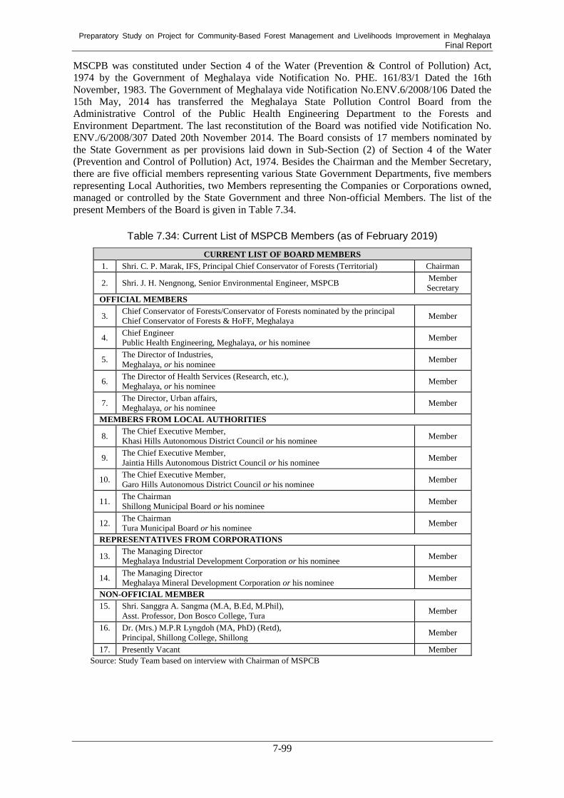
Preparatory Study on Project for Community-Based Forest Management and Livelihoods Improvement in Meghalaya Final Report
7-99
MSCPB was constituted under Section 4 of the Water (Prevention & Control of Pollution) Act,
1974 by the Government of Meghalaya vide Notification No. PHE. 161/83/1 Dated the 16th
November, 1983. The Government of Meghalaya vide Notification No.ENV.6/2008/106 Dated the
15th May, 2014 has transferred the Meghalaya State Pollution Control Board from the
Administrative Control of the Public Health Engineering Department to the Forests and
Environment Department. The last reconstitution of the Board was notified vide Notification No.
ENV./6/2008/307 Dated 20th November 2014. The Board consists of 17 members nominated by
the State Government as per provisions laid down in Sub-Section (2) of Section 4 of the Water
(Prevention and Control of Pollution) Act, 1974. Besides the Chairman and the Member Secretary,
there are five official members representing various State Government Departments, five members
representing Local Authorities, two Members representing the Companies or Corporations owned,
managed or controlled by the State Government and three Non-official Members. The list of the
present Members of the Board is given in Table 7.34.
Table 7.34: Current List of MSPCB Members (as of February 2019)
CURRENT LIST OF BOARD MEMBERS
1. Shri. C. P. Marak, IFS, Principal Chief Conservator of Forests (Territorial) Chairman
2. Shri. J. H. Nengnong, Senior Environmental Engineer, MSPCB Member
Secretary
OFFICIAL MEMBERS
3. Chief Conservator of Forests/Conservator of Forests nominated by the principal
Chief Conservator of Forests & HoFF, Meghalaya Member
4. Chief Engineer
Public Health Engineering, Meghalaya, or his nominee Member
5. The Director of Industries,
Meghalaya, or his nominee Member
6. The Director of Health Services (Research, etc.),
Meghalaya, or his nominee Member
7. The Director, Urban affairs,
Meghalaya, or his nominee Member
MEMBERS FROM LOCAL AUTHORITIES
8. The Chief Executive Member,
Khasi Hills Autonomous District Council or his nominee Member
9. The Chief Executive Member,
Jaintia Hills Autonomous District Council or his nominee Member
10. The Chief Executive Member,
Garo Hills Autonomous District Council or his nominee Member
11. The Chairman
Shillong Municipal Board or his nominee Member
12. The Chairman
Tura Municipal Board or his nominee Member
REPRESENTATIVES FROM CORPORATIONS
13. The Managing Director
Meghalaya Industrial Development Corporation or his nominee Member
14. The Managing Director
Meghalaya Mineral Development Corporation or his nominee Member
NON-OFFICIAL MEMBER
15. Shri. Sanggra A. Sangma (M.A, B.Ed, M.Phil),
Asst. Professor, Don Bosco College, Tura Member
16. Dr. (Mrs.) M.P.R Lyngdoh (MA, PhD) (Retd),
Principal, Shillong College, Shillong Member
17. Presently Vacant Member
Source: Study Team based on interview with Chairman of MSPCB

Preparatory Study on Project for Community-Based Forest Management and Livelihoods Improvement in Meghalaya Final Report
7-100
b. Meghalaya Biodiversity Board182
b.1 Basis Statutes
The Meghalaya Biodiversity Board is a Statutory Body established under Biological Diversity Act,
2002. As per the Act, Biological Diversity Rules, 2004 and the Meghalaya Biological Diversity
Rules, 2010, the functions of the Board are 1. Advise the State Government, subject to any
guidelines issued by the Central Government, on matters relating to the conservation of biodiversity,
sustainable use of its components, and equitable sharing of the benefits arising out of the utilisation
of biological resources; 2. Regulate by granting of approvals or otherwise requests for commercial
utilization or bio-survey and bio-utilisation of any biological resource by Indians; 3. Perform such
other functions as may be necessary to carry out the provisions of this Act or as may be prescribed
by the State Government (as per Section 23 of Biodiversity Act, 2002).
b.2 Activities
i) Biodiversity Management Committee (BMC)
The Biodiversity Management Committees (BMCs) are statutory bodies that are formed by
the 'local bodies' as per Section 41 of the Biological Diversity Act 2002, Rule 23 of the
Meghalaya Biological Diversity Rules, 2010, and Biological Diversity Amendment Rules,
2015. In Meghalaya 94 BMCs have so far been constituted at the village level. Role of
BMCs are as follows:
- Documentation of local biodiversity in the form of Peoples' Biodiversity Register
(PBR)
- Protection of Traditional Knowledge recorded in PBR.
- Conservation and sustainable utilization of biological resources.
- Eco-restoration of the local biodiversity.
- Proper feedback to the SBB in the matter of IPR, Traditional Knowledge and local
biodiversity issues, wherever feasible and essential feedback to be provided to the
NBA.
- Management of Heritage Sites including Heritage Trees, Animals/Microorganisms etc.
and sacred groves and sacred water bodies.
- Regulation of access to the biological resources and/or associated Traditional
knowledge, for commercial and research purposes.
- Sharing of benefits arising out of commercial use of bio-resources.
- Conservation of traditional varieties/Breeds of economically important plants/animals.
- Biodiversity education and awareness building.
- Development of bio-cultural protocols.
ii) People’s Biodiversity Register (PBR)
One of the main functions of the Biodiversity Management Committees (BMCs) is to
prepare People’s Biodiversity Register (PBR) in consultation with local people. The
Register shall contain comprehensive information on the local biological resources, their
medicinal or any other use or any other traditional knowledge associated with them. PBR
should serve as a component of the knowledge base for conservation, sustainable use and
equitable sharing of benefits of biodiversity and it should also be used in maintenance and
prudent management of ecosystems such as forests, rivers, lakes, grasslands, and ponds.
This will then enhance the public awareness of the significance of conservation, sustainable
use, the equitable sharing of the benefits of biodiversity, and to catalyse grass roots action.
iii) Biodiversity Heritage Sites
Under Section 37 of Biological Diversity Act, 2002 (BDA) the State Government in
182
Descriptions from Official Website of Meghalaya Biodiversity Board (http://megbiodiversity.nic.in/members;
accessed in February 2019)

Preparatory Study on Project for Community-Based Forest Management and Livelihoods Improvement in Meghalaya Final Report
7-101
consultation with local bodies may notify in the official gazette, areas of biodiversity
importance as Biodiversity Heritage Sites (BHS). Under sub section (2) of Section 37, the
State Government in consultation with the Central Government may frame rules for the
management and conservation of BHS. Under sub section (3) of Section 37, the State
Governments shall frame schemes for compensating or rehabilitating any person or section
of people economically affected by such notification. "Biodiversity Heritage Sites" (BHS)
are well-defined areas that are unique, ecologically fragile ecosystems - terrestrial, coastal
and inland waters and marine having rich biodiversity comprising of any one or more of the
following components: richness of wild as well as domesticated species or intra-specific
categories, high endemism, the presence of rare and threatened species, keystone species,
species of evolutionary significance, wild ancestors of domestic/cultivated species or their
varieties, past pre-eminence of biological components represented by fossil beds and having
significant cultural, ethical or aesthetic values and which are important for the maintenance
of cultural diversity, with or without a long history of human association with them.
Areas having any of the following characteristics may qualify for inclusion as BHS.
- Areas having any of the following characteristics may qualify for inclusion as BHS.
- Areas that contain a mosaic of natural, semi-natural, and manmade habitats, which
together contain a significant diversity of life forms.
- Areas that contain significant domesticated biodiversity component and/or
representative agro-ecosystems with ongoing agricultural practices that sustain this
diversity.
- Areas that are significant from a biodiversity point of view and also are important
cultural spaces such as sacred groves/trees and sites, or other large community
conserved areas.
- Areas including very small ones that offer refuge or corridors for threatened and
endemic fauna and flora, such as community conserved areas or urban greens and
wetlands.
- Regulation of access to the biological resources and/or associated traditional
knowledge, for commercial and research purposes
- Areas that provide habitats, aquatic or terrestrial, for seasonal migrant species for
feeding and breeding.
- Areas that are maintained as preservation plots by the research wing of Forest
Department.
- Medicinal Plant Conservation Areas.
State Biodiversity Boards (SBB) may invite suggestions (or consider those already coming
from communities) for declarations of BHSs, through BMCs and other relevant community
institutions, including gram sabhas, panchayats, urban wards, forest protection committees,
and tribal councils. SBB may undertake widespread dissemination of information related to
the proposed BHS among rural communities, NGOs, farmer/fishermen/adivasi associations,
urban groups, research institutions, government agencies, and other organizations,
regarding the provision of BHSs, through locally appropriate means. These could include
local language newspapers, radio, holding meetings with the communities, letters to line
departments, gram panchayats, local bodies, and other means.
As per the Biodiversity Act, areas rich/unique in biodiversity can be notified by the State
Government as BHS. Based on the recommendation received from the Dorbar of Umkon
Village, a forest patch of 16 ha area, under Umkon Village, Ri-Bhoi District has been
proposed to be constituted as the first BHS in the state. The proposal has already been
submitted to the Government of Meghalaya for further process towards declaration of the
first BHS.

Preparatory Study on Project for Community-Based Forest Management and Livelihoods Improvement in Meghalaya Final Report
7-102
b.3 Board Members
As per Rule 9 of MBDR, 2010, the five ex-official members are posted.
- PCCF & HoFF, Forests & Environment Department
- Director, Agriculture Department
- Director, Veterinary & Animal Husbandry Department
- Director, Fisheries Department
- Director, Education Department
7.7.3. Environmental and Social Management System Framework (ESMSF)
The objective and structure of ESMSF are describe as below.
(1) Objective of ESMSF
The ESMSF is the primary reference document outlining how environmental and social
considerations will be addressed in the project design and implementation.
ESMSF helps to establish a process for environmental and social safeguards which will permit the
executing agency of the project to identify, assess and mitigate the environmental and social
impacts of the proposed interventions. In the process, the framework also determines the
institutional measures to be taken during the program implementation.
The objectives of the ESMSF are summarized as:
1) To provide a broad framework for the identification, management and monitoring of
potential environmental and social risks arising under the project;
2) To enhance the project’s positive environmental and social impacts and avoid or
otherwise mitigate associated negative impacts;
3) To ensure that the rights and needs of forest dependents and their communities affected
by or involved in the project, are respected and met in the design and implementation of
project interventions; and
4) To ensure the protection of local ecosystems and environmental resources in the design
and implementation of the project interventions.
(2) Structure of ESMSF
The ESMSF of the Project is structured as follows:
1) Summary of the Project: It briefly describes the project framework and sub-projects.
2) Environmental and Social Safeguard Policies of JICA: It briefly describes JICA’s
environmental and social safeguard policies and clarifies how the Project shall be
categorized and what types of measures will be required.
3) Clarifying Definition and Selection of Safeguard Frameworks: It analyses and defines
the key technical terms and select appropriate safeguard frameworks to be applicable for
the Project.
4) Target Groups of ESMSF: It defines beneficiaries.
5) Existing Environmental and Social Management Systems: Outline of the legal and
policy context for environmental and social safeguard in India as well as in the Tripura
State.
6) Environmental and Social Risks and Mitigation Measures: An assessment of potential
positive and negative environmental and social aspects associated with the Project, as
well as measures for the mitigation of adverse risks in the project design and

Preparatory Study on Project for Community-Based Forest Management and Livelihoods Improvement in Meghalaya Final Report
7-103
implementation.
7) Framework and Procedures/ Detail Procedures of ESMSF: It indicates the institutional
framework and identifies procedures for management and mitigation of environmental
and social risks of the project cycle. Social assessment to determine community needs
and priorities, to obtain their views on the design and proposed implementation
mechanisms of the Project is also covered here.
8) Capacity Development Requirements for ESMSF Implementation: The capacity
development and training requirements for effective implementation of the ESMSF are
identified.
7.7.4. Resettlement Plan Framework (RPF)
As the occasion arises, RPF will be developed and incorporated to the Draft Final Report. The draft
structure of RPF is shown below.
1) Project objective and necessity of involuntary resettlement and land acquisition
2) Reason why resettlement plan cannot be prepared before loan approval
3) Preparation and approval process of resettlement plan
4) Estimated number of resettlement (including economic transfers that lose major
livelihoods due to influence on owned land and structures)
5) Compensation and entitlements for affected assets/properties
6) Compensating procedure for loss assets based on reacquisition price
7) Means for livelihood rehabilitation which can improve or at least restore livelihood and
living standard of eligibility of benefits
8) Grievance redress mechanism
9) The organizational framework for implementing resettlement, including identification of
agencies responsible for delivery of resettlement measures and provision of services
10) Implementation schedule to initiate physical relocation after completion of
compensation payment for asset losses
11) Costs and budget
12) Arrangements for monitoring of resettlement activities by the implementing agency
supplemented by independent monitors
13) Strategy for consultation with and participation of resettlers and hosts in the design and
implementation of the resettlement activities
However, the RPF will not be prepared because any voluntary/involuntary resettlement is planned
in the proposed project.
7.7.5. Scheduled Tribe and Forest Dependents Plan Framework (STFDPF)
The objective and draft structure of STFDPF are shown below.
(1) Objective of STFDPF
The STFDPF is to be applied as an additional framework that works together with the ESMSF, the
primary project safeguards document for the Project. In general, the STFDPF is specifically applied
in situations where Scheduled Tribes (ST), Scheduled Castes (SC), Other Backward Classes, forest
dwellers and other forest dependents are affected by the project activities and provides guidance for
specific measures which may be required in addition to the provisions of the ESMSF.
Preparatory Study on Project for Community-Based Forest Management and Livelihoods Improvement in Meghalaya Final Report
7-104
(2) Structure of STFDPF
STFDPF is structured in an almost identical way to the ESMSF for easy usage by simply referring
the ESMSF. The structure of STFDPF is described hereunder.
1) Definition of “Scheduled Tribes and Forest Dwellers” as “Indigenous People” and as
Target of STFDPF
2) Safeguard Policies of JICA on ST and Forest Dependents
3) Legal and Policy Framework for ST and Forest Dependents
4) Environmental and Social Risks and Mitigation Measures
5) Framework and Procedures/Detail Procedures of STFDPF (Preparation of Scheduled
Tribe and Forest Dependents Plan, Free, Prior and Informed Consultation, Social
Assessment, Micro planning, Selection and Screening of Sub-project, Monitoring and
Evaluation (M&E), and Grievance Procedures
ESMSF and STFDP, Environmental Checklist, ESMS Checklist, and Agreement on Environmental
and Social Considerations between Planning Department (on behalf of MBDA) and JICA Study
Team are attached in Annexure 6.
7.8. Gender Mainstreaming
7.8.1. Rationale and Methodology
Gender mainstreaming is one of the most critical strategies for achieving inclusive community
forest management and overall poverty alleviation through the Project. This is mainly because
women in rural Meghalaya take a main role in collecting NTFPs, specifically firewood and edible
wild plants, as well as in farming food grains and cash crops and managing livestock to maintain
their livelihoods. In spite of this, women there are often excluded from public meetings and the
decision-making processes of existing traditional governing structures, such as Dorbar Shnong,
Raid, and Hima. Thus, gender mainstreaming is essential for making it sure that these women be
involved in the decision-making processes of the Project, their interests and needs based on their
role be reflected in the planning of the Project’s activities, and women get empowered through even
taking leading roles in and having more access to resources and services through the Project.
Women’s empowerment should contribute to the achievement of the Project’s purposes because
they take important roles.
For gender mainstreaming, a gender perspective should be integrated into both the organizational
structure of the Project and its contents in all the processes of planning, implementation, and
monitoring & evaluation (M&E). In the tribal society of rural Meghalaya, gender division of
labor/role is strictly determined and kept on a basis of social norms and tradition, and women’s
interests and needs are most probably different from men’s. If the managers and other staff
members involved in the Project ignore or overlook this point, the contents of the Project will tend
to be designed and undertaken for the sake of men and the elderly who have dominated the
decision-making power of existing traditional governing structures. To avoid this, a gender
perspective should be fully integrated in the Project.
7.8.2. Gender Mainstreaming to the Organizational Structural of the Project
For gender mainstreaming, the Project should build systems which consist of gender responsive
organizational structure and Project operation. First, in order to make the organizational structure of
the Project gender responsive, it is highly recommended that a critical number of women should be
involved as managerial officials, in addition to thematic experts and implementing staff members.
This aims to avoid the Project’s management/decision-making body being dominated by men only
and instead to make it more diverse by involving a critical-mass number of women. Secondly, the

Preparatory Study on Project for Community-Based Forest Management and Livelihoods Improvement in Meghalaya Final Report
7-105
Project may establish a Gender Committee and appoint a gender focal point representing each of
the Project’s components. The committee of which members compose management officials and
gender focal points is supposed to systematically monitor and check the processes and outcomes of
the Project from a gender perspective and make it sure that the Project is operated in a
socially-inclusive manner. If any serious constraints hinder local women’s active participation in
the Project, the committee members, together with implementing staff members, are supposed to
identify and take effective measures to solve these problems. Such structural systems should be
supported by gender responsive operational systems, which can mainstream a gender perspective in
the Project.
One of crucial keys to making such a structural organization functional is to conduct gender
analysis, based on which the contents of the Project are designed and the progress of the Project in
promoting women’s empowerment is monitored. For this, the Project should establish
gender-disaggregated data collection and data storage system. Based on the data disaggregated by
gender and other factors, the committee can assess the extent to which the Project achieves social
inclusion in terms of the quantity and quality of women’s participation in decision-making
processes and activities and the distribution of the Project’s benefits among diverse groups of local
people. As a sort of knowledge management system, the Project may also establish a system by
which the officials and staff members involved in the Project can share key lessons learnt from the
activities of the Project and good practices in terms of promoting women’s empowerment. To use
such systems properly, the Project should train all the officials and staff members involved in the
Project to be gender responsive and technically capable. Through the training, they are expected to
recognize and well understand about the mechanism of context-specific gender-based division of
labor/roles, different gender needs, and unequal gender relations. Based on these, the officials and
staff members involved in the Project are supposed to make a plan, implement, and monitor and
evaluate the Project.
Interventions which need to be taken for mainstreaming a gender perspective in the organizational
structure of the Project is given in the following table while more details, including indicators, are
described in Annexure 5:
Table 7.35: Interventions Necessary for Mainstreaming a Gender Perspective in the
Organizational Structure of the Project
Categories Interventions Timing Main Purposes
Organizational
Structure
involvement of women
managers as well as women
experts
during the
preparatory period
to make decision-making body
diverse
conducting gender analysis at the beginning of
the Project
to understand context-specific
gender division of labor/role,
gender needs, gender relations,
etc., based on which the
contents of the Project/activities
are designed
setting up of Gender
Committee and
appointment of gender
focal points representing
each of the components
at the early stage of
the Project
to monitor the progress of the
Project's promotion of women's
empowerment and solve critical
problems by identifying
effective measures
set up
gender/other-factors-disagg
regated data collection and
data storage system
set up knowledge bank on
lessons learnt and good
at the early stage of
the project and
continuously
through the Project
to analyze and visualize gender
gaps in terms of participation in
decision-making processes,
activities, etc. and distribution
of benefits from the Project
to reflect the lessons learnt and

Preparatory Study on Project for Community-Based Forest Management and Livelihoods Improvement in Meghalaya Final Report
7-106
Categories Interventions Timing Main Purposes
practices in terms of
promoting women's
empowerment
good practices in the planning
and implementation of activities
in other target villages
conducting gender training
for those involved in the
project
throughout the
Project, specifically
at the early stage
to make all those who are
involved in the Project gender
responsive and technically
capable to operate the Project
from a gender perspective Source: developed by Study Team.
7.8.3. Gender Mainstreaming to the Project Operation
For mainstreaming a gender perspective in the Project, its rules and operational procedures also
need to be gender responsive. To share the concept of gender mainstreaming among all the
stakeholders, including the officials, staff members, and local people, the Project needs to develop
operational guidelines in which a gender perspective is fully integrated. The main purpose and role
of the guidelines is to regulate the rules and procedures by which the Project can prevent women
and other marginalized groups of people from being excluded from decision-making processes and
activities and from being utilized only as assistants to achieve the goals/interests of dominant
groups in a community. Instead, the guidelines should lead the stakeholders, specifically the
implementation staff members, to involving women and other marginalized groups of people as
main actors, not passive beneficiaries, in the Project and fostering their agency or
self-determination through the Project and activities, which is essential for achieving social
inclusion.
There are several critical points which need to be stated in the guidelines and properly implemented
in the Project. First, the Project should conduct a series of gender sensitization workshops at the
village level throughout the Project, specifically during its early stage. Through the workshops, the
Project aims to change the ideas and attitude of local women and men toward stereotyped gender
division of labor/role and unequal gender relations. As a result of the workshops, women are
expected to actively participate in decision-making processes and the Project’s activities, not only
income generation, but also micro-planning, mapping/GIS, and community forest management. On
the other hand, men are expected to encourage women to assume even leading roles, instead of
assisting roles, and also assist women in participating in various activities by taking up the
household chores and child care which women exclusively take.
In order to make it sure that women be involved in the decision-making processes of the Project,
the guidelines should regulate that a critical number of women should be involved as chairpersons,
vice chairpersons, or other members in the executive committee at the village level. More
importantly, the Project should make sure that women are not involved in the committee in name
only, but that they play a leading and decision-making role. In order for women to be self-confident
and speak up in public places, the guidelines also need to state that women will be provided with
training on communication skills and leadership.
Interventions which need to be taken into account for gender mainstreaming to the Project operation
are as follows while more details, including indicators, are described in Annexure 5:

Preparatory Study on Project for Community-Based Forest Management and Livelihoods Improvement in Meghalaya Final Report
7-107
Table 7.36: Necessary Interventions to Mainstream Gender in the Operation of the Project
Category Interventions Timing Main Purposes
Project
Operation
involvement of women in
decision-making
processes and women's
taking up leading roles
at the early stage
of the project and
throughout the
Project
to let women's ideas/needs heard by
other villagers and reflect their
ideas/needs in the plans of the
Project activities
to give women more opportunities to
represent villagers, make decisions,
contribute as main actors to
community forest management and
livelihood improvement, etc.
dissemination of
information on the
project among all
villagers
in the very
beginning of the
project and
throughout the
Project
not to exclude anyone from the
Project and let all villagers to know
about the Project and the possible
benefits they might get from the
Project, based on which they can
make a choice on if they participate
in the Project
conducting gender
sensitization workshops
at the early stage
of the project and
throughout the
Project
to change the ideas and attitude of
women and men toward stereotyped
gender division of labor/role and
unequal gender relations, to
encourage women to actively
participate in decision-making
processes and take up leading roles,
and to convince men to understand
the importance of women's taking up
new roles through the Project and
assist women doing household
chores and child-care so that women
can participate in the Project's
activities
provision of training on
communication skills and
leadership for women
at the early stage
of the project and
throughout the
project
to let women speak up in the public
places with self-confidence
involvement of women
and men in all activities
of the Project:
micro-planning,
mapping/GIS activities,
community forest
management,
micro-credit activities,
income generation
activities, etc.
at the early stage
of the Project and
throughout the
Project
not to exclude women and men from
the processes of realizing community
forest management and livelihood
improvement through the Project and
to let both women and men have
opportunities for decision making,
receiving materials/resources, taking
training, improving skills and
incomes, making network, etc.
Source: developed by Study Team

Preparatory Study on Project for Community-Based Forest Management and Livelihoods Improvement in Meghalaya Final Report
7-108
7.9. Project Cost Estimate
7.9.1. Conditions and Assumptions
(1) Preconditions for Cost Estimate
The Project cost shall be estimated based on the following preconditions:
1) Preconditions for Project cost estimate as of June 2019 provided by JICA
The project period is ten (10) years, and the unit costs were estimated based on the
constant price of June 2019 in Indian Rupees.
The following exchange rates were applied:
INR 1 = JPY 1.58
USD 1 = Rs 69.8
USD 1 = JPY 110
The average inflation rate (the average WPI and CPI in 2009 to 2018) was estimated as
5.50%, and the average exchange fluctuation rate was 1.97% in the same years. As a
result, the price escalation rate for the local currency portion was estimated as 3.53% (=
5.50% - 1.97%).
Similarly, the price escalation rate for the foreign currency portion was estimated as
1.72%.
A 5% physical contingency was applied.
2) GST (Goods and Services Tax)
GST (Goods and Services Tax) shall be calculated as CGST (Central GST) x 2 since GST
is combined with CGST and SGST (State GST) for intra-state business. CGST shall be
referred to using the schedule of CGST rates on goods183
and the schedule of CGST rates
on services184
. However, the schedule of SGST is not available.
IGST (Integrated GST) shall be calculated as CGST x 2 following the same practice
above for inter-state business.
(2) Price Adjustment
A value of a unit cost in a past base year shall be adjusted to the value for 2019 with the following
price indices:
The unit cost referred from a past base year shall be multiplied by the price index in the table below
to adjust for 2019 price. The price indices were calculated based on the average inflation rate (the
average WPI and CPI between 2010 and 2018) as mentioned above. The price indices to adjust for
2019 price from 2010 are shown in the table below.
183 Updated schedule of CGST rates on goods, as on 15.11.2017, Central Board of Excise and Customs (CBEC), the
Department of Revenue, the Ministry of Finance, Government of India 184 Schedule of CGST rates on services, discussed on 19 May 2017 during the 14th GST Council meeting, CBEC

Preparatory Study on Project for Community-Based Forest Management and Livelihoods Improvement in Meghalaya Final Report
7-109
Table 7.37: Price Indices to Adjust for 2019 Price
Base Year 2010 2011 2012 2013 2014 2015 2016 2017 2018 2019
Price Index 1.87 1.67 1.53 1.40 1.26 1.19 1.12 1.07 1.05 1.00 Source: compiled by Study Team based on the preconditions provided by JICA
7.9.2. Project Cost
(1) Summary of Cost Estimate
The total project cost is estimated to be approximately 9,289 million INR. The summary of cost
components is shown in Table 7.38 and the project cost breakdown is shown in Annexure 10 (1).
Table 7.38: Summary of Project Cost
(million INR)
ClClose to the public
Source: compiled by Study Team based on JICA Cost Estimate Kit
(2) Project Component (Base Cost)
The major part of the project cost is the cost for the implementation of all project activities that are
organized into components. This is the base cost for the project, and the total base cost was
estimated to be approximately 5,351 million INR.
(3) Price Escalation
Price escalation was calculated based on the average WPI, CPI and exchange fluctuation rates of
last 10 years. Price escalation for the project was estimated based on the annual cost schedule, and
it was applied separately to local and foreign currency portions of all cost components. This
includes the price escalation of base cost, administrative cost and taxes and duties, excluding the
price escalation for project consultants.
Price escalation rates for foreign currency and local currency for this project cost estimate are
adopted at 1.72% and 3.53% respectively.
(4) Physical Contingency
Physical contingency is applied for all base costs, administration and price escalation. Physical
contingency is estimated at 5% as for most JICA-funded projects. This includes the physical
contingencies of base costs, administrative costs and taxes and duties, excluding the physical
contingencies of project consultants.
Close to the public
Close to the public
Close to the public
Close to the public

Preparatory Study on Project for Community-Based Forest Management and Livelihoods Improvement in Meghalaya Final Report
7-110
(5) Consulting Services
The scope of work and requirements of the project consultants were estimated as described in the
Chap. 7.5.4. The unit costs for consultants were derived from the market price corresponding to the
expected appropriate qualifications. This includes the remuneration, direct costs, price escalation and
physical contingency. This does not include the service tax, which is included in the taxes and duties below.
(6) Taxes and Duties
GST (Goods and Services Tax) of which the rates are depending on the kinds of goods and services
(5%, 12%, 18% and 28%), import taxes, and other taxes and duties have been estimated for the cost
estimate. The goods to be imported were not included in the project.
(7) Annual Fund Requirement
Annual fund requirement was estimated based on the project implementation schedule (Annexure
10(2). The summary of annual fund requirement for the project is shown in the table below. The
breakdown of annual fund requirement is shown in Annexure 10(3).
Table 7.39: Annual Fund Requirement
(million JPY)
Close to the public
Source: compiled by Study Team based on JICA Cost Estimate Kit
(8) Currency Component
The project cost was divided into foreign and local currency portions. In Meghalaya, all goods and
services are available locally except the international consultants for the consulting services. Thus,
only the cost for the international consultants (remuneration and a part of direct costs) was
segregated as the foreign currency portion, and all the service taxes are included in the local
currency portion as summarized in the table below.
Table 7.40: Currency Components of Project Cost
Close to the public
Close to the public
Close to the public
Close to the public
Close to the public

Preparatory Study on Project for Community-Based Forest Management and Livelihoods Improvement in Meghalaya Final Report
7-111
Source: compiled by Study Team based on JICA Cost Estimate Kit
(9) Financial Plan
JICA loan portion will not cover administrative costs, taxes and duties relating to the project. As a
result, the total cost to be borne by the JICA Loan is estimated to be approximately 7,171 million INR
(approximately 11,330 million JPY), while the total cost to be borne by the Government of
Meghalaya is estimated to be approximately 2,118 million INR. A summary of the financial plan by
components is shown in Table 7.41.
Table 7.41: Summary of Financial Plan by Components
Close to the public
Source: developed by Study Team
7.10. Project Evaluation
7.10.1. Economic Analysis
(1) Basic Assumptions for Cost-Benefit Analysis
The cost-benefit analysis was conducted under the following basic conditions and assumptions.
The economic life of the project is assumed to be 50 years since this type of forest
management project takes a longer time to deliver returns than ordinary infrastructure
development projects.
The project costs in the project period are estimated based on June 2019 constant
prices in Indian rupees.
For the estimation of the economic project cost, each item of the financial cost is
divided into a foreign currency portion and local currency portion. The local currency
portion is converted into economic value by applying a standard conversion factor of
0.9 which is generally used in many projects in India Special Assistance for Project
Formation (SAPROF) for Tripura Forest Environment Improvement and Poverty
Close to the public

Preparatory Study on Project for Community-Based Forest Management and Livelihoods Improvement in Meghalaya Final Report
7-112
Alleviation Project (TFIPAP) applied 0.9, West Bengal Integrated Forestry
Development and Biodiversity Conservation Project applied 0.9, and “Manual on
Economic Evaluation of Highway Projects in India” by Indian Roads Congress
(2009) mentioned that as an approximation in many projects taken up in India, a
factor of 0.80 - 0.90 has been used to convert financial costs of road works to
economic costs.)
The price contingencies, taxes and other kinds of transfer payments are excluded
from the estimated financial costs to estimate the economic costs.
For the calculation of the net present value, a discount rate of 12% is applied.
Exchange Rates: INR 1 = JPY 1.58; USD 1 = JPY 110; USD 1 = INR 69.8 as of June
2019.
Major Activities of the Project are not supposed to collect any charges from beneficiaries except
ecotourism activity. For the ecotourism, the Ecotourism Development Organization would be
established and operate the ecotourism facilities. Thus, only economic analysis is carried out and
financial analysis is not done in this report.
(2) Economic Cost of the Project
1) Capital Cost
The economic cost of the project was estimated based on the conditions mentioned above. The
financial cost and estimated economic cost are summarized in Table 7.42.
Table 7.42: Financial and Economic Cost by Component and Item (million INR)
Item Financial Cost
Economical Cost
Component 1. Sustainable Forest Management 3,427 3,084
Component 2. Community Development/Livelihood Improvement 786 707
Component 3. Institutional Strengthening 1,137 1,023
Base Cost Total 5,351 4,816
Price Escalation 1,129 0
Physical Contingency 324 292
Consulting Services 367 330
Land Acquisition 0 0
Meghalaya Government 1,486 1,337
Taxes & Duties 0 0
Price Escalation 290 0
Physical Contingency 89 80
Interest during construction 243 0
Front End Fee 9 0
Grand Total 9,288 6,855 Source: compiled by Study Team based on JICA Cost Estimate Kit
In addition to the capital costs stated above, O&M cost and replacement cost were estimated for the
economic analysis with following assumptions.
2) Operation and Maintenance Cost
It was assumed that the major portion of the O&M cost would emerge after the completion of each
component, while most maintenance costs will be covered by the project during the project period.
Major portion of the O&M cost would be generated from construction works such as building,
facilities and structures. O&M costs for the project were estimated at 1% of the construction and
activites costs based on the SAPROF for TFIPAP applied 1% of the capital cost.

Preparatory Study on Project for Community-Based Forest Management and Livelihoods Improvement in Meghalaya Final Report
7-113
3) Replacement Cost
The replacement costs were estimated to recur every 20 and 30 years for the nursery and plantation.
The replacement cost is applied as the same amount of the cost for the nursery and plantation.
(3) Benefit Evaluation
Several economic benefits would be derived from the implementation of the project. Some of these
are direct benefits, while others are indirect. Among other things, the following items are regarded
as the major economic benefits derived from the project, which can be either estimated in or
converted into monetary terms showing in Table 7.43.
Table 7.43: Major Activities for Benefit Evaluation
Items Beneficial Activities
Forestry Production Production from AR, ANR, ANR Mix (NTFP, Fuel wood and pine)
Prevention of Soil Erosion Prevention of soil erosion by increase of vegetative
cover
Water Use Aquaculture in the check dams and conservation pond, and water usage for living by the check dams, conservation pond and water tank
Income Generation Activities Imcome generation by production of piggery, mushroom and weiving.
CO2 Reduction Increment of CO2 stock between without and with the
Project by Forestry Production Source: developed by Study Team
The methodology of the benefit evaluation for each item is shown below.
1) Forestry Production
Several species will be planted in the project. For the benefit evaluation purpose, major species for
each activity were selected. Major species and size of area for the AR, ANR and AR Mix are
summarized in Table 7.44. Each species will be planted from 3rd to 8th project years.
Table 7.44: Major Species and Area to Be Planted
Components Main Species Area (ha)
1.2.3 ANR Sal 1,600
1.2.4 ANR Fuel wood 7,700 1.2.5 AR Pine 5,500
1.2.6 ANR Mix NTFP (Emblica officinalis) 1,250
Pine 1,600 Fuel wood 1,600
1.2.7 AR Pine Mix 3,100 1.2.8 ANR Jack Fruit 150
Total 22,500 Source: developed by Study Team
For each component (species), the value/benefit was estimated with a set of assumptions. The
assumptions for the value calculation for each component (species) are shown below.
It should be noted that from each component above, 50% of the value was deducted as the costs for
maintenance, harvesting, marketing and other miscellaneous expenses, resulting in 50% of the
value as the net profit of plantation. This cost is equivalent to the average cost for cypress and ceder,
46% and 77% respectively based on the Annual Reports on Forest and Forestry by Forest Agency,
Japan.

Preparatory Study on Project for Community-Based Forest Management and Livelihoods Improvement in Meghalaya Final Report
7-114
ANR (Sal)
It is assumed that Sal would become valuable from 30 years after establishment in Table 7.45.
Table 7.45: Assumptions for Value Calculation (Sal)
Year Production
(m3/ha)
Unit Price
(INR/m3)
Value
(INR/ha) Area
(ha)
Total Value
(INR)
33 - 38 36.55 2,500 91,375 267 24,397,125 Source: Production rate and Unit Price; Perspective plan for development of forestry sector 2002-03 to 2011-12 (2001)
Tripura Forest Department (TFD)
ANR (Fuel Wood)
It is assumed that fuel wood would become valuable from 5 years after plantation (8th project year)
in Table 7.46.
Table 7.46: Assumptions for Value Calculation (Fuel Wood)
Year Production
(m3/ha)
Unit Price
(INR/m3)
Value
(INR/ha)
Area
(ha)
Total Value
(INR)
8< 150 250 37,500 1,283 48,112,500 Source: Production rate and Unit Price; Perspective plan for development of forestry sector 2002-03 to 2011-12 (2001)
TFD.
AR (Pine)
It is assumed that pine would become valuable from 20 years after establishment shown in Table
7.47.
Table 7.47: Assumptions for Value Calculation (Pine)
Year Production
(m3/ha)
Unit Price
(INR/m3)
Value
(INR/ha) Area
(ha)
Total Value
(INR)
23 - 28 23 2,000 46,000 917 42,182,000
43 - 48 23 2,000 46,000 917 42,182,000 Source: Production rate and Unit Price; Perspective plan for development of forestry sector 2002-03 to 2011-12 (2001) TFD.
ANR Mix
It is assumed that emblica officinalis and fuel wood would become valuable from 5 years after
plantation (8th project year), while pine would become valuable from 20 years after establishment
shown in Table 7.48 (emblica officinalis).
Table 7.48: Assumptions for Value Calculation (NTFP: Emblica officinalis)
Year No of Tree
(nos/ha)
Production
(kg/tree)
Unit Price
(INR/kg)
Value
(INR/ha)
Area
(ha)
Total Value
(INR)
8 200 20 60.0 240,000 200 52,800,000
9 200 20 60.0 240,000 400 105,600,000
10 200 20 60.0 240,000 600 158,400,000
11 200 20 60.0 240,000 800 211,200,000
12 200 20 60.0 240,000 1,000 264,000,000
13 200 20 60.0 240,000 1,250 330,000,000
14< 200 20 60.0 240,000 1,250 330,000,000 Source: Production rate and Unit Price; National Afforestation Program and SAPROF for TFIPAP.
ANR (Jack Fruit)
It is assumed that jack fruit would become valuable from 5 years after plantation (8th project year)

Preparatory Study on Project for Community-Based Forest Management and Livelihoods Improvement in Meghalaya Final Report
7-115
in Table 7.49.
Table 7.49: Assumptions for Value Calculation (Jack Fruit)
Year No of Tree
(nos/ha)
Production
(kg/tree)
Unit Price
(INR/kg)
Value
(INR/ha)
Area
(ha)
Total Value
(INR)
8 200 150 100 3,000,000 25 82,500,000
9 200 150 100 3,000,000 50 165,000,000
10 200 150 100 3,000,000 75 247,500,000
11 200 150 100 3,000,000 100 330,000,000
12 200 150 100 3,000,000 125 412,500,000
13 200 150 100 3,000,000 150 495,000,000
14< 200 150 100 3,000,000 150 495,000,000 Source: developed by Study Team
2) Prevention of Soil Erosion
The forest covering the surface of the earth with trees and other plants would mitigate the rainfall
impact on the surface soil so that surface erosion would be alleviated. Also, the root system of the
vegetation would bind the soil. If there is no vegetation on the earth, the surface soil is run off and
deposited on the river bed. As a result, excavation of the river bed would be required. So, the value
of soil erosion prevention by the vegetative cover was calculated as surrogated cost being
represented by the excavation of the river bed.
Since no adequate data is available on soil erosion and erosion mitigation by vegetation in
Meghalaya, 4.2 mm/ha/year185
for plantation was used for the estimation as the effect of reduction
of soil erosion with regards to the Project. For the ANR site, 2.1 mm/year of the reduction rate was
applied since vegetation would be already existed more than the plantation and AR site and the
reduction effect by the ANR would be smaller.
Total effect by soil conservation activities was calculated multiplying unit effect and area to be
covered by the activities as shown in Table 7.50.
Table 7.50: Value Calculation for Prevention of Soil Erosion
Activities Area (ha)
Reduction Rate
(mm/year)
Volume (m
3)
Excavation
Unit Cost
(INR/m3)
Total Value (INR)
ANR (Sal) 1,600 2.1 33,600 189.4 6,363,840
ANR (Fuel wood) 7,700 2.1 161,170 189.4 30,625,980
AR (Pine) 5,500 4.2 231,000 189.4 43,751,400
ANR Mix 4,450 4.2 186,900 189.4 35,398,860
AR (Pine mix) 3,100 4.2 130,200 189.4 24,659,880
ANR (Jack fruit) 150 2.1 3,150 189.4 596,610 Source: Unit cost is estimated based on INR 113.4/m3 of Tripura Schedule Rate (2011) and multiplied by 1.67 for the
price index referred to Table 7.37.
3) Water Use For the estimation of economic benefit from water use by the activites for soil and water
conservation, the following assumptions were made.
185
Nelly C antolin and Vincente P. Varacion: “Effect of Alley Cropping on Some Hydrologic Data and Soil Properties of
Upland Farms in Bacnotan, La Union”, 1993.

Preparatory Study on Project for Community-Based Forest Management and Livelihoods Improvement in Meghalaya Final Report
7-116
Aquaculture
A number of check dams and conservation ponds would be constructed under the project. The
check dams and conservation ponds would be used for fish culture under the JFMC. 1.0 ha of water
body can produce 3,000 kg of fish per year at the price of INR 186.4/kg. The utilization rate of
check dams for the fish culture is assumed as 50%.
30% of the total value was assumed to be deducted as the necessary expense such as purchase of the
seedlings, harvesting, marketing and other miscellaneous. Value calculation for aquaculture in
check dams and conservation ponds are shown in Table 7.51 and Table 7.52, respectively.
Table 7.51: Value Calculation for Aquaculture in Check Dam
Year Check
dam (ha)
Utilization
Rate for Aquaculture
Production
Rate (kg/ha)
Fish
Production (kg)
Unit Price
of Fish (INR/kg)
Value (INR) Net Profit
(INR)
4 48 50% 3,000 72,000 186.4 13,420,800 9,394,560
5 184 50% 3,000 276,000 186.4 51,446,400 36,012,480
6 320 50% 3,000 480,000 186.4 89,472,000 62,630,400
7 456 50% 3,000 684,000 186.4 127,497,600 89,248,320
8 592 50% 3,000 888,000 186.4 165,523,200 115,866,240
9 680 50% 3,000 1,020,000 186.4 190,128,000 133,089,600
10< 680 50% 3,000 1,020,000 186.4 190,128,000 133,089,600 Source: Production rate and Unit Price; SAPROF for TFIPAP.
Table 7.52: Value Calculation for Aquaculture in Conservation Pond
Year Check
dam (ha)
Utilization Rate for
Aquaculture
Production Rate
(kg/ha)
Fish Production
(kg)
Unit Price of Fish
(INR/kg) Value (INR)
Net Profit
(INR)
4 68 50% 3,000 102,000 186.4 19,012,00 13,308,900
5 204 50% 3,000 306,000 186.4 57,038,400 39,926,880
6 340 50% 3,000 510,000 186.4 95,064,000 66,544,800
7 476 50% 3,000 714,000 186.4 133,089,600 93,162,720
8 612 50% 3,000 918,000 186.4 171,115,200 119,780,640
9 680 50% 3,000 1,020,000 186.4 190,128,000 133,089,600
10< 680 50% 3,000 1,020,000 186.4 190,128,000 133,089,600 Source: Production rate and Unit Price; SAPROF for TFIPAP.
Living Water
With the aid of the check dams and conservation ponds, people living around the check dams and
ponds would be able to use the water in dry season. The benefit of the water usage was assumed as
the cost of water in public service (3.2 INR/m3: 350 INR/year average for public water payment
devided by 109.5 m3/year/family usage). The value calculation for living water in check dam and
conservation pond are shown in Table 7.53 and Table 7.54, respectively.
Table 7.53: Value Calculation for Living Water in Check Dam
Year Check dam
(m3)
Utilization
Rate for Water
Effective
Water Volume (m
3)
Water Use
Volume (m
3/year)
Unit Price
(INR/ m3)
Value (INR)
4 80,000 50% 40,000 80,000 3.2 256,000
5 1,546,667 50% 773,333 1,546,667 3.2 4,949,333
6 3,013,333 50% 1,506,667 3,013,333 3.2 9,642,667
7 4,480,000 50% 2,240,000 4,480,000 3.2 14,336,000
8 5,946,667 50% 2,973,333 5,946,667 3.2 19,029,333
9 7,333,333 50% 3,666,667 7,333,333 3.2 23,466,667

Preparatory Study on Project for Community-Based Forest Management and Livelihoods Improvement in Meghalaya Final Report
7-117
Year Check dam
(m3)
Utilization Rate for
Water
Effective Water Volume
(m3)
Water Use Volume
(m3/year)
Unit Price
(INR/ m3)
Value (INR)
10< 7,333,333 50% 3666,667 7,333,333 3.2 23,466,667 Source: developed by Study Team
Table 7.54: Value Calculation for Living Water in Conservation Pond
Year Check dam
(m3)
Utilization Rate for Water
Effective Water Volume
(m3)
Water Use Volume
(m3/year)
Unit Price
(INR/ m3)
Value (INR)
4 693,333 50% 346,667 693,333 3.2 2,218,667
5 2,080,000 50% 1,040,000 2,080,000 3.2 6,656,000
6 3,466,667 50% 1,733,333 3,466,667 3.2 11,093,333
7 4,853,333 50% 2,426,667 4,853,333 3.2 15,530,667
8 6,240,000 50% 3,120,000 6,240,000 3.2 19,968,000
9 6,933,333 50% 3,466,667 6,933,333 3.2 22,186,667
10< 6,933,333 50% 3,466,667 6,933,333 3.2 22,186,667 Source: developed by Study Team
With the RCC tanks/spring tapped chambers for fifteen families and water tanks for four families,
people living around the tanks and chambers would be able to use the water all year round. The
benefit of the water usage was assumed as the cost of water in public service. The result for RCC
tanks/chambers and water tanks are shown in Table 7.55 and Table 7.56, respectively.
Table 7.55: Value Calculation for Living Water in RCC Tank/Chamber
Year
Tank
/Chamber (m
3)
No. of
Families (No.)
WaterUse (m
3/year)
Unit Price
(INR/ m3)
Value (INR)
4 210 3,150 344,925 3.2 1,103,760
5 420 6,300 689,850 3.2 2,207,520
6 625 9,375 1,026,563 3.2 3,285,000
7 830 12,450 1,363,275 3.2 4,362,480
8 1,040 15,600 1,708,200 3.2 5,466,240
9 1,250 18,750 2,053,125 3.2 6,570,000
10< 1,250 18,750 2,053,125 3.2 6,570,000 Source: developed by Study Team
Table 7.56: Value Calculation for Living Water in Water Tank
Year Water Tank
(m3)
No. of
Families (No.)
WaterUse (m
3/year)
Unit Price
(INR/ m3)
Value (INR)
4 210 840 91,980 3.2 294,340
5 420 1,680 183,960 3.2 588,670
6 625 2,500 273,750 3.2 876,000
7 830 3,320 363,540 3.2 1,163,330
8 1,040 4,160 455,520 3.2 1,457,660
9 1,250 5,000 547,500 3.2 1,752,000
10< 1,250 5,000 547,500 3.2 1,752,000 Source: developed by Study Team
4) Income Generation Activities (IGAs) For the estimation of economic benefit of Income Generation Activities (IGAs), the following
assumptions were made.

Preparatory Study on Project for Community-Based Forest Management and Livelihoods Improvement in Meghalaya Final Report
7-118
Piggery
For the estimation purpose, it was assumed that 300 SHGs would be adopted in the IGA activities
for the piggery. SHGs would purchase a 3-month-old piglet and they would sell them within a year.
Selling price of the pig were estimated based on the actual situation stated in the interviews during
study, say selling price of a pig is INR 15,000.
30% of the total value was deducted as the necessary expense such as purchasing of a little pig
(INR 3,000, stated in the interviews during study), feeding, marketing and other miscellaneous
showing in Table 7.57.
Table 7.57: Value Calculation for Piggery
Year Progress No. of
SGH
Sold Pig
(No.)
Selling Price
(INR)
Revenue
(INR)
Net Profit
(INR)
3 20% 60 0 15,000 0 0
4 40% 120 1,800 15,000 27,000,000 18,900,000
5 60% 180 3,600 15,000 54,000,000 37,800,000
6 80% 240 5,400 15,000 81,000,000 56,700,000
7 100% 300 7,200 15,000 108,000,000 75,600,000
8 100% 300 9,000 15,000 135,000,000 94,500,000
9< 100% 300 9,000 15,000 135,000,000 94,500,000 Source: developed by Study Team
Mushroom
For the estimation purpose, it was assumed that 150 SHGs would be adopted in the IGA for the
mushroom production. SHGs would harvest mushroom 3 times a year. Selling price per hurvest
was estimated based on the actual situation stated in the interviews during study, which is INR
8,500. 50% of the total value was deducted as the necessary expense such as purchasing fungus,
nursery woods, transport, marketing and other miscellaneous.
Table 7.58: Value Calculation for Mushroom
Year Progress No. of
SGH
No. of
Families
Selling
Price(INR)
Annual Sales
(INR/year)
Revenue
(INR)
Net Profit
(INR)
3 20% 30 0 8,500 25,500 0 0
4 40% 60 1,350 8,500 25,500 34,450,000 17,215,500
5 60% 90 2,700 8,500 25,500 68,850,000 34,425,000
6 80% 120 4,050 8,500 25,500 103,275,000 51,637,500
7 100% 150 5,400 8,500 25,500 137,700,000 68,850,000
8 100% 150 6,750 8,500 25,500 172,125,000 86,062,500
9< 100% 150 6,750 8,500 25,500 172,125,000 86,062,500 Source: developed by Study Team
Weaving
For the estimation purpose, it was assumed that 50 SHGs would be adopted in the IGA for weaving.
SHGs would produce epron, cloths, bed sheets, etc. by weaving monthly. Selling price per monthly
weaving was estimated based on the actual situation stated in the interviews during study, which is
INR 20,000 on average. 20% of the total value was deducted as the necessary expense such as
purchasing close, threads, transport, marketing and other miscellaneous.

Preparatory Study on Project for Community-Based Forest Management and Livelihoods Improvement in Meghalaya Final Report
7-119
Table 7.59: Value Calculation for Weaving
Year Progress No. of
SGH
No. of
Families
Selling
Price(INR)
Annual Sales
(INR/year)
Revenue
(INR)
Net Profit
(INR)
3 20% 10 0 20,000 240,000 0 0
4 40% 20 150 20,000 240,000 36,000,000 28,800,000
5 60% 30 300 20,000 240,000 72,000,000 57,600,000
6 80% 40 450 20,000 240,000 108,000,000 86,400,000
7 100% 50 600 20,000 240,000 144,000,000 115,200,000
8 100% 50 750 20,000 240,000 180,000,000 144,000,000
9< 100% 50 750 20,000 240,000 180,000,000 144,000,000 Source: developed by Study Team
5) CO2 Reduction
The reduction of CO2 emission was calculated and described in Chapter 7.10.2.
Based on the CO2 reduction estimation result, economic value of the CO2 reduction is estimated.
For valuing reduction of CO2 emission in monetary term, Euro CO2 Emission Allowance at the date
of December 2018 (9.68 EUR) was used. Value calculation for CO2 reduction was estimated and
shown in Table 7.60.
Table 7.60: Value Calculation for CO2 Reduction
Year Planted Area
(ha)
Occupancy
(%)
Reduction
(tCO2/year) Unit Price
(INR/tCO2)
Value
(INR/year)
3 0 0.0% 92,724 769.5 0[
4 1,500 6.7% 92,724 769.5 4,756,741
5 3,000 13.3% 92,724 769.5 9,513,482
6 4,500 20.0% 92,724 769.5 14,270,224
7 6,000 26.7% 92,724 769.5 19,026,965
8 7,500 33.3% 92,724 769.5 23,783,706
9 9,000 40.0% 92,724 769.5 28,540,447
10 10,500 46.7% 92,724 769.5 33,297,188
11 12,000 53.3% 92,724 769.5 38,053,930
12 13,500 60.0% 92,724 769.5 42,810,671
13 15,000 66.7% 92,724 769.5 47,567,412
14 16,500 73.3% 92,724 769.5 52,324,153
15 18,000 80.0% 92,724 769.5 57,080,894
16 19,500 86.7% 92,724 769.5 61,837,636
17 21,000 93.3% 92,724 769.5 66,594,377
18 22,500 100.0% 92,724 769.5 71,351,118
19< 22,500 100.0% 92,724 769.5 71,351,118 Source: developed by Study Team

Preparatory Study on Project for Community-Based Forest Management and Livelihoods Improvement in Meghalaya Final Report
7-120
(4) Cost Benefit Analysis
1) Cost Benefit Analysis Results
The economic internal rate of return (EIRR), net present value (NPV), and cost-benefit ratio (B/C)
of the Project were calculated to assess the economic viability of the project based on the projected
economic cash flow is shown in Table 7.61. The EIRR is 15.5%, which is higher than the discount
ratio of 12%, and the NPV and B/C are 1,350.4 million INR and 1.27, so that the project is
economically viable.
2) Sensitivity Analysis
A sensitivity analysis was carried out to examine the viability of the project under the enforceable
change of the benefit and cost levels. The result of the calculation indicates that the project is still
viable even with 10% increase of cost or 10% decrees of benefit, however in case 20% increase of
cost and 10% decrease of benefit is not viable shown in Table 7.61.
Table 7.61: Sensitivity Analysis of EIRR
Change of Cost Change of Benefit
+10% 0% -10%
0% 17.1% 15.5% 13.9%
+10% 15.5% 14.0% 12.6%
+20% 14.2% 12.8% 11.4% Source: developed by Study Team

Preparatory Study on Project for Community-Based Forest Management and Livelihoods Improvement in Meghalaya Final Report
7-121
Table 7.62: Result of the Cost-benefit Analysis
Source: developed by Study Team
Capital(Loan)
Capital(Borrower)
O&M Replace TotalForest
Production
Preventionof SoilErosion
Water UseIncome
GenerationActivity
CO2Reduction
Total
1 2019 59.7 78.0 137.7 0.0 0.0 0.0 0.0 0.0 0.0 -137.7
2 2020 399.5 174.2 573.7 0.0 0.0 0.0 0.0 0.0 0.0 -573.7
3 2021 732.3 176.2 908.5 0.0 0.0 0.0 0.0 0.0 0.0 -908.5
4 2022 732.4 187.7 920.1 0.0 19.1 49.3 64.9 4.8 138.0 -782.1
5 2023 769.3 199.6 968.9 0.0 38.1 166.3 129.8 9.5 343.7 -625.1
6 2024 771.1 211.9 983.0 0.0 58.4 283.2 194.7 14.3 550.6 -432.4
7 2025 803.4 224.7 1,028.0 0.0 78.6 400.2 259.7 19.0 757.5 -270.5
8 2026 809.9 237.8 1,047.8 96.7 118.4 517.2 324.6 23.8 1,080.6 32.9
9 2027 817.3 251.5 1,068.8 164.4 141.4 586.3 324.6 28.5 1,245.2 176.4
10 2028 841.2 265.6 1,106.9 232.0 141.4 586.3 324.6 33.3 1,317.6 210.7
11 2029 434.6 110.4 545.0 299.7 141.4 586.3 324.6 38.1 1,390.0 845.0
12 2030 92.9 0.0 92.9 367.3 141.4 586.3 324.6 42.8 1,462.4 1,369.5
13 2031 92.9 0.0 92.9 441.6 141.4 586.3 324.6 47.6 1,541.4 1,448.5
14 2032 92.9 0.0 92.9 441.6 141.4 586.3 324.6 52.3 1,546.2 1,453.3
15 2033 92.9 0.0 92.9 441.6 141.4 586.3 324.6 57.1 1,550.9 1,458.1
16 2034 92.9 0.0 92.9 441.6 141.4 586.3 324.6 61.8 1,555.7 1,462.8
17 2035 92.9 0.0 92.9 441.6 141.4 586.3 324.6 66.6 1,560.4 1,467.6
18 2036 92.9 0.0 92.9 441.6 141.4 586.3 324.6 71.4 1,565.2 1,472.3
19 2037 92.9 0.0 92.9 441.6 141.4 586.3 324.6 71.4 1,565.2 1,472.3
20 2038 92.9 0.0 92.9 441.6 141.4 586.3 324.6 71.4 1,565.2 1,472.3
21 2039 92.9 0.0 92.9 441.6 141.4 586.3 324.6 71.4 1,565.2 1,472.3
22 2040 92.9 0.0 92.9 441.6 141.4 586.3 324.6 71.4 1,565.2 1,472.3
23 2041 92.9 196.9 289.7 480.7 141.4 586.3 324.6 71.4 1,604.3 1,314.6
24 2042 92.9 196.9 289.7 480.7 141.4 586.3 324.6 71.4 1,604.3 1,314.6
25 2043 92.9 196.9 289.7 480.7 141.4 586.3 324.6 71.4 1,604.3 1,314.6
26 2044 92.9 196.9 289.7 480.7 141.4 586.3 324.6 71.4 1,604.3 1,314.6
27 2045 92.9 196.9 289.7 480.7 141.4 586.3 324.6 71.4 1,604.3 1,314.6
28 2046 92.9 196.9 289.7 480.7 141.4 586.3 324.6 71.4 1,604.3 1,314.6
29 2047 92.9 0.0 92.9 441.6 141.4 586.3 324.6 71.4 1,565.2 1,472.3
30 2048 92.9 0.0 92.9 441.6 141.4 586.3 324.6 71.4 1,565.2 1,472.3
31 2049 92.9 0.0 92.9 441.6 141.4 586.3 324.6 71.4 1,565.2 1,472.3
32 2050 92.9 0.0 92.9 441.6 141.4 586.3 324.6 71.4 1,565.2 1,472.3
33 2051 92.9 30.9 123.8 453.8 141.4 586.3 324.6 71.4 1,577.4 1,453.6
34 2052 92.9 30.9 123.8 453.8 141.4 586.3 324.6 71.4 1,577.4 1,453.6
35 2053 92.9 30.9 123.8 453.8 141.4 586.3 324.6 71.4 1,577.4 1,453.6
36 2054 92.9 30.9 123.8 453.8 141.4 586.3 324.6 71.4 1,577.4 1,453.6
37 2055 92.9 30.9 123.8 453.8 141.4 586.3 324.6 71.4 1,577.4 1,453.6
38 2056 92.9 30.9 123.8 453.8 141.4 586.3 324.6 71.4 1,577.4 1,453.6
39 2057 92.9 0.0 92.9 441.6 141.4 586.3 324.6 71.4 1,565.2 1,472.3
40 2058 92.9 0.0 92.9 441.6 141.4 586.3 324.6 71.4 1,565.2 1,472.3
41 2059 92.9 0.0 92.9 441.6 141.4 586.3 324.6 71.4 1,565.2 1,472.3
42 2060 92.9 0.0 92.9 441.6 141.4 586.3 324.6 71.4 1,565.2 1,472.3
43 2061 92.9 196.9 289.7 480.7 141.4 586.3 324.6 71.4 1,604.3 1,314.6
44 2062 92.9 196.9 289.7 480.7 141.4 586.3 324.6 71.4 1,604.3 1,314.6
45 2063 92.9 196.9 289.7 480.7 141.4 586.3 324.6 71.4 1,604.3 1,314.6
46 2064 92.9 196.9 289.7 480.7 141.4 586.3 324.6 71.4 1,604.3 1,314.6
47 2065 92.9 196.9 289.7 480.7 141.4 586.3 324.6 71.4 1,604.3 1,314.6
48 2066 92.9 196.9 289.7 480.7 141.4 586.3 324.6 71.4 1,604.3 1,314.6
49 2067 92.9 0.0 92.9 441.6 141.4 586.3 324.6 71.4 1,565.2 1,472.3
50 2068 92.9 0.0 92.9 441.6 141.4 586.3 324.6 71.4 1,565.2 1,472.3
7,170.7 2,117.7 3,622.5 2,547.8 15,458.7 18,481.8 6,251.2 26,042.3 14,605.3 2,854.0 68,234.6
EIRR= 15.5%
12% NPV= 1,350.4
B/C= 1.27
(million INR)
Discount Rate=
Year
Cost Benefit
B-C
Preparatory Study on Project for Community-Based Forest Management and Livelihoods Improvement in Meghalaya Final Report
7-122
7.10.2. Reduction of CO2 Emission
Forest management activities in Component 1, including afforestation and forest protection, will
contribute to reduction of CO2 emission through increase in carbon stock and prevent carbon loss
from forests by growing trees and maintain existing forests.
The following parts explain the procedure of the estimation of amount of CO2 emission reduction.
(1) Methodology
To estimate the forest carbon stock through the project, JICA Climate Finance Impact Tool for
Mitigation Draft Ver.2.0 (March 2014) and its section of “Afforestation” and “Forest Protection”
was used. The amount of CO2 sequestration was estimated at the point of 30 years after planting
trees and starting protecting forests.
1) CO2 Sequestration in the Project
The amount of CO2 sequestration in the Project was estimated as follow:
ERy = ERAR,y + ERREDD,y
Where,
ERARy : CO2 sequestration by afforestation in the Project in year 30 (t-CO2)
ERREDD,y : Reduction of CO2 emission by forest protection in the Project in year 30 (t-CO2)
2) CO2 Sequestration in Afforestation
As described in 7.5.1, there are two types of afforestation measures in the Project, namely ANR and
AR with different tree density of 200 trees/ha and 1100 trees/ha, respectively. Afforestation through
ANR is planed to be implemented in C1.2.3, C1.2.4, C1.2.6, C1.2.7 and C1.2.8, and AR in C1.2.5.
The amount of CO2 sequestration in afforestation in the Project was estimated by the following
equation.
ERAR,y = CPJ, y - CBL, y
Where,
CPJ, y : CO2 sequestration with the Project in year 30 (t-CO2)
CBL, y : CO2 sequestration without the Project in year 30; Baseline (t-CO2) = 0
3) CO2 Emission Reduction in Forest Protection
Forest protection is also carried out in the afforestation site of C1.2.3, C1.2.4, C1.2.6, C1.2.7 and
C1.2.8.
Reduction of CO2 emission in forest protection in the Project was estimated by the following
equation.
ERREDD,y = CBL, y - CPJ, y
Where,
ΔCBL, y : CO2 emission without the Project in year 30; Baseline (t-CO2)
ΔCPJ, y : CO2 emission with the Project in year 30 (t-CO2)
Base line of CO2 emission without the Project in forest protection was obtained from the past trend
of forest area change driven by deforestation and forest degradation between 2007 and 2017 in the
state. In deforestation, it loses 100% of existing carbon stock in forest. In forest degradation, it was
assumed to lose 30% of carbon stock in forest under the transition of forest status from MDF to OF
in this estimation. The total forest area change by both deforestation and forest degradation from
2007 to 2017 was converted to reduced carbon stock, giving the carbon reduction rate 0.37% from
forests annually.

Preparatory Study on Project for Community-Based Forest Management and Livelihoods Improvement in Meghalaya Final Report
7-123
4) Calculation for amount of CO2 in the Project area
The amount of CO2 in each activity area was produced in the following calculation.
C = Cs×SD×A×44/12
Where,
C : CO2 stock in the Project site (t-CO2)
Cs : Carbon stock per tree (t-C/tree)
SD : Tree stand density (trees/ha)
A : Area (ha)
Cs = ( AGB + BGB )×Cc = AGB×( 1 + R )×Cc
Where,
AGB : Above ground biomass (t-dm/tree)
BGB : Below ground biomass (t-dm/tree)
R : Root/Shoot Ratio
Cc : Carbon content (%)
ABG = V×WD
Where,
V : Tree volume of above ground (m3/tree) gained by the volume equation (a.5)
WD : Wood density (t-dm/m3)
5) Tree species, volume equations and variables used in the estimation
Tree species used in this estimation were selected with consideration of climate of the state
(Tropical Moist and Dry Deciduous) and availability of tree volume equations developed by FSI186
.
Pinus roxburghii was selected for activity C1.2.3 as timber resource.
Tables below list the tree species, volume equations and variables used in the estimation.
Table 7.63: Activities and Tree Species for the CO2 Sequestration Estimation
Activity
No. Contents of activity
Total
area(ha)
Tree Species used for
calculation
1.2.3 Restoration of timber resources (ANR) 1,600 Pinus roxburghii
1.2.4 Restoration of natural vegetation (ANR) 7,700 Albizia spp.
Castanopsis spp.
Gmelina arborea
Schima wallichii
Shorea robusta
1.2.5 Afforestation on barren land (AR) 5,500
1.2.6 Restoration of shifting cultivation area (ANR) 4,450
1.2.7 Restoration of degraded lands due to quarrying (ANR) 3,100
1.2.8 Improvement of corridors (ANR) 150 Source: developed by Study Team
Table 7.64: Specie-wise Equations
Tree Species Equations Pinus roxburghii √V = 0.05131 + 3.9859D − 1.0245√D
Albizia spp. √𝑉 = −0.07109 + 2.99732𝐷 − 0.26953𝐷2
Castanopsis spp. √𝑉 = 0.05331 − 0.87098𝐷 + 6.52533𝐷2 +1.74231𝐷3
Gmelina arborea 𝑉 = 0.25058 − 3.55124𝐷 + 16.4172𝐷2-8.32129𝐷3
Schima wallichii 𝑉 = 0.27609 − 3.68443𝐷 + 15.86687𝐷3
Shorea robusta 𝑉 = 0.16019 − 2.81861𝐷 + 16.19328𝐷2 Note: V: Tree Volume (m3/tree), including all above ground volume; D: Diameter at breast height (m) Source: State Forest Report 2017. Annexure.
186 State of Forest Report 2017. Annexure.

Preparatory Study on Project for Community-Based Forest Management and Livelihoods Improvement in Meghalaya Final Report
7-124
Table 7.65: Variables Used for Estimation
Tree Species DBH (cm)
WD (t-dm /m
3) R
*13 C (%) SD (trees/ha)
Pinus roxburghii 15.7*1
0.55*7
0.24 0.54*14
ANR: 200
AR: 1100
Natural forest: 1204*20
Albizia spp. 15.6*2
0.66*8
0.24 0.45*15
Castanopsis spp. 28.6*3
0.67*9
0.24 0.43*16
Gmelina arborea 25.9*4
0.53*10
0.24 0.45*17
Schima wallichii 25.9*5
0.75*11
0.24 0.43*18
Shorea robusta 19.0*6
0.81*12
0.24 0.48*19
Note: DBH: diameter at breast height; WD: wood density; R: root/shoot ratio; C: carbon content, SD: stand density
Source: see “Data Sources”
(2) Result of CO2 emissiton reduction in the Project
The estimation gave the result that the Project will contribute to total 2,781,720 t-CO2 sequestration
and emission reduction in 30 years (Table 7.66).
Table 7.66: CO2 Sequestration and Emission Reduction in the Project
Activity
No Area (ha) Project activity
CO2 sequestration/reduction
for 30 years (t-CO2)
Average annual CO2
sequestration/reduction (t-CO2/y)
C1.2.3 1,600 Afforestation
Forest Protection
25,320
10,980
844
366
C1.2.4 7,700 Afforestation
Forest Protection
239,220
267,030
7,974
8,901
C1.2.5 5,500 Afforestation 939,570 31,319
C1.2.6 4,450 Afforestation 760,200 25,340
C1.2.7 3,100 Afforestation 529,560 17,652
C1.2.8 150 Afforestation
Forest Protection
4,650
5,190
155
173
Total 22,500
2,781,720 92,724 Source: developed by Study Team
(3) Data Sources
Variables in Table 7.65 were obtained from the following literature:
*1: ENVIS. Chir Pine (Pinus roxburghii). http://www.frienvis.nic.in/WriteReadData/UserFiles
/file/pdfs/Chir_Pine.pdf, (accessed 2019-06-01).
*2,3,4,5: https://shodhganga.inflibnet.ac.in/bitstream/10603/98554/7/th-1808_ch6.pdf, (accessed
2019-06-01).
*2,7: P.S.Thakur and H. Kaur. Variation in photosynthesis, transpiration, water use efficienc
y, light transmission and leaf area index in multipurpose agroforestry tree speies. India
n J Plant Physiol. 2001. 6(3), pp. 249-253.
*3,5: Lalfakawma, U.K., Sahoo, S.Roy, K. Vanlalhriatpuia, P.C. Vanalalhluna. Community c
omposition and tree population structure in undistributed and distributed semi-evergreen
forest stands pf North-East India. 2009. Applied Ecology and Environmental Research.
7, pp. 303-318.
*4: A.Balasubramanian. Developing yield table for few fast growing tree species grown in f
arm settings. Project Completion Report. https://www.forests.tn.gov.in/app/webroot/img/Yi
eld%20table%20for%20few%20tree%20species%20grown%20in%20farm%20settings.pdf, (a
ccessed 2019-06-01)

Preparatory Study on Project for Community-Based Forest Management and Livelihoods Improvement in Meghalaya Final Report
7-125
*6: Baral, S., Prasad, Gaire, N. P., Aryal, S., Pandey, M., Rayamajhi, S. and Vacik, H. Gr
owth Ring Measurements of Shorea robusta Reveal Responses to Climatic Variation. F
orest. 2019. 10(6), p. 466, https://doi.org/10.3390/f10060466
*8,12: Rani, A., Singh, J. Singh, T.P. An experimental characterization of physical propertie
s of timber woods. Mater Sci Nanotechnol. 2017. 1(2), pp.41-45.
*9,11: Pitamber, S., Dipul, K., Dhanapati, D. Assessment of the fuel wood of India: A cas
e study based on fuel characteristics of some indigenous species of Arunachal Pradesh.
Energy Sources Part A Recovery Utilization and Environmental Effects. 2013. 38(7), p
p. 891-897. doi: 10.1080/15567036.2013.834399.
*10: Verma, P., Bijalwan, A., Shankhwar, A. K., Dobriyal, M.J.R., Jacob, V., Rathaude, S.
K. Scaling up an Indigenous Tree (Gmelina arborea) Based Agroforestry Systems in I
ndia. International Journal of Science and Qualitative Analysis. 2017. 3(6), pp. 73-77.
doi: 10.11648/j.fem.20170306.11
*13: IPCC. Good Practice Guidance for Land Use, Land-Use Change and Forestry.TABLE
3A.1.8. 2003.
*14: Kaur, R.; Kaur, S. Growth, Biomass, Carbon Sequestration and soil nutrient dynamics
under pine-forest in North-Eat Himalayas. International Journal of Advanced Research.
2016. 4(6), pp. 738-746. doi: 10.21474/IJAR01
*15,17: Hauchhum, R. Aboveground biomass and carbon stock assessment in forest stands
of Gmelina arborea Roxb. in Mizoram, North-East India. Journal of Tropical Forestry
and Environment. 2017. 7(2), pp. 31-38.
*16,18: Bishnu, S. Carbon Sequestration in Schima-Castanopsis Forests. The Greenary, A Jo
urnal of Environment and Biodiversity. 2009. 7, pp. 34-40.
*19: Das, B., Sarkar, P. K., Kumari, N., Dey, P., Singh, A. K., Bhatt, B. P., Biophysical p
erformance of different multipurpose trees species in Jharkhand, India. Current Science.
2019. 116(1), p.82-88.
*20: Upadhaya, K., Pandey, H.N., Law, P.S.; Tripathi, R.S. Tree diversity in sacred groves of the
Jaintia hills in Meghalaya, northeast India. Biodiversity and Conservation. 2003. 12, pp. 583–597.
7.11. Risk Management
During the implementation of the Project, there will be several risks that would hamper progress
and achievement of the Project. The risks include multiple aspects such as capacity, governance,
finance and crime. It is necessary to analyse potential risks and prepare countermeasures against
them in prior to the implementation of the Project. In this regards, the risk analysis was conducted
during the Study by using a format provided by JICA. Detail results of the risk analysis was shown
in Annexure 11.
In conclusion, it is assessed that an overall risk for the Project was low. However, since various
departments and organizations are involved in the project implementation at multiple levels, close
coordination and efficient management are required. Poor management may result in delay and/or
failure of the Project and cause financial problems in fund flow and complicity of fraud. Moreover,
because this is the first Japan ODA loan project in the forestry sector for Meghalaya State,
sufficient support and capacity building need to be provided to EA and other concerned
governmental agencies especially at the initial stage of the Project period.
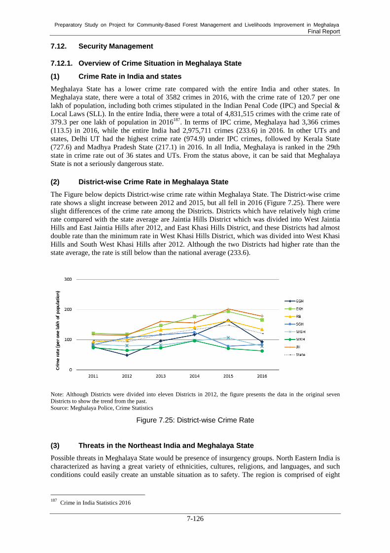
Preparatory Study on Project for Community-Based Forest Management and Livelihoods Improvement in Meghalaya Final Report
7-126
7.12. Security Management
7.12.1. Overview of Crime Situation in Meghalaya State
(1) Crime Rate in India and states
Meghalaya State has a lower crime rate compared with the entire India and other states. In
Meghalaya state, there were a total of 3582 crimes in 2016, with the crime rate of 120.7 per one
lakh of population, including both crimes stipulated in the Indian Penal Code (IPC) and Special &
Local Laws (SLL). In the entire India, there were a total of 4,831,515 crimes with the crime rate of
379.3 per one lakh of population in 2016187
. In terms of IPC crime, Meghalaya had 3,366 crimes
(113.5) in 2016, while the entire India had 2,975,711 crimes (233.6) in 2016. In other UTs and
states, Delhi UT had the highest crime rate (974.9) under IPC crimes, followed by Kerala State
(727.6) and Madhya Pradesh State (217.1) in 2016. In all India, Meghalaya is ranked in the 29th
state in crime rate out of 36 states and UTs. From the status above, it can be said that Meghalaya
State is not a seriously dangerous state.
(2) District-wise Crime Rate in Meghalaya State
The Figure below depicts District-wise crime rate within Meghalaya State. The District-wise crime
rate shows a slight increase between 2012 and 2015, but all fell in 2016 (Figure 7.25). There were
slight differences of the crime rate among the Districts. Districts which have relatively high crime
rate compared with the state average are Jaintia Hills District which was divided into West Jaintia
Hills and East Jaintia Hills after 2012, and East Khasi Hills District, and these Districts had almost
double rate than the minimum rate in West Khasi Hills District, which was divided into West Khasi
Hills and South West Khasi Hills after 2012. Although the two Districts had higher rate than the
state average, the rate is still below than the national average (233.6).
Note: Although Districts were divided into eleven Districts in 2012, the figure presents the data in the original seven
Districts to show the trend from the past.
Source: Meghalaya Police, Crime Statistics
Figure 7.25: District-wise Crime Rate
(3) Threats in the Northeast India and Meghalaya State
Possible threats in Meghalaya State would be presence of insurgency groups. North Eastern India is
characterized as having a great variety of ethnicities, cultures, religions, and languages, and such
conditions could easily create an unstable situation as to safety. The region is comprised of eight
187
Crime in India Statistics 2016

Preparatory Study on Project for Community-Based Forest Management and Livelihoods Improvement in Meghalaya Final Report
7-127
states and has a high concentration of tribal groups, making up 30% of the total population188
.
Instability as regards safety could easily occur in Northeast India due to the fears of local people of
migrants from bordering countries, namely Bangladesh, Bhutan, Myanmar, and China, a lack of
economic opportunities, and weak governance, which makes people feel alienated and left behind.
In addition, there is easy access to arms from the international border areas189
. Although Meghalaya
State is said to have relatively fewer number of insurgencies compared with neighboring states, the
state is being increasingly used as a corridor and regrouping zone by rebels from all over Northeast.
There are two major insurgent groups in Meghalaya State.
Garo National Liberation Army (GNLA)
The Garo National Liberation Army (GNLA) is a home-grown insurgent force formed in 2009. The
aim of GNLA is to create a separate ‘Garoland' in the western parts of the state, especially in coal
rich areas. GNLA has modern weapons and is conducting several violent activities, such as killing,
kidnapping, and extortion in the Garo Hills District. GNLA has links with other militant groups,
such as the United Liberation Front of Asom190
.
Hynniewtrep National Liberation Council (HNLC)
HNLC is a militant organization claiming itself to be a representative of the Khasi and Jaintia
people. Its aim is to free Meghalaya from the Garos and the non-tribal groups that dominate the
state. HNLC’s activities are restricted to the Khasi Hills; several attacks have taken place in the
state capital of Shillong191
.
These two rebels were active in the past years but inactive now, according to the local police
responding the questionnaire in the survey mentioned in a later section.
Another potential risk in Meghalaya State is to have majority of Christians in the population. About
85 % of population is tribal people and most are Christians, while Hindus comprise about 10%,
Muslims 2%, and other groups the remaining 2%. The Meghalaya High Court, however, issued a
statement that restricts Muslim citizenship in the state192
, which could trigger instability and
protests by those people affected.
7.12.2. Security Management Survey
A survey was conducted to understand the actual local security situations in the state by collecting
information through both interviews and questionnaires. The interviews were given with the
Superintendent of Police (SP) in two districts, West Jaintia Hills and West Garo Hills Districts, and
with one security guard from Shillong. In the other nine districts, questionnaires were sent to the
MBDA District Project Managers (DPMs), and the DPMs forwarded them to their local SP as
needed.
Answers to the questionnaire indicated that there were serious dangers that could negatively impact
on the Project implementation in the state. In Shillong and the East Kashi Hills area, no threats from
HNLC and GNLA have been reported for the last 20 years. Besides these rebels, no other major
crimes have been reported during the last 20 years. However, migrants protested in Shillong against
the government in 2014 for permission to work in the state. This type of protest may happen again
188 Subir Bhaumik. (2007). Insurgencies in India’s Northeast: Conflict, Co-option & Changes 189
Vision IAS. Insurgency in North East.: http://visionias.in/beta/sites/all/themes/momentum/files/interview_issues_
2016/Insurgency_in_NE.pdf 190
Sushil Kumar Sharma. (2016). Garo National Liberation Army: An Emerging Threat in Meghalaya. 191
centre for development and peace studies (CDPS). (2018). Overview: Insurgency & Peace Efforts in Meghal
aya.: http://cdpsindia.org/meghalaya_insurgency.asp 192
THE WEEK. (2018). India becoming Islamic state would spell doomsday: Meghalaya HC judge.:
https://www.theweek.in/news/india/2018/12/13/india-islamic-doomsday-meghalaya-hc.html

Preparatory Study on Project for Community-Based Forest Management and Livelihoods Improvement in Meghalaya Final Report
7-128
in the future and the Project members may be affected.
In West Jaintia Hills, HNLC was active until 2010, but no incidents have been reported since 2010.
The situation in East Jaintia Hills is similar. One incident was reported in East Jaintia Hills in which
police were beaten when they tried to capture illegal coal miners, but this incident will not strongly
influence the implementation of the Project activities.
Caution will be needed in the Garo Hills area. According to SP in West Garo Hills District, GNLA
was active in the entire Garo Hills area from 2010 to 2018 and they targeted everybody, including
government officers and citizens. In February 2018, the leader of GNLA was killed by police; since
then, the Garo Hills area has become stable. Since February 2018, no incidents involving GNLA
have been reported.
Similar information was reported from South Garo Hills. In South Garo Hills, special forces are still
deployed to ensure security. Therefore, although no threat has been observed there since February
2018, caution should be still taken and the security situation should be monitored, particularly in the
Garo Hills area.
Other than HNLC and GNLA, a conflict was reported between different tribes, namely in South
Garo Hills between Garo and Rabha tribes in 2010. The situation has been settled and is under
control now by the district police. Regarding inter-tribe conflicts, no incident has been reported in
the last decade.
The questionnaire also asked about the presence of especially dangerous areas. No respondent
mentioned any such areas, except for the coal mining area of Nongalbriba in South Garo Hills,
which likely attracts petty criminals. However, the district police have been deployed to check
criminal activity and ensure security, and no incidents have been reported recently.
Thus, there will be no limitations on the places in which the Project will be conducted. Nevertheless,
caution will be needed in mining areas and areas with different neighboring tribes.
Overall, it is concluded that there will be no serious security risk in the state to implementing the
Project, but security measures as described in the following section are needed.
7.12.3. Measures against Insecurities
Although the state does not have serious security risks at present, measures to avoid and mitigate
risks should be taken. In the following parts, measures to ensure safety in the field, residences, and
trips to the field are explained.
General and Before Journey
The following measure will be required in general and before journey
i. Collect and analyze information on rebels such as GNLA, HNLC and others, as well as
on political situations, through local newspapers and television programs to avoid any
conflicts and danger
ii. Contact the concerned institutions regarding security, and ask for guidance before
visiting the Project site
iii. Appoint reliable security guards who are equipped with arms and have had official
training facilitated by the government, especially for visits to Garo Hills
iv. Plan routes to the Project site that Project members know ahead departure and arrival
v. Plan an alternative route in case of necessity
vi. Report travel details, including persons who travel, routes, time of departure and arrival,

Preparatory Study on Project for Community-Based Forest Management and Livelihoods Improvement in Meghalaya Final Report
7-129
transportation, assigned drivers, contact information of Project members, and submit
these to the security department
vii. Hire or appoint reliable drivers who have had training for security as well as first aid
viii. Develop an emergency evacuation plan and security management procedure and
nominate persons for security and safety management with clear roles and responsibility
ix. Undergo security management and awareness training on arrival in India or the state
x. Avoid any criticism of the government, political parties, religious or indigenous groups
During Journey
i. Work and move in day-time before getting dark
ii. Ensure all vehicles display the emergency numbers of the police, fire station, ambulance
etc.
iii. Use a system or apps that can track the location of persons in the field
iv. Report arrival to security personnel in charge, and if no report is received by the expected
arrival time, security personnel thereafter alerts a manager at a higher level
v. Avoid mining sites and areas neighboring different tribes unless it necessary, since GNLA
is likely to often appear at coal mining sites and conflicts might happen.
Safety Practices in emergency
i. In case of an attack by insurgent groups, move away from the place immediately
ii. When an insurgent event happens outside a hotel or place of residence, close the drapes,
stay away from the windows, and turn off the lights
iii. In confronting extortion, give all valuables and do not resist or attempt to pursue the rebel
7.13. Possibility of Introduction of Japanese Technologies
The northeastern region of India, including Meghalaya State, is identified as one of the prioritized
areas of “Act East Policy” of the Government of India and “Free and Open Indo-Pacific Strategy”
of the Government of Japan. Following these policies, it is expected to improve the relationship
between the two governments and generate tangible outputs through their collaboration. In this
regard, this section examines possibilities to introduce Japanese domestic technologies in forestry
sector projects, particularly for GIS and MIS and Timber and Bamboo Processing.
Forest Planning and Monitoring by using GIS/MIS Technologies
Japan has experiences with the use of advanced geospatial technologies in overseas countries. In
this section, three major Japanese technologies are discussed. They include (1) the development of
forest information management systems based on data acquired using geospatial data such as
satellite imagery and aerial photos, (2) combination use of timely and free data for efficient
monitoring, and (3) data management using cloud services. In the context of this section, “Japanese
domestic technology” refers to not individual element technologies, but a combination of individual
elements technologies appropriate to achieve project objectives.
First, forest information management systems have a good potential to be developed in Meghalaya
State. These systems were developed to enable the local governments for efficiently and effectively
conducing forest management in some overseas countries under JICA projects. For example, the
tablet-based data collection technology was developed and incorporated in an official forest
monitoring system, namely Forest Resource Monitoring System. The tablet-based data collection
method provides multiple functions including digital base maps for easy field navigation, GPS for
area measurement, digital camera for site conditions recording, and digital field notes for direct data
input on site. The collected data are directly transferred to the central database and can be managed
under Forest Management Information System, going through the approval process at district,

Preparatory Study on Project for Community-Based Forest Management and Livelihoods Improvement in Meghalaya Final Report
7-130
provincial, and national level. In the context of Meghalaya State, this kind of technology will be
useful for preparing working schemes by the ADCs and making forest management plans by
communities as well as monitoring the implementation of those plans in the Project.
Second, at present, needs for timely data analysis and free geospatial information has rapidly
increased, and to date, many satellite imagery and thematic maps generated from the satellite
imagery have become available for free of charge. To achieve sustainable monitoring activities in
terms of time and cost in the future, it can be also proposed to additionally utilize freely available
deforestation datasets (e.g. JJ-FAST and Hansen data) to detect forest cover changes in a timely
manner.
Finally, it is also important to manage a wide range of data and information about forestry in a
systematic and efficient manner. The timely data for identifying possible monitoring sites are
shared within relevant organizations. These data can be shared through cloud service. By the
combination use of local server, which is for confidential data and information, and cloud services,
which can be used for a large volume of data and less sensitive information, the speed and
efficiency of data sharing can be improved while securing the data confidentiality.
Timber and Bamboo Processing Technologies
Through the preparatory study, it was revealed that majority of communities do not have intention
to produce timber for commercial purposes. Rather, they would like to conserve their forests for
conserving water resources and biodiversity. Some private forest owners harvest timber from their
forests and sell it to local saw mills. According to the observation by the Study Team, a sawing
machine used in a local saw mill was primitive, and the volume of timber producing in the state was
small. Under these circumstances, it is not adequate to introduce Japanese advanced technologies
by using modern machines on timber harvesting or timber processing.
Bamboo is one of the important NTFPs in the state, and it is used for craft making. Although
traditional bamboo crafts in Meghalaya State are marvelous, there is still potential to develop
bamboo craft further in terms of design, items, and durability. For example, treatment of bamboo is
necessary before making furniture because furniture made from bamboo will be damaged by
insects. Japan also has traditional as well as modernized techniques of bamboo craft. However, it
may be better to introduce bamboo processing technologies not from Japan but from Tripura State
in which Bamboo and Cane Development Institute (BCDI) is located. BCDI has sophisticated and
modernized technologies including bamboo treatment and provides training on bamboo craft
making. Natural and social conditions in Tripura is much more similar to those in Meghalaya than
those in Japan, thus, bamboo related technologies transferred from Tripura may be more suitable for
Meghalaya.

Preparatory Study on Project for Community-Based Forest Management and Livelihoods Improvement in Meghalaya
Final Report