Embed Size (px)
DESCRIPTION
Portfolio landscape urbanist
Citation preview
L A N D S C A P E E N G I N E E R - U R B A N D E S I G N E R
PO
RT
FO
LIO
Hubert Namgyel
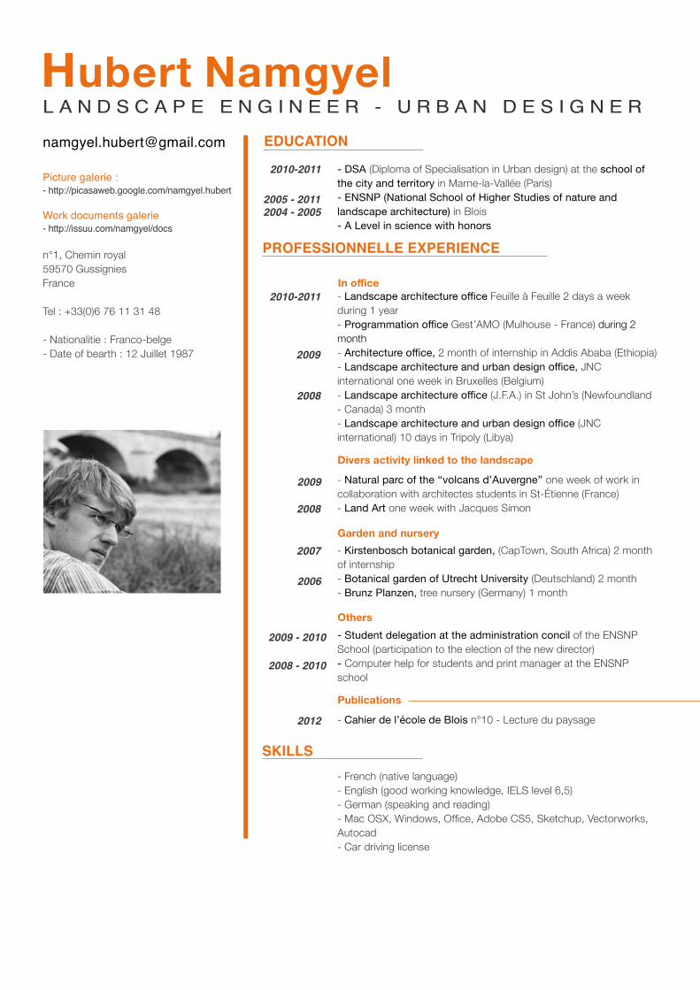
Picture galerie :- http://picasaweb.google.com/namgyel.hubert
Work documents galerie- http://issuu.com/namgyel/docs
n°1, Chemin royal59570 GussigniesFrance
Tel : +33(0)6 76 11 31 48
- Nationalitie : Franco-belge- Date of bearth : 12 Juillet 1987
L A N D S C A P E E N G I N E E R - U R B A N D E S I G N E RHubert Namgyel
- DSA (Diploma of Specialisation in Urban design) at the school of the city and territory in Marne-la-Vallée (Paris)- ENSNP (National School of Higher Studies of nature and landscape architecture) in Blois- A Level in science with honors
- Landscape architecture office Feuille à Feuille 2 days a week during 1 year- Programmation office Gest’AMO (Mulhouse - France) during 2 month- Architecture office, 2 month of internship in Addis Ababa (Ethiopia)- Landscape architecture and urban design office, JNC international one week in Bruxelles (Belgium) - Landscape architecture office (J.F.A.) in St John’s (Newfoundland - Canada) 3 month- Landscape architecture and urban design office (JNC international) 10 days in Tripoly (Libya)
- Natural parc of the ‘‘volcans d’Auvergne’’ one week of work in collaboration with architectes students in St-Étienne (France)- Land Art one week with Jacques Simon
- Kirstenbosch botanical garden, (CapTown, South Africa) 2 month of internship- Botanical garden of Utrecht University (Deutschland) 2 month- Brunz Planzen, tree nursery (Germany) 1 month
- Student delegation at the administration concil of the ENSNP School (participation to the election of the new director)- Computer help for students and print manager at the ENSNP school
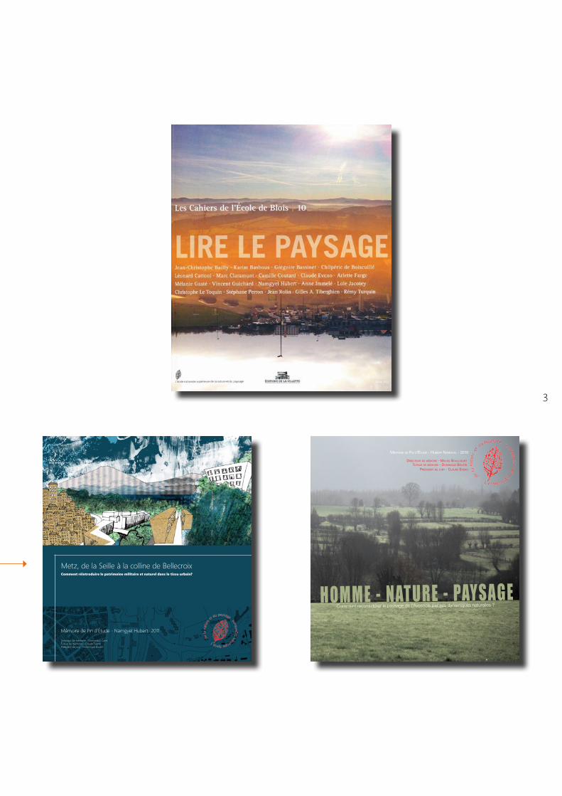
- Cahier de l’école de Blois n°10 - Lecture du paysage
- French (native language)- English (good working knowledge, IELS level 6,5)- German (speaking and reading)- Mac OSX, Windows, Office, Adobe CS5, Sketchup, Vectorworks, Autocad- Car driving license
2005 - 20112004 - 2005
2009
2010-2011
2010-2011
2009
2007
2009 - 2010
2008 - 2010
EDUCATION
PROFESSIONNELLE EXPERIENCE
SKILLS
In office
Divers activity linked to the landscape
Garden and nursery
Others
Publications
2008
2006
2012
2008
3
L A N D S C A P E E N G I N E E R - U R B A N D E S I G N E R
MéMoire de Fin d’étude - Hubert naMgyel - 2010
directeur de MéMoire - MicHel boulcourt
tuteur de MéMoire - doMinique boutin
Président de jury - claude eveno
Comment reconsidérer le paysage de l’Avesnois par ses dynamiques naturelles ?H O M M E - N AT U R E - PAY S A G E
Mémoire de Fin d’Étude - Namgyel Hubert- 2011
Directeur de mémoire - Dominique CaireTuteur de mémoire - Claude EvenoPrésident de jury - Dominique Boutin
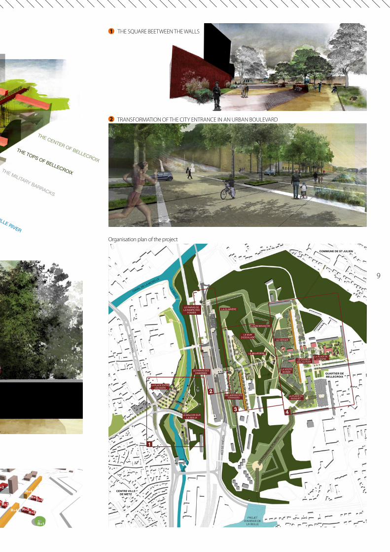
Metz, de la Seille à la colline de BellecroixComment réintroduire le patrimoine militaire et naturel dans le tissu urbain?
5
URBAN CONTEXT PROJECTS
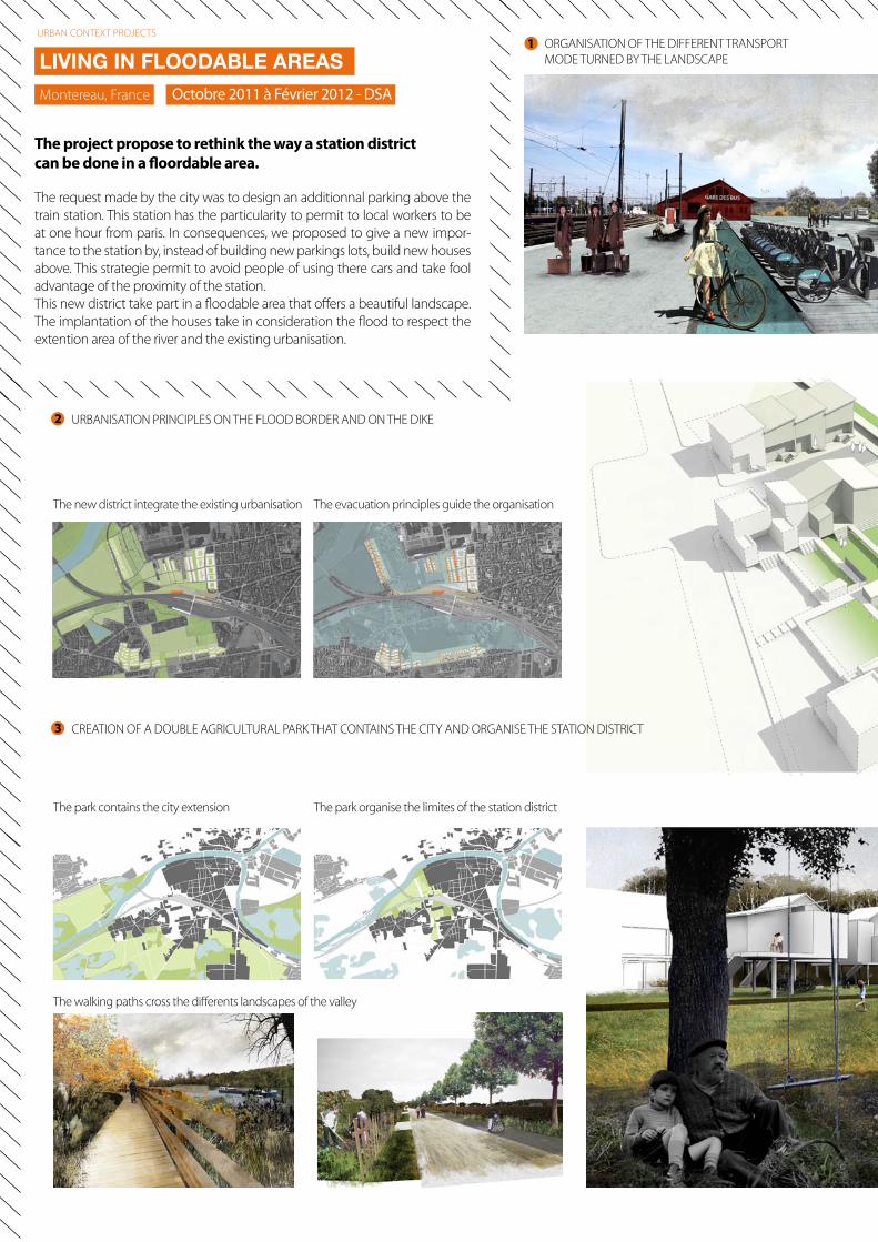
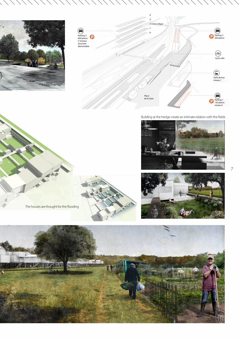
The request made by the city was to design an additionnal parking above the train station. This station has the particularity to permit to local workers to be at one hour from paris. In consequences, we proposed to give a new impor-tance to the station by, instead of building new parkings lots, build new houses above. This strategie permit to avoid people of using there cars and take fool advantage of the proximity of the station. This new district take part in a floodable area that offers a beautiful landscape. The implantation of the houses take in consideration the flood to respect the extention area of the river and the existing urbanisation.
LIVING IN FLOODABLE AREASOctobre 2011 à Février 2012 - DSAMontereau, France
The project propose to rethink the way a station district can be done in a floordable area.
URBAN CONTEXT PROJECTS
URBANISATION PRINCIPLES ON THE FLOOD BORDER AND ON THE DIKE
CREATION OF A DOUBLE AGRICULTURAL PARK THAT CONTAINS THE CITY AND ORGANISE THE STATION DISTRICT
The park contains the city extension
The new district integrate the existing urbanisation
The park organise the limites of the station district
The evacuation principles guide the organisation
The walking paths cross the differents landscapes of the valley
ORGANISATION OF THE DIFFERENT TRANSPORT MODE TURNED BY THE LANDSCAPE
1
2
3
7
P
P
P
Gare de busniveau 1
Cyclo vélo
Parking 2200 places
Parking 1130 placesniveau 0
Parking 3 600 places5 niveaux structure démontable
0
1
2 niveau digue
3
4
Place de la Gare
LA VOITURE MAJORITAIREMENT UTILISE A MONTEREAU
31% VOITURE (CONDUCTEUR)
29% BUS
46%
22% A PIED
15% VOITURE (PASSAGER)
2% AUTRE TRAIN
1% 2 ROUES NON MOTORISES
LA VOITURE MAJORITAIREMENT UTILISE A MONTEREAU
31% VOITURE (CONDUCTEUR)
29% BUS
46%
22% A PIED
15% VOITURE (PASSAGER)
2% AUTRE TRAIN
1% 2 ROUES NON MOTORISES
LA VOITURE MAJORITAIREMENT UTILISE A MONTEREAU
31% VOITURE (CONDUCTEUR)
29% BUS
46%
22% A PIED
15% VOITURE (PASSAGER)
2% AUTRE TRAIN
1% 2 ROUES NON MOTORISES
LA VOITURE MAJORITAIREMENT UTILISE A MONTEREAU
31% VOITURE (CONDUCTEUR)
29% BUS
46%
22% A PIED
15% VOITURE (PASSAGER)
2% AUTRE TRAIN
1% 2 ROUES NON MOTORISES
LA VOITURE MAJORITAIREMENT UTILISE A MONTEREAU
31% VOITURE (CONDUCTEUR)
29% BUS
46%
22% A PIED
15% VOITURE (PASSAGER)
2% AUTRE TRAIN
1% 2 ROUES NON MOTORISES
Création d’un quartier sur la digue en s’intégrant dans le paysage existant
Building at the hedge create an intimate relation with the fields
The houses are thought for the flooding
THE SEILLE RIVER
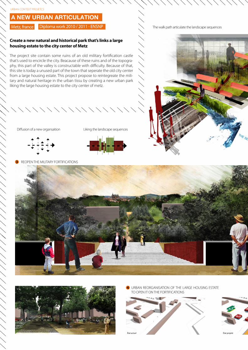
Liking the landscape sequences
REOPEN THE MILITARY FORTIFICATIONS
Diffusion of a new organsaition
The walk path articulate the landscape sequences
3
URBAN REORGANISATION OF THE LARGE HOUSING ESTATE TO OPEN IT ON THE FORTIFICATIONS
État actuel
R+3R+2
R+1 R+2
État projeté
4
The project site contain some ruins of an old military fortification castle that’s used to encircle the city. Beacause of these ruins and of the topogra-phy, this part of the valley is constructable with difficulty. Because of that, this site is today a unused part of the town that seperate the old city center from a large housing estate. This project propose to reintegreate the mili-tary and natural heritage in the urban tissu by creating a new urban park liking the large housing estate to the city center of metz.
A NEW URBAN ARTICULATIONDiploma work 2010 / 2011 - ENSNPMetz, france
Create a new natural and historical park that’s links a large housing estate to the city center of Metz
URBAN CONTEXT PROJETCS
9
THE SEILLE RIVER
THE MILITARY BARRACKS
THE TOPS OF BELLECROIX
THE CENTER OF BELLECROIX
TRANSFORMATION OF THE CITY ENTRANCE IN AN URBAN BOULEVARD
1
2
3
LA P
ROMEN
ADE P
LANTÉ
E
LA PLACE ENTRE LES MURS
LE PARVIS DES CASERNES
LE MUR D’ESCALADE
L’ACROBRANCHE
LA CLAIRIÈRE
LES JARDINS DES TERRASSES
LE DOUBLE MAIL DU FORT
LA PLACE DE LA MAIRIE
LA PLACE DU BOSQUET
LE BELVÉDÉRE
LA VOÛTE BOISÉE
LE VERGER
LE PARVIS DE LA RAMPE DES
FOSSÉS
LE BALCON SUR LA SEILLE
BLD PAIXHANS
BLD
DE T
RÈVE
S
PROJET D’AVENUE DE
LA SEILLE
LA SEILLE
CANAL DE LA MOSELLE
4
CENTRE VILLE DE METZ
QUARTIER DE BELLECROIX
COMMUNE DE ST JULIEN
Organisation plan of the project
R+4R+3
R+3
R+1
R+2R+4
R+3R+2
R+3R+2
2
1 THE SQUARE BEETWEEN THE WALLS
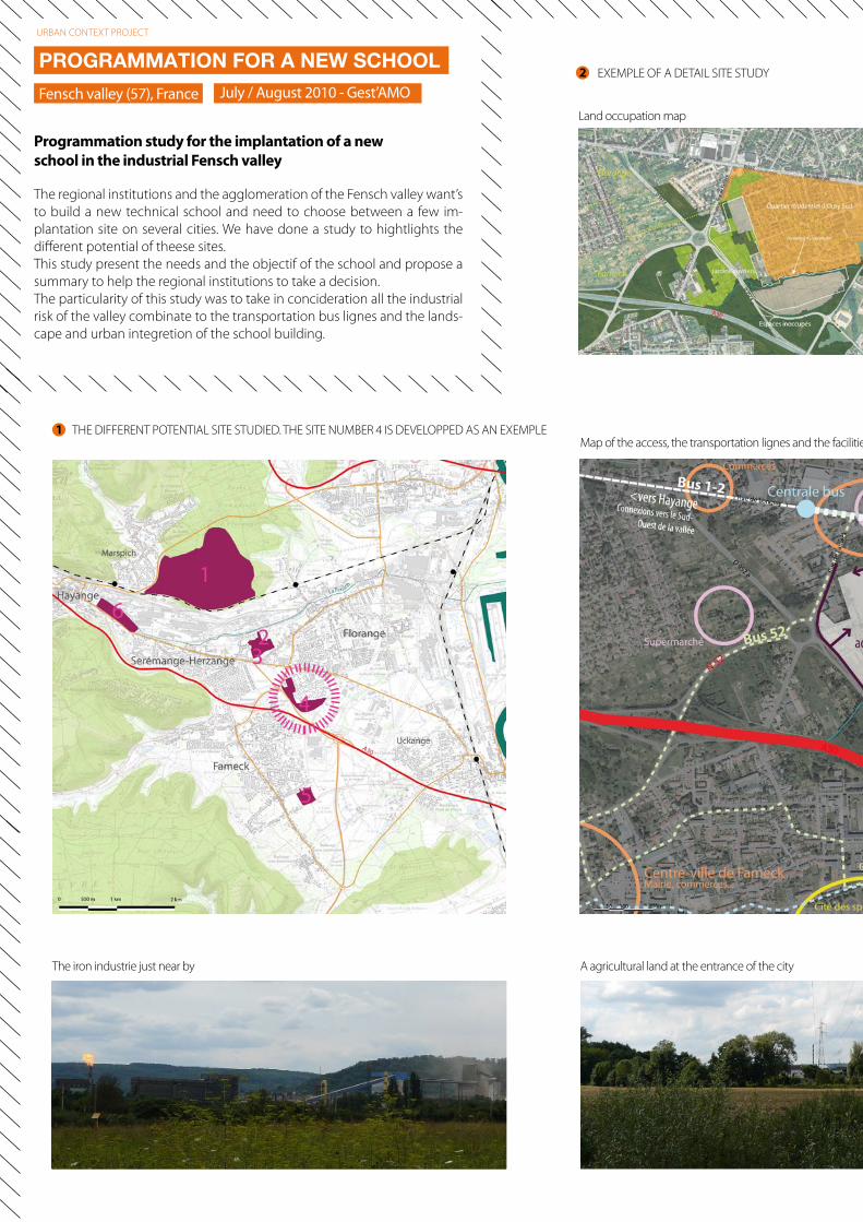
THE DIFFERENT POTENTIAL SITE STUDIED. THE SITE NUMBER 4 IS DEVELOPPED AS AN EXEMPLE
A agricultural land at the entrance of the cityThe iron industrie just near by
Land occupation map
Map of the access, the transportation lignes and the facilities
EXEMPLE OF A DETAIL SITE STUDY
1
2PROGRAMMATION FOR A NEW SCHOOL
July / August 2010 - Gest’AMOFensch valley (57), France
Programmation study for the implantation of a new school in the industrial Fensch valley
URBAN CONTEXT PROJECT
The regional institutions and the agglomeration of the Fensch valley want’s to build a new technical school and need to choose between a few im-plantation site on several cities. We have done a study to hightlights the different potential of theese sites. This study present the needs and the objectif of the school and propose a summary to help the regional institutions to take a decision.The particularity of this study was to take in concideration all the industrial risk of the valley combinate to the transportation bus lignes and the lands-cape and urban integretion of the school building.
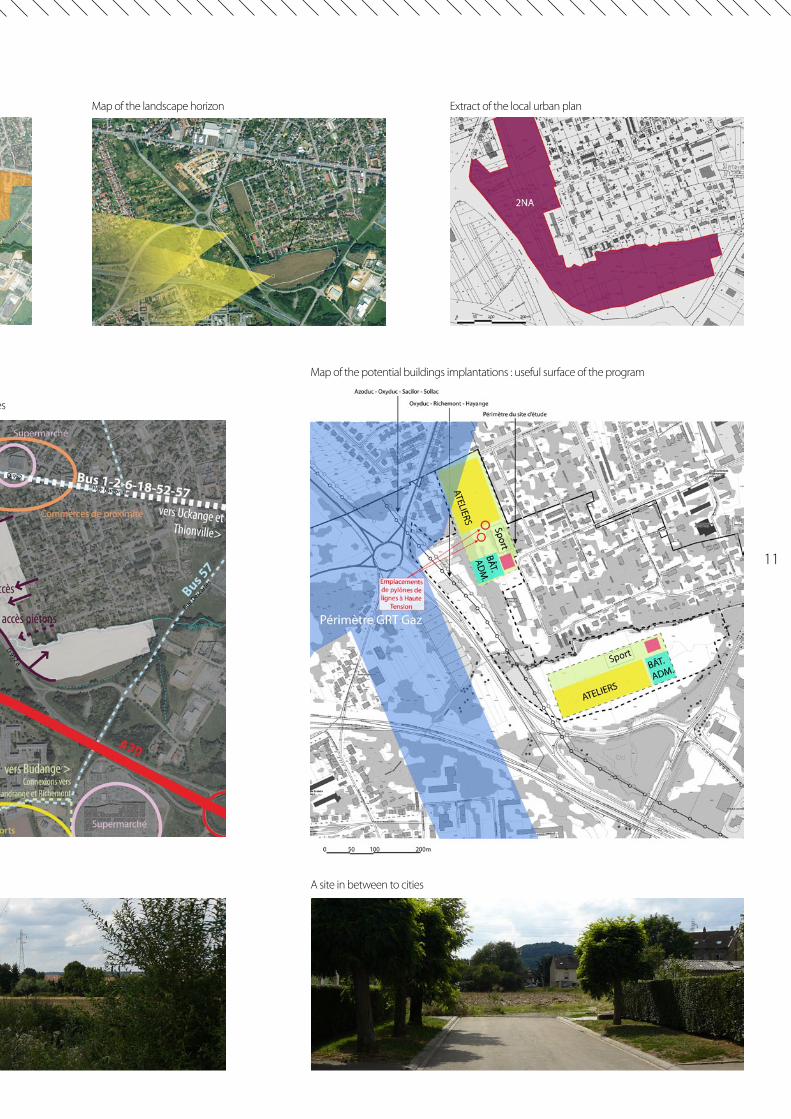
11
A site in between to cities
Map of the landscape horizon Extract of the local urban plan
Map of the access, the transportation lignes and the facilities
Map of the potential buildings implantations : useful surface of the program
0 5 10 15 20m
Link
the
parts
of
the
city
squa
re
Mar
k the
limite
s of t
he u
ses
A new green square is created. It can collect the rain water
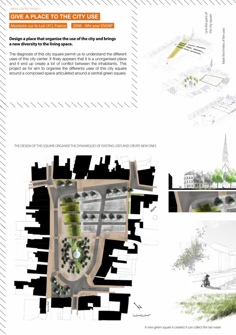
THE DESIGN OF THIS SQUARE ORGANISE THE DYNAMIQUES OF EXISTING USES AND CREATE NEW ONES
The diagnosis of this city square permit us to understand the different uses of this city center. It finaly appears that it is a unorganised place and it end up create a lot of conflict between the inhabitants. This project as for aim to organise the differents uses of this city square around a composed space articuleted around a central green square.
GIVE A PLACE TO THE CITY USE
Montoire-sur-le-Loir (41), France 2008 - 3thr year ENSNP
Design a place that organise the use of the city and brings a new diversity to the living space.
URBAN CONTEXT PROJECT
13
Giv
e a
prio
rity
to th
e pe
dest
rian
wal
k
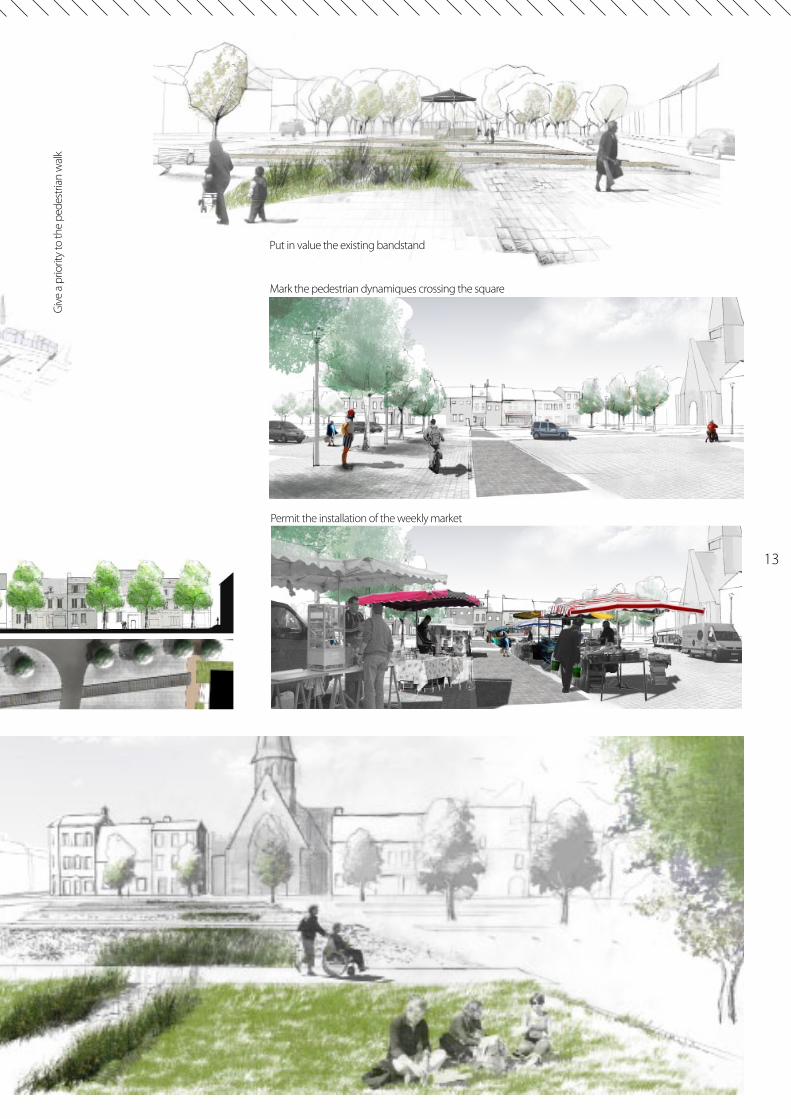
Permit the installation of the weekly market
Put in value the existing bandstand
Mark the pedestrian dynamiques crossing the square

15
RURAL CONTEXT PROJECTS
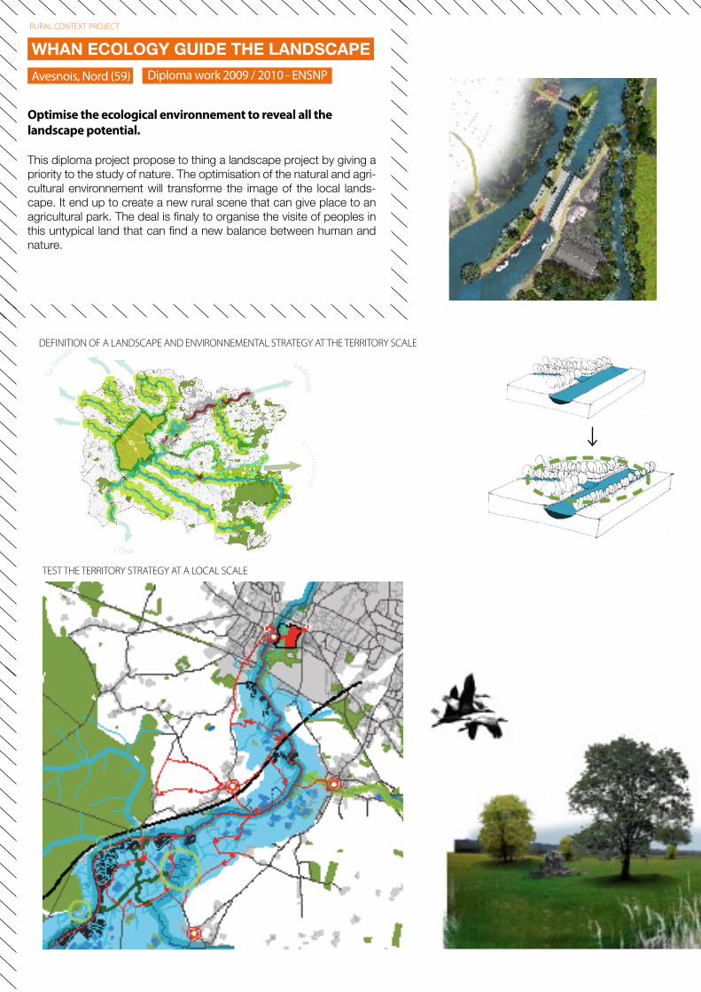
DEFINITION OF A LANDSCAPE AND ENVIRONNEMENTAL STRATEGY AT THE TERRITORY SCALE
TEST THE TERRITORY STRATEGY AT A LOCAL SCALE
This diploma project propose to thing a landscape project by giving a priority to the study of nature. The optimisation of the natural and agri-cultural environnement will transforme the image of the local lands-cape. It end up to create a new rural scene that can give place to an agricultural park. The deal is finaly to organise the visite of peoples in this untypical land that can find a new balance between human and nature.
WHAN ECOLOGY GUIDE THE LANDSCAPEDiploma work 2009 / 2010 - ENSNPAvesnois, Nord (59)
Optimise the ecological environnement to reveal all the landscape potential.
RURAL CONTEXT PROJECT
17
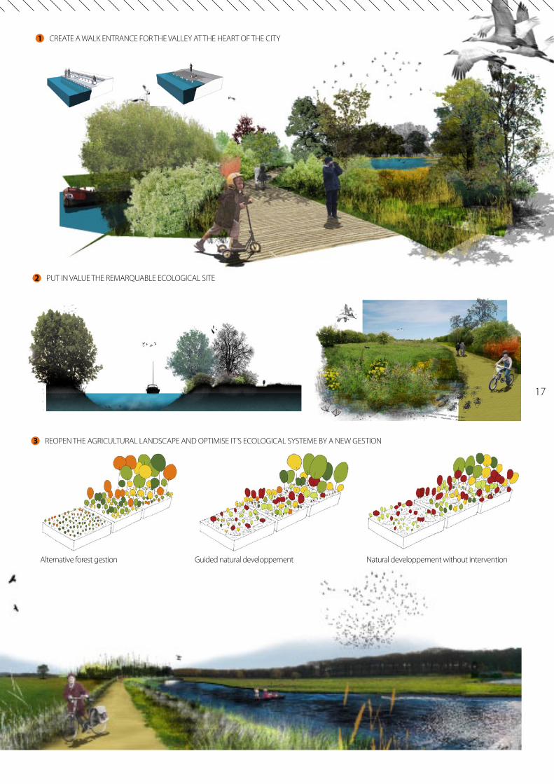
CREATE A WALK ENTRANCE FOR THE VALLEY AT THE HEART OF THE CITY
PUT IN VALUE THE REMARQUABLE ECOLOGICAL SITE
REOPEN THE AGRICULTURAL LANDSCAPE AND OPTIMISE IT’S ECOLOGICAL SYSTEME BY A NEW GESTION
1
2
3
Guided natural developpementAlternative forest gestion Natural developpement without intervention
Juillet / Août 2011 - Gest’AMO
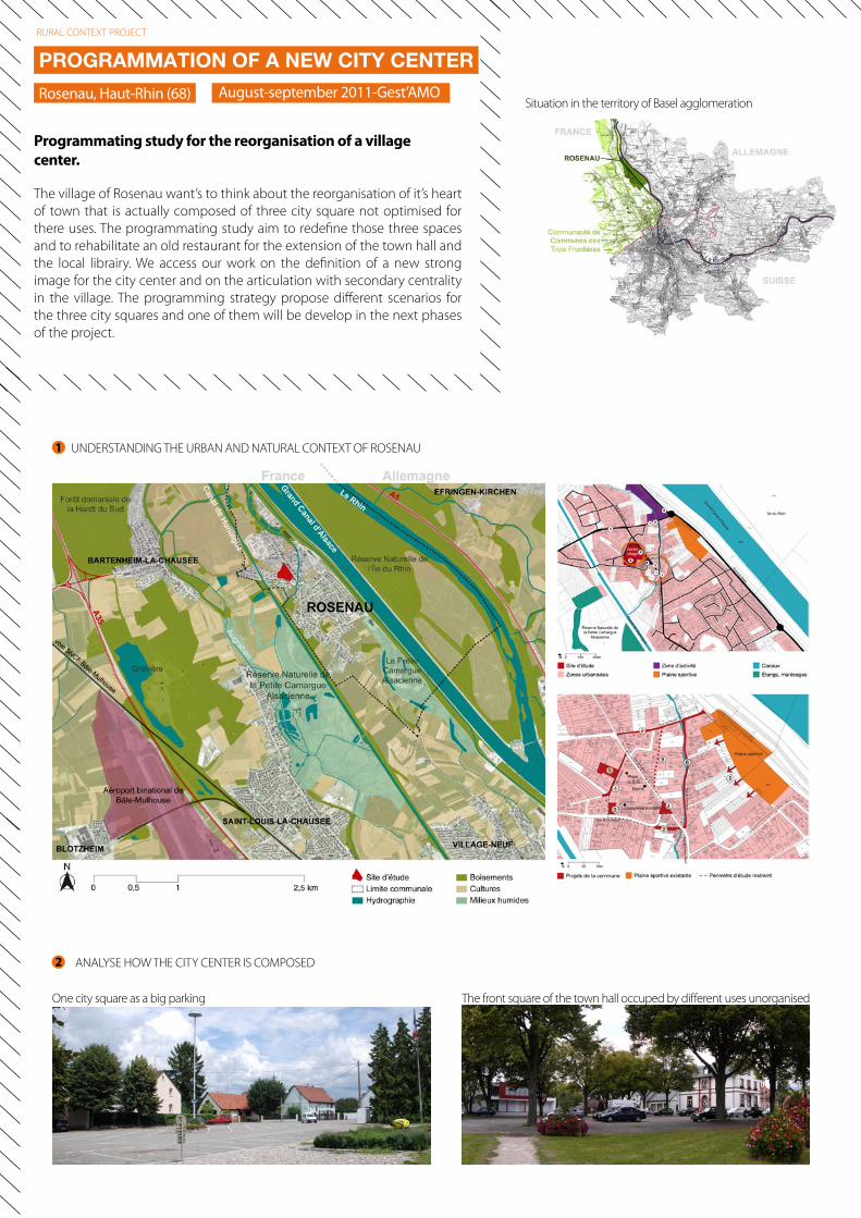
The front square of the town hall occuped by different uses unorganised
UNDERSTANDING THE URBAN AND NATURAL CONTEXT OF ROSENAU
ANALYSE HOW THE CITY CENTER IS COMPOSED
One city square as a big parking
Situation in the territory of Basel agglomeration
1
2
The village of Rosenau want’s to think about the reorganisation of it’s heart of town that is actually composed of three city square not optimised for there uses. The programmating study aim to redefine those three spaces and to rehabilitate an old restaurant for the extension of the town hall and the local librairy. We access our work on the definition of a new strong image for the city center and on the articulation with secondary centrality in the village. The programming strategy propose different scenarios for the three city squares and one of them will be develop in the next phases of the project.
PROGRAMMATION OF A NEW CITY CENTER
Rosenau, Haut-Rhin (68)
Programmating study for the reorganisation of a village center.
RURAL CONTEXT PROJECT
August-september 2011-Gest’AMO
19
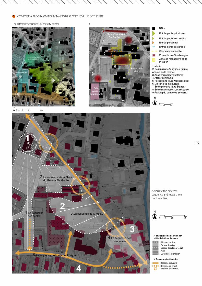
COMPOSE A PROGRAMMING BY TAKING BASE ON THE VALUE OF THE SITE
The different sequences of the city center t
Articulate the different sequence and reveal there particularities
3
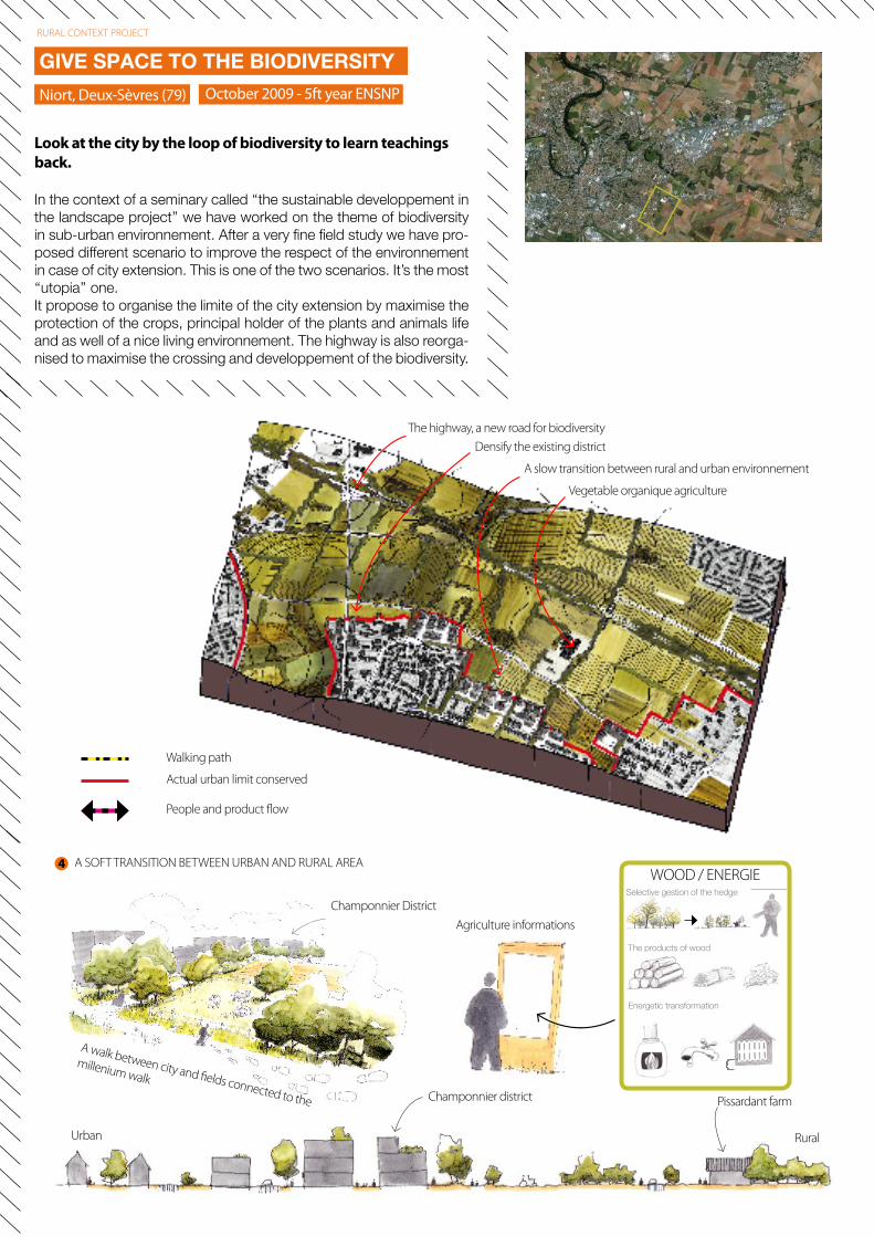
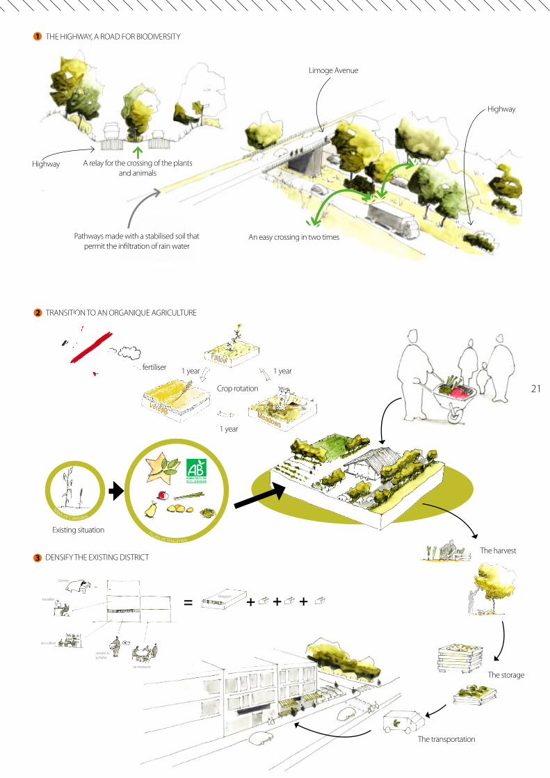
In the context of a seminary called ‘‘the sustainable developpement in the landscape project’’ we have worked on the theme of biodiversity in sub-urban environnement. After a very fine field study we have pro-posed different scenario to improve the respect of the environnement in case of city extension. This is one of the two scenarios. It’s the most ‘‘utopia’’ one.It propose to organise the limite of the city extension by maximise the protection of the crops, principal holder of the plants and animals life and as well of a nice living environnement. The highway is also reorga-nised to maximise the crossing and developpement of the biodiversity.
GIVE SPACE TO THE BIODIVERSITYOctober 2009 - 5ft year ENSNPNiort, Deux-Sèvres (79)
Look at the city by the loop of biodiversity to learn teachings back.
RURAL CONTEXT PROJECT
Walking path
Actual urban limit conserved
People and product flow
The highway, a new road for biodiversityDensify the existing district
A slow transition between rural and urban environnement
Vegetable organique agriculture
Urban Rural
Champonnier district Pissardant farm
A walk between city and fields connected to the
millenium walk
Champonnier District
WOOD / ENERGIE
The products of wood
Energetic transformation
A SOFT TRANSITION BETWEEN URBAN AND RURAL AREA
Agriculture informations
Selective gestion of the hedge
4
21
Vegetable organique agriculture
THE HIGHWAY, A ROAD FOR BIODIVERSITY
TRANSITION TO AN ORGANIQUE AGRICULTURE
DENSIFY THE EXISTING DISTRICT
A relay for the crossing of the plants and animals
An easy crossing in two timesPathways made with a stabilised soil that permit the infiltration of rain water
Limoge Avenue
Highway
Highway
The harvest
The storage
The transportation
Crop rotation
Mais et Céréales
Fruits et légumes
Existing situation
No chemical fertiliser
Cereals Meadows
Fallow1 year
1 year
1 year
Dormir
travaillerMagasin
se cultiver
vendre & acheter
se restaurer
1
2
3
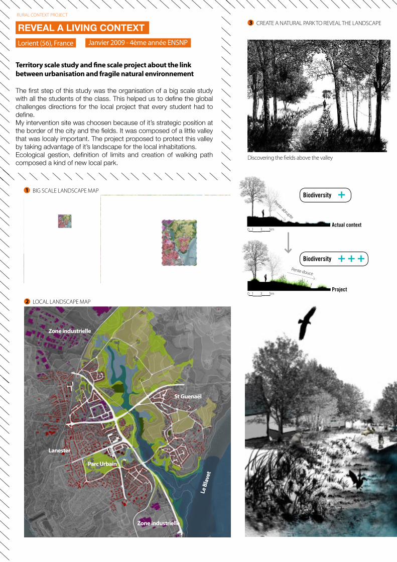
The first step of this study was the organisation of a big scale study with all the students of the class. This helped us to define the global challenges directions for the local project that every student had to define.My intervention site was choosen because of it’s strategic position at the border of the city and the fields. It was composed of a little valley that was localy important. The project proposed to protect this valley by taking advantage of it’s landscape for the local inhabitations.Ecological gestion, definition of limits and creation of walking path composed a kind of new local park.
REVEAL A LIVING CONTEXTJanvier 2009 - 4ème année ENSNPLorient (56), France
Territory scale study and fine scale project about the link between urbanisation and fragile natural environnement
RURAL CONTEXT PROJECT
Lanester
St Guenaël
Parc Urbain
Zone industrielle
Zone industrielle
Le B
lave
t
LOCAL LANDSCAPE MAP
BIG SCALE LANDSCAPE MAP
Discovering the fields above the valley
Actual context
Biodiversity +
Biodiversity + + +
Project
Pente douce
Pente abrupte
1 3 5m0
1 3 5m0
1
2
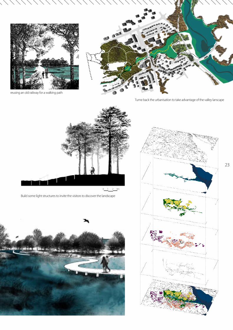
CREATE A NATURAL PARK TO REVEAL THE LANDSCAPE3
23
reusing an old railway for a walking path
Turne back the urbanisation to take advantage of the valley lanscape
1 2 3m0
Build some light structures to invite the visitors to discover the landscape
CREATE A NATURAL PARK TO REVEAL THE LANDSCAPE