Embed Size (px)
Citation preview
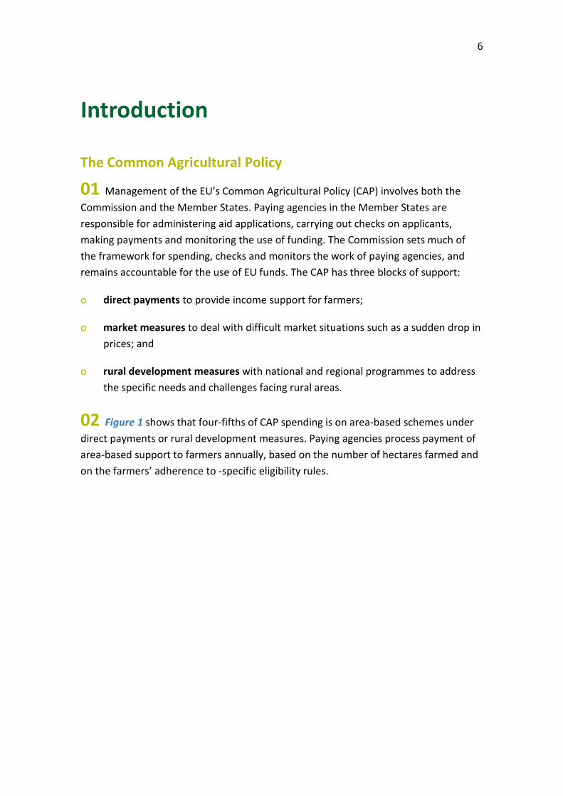
Special Report Using new imaging technologies to monitor the Common Agricultural Policy: steady progress overall, but slower for climate and environment monitoring
EN 2020 04
2
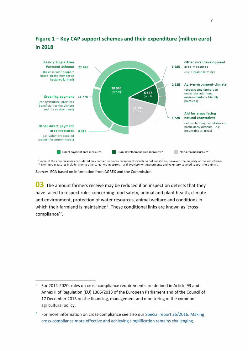
Contents
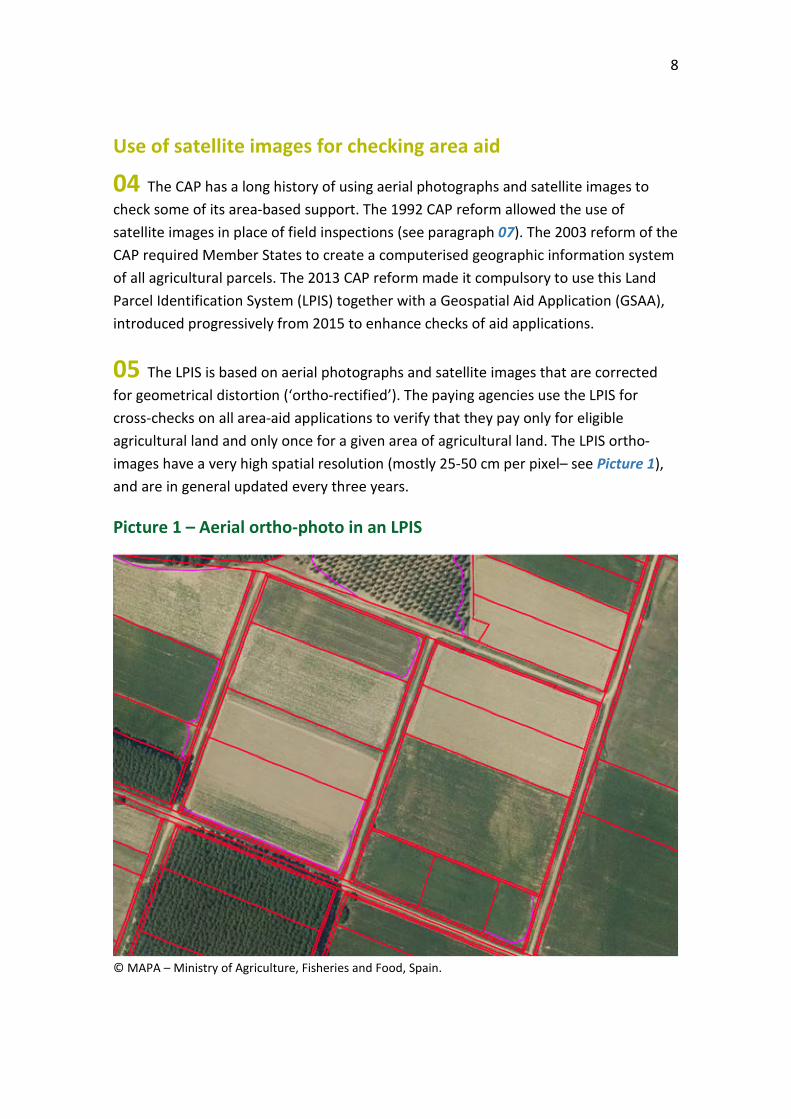
Paragraph
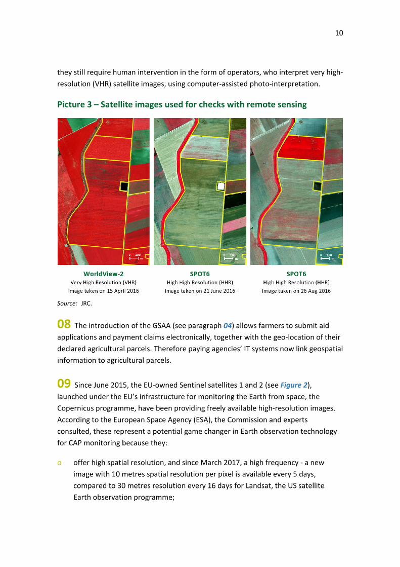
Executive summary I-VIII
Introduction 01-19 The Common Agricultural Policy 01-03
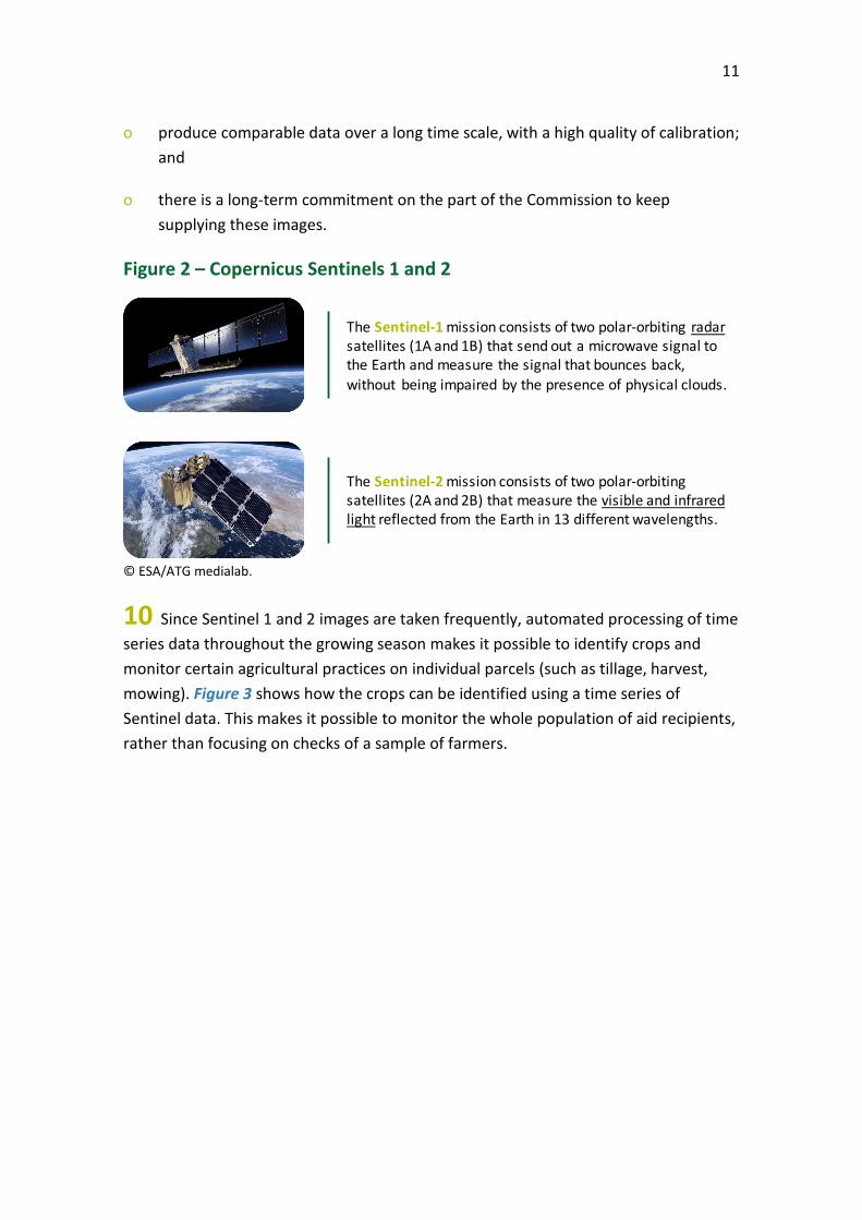
Use of satellite images for checking area aid 04-10
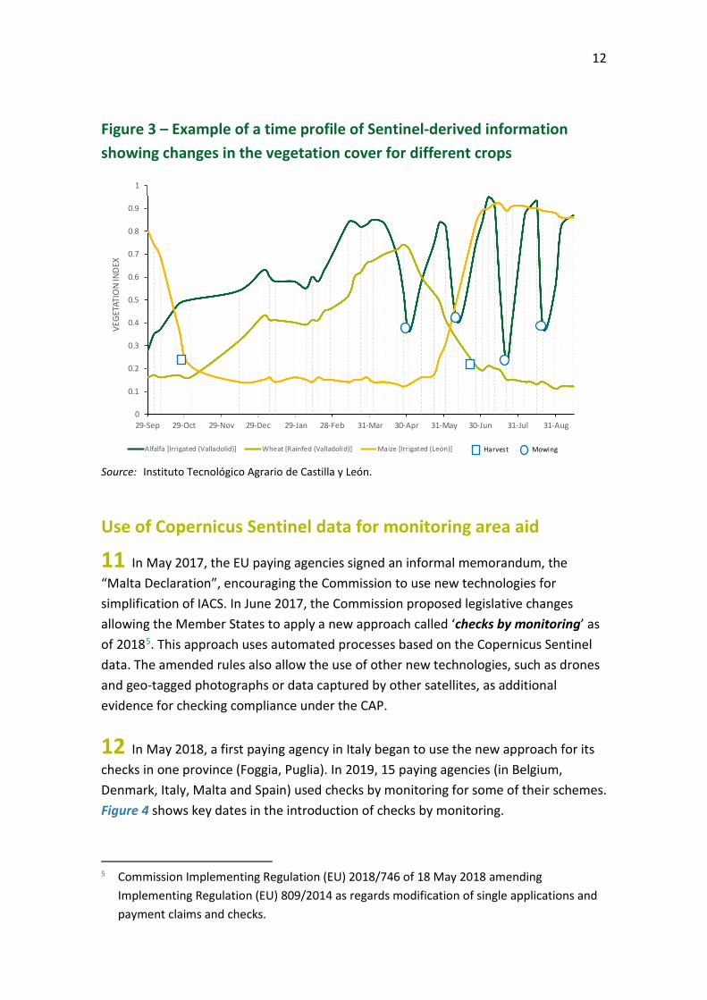
Use of Copernicus Sentinel data for monitoring area aid 11-14
Expected benefits of the new monitoring approach 15-19
Audit scope and approach 20-22
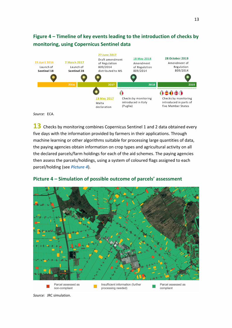
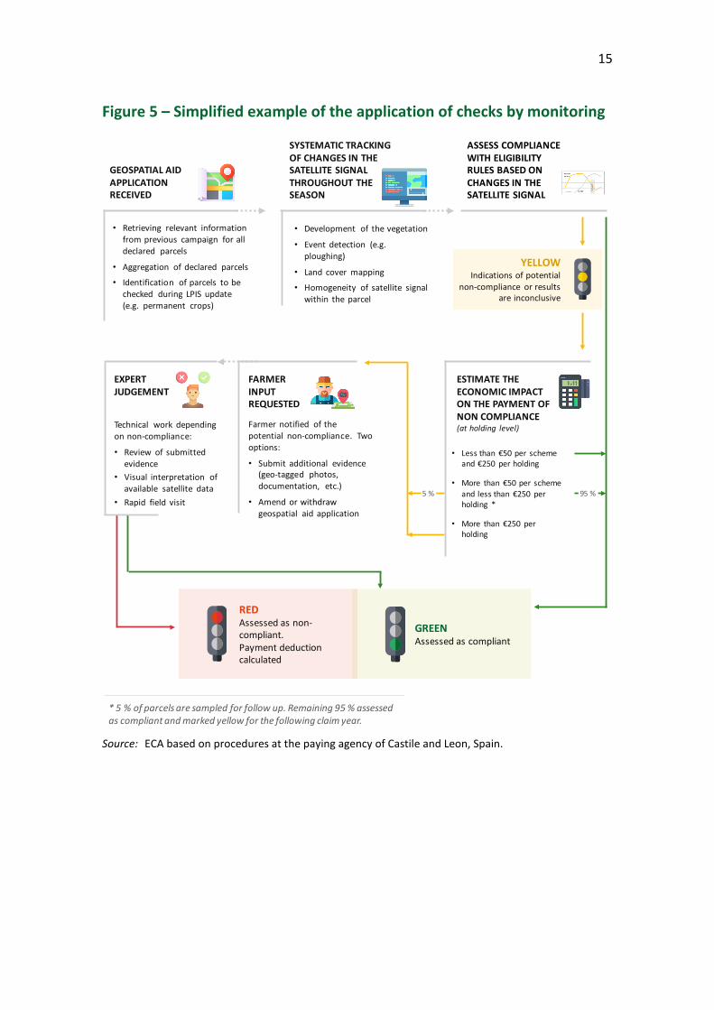
Observations 23-76 The Commission has supported the use of new technologies 23-44 The legal framework for checks by monitoring has become clearer 24-30
The Commission has promoted and supported the new approach 31
The Commission has been searching for solutions to reduce the number of parcels requiring follow-up 32-37
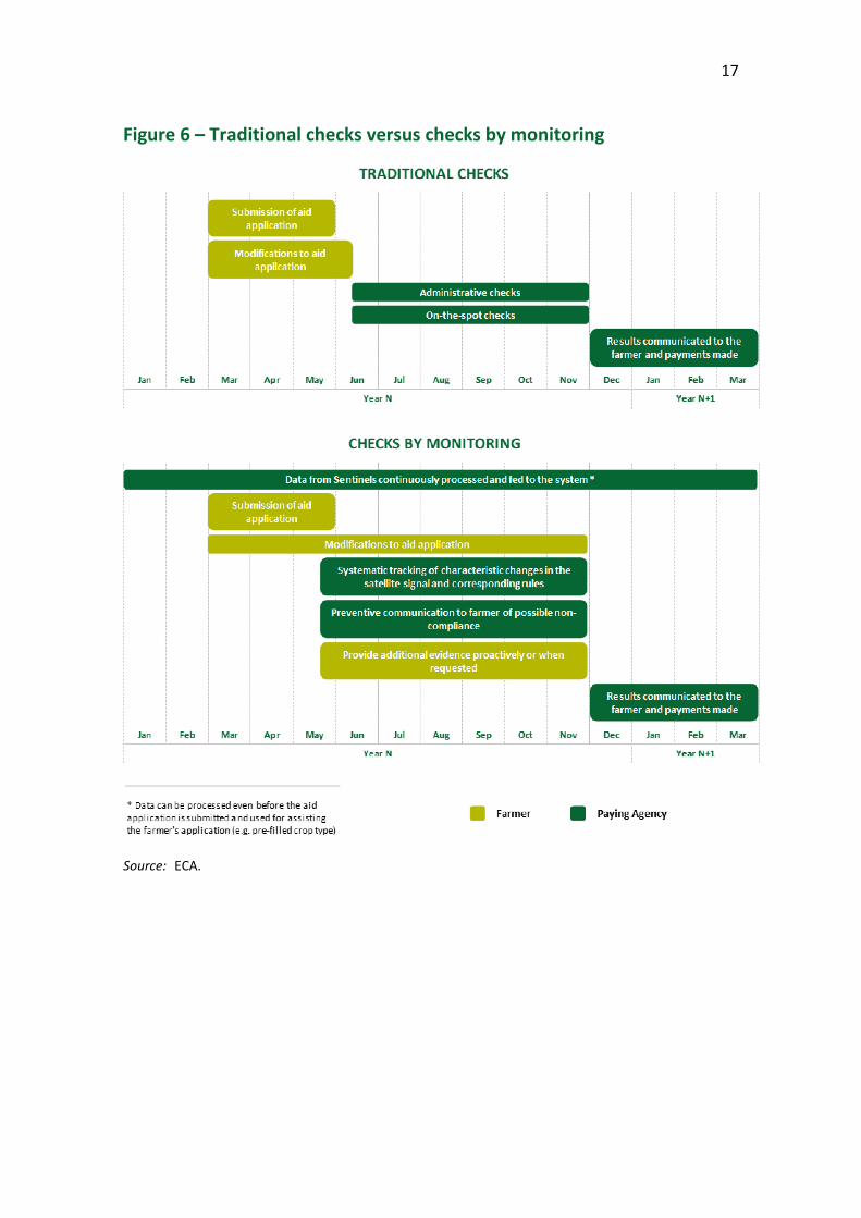
The EU-funded cloud-based services were used for testing rather than for operational monitoring 38-40
The results of research projects are yet to be exploited 41-44
Some Member States took action to deploy the new technologies for direct payments 45-58 15 paying agencies made selective use of checks by monitoring in 2019 46-50
Paying agencies also use new imaging technologies in their work outside checks by monitoring 51-54
Obstacles hampering deployment of the new technologies 55-58
3
Slower progress in meeting the challenge of using new technologies to monitor environmental and climate requirements 59-76 Commission support for the monitoring approach has prioritised direct payment schemes 63-67
Paying agencies do not yet use the monitoring approach for cross-compliance checks and rural development agri-environment climate schemes 68-72
The Commission does not require Member States to use new technologies to directly monitor the environmental and climate impact of agriculture post-2020 73-76
Conclusions and recommendations 77-84
Acronyms and abbreviations
Glossary
Replies of the Commission
Audit team
Timeline
4
Executive summary I The Common Agricultural Policy has a long history of using satellite or aerial images for checking area-based aid, which nowadays accounts for almost 80 % of the EU funding provided to agriculture and rural development. While these images usually have very high spatial resolution, before 2017 they were not available with sufficient frequency to allow verification of activities taking place on agricultural land throughout the year (e.g. harvesting).
II Since March 2017, the EU-owned Copernicus Sentinel satellites 1 and 2 have been providing frequent, freely available, high-resolution images, with the potential to be a game changer in Earth observation technology for monitoring agricultural activities. Since the images are taken frequently, automated processing of time series data throughout the growing season makes it possible to identify, without human intervention, crops and monitor certain agricultural practices on individual parcels (such as tillage, mowing). Since 2018, paying agencies can use Copernicus Sentinel data in place of traditional checks based on field inspections.
III According to the Commission and CAP stakeholders, Copernicus Sentinel data and other technologies for monitoring area aid have significant potential benefits for farmers, administrations and the environment. Our audit examined whether the Commission effectively encouraged widespread use of these new technologies and whether Member States had taken adequate action to deploy them. We looked at the Copernicus Sentinel satellite data, images taken by drones, and geotagged images. An assessment of the progress made in the use of new imaging technologies is especially relevant now, as the results of our audit could be applied in the post-2020 CAP.
IV We found that both the Commission and some Member States have taken action to unlock the potential benefits of the new technologies. The Commission promoted the use of new technologies through many conferences and workshops and provided bilateral support to many paying agencies. 15 out of 66 paying agencies used the Copernicus Sentinel data in 2019 to check aid applications for some schemes and some groups of beneficiaries (“checks by monitoring”). Our audit revealed that many paying agencies consider that there are obstacles to wider use of the new technologies.
V Although the Commission has attempted to remove or mitigate some of these obstacles, paying agencies expect further guidance from the Commission in order to take the right decisions and reduce the risk of future financial corrections.
5
VI Moving to checks by monitoring requires significant changes to IT systems, specific resources and expertise. The Commission has taken initiatives to facilitate access to Sentinel data and digital cloud processing services, but the take-up by paying agencies for operational purposes is still low.
VII With regard to rural development schemes and cross-compliance, we observed limited use of new technologies for both compliance and performance monitoring of climate and environmental requirements. We also conclude that the currently proposed set of post 2020 CAP performance indicators is largely not designed for direct monitoring with Sentinel data.
VIII We recommend that the Commission provide incentives to Member States to use checks by monitoring in the post 2020 CAP as a key control system. We further recommend that the Commission make better use of new technologies for monitoring environmental and climate requirements.
6
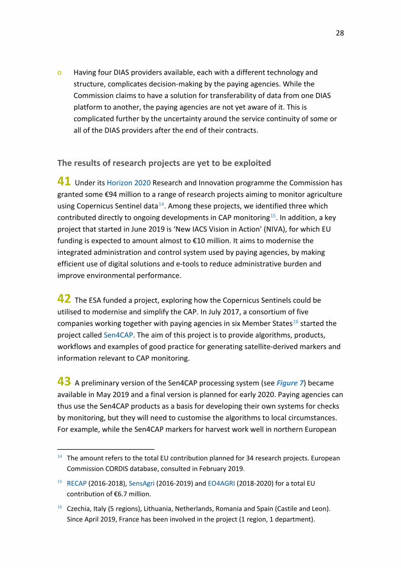
Introduction
The Common Agricultural Policy
01 Management of the EU’s Common Agricultural Policy (CAP) involves both the Commission and the Member States. Paying agencies in the Member States are responsible for administering aid applications, carrying out checks on applicants, making payments and monitoring the use of funding. The Commission sets much of the framework for spending, checks and monitors the work of paying agencies, and remains accountable for the use of EU funds. The CAP has three blocks of support:
o direct payments to provide income support for farmers;
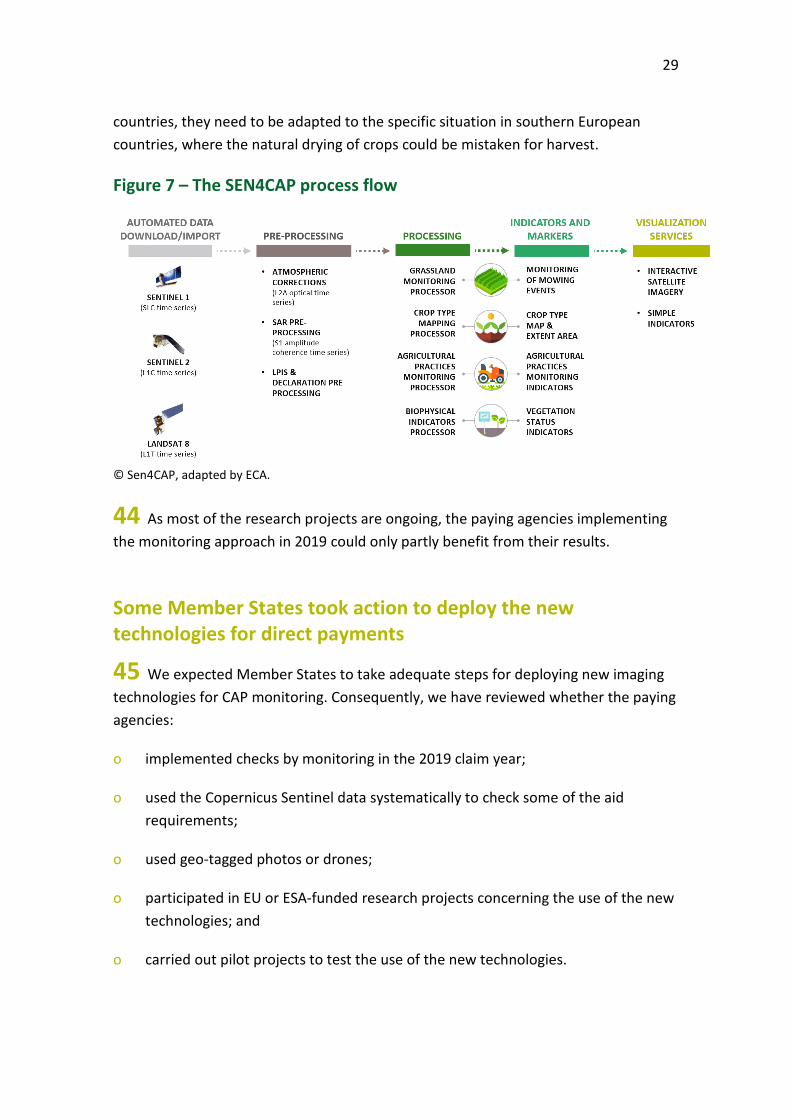
o market measures to deal with difficult market situations such as a sudden drop in prices; and
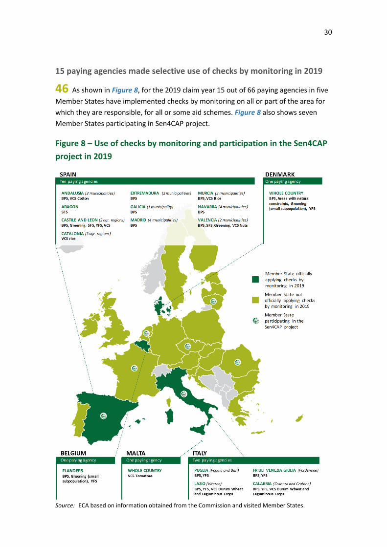
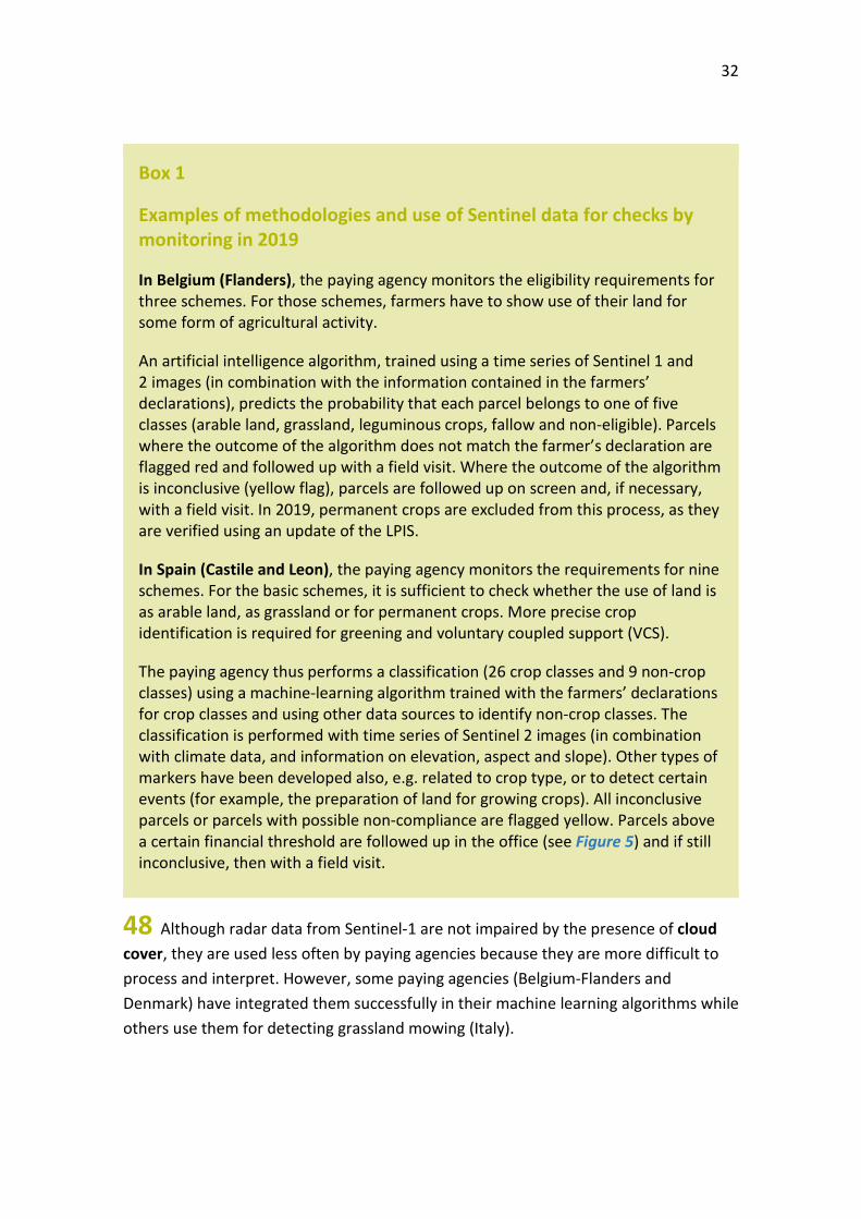
o rural development measures with national and regional programmes to address the specific needs and challenges facing rural areas.
02 Figure 1 shows that four-fifths of CAP spending is on area-based schemes under direct payments or rural development measures. Paying agencies process payment of area-based support to farmers annually, based on the number of hectares farmed and on the farmers’ adherence to -specific eligibility rules.
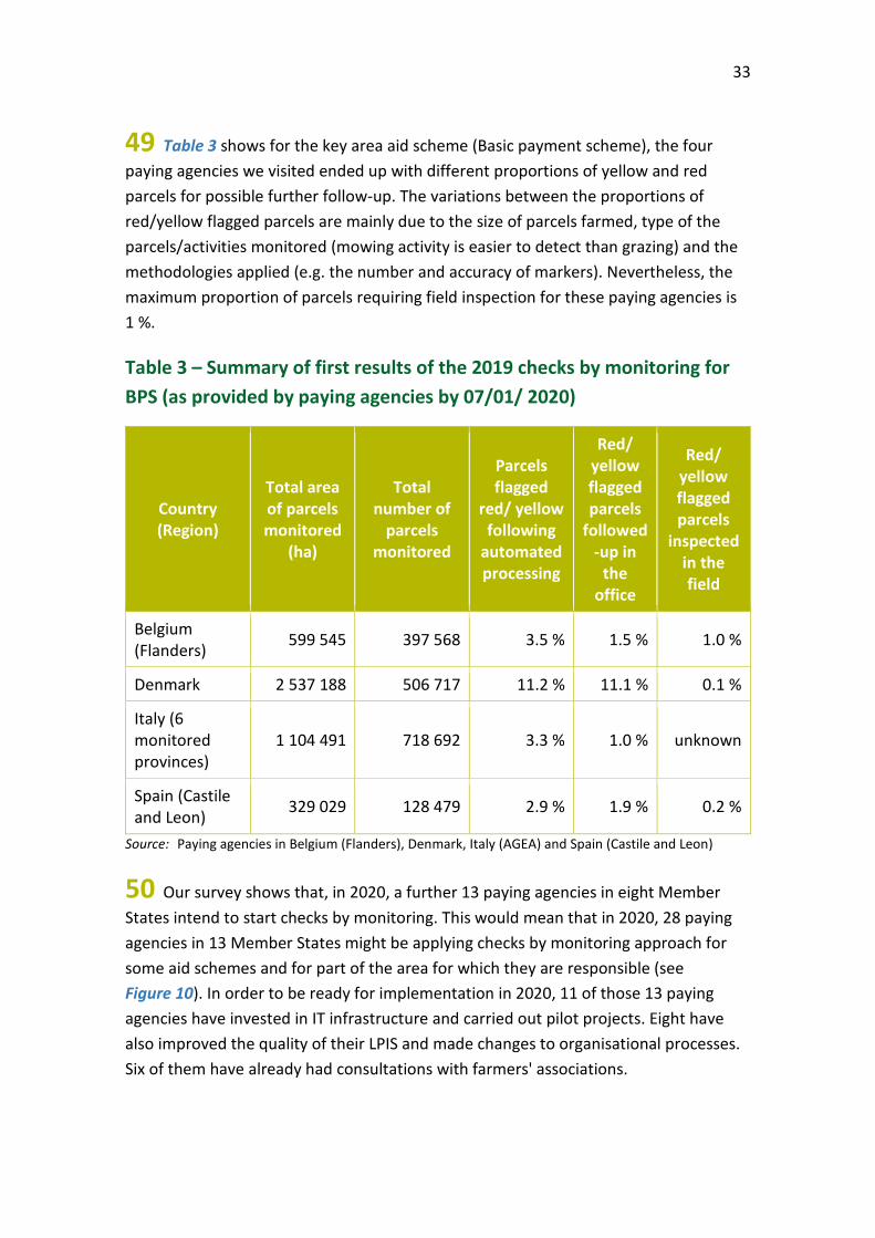
7
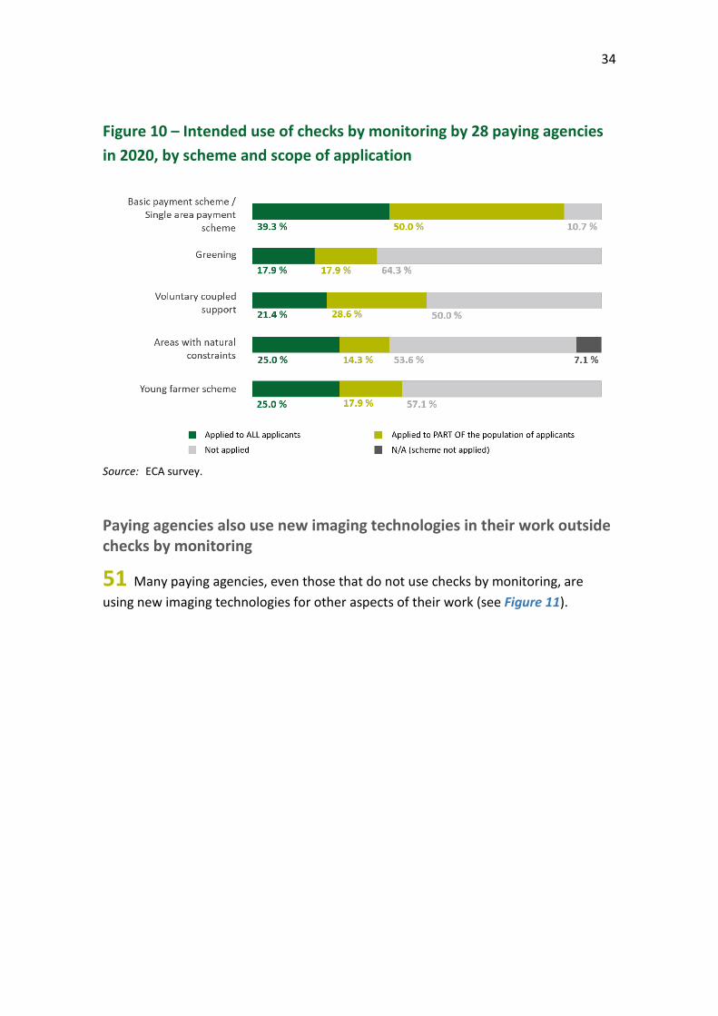
Figure 1 – Key CAP support schemes and their expenditure (million euro) in 2018
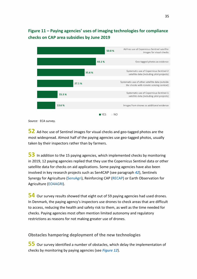
Source: ECA based on information from AGREX and the Commission.
03 The amount farmers receive may be reduced if an inspection detects that they have failed to respect rules concerning food safety, animal and plant health, climate and environment, protection of water resources, animal welfare and conditions in which their farmland is maintained1. These conditional links are known as ‘cross-compliance’2.
1 For 2014-2020, rules on cross-compliance requirements are defined in Article 93 and
Annex II of Regulation (EU) 1306/2013 of the European Parliament and of the Council of 17 December 2013 on the financing, management and monitoring of the common agricultural policy.
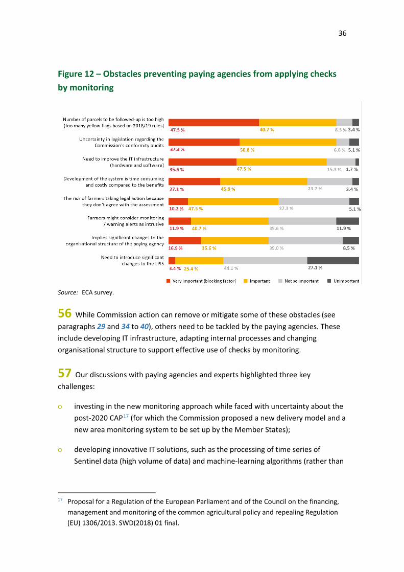
2 For more information on cross-compliance see also our Special report 26/2016: Making cross-compliance more effective and achieving simplification remains challenging.
8
Use of satellite images for checking area aid
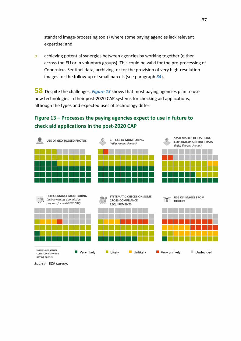
04 The CAP has a long history of using aerial photographs and satellite images to check some of its area-based support. The 1992 CAP reform allowed the use of satellite images in place of field inspections (see paragraph 07). The 2003 reform of the CAP required Member States to create a computerised geographic information system of all agricultural parcels. The 2013 CAP reform made it compulsory to use this Land Parcel Identification System (LPIS) together with a Geospatial Aid Application (GSAA), introduced progressively from 2015 to enhance checks of aid applications.
05 The LPIS is based on aerial photographs and satellite images that are corrected for geometrical distortion (‘ortho-rectified’). The paying agencies use the LPIS for cross-checks on all area-aid applications to verify that they pay only for eligible agricultural land and only once for a given area of agricultural land. The LPIS ortho-images have a very high spatial resolution (mostly 25-50 cm per pixel– see Picture 1), and are in general updated every three years.
Picture 1 – Aerial ortho-photo in an LPIS
© MAPA – Ministry of Agriculture, Fisheries and Food, Spain.
9
06 The LPIS is the cornerstone of the paying agencies’ integrated administrative and control systems (IACS) for area-based schemes. While our Special report 25/2016 on LPIS identified room for improvement, it also recognised the action taken by the Commission and the paying agencies over the years to make it more reliable3. Due to the low frequency of updates to LPIS imagery, paying agencies cannot use them to verify activities taking place on the parcel during the year (planting, harvesting, mowing, etc.). To verify farmers’ declarations and adherence to eligibility rules, paying agencies have had to carry out field inspections for a sample of around 5 % of farmers (see Picture 2).
Picture 2 – Field inspection
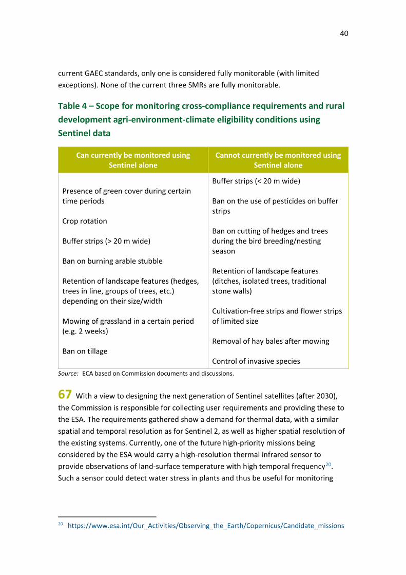
Source: ECA.
07 Field inspections are time-consuming and costly and provide a one-off record of the situation on the field. The Commission developed, since 1992, an alternative approach for inspecting agricultural parcels with satellite images from commercial providers (such as SPOT, WorldView, PlanetScope) taken at different times throughout the year, called ‘checks with remote sensing’ (see Picture 3). According to the European Commission’s Joint Research Centre (JRC), across the EU an average of 80 % of field inspections are now performed using remote sensing. If the paying agency cannot draw a conclusion based on these images an inspector carries out a ‘rapid field visit’ to the land parcels concerned. While checks with remote sensing are less costly4,
3 See also our 2018 annual report, paragraphs 7.16 to 7.18.
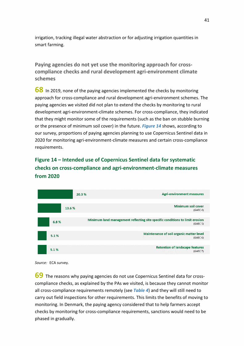
4 DG AGRI and ECORYS, “Analysis of administrative burden arising from the CAP”, 2018, p. 99.
10
they still require human intervention in the form of operators, who interpret very high-resolution (VHR) satellite images, using computer-assisted photo-interpretation.
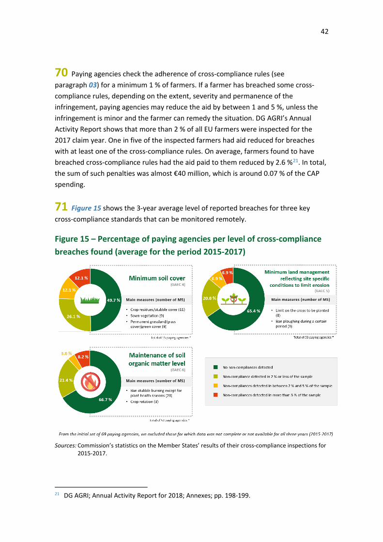
Picture 3 – Satellite images used for checks with remote sensing
Source: JRC.
08 The introduction of the GSAA (see paragraph 04) allows farmers to submit aid applications and payment claims electronically, together with the geo-location of their declared agricultural parcels. Therefore paying agencies’ IT systems now link geospatial information to agricultural parcels.
09 Since June 2015, the EU-owned Sentinel satellites 1 and 2 (see Figure 2), launched under the EU’s infrastructure for monitoring the Earth from space, the Copernicus programme, have been providing freely available high-resolution images. According to the European Space Agency (ESA), the Commission and experts consulted, these represent a potential game changer in Earth observation technology for CAP monitoring because they:
o offer high spatial resolution, and since March 2017, a high frequency - a new image with 10 metres spatial resolution per pixel is available every 5 days, compared to 30 metres resolution every 16 days for Landsat, the US satellite Earth observation programme;
11
o produce comparable data over a long time scale, with a high quality of calibration; and
o there is a long-term commitment on the part of the Commission to keep supplying these images.
Figure 2 – Copernicus Sentinels 1 and 2
© ESA/ATG medialab.
10 Since Sentinel 1 and 2 images are taken frequently, automated processing of time series data throughout the growing season makes it possible to identify crops and monitor certain agricultural practices on individual parcels (such as tillage, harvest, mowing). Figure 3 shows how the crops can be identified using a time series of Sentinel data. This makes it possible to monitor the whole population of aid recipients, rather than focusing on checks of a sample of farmers.
The Sentinel-1 mission consists of two polar-orbiting radarsatellites (1A and 1B) that send out a microwave signal to the Earth and measure the signal that bounces back, without being impaired by the presence of physical clouds.
The Sentinel-2 mission consists of two polar-orbiting satellites (2A and 2B) that measure the visible and infrared light reflected from the Earth in 13 different wavelengths.
12
Figure 3 – Example of a time profile of Sentinel-derived information showing changes in the vegetation cover for different crops
Source: Instituto Tecnológico Agrario de Castilla y León.
Use of Copernicus Sentinel data for monitoring area aid
11 In May 2017, the EU paying agencies signed an informal memorandum, the “Malta Declaration”, encouraging the Commission to use new technologies for simplification of IACS. In June 2017, the Commission proposed legislative changes allowing the Member States to apply a new approach called ‘checks by monitoring’ as of 20185. This approach uses automated processes based on the Copernicus Sentinel data. The amended rules also allow the use of other new technologies, such as drones and geo-tagged photographs or data captured by other satellites, as additional evidence for checking compliance under the CAP.
12 In May 2018, a first paying agency in Italy began to use the new approach for its checks in one province (Foggia, Puglia). In 2019, 15 paying agencies (in Belgium, Denmark, Italy, Malta and Spain) used checks by monitoring for some of their schemes. Figure 4 shows key dates in the introduction of checks by monitoring.
5 Commission Implementing Regulation (EU) 2018/746 of 18 May 2018 amending
Implementing Regulation (EU) 809/2014 as regards modification of single applications and payment claims and checks.
0
0.1
0.2
0.3
0.4
0.5
0.6
0.7
0.8
0.9
1
29-Sep 29-Oct 29-Nov 29-Dec 29-Jan 28-Feb 31-Mar 30-Apr 31-May 30-Jun 31-Jul 31-Aug
VEGE
TATI
ON
INDE
X
Alfalfa [Irrigated (Valladolid)] Wheat [Rainfed (Valladolid)] Maize [Irrigated (León)] Harvest Mowing
13
Figure 4 – Timeline of key events leading to the introduction of checks by
monitoring, using Copernicus Sentinel data
Source: ECA.
13 Checks by monitoring combines Copernicus Sentinel 1 and 2 data obtained every
five days with the information provided by farmers in their applications. Through
machine learning or other algorithms suitable for processing large quantities of data,
the paying agencies obtain information on crop types and agricultural activity on all
the declared parcels/farm holdings for each of the aid schemes. The paying agencies
then assess the parcels/holdings, using a system of coloured flags assigned to each
parcel/holding (see Picture 4).
Picture 4 – Simulation of possible outcome of parcels’ assessment
Source: JRC simulation.
14
14 Paying agencies assess the activity on the parcels/holdings throughout the year, taking into account the latest available Sentinel data and information obtained from the farmers. For example, a grassland parcel would be assigned a yellow flag until the Sentinel data indicates that it has been mown within the regulatory deadline, after which its flag status is changed to green. Due to their spatial resolution, Sentinel data are not suited for measuring the area of a parcel. Paying agencies thus measure the parcel area in the LPIS, which uses images with higher spatial resolution.Therefore, before moving to checks by monitoring, the paying agency’s LPIS needs to be of good quality in terms of both the accuracy of eligible area registered and the frequency of its update. Figure 5 gives an example of how the checks by monitoring system works.
15
Figure 5 – Simplified example of the application of checks by monitoring
Source: ECA based on procedures at the paying agency of Castile and Leon, Spain.
ASSESS COMPLIANCE WITH ELIGIBILITY RULES BASED ON CHANGES IN THE SATELLITE SIGNAL
GEOSPATIAL AID APPLICATION RECEIVED
• Retrieving relevant information from previous campaign for all declared parcels
• Aggregation of declared parcels
• Identification of parcels to be checked during LPIS update (e.g. permanent crops)
• Development of the vegetation
• Event detection (e.g. ploughing)
• Land cover mapping
• Homogeneity of satellite signal within the parcel
ESTIMATE THE ECONOMIC IMPACT ON THE PAYMENT OF NON COMPLIANCE(at holding level)
• Less than €50 per scheme and €250 per holding
• More than €50 per scheme and less than €250 per holding *
• More than €250 per holding
* 5 % of parcels are sampled for follow up. Remaining 95 % assessed as compliant and marked yellow for the following claim year.
EXPERT JUDGEMENT
FARMER INPUT REQUESTED
YELLOWIndications of potential
non-compliance or resultsare inconclusive
GREENAssessed as compliant
REDAssessed as non-compliant. Payment deduction calculated
SYSTEMATIC TRACKING OF CHANGES IN THE SATELLITE SIGNAL THROUGHOUT THE SEASON
Farmer notified of the potential non-compliance. Two options:
• Submit additional evidence (geo-tagged photos, documentation, etc.)
• Amend or withdraw geospatial aid application
Technical work depending on non-compliance:
• Review of submitted evidence
• Visual interpretation of available satellite data
• Rapid field visit5 % 95 %
16
Expected benefits of the new monitoring approach
15 The Commission, paying agencies, relevant stakeholders and experts agree that the monitoring approach using Copernicus Sentinel data represents a major change in the management and control of the CAP.
Increasing compliance, by helping farmers to meet requirements
16 The traditional system of aid claims and checks is a sequential system, whereas checks by monitoring is an interactive system. The checks by monitoring approach can take new information into account at any time during the growing season (such as newly acquired, more recent Sentinel data, geo-tagged photos, or other documents sent by the farmer), and it therefore provides more opportunities for farmers to rectify their claims before they are finalised (see Figure 6). Paying agencies can also send warning messages to farmers, giving them the opportunity to take corrective action (e.g. mowing a field). Therefore, the monitoring approach can prevent non-compliance from occurring rather than penalising farmers afterwards.
17
Figure 6 – Traditional checks versus checks by monitoring
Source: ECA.
18
Covering all farmers, reducing administrative burden and improving cost-effectiveness
17 Under the traditional approach using on-the-spot checks, paying agencies select small samples of farmers to check. If a sample field visit takes place, an inspector checks the parcel area and the crops grown against the information provided by the farmer in the aid claim.
18 Under the new approach, all agricultural parcels in a region are subject to the same monitoring process. Field visits are carried out only if the outcome of the monitoring process is inconclusive and the potential financial impact of non-compliance exceeds a certain threshold. If this leads to fewer field visits, it reduces the burden on the farmer and the costs for the paying agency. According to a recent study6, automation, digitalisation, and new technologies for management and controls can help mitigate the costs of CAP administration. If the use of satellites means that field visits are targeting farms most likely to be non-compliant, this improves their efficiency.
Improving information for farm management
19 The checks by monitoring approach generates data useful for smart farming (using modern technology to increase the quantity and quality of agricultural products), which can provide farmers with economic benefits. For example, satellite images can provide information about soil nitrogen content or drought stress, which could optimise fertiliser application or irrigation, cutting costs for the farmer and reducing the negative environmental impacts of the agricultural activity. By providing access to their data (LPIS, Sentinel and other satellite images, information on environmental requirements), paying agencies thus have the possibility of providing a service to their farmers, multiplying the benefits of the new technologies.
6 DG AGRI and ECORYS, “Analysis of administrative burden arising from the CAP”, 2018,
pp. 153, 155.

19
Audit scope and approach 20 Our audit examined whether the Commission and Member States have taken sufficient steps to unlock the potential benefits of new imaging technologies for CAP monitoring. In particular, we assessed whether the Commission effectively encouraged widespread use of the new technologies and whether Member States had taken adequate action to deploy them. We also sought to identify examples of good practice in the use of new technologies for CAP monitoring, as well as shed light on obstacles hindering their wider deployment. An assessment of the progress made in the use of new imaging technologies is especially relevant now, as the results of our audit could be applied in the post-2020 CAP. The increased use of new technologies for CAP monitoring may affect the future audit approach taken by national and EU audit bodies.
21 The new imaging technologies included in the scope of our audit are the Copernicus Sentinel satellite data, images taken by drones, and geotagged images. Our audit did not cover the use of Copernicus Sentinel data for smart farming applications, crop yield forecasts or areas outside the CAP.
22 We obtained our evidence from:
o documentary reviews and interviews with staff at four Commission Directorates-General (Agriculture and Rural Development; Internal Market, Industry, Entrepreneurship and SMEs; Joint Research Centre and Environment), the European Environment Agency (EEA) and the Research Executive Agency;
o visits to four paying agencies implementing checks by monitoring in 2019 located in Belgium, Denmark, Italy and Spain;
o a survey of 66 paying agencies managing area-related measures in 27 Member States (we excluded the United Kingdom as it had entered the Article 50 process to leave the EU). The survey asked questions on the use of new imaging technologies, progress towards implementing checks by monitoring, and challenges identified in preparing for the post-2020 CAP. We received responses from 59 paying agencies (an 89 % response rate);
o a visit to the European Space Agency and an expert panel meeting involving representatives of the paying agencies, research, industry and of the EEA; and
o analysing the Member States’ results of the cross-compliance inspections for the years 2015-2017.
20
Observations
The Commission has supported the use of new technologies
23 The Commission has assessed the new imaging technologies as offering significant benefits in terms of improving CAP monitoring efficiency (see paragraphs 15 to 19). We examined whether the Commission has taken sufficient steps to realise these benefits by:
o introducing changes to legislation and guidelines to allow the use of new technologies to check aid applications;
o providing timely support to paying agencies and promoting the use of new technologies;
o identifying examples of good practice and solutions for challenges faced by the paying agencies;
o facilitating access for the paying agencies to the Copernicus Sentinel data; and
o initialising and funding research projects, which have the potential to increase the use of new technologies for CAP monitoring.
The legal framework for checks by monitoring has become clearer
24 According to the results of our survey, around two-fifths of the paying agencies consider that the initial legislation adopted in May 2018 (see paragraph 11) did not allow pragmatic solutions to implement checks by monitoring. The Commission realised that there was a need for further clarification and amended the legal framework applicable to the 2019 claim year7.
25 Our survey shows that for 52 out of 59 paying agencies, one important obstacle is uncertainty about the Commission’s conformity clearance procedure in the context of the new approach. While, in the case of traditional checks, detailed rules exist on
7 Commission Implementing Regulation (EU) 2019/1804 of 28 October 2019 amending
Implementing Regulation (EU) 809/2014 as regards amendments of aid applications or payment claims, checks in the integrated administration and control system and the control system in relation to cross compliance.
21
how to carry out on the spot or remote sensing checks, there are no such rules for checks by monitoring. Paying agencies are thus concerned that the Commission may later question their approach and the decisions taken, and apply financial corrections.
26 The Commission understood this concern and took steps to clarify how checks by monitoring will be audited in the future through:
o assessing each notification of checks by monitoring against a set of legal and technical elements8;
o communicating the results of these assessments to the paying agencies; and
o sending a letter to all paying agencies implementing checks by monitoring in 2019, expressing its readiness to hold discussions and find a solution if major issues arise.
27 Some of the paying agencies we visited during our audit expected the Commission to approve their methodology for checks by monitoring. While the paying agencies have discussed a number of technical aspects with JRC experts, the Commission has not approved methodologies and does not plan to do so.
28 In its technical guidelines9, the Commission describes some basic rules for checking whether the system correctly interpreted the Sentinel data, by comparing it with the situation found on the field. To evaluate the reliability of the automated system for assessing the parcels, the Commission has set two initial thresholds for paying agencies’ systems not to exceed:
o 5 % of false red errors, which occurs when a farmer with a correct declaration is assessed as non-compliant. This error has little impact on the EU budget as the farmer would most likely appeal; and
o 10-20 % of false green errors, which occurs when a farmer who is fully or partially non-compliant is paid without this non-compliance being detected by the system. This type of error may result in an overpayment, thus having a clear impact on the
8 Stipulated in Articles 40a and 40b of Regulation 809/2014 and in the JRC ‘Technical
guidance on the decision to go for substitution of OTSC by monitoring’; 2018; pp. 3 to 8.
9 JRC; ‘Second discussion document on the introduction of monitoring in place of on the spot checks: rules for processing applications in 2018-2019’; 2018, p. 16.
22
EU budget. As systems improve, the Commission expects that it can lower this threshold.
29 The technical guidelines do not provide information on some key elements of the quality control arrangements (minimum number of samples for testing, selection criteria, reporting requirements). A robust quality assessment framework could provide valuable information for the paying agencies implementing the checks by monitoring system, while reducing the risk of financial corrections. In 2010, the Commission established such a quality assessment framework for LPIS, requiring Member States to annually test its quality and take remedial action where required. While we identified weaknesses in the LPIS quality framework in our Special Report No 25/201610, we also acknowledged its contribution to improving the quality of the LPIS.
30 An issue, which the Commission’s legislative changes have not resolved completely, is the complexity of some area aid schemes’ requirements. These are a combination of EU and national rules and designed at a time when Copernicus and other technologies were not available. They can be very complex for some CAP aid measures, such as greening, which involve making direct payments to farmers who adopt or maintain farming practices that help in meeting environmental and climate goals. These cannot always be monitored remotely, meaning that paying agencies continue to need traditional field inspections (see Table 1). The introduction of the post-2020 CAP represents an opportunity to reassess the benefits and need for some of these requirements.
10 ECA, Special report 25/2016: The Land Parcel Identification System: a useful tool to
determine the eligibility of agricultural land – but its management could be further improved, paragraphs 65-72.

23
Table 1 – Examples of greening requirements and whether they can be monitored remotely with Sentinel data
Can be monitored Cannot be monitored
Presence of a catch crop Presence of a nitrogen-fixing crop Fallow land
Presence of two species of plants in the catch crop Landscape elements (rows of trees, hedges, ponds, canals) less than 20m wide
Source: ECA based on Commission documents and discussions.
The Commission has promoted and supported the new approach
31 Our survey indicates that two thirds of the paying agencies consider the Commission has provided sufficient support for them to implement the checks by monitoring approach. While one fifth of paying agencies did not consider the Commission’s support to be adequate, they did not provide valid justification for this statement. The remaining respondents were neutral. We found the Commission to be active in promoting and supporting checks by monitoring in various ways:
o since May 2017, it has organised more than 15 conferences, workshops, expert group meetings and seminars where checks by monitoring was explicitly on the agenda;
o from January 2018 to August 2019, it has held bilateral meetings with paying agencies interested in implementing checks by monitoring in 15 Member States; and
o it has replied to questions from Member States, and made available a single Questions & Answers document on the new monitoring approach.
24
The Commission has been searching for solutions to reduce the number of parcels requiring follow-up
32 Nearly nine-tenths of the paying agencies who replied to our survey considered the risk of having too many yellow-flagged parcels to be an important or a very important drawback. If the fully automated part of the system generates a large number of inconclusive parcels from the entire group of claimants, the paying agency’s workload may be higher than if it used traditional on-the-spot checks for a small sample of claimants. Yellow-flagged parcels under checks by monitoring may need to be followed up (after considering the financial impact thresholds described in paragraph 35) by:
(1) visually checking the available images for that parcel;
(2) requesting and checking additional information from the farmer;
and where these do not allow conclusions to be drawn:
(3) inspecting the field.
33 Small parcels are frequently assigned yellow flags, mainly due to insufficient Sentinel spatial resolution (insufficient number of pixels falling entirely within the parcel boundaries). Paying agencies have different definitions of small parcels, from 0.2 ha to 1 ha. They can be high in number, and cause a lot of work for the paying agency, even if they usually represent only a small part of the overall agricultural area covered by the paying agency. Table 2 shows the proportion of yellow flagged small parcels out of all parcels for three paying agencies we visited.
Table 2 – Proportion of yellow flagged small parcels (<0.5 ha) out of all parcels for three paying agencies using checks by monitoring
Paying agency Proportion of small parcels in terms of
number
Proportion of small parcels in terms of area
Belgium (Flanders) 1.9 % 0.2 %
Denmark 5.7 % 0.3 %
Spain (Castile and Leon) 1.0 % 0.1 % Source: Paying agencies in Belgium (Flanders), Denmark and Spain (Castile and Leon).
25
34 The Commission has proposed the following ways of dealing with small parcels:
o Aggregating adjacent small agricultural parcels of the same holding with the same declared land use into a single ‘feature of interest’. The paying agency in Castile and Leon (Spain) uses this approach.
o Following up small inconclusive parcels when updating the LPIS, rather than by making a site visit. The Commission allows this option only when aerial photos are taken annually for the whole country. Denmark has used this option.
o Acquiring very high-resolution satellite data to provide better information on small parcels, to remove the need for a field visit. The JRC has recently concluded a contract with a provider of such data to test this approach for 2019. Under this contract, the paying agencies implementing the checks by monitoring in 2019 can obtain time series for small parcels, derived from high-resolution satellite images (4m pixel size). Nevertheless, the data will be available too late to be used effectively by the paying agencies in the follow-up procedure in 2019.
26
35 These options help to reduce the number of yellow-flagged parcels. For those that remain, the Commission has defined monetary thresholds in its technical guidelines11 and Questions & Answers document, with corresponding follow-up actions.
o If the impact on beneficiary payment of all the yellow-flagged parcels is expected to be low (below €50 at scheme level) then no follow-up is required.
o If the impact is expected to be medium (above €50 at scheme level and below €250 at beneficiary level), then a 5 % sample of the yellow-flagged parcels should be followed up.
o If the impact is expected to be high (above €250 at beneficiary level), then follow-up of all such beneficiaries is required.
36 Lower thresholds imply a higher level of assurance, but also lead to more follow-up checks and thus higher cost of controls. While the Commission carried out an analysis of monetary thresholds in existing CAP legislation and consulted data about field visit costs to define the €250 threshold, it did not do so for the €50 threshold.
37 Some agricultural activities are difficult to monitor with Sentinel satellites, such as extensive grazing on grassland, or crop cultivation in greenhouses, as is the absence of agricultural activity (e.g. land abandonment). In some Member States, this can also lead to large numbers of yellow-flagged parcels. As possible solutions to detect some of these activities, the Commission allowed the use of geo-tagged photos as additional evidence. The European GNSS Agency has been working during 2019 on the development of a smartphone application for geo-tagged photos. Paying agencies in Denmark and Italy cooperate with private companies to develop dedicated applications. However, the paying agencies we visited did not yet use geo-tagged photos in the 2019 claim year (only for pilot testing in Italy).
11 JRC, Second discussion document on the introduction of monitoring in place of on the spot
checks: rules for processing applications in 2018-2019, 2018, p. 18.
27
The EU-funded cloud-based services were used for testing rather than for operational monitoring
38 Copernicus is the largest space data provider in the world, currently producing 12 terabytes per day. To facilitate and standardise access to this data, the European Commission has been funding the deployment of five digital cloud-based platforms providing centralised access to Copernicus data and information, as well as to processing tools. These platforms are known as the Data and Information Access Services (DIAS). Four of them offer services relevant to agriculture in 201912. They must meet various technical requirements and provide the Copernicus data free of charge, but they can charge for extra services (such as data processing, data storage, and combining Copernicus data with other datasets)13.
39 The DIAS providers’ services became available during 2018. In autumn 2018, the Commission decided to support the paying agencies implementing the checks by monitoring approach by subsidising their individual access to one of the four DIAS platforms for 2019. The subsidy amounted to €120 000 per DIAS provider to cover three phases: technical readiness review of DIAS providers by the Commission, onboarding of paying agencies on one of the DIAS provider and operational use of the DIAS by the paying agencies in 2019. Although all the paying agencies we visited had found it useful to test for free a DIAS platform, most of them used their existing infrastructure or contracts as primary processing solutions for checks by monitoring in 2019. Consequently, the value added by the Commission’s expenditure of €480 000 is yet to be established.
40 According to our June 2019 survey, most paying agencies do not intend to move to a DIAS platform soon. Our discussions with the paying agencies and expert panel between April and September 2019 highlighted the following uncertainties, delaying the move to DIAS providers.
o The cost of DIAS services now and in the future. Due to the technicalities and the pay-per-use business models, most paying agencies do not know how much it would cost them to run checks by monitoring on DIAS platforms in their country or region.
12 CREODIAS, MUNDI, ONDA and SOBLOO.
13 The Court has started an audit on the Commission’s efforts to promote the uptake of services provided by the EU’s main space programmes COPERNICUS and GALILEO. This audit also covers the DIAS.
28
o Having four DIAS providers available, each with a different technology and structure, complicates decision-making by the paying agencies. While the Commission claims to have a solution for transferability of data from one DIAS platform to another, the paying agencies are not yet aware of it. This is complicated further by the uncertainty around the service continuity of some or all of the DIAS providers after the end of their contracts.
The results of research projects are yet to be exploited
41 Under its Horizon 2020 Research and Innovation programme the Commission has granted some €94 million to a range of research projects aiming to monitor agriculture using Copernicus Sentinel data14. Among these projects, we identified three which contributed directly to ongoing developments in CAP monitoring15. In addition, a key project that started in June 2019 is ‘New IACS Vision in Action’ (NIVA), for which EU funding is expected to amount almost to €10 million. It aims to modernise the integrated administration and control system used by paying agencies, by making efficient use of digital solutions and e-tools to reduce administrative burden and improve environmental performance.
42 The ESA funded a project, exploring how the Copernicus Sentinels could be utilised to modernise and simplify the CAP. In July 2017, a consortium of five companies working together with paying agencies in six Member States16 started the project called Sen4CAP. The aim of this project is to provide algorithms, products, workflows and examples of good practice for generating satellite-derived markers and information relevant to CAP monitoring.
43 A preliminary version of the Sen4CAP processing system (see Figure 7) became available in May 2019 and a final version is planned for early 2020. Paying agencies can thus use the Sen4CAP products as a basis for developing their own systems for checks by monitoring, but they will need to customise the algorithms to local circumstances. For example, while the Sen4CAP markers for harvest work well in northern European
14 The amount refers to the total EU contribution planned for 34 research projects. European
Commission CORDIS database, consulted in February 2019.
15 RECAP (2016-2018), SensAgri (2016-2019) and EO4AGRI (2018-2020) for a total EU contribution of €6.7 million.
16 Czechia, Italy (5 regions), Lithuania, Netherlands, Romania and Spain (Castile and Leon). Since April 2019, France has been involved in the project (1 region, 1 department).
29
countries, they need to be adapted to the specific situation in southern European countries, where the natural drying of crops could be mistaken for harvest.
Figure 7 – The SEN4CAP process flow
© Sen4CAP, adapted by ECA.
44 As most of the research projects are ongoing, the paying agencies implementing the monitoring approach in 2019 could only partly benefit from their results.
Some Member States took action to deploy the new technologies for direct payments
45 We expected Member States to take adequate steps for deploying new imaging technologies for CAP monitoring. Consequently, we have reviewed whether the paying agencies:
o implemented checks by monitoring in the 2019 claim year;
o used the Copernicus Sentinel data systematically to check some of the aid requirements;
o used geo-tagged photos or drones;
o participated in EU or ESA-funded research projects concerning the use of the new technologies; and
o carried out pilot projects to test the use of the new technologies.
30
15 paying agencies made selective use of checks by monitoring in 2019
46 As shown in Figure 8, for the 2019 claim year 15 out of 66 paying agencies in five
Member States have implemented checks by monitoring on all or part of the area for
which they are responsible, for all or some aid schemes. Figure 8 also shows seven
Member States participating in Sen4CAP project.
Figure 8 – Use of checks by monitoring and participation in the Sen4CAP
project in 2019
Source: ECA based on information obtained from the Commission and visited Member States.
31
47 Taking into account the technical guidelines drafted by the JRC, these 15 paying agencies have developed diverse methodologies for monitoring the different aid scheme requirements applicable in their regions (see Figure 9 and Box 1). Crop types, agricultural practices and agro-climatic conditions are important factors that come into play.
Figure 9 – Variety of approaches to checks by monitoring
Source: ECA based on information received during visits to Member States.
32
Box 1
Examples of methodologies and use of Sentinel data for checks by monitoring in 2019
In Belgium (Flanders), the paying agency monitors the eligibility requirements for three schemes. For those schemes, farmers have to show use of their land for some form of agricultural activity.
An artificial intelligence algorithm, trained using a time series of Sentinel 1 and 2 images (in combination with the information contained in the farmers’ declarations), predicts the probability that each parcel belongs to one of five classes (arable land, grassland, leguminous crops, fallow and non-eligible). Parcels where the outcome of the algorithm does not match the farmer’s declaration are flagged red and followed up with a field visit. Where the outcome of the algorithm is inconclusive (yellow flag), parcels are followed up on screen and, if necessary, with a field visit. In 2019, permanent crops are excluded from this process, as they are verified using an update of the LPIS.
In Spain (Castile and Leon), the paying agency monitors the requirements for nine schemes. For the basic schemes, it is sufficient to check whether the use of land is as arable land, as grassland or for permanent crops. More precise crop identification is required for greening and voluntary coupled support (VCS).
The paying agency thus performs a classification (26 crop classes and 9 non-crop classes) using a machine-learning algorithm trained with the farmers’ declarations for crop classes and using other data sources to identify non-crop classes. The classification is performed with time series of Sentinel 2 images (in combination with climate data, and information on elevation, aspect and slope). Other types of markers have been developed also, e.g. related to crop type, or to detect certain events (for example, the preparation of land for growing crops). All inconclusive parcels or parcels with possible non-compliance are flagged yellow. Parcels above a certain financial threshold are followed up in the office (see Figure 5) and if still inconclusive, then with a field visit.
48 Although radar data from Sentinel-1 are not impaired by the presence of cloud cover, they are used less often by paying agencies because they are more difficult to process and interpret. However, some paying agencies (Belgium-Flanders and Denmark) have integrated them successfully in their machine learning algorithms while others use them for detecting grassland mowing (Italy).
33
49 Table 3 shows for the key area aid scheme (Basic payment scheme), the four paying agencies we visited ended up with different proportions of yellow and red parcels for possible further follow-up. The variations between the proportions of red/yellow flagged parcels are mainly due to the size of parcels farmed, type of the parcels/activities monitored (mowing activity is easier to detect than grazing) and the methodologies applied (e.g. the number and accuracy of markers). Nevertheless, the maximum proportion of parcels requiring field inspection for these paying agencies is 1 %.
Table 3 – Summary of first results of the 2019 checks by monitoring for BPS (as provided by paying agencies by 07/01/ 2020)
Country (Region)
Total area of parcels monitored
(ha)
Total number of
parcels monitored
Parcels flagged
red/ yellow following
automated processing
Red/ yellow flagged parcels
followed-up in
the office
Red/ yellow flagged parcels
inspected in the field
Belgium (Flanders) 599 545 397 568 3.5 % 1.5 % 1.0 %
Denmark 2 537 188 506 717 11.2 % 11.1 % 0.1 %
Italy (6 monitored provinces)
1 104 491 718 692 3.3 % 1.0 % unknown
Spain (Castile and Leon) 329 029 128 479 2.9 % 1.9 % 0.2 %
Source: Paying agencies in Belgium (Flanders), Denmark, Italy (AGEA) and Spain (Castile and Leon)
50 Our survey shows that, in 2020, a further 13 paying agencies in eight Member States intend to start checks by monitoring. This would mean that in 2020, 28 paying agencies in 13 Member States might be applying checks by monitoring approach for some aid schemes and for part of the area for which they are responsible (see Figure 10). In order to be ready for implementation in 2020, 11 of those 13 paying agencies have invested in IT infrastructure and carried out pilot projects. Eight have also improved the quality of their LPIS and made changes to organisational processes. Six of them have already had consultations with farmers' associations.
34
Figure 10 – Intended use of checks by monitoring by 28 paying agencies in 2020, by scheme and scope of application
Source: ECA survey.
Paying agencies also use new imaging technologies in their work outside checks by monitoring
51 Many paying agencies, even those that do not use checks by monitoring, are using new imaging technologies for other aspects of their work (see Figure 11).
35
Figure 11 – Paying agencies’ uses of imaging technologies for compliance checks on CAP area subsidies by June 2019
Source: ECA survey.
52 Ad-hoc use of Sentinel images for visual checks and geo-tagged photos are the most widespread. Almost half of the paying agencies use geo-tagged photos, usually taken by their inspectors rather than by farmers.
53 In addition to the 15 paying agencies, which implemented checks by monitoring in 2019, 12 paying agencies replied that they use the Copernicus Sentinel data or other satellite data for checks on aid applications. Some paying agencies have also been involved in key research projects such as Sen4CAP (see paragraph 42), Sentinels Synergy for Agriculture (SensAgri), Reinforcing CAP (RECAP) or Earth Observation for Agriculture (EO4AGRI).
54 Our survey results showed that eight out of 59 paying agencies had used drones. In Denmark, the paying agency’s inspectors use drones to check areas that are difficult to access, reducing the health and safety risk to them, as well as the time needed for checks. Paying agencies most often mention limited autonomy and regulatory restrictions as reasons for not making greater use of drones.
Obstacles hampering deployment of the new technologies
55 Our survey identified a number of obstacles, which delay the implementation of checks by monitoring by paying agencies (see Figure 12).
36
Figure 12 – Obstacles preventing paying agencies from applying checks by monitoring
Source: ECA survey.
56 While Commission action can remove or mitigate some of these obstacles (see paragraphs 29 and 34 to 40), others need to be tackled by the paying agencies. These include developing IT infrastructure, adapting internal processes and changing organisational structure to support effective use of checks by monitoring.
57 Our discussions with paying agencies and experts highlighted three key challenges:
o investing in the new monitoring approach while faced with uncertainty about the post-2020 CAP17 (for which the Commission proposed a new delivery model and a new area monitoring system to be set up by the Member States);
o developing innovative IT solutions, such as the processing of time series of Sentinel data (high volume of data) and machine-learning algorithms (rather than
17 Proposal for a Regulation of the European Parliament and of the Council on the financing,
management and monitoring of the common agricultural policy and repealing Regulation (EU) 1306/2013. SWD(2018) 01 final.
37
standard image-processing tools) where some paying agencies lack relevant expertise; and
o achieving potential synergies between agencies by working together (either across the EU or in voluntary groups). This could be valid for the pre-processing of Copernicus Sentinel data, archiving, or for the provision of very high-resolution images for the follow-up of small parcels (see paragraph 34).
58 Despite the challenges, Figure 13 shows that most paying agencies plan to use new technologies in their post-2020 CAP systems for checking aid applications, although the types and expected uses of technology differ.
Figure 13 – Processes the paying agencies expect to use in future to check aid applications in the post-2020 CAP
Source: ECA survey.
38
Slower progress in meeting the challenge of using new technologies to monitor environmental and climate requirements
59 In addition to using new technologies to carry out eligibility checks for direct payment area aid, we expected both the Commission and Member States to take initiatives in using these technologies for monitoring certain environmental and climate requirements, such as the obligation to grow a catch crop or the ban on stubble burning.
60 This technology will become more important in the post-2020 CAP, since the Commission's legislative proposals introduce a mandatory area monitoring system for the purposes of monitoring agri-environment-climate policy.
61 We examined whether the Commission had taken appropriate steps towards using new imaging technologies for cross-compliance and rural development agri-environment-climate requirements through:
o proposing changes to legislation;
o assessing to what extent current requirements can be monitored by new technologies;
o identifying, sharing and supporting examples of good practice; and
o assessing how the new technologies can help in monitoring climate and environmental requirements.
62 We also reviewed whether paying agencies had started using the new technologies to monitor cross-compliance or agri-environment-climate schemes, or whether they intended to do so in the near future.
39
Commission support for the monitoring approach has prioritised direct payment schemes
63 The cross-compliance rules (see paragraph 03) comprise standards for Good Agricultural and Environmental Condition (GAEC) of land, established nationally, and Statutory Management Requirements (SMRs) set at EU level18. There are seven GAEC standards and three area-related SMRs covering environment, climate change, and the good agricultural condition of land.
64 Agri-environment payment schemes are diverse across the EU. They aim at enhancing the agriculture-environment-climate relationship by encouraging farmers to undertake environmentally friendly practices. Farmer participation in these measures is voluntary.
65 To date, the Commission’s work has prioritised the use of checks by monitoring for area-based direct payment schemes, rather than for cross-compliance and rural development agri-environment-climate schemes. The legal framework for applying checks by monitoring to direct payments and rural development has been available since May 2018 (see paragraph 11), and in the course of 201919 the Commission prepared a legal framework for applying the checks by monitoring approach to cross-compliance (see paragraph 24).
66 In 2019, the Commission started a review of the cross-compliance requirements to identify those area-based requirements that could be remotely monitored. The Commission also informally assessed the use of Sentinel data for monitoring requirements under agri-environment-climate measures. As Member State authorities design agri-environment-climate schemes and these vary significantly within and between Member States, the Commission carried out this informal analysis for a sample of paying agencies. It found that many requirements are too complex for monitoring with Sentinel data alone (see Table 4). The Commission’s initial analysis of the potential applicability of checks by monitoring for cross-compliance, show that many requirements under GAEC can be monitored, but currently, out of the seven
18 The full list of GAECs and SMRs is in Annex II of Regulation (EU) 1306/2013.
19 Commission Implementing Regulation (EU) 2019/1804 of 28 October 2019 amending Implementing Regulation (EU) 809/2014 as regards amendments of aid applications or payment claims, checks in the integrated administration and control system and the control system in relation to cross compliance.
40
current GAEC standards, only one is considered fully monitorable (with limited exceptions). None of the current three SMRs are fully monitorable.
Table 4 – Scope for monitoring cross-compliance requirements and rural development agri-environment-climate eligibility conditions using Sentinel data
Can currently be monitored using Sentinel alone
Cannot currently be monitored using Sentinel alone
Presence of green cover during certain time periods Crop rotation Buffer strips (> 20 m wide) Ban on burning arable stubble Retention of landscape features (hedges, trees in line, groups of trees, etc.) depending on their size/width Mowing of grassland in a certain period (e.g. 2 weeks) Ban on tillage
Buffer strips (< 20 m wide) Ban on the use of pesticides on buffer strips Ban on cutting of hedges and trees during the bird breeding/nesting season Retention of landscape features (ditches, isolated trees, traditional stone walls) Cultivation-free strips and flower strips of limited size Removal of hay bales after mowing Control of invasive species
Source: ECA based on Commission documents and discussions.
67 With a view to designing the next generation of Sentinel satellites (after 2030), the Commission is responsible for collecting user requirements and providing these to the ESA. The requirements gathered show a demand for thermal data, with a similar spatial and temporal resolution as for Sentinel 2, as well as higher spatial resolution of the existing systems. Currently, one of the future high-priority missions being considered by the ESA would carry a high-resolution thermal infrared sensor to provide observations of land-surface temperature with high temporal frequency20. Such a sensor could detect water stress in plants and thus be useful for monitoring
20 https://www.esa.int/Our_Activities/Observing_the_Earth/Copernicus/Candidate_missions
41
irrigation, tracking illegal water abstraction or for adjusting irrigation quantities in smart farming.
Paying agencies do not yet use the monitoring approach for cross-compliance checks and rural development agri-environment climate schemes
68 In 2019, none of the paying agencies implemented the checks by monitoring approach for cross-compliance and rural development agri-environment schemes. The paying agencies we visited did not plan to extend the checks by monitoring to rural development agri-environment-climate schemes. For cross-compliance, they indicated that they might monitor some of the requirements (such as the ban on stubble burning or the presence of minimum soil cover) in the future. Figure 14 shows, according to our survey, proportions of paying agencies planning to use Copernicus Sentinel data in 2020 for monitoring agri-environment-climate measures and certain cross-compliance requirements.
Figure 14 – Intended use of Copernicus Sentinel data for systematic checks on cross-compliance and agri-environment-climate measures from 2020
Source: ECA survey.
69 The reasons why paying agencies do not use Copernicus Sentinel data for cross-compliance checks, as explained by the PAs we visited, is because they cannot monitor all cross-compliance requirements remotely (see Table 4) and they will still need to carry out field inspections for other requirements. This limits the benefits of moving to monitoring. In Denmark, the paying agency considered that to help farmers accept checks by monitoring for cross-compliance requirements, sanctions would need to be phased in gradually.
42
70 Paying agencies check the adherence of cross-compliance rules (see paragraph 03) for a minimum 1 % of farmers. If a farmer has breached some cross-compliance rules, depending on the extent, severity and permanence of the infringement, paying agencies may reduce the aid by between 1 and 5 %, unless the infringement is minor and the farmer can remedy the situation. DG AGRI’s Annual Activity Report shows that more than 2 % of all EU farmers were inspected for the 2017 claim year. One in five of the inspected farmers had aid reduced for breaches with at least one of the cross-compliance rules. On average, farmers found to have breached cross-compliance rules had the aid paid to them reduced by 2.6 %21. In total, the sum of such penalties was almost €40 million, which is around 0.07 % of the CAP spending.
71 Figure 15 shows the 3-year average level of reported breaches for three key cross-compliance standards that can be monitored remotely.
Figure 15 – Percentage of paying agencies per level of cross-compliance breaches found (average for the period 2015-2017)
Sources: Commission’s statistics on the Member States’ results of their cross-compliance inspections for
2015-2017.
21 DG AGRI; Annual Activity Report for 2018; Annexes; pp. 198-199.
43
72 In the last year for which information was available (2017), we calculated that eighteen paying agencies detected no breaches whatsoever for these three standards while fifteen detected levels exceeding 5 % of farmers breaching the conditions in at least one of these standards.
The Commission does not require Member States to use new technologies to directly monitor the environmental and climate impact of agriculture post-2020
73 The Commission proposals of June 2018 for the post-2020 CAP contain specific environmental and climate objectives. Member States are to address these objectives in their CAP strategic plans.
74 The Commission proposes a number of performance indicators, intended to measure progress towards achieving the objectives. The following are our standard definitions of performance indicators22 (together with examples in the area of agriculture):
o Output indicators: measure something produced or achieved by an EU-funded project (e.g. number of hectares covered by a ban on spraying plant protection products).
o Result indicators: measure the immediate effect of a project or programme upon its completion (e.g. share of agricultural land farmed without plant protection products).
o Impact indicators: measure the long-term consequences of a completed project or programme, which may be socio-economic, environmental or financial (e.g. concentration of plant protection residues in surface water).
22 ECA, Glossary for our Annual report concerning the financial year 2018.

44
75 In previous reports23, we repeatedly noted that the Commission’s result indicator measuring the ‘Share of area under greening practices’ was of limited use for monitoring the results achieved with greening. In our Opinion No 7/201824 concerning the Commission’s post-2020 CAP proposals, we refer to a number of our audit reports criticising the current CAP common monitoring and evaluation framework. In Annex I to this Opinion, we commented on the pertinence and quality of the proposed indicators. Among other issues we noted that, for example, indicators measuring areas under climate commitments do not take into account differences in their contributions to climate change (each hectare counts equally). This means that due to the different Member States’ conditions to which farmers have to adhere, the impact of these measures could be completely different.
76 In its assessment of the post-2020 CAP indicators, the Commission has identified three indicators (I.10, I.13 and I.2025) that, together with other sources, can be based on Sentinel data. It proposes basing many others on existing surveys/databases managed by the Member States (e.g. LPIS), Eurostat (e.g. Land Use/Cover Area frame statistical Survey) and the European Environmental Agency.
23 ECA, Annual report for 2018, paragraph 7.63 and Special report 21/2017: ‘Greening: a more
complex income support scheme, not yet environmentally effective’, paragraphs 26-33.
24 ECA, Opinion 7/2018: concerning Commission proposals for regulations relating to the Common Agricultural Policy for the post-2020 period, paragraph 72.
25 COM(2018) 392: Annex I to Proposal for a Regulation of the European Parliament and of the Council establishing rules on support for strategic plans to be drawn up by Member States under the Common agricultural policy (CAP Strategic Plans) and financed by the European Agricultural Guarantee Fund (EAGF) and by the European Agricultural Fund for Rural Development (EAFRD) and repealing Regulation (EU) No 1305/2013 of the European Parliament and of the Council and Regulation (EU) No 1307/2013 of the European Parliament and of the Council.

45
Conclusions and recommendations 77 According to the Commission and CAP stakeholders, the use of Copernicus Sentinel data and other imaging technologies for monitoring area aid has significant potential benefits for farmers, for administrations and for the environment (see paragraphs 15 to 19). Our audit examined whether the Commission effectively encouraged widespread use of these new technologies and whether Member States had taken adequate action to deploy them (see paragraphs 20 to 22).
78 We found that the Commission has encouraged the use of new technologies, especially for monitoring direct payment area aid. The legal framework allowing the use of Sentinel data for checking farmers’ area aid applications entered into force in May 2018. The legislative changes made in October 2019 clarified many areas of the new monitoring approach, but paying agencies are still concerned about the possible outcomes of future Commission’s audits, as the rules for the new approach are not as detailed as those for the traditional checks. While this provides scope for innovation and the Commission has expressed its readiness to hold discussions and find solutions if major issues arise, paying agencies expect further guidance from the Commission in order to take the right decisions and reduce the risk of future financial corrections. Another issue is the complexity of the current CAP aid measures, as some requirements cannot always be monitored remotely (see paragraphs 24 to 30).
79 Most of the paying agencies in our survey are also concerned about the risk of not being able to reach conclusions on a large number of parcels using automation, especially if these would have to be followed up with field visits. This could be the case for small parcels, as well as for parcels with certain types of activity (e.g. extensive grazing). The Commission has taken steps to find solutions for these issues but they still need testing in operational environments (see paragraphs 32 to 37).
80 Moving to checks by monitoring requires significant changes to IT systems and not all paying agencies consider that they currently have the necessary resources and expertise to do so. The Commission has taken initiatives to facilitate access to Sentinel data and digital cloud processing services, but the take-up by the paying agencies for operational purposes is still low (see paragraphs 38 to 40).
81 The Commission has initiated and funded research projects, most of which are still ongoing, so the results of these efforts will only be fully visible in the coming years (see paragraphs 41 to 44).
46
82 We found that five Member States have taken action for direct payments, as 15 of their paying agencies used the new monitoring approach already in 2019, although usually only for certain aid schemes and certain groups of farmers (see paragraphs 45 to 54). Another 13 paying agencies intend to introduce checks by monitoring in 2020, but we observed that a number of obstacles currently hamper wider use of the new technologies (see paragraphs 55 to 58).
Recommendation 1 – Promote the checks by monitoring approach as a key control system for paying agencies
The Commission should provide support and incentives to Member States to use the checks by monitoring approach in the post-2020 CAP as a key control system by:
(1) maintaining a catalogue of documented examples of good technical practice for checks by monitoring that paying agencies can customise according to their needs;
(2) setting up a quality assessment framework for checks by monitoring;
(3) providing a platform for exchanges between paying agencies aimed at identifying synergies for data processing, data storage, data acquisition, or other related services, which would provide mutual benefits and savings.
Timeframe: December 2021
83 While Member States can use the checks by monitoring approach for checking certain rural development and cross-compliance requirements, most of them will not do so before 2021. This is due to the nature of some of these requirements, which are not monitorable remotely, but also because paying agencies expect only limited benefits in terms of performance and cost savings (see paragraphs 59 to 71).
84 While the area monitoring system may play an important role in monitoring the CAP’s environmental and climate performance, the set of currently proposed post-2020 CAP indicators is largely not designed for direct monitoring with Sentinel data (see paragraphs 73 to 76).
47
Recommendation 2 – Make better use of new technologies for monitoring environmental and climate requirements
The Commission should:
(1) identify obstacles hindering the uptake of new technologies for checking cross- compliance and rural development requirements and develop an action plan to remove them where this is cost-effective;
(2) use, and promote the use of, information coming from the new technologies to provide better insight into the policy performance of the post-2020 CAP.
Timeframe: December 2021
This Report was adopted by Chamber I, headed by Mr Nikolaos Milionis, Member of the Court of Auditors, in Luxembourg at its meeting of 8 January 2020.
For the Court of Auditors
Klaus-Heiner Lehne President

48
Acronyms and abbreviations AMS: Area monitoring system
BPS: Basic payment scheme
CAP: Common Agricultural Policy
DG AGRI: Directorate-General for Agriculture and Rural Development
DIAS: Data and information access services
ECA: European Court of Auditors
ESA: European Space Agency
EU: European Union
GAEC: Good agricultural and environmental condition
GNSS: Global Navigation Satellite Systems
GROW: Directorate-General for Internal Market, Industry, Entrepreneurship and SMEs
GSAA: Geospatial Aid Application
IACS: Integrated Administration and Control System
IT: Information technology
JRC: Joint Research Centre
LPIS: Land parcel identification system
Sen4CAP: Sentinels for the Common Agricultural Policy
SMR: Statutory management requirements
VCS: Voluntary coupled support
YFS: Young farmer scheme
49
Glossary Agri-environment-climate commitment (measure): A practice, going beyond the usual environmental requirements, which farmers can choose to apply and for which they receive a payment from the EU budget.
Area monitoring system (AMS): Technology for the systematic observation, tracking and assessment of agricultural activities using Copernicus Sentinels satellite data or equivalent.
Checks by monitoring: A substitute for on-the-spot checks, involving the systematic observation, tracking and assessment of eligibility criteria and obligations using Copernicus Sentinel data.
Cloud mask: A filter to exclude cloud-contaminated pixels from a satellite image.
Conformity clearance procedure: The process whereby the Commission verifies whether a Member State has made correct use of the agricultural funds at its disposal and has operated its management and control systems effectively. In the case of an infringement, the procedure may result in the Member State being required to make a repayment.
Drone: An unmanned aircraft that is controlled remotely and can take photographs.
Geospatial aid application (GSAA): An online tool for submitting area-based claims for agricultural aid.
Geotagging: The process of adding geographical (and possibly temporal) metadata – obtained by the device’s in-built global navigation satellite system – to media, such as a photograph.
Greening: The adoption of agricultural practices which benefit the climate and the environment. Also commonly used to refer to the related EU support scheme.
Land parcel identification system (LPIS): A database of agricultural land in the Member States, used in the payment of direct aid under the common agricultural policy and in eligibility checks on farmers' claims.
Machine learning: an application of artificial intelligence in which computer systems use algorithms and statistical models to improve their performance of a specific task (such as image classification) without being programmed to that end.

50
Marker: a characteristic change of the satellite signal over time that can be linked to a land cover event (such as fast vegetation growth or appearance of dry vegetation).
Pixel: the smallest unit of an image that can be displayed on a digital device.
Smart farming: the use of modern technology for tracking, monitoring, automating and analysing operations to increase the quantity and quality of agricultural products.
Spatial resolution: the level of detail that can be detected by a satellite sensor or displayed in a satellite image, expressed in (centi)metres per pixel.
EN EN 1
REPLIES OF THE COMMISSION TO THE SPECIAL REPORT OF THE EUROPEAN COURT OF AUDITORS
“USING NEW IMAGING TECHNOLOGIES TO MONITOR THE COMMON AGRICULTURAL POLICY: STEADY PROGRESS OVERALL, BUT SLOWER FOR
CLIMATE AND ENVIRONMENT MONITORING”
EXECUTIVE SUMMARY
I. The Commission is fully committed to continue simplifying and modernising one of the first and largest EU policies, the Common Agricultural Policy (CAP), and welcomes the ECA’s report.
This highly innovative approach of checks by monitoring is based on an automated analysis of data from Copernicus Sentinels satellites to determine the eligibility of beneficiaries for CAP payments thus substituting resource-consuming inspections on farm. Follow-up methods using other new technologies (such as geotagged photos) are foreseen in case of inconclusive satellite evidence. Checks by monitoring allows for alert messages to farmers and offers them the possibility to take corrective action to meet the eligibility requirements and receive payments.
In order to fast-track the uptake of new technologies, Commission services invested significant efforts in providing the legal and technical framework for Member States to adopt “checks by monitoring” approach. The Commission offered guidance and hands-on training to the early adopters, as well as financial support for the on-boarding of the Copernicus Data and Information Access Services (DIAS).
The use of the checks by monitoring in 2019 by five Member States under the current CAP has to be seen as an initial phase, on which the future Area Monitoring System will be based (foreseen under the proposed legal framework for the post 2020 CAP).
The latest information from Member States implementing the checks by monitoring are positive and reassuring. In many cases, the negatives anticipated before the start, have shown not be a great concern.
II. Sentinel 1A, Sentinel 2A, Sentinel 1B and Sentinel 2B were launched respectively on 3 April 2014, 25 June 2015, 25 April 2016 and 7 March 2017. After few months of commissioning periods starting from these launch dates, each of the Sentinel satellite has been providing in operational mode Earth observation data distributed under the free, full and open Copernicus data policy.
VII. The Commission understands checks by monitoring as a highly innovative process which calls for a gradual extension in the scope of the measures and requirements covered, building on the experience gathered. The amendment to Implementing Regulation (EU) 809/2014 was only adopted in October 2019. This creates the legal basis to start implementing checks by monitoring for Cross-compliance.
So far, six Member States have implemented pilot studies in 2019 for Cross-compliance checks by monitoring other than to carry out eligibility checks for direct payment area aid.
The Commission expects further adherence from Member States to the checks by monitoring for cross-compliance and for Rural Development area based measures.
VIII. The Commission accepts the recommendations.
EN EN 2
INTRODUCTION
3. Regulation (EU) No 1306/2013 carries the principle that there is a link through the system of Cross-compliance (CC) between full receipt of CAP support by farmers and respect of a set of basic rules related to the three areas of public expectations on environment, health and animal welfare.
11. The importance of the 'Malta declaration' is also in triggering the shift, to the extent possible, from control to prevention. Using new technologies and a constant e-monitoring of agricultural activities provides paying agencies with information that can be used to advise and foster compliance with eligibility rules, in a preventive and pro-active way, rather than imposing sanctions ex-post. This supportive aspect was key to subsequent Commission actions and one of the guiding principles for amending the legal framework to enable checks by monitoring.
17. One of the decisive reasons to start checks by monitoring is the ability to prevent penalties by informing the beneficiary of potential non-compliances and allowing for remedial actions. With checks by monitoring, beneficiaries have the possibility to amend the aid application based on continuously updated information on the activities on the farm and a dialogue with the paying agency in charge. This option is not available with the classical control approach. After a classical field inspection, reductions and penalties are applied for non-compliances detected.
19. It is feasible to envisage situations where Member States provide services without the need to grant ‘access to their data’. This is for example foreseen in the context of the Area Monitoring System – which is a mandatory Integrated Administration and Control System (IACS) element in the Commission's post-2020 CAP proposal.
OBSERVATIONS
25. The service responsible for clearance of accounts was involved at all stages of the introduction of the checks by monitoring. When Member States presented their proposals, the audit unit was present as to answer any questions they may have on the procedure applied in the conformity audits.
26. In its letters to paying agencies implementing checks by monitoring in 2019, the Commission did not provide any upfront guarantees but rather expressed its readiness to hold discussions and to find a solution in case of systemic issues reported in good time.
27. The Commission does not approve the control methodologies. It fixes general objectives and provides guidance. Nonetheless, the Commission provided a certain assurance in that the methods used for checks by monitoring were discussed, as confirmed in letters of comfort by the Director General, indicating potential issues.
28. The Commission notes that the general CAP rules on recoveries apply to transactions subject to checks by monitoring. This means that undue payments must be recovered, irrespective of whether the traditional approach or Checks by Monitoring is applied. The Land Parcel Identification System (LPIS) update cycle together with the compulsory retroactive recovery procedures ensure the detection and follow-up of overpayments.
From the outset, the Commission announced that the acceptable levels of false red and false green errors would be revisited. From the experience in 2019, and strengthened by the information coming from the industry, the Commission will be in a position to revise the values for 2020.
29. The development of a Quality Assessment (QA) framework requires sufficient experience with the method in question. Given that the legal framework for checks by monitoring is only available since May 2018, and given that there was only one paying agency implementing Checks by Monitoring in 2018, it is understandable that detailed QA instructions are still being finalised.
EN EN 3
30. While checks by monitoring make use of Sentinel data for automated monitoring of agricultural activities and conditions, it also provides Member States with the possibility to use other new technologies – such as geo-tagged photos – for the follow-up of inconclusive parcels.
All the Greening elements listed in table 1 can be handled with geo-tagged imagery in the context of follow-ups permitted (for parcels that were inconclusively monitored with Sentinel data) under the Checks by Monitoring approach.
33. The Commission notes that the experience of 2019 shows that the number of yellow parcels, and the additional work for the paying agencies are not as high as anticipated by the Member States.
39. Although not used in operational mode, the Data and Information Access Services (DIAS) were effectively tested by some paying agencies in the frame of this initiative. It led to hands-on experience with systematic analysis of Sentinel data in different cloud environments and new developments. Paying agencies and the Commission gained valuable experience and the feedback is positive. Some Member States are expressing their willingness to participate to this scheme. It must be emphasised that the choice of IT infrastructure and related procurement are usually made after thorough analysis with often long investment cycles, in particular when Member States have already invested in their own infrastructure.
40. The DIAS are, as indicated, a very recent initiative making a departure from the traditional access to the data and needing some time to establish itself. In view of the ever increasing volumes of Sentinel data archive, moving Sentinel data to users creates bottlenecks, consumes large amount of network bandwidth and constrains users to manage themselves these data and the infrastructure to process them. The modern alternative is to bring the users’ algorithms to the data and allow the user to set up their processing chain and value-adding services on top of data lakes. The DIAS have been set up following this new paradigm. The users can then build communities or businesses on top of these DIAS and share software and knowledge with their own users. As new initiatives, the DIAS need to make their services and business model better known and understood by users. They are moving in a competitive environment and have the freedom to adapt themselves to satisfy their potential users’ needs. The transition from privately owned infrastructure to public cloud services changes the procurement and cost models and users are likely be still dependent on already procured infrastructures. However the collocation of Copernicus data, storage, processing capacities and software for the benefit of users is a must have for the years to come.
46. The Commission welcomes this very quick progress in the uptake of an innovative technology considering the highly regulated environment of controls of CAP payments.
49. The Commission points out that there is no legal requirement for paying agencies to perform follow up visits on conclusively non-compliant (red) parcels.
60. Article 68 of the Commission proposal for Regulation on the financing, management and monitoring of the common agricultural policy and repealing Regulation (EU) No 1306/2013 stipulates that Member States shall set up and operate an area monitoring system. "Area Monitoring System" means a procedure of regular and systematic observation, tracking and assessment of agricultural activities and practices on agricultural areas by Copernicus Sentinels satellite data or other data with at least equivalent value.
61. The amendment to Implementing Regulation (EU) 809/2014 was only adopted in October 2019, which also allows Member States to carry out checks by monitoring for Cross-compliance.
Six Member States have implemented pilot studies in 2019 for Cross-compliance checks by monitoring other than to carry out eligibility checks for direct payment area aid.
The Commission invites all Member States’ paying agencies to biannual workshops to present the latest information on the application of these new monitoring technologies.
EN EN 4
65. Based on the technical capabilities at that time, the Commission’s work began with the use of checks by monitoring for area-based direct payment schemes, rather than for Cross-compliance and rural development agri-environmental schemes, where more specific and qualitative requirements need to be considered. Hence, in 2019 checks by monitoring were extended to Cross-compliance.
66. The table of proposed Good Agricultural and Environmental Condition (GAEC) standards (as listed in Annex III of the proposal CAP strategic plans regulation) proposes ten future GAEC standards , five of which are considered monitorable (1,3,7,8 & 9) (with some limitations). Four other GAEC standards will be at least partially monitorable (one or more sub-requirements are monitorable). The remaining standard, GAEC 5, will be delivered via an IT tool, which will facilitate automated checks, without a field visit. Hence, this standard can be considered fully monitorable (although not via Sentinel data).
Concerning the Statutory Management Requirements (SMRs), there may be certain area-based elements that will be monitorable, depending on size/nature of the measures in the Nitrates Action Programme (NAP) or Management Plan (MP) under a nature Directive. Hence, these SMRs are at least partially monitorable.
67. Land Surface Temperature monitoring (LSTM) is one of the high-priority missions of Copernicus designed by the Commission and European Space Agency (ESA). The LSTM has been proposed under the Expansion missions to be launched post 2025. The specifications of the mission have been defined with international experts, including from the Commission. Considering the technological possibilities and the Policy User Requirements, the spatial resolution envisaged is 50 meters. Full interoperability with S2 and S2 Next Generation will be ensured.
68. The technical capabilities of the current technology limits full monitorability to one GAEC under the current Cross-compliance rules and then partially to four of the other seven, where sub requirements may be monitorable.
The Commission also expects that eventually monitoring will be extended to Rural Development area-based measures.
69. Checks by monitoring cannot verify all the Cross-compliance requirements, for example: food safety, animal identification and animal welfare.
74. In its proposal for the post-2020 CAP, the Commission proposed indicators on the following basis:
• Output indicators: serve to link expenditure to outputs. They are used for annual performance clearance.
• Result indicators: are used to link outputs to specific objectives, for setting targets (realised by approved interventions) and for monitoring implementation progress (performance review).
• Impact indicators: contribute to evaluating performance of the CAP in relation to CAP-specific objectives (mid-term and ex-post evaluation).
75. Our future CAP indicators are pertinent and relevant for measuring farmers’ commitments towards mitigating climate change. However, measuring the actual contribution of the CAP to emission reductions is too complex and not required to Member States in the annual report.
76. In addition to these three impact indicators, which can be partly based on Sentinel and Copernicus data, the Commission is asking Member States to put in place a system to collect reliable and accurate (output and result) data on CAP implementation and satellites can help Member States to do it.
EN EN 5
CONCLUSIONS AND RECOMMENDATIONS
77. The Commission welcomes the ECA’s conclusions and will continue working to foster the uptake of new technologies by both administrations and farmers. Efforts to-date has made possible the significant achievements made so far: the new technologies are gaining ground and real-life implementation is well on track in several Member States. Further progress is expected, also as a result of the Commission putting in place actions to fulfil the recommendations proposed by the ECA in this Special Report.
78. Changes in the legislation as well as guidance provided to Member States were prepared in close cooperation between the policy and audit experts of the Commission. Hence, the need to provide flexibility was balanced with ensuring minimum risk of potential financial corrections.
79. The results from those Member States actually implementing checks by monitoring in 2019, demonstrate that the risk of a high number of inconclusive results did not materialise. This information, presented by the ECA in Table 3, was available only after the ECA carried out its survey (i.e. at the end of claim year 2019).
82. The Commission encourages Member States to take up the new monitoring approach by gradually phasing-in, extending the scope of measures and groups of farmers covered.
The results from the Member States implementing the new monitoring approach are very positive and did not confirm the obstacles indicated by the paying agencies in the survey.
Recommendation 1 – Promote the checks by monitoring approach as a key control system for paying agencies
Since the future CAP foresees an increased level of subsidiarity given to Member States, the Commission understands the ECA’s recommendation 1 as within the limits of subsidiarity.
(1) The Commission accepts the recommendation.
The Commission will provide a facility for Member States to enable the exchange of best practices and technical solutions implemented by paying agencies.
(2) The Commission accepts the recommendation.
Efforts to define a QA system for Checks by Monitoring are underway.
(3) The Commission accepts the recommendation.
This should be done using existing services, such as DIAS, which are providing the digital environment allowing communities to share algorithms, software, knowledge and data between their users.
83. The technical capabilities of the current technology limit full monitorability to one GAEC under the current Cross-compliance rules and then only partially to four of the other seven, where sub requirements may be monitorable.
The legal act allows now Member States to start implementing checks by monitoring to Cross-compliance and many Member States are in a study phase assessing the impact of checks by monitoring on the Cross-compliance control system.
84. Sentinel is suitable for direct monitoring of certain output and result indicators by Member States.
Copernicus provides opportunities for monitoring of CAP indicators.
Recommendation 2 – Make better use of new technologies for monitoring environmental and climate requirements
EN EN 6
(1) The Commission accepts the recommendation.
The Commission, in close cooperation with Member States, will identify the main obstacles in extending the scope of checks by monitoring and propose adequate legal and technical solutions.
(2) The Commission accepts the recommendation. The Commission will work with Member States to foster the use of new technologies for policy monitoring and implementation, allowing all stakeholders in the agricultural sector to harvest the benefits of innovation.

Audit team The ECA’s special reports set out the results of its audits of EU policies and programmes, or of management-related topics from specific budgetary areas. The ECA selects and designs these audit tasks to be of maximum impact by considering the risks to performance or compliance, the level of income or spending involved, forthcoming developments and political and public interest.
This performance audit was carried out by Audit Chamber I Sustainable use of natural resources, headed by ECA Member Nikolaos Milionis. The audit was led by ECA Member Phil Wynn Owen, supported by Gareth Roberts, Head of Private Office Ramona Bortnowschi and Olivier Prigent, Private Office Attachés; Richard Hardy, Principal Manager; Jindrich Dolezal, Head of Task; Els Brems, Deputy Head of Task; Paulo Braz, Antonio Caruda Ruiz, Arfah Chaudry, Michail Konstantopoulos, Anne Poulsen, Bruno Scheckenbach and Pekka Ulander, Auditors. Richard Moore provided linguistic support.
From left to right: Pekka Ulander, Arfah Chaudry, Richard Moore, Jindrich Dolezal, Richard Hardy, Ramona Bortnowschi, Phil Wynn Owen, Olivier Prigent.
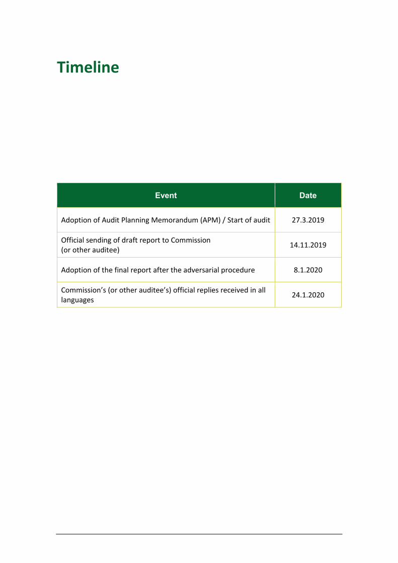
Timeline
Event Date
Adoption of Audit Planning Memorandum (APM) / Start of audit 27.3.2019
Official sending of draft report to Commission (or other auditee) 14.11.2019
Adoption of the final report after the adversarial procedure 8.1.2020
Commission’s (or other auditee’s) official replies received in all languages 24.1.2020
COPYRIGHT
© European Union, 2020.
The reuse policy of the European Court of Auditors (ECA) is implemented by the Decision of the European Court of Auditors No 6-2019 on the open data policy and the reuse of documents.
Unless otherwise indicated (e.g. in individual copyright notices), the ECA’s content owned by the EU is licensed under the Creative Commons Attribution 4.0 International (CC BY 4.0) licence. This means that reuse is allowed, provided appropriate credit is given and changes are indicated. The reuser must not distort the original meaning or message of the documents. The ECA shall not be liable for any consequences of reuse.
You are required to clear additional rights if a specific content depicts identifiable private individuals, f. ex. as on pictures of the ECA’s staff or includes third-party works. Where permission is obtained, such permission shall cancel the above-mentioned general permission and shall clearly indicate any restrictions on use.
To use or reproduce content that is not owned by the EU, you may need to seek permission directly from the copyright holders. Software or documents covered by industrial property rights, such as patents, trade marks, registered designs, logos and names, are excluded from the ECA’s reuse policy and are not licensed to you.
The European Union’s family of institutional Web Sites, within the europa.eu domain, provides links to third-party sites. Since the ECA does not control them, you are encouraged to review their privacy policies.
Use of European Court of Auditors’ logo
The European Court of Auditors logo must not be used without the European Court of Auditors’ prior consent.
PDF ISBN 978-92-847-4244-8 ISSN 1977-5679 doi:10.2865/46869 QJ-AB-20-001-EN-N HTML ISBN 978-92-847-4229-5 ISSN 1977-5679 doi:10.2865/75782 QJ-AB-20-001-EN-Q
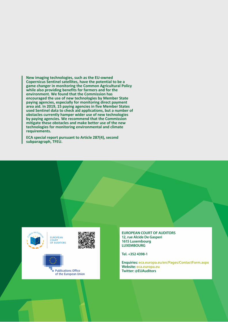
2
New imaging technologies, such as the EU-owned Copernicus Sentinel satellites, have the potential to be a game changer in monitoring the Common Agricultural Policy while also providing benefits for farmers and for the environment. We found that the Commission has encouraged the use of new technologies by Member State paying agencies, especially for monitoring direct payment area aid. In 2019, 15 paying agencies in five Member States used Sentinel data to check aid applications, but a number of obstacles currently hamper wider use of new technologies by paying agencies. We recommend that the Commission mitigate these obstacles and make better use of the new technologies for monitoring environmental and climate requirements. ECA special report pursuant to Article 287(4), second subparagraph, TFEU.