Embed Size (px)
Citation preview
TR
AN
SA
CT
ION
S O
N S
CIE
NC
E A
ND
TE
CH
NO
LO
GY
Cheng, 2016. Transactions on Science and Technology, 3(1), 47 - 58
Plate Tectonics and Seismic Activities in
Sabah Area
Kuei-hsiang CHENG* Kao Yuan University, 1821 Zhongshan Road, Luzhu District, Kaohsiung, Taiwan.
*Corresponding author: [email protected]; Tel: 886-7-6077750; Fax: 886-7-6077762
Received: 27 November 2015
Revised: 25 December 2015
Accepted: 7 January 2016
In press: 8 January 2016
Online: 1 April 2016
Keywords:
Arc and Trench System,
Tectonic earthquake, Seismic
zoning, GM(1,1)model,
Seismic potential assessment
A b s t r a c t
Ever since the Pliocene which was 1.6 million years ago, the structural
geology of Sabah is already formed; it is mainly influenced by the early South China Sea Plate, which is subducted into the Sunda Plate. However,
since the Cenozoic, the Sunda Plate is mainly influenced by the western and
southern of the Sunda-Java Arc and Trench system, and the eastern side of
Luzon Arc and Trench system which has an overall impact on the tectonic
and seismic activity of Sunda plate. Despite the increasing tectonic activities
of Sunda-Java Arc and Trench System, and of Luzon Arc and Trench
System since the Quaternary, which cause many large and frequent
earthquakes. One particular big earthquake is the M9.0 one in Indian Ocean
in 2004, leading to more than two hundred and ninety thousand deaths or
missing by the tsunami caused by the earthquake. As for Borneo island
which is located in residual arc, the impact of tectonic earthquake is trivial;
on the other hand, the Celebes Sea which belongs to the back-arc basin is influenced by the collision of small plates, North Sulawesi, which leads to
two M≧7 earthquakes (1996 M7.9 and 1999 M7.1) in the 20th century. In
Sabah, there is a complete record of earthquake catalog for more than 40
years. The major earthquake affected Sabah area is from the northwest to the
southeast of the seismic zone. The present study is based on the 66
earthquakes (M≧3.7) occurred in Sabah areas since 1974. With the use of
seismic zoning method, Sabah area is divided into eight seismic zones. The
study uses two predictive models, GM (1,1) model and GM (1,1) Verhulst
model of Grey Forecasting theory in Grey System Theory, to evaluate these
eight seismic potential zones of future earthquakes. The result shows that Sandakan, Semporna and Celebes Sea have reached a critical point of
accumulating seismic energy. If any trigger factor appears, there is a high
possibility for moderate to heavy earthquakes to occur. Additionally, there
will be high earthquake potential in Lahad Datu, Tawau, Kudat, Ranau,
Tarakan and Sitangkai within the next seven years (2015-2022). Possible
disaster reduction is needed.
Introduction
Plate tectonic theory has revolutionized the study of earth science since 19th century. It describes the
outer rigid layer of the earth is divided into a dozen of plates that move across the earth’s surfaces
relative to each other. These plates basically separate lithosphere and asthenosphere. Lithosphere is
the rigid and brittle shell of the earth. Asthenosphere is the hot, plastic interior of the earth. Within the
asthenosphere are convection cells that bring heat from the earth’s interior out the surface in a very
slow pace of about 10 centimeters a year. Over a long period of time, when the convection cells reach
the base of lithosphere, they release heat to the surface causing the cooled plastic rock turns sideways
and moves parallel to the earth’s surface. In back and forth movement, they descend back into earth at
the subduction zones to become reheated and eventually drives the plate movements.
TR
AN
SA
CT
ION
S O
N S
CIE
NC
E A
ND
TE
CH
NO
LO
GY
Cheng, 2016. Transactions on Science and Technology, 3(1), 47 - 58 48
ISSN 2289-8786. http://transectscience.org/
In cross section, there are three kinds of plate boundaries namely convergent, divergent and
transform. Convergent boundaries are where two tectonic plates are colliding to form subduction
zones. This collision can occur between oceanic crust and continental crust, or together within each
other. Divergent boundaries are where two tectonic plates are moving apart to create a space filled
with new crustal sourced from molten magma. Transform boundaries are where plates slide passed
each other in horizontal motion. Because of friction, the plates cannot simply glide past each other.
Rather, stress builds up in both plates during the collision and when it exceeds the threshold of the
rocks, the energy is released and eventually causing earthquake.
Recently, an earthquake struck Ranau, Sabah with a magnitude of 6.0 on 5th June 2015, which
lasted for 30 seconds, was one of strongest earthquakes recorded in Malaysia (Earthquake Track, 2015).
The news has drawn enormous attentions from the local government and related agencies around the
world to study the seismic activities in Sabah area. In this work, potential zones of future earthquakes
are evaluated using two predictive models in Grey System Theory. The evaluation is based on the 66
earthquakes (M≧3.7) occurred in Sabah areas since 1974. The result shows that Sandakan, Semporna
and Celebes Sea have reached a critical point of accumulating seismic energy. If any trigger factor
appears, there is a high possibility for moderate to heavy earthquakes to occur. Additionally, there will
be high earthquake potential in Lahad Datu, Tawau, Kudat, Ranau, Tarakan and Sitangkai within the
next seven years (2015-2022).
Plate tectonic setting
Sunda-Java Arc and Trench System
In recent years, the India-Australian Plate is to the north of Sunda-Java Trench and is subducted
beneath the Sunda Plate which causes the increasing seismic activity in the Sunda Strait and the
Lesser Sunda islands which locate in fore-arc basin. The M9 earthquake in 2004 was one particular
example.
Luzon Arc and Trench System
The Philippine Sea Plate is on the northwest direction underneath from the Manila trench to Sunda
Plate, causing a series of deep earthquakes and a considerable number of M7 shallow earthquakes in
Sulu Sea and Celebes Sea of back-arc basin. It appears that the tectonic and seismic activity not only
is increasing but also is enhancing. However, concerning these two subduction zones to the same
residual arc of Borneo State, the influence of tectonic earthquake is minimal.
North Sulawesi Plate (Molucca Sea Plate)
The Celebes Sea which belongs to the back-arc basin is influenced because of the small plate
collision in the south of North Sulawesi Trench. It is also influenced by the active tectonic in Bayan
ng arc island, making the occurrence of multiple M7 shallow earthquakes. As for the eastern district
TR
AN
SA
CT
ION
S O
N S
CIE
NC
E A
ND
TE
CH
NO
LO
GY
Cheng, 2016. Transactions on Science and Technology, 3(1), 47 - 58 49
ISSN 2289-8786. http://transectscience.org/
of Sabah State, the near and far of epicenter will cause a number of damages to a certain extent.
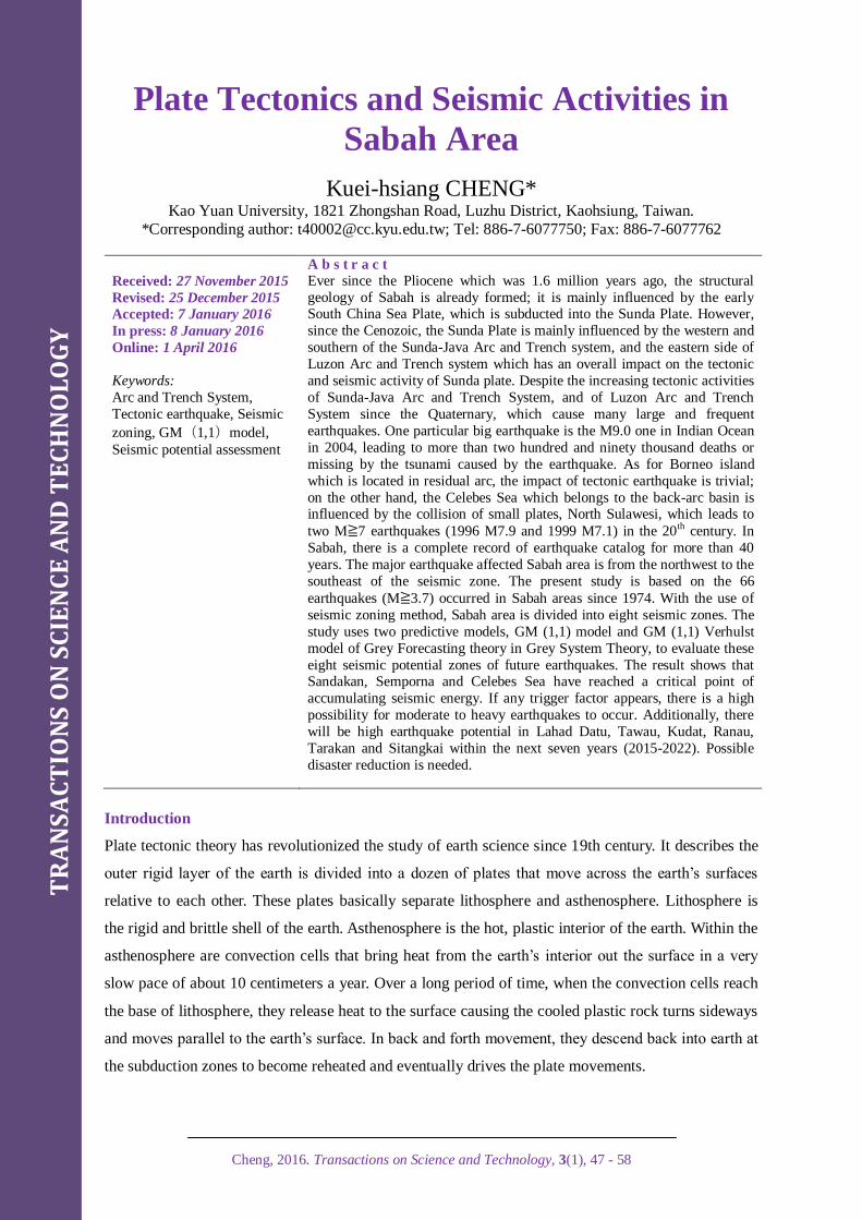
Tectonic Sunda Plate environment can be concerned by Figure 1.
Figure l: Tectonic Sunda plate diagram. (Wikipedia, 2015)
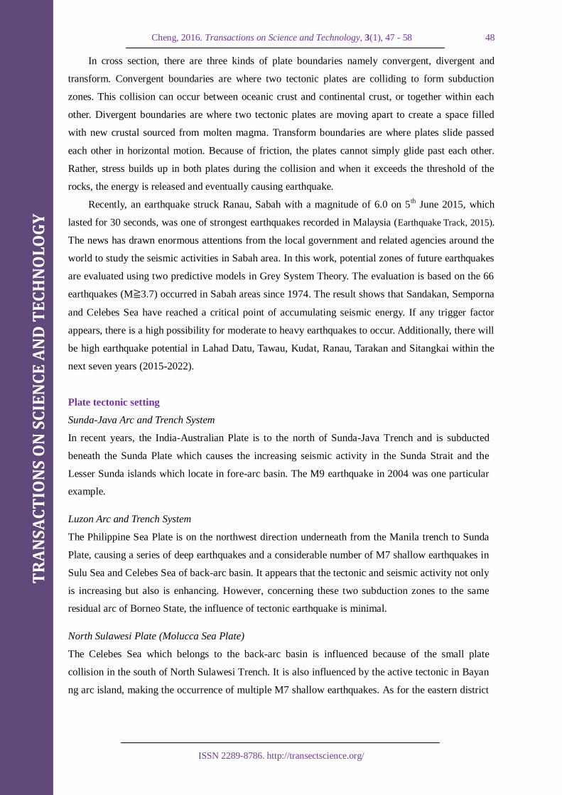
Since 1973, the 26 pieces of M7.5 to 9.0 earthquakes occurred in the tectonic Sunda Plate
boundaries were showed of their distribution in Figure 2. The tectonic earthquakes induced by Sunda
Trench and Manila Trench on the Sunda Plate boundary and by the four small plates in the southeast
(MS, BS, TI and BH) are shown in Figure 3.
Figure 2: Major earthquakes since 1973 which occurred in Tectonic Sunda Plate boundaries
(USGS, 2015)
TR
AN
SA
CT
ION
S O
N S
CIE
NC
E A
ND
TE
CH
NO
LO
GY
Cheng, 2016. Transactions on Science and Technology, 3(1), 47 - 58 50
ISSN 2289-8786. http://transectscience.org/
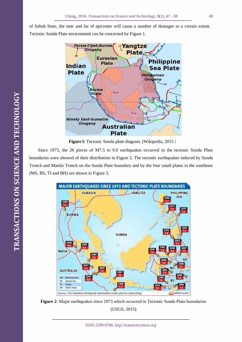
Figure 3: The tectonic earthquakes in Sunda Plate (Scientific Malaysian, 2015).
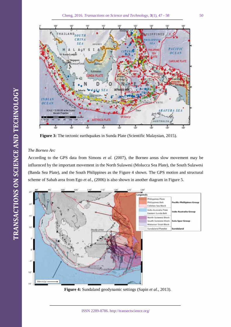
The Borneo Arc
According to the GPS data from Simons et al. (2007), the Borneo areas slow movement may be
influenced by the important movement in the North Sulawesi (Molucca Sea Plate), the South Sulawesi
(Banda Sea Plate), and the South Philippines as the Figure 4 shown. The GPS motion and structural
scheme of Sabah area from Ego et al., (2006) is also shown in another diagram in Figure 5.
Figure 4: Sundaland geodynamic settings (Sapin et al., 2013).

TR
AN
SA
CT
ION
S O
N S
CIE
NC
E A
ND
TE
CH
NO
LO
GY
Cheng, 2016. Transactions on Science and Technology, 3(1), 47 - 58 51
ISSN 2289-8786. http://transectscience.org/
Figure 5: NW Borneo GPS motion and structural scheme (Ego et al., 2006).
Data
The district of earthquakes in Sabah
The seismic zoning method is used to record the 66 pieces of M≧3.7 earthquakes (see as Table 1)
occurred from 1974 to 2015 in Sabah area, as depicted in Figure 6.
Table 1: Earthquake catalogs in Sabah area
No Year Date-month Time Epicenter Depth
(km)
Magnitude
(M)
District
1 2015 26-Jul 16:10 6.224, 116.868 15 4.6 Ranau
2 2015 23-Jun 09:32 6.159, 116.606 15 4.5 Ranau
3 2015 12-Jun 18:29 6.182, 116.651 11 5.3 Ranau
4 2015 6-Jun 05:45 5.956, 116.608 10 4.5 Ranau
5 2015 4-Jun 23:15 5.979, 116.529 10 6.0 Ranau
6 2015 25-Feb 01:31 6.089, 119.844 24 5.6 Jolo
7 2015 19-Jan 17:19 4.624, 119.761 11 5.5 Sitangkai
8 2014 8-Nov 20:07 3.594, 117.603 43 4.4 Tarakan
9 2014 24-Oct 05:40 7.194, 117.247 14 4.6 Kudat
10 2014 1-Feb 11:35 6.157, 116.589 17 4.7 Ranau
11 2013 5-Jun 19:23 2.984, 117.561 16 4.9 Tarakan
12 2012 28-May 16:44 4.786, 118.321 39 4.6 Lahad Datu
13 2010 21-Aug 19:43 5.370, 118.368 54 4.2 Lahad Datu
14 2009 4-Sep 04:49 7.191, 117.115 35 4.5 Kudat
15 2008 18-May 06:26 4.598, 118.173 10 5.0 Tawau
16 2008 9-Apr 00:51 4.838, 118.713 27 4.5 Semporna

TR
AN
SA
CT
ION
S O
N S
CIE
NC
E A
ND
TE
CH
NO
LO
GY
Cheng, 2016. Transactions on Science and Technology, 3(1), 47 - 58 52
ISSN 2289-8786. http://transectscience.org/
17 2008 10-Jan 13:18 4.205, 116.508 10 4.1 Keningau
18 2007 23-Oct 20:34 5.710, 119.316 48 5.2 Sitangkai
19 2006 28-Sep 15:11 6.041, 117.398 10 4.5 Ranau
20 2006 22-Apr 02:01 6.121, 117.810 70 4.0 Sandakan
21 2005 30-Jun 18:09 4.329, 115.620 24 4.5 Limbang
22 2005 23-May 19:58 6.256, 117.709 19 5.3 Sandakan
23 2003 3-Aug 18:44 3.694, 118.759 33 4.9 Semporna
24 2002 7-Apr 01:03 7.225, 117.052 33 5.1 Kudat
25 2001 31-Jul 16:41 8.023, 117.466 33 5.5 Pulot
26 1999 4-Mar 08:52 5.397, 121.937 33 7.1 Seit
27 1996 6-Dec 12:42 4.894, 118.605 33 4.4 Lahad Datu
28 1996 7-Feb 22:42 5.208, 119.609 33 4.4 Sitangkai
29 1996 1-Jan 08:05 0.729, 119.931 24 7.9 Palu
30 1995 11-Aug 06:21 6.340, 117.150 33 4.1 Ranau
31 1995 6-Mar 18:43 2.690, 118.226 16 6.1 Tarakan
32 1994 8-Dec 08:30 1.967, 120.844 38 5.7 Gorontalo
33 1994 27-Nov 18:27 5.768, 119.324 27 5.5 Sitangkai
34 1994 2-Nov 01:43 5.099, 118.643 55 5.7 Lahad Datu
35 1992 4-Jul 22:33 4.976, 118.454 10 4.6 Lahad Datu
36 1992 4-Jul 18:19 4.579, 118.049 50 4.3 Tawau
37 1992 22-Feb 00:39 5.415, 114.546 40 5.2 Labuan
38 1991 25-Aug 07:15 4.636, 118.256 33 4.5 Semporna
39 1991 26-May 11:16 5.869, 116.815 18 5.1 Ranau
40 1991 26-May 11:14 5.718, 116.748 33 4.7 Ranau
41 1991 26-May 10:59 5.865, 116.746 33 5.1 Ranau
42 1991 26-May 07:02 6.130 , 117.168 33 4.6 Ranau
43 1989 9-Oct 15:58 3.455, 117.674 10 3.7 Tarakan
44 1989 13-Feb 20:24 4.265, 117.843 32 4.4 Tawau
45 1989 5-Feb 18:32 4.560, 118.089 24 3.7 Tawau
46 1988 14-Dec 17:06 5.753, 117.859 79 5.1 Sandakan
47 1984 24-May 14:56 4.108, 118.600 33 4.5 Semporna
48 1984 14-Mar 00:39 5.203, 118.387 50 5.6 Lahad Datu
49 1983 22-Mar 22:44 3.835, 118.862 57 5.0 Semporna
50 1982 26-Nov 19:29 4.895, 118.387 33 4.5 Lahad Datu
51 1981 25-Dec 00:28 4.760, 118.477 39 5.4 Semporna
52 1981 9-Dec 19:24 3.796, 117.319 57 4.8 Tarakan
53 1980 23-Oct 14:00 6.519, 117.957 51 5.1 Sandakan
54 1979 30-May 14:06 6.886, 117.004 33 4.5 Kudat

TR
AN
SA
CT
ION
S O
N S
CIE
NC
E A
ND
TE
CH
NO
LO
GY
Cheng, 2016. Transactions on Science and Technology, 3(1), 47 - 58 53
ISSN 2289-8786. http://transectscience.org/
55 1976 18-Sep 07:54 4.639, 118.033 33 5.0 Tawau
56 1976 14-Aug 11:10 4.714, 118.421 36 5.1 Semporna
57 1976 26-Jul 13:12 4.592, 118.160 33 4.5 Tawau
58 1976 26-Jul 09:43 4.994, 118.550 33 5.1 Lahad Datu
59 1976 26-Jul 08:49 4.894, 118.342 33 5.3 Lahad Datu
60 1976 26-Jul 08:36 4.904, 118.052 33 5.3 Lahad Datu
61 1976 26-Jul 05:35 4.986, 118.594 33 5.2 Lahad Datu
62 1976 26-Jul 03:03 5.062, 118.385 33 5.3 Lahad Datu
63 1976 26-Jul 02:56 4.956, 118.308 33 6.2 Lahad Datu
64 1976 25-Jul 14:03 5.092, 118.287 33 5.3 Lahad Datu
65 1976 18-Jun 18:40 6.041, 119.771 33 4.5 Jolo
66 1974 12-Nov 22:13 2.316, 121.129 54 5.8 Gorontalo
Figure 6: The seismic epicenter distribution diagram from 1974 to 2015 in Sabah area.

TR
AN
SA
CT
ION
S O
N S
CIE
NC
E A
ND
TE
CH
NO
LO
GY
Cheng, 2016. Transactions on Science and Technology, 3(1), 47 - 58 54
ISSN 2289-8786. http://transectscience.org/
The 60 records of the eight seismic zones are shown in Table 2.
Table 2: Seismic zoning and range statistics table
No. District Quake no. M max Longitude (°) Latitude (°) Area (km2)
1 Ranau 12 M6.0 116.4~117.4 5.5~6.4 100*90
2 Kudat 4 M5.1 116.8~117.4 6.6~7.4 60*80
3 Sandakan 4 M5.3 117.5~118.0 5.5~6.6 50*110
4 Lahad Datu 17 M6.2 118.0~118.9 4.7~5.5 90*80
5 Tawau 10 M5.0 117.8~118.9 3.6~4.7 110*110
6 Tarakan 5 M6.1 117.3~118.3 2.6~3.8 100*120
7 Sitangkai 4 M5.5 119.3~119.8 4.6~5.8 50*120
8 Collision Zone 4 M7.9 120.0~122.0 0.5~5.5 200*500
Future seismic potential assessment in Sabah area
Based on seismic zoning, we use these 60 pieces of earthquake catalog from the upper section of
Table 1 in Sabah, to summarize into eight different districts as follows in Table 3 - 10.
Table 3: Ranau area earthquakes list
No. Year Date-month Time Epicenter Depth (km) Magnitude(M) District
1 2015 26-Jul 16:10 6.224, 116.868 15 4.6 Ranau
2 2015 23-Jun 09:32 6.159, 116.606 15 4.5 Ranau
3 2015 12-Jun 18:29 6.182, 116.651 11 5.3 Ranau
4 2015 6-Jun 05:45 5.956, 116.608 10 4.5 Ranau
5 2015 4-Jun 23:15 5.979, 116.529 10 6.0 Ranau
10 2014 1-Feb 11:35 6.157, 116.589 17 4.7 Ranau
19 2006 28-Sep 15:11 6.041, 117.398 10 4.5 Ranau
30 1995 11-Aug 06:21 6.340, 117.150 33 4.1 Ranau
39 1991 26-May 11:16 5.869, 116.815 18 5.1 Ranau
40 1991 26-May 11:14 5.718, 116.748 33 4.7 Ranau
41 1991 26-May 10:59 5.865, 116.746 33 5.1 Ranau
42 1991 26-May 07:02 6.113, 117.168 33 4.6 Ranau
Table 4: Kudat area earthquakes list
No. Year Date-month Time Epicenter Depth (km) Magnitude (M) District
9 2014 24-Oct 05:40 7.194, 117.247 14 4.6 Kudat
14 2009 4-Sep 04:49 7.191, 117.115 35 4.5 Kudat
24 2002 7-Apr 01:03 7.225, 117.052 33 5.1 Kudat
54 1979 30-May 14:06 6.886, 117.004 33 4.5 Kudat
TR
AN
SA
CT
ION
S O
N S
CIE
NC
E A
ND
TE
CH
NO
LO
GY
Cheng, 2016. Transactions on Science and Technology, 3(1), 47 - 58 55
ISSN 2289-8786. http://transectscience.org/
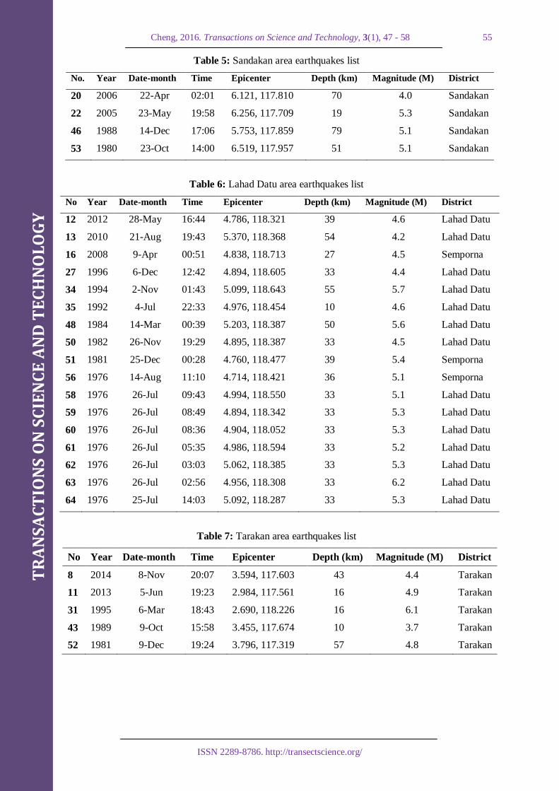
Table 5: Sandakan area earthquakes list
No. Year Date-month Time Epicenter Depth (km) Magnitude (M) District
20 2006 22-Apr 02:01 6.121, 117.810 70 4.0 Sandakan
22 2005 23-May 19:58 6.256, 117.709 19 5.3 Sandakan
46 1988 14-Dec 17:06 5.753, 117.859 79 5.1 Sandakan
53 1980 23-Oct 14:00 6.519, 117.957 51 5.1 Sandakan
Table 6: Lahad Datu area earthquakes list
No Year Date-month Time Epicenter Depth (km) Magnitude (M) District
12 2012 28-May 16:44 4.786, 118.321 39 4.6 Lahad Datu
13 2010 21-Aug 19:43 5.370, 118.368 54 4.2 Lahad Datu
16 2008 9-Apr 00:51 4.838, 118.713 27 4.5 Semporna
27 1996 6-Dec 12:42 4.894, 118.605 33 4.4 Lahad Datu
34 1994 2-Nov 01:43 5.099, 118.643 55 5.7 Lahad Datu
35 1992 4-Jul 22:33 4.976, 118.454 10 4.6 Lahad Datu
48 1984 14-Mar 00:39 5.203, 118.387 50 5.6 Lahad Datu
50 1982 26-Nov 19:29 4.895, 118.387 33 4.5 Lahad Datu
51 1981 25-Dec 00:28 4.760, 118.477 39 5.4 Semporna
56 1976 14-Aug 11:10 4.714, 118.421 36 5.1 Semporna
58 1976 26-Jul 09:43 4.994, 118.550 33 5.1 Lahad Datu
59 1976 26-Jul 08:49 4.894, 118.342 33 5.3 Lahad Datu
60 1976 26-Jul 08:36 4.904, 118.052 33 5.3 Lahad Datu
61 1976 26-Jul 05:35 4.986, 118.594 33 5.2 Lahad Datu
62 1976 26-Jul 03:03 5.062, 118.385 33 5.3 Lahad Datu
63 1976 26-Jul 02:56 4.956, 118.308 33 6.2 Lahad Datu
64 1976 25-Jul 14:03 5.092, 118.287 33 5.3 Lahad Datu
Table 7: Tarakan area earthquakes list
No Year Date-month Time Epicenter Depth (km) Magnitude (M) District
8 2014 8-Nov 20:07 3.594, 117.603 43 4.4 Tarakan
11 2013 5-Jun 19:23 2.984, 117.561 16 4.9 Tarakan
31 1995 6-Mar 18:43 2.690, 118.226 16 6.1 Tarakan
43 1989 9-Oct 15:58 3.455, 117.674 10 3.7 Tarakan
52 1981 9-Dec 19:24 3.796, 117.319 57 4.8 Tarakan

TR
AN
SA
CT
ION
S O
N S
CIE
NC
E A
ND
TE
CH
NO
LO
GY
Cheng, 2016. Transactions on Science and Technology, 3(1), 47 - 58 56
ISSN 2289-8786. http://transectscience.org/
Table 8: Tawau area earthquakes list
No Year Date-month Time Epicenter Depth (km) Magnitude (M) District
15 2008 18-May 06:26 4.598, 118.173 10 5.0 Tawau
23 2003 3-Aug 18:44 3.694, 118.759 33 4.9 Semporna
36 1992 4-Jul 18:19 4.579, 118.049 50 4.3 Tawau
38 1991 25-Aug 07:15 4.636, 118.256 33 4.5 Semporna
44 1989 13-Feb 20:24 4.265, 117.843 32 4.4 Tawau
47 1984 24-May 14:56 4.108, 118.600 33 4.5 Semporna
49 1983 22-Mar 22:44 3.835, 118.862 57 5.0 Semporna
45 1989 5-Feb 18:32 4.560, 118.089 24 3.7 Tawau
55 1976 18-Sep 07:54 4.639, 118.033 33 5.0 Tawau
57 1976 26-Jul 13:12 4.592, 118.160 33 4.5 Tawau
Table 9: Sitangkai area earthquakes list
No Year Date-month Time Epicenter Depth (km) Magnitude (M) District
7 2015 19-Jan 17:19 4.624, 119.761 11 5.5 Sitangkai
18 2007 23-Oct 20:34 5.710, 119.316 48 5.2 Sitangkai
28 1996 7-Feb 22:42 5.208, 119.609 33 4.4 Sitangkai
33 1994 27-Nov 18:27 5.768, 119.324 27 5.5 Sitangkai
Table 10: Collision Zone earthquakes list
No Year Date-month Time Epicenter Depth (km) Magnitude (M) District
26 1999 4-Mar 08:52 5.397, 121.937 33 7.1 Seit
29 1996 1-Jan 08:05 0.729, 119.931 24 7.9 Palu
32 1994 8-Dec 08:30 1.967, 120.844 38 5.7 Gorontalo
66 1974 12-Nov 22:13 2.316, 121.129 54 5.8 Gorontalo
Results & discussion
We use the method of assessing future seismic potential at different seismic zones in Sabah area, and
the study can get analytical results in each area as follows:
Ranau Area
According to Tongkul’s estimation (Tongkul, 2015) from the Universiti Malaysia Sabah, the M≧5
earthquake cycle of Ranau area is 25 years which means that there will be another M5.5 earthquake
around 2040. However, based on the present study which uses the two gray prediction model, GM
(1.1) and GM Verhulst, the next M≧5.0 earthquake will be occurred around 2019-2020 in Ranau area.

TR
AN
SA
CT
ION
S O
N S
CIE
NC
E A
ND
TE
CH
NO
LO
GY
Cheng, 2016. Transactions on Science and Technology, 3(1), 47 - 58 57
ISSN 2289-8786. http://transectscience.org/
Kudat Area
Based on GM (1,1) model estimation, the next two earthquakes will occur around 2017-2018 and
2020-2021 respectively in Kudat area.
Sandakan Area
A M5 earthquake whose depth is 70 km will occur in Sandakan area in 2015.
Lahad Datu Area
Based on GM (1,1) model estimation, whether to ignore the M4.6 earthquake at a depth of 10 km
in1992 or not, another earthquake will occur earliest around 2016-2017 and slowest in 2026. And the
next earthquake at the depth of 33km will occur around 2021-2022.
Tawau Area
An earthquake will occur around 2017 in the Tawau area. But the Semporna area has already reached
the critical point, in theory, an earthquake is very likely to occur at any time.
Tarakan Area
Based on GM (1,1) model estimation, the next earthquake in Tawau area will be around 2019-2020.
But if based on the GM(1,1) Verhulst model, the next earthquake will occur around 2021-2022.
Sitangkai Area
Based on the GM (1,1) model estimation of Sitangkai area, the next M> 5 earthquake will occur
around 2020-2021. As for the estimation of GM Verhulst model, the date will be two years earlier.
Celebes Sea Collision Zone
As for the Collision Zone of the Celebes Sea, the next M≥6.0 earthquake has now entered the critical
range of earthquakes using the GM (1,1) model estimation. Theoretically, M≧6.0 earthquake will
occur at any time in this region. If we take the above eight sections of future potential earthquakes in
Sabah State, the present study can get future seismic potential assessment in Sabah area as shown in
Table 11:

TR
AN
SA
CT
ION
S O
N S
CIE
NC
E A
ND
TE
CH
NO
LO
GY
Cheng, 2016. Transactions on Science and Technology, 3(1), 47 - 58 58
ISSN 2289-8786. http://transectscience.org/
Table 11: Future seismic potential in Sabah area
No. Year Magnitude (M) Depth (km) District
1 ~now M5.0 70km Sandakan
2 ~now 4.5≦M≦5.0 ~33km Semporna
3 ~now M≧6.0 Celebes Sea
4 2017 4.5≦M≦6.0 ~33km Lahad Datu
5 2017 4.5≦M≦5.0 Tawau
6 2018 4.5≦M≦5.0 Kudat
7 2020 4.5≦M≦6.0 Ranau
8 2020 4.5≦M≦6.0 Tarakan
9 2021 4.5≦M≦5.0 Sitangkai
10 2021 4.5≦M≦5.0 Kudat
11 2022 4.5≦M≦5.0 Tawau
12 2022 4.5≦M≦6.0 ~33km Lahad Datu
Conclusion
The high seismic potential region in Sabah State in the next three years (2015-2017) are Sandakan,
Semporna, and the Celebes Sea. These three areas have currently accumulated enough strain energy.
As long as the trigger factors take place, it will cause the fault dislocation and induce earthquakes.
Another higher seismic potentials areas are Lahad Datu and Tawau. According to the high seismic
potential areas in Sabah State in the next seven years (2015-2022), in addition to the above five
regions, other areas such as Kadat, Ranau, Tarakan, Sitangkai, Lahad Datu, and Tawau areas are also
included.
References [1] Ego, F., Chamot-Rooke, N., Loevenbruck, A., Lorne, A., Pubellier, M., Rabaute, A. & Vigny, C. (2006).
Tectostrain Project: structures and strain field, Central South-East Asia. Unpublished report.
[2] Earthquake Track. (2015). Recent Earthquake Near Sabah, Malaysia
(http://earthquaketrack.com/p/malaysia/sabah/recent). Accesssed on 18 December 2015.
[3] Sapin, F., Hermawan, I., Pubellier, M., Vigny, C. & Ringeubach, J.-C. (2013). The recent convergence on
the NW Borneo Wedge - a crustal - scale gravity gliding evidenced from GPS. Geophysical Journal
International, 193(2), 549-556.
[4] Scientific Malaysian. (2015). Earthquake geology of Southeast Asia
(http://www.scientificmalaysian.com/project-collab-directory/1079/earthquake-geology-of-southeast-
asia/). Accesssed on 18 December 2015. [5] Simons, W. J. F., Socquet, A., Vigny, C., Ambrosius, B. A. C., Haji Abu, S., Subarya, C., Promthong, C.,
Sarsito, D. A., Matheussen, S., Morgan, P. & Spakman, W. (2007). A decade of GPS in Southeast Asia:
resolving Sundaland motion and boundaries. Geodesy and Gravity Tectonophysics, 112, B06420.
[6] Tongkul. F. (2015). Sabah quake: A geologist’s perspective
(http://www.thestar.com.my/news/nation/2015/06/07/sabah-quake-geologist/). Accesssed on 18 December
2015.
[7] USGS National Earthquake Information Center (NEIC). (2015). Major earthquakes since 1973 and
Tectonic Plate boundaries (http://earthquake.usgs.gov/contactus/golden/neic.php). Accesssed on 18
December 2015.
[8] Wikipedia. (2015). Sunda Plate (https://en.wikipedia.org/wiki/Sunda_Plate). Accesssed on 18 December
2015.