Embed Size (px)
Citation preview
PLANNING ADVISORY COMMITTEE COUNCIL CHAMBERS, CITY HALL
AGENDA APRIL 19, 2017 A. APPROVAL OF MINUTES Regular Meeting – March 15, 2017 B. ZONING APPLICATIONS
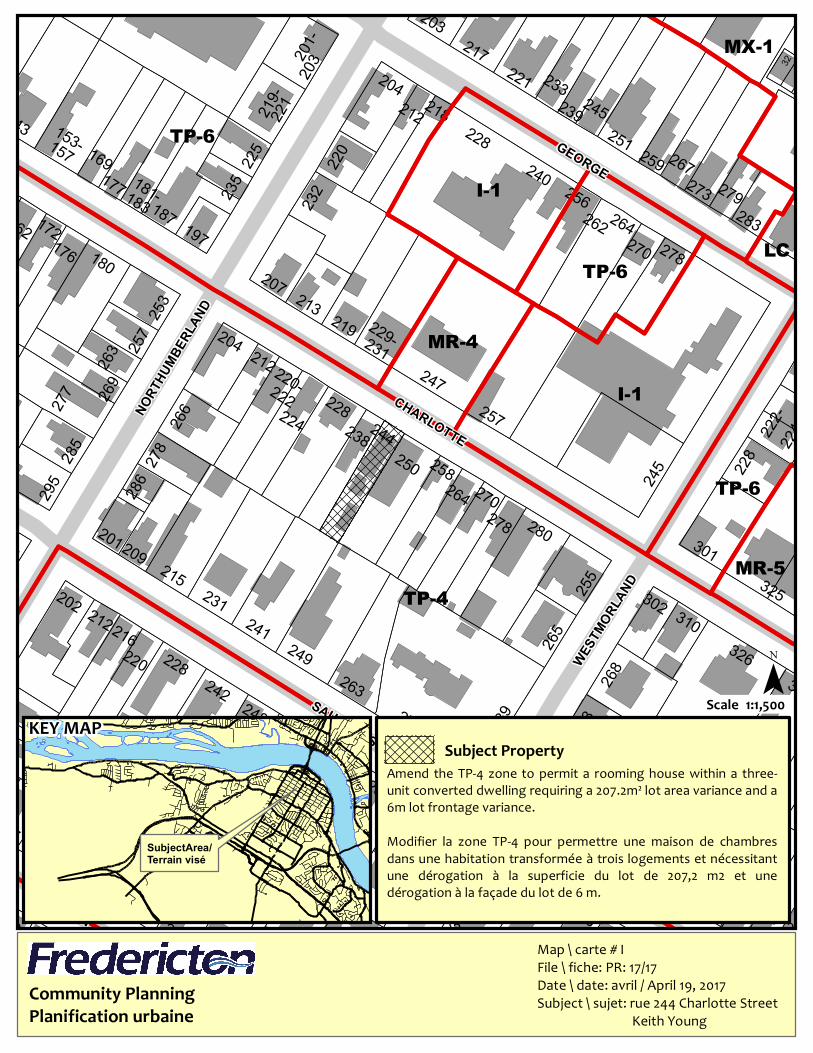
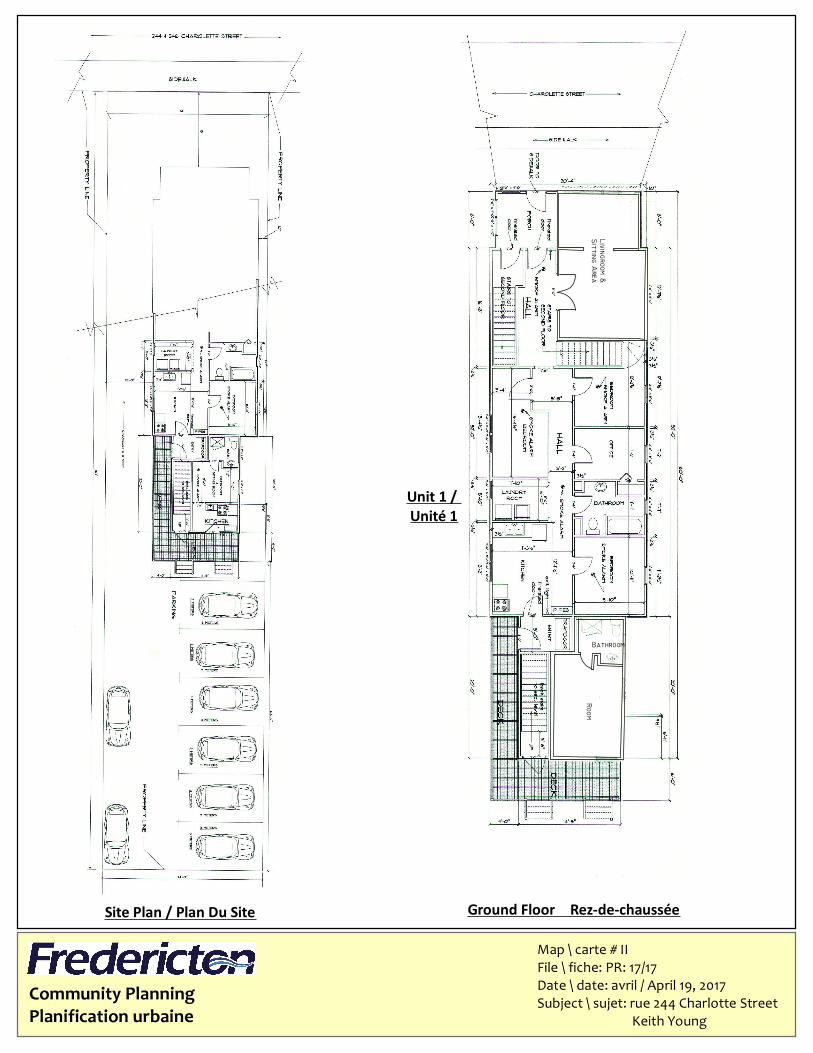
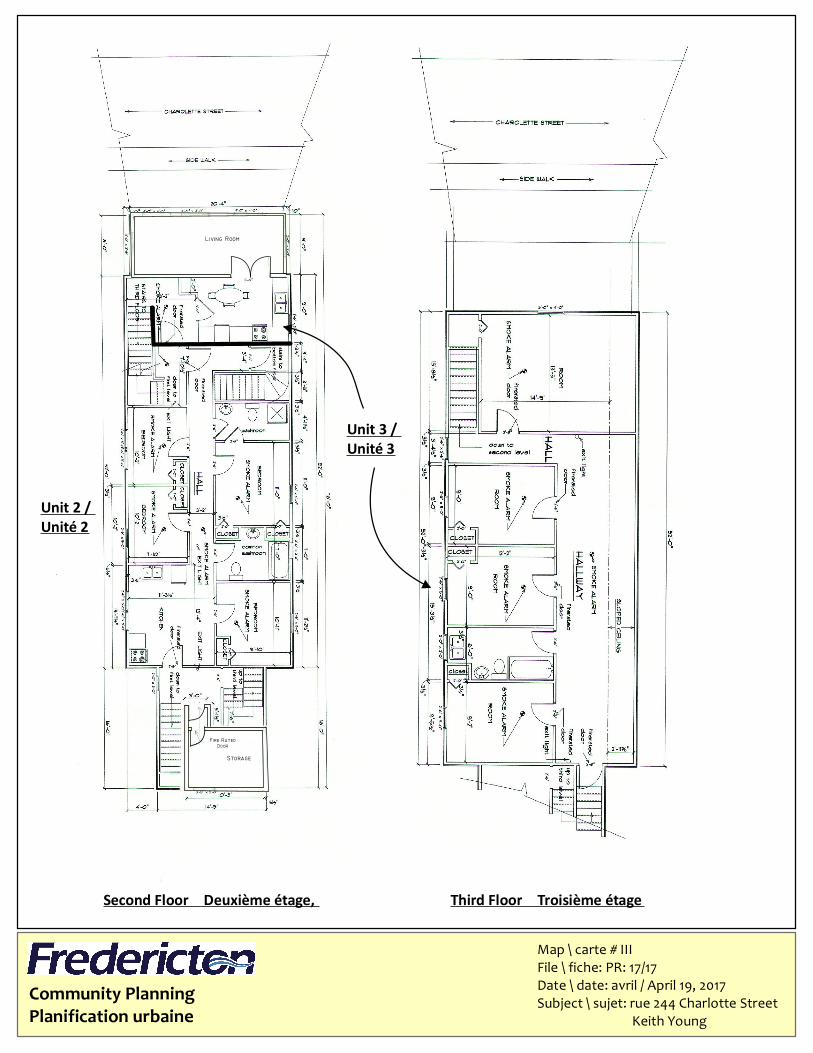
1. Keith Young - 244 - 246 Charlotte Street
Zone Amendment to Permit a Rooming House in a 3-Unit Dwelling Lot Area and Lot Frontage Variances
C. SUBDIVISION APPLICATIONS
1. City of Fredericton – 521 Woodstock Road
Subdivision to Add Land to the Public ROW
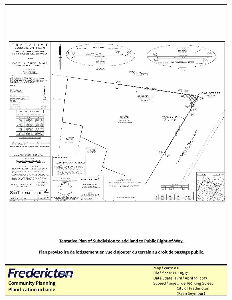
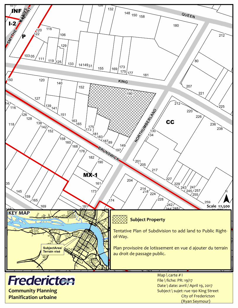
2. City of Fredericton – 190 King Street
Subdivision to Add Land to the Public ROW
3. Cecile and Neil Grant – 146 Wallace Avenue
Subdivision to Create 1 R-2 Lot
4. City of Fredericton – 564 Royal Road
Subdivision to Create a Municipal Services Corridor
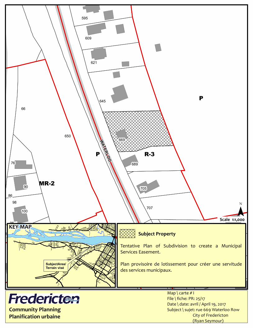
5. City of Fredericton – 669 Waterloo Row
Subdivision to Create a Municipal Services Easement
D. VARIANCE APPLICATIONS
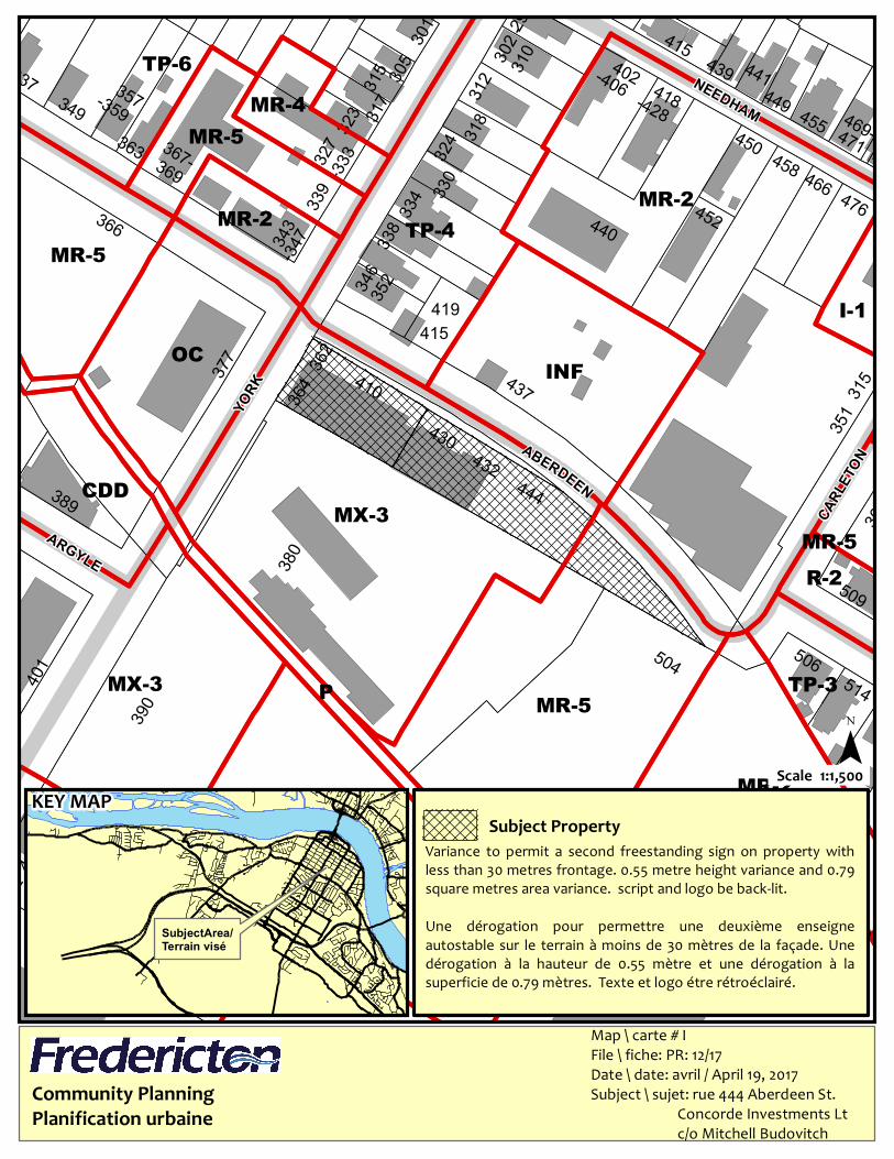
1. Concorde Investments Ltd. – 444 Aberdeen Street
Variances to Permit a 2nd Freestanding Sign
2. Dobbelsteyn Signs – 565 Priestman Street
Sign Height and Sign Area Variances
2
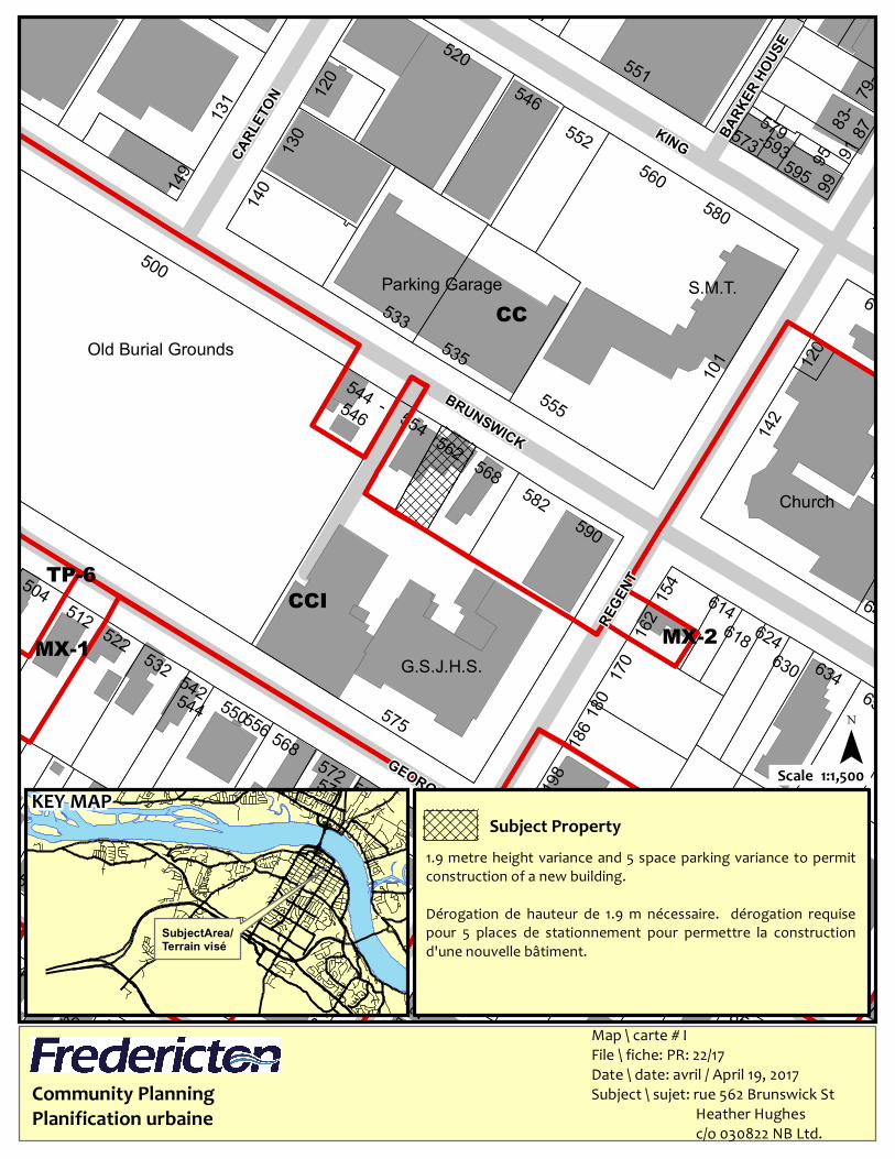
3. Heather Hughes – 562 Brunswick Street
Height and Parking Variances to Permit Construction of a New Building
E. OLD BUSINESS F. NEW BUSINESS
G. BUILDING PERMITS To receive building permits for the month of March 2017 H. ADJOURNMENT
222-
240
228
243
219-
-
182
203
235
143
162 172176 180
232220177
357
317
231
153-
183
242228
316
212216
268
263
262
215
256
259 327
278266
253257
202
286
278
300
248
249 326
273
336
279
310
325
301
289
312
228
326
313321 323
329 335
324
264
262270
264
247257
204 212
224
267
231241
259251
263269277
169
221
181
221
238
187
258
197
250
244228
239
203
157
217
278268
280278
245212
256
270
213
222220-
255
265
219
285
229-
295
347345
283
245220
201-
218
280
204
302
225
230 236
217 223 233 239-249
32 28233
209201
199
271-275
207
224
274-276
302
361-363
340
MR-5
LC
I-1
TP-6
MR-4
I-1
MX-1
TP-6
TP-4
TP-6
TP-6
NORT
HUMBE
RLAN
D
GEORGE
SAUNDERS
ABERDEEN
WESTM
ORLAN
D
CHARLOTTE
Community PlanningPlanification urbaine
Map \ carte # IFile \ fiche: PR: 17/17Date \ date: avril / April 19, 2017Subject \ sujet: rue 244 Charlotte Street Keith Young
KEY MAP¯
1:1,500Scale
Subject Property
SubjectArea/Terrain visé
Amend the TP-4 zone to permit a rooming house within a three-unit converted dwelling requiring a 207.2m² lot area variance and a6m lot frontage variance.Modifier la zone TP-4 pour permettre une maison de chambresdans une habitation transformée à trois logements et nécessitantune dérogation à la superficie du lot de 207,2 m2 et unedérogation à la façade du lot de 6 m.
Community PlanningPlanification urbaine
Map \ carte # IIFile \ fiche: PR: 17/17Date \ date: avril / April 19, 2017Subject \ sujet: rue 244 Charlotte Street Keith Young
Site Plan / Plan Du Site Ground Floor – Rez-de-chaussée
Unit 1 / Unité 1
Community PlanningPlanification urbaine
Map \ carte # IIIFile \ fiche: PR: 17/17Date \ date: avril / April 19, 2017Subject \ sujet: rue 244 Charlotte Street Keith Young
Second Floor – Deuxième étage, Third Floor – Troisième étage
Unit 2 / Unité 2
Unit 3 / Unité 3

WESTM
ORLAN
D
251
294
135
114
101 126
I-2
I-1
CC
MX-1
TP-6
INF
P
SMYT
HE
BRUNSWICK
SAINTA NNEPO
INT QUEEN
FREDERICK
NORT
HUMBE
RLAN
D
GEORGE
KING
228221 245218 239 48219 212 233 12 15116204 20221 24203 28219 32217201292203 290288286182 284282176
172 199 182 262158 191 279252 273178185148 244 248181169 242 259174165 228159 255224218145 173 245 257214 243 247229161 204 227
217205
201190182
176 197168
160 189187149
158 183 134181152 130173 238142 175 236165138 163128 226126 151220
116 141 225139 212127
190 221152 207140120150
181177175169155 173151141149133125 80119111105103
129
212106122120 116
158150148132
180
118
Community PlanningPlanification urbaine
Map \ carte # IFile \ fiche : PR: 19/17Date \ date : avril / April 19, 2017Su bje ct \ s u je t: ru e 190 King Stre e t City of Fre de ricto n (Ryan Se ymo u r)
KEY MAP¯
1:1,500Scale
Subject Property
SubjectArea/Terrain visé
Te n tativ e Plan of Su bdivisio n to add land to Pu blic Right-of-Way.Plan pro vis oire de lo tis s e me n t e n v u e d’ajo u t e r du te rrainau droit de pas sage pu blic.
Community PlanningPlanification urbaine
Tentative Plan of Subdivision to add land to Public Right-of-Way.Plan proviso ire de lotissement en vue d’ajouter du terrain au droit de passage public.
Map \ carte # IIFile \ fiche: PR: 19/17Date \ date: avril / April 19, 2017Subject \ sujet: rue 190 King Street City of Fredericton (Ryan Seymour)
WESTM
ORLAN
D
251
294
135
114
101 126
I-2
I-1
CC
MX-1
TP-6
INF
P
SMYT
HE
BRUNSWICK
SAINTA NNEPO
INT QUEEN
FREDERICK
NORT
HUMBE
RLAN
D
GEORGE
KING
228221 245218 239 48219 212 233 12 15116204 20221 24203 28219 32217201292203 290288286182 284282176
172 199 182 262158 191 279252 273178185148 244 248181169 242 259174165 228159 255224218145 173 245 257214 243 247229161 204 227
217205
201190182
176 197168
160 189187149
158 183 134181152 130173 238142 175 236165138 163128 226126 151220
116 141 225139 212127
190 221152 207140120150
181177175169155 173151141149133125 80119111105103
129
212106122120 116
158150148132
180
118
Community PlanningPlanification urbaine
Map \ carte # IFile \ fiche : PR: 19/17Date \ date : avril / April 19, 2017Su bje ct \ s u je t: ru e 190 King Stre e t City of Fre de ricto n (Ryan Se ymo u r)
KEY MAP¯
1:1,500Scale
Subject Property
SubjectArea/Terrain visé
Te n tativ e Plan of Su bdivisio n to add land to Pu blic Right-of-Way.Plan pro vis oire de lo tis s e me n t e n v u e d’ajo u t e r du te rrainau droit de pas sage pu blic.

Community PlanningPlanification urbaine
Tentative Plan of Subdivision to add land to Public Right-of-Way.Plan proviso ire de lotissement en vue d’ajouter du terrain au droit de passage public.
Map \ carte # IIFile \ fiche: PR: 19/17Date \ date: avril / April 19, 2017Subject \ sujet: rue 190 King Street City of Fredericton (Ryan Seymour)
91
495
City
Gourley Park95
120112
128
107100
153
107
500
158
156
154
152
111
157102100
105
101505496
116
106 108 110
102104
136
130
159161
163
149
102 104
105
126
111
101
111
134132
109
109 110
108
318
306 312
106
304
150
147
155
151
103
114
106
145
112
108
124
101
103
104
146
107105
103
109
577112110
106
Capital Manor
98
170-172
180-182
25
7583
7280
8688
98
307
310
125
301
298
151
329
347335
98 336328
321
63
283286
290288
280
267
259
314
312
305294 296
300 315
265
304
366
124
122
298
7888
84
98
7477
149
6575
55
293
Eagle
wood
69
29
65
-318
29
269271-275-277
370
357
279
I-1
P
BILC
R-2
R-2 MR-1
EOS
EOSR-4
COR-1
COR-1
DC
R-LF
LYNN
WALLA
CE
DEVO
NSHIR
E
FIR
MAIN
BLOOR
PUGH
MOSS
ALDE
RCITYV
IEW
CAPIT
AL
Community PlanningPlanification urbaine
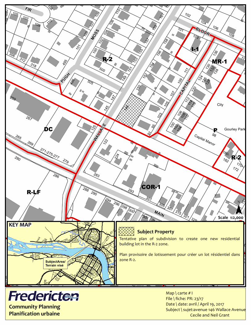
Map \ carte # IFile \ fiche: PR: 23/17Date \ date: avril / April 19, 2017Subject \ sujet:avenue 146 Wallace Avenue Cecile and Neil Grant
KEY MAP¯
1:2,000Scale
Subject Property
SubjectArea/Terrain visé
Tentative plan of subdivision to create one new residentialbuilding lot in the R-2 zone.Plan provisoire de lotissement pour créer un lot résidentiel danszone R-2.
Community PlanningPlanification urbaine
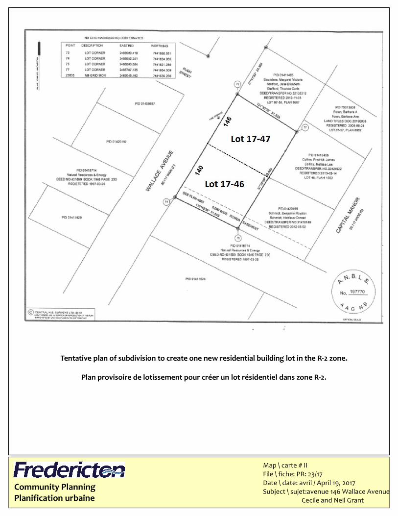
Tentative plan of subdivision to create one new residential building lot in the R-2 zone.Plan provisoire de lotissement pour créer un lot résidentiel dans zone R-2.
Map \ carte # IIFile \ fiche: PR: 23/17Date \ date: avril / April 19, 2017Subject \ sujet:avenue 146 Wallace Avenue Cecile and Neil Grant
140
146
RANDOLPH
ATTENBOROUGH
NEVILLE
HAYWARDWE
STIN
WILC
OX
MCKNIGHT
SUNSET
SHIBU
CALDER MAXWELL
REYNOLDS
EBONY
DAH LIA
JENNINGS
P
MR-4MR-4MR-2
R-2R-2R-2
R-2R-2 I-1
R-2 BIR-2I-1
R-2PR-4
I-1
MR-5
P
P
R-3
R-3
BI
R-2
R-2
MR-2(H)
R-1N
P MR-2
GI
R-2EOS
EOSP
FD
GI(H)
R-2
FD
GI
R-5
R-2 R-2R-2 R-2
MR-4MR-2
PR-5
PR-2 R-2(H)
NC(H)
R-2R-5
MR-2
LOMB
ARDI
DYKEMANPRIMROSE
DICKS
O N
A
SHLEYRING WEST
WILLIAM
ROYAL
RING EAST
BATE
S
FALLOW
VISTA
CRES
TLINE
CHAT
EAU
RING
BARTON
MCLEOD HILL
HAINES
Community PlanningPlanification urbaine
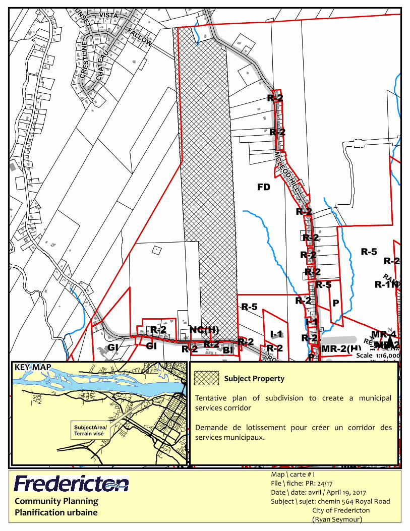
Map \ carte # IFile \ fiche: PR: 24/17Date \ date: avril / April 19, 2017Subject \ sujet: chemin 564 Royal Road City of Fredericton (Ryan Seymour)
KEY MAP¯
1:16,000Scale
Subject Property
SubjectArea/Terrain visé
Tentative plan of subdivision to create a municipalservices corridorDemande de lotissement pour créer un corridor desservices municipaux.
Community PlanningPlanification urbaine
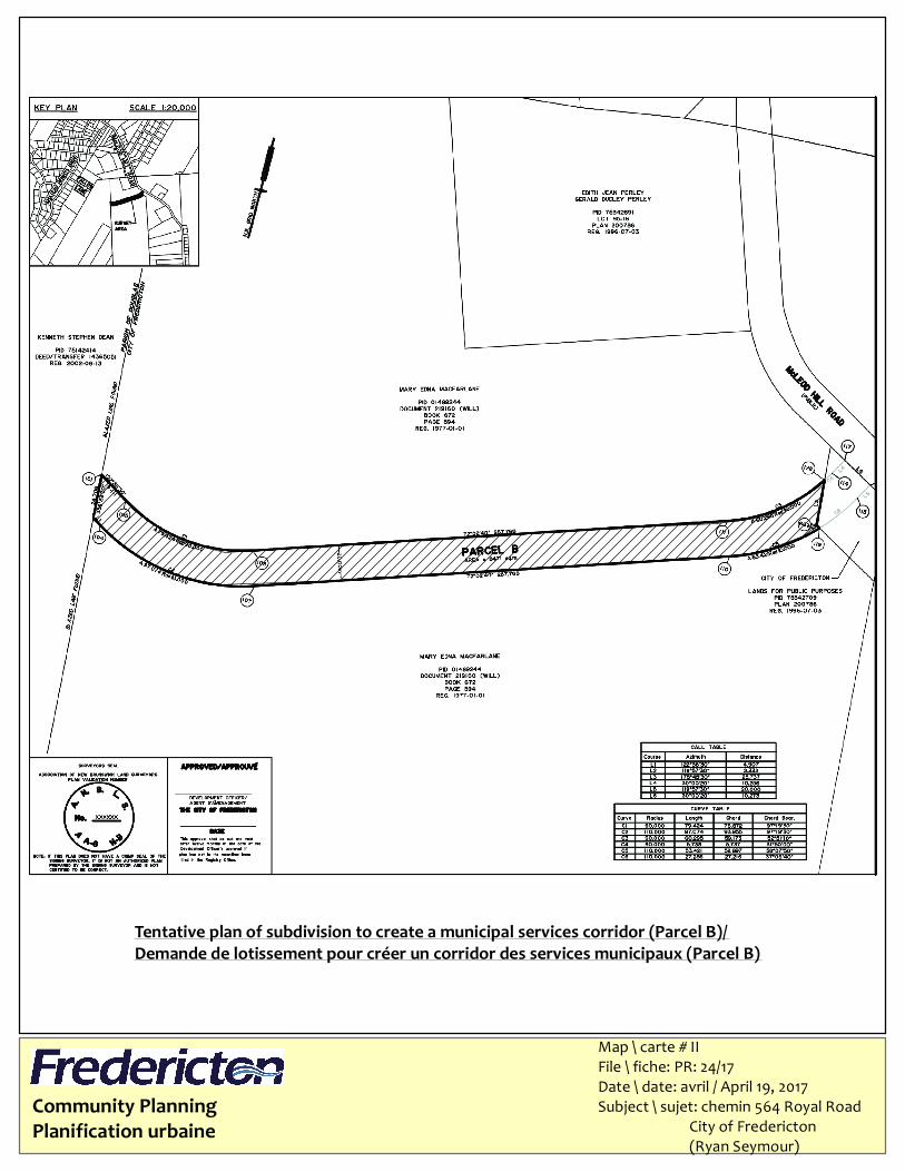
Tentative plan of subdivision to create a municipal services corridor (Parcel B)/Demande de lotissement pour créer un corridor des services municipaux (Parcel B)
Map \ carte # IIFile \ fiche: PR: 24/17Date \ date: avril / April 19, 2017Subject \ sujet: chemin 564 Royal Road City of Fredericton (Ryan Seymour)
110102
MR-2
P
P
R-3
R-2R-4
WATERLOO
723
130
717
71196
100 70798
8670590
68976
669
66645
621
609
595
650
Community PlanningPlanification urbaine
Map \ carte # IFile \ fiche: PR: 25/17Date \ date: avril / April 19, 2017Subject \ sujet: rue 669 Waterloo Row City of Fredericton (Ryan Seymour)
KEY MAP¯
1:1,000Scale
Subject Property
SubjectArea/Terrain visé
Tentative Plan of Subdivision to create a MunicipalServices Easement.Plan provisoire de lotissement pour créer une servitudedes services municipaux.
Community PlanningPlanification urbaine
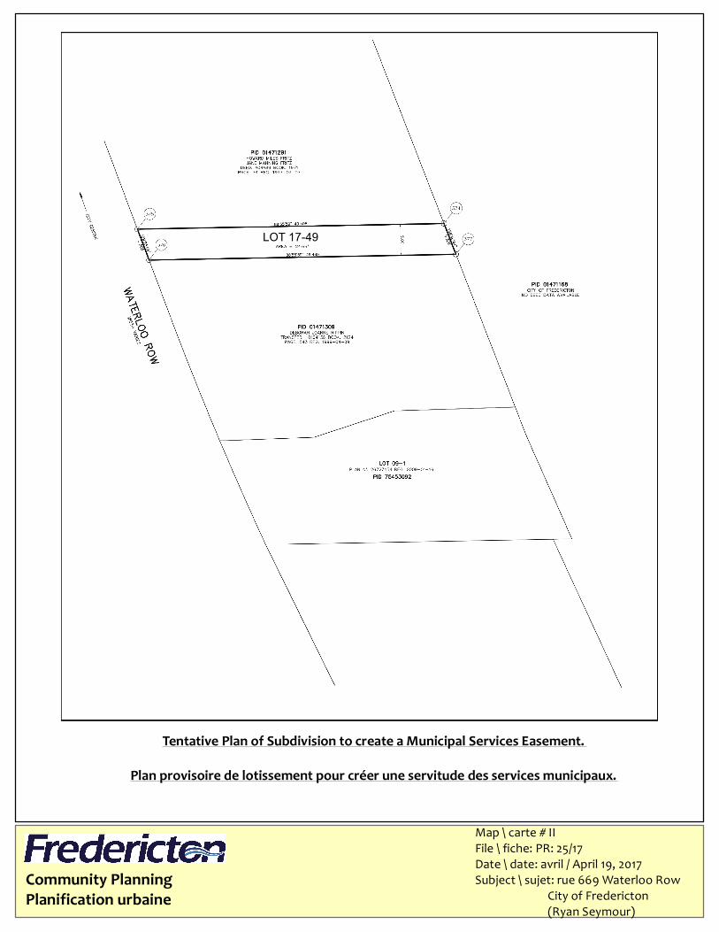
Tentative Plan of Subdivision to create a Municipal Services Easement.Plan provisoire de lotissement pour créer une servitude des services municipaux.
Map \ carte # IIFile \ fiche: PR: 25/17Date \ date: avril / April 19, 2017Subject \ sujet: rue 669 Waterloo Row City of Fredericton (Ryan Seymour)
LOT 17-49
401
389
450
420418 416
414
352
-347
369
302 -
310305
351
506514
458450
418
466 476
475
349
366
315337
364
367-
357
363
362
317
296
430
441449
415 439
324318
330
334338
312
402
301
377
509
504
437
327339
343
469-455
362
471
-406
440
-428
410
-359390
380
452
323-33
3346
422
432444
415419
315
TP-3
R-2MR-5
MR-2
MR-4MR-5
MR-2 TP-4
TP-6
CDD
MR-5
OC
MX-3
MX-3
INF
CDDDCMX-3
I-1
MR-5
P MR-5
OC
MR-2
ABERDEEN
ARGYLE
CARL
ETON
YORK
NEEDHAM
Community PlanningPlanification urbaine
Map \ carte # IFile \ fiche: PR: 12/17Date \ date: avril / April 19, 2017Subject \ sujet: rue 444 Aberdeen St. Concorde Investments Lt c/o Mitchell Budovitch
KEY MAP¯
1:1,500Scale
Subject Property
SubjectArea/Terrain visé
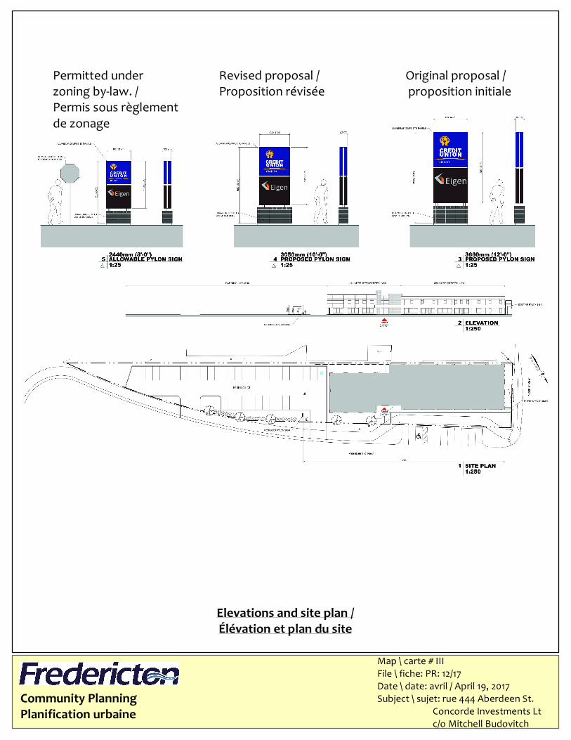
Variance to permit a second freestanding sign on property withless than 30 metres frontage. 0.55 metre height variance and 0.79square metres area variance. script and logo be back-lit.Une dérogation pour permettre une deuxième enseigneautostable sur le terrain à moins de 30 mètres de la façade. Unedérogation à la hauteur de 0.55 mètre et une dérogation à lasuperficie de 0.79 mètres. Texte et logo étre rétroéclairé.
Community PlanningPlanification urbaine
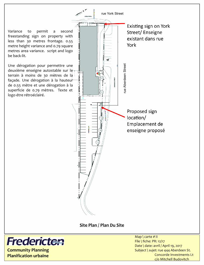
Site Plan / Plan Du Site
rue York Street
rue Ab
erdee
n Stre
et
Variance to permit a secondfreestanding sign on property withless than 30 metres frontage. 0.55metre height variance and 0.79 squaremetres area variance. script and logobe back-lit.Une dérogation pour permettre unedeuxième enseigne autostable sur leterrain à moins de 30 mètres de lafaçade. Une dérogation à la hauteurde 0.55 mètre et une dérogation à lasuperficie de 0.79 mètres. Texte etlogo étre rétroéclairé.
Map \ carte # IIFile \ fiche: PR: 12/17Date \ date: avril / April 19, 2017Subject \ sujet: rue 444 Aberdeen St. Concorde Investments Lt c/o Mitchell Budovitch
Community PlanningPlanification urbaine
Elevations and site plan /Élévation et plan du site
Map \ carte # IIIFile \ fiche: PR: 12/17Date \ date: avril / April 19, 2017Subject \ sujet: rue 444 Aberdeen St. Concorde Investments Lt c/o Mitchell Budovitch
Permitted under zoning by-law. /Permis sous règlementde zonage
Revised proposal /Proposition révisée
Original proposal / proposition initiale
ABBO
TT
LISGA
R
OC
MR-5
OC
MR-4
MR-2R-2R-2
MR-2
MR-2
MR-2
NC
I-2
PRIESTMAN
REGEN
T
MANDERLEY
VENU
S
1115
1113 680
1111
655
565
526
527504
5171039
564
1015550
536500
1009
487
477
Community PlanningPlanification urbaine
Map \ carte # IFile \ fiche: PR: 21/17Date \ date: avril / April 19, 2017Subject \ sujet:rue 565 Priestman St Dobbelsteyn Signs
KEY MAP¯
1:1,586ScaleSubject Property
SubjectArea/Terrain visé
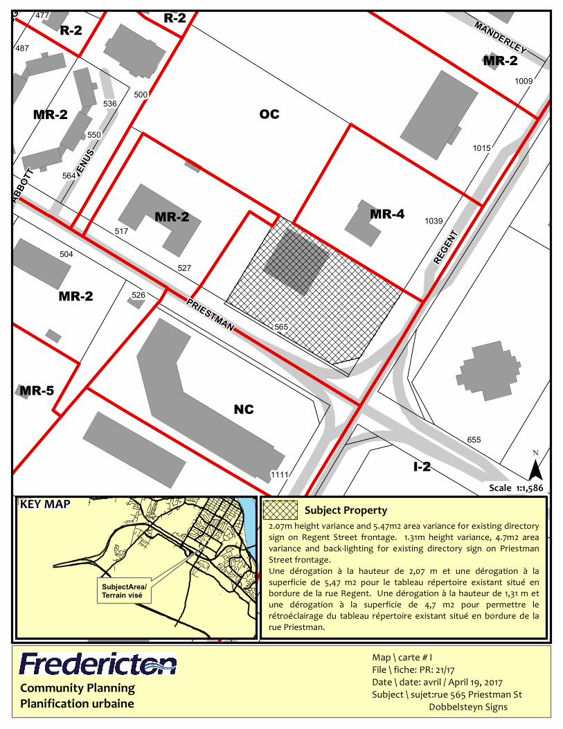
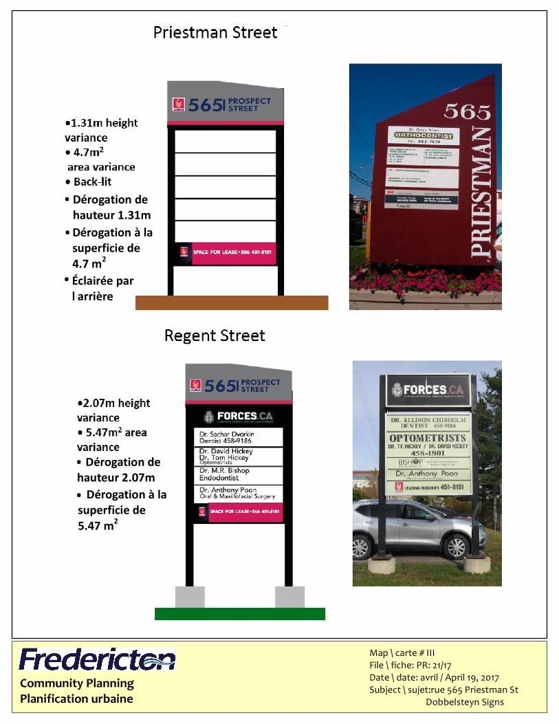
2.07m height variance and 5.47m2 area variance for existing directorysign on Regent Street frontage. 1.31m height variance, 4.7m2 areavariance and back-lighting for existing directory sign on PriestmanStreet frontage.Une dérogation à la hauteur de 2,07 m et une dérogation à lasuperficie de 5,47 m2 pour le tableau répertoire existant situé enbordure de la rue Regent. Une dérogation à la hauteur de 1,31 m etune dérogation à la superficie de 4,7 m2 pour permettre lerétroéclairage du tableau répertoire existant situé en bordure de larue Priestman.
Community PlanningPlanification urbaine
Map \ carte # IIFile \ fiche: PR: 21/17Date \ date: avril / April 19, 2017Subject \ sujet:rue 565 Priestman St Dobbelsteyn Signs
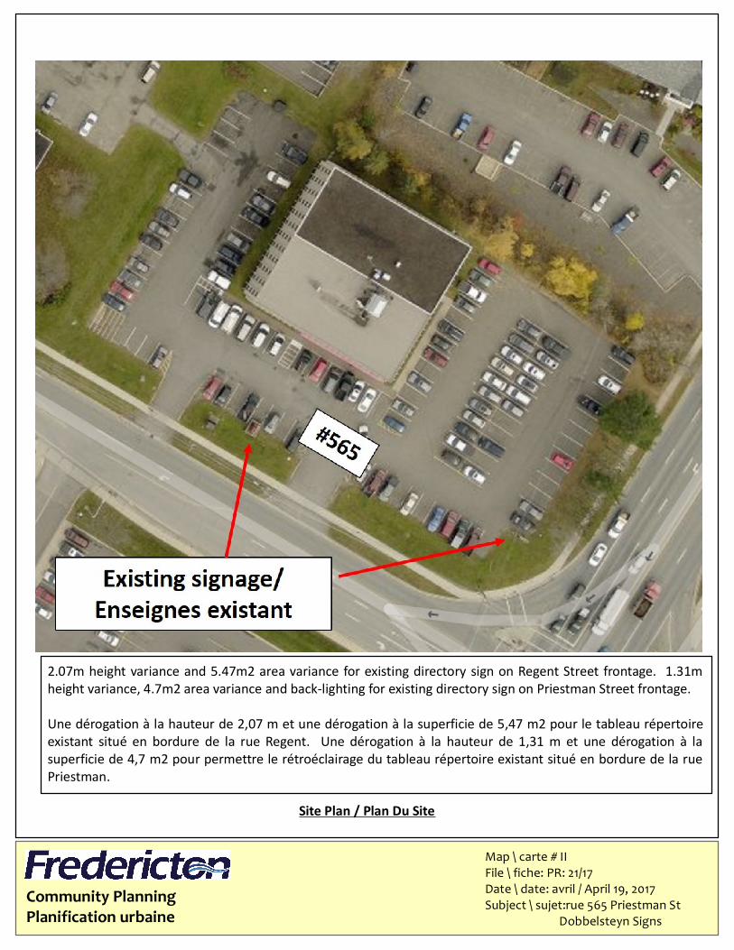
Site Plan / Plan Du Site
2.07m height variance and 5.47m2 area variance for existing directory sign on Regent Street frontage. 1.31mheight variance, 4.7m2 area variance and back-lighting for existing directory sign on Priestman Street frontage.Une dérogation à la hauteur de 2,07 m et une dérogation à la superficie de 5,47 m2 pour le tableau répertoireexistant situé en bordure de la rue Regent. Une dérogation à la hauteur de 1,31 m et une dérogation à lasuperficie de 4,7 m2 pour permettre le rétroéclairage du tableau répertoire existant situé en bordure de la ruePriestman.
Community PlanningPlanification urbaine
Map \ carte # IIIFile \ fiche: PR: 21/17Date \ date: avril / April 19, 2017Subject \ sujet:rue 565 Priestman St Dobbelsteyn Signs
Dérogation de hauteur 1.31mDérogation à la superficie de 4.7 m2Éclairée parl’arrière
.
.
.
Dérogation de hauteur 2.07m. Dérogation à la superficie de 5.47 m2.
231
546 -
Church
Parking Garage
149
Old Burial Grounds
G.S.J.H.S.
S.M.T.
504
520
81
551
140
131500
522 532
218
544
229
568204
221
582572
568
215
590
582
209
575
531
562
551 561575
527
542 550
230203
120
95
650
198
614
224554
512
612
99
527
568560
541
550540
658
614618
634630
624
101
186
100
120
180
679
162170
154 641
573
142
579
652
632
620
63591
665
546
535
533
83-
130 595-593
79-87
580
544 556
578
552560
555
644
I-1
MX-1
TP-2
MX-2
OC
OC
CCI
CC
TP-4
TP-4
TP-6
KING
REGE
NT
BARK
ER HO
USE
CHARLOTTE
BRUNSWICK
CARL
ETON
GEORGE
Community PlanningPlanification urbaine
Map \ carte # IFile \ fiche: PR: 22/17Date \ date: avril / April 19, 2017Subject \ sujet: rue 562 Brunswick St Heather Hughes c/o 030822 NB Ltd.
KEY MAP¯
1:1,500Scale
Subject Property
SubjectArea/Terrain visé
1.9 metre height variance and 5 space parking variance to permitconstruction of a new building.Dérogation de hauteur de 1.9 m nécessaire. dérogation requisepour 5 places de stationnement pour permettre la constructiond'une nouvelle bâtiment.
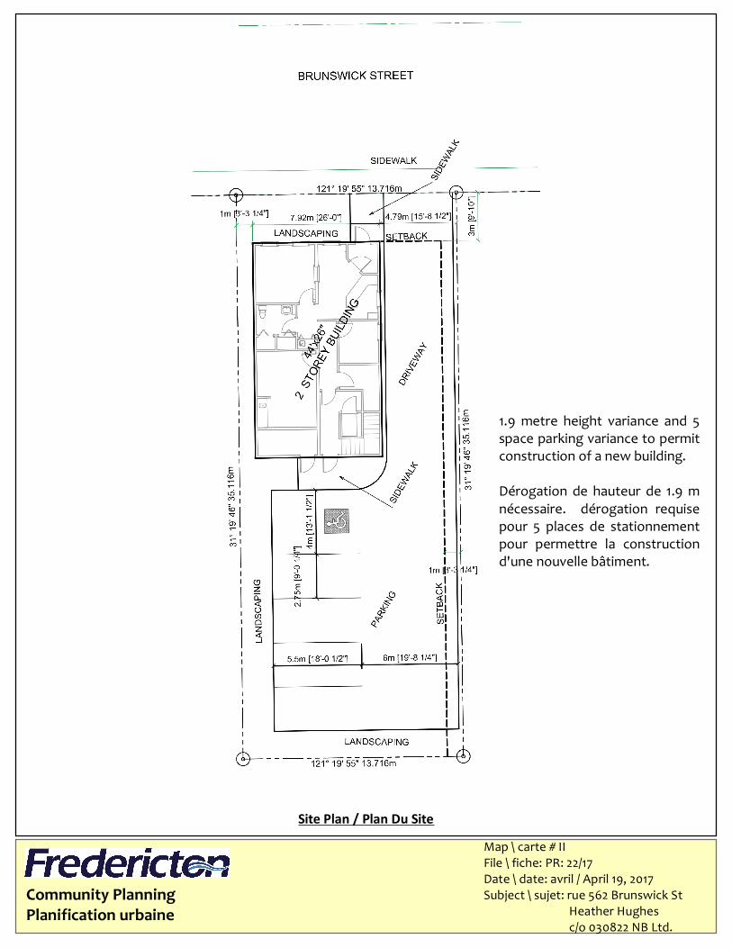
Community PlanningPlanification urbaine
Site Plan / Plan Du SiteMap \ carte # IIFile \ fiche: PR: 22/17Date \ date: avril / April 19, 2017Subject \ sujet: rue 562 Brunswick St Heather Hughes c/o 030822 NB Ltd.
1.9 metre height variance and 5space parking variance to permitconstruction of a new building.Dérogation de hauteur de 1.9 mnécessaire. dérogation requisepour 5 places de stationnementpour permettre la constructiond'une nouvelle bâtiment.
Community PlanningPlanification urbaine
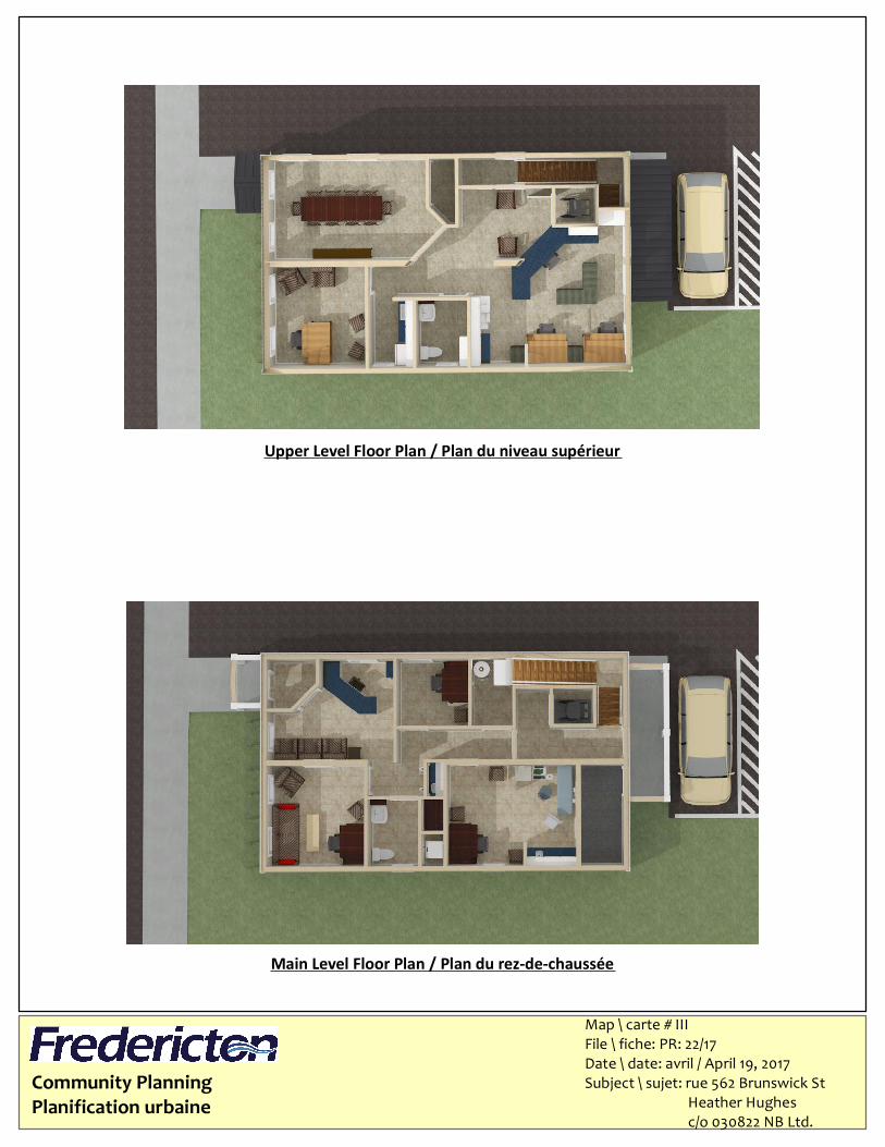
Main Level Floor Plan / Plan du rez-de-chaussée
Map \ carte # IIIFile \ fiche: PR: 22/17Date \ date: avril / April 19, 2017Subject \ sujet: rue 562 Brunswick St Heather Hughes c/o 030822 NB Ltd.
Upper Level Floor Plan / Plan du niveau supérieur
Community PlanningPlanification urbaine
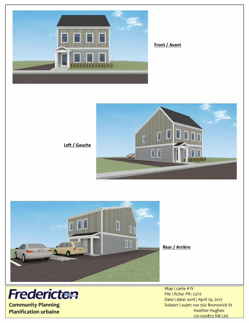
Map \ carte # IVFile \ fiche: PR: 22/17Date \ date: avril / April 19, 2017Subject \ sujet: rue 562 Brunswick St Heather Hughes c/o 030822 NB Ltd.
Front / Avant
Left / Gauche
Rear / Arrière