Embed Size (px)
Citation preview
W hen it comes to the design of utility installations, few things move at the speed of
telecom technology—particularly in an area like metropolitan Phoenix, in which growth has rebounded nicely to pre-recession rates. The ongoing demand for standard utility work, coupled with a push to bring broadband and fiber optic network service to businesses and residents in the Valley, has given a competitive edge to companies that can provide design services at an equally brisk pace. With that goal in mind, BPG Designs has opted to augment its survey effort with mobile mapping via a Topcon IP-S3 LiDAR scanner to
streamline the initial facet of its design process. Doing so has netted some truly impressive results, including one in which a long-term project’s expected duration has already been reduced by at least three years. A great rule of thumb: when you’re measuring production savings in years, you’ve found a solution that works.
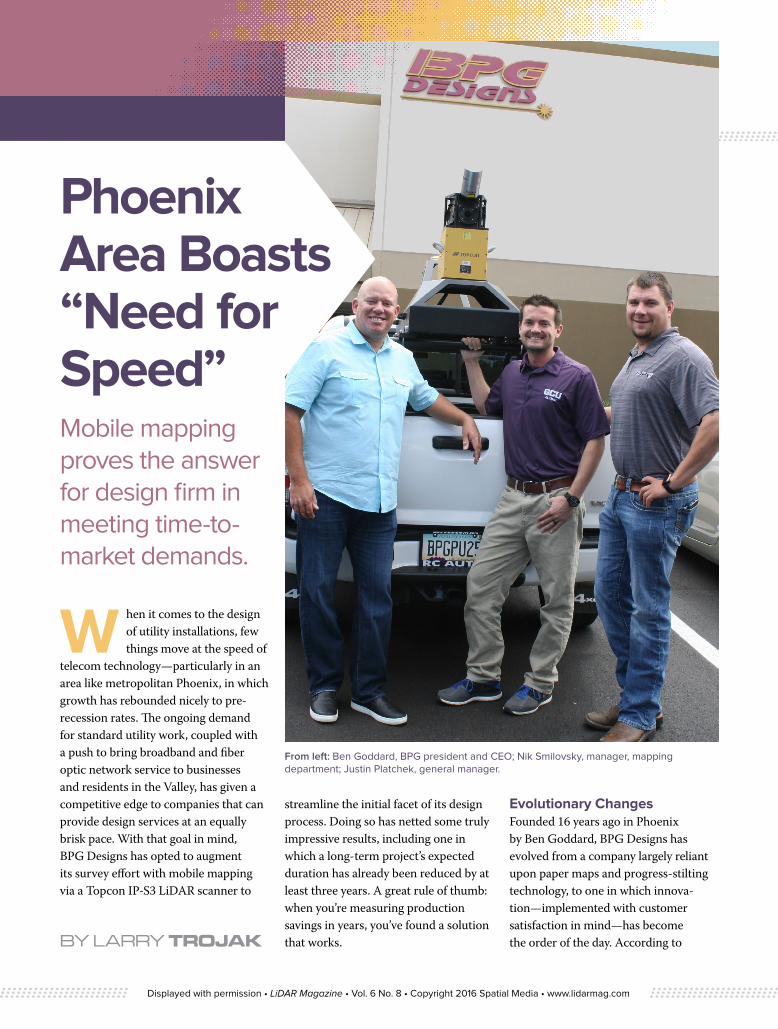
Evolutionary ChangesFounded 16 years ago in Phoenix by Ben Goddard, BPG Designs has evolved from a company largely reliant upon paper maps and progress-stilting technology, to one in which innova-tion—implemented with customer satisfaction in mind—has become the order of the day. According to BY LARRY TROJAK
Mobile mapping proves the answer for design firm in meeting time-to-market demands.
From left: Ben Goddard, BPG president and CEO; Nik Smilovsky, manager, mapping department; Justin Platchek, general manager.
Phoenix Area Boasts “Need for Speed”
Displayed with permission • LiDAR Magazine • Vol. 6 No. 8 • Copyright 2016 Spatial Media • www.lidarmag.com
Nik Smilovsky, manager of the firm’s mapping department, Goddard’s ability to see the possibilities in new and evolv-ing technology, has helped drive the company’s steady, impressive growth.
“When Ben started BPG in 2000, he did so with a dozen or so employees and a vision,” said Smilovsky. “We currently have over 100 people, each of whom is encouraged to grow and develop their professional skills while, at the same time, working to improve their lives. One of Ben’s initial pushes involved utilizing geospatial technology—at the time, a Sokkia total station—to help move his telecom clients away from things like hand-drawn paper maps and into a 21st century environment. Much of what we are able to do today is a result of those efforts.”
The typical BPG project can differ greatly, from something as simple as utility work being performed in a pit, to designing cable runs that can stretch up to 90 miles. Similarly, the company offers its clients a robust package of
capabilities, offering everything from a detailed map of the proposed project to construction infrastructure work itself.
“We are a design-build company in every sense of the word,” said Goddard. “Part of our appeal to a potential client is
the fact that we can literally take a project from square one in project management, through data collection, into planning, and on to actual construction. A good deal of our success to date is because of how robust our capabilities are.”
Group ThinkingTo maximize the effectiveness of that design-build capability, BPG has assembled an organizational structure in which any (or all) of four separate groups—mapping, design, construction and infrastructure—can be called upon to help achieve its customer’s goals. Subgroups also play a key role, accord-ing to Smilovsky.
“Within our 20-person strong mapping group—in which we do everything from mapping of utilities and assets to survey to 3-D mobile mapping, even the processing of unmanned aerial vehicle (UAV) data—we have three smaller teams,” he said. “We have units dedicated to data collection, data
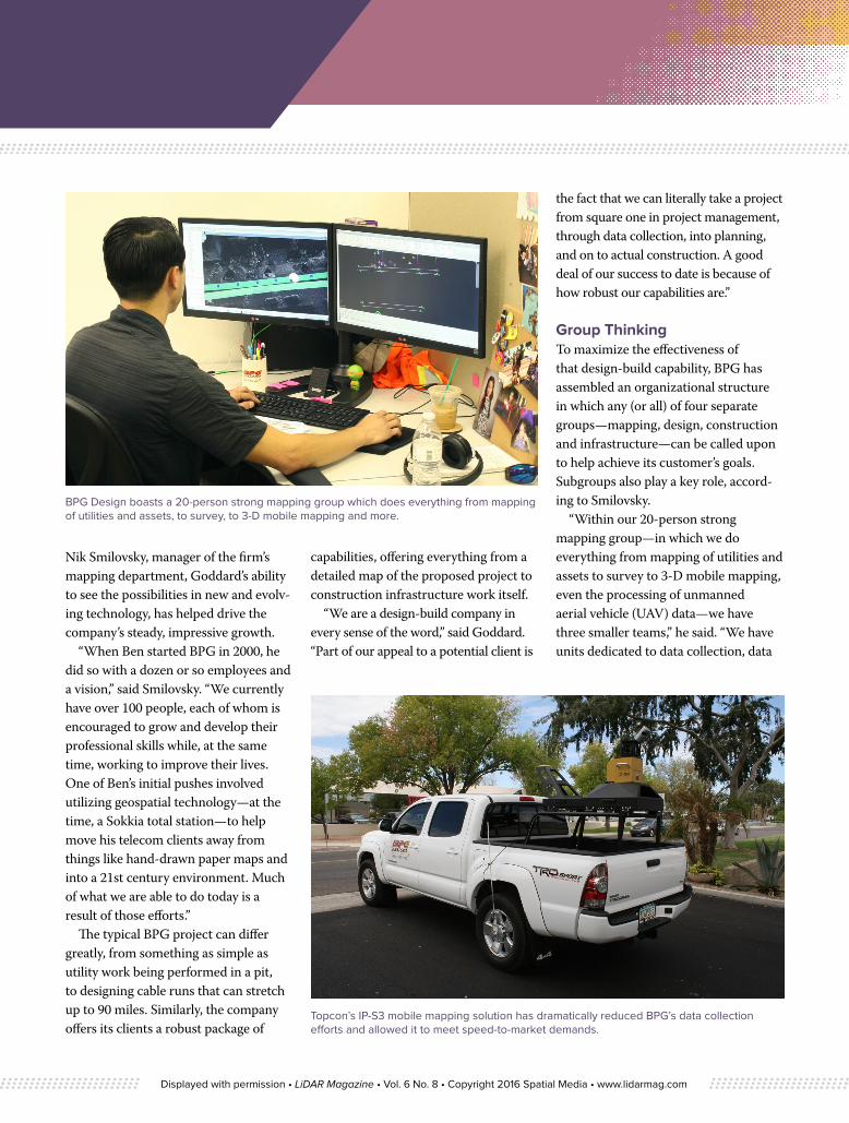
BPG Design boasts a 20-person strong mapping group which does everything from mapping of utilities and assets, to survey, to 3-D mobile mapping and more.
Topcon’s IP-S3 mobile mapping solution has dramatically reduced BPG’s data collection efforts and allowed it to meet speed-to-market demands.
Displayed with permission • LiDAR Magazine • Vol. 6 No. 8 • Copyright 2016 Spatial Media • www.lidarmag.com

Point Cloud view of Virtual Surveying on curb-breakline features for topography extraction
extraction and general mapping. So we are well-positioned to not only collect information, we can distill it and then either hand the resultant product to the client directly or to our own designs department for further work.”
BPG differs from many design engineering firms in that their construc-tion group can, if required to do so, bring their designs to life. In addition, after the infrastructure is in place, their technologies group can handle tasks such as fiber-optic splicing, structured cabling, copper termination, etc.
“This company is proud of the fact that we can take an idea, design it, build it and turn it over to our customer, then back that up with tests to ensure they are up and running smoothly,” said Smilovsky.
Mapping on the MoveDiverse though their workload might be, virtually every BPG project starts with a mapping effort and it was improvement in this area—and the fact that the bulk of their work was trending towards
telecom—that drove Goddard in 2014 to begin looking toward a LiDAR-based mobile mapping solution.
“We needed a way to gather huge amounts of data quickly—one of the main selling points of LiDAR scanning technology,” said Goddard. “Everything in telecom is about speed-to-market—everyone wants it ‘yesterday’ and if you can’t produce they’ll find someone who can. We were looking for a way to cut down the time frame on deliverables to our customers and felt that adding a mobile mapping capability could help tremendously in that regard. We first purchased a Topcon IP-S2—which we still use regularly—but recently added the smaller, lighter, more powerful IP-S3 to our lineup. The technology proved to be a perfect fit.”
Case in point: the massive fiber-to-home effort mentioned earlier. According to Smilovsky, while they’ve already been involved in that project for about two years, gathering that data the traditional way would easily have taken
five years. He added that the Topcon scanner has laid the groundwork for some other truly impressive stats as well.
“In the last three years, we have driven over 14,000 miles collecting and processing LiDAR data,” he said. “From that data, we have extracted over 38,000 cable pedestals, 2,000 aerial poles, 21,000 individual businesses and more than 75,000 miles of line work. If you take those kinds of numbers and start to think in terms of ‘boots on the ground,’ that is, what it would take from a manual survey perspective, it becomes an almost unimaginable task. In those terms alone, the mobile mapping solution has been irreplaceable.”
No ComparisonBecause of the variables involved, quantifying the impact a new technol-ogy or approach has on an operation is often difficult. However, in a large build BPG is doing in the Scottsdale/Paradise Valley area northeast of Phoenix, they set out to do just that and Smilovsky
Displayed with permission • LiDAR Magazine • Vol. 6 No. 8 • Copyright 2016 Spatial Media • www.lidarmag.com

Photo view of intersection for Van Ness Road (CA) sign inventory
Dual view of integrated photography and point cloud for Van Ness Road (CA) sign inventory
said the results have been head-turning.“This particular project involves about
75 miles of design for underground work, overhead lines and businesses connections,” he said. “Using the IP-S3, two men were able to collect the entire 75-mile job in two days—that represents about 40 hours for collection. Then, using Topcon Mobile Mapping Office,
the IP-S3’s proprietary software, it took one man a week to process it, bringing the total time invested to about 80 hours. To align the data, we manually shot some 735 brass-cap GPS monu-ments, which took one man two days, bringing the total to about 100 hours to have all the data collected, processed, and output.”
By comparison, he said, their surveyors can generally only do about 350 feet/hour. Given that pace, manually survey-ing that full 75 mile (396,000 foot) run, would take about 1,100 hours. “Even working ten-hour days, that’s 110 days of survey versus four days using the Topcon mobile mapping solution,” said Smilovsky. “At the outset of the project,
Displayed with permission • LiDAR Magazine • Vol. 6 No. 8 • Copyright 2016 Spatial Media • www.lidarmag.com

Point Cloud birds eye view of Van Ness Road (CA) sign inventory
we began delivering three miles a week of actual design to our customer. It’s tough to argue with that kind of production.”
An Arc and an OrbitWhile getting the data collected in an impressive time-frame is key, that effort would all be for naught if BPG was unable to process and deliver the product to its clients in an equally effec-tive manner. To that end, said Smilovsky, the company has invested heavily in the software side of the equation as well.
“The backbone of our data processing effort is Esri’s ArcGIS Server which, through its SQL capability, allows for activity such as 2-D analysis, creation of maps, hosting of interactive maps, and so on. To allow customers to easily extract the specific assets they need, we’ve had great results using Orbit GT. Ten years ago, a common approach to getting information to a client would have involved giving them PDFs of what we collected. Instead, capitalizing on Orbit GT’s online publishing strengths, we now create unique, interactive websites for our clients at which they can log in and see everything—the
colors, the layers, the data, etc.—and download any files they need.”
Streamlining the ProcessTo underscore just how much of an improvement the mobile mapping solu-tion offers from a workflow perspective, Justin Platcheck, BPG’s general manager also cites the drawing/PDF process that was, at one time, the standard.
“Once we would send the client a drawing, they would assign it to one of their field checkers, he would go out to the site, look at it, make his notes, come back in, email any changes over, and we would make the change. Given people’s schedules, that back-and-forth could easily become a three-week process.”
By comparison, he said, using nothing more than their phone, their tablet, or a laptop, that effort has been streamlined dramatically. Today, a customer can go in and, for example, make a note saying they no longer like the trajectory of a specific route, and offer an alternative by simply drawing it out on the app.
“We get the info from them and within minutes—or, at most, hours—we’ve updated the file and returned it
to the client,” said Platchek. “They no longer actually have to physically go out to the field—the LiDAR data allows them to see it as they would in real life. So, not only have we achieved those much-needed speed-to-market objec-tives, our customers are cutting costs and liability by not being on the road.”
“We pride ourselves in our ability to pick the right tool for the job, and having a pair of mobile mapping systems in our inventory is huge for us” adds Smilovsky. “It has helped us not only meet a growing workload in this area, but also expand with a satellite office just outside of San Diego. While it’s only a matter of time until this technology becomes the ‘standard’ way of doing things for our industry, we always enjoy being ahead of the curve, and this definitely puts us there.” ◾
Larry Trojak of Minnesota-based Trojak Communications, is a freelance marketing content specialist. He writes extensively for the geopositioning, utility, aggregate processing, recycling, construction, and
Displayed with permission • LiDAR Magazine • Vol. 6 No. 8 • Copyright 2016 Spatial Media • www.lidarmag.com