Embed Size (px)
Citation preview

PHASE I ENVIRONMENTAL SITE ASSESSMENT REPORT
ASSET NUMBER 10313000988 0 Golfers Way Chula, Georgia 31793 November 15, 2011 Partner Project No. 11-81719.1 FDIC Asset No. 10313000988 Prepared for THE FDIC AS RECEIVER FOR TIFTON BANKING
COMPANY (FIN# 10313) 7777 Baymeadows Way West Jacksonville, Florida 32256

1990 E. Grand Ave., Ste. 100, El Segundo, CA 90245 ◊ Phone 800-419-4923 ◊ Fax 866-928-7418
November 15, 2011 The FDIC as Receiver for Tifton Banking Company (FIN# 10313) 7777 Baymeadows Way West Jacksonville, Florida 32256 Subject: Phase I Environmental Site Assessment
0 Golfers Way Chula, Georgia 31793 Partner Project No. 11-81719.1
Partner Engineering and Science, Inc. (Partner) is pleased to provide the results of the Phase I Environmental Site Assessment (Phase I ESA) report of the abovementioned address (the “subject property”). This assessment was performed in general conformance with the scope and limitations as detailed in the ASTM Practice E1527-05 Standard Practice for Environmental Site Assessments: Phase I Environmental Site Assessment Process and the Statement of Work: Federal Deposit Insurance Corporation (FDIC) Phase I Environmental Site Assessment.
This assessment included a site reconnaissance as well as research and interviews with representatives of the public, property ownership, site manager, and regulatory agencies. An assessment was made, conclusions stated, and recommendations outlined.
We appreciate the opportunity to provide environmental services to The FDIC as Receiver for Tifton Banking Company (FIN# 10313). If you have any questions concerning this report, or if we can assist you in any other matter, please contact me at (310) 615-4500.
Sincerely, Jenny Redlin, REA Relationship Manager

Phase I Environmental Site Assessment Project No. 11-81719.1 November 15, 2011 Page i
EXECUTIVE SUMMARY
Partner Engineering and Science, Inc. (Partner) has performed a Phase I Environmental Site Assessment (ESA) in general accordance with the scope of work and limitations of ASTM Standard Practice E1527-05, the Environmental Protection Agency Standards and Practices for All Appropriate Inquiries (AAI) (40 CFR Part 312) and set forth by and the Statement of Work: FDIC Phase I Environmental Site Assessment for the property located at 0 Golfers Way in the City of Chula, Tift County, Georgia (the “subject property”). The Phase I Environmental Site Assessment is designed to provide The FDIC as Receiver for Tifton Banking Company (FIN# 10313) with an assessment concerning environmental conditions (limited to those issues identified in the report) as they exist at the subject property.
Property Description
The subject property is located on the northwest side of Club View Drive within a mixed commercial, agricultural and residential area of Chula, Georgia. Please refer to the table below for further description of the subject property:
Address: 0 Golfers Way, Chula, Georgia 31793
Assessor’s Parcel Number (APN): 0027 019E
Nature of Use: Pecan Orchard
Number of Buildings: None
Number of Floors: Not Applicable
Type of Construction: Not Applicable
Building Square Footage (SF): Not Applicable
Land Acreage (Ac): 6.11 Ac
Date of Construction: Not Applicable
Current Tenants: None
The subject property is currently an un-groomed pecan orchard.
According to available historical sources, the subject property has been a pecan orchard since at least 1937.
The immediately surrounding properties consist of undeveloped land and a cemetery to the north; Club View Drive followed by undeveloped land and golf course to the south; Club View Drive followed by golf course to the east; and Highway 41 followed by railroad tracks and agricultural land to the west.

Phase I Environmental Site Assessment Project No. 11-81719.1 November 15, 2011 Page ii
According to the topographic map, the depth and direction of groundwater in the vicinity of the subject property is inferred to be present at approximately greater than 20 feet below ground surface (bgs) and flow toward the east.
Findings
A recognized environmental condition (REC) refers to the presence or likely presence of any hazardous substance or petroleum product on a property under conditions that indicate an existing release, a past release, or a material threat of a release of any hazardous substances or petroleum products into structures on the property or into the ground, groundwater, or surface water of the property. The term REC includes hazardous substances and petroleum products even under conditions that might be in compliance with laws. The term is not intended to include "de minimis" conditions that do not present a threat to human health and/or the environment and that would not be subject to an enforcement action if brought to the attention of appropriate governmental agencies. The following was identified during the course of this assessment:
Partner did not identify any recognized environmental conditions during the course of this assessment.
A historical recognized environmental condition (HREC) refers to an environmental condition which would have been considered a REC in the past, but which is no longer considered a REC based on subsequent assessment or regulatory closure. The following was identified during the course of this assessment:
Partner did not identify any historical recognized environmental conditions during the course of this assessment.
Special Resources are defined by Statement of Work: FDIC Phase I Environmental Site Assessment (ESA), dated February 2006, as resources with natural, cultural, recreational, or scientific value of special significance.
Partner did not identify the presence or likely presence of any Special Resource that may restrict the use of or affect the marketability or value of the subject property.
An environmental issue refers to environmental concerns identified by Partner, which do not qualify as RECs; however, require discussion. The following was identified during the course of this assessment:
The subject property has been utilized for agricultural purposes since at least 1937. There is a potential that agricultural chemicals such as pesticides, herbicides, and fertilizers may have been used at the subject property. Depending on the planned use of the subject property, the owner or the developer of the subject property should evaluate potential environmental concerns pertaining to the agricultural uses.

Phase I Environmental Site Assessment Project No. 11-81719.1 November 15, 2011 Page iii
Conclusions, Opinions and Recommendations
Partner has performed a Phase I Environmental Site Assessment in conformance with the scope and limitations of ASTM Practice E1527-05, AAI, and the Statement of Work: FDIC Phase I ESA of 0 Golfers Way in the City of Chula, Tift County, Georgia (the “subject property”). Any exceptions to or deletions from this practice are described in Section 1.5 of this report.
This assessment has revealed no evidence of recognized environmental conditions; however, an environmental issue in connection with the subject property was noted. Based on the conclusions of this assessment, Partner recommends no further investigation of the subject property at this time.

Phase I Environmental Site Assessment Project No. 11-81719.1 November 15, 2011 Page iv
TABLE OF CONTENTS
1.0 INTRODUCTION ......................................................................................................................... 1
1.1 Purpose .......................................................................................................................................... 1 1.2 Scope of Work .............................................................................................................................. 1 1.3 Limitations .................................................................................................................................... 2 1.4 User Reliance ................................................................................................................................ 2 1.5 Limiting Conditions ...................................................................................................................... 2
2.0 SITE DESCRIPTION .................................................................................................................... 4
2.1 Site Location and Legal Description ............................................................................................. 4 2.2 Current Property Use .................................................................................................................... 4 2.3 Current Use of Adjoining Properties ............................................................................................ 5 2.4 Physical Setting Sources ............................................................................................................... 5
2.4.1 Topography ........................................................................................................................... 5 2.4.2 Hydrology ............................................................................................................................. 5 2.4.3 Geology/Soils ........................................................................................................................ 5 2.4.4 Flood Zone Information ........................................................................................................ 6 2.4.5 Undeveloped Coastal Zones / Coastal Barrier Units ............................................................. 6 2.4.6 Undeveloped Sole Source Aquifers ...................................................................................... 6
3.0 HISTORICAL INFORMATION ................................................................................................. 7
3.1 Aerial Photograph Review ............................................................................................................ 7 3.2 Sanborn Fire Insurance Maps ....................................................................................................... 8 3.3 City Directories ............................................................................................................................. 8 3.4 Historical Topographic Maps ........................................................................................................ 9
4.0 REGULATORY RECORDS REVIEW ..................................................................................... 10
4.1 Regulatory Agencies ................................................................................................................... 10 4.1.1 State Department ................................................................................................................. 10 4.1.2 Health Department .............................................................................................................. 10 4.1.3 Fire Department .................................................................................................................. 10 4.1.4 Air Protection Branch ......................................................................................................... 11 4.1.5 Watershed Protection Branch .............................................................................................. 11 4.1.6 Agency for Toxic Substances and Disease Registry ........................................................... 11 4.1.7 Assessor’s Department ........................................................................................................ 11 4.1.8 Zoning Department ............................................................................................................. 11 4.1.9 Oil & Gas Exploration ........................................................................................................ 12 4.1.10 Archeological Resources/Historic Sites and Structures ...................................................... 12 4.1.11 National Natural Landmarks ............................................................................................... 12
4.2 Mapped Database Records Search .............................................................................................. 12
5.0 USER PROVIDED INFORMATION AND INTERVIEWS ................................................... 16
5.1 Interviews .................................................................................................................................... 17 5.1.1 Interview with Owner ......................................................................................................... 17 5.1.2 Interview with Report User ................................................................................................. 17 5.1.3 Interview with Key Site Manager ....................................................................................... 17 5.1.4 Interviews with Past Owners, Operators and Occupants .................................................... 17

Phase I Environmental Site Assessment Project No. 11-81719.1 November 15, 2011 Page v
5.1.5 Interview with Others .......................................................................................................... 17 5.2 User Provided Information .......................................................................................................... 17
5.2.1 Title Records ....................................................................................................................... 17 5.2.2 Environmental Liens or Activity and Use Limitation ......................................................... 17 5.2.3 Specialized Knowledge ....................................................................................................... 18 5.2.4 Commonly Known or Reasonably Ascertainable Information ........................................... 18 5.2.5 Valuation Reduction for Environmental Issues .................................................................. 18 5.2.6 Previous Reports and Other Provided Documentation ....................................................... 18
6.0 SITE RECONNAISSANCE ........................................................................................................ 19
6.1 General Site Characteristics ........................................................................................................ 19 6.2 Potential Environmental Hazards ................................................................................................ 20 6.3 Non-ASTM Services ................................................................................................................... 21
6.3.1 Asbestos-Containing Materials (ACMs) ............................................................................. 21 6.3.2 Lead-Based Paint (LBP) ..................................................................................................... 21 6.3.3 Radon .................................................................................................................................. 21 6.3.4 Lead in Drinking Water ...................................................................................................... 21 6.3.5 Wetlands ............................................................................................................................. 21 6.3.6 Endangered or Threatened Species or Habitats .................................................................. 22 6.3.7 Undeveloped Floodplains/Wild and Scenic Rivers ............................................................. 22 6.3.8 Areas of Scientific Significance .......................................................................................... 22 6.3.9 Wilderness Area .................................................................................................................. 22 6.3.10 Recreational Areas .............................................................................................................. 22 6.3.11 Additional Hazards and Nuisances ..................................................................................... 23
6.4 Adjacent Property Reconnaissance ............................................................................................. 23
7.0 FINDINGS AND CONCLUSIONS ............................................................................................ 24
8.0 SIGNATURES OF ENVIRONMENTAL PROFESSIONALS ............................................... 26
9.0 REFERENCES ............................................................................................................................. 27
FIGURES Figure 1 Site Location Map Figure 2 Topographic Map Figure 3 Site Plan APPENDICES Appendix A Site Photographs Appendix B Historical/Regulatory Documentation B1 Aerial Photographs
B2 Regulatory Agency Responses/Requests B3 Client-Provided Documentation
B4 Record of Communication B5 Title/Lien Search Records
Appendix C Regulatory Database Report Appendix D Qualifications/Insurance

Phase I Environmental Site Assessment Project No. 11-81719.1 November 15, 2011 Page 1
1.0 INTRODUCTION
Partner has performed a Phase I ESA in general conformance with the scope and limitations of ASTM Standard Practice E1527-05, AAI, and the Statement of Work: FDIC Phase I ESA for the property located at 0 Golfers Way in the City of Chula, Tift County, Georgia (the “subject property”). Any exceptions to, or deletions from, this scope of work are described in the report.
1.1 Purpose
The purpose of this ESA is to identify existing or potential Recognized Environmental Conditions (as defined by ASTM Standard E-1527-05) affecting the subject property that: 1) constitute or result in a material violation or a potential material violation of any applicable environmental law; 2) impose any material constraints on the operation of the subject property or require a material change in the use thereof; 3) require clean-up, remedial action or other response with respect to Hazardous Substances or Petroleum Products on or affecting the subject property under any applicable environmental law; 4) may affect the value of the subject property; and 5) may require specific actions to be performed with regard to such conditions and circumstances. The information contained in the ESA Report will be used by Client to: 1) evaluate its legal and financial liabilities for transactions related to foreclosure, purchase, sale, loan origination, loan workout or seller financing; 2) evaluate the subject property’s overall development potential, the associated market value and the impact of applicable laws that restrict financial and other types of assistance for the future development of the subject property; and/or 3) determine whether specific actions are required to be performed prior to the foreclosure, purchase, sale, loan origination, loan workout or seller financing of the subject property.
This ESA was performed to permit the User to satisfy one of the requirements to qualify for the innocent landowner, contiguous property owner, or bona fide prospective purchaser limitations on scope of Comprehensive Environmental Response, Compensation and Liability Act (CERCLA) (42 U.S.C. §9601) liability (hereinafter, the “landowner liability protections,” or “LLPs”). ASTM Standard E-1527-05 constitutes “all appropriate inquiry into the previous ownership and uses of the property consistent with good commercial or customary practice” as defined at 42 U.S.C. §9601(35)(B).
1.2 Scope of Work
The scope of work for this ESA is in general accordance with the requirements of ASTM Standard E 1527-05, AAI, and the Statement of Work: FDIC Phase I ESA. This assessment included: 1) a property and adjacent site reconnaissance; 2) interviews with key personnel; 3) a review of historical sources; 4) a review of regulatory agency records; and 5) a review of a regulatory database report provided by a third-party vendor.
If requested by Client, this report may also include the identification, discussion of, and/or limited sampling of asbestos-containing materials (ACMs), lead-based paint (LBP), and/or radon.

Phase I Environmental Site Assessment Project No. 11-81719.1 November 15, 2011 Page 2
1.3 Limitations
Partner warrants that the findings and conclusions contained herein were accomplished in accordance with the methodologies set forth in the Scope of Work. These methodologies are described as representing good commercial and customary practice for conducting an ESA of a property for the purpose of identifying recognized environmental conditions. There is a possibility that even with the proper application of these methodologies there may exist on the subject property conditions that could not be identified within the scope of the assessment or which were not reasonably identifiable from the available information. Partner believes that the information obtained from the record review and the interviews concerning the subject property is reliable. However, Partner cannot and does not warrant or guarantee that the information provided by these other sources is accurate or complete. The conclusions and findings set forth in this report are strictly limited in time and scope to the date of the evaluations. The conclusions presented in the report are based solely on the services described therein, and not on scientific tasks or procedures beyond the scope of agreed-upon services or the time and budgeting restraints imposed by the Client. No other warranties are implied or expressed.
Some of the information provided in this report is based upon personal interviews, and research of available documents, records, and maps held by the appropriate government and private agencies. This report is subject to the limitations of historical documentation, availability, and accuracy of pertinent records and the personal recollections of those persons contacted.
This practice does not address requirements of any state or local laws or of any federal laws other than the all appropriate inquiry provisions of the LLPs. Further, this report does not intend to address all of the safety concerns, if any, associated with the subject property.
Environmental concerns, which are beyond the scope of a Phase I ESA as defined by ASTM include the following: ACMs, LBP, radon, and lead in drinking water. These issues may affect environmental risk at the subject property and may warrant discussion and/or assessment; however, are considered non-scope issues. If specifically requested by the Client, these non-scope issues are discussed in Section 6.3.
1.4 User Reliance
All reports, both verbal and written, are for the sole use and benefit of The FDIC as Receiver for Tifton Banking Company (FIN# 10313). This report has no other purpose and may not be relied upon by any other person or entity.
1.5 Limiting Conditions
The findings and conclusions contain all of the limitations inherent in these methodologies that are referred to in ASTM E1527-05.
Specific limitations and exceptions to this ESA are more specifically set forth below:

Phase I Environmental Site Assessment Project No. 11-81719.1 November 15, 2011 Page 3
Interviews with past or current owners, operators and occupants were not reasonably ascertainable and thus constitute a data gap. Based on information obtained from other historical sources (as discussed in Section 3.0), this data gap is not expected to alter the findings of this assessment.
Partner requested information relative to deed restrictions and environmental liens, a title search, and completion of a pre-survey questionnaire from the Report User. This information was not provided at the time of the assessment.

Phase I Environmental Site Assessment Project No. 11-81719.1 November 15, 2011 Page 4
2.0 SITE DESCRIPTION
2.1 Site Location and Legal Description
The subject property is located on the northwest side of Club View Drive. Please refer to the table below for further description of the subject property:
Address: 0 Golfers Way
Assessor’s Parcel Number (APN): 0027 019E
Nature of Use: Pecan Orchard
Number of Buildings: None
Number of Floors: Not Applicable
Type of Construction: Not Applicable
Building Square Footage (SF): Not Applicable
Land Acreage (Ac): 6.11 Ac
Date of Construction: Not Applicable
Current Tenants: None
According to the Tift County Assessor, the subject property is legally described as
“All that certain tract or parcel of land lying and being in Land Lot 64 of the 6th Land District of Tift County, Georgia, and being more particularly described 6.109 acres all according to that plat of survey entitled "Survey for The Hills of Sunsweet Section 11" prepared by Hampton & Associates Surveying Co. of Tifton, Georgia, on July 2, 2009, said plat being recorded in Plat Book 40, Page 125B, in the office of the Clerk of Tift Superior Court and being by reference incorporated herein.”
Ownership information was not available.
Please refer to Figure 1: Site Location Map, Figure 2: Topographic Map, Figure 3: Site Plan, and Appendix A: Site Photographs for the location and site characteristics of the subject property.
2.2 Current Property Use
The subject property is currently an un-groomed pecan orchard.
The subject property is designated for residential development by Tift County and is considered a legal use in its current configuration.
The subject property was not identified in the regulatory database report of Section 4.2.

Phase I Environmental Site Assessment Project No. 11-81719.1 November 15, 2011 Page 5
2.3 Current Use of Adjoining Properties
The subject property is located within a mixed commercial, agricultural and residential area of Chula, Georgia. During the vicinity reconnaissance, Partner observed the following land use on properties in the immediate vicinity of the subject property:
Immediately surrounding properties North: Undeveloped land and a cemetery
South: Club View Drive followed by undeveloped land and golf course (Golf Club of South Georgina at 3922 Highway 41 N)
East: Club View Drive followed by golf course (Golf Club of South Georgina at 3922 Highway 41 N)
West: Highway 41 followed by railroad tracks and agricultural land
No adjacent properties were identified in the regulatory database report of Section 4.2.
2.4 Physical Setting Sources
2.4.1 Topography
The United States Geological Survey (USGS), Chula, Georgia Quadrangle 7.5-minute series topographic map was reviewed for this ESA. According to the contour lines on the topographic map, the subject property is located at approximately 375 feet above mean sea level (MSL). The contour lines in the area of the subject property indicate the area is sloping gently toward the east. The subject property is depicted as undeveloped.
Please refer to Figure 2: Topographic Map.
2.4.2 Hydrology
According to topographic map interpretation, the direction of groundwater in the vicinity of the subject property is inferred to flow toward the east. The nearest surface water in the vicinity of the subject property is an unnamed pond located approximately 1,000 feet east-northeast of the subject property. No settling ponds, lagoons, surface impoundments, wetlands or natural catch basins were observed at the subject property during this assessment.
According to available information, the public water system is not available the subject property vicinity. Residents in this area have water wells on their property.
Information specific to the subject property regarding the depth to groundwater and direction of groundwater flow was not available for the subject area. However, according to information obtained from the topographic map, depth to the high water table is anticipated at greater than 20 feet below ground surface (bgs).
2.4.3 Geology/Soils
The subject property is located within the Coastal Plain geologic region of the state of Georgia which is an extensive, low-relief area that is bounded by the sea on one side and by some type of relatively high-relief province on the landward side. The geologic province of the coastal plain

Phase I Environmental Site Assessment Project No. 11-81719.1 November 15, 2011 Page 6
actually extends beyond the shoreline across the continental shelf. It is only during times of glacial melting and high sea level that much of the coastal plain is drowned.
Based on information obtained from the USDA Natural Resources Conservation Service Web Soil Survey online database, the subject property is mapped as Cowarts fine sandy loam. The Cowarts series consists of very deep, well drained and moderately well drained soils on ridge tops and side slopes on uplands of the Coastal Plain. They formed in loamy marine sediments. They are Slopes range from 1 to 60 percent.
2.4.4 Flood Zone Information
Partner performed a review of the Flood Insurance Rate Map, published by the Federal Emergency Management Agency (FEMA). According to Community Panel Number 13277C0100D, dated August 17, 1998, the subject property appears to be located in Zone X, an area located outside of the 100-year and 500-year flood plains.
2.4.5 Undeveloped Coastal Zones / Coastal Barrier Units
According to online mapping systems, the subject property is not located within a coastal barrier as designated by FEMA, the Department of the Interior (DOI) or the State Coastal Area Management Program.
2.4.6 Undeveloped Sole Source Aquifers
Based on a review of the Designated Sole Source Aquifers National Map published by the USEPA, the subject property is not located in a sole source aquifer recharge area.

Phase I Environmental Site Assessment Project No. 11-81719.1 November 15, 2011 Page 7
3.0 HISTORICAL INFORMATION
Partner obtained historical use information about the subject property from a variety of sources. A chronological listing of the historical data found is summarized in the table below:
Historical Use Information Period/Date Source Description/Use
1937-Present Aerial Photographs, Interviews, Previous Report Pecan Orchard
Potential environmental concerns were identified in association with the current or historic use of the subject property, as further discussed in Section 7.0.
3.1 Aerial Photograph Review
On October 22, 2011, Partner obtained available aerial photographs of the subject property and surrounding area from Environmental Data Resources, Inc (EDR). The aerial photographs were reviewed for indications of previous uses, as discussed below:
Date: 1937 Scale: 1”=476’
The subject property appears to be a planned orchard.
The adjacent properties to the north, east, and south appear to be developed with planned orchards. Highway 41 is present to the west beyond which is agricultural land.
Date: 1948 Scale: 1”=476’
Club View Drive (or its predecessor) appears to the south and east of the subject property. No other significant changes were noted from the previous photograph.
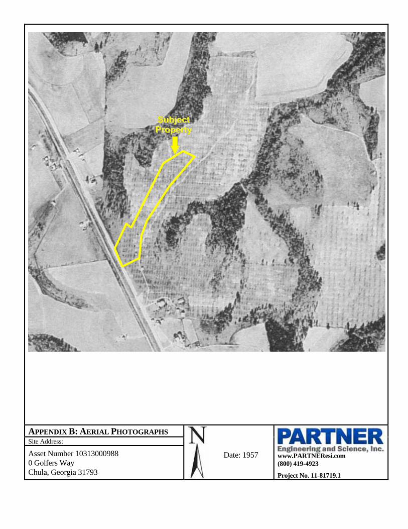
Date: 1957 Scale: 1”=476’
No significant changes were noted from the previous photograph.
Date: 1962 Scale: 1”=476’
No significant changes were noted from the previous photograph.
Date: 1969 Scale: 1”=950’
No significant changes were noted from the previous photograph.
Date: 1972 Scale: 1”=950’
No significant changes were noted from the previous photograph.
Date: 1988 Scale: 1”=950’
No significant changes were noted from the previous photograph.

Phase I Environmental Site Assessment Project No. 11-81719.1 November 15, 2011 Page 8
Date: 1993 Scale: 1”=604’
The adjacent properties to the east and south appear to be developed with portions of a golf course. The adjacent property to the north no longer appears to be used as an orchard. No other significant changes were noted from the previous photograph.
Date: 2005 Scale: 1”=604’
No significant changes were noted from the previous photograph.
Date: 2006 Scale: 1”=604’
No significant changes were noted from the previous photograph.
Date: 2007 Scale: 1”=604’
No significant changes were noted from the previous photograph.
Copies of aerial photographs are included in Appendix B of this report.
3.2 Sanborn Fire Insurance Maps
Sanborn maps were originally created in the late 1800s and early 1900s for assessing fire insurance liability in urbanized areas of the United States. These maps include detailed town and building information.
Partner reviewed Sanborn Fire insurance maps obtained from EDR’s collection on October 20, 2011. Sanborn map coverage was not available for the subject property.
3.3 City Directories
City directories have been produced for most urban and some rural areas since the late 1800s. The directories are generally not comprehensive and may contain gaps in time periods.
Partner reviewed historical city directories obtained from Tift County Library on October 26, 2011 for past names and businesses that were listed for the subject property and adjacent properties. The findings are presented in the following table:
City Directory Search for Golfers Way (Subject Property) Year(s) Occupant Listed 1949, 1956, 1963, 1970, 1982, 1997, 2000 and 2008
Street not identified in the research sources
Based on the city directory review, no environmentally sensitive listings were identified for the subject property address.
City Directory Search for Adjacent Properties Year(s) Occupant Listed 1949, 1956, 1963, 1970, 1982, 1997, 2000 and 2008
Addresses not identified in the research sources

Phase I Environmental Site Assessment Project No. 11-81719.1 November 15, 2011 Page 9
Based on the city directory review, no environmentally sensitive listings were identified for the adjoining property addresses.
3.4 Historical Topographic Maps
Historical topographic maps were not available at the time of the assessment. The historical use of the subject property was researched through other standard historical sources.

Phase I Environmental Site Assessment Project No. 11-81719.1 November 15, 2011 Page 10
4.0 REGULATORY RECORDS REVIEW
4.1 Regulatory Agencies
Partner contacted local agencies, such as environmental health departments, fire departments and building departments in order to determine any current and/or historic hazardous materials usage, storage and/or releases of hazardous substances on the subject property. Additionally, Partner researched information on the presence of activity and use limitations (AULs) at these agencies. As defined by ASTM E1527-05, AULs are the legal or physical restrictions or limitations on the use of, or access to, a site or facility: 1) to reduce or eliminate potential exposure to hazardous substances or petroleum products in the soil or groundwater on the subject property; or 2) to prevent activities that could interfere with the effectiveness of a response action, in order to ensure maintenance of a condition of no significant risk to public health or the environment. These legal or physical restrictions, which may include institutional and/or engineering controls (IC/ECs), are intended to prevent adverse impacts to individuals or populations that may be exposed to hazardous substances and petroleum products in the soil or groundwater on the property.
4.1.1 State Department
Partner requested records from the Georgia Department of Natural Resources – Environmental Protection Division (GEPD) on October 28, 2011 for the subject property. These records may contain evidence indicating current and/or historical hazardous materials usage, storage or releases, as well as the presence of underground storage tanks (USTs).
No records regarding hazardous materials use or the presence of AULs on the subject property were on file with the GEPD.
4.1.2 Health Department
Partner requested records from the Tift County Health Department (TCHD) on October 25, 2011 for the subject property. These records may contain evidence indicating current and/or historical hazardous materials usage, storage or releases, as well as the presence of USTs.
No records regarding hazardous materials use or the presence of AULs on the subject property were on file with the TCHD.
4.1.3 Fire Department
Partner requested records from the Tift County Fire Department (TCFD) on October 25, 2011 for the subject property. These records may contain evidence indicating current and/or historical hazardous materials usage, storage or releases, as well as the presence of USTs.

Phase I Environmental Site Assessment Project No. 11-81719.1 November 15, 2011 Page 11
No records regarding hazardous materials use or the presence of AULs on the subject property were on file with the TCFD.
4.1.4 Air Protection Branch
Partner researched the Air Protection in Georgia (APG) online database on October 25, 2011 for information regarding any Permits to Operate (PTO), Notices of Violation (NOV), or Notices to Comply (NTC) records for the subject property related to air emission equipment, which may include dry cleaning machines and USTs.
No PTOs, NOVs, NTCs or the presence of AULs were on file for the subject property with the APG.
4.1.5 Watershed Protection Branch
Partner researched the Watershed Protection Branch (WPB) online database on October 25, 2011 for information regarding any releases to the subsurface which may have impacted or threatened a body of water.
No records regarding a release or the presence of AULs on the subject property were on file with the WPB.
4.1.6 Agency for Toxic Substances and Disease Registry
Partner researched the Agency for Toxic Substances and Disease online database on October 25, 2011 for the subject property. These records may contain evidence indicating current and/or historical hazardous materials usage, storage or releases.
No records regarding a release or the presence of AULs on the subject property were on file with the Agency for Toxic Substances and Disease.
4.1.7 Assessor’s Department
Partner contacted the Tift County Assessor’s Department (TCAD) on October 25, 2011for information regarding historical tenants and property use of the subject property. The TCAD customer service representative indicated that computer records only date back to 1997 and they show that the subject property is vacant land.
4.1.8 Zoning Department
Partner contacted the Tift County Zoning Department (TCZD) on October 25, 2011 for information on the subject property in order to identify AULs associated with the subject property as well as identify the historic preservation of the subject property.
According to records reviewed, the subject property is zoned for residential development by Tift County and is considered a legal use in its current configuration.

Phase I Environmental Site Assessment Project No. 11-81719.1 November 15, 2011 Page 12
According to the TCZD, the subject property is not located within or directly adjacent to a historic district. No AULs were found for the subject property at the TCZD.
4.1.9 Oil & Gas Exploration
The State of Georgia does not maintain records of oil and gas exploration. Partner did not identify any oil or gas wells on or adjacent to the subject property during the course of this assessment.
4.1.10 Archeological Resources/Historic Sites and Structures
Partner contacted the State Historic Preservation Office (SHPO) on October 27, 2011 for information regarding the historic preservation of the subject property.
According to the online National Register Information System (NRIS) database, the subject property is not listed on or eligible for listing on the National Register of Historic Places. Based on the historical review, the subject property is not improved with a structure 50 years or more in age.
4.1.11 National Natural Landmarks
Partner researched the National Registry of Natural Landmarks online database on October 27, 2011 for evidence of National Natural Landmarks on the subject property.
The subject property does not possess National Natural Landmarks, as defined by the National Registry of Natural Landmarks June 2009.
4.2 Mapped Database Records Search
Information from standard federal, state, county, and city environmental record sources was provided by EDR. Data from governmental agency lists are updated and integrated into one database, which is updated as these data are released. The information contained in this report was compiled from publicly available sources and the locations of the sites are plotted utilizing a geographic information system, which geocodes the site addresses. The accuracy of the geocoded locations is approximately +/-300 feet. Please refer to the radius map for a complete listing (Appendix C).
The subject property and adjacent properties were not identified in the regulatory database report.
Federal NPL
The National Priorities List (NPL) is the Environmental Protection Agency (EPA) database of uncontrolled or abandoned hazardous waste sites identified for priority remedial actions under the Superfund Program.
No NPL sites are located within 1-mile of the subject property.

Phase I Environmental Site Assessment Project No. 11-81719.1 November 15, 2011 Page 13
Federal CERCLIS List
The Comprehensive Environmental Response, Compensation and Liability Information System (CERCLIS) list is a compilation of sites that the EPA has investigated or is currently investigating for a release or threatened release of hazardous substances.
No CERCLIS sites are listed within ½-mile of the subject property.
Federal CERCLIS-NFRAP Sites List
The CERCLIS No Further Remedial Action Planned (NFRAP) List is a compilation of sites that the EPA has investigated, and has determined that the facility does not pose a threat to human health or the environment, under the CERCLA framework.
No CERCLIS-NFRAP sites are listed within 1/2-mile of the subject property.
Federal RCRA Generator List
The EPA Resource Conservation and Recovery Act (RCRA) program identifies and tracks hazardous waste from the point of generation to the point of disposal. The RCRA Generators database is a compilation by the EPA of reporting facilities that generate hazardous waste.
No RCRA Generator facilities are listed within ¼-mile of the subject property.
Federal RCRA CORRACTS Facilities List
The RCRA CORRACTS database is the EPA’s list of TSD facilities subject to corrective action under RCRA.
No RCRA CORRACTS facilities are listed within 1-mile of the subject property.
Federal Resource Conservation and Recovery Act (RCRA) TSD Facilities List
The RCRA Treatment, Storage and Disposal (TSD) database is a compilation by the EPA of reporting facilities that treat, store or dispose of hazardous waste.
No RCRA TSD sites are listed within ½-mile of the subject property.
Federal Institutional Controls/Engineering Controls (IC/EC)
The Federal IC/EC database is designed to assist the EPA in collecting, tracking, and updating information, as well as reporting on the major activities and accomplishments of the various Brownfield grant programs. The IC/EC sites are superfund sites that have either engineering or an institutional control in place. The data includes the control and the media contaminated.
No Federal IC/EC sites are listed within ½-mile of the subject property.

Phase I Environmental Site Assessment Project No. 11-81719.1 November 15, 2011 Page 14
Federal Emergency Notification System (ERNS)
The Emergency Response Notification System (ERNS) is a national database used to collect information or reported release of oil or hazardous substances.
No ERNS sites are listed on or adjacent to the subject property.
State/Tribal Sites (SPL)
The GEPD maintains a State Priority List (SPL) of sites considered to be actually or potentially contaminated and a State CERCLIS-equivalent list (SCL) of sites under investigation that could be actually or potentially contaminated and presenting a possible threat to human health and the environment.
No SPL sites are listed within 1-mile of the subject property.
State/Tribal Equivalent CERCLIS (SHWS) Sites
The GEPD compiles a list of state hazardous waste sites equivalent to CERCLIS. These sites may or may not already be listed on the federal CERCLIS list.
No SHWS sites are listed within 1-mile of the subject property.
Solid Waste/Landfill Facilities (SWLF)
A database of SWLF is prepared by the GEPD.
No SWLF facilities are listed within ½-mile of the subject property.
State Leaking Underground Storage Tank List (LUST)
The GEPD compiles lists of all leaks of hazardous substances from underground storage tanks.
No LUST facilities are located within 1-mile of the subject property.
State Underground Storage Tank/Aboveground Storage Tank List (UST/AST)
The GEPD compiles a list of UST and AST locations.
No UST or AST facilities are located within ½ -mile of the subject property.
State/Tribal VCP Sites
The GEPD compiles a list of Voluntary Cleanup Program (VCP) sites.
No State/Tribal VCP sites are listed within ½-mile of the subject property.

Phase I Environmental Site Assessment Project No. 11-81719.1 November 15, 2011 Page 15
State/Tribal Brownfield Sites
The GEPD has developed an electronic database system with information about sites that are known to be contaminated with hazardous substances as well as information on uncharacterized properties where further studies may reveal problems.
No State/Tribal Brownfield sites are listed within ½-mile of the subject property.
US Brownfield Sites
The EPA Brownfield database was reviewed to identify facilities that qualify for federal remediation funding under the Small Business Liability Relief and Brownfield Revitalization Act (the “Brownfield” amendment to CERCLA).
No US Brownfield sites are listed within ½-mile of the subject property.
State Spills Sites (SPILLS)
The GEPD maintains reports of sites that have records of spills, leaks, investigations and cleanups.
No SPILLS sites are listed on or adjacent to the subject property.
Tribal Records
The EPA maintains a database of Indian administered lands of the United States that total 640 acres or more.
No Tribal sites are listed within 1-mile of the subject property.
MANIFEST Sites
The GEPD maintains a Manifest database which lists and tracks hazardous waste from the generator through transporters to a TSD facility.
No Manifest sites are listed on or adjacent to the subject property.
Drycleaners
The GEPD maintains a list of registered dry cleaning facilities.
No Drycleaners are listed on or adjacent to the subject property.
Phase I Environmental Site Assessment Project No. 11-81719.1 November 15, 2011 Page 16
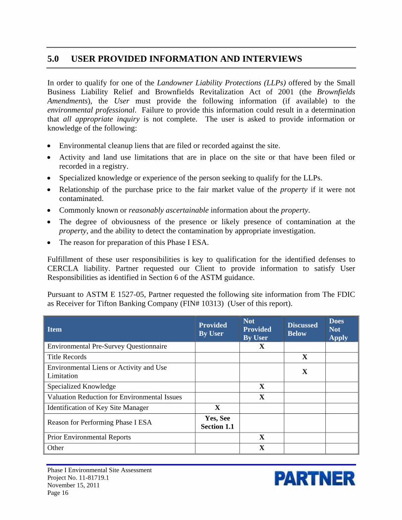
5.0 USER PROVIDED INFORMATION AND INTERVIEWS
In order to qualify for one of the Landowner Liability Protections (LLPs) offered by the Small Business Liability Relief and Brownfields Revitalization Act of 2001 (the Brownfields Amendments), the User must provide the following information (if available) to the environmental professional. Failure to provide this information could result in a determination that all appropriate inquiry is not complete. The user is asked to provide information or knowledge of the following:
Environmental cleanup liens that are filed or recorded against the site.
Activity and land use limitations that are in place on the site or that have been filed or recorded in a registry.
Specialized knowledge or experience of the person seeking to qualify for the LLPs.
Relationship of the purchase price to the fair market value of the property if it were not contaminated.
Commonly known or reasonably ascertainable information about the property.
The degree of obviousness of the presence or likely presence of contamination at the property, and the ability to detect the contamination by appropriate investigation.
The reason for preparation of this Phase I ESA.
Fulfillment of these user responsibilities is key to qualification for the identified defenses to CERCLA liability. Partner requested our Client to provide information to satisfy User Responsibilities as identified in Section 6 of the ASTM guidance.
Pursuant to ASTM E 1527-05, Partner requested the following site information from The FDIC as Receiver for Tifton Banking Company (FIN# 10313) (User of this report).
Item Provided By User
Not Provided By User
Discussed Below
Does Not Apply
Environmental Pre-Survey Questionnaire X
Title Records X
Environmental Liens or Activity and Use Limitation
X
Specialized Knowledge X
Valuation Reduction for Environmental Issues X
Identification of Key Site Manager X
Reason for Performing Phase I ESA Yes, See
Section 1.1
Prior Environmental Reports X
Other X

Phase I Environmental Site Assessment Project No. 11-81719.1 November 15, 2011 Page 17
5.1 Interviews
5.1.1 Interview with Owner
The owner of the subject property was not available to be interviewed at the time of the assessment.
5.1.2 Interview with Report User
Please refer to Section 5.2 below for information requested from the Report User. The information requested was not received prior to the issuance of this report. Because the Report User (Client) is a lender, it is understood that the Report User would not have knowledge of the property that would significantly impact our ability to satisfy the objectives of this assessment. The lack of this information is not considered to represent a significant data gap.
5.1.3 Interview with Key Site Manager
A key site manager was not available for an interview.
5.1.4 Interviews with Past Owners, Operators and Occupants
Interviews with past owners, operators and occupants were not reasonably ascertainable and thus constitute a data gap.
5.1.5 Interview with Others
As the subject property is not an abandoned property as defined in ASTM 1527-05, interview with others were not performed. However, Partner interviewed the owner of the adjacent golf course, Mr. Tom Flick, who stated that the subject property has been a pecan orchard for a long time but that in recent years the orchard has been un-groomed.
5.2 User Provided Information
5.2.1 Title Records
At the request of the User, Partner contacted EDR to perform a chain of title search for the subject property. According to the information provided by EDR, The current owner is identified as Brooker & Dollar Investments, LLC. The current owner purchased the property from The Hills at Sunsweet, LLC in 2007. Previous owners at the subject property include various entities and individuals from 1937 to 2007. No environmentally sensitive records were identified in the chain of title report.
5.2.2 Environmental Liens or Activity and Use Limitation
Partner requested information from the User regarding knowledge of environmental liens and activity and use limitations (AULs) for the subject property.

Phase I Environmental Site Assessment Project No. 11-81719.1 November 15, 2011 Page 18
At the request of the User, Partner contacted EDR to perform an environmental lien search for the subject property. No environmental liens or activity use limitations were identified for the subject property by EDR.
5.2.3 Specialized Knowledge
Partner inquired with the User regarding any specialized knowledge of environmental conditions associated with the subject property. No specialized knowledge was provided by the User at the time of the assessment.
5.2.4 Commonly Known or Reasonably Ascertainable Information
Partner inquired with the User regarding any commonly known or reasonably ascertainable information within the local community about the subject property that is material to recognized environmental conditions in connection with the subject property. Commonly known or reasonably ascertainable information associated with the subject property was not provided by the User at the time of the assessment.
5.2.5 Valuation Reduction for Environmental Issues
Partner inquired with the User regarding any knowledge of reductions in property value due to environmental issues. Knowledge of valuation reductions associated with the subject property was not provided by the User at the time of the assessment.
5.2.6 Previous Reports and Other Provided Documentation
The following information was provided to Partner for review during the course of this assessment:
Appraisal Report of 0 Golfers Way, Kunes Real Estate & Appraisals Inc. (October 5, 2010)
Kunes Real Estate & Appraisals Inc (Kunes) prepared this report on behalf of Tifton Banking Company. According to the report, the subject property was a 6.1-acre parcel of undeveloped land.

Phase I Environmental Site Assessment Project No. 11-81719.1 November 15, 2011 Page 19
6.0 SITE RECONNAISSANCE
The subject property was inspected by Ms. Ellen Condich of Partner on October 26, 2011. The weather at the time of the site visit was sunny and clear. Partner was unaccompanied during field reconnaissance activities.
All areas of the subject property were accessible at the time of the site inspection. There were no physical or visual obstructions of the subject property.
The subject property is currently an un-groomed pecan orchard. No potential environmental concerns were identified during the onsite reconnaissance.
6.1 General Site Characteristics
6.1.1 Solid Waste Disposal
No solid waste is generated at the subject property.
6.1.2 Sewage Discharge and Disposal
No sanitary discharges are generated at the subject property. No wastewater treatment facilities or septic systems are located on the subject property.
6.1.3 Surface Water Drainage
Surface water drainage percolates into the ground surface.
The subject property does not appear to be a designated wetland area, based on information obtained from the United States Department of Agriculture; however, a comprehensive wetlands survey would be required in order to formally determine actual wetlands on the subject property. No surface impoundments, wetlands, natural catch basins, settling ponds, or lagoons are located on the subject property. No drywells were identified on the subject property.
6.1.4 Source of Heating and Cooling
Heating and cooling systems and domestic hot water equipment are not present on the subject property.
6.1.5 Wells and Cisterns
No aboveground evidence of wells or cisterns was observed during the site reconnaissance.
6.1.6 Wastewater
Domestic wastewater is not generated at the subject property. No industrial process is currently performed at the subject property.

Phase I Environmental Site Assessment Project No. 11-81719.1 November 15, 2011 Page 20
6.1.7 Septic Systems
No septic systems were observed or reported on the subject property.
6.1.8 Additional Site Observations
No additional general site characteristics were observed.
6.2 Potential Environmental Hazards
6.2.1 Hazardous Materials and Petroleum Products Used or Stored at the Site
No hazardous materials or petroleum products were observed on the subject property.
6.2.2 Aboveground & Underground Hazardous Substance or Petroleum Product Storage Tanks (ASTs/USTs)
No evidence of current or former ASTs or USTs was observed during the site reconnaissance.
6.2.3 Evidence of Releases
No spills, stains or other indications that a surficial release has occurred at the subject property were observed.
6.2.4 Polychlorinated Biphenyls (PCBs)
No potential PCB-containing equipment (transformers, oil-filled switches, hoists, lifts, dock levelers, hydraulic elevators, etc) was observed on the subject property during Partner’s reconnaissance.
6.2.5 Strong, Pungent or Noxious Odors
No strong, pungent or noxious odors were evident during the site reconnaissance.
6.2.6 Pools of Liquid
No pools of liquid were observed on the subject property.
6.2.7 Drains, Sumps and Clarifiers
No drains, sumps or clarifiers were observed on the subject property.
6.2.8 Pits, Ponds and Lagoons
No pits, ponds or lagoons were observed on the subject property.

Phase I Environmental Site Assessment Project No. 11-81719.1 November 15, 2011 Page 21
6.2.9 Stressed Vegetation
No stressed vegetation was observed on the subject property.
6.2.10 Additional Potential Environmental Hazards
No additional environmental hazards, including landfill activities or radiological hazards, were observed.
6.3 Non-ASTM Services
6.3.1 Asbestos-Containing Materials (ACMs)
Due to the undeveloped nature of use of the subject property, an asbestos evaluation was not considered within the scope of this assessment.
6.3.2 Lead-Based Paint (LBP)
Due to the undeveloped nature of use of the subject property, lead-based paint was not considered within the scope of this assessment.
6.3.3 Radon
Radon is a colorless, odorless, naturally occurring, radioactive, inert, gaseous element formed by radioactive decay of radium (Ra) atoms. The US EPA has prepared a map to assist National, State, and local organizations to target their resources and to implement radon-resistant building codes. The map divides the country into three Radon Zones; Zone 1 being those areas with the average predicted indoor radon concentration in residential dwellings exceeding the US EPA Action Limit of 4.0 picoCuries per Liter (pCi/L). It is important to note that the EPA has found homes with elevated levels of radon in all three zones, and the US EPA recommends site-specific testing in order to determine radon levels at a specific location. However, the map does give a valuable indication of the propensity of radon gas accumulation in structures.
Radon sampling was not conducted as part of this assessment. Review of the US EPA Map of Radon Zones places the subject property in Zone 3, where average predicted radon levels are less than 2.0 pCi/L.
6.3.4 Lead in Drinking Water
According to available information, the public water system is not available in the subject property vicinity. Residents in this area have water wells on their property.
6.3.5 Wetlands
Partner did not observe vegetation characteristic of wetlands, such as drainage ways, streams, rivers, ponds, marshes, bogs, swamps, or other wetlands on the subject property during the onsite

Phase I Environmental Site Assessment Project No. 11-81719.1 November 15, 2011 Page 22
observations. According to the U.S. Fish & Wildlife Service National Wetlands Inventory website, there are no federally regulated wetlands located on or adjacent to the subject property.
6.3.6 Endangered or Threatened Species or Habitats
The subject property has never been developed but has been utilized agriculturally. Based on the agricultural use, it is unlikely that endangered or threatened species of habitats are located onsite. Therefore, Partner does not anticipate that the subject property would impact an endangered or threatened species or habitat.
6.3.7 Undeveloped Floodplains/Wild and Scenic Rivers
During the on-site reconnaissance, Partner did observe areas that are considered to be natural areas. Partner performed a review of the Flood Insurance Rate Map, published by the Federal Emergency Management Agency (FEMA). According to Community Panel Number 13277C0100D, dated August 17, 1998, the subject property appears to be located in Zone X, an area located outside of the 100-year and 500-year flood plains. Partner searched the National Wild and Scenic Rivers database and no nearby waterways were listed.
6.3.8 Areas of Scientific Significance
Based on observations noted during the onsite reconnaissance and aerial photographs, the subject property is not greater than 50 acres in size, is undeveloped and does not appear to possess areas of scientific significance or wilderness areas as indicated by the National Wilderness Preservation System map.
6.3.9 Wilderness Area
Based on Partner’s site reconnaissance and review of historical sources the property is not part of, contiguous with or adjacent to federally-owned lands, or lands legally designated for acquisition by a federal agency that are designated or proposed for designation as a part of the National Wilderness Preservation System.
6.3.10 Recreational Areas
During the onsite reconnaissance, Partner did observe areas that are considered to be natural areas; however, no recreational areas, used for potential public outdoor recreational value such as, a park or other outdoor recreational activity were identified. Additionally, Partner contacted the State Comprehensive Outdoor Recreational Planner, and confirmed the subject property has not been identified for acquisition for recreational purposes and is not associated with a national recreational, scenic, or historic trail established under the National Trails System Act.
Phase I Environmental Site Assessment Project No. 11-81719.1 November 15, 2011 Page 23
6.3.11 Additional Hazards and Nuisances
Partner did not observe any high pressure natural gas or petroleum pipelines or pipeline easements on or adjacent to the subject property. The subject property is not located within the fall distance of a high voltage power transmission tower, or any other tower.
6.4 Adjacent Property Reconnaissance
The adjacent property reconnaissance consisted of observing the adjacent properties from the subject property premises. No items of environmental concern were identified on the adjacent properties during the site inspection, including hazardous materials, petroleum products, ASTs, USTs, evidence of releases, PCBs, strong or noxious odors, pools of liquids, sumps or clarifiers, pits or lagoons, stressed vegetation, or any other potential environmental hazards.

Phase I Environmental Site Assessment Project No. 11-81719.1 November 15, 2011 Page 24
7.0 FINDINGS AND CONCLUSIONS
Findings
A REC refers to the presence or likely presence of any hazardous substance or petroleum product on a property under conditions that indicate an existing release, a past release, or a material threat of a release of any hazardous substances or petroleum products into structures on the property or into the ground, groundwater, or surface water of the property. The term REC includes hazardous substances and petroleum products even under conditions that might be in compliance with laws. The term is not intended to include "de minimis" conditions that do not present a threat to human health and/or the environment and that would not be subject to an enforcement action if brought to the attention of appropriate governmental agencies. The following was identified during the course of this assessment:
Partner did not identify any recognized environmental conditions during the course of this assessment.
A HREC refers to an environmental condition which would have been considered a REC in the past, but which is no longer considered a REC based on subsequent assessment or regulatory closure. The following was identified during the course of this assessment:
Partner did not identify any historical recognized environmental conditions during the course of this assessment.
Special Resources are defined by Statement of Work: FDIC Phase I Environmental Site Assessment (ESA), dated February 2006, as resources with natural, cultural, recreational, or scientific value of special significance.
Partner did not identify the presence or likely presence of any Special Resource that may restrict the use of or affect the marketability or value of the subject property.
An environmental issue refers to environmental concerns identified by Partner, which do not qualify as RECs; however, require discussion. The following was identified during the course of this assessment:
The subject property has been utilized for agricultural purposes since at least 1937. There is a potential that agricultural chemicals such as pesticides, herbicides, and fertilizers may have been used at the subject property. Depending on the planned use of the subject property, the owner or the developer of the subject property should evaluate potential environmental concerns pertaining to the agricultural uses.

Phase I Environmental Site Assessment Project No. 11-81719.1 November 15, 2011 Page 25
Conclusions, Opinions and Recommendations
Partner has performed a Phase I Environmental Site Assessment in conformance with the scope and limitations of ASTM Practice E1527-05, AAI, and the Statement of Work: FDIC Phase I ESA of 0 Golfers Way in the City of Chula, Tift County, Georgia (the “subject property”). Any exceptions to or deletions from this practice are described in Section 1.5 of this report.
This assessment has revealed no evidence of recognized environmental conditions; however, an environmental issue in connection with the subject property was noted. Based on the conclusions of this assessment, Partner recommends no further investigation of the subject property at this time.

Phase I Environmental Site Assessment Project No. 11-81719.1 November 15, 2011 Page 26
8.0 SIGNATURES OF ENVIRONMENTAL PROFESSIONALS
Partner has performed a Phase I Environmental Site Assessment of the property located at 0 Golfers Way in the City of Chula, Tift County, Georgia in general conformance with the scope and limitations of the protocol and the limitations stated earlier in this report. Exceptions to or deletions from this protocol are discussed earlier in this report.
By signing below, Partner declares that, to the best of our professional knowledge and belief, the undersigned meet the definition of an Environmental Professional as defined in §312.10 of 40 CFR 312 and have the specific qualifications based on education, training, and experience to assess a property of the nature, history, and setting of the subject property. Partner has developed and performed the all appropriate inquiries in conformance with the standards and practices set forth in 40 CFR Part 312.
Reviewed By: Brian A. Dugan Senior Author

Phase I Environmental Site Assessment Project No. 11-81719.1 November 15, 2011 Page 27
9.0 REFERENCES
Contact List
Georgia EPD, 4244 International Parkway, Atlanta, Georgia 30354, (404) 462-2671
Tift County Code Enforcement, 225 Tift Avenue North, Tifton, Georgia 31793, (229) 386-7961
Tift County Assessor, 225 Tift Avenue North, Tifton, Georgia 31793, (229) 386-7961
Tift County Library, 245 Love Avenue, Tifton, Georgia 31793, (229) 386-7205
Tifton Fire Department, Fire Marshal’s Office, 403 Forrest Avenue, Tifton, Georgia 31793, (229) 391-3972
Tifton-Tift County Utility Department, Customer Service, (229) 382-6231.
United States Environmental Protection Agency – Region 4, Atlanta, Georgia
United States Geological Survey, accessed via the Internet, October 2011 of assessment
Reference Documents
American Society for Testing and Materials, Standard Practice for Environmental Site Assessments: Phase I Environmental Site Assessment Process, ASTM Designation: E 1527-05.
Environmental Data Resources, Inc., The EDR Radius Map Report and Aerial Photographs dated 1937, 1948, 1957, 1962, 1968, 1972, 1988, 1993, 2005, 2006 and 2007, September 2011.
United States Department of Agriculture, Natural Resources Conservation Service, Web Soil Survey, accessed via the Internet, October 2011 of assessment
United States Environmental Protection Agency, EPA Map of Radon Zones (Document EPA-402-R-93-071), accessed via the Internet, October 2011 of assessment
United States Geological Survey Topographic Map 1983, 7.5 minute series, Chula, Tift County, Georgia, NIMA 6843 II NE-Series V882, scale 1:24,000, U.S. Geological Survey
FIGURES
1- SITE LOCATION MAP
2- TOPOGRAPHIC MAP
3- SITE PLAN

FIGURE 1: SITE LOCATION MAP
Drawing Not To Scale
Site Address:
www.PARTNEResi.com (800) 419-4923
Project No. 11-81719.1
Asset Number 10313000988 0 Golfers Way Chula, Georgia 31793
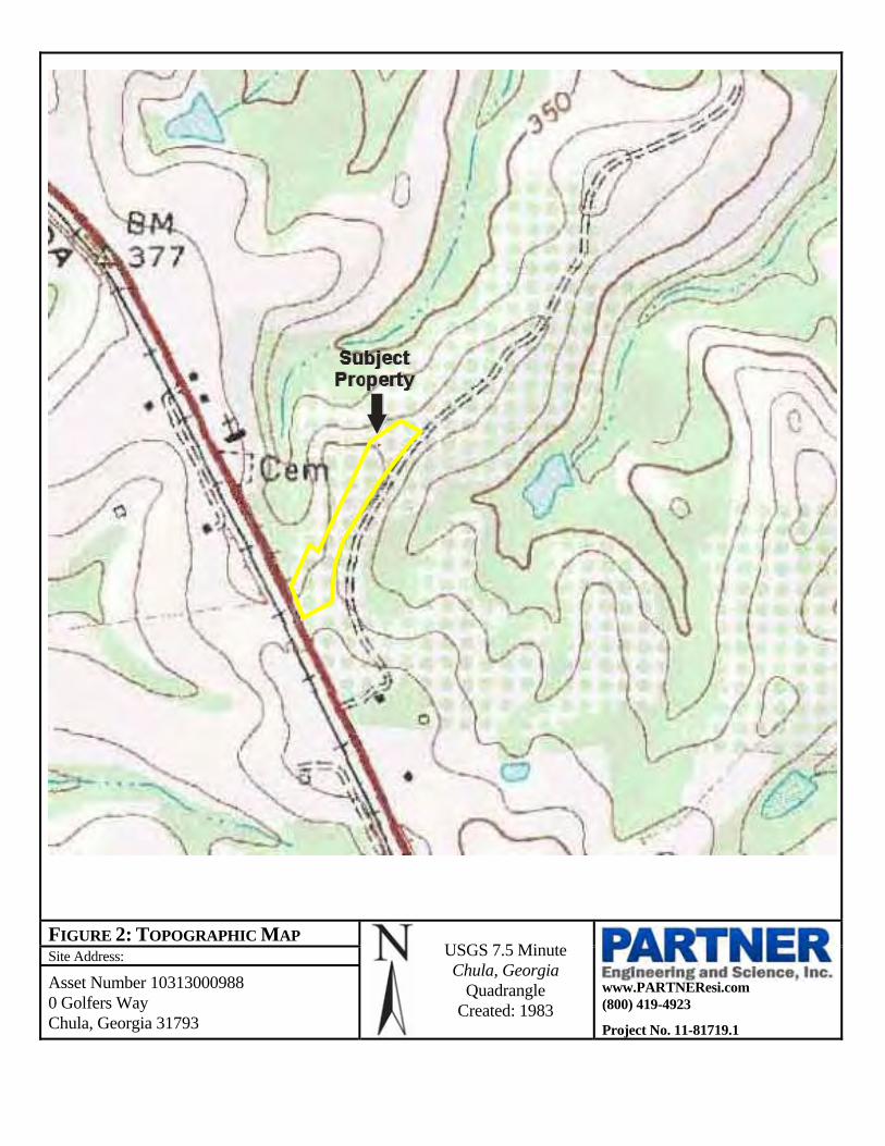
FIGURE 2: TOPOGRAPHIC MAP USGS 7.5 Minute Chula, Georgia
Quadrangle Created: 1983
Site Address:
www.PARTNEResi.com (800) 419-4923
Project No. 11-81719.1
Asset Number 10313000988 0 Golfers Way Chula, Georgia 31793
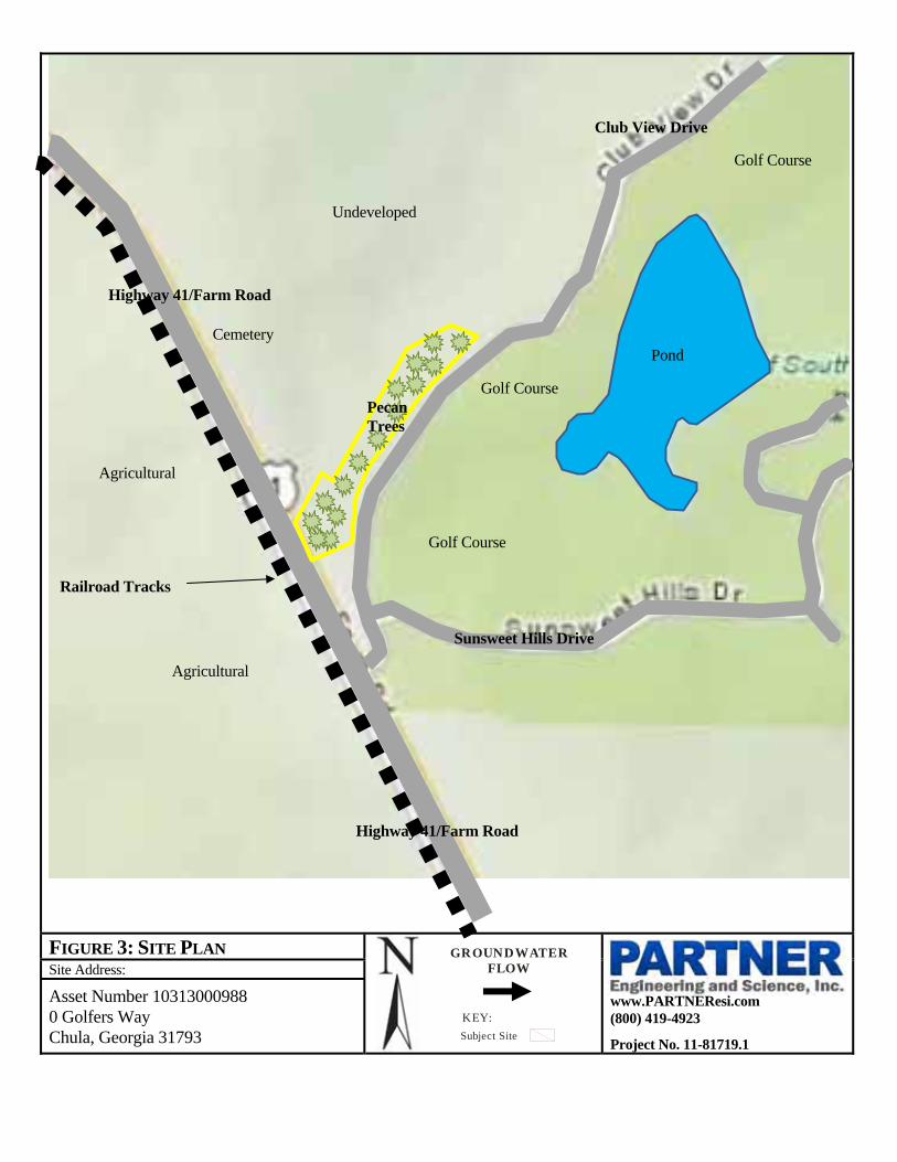
FIGURE 3: SITE PLAN
Site Address:
www.PARTNEResi.com (800) 419-4923
Project No. 11-81719.1
Asset Number 10313000988 0 Golfers Way Chula, Georgia 31793
KEY:
Subject Site
GROUNDWATERFLOW
Highway 41/Farm Road
Club View Drive
Sunsweet Hills Drive
Golf Course
Undeveloped
Cemetery
Agricultural
Agricultural
Highway 41/Farm Road
Golf Course
Golf Course
Pond
Pecan Trees
Railroad Tracks

APPENDIX A: SITE PHOTOGRAPHS

1. View of the signage for the subdivision 2. View of the southwestern boundary of the subject property
3. View of the southern portion of the subject property 4. View of the central portion of the subject property
5. View of the central portion of the subject property 6. View of the northern portion of the subject property
APPENDIX A: SITE PHOTOGRAPHS
Site Address:
www.PARTNEResi.com (800) 419-4923
Project No. 11-81719.1
Asset Number 10313000988 0 Golfers Way Chula, Georgia 31793

7. View of the northern portion of the subject property 8. View of the adjacent golf course
9. View of the adjacent east undeveloped area 10. View of the adjacent north undeveloped land
11. View of the adjacent north cemetery 12. View of the adjacent west agricultural land
APPENDIX A: SITE PHOTOGRAPHS
Site Address:
www.PARTNEResi.com (800) 419-4923
Project No. 11-81719.1
Asset Number 10313000988 0 Golfers Way Chula, Georgia 31793

APPENDIX B: HISTORICAL/REGULATORY DOCUMENTATION

APPENDIX B: AERIAL PHOTOGRAPHS
Date: 1937
Site Address:
www.PARTNEResi.com (800) 419-4923
Project No. 11-81719.1
Asset Number 10313000988 0 Golfers Way Chula, Georgia 31793

APPENDIX B: AERIAL PHOTOGRAPHS
Date: 1948
Site Address:
www.PARTNEResi.com (800) 419-4923
Project No. 11-81719.1
Asset Number 10313000988 0 Golfers Way Chula, Georgia 31793
APPENDIX B: AERIAL PHOTOGRAPHS
Date: 1957
Site Address:
www.PARTNEResi.com (800) 419-4923
Project No. 11-81719.1
Asset Number 10313000988 0 Golfers Way Chula, Georgia 31793

APPENDIX B: AERIAL PHOTOGRAPHS
Date: 1962
Site Address:
www.PARTNEResi.com (800) 419-4923
Project No. 11-81719.1
Asset Number 10313000988 0 Golfers Way Chula, Georgia 31793

APPENDIX B: AERIAL PHOTOGRAPHS
Date: 1969
Site Address:
www.PARTNEResi.com (800) 419-4923
Project No. 11-81719.1
Asset Number 10313000988 0 Golfers Way Chula, Georgia 31793

APPENDIX B: AERIAL PHOTOGRAPHS
Date: 1972
Site Address:
www.PARTNEResi.com (800) 419-4923
Project No. 11-81719.1
Asset Number 10313000988 0 Golfers Way Chula, Georgia 31793

APPENDIX B: AERIAL PHOTOGRAPHS
Date: 1988
Site Address:
www.PARTNEResi.com (800) 419-4923
Project No. 11-81719.1
Asset Number 10313000988 0 Golfers Way Chula, Georgia 31793

APPENDIX B: AERIAL PHOTOGRAPHS
Date: 1993
Site Address:
www.PARTNEResi.com (800) 419-4923
Project No. 11-81719.1
Asset Number 10313000988 0 Golfers Way Chula, Georgia 31793

APPENDIX B: AERIAL PHOTOGRAPHS
Date: 2005
Site Address:
www.PARTNEResi.com (800) 419-4923
Project No. 11-81719.1
Asset Number 10313000988 0 Golfers Way Chula, Georgia 31793

APPENDIX B: AERIAL PHOTOGRAPHS
Date: 2006
Site Address:
www.PARTNEResi.com (800) 419-4923
Project No. 11-81719.1
Asset Number 10313000988 0 Golfers Way Chula, Georgia 31793

APPENDIX B: AERIAL PHOTOGRAPHS
Date: 2007
Site Address:
www.PARTNEResi.com (800) 419-4923
Project No. 11-81719.1
Asset Number 10313000988 0 Golfers Way Chula, Georgia 31793

Certified Sanborn® Map Report
Asset No.10313000988
0 Golfers Way
Chula, GA 31733
Inquiry Number: 3169732.3
September 20, 2011

Certified Sanborn® Map Report 9/20/11
Site Name:Asset No.103130009880 Golfers WayChula, GA 31733
Client Name:Partner Engineering and1990 Grand AvenueEl Segundo, CA 90245
EDR Inquiry # 3169732.3 Contact: Lourdes Ortega
The complete Sanborn Library collection has been searched by EDR, and fire insurance maps covering the targetproperty location provided by Partner Engineering and Science, Inc. were identified for the years listed below. Thecertified Sanborn Library search results in this report can be authenticated by visiting www.edrnet.com/sanborn andentering the certification number. Only Environmental Data Resources Inc. (EDR) is authorized to grant rights forcommercial reproduction of maps by Sanborn Library LLC, the copyright holder for the collection.
Certified Sanborn Results:
Site Name: Asset No.10313000988Address: 0 Golfers WayCity, State, Zip: Chula, GA 31733Cross Street:P.O. # NAProject: 81719.1Certification # EAA9-4A28-AE2A
Library of Congress
University Publications of America
EDR Private Collection
The Sanborn Library LLC Since 1866™
The Sanborn Library includes more than 1.2 millionSanborn fire insurance maps, which track historicalproperty usage in approximately 12,000 Americancities and towns. Collections searched:
Sanborn® Library search resultsCertification # EAA9-4A28-AE2A
UNMAPPED PROPERTYThis report certifies that the complete holdings of the SanbornLibrary, LLC collection have been searched based on clientsupplied target property information, and fire insurance mapscovering the target property were not found.
Limited Permission To Make CopiesPartner Engineering and Science, Inc. (the client) is permitted to make up to THREE photocopies of this Sanborn Map transmittal and each fireinsurance map accompanying this report solely for the limited use of its customer. No one other than the client is authorized to make copies. Uponrequest made directly to an EDR Account Executive, the client may be permitted to make a limited number of additional photocopies. Thispermission is conditioned upon compliance by the client, its customer and their agents with EDR's copyright policy; a copy of which is availableupon request.
Disclaimer - Copyright and Trademark noticeThis Report contains certain information obtained from a variety of public and other sources reasonably available to Environmental Data Resources, Inc. It cannot beconcluded from this Report that coverage information for the target and surrounding properties does not exist from other sources. NO WARRANTY EXPRESSED ORIMPLIED, IS MADE WHATSOEVER IN CONNECTION WITH THIS REPORT. ENVIRONMENTAL DATA RESOURCES, INC. SPECIFICALLY DISCLAIMS THEMAKING OF ANY SUCH WARRANTIES, INCLUDING WITHOUT LIMITATION, MERCHANTABILITY OR FITNESS FOR A PARTICULAR USE OR PURPOSE. ALLRISK IS ASSUMED BY THE USER. IN NO EVENT SHALL ENVIRONMENTAL DATA RESOURCES, INC. BE LIABLE TO ANYONE, WHETHER ARISING OUT OFERRORS OR OMISSIONS, NEGLIGENCE, ACCIDENT OR ANY OTHER CAUSE, FOR ANY LOSS OF DAMAGE, INCLUDING, WITHOUT LIMITATION, SPECIAL,INCIDENTAL CONSEQUENTIAL, OR EXEMPLARY DAMAGES. ANY LIABILITY ON THE PART OF ENVIRONMENTAL DATA RESOURCES, INC. IS STRICTLYLIMITED TO A REFUND OF THE AMOUNT PAID FOR THIS REPORT. Purchaser accepts this Report "AS IS". Any analyses, estimates, ratings, environmental risklevels or risk codes provided in this Report are provided for illustrative purposes only, and are not intended to provide, nor should they be interpreted as providingany facts regarding, or prediction or forecast of, any environmental risk for any property. Only a Phase I Environmental Site Assessment performed by anenvironmental professional can provide information regarding the environmental risk for any property. Additionally, the information provided in this Report is not to beconstrued as legal advice.
Copyright 2011 by Environmental Data Resources, Inc. All rights reserved. Reproduction in any media or format, in whole or in part, of any report or map ofEnvironmental Data Resources, Inc., or its affiliates, is prohibited without prior written permission.
EDR and its logos (including Sanborn and Sanborn Map) are trademarks of Environmental Data Resources, Inc. or its affiliates. All other trademarks used herein arethe property of their respective owners.
3169732 - 3 page 2

Asset No.10313000988
0 Golfers WayChula, GA 31733
Inquiry Number: 3201620.2November 07, 2011
The EDR Environmental LienSearch™ Report
440 Wheelers Farms RoadMilford, CT 06461800.352.0050www.edrnet.comEnvironmental Data Resources IncEnvironmental Data Resources IncEnvironmental Data Resources IncEnvironmental Data Resources Inc
The EDR Environmental LienSearch™ Report
The EDR Environmental LienSearch Report provides results from a search of available current land title records for environmental cleanup liens and other activity and use limitations, such as engineering controls and institutional controls.
A network of professional, trained researchers, following established procedures, uses client supplied address information to: • search for parcel information and/or legal description; • search for ownership information; • research official land title documents recorded at jurisdictional agencies such as recorders' offices, registries of deeds, county clerks' offices, etc.; • access a copy of the deed; • search for environmental encumbering instrument(s) associated with the deed; • provide a copy of any environmental encumbrance(s) based upon a review of key words in the instrument(s) (title, parties involved, and description); and • provide a copy of the deed or cite documents reviewed.
Thank you for your business. Please contact EDR at 1-800-352-0050
with any questions or comments.
Disclaimer - Copyright and Trademark Notice
This Report contains certain information obtained from a variety of public and other sources reasonably available to Environmental Data Resources, Inc. It cannot be concluded from this Report that coverage information for the target and surrounding properties does not exist from other sources. NO WARRANTY EXPRESSED OR IMPLIED, IS MADE WHATSOEVER IN CONNECTION WITH THIS REPORT. ENVIRONMENTAL DATA RESOURCES, INC. SPECIFICALLY DISCLAIMS THE MAKING OF ANY SUCH WARRANTIES, INCLUDING WITHOUT LIMITATION, MERCHANTABILITY OR FITNESS FOR A PARTICULAR USE OR PURPOSE. ALL RISK IS ASSUMED BY THE USER. IN NO EVENT SHALL ENVIRONMENTAL DATA RESOURCES, INC. BE LIABLE TO ANYONE, WHETHER ARISING OUT OF ERRORS OR OMISSIONS, NEGLIGENCE, ACCIDENT OR ANY OTHER CAUSE, FOR ANY LOSS OR DAMAGE, INCLUDING, WITHOUT LIMITATION, SPECIAL, INCIDENTAL, CONSEQUENTIAL, OR EXEMPLARY DAMAGES. ANY LIABILITY ON THE PART OF ENVIRONMENTAL DATA RESOURCES, INC. IS STRICTLY LIMITED TO A REFUND OF THE AMOUNT PAID FOR THIS REPORT. Purchaser accepts this Report "AS IS". Any analyses, estimates, ratings, environmental risk levels or risk codes provided in this Report are provided for illustrative purposes only, and are not intended to provide, nor should they be interpreted as providing any facts regarding, or prediction orforecast of, any environmental risk for any property. Only a Phase I Environmental Site Assessment performed by an environmental professional can provide information regarding the environmental risk for any property. Additionally, the information provided in this Report is not to be construed as legal advice.
Copyright 2010 by Environmental Data Resources, Inc. All rights reserved. Reproduction in any media or format, in whole or in part, of any report or map of Environmental Data Resources, Inc. or its affiliates is prohibited without prior written permission.
EDR and its logos (including Sanborn and Sanborn Map) are trademarks of Environmental Data Resources, Inc. or its affiliates. All other trademarks used herein are the property of their respective owners.

The EDR Environmental LienSearch™ Report
TARGET PROPERTY INFORMATION_______________________________
ADDRESS
0 Golfers WayAsset No.10313000988
Chula, GA 31733
RESEARCH SOURCE
Source 1:
Tift RecorderTift, GA
PROPERTY INFORMATION
Deed 1:
Type of Deed: Warranty Deed
Title is vested in: HILLS AT SUNSWEET LLC
Title received from: Robdoll LLC
Deed Dated 8/8/2007
Deed Recorded: 8/9/2007
Book: 1367
Page: 207
Volume: NA
Instrument: NA
Docket: NA
Land Record Comments:
Miscellaneous Comments:
Legal Description: see exhibit
Legal Current Owner: HILLS AT SUNSWEET LLC
Property Identifiers: 0027A-019E
Comments: see exhibit
ENVIRONMENTAL LIEN
Environmental Lien: Found Not Found
OTHER ACTIVITY AND USE LIMITATIONS (AULs)
AULs: Found Not Found
3201620.2 Page 1

Deed Exhibit 1


Asset No. 10313000988 Golfers Way Chula, GA 31733 Inquiry Number: 3201620.1 November 11, 2011

The EDR Chain of Title Report tracks a line of successive owners from the present back to 1940 of a particular parcel of property, linked together by recorded transactions which pass title. Available nationwide, this report provides a summary of
a property’s ownership history and is a valuable source for determining the prior uses of a property A network of professional abstractors following established procedures, uses client supplied address Information to locate:
Historical Chain of Title research Leases and Miscellaneous
Thank you for your business. Please contact EDR at 1-800-352-0050
with any questions or comments.
Disclaimer – Copyright and Trademark Notice
This report was prepared for the use of Environmental Data Resources, Inc., and Data Abstract Information Service, Inc., exclusively. This report is neither a guarantee of title, a commitment to insure, nor a policy of title insurance. NO WARRANTY, EXPRESSED OR IMPLIED, IS
MADE WHATSOEVER IN CONNECTION WITH THIS REPORT. Environmental Data Resources, Inc. (EDR) and Data Abstract Information Service, Inc. specifically disclaim the making of any such warranties, including without limitation, merchantability or fitness for a particular use or purpose. The information contained in this report is retrieved as it is recorded from the various agencies that make it available. The total liability is limited to the fee paid for this report.
Copyright 2009 by Environmental Data Resources, Inc. All rights reserved. Reproduction in any media or format, in whole or in part, of any report or map of Environmental Data Resources, Inc., or its affiliates, is prohibited without prior written permission.
EDR and its logos are trademarks of Environmental Data Resources, Inc. or its affiliates. All other trademarks used herein are the property of their respective owners.

TARGET PROPERTY INFORMATION
ADDRESS
Asset No. 10313000988
Golfers Way
Chula, GA 31733
Research Source
Source 1: Tift County Recorder of Deeds
Source 2: N/A
Examiner’s Note: Public records of Tift County, GA were searched from January 1, 1940 to October 28, 2011, and no other deeds vesting title in the subject property were found of record during the period searched.
PROPERTY DESCRIPTION
Current Owner: Brooker & Dollar Investments, LLC Legal Description: See Deed Attached Property Identifiers: APN: 0027 019E General Comments: N/A HISTORICAL CHAIN OF TITLE
See Exhibit “A” LEASES AND MISCELLANEOUS
No liens were found of record searching back during the time period of the attached chain. See attached deed for any restrictions , AUL’s, amendments, leases or agreements.
Chain of Title
Exhibit “A”

HISTORICAL CHAIN OF TITLE
Chain 1
Type of Deed: Deed
Title is vested in: Brooker & Dollar Investments, LLC
Title received from: The Hills at Sunsweet, LLC
Date Executed: August 21, 2009
Date Recorded: September 2, 2009
Book: 1491
Page: 125
Volume:
Instrument #:
Docket:
Land Record Comments: According to county records there were three Declarations of Restrictive Covenants filed. They are as follows:
September 2, 2009 Bk 1491 Pg 123; September 12, 2007 Bk 1374 Pg 12; July 21, 2005 Bk 1204 Pg 35
Chain 2
Type of Deed: Deed
Title is vested in: The Hills at Sunsweet, LLC
Title received from Robdol, LLC
Date Executed: August 9, 2007
Date Recorded: August 9, 2007
Book: 1367
Page: 207
Volume:
Instrument #:
Docket:
Land Record Comments: N/A
Chain 3
Type of Deed: Deed
Title is vested in: Robdol, LLC
Title received from Donchi Inc. and Sunsweet Hills Golf Club
Date Executed: August 27, 2003
Date Recorded: August 27, 2003
Book: 1061
Page: 82
Volume:
Instrument #:
Docket:
Land Record Comments: N/A

Chain 4
Type of Deed: Deed
Title is vested in: Donchi Inc. and Sunsweet Hills Golf Club
Title received from Gregory C. Sowell (a/k/a G C Sowell)
Date Executed: December 21, 1998
Date Recorded: December 21, 1998
Book: 726
Page: 146
Volume:
Instrument #:
Docket:
Land Record Comments: N/A
Chain 5
Type of Deed: Deed
Title is vested in: Gregory C. Sowell (a/k/a G C Sowell)
Title received from Gordon E. Hughes
Date Executed: October 2, 1991
Date Recorded: October 2, 1991
Book: 416
Page: 179
Volume:
Instrument #:
Docket:
Land Record Comments: N/A
Chain 6
Type of Deed: Deed
Title is vested in: Gordon E. Hughes
Title received from: Nathaniel Ramer and Jennifer Ramer
Date Executed: May 7, 1984
Date Recorded: May 7, 1984
Book: 143
Page: 298
Volume:
Instrument #:
Docket:
Land Record Comments: N/A

Chain 7
Type of Deed: Deed
Title is vested in: Nathaniel Ramer and Jennifer Ramer
Title received from Steven Scarengos
Date Executed: August 20, 1977
Date Recorded: August 20, 1977
Book: Y612
Page: 529
Volume:
Instrument #:
Docket:
Land Record Comments: N/A
Chain 8
Type of Deed: Deed
Title is vested in: Steven Scarengos
Title received from Emmett Hardy and Arlene Hardy
Date Executed: January 8, 1970
Date Recorded: January 10, 1970
Book: V418
Page: 338
Volume:
Instrument #:
Docket:
Land Record Comments: N/A
Chain 9
Type of Deed: Deed
Title is vested in: Emmett Hardy and Arlene Hardy
Title received from Ervin Smith and Jackie Smith
Date Executed: October 22, 1962
Date Recorded: October 22, 1962
Book: T511
Page: 63
Volume:
Instrument #:
Docket:
Land Record Comments: N/A
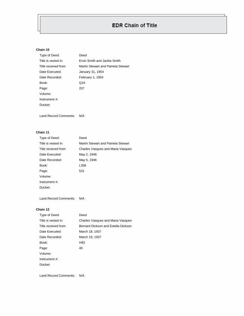
Chain 10
Type of Deed: Deed
Title is vested in: Ervin Smith and Jackie Smith
Title received from Martin Stewart and Pamela Stewart
Date Executed: January 31, 1954
Date Recorded: February 1, 1954
Book: Q19
Page: 207
Volume:
Instrument #:
Docket:
Land Record Comments: N/A
Chain 11
Type of Deed: Deed
Title is vested in: Martin Stewart and Pamela Stewart
Title received from Charles Vasques and Maria Vasques
Date Executed: May 2, 1946
Date Recorded: May 5, 1946
Book: L358
Page: 531
Volume:
Instrument #:
Docket:
Land Record Comments: N/A
Chain 12
Type of Deed: Deed
Title is vested in: Charles Vasques and Maria Vasques
Title received from Bernard Dickson and Estella Dickson
Date Executed: March 18, 1937
Date Recorded: March 19, 1937
Book: H93
Page: 40
Volume:
Instrument #:
Docket:
Land Record Comments: N/A

DEED EXHIBIT


Kunes Real Estate & Appraisals Inc
LAN APRASALREPRTFile No 2009-211LAND_____ APPRAISAL_______REPORT___ Case No 0-Golfers Way
Borrower Dollar & Brooker lnvestm~i,- Census Tract _________________Map Reference 0027 19Property Address 0 Golfers Way
*City Chuta County Tift State GA Zip Code 31793*Legal Description see deed
SalePrie $ 12000 ateof Sle /09 Loa Tem ukwn yrs Property Rights Appraised L2 Fee [71Leasehold DiDe Minimis PUDActual Real Estate Taxes $ (yr) Loan Charges to he paid by seller $ n/a Other Sales Concessions n/a
*Lender/Client Tifton Banking Company Address 729 W 2nd Street Tifton GA 31794Occupant _____________Appraiser Nelson Kunes Instructions to Appraiser Market Value of Vacant Land
Location Urban L Suburban IXJ Rural Good Avg Fair PoorBuilt Up LiOver 75% Li25% to 75% a] Under 25% Employment Stability Xi E~ LiLiGrowth Rate Di Fully 0ev. Rapid ~ Steady X Slow Covnec oEpomnProperty Values H Increasing ~ Stable X Declining Convenience to Shopin 7J~Demand/Supply H Shortage WIn Balance Oversupply Convenience to Schools 7J U L
-Marketing Time Under 3 Moo, Ni 3-6 Mos I ~ Over 6 Mos Adequacy of Public Transportation7*Present Land Use 10 %1 Family _%2-4 Family _% Apts _% Condo % Commercial Recreational Facilities 7J~ L L
%Industrial 90 % Vacant % ___________________ Adequacy of UtilitiesLiIKI iLiSChange In Present Land Use Not Likely - Liey)iTaking Place () Property of Compatibility
(*) From n/a To n/a Protection from Detrimental Conditions LLJU UPredominate Occupancy [91 Owr e ant ___ % Vacant Police and Fire Protection U W U LSingle Family Price Range $ 100 to $ 500 Predominant Value $ 150 General Appearance of Proper ien X L LSingle Family Age 1 yrs to 65 yrs. Predominant Age 20 yn Appeal to Market a Li iComments including those factors, favorable or unfavorable, affecting marketability (e.g. public parks, schools, view, noise): The area is considered good in marketappeal and average in proximity to local employment, schools and shopping The tots are accross the street from the Golf Club of South GA
IThe golf course views are good from this property.
Dimensions See Site Map for Area Calculation -6.109 acres lcorner LotZoning Classification P00 Present Improvements [X] do L] do not conform to zoning regulationsHighest and best use LiPresent use Other (specify) Residential
Public Other (Describe) OFF SITE IMPROVEMENTS Tope gently rollingElec _ _ Street Access E]Public DPrivate Size TypicalGas ________Surface Ashalt Shape RectangularWater UNn Maneac Public PrvteVe Street/golf courseSan.Ser L None Maintore wernce Curb/Gutter Drainage Adequate
L underground Elect & Tel. F Sidewallk F1Street Liphts Is the property located in a HUD identified Special Flood Hazard Area? [XKINo [I]YesComments (favorable or unfavorable including any apparent adverse easements, encroachments or other adverse conditions): There are no adverse easements,
encroachments or other conditions that would negatively effect marketabiltiy
The undersigned has recited three recent sales of properties most similar and proximate to subject and has considered these in the market analysis. The description includesa dollar adjustment reflecting market reaction to those items of significant variation between the subject and comparable properties Ifsa significant item in the comparableproperty is superior to or more favorable than the subject property, a minus (-) adjustment is made thus reducing the indicated value of subject; if a significant item in thecomparable is inferior to or less favorable than the subiect property, a plus ( 1 adiustment is made thus increasing the indicated value of the sub ext
ISUBJECT PROPERTY COMPARABLE NO.1 COMPARABLE NO 2 COMPARABLE NO.3Address 0 Golfers Way Lot 1-3, 21-24 Sloans Village Lots 3-7 Sunbelt Plantation Lots 4-8 Sunbelt Plantation
Chula, GA Moultrie Tifton TiftonProximit to Subiect 30 miles 7 miles 7 miles ____
Sales Price $ 120,000. ....... 7 $ 30000/lot :K 40/o 40/oPrice / $ IS .~ 210,000 K.7>K $ 122,500 .iK$ 12,0Data Source Pub. Rec~s Pub Recs Pub. RecsDate of Sale and DESCRIPTION DESCRIPTION Aa et DESCRIPTION AdjretI DESCRIPTION 8c-mnTime Adjustment 8/09 4/19/07 -9,00C 10/29/07 -7,35C 9/7/07 - -7,35(
-Location rural Suburban urban urbanSite/Viuw 6 109 acres S lots -3,000 5 lots -300O S lots - -3,00sewer septic sewer -2,00d sewer -2,00 sewer - -200Owater none city -2,00 city -2,00C city - -2,00
Sales or FinancingConcessionsNet Adi.(Total) i, .<.., PuXMns$-16,000 Plus X Minus $ -14,350 PlsXMns$ -14,350Indicated Value Net=-53% N et=--59 -% Net=-59%of Subject ____________Gross=53% $ 14,000 Gross=59% $ 10,150 Gross=59% $ 10,150Comments on Market Data The sales used were the best available, Due to the lack of market data sates were taken from over 1 mile away and wereover 6 months old. Lots were adjusted for differences in market conditions (30%) and the fact that 5 or 6 lots will sell for higher per lot than 11The sales were on city sewer so there was an adjustment for the extra cost of a septic systemComments and Conditions of Appraisal: It is assumed all lots are suitable fore aseptic system According to Michael Spinks there will be a single watersystem installed by buyers, that can be used for all lots The estimated cost is $20,000
Final Reconciliation: The sales approach was the only applicable approach The adjusted price per ot is $10,910
I ESTIMATE THE MARKET VALUE, AS DEFINED OF SUBJECT PROPERTY AS OF 8/20/09 to be $ 120,0007,-62 m ~e-f~e~ Review Appraiser (if applicable)*Appraiser(s) _ _ _ _ _ Li6 0 DIdL Did Not Physically __ _ _ _
Nelson Kunes Inspect Property_________________________Date Report Signed 8/21/09 Date Report Signed_______________________
tate Certification # 258287 State GA State Certification # ___________________State
rState License # ___________________State _____Or State License # ___________________ StateExpiration Date of License. or Certification 4/30/2010 Expiration Date of License or Certification
ClickFORMVS Appraisal Software 800-622-8727 Page 1 of 11

Kunes Real Estate & Appraisals IncFile No. 2009-211
___________________________________ Case No 0-Golfers Way
DEFINITION OF MARKET VALUE: The most probable price which a property should bring in a competitive aridopen market under all conditions requisite to a fair sale, the buyer and seller, each acting prudently, knowledgeably aridassuming the price is not affected by undue stimulus. Implicit in this definition is the consummation of a sale as of aspecified date and the passing of title from seller to buyer under conditions whereby. (1) buyer and seller are typicallymotivated, (2) both parties are well informed or well advised, and each acting in what he considers his own best interest,(3) a reasonable time is allowed for exposure in the open market; (4) payment is made in terms of cash in U S dollarsor in terms of financial arrangements comparable thereto, and (5) the price represents the normal consideration for theproperty sold unaffected by special or creative financing or sales concessions* granted by anyone associated with the sale.
*Adjustments to the comparables must be made for special or creative financing or sales concessions No adjustmentsare necessary for those costs which are normally paid by sellers as a result of tradition or law in a market; these costsare readily identifiable since the seller pays these costs in virtually all sales transactions Special or creative financingadjustments can be made to the comparable property by comparisons to financing terms offered by a third partyinstitutional lender that is not already involved in the property or transaction Any adjustment should not be calculatedon a mechanical dollar for dollar cost of the financing or concession but the dollar amount of any adjustment shouldapproximate the market's reaction to the financing or concessions based on the appraiser's judgment
STATEMENT OF LIMITING CONDITIONS AND APPRAISER'S CERTIFICATION
CONTINGENT AND LIMITING CONDITIONS: The appraiser's certification that appears in the appraisal report issubject to the following conditions-
1 The appraiser will not be responsible for matters of a legal nature that affect either the property being appraised orthe title to it. The appraiser assumes that the title is good and marketable and, therefore, will not render any opinionsabout the title The property is appraised on the basis of it being under responsible ownership
2 The appraiser has provided a sketch in the appraisal report to show approximate dimensions of the improvementsand the sketch is included only to assist the reader of the report in visualizing the property and understanding theappraiser's determination of its size
3 The appraiser has examined the available flood maps that are provided by the Federal Emergency Management Agency(or other data sources) and has noted in the appraisal report whether the subject site is located in an identified SpecialFlood Hazard Area Because the appraiser is not a surveyor, he or she makes no guarantees, express or implied, regardingthis determination
4 The appraiser will not give testimony or appear in court because he or she made an appraisal of the property in question,unless specific arrangements to do so have been made beforehand
5 The appraiser has estimated the value of the land in the cost approach at its highest and best use and the improvementsat their contributory value These separate valuations of the land and improvements must not be used in conjunction withany other appraisal and are invalid if they are so used
6 The appraiser has noted in the appraisal report any adverse conditions (such as, needed repairs, depreciation, the presenceof hazard wastes, toxic substances, etc.) observed during the inspection of the subject property or that he or she becameaware of during the normal research involved in performing the appraisal Unless otherwise stated in the appraisal report,the appraiser has no knowledge of any hidden or unapparent conditions of the property or adverse environmental conditions(including the presence of hazardous wastes, toxic substances, etc ) that would make the property more or less valuable,and has assumed that there are no such conditions and makes no guarantees or warranties, express or implied, regardingthe condition of the property The appraiser will not be responsible for any such conditions that do exist or for anyengineering or testing that might be required to discover whether such conditions exist Because the appraiser is not an expertin the field of environmental hazards, the appraisal report must not be considered as an environmental assessment ofthe property
7 The appraiser obtained the information, estimates, and opinions that were expressed in the appraisal report from sourcesthat he or she considers to be reliable and believes them to be true and correct The appraiser does not assume responsibilityfor the accuracy of such items that were furnished by other parties
8 The appraiser will not disclose the contents of the appraisal report except as provided for in the Uniform Standards ofProfessional Appraisal Practice
9 The appraiser has based his or her appraisal report and valuation conclusion for an appraisal that is subject to satisfactorycompletion, repairs, or alterations on the assumption that completion of the improvements will be performed in aworkmanlike manner.
10. The appraiser must provide his or her prior written consent before the lender/client specified in the appraisal reportcan distribute the appraisal report (including conclusions about the property value, the appraiser's identity and professionaldesignations, and references to any professional appraisal organizations or the firm with which the appraiser is associated)to anyone other than the borrower, the mortgagee or its successors and assigns, the mortgage insurer, consultants,professional appraisal organizations; any state or federally approved financial institution, or any department, agency,or instrumentality of the United States or any state or the District of Columbia, except that the lender/client may distributethe property description section of the report only to data collection or reporting service(s) without having to obtain theappraiser's prior written consent The appraiser's written consent and approval must also be obtained before the appraisalcan be conveyed by anyone to the public through advertising, public relations, news, sales, or other media
Freddie Mac Form 439 (6-93) ClickFORMS Appraisal Software 800-622-8727 Fannie Mae Form 1004B (6-931Page 2 of 11

Kunes Real Estate & Appraisals IncFile No 2009-211
___________________________________ Case No. 0-Golfers Way
APPRAISER'S CERTIFICATION: The Appraiser certifies and agrees that
1 I have researched the subject market area and have selected a minimum of three recent sales of properties most similarand proximate to the subject property for consideration in the sales comparison analysis and have made a dollar adjustmentwhen appropriate to reflect the market reaction to those items of significant variation If a significant item in a comparableproperty is superior to, or more favorable than, the subject property, I have made a negative adjustment to reduce theadjusted sales price of the comparable and, if a significant item in a comparable property is inferior to, or less favorablethan the subject property, I have made a positive adjustment to increase the adjusted sales price of the comparable
2 1 have taken into consideration the factors that have an impact on value in my development of the estimate of marketvalue in the appraisal report I have not knowingly withheld any significant information from the appraisal report and Ibelieve, to the best of my knowledge, that all statements and information in the appraisal report are true and correct
3 1 stated in the appraisal report only my own personal, unbiased, and professional analysis, opinions, and conclusions,which are subject only to the contingent and limiting conditions specified in this form
4 1 have no present or prospective interest in the property that is the subject to this report, and I have no present orprospective personal interest or bias with respect to the participants in the transaction I did not base, either partially orcompletely, my analysis and/or the estimate of market value in the appraisal report on the race, color, religion, sex,handicap, familial status, or national origin of either the prospective owners or occupants of the subject property or of thepresent owners or occupants of the properties in the vicinity of the subject property
5 1 have no present or contemplated future interest in the subject property, and neither my current or future employmentnor my compensation for performing this appraisal is contingent on the appraised value of the property
6 1 was not required to report a predetermined value or direction in value that favors the cause of the client or anyrelated party, the amount of the value estimate, the attainment of a specific result, or the occurrence of a subsequent eventin order to receive my compensation and/or employment for performing the appraisal I did not base the appraisal reporton a requested minimum valuation, a specific valuation, or the need to approve a specific mortgage loan
7 1 performed this appraisal in conformity with the Uniform Standards of Professional Appraisal Practice that wereadopted and promulgated by the Appraisal Standards Board of The Appraisal Foundation and that were in place as of theeffective date of this appraisal, with the exception of the departure provision of those Standards, which does not applyI acknowledge that an estimate of a reasonable time for exposure in the open market is a condition in the definition ofmarket value and the estimate I developed is consistent with the marketing time noted in the neighborhood section of thisreport, unless I have otherwise stated in the reconciliation section
8 1 have personally inspected the interior and exterior areas of the subject property and the exterior of all propertieslisted as comparables in the appraisal report I further certify that I have noted any apparent or known adverse conditionsin the subject improvements, on the subject site, or on any site within the immediate vicinity of the subject property ofwhich I am aware and have made adjustments for these adverse conditions in my analysis of the property value to theextent that I had market evidence to support them I have also commented about the effect of the adverse conditions onthe marketability of the subject property
9 1 personally prepared all conclusions and opinions about the real estate that were set forth in the appraisal report If Irelied on significant professional assistance from any individual or individuals in the performance of the appraisal or thepreparation of the appraisal report, I have named such individual(s) and disclosed the specific tasks performed by themin the reconciliation section of this appraisal report. I certify that any individual so named is qualified to perform the tasksI have not authorized anyone to make a change to any item in the report, therefore, if an unauthorized change is made to theappraisal report, I will take no responsibility for it
SUPERVISORY APPRAISER'S CERTIFICATION: if a supervisory appraiser signed the appraiser report, he or shecertifies and agrees that, I directly supervise the appraiser who prepared the appraisal report, have reviewed the appraisalreport, agree with the statements and conclusions of the appraiser, agree to be bound by the appraiser's certificationsnumbered 4 through 7 above, and am taking full responsibility for the appraisal and the appraisal report
ADDRESS OF PROPERTY APPRAISED: - 0 Golfers Way, Chula, GA
APPRAISER: SUPERVISORY APPRAISER (only if required)
Signature _______________________ Signature,____________________Name Nelson Kunes Name_____________________Date Signed- 8/21/09 Date Signed ___________________
State Certification # 258287 State Certification _______________
or State License # ______________ or State License # _____________
State GA State ________________________Expiration Date of Certification or License, 4/30/2010 Expiration Date of Certification or License ______
SDid E Did Not Inspect Property
Freddie Mac Form 439 6-93 ClickFORMS Appraisal Software 800-622-8727 Fannie Mae Form 1004B 6-93Page 3 of 11

Kunes Real Estate & Appraisals IncLOCATION MAP ADDENDUM File No. 2009-211
Borrower Dollar & Brooker Invesm nentsCaeN -ofrWy
Property Address 0 Golfers WayCity Chula County Tift State GA Zip Code 31793Lender/Client Tifton Banking Company Address 729 W 2nd Street Tifton GA 31794
uan Sumner4 A
4 /
P\ mT .. ..... .....
....... .......
4 4.4 4lfil
Slgsbee
Funston
ClickFORMS Appraisal Software 800-622-8727 Page 4 of 11

Kunes Real Estate & Appraisals IncMULTI '1URPOSE SUPPLEMENTAL 9-rDENDUM
JR FEDERALLY RELATED TRANSA, ,ONSFile No. 2009-211
Case No. 0-Golfers WayBorrower/Client Dollar & Brooker InvestmentsProperty Address 0 Golfers WayCity Chula County Tift State GA Zip CodeLender Tifton Banking Company Address 729 W 2nd Street Tifton GA 31794
This Multi-Purpose Supplemental Addendum for Federally Related Transactions was designed to provide the appraiser with a con-venient way to comply with the current appraisal standards and requirements of the Federal Deposit Insurance Corporation (FDIC),the Office of the Controller of Currency (0CC), The Office of Thrift Supervision (OTS), the Resolution Trust Corporation (RTC)
and the Federal Reserve
This Multi-Purpose Supplement Addendum is for use with any appraisal. Only those
statements which have been checked by the appraiser apply to the property being appraised.
x-PRPS & FUCTO OFAPRIA
The purpose of the appraisal is to estimate the market value of the subject property as defined herein The function of the appraisal is toassist the above-named Lender in evaluating the subject property for lending purposes This is a Federally related transaction
0EXTN OF.......SA.....C. SS
FXThe appraisal is based on the information gathered by the appraiser from public records, other identified sources, inspection of thesubject property and neighborhood, and selection of comparable sales within the subject market area The original source of the com-parables is shown in the Data Source section of the market grid along with the source of confirmation, if available. The original sourceis present first The sources and data are considered reliable When conflicting information was provided, the source deemed mostreliable has been used. Data believed to be unreliable was not included in the report nor used as a basis for the value conclusion
DThe Reproduction Cost is based on ______________________________________supplemented by the appraiser's knowledge of the local market
F Physical depreciation is based on the estimated effective age of the subject property Functional and/or external depreciation, ifpresent, is specifically addressed in the appraisal report or other addenda In estimating the site value, the appraiser has relied onpersonal knowledge of the local market The knowledge is based on prior/or current analysis of site sales and/or abstractions of sitevalues from sales of improved properties
~1The subject property is located in an area of primarily owner-occupied single family residences and the Income Approach is not consi-dered to be meaningful For this reason, the Income Approach was not usedD_ The Estimated Market Rent and Gross Rent Multiplier utilized in the Income Approach are based on the appraiser's knowledge of thesubject market area. The rental knowledge is based on prior and/or current rate surveys of residential properties The Gross RentMultiplier is based on prior and/or current analysis of prices and market rates for residential properties
DFor income producing properties, actual rents, vacancies and expenses have been reported and analyzed. They have been used to pro-ject future rents, vacancies and expenses
X................................ATIO
According to Contract the subject propertyF has not been offered for sale in the past 30 days
FRI is currently offered for sale for $ 120,000F1was offered for sale within the past 30 days for $ _________
ElOffering information was considered in the final reconciliation of valueElOffering information was not considered in the final reconciliation of valueElOffering information was not available. The reasons for unavailability and the steps taken by the appraiser are explained later inthis addendum
xn L HISOR OF SUBEC PRPET
According to Public Records the subject propertyF-1 haa not transferred in the past twelve months jLJ has not transferred in the past 36 monthsF-] has transferred in the past twelve months 1:1 has transferred in the past 36 monthsEl] All prior sales which have occurred in the past months are listed below and reconciled to the appraised value, either in the body
of the report or in the addenda
E~Subject property is not located in a FEMA Special Flood Hazard AreaLISubject proper-ty Is located in a FEMA Special Flood Hazard Area
Zoe EM ap/Panel# Map Date Name of Communit:_3270100 D 8/17/98 Tift count
ElThe community does not participate in the National Flood Insurance ProgramFXj The community does participate in the National Flood Insurance Program
[]it is covered by a regular programF-1 it is covered by an emergency procgramFW-70M November 1991 ClickFORMS Appraisal Software 800-622-8727 Page 5 of 11Muli-Purpose Suppiemnal Addendum Pate I of 2

Kunes Real Estate & Appraisals IncFile No 2009-211
J[JJURR MF ,Case No. 0-Golfers Way,EN SALES TR.7
The subject property is currently not under contract.FIThe contract and/or escrow instructions were not available for review. The unavailability of the contract is explained later in the
addenda sectionF-1 The contract and/or escrow instructions were reviewed. The following summarizes the contract
IContract Date Amendment Date Contract Price Seller
ElThe contract indicated that personal property was not included in the saleElThe contract indicated that personal property was included. It consisted of_____________________________________________________________________Estimated contributory value is $ __________HPersonal property was not included in the final value estimate
Personal property was included in the final value estimate
H The contract indicated no financing concessions or other incentivesThe contract indicated the following concessions or incentives ___________________________
Thoespriosr ceties n es thecat alswr hce o iia ocsin n prpit dutet eemdi( a)pThircanle, opah inin a conclusionisedvlpanthsrotwspeae, in conformity with the Uniform Stanard deiefhri
JIAKe asRVE required bFREan exptlthatio the Deprtent Parovisioniofs hSad notsppl(2) 8 Thi copnsation is nconigent upeaonathe mreting ofripredeterminedbvalueporpdirectiondin valueatal avors nthe ueo h
()This Appraisal assignent wags thbaset narqetdmnmmvlain pcfcvlain rteapoa fala
The alueestimate Apis ra cnthce assption tatd the pr ert i h th eguatidaffect ed by the xs eneofhzrds substancesulaoryderiena eirental conitions unless ohtheiepsatent thisioporthe ppe is not aeper nthldntfctino(2hazarouspsusatnes o timntinvinenta conion The aporig fptraise' rolue inspiection ofdinues faout the casboecthpropet did non evelopae nfrmtintat indicattanedt ny arn stigniianeet, thazarouubtnce or dubeient evinmetacondTitos whprihwol affgnet he proety baenegativelyuesstemiisem statin, hiseortc Iuti n osil thtaptests and inpetonsmd
bye aulfed hsiazardos bsotane anduenvionmta texprperty oul retvelyftdb the existence of hazardous substances ordermna
environmental conditions on or around the property that would negatively affect its value
Appaiers Sgntue te 8/20/09 Date Prepared 8/2 1/09Appraiser's Name (print) Nelson Kunes Phone # ( 229 ) 3860440State GA Dl License ZIjCertification # 258287 Tax ID # 200198519
*NC-INN APPAISR' CERTFICTIO
ElThe co-signing appraiser has personally inspected the subject property, both inside and out, and has made an extenior inspection ofall comparable sales listed in the report The report was prepared by the appraiser under direct supervision of the co-signing appraiserThe co-signing appraiser accepts responsibility for the contents of the report including the value conclusion and the limiting condi-tions, and confirms that the certifications apply fully to the co-signing appraiser.
Elthe co-signing appraiser has not personally inspected the interior of the subject property andHhas not inspectedthe exterior of the subject property and all comparable sales listed in the reporthas inspectedthe exterior of the subject property and all comparable sales listed in the reportThe report was prepared by the appraiser under direct supervision of the co-signing appraiser. The co-signing appraiser acceptsresponsibility for the contents of the report, including the value conclusions and the limiting conditions, and confirms that thecertifications apply fully to the co-signing appraiser with the exception of the certification regarding physical inspections The abovedescribes the level of inspection performed by the co-sigining appraiser
Ej The co-signing appraisers level of inspection, involvement in the appraisal process and certification are covered elsewhere in theaddenda section of this appraisal.
S............................ ...................
Co-SigningAppraisers Signature ________________Effective Date 8/20/09 Date Prepared _______
Co-Signing Appraiser's Name (print) _________________Phone # ( __ )___________State D7 License 2- certification # F] Trainee Tax lo #FW-70M November 1991 ClickFORMS Appraisal Software 800-622-8727 Page 6 of 11Muli-Purpose Supplemental Addendum Page 2 of 2

Kunes Real Estate & Appraisals IncSUBJECT PHOTO ADDENDUM File No 2009-211
Borrower Dollar & Brooker investmentsCaeN -ofrWy
Property Address 0 Golfers WayCity Chula County Tift State GA Zip Code 31793Lender/Client Tifton Banking Company Address 729 W 2nd Street Tifton GA 31794
ClickEORMVS Appraisal Software 800-622-8727 Page 7 of 11

Kunes Real Estate & Appraisals IncSUBJECT PHOTO ADDENDUM File No 2009-211
Borrower Dollar & Brooker InvestmentsCaeN -ofrWy
Property Address 0 Golfers WayCity Chula County Tift State GA Zip Code 31793Lender/Cient Tifton Banking Company Address 729 W 2nd Street Tifton GA 31794
ClickFORMVS Appraisal Software 800-622-8727 Page 8 of 11

File No 2009-211Case No 0-Golfers Way
Borrower Dollar & Brooker InvesitoentsProperty Address 0 Golfers WayCity Chula County Tift State GA Zip Code 31793Lender/Client Tifton Banking Company Address 729 W 2nd Street Tifton GA 31794
AN AC TUAL SURVEY USING ATEA, A ~D0-1000 DISTANCE METER,
S HT-AVE BEEN CALCULATED FROM- 7 IN'G A MAGNETIC OBSERVATION
S-'R SRVEY DATUM AS A BASE RE-'~SECONDS IN 4 ANGLES.
E--FOOT IN 26,465 FEET.mo--~,O00+ FEET. SURVEY
R~U~ ~C __'TIONS BY PENTIUM 5:-"K AUTOCAD 2007- 0 DENOTES A
rASS OTHER..tSE NOTED.
TATACCORDING TO FLOOD INSURANCE RATE"E UMBER 13277C0050 D, DATED AUGUST 17,
'S NOT IN A FLOOD HAZARD AREA.
0
0),,
~ 9LINE LENGTH BEARING
Li 62,88 ___ N24*39'18"E6.09ACE 120.30 N8624'13"W
1-3 280.36 S0335*47"WL4 74.74 S61f07*08'E
L5 __ 13718 S49'54'46"W___ L61 47.371 S_40'05'1 4"E____L71 104,221 55006'38"E
CURVE TABLE ______
& ~ CURVE LENGTH RADIUS ICHORD BEARING CHORD DISTANCECl1 33.77 424.851 Sol,1909-W ___ 33.76C2 167-57 365.31 S16-44'1 4'V ___ 166.10
C3 254.64 728.241 S39-5344"Wi _ 253.35
GRAPHIC SCALE
ChickFORMS Appraisal Software 800-622-8727 Page 9 of 11

File No 2009-211Case No 0-Golfers Way
Borrower Dollar & Brooker InvestiientsProperty Address 0 Golfers WayCity Chula ConyTift State GA Zip Code 31793Lender/Client Tifton Banking Company Address 729 W 2nd Street Tifton GA 31794
8 17
A A
177
ST H~ LSr A
A~2E 30/
ClckORS ppaialSotwre802 2 2-77 ae 1of1
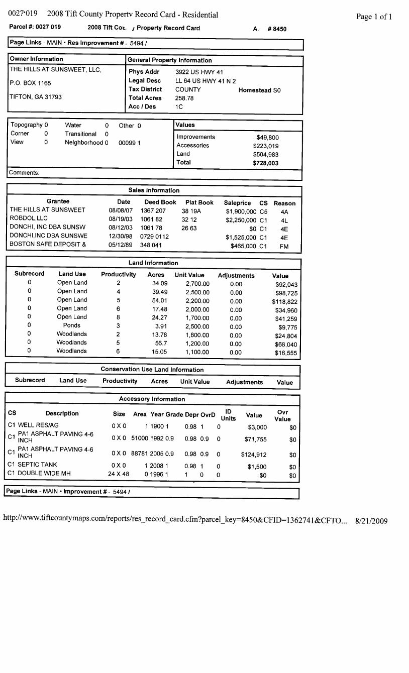
0027,019 2008 Tift County Property Record Card - Residential Page 1 of 1Parcel M: 0027 019 2008 Tift COL. I Property Record Card A. # 8450
Page Links - MAIN * Res Improvement # - 5494 /
Owner Information General Property informationTHE HILLS AT SUNSWEET, LLC, Phys Addr 3922 US HWY 41
P.O. BOX 1165 Legal Desc LL 64 USHWY 41 N 2Tax District COUNTY Homestead SO
TIFTON, GA 31793 Total Acres 258.78AcclIDes 11C
Topography 0 Water 0 Other 0 ValuesCorner 0 Transitional 0 Improvements $49,800View 0 Neighborhood 0 00099 1 Accessories $223,019
Land $504,983Total $728,003
Comments:
Sales Information
Grantee Date Deed Book Plat Book Saleprice CS ReasonTHE HILLS AT SUNSWEET 08/08/07 1367207 38 19A $1,900,000 C5 4AROBDOL,LLC 08/19/03 1061 82 32 12 $2,250,000 C1 4LDONCHI, INC DBA SUNSW 08/12/03 1061 78 26 63 $0 Cl 4EDONCHIINC DBA SUNSWE 12/30/98 07290112 $1,525,000 C1 4EBOSTON SAFE DEPOSIT & 05/12/89 348 041 $465,000 C1 FM
Land Information
Subrecord Land Use Productivity Acres Unit Value Adjustments Value0 Open Land 2 34.09 2,700.00 0.00 $92,0430 Open Land 4 39.49 2,500.00 0.00 $98,7250 Open Land 5 54.01 2,200.00 0.00 $118,8220 Open Land 6 17.48 2,000.00 0.00 $34,9600 Open Land 8 24.27 1,700.00 0.00 $41,2590 Ponds 3 3.91 2,500.00 0.00 $9,7750 Woodlands 2 13.78 1,800.00 0.00 $24,8040 Woodlands 5 56.7 1,200.00 0.00 $68,0400 Woodlands 6 15.05 1,100.00 0.00 $16,555
Surcod LndUe Productivity Acres Unit Value Adjustments Value
Accessory Information
CS Description Size Area Year Grade Depr OvrD UIts Value Vlu
C1 WELL RES/AG O X 0 1 19001 0.98 1 0 $3,000 $0Cl PAlI ASPHALT PAVING 4-6 0 X0 51000 1992 0.9 0.98 0.9 0 $71,755 $0INCHCl PAl ASPHALT PAVING 4-6 OX0 88781 2005 0.9 0.98 0.9 0 $124,912 $0INCHC1 SEPTIC TANK OX0 1 20081 0.98 1 0 $1,500 $0C1 DOUBLE WIDE MH 24 X48 019961 1 0 0 $0 $0
Page Links - MAIN -Improvement # - 5494 /
http://www.tiftcountymaps.com/reports/res-record-card.cfm?parcel-key=8450&CFID= 1362741 &CFTO... 8/21/2009

NOTICE RIGHT TO RECEIVE COPY OF At- .RAISAL
Applicant(s): BROOKER & DOLLAR INVESTMENTS, LLC Loan No.Tifton Banking Company _______________________ 400341100729 W Second Street ________________________Date of ApplicationTifton, GA 31794 Current Address: 2010 LEE AVENUE 08/21/2009
_____________________________________ Date of NoticeTIFTON, GA. 31794 08/21/2009
Property Address: 6.109 ACRES, LL 64, 6TH LD,
Lender's Name and Address TIFT COUNTY, GA
"You" means the Applicant(s) and "l/We" means the Lender
You have the right to a copy of the appraisal report used in connection with your application for credit. If you wish acopy, please write to us at the mailing address we have provided. We must hear from you no later than 90 days afterwe notify you about the action taken on your credit application or you withdraw your application.
In your letter, give us the following information: Loan or application number, if known, date of application, name(s) ofloan applicant(s), property address, and your current mailing address.
ACKNOWLEDGMENTBy signing below, you acknowledge that you have read and understood the Notice of your right to receive a copy of
the appraisal.
BROOKER & DOLLAR INVESTMENTS, LLC
S08/21/2009 -0/120Aprlica nt RUSSELL 81196KER Date 'cant J DOL AR Dt
The Lender certifies that a completed copy of the notice was El mailed N]J delivered to the applicant(s) on 08/21/2009Date
08 /21/2 009Lender Signature Leland Roberts Date
@ 1994 Bankers Systems, Inc., St. Cloud, MVN (1 -800-397-2341) Form REGB-APPR 1/20/94 (page 1 of 1)

�
1990 E. Grand Ave., Ste. 100, El Segundo, CA 90245 ◊ Phone 800-419-4923 ◊ Fax 866-928-7418
October 27, 2011 Historic Preservation Division/DNR 254 Washington Street, SW Ground Level Atlanta, Georgia 30334 ATTN: FOIA Coordinator Subject: Environmental Site Assessment – Undeveloped land – 0 Golfers Way, Tifton, Georgia 31793. Dear Sir or Madam Partner Engineering and Science, Inc. is conducting a Phase I Environmental Site Assessment of the residence located at 0 Golfers Way, Tifton, Georgia 31793. This assessment is being conducted under FDIC guidelines and, therefore, it is necessary to determine if this location is listed on the National Register of Historic Places and/or will adversely affect any historic properties in the area. The property is located on the northwest side of Golfers Way (site and vicinity maps and a photolog of the property and adjacent parcels are attached for your review).
Descriptions of the parcels adjacent to the property are listed below:
North: Pecan orchard, undeveloped land, golf course South: Golf course East: Golf course West: Agricultural land
There are no ground disturbing or expansion activities planned as part of this transaction, and no additional buildings or structures will be constructed. If you require additional information, have any questions regarding this request, or if this request must be submitted to a different department, please contact me at 678-458-6549 or e-mail at [email protected]. A letter indicating the property is not listed on the National Register of Historic Places and will not adversely affect any historic properties in the area, if true, would be greatly appreciated. If it is discovered this statement is incorrect, please notify me immediately in order that I may inform my client.
Thank you for your time and assistance.
Sincerely,
Ellen R. Condich Environmental Professional

FIGURE 1: SITE LOCATION MAP
Drawing Not To Scale
Site Address:
www.PARTNEResi.com (800) 419-4923
Project No. 11-81719.1
Asset Number 10313000988 0 Golfers Way Chula, Georgia 31793

FIGURE 3: SITE PLAN
Site Address:
www.PARTNEResi.com (800) 419-4923
Project No. 11-81719.1
Asset Number 10313000988 0 Golfers Way Chula, Georgia 31793
KEY:
Subject Site
GROUNDWATERFLOW
Highway 41/Farm Road
Club View Drive
Sunsweet Hills Drive
Golf Course
Undeveloped
Cemetery
Agricultural
Agricultural
Highway 41/Farm Road
Golf Course
Golf Course
Pond
Pecan Trees
Railroad Tracks

1. View of the signage for the subdivision 2. View of the southwestern boundary of the subject property
3. View of the southern portion of the subject property 4. View of the central portion of the subject property
5. View of the central portion of the subject property 6. View of the northern portion of the subject property
APPENDIX A: SITE PHOTOGRAPHS
Site Address:
www.PARTNEResi.com (800) 419-4923
Project No. 11-81719.1
Asset Number 10313000988 0 Golfers Way Chula, Georgia 31793

7. View of the northern portion of the subject property 8. View of the adjacent north and east golf course
9. View of the adjacent east undeveloped area 10. View of the adjacent north undeveloped land
11. View of the adjacent north cemetery 12. View of the adjacent west agricultural land
APPENDIX A: SITE PHOTOGRAPHS
Site Address:
www.PARTNEResi.com (800) 419-4923
Project No. 11-81719.1
Asset Number 10313000988 0 Golfers Way Chula, Georgia 31793
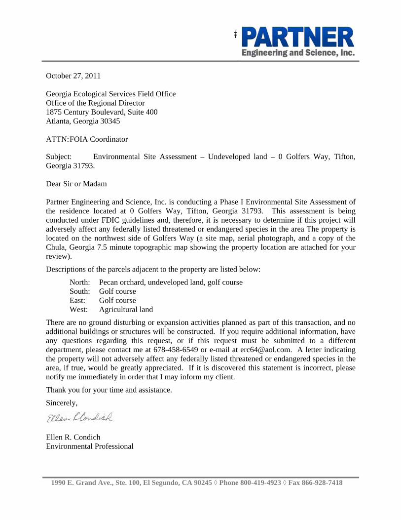
�
1990 E. Grand Ave., Ste. 100, El Segundo, CA 90245 ◊ Phone 800-419-4923 ◊ Fax 866-928-7418
October 27, 2011 Georgia Ecological Services Field Office Office of the Regional Director 1875 Century Boulevard, Suite 400 Atlanta, Georgia 30345 ATTN: FOIA Coordinator Subject: Environmental Site Assessment – Undeveloped land – 0 Golfers Way, Tifton, Georgia 31793. Dear Sir or Madam Partner Engineering and Science, Inc. is conducting a Phase I Environmental Site Assessment of the residence located at 0 Golfers Way, Tifton, Georgia 31793. This assessment is being conducted under FDIC guidelines and, therefore, it is necessary to determine if this project will adversely affect any federally listed threatened or endangered species in the area The property is located on the northwest side of Golfers Way (a site map, aerial photograph, and a copy of the Chula, Georgia 7.5 minute topographic map showing the property location are attached for your review).
Descriptions of the parcels adjacent to the property are listed below:
North: Pecan orchard, undeveloped land, golf course South: Golf course East: Golf course West: Agricultural land
There are no ground disturbing or expansion activities planned as part of this transaction, and no additional buildings or structures will be constructed. If you require additional information, have any questions regarding this request, or if this request must be submitted to a different department, please contact me at 678-458-6549 or e-mail at [email protected]. A letter indicating the property will not adversely affect any federally listed threatened or endangered species in the area, if true, would be greatly appreciated. If it is discovered this statement is incorrect, please notify me immediately in order that I may inform my client.
Thank you for your time and assistance.
Sincerely,
Ellen R. Condich Environmental Professional

FIGURE 3: SITE PLAN
Site Address:
www.PARTNEResi.com (800) 419-4923
Project No. 11-81719.1
Asset Number 10313000988 0 Golfers Way Chula, Georgia 31793
KEY:
Subject Site
GROUNDWATERFLOW
Highway 41/Farm Road
Club View Drive
Sunsweet Hills Drive
Golf Course
Undeveloped
Cemetery
Agricultural
Agricultural
Highway 41/Farm Road
Golf Course
Golf Course
Pond
Pecan Trees
Railroad Tracks

APPENDIX B: AERIAL PHOTOGRAPHS
Date: 2007
Site Address:
www.PARTNEResi.com (800) 419-4923
Project No. 11-81719.1
Asset Number 10313000988 0 Golfers Way Chula, Georgia 31793

FIGURE 2: TOPOGRAPHIC MAP USGS 7.5 Minute Chula, Georgia
Quadrangle Created: 1983
Site Address:
www.PARTNEResi.com (800) 419-4923
Project No. 11-81719.1
Asset Number 10313000988 0 Golfers Way Chula, Georgia 31793

RECORD OF COMMUNICATION
Site Name: 0 Golfers Way Location: Tifton, Georgia
Communication with: Customer Service Of: Tifton-Tift County Utilities
Location: Phone: 229-382-6231
Communication via:
Telephone
Recorded By:
Ellen Condich
Communication via:
Telephone
At: 1:00pm On: October 27, 2011
Re: Subject Property
Summary of Communication:
Obtained information regarding transformers in the area.
Conclusions/Required:
None
RECORD OF COMMUNICATION
Site Name: 0 Golfers Way Location: Tifton, Georgia
Communication with: Administration Of: Tifton Fire Department
Location: Tifton Phone: (229) 391-3972
Communication via:
phone
Recorded By:
Ellen Condich
Communication via:
At: Various On: October 2011
Re: Subject Property
Summary of Communication:
Obtained information pertaining to the USTs and hazardous materials incidents at the subject property.
Conclusions/Required:
No issues

RECORD OF COMMUNICATION
Site Name: 0 Golfers Way Location: Tifton, Georgia
Communication with: Zoning Department Of: Tifton
Location: 225 Tift Avenue North Phone: (229) 386-7961
Communication via:
Telephone
Recorded By:
Ellen Condich
Of:
Partner
At: Various On: October 2011
Re: Subject Property
Summary of Communication:
Requested information pertaining to zoning for the subject property.
Conclusions/Required:
No issues
RECORD OF COMMUNICATION
Site Name:0 Golfers Way Location: Tifton, Georgia
Communication with: Public Works Of: Tift County
Location: Tifton, Georgia Phone: 229-382-6231
Communication via:
Recorded By:
Ellen Condich
Communication via:
At: Various On: October 2011
Re: Subject Property
Summary of Communication:
Obtained information pertaining to the water sources for the subject property and vicinity.
Conclusions/Required:
No issues

RECORD OF COMMUNICATION
Site Name: 0 Golfers Way Location: Tifton, Georgia
Communication with: Assessor Of: Tift County
Location: Tifton, Georgia Phone: (229) 386-7961
Communication via:
Internet
Recorded By:
Ellen Condich
Communication via:
Internet
At: Various On: October 2011
Re: Subject Property
Summary of Communication:
Obtained ownership information.
Conclusions/Required:
No issues
RECORD OF COMMUNICATION
Site Name: 0 Golfers Way Location: Tifton, Georgia
Communication with: Local History Of: Tift County Library
Location: Tifton Phone: (229) 386-7205
Communication via:
In Person
Recorded By:
Ellen Condich
Communication via:
In Person
At: 10:00am On: October 2011
Re: Subject Property
Summary of Communication:
Reviewed historical city directories for the subject property and vicinity.
Conclusions/Required:
None

APPENDIX C: REGULATORY DATABASE REPORT

FORM-BPK-ROM
tropeR ™paM suidaR RDE ehT
440 Wheelers Farms RoadMilford, CT 06461Toll Free: 800.352.0050www.edrnet.com
Asset No.103130009880 Golfers WayChula, GA 31733
Inquiry Number: 3169732.2sSeptember 20, 2011

SECTION PAGE
Executive Summary ES1
Overview Map 2
Detail Map 3
Map Findings Summary 4
Map Findings 7
Orphan Summary 8
Government Records Searched/Data Currency Tracking GR-1
GEOCHECK ADDENDUM
GeoCheck - Not Requested
TC3169732.2s Page 1
Thank you for your business.Please contact EDR at 1-800-352-0050
with any questions or comments.
Disclaimer - Copyright and Trademark Notice
This Report contains certain information obtained from a variety of public and other sources reasonably available to Environmental DataResources, Inc. It cannot be concluded from this Report that coverage information for the target and surrounding properties does not exist fromother sources. NO WARRANTY EXPRESSED OR IMPLIED, IS MADE WHATSOEVER IN CONNECTION WITH THIS REPORT. ENVIRONMENTALDATA RESOURCES, INC. SPECIFICALLY DISCLAIMS THE MAKING OF ANY SUCH WARRANTIES, INCLUDING WITHOUT LIMITATION,MERCHANTABILITY OR FITNESS FOR A PARTICULAR USE OR PURPOSE. ALL RISK IS ASSUMED BY THE USER. IN NO EVENT SHALLENVIRONMENTAL DATA RESOURCES, INC. BE LIABLE TO ANYONE, WHETHER ARISING OUT OF ERRORS OR OMISSIONS, NEGLIGENCE,ACCIDENT OR ANY OTHER CAUSE, FOR ANY LOSS OF DAMAGE, INCLUDING, WITHOUT LIMITATION, SPECIAL, INCIDENTAL,CONSEQUENTIAL, OR EXEMPLARY DAMAGES. ANY LIABILITY ON THE PART OF ENVIRONMENTAL DATA RESOURCES, INC. IS STRICTLYLIMITED TO A REFUND OF THE AMOUNT PAID FOR THIS REPORT. Purchaser accepts this Report "AS IS". Any analyses, estimates, ratings,environmental risk levels or risk codes provided in this Report are provided for illustrative purposes only, and are not intended to provide, norshould they be interpreted as providing any facts regarding, or prediction or forecast of, any environmental risk for any property. Only a Phase IEnvironmental Site Assessment performed by an environmental professional can provide information regarding the environmental risk for anyproperty. Additionally, the information provided in this Report is not to be construed as legal advice.
Copyright 2011 by Environmental Data Resources, Inc. All rights reserved. Reproduction in any media or format, in wholeor in part, of any report or map of Environmental Data Resources, Inc., or its affiliates, is prohibited without prior written permission.
EDR and its logos (including Sanborn and Sanborn Map) are trademarks of Environmental Data Resources, Inc. or its affiliates. All othertrademarks used herein are the property of their respective owners.
TABLE OF CONTENTS
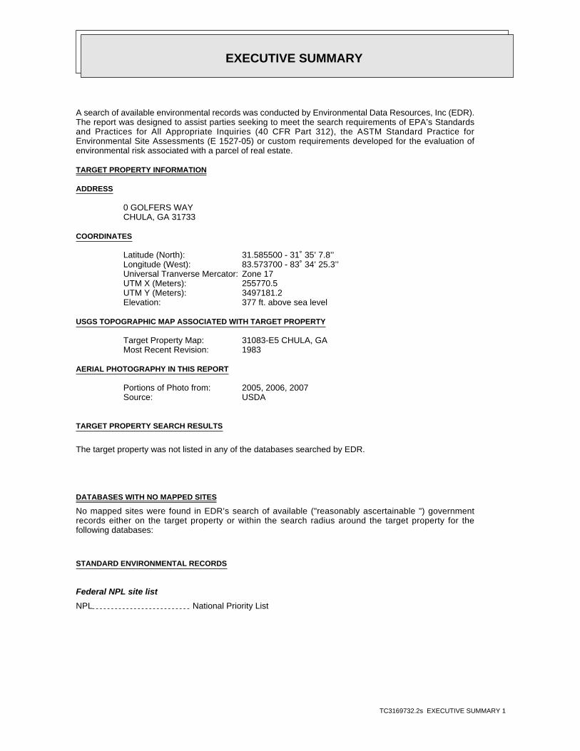
EXECUTIVE SUMMARY
TC3169732.2s EXECUTIVE SUMMARY 1
A search of available environmental records was conducted by Environmental Data Resources, Inc (EDR).The report was designed to assist parties seeking to meet the search requirements of EPA’s Standardsand Practices for All Appropriate Inquiries (40 CFR Part 312), the ASTM Standard Practice forEnvironmental Site Assessments (E 1527-05) or custom requirements developed for the evaluation ofenvironmental risk associated with a parcel of real estate.
TARGET PROPERTY INFORMATION
ADDRESS
0 GOLFERS WAYCHULA, GA 31733
COORDINATES
31.585500 - 31˚ 35’ 7.8’’Latitude (North): 83.573700 - 83˚ 34’ 25.3’’Longitude (West): Zone 17Universal Tranverse Mercator: 255770.5UTM X (Meters): 3497181.2UTM Y (Meters): 377 ft. above sea levelElevation:
USGS TOPOGRAPHIC MAP ASSOCIATED WITH TARGET PROPERTY
31083-E5 CHULA, GATarget Property Map:1983Most Recent Revision:
AERIAL PHOTOGRAPHY IN THIS REPORT
2005, 2006, 2007Portions of Photo from:USDASource:
TARGET PROPERTY SEARCH RESULTS
The target property was not listed in any of the databases searched by EDR.
DATABASES WITH NO MAPPED SITES
No mapped sites were found in EDR’s search of available ("reasonably ascertainable ") governmentrecords either on the target property or within the search radius around the target property for thefollowing databases:
STANDARD ENVIRONMENTAL RECORDS
Federal NPL site list
NPL National Priority List

EXECUTIVE SUMMARY
TC3169732.2s EXECUTIVE SUMMARY 2
Proposed NPL Proposed National Priority List SitesNPL LIENS Federal Superfund Liens
Federal Delisted NPL site list
Delisted NPL National Priority List Deletions
Federal CERCLIS list
CERCLIS Comprehensive Environmental Response, Compensation, and Liability Information SystemFEDERAL FACILITY Federal Facility Site Information listing
Federal CERCLIS NFRAP site List
CERC-NFRAP CERCLIS No Further Remedial Action Planned
Federal RCRA CORRACTS facilities list
CORRACTS Corrective Action Report
Federal RCRA non-CORRACTS TSD facilities list
RCRA-TSDF RCRA - Treatment, Storage and Disposal
Federal RCRA generators list
RCRA-LQG RCRA - Large Quantity GeneratorsRCRA-SQG RCRA - Small Quantity GeneratorsRCRA-CESQG RCRA - Conditionally Exempt Small Quantity Generator
Federal institutional controls / engineering controls registries
US ENG CONTROLS Engineering Controls Sites ListUS INST CONTROL Sites with Institutional Controls
Federal ERNS list
ERNS Emergency Response Notification System
State- and tribal - equivalent CERCLIS
SHWS Hazardous Site InventoryGA NON-HSI Non-Hazardous Site Inventory
State and tribal landfill and/or solid waste disposal site lists
SWF/LF Solid Waste Disposal Facilities
State and tribal leaking storage tank lists
LUST List of Leaking Underground Storage TanksINDIAN LUST Leaking Underground Storage Tanks on Indian Land
State and tribal registered storage tank lists
UST Underground Storage Tank Database

EXECUTIVE SUMMARY
TC3169732.2s EXECUTIVE SUMMARY 3
AST Above Ground Storage TanksINDIAN UST Underground Storage Tanks on Indian LandFEMA UST Underground Storage Tank Listing
State and tribal institutional control / engineering control registries
INST CONTROL Public Record List
State and tribal voluntary cleanup sites
INDIAN VCP Voluntary Cleanup Priority ListingVIC Voluntary Cleanup Program site
State and tribal Brownfields sites
BROWNFIELDS Brownfields Public Record List
ADDITIONAL ENVIRONMENTAL RECORDS
Local Brownfield lists
US BROWNFIELDS A Listing of Brownfields Sites
Local Lists of Landfill / Solid Waste Disposal Sites
ODI Open Dump InventoryDEBRIS REGION 9 Torres Martinez Reservation Illegal Dump Site LocationsHIST LF Historical LandfillsSWRCY Recycling Center ListingINDIAN ODI Report on the Status of Open Dumps on Indian Lands
Local Lists of Hazardous waste / Contaminated Sites
US CDL Clandestine Drug LabsDEL SHWS Delisted Hazardous Site Inventory ListingUS HIST CDL National Clandestine Laboratory Register
Local Land Records
LIENS 2 CERCLA Lien InformationLUCIS Land Use Control Information System
Records of Emergency Release Reports
HMIRS Hazardous Materials Information Reporting SystemSPILLS Spills Information
Other Ascertainable Records
RCRA-NonGen RCRA - Non GeneratorsDOT OPS Incident and Accident DataDOD Department of Defense SitesFUDS Formerly Used Defense SitesCONSENT Superfund (CERCLA) Consent Decrees

EXECUTIVE SUMMARY
TC3169732.2s EXECUTIVE SUMMARY 4
ROD Records Of DecisionUMTRA Uranium Mill Tailings SitesMINES Mines Master Index FileTRIS Toxic Chemical Release Inventory SystemTSCA Toxic Substances Control ActFTTS FIFRA/ TSCA Tracking System - FIFRA (Federal Insecticide, Fungicide, & Rodenticide Act)/TSCA (Toxic Substances Control Act)HIST FTTS FIFRA/TSCA Tracking System Administrative Case ListingSSTS Section 7 Tracking SystemsICIS Integrated Compliance Information SystemPADS PCB Activity Database SystemMLTS Material Licensing Tracking SystemRADINFO Radiation Information DatabaseFINDS Facility Index System/Facility Registry SystemRAATS RCRA Administrative Action Tracking SystemNPDES NPDES Wastewater Permit ListDRYCLEANERS Drycleaner DatabaseAIRS Permitted Facility and Emissions ListingTIER 2 Tier 2 Data ListingINDIAN RESERV Indian ReservationsSCRD DRYCLEANERS State Coalition for Remediation of Drycleaners ListingCOAL ASH DOE Sleam-Electric Plan Operation DataFINANCIAL ASSURANCE Financial Assurance Information ListingPCB TRANSFORMER PCB Transformer Registration DatabaseCOAL ASH Coal Ash Disposal Site ListingCOAL ASH EPA Coal Combustion Residues Surface Impoundments List
EDR PROPRIETARY RECORDS
EDR Proprietary Records
Manufactured Gas Plants EDR Proprietary Manufactured Gas Plants
SURROUNDING SITES: SEARCH RESULTS
Surrounding sites were not identified.
Unmappable (orphan) sites are not considered in the foregoing analysis.

EXECUTIVE SUMMARY
TC3169732.2s EXECUTIVE SUMMARY 5
Due to poor or inadequate address information, the following sites were not mapped. Count: 18 records.
Site Name Database(s)____________ ____________
FORSTMANN & COMPANY, INC. DEL SHWSRACHELS MINI SUPER UST, FINANCIAL ASSURANCETIFTON - OMEGA / ELDORADO ROAD MSW SHWSSYCAMORE PESTICIDE SITE CERC-NFRAPS&M SCRAP METAL CERC-NFRAP, RCRA-NonGen, FINDSCITY OF SYCAMORE SWF/LFSYCAMORE GAS COMPANY ASTDIXIE FOOD #625 ASTQUICK BUYS #110 ASTN & N PETRO #214 ASTGEORGIA VEGETABLE COMPANY ASTALUMAX BUILDING PRODUCTS (CLOSED) ASTYELLOW FREIGHT SYSTEM, INC.(CLOSED ASTTIFTON PEANUT COMPANY ASTGA DEPT OF AGRICULTURE TIFTON RCRA-CESQG, FINDSTIFTON GAARNG ARMORY RCRA-CESQG, FINDSSOUTH BOUND TRAIN NO.215 ERNSSOUTH BOUND TRAIN NO.215 ERNS

EDR Inc.EDR Inc.EDR Inc.EDR Inc.EDR Inc.EDR Inc.EDR Inc.EDR Inc.EDR Inc.EDR Inc.EDR Inc.EDR Inc.EDR Inc.EDR Inc.EDR Inc.EDR Inc.EDR Inc.EDR Inc.EDR Inc.EDR Inc.EDR Inc.EDR Inc.EDR Inc.EDR Inc.EDR Inc.EDR Inc.EDR Inc.EDR Inc.EDR Inc.EDR Inc.EDR Inc.EDR Inc.EDR Inc.EDR Inc.EDR Inc.EDR Inc.EDR Inc.EDR Inc.EDR Inc.EDR Inc.
3 6 0
4 0 0
400
32
0
32
0
3 2 0
3 20
3 6 0
36
0
36
0
3 60
3
60
360
3 6 0
36
0
3 6 0
3 6 0
3 6 0
3 6 0
36
0
3 6 0
3
60
3 6 0
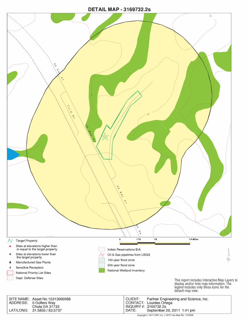
EDR Inc.EDR Inc.EDR Inc.EDR Inc.EDR Inc.EDR Inc.EDR Inc.EDR Inc.EDR Inc.EDR Inc.EDR Inc.EDR Inc.EDR Inc.EDR Inc.EDR Inc.EDR Inc.EDR Inc.EDR Inc.EDR Inc.EDR Inc.EDR Inc.EDR Inc.EDR Inc.EDR Inc.EDR Inc.EDR Inc.EDR Inc.EDR Inc.EDR Inc.EDR Inc.EDR Inc.EDR Inc.EDR Inc.EDR Inc.EDR Inc.EDR Inc.EDR Inc.EDR Inc.EDR Inc.EDR Inc.
360
360
360

MAP FINDINGS SUMMARY
SearchTarget Distance Total
Database Property (Miles) < 1/8 1/8 - 1/4 1/4 - 1/2 1/2 - 1 > 1 Plotted
STANDARD ENVIRONMENTAL RECORDS
Federal NPL site list
0 NR 0 0 0 0 1.000NPL 0 NR 0 0 0 0 1.000Proposed NPL 0 NR NR NR NR NR TPNPL LIENS
Federal Delisted NPL site list
0 NR 0 0 0 0 1.000Delisted NPL
Federal CERCLIS list
0 NR NR 0 0 0 0.500CERCLIS 0 NR 0 0 0 0 1.000FEDERAL FACILITY
Federal CERCLIS NFRAP site List
0 NR NR 0 0 0 0.500CERC-NFRAP
Federal RCRA CORRACTS facilities list
0 NR 0 0 0 0 1.000CORRACTS
Federal RCRA non-CORRACTS TSD facilities list
0 NR NR 0 0 0 0.500RCRA-TSDF
Federal RCRA generators list
0 NR NR NR 0 0 0.250RCRA-LQG 0 NR NR NR 0 0 0.250RCRA-SQG 0 NR NR NR 0 0 0.250RCRA-CESQG
Federal institutional controls /engineering controls registries
0 NR NR 0 0 0 0.500US ENG CONTROLS 0 NR NR 0 0 0 0.500US INST CONTROL
Federal ERNS list
0 NR NR NR NR NR TPERNS
State- and tribal - equivalent CERCLIS
0 NR 0 0 0 0 1.000SHWS 0 NR 0 0 0 0 1.000GA NON-HSI
State and tribal landfill and/orsolid waste disposal site lists
0 NR NR 0 0 0 0.500SWF/LF
State and tribal leaking storage tank lists
0 NR NR 0 0 0 0.500LUST 0 NR NR 0 0 0 0.500INDIAN LUST
State and tribal registered storage tank lists
0 NR NR NR 0 0 0.250UST
TC3169732.2s Page 4

MAP FINDINGS SUMMARY
SearchTarget Distance Total
Database Property (Miles) < 1/8 1/8 - 1/4 1/4 - 1/2 1/2 - 1 > 1 Plotted
0 NR NR NR 0 0 0.250AST 0 NR NR NR 0 0 0.250INDIAN UST 0 NR NR NR 0 0 0.250FEMA UST
State and tribal institutionalcontrol / engineering control registries
0 NR NR 0 0 0 0.500INST CONTROL
State and tribal voluntary cleanup sites
0 NR NR 0 0 0 0.500INDIAN VCP 0 NR NR 0 0 0 0.500VIC
State and tribal Brownfields sites
0 NR NR 0 0 0 0.500BROWNFIELDS
ADDITIONAL ENVIRONMENTAL RECORDS
Local Brownfield lists
0 NR NR 0 0 0 0.500US BROWNFIELDS
Local Lists of Landfill / SolidWaste Disposal Sites
0 NR NR 0 0 0 0.500ODI 0 NR NR 0 0 0 0.500DEBRIS REGION 9 0 NR NR 0 0 0 0.500HIST LF 0 NR NR 0 0 0 0.500SWRCY 0 NR NR 0 0 0 0.500INDIAN ODI
Local Lists of Hazardous waste /Contaminated Sites
0 NR NR NR NR NR TPUS CDL 0 NR 0 0 0 0 1.000DEL SHWS 0 NR NR NR NR NR TPUS HIST CDL
Local Land Records
0 NR NR NR NR NR TPLIENS 2 0 NR NR 0 0 0 0.500LUCIS
Records of Emergency Release Reports
0 NR NR NR NR NR TPHMIRS 0 NR NR NR NR NR TPSPILLS
Other Ascertainable Records
0 NR NR NR 0 0 0.250RCRA-NonGen 0 NR NR NR NR NR TPDOT OPS 0 NR 0 0 0 0 1.000DOD 0 NR 0 0 0 0 1.000FUDS 0 NR 0 0 0 0 1.000CONSENT 0 NR 0 0 0 0 1.000ROD 0 NR NR 0 0 0 0.500UMTRA
TC3169732.2s Page 5
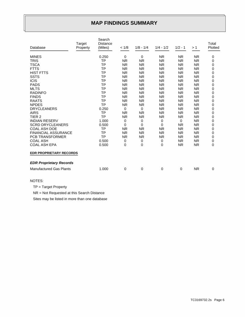
MAP FINDINGS SUMMARY
SearchTarget Distance Total
Database Property (Miles) < 1/8 1/8 - 1/4 1/4 - 1/2 1/2 - 1 > 1 Plotted
0 NR NR NR 0 0 0.250MINES 0 NR NR NR NR NR TPTRIS 0 NR NR NR NR NR TPTSCA 0 NR NR NR NR NR TPFTTS 0 NR NR NR NR NR TPHIST FTTS 0 NR NR NR NR NR TPSSTS 0 NR NR NR NR NR TPICIS 0 NR NR NR NR NR TPPADS 0 NR NR NR NR NR TPMLTS 0 NR NR NR NR NR TPRADINFO 0 NR NR NR NR NR TPFINDS 0 NR NR NR NR NR TPRAATS 0 NR NR NR NR NR TPNPDES 0 NR NR NR 0 0 0.250DRYCLEANERS 0 NR NR NR NR NR TPAIRS 0 NR NR NR NR NR TPTIER 2 0 NR 0 0 0 0 1.000INDIAN RESERV 0 NR NR 0 0 0 0.500SCRD DRYCLEANERS 0 NR NR NR NR NR TPCOAL ASH DOE 0 NR NR NR NR NR TPFINANCIAL ASSURANCE 0 NR NR NR NR NR TPPCB TRANSFORMER 0 NR NR 0 0 0 0.500COAL ASH 0 NR NR 0 0 0 0.500COAL ASH EPA
EDR PROPRIETARY RECORDS
EDR Proprietary Records
0 NR 0 0 0 0 1.000Manufactured Gas Plants
NOTES:
TP = Target Property
NR = Not Requested at this Search Distance
Sites may be listed in more than one database
TC3169732.2s Page 6

MAP FINDINGSMap IDDirection
EDR ID NumberDistanceEPA ID NumberDatabase(s)SiteElevation
NO SITES FOUND
TC3169732.2s Page 7
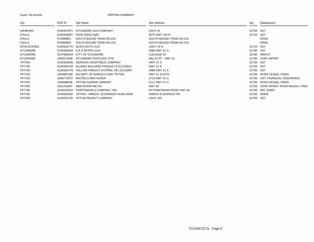
ORPHAN SUMMARY
City EDR ID Site Name Site Address Zip Database(s)
Count: 18 records.
ASHBURN A100347971 SYCAMORE GAS COMPANY USHY 41 31793 ASTCHULA A100334897 DIXIE FOOD #625 5070 HWY 125 N 31733 ASTCHULA 974080801 SOUTH BOUND TRAIN NO.215 SOUTH BOUND TRAIN NO.215 ERNSCHULA 974080800 SOUTH BOUND TRAIN NO.215 SOUTH BOUND TRAIN NO.215 ERNSOCHLOCKNEE A100334775 QUICK BUYS #110 USHY 19 N 31733 ASTSYCAMORE A100335049 N & N PETRO #214 2695 HWY 41 S 31790 ASTSYCAMORE S107666019 CITY OF SYCAMORE COLLEGE ST 31790 SWF/LFSYCAMORE 1002872038 SYCAMORE PESTICIDE SITE WILLIS ST HWY 41 31790 CERC-NFRAPTIFTON A100334695 GEORGIA VEGETABLE COMPANY HWY 41 S 31793 ASTTIFTON A100334700 ALUMAX BUILDING PRODUCTS (CLOSED) HWY 41 S 31793 ASTTIFTON A100334778 YELLOW FREIGHT SYSTEM, INC.(CLOSED 3386 HWY 41 S 31793 ASTTIFTON 1004687188 GA DEPT OF AGRICULTURE TIFTON HWY 41 SOUTH 31793 RCRA-CESQG, FINDSTIFTON 1006772573 RACHELS MINI SUPER 2712 HWY 41 S 31793 UST, FINANCIAL ASSURANCETIFTON 1004688036 TIFTON GAARNG ARMORY 3111 HWY 41 S 31793 RCRA-CESQG, FINDSTIFTON 1001218407 S&M SCRAP METAL HWY 82 31793 CERC-NFRAP, RCRA-NonGen, FINDSTIFTON S103224324 FORSTMANN & COMPANY, INC. 26 FORSTMANN ROAD HWY W 31793 DEL SHWSTIFTON S105565400 TIFTON - OMEGA / ELDORADO ROAD MSW OMEGA ELDORADO RD 31793 SHWSTIFTON A100334720 TIFTON PEANUT COMPANY USHY 319 31793 AST
TC3169732.2s Page 8

To maintain currency of the following federal and state databases, EDR contacts the appropriate governmental agencyon a monthly or quarterly basis, as required.
Number of Days to Update: Provides confirmation that EDR is reporting records that have been updated within 90 daysfrom the date the government agency made the information available to the public.
STANDARD ENVIRONMENTAL RECORDS
Federal NPL site list
NPL: National Priority ListNational Priorities List (Superfund). The NPL is a subset of CERCLIS and identifies over 1,200 sites for prioritycleanup under the Superfund Program. NPL sites may encompass relatively large areas. As such, EDR provides polygoncoverage for over 1,000 NPL site boundaries produced by EPA’s Environmental Photographic Interpretation Center(EPIC) and regional EPA offices.
Date of Government Version: 03/31/2011Date Data Arrived at EDR: 04/13/2011Date Made Active in Reports: 06/14/2011Number of Days to Update: 62
Source: EPATelephone: N/ALast EDR Contact: 07/12/2011Next Scheduled EDR Contact: 10/24/2011Data Release Frequency: Quarterly
NPL Site Boundaries
Sources:
EPA’s Environmental Photographic Interpretation Center (EPIC)Telephone: 202-564-7333
EPA Region 1 EPA Region 6Telephone 617-918-1143 Telephone: 214-655-6659
EPA Region 3 EPA Region 7Telephone 215-814-5418 Telephone: 913-551-7247
EPA Region 4 EPA Region 8Telephone 404-562-8033 Telephone: 303-312-6774
EPA Region 5 EPA Region 9Telephone 312-886-6686 Telephone: 415-947-4246
EPA Region 10Telephone 206-553-8665
Proposed NPL: Proposed National Priority List SitesA site that has been proposed for listing on the National Priorities List through the issuance of a proposed rulein the Federal Register. EPA then accepts public comments on the site, responds to the comments, and places onthe NPL those sites that continue to meet the requirements for listing.
Date of Government Version: 03/31/2011Date Data Arrived at EDR: 04/13/2011Date Made Active in Reports: 06/14/2011Number of Days to Update: 62
Source: EPATelephone: N/ALast EDR Contact: 07/12/2011Next Scheduled EDR Contact: 10/24/2011Data Release Frequency: Quarterly
NPL LIENS: Federal Superfund LiensFederal Superfund Liens. Under the authority granted the USEPA by CERCLA of 1980, the USEPA has the authorityto file liens against real property in order to recover remedial action expenditures or when the property ownerreceived notification of potential liability. USEPA compiles a listing of filed notices of Superfund Liens.
Date of Government Version: 10/15/1991Date Data Arrived at EDR: 02/02/1994Date Made Active in Reports: 03/30/1994Number of Days to Update: 56
Source: EPATelephone: 202-564-4267Last EDR Contact: 08/15/2011Next Scheduled EDR Contact: 11/28/2011Data Release Frequency: No Update Planned
TC3169732.2s Page GR-1
GOVERNMENT RECORDS SEARCHED / DATA CURRENCY TRACKING

Federal Delisted NPL site list
DELISTED NPL: National Priority List DeletionsThe National Oil and Hazardous Substances Pollution Contingency Plan (NCP) establishes the criteria that theEPA uses to delete sites from the NPL. In accordance with 40 CFR 300.425.(e), sites may be deleted from theNPL where no further response is appropriate.
Date of Government Version: 03/31/2011Date Data Arrived at EDR: 04/13/2011Date Made Active in Reports: 06/14/2011Number of Days to Update: 62
Source: EPATelephone: N/ALast EDR Contact: 07/12/2011Next Scheduled EDR Contact: 10/24/2011Data Release Frequency: Quarterly
Federal CERCLIS list
CERCLIS: Comprehensive Environmental Response, Compensation, and Liability Information SystemCERCLIS contains data on potentially hazardous waste sites that have been reported to the USEPA by states, municipalities,private companies and private persons, pursuant to Section 103 of the Comprehensive Environmental Response, Compensation,and Liability Act (CERCLA). CERCLIS contains sites which are either proposed to or on the National PrioritiesList (NPL) and sites which are in the screening and assessment phase for possible inclusion on the NPL.
Date of Government Version: 02/25/2011Date Data Arrived at EDR: 03/01/2011Date Made Active in Reports: 05/02/2011Number of Days to Update: 62
Source: EPATelephone: 703-412-9810Last EDR Contact: 09/01/2011Next Scheduled EDR Contact: 12/12/2011Data Release Frequency: Quarterly
FEDERAL FACILITY: Federal Facility Site Information listingA listing of National Priority List (NPL) and Base Realignment and Closure (BRAC) sites found in the ComprehensiveEnvironmental Response, Compensation and Liability Information System (CERCLIS) Database where EPAa??s FederalFacilities Restoration and Reuse Office is involved in cleanup activities.
Date of Government Version: 12/10/2010Date Data Arrived at EDR: 01/11/2011Date Made Active in Reports: 02/16/2011Number of Days to Update: 36
Source: Environmental Protection AgencyTelephone: 703-603-8704Last EDR Contact: 07/15/2011Next Scheduled EDR Contact: 10/24/2011Data Release Frequency: Varies
Federal CERCLIS NFRAP site List
CERCLIS-NFRAP: CERCLIS No Further Remedial Action PlannedArchived sites are sites that have been removed and archived from the inventory of CERCLIS sites. Archived statusindicates that, to the best of EPA’s knowledge, assessment at a site has been completed and that EPA has determinedno further steps will be taken to list this site on the National Priorities List (NPL), unless information indicatesthis decision was not appropriate or other considerations require a recommendation for listing at a later time.This decision does not necessarily mean that there is no hazard associated with a given site; it only means that,based upon available information, the location is not judged to be a potential NPL site.
Date of Government Version: 02/25/2011Date Data Arrived at EDR: 03/01/2011Date Made Active in Reports: 05/02/2011Number of Days to Update: 62
Source: EPATelephone: 703-412-9810Last EDR Contact: 09/01/2011Next Scheduled EDR Contact: 12/12/2011Data Release Frequency: Quarterly
Federal RCRA CORRACTS facilities list
CORRACTS: Corrective Action ReportCORRACTS identifies hazardous waste handlers with RCRA corrective action activity.
TC3169732.2s Page GR-2
GOVERNMENT RECORDS SEARCHED / DATA CURRENCY TRACKING
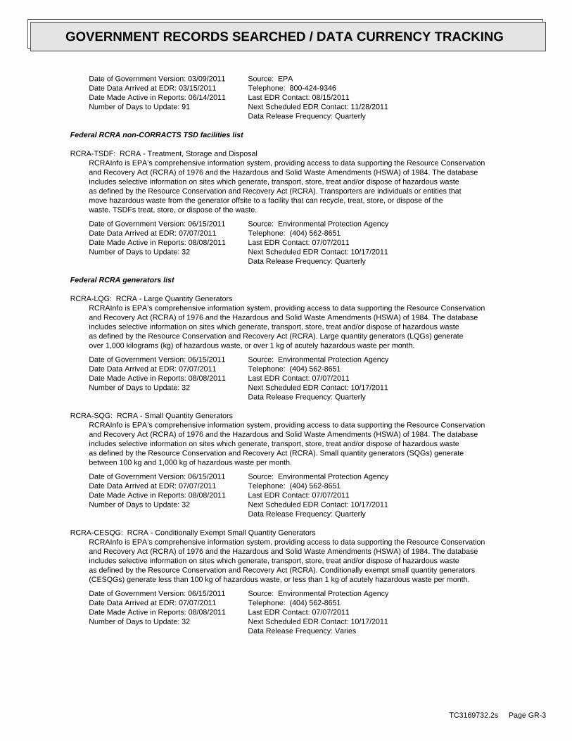
Date of Government Version: 03/09/2011Date Data Arrived at EDR: 03/15/2011Date Made Active in Reports: 06/14/2011Number of Days to Update: 91
Source: EPATelephone: 800-424-9346Last EDR Contact: 08/15/2011Next Scheduled EDR Contact: 11/28/2011Data Release Frequency: Quarterly
Federal RCRA non-CORRACTS TSD facilities list
RCRA-TSDF: RCRA - Treatment, Storage and DisposalRCRAInfo is EPA’s comprehensive information system, providing access to data supporting the Resource Conservationand Recovery Act (RCRA) of 1976 and the Hazardous and Solid Waste Amendments (HSWA) of 1984. The databaseincludes selective information on sites which generate, transport, store, treat and/or dispose of hazardous wasteas defined by the Resource Conservation and Recovery Act (RCRA). Transporters are individuals or entities thatmove hazardous waste from the generator offsite to a facility that can recycle, treat, store, or dispose of thewaste. TSDFs treat, store, or dispose of the waste.
Date of Government Version: 06/15/2011Date Data Arrived at EDR: 07/07/2011Date Made Active in Reports: 08/08/2011Number of Days to Update: 32
Source: Environmental Protection AgencyTelephone: (404) 562-8651Last EDR Contact: 07/07/2011Next Scheduled EDR Contact: 10/17/2011Data Release Frequency: Quarterly
Federal RCRA generators list
RCRA-LQG: RCRA - Large Quantity GeneratorsRCRAInfo is EPA’s comprehensive information system, providing access to data supporting the Resource Conservationand Recovery Act (RCRA) of 1976 and the Hazardous and Solid Waste Amendments (HSWA) of 1984. The databaseincludes selective information on sites which generate, transport, store, treat and/or dispose of hazardous wasteas defined by the Resource Conservation and Recovery Act (RCRA). Large quantity generators (LQGs) generateover 1,000 kilograms (kg) of hazardous waste, or over 1 kg of acutely hazardous waste per month.
Date of Government Version: 06/15/2011Date Data Arrived at EDR: 07/07/2011Date Made Active in Reports: 08/08/2011Number of Days to Update: 32
Source: Environmental Protection AgencyTelephone: (404) 562-8651Last EDR Contact: 07/07/2011Next Scheduled EDR Contact: 10/17/2011Data Release Frequency: Quarterly
RCRA-SQG: RCRA - Small Quantity GeneratorsRCRAInfo is EPA’s comprehensive information system, providing access to data supporting the Resource Conservationand Recovery Act (RCRA) of 1976 and the Hazardous and Solid Waste Amendments (HSWA) of 1984. The databaseincludes selective information on sites which generate, transport, store, treat and/or dispose of hazardous wasteas defined by the Resource Conservation and Recovery Act (RCRA). Small quantity generators (SQGs) generatebetween 100 kg and 1,000 kg of hazardous waste per month.
Date of Government Version: 06/15/2011Date Data Arrived at EDR: 07/07/2011Date Made Active in Reports: 08/08/2011Number of Days to Update: 32
Source: Environmental Protection AgencyTelephone: (404) 562-8651Last EDR Contact: 07/07/2011Next Scheduled EDR Contact: 10/17/2011Data Release Frequency: Quarterly
RCRA-CESQG: RCRA - Conditionally Exempt Small Quantity GeneratorsRCRAInfo is EPA’s comprehensive information system, providing access to data supporting the Resource Conservationand Recovery Act (RCRA) of 1976 and the Hazardous and Solid Waste Amendments (HSWA) of 1984. The databaseincludes selective information on sites which generate, transport, store, treat and/or dispose of hazardous wasteas defined by the Resource Conservation and Recovery Act (RCRA). Conditionally exempt small quantity generators(CESQGs) generate less than 100 kg of hazardous waste, or less than 1 kg of acutely hazardous waste per month.
Date of Government Version: 06/15/2011Date Data Arrived at EDR: 07/07/2011Date Made Active in Reports: 08/08/2011Number of Days to Update: 32
Source: Environmental Protection AgencyTelephone: (404) 562-8651Last EDR Contact: 07/07/2011Next Scheduled EDR Contact: 10/17/2011Data Release Frequency: Varies
TC3169732.2s Page GR-3
GOVERNMENT RECORDS SEARCHED / DATA CURRENCY TRACKING

Federal institutional controls / engineering controls registries
US ENG CONTROLS: Engineering Controls Sites ListA listing of sites with engineering controls in place. Engineering controls include various forms of caps, buildingfoundations, liners, and treatment methods to create pathway elimination for regulated substances to enter environmentalmedia or effect human health.
Date of Government Version: 03/16/2011Date Data Arrived at EDR: 03/25/2011Date Made Active in Reports: 06/14/2011Number of Days to Update: 81
Source: Environmental Protection AgencyTelephone: 703-603-0695Last EDR Contact: 09/12/2011Next Scheduled EDR Contact: 12/26/2011Data Release Frequency: Varies
US INST CONTROL: Sites with Institutional ControlsA listing of sites with institutional controls in place. Institutional controls include administrative measures,such as groundwater use restrictions, construction restrictions, property use restrictions, and post remediationcare requirements intended to prevent exposure to contaminants remaining on site. Deed restrictions are generallyrequired as part of the institutional controls.
Date of Government Version: 03/16/2011Date Data Arrived at EDR: 03/25/2011Date Made Active in Reports: 06/14/2011Number of Days to Update: 81
Source: Environmental Protection AgencyTelephone: 703-603-0695Last EDR Contact: 09/12/2011Next Scheduled EDR Contact: 12/26/2011Data Release Frequency: Varies
Federal ERNS list
ERNS: Emergency Response Notification SystemEmergency Response Notification System. ERNS records and stores information on reported releases of oil and hazardoussubstances.
Date of Government Version: 04/05/2011Date Data Arrived at EDR: 04/05/2011Date Made Active in Reports: 06/14/2011Number of Days to Update: 70
Source: National Response Center, United States Coast GuardTelephone: 202-267-2180Last EDR Contact: 07/05/2011Next Scheduled EDR Contact: 10/17/2011Data Release Frequency: Annually
State- and tribal - equivalent CERCLIS
SHWS: Hazardous Site InventoryState Hazardous Waste Sites. State hazardous waste site records are the states’ equivalent to CERCLIS. These sitesmay or may not already be listed on the federal CERCLIS list. Priority sites planned for cleanup using state funds(state equivalent of Superfund) are identified along with sites where cleanup will be paid for by potentiallyresponsible parties. Available information varies by state.
Date of Government Version: 07/01/2011Date Data Arrived at EDR: 07/21/2011Date Made Active in Reports: 08/09/2011Number of Days to Update: 19
Source: Department of Environmental ProtectionTelephone: 404-657-8600Last EDR Contact: 07/01/2011Next Scheduled EDR Contact: 10/17/2011Data Release Frequency: Annually
NON HSI: Non-Hazardous Site InventoryThis list was obtained by EDR in 1998 and contains property listings that have reported contamination of soilor groundwater under the Georgia Hazardous Site Response Act (HSRA). These sites were not placed on the GeorgiaPriority list (Hazardous Site Inventory or HSI) because their hazard evaluation scores did not exceed the thresholdlevels established for sites posing an imminent threat to health or the environment. Disclaimer provided by Rindt-McDuffAssociates - the database information has been obtained from publicly available sources produced by other entities.While reasonable steps have been taken to insure the accuracy of the data, RMA does not guarantee the accuracyof the data. No claim is made for the actual existence of pollution at any site. This data does not constitutea legal opinion.
TC3169732.2s Page GR-4
GOVERNMENT RECORDS SEARCHED / DATA CURRENCY TRACKING

Date of Government Version: 06/30/2011Date Data Arrived at EDR: 07/08/2011Date Made Active in Reports: 08/09/2011Number of Days to Update: 32
Source: Rindt-McDuff Associates, Inc.Telephone: N/ALast EDR Contact: 09/12/2011Next Scheduled EDR Contact: 12/26/2011Data Release Frequency: Annually
State and tribal landfill and/or solid waste disposal site lists
SWF/LF: Solid Waste Disposal FacilitiesSolid Waste Facilities/Landfill Sites. SWF/LF type records typically contain an inventory of solid waste disposalfacilities or landfills in a particular state. Depending on the state, these may be active or inactive facilitiesor open dumps that failed to meet RCRA Subtitle D Section 4004 criteria for solid waste landfills or disposalsites.
Date of Government Version: 03/04/2011Date Data Arrived at EDR: 05/11/2011Date Made Active in Reports: 06/23/2011Number of Days to Update: 43
Source: Department of Natural ResourcesTelephone: 404-362-2696Source: Center for GIS, Georgia Institute of TechnologyTelephone: 404-385-0900Last EDR Contact: 08/12/2011Next Scheduled EDR Contact: 11/21/2011Data Release Frequency: Semi-Annually
State and tribal leaking storage tank lists
LUST: List of Leaking Underground Storage TanksLeaking Underground Storage Tank Incident Reports. LUST records contain an inventory of reported leaking undergroundstorage tank incidents. Not all states maintain these records, and the information stored varies by state.
Date of Government Version: 04/13/2011Date Data Arrived at EDR: 06/21/2011Date Made Active in Reports: 07/22/2011Number of Days to Update: 31
Source: Environmental Protection DivisionTelephone: 404-362-2687Last EDR Contact: 09/20/2011Next Scheduled EDR Contact: 01/02/2012Data Release Frequency: Quarterly
INDIAN LUST R4: Leaking Underground Storage Tanks on Indian LandLUSTs on Indian land in Florida, Mississippi and North Carolina.
Date of Government Version: 08/11/2011Date Data Arrived at EDR: 08/12/2011Date Made Active in Reports: 09/13/2011Number of Days to Update: 32
Source: EPA Region 4Telephone: 404-562-8677Last EDR Contact: 08/01/2011Next Scheduled EDR Contact: 11/14/2011Data Release Frequency: Semi-Annually
INDIAN LUST R9: Leaking Underground Storage Tanks on Indian LandLUSTs on Indian land in Arizona, California, New Mexico and Nevada
Date of Government Version: 01/31/2011Date Data Arrived at EDR: 02/01/2011Date Made Active in Reports: 03/21/2011Number of Days to Update: 48
Source: Environmental Protection AgencyTelephone: 415-972-3372Last EDR Contact: 08/01/2011Next Scheduled EDR Contact: 11/14/2011Data Release Frequency: Quarterly
INDIAN LUST R10: Leaking Underground Storage Tanks on Indian LandLUSTs on Indian land in Alaska, Idaho, Oregon and Washington.
Date of Government Version: 08/04/2011Date Data Arrived at EDR: 08/05/2011Date Made Active in Reports: 09/13/2011Number of Days to Update: 39
Source: EPA Region 10Telephone: 206-553-2857Last EDR Contact: 08/01/2011Next Scheduled EDR Contact: 11/14/2011Data Release Frequency: Quarterly
TC3169732.2s Page GR-5
GOVERNMENT RECORDS SEARCHED / DATA CURRENCY TRACKING

INDIAN LUST R1: Leaking Underground Storage Tanks on Indian LandA listing of leaking underground storage tank locations on Indian Land.
Date of Government Version: 05/05/2011Date Data Arrived at EDR: 08/02/2011Date Made Active in Reports: 09/13/2011Number of Days to Update: 42
Source: EPA Region 1Telephone: 617-918-1313Last EDR Contact: 08/02/2011Next Scheduled EDR Contact: 11/14/2011Data Release Frequency: Varies
INDIAN LUST R6: Leaking Underground Storage Tanks on Indian LandLUSTs on Indian land in New Mexico and Oklahoma.
Date of Government Version: 05/10/2011Date Data Arrived at EDR: 05/11/2011Date Made Active in Reports: 06/14/2011Number of Days to Update: 34
Source: EPA Region 6Telephone: 214-665-6597Last EDR Contact: 08/01/2011Next Scheduled EDR Contact: 11/14/2011Data Release Frequency: Varies
INDIAN LUST R7: Leaking Underground Storage Tanks on Indian LandLUSTs on Indian land in Iowa, Kansas, and Nebraska
Date of Government Version: 02/16/2011Date Data Arrived at EDR: 06/02/2011Date Made Active in Reports: 09/13/2011Number of Days to Update: 103
Source: EPA Region 7Telephone: 913-551-7003Last EDR Contact: 08/02/2011Next Scheduled EDR Contact: 11/14/2011Data Release Frequency: Varies
INDIAN LUST R8: Leaking Underground Storage Tanks on Indian LandLUSTs on Indian land in Colorado, Montana, North Dakota, South Dakota, Utah and Wyoming.
Date of Government Version: 08/18/2011Date Data Arrived at EDR: 08/19/2011Date Made Active in Reports: 09/13/2011Number of Days to Update: 25
Source: EPA Region 8Telephone: 303-312-6271Last EDR Contact: 08/01/2011Next Scheduled EDR Contact: 11/14/2011Data Release Frequency: Quarterly
State and tribal registered storage tank lists
UST: Underground Storage Tank DatabaseRegistered Underground Storage Tanks. UST’s are regulated under Subtitle I of the Resource Conservation and RecoveryAct (RCRA) and must be registered with the state department responsible for administering the UST program. Availableinformation varies by state program.
Date of Government Version: 09/14/2010Date Data Arrived at EDR: 09/21/2010Date Made Active in Reports: 11/29/2010Number of Days to Update: 69
Source: Environmental Protection DivisionTelephone: 404-362-2687Last EDR Contact: 06/24/2011Next Scheduled EDR Contact: 10/03/2011Data Release Frequency: Annually
AST: Above Ground Storage TanksA listing of LP gas tank site locations.
Date of Government Version: 06/13/2011Date Data Arrived at EDR: 06/15/2011Date Made Active in Reports: 07/18/2011Number of Days to Update: 33
Source: Office of Insurance & Safety Fire CommissionerTelephone: 404-656-5875Last EDR Contact: 08/31/2011Next Scheduled EDR Contact: 12/12/2011Data Release Frequency: Varies
INDIAN UST R6: Underground Storage Tanks on Indian LandThe Indian Underground Storage Tank (UST) database provides information about underground storage tanks on Indianland in EPA Region 6 (Louisiana, Arkansas, Oklahoma, New Mexico, Texas and 65 Tribes).
TC3169732.2s Page GR-6
GOVERNMENT RECORDS SEARCHED / DATA CURRENCY TRACKING

Date of Government Version: 05/10/2011Date Data Arrived at EDR: 05/11/2011Date Made Active in Reports: 06/14/2011Number of Days to Update: 34
Source: EPA Region 6Telephone: 214-665-7591Last EDR Contact: 08/01/2011Next Scheduled EDR Contact: 11/14/2011Data Release Frequency: Semi-Annually
INDIAN UST R4: Underground Storage Tanks on Indian LandThe Indian Underground Storage Tank (UST) database provides information about underground storage tanks on Indianland in EPA Region 4 (Alabama, Florida, Georgia, Kentucky, Mississippi, North Carolina, South Carolina, Tennesseeand Tribal Nations)
Date of Government Version: 08/11/2011Date Data Arrived at EDR: 08/12/2011Date Made Active in Reports: 09/13/2011Number of Days to Update: 32
Source: EPA Region 4Telephone: 404-562-9424Last EDR Contact: 08/01/2011Next Scheduled EDR Contact: 11/14/2011Data Release Frequency: Semi-Annually
INDIAN UST R5: Underground Storage Tanks on Indian LandThe Indian Underground Storage Tank (UST) database provides information about underground storage tanks on Indianland in EPA Region 5 (Michigan, Minnesota and Wisconsin and Tribal Nations).
Date of Government Version: 07/01/2011Date Data Arrived at EDR: 08/26/2011Date Made Active in Reports: 09/13/2011Number of Days to Update: 18
Source: EPA Region 5Telephone: 312-886-6136Last EDR Contact: 08/01/2011Next Scheduled EDR Contact: 11/14/2011Data Release Frequency: Varies
INDIAN UST R10: Underground Storage Tanks on Indian LandThe Indian Underground Storage Tank (UST) database provides information about underground storage tanks on Indianland in EPA Region 10 (Alaska, Idaho, Oregon, Washington, and Tribal Nations).
Date of Government Version: 08/04/2011Date Data Arrived at EDR: 08/05/2011Date Made Active in Reports: 09/13/2011Number of Days to Update: 39
Source: EPA Region 10Telephone: 206-553-2857Last EDR Contact: 08/01/2011Next Scheduled EDR Contact: 11/14/2011Data Release Frequency: Quarterly
INDIAN UST R1: Underground Storage Tanks on Indian LandThe Indian Underground Storage Tank (UST) database provides information about underground storage tanks on Indianland in EPA Region 1 (Connecticut, Maine, Massachusetts, New Hampshire, Rhode Island, Vermont and ten TribalNations).
Date of Government Version: 05/05/2011Date Data Arrived at EDR: 08/08/2011Date Made Active in Reports: 09/13/2011Number of Days to Update: 36
Source: EPA, Region 1Telephone: 617-918-1313Last EDR Contact: 08/02/2011Next Scheduled EDR Contact: 11/14/2011Data Release Frequency: Varies
INDIAN UST R9: Underground Storage Tanks on Indian LandThe Indian Underground Storage Tank (UST) database provides information about underground storage tanks on Indianland in EPA Region 9 (Arizona, California, Hawaii, Nevada, the Pacific Islands, and Tribal Nations).
Date of Government Version: 08/04/2011Date Data Arrived at EDR: 08/05/2011Date Made Active in Reports: 09/13/2011Number of Days to Update: 39
Source: EPA Region 9Telephone: 415-972-3368Last EDR Contact: 08/01/2011Next Scheduled EDR Contact: 11/14/2011Data Release Frequency: Quarterly
INDIAN UST R8: Underground Storage Tanks on Indian LandThe Indian Underground Storage Tank (UST) database provides information about underground storage tanks on Indianland in EPA Region 8 (Colorado, Montana, North Dakota, South Dakota, Utah, Wyoming and 27 Tribal Nations).
TC3169732.2s Page GR-7
GOVERNMENT RECORDS SEARCHED / DATA CURRENCY TRACKING

Date of Government Version: 08/18/2011Date Data Arrived at EDR: 08/19/2011Date Made Active in Reports: 09/13/2011Number of Days to Update: 25
Source: EPA Region 8Telephone: 303-312-6137Last EDR Contact: 08/01/2011Next Scheduled EDR Contact: 11/14/2011Data Release Frequency: Quarterly
INDIAN UST R7: Underground Storage Tanks on Indian LandThe Indian Underground Storage Tank (UST) database provides information about underground storage tanks on Indianland in EPA Region 7 (Iowa, Kansas, Missouri, Nebraska, and 9 Tribal Nations).
Date of Government Version: 04/01/2011Date Data Arrived at EDR: 06/01/2011Date Made Active in Reports: 06/14/2011Number of Days to Update: 13
Source: EPA Region 7Telephone: 913-551-7003Last EDR Contact: 08/02/2011Next Scheduled EDR Contact: 11/14/2011Data Release Frequency: Varies
FEMA UST: Underground Storage Tank ListingA listing of all FEMA owned underground storage tanks.
Date of Government Version: 01/01/2010Date Data Arrived at EDR: 02/16/2010Date Made Active in Reports: 04/12/2010Number of Days to Update: 55
Source: FEMATelephone: 202-646-5797Last EDR Contact: 07/18/2011Next Scheduled EDR Contact: 10/31/2011Data Release Frequency: Varies
State and tribal institutional control / engineering control registries
INST CONTROL: Public Record ListSites on the Public Record Listing that have institutional controls or limitations on use are sites with RiskReduction Standards of 3, 4, and 5.
Date of Government Version: 04/18/2011Date Data Arrived at EDR: 05/20/2011Date Made Active in Reports: 06/02/2011Number of Days to Update: 13
Source: Department of Natural ResourcesTelephone: 404-657-8600Last EDR Contact: 08/17/2011Next Scheduled EDR Contact: 11/28/2011Data Release Frequency: Varies
State and tribal voluntary cleanup sites
VCP: Voluntary Cleanup Program siteGeorgia?s Voluntary Remediation Program Act was created to encourage voluntary investigation and remediation ofcontaminated properties.
Date of Government Version: 05/31/2011Date Data Arrived at EDR: 06/07/2011Date Made Active in Reports: 06/28/2011Number of Days to Update: 21
Source: DNRTelephone: 404-657-8600Last EDR Contact: 09/07/2011Next Scheduled EDR Contact: 12/19/2011Data Release Frequency: Varies
INDIAN VCP R7: Voluntary Cleanup Priority LisitngA listing of voluntary cleanup priority sites located on Indian Land located in Region 7.
Date of Government Version: 03/20/2008Date Data Arrived at EDR: 04/22/2008Date Made Active in Reports: 05/19/2008Number of Days to Update: 27
Source: EPA, Region 7Telephone: 913-551-7365Last EDR Contact: 04/20/2009Next Scheduled EDR Contact: 07/20/2009Data Release Frequency: Varies
INDIAN VCP R1: Voluntary Cleanup Priority ListingA listing of voluntary cleanup priority sites located on Indian Land located in Region 1.
TC3169732.2s Page GR-8
GOVERNMENT RECORDS SEARCHED / DATA CURRENCY TRACKING

Date of Government Version: 05/05/2011Date Data Arrived at EDR: 07/05/2011Date Made Active in Reports: 09/13/2011Number of Days to Update: 70
Source: EPA, Region 1Telephone: 617-918-1102Last EDR Contact: 07/05/2011Next Scheduled EDR Contact: 10/17/2011Data Release Frequency: Varies
State and tribal Brownfields sites
BROWNFIELDS: Brownfields Public Record ListThe Brownfields Public Record lists properties where response actions under the Georgia Hazardous Site Reuse andRedevelopment Act are planned, ongoing or completed.
Date of Government Version: 04/18/2011Date Data Arrived at EDR: 05/20/2011Date Made Active in Reports: 06/02/2011Number of Days to Update: 13
Source: Department of Natural ResourcesTelephone: 404-657-8600Last EDR Contact: 08/17/2011Next Scheduled EDR Contact: 11/28/2011Data Release Frequency: Varies
ADDITIONAL ENVIRONMENTAL RECORDS
Local Brownfield lists
US BROWNFIELDS: A Listing of Brownfields SitesIncluded in the listing are brownfields properties addresses by Cooperative Agreement Recipients and brownfieldsproperties addressed by Targeted Brownfields Assessments. Targeted Brownfields Assessments-EPA’s Targeted BrownfieldsAssessments (TBA) program is designed to help states, tribes, and municipalities--especially those without EPABrownfields Assessment Demonstration Pilots--minimize the uncertainties of contamination often associated withbrownfields. Under the TBA program, EPA provides funding and/or technical assistance for environmental assessmentsat brownfields sites throughout the country. Targeted Brownfields Assessments supplement and work with other effortsunder EPA’s Brownfields Initiative to promote cleanup and redevelopment of brownfields. Cooperative AgreementRecipients-States, political subdivisions, territories, and Indian tribes become Brownfields Cleanup RevolvingLoan Fund (BCRLF) cooperative agreement recipients when they enter into BCRLF cooperative agreements with theU.S. EPA. EPA selects BCRLF cooperative agreement recipients based on a proposal and application process. BCRLFcooperative agreement recipients must use EPA funds provided through BCRLF cooperative agreement for specifiedbrownfields-related cleanup activities.
Date of Government Version: 06/27/2011Date Data Arrived at EDR: 06/27/2011Date Made Active in Reports: 09/13/2011Number of Days to Update: 78
Source: Environmental Protection AgencyTelephone: 202-566-2777Last EDR Contact: 06/27/2011Next Scheduled EDR Contact: 10/10/2011Data Release Frequency: Semi-Annually
Local Lists of Landfill / Solid Waste Disposal Sites
ODI: Open Dump InventoryAn open dump is defined as a disposal facility that does not comply with one or more of the Part 257 or Part 258Subtitle D Criteria.
Date of Government Version: 06/30/1985Date Data Arrived at EDR: 08/09/2004Date Made Active in Reports: 09/17/2004Number of Days to Update: 39
Source: Environmental Protection AgencyTelephone: 800-424-9346Last EDR Contact: 06/09/2004Next Scheduled EDR Contact: N/AData Release Frequency: No Update Planned
DEBRIS REGION 9: Torres Martinez Reservation Illegal Dump Site LocationsA listing of illegal dump sites location on the Torres Martinez Indian Reservation located in eastern RiversideCounty and northern Imperial County, California.
Date of Government Version: 01/12/2009Date Data Arrived at EDR: 05/07/2009Date Made Active in Reports: 09/21/2009Number of Days to Update: 137
Source: EPA, Region 9Telephone: 415-947-4219Last EDR Contact: 06/27/2011Next Scheduled EDR Contact: 10/10/2011Data Release Frequency: No Update Planned
TC3169732.2s Page GR-9
GOVERNMENT RECORDS SEARCHED / DATA CURRENCY TRACKING

SWRCY: Recycling Center ListingA listing of recycling facility locations.
Date of Government Version: 04/07/2011Date Data Arrived at EDR: 04/21/2011Date Made Active in Reports: 05/19/2011Number of Days to Update: 28
Source: Department of Community AffairsTelephone: 404-679-1598Last EDR Contact: 09/12/2011Next Scheduled EDR Contact: 10/31/2011Data Release Frequency: Varies
HIST LF: Historical LandfillsLandfills that were closed many years ago.
Date of Government Version: 01/15/2003Date Data Arrived at EDR: 01/20/2004Date Made Active in Reports: 02/06/2004Number of Days to Update: 17
Source: Department of Natural ResourcesTelephone: 404-362-2696Last EDR Contact: 01/20/2004Next Scheduled EDR Contact: N/AData Release Frequency: Varies
INDIAN ODI: Report on the Status of Open Dumps on Indian LandsLocation of open dumps on Indian land.
Date of Government Version: 12/31/1998Date Data Arrived at EDR: 12/03/2007Date Made Active in Reports: 01/24/2008Number of Days to Update: 52
Source: Environmental Protection AgencyTelephone: 703-308-8245Last EDR Contact: 08/08/2011Next Scheduled EDR Contact: 11/21/2011Data Release Frequency: Varies
Local Lists of Hazardous waste / Contaminated Sites
US CDL: Clandestine Drug LabsA listing of clandestine drug lab locations. The U.S. Department of Justice ("the Department") provides thisweb site as a public service. It contains addresses of some locations where law enforcement agencies reportedthey found chemicals or other items that indicated the presence of either clandestine drug laboratories or dumpsites.In most cases, the source of the entries is not the Department, and the Department has not verified the entryand does not guarantee its accuracy. Members of the public must verify the accuracy of all entries by, for example,contacting local law enforcement and local health departments.
Date of Government Version: 04/08/2011Date Data Arrived at EDR: 06/16/2011Date Made Active in Reports: 09/13/2011Number of Days to Update: 89
Source: Drug Enforcement AdministrationTelephone: 202-307-1000Last EDR Contact: 09/07/2011Next Scheduled EDR Contact: 12/19/2011Data Release Frequency: Quarterly
DEL SHWS: Delisted Hazardous Site Inventory ListingA listing of sites delisted from the Hazardous Site Inventory.
Date of Government Version: 07/01/2011Date Data Arrived at EDR: 07/21/2011Date Made Active in Reports: 08/09/2011Number of Days to Update: 19
Source: Department of Natural ResourcesTelephone: 404-657-8636Last EDR Contact: 07/01/2011Next Scheduled EDR Contact: 10/18/2010Data Release Frequency: Annually
US HIST CDL: National Clandestine Laboratory RegisterA listing of clandestine drug lab locations. The U.S. Department of Justice ("the Department") provides thisweb site as a public service. It contains addresses of some locations where law enforcement agencies reportedthey found chemicals or other items that indicated the presence of either clandestine drug laboratories or dumpsites.In most cases, the source of the entries is not the Department, and the Department has not verified the entryand does not guarantee its accuracy. Members of the public must verify the accuracy of all entries by, for example,contacting local law enforcement and local health departments.
TC3169732.2s Page GR-10
GOVERNMENT RECORDS SEARCHED / DATA CURRENCY TRACKING

Date of Government Version: 09/01/2007Date Data Arrived at EDR: 11/19/2008Date Made Active in Reports: 03/30/2009Number of Days to Update: 131
Source: Drug Enforcement AdministrationTelephone: 202-307-1000Last EDR Contact: 03/23/2009Next Scheduled EDR Contact: 06/22/2009Data Release Frequency: No Update Planned
Local Land Records
LIENS 2: CERCLA Lien InformationA Federal CERCLA (’Superfund’) lien can exist by operation of law at any site or property at which EPA has spentSuperfund monies. These monies are spent to investigate and address releases and threatened releases of contamination.CERCLIS provides information as to the identity of these sites and properties.
Date of Government Version: 05/05/2011Date Data Arrived at EDR: 05/11/2011Date Made Active in Reports: 09/13/2011Number of Days to Update: 125
Source: Environmental Protection AgencyTelephone: 202-564-6023Last EDR Contact: 08/12/2011Next Scheduled EDR Contact: 11/14/2011Data Release Frequency: Varies
LUCIS: Land Use Control Information SystemLUCIS contains records of land use control information pertaining to the former Navy Base Realignment and Closureproperties.
Date of Government Version: 12/09/2005Date Data Arrived at EDR: 12/11/2006Date Made Active in Reports: 01/11/2007Number of Days to Update: 31
Source: Department of the NavyTelephone: 843-820-7326Last EDR Contact: 07/11/2011Next Scheduled EDR Contact: 09/05/2011Data Release Frequency: Varies
Records of Emergency Release Reports
HMIRS: Hazardous Materials Information Reporting SystemHazardous Materials Incident Report System. HMIRS contains hazardous material spill incidents reported to DOT.
Date of Government Version: 04/05/2011Date Data Arrived at EDR: 04/05/2011Date Made Active in Reports: 09/13/2011Number of Days to Update: 161
Source: U.S. Department of TransportationTelephone: 202-366-4555Last EDR Contact: 07/05/2011Next Scheduled EDR Contact: 10/17/2011Data Release Frequency: Annually
SPILLS: Spills InformationOil or Hazardous Material Spills or Releases.
Date of Government Version: 07/10/2011Date Data Arrived at EDR: 07/22/2011Date Made Active in Reports: 08/09/2011Number of Days to Update: 18
Source: Department of Natural ResourcesTelephone: 404-656-6905Last EDR Contact: 08/22/2011Next Scheduled EDR Contact: 10/17/2011Data Release Frequency: Quarterly
Other Ascertainable Records
RCRA-NonGen: RCRA - Non GeneratorsRCRAInfo is EPA’s comprehensive information system, providing access to data supporting the Resource Conservationand Recovery Act (RCRA) of 1976 and the Hazardous and Solid Waste Amendments (HSWA) of 1984. The databaseincludes selective information on sites which generate, transport, store, treat and/or dispose of hazardous wasteas defined by the Resource Conservation and Recovery Act (RCRA). Non-Generators do not presently generate hazardouswaste.
Date of Government Version: 06/15/2011Date Data Arrived at EDR: 07/07/2011Date Made Active in Reports: 08/08/2011Number of Days to Update: 32
Source: Environmental Protection AgencyTelephone: (404) 562-8651Last EDR Contact: 07/07/2011Next Scheduled EDR Contact: 10/17/2011Data Release Frequency: Varies
TC3169732.2s Page GR-11
GOVERNMENT RECORDS SEARCHED / DATA CURRENCY TRACKING

DOT OPS: Incident and Accident DataDepartment of Transporation, Office of Pipeline Safety Incident and Accident data.
Date of Government Version: 01/12/2011Date Data Arrived at EDR: 02/11/2011Date Made Active in Reports: 05/02/2011Number of Days to Update: 80
Source: Department of Transporation, Office of Pipeline SafetyTelephone: 202-366-4595Last EDR Contact: 08/09/2011Next Scheduled EDR Contact: 11/21/2011Data Release Frequency: Varies
DOD: Department of Defense SitesThis data set consists of federally owned or administered lands, administered by the Department of Defense, thathave any area equal to or greater than 640 acres of the United States, Puerto Rico, and the U.S. Virgin Islands.
Date of Government Version: 12/31/2005Date Data Arrived at EDR: 11/10/2006Date Made Active in Reports: 01/11/2007Number of Days to Update: 62
Source: USGSTelephone: 888-275-8747Last EDR Contact: 07/22/2011Next Scheduled EDR Contact: 10/31/2011Data Release Frequency: Semi-Annually
FUDS: Formerly Used Defense SitesThe listing includes locations of Formerly Used Defense Sites properties where the US Army Corps of Engineersis actively working or will take necessary cleanup actions.
Date of Government Version: 12/31/2009Date Data Arrived at EDR: 08/12/2010Date Made Active in Reports: 12/02/2010Number of Days to Update: 112
Source: U.S. Army Corps of EngineersTelephone: 202-528-4285Last EDR Contact: 09/12/2011Next Scheduled EDR Contact: 12/26/2011Data Release Frequency: Varies
CONSENT: Superfund (CERCLA) Consent DecreesMajor legal settlements that establish responsibility and standards for cleanup at NPL (Superfund) sites. Releasedperiodically by United States District Courts after settlement by parties to litigation matters.
Date of Government Version: 12/31/2010Date Data Arrived at EDR: 04/05/2011Date Made Active in Reports: 06/14/2011Number of Days to Update: 70
Source: Department of Justice, Consent Decree LibraryTelephone: VariesLast EDR Contact: 07/01/2011Next Scheduled EDR Contact: 10/17/2011Data Release Frequency: Varies
ROD: Records Of DecisionRecord of Decision. ROD documents mandate a permanent remedy at an NPL (Superfund) site containing technicaland health information to aid in the cleanup.
Date of Government Version: 05/31/2011Date Data Arrived at EDR: 06/15/2011Date Made Active in Reports: 09/13/2011Number of Days to Update: 90
Source: EPATelephone: 703-416-0223Last EDR Contact: 09/14/2011Next Scheduled EDR Contact: 12/26/2011Data Release Frequency: Annually
UMTRA: Uranium Mill Tailings SitesUranium ore was mined by private companies for federal government use in national defense programs. When the millsshut down, large piles of the sand-like material (mill tailings) remain after uranium has been extracted fromthe ore. Levels of human exposure to radioactive materials from the piles are low; however, in some cases tailingswere used as construction materials before the potential health hazards of the tailings were recognized.
Date of Government Version: 09/14/2010Date Data Arrived at EDR: 10/21/2010Date Made Active in Reports: 01/28/2011Number of Days to Update: 99
Source: Department of EnergyTelephone: 505-845-0011Last EDR Contact: 08/31/2011Next Scheduled EDR Contact: 12/12/2011Data Release Frequency: Varies
TC3169732.2s Page GR-12
GOVERNMENT RECORDS SEARCHED / DATA CURRENCY TRACKING

MINES: Mines Master Index FileContains all mine identification numbers issued for mines active or opened since 1971. The data also includesviolation information.
Date of Government Version: 05/06/2011Date Data Arrived at EDR: 06/08/2011Date Made Active in Reports: 09/13/2011Number of Days to Update: 97
Source: Department of Labor, Mine Safety and Health AdministrationTelephone: 303-231-5959Last EDR Contact: 09/08/2011Next Scheduled EDR Contact: 12/19/2011Data Release Frequency: Semi-Annually
TRIS: Toxic Chemical Release Inventory SystemToxic Release Inventory System. TRIS identifies facilities which release toxic chemicals to the air, water andland in reportable quantities under SARA Title III Section 313.
Date of Government Version: 12/31/2009Date Data Arrived at EDR: 12/17/2010Date Made Active in Reports: 03/21/2011Number of Days to Update: 94
Source: EPATelephone: 202-566-0250Last EDR Contact: 09/01/2011Next Scheduled EDR Contact: 12/12/2011Data Release Frequency: Annually
TSCA: Toxic Substances Control ActToxic Substances Control Act. TSCA identifies manufacturers and importers of chemical substances included on theTSCA Chemical Substance Inventory list. It includes data on the production volume of these substances by plantsite.
Date of Government Version: 12/31/2006Date Data Arrived at EDR: 09/29/2010Date Made Active in Reports: 12/02/2010Number of Days to Update: 64
Source: EPATelephone: 202-260-5521Last EDR Contact: 06/30/2011Next Scheduled EDR Contact: 10/10/2011Data Release Frequency: Every 4 Years
FTTS: FIFRA/ TSCA Tracking System - FIFRA (Federal Insecticide, Fungicide, & Rodenticide Act)/TSCA (Toxic Substances Control Act)FTTS tracks administrative cases and pesticide enforcement actions and compliance activities related to FIFRA,TSCA and EPCRA (Emergency Planning and Community Right-to-Know Act). To maintain currency, EDR contacts theAgency on a quarterly basis.
Date of Government Version: 04/09/2009Date Data Arrived at EDR: 04/16/2009Date Made Active in Reports: 05/11/2009Number of Days to Update: 25
Source: EPA/Office of Prevention, Pesticides and Toxic SubstancesTelephone: 202-566-1667Last EDR Contact: 08/31/2011Next Scheduled EDR Contact: 12/12/2011Data Release Frequency: Quarterly
FTTS INSP: FIFRA/ TSCA Tracking System - FIFRA (Federal Insecticide, Fungicide, & Rodenticide Act)/TSCA (Toxic Substances Control Act)A listing of FIFRA/TSCA Tracking System (FTTS) inspections and enforcements.
Date of Government Version: 04/09/2009Date Data Arrived at EDR: 04/16/2009Date Made Active in Reports: 05/11/2009Number of Days to Update: 25
Source: EPATelephone: 202-566-1667Last EDR Contact: 08/31/2011Next Scheduled EDR Contact: 12/12/2011Data Release Frequency: Quarterly
HIST FTTS: FIFRA/TSCA Tracking System Administrative Case ListingA complete administrative case listing from the FIFRA/TSCA Tracking System (FTTS) for all ten EPA regions. Theinformation was obtained from the National Compliance Database (NCDB). NCDB supports the implementation of FIFRA(Federal Insecticide, Fungicide, and Rodenticide Act) and TSCA (Toxic Substances Control Act). Some EPA regionsare now closing out records. Because of that, and the fact that some EPA regions are not providing EPA Headquarterswith updated records, it was decided to create a HIST FTTS database. It included records that may not be includedin the newer FTTS database updates. This database is no longer updated.
TC3169732.2s Page GR-13
GOVERNMENT RECORDS SEARCHED / DATA CURRENCY TRACKING

Date of Government Version: 10/19/2006Date Data Arrived at EDR: 03/01/2007Date Made Active in Reports: 04/10/2007Number of Days to Update: 40
Source: Environmental Protection AgencyTelephone: 202-564-2501Last EDR Contact: 12/17/2007Next Scheduled EDR Contact: 03/17/2008Data Release Frequency: No Update Planned
HIST FTTS INSP: FIFRA/TSCA Tracking System Inspection & Enforcement Case ListingA complete inspection and enforcement case listing from the FIFRA/TSCA Tracking System (FTTS) for all ten EPAregions. The information was obtained from the National Compliance Database (NCDB). NCDB supports the implementationof FIFRA (Federal Insecticide, Fungicide, and Rodenticide Act) and TSCA (Toxic Substances Control Act). SomeEPA regions are now closing out records. Because of that, and the fact that some EPA regions are not providingEPA Headquarters with updated records, it was decided to create a HIST FTTS database. It included records thatmay not be included in the newer FTTS database updates. This database is no longer updated.
Date of Government Version: 10/19/2006Date Data Arrived at EDR: 03/01/2007Date Made Active in Reports: 04/10/2007Number of Days to Update: 40
Source: Environmental Protection AgencyTelephone: 202-564-2501Last EDR Contact: 12/17/2008Next Scheduled EDR Contact: 03/17/2008Data Release Frequency: No Update Planned
SSTS: Section 7 Tracking SystemsSection 7 of the Federal Insecticide, Fungicide and Rodenticide Act, as amended (92 Stat. 829) requires allregistered pesticide-producing establishments to submit a report to the Environmental Protection Agency by March1st each year. Each establishment must report the types and amounts of pesticides, active ingredients and devicesbeing produced, and those having been produced and sold or distributed in the past year.
Date of Government Version: 12/31/2009Date Data Arrived at EDR: 12/10/2010Date Made Active in Reports: 02/25/2011Number of Days to Update: 77
Source: EPATelephone: 202-564-4203Last EDR Contact: 08/18/2011Next Scheduled EDR Contact: 11/14/2011Data Release Frequency: Annually
ICIS: Integrated Compliance Information SystemThe Integrated Compliance Information System (ICIS) supports the information needs of the national enforcementand compliance program as well as the unique needs of the National Pollutant Discharge Elimination System (NPDES)program.
Date of Government Version: 01/07/2011Date Data Arrived at EDR: 01/21/2011Date Made Active in Reports: 03/21/2011Number of Days to Update: 59
Source: Environmental Protection AgencyTelephone: 202-564-5088Last EDR Contact: 06/27/2011Next Scheduled EDR Contact: 10/10/2011Data Release Frequency: Quarterly
PADS: PCB Activity Database SystemPCB Activity Database. PADS Identifies generators, transporters, commercial storers and/or brokers and disposersof PCB’s who are required to notify the EPA of such activities.
Date of Government Version: 11/01/2010Date Data Arrived at EDR: 11/10/2010Date Made Active in Reports: 02/16/2011Number of Days to Update: 98
Source: EPATelephone: 202-566-0500Last EDR Contact: 07/22/2011Next Scheduled EDR Contact: 10/31/2011Data Release Frequency: Annually
MLTS: Material Licensing Tracking SystemMLTS is maintained by the Nuclear Regulatory Commission and contains a list of approximately 8,100 sites whichpossess or use radioactive materials and which are subject to NRC licensing requirements. To maintain currency,EDR contacts the Agency on a quarterly basis.
Date of Government Version: 06/21/2011Date Data Arrived at EDR: 07/15/2011Date Made Active in Reports: 09/13/2011Number of Days to Update: 60
Source: Nuclear Regulatory CommissionTelephone: 301-415-7169Last EDR Contact: 09/12/2011Next Scheduled EDR Contact: 12/26/2011Data Release Frequency: Quarterly
TC3169732.2s Page GR-14
GOVERNMENT RECORDS SEARCHED / DATA CURRENCY TRACKING
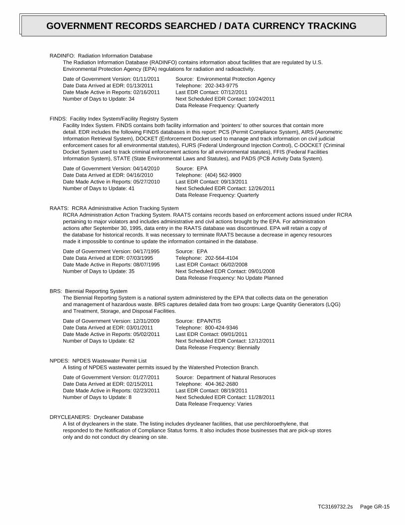
RADINFO: Radiation Information DatabaseThe Radiation Information Database (RADINFO) contains information about facilities that are regulated by U.S.Environmental Protection Agency (EPA) regulations for radiation and radioactivity.
Date of Government Version: 01/11/2011Date Data Arrived at EDR: 01/13/2011Date Made Active in Reports: 02/16/2011Number of Days to Update: 34
Source: Environmental Protection AgencyTelephone: 202-343-9775Last EDR Contact: 07/12/2011Next Scheduled EDR Contact: 10/24/2011Data Release Frequency: Quarterly
FINDS: Facility Index System/Facility Registry SystemFacility Index System. FINDS contains both facility information and ’pointers’ to other sources that contain moredetail. EDR includes the following FINDS databases in this report: PCS (Permit Compliance System), AIRS (AerometricInformation Retrieval System), DOCKET (Enforcement Docket used to manage and track information on civil judicialenforcement cases for all environmental statutes), FURS (Federal Underground Injection Control), C-DOCKET (CriminalDocket System used to track criminal enforcement actions for all environmental statutes), FFIS (Federal FacilitiesInformation System), STATE (State Environmental Laws and Statutes), and PADS (PCB Activity Data System).
Date of Government Version: 04/14/2010Date Data Arrived at EDR: 04/16/2010Date Made Active in Reports: 05/27/2010Number of Days to Update: 41
Source: EPATelephone: (404) 562-9900Last EDR Contact: 09/13/2011Next Scheduled EDR Contact: 12/26/2011Data Release Frequency: Quarterly
RAATS: RCRA Administrative Action Tracking SystemRCRA Administration Action Tracking System. RAATS contains records based on enforcement actions issued under RCRApertaining to major violators and includes administrative and civil actions brought by the EPA. For administrationactions after September 30, 1995, data entry in the RAATS database was discontinued. EPA will retain a copy ofthe database for historical records. It was necessary to terminate RAATS because a decrease in agency resourcesmade it impossible to continue to update the information contained in the database.
Date of Government Version: 04/17/1995Date Data Arrived at EDR: 07/03/1995Date Made Active in Reports: 08/07/1995Number of Days to Update: 35
Source: EPATelephone: 202-564-4104Last EDR Contact: 06/02/2008Next Scheduled EDR Contact: 09/01/2008Data Release Frequency: No Update Planned
BRS: Biennial Reporting SystemThe Biennial Reporting System is a national system administered by the EPA that collects data on the generationand management of hazardous waste. BRS captures detailed data from two groups: Large Quantity Generators (LQG)and Treatment, Storage, and Disposal Facilities.
Date of Government Version: 12/31/2009Date Data Arrived at EDR: 03/01/2011Date Made Active in Reports: 05/02/2011Number of Days to Update: 62
Source: EPA/NTISTelephone: 800-424-9346Last EDR Contact: 09/01/2011Next Scheduled EDR Contact: 12/12/2011Data Release Frequency: Biennially
NPDES: NPDES Wastewater Permit ListA listing of NPDES wastewater permits issued by the Watershed Protection Branch.
Date of Government Version: 01/27/2011Date Data Arrived at EDR: 02/15/2011Date Made Active in Reports: 02/23/2011Number of Days to Update: 8
Source: Department of Natural ResorucesTelephone: 404-362-2680Last EDR Contact: 08/19/2011Next Scheduled EDR Contact: 11/28/2011Data Release Frequency: Varies
DRYCLEANERS: Drycleaner DatabaseA list of drycleaners in the state. The listing includes drycleaner facilities, that use perchloroethylene, thatresponded to the Notification of Compliance Status forms. It also includes those businesses that are pick-up storesonly and do not conduct dry cleaning on site.
TC3169732.2s Page GR-15
GOVERNMENT RECORDS SEARCHED / DATA CURRENCY TRACKING

Date of Government Version: 09/18/2009Date Data Arrived at EDR: 09/18/2009Date Made Active in Reports: 10/09/2009Number of Days to Update: 21
Source: Department of Natural ResourcesTelephone: 404-363-7000Last EDR Contact: 08/15/2011Next Scheduled EDR Contact: 11/28/2011Data Release Frequency: Varies
AIRS: Permitted Facility & Emissions LisingA listing of permitted Air facilities and emissions data.
Date of Government Version: 12/31/2009Date Data Arrived at EDR: 06/29/2011Date Made Active in Reports: 08/16/2011Number of Days to Update: 48
Source: Department of Natural ResourcesTelephone: 404-363-7000Last EDR Contact: 08/31/2011Next Scheduled EDR Contact: 12/12/2011Data Release Frequency: Varies
TIER 2: Tier 2 Data ListingA listing of facilities which store or manufacture hazardous materials and submit a chemical inventory report.
Date of Government Version: 12/31/2009Date Data Arrived at EDR: 09/24/2010Date Made Active in Reports: 11/24/2010Number of Days to Update: 61
Source: Department of Natural ResourcesTelephone: 404-656-4852Last EDR Contact: 09/06/2011Next Scheduled EDR Contact: 12/19/2011Data Release Frequency: Varies
INDIAN RESERV: Indian ReservationsThis map layer portrays Indian administered lands of the United States that have any area equal to or greaterthan 640 acres.
Date of Government Version: 12/31/2005Date Data Arrived at EDR: 12/08/2006Date Made Active in Reports: 01/11/2007Number of Days to Update: 34
Source: USGSTelephone: 202-208-3710Last EDR Contact: 07/22/2011Next Scheduled EDR Contact: 10/31/2011Data Release Frequency: Semi-Annually
SCRD DRYCLEANERS: State Coalition for Remediation of Drycleaners ListingThe State Coalition for Remediation of Drycleaners was established in 1998, with support from the U.S. EPA Officeof Superfund Remediation and Technology Innovation. It is comprised of representatives of states with establisheddrycleaner remediation programs. Currently the member states are Alabama, Connecticut, Florida, Illinois, Kansas,Minnesota, Missouri, North Carolina, Oregon, South Carolina, Tennessee, Texas, and Wisconsin.
Date of Government Version: 03/07/2011Date Data Arrived at EDR: 03/09/2011Date Made Active in Reports: 05/02/2011Number of Days to Update: 54
Source: Environmental Protection AgencyTelephone: 615-532-8599Last EDR Contact: 07/15/2011Next Scheduled EDR Contact: 11/07/2011Data Release Frequency: Varies
FINANCIAL ASSURANCE: Financial Assurance Information ListingA listing of financial assurance information for underground storage tank facilities.
Date of Government Version: 09/14/2010Date Data Arrived at EDR: 09/21/2010Date Made Active in Reports: 11/24/2010Number of Days to Update: 64
Source: Department of Natural ResourcesTelephone: 404-362-4892Last EDR Contact: 06/24/2011Next Scheduled EDR Contact: 10/03/2011Data Release Frequency: Annually
COAL ASH DOE: Sleam-Electric Plan Operation DataA listing of power plants that store ash in surface ponds.
Date of Government Version: 12/31/2005Date Data Arrived at EDR: 08/07/2009Date Made Active in Reports: 10/22/2009Number of Days to Update: 76
Source: Department of EnergyTelephone: 202-586-8719Last EDR Contact: 07/18/2011Next Scheduled EDR Contact: 10/31/2011Data Release Frequency: Varies
TC3169732.2s Page GR-16
GOVERNMENT RECORDS SEARCHED / DATA CURRENCY TRACKING
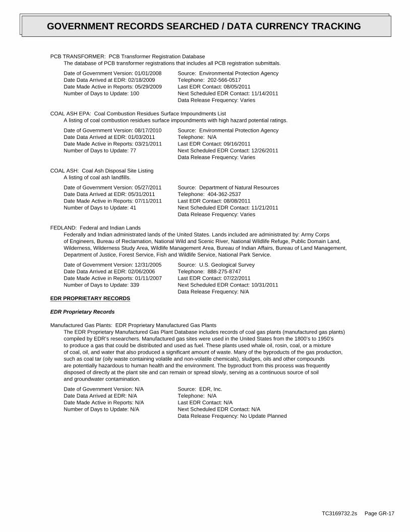
PCB TRANSFORMER: PCB Transformer Registration DatabaseThe database of PCB transformer registrations that includes all PCB registration submittals.
Date of Government Version: 01/01/2008Date Data Arrived at EDR: 02/18/2009Date Made Active in Reports: 05/29/2009Number of Days to Update: 100
Source: Environmental Protection AgencyTelephone: 202-566-0517Last EDR Contact: 08/05/2011Next Scheduled EDR Contact: 11/14/2011Data Release Frequency: Varies
COAL ASH EPA: Coal Combustion Residues Surface Impoundments ListA listing of coal combustion residues surface impoundments with high hazard potential ratings.
Date of Government Version: 08/17/2010Date Data Arrived at EDR: 01/03/2011Date Made Active in Reports: 03/21/2011Number of Days to Update: 77
Source: Environmental Protection AgencyTelephone: N/ALast EDR Contact: 09/16/2011Next Scheduled EDR Contact: 12/26/2011Data Release Frequency: Varies
COAL ASH: Coal Ash Disposal Site ListingA listing of coal ash landfills.
Date of Government Version: 05/27/2011Date Data Arrived at EDR: 05/31/2011Date Made Active in Reports: 07/11/2011Number of Days to Update: 41
Source: Department of Natural ResourcesTelephone: 404-362-2537Last EDR Contact: 08/08/2011Next Scheduled EDR Contact: 11/21/2011Data Release Frequency: Varies
FEDLAND: Federal and Indian LandsFederally and Indian administrated lands of the United States. Lands included are administrated by: Army Corpsof Engineers, Bureau of Reclamation, National Wild and Scenic River, National Wildlife Refuge, Public Domain Land,Wilderness, Wilderness Study Area, Wildlife Management Area, Bureau of Indian Affairs, Bureau of Land Management,Department of Justice, Forest Service, Fish and Wildlife Service, National Park Service.
Date of Government Version: 12/31/2005Date Data Arrived at EDR: 02/06/2006Date Made Active in Reports: 01/11/2007Number of Days to Update: 339
Source: U.S. Geological SurveyTelephone: 888-275-8747Last EDR Contact: 07/22/2011Next Scheduled EDR Contact: 10/31/2011Data Release Frequency: N/A
EDR PROPRIETARY RECORDS
EDR Proprietary Records
Manufactured Gas Plants: EDR Proprietary Manufactured Gas PlantsThe EDR Proprietary Manufactured Gas Plant Database includes records of coal gas plants (manufactured gas plants)compiled by EDR’s researchers. Manufactured gas sites were used in the United States from the 1800’s to 1950’sto produce a gas that could be distributed and used as fuel. These plants used whale oil, rosin, coal, or a mixtureof coal, oil, and water that also produced a significant amount of waste. Many of the byproducts of the gas production,such as coal tar (oily waste containing volatile and non-volatile chemicals), sludges, oils and other compoundsare potentially hazardous to human health and the environment. The byproduct from this process was frequentlydisposed of directly at the plant site and can remain or spread slowly, serving as a continuous source of soiland groundwater contamination.
Date of Government Version: N/ADate Data Arrived at EDR: N/ADate Made Active in Reports: N/ANumber of Days to Update: N/A
Source: EDR, Inc.Telephone: N/ALast EDR Contact: N/ANext Scheduled EDR Contact: N/AData Release Frequency: No Update Planned
TC3169732.2s Page GR-17
GOVERNMENT RECORDS SEARCHED / DATA CURRENCY TRACKING

OTHER DATABASE(S)
Depending on the geographic area covered by this report, the data provided in these specialty databases may or may not becomplete. For example, the existence of wetlands information data in a specific report does not mean that all wetlands in thearea covered by the report are included. Moreover, the absence of any reported wetlands information does not necessarilymean that wetlands do not exist in the area covered by the report.
CT MANIFEST: Hazardous Waste Manifest DataFacility and manifest data. Manifest is a document that lists and tracks hazardous waste from the generator throughtransporters to a tsd facility.
Date of Government Version: 12/31/2007Date Data Arrived at EDR: 08/26/2009Date Made Active in Reports: 09/11/2009Number of Days to Update: 16
Source: Department of Environmental ProtectionTelephone: 860-424-3375Last EDR Contact: 08/26/2011Next Scheduled EDR Contact: 12/05/2011Data Release Frequency: Annually
NJ MANIFEST: Manifest InformationHazardous waste manifest information.
Date of Government Version: 12/31/2010Date Data Arrived at EDR: 07/20/2011Date Made Active in Reports: 08/11/2011Number of Days to Update: 22
Source: Department of Environmental ProtectionTelephone: N/ALast EDR Contact: 07/20/2011Next Scheduled EDR Contact: 10/31/2011Data Release Frequency: Annually
NY MANIFEST: Facility and Manifest DataManifest is a document that lists and tracks hazardous waste from the generator through transporters to a TSDfacility.
Date of Government Version: 08/01/2011Date Data Arrived at EDR: 08/09/2011Date Made Active in Reports: 09/16/2011Number of Days to Update: 38
Source: Department of Environmental ConservationTelephone: 518-402-8651Last EDR Contact: 08/09/2011Next Scheduled EDR Contact: 11/21/2011Data Release Frequency: Annually
PA MANIFEST: Manifest InformationHazardous waste manifest information.
Date of Government Version: 12/31/2008Date Data Arrived at EDR: 12/01/2009Date Made Active in Reports: 12/14/2009Number of Days to Update: 13
Source: Department of Environmental ProtectionTelephone: 717-783-8990Last EDR Contact: 07/15/2011Next Scheduled EDR Contact: 10/10/2011Data Release Frequency: Annually
RI MANIFEST: Manifest informationHazardous waste manifest information
Date of Government Version: 12/31/2010Date Data Arrived at EDR: 06/24/2011Date Made Active in Reports: 06/30/2011Number of Days to Update: 6
Source: Department of Environmental ManagementTelephone: 401-222-2797Last EDR Contact: 08/31/2011Next Scheduled EDR Contact: 12/12/2011Data Release Frequency: Annually
WI MANIFEST: Manifest InformationHazardous waste manifest information.
Date of Government Version: 12/31/2010Date Data Arrived at EDR: 08/19/2011Date Made Active in Reports: 09/15/2011Number of Days to Update: 27
Source: Department of Natural ResourcesTelephone: N/ALast EDR Contact: 09/19/2011Next Scheduled EDR Contact: 01/02/2012Data Release Frequency: Annually
Oil/Gas Pipelines: This data was obtained by EDR from the USGS in 1994. It is referred to by USGS as GeoData Digital Line Graphsfrom 1:100,000-Scale Maps. It was extracted from the transportation category including some oil, but primarilygas pipelines.
Electric Power Transmission Line DataSource: Rextag Strategies Corp.Telephone: (281) 769-2247U.S. Electric Transmission and Power Plants Systems Digital GIS Data
TC3169732.2s Page GR-18
GOVERNMENT RECORDS SEARCHED / DATA CURRENCY TRACKING

Sensitive Receptors: There are individuals deemed sensitive receptors due to their fragile immune systems and special sensitivityto environmental discharges. These sensitive receptors typically include the elderly, the sick, and children. While the location of allsensitive receptors cannot be determined, EDR indicates those buildings and facilities - schools, daycares, hospitals, medical centers,and nursing homes - where individuals who are sensitive receptors are likely to be located.
AHA Hospitals:Source: American Hospital Association, Inc.Telephone: 312-280-5991The database includes a listing of hospitals based on the American Hospital Association’s annual survey of hospitals.
Medical Centers: Provider of Services ListingSource: Centers for Medicare & Medicaid ServicesTelephone: 410-786-3000A listing of hospitals with Medicare provider number, produced by Centers of Medicare & Medicaid Services,a federal agency within the U.S. Department of Health and Human Services.
Nursing HomesSource: National Institutes of HealthTelephone: 301-594-6248Information on Medicare and Medicaid certified nursing homes in the United States.
Public SchoolsSource: National Center for Education StatisticsTelephone: 202-502-7300The National Center for Education Statistics’ primary database on elementaryand secondary public education in the United States. It is a comprehensive, annual, national statisticaldatabase of all public elementary and secondary schools and school districts, which contains data that arecomparable across all states.
Private SchoolsSource: National Center for Education StatisticsTelephone: 202-502-7300The National Center for Education Statistics’ primary database on private school locations in the United States.
Daycare Centers: Child Care CentersSource: Department of Human ResourcesTelephone: 404-651-5562
Flood Zone Data: This data, available in select counties across the country, was obtained by EDR in 2003 & 2011 from the FederalEmergency Management Agency (FEMA). Data depicts 100-year and 500-year flood zones as defined by FEMA.
NWI: National Wetlands Inventory. This data, available in select counties across the country, was obtained by EDRin 2002 and 2005 from the U.S. Fish and Wildlife Service.
Scanned Digital USGS 7.5’ Topographic Map (DRG)Source: United States Geologic SurveyA digital raster graphic (DRG) is a scanned image of a U.S. Geological Survey topographic map. The map imagesare made by scanning published paper maps on high-resolution scanners. The raster imageis georeferenced and fit to the Universal Transverse Mercator (UTM) projection.
STREET AND ADDRESS INFORMATION
© 2010 Tele Atlas North America, Inc. All rights reserved. This material is proprietary and the subject of copyright protectionand other intellectual property rights owned by or licensed to Tele Atlas North America, Inc. The use of this material is subjectto the terms of a license agreement. You will be held liable for any unauthorized copying or disclosure of this material.
TC3169732.2s Page GR-19
GOVERNMENT RECORDS SEARCHED / DATA CURRENCY TRACKING

APPENDIX D: QUALIFICATIONS/INSURANCE

Ellen R. Condich Partner Associate Education Bachelor of Science in Environmental Science Registrations Certified EPA/AHERA Asbestos Inspector/Management Planner Lead-Based Paint Inspector EPA Target Housing and Child-Occupied Facilities OSHA 40-Hour Training for Hazardous Waste Operations Summary of Professional Experience Ms. Condich has 11 years of experience in the environmental industry. She has significant experience in due diligence assessments for a variety of property types and the needs and requirements of varied number of reporting standards, including ASTM standards, EPA’s All Appropriate Inquiry (AAI), and customized client formats. Specifically, Ms. Condich has performed Phase I Environmental Site Assessments, Environmental Transaction Screens, Phase II and III Subsurface Investigations, Regulatory Compliance Assessments, Asbestos Surveys, Lead-based Paint Surveys, Radon Studies, Mold Assessments, and Lead-in-water sampling and analysis.
Ms. Condich has managed field staff that perform Phase I ESAs and has been responsible for the proper investigation of the property to include; investigation of the potential presence of USTs and hazardous chemicals or petroleum products on the property; evaluation and interpretation of environmental databases (CERCLIS, NPL, RCRA, etc.); researching historical owners and uses of the Site and neighboring properties; researching local geology; and investigating other issues which may have potential impacts to the subject property. Ms. Condich worked closely and communicated effectively with technical staff in satellite offices throughout the USA to bring the project in on time and within budget by being as flexible as needed for successful results.
Phase I ESA project experience include conducting on-site evaluations for the presence or absence of recognized environmental conditions, conducting appropriate records research, and researching the history of the Site. Evaluated property types range from undeveloped land to heavy industrial/manufacturing facilities. Ms. Condich has had to reconcile a myriad of on- and off-site environmental issues to include: Leaking Underground Storage Tanks (LUSTs); asbestos-containing materials; lead-based paint; elevated radon levels; potential contamination from dry cleaning and other halogenated solvents; abandoned leaking drums of unknown chemicals; potential issues from suspect historical operations; and metals contamination to soil and groundwater.
Phase II ESA projects include conducting on-Site subsurface evaluations to determine the presence or absence of soil and/or groundwater contamination. Subsurface evaluations included placing soil borings in appropriate areas of concern and collecting soil samples from the soil

Ellen R. Condich (Continued)
borings. The borings may be converted to temporary groundwater monitoring wells and samples of ground water were then collected.
Finally, Ms. Condich’s diversity across residential, industrial, municipal, and commercial environments is a major contribution to Partner Engineering and Science’s Associate team in the Southeast region of the United States.

Brian A. Dugan Project Manager Education Bachelor of Science , Rutgers University, Cook College – New Brunswick, New Jersey – May 21, 1998 Major: Environmental Science Registrations Environmental Protection Agency (EPA) / Asbestos Hazard Emergency Response Act (AHERA) Accredited Asbestos Building Inspector; Asbestos Management Planner - State of Ohio, Department of Health, Asbestos Hazard Evaluation Specialist (Certificate No. ES35190) Summary of Professional Experience Mr. Dugan has eleven years of experience in the real estate due diligence consulting service industry. He has significant experience in due diligence assessments for a variety of property types and the needs and requirements of varied number of reporting standards, including ASTM standards, EPA’s All Appropriate Inquiry (AAI), Fannie Mae DUS, Freddie Mac and customized client formats. Specifically, Mr. Dugan has performed Phase I Environmental Site Assessments, Environmental Transaction Screens, Regulatory Database and Historical Reviews, Property Condition Assessments (PCAs), Small Loan PCAs, Asbestos Surveys, Lead-based Paint Surveys, Radon Studies, Mold Assessments, and Lead-in-water sampling and analysis. He has performed field inspections on over seven hundred facilities located throughout the United States.
Mr. Dugan served as Project Manager for a former Fortune 500 national environmental and engineering consulting firm, where he performed, managed or reviewed thousands of real estate transactions on assorted manufacturing, commercial, retail, office, industrial, medical, agricultural, assisted living, institutional and multi-family residential properties. Primary responsibilities included client interaction, project oversight and report review with clientele including property owners, agency lenders (Fannie Mae & Freddie Mac), real estate investors, Commercial Mortgage-Backed Securities (CMBS) lenders, insurance lenders, banks, real estate equity funds and developers. He has extensive experience interacting with property owners, prospective purchasers, third party consultants, loan officers, regulatory agencies and legal counsel for clients. Finally, Mr. Dugan’s diversity across residential, industrial, municipal, and commercial environments is a major contribution to Partner Engineering and Science’s Associate team in the Midwest region of the United States.

Jenny Redlin, REA Principal Education B.S. in Biological Sciences, University of California Santa Barbara, Distinction in Major Registrations Registered Environmental Assessor (REA) OSHA 40-Hour Health and Safety Training Affiliations Member, Environmental Bankers Association Member, Mortgage Banker’s Association
Summary of Professional Experience Ms. Redlin has more than ten years of experience in the environmental consulting industry. Her background in environmental science, in addition to her knowledge of current environmental regulations, allows her to offer the most efficient and cost-effective means of regulatory compliance. Ms. Redlin has extensive experience managing all aspects of due diligence, specializing in environmental due diligence, for nationwide and local clients such as:
• Residential Developers • Commercial Developers • Mortgage Brokers • Real Estate Brokers • Individual Property Owners and Buyers • Financial Institutions including: Portfolio Lenders SBA Lenders HUD Lenders Fannie Mae Lenders Freddie Mac Lenders Private Equity Funds Insurance Lenders
Ms. Redlin has gained valuable knowledge and know-how from having been personally involved in the details of thousands of real estate transactions for various client types, and therefore understands the specific needs and scopes of work required for all parties involved in a transaction. Ms. Redlin has served as an environmental scientist, project manager, or executive senior author on over 5,000 real estate transactions. Ms. Redlin’s due diligence resume includes experience at all levels, advising lenders and real estate investors through the following product types:

Jenny Redlin (Continued)
• Phase I Environmental Site Assessments • Phase II Subsurface Investigations • Phase III Site Characterizations • Remedial Cost Estimates • Remediation Design and Implementation • Environmental Transaction Screens • Property Condition Assessments • Probable Maximum Loss Assessments • Property Condition Evaluations
Ms. Redlin has extensive experience in testing soil, soil gas, and groundwater in the context of a real estate transaction, as well as under the supervision of state and federal regulators. Among her specialties is guiding landowners and prospective purchasers through the process of selling or acquiring an environmentally challenged site. Ms. Redlin has participated in the characterization of groundwater and soil contamination; quarterly groundwater monitoring; implementation of various systems such as soil vapor extraction systems, dual phase extraction systems, ozone sparging, air sparging, pump and treat; and soil excavation projects such as tank removals at several clean-up sites in Los Angeles and Orange County. Real estate investors, redevelopment agencies, financial institutions, insurance lenders, and real estate equity funds have come to rely on her advice and judgment to help them with their real estate business decisions. Ms. Redlin also has extensive experience in environmental compliance monitoring and biological consulting. She has extensive experience working as an independent contractor for and in conjunction with state and local agencies such as Santa Barbara County Parks, California Department of Fish and Game, California Public Utilities Commission, Los Angeles Water and Sanitation and others. This included monitoring construction activities near sensitive biological receptors; containing, quantifying and reporting any hazardous material spills that occurred; working with construction crews to ensure compliance with environmental permit regulations as well as reporting to interested parties on the progress and compliance of the project. Ms. Redlin is a dedicated professional who takes pride and pleasure in meeting her client’s needs. Distinctions Ms. Redlin was named Real Estate Southern California Woman of Influence in 2008 for her role in the area’s commercial real estate transactions. Ms. Redlin has been designated a 2009 California Mortgage Bankers Association (CMBA) Future Leader.

Jenny Redlin (Continued)
Ms. Redlin was one of only two consultants asked to sit on the Risk Managers Association (RMA) Credit Committee roundtable which discussed the effects of the new Federal All Appropriate Inquiries (AAI) standard on Phase I Environmental Site Assessments. Publications Granite Distributor Sponsors Radon Granite Testing Project, Stone World, December 2008