Embed Size (px)
Citation preview

Extra Dimension Solutions
PAV EMENT CONFORMANCE PAV EMENT CONFORMANCE PAV EMENT CONFORMANCE PAV EMENT CONFORMANCE
I N 1 2D MODE LI N 1 2D MODE LI N 1 2D MODE LI N 1 2D MODE L
PAVEMENT CONFORMANCE
12d Model October 2009 Page Civil and Surveying Software Distributed by Extra Dimension Solutions
2
Extra Dimension Solutions
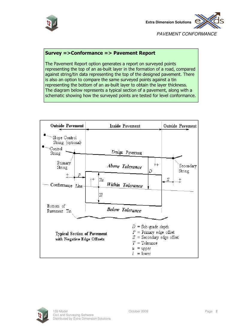
Survey =>Conformance => Pavement Report The Pavement Report option generates a report on surveyed points representing the top of an as-built layer in the formation of a road, compared against string/tin data representing the top of the designed pavement. There is also an option to compare the same surveyed points against a tin representing the bottom of an as-built layer to obtain the layer thickness. The diagram below represents a typical section of a pavement, along with a
schematic showing how the surveyed points are tested for level conformance.

PAVEMENT CONFORMANCE
12d Model October 2009 Page Civil and Surveying Software Distributed by Extra Dimension Solutions
3
Extra Dimension Solutions
Data source: the surveyed points usually either a string or model of data.
Design data: These may be design strings or a tin created from the design strings. Control string (usually centre line) will be the reference for chainage and offset of the surveyed points. Slope control is optional, if not filled in the control string is used. Primary string should represent the edge of the designed pavement, usually the edge closest to the Control string. Secondary string represents the ‘other’ edge of the designed pavement. Design pavement tin, if you have created a tin from the design, enter it here
Constraints: Start/End Chainage these can be used to specify where the conformance will begin and end. By default the start and end chainage is set when the control string is selected. Chainage Bandwidth, if the surveyed points are set out in rows of roughly equivalent chainages, these bands will appear in the report.
Results: Report file, the name for the report file to be created. Results model the prefix for the result models to be created. If no name is entered no models will be created.
If the previous layer (Sub base) had been surveyed and the survey points used to create a tin, the tin can is selected here to obtain the thickness of the pavement.
If you do not have a constant grade from one edge of the pavement to the other (Crowned Road), the design data will need to be a tin or the conformance will have to be run in two separate operations.

PAVEMENT CONFORMANCE
12d Model October 2009 Page Civil and Surveying Software Distributed by Extra Dimension Solutions
4
Extra Dimension Solutions
Thickness tolerance may be applied if a ‘bottom of pavement tin’ has been entered on the previous page. This will compare the surveyed points to the tin created from a previous conformance on a ‘sub-base’
If you do not have a .tol file, all the tolerance parameters need to be entered. Depth from design: to obtain the conformance line. Depth can be measured (D) perpendicular to pavement or vertical. Depth is entered in meters, positive being below the design.
Vertical tolerance: Again depth can be measured vertically on perpendicular to the pavement. Upper tolerance (Tu) is the tolerable distance above the conformance line. Lower tolerance (Tl) is the tolerable distance below the conformance line.
A tolerance file is used to load or save the details of the conformance. The .tol file stores the details of every field on the Tolerance tab, Edges tab, Report file tab and Results Model tab. A tolerance file is not required to run a conformance, but makes life a lot easier.
The next tab is the Tolerances.
The next tab is the Edges.
Continuing with the tolerances parameters: Primary/Secondary edge details, the edge type will be, on what side of the road the Primary/Secondary edge will fall travelling along the road. Edge mode, you can either test the surveyed points (close to the edge) horizontally and vertically or horizontally only. Points outside edge, either don’t test (most common) or test vertically (Untested points do not appear on the conformance report.) Edge extents, the amount to increase or decrease the design pavement (P or S). A negative value is more common, since points near the edge are usually ignored for conformance purposes.

PAVEMENT CONFORMANCE
12d Model October 2009 Page Civil and Surveying Software Distributed by Extra Dimension Solutions
5
Extra Dimension Solutions
Edge tolerance, this will specify the distance tolerated from the design string horizontally. This is usually used to check the built pavement edge falls within a certain distance from the designed pavement edge, to ensure the pavement has been built wide enough.
Report file tab, Max lines per page: this number is needed so that page breaks can be inserted into the report file at the appropriate places. Header info, the information that will appear at the top of the report file. Table options, if you would like design levels and non-conformance errors to be shown on the report, ‘tick’ the boxes. Footer info, surveyors details to be applied at the bottom of the report.
In this panel the configuration and content of the result models are set up. Usually you are going to run the conformance more than once, so it’s a good idea to ‘tick’ the clean results model beforehand box. Then you can choose which Z values, Vertex text and Textstyle is shown. There is also an option to separate models by colours.
This option allows you to create a tin of the tested survey points. This tin can be used in future conformances for thicknesses, and for doing volumes calculations.
PAVEMENT CONFORMANCE
12d Model October 2009 Page Civil and Surveying Software Distributed by Extra Dimension Solutions
6
Extra Dimension Solutions
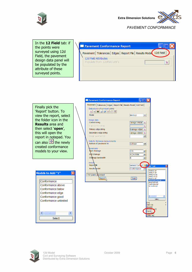
In the 12 Field tab: if the points were surveyed using 12d Field, the pavement design data panel will be populated by the attribute of these surveyed points.
Finally pick the ‘Report’ button. To view the report, select the folder icon in the Results area and then select ‘open’, this will open the report in notepad. You
can also the newly created conformance models to your view.
PAVEMENT CONFORMANCE
12d Model October 2009 Page Civil and Surveying Software Distributed by Extra Dimension Solutions
7
Extra Dimension Solutions
Notes: ______________________________________________________________________________________________________________________________________________________________________________________________________________________________________________________________________________________________________________________________________________________________________________________________________________________________________________________________________________________________________________________________________________________________________________________________________________________________________________________________________________________________________________________________________________________________________________
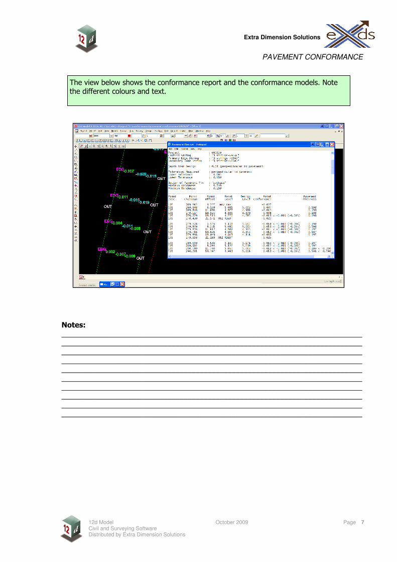
The view below shows the conformance report and the conformance models. Note the different colours and text.


![á F] - vaillant.pl · 3e DHW 10c 5 2 12d 3 12d 3c 10c 3 12d 12 12a 9j 8e 9h BUS BUS BUS BUS BUS BUS BUS BUS BUS BUS BUS 8c 8f BUS 12d (S9) 8b 3f2 10c 9a FS2 12k2 9c 2 4 33 9k2 12d](https://img.pdfslide.us/doc/110x75/5c69bd9909d3f21a048b9235/a-f-3e-dhw-10c-5-2-12d-3-12d-3c-10c-3-12d-12-12a-9j-8e-9h-bus-bus-bus-bus.jpg)