Embed Size (px)
Citation preview

1
PART I
SUMMARY OF THE FACTS ON WHICH PROPOSALS ARE
BASED
2
CHAPTER - I
THE TRACT DEALT WITH (General Information)
1.1 NAME AND SITUATION
1.1.1 This Working Plan pertains to the demarcated forests of Reasi Forest Division of Jammu West Circle mainly situated in the Reasi and Udhampur Tehsils of Udhampur District and very small portion of Rajouri District. The tract lies between 32º-53’ and 33º-20’ North latitude and 24º-35’ and 75º-10’ East longitude represented on the Survey of India Map 1:50,000 G.T. Sheets Nos. 43/K/11, K/12, K/15, K/16, L/13, 0/4, P/1. This Division is bound on the West by Nowshera Forest Division in the North by Mahore Forest Division, in the East by Udhampur Forest Division and in the South by Jammu Forest Division. Salal Hydro Electric Project constructed on Chenab river at Dhayangarh falls in the catchment area of Rad nalla, Ans river and Chenab river i.e. the Salal Hydro Electric Project Reservoir (9 Sq. Kms. With 35 kms. Outer periphery falls in the Catchment area of both Reasi and Mahore Forest Divisions.
1.2 CONFIGURATION OF THE GROUND 1.2.1 The altitude of the tract varies from 360 meters at Bhabbar of Katra Range to 2603 Meters at Mathani top of Thakrakote Range, Choru Sira 237SM and Sarioli 2487
meters small peaks also lie in this Division. Most of the tract is hilly and rugged. 1.2.2 The division lies in the catchment of river Chenab. Entering at Harog from where the
gradient becomes very easy. 1.2.3 The Reasi Range is drained by Anji nalla which joins the river Chenab near Reasi Town
and by a number of streams and nalas directly draining in the river Chenab. 1.2.4 The Thakrakote Range is drained by Sunch, Rud nala, Pouni Tawi and also a number
of nallas directly draining the river Chenab. 1.2.5 Katra Range is partly drained by river Chenab and also by Pai and Banganga nallahs
draining into river Chenab
3
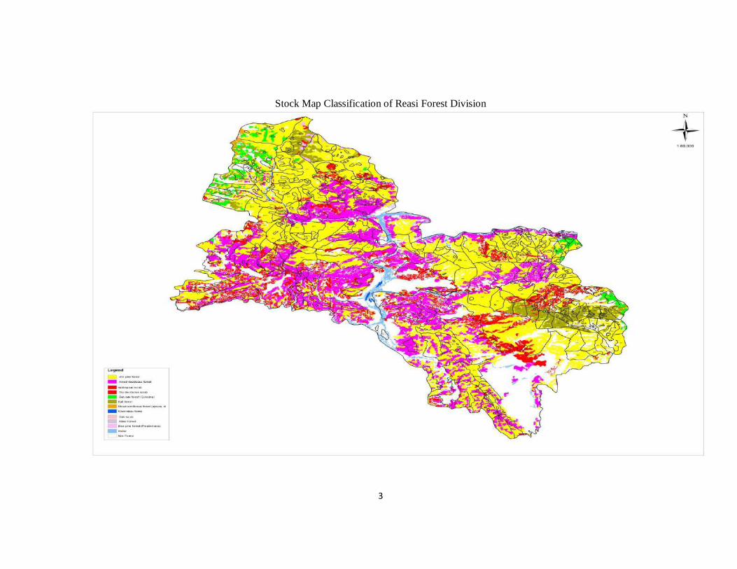
Stock Map Classification of Reasi Forest Division

4
1.3 GEOLOGY, ROCK AND SOIL 1.3.1 Details of various rock formations exposed in the area as follows. 1.4 RECENT 1.4.1 The area occupied by recent deposits is practically negligible and is represented
by various nallas and river terraces and is comprised of alluvium, boulders and deposits of silty clay.
1.5 SHIWALKS 1.5.1 This group is characterized by boulders and conglomerates at the top.
Predominantly sand-stones and sub-ordinate clay bunds in the middle of mainly red and purple clays with minor sand-stone at the base.
1.6 MURREES 1.6.1 Murrees cover extensive area. These are represented by light grey and purple
sand-stone in the lower portion which are relatively hard, fine grained and non-minacious. These sand stones are associated in the upper part are also with thick beds of red and purple clay. Murrees series occupy the area south of Subathu series exposed at the boundary fault muttal, north of Reasi and near Pouni etc.
1.7 SUBATHU OR NUMMULITIES 1.7.1 This group comprises of lime-stone and olive shales, pyritous shales, ironstone
shales. Coal seems are also associated at several places particularly at the fringe of the great lime-stone.
1.8 BAUXITE GROUP 1.8.1 This group underlies the Nummulitics and bauxitic clay is seen at Salal, Jungle gali
and at several other places. Bauxite group overlies the great lime-stone Reasi lime-stone Great lime-stone (Reasi lime-stone sirbay lime-stone).
1.8.2 This lime-stone occurs as in liens in the Murrees and younger Siwalik sediments.
The lime-stone is bluish or grayish in colour with bands of cream coloured and dark grey lime-stone. Chart Bands are also present and lime-stone as usually magnesium and contains high Silica Good besides of lime-stone suitable for manufacture of cement are also present at places which can be traced for a considerable distance.
5
1.9 PANJAL TRAP 1.9.1 This unit usually consists of and sitic or basaltic lava flows. Both amygdaloidal as
well as massive varieties have been met with. 1.10 AGGLOMERATIC SLATES 1.10.1 This unit comprises of slates, quartilite bands, and grits and pebble beds. The
presence of devitrified glass fragments and volcanic material in them suggests that these are derived from volcanic explosions and re-arranged by sub-aerial agencies.
1.11 DOGRA SLATES
1.11.1 These rocks consist essentially of a thick series of phyllitic blue and green
coloured flaggy or massive slates abundantly intercalated with green choritised amygdaloidal trap. Lenticular quartz veins are commonly met.
1.12 SALKHALAS 1.12.1 Salkhalas as exposed in this area comprise of low grade schists. This unit
according to Wadia consists of wavy schists and phyllite, graphitic phyllite, carbonaceous phyllite and bands of grey and white lime-stone altered to saccharoidal marble. Gneisses have also encountered at some places. Salkhalas are oldest units.
1.13 GRANITE INTRUSIVE 1.13.1 The granite generally comprises highly joined coarse grained porphyritic goodies
which are mildly folia ted in the marginal portion. They show a great variation in granularity from fine grained homogeneous granite to coarse grained porphyritic granites.
1.14 STRUCTURAL SET-UP 1.14.1 The Murrees and Siwaliks are separated from the older units by the east west
trending fault (Murres thrust). The younger Murrees and Siwaliks occur towards south of it and the older formation occupy the area towards North of it. Besides this fault there are series of other dislocation and fracture zones.
1.15 MINERALS OF ECONOMIC IMPORTANCE 1.15.1 Coal and bauxite occur at the fringe of great lime-stone. However, the quantity
available is not sufficient for their economic exploitation.
6
1.16 SOIL 1.16.1 The Soils in most of the areas are clayed to sandy loam produced from Triassic
rock formations. The sandy loam is favorable to chir pine. It is light brown in colour. The soil comprises blocks of spheroidal structures and is coarse-grained. As a result it is subject to heavy erosion.
1.17 CLIMATE
1.17.1 The Climate at lower altitudes i.e., at Reasi Pouni, Katra and their adjoining areas is very hot during summer which moderates towards the higher elevation i.e., towards sarolia and Mathlani tops. The lower areas also become quite cold during winter. The higher zones are cold and receive snow fall during November to February. Snow sometimes reaches down to 800 metres but melts away soon. Strong winds blow at Bidda and Jyotipuram. Some-times there is occasionally damage to Forest due to wind storms. Snow damage also occur occasionally in the temperate zone.
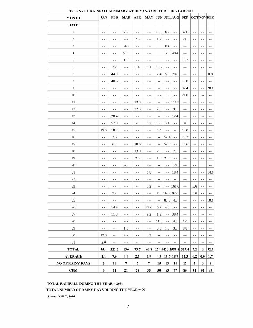
1.18 RAINFALL 1.18.1 This tract gets the benefit of both winter and monsoon precipitation. It receives
the major portion of the precipitation during summer months of July and August.
7
TOTAL RAINFALL DURING THE YEAR = 2056
TOTAL NUMBER OF RAINY DAYS DURING THE YEAR = 95
Source: NHPC, Salal
Table No 1.1 RAINFALL SUMMARY AT DHYANGARH FOR THE YEAR 2011
MONTH JAN FEB MAR APR MAY JUN JUL AUG SEP OCT NOV DEC
DATE
1 - - - - 7.2 - - - - 28.0 8.2 - - 32.6 - - - - --
2 - - - - - - 2.6 - - 1.2 - - - - 2.0 - - - - --
3 - - - - 34.2 - - - - 0.4 - - - - - - - - --
4 - - - - 50.0 - - - - 17.0 48.4 - - - - - - --
5 - - 1.6 - - - - - - - - 10.2 - - - - --
6 - - 2.2 - - 1.4 15.6 28.2 - - - - - - - - - - --
7 - - 44.0 - - - - - - 2.4 5.0 70.0 - - - - 0.8
8 - - 40.6 - - - - - - -- - - - - 16.0 - - - - --
9 - - - - - - - - - - -- - - - - 97.4 - - - - 20.0
10 - - - - - - - - - - 5.2 1.8 - - 21.0 - - -- --
11 - - - - - - 13.0 - - -- - - 110.2 - - - - - - --
12 - - - - - - 22.5 - - 2.8 - - 9.0 - - - - - - --
13 - - 20.4 - - - - - - -- - - 12.4 - - - - -- --
14 - - 57.0 - - -- 3.2 16.8 3.4 - - 8.6 - - - - --
15 19.6 18.2 - - - - - - 4.4 - - -- 18.0 - - - - --
16 - - 2.6 - - - - - - -- 52.4 - - 75.2 - - - - --
17 - - 6.2 - - 18.6 - - -- 59.0 - - 46.6 -- - - --
18 - - - - - - 13.0 - - 2.8 - - 7.8 - - - - - - --
19 - - - - - - 2.6 - - 1.6 25.8 - - - - - - - - --
20 - - - - 37.8 - - - - -- - - 12.8 - - - - --
21 - - - - - - - - 1.8 -- - - 18.4 - - - - - - 14.0
22 - - - - - - - - - - -- - - -- - - - - - - --
23 - - - - - - -- 5.2 -- - - 160.0 - - 3.6 - - --
24 - - 5.2 - - - - - - 7.0 160.8 82.0 - - 3.6 - - --
25 - - - - - - - - - - -- 80.0 4.0 - - - - - - 18.0
26 - - 14.4 - - - - 22.6 6.2 4.6 - - - - - - - - --
27 - - 11.8 - - - - 9.2 1.2 - - 38.4 - - - - -- --
28 - - - - - - - - - - 21.0 - - 4.0 1.0 - - - - --
29 - - -- 1.0 - - - - 0.6 1.8 3.0 8.8 - - - - --
30 13.8 -- 4.2 - - 3.2 -- - - - - - - - - - - --
31 2.0 -- - - -- - - -- - - -- -- - - -- --
TOTAL 35.4 222.6 136 73.7 60.8 129.4420.2580.4 337.4 7.2 0 52.8
AVERAGE 1.1 7.9 4.4 2.5 1.9 4.3 13.6 18.7 11.3 0.2 0.0 1.7
NO OF RAINY DAYS 3 11 7 7 7 15 13 14 12 2 0 4
CUM 3 14 21 28 35 50 63 77 89 91 91 95
8
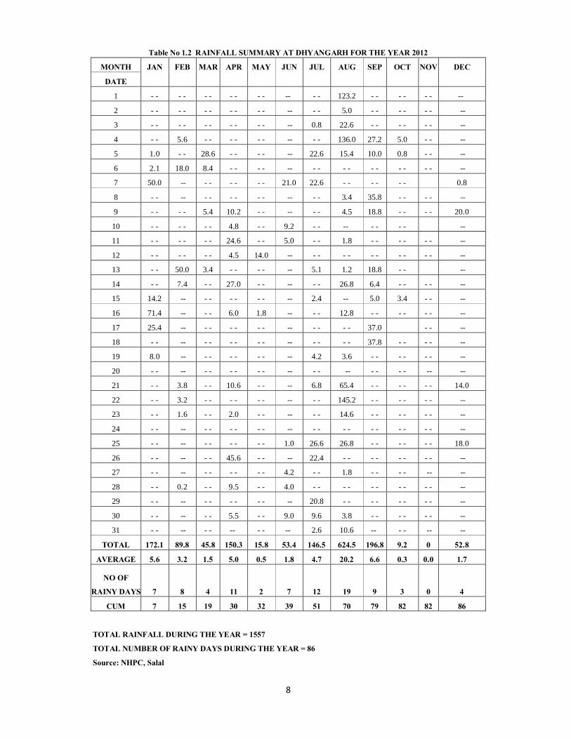
Table No 1.2 RAINFALL SUMMARY AT DHYANGARH FOR THE YEAR 2012
MONTH JAN FEB MAR APR MAY JUN JUL AUG SEP OCT NOV DEC
DATE
1 - - - - - - - - - - -- - - 123.2 - - - - - - --
2 - - - - - - - - - - -- - - 5.0 - - - - - - --
3 - - - - - - - - - - -- 0.8 22.6 - - - - - - --
4 - - 5.6 - - - - - - -- - - 136.0 27.2 5.0 - - --
5 1.0 - - 28.6 - - - - -- 22.6 15.4 10.0 0.8 - - --
6 2.1 18.0 8.4 - - - - -- - - - - - - - - - - --
7 50.0 -- - - - - - - 21.0 22.6 - - - - - - 0.8
8 - - -- - - - - - - -- - - 3.4 35.8 - - - - --
9 - - - - 5.4 10.2 - - -- - - 4.5 18.8 - - - - 20.0
10 - - - - - - 4.8 - - 9.2 - - -- - - - - --
11 - - - - - - 24.6 - - 5.0 - - 1.8 - - - - - - --
12 - - - - - - 4.5 14.0 -- - - - - - - - - - - --
13 - - 50.0 3.4 - - - - -- 5.1 1.2 18.8 - - --
14 - - 7.4 - - 27.0 - - -- - - 26.8 6.4 - - - - --
15 14.2 -- - - - - - - -- 2.4 -- 5.0 3.4 - - --
16 71.4 -- - - 6.0 1.8 -- - - 12.8 - - - - - - --
17 25.4 -- - - - - - - -- - - - - 37.0 - - --
18 - - -- - - - - - - -- - - - - 37.8 - - - - --
19 8.0 -- - - - - - - -- 4.2 3.6 - - - - - - --
20 - - -- - - - - - - -- - - -- - - - - -- --
21 - - 3.8 - - 10.6 - - -- 6.8 65.4 - - - - - - 14.0
22 - - 3.2 - - - - - - -- - - 145.2 - - - - - - --
23 - - 1.6 - - 2.0 - - -- - - 14.6 - - - - - - --
24 - - -- - - - - - - -- - - - - - - - - - - --
25 - - -- - - - - - - 1.0 26.6 26.8 - - - - - - 18.0
26 - - -- - - 45.6 - - -- 22.4 - - - - - - - - --
27 - - -- - - - - - - 4.2 - - 1.8 - - - - -- --
28 - - 0.2 - - 9.5 - - 4.0 - - - - - - - - - - --
29 - - -- - - - - - - -- 20.8 - - - - - - - - --
30 - - -- - - 5.5 - - 9.0 9.6 3.8 - - - - - - --
31 - - -- - - -- - - -- 2.6 10.6 -- - - -- --
TOTAL 172.1 89.8 45.8 150.3 15.8 53.4 146.5 624.5 196.8 9.2 0 52.8
AVERAGE 5.6 3.2 1.5 5.0 0.5 1.8 4.7 20.2 6.6 0.3 0.0 1.7
NO OF
RAINY DAYS 7 8 4 11 2 7 12 19 9 3 0 4
CUM 7 15 19 30 32 39 51 70 79 82 82 86
TOTAL RAINFALL DURING THE YEAR = 1557
TOTAL NUMBER OF RAINY DAYS DURING THE YEAR = 86
Source: NHPC, Salal
9
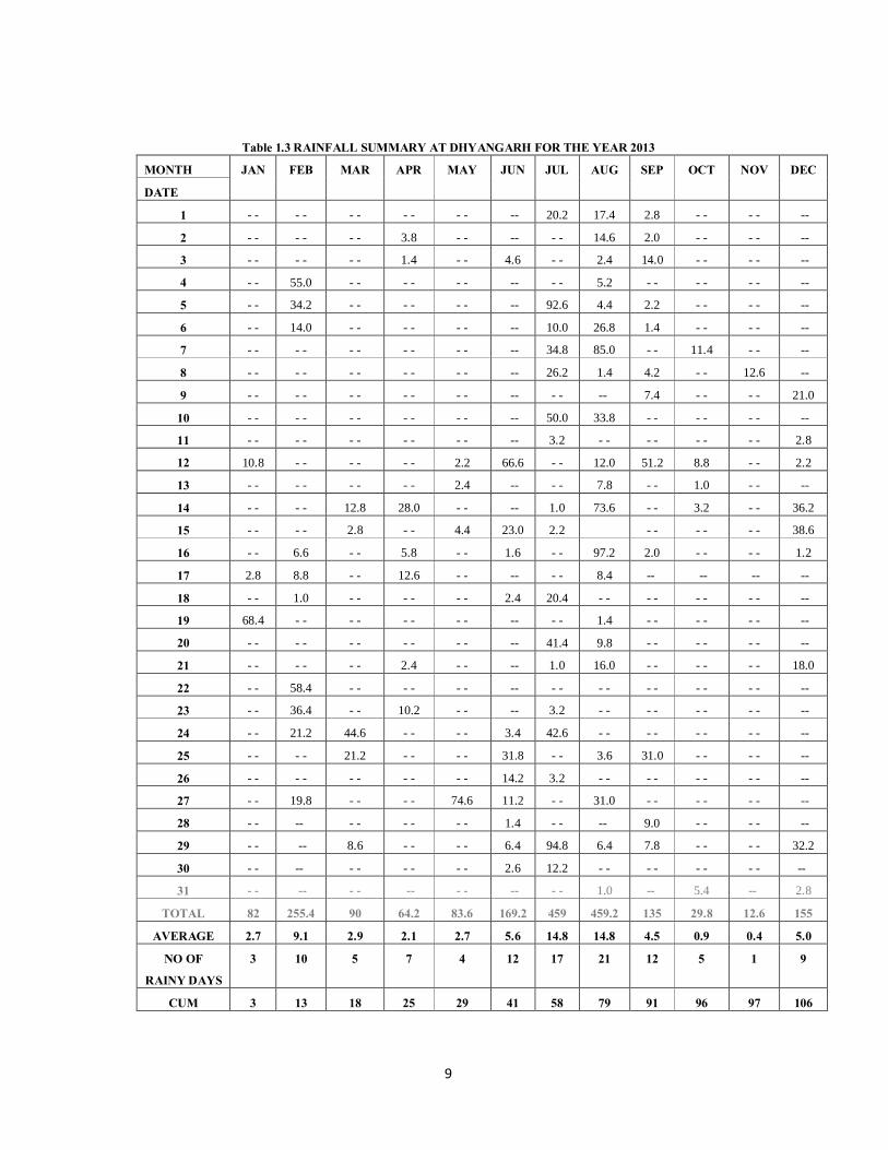
Table 1.3 RAINFALL SUMMARY AT DHYANGARH FOR THE YEAR 2013 MONTH JAN FEB MAR APR MAY JUN JUL AUG SEP OCT NOV DEC
DATE
1 - - - - - - - - - - -- 20.2 17.4 2.8 - - - - --
2 - - - - - - 3.8 - - -- - - 14.6 2.0 - - - - --
3 - - - - - - 1.4 - - 4.6 - - 2.4 14.0 - - - - --
4 - - 55.0 - - - - - - -- - - 5.2 - - - - - - --
5 - - 34.2 - - - - - - -- 92.6 4.4 2.2 - - - - --
6 - - 14.0 - - - - - - -- 10.0 26.8 1.4 - - - - --
7 - - - - - - - - - - -- 34.8 85.0 - - 11.4 - - --
8 - - - - - - - - - - -- 26.2 1.4 4.2 - - 12.6 --
9 - - - - - - - - - - -- - - -- 7.4 - - - - 21.0
10 - - - - - - - - - - -- 50.0 33.8 - - - - - - --
11 - - - - - - - - - - -- 3.2 - - - - - - - - 2.8
12 10.8 - - - - - - 2.2 66.6 - - 12.0 51.2 8.8 - - 2.2
13 - - - - - - - - 2.4 -- - - 7.8 - - 1.0 - - --
14 - - - - 12.8 28.0 - - -- 1.0 73.6 - - 3.2 - - 36.2
15 - - - - 2.8 - - 4.4 23.0 2.2 - - - - - - 38.6
16 - - 6.6 - - 5.8 - - 1.6 - - 97.2 2.0 - - - - 1.2
17 2.8 8.8 - - 12.6 - - -- - - 8.4 -- -- -- --
18 - - 1.0 - - - - - - 2.4 20.4 - - - - - - - - --
19 68.4 - - - - - - - - -- - - 1.4 - - - - - - --
20 - - - - - - - - - - -- 41.4 9.8 - - - - - - --
21 - - - - - - 2.4 - - -- 1.0 16.0 - - - - - - 18.0
22 - - 58.4 - - - - - - -- - - - - - - - - - - --
23 - - 36.4 - - 10.2 - - -- 3.2 - - - - - - - - --
24 - - 21.2 44.6 - - - - 3.4 42.6 - - - - - - - - --
25 - - - - 21.2 - - - - 31.8 - - 3.6 31.0 - - - - --
26 - - - - - - - - - - 14.2 3.2 - - - - - - - - --
27 - - 19.8 - - - - 74.6 11.2 - - 31.0 - - - - - - --
28 - - -- - - - - - - 1.4 - - -- 9.0 - - - - --
29 - - -- 8.6 - - - - 6.4 94.8 6.4 7.8 - - - - 32.2
30 - - -- - - - - - - 2.6 12.2 - - - - - - - - --
31 - - -- - - -- - - -- - - 1.0 -- 5.4 -- 2.8
TOTAL 82 255.4 90 64.2 83.6 169.2 459 459.2 135 29.8 12.6 155
AVERAGE 2.7 9.1 2.9 2.1 2.7 5.6 14.8 14.8 4.5 0.9 0.4 5.0
NO OF
RAINY DAYS
3 10 5 7 4 12 17 21 12 5 1 9
CUM 3 13 18 25 29 41 58 79 91 96 97 106
10
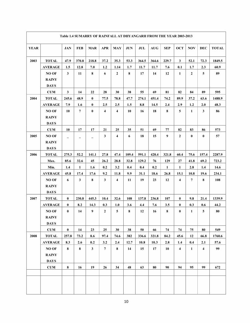
Table 1.4 SUMARRY OF RAINFALL AT DHYANGARH FROM THE YEAR 2003-2013
YEAR JAN FEB MAR APR MAY JUN JUL AUG SEP OCT NOV DEC TOTAL
2003 TOTAL 47.9 370.8 218.8 37.2 35.3 53.3 364.5 364.6 229.7 3 52.1 72.3 1849.5
AVERAGE 1.5 12.8 7.0 1.2 1.14 1.7 11.7 11.7 7.6 0.1 1.7 2.3 60.9
NO OF
RAINY
DAYS
3 11 8 6 2 8 17 14 12 1 2 5 89
CUM 3 14 22 28 30 38 55 69 81 82 84 89 595
2004 TOTAL 245.6 48.9 0 77.5 78.8 47.7 274.1 451.4 74.2 89.9 37.2 63.6 1488.9
AVERAGE 7.9 1.6 0 2.5 2.5 1.5 8.8 14.5 2.4 2.9 1.2 2.0 48.3
NO OF
RAINY
DAYS
10 7 0 4 4 10 16 18 8 5 1 3 86
CUM 10 17 17 21 25 35 51 69 77 82 83 86 573
2005 NO OF
RAINY
DAYS
_ _ _ 3 4 6 18 15 9 2 0 0 57
2006 TOTAL 275.3 52.2 141.1 27.8 47.4 109.4 591.1 428.4 321.8 60.4 75.6 157.4 2287.9
Max. 85.6 32.6 45 26.2 28.8 32.8 129.2 76 129 27 41.8 69.2 723.2
Min. 1.4 1 1.6 0.2 3.2 0.4 0.4 0.2 1 1 2.8 1.4 14.6
AVERAGE 45.8 17.4 17.6 9.2 11.8 9.9 31.1 18.6 26.8 15.1 10.8 19.6 234.1
NO OF
RAINY
DAYS
6 3 8 3 4 11 19 23 12 4 7 8 108
2007 TOTAL 0 230.8 445.3 10.4 32.6 108 137.8 236.8 107 0 9.8 21.4 1339.9
AVERAGE 0 8.2 14.3 0.3 1.0 3.6 4.4 7.6 3.5 0 0.3 0.6 44.2
NO OF
RAINY
DAYS
0 14 9 2 5 8 12 16 8 0 1 5 80
CUM 0 14 23 25 30 38 50 66 74 74 75 80 549
2008 TOTAL 257.8 73.2 8.6 97.4 74.6 382 336.6 321.8 84.2 45.6 12 66.8 1760.6
AVERAGE 8.3 2.6 0.2 3.2 2.4 12.7 10.8 10.3 2.8 1.4 0.4 2.1 57.6
NO OF
RAINY
DAYS
8 8 3 7 8 14 15 17 10 4 1 4 99
CUM 8 16 19 26 34 48 63 80 90 94 95 99 672
11
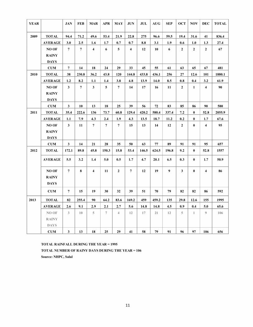
TOTAL RAINFALL DURING THE YEAR = 1995
TOTAL NUMBER OF RAINY DAYS DURING THE YEAR = 106
Source: NHPC, Salal
YEAR JAN FEB MAR APR MAY JUN JUL AUG SEP OCT NOV DEC TOTAL
2009 TOTAL 94.4 71.2 49.6 53.4 21.9 22.8 275 96.6 59.5 19.4 31.6 41 836.4
AVERAGE 3.0 2.5 1.6 1.7 0.7 0.7 8.8 3.1 1.9 0.6 1.0 1.3 27.4
NO OF
RAINY
DAYS
7 7 4 6 5 4 12 10 6 2 2 2 67
CUM 7 14 18 24 29 33 45 55 61 63 65 67 481
2010 TOTAL 38 230.8 36.2 43.8 120 144.8 433.8 436.1 256 27 12.6 101 1880.1
AVERAGE 1.2 8.2 1.1 1.4 3.8 4.8 13.9 14.0 8.5 0.8 0.4 3.2 61.9
NO OF
RAINY
DAYS
3 7 3 5 7 14 17 16 11 2 1 4 90
CUM 3 10 13 18 25 39 56 72 83 85 86 90 580
2011 TOTAL 35.4 222.6 136 73.7 60.8 129.4 420.2 580.4 337.4 7.2 0 52.8 2055.9
AVERAGE 1.1 7.9 4.3 2.4 1.9 4.3 13.5 18.7 11.2 0.2 0 1.7 67.6
NO OF
RAINY
DAYS
3 11 7 7 7 15 13 14 12 2 0 4 95
CUM 3 14 21 28 35 50 63 77 89 91 91 95 657
2012
TOTAL 172.1 89.8 45.8 150.3 15.8 53.4 146.5 624.5 196.8 9.2 0 52.8 1557
AVERAGE 5.5 3.2 1.4 5.0 0.5 1.7 4.7 20.1 6.5 0.3 0 1.7 50.9
NO OF
RAINY
DAYS
7 8 4 11 2 7 12 19 9 3 0 4 86
CUM 7 15 19 30 32 39 51 70 79 82 82 86 592
2013 TOTAL 82 255.4 90 64.2 83.6 169.2 459 459.2 135 29.8 12.6 155 1995
AVERAGE 2.6 9.1 2.9 2.1 2.7 5.6 14.8 14.8 4.5 0.9 0.4 5.0 65.6
NO OF
RAINY
DAYS
3 10 5 7 4 12 17 21 12 5 1 9 106
CUM 3 13 18 25 29 41 58 79 91 96 97 106 656
12
1.19 WATER SUPPLY 1.19.1 In the higher temperate zones availability of water is sound to some extent due to
perennial streams and springs but overall it is insufficient. In the lower subtropical zone the water supply is much deficient with few springs infested with North worms and leeches which is due to the presence of lime in excess, xerophytic conditions are very common. Monsoon rains and winter rains supply plenty of water for agriculture and forest crops. The survival of artificial plantations depends only upon Monsoon and winter rains. Chenab River, Pouni Tawi, Anji, Rad and Balganga Nalas have water throughout the year but due to hilly terrain upto this time only a few irrigation canals etc., have been constructed. In some of the areas even at higher altitudes like Satoigali, Sangerdanda, Chili, Matah etc., the people have no other source of drinking water except muddy ponds and water collected during rains. This water collected during rains infested with narhwa worms and leeches is used by men and Cattle. In some areas, PHE Department is supplying drinking water but this is not sufficient. Only at Reasi, Katra and Pouni Towns the water supply for drinking purposes is satisfactory to some extent.
1.20 DISTRIBUTION OF AREA 1.20.1 The presence of large number of Chaks inside the demarcated Forests is a
prominent feature of the division. The lower fringes of the Forest are honey combed with human habitations and are under heavy biotic pressure. The Forests are bounded all along their lengths at least on one side by the habitation. With increase of population, there is a corresponding increase in land hunger among the people and some of the lower fringes of the Forests near and around chaks have already been encroached upon.
1.21 TOTAL AREA 1.21.1 The area of this Division is mainly spread over the civil jurisdiction of Reasi Tehsil
of Udhampur District. The gross area including Forest land and revenue area has been calculated as 92717 ha.
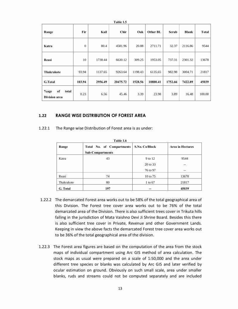
1.21.2 The total Demarcated Forest area of this Division is 45039 ha. The species wise
distribution of area is as given in table 1.5
13
Table 1.5
Range Fir Kail Chir Oak Other BL Scrub Blank Total
Katra 0 80.4 4581.96 20.88 2711.71 32.37 2116.86 9544
Reasi 10 1738.44 6630.12 309.25 1953.05 737.31 2301.32 13678
Thakrakote 93.94 1137.65 9263.64 1198.43 6135.65 982.98 3004.71 21817
G.Total 103.94 2956.49 20475.72 1528.56 10800.41 1752.66 7422.89 45039
%age of total
Division area 0.23 6.56 45.46 3.39 23.98 3.89 16.48 100.00
1.22 RANGE WISE DISTRIBUTION OF FOREST AREA 1.22.1 The Range wise Distribution of Forest area is as under:
Table 1.6
Range Total No. of Compartments
Sub-Compartments
S.No. Co/Block Area in Hectares
Katra 43 9 to 12
20 to 33
76 to 97
9544
--
--
Reasi 74 10 to 75 13678
Thakrakote 80 1 to 67 21817
G. Total 197 -- 45039
1.22.2 The demarcated Forest area works out to be 58% of the total geographical area of this Division. The Forest tree cover area works out to be 76% of the total demarcated area of the Division. There is also sufficient trees cover in Trikuta hills falling in the jurisdiction of Mata Vaishno Devi Ji Shrine Board. Besides this there is also sufficient tree cover in Private, Revenue and other Government Lands. Keeping in view the above facts the demarcated Forest tree cover area works out to be 36% of the total geographical area of the division.
1.22.3 The Forest area figures are based on the computation of the area from the stock
maps of individual compartment using Arc GIS method of area calculation. The stock maps as usual were prepared on a scale of 1:50,000 and the area under different tree species or blanks was calculated by Arc GIS and later verified by ocular estimation on ground. Obviously on such small scale, area under smaller blanks, ruds and streams could not be computed separately and are included
14
under the above respective category of area figures. The total geographical area of the Division is also calculated by dot grid method.
1.22.4 As per approximate assessment, the total tree cover area of the division is about
50%. 1.23 STATE OF BOUNDARIES 1.23.1 Absence of boundary pillars on ground at many places has resulted in lot of
difficulties in preparation of stock maps and layout of compartments. Although the boundaries of the demarcated Forests were delineated by loose heaps of stones and wooden pillars, the condition of boundaries is very unsatisfactory at present. Most of the boundary pillars have been removed and displaced by the local villagers as a result of which demarcation pillars line does not exist over large tracts. The encroachments were common features in the past as a result of which forest land is shrinking. There is need of fresh demarcation and erection of permanent masonry boundary pillars.
1.24 LEGAL POSITION 1.24.1 All demarcated Forests are the property of the state and are managed by the
Jammu and Kashmir Forest Department. The control of fluctuating grazing is with the Forest Department closure of any Forest area up to ½ of any Forest subject to maximum of one quarter of the total area of Forest Range at a time with adequate and suitable provision for right of way can be effected by Forest Department with previous sanction of Minister in charge. In discharging its obligations the Forest Department derives authority from the following enactments and rules made there under:
1. The Forest Act of Samvat 1987 Act No II of 1987 (1930 A.D.) as amended to date. 2. The Kuth Act 1978 (1921 A.D.) Act No I of 1978. 3. The Cattle trespasser Act 1977 (1920 A.D.) Act No. VIII of 1977. 4. The kahchari Act 2011 Act No XVIII of 2011 (1954 A.D.). 5. The J&K Public premises (Eviction of unauthorized occupants) Act 1959 Act No XIII
of 1959. 6. The J&K land Improvement Schemes Act 1972 Act No XXIV of 1972. 7. The J&K State Forest Corporation Act 1978 Act No XII of 1978. 8. The J&K Wild life protection Act 1978 Act No XIII of 1978. 9. The J&K nationalization of Forest Working ordinance 1986 ordinance No V of
1986. 10. The J&K extraction of Resin Act Governor’s Act No. VII of 1986. 11. The J&K Forest Notices. 12. Govt. Order No. 24 FST of 1990 Dated 15-01-1990. 13. The J&K Forest (Conservation) Act 1997. Coverners Act No. XXIV of 1997, other
rules and regulation enacted from time to time.
15
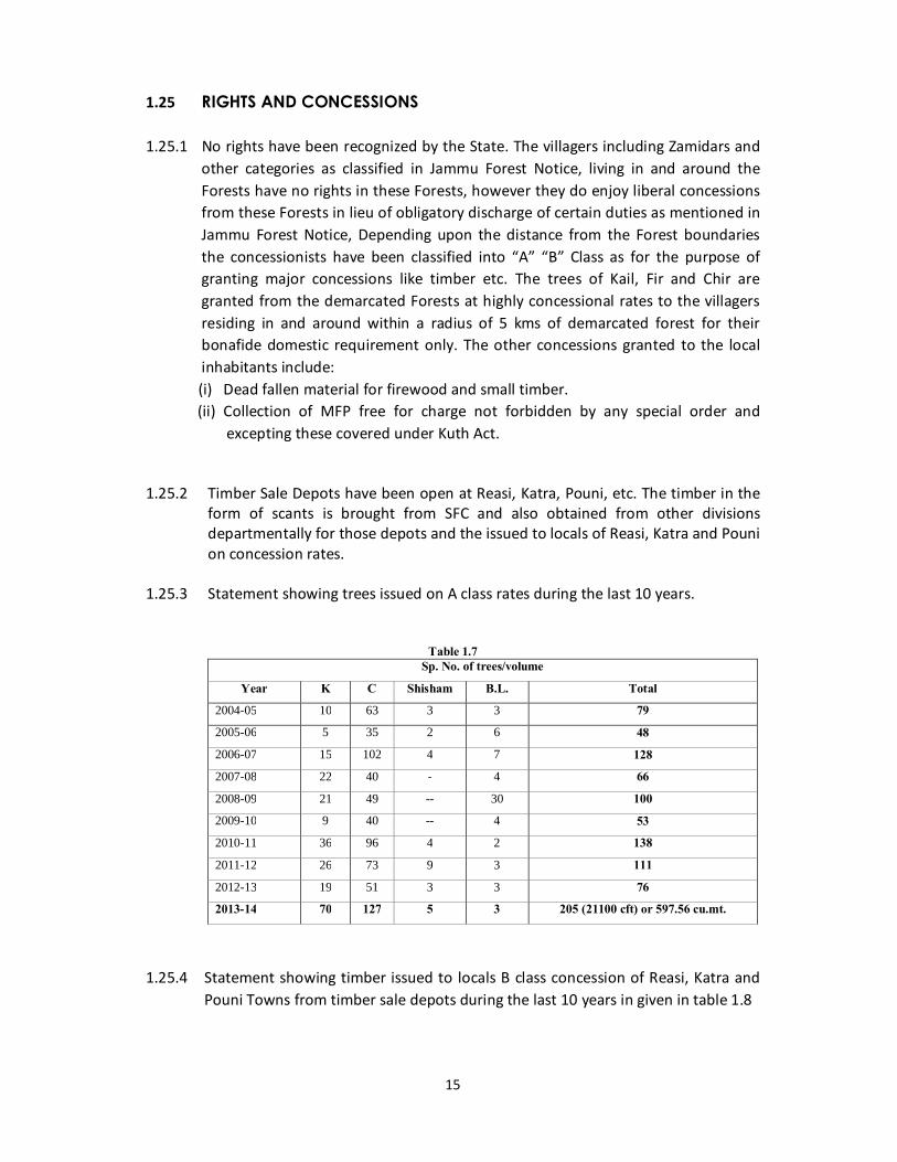
1.25 RIGHTS AND CONCESSIONS 1.25.1 No rights have been recognized by the State. The villagers including Zamidars and
other categories as classified in Jammu Forest Notice, living in and around the Forests have no rights in these Forests, however they do enjoy liberal concessions from these Forests in lieu of obligatory discharge of certain duties as mentioned in Jammu Forest Notice, Depending upon the distance from the Forest boundaries the concessionists have been classified into “A” “B” Class as for the purpose of granting major concessions like timber etc. The trees of Kail, Fir and Chir are granted from the demarcated Forests at highly concessional rates to the villagers residing in and around within a radius of 5 kms of demarcated forest for their bonafide domestic requirement only. The other concessions granted to the local inhabitants include:
(i) Dead fallen material for firewood and small timber. (ii) Collection of MFP free for charge not forbidden by any special order and
excepting these covered under Kuth Act. 1.25.2 Timber Sale Depots have been open at Reasi, Katra, Pouni, etc. The timber in the
form of scants is brought from SFC and also obtained from other divisions departmentally for those depots and the issued to locals of Reasi, Katra and Pouni on concession rates.
1.25.3 Statement showing trees issued on A class rates during the last 10 years.
Table 1.7 Sp. No. of trees/volume
Year K C Shisham B.L. Total
2004-05 10 63 3 3 79
2005-06 5 35 2 6 48
2006-07 15 102 4 7 128
2007-08 22 40 - 4 66
2008-09 21 49 -- 30 100
2009-10 9 40 -- 4 53
2010-11 36 96 4 2 138
2011-12 26 73 9 3 111
2012-13 19 51 3 3 76
2013-14 70 127 5 3 205 (21100 cft) or 597.56 cu.mt.
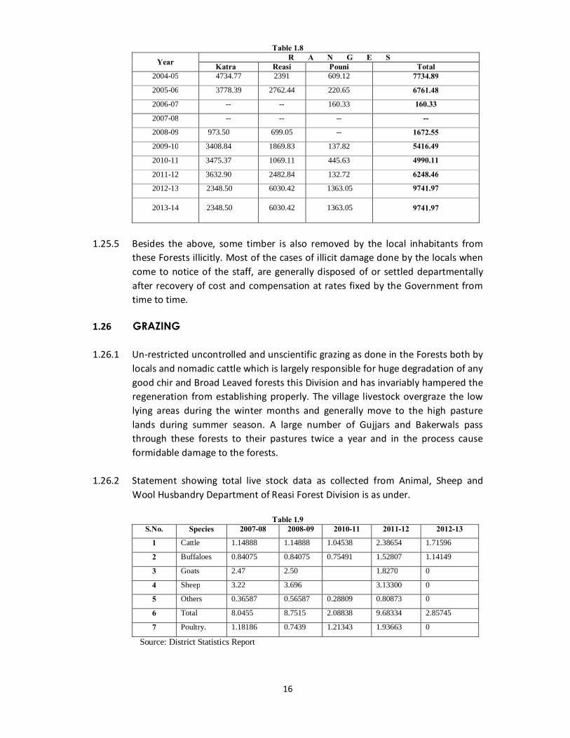
1.25.4 Statement showing timber issued to locals B class concession of Reasi, Katra and
Pouni Towns from timber sale depots during the last 10 years in given in table 1.8
16
Table 1.8
Year R A N G E S Katra Reasi Pouni Total
2004-05 4734.77 2391 609.12 7734.89
2005-06 3778.39 2762.44 220.65 6761.48
2006-07 -- -- 160.33 160.33
2007-08 -- -- -- --
2008-09 973.50 699.05 -- 1672.55
2009-10 3408.84 1869.83 137.82 5416.49
2010-11 3475.37 1069.11 445.63 4990.11
2011-12 3632.90 2482.84 132.72 6248.46
2012-13 2348.50 6030.42 1363.05 9741.97
2013-14 2348.50 6030.42 1363.05 9741.97
1.25.5 Besides the above, some timber is also removed by the local inhabitants from
these Forests illicitly. Most of the cases of illicit damage done by the locals when come to notice of the staff, are generally disposed of or settled departmentally after recovery of cost and compensation at rates fixed by the Government from time to time.
1.26 GRAZING 1.26.1 Un-restricted uncontrolled and unscientific grazing as done in the Forests both by
locals and nomadic cattle which is largely responsible for huge degradation of any good chir and Broad Leaved forests this Division and has invariably hampered the regeneration from establishing properly. The village livestock overgraze the low lying areas during the winter months and generally move to the high pasture lands during summer season. A large number of Gujjars and Bakerwals pass through these forests to their pastures twice a year and in the process cause formidable damage to the forests.
1.26.2 Statement showing total live stock data as collected from Animal, Sheep and
Wool Husbandry Department of Reasi Forest Division is as under.
Table 1.9 S.No. Species 2007-08 2008-09 2010-11 2011-12 2012-13
1 Cattle 1.14888 1.14888 1.04538 2.38654 1.71596
2 Buffaloes 0.84075 0.84075 0.75491 1.52807 1.14149
3 Goats 2.47 2.50 1.8270 0
4 Sheep 3.22 3.696 3.13300 0
5 Others 0.36587 0.56587 0.28809 0.80873 0
6 Total 8.0455 8.7515 2.08838 9.68334 2.85745
7 Poultry. 1.18186 0.7439 1.21343 1.93663 0
Source: District Statistics Report
17
1.26.3 Statement showing fluctuating livestock population grazing in the Forests of Reasi Forest Division enumerated by the territorial Division.
Table 1.10
Year Sheep Goat Buffalo Horse Mule Total
2004-05 15886 22386 173 9 2 38456
2005-06 15561 20760 153 125 - 36599
2006-07 19706 13459 216 56 - 33437
2007-08 11773 16272 174 20 - 28239
2008-09 12325 16060 22 8 11 28426
2009-10 15905 20920 141 2 - 36968
2010-11 25406 22458 24 4 - 47892
2011-12 20809 28881 96 10 8 49809
2012-13 26405 28826 131 12 10 55384
2013-14 22403 31318 59 2 - 53782
1.26.4 Statement showing Rates Charged as grazing fee.
Table 1.11 S.No. Kind of Cattle A. Rate B. Rate C. Rate
1 Pack Bullocks 0.80 0.80 0.80
2 Teli Bullocks 0.50 1.00 2.00
3 Buffaloos 1.80 3.15 11.25
4 Riding Ponies 2.50 3.75 7.50
5 Pack Ponies+malies 2.80 2.80 5.00
6 Donkeys 0.65 0.65 0.65
7 Camels 5.00 10.00 15.00
8 Sheep for Ladakh 0.15 0.20 0.60
9 Goats unperted for commercial purpose - - 2.50
10 Sheep for rest of the State 0.15 0.20 0.65
11 Sheep unperted for commercial purpose - - 0.20
1.26.5 As per records available the following statement shows the revenue realized as
fluctuating grazing fee.
18
Table 1.12 Year Amount realized (in Rs.)
1981-82 24679.00
1982-83 19238.00
1983-84 21040.00
1984-85 11609.45
1985-86 14324.50
1986-87 16208.35
1987-88 12090.30
1988-89 11852.15
1989-90 17300.75
1990-91 14930.25
1991-92 131113.00
“A” Rates are charged from local cattle. “B”for inter provincial movement of cattle. “C” rates from foreign grazing.
19
CHAPTER – II
A-FOREST FLORA B-FOREST FAUNA
20
CHAPTER – II
A-FOREST FLORA 2.1 COMPOSITION AND CONSTITUION OF THE CROP 2.1.1 The altitude of this division extends from 360 mts at Bhabber along the river
Chenab in Katra Range to 2600 Mts at Mathlani-top in Thakrakote Range dividing it mainly into tropical and temperate zones. Hence this division has mainly four categories of Forests namely. (i) Brush Wood Forests. (ii) Chir Forests. (iii) Kail and Fir Forests. (iv) Oak Forests.
2.1.2 The main species found in this Division are Chir, kail, Fir, Broad leaved and scanty
shrubs of poor quantity and poor density. The crop is scanty at the base i.e. near the habitations due to heavy biotic interference than at top of hills
2.2 CHIR 2.2.1 Chir Forests in this Division are thin open sparse degraded and continued to 600
meters to 2000 meters elevation over the low lying sub-tropical belt in all the three Ranges i.e Reasi, Katra and Thakrakote. Chir grows mostly pure as well as mixed with kail and Broad leaved species at places better quality Chir is found between 750 Mt to 1500 Mtrs. elevation, above and below it is stunted.
2.2.2 The crop is young to middle aged with less representation of mature and over
mature trees. These Forests are heavily burdened by biotic interference and resin tapping. Regeneration on the whole is very deficient due to heavy biotic interference i.e. excessive grazing and fires etc. under favourable condition patches of established regeneration are meet with.
2.3 KAIL AND FIR 2.3.1 Kail and small portion of Fir occur above the Chir zone either pure or kail mixed
with Fir or kail mixed with Ban Oak in varying proportion, mostly above Ladha and Tirshue towards sareli etc. in Reasi Range and few narrow strips on high altitude, Mathani top in Thakrakote Range. Some Kail occures in high altitude of Jangalgali Block in Katra Range.
2.3.2 Kail crop is irregular middle aged or in pole stage with a smaller proportion of
mature and over mature stamps. Regeneration of kail is good and is established inCompartment 55, 62, 63 in Reasi, The Fir crop is middle ages in mature and
21
overmature. The regeneration of Fir is absent although young poles are present at places.
2.3.3 Broad leaved species ranging from sub-tropical miscellaneous type to Oak are
found in this division. Quercus leucotrichophora is found from Chir Zone to Kail Zone. It is heavily topped adjoining to human habitations.
2.4 GENERAL DESCRIPTION OF THE GROWING STOCK 2.4.1 Depending upon elevation the Forests of this division can be divided in two
distinct zones. (A) Sub-Tropical (B) Temperate 2.5 SUB TROPICAL ZONE 2.5.1 These are mainly brushwood Forests along the River Chenab and its tributaries
the Anji, Rud and others. Euphorbia royleana is Characteristics of such areas which indicates Zerophytic vegetation. The main species found are Accacia catechu, Dalbergia sissoo, Olea cuspiodata, Accacia modesta, Cassia fistula, Terminalia beterica, Anogeissusw latifolia, Mallotus phikllpinensis, Lannea cormandalica with occasional Phoenixhumillis, Toona ciliata, Bombex cebia, Syzygiym cumini etc. Pure patches of Dalbergia sissoo are at Dehra baba (Bhabbar). Around Reasi in Chinkah fenna, Coromanaelica and Kamita are commonly found.
2.5.2 Undergrowth mainly consists of Adhatoda vasica and Dodonaea viscosa which
gets replaced on favourable sites by wood Fordia fruiticicosa, Carissa opaca and Cotinus coggygria etc. is found below Katra, near Reasi Talwara to Pouni and Bharakh etc. Bamboo occurs over a small stretch near Jhallenger, Pouni and Bharakh.
2.5.3 Also Chir is the predominant species of this zone, occupying low lying sub-tropical
belt along the Chenab around Anji and other Chenab tributaries. The common associates are Quercus lecotrichophora, Pyrus pashia, Vasica,
Rubus ellipticus, Indigofara pulchella. 2.5.4 Undergrowth mainly consists of the Carissa opaca, Dodonaca vasica, Rubus
ellipticus, and Indigofara puichella. 2.5.5 The ground flora comprises of Vioala serpens and variety of grasses and ferms.
22
2.6 TEMPERATE ZONE 2.6.1 Kail with very small portion of Fir are the two predominant species. These species
occur either in pure form or mixed with each other and broad leaved species. The common associates are Quercus lecucotrichophera, Aesculus indica, Pyrus poshia.
2.6.2 Undergrowth mainly consists of Viburnum nervosum, Desmodium tilaefollium,
Common Climbers are Hebra nepalensis, Smilax, Rosa brunonii.Ground flora consists of Viola serpens, Fragaria vasica, Cirardinia, Rumax species etc.
2.7 GENERAL DESCRIPTION OF THE FOREST TYPE 2.7.1 On the basis of the ‘Revised Survey of the Forest Types of India’ by Champion and
Seth the Forest Types. 2.8 NORTHERN MIXED DRY DECIDUOUS FORESTS TYPE (SB/C2). 2.8.1 These Forests occur along river Chenab and its tributaries, on Southern slopes of
low hills, flat hill tops, eroded ground near Katra, Reasi, Pouni, Bharakh, Bidda etc. At places they extend upto 1250 m particularly on the other Ranges subjected to rapid drainage and strong insulation. Some species like Lannea grandis and Anogeissus latifolia etc., form extensive consociations. Most of the trees have low spreading crowns.
2.8.2 Floristics:
a) Lannea coromandelica,Anogeissus latifolia, Bombax ceiba, Acacia catechu,
Emblica officinalis, Wendlendia heyneii, Grewia clastica, Ougenia oojenensis, Terminalia tomentosa, Mitragyna parviflora, Bauhinia spp. Acacia modesta, Mallotus Phillipinensis, Cassia fistula, Ficus sppetc.
b) Carissa opaca, Dodonaea viscose, Woodfordia fruticosa, Flacourtia indica,
Adhatoda vasica, Colegrookiaspps. etc.
c) Dendrocalamus strictus, various grasses, few climbers, Bauhinia vahlii etc. 2.9 DRY DECIDUOUS SCRUB (TYPE 5/DSI) 2.9.1 This is a degradation stage of type 5/c2 occuring along the letter’s habitat. Some
trees species have reduced to shrubby conditions and there occurs a shrubby growth, 3 to 5 mts., high. The trees have become malformed stunted. The main cause for degradation of these Forests is unrestricted heavy biotic interference for firewood, lopping and grazing etc. These Forests are badly eroded and are fast depleting.
23
2.9.2 Floristics:
a) Acacia catechu, Cassia fistula, Lanea coromandalica, Mallotus phillipinensis, Euphorbia royleana, Carissa opaca, Dodonaea viscose, Flacortia indica, Woodfordia frulicosa, Colebrookia oppositifoliaetc.
2.10 PURE SISSU FOREST (TYPE 5/IS2)
2.10.1 This primary serial type of the reverine succession. Pure Sissu occupy islands in the bed of river Chenab near Derha and Bhabber villages Cassiatora and grasses farm the main undergrowth.
2.11 CHIR FOREST (GROUP 9/SUB-TROPICAL PINE FORESTS) 2.11.1 These Forests are present in all the three Ranges of the Reasi Division confined to
600 metre to 2000 metre elevation over the low lying sub-tropical belt. Chir is the dominant species, with open canopy, in moist areas (in Siwalik and along parennial nalla banks in upper Chir occur as predominant with broad leaved species.
Following types occur in this Division. (i) 9/C1 Himalayan sub-tropical pine Forests. (ii) 9/DS1 Himalayan sub-tropical pine Forests. (iii) 9/DS2 Sub-tropical Euphorbia scrub.
2.12 TYPE 9/C1 COMPRISES TWO SUB-TYPES, NAMELY: 2.13 SHIWALIK CHIR PINE FORESTS (9C1a) 2.13.1 This sub-type occurs on the Siwaliks from domel to Reasi. The Chir trees are
generally malformed having poor height growth. 2.13.2 Floristics:
a) Pinus roxburghii,Mallotus phillipinensis, Wendlendia heyneii, Emblica officinalis, Syzygium cuminii, Cassia fistula etc.
b) Carissa spinarum, Dodonaea viscose, Colebrokia oppositifollia, Adhatoda vasica, Indigoferra spp., etc.
2.14 HIMALAYAN CHIR PINE FORESTS (9C1D) 2.14.1 This sub-type occurs between 908 metres to 1800 metres elevation. 2.14.2 Floristics:
a) Pinus roxburghii b) Quercus leucotricophora, Syzygium cuminii, Rhododendron arboreum, Pyrus
pashia, Crataegus crenulata, Olea cuspidate, etc.
24
c) Berberis spp: Myrsine africana, Rubus ellipticus, Viburnum spp., Indigofera pulchella, Princepia utilis, Rosa brunonii etc.
d) Gallium rotundifolium, Viola serpens, Plantago tibiticaetc,several grass species.
2.14.3 Regeneration of Chir: The natural regeneration of Chir both in Siwalik Chir and
Himalayan Chir is unsatisfactory. It is present in patches at places and young recruits are found occasionally. The heavy biotic interference uncontrolled grazing, grass cutting and occurrence of frequent fires do not allow the regeneration to complete and establish. This all heavy biotic interference also prevents the development of Shrubs. However in some areas in the Siwalik the thick undergrowth inhabits the natural regeneration.
2.15 HIMALAYAN SUB-TROPICAL SCRUB (TYPE 9DS2) 2.15.1 Over considerable areas in the Siwalik Chir Zone extending upto the Himalayan
Chir Forests and down into the mixed deciduous Forests, the overwood has been destroyed perhaps has been unable to develop owing to excessively dry and shallow Soil, on open shrub formation occupy the ground. The species are Carissa spinarum, Dodonaea viscosa, Woodfordia fruiticosa etc.
2.16 SUB-TROPICAL EUPHORBIA (TYPE 9/DS2) 2.16.1 Euphorbia royleana forms consociations in small patches on rocky and dry sites
and those subjected to heavy biotic pressure. They indicate xerophytic conditions. This type can be easily observed while traveling from Reasi to Katra.
2.17 HIMALAYAN MOIST TEMPERATE FORESTS 2.17.1 These are conifer forests occurring above the sub-tropical Chir Pine Forests
towards high altitudes above 1600 m to 2600 m. Mostly pure patches of Kail Banj Oak or Kail mixed with Bank Oak in varying proportion according to altitude, configuration and aspect etc. The conifers generally form open Forests with varying amount of underwood. Undergrowth of deciduous and evergreen shrubs present according to density of the canopy and intensity of grazing. Following types and sub-types of this group occur in this Division are:
2.18 BANJ OAK FORESTS (TYPE 12/Cla) 2.18.1 These Forests occur most extensively in the upper catchments of Rud and such
Nallah in Thakrakote Range Anji Nallah in Reasi and in very small portion in Jungelgali bokc of Katra Range. The soil in damp covered with litter. These forests are subjected to damage through local inhabitants near habitations, lopping for
25
fodder and firewood damage is very common. As a result these forests have vanished over some areas which have been increasingly brought under plough.
2.18.2 Floristics:
a) Quercus leucotrichophera, Pinus roxgburghii, Pinus wallichiana, Machilus duthei, Maclilus ganibei, Rhododendrion arboreum, Pieris ovalafolia, Pyruspashiaetc.
b) Viburnum spp., desmodium tiliaefolium, Sercacoca saligna, Indigoferra pulchella, Rubus ellipticusvitis, Himalayana, hedra nepaleusis, Rosa brunonii, Smilax asperaetc.
c) Fragaxia vasica, Plantago tibetica, Viola canescensetc. 2.19 FIR FORESTS (TYPE 12/C1d) 2.19.1 These forests are distributed over few narrow strips of high altitudes towards
Saroli and Mathiani tops in Reasi and Thakrakote Ranges respectively. The altitudinal zone is 2100 mt., and above. They are either pure Fir, Fir-Kail with admixture of evergreen of deciduous broad leaved trees. Young trees are relatively deficient and regeneration is a problem throughout these Forests. Most of the crop includes mature and over mature trees.
2.19.2 Floristics:
a) Abies pindrow, Picea smithiana, Pinus wallichiana. b) Quercus dilatata, Aesculus indica, Juglans regia, Quercus leucotricophora, Buxes
wallichiana, Acer, Machilus, Viburnum, narvosum, Viburnum cotinifolium. c) Fragaria vasica, Rumex, Viola seprens, Gallium rotundifolium, Vitis himalayana,
Hedra nepalensis.
2.19.2 Ecological Status: It appears to be a climatic climax.
2.20 MOIST TEMPERATE DECIDUOUS FORESTS (TYPE 12/C1a & 12/C2C)
2.20.1 This type is found from 1800 m to 2600 m on the moist nallah banks and often as strips along the shady depressions along the gentler slopes throughout the moist localities.
2.20.2 Floristics:
Aesculus indica, Juglans regia, Acer pictum, Acer caesium, Abies pindrow, Populus siliata, Prunus padus, Viburnum cotonifolium, Rubus spp., Iris sp. Spirea Lindlyana, Sarcococa saligna, Dephnae papyracea.
26
2.21 LOW LEVEL BLUE PINE FORESTS (TPYE 12/2s 1) 2.21.1 These forests occur in the upper most catchment of Anji river above ladha and
Tirshu in Reasi Range, along few narrow strips on high altitudes, in Thakrakote Range and Junglegali Block of Katra Range at altitudinal zones 1500 to 2400 m.
Kail is the predominant species intermixed with Fir and broad leaved in moist sites.
2.21.2 Floristics:
Pinus wallichiana, Abies pindrow, Quercus leucotrichophora, Berberis sp. Viburnum nervosum, Iris ensata, Rosa macrophylia, Rubus ellipticus, Sarcocoosa saligua, Daphrae papyracea, Pteridkum, Viola, Frageria vasica, Galium rotundifolium.
2.22 INJURIES TO WHICH THE CROP IS LIABLE 2.22.1 Various agents causing injuries to the crop of these Forests directly or indirectly
are enlisted below: i. Man and his animals. ii. Fires. iii. Wild animals. iv. Insects, fungi and parasites. v. Climate (Physical causes)
2.23 MAN AND HIS ANIMAL 2.23.1 Man and his animal are directly or indirectly responsible for causing the heaviest
injuries to the forests. Man is the greatest beneficiary as well as the biggest enemy of the Forests. Man is responsible for girdling, lopping, firewood extraction, fires, grazing cutting illicit damage and encroachment of forest etc.
2.24 GRAZING 2.24.1 The entire forest tract is subjected to uncontrolled and unrestricted grazing both
by local and nomadic cattle. The number of these Cattle has gone beyond the carrying capacity of these forests. This is the main cause of the failure of the natural regeneration. Hence due to excessive grazing in Chir Forests the overall condition of regeneration is quite unsatisfactory. Due to grazing not only the seedlings and young samplings are browsed but also the soil get trampled due to continuous movement of grazing and browsing of cattle causing varying degree of soil erosion.
2.25 GRASS CUTTING 2.25.1 Villagers cut and remove the coniferous recruits and seedlings indiscriminately
alongwith the grass this is also the cause of failure of natural regeneration.

27
2.26 LOPPING 2.26.1 Lopping of broadleaved tree species especially Oak and other fodder trees is
carried out on a large scale by the villagers for feeding their cattle. Besides reducing the crown and consequential reduction in the rate increment, lopping renders the trees more vulnerable to fungal diseases. Torchwood extraction is often done in remote areas by the villagers from the standing trees of both Chir and Kail. As a result of which the trees get damaged, weakened and become more vulnerable to damage by strong winds and snow.
2.27 RESIN TAPPING 2.27.1 Resin tapping by French cup and lip method has damaged almost whole of the
chir crop existing in the division. In the past the prescribed norms in respect of depth, width, number of Channels have never been followed. This method has weakened the Chir crop and rendered it to easily damage by strong winds. However French Cup and Lip method has been stopped with effect from 1987. The extraction of resin is carried by Rill method which causes less injuries to the Chir crop as compared to the old Cup and Lip method.
2.28 ENCROACHMENTS 2.28.1 With the growth in human population the people fell the trees around their
proprietary land with an objective to encroachment for expending their holding. However this process of encroachment is decreasing as compared to past but has not yet stopped as some fresh encroachments are going on. Fresh encroachment needs to be checked by proper demarcation and strict vigilance.
2.29 ROADS AND OTHER ENGINEERING PROJECTS CONSTRUCTION 2.29.1 As a result of Road and other engineering projects, constructions involving earth
work, the area becomes de-established and the hill slopes become vulnerable to soil erosion and landslides which ultimately destroy the forest crop.
2.30 ILLICIT DAMAGE 2.30.1 With rapid rate of organization and increase in population there has been
corresponding increase in the demand for the timber and fuel wood resulting illicit damage. Mostly the illicit damage is caused by local people for meeting their needs.
2.30.2 The following table shows the year wise number of damage cases registered in
the Reasi Forest Division during the years given in table 2.1:
28
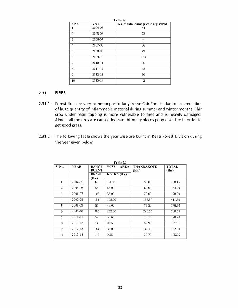
Table 2.1 S.No. Year No. of total damage case registered 1 2004-05 34
2 2005-06 73
3 2006-07 --
4 2007-08 66
5 2008-09 49
6 2009-10 133
7 2010-11 86
8 2011-12 43
9 2012-13 80
10 2013-14 42
2.31 FIRES 2.31.1 Forest fires are very common particularly in the Chir Forests due to accumulation
of huge quantity of inflammable material during summer and winter months. Chir crop under resin tapping is more vulnerable to fires and is heavily damaged. Almost all the fires are caused by man. At many places people set fire in order to get good grass.
2.31.2 The following table shows the year wise are burnt in Reasi Forest Division during
the year given below:
Table 2.2 S. No. YEAR RANGE WISE AREA
BURNT THAKRAKOTE (Ha.)
TOTAL (Ha.)
REASI (Ha.)
KATRA (Ha.)
1 2004-05 65 120.15 53.00 238.15
2 2005-06 55 46.00 62.00 163.00
3 2006-07 105 53.00 20.00 178.00
4 2007-08 151 105.00 155.50 411.50
5 2008-09 55 46.00 75.50 176.50
6 2009-10 305 252.00 223.55 780.55
7 2010-11 52 55.60 13.10 120.70
8 2011-12 14 0.25 52.90 67.15
9 2012-13 184 32.00 146.00 362.00
10 2013-14 146 9.25 30.70 185.95

29
2.32 WILD ANIMALS 2.32.1 Injuries caused to the Forest by the wild animals are negligible in nature as
compared to the damage done by the man and his animals, porcupines, Hares, Monkeys squirrels, Rats, cause damage to forest crop. But on the whole the damage is not very significant.
2.33 CLIMATE (PHYSICAL CAUSES) 2.33.1 The damage does not occur in this division. However at higher altitudes when
heavy snowfall occurs some trees get broken at whole or top are uprooted. Sometimes wind and rain storms also cause damage to crop by breaking the trees and by uprooting them especially of Chir trees weakened due to resin tapping. Drought retards the growth of the trees especially of young regeneration and damage seedlings and samplings. The drought effected trees become less resistant to fires. Heavy rains cause floods and leads to landslides and soil erosion also causes uprooting of trees. Soil erosion is all over the division but it is quite common in low lying areas where Gullies, Nallas and Khads are increasing in width and cutting the forests on their banks.
B-FOREST FAUNA 2.34 GENERAL DESCRIPTION 2.34.1 A variety of fauna is found in this division because of varied climatic conditions
and altitudinal zonation prevailing in the tract. The over increasing pressure of human population is responsible for sharp decline of wild life population in this division as elsewhere in the state Excessive interference by the graziers and their large birds of animals has led to the large scale destruction of some species of wild animals like wild goats etc. Apart from large scale killing of game animals and birds by man, the deforestation has also been responsible for disturbing the habitat of the wild life and consequent reduction in their number.
2.35 WILDLIFE OCCURING IN THE TRACT 2.35.1 The fauna species especially the animals and birds as described below are on
constant decline and some of these have reached to a point of extinction. 2.36 ANIMALS:
a) MAMMILIA b) CARNIVORA
2.36.1 Leopard or Panther (Panthera pardus): Locally known as Chitra or Chita size 7’
and average weight 52 Kg for male and 35 Kg in female. It is reported in higher altitudes of Reasi Range. It is short haired with fulvous or bright fulvous coat

30
marked with small close-set black rosette. The Panther can over power with safety, Cattle, Monkeys, Rodents, Crack, Birds, Reptiles, etc. It can also prey domestic animals, calves, Sheep and goat etc. It has been declared as special game as per J&K wild life protection Act 1978.
2.36.2 The Jackal (Canis aureus): Size body length 60-70 cm, tail 20-27 cm typical mixture of black and white washed with buff on shoulders, ears and legs. It is commonly found in the division mostly in low land areas near towns, Villages and cultivation, sheltering in holes in the ground, dense grass or scrub. It sometimes attacks small domestic animals like goats, sheep and their young ones and birds. It is one of the most common of nature scavengers. This animal has been declared as vermin by the J&K wild life protection Act, 1978.
2.36.3 The Red Fox (Vulpus vulpus): It is found in the upper sub-temperate and
temperate zone of the tract. It has been included in scheduled IV of J&K Wild life protection Act, 1978.
2.36.4 The Indian Fox (Vulpes bengalensis): Size: Body length 45-60 cms and tail 25-30 cms. Grey coloured pretty and slender limbed animal. It is found in sub-tropical zone of this division. It lives in the burrow dug by itself in open ground or in scrub. It feeds on small mammals, reptiles and insects. It has been declared vermin as per the J&K wildlife protection Act 1978.
2.36.5 The Himalayan Black Bear (Selenaractor thibetanus): Size: 1 to 1.5 m and
average weight 100 kg. It is black in colour. Locally known as Reich. It is found in the temperate zone mostly of Reasi Range in sizeable number. It resides in Caves in the day time and come out at dusk to seek food & returns at sun rise. It lives largely on variety of wild fruits, berries, insects, termites and larvae. It is the most carnivorous of the bears and kills Sheep, Goat and even large domestic animals. It is included in scheduled III of the J&K Wildlife Protection Act 1978.
2.36.6 Mongoose (The small Indial Mangoose) (Herpestevs aurpuctatus): Size:(45-50
cm) in total length. A short animal with dark brown gold flacked, soft silky fur. It is mostly found in low lying area of this division in and around cultivated fields. It lives in holes burrowed by it. It feeds on rats, mice, wasps and insects of all kind.
2.37 RODENTS 2.37.1 The Red Flying Squirrel (Philippens altrvent): It has a very thick fur; the tail is
usually longer than the body and head. It feeds on fruits nuts, gums, resin of various trees and sometimes on small insects and their larvae. It has been included in schedule II of the J&K Wild life protection Act 1978.
2.37.2 Five striped palm squirrel (Funambules penanti): Size: 13 cm to 16 cm. It is
distinctive in having five pole strips on back with supplementary strips. It is quite
31
common in subtropical belt of this division. It is rarely found in the Forests but lives around the human dwellings and agricultural fields. It feeds on fruits, nuts, young shoots and bark etc. It has been included in schedule II of J&K Wildllife Protection Act 1978.
2.37.3 The Indian Field Mouse (Mus booduqa): Size: it is about 5 to 8 cm in body
length, tail about 5 cm in body length, and tail about 5 cm. The dorsal fur varies from brown to dark grayish brown, under side white. It is commonly found in fields, compounds and generally venture into the houses. It lives in burrows and feeds on grass fruits roots and nuts etc. It damages agricultural crops nurseries and plantations. It has been declared as vermin in schedule V of the J&K Wildlife Protection act 1978.
2.37.4 The Indian Porcupine (Hystrix indica): It is found in tropical and sub-tropical belt. It causes damage to nurseries and young plantations. It has been included in Schedule II of the J&K Wildlife Protection act 1978.
2.38 GOAT GROUP 2.38.1 The Grey Himalayan Goral (Naemerhedus goral): It is locally known as “Pijjar”.
It is a goat like animal. It has small horns sorter then the distance between at the base scarcely diverging. Generally its colour is yellowish grey, diffused with black. It stands 65-70 cm high at shoulders, weighs 25 to 30 Kg.
2.39 DEER GROUP 2.39.1 Barking Deer (Muntiacus muntjak): It is locally known as “Kakar”. It colour it is
deep chestnut, becoming darker on the neck and paler and duller below. This is generally found in the lower scrub Forests along Chenab River and in other broad leaved Forests up to 2000 m. It has well developed horns on bony pedicels. Height at shoulders is 50-75 cm and weighs about 20 to 25 Kgs. The male is distinguished by Sharp exposed canine teeth and small upright antlers. It is fairly diurnal in habit. Its food consists of leaves, grasses and wild fruits. It has been reduced to a small number. It has been included in scheduled III of J&K Wild Life Protection act 1978.
2.40 PIGS 2.40.1 The Indian Wild Boar (Pig)(Sus scrofa): It is locally called “Jungl Suar” and
inhabits the sub-tropical scrub forests of the tract. Young animals are brownish and old animals are grayish. It turns up soft soil with his shouts when roaming about for food. It stands about 90 cms high at shoulders and may weigh well over 230 Kg. The lower tusks vary between 20-30 cms on the outside curves. It is omnivorous and damages crops. It has been included in schedule III of the J&K Wildlife Protection Act 1978.

32
2.41 PRIMATES 2.41.1 The Rhesus macaque (Monkey) (Macaca mulatta): Size male about 60 cm,
female smaller than male it is locally known as “Bander”. It is generally found in herds often of considerable size and is found almost in the entire division. It generally damages young seedlings of Chir by Uprooting and chewing them. It raids fields and gardens generally in morning and evening.
2.41.2 The common langur (Preshbytis entellus): Size 60-75 cms in height when
sitting, tail (90-100) cms. It is locally known as “Langur” and is seen occasionally in the higher altitude areas. It is a black faced and long tailed monkey arboreal in habit. Langurs are pure vegetarian. They eat wild fruits, flowers, buds, shoots and leaves. They live in peaceful relaxed and fairly large groups of all ages and sexes.
2.41.3 The Indian Hare: It is locally called Khargosh and is found in lower scrub forests
amongst grass and bushes. It feeds on grass, seeds and fruits. Its head and body measure 40-50 cms and its weight is about 2 Kg.
2.41.4 The Indian crested Porcupine: It is locally known as “Sehi”. It is robust heavy and
terrestrial. The whole of the back is covered with long and well developed quills which may be nearly 60-70 cms in length and which are frequently shed during the life. It is nocturnal, hiding in caves and burrows during day time. It feeds on roots and is destructive to plantations. Its head and body measures 70-90 cms weighs 11-18 Kg.
2.42 CLASS AVES (BIRDS)
2.42.1 Monal pheasant(Lophophorus impejanus):A beautiful large bird with brilliant metallic green head crest of wire-like spatula tipped feather, white patch on back and cinnamon coloured broad and square cut tail. Found in high level Fir zone and is at the verge of extinction.
2.42.2 The Koklas Pheasant (Pucrasia macrolphus): Size domestic fowl. Cock is grey,
upper side streaked blackish, chestnut below, Chest is brown. Two long metallic green horn-like lifts just behind its metallic green head. A white patch on either side of the head is characteristic found in high level Fir zone and is at the verge of extinction.
2.42.3 The White crested Kalej pheasant (Gennacus ramiltoni): Size as of Koklas
pheasant. A bird with long sickle shaped black tail, whitish rump and black above; having bare scarlet patches round eyes. Found in Bank Oak Forests and is at the verge of extinction.
2.42.4 Jungle Fowl (Gallus gallus): Size that of a village hen. Find in Chir zone. Their
population has shown a sharp decline.

33
2.42.5 Black Partridge (Francolinus froncolinus): Size is that of half-grown domestic hen. Found in the entire sub-tropical zone of the division.
2.42.6 Chukor (Alectoris graecca): A beautiful grey brown partridge large than the
black partridge. 2.42.7 The Grey Partridge (Froncolinus pendicerianus): Size that of halt grown
domestic hen. Very commonly found all over the sub-tropical zone of the division.
2.42.8 Common or Grey Quail (Coturnix coturnix): A tailless bird found in the division.
2.42.9 Ring Dove (Streptopetia decaocto): A Pigeon sized dove with a narrow black half ring on the hindneck.
2.42.10 Spotted Dove (Streptopelia chinensis): Size: Between myna and pigeon. A dove
with white spotted pinkish brown and grey upper parts and white and black on hindneck. Found in the open chir areas.
2.42.11 White Backed Bengal Vulture (Preudogyps bengalensis): Size: Peacock sized
blackish brown vulture withnecked head and neck and white back. Found in the lower area of this Division.
2.42.12 The Himalayan Griffon (Gyps himalayensis): An enormous sized bird with long
naked neck and unfeathered bald head, sandy, white or Khaki colour. Found in the higher zone of the division.
2.42.13 Fulvous or Indian GriffonVulture (Gyps fulvus): Found in the higher zone. 2.42.14 House crow (Corvus splendens): This is the common crow found all over especially along habitations.
2.42.15 Jungle crow(Corvus macrorhynchos): A glossy jet black crow found in upper portion of this division.
2.42.16 Koel (Eudynamys scolopacea): Size: House crow. Found in the sub-tropical and lower temperate zones.
2.42.17 Indian myna (Acridotheres tristis): Size: Larger than bulbul. A dark brown bird With bright yellow bill and legs and are skin round the eyes.
2.42.18 Brahminy or Black Headed Myna (Sturnus pagodarnum): Size: Smaller than The India Myna, grey above, reddish below with glossy black
Crown seasonally found in the lower area of the division.
34
2.42.19 Jungle Myna (Acridotheres Fuscus): Similar to Indian myna but more grayish brown devoid of yellow skin aroundthe eyes. Found almost in the entire
division. 2.42.20 Small yellow napped wood pecker(Picus chlorolphus):A yellow green wood
pecker with golden yellow nuchal crest. Found in the lower portions of the division.
2.42.21 Golden Backed wood pecker: (Dinopium benghaoenis) (Syn) (Brachypternus
benghalexsis) Size: Myna. A wood pecker with upper plumage golden yellow and blackcrimson crown and occipital crest. Found mostly in the sub-tropical zone.
2.42.22 The West Himalayan Pied Wood-picker (Dryobates himalayanus): Size:
Myna. A wood pecker with a red patch under tail and on the head, blackand white shoulders almost all over the area.
2.42.23 Rose ringed parakeet (Psittacula krameria): Size: A grassy green bird with a
long pointed tail, red ring on the hind neck,found all over the sub-tropical zone of this area.
2.42.24 Indian Robin (Saxicolides fulicata): Size: Sparrow a blackish bird with a white
patch on wing and rusty red underroot of cooked tail. Found in lower areas.
2.42.25 Tailor Bird (Orthotomous sutorious): Size: Sparrow. A small rest-less olive green bird with white under parts, rustcoloured crown and two long painted feathers in the cocked tail. Found in thelower areas of the division.
2.42.26 Paradise Flycatcher(Terpsiphone paradisi): A Bulbul sized silvery white bird
with metallic black crested head and two very long narrow ribbon like curved feathers in tail. Found seasonally in the division.
2.42.27 White spotted Fantail Flycatcher(Rhipidura albicollis):A sparrow sized
cheery restless smoke brown bird with white eye brows, white spotted Brest and flanks, whitish abdomen and fanned out tail. Found all over the area.
2.42.28 Hoopoe (Upupa epops): Size: Myna. A fawn coloured bird with white and
black zebra markings on back, wings and tail.
2.42.29 Logger falcon (Falco biamicus Jugger): Size: Jungle crow, Ashy brown falcon with brown streaked white under parts and narrow brown mustachio strip running down from in front and below the eyes.
2.42.30 Bhossom headed parakeet (Psittacula cynanocephala): Size: Myna. A grassy
green bird with blush redhead and maroon shoulderPatches.
2.42.31 Black Drango (Dicrusus adsimilis): Size: Bulbul. A grassy black bird with long deeply forked tail.
35
2.42.32 Houses sparrow (Passar domestius): Size: Bulbul.
2.42.33 Owl.
2.42.34 Night jars (Caprimulgns asialicus).
2.42.35 Acquatic Birds: Very few ducks are found in the Division near habitations. 2.43 REPTILES
2.43.1 Varieties of both poisonous and non-poisonous snakes are found all over the division. Important are: Indian cobra, Pet viper, Rat snake. A number of lizard species also occur in the division. Important are: Agama tuberculotaand common house gecko.
2.44 FISHES
2.44.1 Local varieties of fish are of common occurrence in the river. Chenab and its tributaries. There is also one Fish form at Reasi. Fisheries Department has introduced other fish species in this form and Salal Dam on large scale.
2.45 INJURIES TO WHICH FAUNA IS LIABLE
2.45.1 Wildlife has been destroyed in the past by royal hunting parties and royal army or indirectly by destruction of its habitat. However, the greatest devastation of the Wildlife has taken place during last five six decades in general and after independence in particular. The fauna of the tract is liable to injuries by man, Wildlife, epidemics, atmospheric influences, fires, etc. The man is more injurious to the Wildlife than any other agency.
2.46 INJURIES BY MAN
2.46.1 Man is the biggest enemy of the fauna hunting (both legal as well as illegal) of wild animals and birds has always been game for the man; wild animals and birds are killed for their valuable skin, horns, flesh etc. Man has been responsible for creating an ecological imbalance in the biological pyramid by killing certain forms of wildlife. Large scale destruction of Forest by man by way of encroachments, excessive felling, frequent fires, population explosion, excessive grazing, and various Development projects is also responsible for destroying the habitat of the Wildlife.
36
2.47 INJURIES BY WILD ANIMALS
2.47.1 Under normal circumstances bigger animals predate over the smaller animals. But this is the smaller animals. But this is the natural process of the food chain which works for the balance of the nature.
2.48 INJURIES BY EPIDEMICS
2.48.1 Sometimes contagious diseases to spread among the wildlife animals mainly through the domesticated animals grazing inside the Forests.
2.49 INJURIES BY FIRES
2.49.1 At times wild animals are trapped in the Wild fire and die.
2.50 INJURIES BY ATMOSPHERE INFLUENCES
2.50.1 Though the Wildlife has on inbuilt capacity to withstand and survive the vagaries of nature, yet atmospheric influences do affect the young ones of the wild animals and birds. The birds do suffer from heavy snowfall, rains, storms and droughts as their young ones and eggs are destroyed by these natural agencies.

37
CHAPTER - III
UTILIZATION OF THE PRODUCE
38
CHAPTER - III
UTILIZATION OF THE PRODUCE
3.1 SOCIO-ECONOMIC CONDITIONS: THE PEOPLE
3.1.1 The area is hilly and the tract is inhabited by sparse rural population. The population lives mostly in small villages. There are also large villages in this division. Reasi and Katra are prominent towns also Jyotipuram and Talwara are small Towns of SALAL HYDRO ELECTRICITY PROJECT (SHEP). All the three Ranges Reasi, Thakrakote and Katra are inhabited predominantly by Hindus, Muslims including Gujjars and Backkerwals who live in all the three Ranges in sizeable number.
3.1.2 Reasi Town is the Headquarter of Reasi Forest Division and is connected by a network of roads i.e., NH1A at Domel via Katra and at Tikri via Katra. Jammu- Rajouri Road at Bhamla via Pouni and Rajouri via Bharakh, Mahore via Jyotipuram, Arnas Bharmata etc.Reasi Forest Division has three territorial Ranges namely Reasi, Katra and Thakrakote with Headquarters at Reasi, Katra and Pouni respectively. This Division has one overlapping Soil Conservation Range with headquarters at Reasi.
3.2.1 THE OCCUPATION
3.2.2 The main occupation of the People is agriculture and Cattle rearing. Agriculture is mainly confined to low lying area of gentle slopes along the contour. The nomadic Gujjars and Bakkerwals are professional graziers and trade in Cattle and their products. Large numbers of people work as labours employed by Govt. Department like PWD, Rural Development and Forest Department etc., and also by private individuals on daily basis. A relatively small number of people are in Govt. Service also. Mata Vaishno Devi Shrine falls in this division and is 13 Kilometers from Katra and people from adjoining localities are employed by Mata Vaishno Devi Shrine Board. Also during heavy rush of Piligrimages some more peoples of Katra and adjoining localities are engaged at Katra and thus they earn their livelihood.
3.3 LANGUAGE
3.3.1 The people of the area speak mostly Dogri language.
3.4 ECONOMIC CONDITION
3.4.1 The majority of rural people is living below poverty line and only a few families are prosperous. Generally the land holdings are small. Soil fertility is poor and only one crop is raised in a year. As a result the produce from the land is not even adequate for the family of the tiller. Even the bare necessities of life are not met
39
with. The people in rural areas live in flat roofed mud houses, which require annual repairs.
3.4.2 The employment opportunities are very limited. The people are generally
lethargic and lack economic consciousness. Most of them do not leave their home in search of employment which are available at many places in different parts of the district and the state. The people living around Pouni, Bharakh and Katra are economically better off. The villagers there grow at least two crops a year and the land is productive.
3.5 DEMANDS OF LOCAL PEOPLE
3.5.1 The population of area is totally dependent upon the demarcated forests for meeting their requirement of timber for agricultural implements, house building repairs, firewood and fodder. The demarcated forests of the tract also provide livelihood, to the local population by way of generating employment and other direct and indirect benefits. The people are also totally dependent on forests for grazing requirement of their Cattle, Sheep, Goat, etc. The tract is not self-sufficient in agriculture produce because of marginal holdings and uncertain crop harvests, with the result half of food grains are imported from outside to feed the population. As a result of population growth developmental activities and standard of living of people these demands have increased considerably and are rising steeply.
3.6 ENCROACHMENTS
3.6.1 The encroachment of forest land is not only a legal or administrative problem but also a socio-economic problem. With population increase and limited employment opportunities, the low (and at places poorly) fertile land holdings could not and cannot provide subsistence to the people living in the vicinity of forests. Obviously the pressure on land has been increasing and the temptation and need for having larger land ownership has come to be treated as the only resort. Moreover, the desire and temptation for land accretion have become irresistible, the authorities being silent spectators. As a result large forests areas have been illicitly encroached upon by the local people.
3.6.2 The small chaks within the forests are nucleus of further encroachment and the
pressures from the periphery are unsurmountable. The net result is shrinkage of the forest belt. The solution of this problem lies in the land reforms and the resettlement.
3.7 TIMBER AND FUELWOOD REQUIREMENT
3.7.1 Although no record of rural consumption of firewood and timber from these forests is available. Yet an idea of the extent to which the forests of this division
40
are subjected to pressures for providing timber and fuelwood etc., to the local population can be had from the following calculations.
3.7.2 It is presumed that for average family size i.e., 4 membered, 10 cubic metre timbers is required for making single story houses in rural areas. The houses require complete renovation after about 25 years. Thus the annual requirement of timber on this account for the existing 48000 RURAL house hold works out to be 48000 x 10/25 = 19200 cubic metres. Apart from this about approx. 1000 new houses are being constructed every year which require 1000 cubic metre standing timber. Thus the total annual requirement of timber for the rural population of this division comes to be 29200 cubic metres two third of this requirement is met from these forests.
3.7.3 Against these estimates the timber actually issued to the rural concessionists from
the department from time to time is given in 1.13.3 (600 cubic metres approx. annually). It becomes evident that hardly 2% of the total annual timber requirement of the population goes recorded majority of the rest of it is made of by resorting to illicit and illegal means.
3.8 FUEL WOOD REQUIREMENT
3.8.1 An average 1 Kg per person per day requirement of fuelwood is estimated for this division. For the existing population of 2.7 lakh (91% of total population) persons fuelwood requirement of 1 Kg per person per day works out to be 2500 qtls appx. The dependence on the Forests, for fuelwood requirement is met form forests. Hence annual fuelwood requirement for this division is assessed about 900000 Qts appx. There is no record of fuelwood which is consumed by the inhabitants of this division. Also there is no fuelwood depot in this division. Dry fallen trees of Kail, Chir and other Broad leaved species are issued on concession rates to A class concessionists for meting their bonafide needs of timber. Timber is purchased by the Forest Department from SFC and distributed to the needful inhabitants of Katra and Reasi on B Class concession rates.
3.8.2 Due to nationalization of Forests Act the fellings for commercial are banned in this division. Hence fellings or extraction operations of timber for commercial purposes are not carried out in this division.
3.8.3 The important timber species found in this Division are: 1. Blue Pine 2. Chir Pine 3. Shisham 4. Fir etc. The important sources of firewood species in this division are:
1. Dalbergia sissoo2. Lagerstroemia spp. 3. Quercus spp. 4. Syzygium cumminii 5. Terminalia spp.6. Dodonaea viscosa 7. Lannaea coromandelica 8. Bombax ceiba 9. Acacia catechu10. Anogeissus latifolia 11. Conifer spp.
41
3.9 MINOR FOREST PRODUCE (MFP)
3.9.1 Except resin other (MFP) is occur in inadequate quantity in this division so far to significant source of revenue.
3.9.2 Pinus roxburghii is tapped for oleoresin. Detail are given in Chapter XI.
3.9.3 Other Minor Forest Produce and their sources are listed below:
a) Katha (Cutch) Acacia catechu. b) Gum: Source is Acacia catechu, Acacia modesta, Anogeisous Latifolia,
Bauhinia racemosa, Lannea coromandelica. c) Rasount sources Berberis axistate, Berberis lycium. d) Jhingan gum. Source Lannea coromandelica. e) Babul gum: Source Acacia nilotica. f) Other important medicinal plants occurring in this division are: Polygonatum verticillatum (Salam misiri), Thymus serphyllum (Jungli
ajwain), Viola serpens Banufsham Atropa belladonna (Belladonna), Rauwalfia serpentina, Cassia fistula, Emblica officinals, Holorrhena antidysentrica.
g) Dye yielding species are: Emblica officinalis, Acacia catechue, Acacia modesta and Cassia fistula.
h) Fibre yielding species are: Cannabis sativa, Ficus religiosa, and Ficus bengalensis.
i) Flosses are made from Bombax ceiba. Donas are prepared from Bauhinia vahlii leaves.
3.10 MARKETS
3.10.1 The main market is located at Jammu. Resin is supplied to R&T. Industry Miransahib and other factories.
3.11 LINES OF EXPORT 3.11.1 Resin is transported manually through ponies etc., up to the Road side from thee
it is transported by trucks.
3.12 METHODS OF EXPLOTATION
3.12.1 The commercial fellings in this division are banned. Therefore no agency is extracting timber from this division for commercial purposes. Trees issued to concessionists are extracted locally by saw and are. Method of resin extraction is given in detail in Chapter.
42
3.13 COST OF EXTRACTION
3.13.1 Due to enforcement of nationalization of Forests Govt. Order No: 24 FST of 1990 Dated 15-01.-1990 commercial fellings in this Division have been banned and timber is not extracted for this division for commercial purpose. Hence the cost of extraction for timber has not been worked out. Resin used to be extracteddepartmentally till 2009-10 but since that time it has been stopped. Hence the cost of resin extraction has not been calculated.
43
CHAPTER - IV
ACTIVITIES OF STATE FOREST CORPORATION
& RESULT OF SOCIO-ECONOMIC SURVEY
44
CHAPTER – IV
ACTIVITIES OF STATE FOREST CORPORATION &
RESULT OF SOCIO ECONOMIC SURVEY
4.1 ACTIVITIES OF J&KSTATE FOREST CORPORATIONS IN HARVESTING AND MARKETING OF FOREST PRODUCE
4.1.1 The J&K State Forest Corporation is a statutory Corporation established in the year 1978. In the year 1978, the State Legislature passed an Act called J&K State Forest Corporation Act, 1978. In pursuance of the SFC Act, 1978, the Government Lumbering Undertaking (GLU) was converted into J&K State Forest Corporation with the objectives of better preservation, supervision and development of forests and better exploitation of forest produce. The Corporation came into existence and started its functions independently from 01.07.1979.The GLU used to carry out extraction and sale of timber in the past. The main functions of the Corporation as per the J&K SFC Act are:-
a) To undertake removal and disposal of trees and exploitation of forest resources entrusted to it by the Government.
b) To undertake research programmes relating to forest and forest products and render technical advice to Government on matters relating to forestry.
c) To manage, maintain and develop such forests as are transferred and entrusted to it by the Government till these are handed back to the Government.
d) To manage, maintain and develop such forests as are transferred and entrusted to it by the Government till these are handed back to the Government.
4.1.2 However at present the State Forest Corporation is only involved in the extraction and sale of the Major Forest Produce i.e., Timber. The extraction and marketing of the Non Timber Forest Produce is not being done by the Corporation. The extraction of Resin is done departmentally through “Wagemate”.Similary the other forest products like Gucchies, anardana etc are extracted by the locals and the departments collect the royalty.
4.2 TIMBER EXTRACTION 4.2.1 The Forest Department, on the basis of scientific principles of forest
management, identifies trees that can be harvested from the forests and marks them. These marked trees are handed over to the State Forest Corporation for their eventual felling, conversion and transportation to markets. At present, such markings are restricted to dry standing and fallen trees only in pursuance to the orders of the Hon’ble Supreme Court of India. The SFC extracts timber in sawn as well as log form from the trees handed over to it.
45
4.3 TIMBER SALES 4.3.1 The SFC conducts regular auctions of timber from its sales depots located in
Kashmir Valley and Jammu. The Corporation also supplies timber to consumers on subsidized rates for house construction and repairs in the Municipal Corporation areas of Jammu and Srinagar cities.
4.4 OUT-TURN OF MAJOR FOREST PRODUCE BY SFC IN REASI FOREST
DIVISION 4.4.1 The details of the outturn of timber by the State Forest Corporation in Reasi
Forest Division is given in the Table below:-
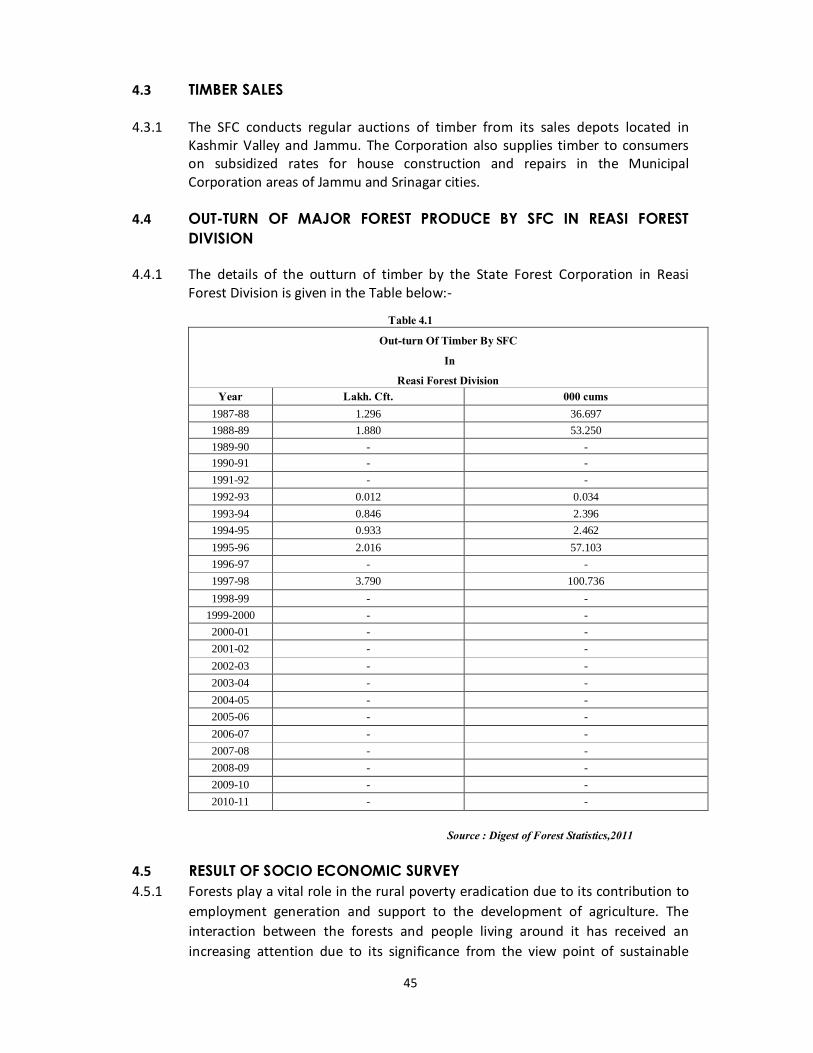
Table 4.1
Out-turn Of Timber By SFC
In
Reasi Forest Division Year Lakh. Cft. 000 cums
1987-88 1.296 36.697 1988-89 1.880 53.250 1989-90 - - 1990-91 - - 1991-92 - - 1992-93 0.012 0.034 1993-94 0.846 2.396 1994-95 0.933 2.462 1995-96 2.016 57.103 1996-97 - - 1997-98 3.790 100.736 1998-99 - -
1999-2000 - - 2000-01 - - 2001-02 - - 2002-03 - - 2003-04 - - 2004-05 - - 2005-06 - - 2006-07 - - 2007-08 - - 2008-09 - - 2009-10 - - 2010-11 - -
Source : Digest of Forest Statistics,2011
4.5 RESULT OF SOCIO ECONOMIC SURVEY 4.5.1 Forests play a vital role in the rural poverty eradication due to its contribution to
employment generation and support to the development of agriculture. The interaction between the forests and people living around it has received an increasing attention due to its significance from the view point of sustainable
46
management of forests and the welfare of people. This is particularly true in case of the benefits from the Non Wood Forest Products (NTFP’s).Hence to sustain the livelihood of rural poor the management of NTFP’s is very crucial .The people depending on these NTFP’s for their livelihood suffer from geographical isolation and social exclusion, so their dependence on the forests is bound to increase as their population is increasing.
4.5.2 The initial National Forest Policies of the country were mainly timber oriented
and more stress was given to the agriculture sector. However, since 1988 the focus has shifted towards the conservation of forests. The Wildlife protection Act 1972, Forest Conservation Act 1980 and the National Forest policy of 1988 have reoriented the objectives by treating the forests as an environmental and social resource, rather than a mere revenue earning resource . Even the State Forest Policy of J&K laid stress on Poverty alleviation by meeting livelihood needs of forest dependent communities through sustainable supply of forest produce by improving productivity of existing forests, and through forestry activities, schemes and programmes. It further aims at Utilization of natural resources using best management practices including development of non-timber forest produce. Although the management of forests of the State for NTFP’s has received some attention in the State Forest Policy, now it’s the responsibility of the department to design an incentive based mechanism so that the long term benefits of managing the forests for NTFP’s can be achieved .By doing so the basic objective of poverty eradication and rural development can be achieved.
4.5.3 Since in Reasi agriculture is mostly rain fed, food grain production is far from
satisfactory Average Economic condition is generally poor. The people live in flat roofed mud houses which consume large quantity of timber. Firewood and charcoal are the two main sources of energy for cooking and heating purposes.
4.6 SOCIO-ECONOMIC PROFILE OF REASI FOREST DIVISION
4.6.1 The present study socio-economic aspects of Reasi Forest Division bring to light the immense importance of Forests in the daily life of the rural population. District Reasi extending over an area of 1707 Sq. Kms comprises of 253 Villages including 2 Un-inhabited Villages. It has 3, 14,667 Population as per census 2011. The District Population is mostly rural which 91.42 % of the total population is and only 8.57 % of it resides in towns. The District having ST population 28.08 % and SC population is 12 %. As the terrain of this Distt. is highly mountainous, most of the villages depend in one way on the other on Forests. Most of the agriculture is rainfed for obvious reasons and only 9% of the gross area is irrigated.
4.6.2 Livestock rearing is an important occupation of the village folks in general &
migratory proportion in particular. As per 2007-08 Census, the District accounts for 205117 lacs of Sheep & 180576 lacs of Goats. Despite the facts every effort is

47
being made to give proper health coverage and breeding facilities, so as to improve the health and quality of the animals, these animals assert great pressure upon the forests by way of unregulated grazing and instigation of fire incidences by cattle and livestock owners for better grass output during the monsoon.
Table 4.2: Socio-economic survey of Rural villages falling in the Territorial jurisdiction of Reasi Forest Division (Tehsil wise)
Tehsil No. of Households
Cropped areas (ha) (District Wise & year wise)
Total area irrigated (in ha.) year wise
Departmental Forest Timber/Firewood sale depots.
Reasi Rural 7300 2007-08 37660 2007-08 2370 02/02
Urban 21871 2008-09 39450 2008-09 2900 01 Total 94871 2009-10 36642 2009-10 2927 05 Pouni Rural 40676 2010-11 37561 2010-11 4174 02/0 Urban 5125 2011-12 38065 2011-12 2667 01 Total 45801 2012-13 39711 2012-13 2679 03 Arnas Rural 58582 - - - - - Urban 0 - - - - - Total 58582 - - - - -
4.7 EFFECTS OF SOCIO-ECONOMIC STATUS ON FORESTS
4.7.1 The socio economic status of forest fringe population is an indicator of dependence of local population on forest resources.After analyzing the same it emerges that the socio-economic condition of areas falling under Reasi Forest Division is not very encouraging. 91.42% of the population is rural living in and around the forests nearby creating lot of biotic pressure on the already degraded Forests of the Division. However, an encouraging fact is the electrification of 95% of all the households in the Distt. This has gone a long way in relieving the pressure off the forests for fuelwood and energy requirement of the local population which was not the case before.
4.7.2 Socio-economic status of people of the rural population of Reasi Distt.
Canimprove by providing employment by starting development works i.e. plantation work, soil and moisture conservation works in CAMPA and other JFM schemes.
4.8 JFM IN REASI FOREST DIVISION
4.8.1 The Forest Development Agencies (FDA) will provide tremendous opportunity to the Department and the people to work together.
4.8.2 Keeping in view the present funds position of the department in FDA and
geographical situation of the tract the following suggestions are made regarding JFM:
48
a) If funds are available in a limited way it is recommended that RDF activities be planned in compact contiguous areas.
b) Further the subsequent plantation works should be taken up adjacent to the previous year’s plantations so that monitoring and protection is effective.
c) The flow of usufructory benefits to the villagers is vital to win their co-operation. It is suggested that mature plantations be harvested in phases and benefits be shared as per the rules.
d) The species planted should be of fast growing, multipurpose trees which yield fodder, fuel wood and small timber. The shisham, bamboo, dhamman etc. are the potential species around which successful JFM can be built especially in the initial years. Bamboo can be harvested within 6-8 years. It is a multipurpose plant, dhamman is also a multipurpose tree and preferred by villagers for various purposes. Further the local species which supplement the raw material requirement of cottage industries be given preference e.g mango, jamun, sohanjana, aloe vera, dheu and mulberry etc.
4.9 PRESENT STATUS OF JFM IN REASI FOREST DIVISION:
4.9.1 The Reasi Forest Division has been at the forefront of participatory forest management in the state. It was one of the first couple of Forest Divisions in the state to start Joint Forest Management activities and hence has been a pioneer in the participatory forest management activities in the state. A total of 38 VFC have been formed across the division till date and most of them have been functional too. But since the Formation of State forest Development Agency (SFDA) in 2010-2011, the funding have been relatively curtailed and each year some of the 38 VFC are active on rotational or priority basis.
4.10 FDA in Reasi Forest Division:
4.10.1 38 JFMCs were formed in Reasi Forest Division under National Afforestation Programme, out of which 20 JFMCs are functional for the last couple of years due to non-availability of funds and other constraints. The activities undertaken in these JFMC,s are rehabilitation of degraded forests through Aided Natural Regeneration(ANR), Artificial Regeneration(AR), Sowing and Planting (SP), Entry Point Activities(EPA) and other soil & moisture conservation works. Detail of JFMCs formed under JFM scheme in Reasi Forest Division is as under in the table 4.3.
4.10.2 During the field survey and inspection of JFM works in the Jurisdiction of
ReasiForest Division, it was observed that there is need to further convince and involve the local population. Special VFC should be formed in each Range of Reasi Forest Division for protection and development of local Medicinal Plants.
4.10.3 SFDA wise detail of all works done since the inception of this scheme are enclosed as Annexure XIV (1) to Annexure XIV (52).
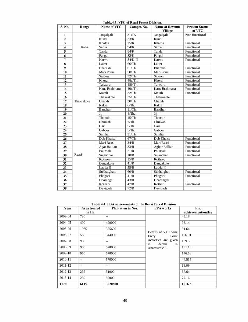
49
Table.4.3: VFC of Reasi Forest Division. S. No. Range Name of VFC Comptt. No. Name of Revenue
Village Present Status
of VFC 1
Katra
Jangalgali 31u/K Jangalgali Non functional 2 Kund 33/K Kund 3 Khalda 25/K Khalda Functional 4 Sarna 94/K Sarna Functional 5 Tanda 84/K Tanda Functional 6 Pangal 82/K Pangal Functional 7 Karwa 84/K-II Karwa Functional 8
Thakrakote
Laiter 66/Th. Laiter 9 Bharakh 61/Th. Bharakh Functional 10 Mari Pouni 58/Th. Mari Pouni Functional 11 Saloon 52/Th. Saloon Functional 12 Kheral 48c/Th. Kheral Functional 13 Talwara 48b/Th. Talwara Functional 14 Kans Brahmana 49c/Th. Kans Brahmana Functional 15 Matah 32/Th. Matah Functional 16 Thakrakote 35/Th. Thakrakote 17 Chandi 30/Th. Chandi 18 Kakra 6/Th. Kakra 19 Bandhar 11/Th. Bandhar 20 Jij 4/Th. Jij 21 Thanole 15/Th. Thanole 22 Chinkah 7/Th. Chinkah 23 Gari 5/Th. Gari 24 Gabber 5/Th. Gabber 25 Samhar 31/Th. Samhar 26 Dub Khalsa 67/Th. Dub Khalsa Functional 27
Reasi
Mari Reasi 34/R Mari Reasi Functional 28 Agar Ballian 33/R Aghar Ballian Functional 29 Pounsali 31/R Pounsali Functional 30 Sujandhar 18/R Sujandhar Functional 31 Kothroo 15/R Kothroo 32 Dangakote 41/R Dangakote 33 Ladda II 55/R Ladda II 34 Sukhalghati 60/R Sukhalghati Functional 35 Phagori 41/R Phagori Functional 36 Dharangali 43/R Dharangali 37 Kothari 47/R Kothari Functional 38 Devigarh 72/R Devigarh
Table 4.4: FDA achievements of the Reasi Forest Division Year Area treated
in Ha. Plantation in Nos. EPA works Fin.
achievement/outlay 2003-04 730 --
Details of VFC wise Entry Point Activities are given in detain in Annexures…..
45.18
2004-05 400 490000 93.14
2005-06 1065 375600 91.64
2006-07 565 344000 106.91
2007-08 950 -- 159.55
2008-09 950 570000 151.13
2009-10 950 570000 146.56
2010-11 -- 570000 44.515
2011-12 -- -- 13.09
2012-13 255 51000 87.64
2013-14 250 50000 77.16
Total 6115 3020600 1016.5
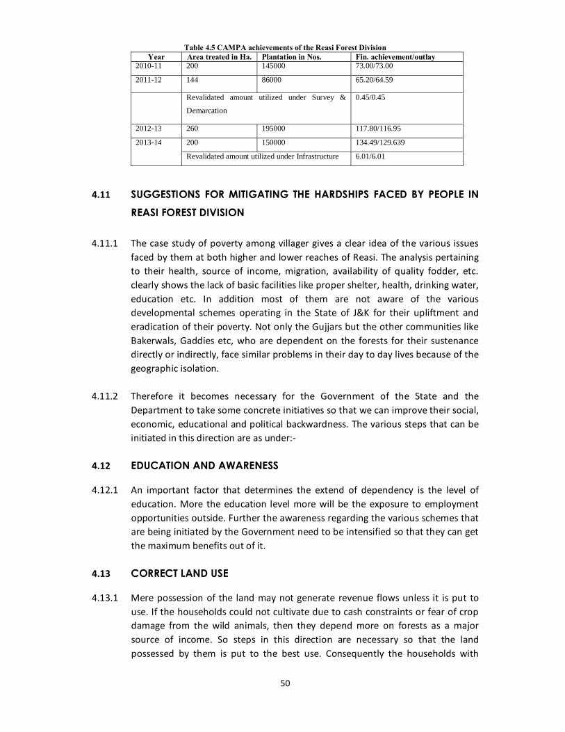
50
Table 4.5 CAMPA achievements of the Reasi Forest Division Year Area treated in Ha. Plantation in Nos. Fin. achievement/outlay
2010-11 200 145000 73.00/73.00
2011-12 144 86000 65.20/64.59
Revalidated amount utilized under Survey &
Demarcation
0.45/0.45
2012-13 260 195000 117.80/116.95
2013-14 200 150000 134.49/129.639
Revalidated amount utilized under Infrastructure 6.01/6.01
4.11 SUGGESTIONS FOR MITIGATING THE HARDSHIPS FACED BY PEOPLE IN
REASI FOREST DIVISION 4.11.1 The case study of poverty among villager gives a clear idea of the various issues
faced by them at both higher and lower reaches of Reasi. The analysis pertaining to their health, source of income, migration, availability of quality fodder, etc. clearly shows the lack of basic facilities like proper shelter, health, drinking water, education etc. In addition most of them are not aware of the various developmental schemes operating in the State of J&K for their upliftment and eradication of their poverty. Not only the Gujjars but the other communities like Bakerwals, Gaddies etc, who are dependent on the forests for their sustenance directly or indirectly, face similar problems in their day to day lives because of the geographic isolation.
4.11.2 Therefore it becomes necessary for the Government of the State and the
Department to take some concrete initiatives so that we can improve their social, economic, educational and political backwardness. The various steps that can be initiated in this direction are as under:-
4.12 EDUCATION AND AWARENESS
4.12.1 An important factor that determines the extend of dependency is the level of education. More the education level more will be the exposure to employment opportunities outside. Further the awareness regarding the various schemes that are being initiated by the Government need to be intensified so that they can get the maximum benefits out of it.
4.13 CORRECT LAND USE
4.13.1 Mere possession of the land may not generate revenue flows unless it is put to use. If the households could not cultivate due to cash constraints or fear of crop damage from the wild animals, then they depend more on forests as a major source of income. So steps in this direction are necessary so that the land possessed by them is put to the best use. Consequently the households with

51
more agricultural income will depend less on the forests of the Division for their survival.
4.14 COMPREHENSIVE GRAZING POLICY
4.14.1 Multi- pronged strategy is to be adopted to tackle the problem of degradation of pastures and the improvement of bio-mass production. The development of fodder resources and rehabilitation of grazing lands on forests and in forest fringe areas is of paramount importance in view of the total dependence of a large number of people on this resource for their livelihood needs. The development of fodder resources will be achieved through allocation of clear and mutually exclusive but closely inter-linked roles and responsibilities to the various line departments, viz. the Department of Animal Husbandry, in collaboration with research institutes, will be responsible for development of better livestock breeds; and fodder storage, feed development etc. The Department of Agriculture, in collaboration with agricultural universities andresearch institutes, will be responsible for developing, promoting and extending nutritious and high yielding varieties of fodder species for cultivation on agricultural lands.
4.14.2 Grazing during the correct season is very important for obtaining maximum production from grassland. Large numbers of cattle throng the alpine pastures immediately after the snow melts. During this period, rapid growth of plants temporarily depletes the food reserve and therefore grazing should be deferred till the plants are able to restore these food supplies. Since it may not be possible to implement in field, rotational grazing should be introduced. The pasture to be grazed should be divided into a number of units, each of which should be opened for grazing in turn.
4.14.3 In addition inferior cattle are to be castrated with the help of Animal Husbandry Department and sufficient and good quality fodder is to be provided to the superior livestock. In particular, population of goat needs to be controlled. Because of their browsing habit, they cause a devastating effect on vegetation. The goat owner, therefore, should be educated on the advisability of reducing the number of goats. To obtain maximum production from particular grassland, it is of paramount importance to secure a balance between number of animals and fodder resources.
4.14.4 The concept of stall feeding should be popularized. Community fodder banks should be established at various places. Existing springs and ponds should be suitably developed for use of grazing animals. Small check dams should be constructed along minor water courses to help conserve the soil and water and impound water to create reservoir for use of grazing animals.
52
4.15 CREATING ALTERNATE SOURCE OF INCOME SO AS TO REDUCE THE DEPENDENCE ON FORESTS
4.15.1 Alternative income source would greatly reduce their dependence on the forests for grazing and hence ease the conflict between them and the forest Department with regards to the regeneration of the forests, as large population of new regeneration on the forest floor is grazed by their cattle.
4.15.2 There are strong evidences that people who depend on the forests and its products continue to remain poor. Given the limited resources, if the population expands, their dependence on the forests serves as a poverty trap than a safety net for the poor. A diminishing forest resource base combined with limited ability to take advantage of other opportunities place the poor at risk for further deprivation.
4.15.3 Hence the long term goal of the department should be to make the community less forest dependent. Providing alternate source of income through employment opportunities or by a secured source of income from cultivation will help the people in the long run. The overall socio-economic upliftment of forest dependent communities will reduce the human pressure on the forests and promote conservation of the biological diversity.
4.16 PROPER SHARING OF BENEFITS
4.16.1 This can be achieved by ensuring a fair share to the local people living near the forests in the final value of the various NTFP’s extracted by them. One of the major contentions in JFM approach is that the gatherers get a very low share for the products extracted, whereas the final value of the product s fetches very high returns. This is true with regards to the extraction of Gucchies by the local people. So it is important to sustain the interest of the local communities so as to manage the forests effectively. The contribution of these communities to forests protection and management will at the end benefit the larger interest of the department. Therefore, the people doing the extraction to generate extra income need to be compensated. In order to do this the current mechanism for collection and marketing of various NTFP’s needed to be changed, as there are many intermediaries between the people and the final consumers. Higher marketing margin by these intermediaries results in higher consumer prices and low collection price received by the gatherers.
4.16.2 Eliminating the cost of the intermediaries will improve the benefits of the local communities, which will serve as an incentive for the gatherers to cooperate willingly in managing the products sustainably.
53
4.17 CONSTRUCTION OF HALTING PLACES AND SHELTER SHEDS
4.17.1 During their seasonal migration, the nomadic graziers face numerous problems such as inclement weather conditions, lack of proper halting places along the route, lack of fodder and water along the migratory route, lack of proper path for movement of their families and livestock etc. Cases of friction with local villages because of largely conflicting demands have become all too frequent. The stretch of the routes which passes through roads, especially National Highway, poses serious problems to the nomadic families and their livestock .There is no proper place along the roads where they can spend a few nights before moving to the next halting place.
4.17.2 Halting places where graziers can spend a few nights before moving to the next station are to be provided. To provide protection to the families of nomads and their livestock against unfavourable weather conditions such as incessant rains, cloud bursts, hail storms etc. shelter sheds shall be constructed at all the important behaks.
4.18 SUSTAINING PARTICIPATORY APPROACH
4.18.1 The Forest policy of 1988 facilitated the implementation of Joint Forest Management. The Govt. Of India provided guidelines to all the States for the involvement of village communities in the regeneration of degraded forests. The Scheme participatory forest management received further importance in the resolution of 1990. Participatory forest management was formally adopted in J&K State by issuing a notification SRO-61 dated 19-03-1992. The new approach gave way to reduce for more participation of people.
4.18.2 Even though JFM approach agreed upon sharing the responsibilities and power with the local user groups, however it has been seen that the ultimate producers are greatly influenced by the State and related departments decisions. Substantive power still vests with the Forest Department to suspend anddissolve the JFM communities. The fact is that very poor and marginal have little say in the management process and often locally powerful groups influence the final outcome. This practice needs to be stopped and the network of JFM’s in the Division needs to be strengthened.
4.18.3 Further the practical difficulties in JFM approach need to be sorted out before working out a viable participatory framework. JFM has the potential to generate diversified livelihood in rural communities. Its correct implementation can help in empowering the locals as well as in improving the condition of the forests of the Division. The success of JFM totally depends on the nature of power sharing. The equitable distribution of the benefit sharing is a precondition for sustaining participatory approach.
54
CHAPTER –V
FIVE YEAR PLANS
55
CHAPTER –V
FIVE YEAR PLANS
5.1 FIVE YEAR PLAN: AN INTRODUCTION
5.1.1 The Five-year Plans (FYP’s), are developed, executed, and monitored by the Planning Commission with the Prime Minister as the ex-officio Chairman. The first Five Year Plan was launched in the year 1951. Presently there is tremendous pressure for addressing growing livelihood, industrial and development needs, on the green cover. It is, therefore, important to focus on sustainable management approach and maintenance of environmental stability. With the increase in population of both human as well as livestock, the forests are under great pressure due to open grazing, heavy exploitation and excessive biotic dependence. Therefore, augmentation of natural regeneration, eco-restoration of degraded forests along with increasing their productivity have assumed significant place in the economy. In order to sustain the ecology the Government of India has been allocating funds to the forestry sector right from the beginning of the First Five Year Plan. Although the main focus during the initial years of implementation was towards Agriculture but regular provisions have been made for forestry development and forest based programmes.
5.2 DEVELOPMENT IN FORESTRY DURING FIVE YEAR PLANS IN INDIA
5.2.1 In first five year plan a sum of Rs. 9.5 crore was spent on forestry programmers in which emphasis was laid on afforestation, forest transport and communication, forest administration and small scale plantation by state governments. Similarly the central government gave priority to forest research, forestry education and wild life conservation.
5.2.2 In Second Five Year Plan 193 million rupees was allocated for forestry development programmes. Here main focus was towards afforestation, devel-opment of plant species of commercial and industrial importance, increase production of timber and important minor forest products, wild life conservation, improvement in the living conditions of forest personnel, forestry research, extension of new technological facilities and widening the scope of cooperation with the Central Government. Due to these efforts value of major forest products increased from 190 million rupees to 590 million rupees and minor forest products from 69.3 million rupees to 111.3 million rupees during 1951-61.The area of reserved forests also increased from 27.3 million sq. km. to 36.5 million sq. km and the number of forest personnel grew from 4 to 50 lakhs.
5.2.3 In Third Five Year Plan a provision of Rs. 510 million was made for forestry development which laid to the planting of quick growing varieties of trees on 64,000 ha. And trees of economic importance on 240,000 ha. Of area. About 2
56
lakh hectares of forest land was replanted and 11,000 km long new roads were constructed besides the repairing of 4,000 km long old roads.
5.2.4 During Fourth Five Year Plan quick growing varieties of trees were planted on 4 lakh ha. of land to meet industrial demand (paper, plywood and match industries) besides the afforestation on 3.4 lakh ha. of area for economically important trees (teak, semen and shisham) and 75 lakh ha. for fuel wood. During this period about 2 lakh ha. Of old forest land was reforested. For the proper development of forests about 16,000 km. long new roads were constructed and 2,000 km long old roads were repaired. About 2 lakh ha. Of forest land was also developed for providing fodder to the cattle.
5.2.5 During Fifth five Year Plan provision was made for planting quick growing varieties of trees on 8.6 lakh ha. Of area along the roads, rivers, canals and rail lines and trees of economic and industrial use on 16 lakh ha of area. The plan also proposed the construction of about 60,000 km long roads for the maintenance and development of forest areas.
5.2.6 During Sixth Five Year Plan an outlay of 692.64 crore rupees was made for forestry development with main objectives for the conservation of existing forests and the launching of country-wide afforestation and social forestry programmes to fulfill three sets of needs: (a) ecological security, (b) fuel, fodder and other domestic needs of the population; and (c) the needs of village, small scale and large scale industries. The programmes included forest conservation, social forestry, fuel wood, forest labour, forest survey, forest research and peo-ple's participation in forest development. The new thrusts included 'tree for every child programme', eco-development force, eco-development camps and agro-forestry programmes. During this period afforestation was made over 21.5 lakh ha. of area. The Forest Conservation Act, 1980 restricted the transfer of forest land to other uses.
5.2.7 During Seventh Five Year Plan (1985-90) a sum of Rs. 1859.10 crore was allocated for forestrydevelopment. It fixed up target for planting trees on 50 lakh ha. of area with main programmes like (i) conservation of important flora and fauna for ecosystem, (ii) increasing forest area through afforestation programmes like social forestry, agro forestry etc, (iii) fulfilling the needs of fuel wood, fodder, timber and minor forest products, (iv) maintaining balance between forestry programmes and welfare of tribal's dependent on forests, (v) laying emphasis on forestry research, forestry education, and forestry training, and (vi) seeking people's participation for forestry development under JFM (Joint Forest Man-agement) Scheme.
5.2.8 During the Eighth Five Year Plan an outlay of Rs. 525 crore has been provided for forestry development under Central Sector. The programmes include: (i) rehabilitation of degraded forests, (ii) soil and moisture conservation, (iii) farm forestry, (iv) roadside and canal bank plantation, (v) creation of wind-breaks, and
57
(vi) wood lots on community land and pasture development. Under these programmes besides social forestry scheme, rural fuel wood plantation has been introduced in 101 districts of the country which are chronically deficient in fuel wood and fodder resources.
5.2.9 The Ninth Five Year Plan came after 50 years of Indian Independence. It focused onenvironmental stability through social mobilization and participation of people.
5.2.10 An outlay of Rs 5945 crores was fixed for the forestry sector in the 10th Five Year Plan. As the National Forest Policy stipulated that 1/3rd geographical area of the country should be brought under forest/tree cover, the imperative was echoed in the 10th FYP, which stated that the country will bring 25% area under forest/tree cover by the end of 10th Plan period and 33% by the end of 11th FYP.
5.2.11 The outlays for the 11thFYP for forestry and Wildlife was Rs. 6213.99 crores and the projected budget outlays (with 20% increase for the 12th FYP (2012-13 to 2016-17) is 7456.788 crores.
5.3 PLAN OUTLAY & EXPENDITURE FOR FORESTY SECTOR IN THE STATE OF
JAMMU AND KASHMIR FROM 1ST FIVE YEAR PLAN (1951-56) 5.3.1 In the State of J&K the funds have regularly been allocated to the forestry sector
since the1stFirst Five year Plan. The detail of year wise allocation to the J&K Forest Department is given in the table below:
Table 5.1
(Rs in Lakhs)
S. No Plan Period Sector Outlay Expenditure
1 1st FYP (1951-56) Forest & Soil Conservation
16.77 14.91
2 2ndFYP (1956-61) -do- 66.50 75.32
3 3rdFYP (1961-66) -do- 175.00 132.10
4 Inter Plan Period (1966-69)
-do- 179.00 119.68
5 4th FYP (1969-74) -do- 575.00 302.64
6 5th FYP (1974-79) -do- 498.76 348.30
7 AnnualPlan
(1978-79)
-do- 152.00 145.32
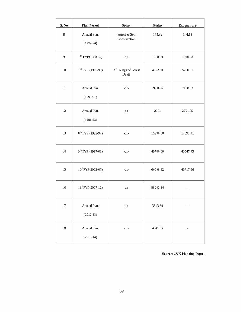
58
S. No Plan Period Sector Outlay Expenditure
8 Annual Plan
(1979-80)
Forest & Soil Conservation
173.92 144.18
9 6th FYP(1980-85) -do- 1250.00 1910.93
10 7th FYP (1985-90) All Wings of Forest Deptt.
4922.00 5200.91
11 Annual Plan
(1990-91)
-do- 2180.86 2108.33
12 Annual Plan
(1991-92)
-do- 2371 2701.35
13 8th FYP (1992-97) -do- 15990.00 17891.01
14 9th FYP (1997-02) -do- 49700.00 43547.95
15 10thFYP(2002-07) -do- 66598.92 48717.66
16 11thFYP(2007-12) -do- 88292.14 -
17 Annual Plan
(2012-13)
-do- 3643.69 -
18 Annual Plan
(2013-14)
-do- 4841.95 -
Source: J&K Planning Deptt.

59
5.4 ACHIEVEMENTS OF REASI FOREST DIVISION DURING FIVE YEAR PLANS
5.4.1 Reasi Forest Division has been committed to initiate and catalyze actions that prevent the destruction of its rich forest resources. A number of Eco restoration and plantation programmes have initiated in this direction. Various measures like formation of closures, fencing, DRSM Works, Plantation, development of infrastructure, etc. have been taken. The year wise achievements by Reasi Forest Division and the total expenditure incurred in various restoration works is given Year wise in the following tables:-
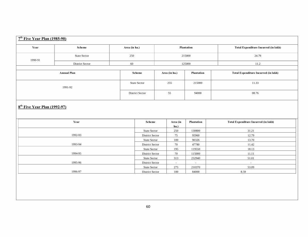
60
7th Five Year Plan (1985-90)
Year Scheme Area (in ha.) Plantation Total Expenditure Incurred (in lakh)
1990-91
State Sector 250 215000 24.79
District Sector 60 125000 11.2
Annual Plan Scheme Area (in ha.) Plantation Total Expenditure Incurred (in lakh)
1991-92
State Sector 255 215000 11.33
District Sector 55 94000 08.76
8th Five Year Plan (1992-97)
Year Scheme Area (in ha.)
Plantation Total Expenditure Incurred (in lakh)
1992-93
State Sector 250 130800 31.21 District Sector 75 95960 12.79
1993-94
State Sector 100 90326 13.70 District Sector 70 47780 11.42
1994-95
State Sector 195 119550 18.13 District Sector 70 115000 11.11
1995-96
State Sector 313 232940 51.01 District Sector - - -
1996-97
State Sector 275 210370 53.09 District Sector 100 84000 8.59
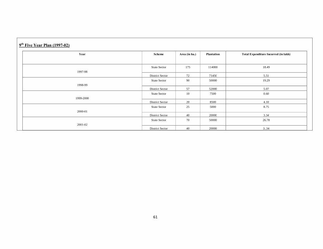
61
9th Five Year Plan (1997-02)
Year Scheme Area (in ha.) Plantation Total Expenditure Incurred (in lakh)
1997-98
State Sector 175 114000 18.49
District Sector 72 71450 5.51
1998-99 State Sector 90 50000 19.29
District Sector 57 52000 5.07
1999-2000 State Sector 10 7500 0.60
District Sector 20 8500 4.10
2000-01 State Sector 25 5000 8.75
District Sector 40 20000 3.34
2001-02 State Sector 70 50000 26.78
District Sector 40 20000 3..34

62
10th Five Year Plan (2002-07)
Year Scheme Area (in ha.) Plantation Total Expenditure Incurred (in lakh)
2002-03
State Sector 100 57000 13.00 District Sector 30 18000 3.34
2003-04
State Sector 110 62000 10.24 District Sector 34 11000 3.12
2004-05
State Sector 60 46000 31.39 District Sector 30 17000 4.02
2005-06
State Sector 86 47000 8.64 District Sector 30 19500 10.46
CMP 15 15500 3.74 12th F.C. - - 5.09
IFP - - 1.65 FDA 91.64
2006-07
State Sector - - - District Sector 69 31500 10.50
CMP 25 25000 3.75 12th F.C - 80601 3.79

63
11th Five Year Plan (2007-12)
Year Scheme Area (in ha.) Plantation Total Expenditure Incurred (in lakh)
2007-08
State Sector 28 11200 4.00 District Sector 50 20000 8.75
CMP 20 17000 3.65 12th finance 6 ha new fencing
and 49133 rft repair/renovation
49451 10.42
2008-09
State Sector 50 18000 9.00 District Sector 35 13200 8.20
CMP 20 12000 4.00
2009-10
State Sector 66 16000 7.93 District Sector 21 12500 6.61
CMP 20 12000 4.00 12th F.C. - 29250 13.80
NBM 50 21000 9.23
2010-11
State Sector 44 17000 6.32 District Sector 15 9000 6.61
12th F.C. - - 10.00 CDF - - 0.76
13th F.C. - - 6.00 CMP 18 10000 3.79 NBM 50 21000 9.98
2011-12
State Sector 36 18000 7.20 District Sector 36 16700 9.51
CMP 18 10000 3.41 13th F.C 36 15000 5.00 CAMPA 144 86400 65.04

64
12th Five Year Plan
Year+ Scheme Area (in ha.) Plantation Total Expenditure Incurred (in lakh)
2012-13
State Sector 36 18000 8.20
District Sector 36 15500 9.51
CMP 18 10300 3.34
IFM - - 1.80
CDF - - 5.00
CAMPA 220 165000 110.94
2013-14
State Sector 36 17000 6.85
District Sector - - 5.07
CMP 10 7000 2.00
CAMPA 200 219000 129.64
NBM 25 13025 3.27
13th F.C. - - 9.00
65
5.5 FOCUS OF 12TH FIVE YEAR PLAN IN J&K
5.5.1 During the 12th Five Year Plan, focus will be given towards strategic directions for managing environment and forest in more professional manner.
5.5.2 Greening of degraded land, afforestation and eco-restoration of ecological sensitive
areas. 5.5.3 Technology based monitoring of forest cover, biodiversity and growing stock
besides establishment of open web-based National Forestry and Environmental Information system for research and public accessibility.
5.5.4 Development of important forest species seed at forest circle level and model
Nurseries in potential areas. 5.5.5 Improve forest productivity, production and sustainable management of
biodiversity (equity in access to benefit sharing with local people). 5.5.6 Restoration and intensification of forest grazing land management and establish
community grazing land around forest fringe villages. 5.5.7 Revive seed orchards for various types as well enlisted species under minor forest
produce/non-timber forest produce.
5.6 SUGGESTIONS BASED ON CONDITION OF THE CROP
5.6.1 It has been observed during the preparation of this Plan that very little effort has been made to regenerate the Oak forests of the Division. Oak being the climatic climax species and important for rural hill economy and Oak forests are extensively lopped for firewood and fodder. It’s therefore suggested to allocate sufficient funds in the Proposed Plan period so that the Oak nurseries specifically could be established so that the degraded areas of the Oak forests could be rehabilitated.
5.6.2 In addition there is no exact data available with regards to the distribution of medicinal plants of the Division. So a detailed survey regarding the diversity of medicinal plants is the need of the hour. By knowing the exact extent, the future strategy with regards to their harvesting, marketing management and conservation of rare and threatened species could be taken.

66
CHAPTER VI
STAFF AND LABOUR SUPPLY
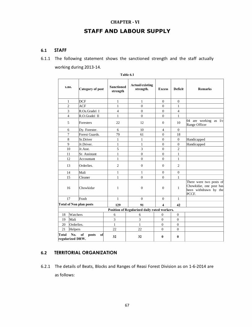
67
CHAPTER - VI
STAFF AND LABOUR SUPPLY
6.1 STAFF 6.1.1 The following statement shows the sanctioned strength and the staff actually
working during 2013-14. Table 6.1
s.no. Category of post Sanctioned
strength Actual/existing
strength.
Excess Deficit Remarks
1 DCF 1 1 0 0 2 ACF 1 0 0 1 3 R.Os.Grade– I 4 0 0 4 4 R.O.Grade– II 1 0 0 1
5 Foresters 22 12 0 10 04 are working as I/c Range Officer
6 Dy. Forester. 6 10 4 0 7 Forest Guards. 79 61 0 18 8 Sr.Driver 1 1 0 0 Handicapped 9 Jr.Driver. 1 1 0 0 Handicapped 10 Jr.Asst. 5 3 0 2 11 Sr. Assistant 1 0 0 1 12 Accountant 1 0 0 1
13 Orderlies. 2 0 0 2
14 Mali 1 1 0 0 15 Cleaner 1 0 0 1
16 Chowkidar 1 0 0 1
There were two posts of Chowkidar, one post has been withdrawn by the PCCF.
17 Frash 1 0 0 1 Total of Non plan posts 129 91 4 42
Position of Regularized daily rated workers. 18 Watchers 6 6 0 0 19 Mali 3 3 0 0 20 Orderlies. 1 1 0 0 21 Helpers 22 22 0 0
Total No. of posts of regularized DRW. 32 32 0 0
6.2 TERRITORIAL ORGANIZATION 6.2.1 The details of Beats, Blocks and Ranges of Reasi Forest Division as on 1-6-2014 are
as follows:
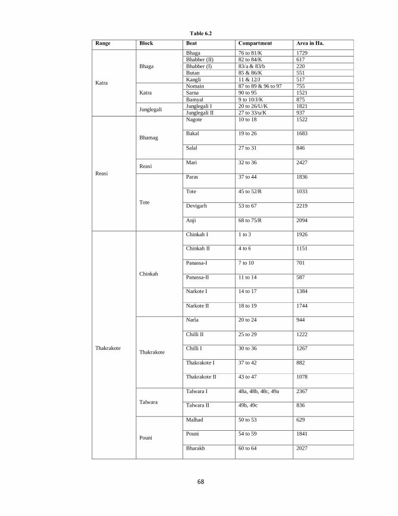
68
Table 6.2
Range Block Beat Compartment Area in Ha.
Katra
Bhaga
Bhaga 76 to 81/K 1729 Bhabber (II) 82 to 84/K 617 Bhabber (I) 83/a & 83/b 220 Butan 85 & 86/K 551 Kangli 11 & 12/J 517
Katra Nomain 87 to 89 & 96 to 97 755 Sarna 90 to 95 1521 Bamyal 9 to 10/J/K 875
Junglegali Junglegali I 20 to 26/U/K 1821 Junglegali II 27 to 33/u/K 937
Reasi
Bhamag
Nagote 10 to 18 1522
Bakal 19 to 26 1683
Salal 27 to 31 846
Reasi Mari 32 to 36 2427
Tote
Paras 37 to 44 1836
Tote 45 to 52/R 1033
Devigarh 53 to 67 2219
Anji 68 to 75/R 2094
Thakrakote
Chinkah
Chinkah I 1 to 3 1926
Chinkah II 4 to 6 1151
Panassa-I 7 to 10 701
Panassa-II 11 to 14 587
Narkote I 14 to 17 1384
Narkote II 18 to 19 1744
Thakrakote
Narla 20 to 24 944
Chilli II 25 to 29 1222
Chilli I 30 to 36 1267
Thakrakote I 37 to 42 882
Thakrakote II 43 to 47 1078
Talwara
Talwara I 48a, 48b, 48c, 49a 2367
Talwara II 49b, 49c 836
Pouni
Malhad 50 to 53 629
Pouni 54 to 59 1841
Bharakh 60 to 64 2027
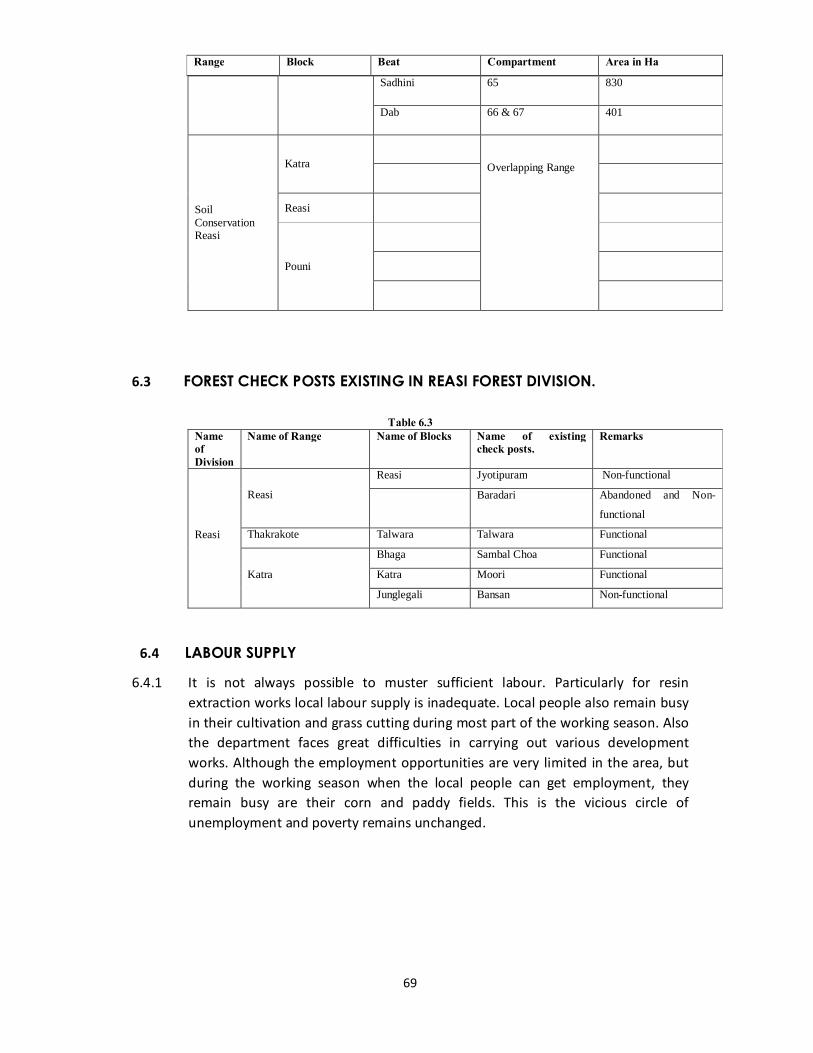
69
Sadhini 65 830
Dab 66 & 67 401
Soil Conservation Reasi
Katra
Overlapping Range
Reasi
Pouni
6.3 FOREST CHECK POSTS EXISTING IN REASI FOREST DIVISION.
Table 6.3 Name of Division
Name of Range Name of Blocks Name of existing check posts.
Remarks
Reasi
Reasi
Reasi Jyotipuram Non-functional
Baradari Abandoned and Non-
functional
Thakrakote Talwara Talwara Functional
Katra
Bhaga Sambal Choa Functional
Katra Moori Functional
Junglegali Bansan Non-functional
6.4 LABOUR SUPPLY
6.4.1 It is not always possible to muster sufficient labour. Particularly for resin extraction works local labour supply is inadequate. Local people also remain busy in their cultivation and grass cutting during most part of the working season. Also the department faces great difficulties in carrying out various development works. Although the employment opportunities are very limited in the area, but during the working season when the local people can get employment, they remain busy are their corn and paddy fields. This is the vicious circle of unemployment and poverty remains unchanged.
Range Block Beat Compartment Area in Ha

70
CHAPTER VII
PAST SYSTEMS OF MANAGEMENT
71
CHAPTER– VII
PAST SYSTEMS OF MANAGEMENT
7.1 INTRODUCTION OF GENERAL HISTORY OF THE FORESTS 7.1.1 Before the Forest Department was created the State Forests were under the
control of the Revenue Department. The Legislation to regulate fellings and collection of Forest Produce was introduced in 1983 A.D.
7.1.2 In 1893 AD Udhampur Forest Division was created. In 1906 the old Udhampur Forest Division was divided into Kishtwar and Reasi Forest Divisions and the H.Q’s of Reasi Forest Division was fixed at Udhampur. In 1924 the Reasi Forest Division old was split into three Divisions namely Udhampur, Ramban and Reasi and H.Q’s of Reasi Forest Division was fixed at Reasi. As a result of which Reasi Forest Division old was split into five Ranges transferred to newly created Forest Division Ramban and Udhampur. Reasi and Bhomag Range were reorganized into Reasi and Katra Ranges. Two beats of the Mirpur Division at the top of Ans, valley were transferred to Reasi Division.
7.1.3 At the time of 1st Chir Plan by Sh. Harnam Singh Pathania in 1928 there were four Ranges in Reasi Forest Division and each Range having one block, namely Reasi, Thakrakote, Arnas and Gulabgarh.
7.1.4 In 1951 these Ranges were reorganized Kud, illaqa was transferred from Gulabgarh Range to Arnas Range. Tuli, Bana and Thilu beats of Thakrakote Range were transferred to Gulabgarh Range with Makhidhar joining at the junction of Jij nalla with Ans River as the inter Range boundary.
(a) Kalidhar Range was abolished and its various beats readjusted as under:- Jhalenger beat, river beats and depots from Dehra upwards were transferred to
the change of Forest Ranger I/c Boom at Baradari Range with H.Q. at Baradari under the control of DFO, Reasi.
(b) Rest of the beats falling in Reasi Tehsil were with Thakrakote Range (Reasi Division).
(c) Portion falling in Akhnoor Tehsil was allotted to Akhnoor Range in Soil Conservation Division Jammu. Pouni was fixed as H.Q. of the reconstituted Thakrakote Range.
7.1.5 In 1953 following changes were made: Charyai beat was transferred to Udhampur
division & Jhajjar Khad was fixed at the inter divisional boundary between Udhampur & Reasi Forest Divisions instead of Tehsil boundary. Pauna-Kotlu beat was transferred from Thakrakote Range to Dhaleri Range of Rajouri Division to Gulabgarh Range of Reasi Division. Kalidhar was fixed as the inter-divisional boundary between Soil Conservation Division Jammu on one side & Reasi, Rajouri
72
divisions on the other. Baradari Range was abolished. The Forests on the right bank of Chenab were amalgamated with Thakrakote Range.
7.1.6 As a result of these changed during combined revision of Bhai Sher Singh & Sh. S.D. Dhar’s plan by Sh. Gurbachan Singh the Comptt: number of all the four Ranges namely Reasi, Thakrakote, Gulabgarh & Arnas were renumbered.
7.1.7 Further due to readjustment of Range & Divisional boundaries Bhari’s Plan (i) Comptt: 1 to 18 of Reasi Block were transferred to Udhampur block of Udh.division leaving the 97 comptt. in Reasi Range.
(ii) Comptt’s 68 to 74 of Thakrakote block were transferred to Akhnoor block of Soil Conservation Division, Jammu leaving thereby 67 comptts in Thakrakote Block to Thakrakote Range.
7.1.8 At the time of Revision of Working Plan of Reasi Forest Division by Sh. I.A. Khan
IFS, in July 1980 there were four territorial Ranges Reasi Forest Division as under: 1. Arnas Comptt. No. 1 to 134. 2. Gulab Garh Comptt. No. 1 to 103. 3. Reasi Comptt. No. 10 to 97. 4. Thakrakote Comptt. No. 1 to 67.
7.1.9 The Ranges of Old Reasi Forest Division were first reconstituted at the time of reorganization vide Govt. Order No. 34 FST of 1981 Dated 20-2-1981 as under:
1. Arnas Range.
2. Reasi Range.
3. Thakrakote Range
4. Soil Conservation Range (Budhan Mahore).
5. Katra Soil Conservation Range.
7.1.10 Thereafter the Ranges of Reasi Forest Division were again reconstituted vide CCF’s Forest Order No. 317 of 1981 in the table 7.1.
7.1.11 The Reasi Forest Division was further bifurcated vide Govt. Order No. 185 FST of
1981 Dated 26-10-1981 as under:
1. Mahore Territorial Forest Division for the time being H.Q. at Reasi.
2. Reasi Territorial Forest Division with H.C. at Reasi.
7.1.12 The distribution of the Forest Ranges between the above two divisions are given
in table 7.2.
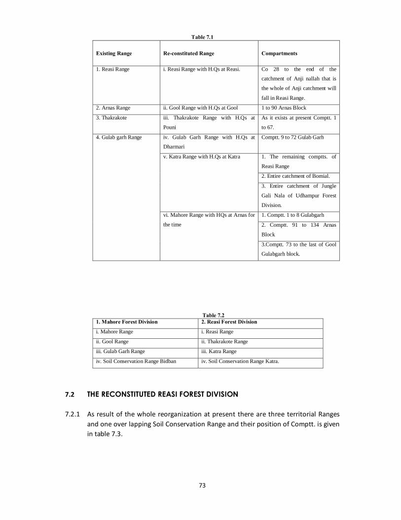
73
Table 7.1 Existing Range
Re-constituted Range
Compartments
1. Reasi Range i. Reasi Range with H.Qs at Reasi. Co 28 to the end of the
catchment of Anji nallah that is
the whole of Anji catchment will
fall in Reasi Range.
2. Arnas Range ii. Gool Range with H.Qs at Gool 1 to 90 Arnas Block
3. Thakrakote iii. Thakrakote Range with H.Qs at
Pouni
As it exists at present Comptt. 1
to 67.
4. Gulab garh Range iv. Gulab Garh Range with H.Qs at
Dharmari
Comptt. 9 to 72 Gulab Garh
v. Katra Range with H.Qs at Katra 1. The remaining comptts. of
Reasi Range
2. Entire catchment of Bomial.
3. Entire catchment of Jungle
Gali Nala of Udhampur Forest
Division.
vi. Mahore Range with HQs at Arnas for
the time
1. Comptt. 1 to 8 Gulabgarh
2. Comptt. 91 to 134 Arnas
Block
3.Comptt. 73 to the last of Gool
Gulabgarh block.
Table 7.2
1. Mahore Forest Division 2. Reasi Forest Division
i. Mahore Range i. Reasi Range
ii. Gool Range ii. Thakrakote Range
iii. Gulab Garh Range iii. Katra Range
iv. Soil Conservation Range Bidban iv. Soil Conservation Range Katra.
7.2 THE RECONSTITUTED REASI FOREST DIVISION 7.2.1 As result of the whole reorganization at present there are three territorial Ranges
and one over lapping Soil Conservation Range and their position of Comptt. is given in table 7.3.

74
Table 7.3
7.2.2 Ruthless fellings were conducted in the accessible areas during pre-departmental
days which resulted in bareness of slopes and denudation. Fellings at places were heavy for cultivation purposes with the result that high level coniferous forests are relegated to top portion of hill slopes and inner valley. Chir suffered from incendiaries, which resulted in bad quality of trees and scanty regeneration.
7.2.3 Till 1927 no regular Working Plan for the Forests of this Division was drawn up
and then for the first time Chir Forests were brought under a Working Plan. Before that only irregular fellings were conducted by sale of selected trees. During the war, demand still increased and there were added removal of the best trees. Two hundred trees of Chir in each Range and that of Fir were marked annually
7.2.4 The sale in those days was, mainly to get revenue with no attention being paid to the silviculture of the species. Thus the crop deteriorated with heavy fellings in selected spots especially in the Chir Forests. Heavy gaps were created. Some regeneration on favourable slopes did come up and established itself. In fact, there was no concentrated working and thus no proper control.
S.No.
Range Comptt. No. Total no. of comptts sub co.
Area in Hects.
Remarks From To
1. Reasi 10 to 75/R 73 13678 Comptts. 19 to 115/Reasi Range of Sh. M.S. Bharis Working Plan have been renumbered as Comptt. 1 to 97 without disturbing the sequence in Sh. I.A. Khan’s Working Plan Comptt. 1 to 9 were transferred from Reasi Range to Panchari Range Udhampur Forest Division vide CCF’s F.O. No. 74 of 1979-80 Dated 21-5-1979 & Comptts 76 to 97/R have been annexed from Reasi Range and clubbed with Katra Range vide CCF’s No. 317 of 1981-82 Dt. 26-8-1981.
2 Thakrakote 1 to 67/Th. 80 21817 As it exists in Sh. I.A. Khan’s Working Plan.
3 Katra 76 to 97/Reasi 9 to 12/Jammu 20 to 33/Udhampur
43 9544 Katra Range was newly created vide CCF’s F.O. No. 317 of 1981-82 Dt. 26-8-1981 comparising of comptts. 76 to 97/R, 9 to 12/Jammu, 20 to 33/Udhampur Range of Reasi, Jammu & Udhampur Forest Divisions respectively.
4 Soil Conservation Range
Over lapping in whole Reasi Forest Division.
Total: 196 45039 Ha.
75
7.3 FIRST CHIR PLAN BY TH. HARNAM SINGH PATHANIA (1928-29 TO 1937-38)
7.3.1 The first working plan for the Chir Forests of Reasi Forest Division was operated by
Th. Harnam Singh Pathania. Only Commercial Chir Forests were included in this plan and as such one Working Circle namely Chir Regular Working Circle was constituted
7.3.2 The Shelter wood compartment system was adopted in order to bring about the conversion of the irregular Forests to regular ones. It was considered the first system as Chir being a light demander cannot be successfully regenerated under only form of selection system. The exploitable size was fixed at 27” dbh.
7.3.3 A rotation of 120 years was adopted. The regeneration period was fixed at 30 years and four periodic blocks were constituted. Brush wood cutting, Seed sowing, control burning and controlled grazing were prescribed. Out of the total commercial area of 30316 acres in 109 compartments, 4790 acres were assigned to P.B.I.
7.3.4 The growing stock in compartments finally allotted to P.B.I. was enumerated in 6”
(15 cms.) diameter classes from “(30 cms.) Upwards. The middle aged stock 18-24”, 24-30” were much excess and there was deficit in the mature (30” above) and youngest (12-18”) classes. Yield was calculated by applying the formula.
Y =V+I + P/2 P
Where V = volume of growing stock
Y = yield in cft.
I = Increment (C.A.I) in cft.
P = No. of years in regeneration period.
The yield worked to 1, 89,658 cft.
7.4 BHAI SHER SINGH’s PLAN (1941-1950)
7.4.1 The first chir working plan by Harnam Singh was revised by Bhai Sher Singh. The S.
No. of compartments and specie wise area in Bhai Sher Singh’s plan was as follows.
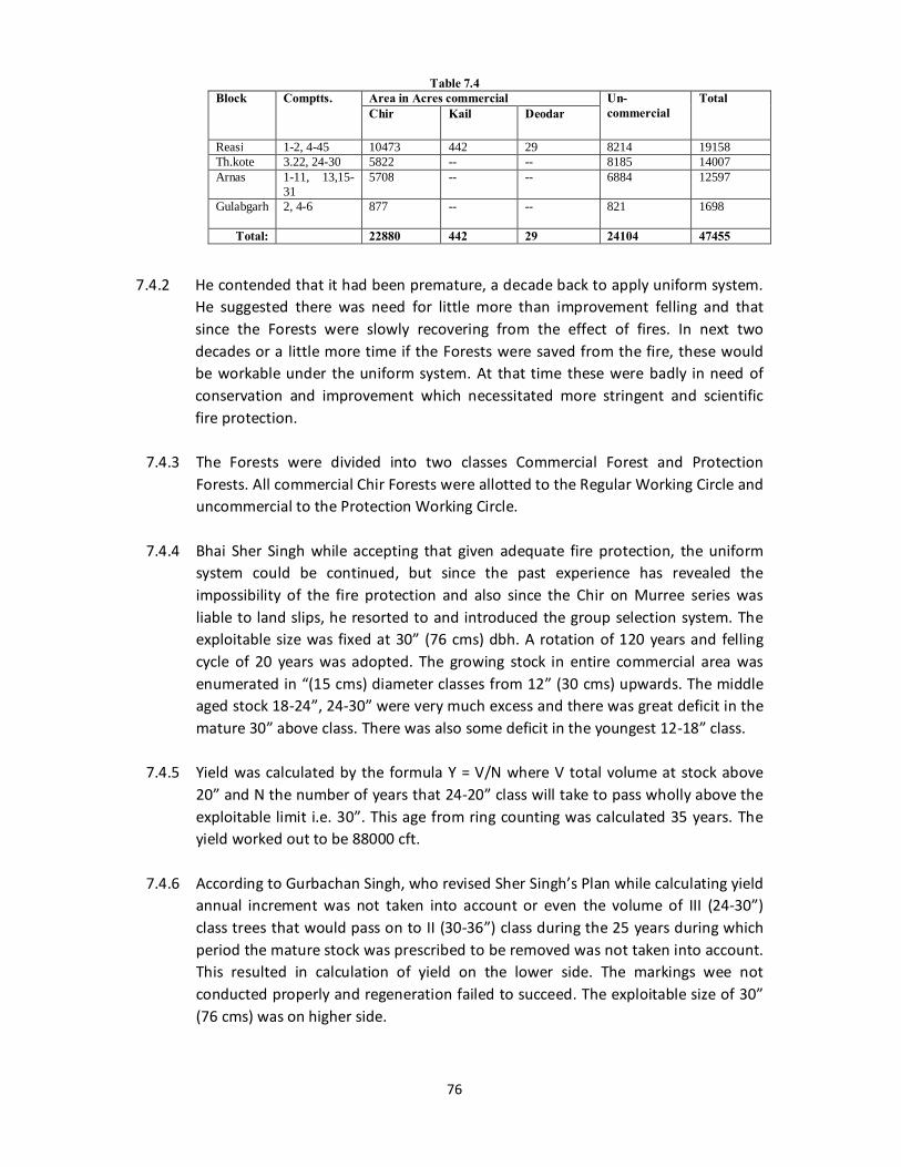
76
Table 7.4 Block Comptts. Area in Acres commercial Un-
commercial Total
Chir Kail Deodar
Reasi 1-2, 4-45 10473 442 29 8214 19158 Th.kote 3.22, 24-30 5822 -- -- 8185 14007 Arnas 1-11, 13,15-
31 5708 -- -- 6884 12597
Gulabgarh 2, 4-6 877 -- -- 821 1698
Total: 22880 442 29 24104 47455
7.4.2 He contended that it had been premature, a decade back to apply uniform system. He suggested there was need for little more than improvement felling and that since the Forests were slowly recovering from the effect of fires. In next two decades or a little more time if the Forests were saved from the fire, these would be workable under the uniform system. At that time these were badly in need of conservation and improvement which necessitated more stringent and scientific fire protection.
7.4.3 The Forests were divided into two classes Commercial Forest and Protection Forests. All commercial Chir Forests were allotted to the Regular Working Circle and uncommercial to the Protection Working Circle.
7.4.4 Bhai Sher Singh while accepting that given adequate fire protection, the uniform
system could be continued, but since the past experience has revealed the impossibility of the fire protection and also since the Chir on Murree series was liable to land slips, he resorted to and introduced the group selection system. The exploitable size was fixed at 30” (76 cms) dbh. A rotation of 120 years and felling cycle of 20 years was adopted. The growing stock in entire commercial area was enumerated in “(15 cms) diameter classes from 12” (30 cms) upwards. The middle aged stock 18-24”, 24-30” were very much excess and there was great deficit in the mature 30” above class. There was also some deficit in the youngest 12-18” class.
7.4.5 Yield was calculated by the formula Y = V/N where V total volume at stock above
20” and N the number of years that 24-20” class will take to pass wholly above the exploitable limit i.e. 30”. This age from ring counting was calculated 35 years. The yield worked out to be 88000 cft.
7.4.6 According to Gurbachan Singh, who revised Sher Singh’s Plan while calculating yield
annual increment was not taken into account or even the volume of III (24-30”) class trees that would pass on to II (30-36”) class during the 25 years during which period the mature stock was prescribed to be removed was not taken into account. This resulted in calculation of yield on the lower side. The markings wee not conducted properly and regeneration failed to succeed. The exploitable size of 30” (76 cms) was on higher side.
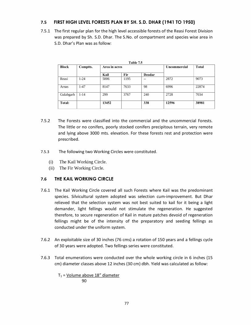
77
7.5 FIRST HIGH LEVEL FORESTS PLAN BY SH. S.D. DHAR (1941 TO 1950)
7.5.1 The first regular plan for the high level accessible forests of the Reasi Forest Division was prepared by Sh. S.D. Dhar. The S.No. of compartment and species wise area in S.D. Dhar’s Plan was as follow:
Table 7.5 Block Comptts. Area in acres Uncommercial Total
Kail Fir Deodar Reasi 1-24 5006 1195 -- 2872 9073
Arnas 1-47 8147 7633 98 6996 22874
Gulabgarh 1-14 299 3767 240 2728 7034
Total: 13452 338 12596 38981
7.5.2 The Forests were classified into the commercial and the uncommercial Forests. The little or no conifers, poorly stocked conifers precipitous terrain, very remote and lying above 3000 mts. elevation. For these forests rest and protection were prescribed.
7.5.3 The following two Working Circles were constituted.
(i) The Kail Working Circle. (ii) The Fir Working Circle.
7.6 THE KAIL WORKING CIRCLE
7.6.1 The Kail Working Circle covered all such Forests where Kail was the predominant species. Silvicultural system adopted was selection cum-improvement. But Dhar relieved that the selection system was not best suited to kail for it being a light demander, light fellings would not stimulate the regeneration. He suggested therefore, to secure regeneration of Kail in mature patches devoid of regeneration fellings might be of the intensity of the preparatory and seeding fellings as conducted under the uniform system.
7.6.2 An exploitable size of 30 inches (76 cms) a rotation of 150 years and a fellings cycle
of 30 years were adopted. Two fellings series were constituted.
7.6.3 Total enumerations were conducted over the whole working circle in 6 inches (15 cm) diameter classes above 12 inches (30 cm) dbh. Yield was calculated as follow:
T1 = Volume above 18” diameter
90

78
Where 90 is the number of years a 12”-18” (30-45 cm) diameter class will take to
attain maturity.
T2 = Volume above 30” d.b.h. 40
Where 40 is the number of years a 24-30” (60-75 cm) diameter class will take to pass on to 30” and above class. Whereas the yield of Kail was considered high as worked out by the first method and low by the second method. Therefore on average of the two was taken. In case of Fir the yield on the lower side was taken.
7.6.4 Out of the Forest allotted for Working during the plan period only a couple of
coupes were worked and in these too the fellings were not carried out strictly in accordance with the Working Plan prescriptions.
7.7 FIR WORKING CIRCLE 7.7.1 The Forests with predominantly Fir crop were included in this Working Circle. The
Silvicultural system adopted was the selection system with an exploitable size of 30 inches (76 cm) a rotation of 150 years and a felling cycle of 30 years.
7.7.2 About one third of the commercial area of the Working Circle was enumerated. This
stocking was multiplied by 21/2 times to work out the total growing stock. The yield was fixed at one percent of the growing stock above 18 inches (45 cm) dbh 2.43 percent of the yield reserved for the concessionists. This was a very conservative method of yield prescription.
7.7.3 In this Working Circle too, only a couple of coupes were taken for exploitation and
this results of the Plan could not be assessed.
7.8 1ST COMBINED PLAN BY GURBACHAN SINGH (1955-56 TO 1966-67)
7.8.1 S. Gurbachan Singh revised Sher Singh’s Chir Working Plan and Dhar’s high level Forests Plan and for the first time prepared a combined Working Plan for all Forests of the Reasi Division. Due to reorganization during 1951 and 1953 the Ranges and Divisions were reconstituted. Hence Gurbachan Singh renumbered all the compartments of Bhai Sher Singh’s and S.D. Dhar’s Plan. The S.No. of compartments and species wise area in Gurbachan Singh’s Plan was as given in table 7.6
7.8.2. Following five Working Circle were constituted.
(I) Chir Working Circle.
(II) Fir Working Circle.
(III) Kail Working Circle.
(IV) Resin Working Circle.
(V) Un-regulated Working Circle.
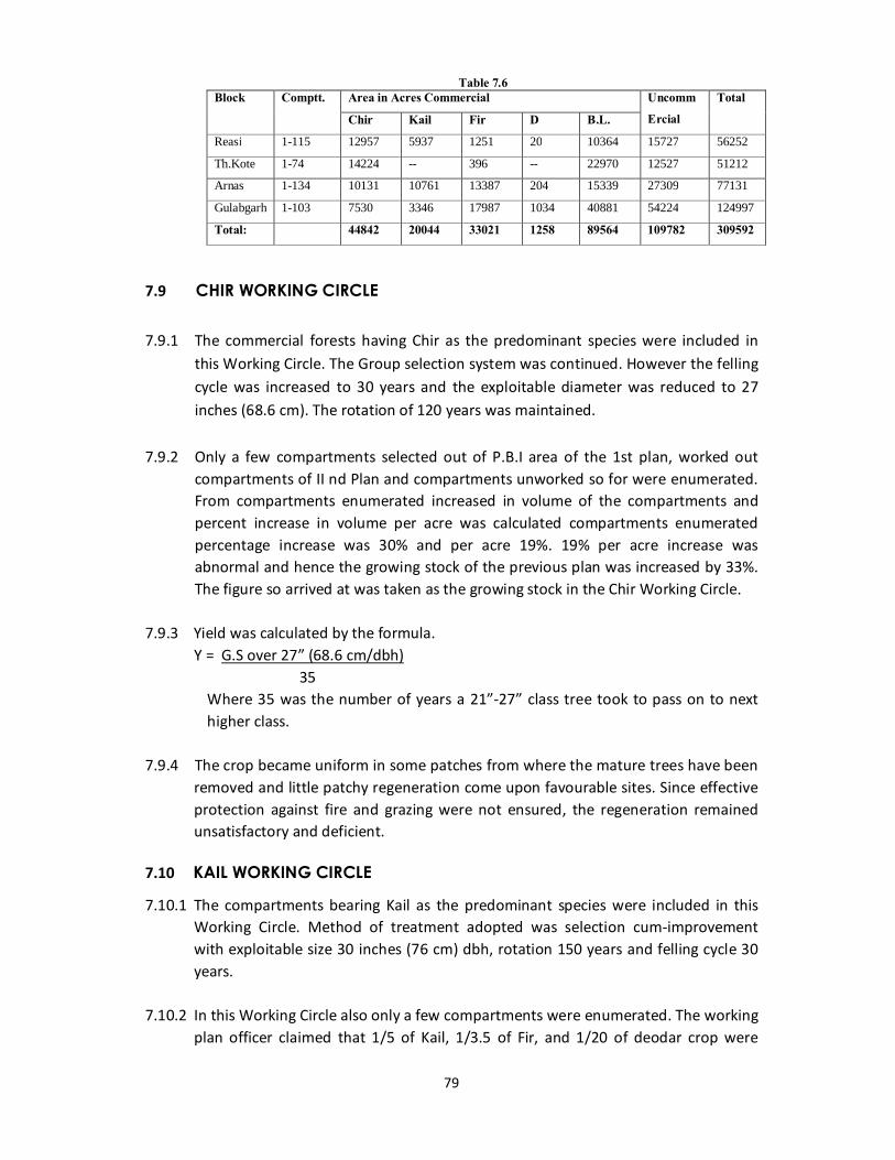
79
Table 7.6 Block Comptt. Area in Acres Commercial Uncomm
Ercial Total
Chir Kail Fir D B.L.
Reasi 1-115 12957 5937 1251 20 10364 15727 56252
Th.Kote 1-74 14224 -- 396 -- 22970 12527 51212
Arnas 1-134 10131 10761 13387 204 15339 27309 77131
Gulabgarh 1-103 7530 3346 17987 1034 40881 54224 124997
Total: 44842 20044 33021 1258 89564 109782 309592
7.9 CHIR WORKING CIRCLE
7.9.1 The commercial forests having Chir as the predominant species were included in
this Working Circle. The Group selection system was continued. However the felling cycle was increased to 30 years and the exploitable diameter was reduced to 27 inches (68.6 cm). The rotation of 120 years was maintained.
7.9.2 Only a few compartments selected out of P.B.I area of the 1st plan, worked out
compartments of II nd Plan and compartments unworked so for were enumerated. From compartments enumerated increased in volume of the compartments and percent increase in volume per acre was calculated compartments enumerated percentage increase was 30% and per acre 19%. 19% per acre increase was abnormal and hence the growing stock of the previous plan was increased by 33%. The figure so arrived at was taken as the growing stock in the Chir Working Circle.
7.9.3 Yield was calculated by the formula.
Y = G.S over 27” (68.6 cm/dbh) 35
Where 35 was the number of years a 21”-27” class tree took to pass on to next higher class.
7.9.4 The crop became uniform in some patches from where the mature trees have been
removed and little patchy regeneration come upon favourable sites. Since effective protection against fire and grazing were not ensured, the regeneration remained unsatisfactory and deficient.
7.10 KAIL WORKING CIRCLE
7.10.1 The compartments bearing Kail as the predominant species were included in this Working Circle. Method of treatment adopted was selection cum-improvement with exploitable size 30 inches (76 cm) dbh, rotation 150 years and felling cycle 30 years.
7.10.2 In this Working Circle also only a few compartments were enumerated. The working
plan officer claimed that 1/5 of Kail, 1/3.5 of Fir, and 1/20 of deodar crop were

80
enumerated. The volume of Kail, Fir and Deodar in the compartments enumerated were multiplied by 5, 3.5 and 20 respectively to find out volume figures from which the volume felled during the previous plan period was deducted. The figures so arrived at were taken as the Growing stock in the Working Circle.
7.10.3 The yield was calculated as follows:
i)Y = Volume of total G.S. 100 Where 100 was the number of years a 12 inches (30 cms) pole took to become 30
inches (76 cm) tree. ii)Y = Volume of Crop above 30 inches (76 cm) 40 Where 40 was the number of years 24”-30” (61-76 cm) dbh tree would take to
become 30” (76 cms) dbh or above. 7.10.4 For Kail the average of the above two was prescribed and for fir the lower of the
two which was further reduced arbitrarily. The prescribed yield was 6653 cum. Some additional compartments were also marked. There was still great dissimilarity in the crop conditions. There was no control on grazing. The blanks were not regenerated artificially.
7.11 FIR WORKING CIRCLE
7.11.1 The Forest having predominantly Fir Crop with little admixture of blue pine (Kail) were included in this Working Circle. Method of treatment adopted was selection system with exploitable size 30 inches (76 cms) dbh rotation of 150 years and felling cycle of 30 years.
7.11.2 The yield was calculated on the basis of the partial enumeration, carried out several
years ago by the following formulae: i) Y = Volume G.S. over 12” (30 cm)
100 Where 100 was the number of years during which a 12 inches (30 cms) tree was
considered to become 30” (76 cms) dbh tree. ii) Y = G.S. over 30” (76 cms) 40 Where 40 was the number of years that 24-30” (61-76 cms) class would take to
become over 30 inches (76 cm). In case of Fir the lower of two figures arrived as above was prescribed after
further reducing it arbitrarily.
7.11.3 The yield calculation was based on false assumptions. A rotation of 150 years was too low to be realistic. Also in yield calculation both for Kail and Fir, same growth rates were assumed which was very ridiculous. As a result in the Fir Working circle the yield prescribed was over estimated.
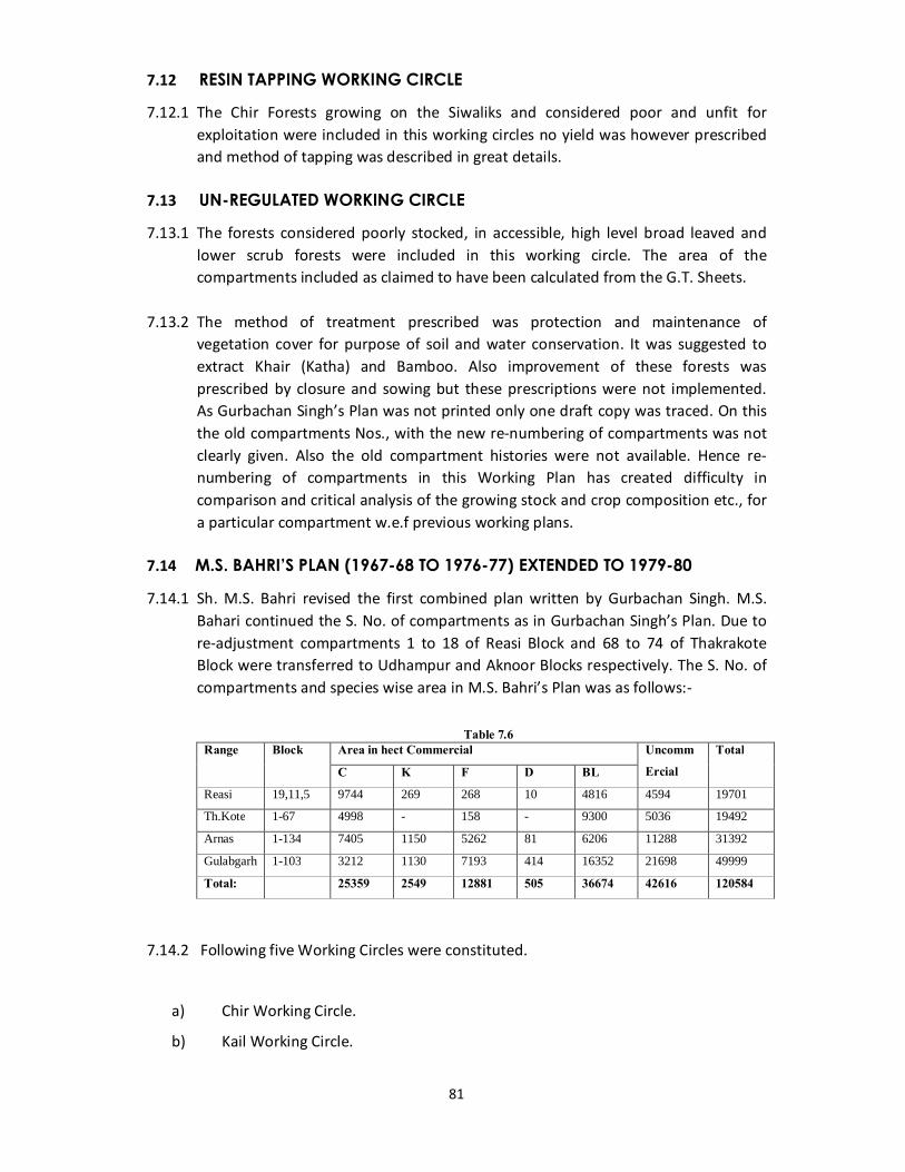
81
7.12 RESIN TAPPING WORKING CIRCLE
7.12.1 The Chir Forests growing on the Siwaliks and considered poor and unfit for exploitation were included in this working circles no yield was however prescribed and method of tapping was described in great details.
7.13 UN-REGULATED WORKING CIRCLE
7.13.1 The forests considered poorly stocked, in accessible, high level broad leaved and lower scrub forests were included in this working circle. The area of the compartments included as claimed to have been calculated from the G.T. Sheets.
7.13.2 The method of treatment prescribed was protection and maintenance of
vegetation cover for purpose of soil and water conservation. It was suggested to extract Khair (Katha) and Bamboo. Also improvement of these forests was prescribed by closure and sowing but these prescriptions were not implemented. As Gurbachan Singh’s Plan was not printed only one draft copy was traced. On this the old compartments Nos., with the new re-numbering of compartments was not clearly given. Also the old compartment histories were not available. Hence re-numbering of compartments in this Working Plan has created difficulty in comparison and critical analysis of the growing stock and crop composition etc., for a particular compartment w.e.f previous working plans.
7.14 M.S. BAHRI’S PLAN (1967-68 TO 1976-77) EXTENDED TO 1979-80
7.14.1 Sh. M.S. Bahri revised the first combined plan written by Gurbachan Singh. M.S. Bahari continued the S. No. of compartments as in Gurbachan Singh’s Plan. Due to re-adjustment compartments 1 to 18 of Reasi Block and 68 to 74 of Thakrakote Block were transferred to Udhampur and Aknoor Blocks respectively. The S. No. of compartments and species wise area in M.S. Bahri’s Plan was as follows:-
Table 7.6
Range Block Area in hect Commercial Uncomm Ercial
Total
C K F D BL
Reasi 19,11,5 9744 269 268 10 4816 4594 19701
Th.Kote 1-67 4998 - 158 - 9300 5036 19492
Arnas 1-134 7405 1150 5262 81 6206 11288 31392
Gulabgarh 1-103 3212 1130 7193 414 16352 21698 49999
Total: 25359 2549 12881 505 36674 42616 120584
7.14.2 Following five Working Circles were constituted.
a) Chir Working Circle.
b) Kail Working Circle.
82
c) Fir Working Circle.
d) Minor Forest Produce Working Circle.
e) Protection and Improvement Working Circle.
7.15 CHIR WORKING CIRCLE
7.15.1 All upper Himalayan Chir compartments considered fit for exploitation covering an area of 19843 hec (120, 30 hec commercial and 7813 hec un-commercial) were included in this Working Circle.Group selection system was continued. Sowing to supplement natural regeneration, closure to grazing fire protection and control burning were prescribed inter a lia. The exploitable size of 70 cms dbh was adopted corresponding to 130 years rotation. The felling cycle was increased to 40 years.
7.15.2 Total growing stock was not assessed. A few compartments (56 lut of total 120)
were enumerated in 10 cms diameter classes above 30 cms dbh. The total volume in the compartment allotted for working was taken as the growing stock of the entire circle for yield calculations.
7.15.3 Yield was calculated by following three methods:
i) Total growing stock over 30 cms dbh 96 Where 96 is the number of years that a 30 cm pole will take to grow to 70 cm. ii) Y = Growing stock over 70 cm dbh 24 Where 24 is the number of years in which 60-70 cms tree will take to grow over
70 cm. iii) Y = 2 Growing stock Rotation Van Mantal’s formula.
7.15.4 Yield calculated by first method was adopted as it was assumed that the yield by third formula was high and that by second formula was disproportionate. The yield worked out was further reduced arbitrarily. The yield for the entire circle including Kail and deodar was 3700 cm.
7.15.5 According to I.A. Khan the devations from the prescriptions were very high which were partly due to the execution and partly by the errors in the Working Plan itself. As the yield marked in some compartments of Gurbachan Singh’s Plan was booked in Bhari’s Plan resulting major devation.
7.15.5 The prescribed yield was under estimated due to errors involved in its calculation. Firstly the total growing stock was assessed at all. Only the results of partial enumeration were taken into account secondly the formula used for yield
83
determination were arbitory or unsuitable. And thirdly the growth rate (diamter increments) in terms of years was not based on any fact. The next results of these inherent errors were that the yield was under estimated. A felling cycle of 40 years was not justified.
7.15.6 There was no improvement in the status of regeneration. The prescriptions in respect of control burning, fire lines, closure, sowing etc. were not implemented. The crop did not improve at all and following the previous tendency.
7.16 KAIL WORKING CIRCLE
7.16.1 All high altitudinal Forests, bearing Kail as the main species and considered commercial were included in this Working Circle. Selection cum-improvement system was continued. A rotation of 130 years felling cycle 20 years and exploitable size 70 cm was adopted. Only one felling serial was continued.
7.16.2 Only 36 compartments out of 56 in Working Circle were enumerated. The total volume in enumerated compartments was taken as total growing stock
of the Working Circle for yield calculation. 7.16.3 Yield was calculated by the similar methods used in case of the Chir Working Circle
except the 90, 27 and 130 years were taken in formula (i), (ii) and (iii) respectively. After further reducing arbitrarily the yield for Kail and Fir was prescribed as 4600 cm and 2000 cms respectively.
7.16.4 According to I.A. Khan the yield calculation was erroneous on similar comments as commented in paragraph 5.66 for Chir Working Circle.
7.16.5 There was no improvement in the crop or in the regeneration most of the subsidiary silvicultural operations and other prescription were not carried out.
7.17 FIR WORKING CIRCLE 7.17.1 Commercial Fir and Spruce Forests, pure or having Kail or mixed in small
proportion were included in this Working Circle selection cum improvement system with a rotation of 180 years, exploitable size 70 cms was adopted.
7.17.2 Out of 41 compartments included in the Working Circle only 18 allotted for working during the Plan period were enumerated completely in 10 cms diameter classes above 30 cms dbh. The total volume in above was taken as total growing stock of the Working Circle for yield calculation. The yield was calculated in the same manner as for Chir and Kail Working Circles except the No. of years taken were 112, 54 and 150 respectively in (i), (ii) and (iii) formula respectively. The yield calculated by first method was orbitrarily reduced and the yield prescribed was 6790 cms and 3600 cum for Fir and Kail respectively.
84
7.17.3 According to I.A. Khan Yield calculation was arbitrary and was not based on sound
scientific considerations, on similar comments as commented in paragraph 5.6.7. for Chir Working Circle. Rotation of Fir was fixed on lower side and the inconsistency of yield calculation was balanced to some extent. Nothing could be done as far as regeneration of Fir was concerned.
7.18 MINOR FOREST PRODUCE WORKING CIRCLE
7.18.1 It was an overlapping Working Circle constituted to ensure systematic development and exploitation of the Minor Forest Produce found in the tract. It was divided into four Working series:
i) Resin Working Series. ii) Medicinal Herbs and Plants Working series. iii) Bamboo Working Series. iv) General Working Series.
7.19 RESIN WORKING SERIES
7.19.1 Chir forests growing on the Siwaliks were included in this Working Series. Thus it was not overlapping. The total number of channels estimated available for tapping were 208039 for light tapping and 1500 for heavy tapping. The prescribed yield was fixed as 2000 Quintals approximately.
7.19.2 It was not an overlapping Working Series. In practice however the tapping of Himalayan Chir was also carried out by the territorial divisions.
7.20 MEDICINAL HERBS AND PLANTS WORKING SERIES 7.20.1 A list of medicinal plants with their altitudinal zone was given without identifying
the specific areas of their occurrence or quantity available.
7.21 BAMBOO WORKING SERIES
7.21.1 Four compartments 41a, 61, 63 & 68 of Thakrakote Range with a total area of 1584 hectares in this working series. It was supposed that the entire aforesaid area was under Bamboo and for purpose of yield calculation this area was divided by a being years of cutting cycle and yield was determined as 396 or 400 hectares to be out annually. Comprehensive cutting rules and method of treatment was given.
7.21 GENERAL WORKING SERIES
7.22.1 Katha (Acacia catechu), Rasount (Berberis), Jingax gum (Lennea coromandalica) Babul gum (Acacia nilotica). Fibres and floss. Kopak (Bombax ceiba) Tans and dyes animal and mineral products like lac, wax, honey, etc. Were included in this series.
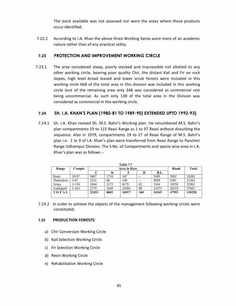
85
The stock available was not assessed nor were the areas where these products occur identified.
7.22.2 According to I.A. Khan the above three Working Series were more of an academic
nature rather than of any practical utility.
7.23 PROTECTION AND IMPROVEMENT WORKING CIRCLE
7.23.1 The area considered steep, poorly stocked and inaccessible not allotted to any other working circle, bearing poor quality Chir, the distant Kail and Fir on rock slopes, high level broad leaved and lower scrub forests were included in this working circle 668 of the total area in this division was included in this working circle (out of the remaining area only 348 was considered as commercial rest being uncommercial. As such only 138 of the total area in the Division was considered as commercial in this working circle.
7.24 SH. I.A. KHAN’S PLAN (1980-81 TO 1989-90) EXTENDED UPTO 1992-93)
7.24.1 Sh. I.A. Khan revised Sh. M.S. Bahri’s Working plan. He renumbered M.S. Bahri’s plan compartments 19 to 115 Reasi Range as 1 to 97 Reasi without disturbing the sequence. Also in 1979, compartments 19 to 27 of Reasi Range of M.S. Bahri’s plan i.e. 1 to 9 of I.A. Khan’s plan were transferred from Reasi Range to Pancheri Range Udhampur Division. The S.No. of Compartments and specie wise area in I.A. Khan’s plan was as follows :-
Table 7.7
Range Comptt. Area in Hect. Blank Total C K F D B.L.
Reasi 10-97 9407 1718 147 -- 5009 3902 19283 Thakrakote 1-67 5231 68 108 -- 9699 6381 21382 Arnas 1-134 5044 5172 6270 62 5164 10250 31962 Gulabgarh 1-103 2770 1649 10392 98 14373 28319 57601 T O T A L 22452 8602 16917 160 34245 47952 130228
7.24.2 In order to achieve the objects of the management following working circles were
constituted. 7.25 PRODUCTION FORESTS:
a) Chir Conversion Working Circle
b) Kail Selection Working Circle.
c) Fir Selection Working Circle
d) Resin Working Circle
e) Rehabilitation Working Circle
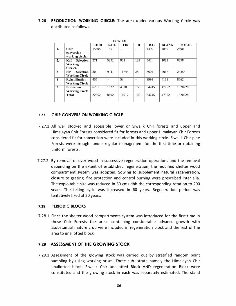
86
7.26 PRODUCTION WORKING CIRCLE: The area under various Working Circle was distributed as follows.
Table 7.8
CHIR KAIL FIR D B.L. BLANK TOTAL 1. Chir
conversion working circle.
15405 155 -- -- 4499 4850 24909
2. Kail Selection Working Circles.
271 5831 801 132 542 1081 8658
3 Fir Selection Working Circle
20 994 11743 28 3604 7967 24356
4 Rehabilitation Working Circle
455 -- 53 -- 3991 4163 8662
5 Protection Working Circle
6201 1622 4320 160 34245 47952 1320228
Total 22352 8602 16917 160 34245 47952 1320228
7.27 CHIR CONVERSION WORKING CIRCLE 7.27.1 All well stocked and accessible lower or Siwalik Chir forests and upper and
Himalayan Chir Forests considered fit for forests and upper Himalayan Chir Forests considered fit for conversion were included in this working circle. Siwalik Chir pine Forests were brought under regular management for the first time or obtaining uniform forests.
7.27.2 By removal of over wood in successive regeneration operations and the removal
depending on the extent of established regeneration, the modified shelter wood compartment system was adopted. Sowing to supplement natural regeneration, closure to grazing, fire protection and control burning were prescribed inter alia. The exploitable size was reduced in 60 cms dbh the corresponding rotation to 200 years. The felling cycle was increased in 60 years. Regeneration period was tentatively fixed at 20 years.
7.28 PERIODIC BLOCKS
7.28.1 Since the shelter wood compartments system was introduced for the first time in these Chir Forests the areas containing considerable advance growth with asubstantial mature crop were included in regeneration block and the rest of the area to unallotted block
7.29 ASSESSMENT OF THE GROWING STOCK 7.29.1 Assessment of the growing stock was carried out by stratified random point
sampling by using working prism. Three sub- strata namely the Himalayan Chir unallotted block. Siwalik Chir unallotted Block AND regeneration Block were constituted and the growing stock in each was separately estimated. The stand
87
tables for Chir and Kail were prepared for each species. The stock tables were prepared from the stand table.
7.29.2 The yield for the entire Chir Working Circle was calculated by the formula:- Total volume of Chir above 60 cms. + 50% volume of 50-60 dbh class 60 Where 60 was the number of years that a 30 cms pole will take to reach 60 cms The yield for regeneration block was calculated by the formula:- Total volume of Chir above 60 cms. + 50% volume of 50.60 dbh class. 20 7.29.3 Further the yield worked out was reduced by 15%. The figures so arrived at were
rounded off and the Annual yield prescribed was as under:- Table 7.8
Species Yield in M3 (cum) Yield from Un-allotted Block Yield from entire
Working Circle Yield from Regeneration
Block Chir 13,780 11,640 2140 Kail 290 160 130
7.29.4 The following compartments were allotted for Working during the Plan period: Arnas Range:47, 48, 84 & 88. Reasi Range:16, 18a, 21, 59, 60a, 66, 68, 89, 90b, 91 & 92. Thakrakote Range:35, 36, 37 and 38. 7.29.5 These compartments were not marked for major marking. Only rope way
marking, snow damage marking, dry marking, supplementary marking were carried out in some compartments of this Working Circle. This was mainly due to the Govt. Policy regarding ban on green Chir tree fellings.
7.30 KAIL SELECTION WORKING CIRCLE
7.30.1 All accessible high level well stocked blue pine (Kail) Forest having Kail as the main species with light mixture of Fir Crop toward upper reaches in depressions and considered commercial were included in this Working Circle. Selection system was continued. Exploitable size was reduced and fixed 60 cms dbh for Deodar, Kail and Chir. For Fir the exploitable size was fixed 70 cms dbh. Rotation for Deodar, Kail was fixed 120 years and for Fir and Chir 190 years and 100 years respectively. Falling Cycle of 20 years was continued. Only one felling series was continued.
7.31 ASSESSMENT OF GROWING STOCK
7.31.1 Assessment of Growing Stock was carried out by stratified random point sampling by using Wedge Prism. Kail stratum was constituted for predominantly Kail bearing areas mixed with Fir constituted the Fir Stratum. For Chir the mean values of Himalayan Chir substratum were applied. The stand tables for Kail, Fir and Chir were prepared for each species. The stock tables were prepared from the stand tables by applying the Kulu volume table.
88
7.31.2 Yield for Kail and Fir was calculated by Brandis method and Smythies formula respectively. For Chir and Deodar the yield was calculated by Brandis method and Vonmantel’s formula respectively. The yield thus worked out was further reduced 13.3%. After rounding off the prescribed annual yield was as under:
Kail: 11,600 cum Fir: 3,600 cum Chir: 800 cum Deodar: 500 cum Total:16,500 cum 7.31.3 The following compartments were allotted for Working during the plan period.
Table 7.9 Arnas Range 16, 18a, 18b, 22, 24, 31, 34a, 34b, 37, 40, 41a, 41b, 42, 62b, 62c, 63, 64,
68, 69, 121b, 122, 126 and 127a. Gulab Garh Range 27 and 33. Reasi Range 52, 53, 54 and 55.
7.31.4 As per records available no major markings were carried out in Reasi Range of this
Working Circle. Only snow damage and miscellaneous markings were carried out in this Working Circle.
7.32 FIR SELECTION WORKING CIRCLE
7.32.1 All accessible stocked mixed coniferous Forests having pure Fir. Fir spruce or Fir-Kail with admixture of evergreen and deciduous broad leaved Forests and consider commercial were included in this Working Circle. Selection cum improvement system was continued. The exploitable size of Kail and Fir was continued to be 70 cm. Rotation of 190 years was fixed for Fir and 140 years was fixed for other species. Fellings cycle of 30 years was continued.
7.33 ASSESSMENT OF THE GROWING STOCK
7.33.1 The growing stock was assessed by means of random point sampling. The stand table for Fir and Kail were prepared and from stand table stock table were prepared by applying the Kulu volume table. The yield was calculated by Brandis method and further checked by Smithies safe guarding formula. The yield thus worked out was further reduced 13.5% for sampling errors involved in the growing stock. After rounding off the prescribed annual yield was as under:
Fir:15,100 cum
Kail: 1,700 cum
7.33.2 The following compartments were allotted for working during the plan period.
Table 7.10 Arnas Range 15, 114, 115, 123, 124 and 125 Gulab Garh Range 13, 15, 16, 17, 48, 62, 66, 76, 77, 78 and 79.

89
7.34 REHABILITATION WORKING CIRCLE 7.34.1 This working circle comprises such degraded and poorly stocked forest that can be
rehabilitated and improved by intensive Silvicultural operations and method of treatment.
7.34.2 (i)Removal of dead, dying, diseased, malformed and economically less valuable trees on moderate gradients.
(ii)Closure of areas against biotic interference before the artificial regeneration plantation is take up.
(iii) Engineering works required for Soil Conservation wherever necessary. (iv)Plantation of following suitable species with their plantation techniques for
different altitudinal zones with preference to fast growing species was recommended.
Acacia catechu, Ailenthus exelsa, Bombax ceiba, Dalbergia sissoo, Dendrocalnums strictus, Poplus, Robinia, Pinus roxburghii, Cedrus deodara. Juglans regia, Aesculus indica, Pronus spp.
7.34.3 Minimum 100 ha area was recommended for plantation annually. 7.35 RESIN WORKING CIRCLE 7.35.1 This working circle was the over lapping working circle of entire chir conversion
Working circle. 7.36 METHOD OF WORKING ADOPTED 7.36.1 Light continuous tapping:A 5 year Rotational light continuous tapping for all trees
above 35 cm dbh with one channel on 35.60 cm dbh and two channels on tree above 60 cm dbh was prescribed. Half of the area of unallotted block for first 5 years and remaining half for next five years with first channel or each set of channels tapping for 5 years was recommended.
7.36.2 Heavy tapping: Heavy taping was prescribed for the trees to be felled in the
regeneration block. All tree above 60 cm dbh except those to be retained as seed bearers and 50% trees of 50-60 cm were prescribed for tapping. Such tapping was recommended to be started five years in advance felling. In heavy tapping as many channels can be made as a tree can accommodate with a minimum interspace of 10 cm between the successive channels.
7.37 METHOD OF TAPPING: 7.37.1 French Cup and Lip method was continued which was described in detail. The
total number of channels estimated available for light tapping were 5, 16, 243 and
90
for heavy tapping 40, 630. The prescribed yield was fixed to be 16,300 qtls, 3 Kg’s per channel for light tapping and 2 Kg per channel for heavy tapping.
7.38 TAPPING SCHEDULE 7.38.1 Five years rotational taping i.e., for first five years 5152 ha and for remaining 5
years remaining 5152 ha of production area under chir in unallotted block of chir conversion working circle was prescribed.
7.39 PROTECTION WORKING CIRCLE 7.39.1 Forests which are situated on rugged and highly precipitous grounds where the
crop was poor in quality and density and remote and inaccessible areas were included in protection working circle. No growing stock was assessed in this working circle. 63643 hectares (49% of the total area of this division) was allotted to this working circle. It was prescribed that these Forests shall be protected and preserved in the interest of Soil and water conservation. Selection fellings for charcoal burning were suggested in Bung Oak areas. Issuing of trees to concessionists was recommended for this working circle.
7.40 Sh. B.K. BHAGHAT’s PLAN(1994-1995 to 2003-2004) 7.40.1 In this plan the following working circles were constituted:-
I.Chir working circle II.Rehabilitation working circle III.Protection working circle IV. Resin overlapping working circle
7.41 CHIR WORKING CIRCLE: -
7.41.1 General Constitution Of The Working Circle:This working circle included all chir bearing areas and potential chir areas whichoccurred in all three ranges of the division.
7.41.2 Special Objects Of Management:The special objects of management were to
enhance the density and to improve the health of these forests by carrying out concentrated and intensive regeneration operations.
7.41.3 Assessment Of The Growing Stock:The assessment of the growing stock had
been assessed be Bitterlich’s method of point sampling by using Wedge Prism. Two sub-strata namely the chir unallotted block and chir regeneration block were constituted and growing stock in each substratum were separately estimated for chir area only.
91
7.41.4 Method Of Treatment: Keeping in view the crop condition objects of management and ban on commercial feelings vide GO No. 24 FST of 1990 dated 15.01.1990, no commercial feelings were prescribed for the Plan period. Two measures were suggested under this Plan for effective regeneration operations viz. Fire protection and Closure to grazing and grass cutting.
7.41.5 Division Into Periods And Allotment Of Periodic Blocks: The total area under
chir working circle was allotted less than two blocks viz.
a. Regeneration Block, which included the compartments having considerable advanced growth with substantial quantum of mature crop and having better growing stock.
b.Unallotted block which included the remaining area of the working circle.
7.41.6 Silvicultural System Adopted: This working circle was treated under Indian shelter wood system.
7.41.7 Exploitable Size: An exploitable size of 70 cms D.B.H (O.B) was fixed. 7.41.8 Rotation: A rotation of 130 years was fixed. 7.41.9 Conversion Period: A conversion period of 65 years was opted. 7.41.10 Regeneration Period: The regeneration period was fixed at 25 years. 7.41.11 Yield Determination:Dia class wise abstract of total number of chir and kail trees
60cms dbh and above at mean value of regeneration block and unallotted block was summarized. From the abstract the volume available for fellings during 50 years of the conversion period at lower confidence limit was estimated as under:-
a) Volume of the chir above 70 cms dbh = 91549 cu.m. 50% volume of 60-70 dbh class = 60013 cu.m. Total volume of chir = 15156 cu.m. Volume of kail above 70 cms dbh class = 4058 cu.m. 50% volume of 60-70 cms dbh class = 1593 cu.m. Total volume of kail = 5651 cu.m. b) The estimated annual cut from entire working circle is as under: Chir = 151562/50 = 3031 cu.m. Kail = 5651/50 = 113 cu.m. c) Discounting the yield by 15% error involved in sampling and thus final yield
estimated is as under: Chir = 2576 cu.m.
Kail = 96 cu.m.
Total = 2672 cu.m.
92
7.41.12 Regeneration Block:
a) Total volume of chir above 70 cms dbh = 45126 cu.m. 50% volume of 60-70 cms dbh class = 27606 cu.m. Total volume of chir in regeneration block CR = 72732 cu.m. Volume of kail above 70 cms dbh = 654 cu.m. 50% volume of 60-70 cms dbh class = 257 cu.m. Total volume of Kail in regeneration block KR = 911 cu.m. The annual cut from regeneration block was estimated as below Chir CR/25 = 72732/25 = 2909 cu.m. Kail KR/25 = 911/25 = 36 cu.m.
7.41.13 Results: Conversion could not be taken up because of ban on green felling due to
which good advance growth as well as regeneration has come up. 7.42 REHABILITATION WORKING CIRCLE
7.42.1 General Constitution Of Working Circle: This Working Circle included degraded
forest areas, broad leaved or blanks or areas bearing shrubby growth deteriorated due to excessive biotic interference in the past, lying in tropical, subtropical or temperate region.
7.42.2 Special Objects Of Management: viz.
i. To stock adequately by effective closure and by raising plantations of suitable species besides of taking adequate measures for soil and water conservation.
ii. To meet the demands of local people with respect to timber, firewood and fodder.
7.42.3 Assessment Of The Growing Stock: The growing stock had been assessed by the
Bitterlich’s Method of point sampling by using wedge prism. Two sub-strata namely Chir, Broad leaved were constituted and the growing stock in each sub-stratum was separately estimated.
7.42.4 Method Of Treatment: viz.
i. Fencing of completed degraded areas against grazing and other biotic inferences. ii. Patch sowing of grasses patch sowing/planting of bushes to establish a quick and
efficient vegetal cover in these areas. iii. Planting/sowing of suitable trees in these areas. iv. Soil Conservation measures to check soil erosion wherever necessary.
93
7.42.5 Annual Plantation Area: The area of about 2500 ha needed to be regenerated during the period of the plan.
7.42.6 Compartments Identified For Planting: The following compartments from different ranges were identified for planting.
Table 7.11
Range Priority wise compartments
Reasi 36,35,40,34,33,32,31,57
Katra 76,77,78,79,80,81,12,22,23,29,30,33,83a,83b
Thakrakote 48a,48b,49a,49b,49c,54a,54b,55,65,63,64
7.43 PROTECTION WORKING CIRCLE
7.43.1 General Constitution Of Working Circle: This working circle included Forests which were located on steep to precipitous, rocky and stony hill top slopes, devoid of vegetation and covering uncommercial sites.Forests in the catchment of Rub, Sunch, Sarod (immediate Salal Dam catchment) Anji Nala and various other nalas all draining into the river Chenab.
7.43.2 Special Objects Of Management: To reduce the silt and sediment discharge in
Salal Dam to the minimum possible limit.To stock adequately by effective closure and by raising plantations of suitable species besides taking adequate measures for soil & water conservation.
7.43.3 Assessment Of The Growing Stock: The growing stock had been assessed by the
Bitterlich’s method of point sampling using Wedge Prism. Four sub-strata namely Kail, Chir, Broad Leaved, Banj, Oak were constituted and the growing stock in each sub-stratum had been separately estimated.
7.43.4 Method Of Treatment: To achieve the objects of managements the area of the
working circle had been divided into three types for the purposes of treatment. 7.43.5 Type A Areas:These areas fall in the catchment of Rud, Sunch Sared Nalas i.e.
immediate surrounding catchment of Salal Dam. 7.43.6 Method Of Treatment: The following treatment was prescribed for such areas.
i. Development of Chir Forests. ii. Development of Oak Forests. iii. Development of mixed Broad leaved Forests. iv. Farm Forestry Raising Plantations by Farmers on their private land.
94
7.43.7 Annual Plantation Area:The area of about 3000 ha needed to be fenced for the above type of treatment in the next 10 years.
7.43.8 Compartments Identified For Planting: The following compartments were given
priority while selecting the areas for the above described method of treatment.
Table 7.12 Area to be developed
Range Priority wise compartment Nos.
1. Chir Thakrakote 40,35,36,37,41,42,43,47,11,22a,22b,23,25.
Reasi 23,24,20,18,1,29.
2. Oak Thakrakote 4,8,1c,14,9,20.
Reasi 19b,22,12a,13
3. Misc. B.L. Thakrakote 1a,1b,10a,28a,6.
Reasi 29,22,19a,19b,13,12a.
7.43.9 Type B Areas: Areas other than immediate Salal Dam catchment which were very
much poorly stocked. There are big gaps and blanks present in these areas. The vegetative cover was very much deficient and thus Soil erosion had already set at various sites. Most of these areas were on steeper or precipitous terrain.
7.43.10 Method Of Treatment: The following treatment were prescribed for these areas.
i. These areas would have been effectively fenced against biotic interferences i.e., grazing, encroachments, illicit damage, fires etc. The areas with demarcation would have been fenced along the demarcation line to check encroachments etc.
ii. Localities which were too difficult to be planted with conifers, should have been planted with, suitable, most economical and desirable broad leaved species.
iii. Patch sowing of grasses and patch sowing/planting of bushes.
iv. Areas near and around the human settlements be planted with fruit fodder, fuel wood and Soil Conservation species with a view to reduce pressure on the Forests.
v. Soil Conservation measures like gully plugging and check daming should
have been carried out to check Soil erosion wherever necessary. 7.43.11 Annual Plantation Area: The total forest area in this category is 4826 ha.
Keeping in view the grazing and other needs of local people 3826 ha of comparatively good and un-productive stocked areas on steeper or precipitous terrain could not have been closed for grazing and other biotic interference etc.
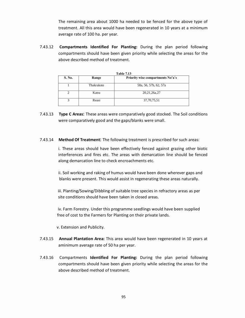
95
The remaining area about 1000 ha needed to be fenced for the above type of treatment. All this area would have been regenerated in 10 years at a minimum average rate of 100 ha. per year.
7.43.12 Compartments Identified For Planting: During the plan period following
compartments should have been given priority while selecting the areas for the above described method of treatment.
Table 7.13
S. No. Range Priority wise compartments No’a`s
1 Thakrakote 58a, 56, 57b, 62, 57a
2 Katra 20,21,26a,27
3 Reasi 37,70,75,51
7.43.13 Type C Areas: These areas were comparatively good stocked. The Soil conditions
were comparatively good and the gaps/blanks were small. 7.43.14 Method Of Treatment: The following treatment is prescribed for such areas:
i. These areas should have been effectively fenced against grazing other biotic interferences and fires etc. The areas with demarcation line should be fenced along demarcation line to check encroachments etc.
ii. Soil working and raking of humus would have been done wherever gaps and blanks were present. This would assist in regenerating these areas naturally. iii. Planting/Sowing/Dibbling of suitable tree species in refractory areas as per site conditions should have been taken in closed areas. iv. Farm Forestry. Under this programme seedlings would have been supplied free of cost to the Farmers for Planting on their private lands. v. Extension and Publicity. 7.43.15 Annual Plantation Area: This area would have been regenerated in 10 years at
aminimum average rate of 50 ha per year. 7.43.16 Compartments Identified For Planting: During the plan period following
compartments should have been given priority while selecting the areas for the above described method of treatment.
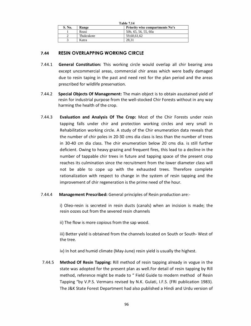
96
Table 7.14 S. No. Range Priority wise compartments No’s
1 Reasi 50b, 65, 56, 55, 60a 2 Thakrakote 59,60,61,62 3 Katra 28,31
7.44 RESIN OVERLAPPING WORKING CIRCLE 7.44.1 General Constitution: This working circle would overlap all chir bearing area
except uncommercial areas, commercial chir areas which were badly damaged due to resin taping in the past and need rest for the plan period and the areas prescribed for wildlife preservation.
7.44.2 Special Objects Of Management: The main object is to obtain asustained yield of resin for industrial purpose from the well-stocked Chir Forests without in any way harming the health of the crop.
7.44.3 Evaluation and Analysis Of The Crop: Most of the Chir Forests under resin
tapping falls under chir and protection working circles and very small in Rehabilitation working circle. A study of the Chir enumeration data reveals that the number of chir poles in 20-30 cms dia class is less than the number of trees in 30-40 cm dia class. The chir enumeration below 20 cms dia. is still further deficient. Owing to heavy grazing and frequent fires, this lead to a decline in the number of tappable chir trees in future and tapping space of the present crop reaches its culmination since the recruitment from the lower diameter class will not be able to cope up with the exhausted trees. Therefore complete rationalization with respect to change in the system of resin tapping and the improvement of chir regeneration is the prime need of the hour.
7.44.4 Management Prescribed: General principles of Resin production are:- i) Oleo-resin is secreted in resin ducts (canals) when an incision is made; the
resin oozes out from the severed resin channels ii) The flow is more copious from the sap wood. iii) Better yield is obtained from the channels located on South or South- West of
the tree. iv) In hot and humid climate (May-June) resin yield is usually the highest. 7.44.5 Method Of Resin Tapping: Rill method of resin tapping already in vogue in the
state was adopted for the present plan as well.For detail of resin tapping by Rill method, reference might be made to “ Field Guide to modern method of Resin Tapping “by V.P.S. Vermans revised by N.K. Gulati, I.F.S. (FRI publication 1983). The J&K State Forest Department had also published a Hindi and Urdu version of

97
this booklet. However the salient features of resin tapping by rill method are given as:
i) Only one blaze should ve given on the chir tree with diameter 40 cms dbh (120 cms girth) and above. ii) There should be a minimum no. of blazes in a channel i.e., a channel should be tapped for a year. Iii) The space left between the two channels should be at least 7.5 cms. Length of the channel and its height above ground level are standardized below.
Table 7.15 Year Length of
initial blaze
Channel cms refreshned
Total Height of Channel From bottom space left between ground level and channel
Up to top of channel
1 0 34 34 15 49 2 34 34 68 15 83 3 68 34 102 15 117 4 102 34 136 15 151
iv) The first blaze is given at the base with the help of bark shaver. All loose and
rough bark over a surface area of 45 cms x 30 cms is to be removed leaving a space of 15 cms from the ground level.
v) After marking the position of the blaze with marking gauge (frame) the position
of the central groove is marked with the help of wooden board and marking gauge frame. The central groove is then to be cut with the help of groove cutter. The blaze area 34 cms height x 20 cms width Angle between the height and width of blaze frame is 45 is delineated with blaze frame with black paint.
vi) The lip is fixed below the lower side of the central groove. vii. The first rill should be given with freshening knife from the lowest point of the
central groove 40º inclination along the blaze line marked on the tree. viii) After marking freshening on both arms of the blaze he chemical stimulant
should be sprayed on freshly cut rills. 6 litres of acid stimulants (Sulphuric acid 2.5. litres and nitric acid 3.5 litres) diluted to the required degree is required for 1000 trees.
ix) The second and subsequent rills should be repeated at weekly intervals from
the upperside of the previous rill. x) The rills should be parallel to each other and equal space of 5 mm should be
left between two consecutive rills. xi) The width of the rill should be 6-7 mm and depth of the rills should be 2 m into
the wood.
98
xii) The rills should neither extend beyond the limits of the blaze nor fall short of
it. xiii) The number of rills per blaze should be to a maximum of 28, to be given at an
interval of one in a week. xiv) The ground should be kept clear of chips, shaving and other inflammable
material up to a distance of 2 metres around the trees under tapping during the taping season.
7.44.6 Estimation Of Resin Yield:The annual yield of resin estimated as under: -
i. The total number of chir trees 40 cms dbh and above in chir Working Circle, Rehabilitation Working Circle and protection working Circle is calculated at the lower confidence limit.
ii. 50% of the total commercial area in Katra and Thakrakote Ranges under these working circles is proposed to be tapped for resin tapping during the first five years (50%) of the plan period. The balance 50% of the commercial area will be tapped during the second half of the plan period and the areas previously tapped will be given rest. The same procedure will be followed in case of Rehablitation Working Circle areas in Reasi Range.
iii. In Reasi Range all the commercial area was under Chir working circles and 75% of
the commercial area under protection working circle shall be tapped during the plan period. The rest 25% area in the Protection working circle will be tapped in two stages one half at a time as applicable in category (ii) above.
In order to calculate the availability of blazes from the prescribed areas a survey was conducted. The following factors were also kept in consideration for this purpose.
a) Uncommercial nature of the terrain. b) Poor density of Chir crop with scattered trees requiring complete protection for
regeneration operations to avoid biotic inference. c) Tapping is not prescribed on trees on which compartment/sub-compartment or
any kind of delineation sign boards etc. are carved and coal tar rings are given. d) In each compartment 3 to 4 trees of 40 to 60 cm diameter class of best quality
with clear pole plus trees per hector must be kept as seed bearers and should not be allowed for resin tapping.
e) Instructions regarding chir resin tapping issued by CCF Jammu vide his No. 036-56 dated 3-2-1993.
f) Other unforeseen factors.

99
iv) On the basis of above considerations the availability percentage of blazes in Reasi, Thakrakote and Katra Ranges work out to 75%, 65% and 55% respectively. In the case of Rehabilitation working circle of Reasi Range the availability is 55%. Accordingly the number of blazes for Chir Resin tapping have been calculated and are given in table XI-3 the Range wise no. of blazes subject to the list given in table XI-3 are summarized.
Table 7.16
Range Total commercial area under Chir in ha.
Commercial area under Chir prescribed for tapping in ha.
Annual number of blazes prescribed for tapping
Reasi 5109 4151 135803 Thakrakote 3572 1785 48463 Katra 5174 2585 60454 Total 13855 8521 245720
v) Rounding the figures the total number of blazes prescribed for annual tapping in
Reasi Forest Division were 245700 covering an area of 8521 hectares approximately.
7.44.7 Prescribed Yield: The prescribed annual yield was 7300 qtls. 7.44.8 Realization Of Yield: Overall the yield from the entire division shall be controlled.
As the annual resin lots neither are equal in area nor equal in stocking. A deviation of “25% shall be permitted in the prescribed annual yield. The higher deviation shall require sanction of Principal Chief Conservator of Forests.
7.44.9 Tapping Schedule: The compartments with their detailed area statement allotted
to Resin tapping over lapping working circle by Rill method are given in appendix in detail. It is prescribed that at least half of the area/number of trees allotted to resin overlapping working circle at Thakarakote Katra Ranges and Compartments 27 to 34 of Reasi Range Rehabilitation working circle are prescribed for rest in two phases of 5 years. In the remaining compartments of Reasi Range allotted to protection working circle 25% area/number of trees are prescribed for rest in two phases of 5 years each. The compartments proposed for rest for 1st five years of the plan period are:
Table 7.17 Range Compartments Total commercial area under Chir
(Ha). Thakrakote 22a, 22b, 23, 25, 26, 27, 28a, 28b, 29, 30, 31, 32,
33, 34, 35, 36, 50, 51. 1786
Reasi 28, 29, 30, 31, 32, 33, 50b, 62a 722
Katra 79, 80, 82, 84, 85, 86, 87, 88, 89, 90a, 90b, 91, 92, 93, 94, 95, 96, 97
2585
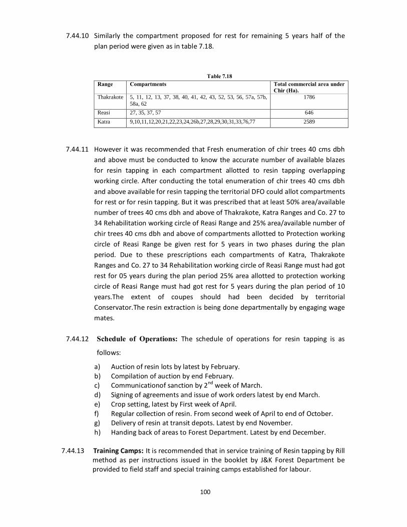
100
7.44.10 Similarly the compartment proposed for rest for remaining 5 years half of the plan period were given as in table 7.18.
Table 7.18 Range Compartments Total commercial area under
Chir (Ha). Thakrakote 5, 11, 12, 13, 37, 38, 40, 41, 42, 43, 52, 53, 56, 57a, 57b,
58a, 62 1786
Reasi 27, 35, 37, 57 646 Katra 9,10,11,12,20,21,22,23,24,26b,27,28,29,30,31,33,76,77 2589
7.44.11 However it was recommended that Fresh enumeration of chir trees 40 cms dbh
and above must be conducted to know the accurate number of available blazes for resin tapping in each compartment allotted to resin tapping overlapping working circle. After conducting the total enumeration of chir trees 40 cms dbh and above available for resin tapping the territorial DFO could allot compartments for rest or for resin tapping. But it was prescribed that at least 50% area/available number of trees 40 cms dbh and above of Thakrakote, Katra Ranges and Co. 27 to 34 Rehabilitation working circle of Reasi Range and 25% area/available number of chir trees 40 cms dbh and above of compartments allotted to Protection working circle of Reasi Range be given rest for 5 years in two phases during the plan period. Due to these prescriptions each compartments of Katra, Thakrakote Ranges and Co. 27 to 34 Rehabilitation working circle of Reasi Range must had got rest for 05 years during the plan period 25% area allotted to protection working circle of Reasi Range must had got rest for 5 years during the plan period of 10 years.The extent of coupes should had been decided by territorial Conservator.The resin extraction is being done departmentally by engaging wage mates.
7.44.12 Schedule of Operations: The schedule of operations for resin tapping is as
follows:
a) Auction of resin lots by latest by February. b) Compilation of auction by end February. c) Communicationof sanction by 2nd week of March. d) Signing of agreements and issue of work orders latest by end March. e) Crop setting, latest by First week of April. f) Regular collection of resin. From second week of April to end of October. g) Delivery of resin at transit depots. Latest by end November. h) Handing back of areas to Forest Department. Latest by end December.
7.44.13 Training Camps: It is recommended that in service training of Resin tapping by Rill
method as per instructions issued in the booklet by J&K Forest Department be provided to field staff and special training camps established for labour.
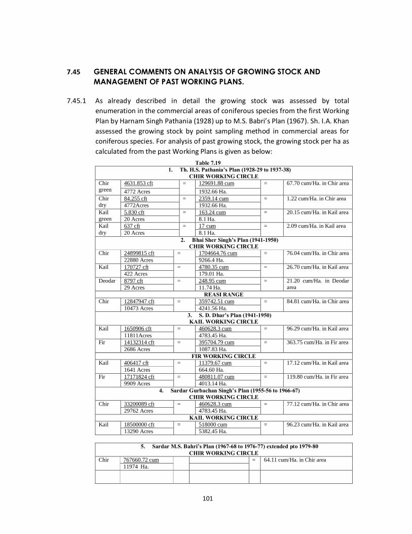
101
7.45 GENERAL COMMENTS ON ANALYSIS OF GROWING STOCK AND
MANAGEMENT OF PAST WORKING PLANS.
7.45.1 As already described in detail the growing stock was assessed by total enumeration in the commercial areas of coniferous species from the first Working Plan by Harnam Singh Pathania (1928) up to M.S. Babri’s Plan (1967). Sh. I.A. Khan assessed the growing stock by point sampling method in commercial areas for coniferous species. For analysis of past growing stock, the growing stock per ha as calculated from the past Working Plans is given as below:
Table 7.19 1. Th. H.S. Pathania’s Plan (1928-29 to 1937-38)
CHIR WORKING CIRCLE Chir green
4631.853 cft = 129691.88 cum = 67.70 cum/Ha. in Chir area 4772 Acres 1932.66 Ha.
Chir dry
84.255 cft = 2359.14 cum = 1.22 cum/Ha. in Chir area 4772Acres 1932.66 Ha.
Kail green
5.830 cft = 163.24 cum = 20.15 cum/Ha. in Kail area 20 Acres 8.1 Ha.
Kail dry
637 cft = 17 cum = 2.09 cum/Ha. in Kail area 20 Acres 8.1 Ha.
2. Bhai Sher Singh’s Plan (1941-1950) CHIR WORKING CIRCLE
Chir 24899815 cft = 1704664.76 cum = 76.04 cum/Ha. in Chir area 22880 Acres 9266.4 Ha.
Kail 170727 cft = 4780.35 cum = 26.70 cum/Ha. in Kail area 422 Acres 179.01 Ha.
Deodar 8797 cft = 248.95 cum = 21.20 cum/Ha. in Deodar area 29 Acres 11.74 Ha.
REASI RANGE Chir 12847947 cft = 359742.51 cum = 84.81 cum/Ha. in Chir area
10473 Acres 4241.56 Ha. 3. S. D. Dhar’s Plan (1941-1950) KAIL WORKING CIRCLE
Kail 1650906 cft = 460628.3 cum = 96.29 cum/Ha. in Kail area 11811Acres 4783.45 Ha.
Fir 14132314 cft = 395704.79 cum = 363.75 cum/Ha. in Fir area 2686 Acres 1087.83 Ha.
FIR WORKING CIRCLE Kail 406417 cft = 11379.67 cum = 17.12 cum/Ha. in Kail area
1641 Acres 664.60 Ha. Fir 17171824 cft = 480811.07 cum = 119.80 cum/Ha. in Fir area
9909 Acres 4013.14 Ha. 4. Sardar Gurbachan Singh’s Plan (1955-56 to 1966-67)
CHIR WORKING CIRCLE Chir 33200089 cft = 460628.3 cum = 77.12 cum/Ha. in Chir area
29762 Acres 4783.45 Ha. KAIL WORKING CIRCLE
Kail 18500000 cft = 518000 cum = 96.23 cum/Ha. in Kail area 13290 Acres 5382.45 Ha.
5. Sardar M.S. Bahri’s Plan (1967-68 to 1976-77) extended pto 1979-80
CHIR WORKING CIRCLE Chir 767660.72 cum = 64.11 cum/Ha. in Chir area
11974 Ha.
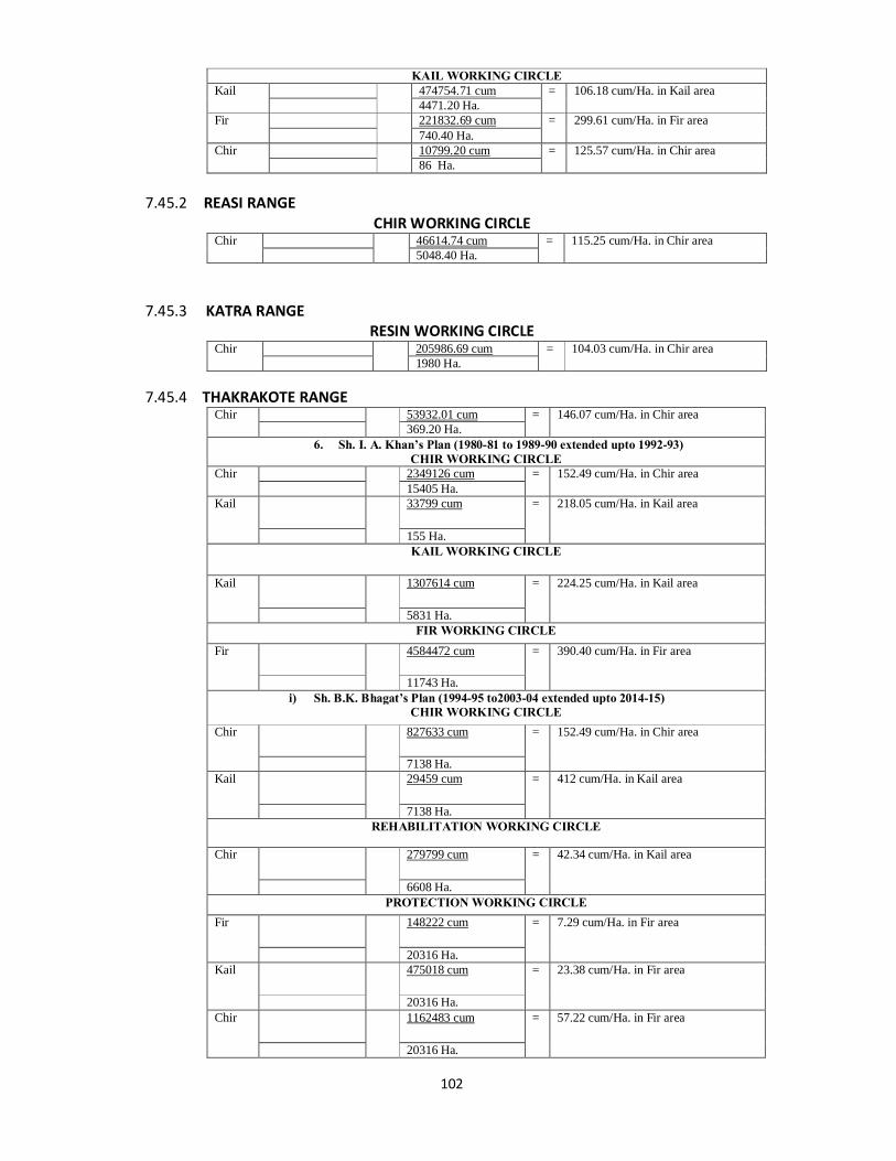
102
KAIL WORKING CIRCLE Kail 474754.71 cum = 106.18 cum/Ha. in Kail area
4471.20 Ha. Fir 221832.69 cum = 299.61 cum/Ha. in Fir area
740.40 Ha. Chir 10799.20 cum = 125.57 cum/Ha. in Chir area
86 Ha. 7.45.2 REASI RANGE
CHIR WORKING CIRCLE Chir 46614.74 cum = 115.25 cum/Ha. in Chir area
5048.40 Ha. 7.45.3 KATRA RANGE
RESIN WORKING CIRCLE Chir 205986.69 cum = 104.03 cum/Ha. in Chir area
1980 Ha. 7.45.4 THAKRAKOTE RANGE
Chir 53932.01 cum = 146.07 cum/Ha. in Chir area 369.20 Ha.
6. Sh. I. A. Khan’s Plan (1980-81 to 1989-90 extended upto 1992-93) CHIR WORKING CIRCLE
Chir 2349126 cum = 152.49 cum/Ha. in Chir area 15405 Ha.
Kail 33799 cum = 218.05 cum/Ha. in Kail area
155 Ha. KAIL WORKING CIRCLE
Kail 1307614 cum = 224.25 cum/Ha. in Kail area
5831 Ha. FIR WORKING CIRCLE
Fir 4584472 cum = 390.40 cum/Ha. in Fir area
11743 Ha. i) Sh. B.K. Bhagat’s Plan (1994-95 to2003-04 extended upto 2014-15)
CHIR WORKING CIRCLE Chir 827633 cum = 152.49 cum/Ha. in Chir area
7138 Ha. Kail 29459 cum = 412 cum/Ha. in Kail area
7138 Ha. REHABILITATION WORKING CIRCLE
Chir 279799 cum = 42.34 cum/Ha. in Kail area
6608 Ha. PROTECTION WORKING CIRCLE
Fir 148222 cum = 7.29 cum/Ha. in Fir area
20316 Ha. Kail 475018 cum = 23.38 cum/Ha. in Fir area
20316 Ha. Chir 1162483 cum = 57.22 cum/Ha. in Fir area
20316 Ha.
103
7.45.5 In Chir Working Circle it is seen that average volume per ha of Chir has increased from 68 cum/Ha from Th.Harnam Singh Pathania’s plan (1928) to 145 cum. per ha in the current plan.
7.45.6 For further analysis of growing stock total enumeration was carried out in Co. 13
Tkt., 47/R and 97/K. The variation in total enumeration results i.e. number of trees and volume of the whole given in tables 7-I, 5-IV.
7.45.7 From these tables it is seen that in Co, 47/R there is more variation in stock
mapping in all the Working plans. There is no variation in volume in Th. H.S. Pathania’s, Bhai Sher Singh’s and S/Gurbachan Singh’s plan. This compartment was allotted for felling during Th. Harnam Singh Pathhania’s plan for artificial regeneration during Bhai Sher Singh’s plan and for felling during M.S. Bahri’s plan. But in Bahri’s plan which is the revision of Gurbachan Singh’s plan within 10 years the total number of trees and total volume has been shown increased approximately three times in case of Chir and two times in case of Kail. In 1977-78 only 1098 trees 2600 cum were extracted during Bahri’s plan. During total enumeration of Co. 47/R in 1992.8963 trees 12783 cum. Above 30 cms. Dbh of chir and Kail were enumerated. By adding the felled trees during 1977-78 the total number and volume becomes 10061 trees 15383 cum. The enumeration results of M.S. Bahri’s plan (1967) were 1235.
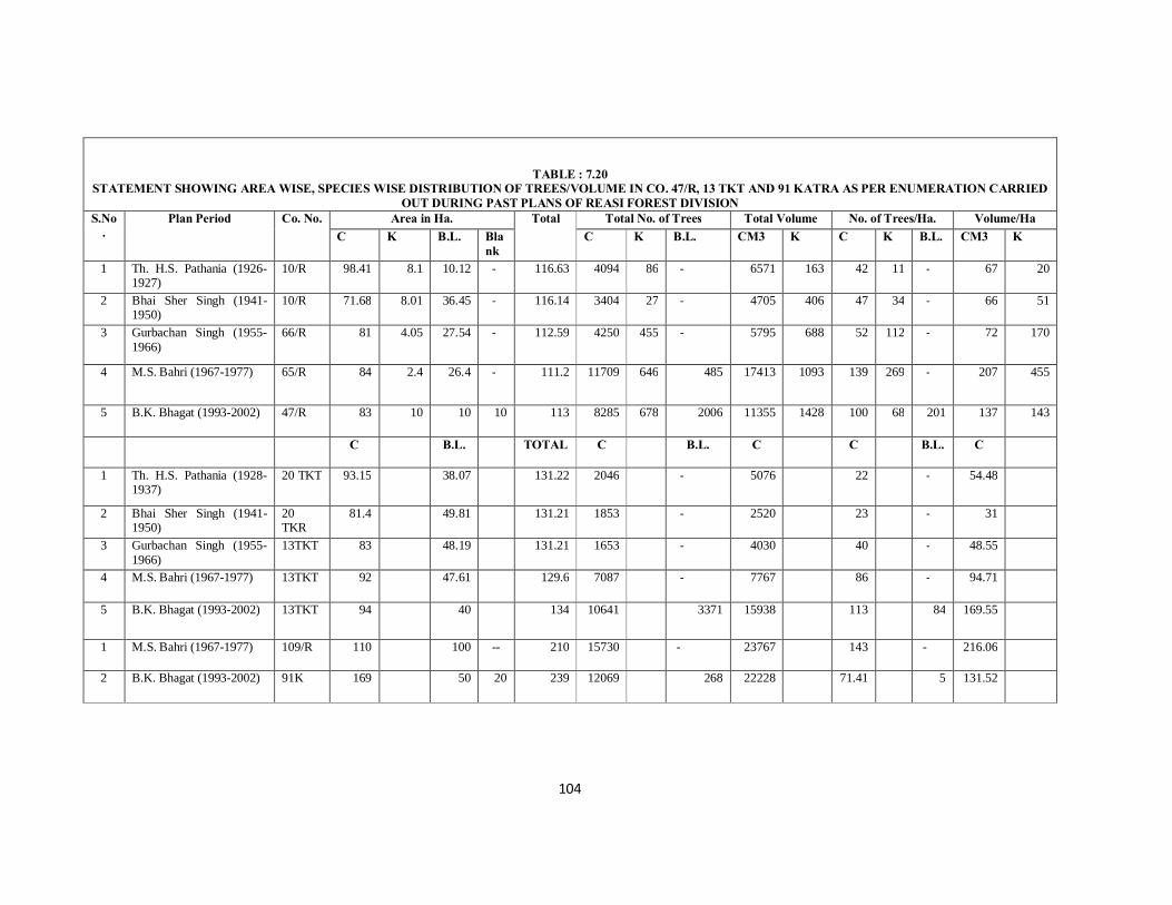
104
TABLE : 7.20 STATEMENT SHOWING AREA WISE, SPECIES WISE DISTRIBUTION OF TREES/VOLUME IN CO. 47/R, 13 TKT AND 91 KATRA AS PER ENUMERATION CARRIED
OUT DURING PAST PLANS OF REASI FOREST DIVISION S.No
. Plan Period Co. No. Area in Ha. Total Total No. of Trees Total Volume No. of Trees/Ha. Volume/Ha
C K B.L. Blank
C K B.L. CM3 K C K B.L. CM3 K
1 Th. H.S. Pathania (1926-1927)
10/R 98.41 8.1 10.12 - 116.63 4094 86 - 6571 163 42 11 - 67 20
2 Bhai Sher Singh (1941-1950)
10/R 71.68 8.01 36.45 - 116.14 3404 27 - 4705 406 47 34 - 66 51
3 Gurbachan Singh (1955-1966)
66/R 81 4.05 27.54 - 112.59 4250 455 - 5795 688 52 112 - 72 170
4 M.S. Bahri (1967-1977) 65/R 84 2.4 26.4 - 111.2 11709 646 485 17413 1093 139 269 - 207 455
5 B.K. Bhagat (1993-2002) 47/R 83 10 10 10 113 8285 678 2006 11355 1428 100 68 201 137 143
C B.L. TOTAL C B.L. C C B.L. C
1 Th. H.S. Pathania (1928-1937)
20 TKT 93.15 38.07 131.22 2046 - 5076 22 - 54.48
2 Bhai Sher Singh (1941-1950)
20 TKR
81.4 49.81 131.21 1853 - 2520 23 - 31
3 Gurbachan Singh (1955-1966)
13TKT 83 48.19 131.21 1653 - 4030 40 - 48.55
4 M.S. Bahri (1967-1977) 13TKT 92 47.61 129.6 7087 - 7767 86 - 94.71
5 B.K. Bhagat (1993-2002) 13TKT 94 40 134 10641 3371 15938 113 84 169.55
1 M.S. Bahri (1967-1977) 109/R 110 100 -- 210 15730 - 23767 143 - 216.06
2 B.K. Bhagat (1993-2002) 91K 169 50 20 239 12069 268 22228 71.41 5 131.52
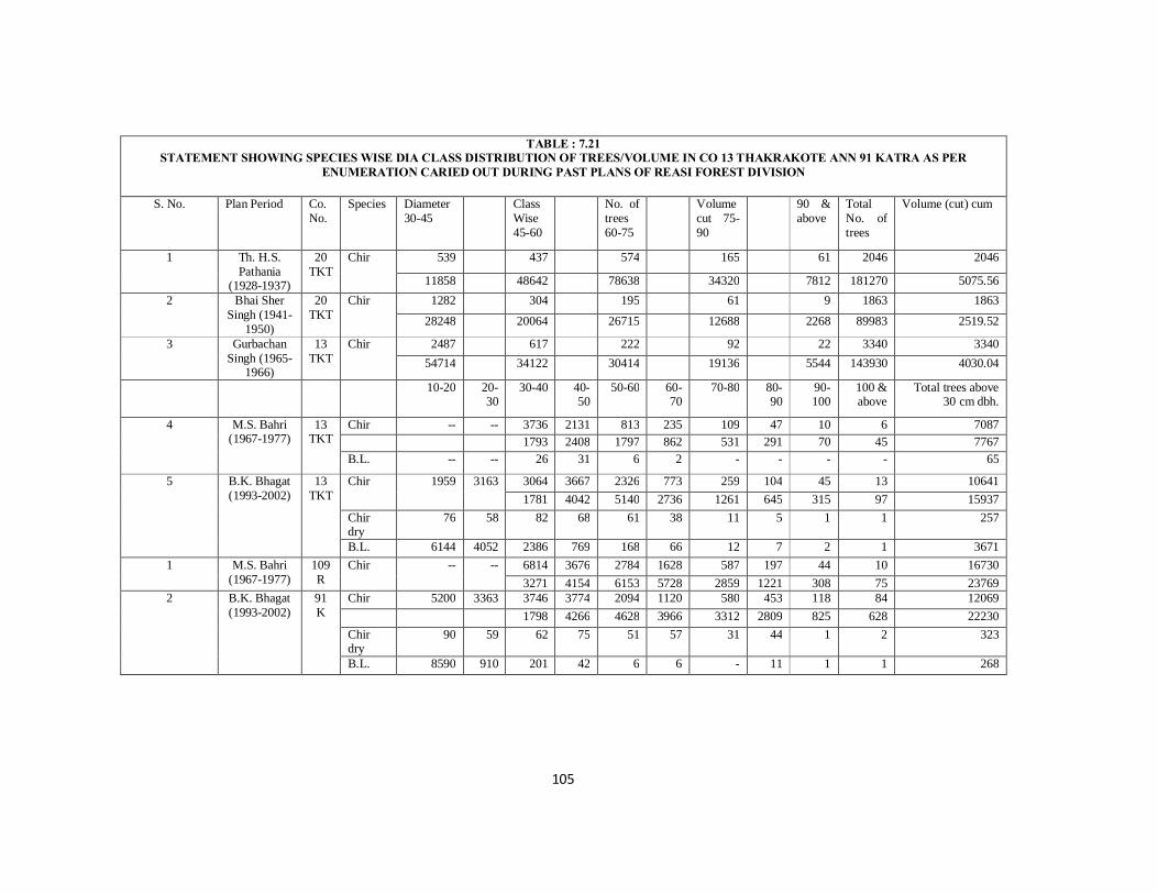
105
TABLE : 7.21 STATEMENT SHOWING SPECIES WISE DIA CLASS DISTRIBUTION OF TREES/VOLUME IN CO 13 THAKRAKOTE ANN 91 KATRA AS PER
ENUMERATION CARIED OUT DURING PAST PLANS OF REASI FOREST DIVISION
S. No. Plan Period Co. No.
Species Diameter 30-45
Class Wise 45-60
No. of trees 60-75
Volume cut 75-90
90 & above
Total No. of trees
Volume (cut) cum
1 Th. H.S. Pathania
(1928-1937)
20 TKT
Chir 539 437 574 165 61 2046 2046
11858 48642 78638 34320 7812 181270 5075.56 2 Bhai Sher
Singh (1941-1950)
20 TKT
Chir 1282 304 195 61 9 1863 1863 28248 20064 26715 12688 2268 89983 2519.52
3 Gurbachan Singh (1965-
1966)
13 TKT
Chir 2487 617 222 92 22 3340 3340 54714 34122 30414 19136 5544 143930 4030.04
10-20 20-30
30-40 40-50
50-60 60-70
70-80 80-90
90-100
100 & above
Total trees above 30 cm dbh.
4 M.S. Bahri (1967-1977)
13 TKT
Chir -- -- 3736 2131 813 235 109 47 10 6 7087 1793 2408 1797 862 531 291 70 45 7767 B.L. -- -- 26 31 6 2 - - - - 65
5 B.K. Bhagat (1993-2002)
13 TKT
Chir 1959 3163 3064 3667 2326 773 259 104 45 13 10641 1781 4042 5140 2736 1261 645 315 97 15937
Chir dry
76 58 82 68 61 38 11 5 1 1 257
B.L. 6144 4052 2386 769 168 66 12 7 2 1 3671 1 M.S. Bahri
(1967-1977) 109 R
Chir -- -- 6814 3676 2784 1628 587 197 44 10 16730 3271 4154 6153 5728 2859 1221 308 75 23769
2 B.K. Bhagat (1993-2002)
91 K
Chir 5200 3363 3746 3774 2094 1120 580 453 118 84 12069 1798 4266 4628 3966 3312 2809 825 628 22230 Chir dry
90 59 62 75 51 57 31 44 1 2 323
B.L. 8590 910 201 42 6 6 - 11 1 1 268

106
TABLE : 7.22 STATEMENT SHOWING SPECIES WISE DIA CLASS WISE DISTRIBUTION OF TREES/VOLUME IN CO. 47 REASI PER ENUMERATION CARRIED
OUT DURING PAST PLANS OF REASI FOREST DIVISION
S.No. Plan Period Co. No.
Species Diameter 30-45
Class Wise 45-60
No. of 60-75
Trees/Volume 75-90
90& above
Total
1 Th. H.S. Pathania (1926-1927)
10/R Chir 2032 1449 483 104 26 4094 4094 44704 95634 66171 21632 6552 234693 6571.40m3
Kail 45 23 10 6 2 86 86 1395 1633 1276 1986 446 5830 163.24 m3 2 Bhai Sher Singh
(1941-1950) 10/R Chir 1901 1182 264 53 4 3404 3404
41822 78012 36118 11024 1008 168034 4704.95m3 Kail 170 74 19 5 3 271 271
5270 5264 2413 905 669 14511 406.3m3 3 Gurbachan Singh
(1955-1966) 65/R Chir 2468 1372 535 61 14 4250 4250
54296 90552 45895 12688 3528 20695 5794.85 m3
Kail 269 144 30 11 1 455 455 8339 10224 3810 1991 223 24587 688.43 m3 10-
20 20-30 30-
40 40-50 50-60 60-70 70-80 80-90 90-
100 100 & above
Total
4 M.S. Bahri (1967-1977)
65/R Chir 4349 3764 1941 1111 404 123 15 2 11789 2088 4253.32 4289.6 3932.94 1967.48 762.6 104.85 14.96 17413.28
Kail 249 178 113 72 23 6 5 - 646 189 242.08 256.51 240.48 762.6 32.6 30.7 - 1092.77 1814 1386 992 490 202 37 13 16 1850 5 B.K. Bhagat
(1993-2002) 47/R Chir 3437 2456 1500 619 210 50 13 - 678
1643 2775.28 3315 2191.26 1022.7 310 90.87 - 11354.87 Kail 177 156 162 112 55 7 3 6 678
135 212.16 367.74 374.08 243.1 37.45 18.42 40.44 1427.91 B.L. 796 382 369 220 127 76 18 18 2006
107
7.45.8 This clears that there might have some error in stock mapping and total
enumeration in M.S. Bahri’s Plan. Of course improvement in growing stock is noted as the total number of trees and volume has doubled as compared form Th. H.S. Pathani’s Plan 1928 and enumeration figures of 1992.
7.45.9 In Co. 13/ThkT there is also variation in stock mapping area between Th.Harnam Singh Pathnia’s plan with other three working plans i.e. Bhai Sher Singh, Gurbachan Singh and M.S. Bahri’s plan. But there is no variation in stock mapping area between Th Harnam Singh Pathnia’s plan (1928) and (1992). As per records available, the compartment was prescribed for felling during Th.Harnam Singh Pathania’s plan for artificial regeneration during Bhai Sher Singh’sd plan and again prescribed for felling during Gurbachan Singh’s plan. Gurbachan Singh in his plan has remarked that this compartment could not be protected from fires, heavy grazing resulting scanty or no regeneration. 203 trees 773 cum volume were extracted from Co. 13 Tkt during 1954.
7.45.10 The number of trees and volume of Chir has been increased from 2046 trees 5076
cum volume from Th. H.S. Pathania’s plan 1928 to three times 10641 trees 15938 cum volume up to 1992.
7.45.11 In Co. 91 K no enumeration were carried out upto Gurbachan Singh’s plan. As per
M.S. Bahri’s plan 1967 there were 15730 trees 23767 cum volume. In 1992 in Co. 91/K 12069 trees 22227 cum volume were enumerated. Hence 1992 enumeration results show decrease of 3661 trees 1540 cum volume within 25 years. This decrease in volume within 25 years cannot be justified. Of course large number of Chir trees have fallen naturally and some broken to ground level due to large and deep size and more than prescribed number of resin channels given for resin tapping during past. There is also difference in stock mapping area and total area in Co. 91 K. As there might be some error in area calculation similarly there might some error in total enumeration in M.S. Bahri’s plan. From this analysis it further becomes clear that in most of Forest area growing stock has increased in spite of facing the threat of increasing human being and domestic animal population. It is observed that growing stock has degraded or even completely removed with alarming speed adjoining human habitation adjoining Forest areas linked by motor able roads due to heavy biotic pressure for other developmental activities and higher standard of living of people.
7.45.12 As per objects of management all the Working Plan Officers have laid stress on 1) To obtain the normal Forest and the maximum sustained yield of timber and revenue by exploiting all species of economic values. 2) To conserve, protect and improve the existing Forest and vegetative cover in the interest of Soil and Water Conservation and to maintain in optimum water regime.
108
7.45.13 The methods of treatments prescribed were not fully implemented. The treatments prescribed were implemented up to 40% only in fellings and resin extraction etc. In these also some compartments not allotted for fellings were felled and on resin extraction there were irregularities in size i.e. length, breath, depth and number of channels. Due to those irregularities Some Chir Forests have degraded i.e. some Chir trees tapped by more than the prescribed channels having irregularities in size of length, breath, depth of channels have dried and broken to ground level.
7.45.14 All the plan prescriptions in respect of subsidiary silvicultural operations, closures, regeneration, fire lines etc. were not implemented.
7.45.15 There might be some errors variations in stock mapping, area calculation in the past plans. As the method of stock mapping i.e. ocular estimate resulting some variation in different Working Plans. The stock maps in this Working Plan have also prepared as per ocular estimate. Because the large scale thematic maps and the Satellite imageries were not available for Reasi Forest Division.
7.45.16 The growing stock in this plan has also been assessed by point sampling as in the previous I.A. Khan’s plan. The main advantage of point sampling is that it is quickest easy and cheap method and required trained but less staff.
7.45.17 The main drawback in this method is that it gives the basal area, number of trees or the volume for the entire/strain of the Working Circle. We cannot know the growing stock of each individual compartment hence the aim of future management fails. The exercise of writing compartment description histories and even stock mapping is futile for each individual compartment without knowing the correct total diameter class wise and species wise growing stock.
7.45.18 On the other hand the total enumeration is costly different more time consuming requires hard work and more staff.
7.45.19 The main advantage of the total enumeration is that accurate Diameter class wise, species wise growing stock of each individual Compartment is known. Hence, there is clear record of each and individual compartment. The Working Plan Officer can be made responsible for accurate diameter class wise and species wise number of trees of each individual compartment. Similarly the territorial staff from beat guard to DFO have the knowledge of trees enumerated in each compartment of the previous plan may have a check on the revised Working plan. The main draw back in total enumeration is that it becomes difficult to carry out total enumeration on very steep slopes, Broad leaved mixed with scrub Forests especially in thorny scrubs.
7.45.20 Keeping in view the above points it is suggested that total enumeration be
referred over point sampling for assessment of growing stock. However point
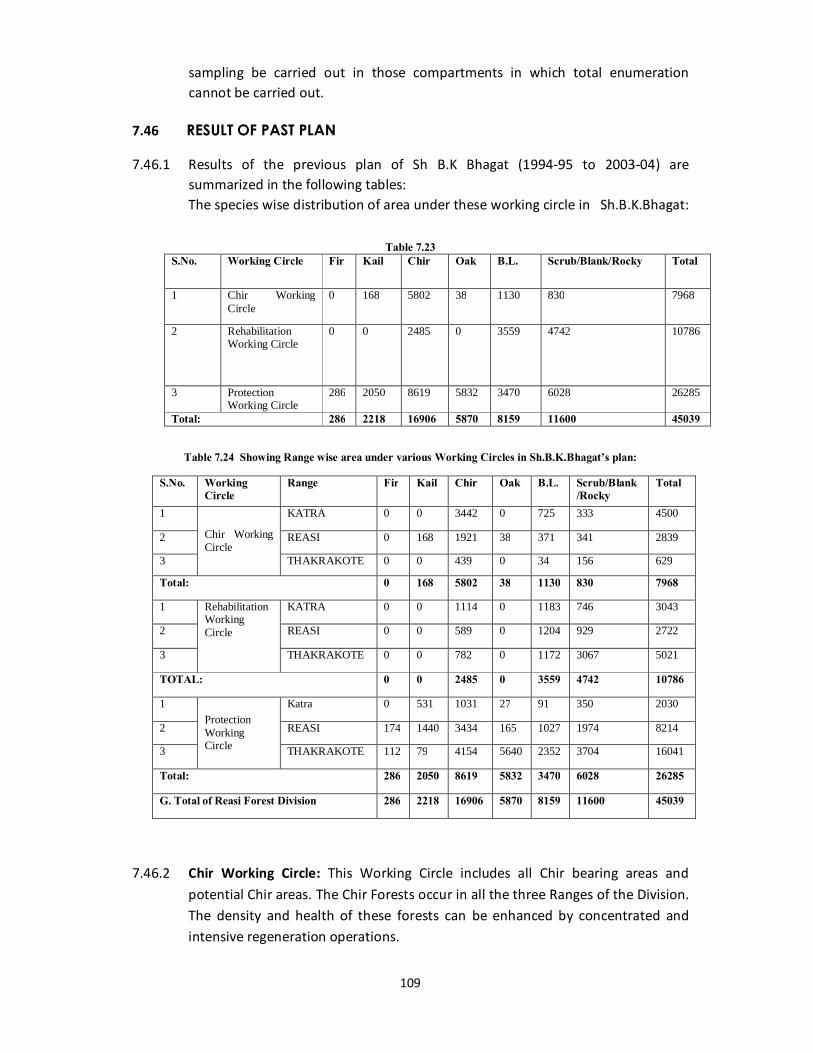
109
sampling be carried out in those compartments in which total enumeration cannot be carried out.
7.46 RESULT OF PAST PLAN
7.46.1 Results of the previous plan of Sh B.K Bhagat (1994-95 to 2003-04) are summarized in the following tables:
The species wise distribution of area under these working circle in Sh.B.K.Bhagat:
Table 7.23 S.No. Working Circle Fir Kail Chir Oak B.L. Scrub/Blank/Rocky Total
1 Chir Working Circle
0 168 5802 38 1130 830 7968
2 Rehabilitation Working Circle
0 0 2485 0 3559 4742 10786
3 Protection Working Circle
286 2050 8619 5832 3470 6028 26285
Total: 286 2218 16906 5870 8159 11600 45039
Table 7.24 Showing Range wise area under various Working Circles in Sh.B.K.Bhagat’s plan:
7.46.2 Chir Working Circle: This Working Circle includes all Chir bearing areas and potential Chir areas. The Chir Forests occur in all the three Ranges of the Division. The density and health of these forests can be enhanced by concentrated and intensive regeneration operations.
S.No. Working Circle
Range Fir Kail Chir Oak B.L. Scrub/Blank /Rocky
Total
1
Chir Working Circle
KATRA 0 0 3442 0 725 333 4500
2 REASI 0 168 1921 38 371 341 2839
3 THAKRAKOTE 0 0 439 0 34 156 629
Total: 0 168 5802 38 1130 830 7968
1 Rehabilitation Working Circle
KATRA 0 0 1114 0 1183 746 3043
2 REASI 0 0 589 0 1204 929 2722
3 THAKRAKOTE 0 0 782 0 1172 3067 5021
TOTAL: 0 0 2485 0 3559 4742 10786
1 Protection Working Circle
Katra 0 531 1031 27 91 350 2030
2 REASI 174 1440 3434 165 1027 1974 8214
3 THAKRAKOTE 112 79 4154 5640 2352 3704 16041
Total: 286 2050 8619 5832 3470 6028 26285
G. Total of Reasi Forest Division 286 2218 16906 5870 8159 11600 45039
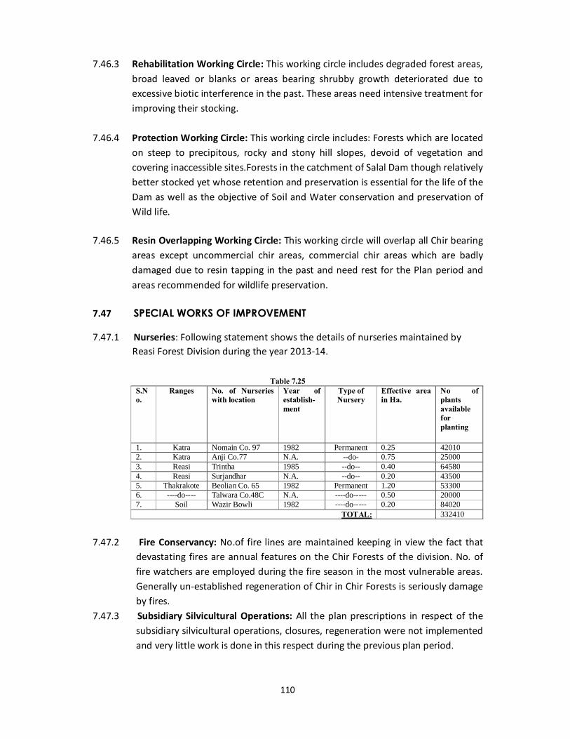
110
7.46.3 Rehabilitation Working Circle: This working circle includes degraded forest areas,
broad leaved or blanks or areas bearing shrubby growth deteriorated due to excessive biotic interference in the past. These areas need intensive treatment for improving their stocking.
7.46.4 Protection Working Circle: This working circle includes: Forests which are located
on steep to precipitous, rocky and stony hill slopes, devoid of vegetation and covering inaccessible sites.Forests in the catchment of Salal Dam though relatively better stocked yet whose retention and preservation is essential for the life of the Dam as well as the objective of Soil and Water conservation and preservation of Wild life.
7.46.5 Resin Overlapping Working Circle: This working circle will overlap all Chir bearing
areas except uncommercial chir areas, commercial chir areas which are badly damaged due to resin tapping in the past and need rest for the Plan period and areas recommended for wildlife preservation.
7.47 SPECIAL WORKS OF IMPROVEMENT
7.47.1 Nurseries: Following statement shows the details of nurseries maintained by Reasi Forest Division during the year 2013-14.
Table 7.25
S.No.
Ranges No. of Nurseries with location
Year of establish-ment
Type of Nursery
Effective area in Ha.
No of plants available for planting
1. Katra Nomain Co. 97 1982 Permanent 0.25 42010 2. Katra Anji Co.77 N.A. --do- 0.75 25000 3. Reasi Trintha 1985 --do-- 0.40 64580 4. Reasi Surjandhar N.A. --do-- 0.20 43500 5. Thakrakote Beolian Co. 65 1982 Permanent 1.20 53300 6. ----do---- Talwara Co.48C N.A. ----do----- 0.50 20000 7. Soil Wazir Bowli 1982 ----do----- 0.20 84020
TOTAL: 332410
7.47.2 Fire Conservancy: No.of fire lines are maintained keeping in view the fact that devastating fires are annual features on the Chir Forests of the division. No. of fire watchers are employed during the fire season in the most vulnerable areas. Generally un-established regeneration of Chir in Chir Forests is seriously damage by fires.
7.47.3 Subsidiary Silvicultural Operations: All the plan prescriptions in respect of the subsidiary silvicultural operations, closures, regeneration were not implemented and very little work is done in this respect during the previous plan period.
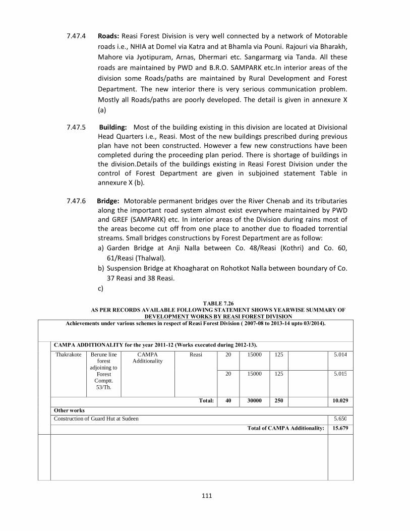
111
7.47.4 Roads: Reasi Forest Division is very well connected by a network of Motorable roads i.e., NHIA at Domel via Katra and at Bhamla via Pouni. Rajouri via Bharakh, Mahore via Jyotipuram, Arnas, Dhermari etc. Sangarmarg via Tanda. All these roads are maintained by PWD and B.R.O. SAMPARK etc.In interior areas of the division some Roads/paths are maintained by Rural Development and Forest Department. The new interior there is very serious communication problem. Mostly all Roads/paths are poorly developed. The detail is given in annexure X (a)
7.47.5 Building: Most of the building existing in this division are located at Divisional Head Quarters i.e., Reasi. Most of the new buildings prescribed during previous plan have not been constructed. However a few new constructions have been completed during the proceeding plan period. There is shortage of buildings in the division.Details of the buildings existing in Reasi Forest Division under the control of Forest Department are given in subjoined statement Table in annexure X (b).
7.47.6 Bridge: Motorable permanent bridges over the River Chenab and its tributaries
along the important road system almost exist everywhere maintained by PWD and GREF (SAMPARK) etc. In interior areas of the Division during rains most of the areas become cut off from one place to another due to floaded torrential streams. Small bridges constructions by Forest Department are as follow: a) Garden Bridge at Anji Nalla between Co. 48/Reasi (Kothri) and Co. 60,
61/Reasi (Thalwal). b) Suspension Bridge at Khoagharat on Rohotkot Nalla between boundary of Co.
37 Reasi and 38 Reasi. c)
TABLE 7.26
AS PER RECORDS AVAILABLE FOLLOWING STATEMENT SHOWS YEARWISE SUMMARY OF DEVELOPMENT WORKS BY REASI FOREST DIVISION
Achievements under various schemes in respect of Reasi Forest Division ( 2007-08 to 2013-14 upto 03/2014).
CAMPA ADDITIONALITY for the year 2011-12 (Works executed during 2012-13). Thakrakote Berune line
forest adjoining to
Forest Comptt. 53/Th.
CAMPA Additionality
Reasi 20 15000 125 5.014
20 15000 125 5.015
Total: 40 30000 250 10.029 Other works Construction of Guard Hut at Sudeen 5.650
Total of CAMPA Additionality: 15.679
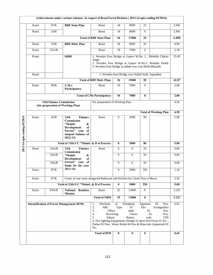
112
Achievements under various schemes in respect of Reasi Forest Division ( 2013-14 upto ending 03/2014).
2013
-14
upto
end
ing
03/2
014
Katra 97/K RDF State Plan Reasi 18 9000 25 3.945
Reasi 33/R Reasi 18 8000 0 2.905
Total of RDF State Plan: 36 17000 25 6.850
Reasi 35/R RDF Distt. Plan Reasi 18 8000 50 4.89
Katra 22/u/K Reasi 18 7000 0 2.18
Pouni SDRF 1. Wooden Foot Bridge at Gajore W.No. 1 , Mohalla Chatter Singh 2. Wooden Foot Bridge at Gajore W.No.2. Mohalla Pandit 3. Wooden Foot Bridge at nallah over Last Morh Bharakh
35.00
Reasi 1. Wooden Foot Bridge over Nallah Sulli, Sujandhar
Total of RDF Distt. Plan: 36 15000 50 42.07
Katra 89/K C.M.s Participatory
Reasi 10 7000 0 2.00
Total of CMs Participatory 10 7000 0 2.00
13th Finance Commission (for preparation of Working Plan)
For preparation of Working Plan 4.50
Total of Working Plan 4.50 Katra 43/R 13th Finance
Commission "Maintt. & Development of Forests" (out of unspent balance of 2012-13)
Reasi 0 3000 80 5.00
Total of 13th F.C "Maintt. & D of Forests: 0 3000 80 5.00
Reasi 18/a/R 13th Finance Commission "Maintt. & Development of Forests" (out of funds for the year 2013-14)
Reasi 0 0 50 0.86
18/a/R 0 0 50 0.86
19/b/R 0 0 50 0.68
Katra 87/K 0 5000 100 1.10
Katra 87/K Const. of one room alongwith Bathroom and Kitchen for Check Post at Moori. 5.50
Total of 13th F.C "Maintt. & D of Forests: 0 5000 250 9.00
Katra 83/b/K National Bamboo Mission
Reasi 25 13000 0 3.221
Total of NBM 25 13000 0 3.221
Intensification of Forest Management (IFM) 1. Purchase of Telephone Appratus 02 Nos. 2. ABC Type FC Fire Extinguisher 3. Office table 02 Nos. 4. Revolving Chairs 02 Nos. 5. Sukam Batery with UPS 6. Fire fighting Equipments (Dangri (Cotton Dril Dress 01 No. , Pathas 02 Nos., Water Bottle 04 Nos & Binocular (imported) 01 No.
0.65
Total of IFM 0 0 0 0.65
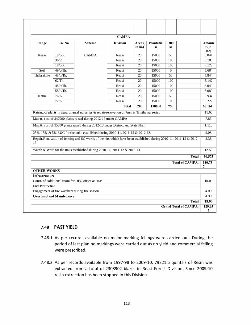
113
CAMPA
Range Co. No Scheme Division Area ( in ha)
Plantation
DRSM
Amount (in lac)
Reasi 19/b/R CAMPA Reasi 20 15000 50 5.844 36/R Reasi 20 15000 100 6.183 18/b/R Reasi 20 15000 100 6.173
Soil 49/c/Th. Reasi 20 15000 0 5.684 Thakrakote 48/b/Th. Reasi 20 15000 50 5.844
62/Th. Reasi 20 15000 100 6.142 48/c/Th. Reasi 20 15000 100 6.049 58/b/Th. Reasi 20 15000 100 6.089
Katra 76/K Reasi 20 15000 50 5.934 77/K Reasi 20 15000 100 6.222
Total 200 150000 750 60.164
Raising of plants in departmental nurseries & repair/renovation of Anji & Trintha nurseries 11.60
Maintt. cost of 247000 plants raised during 2012-13 under CAMPA 7.85
Maintt. cost of 35000 plants raised during 2012-13 under District and State Plan 1.113
25%, 15% & 5% BUC for the units established during 2010-11, 2011-12 & 2012-13. 9.08
Repair/Renovation of fencing and SC works of the nits which have been established during 2010-11, 2011-12 & 2012-13.
8.38
Watch & Ward for the units established during 2010-11, 2011-12 & 2012-13. 12.55
Total 50.573 Total of CAMPA: 110.73
7 OTHER WORKS Infrastructure Const. of Additional room for DFO office at Reasi 10.00 Fire Protection Engagement of fire watchers during fire season. 4.00 Overhead and Maintenance 4.90
Total 18.90 Grand Total of CAMPA: 129.63
7 7.48 PAST YIELD
7.48.1 As per records available no major marking fellings were carried out. During the period of last plan no markings were carried out as no yield and commercial felling were prescribed.
7.48.2 As per records available from 1997-98 to 2009-10, 79321.6 quintals of Resin was
extracted from a total of 2308902 blazes in Reasi Forest Division. Since 2009-10 resin extraction has been stopped in this Division.
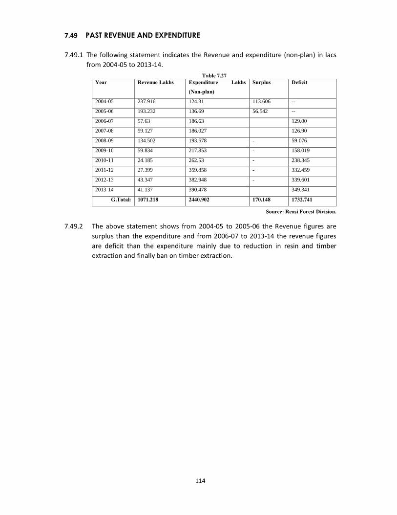
114
7.49 PAST REVENUE AND EXPENDITURE 7.49.1 The following statement indicates the Revenue and expenditure (non-plan) in lacs
from 2004-05 to 2013-14. Table 7.27
Year Revenue Lakhs Expenditure Lakhs (Non-plan)
Surplus Deficit
2004-05 237.916 124.31 113.606 --
2005-06 193.232 136.69 56.542 --
2006-07 57.63 186.63 129.00
2007-08 59.127 186.027 126.90
2008-09 134.502 193.578 - 59.076
2009-10 59.834 217.853 - 158.019
2010-11 24.185 262.53 - 238.345
2011-12 27.399 359.858 - 332.459
2012-13 43.347 382.948 - 339.601
2013-14 41.137 390.478 349.341
G.Total: 1071.218 2440.902 170.148 1732.741
Source: Reasi Forest Division.
7.49.2 The above statement shows from 2004-05 to 2005-06 the Revenue figures are surplus than the expenditure and from 2006-07 to 2013-14 the revenue figures are deficit than the expenditure mainly due to reduction in resin and timber extraction and finally ban on timber extraction.
115
CHAPTER VIII
STATISTICS OF GROWTH AND YIELD VOLUME TABLE
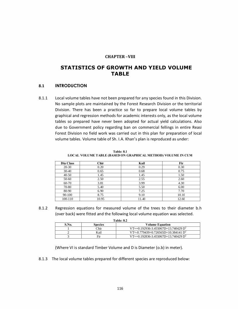
116
CHAPTER –VIII
STATISTICS OF GROWTH AND YIELD VOLUME TABLE
8.1 INTRODUCTION 8.1.1 Local volume tables have not been prepared for any species found in this Division.
No sample plots are maintained by the Forest Research Division or the territorial Division. There has been a practice so far to prepare local volume tables by graphical and regression methods for academic interests only, as the local volume tables so prepared have never been adopted for actual yield calculations. Also due to Government policy regarding ban on commercial fellings in entire Reasi Forest Division no field work was carried out in this plan for preparation of local volume tables. Volume table of Sh. I.A. Khan’s plan is reproduced as under:
Table: 8.1
LOCAL VOLUME TABLE (BASED ON GRAPHICAL METHOD) VOLUME IN CUM
Dia Class Chir Kail Fir 20-30 0.20 0.29 0.30 30-40 0.65 0.68 0.75 40-50 1.45 1.45 1.50 50-60 2.50 2.55 2.60 60-70 3.81 3.99 4.30 70-80 5.40 5.50 6.00 80-90 6.90 7.25 7.70
90-100 8.75 9.10 10.10 100-110 10.95 11.40 12.60
8.1.2 Regression equations for measured volume of the trees to their diameter b.h
(over back) were fitted and the following local volume equation was selected. Table: 8.2
S.No. Species Volume Equation 1 Chir VT=+0.192936-3.455067D+13.740429 D2 2 Kail VT=-0.779439+0.726565D+10.384141 D2 3 Fir VT=+0.192836-3.455067D+13.740429 D2
(Where VI is standard Timber Volume and D is Diameter (o.b) in meter).
8.1.3 The local volume tables prepared for different species are reproduced below:
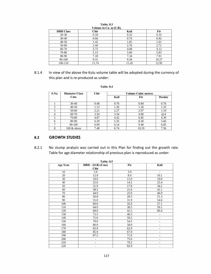
117
Table: 8.3 Volume in Cu. m (U.B).
DBH Class Chir Kail Fir 20-30 0.18 0.32 0.35 30-40 0.66 0.74 0.82 40-50 1.42 1.65 1.61 50-60 2.44 2.76 2.71 60-70 3.75 4.08 4.12 70-80 5.13 5.60 5.83 80-90 7.18 7.34 7.91
90-100 9.31 9.28 10.27 100-110 11.74 11.42 12.95
8.1.4 In view of the above the Kulu volume table will be adopted during the currency of
this plan and is re-produced as under:
Table: 8.4
S.No. Diameter Class Cms.
Chir Volume Cubic metres Kail Fir Deodar
1 30-40 0.48 0.76 0.84 0.76 2 40-50 1.13 1.36 1.56 1.33 3 50-60 2.21 2.27 2.97 1.10 4 60-70 3.54 3.34 4.90 ī.14 5 70-80 4.87 4.42 6.85 4.39 6 80-90 6.20 5.35 8.30 5.66 7 90-100 6.99 6.14 9.40 6.85 8 100 & above 7.48 6.74 10.19 7.56
8.2 GROWTH STUDIES 8.2.1 No stump analysis was carried out in this Plan for finding out the growth rate.
Table for age diameter relationship of previous plan is reproduced as under:
Table: 8.5 Age Year DBH – (O.B) (Cms)
Chir Fir Kail
10 5.9 3.9 - 20 12.9 8.0 10.1 30 19.0 11.0 19.0 40 25.0 14.5 25.4 50 31.9 17.8 34.2 60 38.5 21.0 41.1 70 44.9 25.0 46.9 80 50.8 28.5 51.3 90 55.0 31.9 54.6
100 60.0 35.0 57.1 110 64.0 38.5 59.1 120 68.0 42.5 60.4 130 72.5 46.5 - 140 75.0 50.5 - 150 79.0 54.5 - 160 80.9 58.9 - 170 83.9 62.9 - 180 85.9 67.0 - 190 87.5 71.0 - 200 - 75.0 - 210 - 79.2 - 220 - 82.9 -
118
8.3 QUALITY CLASS
8.3.1 The quality classes vary from place to place depending upon the locality factors of the area. The quality class of Chir generally varied from II/III to III in this area. The quality class of Kail and Fir is I/II to II.
8.4 METHODOLOGY ADOPTED FOR THE ASSESSMENT AND PREPARATION INVENTORY OF THE GROWING STOCK.
8.4.1 The stratified random sampling with the Bitter lick technique known as Point sampling or Plot sampling or probability proportional to size P.P.S., has been continued to assess and prepare the inventory of the growing stock, as was used in previous plan. The sampling unit is a random point around which the crop measurement and description has been noted in accordance with standard forms.
8.4.2 This method has been using by the Working Plan Officers in this State for the last two decades and is found quite suitable to this division as also where, exhibit tremendous variability in respect of their composition, local factors the slopes etc. for which stratified random sampling is prepared to other types of sampling. This method is suitable to assess the growing stock on hill slopes. The stratification (i.e. method of Division of heterogeneous population into more or less internally homogenous sub-populations called strata) of the Forests are stratified into different strata by lumping together alike compartments having as much homogeneity as possible among themselves has been done in various stages given below:
8.5 TOTAL DEMARCATED FORESTS OF THE DIVISION
8.5.1 First stage stratification of total demarcated forests are into wooded area including commercial and uncommercial area.
8.5.2 Second stage stratification of wooded area into 1. Substratum I i.e. Protection stratum 2. Substratum II i.e. Rehabilitation stratum. 8.5.3 Third stage stratification, Substratum I i.e. Protection stratum & Substratum II i.e.
Rehabilitation stratum into 1. Chir. 2. Kail. 3. Broad leaved. 4. Oak, Scrub & Blank.
8.5.4 After having done the stratification the number of sample points required to be surveyed and measured in each of the above strata to achieve the desired precision of 20% at 95% probability level was computed stratum wise. It was based on the co-efficient of variation for the most important variable of interest (i.e. volume per hectare) calculated from the statistical Analysis of the previous Working Plan. The number of Sample Points has therefore been calculated by adopting following standard statistical formula.
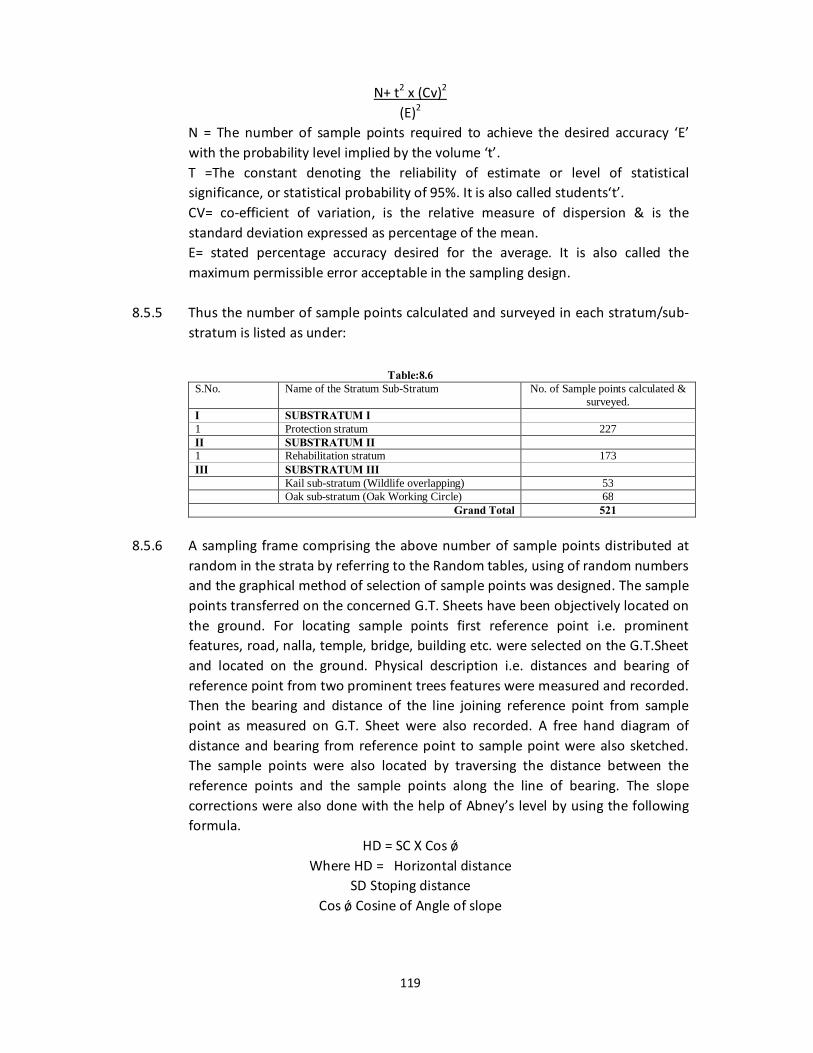
119
N+ t2 x (Cv)2
(E)2 N = The number of sample points required to achieve the desired accuracy ‘E’
with the probability level implied by the volume ‘t’. T =The constant denoting the reliability of estimate or level of statistical
significance, or statistical probability of 95%. It is also called students‘t’. CV= co-efficient of variation, is the relative measure of dispersion & is the
standard deviation expressed as percentage of the mean. E= stated percentage accuracy desired for the average. It is also called the
maximum permissible error acceptable in the sampling design. 8.5.5 Thus the number of sample points calculated and surveyed in each stratum/sub-
stratum is listed as under:
Table:8.6 S.No. Name of the Stratum Sub-Stratum No. of Sample points calculated &
surveyed. I SUBSTRATUM I 1 Protection stratum 227 II SUBSTRATUM II 1 Rehabilitation stratum 173 III SUBSTRATUM III Kail sub-stratum (Wildlife overlapping) 53 Oak sub-stratum (Oak Working Circle) 68
Grand Total 521
8.5.6 A sampling frame comprising the above number of sample points distributed at random in the strata by referring to the Random tables, using of random numbers and the graphical method of selection of sample points was designed. The sample points transferred on the concerned G.T. Sheets have been objectively located on the ground. For locating sample points first reference point i.e. prominent features, road, nalla, temple, bridge, building etc. were selected on the G.T.Sheet and located on the ground. Physical description i.e. distances and bearing of reference point from two prominent trees features were measured and recorded. Then the bearing and distance of the line joining reference point from sample point as measured on G.T. Sheet were also recorded. A free hand diagram of distance and bearing from reference point to sample point were also sketched. The sample points were also located by traversing the distance between the reference points and the sample points along the line of bearing. The slope corrections were also done with the help of Abney’s level by using the following formula.
HD = SC X Cos ǿ Where HD = Horizontal distance
SD Stoping distance Cos ǿ Cosine of Angle of slope
120
8.5.7 At each sample point so located the stems at breast height all around the sample point were viewed through wedge prism of BAF 2 to 4 (Mostly BAF 3) by taking a complete sweep of 360º. The number of trees whose stems at Breast height subtended larger angle than the fixed critical angle of the wedge prism (tally trees) was counted and their dia class wise diamensional details in respect of diameter at breast height, crown class etc. were measured and recorded in the tally sheets. Due care has been taken of trees in case of border line half tally trees. Separate tally sheets have been used for recording the details and sized of trees tallied at each sample point. At each sample point sample point number and tally trees counted were marked with point at breast height. The physical description i.e. Distance and bearing of sample point from two trees in the tally, features were measured and recorded for each sample point the tallied trees are grouped in different diameter classes.
8.5.8 The variables of interest i.e. per hectare have been calculated in respect of each
of these sample points using the following formulae.
Basal Area per Hectare B = BAF x n No. of trees per hectare N = BAF x 1/Bi Volume per hectare V= BAF x Vi/Bi
Where BAF = Basal Area Factor of wedge prism used for taking enumeration
sweep at the sample point. N = No. of trees tallied at the sample point. Vi = Volume of the tallied tree at the sample point. Bi= Basal Area of the tallied trees at the sample point. 8.5.9 Kulu volume table has been adopted for calculation of the volume above 30 cm
dbh (ob). Mean values of the above named three variables of interest have been calculated for each stratum/sub-stratum by computing the Arithmetic average of all the sample points of the stratum/sub-stratum. The mean values of all these variables have been put to statistical tests and scrutiny in each stratum/sub-stratum at 95% level of probability at 20% margin of error. The result follows in the proceeding chapters.


![[XLS]jkrevenue.nic.injkrevenue.nic.in/pdf/Flood_2014/Reasi-Paid.xls · Web viewPrem Singh So Naseeb Singh Chassote 0611040860005212 PREM SINGH SO SH NASIB SINGH 55 Pritam Singh So](https://img.pdfslide.us/doc/110x75/5aee45f57f8b9a903190eeec/xls-viewprem-singh-so-naseeb-singh-chassote-0611040860005212-prem-singh-so-sh.jpg)