Embed Size (px)
Citation preview
North Carolina Forestry BMP Manual Chapter 5 Amended 2006 Page 68
Helpful Hints:
BMPs for the four most common types of stream crossings are provided:
Bridgemats
Culverts
Fords
Pole Crossings
FPG
FPG
Helpful Hints:
Recommendations on stream crossings are available from:
Consulting Foresters
N.C. Forest Service
Soil & Water Conservation Districts
USDA-Natural Resources Conservation Service (NRCS)
Part 3 -- Stream Crossings
Stream crossings are often necessary for roads, skid trails and firelines to gain
access to forestland for management. Permanent crossings usually are for
roads, or in some cases, firebreaks. Temporary crossings are most common
for timber harvesting or other short-duration forestry operations, such as site
prep, tree planting, fertilization or herbicide application.
Because of the obvious potential for water quality impacts at stream crossings,
there are several rules that require practices be used or actions taken. Since the
North Carolina FPGs were enacted in 1990, stream crossings have been the
most frequent location on a job site where sediment may get into the water.
Rules Related to Stream Crossings
Forest Practices Guidelines Related to Water Quality (FPGs)
North Carolina General Statute 77-13 and General Statute 77-14
DWR riverbasin and watershed ‘Riparian Buffer Rules’
These ‘buffer rules’ for specific river basins and watersheds set limitations on
stream crossings within the 50-foot buffer zone
North Carolina Dredge and Fill Law This state law requires that permits be secured for discharges of dredged or fill
material in certain locations within the 20 Coastal Area Management Act
(CAMA) counties. Refer to Chapter 6 for more information on this law.
Planning Stream Crossings Stream crossings should be carefully planned in advance of their need to
determine how water quality can be best protected. This section provides
suggested BMPs when planning crossings.
BMPs for Planning Stream Crossings Avoid having stream crossings if possible. Take note of the FPGs.
Use maps, photos and/or on the ground examinations to determine the
minimum number of crossings needed to efficiently access the property
while protecting water quality.
Designate the location of the proposed stream crossing on the ground to
avoid confusion about where to construct the crossing.
When conditions allow, give preference to locations for crossings where:
-- The stream is relatively straight so crossing distance is minimized.
-- Approaches to the stream are relatively flat to better control runoff.
-- The crossing can be installed at a right-angle (90°) to the stream channel
so crossing distance is minimized.
North Carolina Forestry BMP Manual Chapter 5 Amended 2006 Page 69
FPG
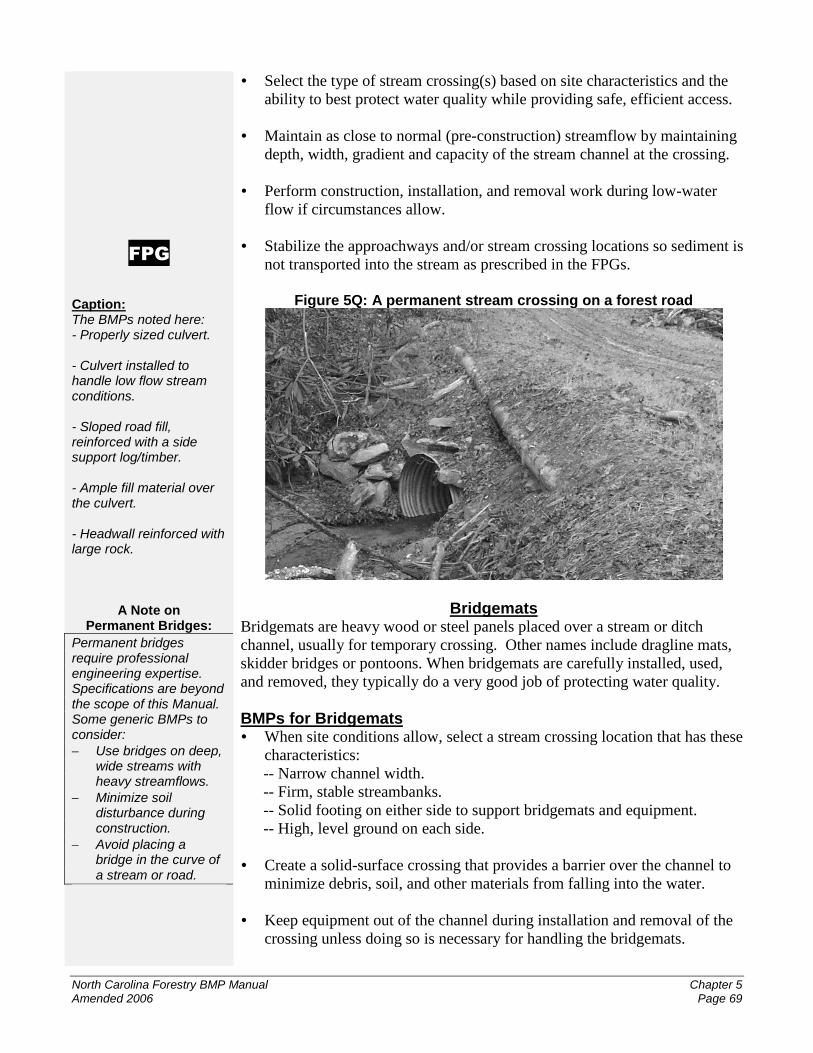
Caption: The BMPs noted here: - Properly sized culvert. - Culvert installed to handle low flow stream conditions. - Sloped road fill, reinforced with a side support log/timber. - Ample fill material over the culvert. - Headwall reinforced with large rock.
A Note on Permanent Bridges:
Permanent bridges require professional engineering expertise. Specifications are beyond the scope of this Manual. Some generic BMPs to consider:
Use bridges on deep, wide streams with heavy streamflows.
Minimize soil disturbance during construction.
Avoid placing a bridge in the curve of a stream or road.
Select the type of stream crossing(s) based on site characteristics and the
ability to best protect water quality while providing safe, efficient access.
Maintain as close to normal (pre-construction) streamflow by maintaining
depth, width, gradient and capacity of the stream channel at the crossing.
Perform construction, installation, and removal work during low-water
flow if circumstances allow.
Stabilize the approachways and/or stream crossing locations so sediment is
not transported into the stream as prescribed in the FPGs.
Figure 5Q: A permanent stream crossing on a forest road
Bridgemats Bridgemats are heavy wood or steel panels placed over a stream or ditch
channel, usually for temporary crossing. Other names include dragline mats,
skidder bridges or pontoons. When bridgemats are carefully installed, used,
and removed, they typically do a very good job of protecting water quality.
BMPs for Bridgemats When site conditions allow, select a stream crossing location that has these
characteristics:
-- Narrow channel width.
-- Firm, stable streambanks.
-- Solid footing on either side to support bridgemats and equipment.
-- High, level ground on each side.
Create a solid-surface crossing that provides a barrier over the channel to
minimize debris, soil, and other materials from falling into the water.
Keep equipment out of the channel during installation and removal of the
crossing unless doing so is necessary for handling the bridgemats.
North Carolina Forestry BMP Manual Chapter 5 Amended 2006 Page 70
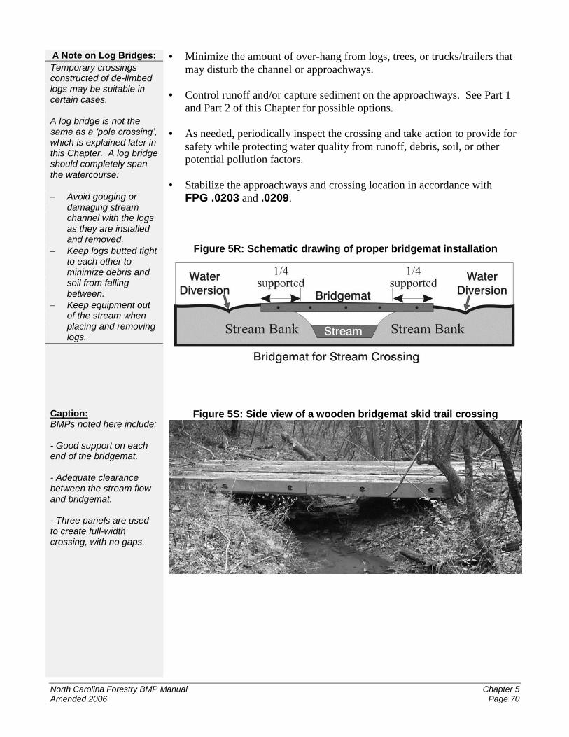
A Note on Log Bridges:
Temporary crossings constructed of de-limbed logs may be suitable in certain cases. A log bridge is not the same as a ‘pole crossing’, which is explained later in this Chapter. A log bridge should completely span the watercourse:
Avoid gouging or damaging stream channel with the logs as they are installed and removed.
Keep logs butted tight to each other to minimize debris and soil from falling between.
Keep equipment out of the stream when placing and removing logs.
Caption: BMPs noted here include: - Good support on each end of the bridgemat. - Adequate clearance between the stream flow and bridgemat. - Three panels are used to create full-width crossing, with no gaps.
Minimize the amount of over-hang from logs, trees, or trucks/trailers that
may disturb the channel or approachways.
Control runoff and/or capture sediment on the approachways. See Part 1
and Part 2 of this Chapter for possible options.
As needed, periodically inspect the crossing and take action to provide for
safety while protecting water quality from runoff, debris, soil, or other
potential pollution factors.
Stabilize the approachways and crossing location in accordance with
FPG .0203 and .0209.
Figure 5R: Schematic drawing of proper bridgemat installation
Figure 5S: Side view of a wooden bridgemat skid trail crossing
North Carolina Forestry BMP Manual Chapter 5 Amended 2006 Page 71
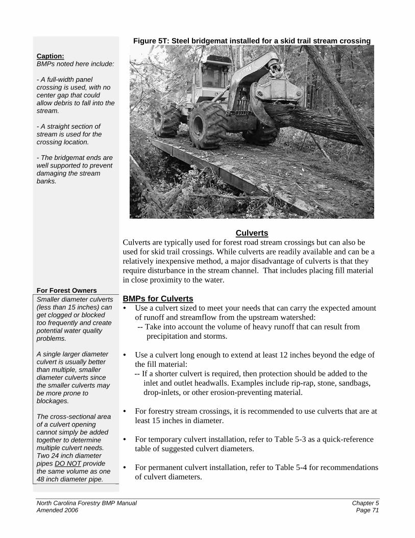
Caption: BMPs noted here include: - A full-width panel crossing is used, with no center gap that could allow debris to fall into the stream. - A straight section of stream is used for the crossing location. - The bridgemat ends are well supported to prevent damaging the stream banks. For Forest Owners
Smaller diameter culverts (less than 15 inches) can get clogged or blocked too frequently and create potential water quality problems. A single larger diameter culvert is usually better than multiple, smaller diameter culverts since the smaller culverts may be more prone to blockages. The cross-sectional area of a culvert opening cannot simply be added together to determine multiple culvert needs. Two 24 inch diameter pipes DO NOT provide the same volume as one 48 inch diameter pipe.
Figure 5T: Steel bridgemat installed for a skid trail stream crossing
Culverts Culverts are typically used for forest road stream crossings but can also be
used for skid trail crossings. While culverts are readily available and can be a
relatively inexpensive method, a major disadvantage of culverts is that they
require disturbance in the stream channel. That includes placing fill material
in close proximity to the water.
BMPs for Culverts Use a culvert sized to meet your needs that can carry the expected amount
of runoff and streamflow from the upstream watershed:
-- Take into account the volume of heavy runoff that can result from
precipitation and storms.
Use a culvert long enough to extend at least 12 inches beyond the edge of
the fill material:
-- If a shorter culvert is required, then protection should be added to the
inlet and outlet headwalls. Examples include rip-rap, stone, sandbags,
drop-inlets, or other erosion-preventing material.
For forestry stream crossings, it is recommended to use culverts that are at
least 15 inches in diameter.
For temporary culvert installation, refer to Table 5-3 as a quick-reference
table of suggested culvert diameters.
For permanent culvert installation, refer to Table 5-4 for recommendations
of culvert diameters.
North Carolina Forestry BMP Manual Chapter 5 Amended 2006 Page 72
Helpful Hints:
If a culvert is partially imbedded into the streambed, a larger diameter pipe may be needed to make up for this loss of open area within the pipe itself.
-- -- -- Avoid backfill with debris or large rocks that could create air pockets within the backfill or damage the culvert. Moist mineral soil usually works best.
If multiple culverts are used, provide adequate cross-sectional opening area
of the culverts to handle the expected streamflow. Refer to Table 5-4 for
suggested diameters of multiple culverts.
Install the culvert crossing during low-flow periods in the stream, if
possible.
Place culvert approximately in the center of the existing or expected water
flow within the channel.
Set the culvert(s) with a downslope grade so streamflow is not impeded
and to prevent debris from clogging the pipe.
Minimize the height that water drops from the outlet of the culvert:
-- For temporary installation, placing the culvert immediately upon the
stream bottom is usually suitable.
-- For permanent installation, it may be appropriate to place the culvert
partially imbedded into the stream bottom to allow better passage of
fish and other water-living organisms.
Backfill over the culvert with at least 12 inches of suitable material.
Culverts larger than 30 inches diameter should have backfill thickness
equal to at least one-third of the culvert’s diameter.
Use backfill material that will pack down tightly. Secure the culvert in
place and provide adequate support for vehicle traffic:
-- Tamp down the backfill along the length of the culvert to block seepage
that may flow around the culvert and wash it out.
Protect the inlet and outlet of the culvert and the fill material to minimize
erosion from the streamflow and runoff.
Construct the crossing so it allows floodwaters to flow around the crossing
location to minimize water backups and the potential of the culvert from
being washed away (commonly called ‘blowing out’):
-- Elevating the backfill over the culvert and creating a very slight crown
can help divert floodwaters around the crossing location.
-- Creating a low depression area within the approachways can provide a
flow-way for floodwaters to bypass around the crossing.
Use surface hardening materials on the culvert crossing and approachways
as needed to provide vehicle support and minimize erosion potential.
North Carolina Forestry BMP Manual Chapter 5 Amended 2006 Page 73
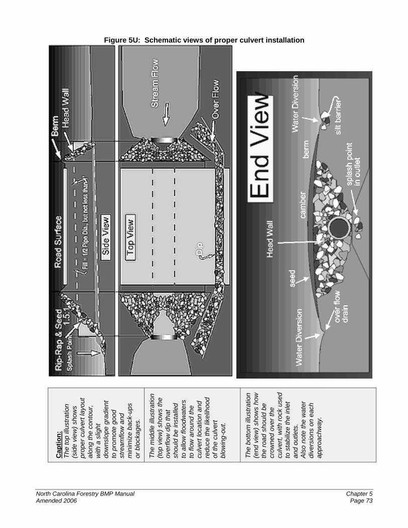
Figure 5U: Schematic views of proper culvert installation
Cap
tio
n:
The to
p illu
str
ation
(sid
e v
iew
) show
s
pro
per
cu
lvert
layout
alo
ng t
he c
on
tour,
with a
slig
ht
dow
nslo
pe
gra
die
nt
to p
rom
ote
go
od
str
eam
flow
and
min
imiz
e b
ack-u
ps
or
blo
cka
ges.
The m
idd
le illu
str
atio
n
(top v
iew
) sh
ow
s th
e
overf
low
dip
th
at
should
be
insta
lled
to a
llow
flo
od
wate
rs
to flo
w a
roun
d th
e
culv
ert
location a
nd
reduce th
e lik
elih
ood
of th
e c
ulv
ert
blo
win
g-o
ut.
The b
otto
m illu
str
ation
(end v
iew
) show
s h
ow
the r
oa
d s
ho
uld
be
cro
wned o
ver
the
culv
ert
, w
ith r
ock u
sed
to s
tab
ilize th
e inle
t
and o
utlets
.
Als
o n
ote
the
wate
r
div
ers
ions o
n e
ach
appro
achw
ay.
North Carolina Forestry BMP Manual Chapter 5 Amended 2006 Page 74
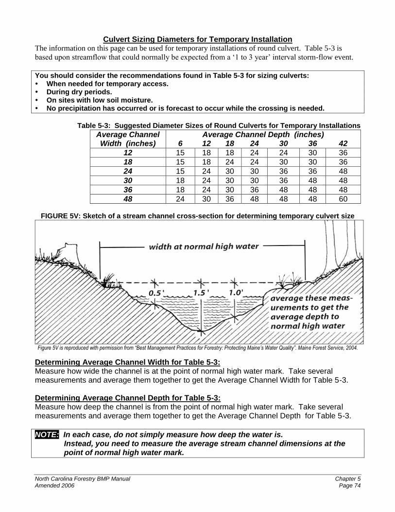
Culvert Sizing Diameters for Temporary Installation The information on this page can be used for temporary installations of round culvert. Table 5-3 is
based upon streamflow that could normally be expected from a ‘1 to 3 year’ interval storm-flow event.
You should consider the recommendations found in Table 5-3 for sizing culverts: When needed for temporary access. During dry periods. On sites with low soil moisture. No precipitation has occurred or is forecast to occur while the crossing is needed.
Table 5-3: Suggested Diameter Sizes of Round Culverts for Temporary Installations
Average Channel Average Channel Depth (inches) Width (inches) 6 12 18 24 30 36 42
12 15 18 18 24 24 30 36
18 15 18 24 24 30 30 36
24 15 24 30 30 36 36 48
30 18 24 30 30 36 48 48
36 18 24 30 36 48 48 48
48 24 30 36 48 48 48 60
FIGURE 5V: Sketch of a stream channel cross-section for determining temporary culvert size
Figure 5V is reproduced with permission from “Best Management Practices for Forestry: Protecting Maine’s Water Quality”. Maine Forest Service, 2004.
Determining Average Channel Width for Table 5-3: Measure how wide the channel is at the point of normal high water mark. Take several measurements and average them together to get the Average Channel Width for Table 5-3. Determining Average Channel Depth for Table 5-3: Measure how deep the channel is from the point of normal high water mark. Take several measurements and average them together to get the Average Channel Depth for Table 5-3.
NOTE: In each case, do not simply measure how deep the water is. Instead, you need to measure the average stream channel dimensions at the point of normal high water mark.
North Carolina Forestry BMP Manual Chapter 5 Amended 2006 Page 75
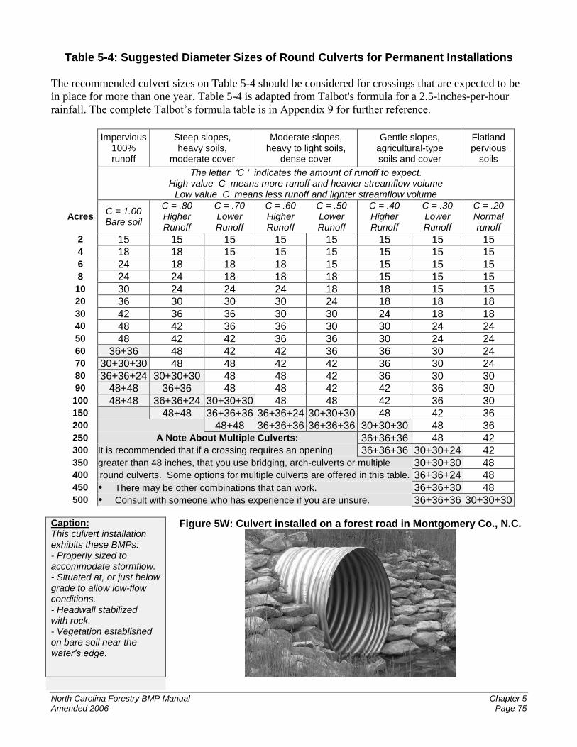
Table 5-4: Suggested Diameter Sizes of Round Culverts for Permanent Installations
The recommended culvert sizes on Table 5-4 should be considered for crossings that are expected to be
in place for more than one year. Table 5-4 is adapted from Talbot's formula for a 2.5-inches-per-hour
rainfall. The complete Talbot’s formula table is in Appendix 9 for further reference.
Impervious
100% runoff
Steep slopes, heavy soils,
moderate cover
Moderate slopes, heavy to light soils,
dense cover
Gentle slopes, agricultural-type soils and cover
Flatland pervious
soils
The letter ‘C ‘ indicates the amount of runoff to expect.
High value C means more runoff and heavier streamflow volume Low value C means less runoff and lighter streamflow volume
Acres C = 1.00 Bare soil
C = .80 Higher Runoff
C = .70 Lower Runoff
C = .60 Higher Runoff
C = .50 Lower Runoff
C = .40 Higher Runoff
C = .30 Lower Runoff
C = .20 Normal runoff
2 15 15 15 15 15 15 15 15 4 18 18 15 15 15 15 15 15 6 24 18 18 18 15 15 15 15 8 24 24 18 18 18 15 15 15
10 30 24 24 24 18 18 15 15 20 36 30 30 30 24 18 18 18 30 42 36 36 30 30 24 18 18 40 48 42 36 36 30 30 24 24 50 48 42 42 36 36 30 24 24 60 36+36 48 42 42 36 36 30 24 70 30+30+30 48 48 42 42 36 30 24 80 36+36+24 30+30+30 48 48 42 36 30 30 90 48+48 36+36 48 48 42 42 36 30 100 48+48 36+36+24 30+30+30 48 48 42 36 30 150 48+48 36+36+36 36+36+24 30+30+30 48 42 36 200 48+48 36+36+36 36+36+36 30+30+30 48 36 250 A Note About Multiple Culverts: 36+36+36 48 42 300 It is recommended that if a crossing requires an opening 36+36+36 30+30+24 42 350 greater than 48 inches, that you use bridging, arch-culverts or multiple 30+30+30 48 400 round culverts. Some options for multiple culverts are offered in this table. 36+36+24 48 450 There may be other combinations that can work. 36+36+30 48 500 Consult with someone who has experience if you are unsure. 36+36+36 30+30+30
Caption: This culvert installation exhibits these BMPs: - Properly sized to accommodate stormflow. - Situated at, or just below grade to allow low-flow conditions. - Headwall stabilized with rock. - Vegetation established on bare soil near the water’s edge.
Figure 5W: Culvert installed on a forest road in Montgomery Co., N.C.
North Carolina Forestry BMP Manual Chapter 5 Amended 2006 Page 76
For Forest Owners:
When properly built and maintained, fords can provide efficient and inexpensive road access.
Watch Out!
Because a vehicle drives directly in the water, fords are usually the least preferred method of crossing for protecting water quality.
FORDS ARE NOT RECOMMENDED for use on skid trail crossings. DO NOT BLOCK the natural flow of water in the stream channel.
Safety 1st - - - Never drive through a ford during high water or rapid currents.
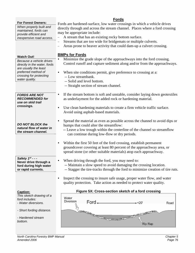
Caption: This sketch drawing of a ford includes: - Water diversions. - Short fording distance. - Hardened stream bottom.
Fords Fords are hardened-surface, low water crossings in which a vehicle drives
directly through and across the stream channel. Places where a ford crossing
may be appropriate include:
A stream that has an existing rocky bottom surface.
Streams that are too wide for bridgemats or multiple culverts.
Areas prone to beaver activity that could dam-up a culvert crossing.
BMPs for Fords Minimize the grade slope of the approachways into the ford crossing.
Control runoff and capture sediment along and/or from the approachways.
When site conditions permit, give preference to crossing at a:
-- Low streambank.
-- Solid and level bottom.
-- Straight section of stream channel.
If the stream bottom is soft and unstable, consider laying down geotextiles
as underlayment for the added rock or hardening material.
Use clean hardening materials to create a firm vehicle traffic surface.
Avoid using asphalt-based materials.
Spread the material as even as possible across the channel to avoid dips or
humps that could alter the streamflow:
-- Leave a low trough within the centerline of the channel so streamflow
can continue during low-flow or dry periods.
Within the first 50 feet of the ford crossing, establish permanent
groundcover covering at least 80 percent of the approachway area, or
spread stone (or other suitable materials) atop each approachway.
When driving through the ford, you may need to:
-- Maintain a slow speed to avoid damaging the crossing location.
-- Stagger the tire-tracks through the ford to minimize creation of tire ruts.
Inspect the crossing to insure safe usage, proper water flow, and water
quality protection. Take action as needed to protect water quality.
Figure 5X: Cross-section sketch of a ford crossing
North Carolina Forestry BMP Manual Chapter 5 Amended 2006 Page 77
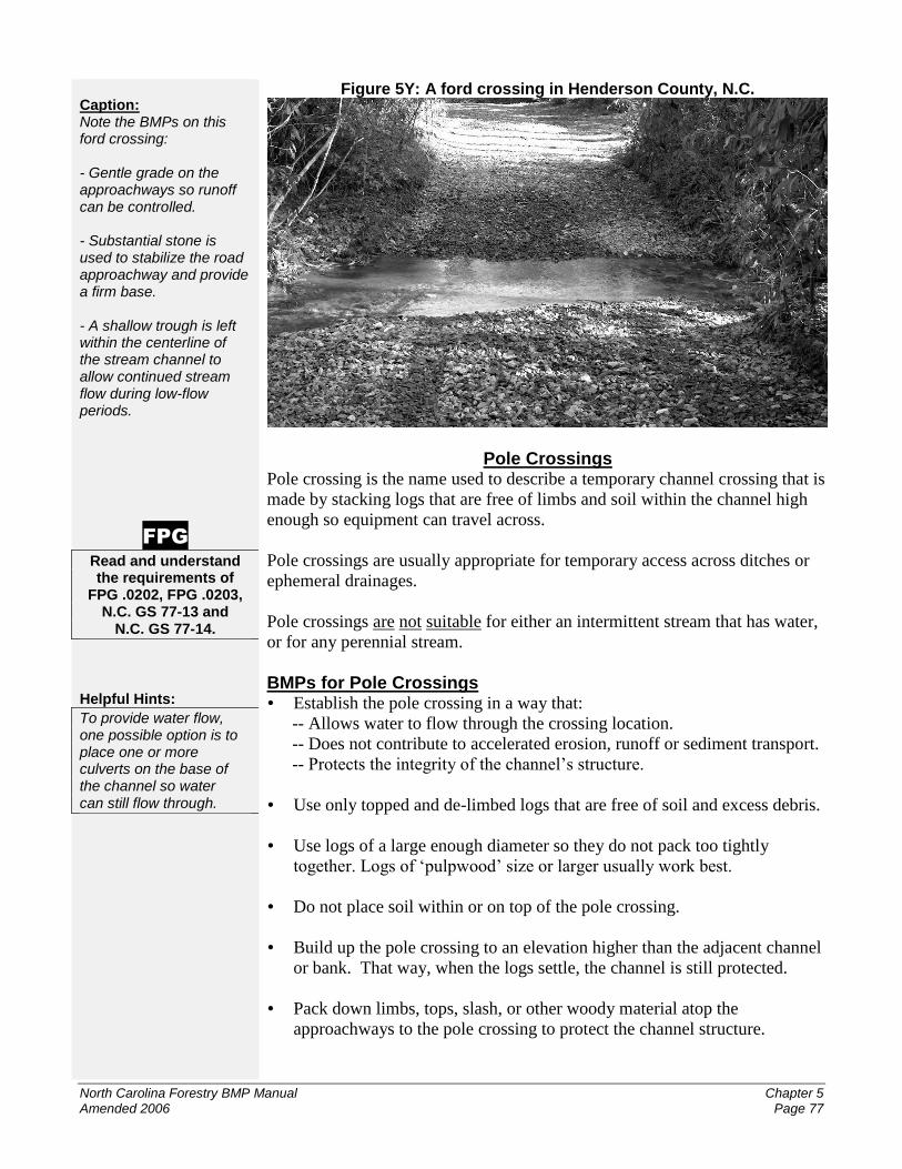
Caption: Note the BMPs on this ford crossing: - Gentle grade on the approachways so runoff can be controlled. - Substantial stone is used to stabilize the road approachway and provide a firm base. - A shallow trough is left within the centerline of the stream channel to allow continued stream flow during low-flow periods.
FPG
Read and understand the requirements of
FPG .0202, FPG .0203, N.C. GS 77-13 and
N.C. GS 77-14.
Helpful Hints:
To provide water flow, one possible option is to place one or more culverts on the base of the channel so water can still flow through.
Figure 5Y: A ford crossing in Henderson County, N.C.
Pole Crossings Pole crossing is the name used to describe a temporary channel crossing that is
made by stacking logs that are free of limbs and soil within the channel high
enough so equipment can travel across.
Pole crossings are usually appropriate for temporary access across ditches or
ephemeral drainages.
Pole crossings are not suitable for either an intermittent stream that has water,
or for any perennial stream.
BMPs for Pole Crossings Establish the pole crossing in a way that:
-- Allows water to flow through the crossing location.
-- Does not contribute to accelerated erosion, runoff or sediment transport.
-- Protects the integrity of the channel’s structure.
Use only topped and de-limbed logs that are free of soil and excess debris.
Use logs of a large enough diameter so they do not pack too tightly
together. Logs of ‘pulpwood’ size or larger usually work best.
Do not place soil within or on top of the pole crossing.
Build up the pole crossing to an elevation higher than the adjacent channel
or bank. That way, when the logs settle, the channel is still protected.
Pack down limbs, tops, slash, or other woody material atop the
approachways to the pole crossing to protect the channel structure.