Embed Size (px)
Citation preview

Stream Crossings: Continuity at the Junction of Two Linear Ecosystems
Arnie Capute, Krystina Lincoln, Michaela Levine, Martin Strenk
Environmental Planning ENVI 302 Fall 2015
Professor Sarah Gardner

TABLE OF CONTENTS
1. Introduction 1.1 Project Goals 1.2 Clients and Interested Parties 1.3 Project Background 1.4 Technical Considerations 1.5 Massachusetts State Standards 1.6 Economic Considerations of Culvert Replacement 1.7 Relevant Laws and Policies 1.8 Culvert Failures in Williamstown
2. Methods 2.1 Components of Surveying a Culvert
2.2 Survey Strategy 2.3 Evaluation Matrix 2.4 Challenges and Practicalities of Stream Crossing Replacements
3. Results
4. Recommendations
5. Acknowledgements
6. Sources
7. Appendix
1

1. INTRODUCTION
1.1 PROJECT GOALS
Our initial goal for the project focused on surveying all 14 of the priority culverts in
Williamstown, MA, to contribute to the North Atlantic Aquatic Connectivity Collaborative
(NAACC) regionwide database. After collecting data on some of these unsurveyed culverts, we
decided to focus on a stream where improving one or a few culverts would make the largest
contribution to connectivity and restoring the health of a larger length of stream ecosystem, due
to the time constraints on our project. Ultimately, we recommended two specific culverts for
replacement based on an evaluation matrix that analyzed structural integrity, ecological integrity,
and availability of state infrastructure funds. However, due to the formal and time consuming
nature of such a proposal, we cannot formally recommend culverts for replacement to the state.
Nevertheless, our work will go to both the Berkshire Environmental Action Team (BEAT) and
the Williamstown Conservation Commission, who can act upon our recommendations on a
longer time scale.
1.2 CLIENT AND INTERESTED PARTIES
The clients for this project are Elia del Molino, a representative from Berkshire
Environmental Action Team who is also a local coordinator for the North Atlantic Aquatic
Connectivity Collaborative (NAACC), Williamstown officials, and Williamstown Conservation
Commission.
2

Elia’s goals for the project centered on increasing the NAACC database of surveyed
stream crossings in Berkshire County. Our contribution to the regionwide dataset will help the
NAACC locate the most critical stream crossings. Ultimately, high priority culverts can be
replaced with better designs, increasing habitat connectivity, and maintaining structural integrity,
which will prevent culvert failures in the future. In the near future, Elia will be working with the
Berkshire Regional Planning Commission to prioritize culverts for replacement in each
Berkshire town, and our contributions to the dataset will increase the accuracy of these
recommendations.
Our team also worked with Williamstown officials to address infrastructure concerns in
Williamstown. By working with Jason Hoch (Town Manager), Andrew Groff (Town Planner),
Tim Kaiser (Director of Department of Public Works), and the Conservation Commission, our
team sought to balance the goals of all involved parties by crafting proposals for crossing
replacements.
1.3 PROJECT BACKGROUND
The North Atlantic Aquatic Connectivity group (NAACC) is a collaboration of a few
dedicated organizations whose goal is to become a cohesive and comprehensive group working
towards the betterment of infrastructure to support roadstream crossings. The current state of
streamroad crossings is far from ideal for both humans and organisms that live in these biomes.
After Hurricane Irene hit the Northeast region, MassDOT gave a grant to Adams and North
Adams amounting to over $200,000 to repair roads and culverts in the area (Jessen). Much of
this flooding was due to insufficient infrastructure at roadstream crossings that was destroyed,
3

washed out, or simply could not handle such severe storm conditions and thereby caused even
more flooding. This is avoidable to a degree if proper crossings are put in place rather than
insufficient solutions that cannot handle high flow conditions and need to be replaced after major
storm events. The NAACC is addressing the dire need for an improvement of this infrastructure
not only for the implications an upgrade will have for people and their towns in terms of flood
resilience, but also to improve the aquatic connectivity in the region, better allowing aquatic
organisms to travel throughout the streams. The NAACC consists of a core team, which is
UMass, The Nature Conservancy,United States Fish and Wildlife Service, the Unites States
Forest Service, the Vermont Fish and Wildlife department, and a work group. The work group
consists of 13 states (CT, DE, MA, MD, ME, NH, NJ, NY, PA, RI, VA, VT, and WV), their
corresponding departments of transportation and natural resource agencies, the United States
Forest Service, the National Oceanic and Atmospheric Administration, the United States Fish
and Wildlife Service, and some various other conservation services. A large goal of the NAACC
is to survey the culverts and to prioritize culverts because of insufficient funding to get all
crossings up to the desired standard of the group. In order to prioritize, comprehensive surveys of
each culvert in a region must be taken, several scoring systems are then used to analyze these
surveys, the data must then be imputed to the online database, and then these results are used to
prioritize and suggest culverts to be repaired.
Part of the process in prioritizing the surveyed culverts is the ecological impact that the
connectivity, or lack thereof, is having on the various species in that area. Because connectivity
is far from the norm, Maine has 60% of the surveyed crossings listed as partial or complete
barriers, aquatic organisms are facing many challenges. Aquatic organisms must have access to
4
the appropriate habitat, especially given that man made environmental impact can change stream
ecology quickly (Jackson 21). Aquatic organisms have to move through streams for various
different reasonssome have daily movements searching for food while others have migratory
patterns specifically for breeding (Jackson 22). If stream connectivity is not maintained, an
essential area for many different species may become unfit for the purpose it used to serve.
When this happens, usually the simplest option is to go to a more fit part of the stream, but if a
large culvert that is perched is blocking the way the species cannot move on and will inevitably
die off. The dying off of individuals in a species is not of great concern, but it is important to
ensure the reproductive potential of the species as a whole by allowing access to breeding
grounds and inviting both immigration and emigration to ensure genetic diversity. Conservation
biologists have different estimates of minimum population size needed to maintain the viability
of a population for both the short and long term, but even if a population is small, and therefore
not considered viable, it can still survive if it is connected to a larger regional population
(Jackson 22). Lacking connectivity is obviously not a good situation for the fish to be in and this
fragmentation of habitat is often caused by insufficiently built infrastructure at roadstream
crossings.
In addition to fragmentation certain types of crossings can also cause habitat degradation
in several ways. Firstly, the culverts that are commonly used in crossings provide little to no
habitat in the culvert. The main reason for this is because substrate does not get into the pipe and
it just has a round metal bottom. This can be avoided if the culvert is partially placed in the
ground or substrate is added (Jackson 24). In addition to the culvert degrading the habitat by
replacing natural habitat, culvert installation and positioning can also alter the habitat negatively.
5

Soil erosion and pollution will commonly runoff into streams during construction, after
installation from the disturbance, and from traffic along the road (Jackson 24). The positioning of
the culvert can also physically alter the biome. For example, water freefalling from the culvert
outlet could possibly cause a scour pool to form where one did not always exist. Aquatic biomes
are often very fragile so these pollutants and environmental alterations can cause extreme
hardships of the organisms living there. There are millions of roadstream crossing in the 13 state
area that the NAACC works in with an estimated 1.2 million solely in New York state, so it is
obvious that the area is in dire need of an infrastructure improvement for the sake of improving
these biomes. The organisms in this area include the; North Atlantic salmon, Eastern brook
trout, blacknose dace, salamanders, Blanding’s turtles, as well as terrestrial species that are
affected.
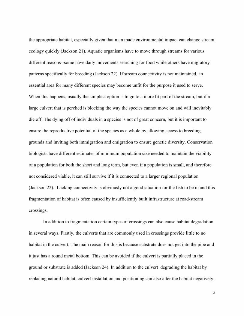
1.4 TECHNICAL CONSIDERATIONS:
Sizing and Durability
Properly constructed and designed culverts are essential for passing water during storm
events and reducing maintenance costs incurred through damage over time. Road crossing
structures need to accommodate both expected high flows and debris swept into the river during
storm events. Culvert designs typically use a minimum of a 20year storm event for sizing and
some may be designed to manage the capacity of a 100year storm based on local regulations and
sensitivities. Due to uncertainty in hydrological estimates and changing land use patterns, culvert
size and capacity should be conservative (BLM).
6
Figure 1. Bureau of Land Management’s estimate for culvert size based on drainage area, slope, and vegetation conditions. Local conditions should be taken into consideration when sizing culverts.
The type of material used is generally based on cost, but metal and concrete are generally
more durable than plastic (BLM). The durability of materials is essential for decreasing the
average annual cost or lifecycle cost of the culverts. The culvert should also be designed so that
the flow of the stream is aligned with the structure and that the road is aligned perpendicular to
the stream (BLM). This increases the stability of the structures and its longterm viability.
7

1.5 MASSACHUSETTS STATE STANDARDS
Culverts and bridges are typically designed with the sole aim of safely moving traffic and
facilitating the movement of water, sediment, and natural debris, which often unintentionally
damages the ecological health of the stream. In response to concerns over habitat fragmentation
due to hindered wildlife passage at stream crossings, the “Massachusetts River and Stream
Crossing Standards” were developed in 2004 to achieve fish and wildlife passage, in addition to
traditional goals of structural integrity, the movement of people, and hydraulic adequacy, at
crossings (MassDOT). The standards were developed using a “stream simulation” design
approach in which the structure is designed to mimic the natural channel throughout the crossing,
maintaining the connectivity of the stream and continuity of the ecosystem (MassDOT). These
standards, developed in partnership with the River and Stream Continuity Project, apply to all
new road crossings and repairs. If an existing crossing is assessed to support a reasonable degree
of wildlife passage, then options for improving that structure may include an inkind replacement
(MassDOT). A stream crossing structure that meets the standards facilitates the movement of
fish and aquatic organisms, maintains the continuity of the aquatic and benthic elements of river
and stream ecosystems through the use of appropriate substrates and hydraulic characteristics,
and facilitates the movement of wildlife species that use riparian areas through the crossing.
8

Figure 2. Diagram of a culvert meeting the general standards.
There are two sets of standards: general standards, which should be applied to all new
structures and repairs where possible, facilitate the movement of aquatic organisms and some
terrestrial wildlife, and the optimum standards, which should be applied to areas that play a
significant role in habitat connectivity, provide for the passage of both aquatic and terrestrial
organisms. The general Standards require the implementation of either an open bottom structure
or a culvert embedded to a minimum of 2 feet to provide a natural stream substrate that matches
the undisturbed upstream and downstream substrates (RSCP). In addition, the structures should
avoid constriction causing increased velocity and depth. To avoid constriction and maintain the
stability of the culvert/bridge, the structure should be a minimum of 1.2 times the bankfull width
9

in diameter. In floodplains, it may be necessary to widen the structure further to facilitate the
conveyance of water and maintain the structure’s stability. Banks should be present on both sides
of stream within the structure, matching the natural channel conditions, to further support its
structural integrity and provide space for the passage of terrestrial wildlife. Finally, the general
standards require that the structure have an openness ratio (measured as the cross sectional area
divided by the structure length) of at least 0.82 feet to allow the passage of small terrestrial
animals (RSCP). In comparison, the U.S. Army Corps of Engineers requires an openness ratio of
0.25 (U.S. Army Corps of Engineers). The optimum standards provide for fish passage, stream
continuity, and passage of all terrestrial wildlife. While many of the standards are the same, the
optimum standards prohibit the use of culverts and require the use of a bridge to minimize
impacts on the stream channel and provide more space for the passage of wildlife. The optimum
standards require that the structure have a minimum height of 8 feet and an openness of 1.64 feet
(RSCP). Optimum standards are applied to crossings in stream corridors linking areas of
significant habitat, including river and stream segments identified by the Natural Heritage and
Endangered Species Program (NHESP) through the “BioMap2” project.
1.6 ECONOMIC CONSIDERATIONS OF CULVERT REPLACEMENT
The Chapter 90 Funding Program
Massachusetts Department of Transportation Chapter 90 Program is one potential source
for completing culvert renovation/replacement projects. This program provides 100%
reimbursement to projects that involve the “maintenance, repair, improvement and construction
of town ways and bridges, which qualify under the State Aid Highway Guidelines” (MassDot).
10

The main requirement for a culvert project to be considered for Chapter 90 funding is that the
given project must be in conjunction with a roadway resurfacing project with a minimum of ¾
inches course and a continuous length of at least 500 feet (MassDot). This essentially means that
a culvert renovation/replacement would not qualify for Chapter 90 funding on its own, but
instead, must be tied in with a preexisting need for substantial repaving in the given area.
In our discussions with Jason Hoch, the town manager, he suggested that Chapter 90 is
often the best bet for receiving adequate funding, so in the second phase of our survey practices,
we increased our focus on the condition of the roadway. Just as we will not be submitting any
formal recommendations for replacement, we will also not be involved in the actual application
process for Chapter 90 funding as it is a lengthy process which extends beyond our time frame,
and since it is a reimbursement program, the actual application for funding does not take place
until after construction begins. Our role was merely to identify culverts and roadway water
passages that are priorities based on structural integrity and ecological benefit, and then make a
conclusion as to whether the roadway itself needs repair and could apply for Chapter 90.
Cost Benefit Analysis
When installing a culvert there are funding and other considerations that are important to
analyze thoroughly. Often the initial costs are given too much weight in the decision of what
type of culvert to install and the operation, maintenance,
and replacement (OM&R) costs are not given enough thought
(Economics of Culvert Replacement). The process that should
be used to determine the best type of culvert to construct is the life cycle cost analysis. This
method takes all costs throughout the life of a culvert into account, including OM&R, time, and
11

financial assistance available (Brovia). Cost and funding are often the leading concerns, so
cheap, unsatisfactory, and high maintenance culverts are often installed, which often end up
being more costly over its lifespan than the proper culvert. There are funding sources that will
subsidize culverts to improve wildlife connectivity, for example, the Wildlife Incentive Program,
will cover 90% of installation costs of a culvert if it meets their environmental standards
(Economics of Culvert Replacement). This subsidy not only incentivizes better stream
continuity, but as a result, culverts are built bigger and, therefore, less maintenance is needed
over time, lowering total life cycle costs.
Figure 3: Life Cycle cost analysis of unsatisfactory/undersized culverts in red against proper culvert costs, in green, over the span of 25 years. It is important to note that there is no subsidy for the proper culvert taken into account and the expected life for the proper culvert far exceeds the 25 year timespan that an unsatisfactory culvert is expected to last (USDA)
12
According to a study done by the Transportation Research Board, there are fairly accurate
expected lifespans for culverts of different materials. They found that concrete culverts are the
longest lasting with lifespans of 70100 years, where plastic and metal culverts general have
expected lifespans of 50 years when properly installed with adequate spacing (Brovia). This
study then looked at several different culvert installations and found that in the 7 case studies
they analyzed, all culverts that failed had exceeded their expected lifespans. These failures
caused hours of delay in detours for many travelers as they were on busy roads, $265,000 to $8
million in replacement costs, and none of these culverts even had planned maintenance in the
near future (Brovia). Because emergency replacement is more costly than planned maintenance
and repair, there are advantages to maintaining culverts instead of only replacing them when they
fail. Because of this, the Transportation Research Board looked into a culvert installation firm
that had a maintenance program and found that they have yet to have a culvert failure. Their
program, simply enough, has employees conduct surveys of their culverts every 2 years and then
when a deficiency is found it is either fixed or replaced (Brovia). Because of this program, the
company has a much lower lifetime cost for each culvert because there are no emergency
replacements. All of these analysis unfortunately do not take the environment into account, but
there is a correlation between strong properly built culverts and stream connectivity, and there
are incentive programs to push for more stream connectivity. The end results indicate that strong
culverts and high environmental quality come hand in hand so the incentives are aligned in this
case.
13
1.7 RELEVANT LAWS AND POLICIES
State Level
Extensions of waterways that supply drinking water, habitat, and flood control, culverts
are subject to the statewide “Wetlands Protection Act” and “Water Quality Certification for
Discharge of Dredged or Fill Material, Dredging and Dredged Material Disposal in Waters of the
United States Within the Commonwealth” regulations (MassDOT). The Massachusetts 401
Water Quality Regulations outline standards requiring permits for any dredging or filling
activity, which would pertain to culvert construction and any armoring measures at outlets. Also,
the regulations call for structural techniques that prevent storm water from overriding the natural
channel and introducing pollutants. Pipes and culverts must be designed to manage storm water
as such (Massachusetts 401 Water Quality Regulations). Additionally, these regulations outline
when a permit or application is required for any roadway projects.
The Wetlands Protection Act must be considered when evaluating culverts and again
during the replacement process. Poorly designed culverts that severely restrict flow may lead a
wetland to develop in the area around the stream. While this wetland was not originally a natural
feature, any alteration to it would require review under the Wetlands Protection Act (MassDOT).
The Massachusetts DEP equally considers benefits of full river restoration against potential harm
to the wetland resource, so culvert replacement proposals should not be deterred by the
MassDEP review.
The Massachusetts Endangered Species Act (MESA) prohibits the taking of rare species
and protects their habitats. “Take” is defined in reference to animals as “harass, harm, pursue,
hunt, shoot, wound, kill, trap, capture, collect, process, disrupt the nesting, breeding, feeding or
14

migratory activity” (Energy and Environmental Affairs). If a project is located within a Priority
Habitat of Rare Species, as defined by the Natural Heritage & Endangered Species Program, then
the proponents of the project must file with the NHESP and undergo MESA Project Review. For
a project to receive a Conservation and Management Permit during a MESA Project Review, the
applicant must demonstrate the project will impact an insignificant portion of the local
population of the affected species and design and implement a conservation plan that provides a
longterm net benefit for the affected species (Energy and Environmental Affairs). Thus, if a new
culvert project is proposed in a Priority Habitat of Rare Species, then the culvert must be
designed to have minimal to no impact on the connectivity of the ecosystem.
Federal Level
The New England District of the U.S. Army Corps of Engineers (USACE) issued the
Massachusetts General Permit (MGP) in 2010 to expedite the review of activities with minimal
impacts on the aquatic environment. The MGP includes the “General Condition 21. Stream
Crossings and Work,” which requires that all crossings be designed to withstand high flows and
not disrupt lifecycle movements of those species native to the stream. The Condition requires
that new stream crossings and replacements meet the “Massachusetts River and Stream Crossing
Standards” to qualify for Category 1, no application required, activities. Replacement crossings
in highquality stream segments (including, those designated by NHESP) are not eligible for
Category 1 approval. For projects that do not meet Category 1 approval, the least ecologically
damaging designs are required (MassDOT). The Corps must issue an individual permit for
Category 2 projects, which do not meeting the conditions. The USACE also issued the
Massachusetts Department of Transportation a Comprehensive Permit for Bridges covering
15

repair, replacement, and reconstruction unless the project spans more than 5,000 square feet of
vegetated wetlands or waters, the project affects a federally listed endangered species, the bridge
intersects the 10year flood elevation, the bridge constricts flow, there is a dam or other
obstructing element within the footprint of the project,the bridge does not span 1.2 times the
bankfull width, and the bridge does not meet the “Stream Crossing Standards” (MassDOT).
1.8 CULVERT FAILURES IN WILLIAMSTOWN
Culvert failure is not an unfamiliar problem in Williamstown. Many of the culverts are
undersized and therefore prone to flooding during extreme storm events. After a torrential rain
event in May, 2013, the current Williamstown Town Manager reported road closures and
hundreds of thousands of dollars in damage due to failed culverts ("Torrential Rain Closes,
Damages Williamstown Roads"). Water Street, Green River Road, and Routes 2 and 7 were all
underwater at points of the storm, which indicated undersized culverts that should have
accommodated the high water flow and kept the water within the stream banks. Additionally,
undersized culverts are prone to blockage during these storm events when debris is mobilized
and transported.
During Tropical Storm Irene, a culvert failure along Route 2 near the Spruces mobile
home park contributed to “the worst flood in recent memory” (Dravis, 2014). This culvert
failure, in conjunction with flooding from the Hoosic River, led to the complete destruction of
the mobile home, which culminated in its condemnation (Dravis, 2014). Ultimately,
Massachusetts Department of Transportation undertook the culvert replacement project, which
totaled $192,000 (Stafford). The replacement project installed three, three foot pipes in the area
16
which previously only had one three foot pipe. Additionally, MassDOT installed a swale to ease
the pressure of high flows (Dravis, 2013). Further conversation with Jason or Williamstown
Conservation Commission members will inform our team about the process of culvert
replacement in times of crisis.
2. METHODS
2.1 COMPONENTS OF SURVEYING A CULVERT
We have assessed roadstream crossings throughout the Williamstown area through the
completion of a previously established NAACC Stream Crossing Survey Data Form at each
passage site evaluated (see appendix). After completing field and online training, we conducted
our own surveys of stream crossings in teams of 2 people.
Stream crossing structures can be classified into seven different types: round culvert,
pipe arch/elliptical culvert, open bottom arch culvert, box culvert, bridge with side slopes, box
bridge with abutments, and a bridge with side slopes. Crossing structures are commonly built
from metal, concrete, plastic, wood, rock, or fiberglass. After identifying the culvert type, the
width, height, length, water width, and water depth are measured at the inlet, where water enters
the structure, and outlet, where water leaves the structure (see Figure 4).
17

Figure 4: Types of stream crossing standards showing where measurements should be taken (“NAACC Stream Crossing Survey Data Form”).
18

At the inlet, the surveyor accesses the inlet type and inlet grade. An inlet can have
wingwalls, angled walls that funnel water flow into the structure, and/or a headwall, a vertical
wall where the water enters the structure. If the structure is a pipe culvert, the inlet can be
projecting if the inlet is not flush with the road embankment. Structures that are mitered to the
slope are flush to the slope of the road embankment. The inlet grade refers to the elevation of the
stream bottom as it enters the structure. The structure is at grade when the stream bottom is at the
same elevation as the stream bottom upstream of the structure; the structure has an inlet drop
when the water falls into the structure due to a decrease in elevation; and the structure is perched
when the structure bottom is above the water surface at the inlet.
The surveyor also accesses the outlet grade as either at stream grade, when there is no
significant elevation change between the structure and the channel downstream, a free fall, when
the outlet structure is raised above the stream bottom so that water drops vertically when exiting
the structure, a cascade, when flows steeply downward over rock or other hard material at the
outlet, or a freefall into a cascade. The surveyor also notes whether the structure is clogged or
has armoring. The presence and size of a scour pool, which forms from high flows exiting the
crossing causing the width, length and depth in the area directly outside the outlet is at least
twice that of the natural stream.
The NAACC survey also examines the interior conditions of the crossing structure. The
surveyor looks for any physical internal structures such as baffles, weirs, or fencing, and any
physical barriers such as accumulated debris, deformation of the structure, internal free falls, or
dry areas. The survey also evaluates the structure for the presence of a substrate, the substrate
coverage in the structure, the substrate type, and the appropriateness of the substrate in regards
19

the upstream and downstream substrate quality. In addition, the surveyor notes the presence or
absence of dry passage in the structure.
Additionally, the survey examines flow conditions. The crossing is aligned when the flow
of the stream enters the crossing at an angle less than 45 degrees, and the crossing is skewed
when the flow enters an angle greater than 45 degrees. The surveyor also notes whether the
velocity of the water in the crossing structure matches the upstream and downstream velocities.
The flow is evaluated for constriction based on the width of the crossing in relation to the
bankfull width of the upstream channel. All surveys should be conducted at typical low flow
conditions for safety purposes.
Finally, the survey provides a space for identifying the crossing with the road, GPS
coordinates, crossing code, and location description. The survey includes pictures of the inlet,
outlet, upstream, and downstream reaches. The survey form also provides space for additional
comments about the structure and its location.
2.2 SURVEY STRATEGY
After completing training, the research team targeted unsurveyed or unmarked culverts
for evaluation. These 8 surveys were added to the NAACC database of stream crossings. Once
most crossings in Williamstown were surveyed, we decided to evaluate previously surveyed
culverts to propose a multiculvert repair that would reconnect significant habitat. Several
culverts along Sweet Brook had already been surveyed and were calculated as a significant or
moderate barrier to aquatic passage. These crossings were surveyed again and examined for
additional criteria including road quality, development density, and structural integrity.
20

Repairing culverts along one stream that can support a robust aquatic ecosystem is more
beneficial to wildlife than repairing a small culvert that contains a small mountainside drainage.
In addition, repairing a culvert upstream when a downstream culvert may be impassible does not
provide any ecological benefit. Thus, targeting one stream that has significant barriers to passage
allows the Town to cost effectively invest resources to reconnect the largest stretch of linear
ecosystem possible
2.3 EVALUATION MATRIX
To begin balancing the varying goals that may drive culvert replacement, we constructed
a rubric, or matrix, which would assign numerical values to relevant properties of a stream
crossing (Table 1). We identified three overarching goals that could drive a crossing
replacement: ecological connectivity, hazard mitigation, and funding availability. With these
comprehensive goals, the rubric can address the ecological impacts of a culvert replacement,
while considering the structural importance and funding feasibility of such a project.
Additionally, the rubric is structured so certain characteristics can be weighted more than others
depending on the interest of the client. Higher scores represent higher priority for replacement.
Our rubric included a “Value” column that can be adjusted to weight specific goals over
others. For our purposes, we attempted to normalize that Impacts Rating, the maximum of which
varied from trait to trait. In our iteration of the rubric, the maximum impact rating for each
section was normalized to 1 with the value multiplier.
21

Table 1: Stream Crossing Evaluation Rubric with Scoring Ranges
Goal 1: Ecological Connectivity Value Impact Rating
IEI Score 0.023440 042.66281 (Berkshires)
Barrier to Passage Rating .2 05
NHESP Status .5 01
BioMap 2.0 Status (Aquatic Core layer) .5 01
Linear Ecosystem .33 03
Goal 2: Hazard Mitigation Value Impact Rating
Flood Plain Status 01
Structural Integrity 03
Development Density 03
Goal 3: Funding Availability Value Impact Rating
Potential Chapter 90 Status 01
Structural Integrity 03
Traffic 01
Development Density 03
Ecological Connectivity
The first goal ecological connectivity addresses ecosystem health and environmental
traits that may increase the importance of a crossing replacement. The IEI (Index of Ecological
Integrity) score was created by the Critical Linkages project to evaluate crossings for predicted
impact on ecological integrity, if they had were updated to have sufficient passage. A high IEI
22
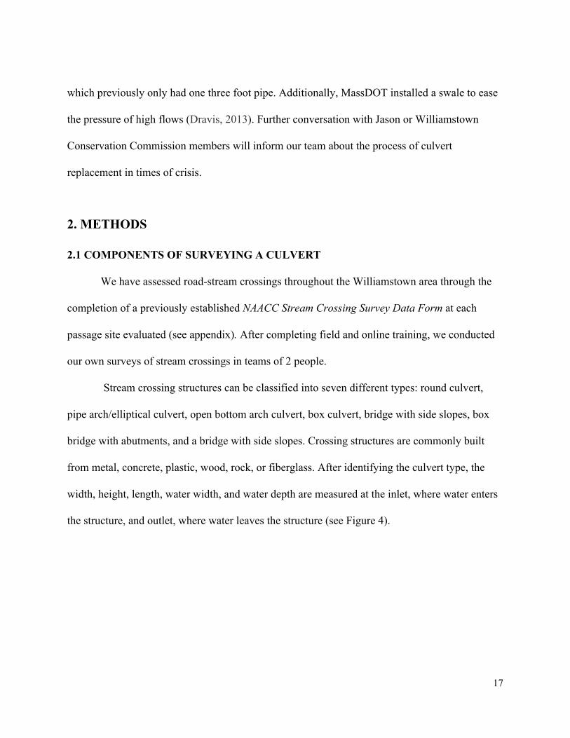
score indicates the greatest improvement to ecological integrity (McGarigal et al., 2012). The
raw IEI score was placed into the evaluation matrix (see Figure 5).
Figure 5. Williamstown culverts with their IEI delta scores. Top 1% in the Berkshires is a score greater than 42.662810, top 5% is a score greater than 24.537955, top 10% is a score greater than 16.59998, top 20% is a score greater than 7.791426 (data from "Conservation Assessment and Prioritization System.").
23

The Barrier to Passage score is calculated by an algorithm in the NAACC database
("North Atlantic Aquatic Connectivity Collaborative"), effectively synthesizing and interpreting
field data. NAACC data is shown in Figure 6. The rubric assigns values as follows:
Table 2: Barrier to Passage Values
Barrier Level Value
Severe 5
Significant 4
Moderate 3
Minor 2
Insignificant 1
Full Passage 0
24

Figure 6. NAACC calculated Barriers to Passage in Williamstown (data from "North Atlantic Aquatic Connectivity Collaborative”).
25

A culvert is given an NHESP score of (1) if it lies within an area (see Figure 7) classified
as “Priority Habitats of Rare Species.” If the crossing does not lie within this area, is is given a
score of (0). The NHESP Priority Habitats of Rare Species data layer is available from MassGIS
("MassGIS Data NHESP Priority Habitats of Rare Species").
Figure 7. NHESP designated Priority Habitats in Williamstown, the known geographical extent of all state listed rare species (data from "MassGIS Datalayers").
26

Each culvert was scored in the same fashion by referencing the BioMap 2.0 Aquatic Core
Habitat data layer (Figure 8). Also developed by the NHESP, “Aquatic Cores are designed to
protect 10 MESAlisted fish, 17 nonlisted fish, as well as 145 MESAlisted species with all or a
portion of their life cycle in aquatic habitats” ("MassGIS Datalayers").
Figure 8. BioMap2 aquatic core habitat as designated by the NHESP for Williamstown are shown in green (data from "MassGIS Data NHESP Priority Habitats of Rare Species").
27

The linear ecosystem score reflects the size of the stream, representing the capacity for
the flow to support fish and other wildlife. Streams are scored as follows: large river (3), main
river (2), small creek or brook (1), unnamed (0). These values reflect the amount of potential
habitat upstream of the crossing.
Hazard Mitigation
The second goal hazard mitigation is designed to measure the impact high flow or flood
conditions would have on the surrounding area. The three categories observed were; floodplain
status, structural integrity, and development density. These three factors took into account the
damage that could occur with a culver failure. Floodplain status prioritizes the frequency of
floods in the area rather than the severity of the flood. This measure was scored as a binary a
crossing was given a 1 if within the FEMA Designated 100 Year Flood Zone, or a 0 if not
(Figure 9). This part of the rubric assigns values as follows:
28

Figure 9. FEMA designated flood zones. Zones A and AE are areas within the determine 100 year floodplain. Zone AH experience ponding during 100 year flood events. Zones V and Ve experience velocity hazards during the 100 year flood. Zone D is an area of undetermined hazard, and x500 is an area that floods during the 500 year flood (data from "MassGIS Datalayers").
29

In the field, each crossing was judged based on structural integrity, considering the
urgency of replacement. Values were assigned according to Table 3.
Table 3: Structural Integrity Values
Barrier Level Value
Desperate 3
Poor 2
OK 1
New 0
In the field, crossing environment was evaluated as presented in Table 4. This was scored
considering the amount of structures in the immediate area, and served as a proxy for potential
damage in a high flood event.
Table 4: Development Density Values
Barrier Level Value
High (6+) 3
Medium (45) 2
Low (12) 1
No Development 0
30

Funding Availability
The last goal in the rubric funding availability uses the same metrics for development
density and structural integrity as presented above, but adds traffic frequency and chapter 90
funding availability. Both of these are measured on a binary scale, either yes or no. In discussion
with Andrew Groff, we determined if each crossing was on a town or state road, as only town
roads are Chapter 90 eligible. If a crossing was eligible for funding, we gave it a score of 1, if
not, a score of 0. Our rubric focuses on evaluating only town roads, and some sections of Route 7
and Route 43 are owned by the town rather than the state. We assumed that these roads would
have higher levels of traffic than other town roads, and scored such crossings with a 1.
Other Elements that may Impact Replacement
Our rubric does not take the cost of replacement into account. While this is a critical
factor when considering crossing replacement, cost of replacement can vary within hundreds of
thousands of dollars. Ultimately, this would require professional evaluation, but cost scales
roughly proportionally with size (Kaiser).
The rubric also did not consider the loss of fishing spots or swimming holes, which could
disappear with a properly sized culvert. While this may be important to the town for community
based reasons, it did not fit into our ecological and structural goals.
2.4 CHALLENGES AND PRACTICALITIES OF STREAM CROSSING REPLACEMENTS
While culverts should work towards stream habitat connectivity, there are several
practical considerations from the town’s perspective that should be taken into account in the
31

planning of replacement projects. Crossing replacements can have both upstream and
downstream effects, even if the replacement mets stream crossing standards. Undersized culverts
can create upstream wetlands, and a replacement project could favor wildlife connectivity while
destroying these wetlands. Tim Kaiser, the Williamstown Director of Public Works, pointed out
that upstream undersized culverts may fail, causing local flooding in a sparely populated area
while preventing further flooding in a downstream area that would incur greater damage. This
was not considered in our rubric.
Additionally, the NAACC database may calculate a crossing as a barrier to passage
when, in fact, there are fish on both sides of the culvert. Culvert replacement may lead to the
destruction of tail water scour pools that act as fishing or swimming holes, which the public may
react negatively toward. Our matrix did not consider this aspect, in an attempt to be as qualitative
as possible.
3. RESULTS
The rubric was scored for each culvert our team surveyed, along with several culverts
along Sweet Brook (highlighted yellow) that were surveyed previously. Full results are seen in
Table 5. Higher scores indicate that replacing the culvert would have a greater benefit for each
subgoal. IEI scores were not available for culverts that were not in the NAACC database, so for
these crossings (highlighted orange) we estimated an IEI score by examining crossings upstream
and downstream. Barrier to passage scores were also unavailable for new and unsurveyed
culverts. We did not attempt to give theses culverts a barrier to passage score. This should be
32
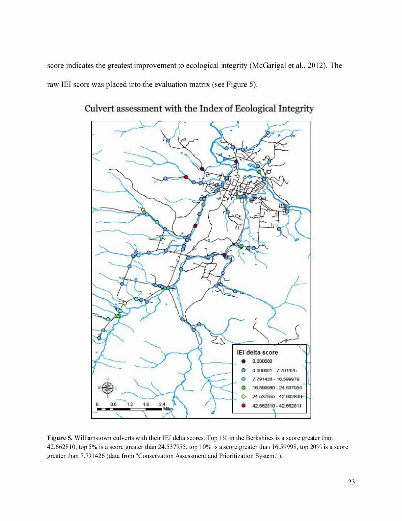
considered when interpreting our results and the matrix should be updated when the NAACC
completes the algorithm needed to calculate a barrier to passage score. The three crossings with
the highest score in each subtotal are highlighted.
Goal 1: ecological connectivity
value
xy4264083773224566
xy4263787373227511
xy4268231673201872
xy4268319473189697
xy4263757773276136
xy4264340473233440
xy4267721173259892
xy4267777673257123
xy4267920173251637
xy4268030173242330
xy4268349473246058
xy42650357323713
xy42644877323495
IEI score
0.02343
0.06075
0.00032
0.08180
0.03516
0.14112
0.00909
0.10006
0.29436
0.07949
0.06322
0.03516
0.03516
0.03516
passage 0.2 0.6 0.8 0.6 0.6
core habitat 0.5 0 0.5 0 0 0 0.5 0.5 0.5 0.5 0.5 0 0 0
NHESP 0.5 0 0.5 0 0 0 0.5 0 0 0 0 0 0 0.5 linear ecosystem
0.33
0.33 0.67
0.00
0.00
0.33 0.67
0.33
0.33 0.33 0.33
0.00
0.33
0.00
subtotal 0.39 1.67
0.08
0.04
0.47 1.68
1.53
1.93 1.51 1.50
0.04
0.37
0.54
Goal 2: hazard mitigation
flood plain 1 0 1 0 0 0 1 0 0 0 0 0 0 0 structural integrity 1 1 1 1 3 1 1 2 2 0 1 3 2 1 development density 1 1 1 1 1 1 0 1 1 1 0 1 0 0
subtotal 2 3 2 4 2 2 3 3 1 1 4 2 1 Goal 3: funding availability
chapter 90 1 1 0 1 0 1 0 1 1 1 1 1 0 0 structural integrity 1 1 1 1 3 1 1 2 2 0 1 3 2 1
traffic 1 0 1 0 0 1 1 0 0 0 0 0 1 1 development density 1 1 1 1 1 1 0 1 1 1 0 1 0 0
subtotal 3 3 3 4 4 2 4 4 2 2 5 3 2
Total 5.39 7.67
5.08
8.04
6.47 5.68
8.53
8.93 4.51 4.50
9.04
5.37
3.54
Table 5: Completed Evaluation matrix for each Crossing (designated by crossing code)
33
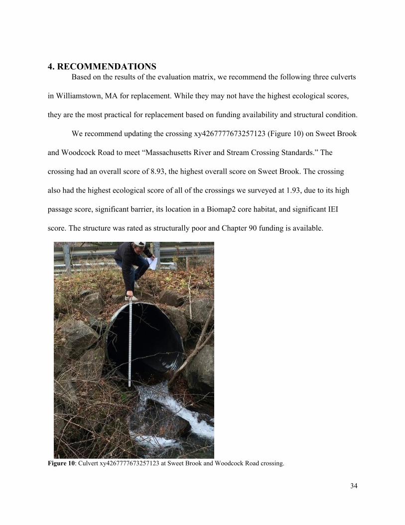
4. RECOMMENDATIONS Based on the results of the evaluation matrix, we recommend the following three culverts
in Williamstown, MA for replacement. While they may not have the highest ecological scores,
they are the most practical for replacement based on funding availability and structural condition.
We recommend updating the crossing xy4267777673257123 (Figure 10) on Sweet Brook
and Woodcock Road to meet “Massachusetts River and Stream Crossing Standards.” The
crossing had an overall score of 8.93, the highest overall score on Sweet Brook. The crossing
also had the highest ecological score of all of the crossings we surveyed at 1.93, due to its high
passage score, significant barrier, its location in a Biomap2 core habitat, and significant IEI
score. The structure was rated as structurally poor and Chapter 90 funding is available.
Figure 10: Culvert xy4267777673257123 at Sweet Brook and Woodcock Road crossing.
34

We also recommend updating the crossing xy4267721173259892 (Figure 11) to meet
the standards. The crossing is located downstream from the previously recommended culvert on
Sweet Brook and Woodcock Road. The overall score for this crossing is 8.53. This culvert is also
in the Aquatic Core habitat. The culvert is rated as structurally poor and Chapter 90 funding is
available. Both this culvert and the culvert upstream had significant free falls at the outlet. We
suggest repairing both of these culverts on Sweet Brook to connect a significant length of linear
ecosystem. Providing full passage at these two stream crossing will likely improve the overall
ecosystem health of Sweet Brook.
35

Figure 11: Culvert xy4267721173259892 at the Woodcock Road Outlet.
The Williamstown DPW may also be interested in culvert xy4268349473246058 on
Oblong Road. The culvert had an overall rating of 9.04, the highest of all the crossings we
surveyed. While this crossing only had an ecological score of 0.04, the culvert has a hazard
mitigation score of 4 and funding availability score of 5, the highest score of all the culverts for
these subgoals. The culvert is in desperate need of repair and Chapter 90 funding available. The
36

crossing’s outlet (see Figure 12) is very clogged and the road is collapsing. The inlet is also
severely constricted with signs of erosion. Despite its low ecological connectivity score, we
recommend repairing this culvert due to the severity of its structural instability.
Figure 12: Culvert xy4268349473246058 on Oblong Road outlet.
Recently the NAACC has updated its database and experts are still working to develop an
algorithm to calculate “Barrier to Passage” scores. When this information becomes available it
37

should be integrated in the matrix for all crossings. For this project, the rubric only considered
this element for the Sweet Brook crossings, which had been surveyed previously.
38
5. ACKNOWLEDGEMENTS
We would like to thank the following people for both their guidance and time
throughout this project:
Sarah Gardner
Elia del Molino
Carrie Banks
David Dethier
Andrew Groff
Jason Hoch
Tim Kaiser
ENVI 302 classmates
Williamstown Conservation Commission
39
6. SOURCES
Brovia, Pam. “Good Culverts Gone Bad” Public Works Magazine. Available http://www.pwmag.com/bridges/goodculvertsgonebad.aspx
“Chapter 90 Program” Massachusetts Department of Transportation Highway Division.
Accessed http://berkshirecountyhighway.org/chapter_90/default.html.
"Conservation Assessment and Prioritization System." Conservation Assessment and Prioritization System. N.p., n.d. Web. 03 Dec. 2015. http://www.umasscaps.org/data_maps/data.html
“Culvert Use, Installation, and Sizing” The Bureau of Land Management. Available
http://www.blm.gov/bmp/low%20volume%20engineering/J_Ch8_Culvert_Use_Installation_&_Sizing.pdf.
“Design of Bridges and Culverts for Wildlife Passage at Freshwater Streams” Massachusetts
Department of Transportation Highway Division. December 2010. Dravis, Stephen. "Route 2 Drainage Project Won't Change Flooding at Spruces."
IBerkshires.com. 14 Aug. 2014. Web. 26 Oct. 2015. Dravis, Stephen. "Williamstown, MassDOT Talk Flooding & Road Work."
IBerkshires.com. 27 Sept. 2013. Web. 26 Oct. 2015. Hoch, Jason. Personal interview. 27 Oct. 2015. Jackson, Scott D. "Ecological Considerations in the Design of River and Stream Crossings."
UMass Amherst. 2003. Web. 26 Oct. 2015. Jessen, Klark. “MassDOT Grants: Tropical Storm Irene Repairs.” MassDOT.gov. 22 Dec. 2011.
Web. 26 Oct. 2015. “Massachusetts River and Stream Crossing Standards” River and Stream Continuity
Partnership (University of Massachusetts Amherst, The Nature Conservancy, Massachusetts Division of Ecological RestorationRiverways Program American Rivers), March 2006. www.streamcontinuty.org.
"MassGIS Datalayers." Administration and Finance. Web. 03 Dec. 2015.
http://www.mass.gov/anf/researchandtech/itservandsupport/application serv/officeofgeographicinformationmassgis/datalayers/layerlist.html
"MassGIS Data NHESP Priority Habitats of Rare Species." Administration and Finance.
40

Commonwealth of Massachusetts, Oct. 2008. Web. 03 Dec. 2015. http://www.mass.gov/anf/researchandtech/itservandsupport/applicationserv/officeofgeographicinformationmassgis/datalayers/prihab.html
“NAACC Stream Crossing Survey Data Form.” NAACC. 24 May 2015. "North Atlantic Aquatic Connectivity Collaborative." NAACC. Web. 3 Dec. 2015.
www.streamcontinuty.org. “Openness Ratio Spreadsheet.” New England District, U.S. Army Corps of Engineers.
http://www.nae.usace.army.mil/Portals/74/docs/regulatory/ StreamRiverContinuity/OpennessRatioSpreadsheet.pdf.
Stafford, Scott. "Route 2 Culvert Project in Williamstown Nears Completion." Berkshire Eagle
Online. 25 Aug. 2014. Web. 26 Oct. 2015. “Regulatory Review” Executive Office of Energy and Environmental Affairs. Natural
Heritage and Endangered Species Program. http://www.mass.gov/eea/agencies/dfg/dfw/naturalheritage/regulatoryreview/.
Kaiser, Tim. Personal interview. 17 Nov. 2015. “The Economics of Culvert Replacement, Fish Passage in Eastern Maine” National
Resource Conservation Service. http://www.nrcs.usda.gov/wps/PA_NRCSConsumption/download?cid=nrcs143_009452&ext=pdf
"Torrential Rain Closes, Damages Williamstown Roads." NorthAdams.com. 30 May 2013. Web.
26 Oct. 2015. McGarigal K, BW Compton, SD Jackson, E Plunkett, and E Ene.“Critical
Linkages Phase 1: Assessing Connectivity Restoration Potential for Culvert Replacement, Dam Removal and Construction of Wildlife Passage Structures in Massachusetts”. 13 July 2012. Report to Massachusetts Department of Transportation and The Nature Conservancy. 28 pgs.
41

APPENDIX
42