Embed Size (px)
Citation preview

1
2012 Industry Training Workshops
Jim Kline Environmental Group Manager
Bureau of Regulatory and Resources Enhancement Office of Oil and Gas Management
Stream
Crossings
During this presentation, we will cover: The various GP’s in Chapter 105 The GP’s that apply to Oil and Gas Activities Common Terminology Authorizations and Forms Waivers The applicability of the GP for Oil and Gas
Activities…what is needed (when and where) Permit Conditions of the GP Notification Requirements Registration Requirements The GP Registration Process (who does what) Areas of Concern PA State Programmatic General Permit Joint Permit (Standard and Small Project)
The GP’s
GP-1 Fish Habitat Enhancement Structures GP-2 Small Docks & Boat Launching Ramps GP-3 Bank Rehabilitation, Bank Protection & Gravel Bar Removal GP-4 Intake and Outfall Structures GP-5 Utility Line Stream Crossings GP-6 Agricultural Crossing & Ramps GP-7 Minor Road Crossings GP-8 Temporary Road Crossings GP-9 Agricultural Activities GP-15 Private Residential Construction in Wetlands

2
Chapter 105- General Permits most
commonly related to Oil and Gas Activities
GP-4 Intake and Outfall Structures
GP-5 Utility Line Stream Crossings
GP-7 Minor Road Crossings
GP-8 Temporary Road Crossings
Common Terminology
PNDI-PNHP
SLLA
ACT 14
Drainage Area
FEMA Floodway
Encroachment
Water Obstruction
Utility Line
Watercourse
Pennsylvania Natural Diversity Inventory (PNDI)
Pennsylvania Natural Heritage Program (PNHP)
Location and status of important ecological resources
(plants, vertebrates, invertebrates, natural
communities and geologic features).
All searches resulting in a conflict must be resolved prior
to a general permit being issued.
The common goal is the conservation of Biodiversity,
resource conservation and preservation.
PNDI Tool Update
Effective July 2, 2012 PNDI receipts and clearance letters issued by the jurisdictional agencies will be valid for two years.
http://www.naturalheritage.state.pa.us/

3
SLLA
Submerged Lands License Agreement Waters and permanently or periodically inundated lands
owned by the Commonwealth (Submerged Lands of the Commonwealth), including lands in the beds of navigable lakes and rivers and beds of streams declared public highways which are owned and held in trust by the Commonwealth.
If applicable, the owner must obtain a SLLA authorizing the
occupation.
The SLLA must be obtained prior to the utilization of any general permit or in conjunction with an individual Chapter 105
permit.
ACT 14
Requires every applicant for a new, amended or revised Department permit to give written notice to each municipality and county government in which the activity is to occur. The written notice must be received by the municipality and county government at least thirty (30) days before the Department may issue or deny an application.
The purpose of this letter is to inform the
municipality or county of your intent to submit an application to DEP.
Drainage area
The drainage area is the total surface area upstream of a point on a stream, where the water from rain or snowmelt which is not absorbed into the ground flows over the ground surface back into streams to finally reach that point on the stream.
Drainage area

4
FEMA Floodway
Federal Emergency Management Agency
The channel of a watercourse and the adjacent land areas which are required to carry & discharge the 100 year frequency flood.
In areas where there are no FEMA maps or studies, it is assumed that the floodway extends 50’ from the top of the bank of the stream.
WATERCOURSE
Any channel or conveyance of surface water having defined bed and banks,
whether natural or artificial, with perennial or intermittent flow.
Water Obstruction
A dike, bridge, culvert, wall, wing wall, fill, pier, wharf, embankment, abutment or other structure located in, along or across or projecting into a watercourse, floodway or body of water.
Encroachment
A structure or activity which changes, expands or diminishes the course, current or cross section of a watercourse, floodway or body of water.
examples:
Excavations, fills and or structures in the stream, floodway or body of water (includes obstructions)

5
UTILITY LINE
Any pipe or pipeline for the transportation of a gaseous, liquid, liquefiable or slurry substance or, any cable, conduit, line or wire for the transmission of electrical energy, telephone, telegraph, radio, or television signals, including cathodic corrosion protection.
Authorizations
Waivers
General Permits (GPs)
• Projects qualify for a GP if they are designed and
implemented in accordance with GP’s conditions and criteria
PA State Programmatic General Permit
(PASPGP-4)
Joint Permit (Standard and Small Project) • PA Water Obstruction and Encroachment Permit
• USACOE Section 404 Permit
• if the project does not require the discharge of dredge or
fill material and/or the placement of structures in waters an
ACOE Section 404 permit may not be required and only
Chapter 105 requirements apply.
Waivers
Certain requirements may be waived. However, the activity or structure is still regulated.
These same activities or structures may require a permit, if the Department finds the activity or structure to have a significant effect upon safety or the protection of life, health, property or the environment.
105.12(a)(2) a water obstruction in a stream or floodway with a drainage area of 100 acres or less and no wetland impacts is waived from permit requirements and considered a waived activity (Waiver 2). Waiver 2 activities still may require federal authorization and are reported to the Army Corp of Engineers (ACOE) under the Pennsylvania State Programmatic General Permit (PASPGP-4).
Waivers

6
General Permit Registration
The Department has up to 60 days to process a GP registration form.
You must receive an acknowledgement of your submitted registration form from the DEP, prior to the start of construction.
The form number is:
Form 3930-PM-WM0500
Current version: Rev. 6/2011
Check all of the
GP blocks that
apply
(Indicate it is for
Oil and Gas)
Section A. Applicant Information Please list an email address Section B. Consultant Information Section C. Project Information *Total project area, not just the crossing area*
Section C (continued).
Detailed Directions to the Site
Project Description
• If GP-5, please, indicate “gathering” or “transmission”; the total pipeline size and length
• If GP-7 and 8, describe in detail
Section D.
Compliance Review
• Is the applicant currently in violation of any permits issued by the Dept?
Please provide:
• Permits Numbers
• Nature of the Violation
• Status of the Violation

7
Section E.
Certification
Original signature of the permittee
Person responsible for the installation, operation and maintenance of the authorized activity.
Section F.
Registration Checklist
Act 14 Notice (Municipality & County)
Copies of the notification letters and proof of receipt ARE NOT required
Cumulative Impact screening form
Location map
Sketch plan
Cross section drawings (where req. GP 5,6,7 & 8)
Color Photographs
Section F.
Registration Checklist
PNDI
• Completed PNDI Project Planning and Environmental Review Form
• Search Receipt - NO Known Impacts
- Avoidance Measures
- Potential Impacts &
agency coordination
Section F.
Registration Checklist Bog Turtle Habitat Screening
Habitat screening form
“no effect” determination from the ACOE
Clearance from the US Fish and Wildlife Service
Activities which permanently impact wetlands
Delineation with completed data sheets
Impacts > 0.05 acres – wetland replacement plan
If on-site is not feasible – fee schedule

8
Section F.
Registration Checklist
Sketch Plan
Project Cross Sections and Plan Views
Chapter 102- Erosion and Sediment Control
E&S Control Plans must be on site during
all phases of construction
The General Permits commonly
related to Oil and Gas Activities GP4- Intake and
Outfall Structures
Structures in the watercourse or
floodway
9
GP4- Intake and Outfall Structures
Applicability for Use & Conditions
Watershed drainage can be greater than
1 square mile
Maximum diameter outfall culvert is 36”
GP4- Intake and Outfall Structures
NON-Applicability (Can not use for):
Exceptional Value or High Quality Waters
Areas of Historic or Archaeological Resources
Wild or Scenic Rivers
Natural Landmarks
Wetlands
Stocked trout streams
from March 1st through June 15th
Wild trout streams
from Oct. 1st through Dec. 31st
GP5- Utility Line Stream Crossings GP5- Utility Line Stream Crossings
Applicability for Use & Conditions
Watershed drainage can be greater than 1 square mile
Maximum line diameter is 36”
3’ of cover (1’ of cover if the line is in rock)
High Quality Waters and below
Installation of trench plugs (or other adequate
measures) must be used in the trench to prevent sedimentation from entering the stream or from dewatering a wetland

10
GP5- Utility Line Stream Crossings
Applicability for Use & Conditions
-Mats, pads or other similar devices must be used when crossing the
wetland by construction equipment. Compaction of wetland soils is not
allowed.
-The owner must also obtain a GP-8 (Temporary Road Crossing) for
construction vehicles crossing at these sites.
GP5- Utility Line Stream Crossings
NON-Applicability (Can not use for):
Exceptional Value Waters
Areas of Historic or Archaeological Resources
Wild or Scenic Rivers
Natural Landmarks
Threatened or Endangered Species
Wetlands greater than 10 acres in size
Stocked trout streams
from March 1st through June 15th
Wild trout streams
from Oct. 1st through Dec. 31st
Reservoirs
GP-5 Areas of Concern
Running utility lines through existing culverts
PHOTO COURTESY: DEP SW DOGO
GP-5 Areas of Concern
HDD inadvertent returns
Shallow depths
Additives
Contingency Plans
PHOTO COURTESY:
DEP Scott Sabocheck

11
GP7- Minor Road Crossing
(permanent structure)
GP8- Temporary Crossing Structures in place for less than 12 months
*Among the many differences, one difference between the GP7 and GP8 is the
amount of time the structure will be in place.
GP7- Minor Road Crossing
Applicability for Use & Conditions
The construction must be completed within 3 years. If not, the structure must be removed and the watercourse must be restored to the former condition.
Crossings are installed at right angles to the stream
GP7- Minor Road Crossing
Applicability for Use & Conditions
The crossing must be kept open and clear
of any obstruction or debris
GP7- Minor Road Crossing
Applicability for Use & Conditions
• Culverts must be
installed with the
invert at least 6”
below the natural
stream bed and that
gradient of the
invert does not
deviate from the
natural stream bed

12
GP7- Minor Road Crossing
Applicability for Use & Conditions
The structure can not interfere with the
migration of fish
Culverts shall not increase the velocity
or direct flow so as to result in the
erosion of the stream bed or bank
GP7- Minor Road
Crossing
Applicability for
Use & Conditions
-Culverts and bridges shall be sized accordingly and shall be
of sufficient width and size so as not to narrow the existing
stream channel
-Culverts must be aligned with the stream flow
GP7- Minor Road Crossing
NON-Applicability (Can not use for):
If the watershed drainage is greater than 1.0 square mile
Exceptional Value Waters (EV) Areas of Historic or Archaeological Resources Wild or Scenic Rivers Natural Landmarks Threatened or Endangered Species Wetlands crossing greater than 0.1 acre in size and less
than 100’ in length Stocked trout streams from March 1st through June 15th Wild trout streams from Oct. 1st through Dec. 31st
GP8- Temporary Road Crossing
Applicability for Use & Conditions
The crossing may remain in place for one year. Crossings are done at right angles to the stream. Crossing of wetlands shall be avoided if an alternate
location is possible. Crossing of wetlands must be located at the narrowest
practicable point. Crossings must be restored to the original topography
& stabilized (except fords…the approaches must be adequately blocked &
stabilized for restoration).

13
GP8- Temporary Road Crossing
NON-Applicability (Can not use for):
Wetland crossings greater than 200’ in length
Culverts less than 12” diameter
Areas of Historic or Archaeological Resources
Threatened or Endangered Species
Natural Landmarks
Stocked trout streams
from March 1st through June 15th
Wild trout streams
from Oct. 1st through Dec. 31st
Fords (GP 7 or GP 8)
- These crossings must be stable
- Are prohibited on HQ and EV
streams or in wild trout streams
- Discharge of sediment while
vehicular crossing is not allowed
Fords
Skidding equipment across a ford is prohibited.
Fords are prohibited within 2,000’ upstream from drinking water intakes or reservoirs for public water supplies
If the stream bed does not have a rock bottom, then a layer of clean rock must be provided and can not obstruct stream flow
The approaches must enter the stream at less than 10% grade within 50’ of the stream
GP8- Areas Of Concern
Timber mat crossing
Geotextile Fabric securely fastened on the underside of timber mats to collect loose debris or sediment and prevent discharge into the stream.

14
GP8- Areas Of Concern
attach geotextile to the underside
install temporary E&S controls at the crossing to prevent sediment from entering the waterway
Notification Requirements
for GPs related to Oil and Gas Activities
Registration form to the DEP OOGM
Pa Historical & Museum Commission
(If resource was found during the activity)
You must notify the PA Fish & Boat Commission Regional Headquarters 10 days prior to construction
Notification Requirements (cont’d)
for GPs related to Oil and Gas Activities Registration Requirements
for GPs related to Oil and Gas Activities
Act 14 Notification Cumulative Impact Project Screening Form USGS Location Map Sketch Plan Cross Sections Color Photographs PNDI Bog Turtle Screening (required for GP 5,7 & 8) Wetland Delineations (NOT applicable for GP4) Erosion & Sediment Control Plan Submerged Lands License Agreement (SLLA) * required if applicable

15
Where do you register a GP? GPs related to
Oil and Gas
activities are
registered in
the
appropriate
OOGM District
Offices:
Meadville
Pittsburgh
Williamsport
An acknowledged copy of this General Permit and the
approved E&S Control Plan MUST BE AVAILABLE AT
THE PROJECT SITE during construction (Ref. section F- Reg. Checklist of the General Permit Registration)
County Conservation Districts (CCDs)
involvement concerning OOGM GPs

16
County Conservation Districts (CCDs)
involvement concerning OOGM GPs
CCDs (with CH105 delegation) will review all GPs associated with transmission lines.
example…. An operator submits an ESCGP to a delegated CCD for a transmission line. Say the transmission line will cross a stream which requires a GP 5. The CCD will also issue the GP for this activity.
GPs not associated with transmission lines (collection, gathering lines etc and everything that we talked about today) will be covered by OOGM.
Federal Programmatic General
Permit (PASPGP-4)
“One Stop Shop”
Pennsylvania State Programmatic General Permit-4 (4th version)
effective July 1, 2011
Many projects in Commonwealth waters and wetlands also require federal authorization.
For certain projects DEP can attach a federal SPGP permit to state permit
When it applies, PASPGP-4 eliminates any need for redundant federal reviews
PASPGP-4
(Federal Authorization) Waiver of DEP permit
• Under 100 acre of drainage area • Does not apply to wetlands located in the floodway • Must contact USACOE for Federal Authorization
PASPGP-4 • An automatic Federal Authorization when DEP General Permit
is issued • If it is not attached, then an additional 45 day review by
USACOE If > 0.25 acre wetland impacts (accumulated) If > 250 ft linear impacts of stream (accumulated)
If > 1 acre of all water impacts (streams + wetlands) USACOE will review and issue directly
If < 1 acre water and not eligible DEP General Permit • Joint Permit
Full Small Project (not any significant impacts (e.g. no wetlands, etc.))
PASPGP-4
Section 404(e) of the Clean Water Act (CWA) (33 United States Code [U.S.C.] Section [§] 1344) allows for the issuance of general permits on a statewide basis, which operate in conjunction with a State regulatory program that protects the aquatic environment in a manner equivalent to the Department of the Army regulatory program, provided that the activities permitted under each category of such general permits are similar in nature and result in no more than minimal individual or cumulative adverse effects on the aquatic environment. This Pennsylvania State Programmatic General Permit # 4 (PASPGP-4) is issued pursuant to Section 404(e) and is based on and consistent with the requirements of the CWA 404(b)(1) Guidelines.
http://www.nap.usace.army.mil/cenap-op/regulatory/paspgp.html

17
PASPGP3
All activities issued under PASPGP-3 that did not expire prior to June 30, 2011, are reauthorized by the PASPGP-4 without further notice to the applicable Corps District provided the proposed regulated activities comply with all terms, conditions, limits, and best management practices identified and required by the PASPGP-4; all special conditions attached to the original PASPGP-3 authorization; and all applicable PADEP Chapter 105 authorizations. The duration of these reauthorizations will be for: the term of the PASPGP-4 (June 30, 2016) for Category I or II activities, or the applicable PADEP Chapter 105 authorization, or five years from issuance of the PASPGP-3 Category III activities, whichever is less.
Joint Permit (Standard and Small Project)
No work in wetlands
No impacts to a Federal wilderness area or a National Historic Site
No impacts on the habitat of rare, threatened or endangered species
(PNDI-PNHP)
No significant impacts to public water supplies, HQ or EV watersheds, scenic rivers or wild or stocked trout streams
3930-PM-
WM0036A
Rev. 6/2011
(3 page application)
Joint Permit Requirements
An application for a joint permit shall have the following information provided with it:
• A site plan
• A location map
• Project description
• Color photographs
• Stormwater Management Analysis
• Floodplain Management Analysis
• Risk Assessment
18
Joint Permit Requirements
(cont’d) • Alternatives analysis
• Mitigation plan
(avoid, reduce, minimize, compensate)
• Impacts analysis
• Other data required by Chapter 105
• Additional information requested by the Department
• Proof of an application for an
Earth Disturbance Permit
or an Erosion & Sedimentation Control Plan.
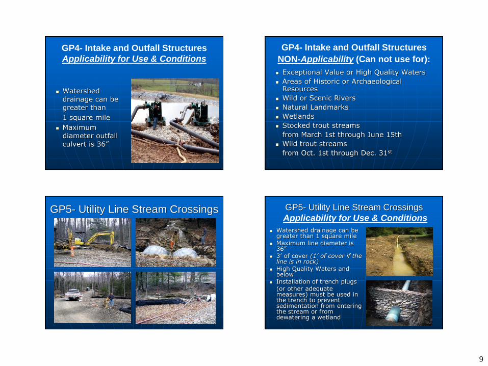
Joint Permit Registration
Under Money Back Guarantee,
the Department has up to 130 days to process a joint permit application
You must obtain a written permit from DEP, prior to the start of construction
Form 3930-PM-WM0036A
- Current version: Rev. 6/2011
- Do not use other versions
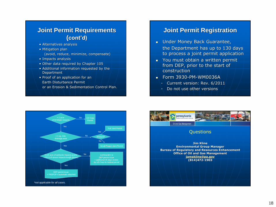
< 1 acre
of All Water Impacts US Corp
Permit
No
Yes
<0.25 acre of wetlands Impacts and/or
<250 ft of stream impacts length (linear)
No CATEGORY III
DEP permit issue
+ additional 45 days review
by US Corp for federal permit
< 1 sq. mile
drainage area
Yes
Full Joint Permit
No Wetland?
Small Project Joint Permit
*not applicable for all cases.
DEP permit issue
+ PASPGP-4 automatic attached
Yes
No
Yes
Questions
Jim Kline Environmental Group Manager
Bureau of Regulatory and Resources Enhancement Office of Oil and Gas Management
[email protected] (814)472-1903