Embed Size (px)
Citation preview
Pangandaran Coastal Land Carrying Capacity Analysis for Tourism
Activity
Bambang Edhi Leksono, Santi Azarah, Putri Rahmadani, M.Adie Brilian (Indonesia)
Keywords : coastal land, carrying capacity, tourism activity, environment.
SUMMARY
Pangandaran beach has gone through a lot of environmental dynamics due to anthropological
interference or natural disasters such as earthquake and tsunami.
Coastal engineering and directed development are needed to prevent Pangandaran Area from
undesirable condition such as overshot carrying capacity or get into the tourism stagnan phase.
Study concerning the coastal environment management which is conducted by several parties
has been shown to be optimal in restoring environmental degradation without reducing the
benefits obtained from tourism activities.
Marine tourism development itself is currently being a hot topic between tourism developers or
academic researchers. Uncontrolled marine tourism development will always leads to the
imbalance of monetary, social, and ecological aspects and disrupt the sustainability idea.
Unfortunately, Pangandaran Beach’s land carrying capacity as a largest marine tourism
destination in West Java never been analysed; and there is no update of Pangandaran suitability
environment to support its marine tourism activity.
To that end, this research aims to analysing the suitability of Pangandaran Beach for tourism
area and its land carrying capacity based on its environmental condition to support spatial
planning or stakeholder take on policy in order to attain marine tourism sustainability.
The methodology used for calculating Pangandaran Carrying Capacity is referred to Regulation
of the Indonesian Minister of Environment and Forestry No. 7 of 2009
Result and Discussion Land carrying capacity status in Pangandaran Sub-districts is overshot,
in as much that the SL value is below the DL value by the year of 2020-2050 from its projection.
Pangandaran Coastal Land Carrying Capacity Analysis for Tourism Activity (10973)
Bambang Edhi Leksono, Santi Azzahrah, Putri Rahmadani and Brilian Adie (Indonesia)
FIG e-Working Week 2021
Smart Surveyors for Land and Water Management - Challenges in a New Reality
Virtually in the Netherlands, 21–25 June 2021
SUMMARY (Indonesia)
Pantai Pangandaran banyak mengalami dinamika lingkungan akibat gangguan antropologi
atau bencana alam seperti gempa bumi dan tsunami.
Rekayasa pesisir dan pengembangan terarah diperlukan untuk mencegah Kawasan
Pangandaran dari kondisi yang tidak diinginkan seperti daya dukung yang terlampaui atau
masuk ke fase stagnan pariwisata.
Kajian tentang pengelolaan lingkungan pesisir yang dilakukan oleh beberapa pihak terbukti
optimal dalam memulihkan kerusakan lingkungan tanpa mengurangi manfaat yang diperoleh
dari kegiatan pariwisata.
Perkembangan wisata bahari sendiri saat ini sedang menjadi perbincangan hangat di kalangan
pengembang pariwisata maupun akademisi peneliti.
Perkembangan wisata bahari yang tidak terkendali akan selalu menimbulkan
ketidakseimbangan aspek moneter, sosial, dan ekologi serta mengganggu gagasan
keberlanjutan.
Sayangnya, daya dukung daratan Pantai Pangandaran sebagai destinasi wisata bahari terbesar
di Jawa Barat tidak pernah dianalisis dan belum adanya update kesesuaian lingkungan
Pangandaran untuk menunjang kegiatan wisata baharinya.
Untuk itu, penelitian ini bertujuan untuk menganalisis kesesuaian Pantai Pangandaran untuk
kawasan wisata dan daya dukung daratannya berdasarkan kondisi lingkungannya untuk
mendukung penataan ruang atau pengambilan kebijakan oleh stakeholders dalam rangka
mencapai keberlanjutan wisata bahari.
Metodologi yang digunakan untuk menghitung Daya Dukung Pangandaran mengacu pada
Peraturan Menteri Lingkungan Hidup dan Kehutanan Nomor 7 Tahun 2009.
Hasil dan Pembahasan Status daya dukung lahan di Kecamatan Pangandaran terlampaui,
karena nilai SL berada di bawah nilai DL pada tahun 2020-2050 dari proyeksi.
Pangandaran Coastal Land Carrying Capacity Analysis for Tourism Activity (10973)
Bambang Edhi Leksono, Santi Azzahrah, Putri Rahmadani and Brilian Adie (Indonesia)
FIG e-Working Week 2021
Smart Surveyors for Land and Water Management - Challenges in a New Reality
Virtually in the Netherlands, 21–25 June 2021

Pangandaran Coastal Land Carrying Capacity Analysis for Tourism
Activity
Bambang Edhi Leksono, Santi Azarah, Putri Rahmadani, M.Adie Brilian (Indonesia)
1. Introduction
Utilization of coastal resources for tourism needs is increasingly prevalent, along with the
increasing tendency of tourists to visit the marine tourism industry compared to other types of
tourism (Papageorgiou, 2016). Marine tourism is chosen by tourists due to the availability of
services interacting with beautiful and unique nature, or in other words, it has a natural
atmosphere that is different from the environment the tourist originated (M. Orams, 2002).
Pangandaran beach provides marine tourism acitivy since a long ago. Moreover, the tourism
sector contributes the most regional Pangandaran Regency income, up to 36% of total local
revenue (BPKD Pangandaran, 2019). Furthermore, the income earned through the tourism
industry can instill in the local communities a sense of pride in their environment as well as
highlight the connection between tourism and their livelihood (Wu & Tsai, 2016) and
potentially accelerate solving localhood poverty (Yoeti, 2008).
The focus of the local government in the tourism sector has led to the increasing economic
activity of the people in the Pangandaran region and the growth of building number with several
function (Mardiatno et al., 2020). For example, within 5 years, the hotel growth in Pangandaran
has reached 208% growth rate (Ahari, 2011). It can be an advantage from the economic
perspective, but can leads to the increasement of the potential risk damage (Mardiatno et al.,
2020) and environmental degradation in certain territories (Amado dos Santos et al., 2020). On
the other hand, the increment of local population can trigger the rise of land use needed for
housing or new settlement (Mulder, 2006) or even overshot its carrying capacity (Mwalyosi,
1991). Need to know that the essence of carrying capacity is the comparison between supply
and demand and the extent of the available land has been always limited (Widodo et al., 2015).
The concept of carrying capacity especially for tourism activity arises from the perception that
tourism cannot grow continuously in a particular region without causing irreversible damage to
the local (Coccossis, H., & Mexa, 2017).
Pangandaran beach has gone through a lot of environmental dynamics due to anthropological
interference (Yuliadi et al., 2019) or natural disasters such as tsunami (Mardiatno et al., 2020).
Coastal engineering and directed development are needed to prevent Pangandaran Area from
undesirable condition such as overshot carrying capacity or get into the tourism stagnan phase
(Hidayat, 2016). Study concerning the coastal environment management which is conducted
by several parties has been shown to be optimal in restoring environmental degradation without
reducing the benefits obtained from tourism activities (Lin et al., 2020; Rao et al., 2014;
Scheufele et al., 2018).
Marine tourism development itself is currently being a hot topic between tourism developers or
academic researchers (M. B. Orams & Lück, 2014). Uncontrolled marine tourism development
Pangandaran Coastal Land Carrying Capacity Analysis for Tourism Activity (10973)
Bambang Edhi Leksono, Santi Azzahrah, Putri Rahmadani and Brilian Adie (Indonesia)
FIG e-Working Week 2021
Smart Surveyors for Land and Water Management - Challenges in a New Reality
Virtually in the Netherlands, 21–25 June 2021
will always leads to the imbalance of monetary, social, and ecological aspects and disrupt the
sustainability idea (Long et al., 2014). Unfortunately, Pangandaran Beach’s land carrying
capacity as a largest marine tourism destination in West Java never been analysed; and there’s
no update of Pangandaran suitability environment to support its marine tourism activity. To that
end, this research aims to analysing the suitability of Pangandaran Beach for tourism area and
its land carrying capacity based on its environmental condition to support spatial planning or
stakeholder take on policy in order to attain marine tourism sustainability.
2. LITERATURE REVIEW
2.1 Carrying capacity
Many international organizations and national institutions have launched coastal development
strategies and policies in a bid to achieve coastal ecosystem sustainability, and carrying capacity
assessment is conducive to promote the coordinated development of the ecological environment
and human activities (Liu et al., 2020). Carrying capacity indicatesthe difficulty of evaluating
objectively the interaction between a population and the environment (Seidl & Tisdell, 1999),
or the maximum density which a particular range is capable of supporting (Dhondt, 1988). The
capacity of land are the minimum living needs that can be provided by land to accommodate
life on it. Population pressure on land carrying capacity can be determined based on the ratio
value between the population and the percentage of agriculture with a minimum land area for a
decent living (Soermarwoto, 2000).
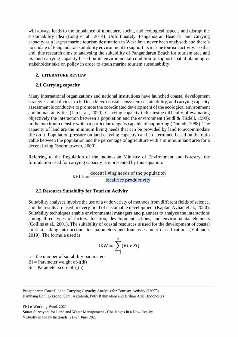
Referring to the Regulation of the Indonesian Ministry of Environment and Forestry, the
formulation used for carrying capacity is represented by this equation:
KHLL =decent living needs of the population
local rice productivity
2.2 Resource Suitability for Tourism Activity
Suitability analyses involve the use of a wide variety of methods from different fields of science,
and the results are used in every field of sustainable development (Kaptan Ayhan et al., 2020).
Suitability techniques enable environmental managers and planners to analyze the interactions
among three types of factors: location, development actions, and environmental elements
(Collins et al., 2001). The suitability of coastal resources is used for the development of coastal
tourism, taking into account ten parameters and four assessment classifications (Yulianda,
2019). The formula used is:
IKW = ∑(𝐵𝑖 𝑥 𝑆𝑖)
𝑛
𝑖=1
n = the number of suitability parameters
Bi = Parameter weight of-i(th)
Si = Parameter score of-i(th)
Pangandaran Coastal Land Carrying Capacity Analysis for Tourism Activity (10973)
Bambang Edhi Leksono, Santi Azzahrah, Putri Rahmadani and Brilian Adie (Indonesia)
FIG e-Working Week 2021
Smart Surveyors for Land and Water Management - Challenges in a New Reality
Virtually in the Netherlands, 21–25 June 2021

The tourism suitability analysis uses a suitability matrix arranged based on the importance of
each parameter to support activities in the area (Yulianda, 2019), shown by Table 1.
Table 1. Matriks Kesesuaian untuk Wisata Pantai Kategori Rekreasi
No. Parameter Weight Category Score
1 beach type 0,200
white sand 3
white sand with coral
fragments 2
black sand, a little steep 1
mud, rocky, steep 0
2 beach’s wide (m) 0,200
>15 3
10 until 15 2
3- <10 1
<3 0
3 sea waters bed material 0,170
sand 3
sandy coral 2
muddy sand 1
mud, sandy mud 0
4 water’s depth (m) 0,125
0-3 3
>3-6 2
>6-10 1
>10 0
5 waters brightness (%) 0,125
>80 3
>50-80 2
20-50 1
<20 0
6 0,80 0-17 3
Pangandaran Coastal Land Carrying Capacity Analysis for Tourism Activity (10973)
Bambang Edhi Leksono, Santi Azzahrah, Putri Rahmadani and Brilian Adie (Indonesia)
FIG e-Working Week 2021
Smart Surveyors for Land and Water Management - Challenges in a New Reality
Virtually in the Netherlands, 21–25 June 2021

current velocity
(cm/detik)
17-34 2
34-51 1
>51 0
7 beach slope (derajat) 0,80
<10 3
10 - 25 2
>25-45 1
>45 0
8 beach land cover 0,010
Coconut trees, open field 3
Low bush, Savana 2
High scrub 1
Mangrove forests, settlements,
ports 0
9 dangerous biota 0,005
Null 3
Sea urchins 2
Sea urchins, stingray 1
Sea urchins, stingray,
stonefish, shark 0
10
freshwater availability /
distance to fresh water
source (km)
0,005
<0.5 3
>0.5-1 2
>1-2 1
>2 0
Scoring based on the quality of each suitability parameter during the data collection process in
the field. After determining the weights and scores, the tourism suitability index (IKW) value
is calculated based on the total multiplication of weights and scores of all parameters for each
type of tourism activity. Based on the calculation of the Tourism Suitability Index, the land
suitability classes are obtained for coastal recreation tourism (Nugraha et al., 2013).
3. THE MATERIAL AND METHOD
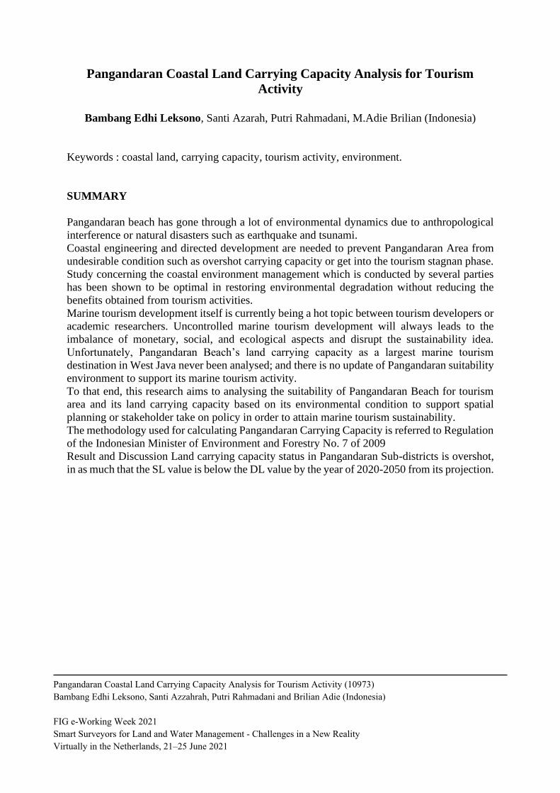
This research was conducted in Pangandaran District which is administratively located in
Pangandaran Regency, West Java, Indonesia. Geographically, Pangandaran District is located
at 07˚ 42 '06 "South Latitude - 108˚ 29" 41 "East Longitude (Rahmawan et al., 2020).
Pangandaran District has 8 villages with an area of 60.77 km2 (Badan Pusat Statistik, 2018).
Pangandaran District has a beach area of 136 ha (Dinas Pariwisata dan Kebudayaan, 2003). The
Pangandaran area is well-known for its tourism potential in the water sector which supports
regional income potential (Yuningsih, 2005). Therefore, environmental analysis is needed to
support sustainable tourism. Visually, the research location will be shown in the image below.
Pangandaran Coastal Land Carrying Capacity Analysis for Tourism Activity (10973)
Bambang Edhi Leksono, Santi Azzahrah, Putri Rahmadani and Brilian Adie (Indonesia)
FIG e-Working Week 2021
Smart Surveyors for Land and Water Management - Challenges in a New Reality
Virtually in the Netherlands, 21–25 June 2021
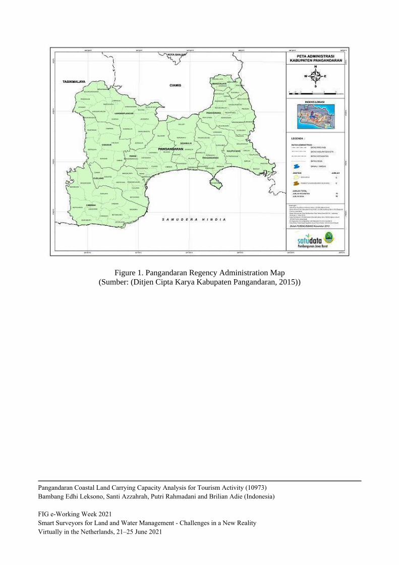
Figure 1. Pangandaran Regency Administration Map
(Sumber: (Ditjen Cipta Karya Kabupaten Pangandaran, 2015))
Pangandaran Coastal Land Carrying Capacity Analysis for Tourism Activity (10973)
Bambang Edhi Leksono, Santi Azzahrah, Putri Rahmadani and Brilian Adie (Indonesia)
FIG e-Working Week 2021
Smart Surveyors for Land and Water Management - Challenges in a New Reality
Virtually in the Netherlands, 21–25 June 2021
8
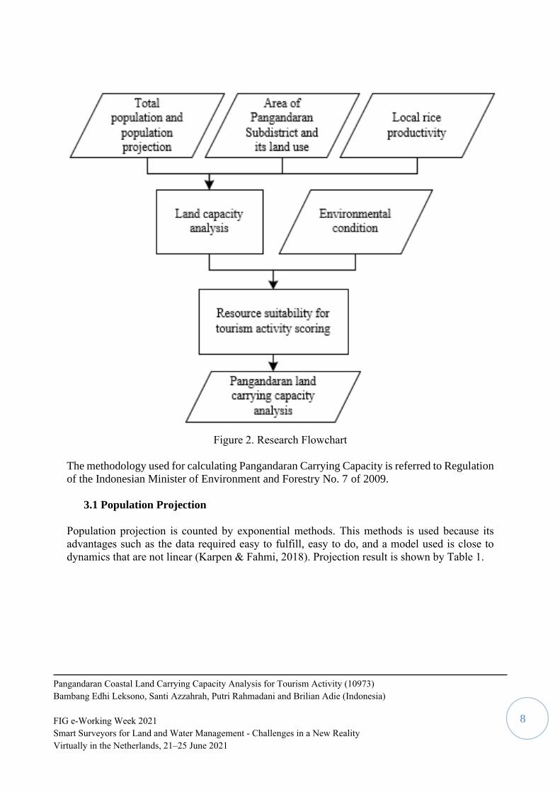
Figure 2. Research Flowchart
The methodology used for calculating Pangandaran Carrying Capacity is referred to Regulation
of the Indonesian Minister of Environment and Forestry No. 7 of 2009.
3.1 Population Projection
Population projection is counted by exponential methods. This methods is used because its
advantages such as the data required easy to fulfill, easy to do, and a model used is close to
dynamics that are not linear (Karpen & Fahmi, 2018). Projection result is shown by Table 1.
Pangandaran Coastal Land Carrying Capacity Analysis for Tourism Activity (10973)
Bambang Edhi Leksono, Santi Azzahrah, Putri Rahmadani and Brilian Adie (Indonesia)
FIG e-Working Week 2021
Smart Surveyors for Land and Water Management - Challenges in a New Reality
Virtually in the Netherlands, 21–25 June 2021

9
Table 1. Pangandaran Sub-District Population and Projection
Year Population
(People)
Population
Growth Rate
(%)
2015 61864 0,558
2016 62210 0,598
2017 62583 0,577
2018 62945 0,529
2019 63279 0,565
Prediction
2020 63638
2030 67339
2040 71256
2050 75401
3.2 Land Use
Based on data obtained from government agencies such as the Regional Planning and
Development Agency of Pangandaran Regency and the Public Works Office of Pangandaran
Regency in the form of shapefiles, the authors carried out processing and analysis. The results
of data processing can be seen that the land cover in Pangandaran District consists of pond
water, canal water, mangrove forests, jungle forests, grasslands, sand or sand dunes, plantations,
settlements, rice fields, rainfed rice fields, shrubs, rivers, tourist parks and moor. Furthermore,
based on the author's analysis, it can be seen that the land cover in Pangandaran District is
dominated by plantations by 88%. More details related to land cover in Pangandaran District
will be visualized in the image below.
Pangandaran Coastal Land Carrying Capacity Analysis for Tourism Activity (10973)
Bambang Edhi Leksono, Santi Azzahrah, Putri Rahmadani and Brilian Adie (Indonesia)
FIG e-Working Week 2021
Smart Surveyors for Land and Water Management - Challenges in a New Reality
Virtually in the Netherlands, 21–25 June 2021

10
Figure 1. Pangandaran Regency Land Cover
3.3 Local Rice Productivity
Environmental productivity to calculate land needs and capacity in terms of rice or local rice
productivity in an area. According to the Agriculture Ministerial Regulation No. 07/2012, the
criteria for land that can be called productive is when the land can produce 30 quintals of rice
per hectare each year. in which there are criteria for each commodity to be called productive.
Data related to the results of the 3 commodities above were obtained from the Pangandaran
Central Statistics Agency in 2019. More details regarding the data can be seen in the table
below.
Table 2. Data produktivitas padi dari tahun 2013-2017 (kw)
Jenis
Pertanian
2013
(Kw)
2014
(Kw)
2015
(Kw)
2016
(Kw)
2017
(Kw)
Rata-Rata
Keseluruhan
(Kw)
Padi 99.53 104.25 104.89 94.27 105.58 101.704
From these data, it can be concluded that according to the Agricultural Ministerial Regulation
Number 07 of 2012, Pangandaran District is included in the criteria for productive land.
Pangandaran Coastal Land Carrying Capacity Analysis for Tourism Activity (10973)
Bambang Edhi Leksono, Santi Azzahrah, Putri Rahmadani and Brilian Adie (Indonesia)
FIG e-Working Week 2021
Smart Surveyors for Land and Water Management - Challenges in a New Reality
Virtually in the Netherlands, 21–25 June 2021
11
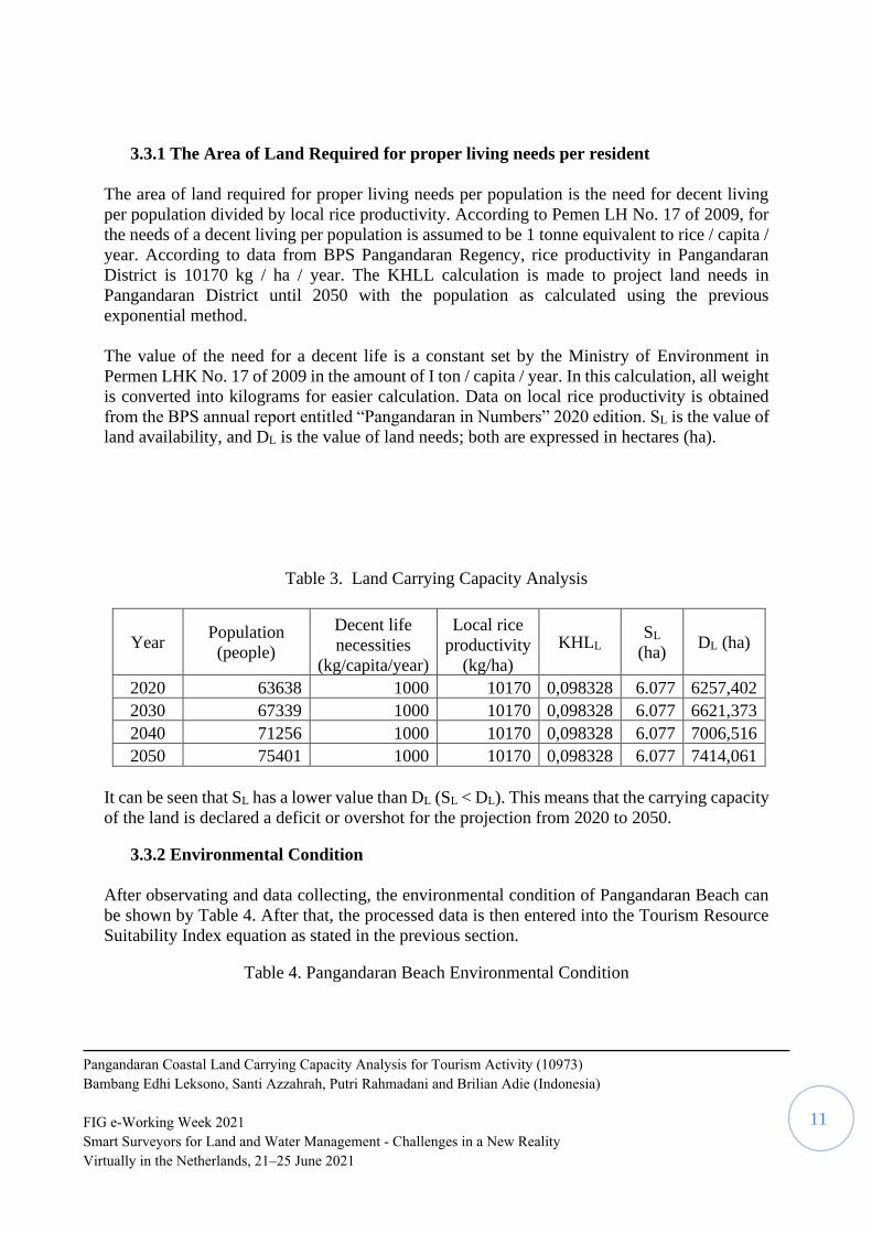
3.3.1 The Area of Land Required for proper living needs per resident
The area of land required for proper living needs per population is the need for decent living
per population divided by local rice productivity. According to Pemen LH No. 17 of 2009, for
the needs of a decent living per population is assumed to be 1 tonne equivalent to rice / capita /
year. According to data from BPS Pangandaran Regency, rice productivity in Pangandaran
District is 10170 kg / ha / year. The KHLL calculation is made to project land needs in
Pangandaran District until 2050 with the population as calculated using the previous
exponential method.
The value of the need for a decent life is a constant set by the Ministry of Environment in
Permen LHK No. 17 of 2009 in the amount of I ton / capita / year. In this calculation, all weight
is converted into kilograms for easier calculation. Data on local rice productivity is obtained
from the BPS annual report entitled “Pangandaran in Numbers” 2020 edition. SL is the value of
land availability, and DL is the value of land needs; both are expressed in hectares (ha).
Table 3. Land Carrying Capacity Analysis
Year Population
(people)
Decent life
necessities
(kg/capita/year)
Local rice
productivity
(kg/ha)
KHLL SL
(ha) DL (ha)
2020 63638 1000 10170 0,098328 6.077 6257,402
2030 67339 1000 10170 0,098328 6.077 6621,373
2040 71256 1000 10170 0,098328 6.077 7006,516
2050 75401 1000 10170 0,098328 6.077 7414,061
It can be seen that SL has a lower value than DL (SL < DL). This means that the carrying capacity
of the land is declared a deficit or overshot for the projection from 2020 to 2050.
3.3.2 Environmental Condition
After observating and data collecting, the environmental condition of Pangandaran Beach can
be shown by Table 4. After that, the processed data is then entered into the Tourism Resource
Suitability Index equation as stated in the previous section.
Table 4. Pangandaran Beach Environmental Condition
Pangandaran Coastal Land Carrying Capacity Analysis for Tourism Activity (10973)
Bambang Edhi Leksono, Santi Azzahrah, Putri Rahmadani and Brilian Adie (Indonesia)
FIG e-Working Week 2021
Smart Surveyors for Land and Water Management - Challenges in a New Reality
Virtually in the Netherlands, 21–25 June 2021

12
No. Parameter Bobot
Skor
Eksisting
1 Beach Type 0,200 2
2 Beach Width (m) 0,200 3
3 Basic Water Material 0,170 3
4 Depth of Water (m) 0,125 3
5 Water Brightness (%) 0,125 1
6 Flow Velocity (cm / sec) 0,80 0
8 Coastal Land Closure 0,010 3
9 Dangerous Biota 0,005 3
10 Freshwater Availability / Distance to Fresh
Water Source (km) 0,005 2
4. RESULT AND DISCUSSION
Land carrying capacity status in Pangandaran Sub-districts is overshot, inasmuch that the SL
value is below the DL value by the year of 2020-2050 from its projection. The result shown by
Table 5.
Table 5. Land Carrying Capacity Calculation Results
Year SL DL (ha)
2020 6077 6257
2030 6077 6621
2040 6077 7007
2050 6077 7414
The population in Pangandaran District is projected to be 75,401 people in 2050. This means
that 7,414 ha of land is needed to accommodate these residents if it refers to the decent living
standard set by the Ministry of Environment and Forestry. Because the land area cannot be
increased, the variable that must be addressed is the population itself. If possible, the
Pangandaran Government should immediately make a firm policy regarding pregnancy control
(family planning) or direct the planning of vertical housing development in order to meet the
needs of residential land for residents in the Pangandaran area. It should be noted that marine
tourism activities should not interfere with the lives of local residents (Pham, 2020), in fact,
they should provide better livelihoods for local residents themselves (2016). Even so, the
environmental conditions of Pangandaran Beach are still included in the category according to
Pangandaran Coastal Land Carrying Capacity Analysis for Tourism Activity (10973)
Bambang Edhi Leksono, Santi Azzahrah, Putri Rahmadani and Brilian Adie (Indonesia)
FIG e-Working Week 2021
Smart Surveyors for Land and Water Management - Challenges in a New Reality
Virtually in the Netherlands, 21–25 June 2021

13
the index of 3,665 for marine tourism activities, even though there have been natural
disturbances or anthropological interferences.
5. CONCLUSION
From the result of land carrying capacity and resource suitability analysis above, it can be
concluded that the urgency of Pangandaran beach is not about its environmental condition and
quality. The stakeholders should put some corncerns to the local life quality, considering the
disparition of its DL and SL value of land carrying capacity in Pangandaran Sub-districts.
REFERENCES
BIOGRAPHICAL NOTES
Dr. Bambang Edhi LEKSONO, born in 1957, Graduated in 1982 as Engineer in Surveying
and Mapping from Institut Teknologi Bandung (Indonesia), obtaining Master degree in Urban
Survey & Human Settlement Analysis (ITC-Holland) in 1990 and Doctorate degree in
Geography in 1996 from Universite de Nice Sophia Antipolis (France). Now, Dr. Bambang
Edhi Leksono is Lecturer and also member of Surveying and Cadastre Research Group in
Institut Teknologi Bandung, Indonesia.
CONTACTS
Dr. Bambang Edhi LEKSONO
Institut Teknologi Bandung
Surveying and Cadastre Research Group, ITB
Labtek IX-C Building ,3rd floor, Jl Ganesha 10, Bandung- 40132 ,INDONESIA
Tel. +62.22.2530701 ,Fax. +62.22.2530702
Email: [email protected] and [email protected]
Mobile : +62 811208137
Pangandaran Coastal Land Carrying Capacity Analysis for Tourism Activity (10973)
Bambang Edhi Leksono, Santi Azzahrah, Putri Rahmadani and Brilian Adie (Indonesia)
FIG e-Working Week 2021
Smart Surveyors for Land and Water Management - Challenges in a New Reality
Virtually in the Netherlands, 21–25 June 2021