Embed Size (px)
Citation preview
Page 1
A
Summary The Project and Preliminary Plan applications propose a mixed-use development of commercial and residential uses in accordance with the Optional Method of development. Public facilities, amenities, and other design features that create an environment capable of supporting the greater
densities and intensities permitted by the Optional Method of development including:
- Public use spaces and placemaking features; - Linkages and pedestrian orientation; - Compatibility, solar orientation and green building technology; and - Environmental protection and conservation.
A new public roadway alignment for Crystal Rock Drive and Century Boulevard that is consistent with the goals and objectives of the Germantown Employment Area Sector Plan.
Building Lot Terminations (BLTs) will be required at Site Plan approval to preserve agriculture and rural open space. Staff has not received any opposition to the Project and Preliminary Plans
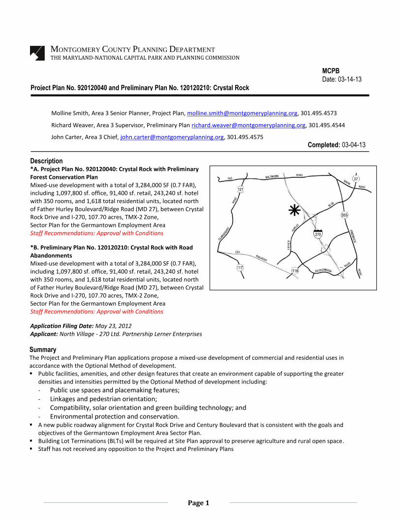
MONTGOMERY COUNTY PLANNING DEPARTMENT
THE MARYLAND-NATIONAL CAPITAL PARK AND PLANNING COMMISSION
MCPB Date: 03-14-13
Project Plan No. 920120040 and Preliminary Plan No. 120120210: Crystal Rock
Molline Smith, Area 3 Senior Planner, Project Plan, [email protected], 301.495.4573
Richard Weaver, Area 3 Supervisor, Preliminary Plan [email protected], 301.495.4544
John Carter, Area 3 Chief, [email protected], 301.495.4575
Completed: 03-04-13
Description *A. Project Plan No. 920120040: Crystal Rock with Preliminary Forest Conservation Plan Mixed-use development with a total of 3,284,000 SF (0.7 FAR), including 1,097,800 sf. office, 91,400 sf. retail, 243,240 sf. hotel with 350 rooms, and 1,618 total residential units, located north of Father Hurley Boulevard/Ridge Road (MD 27), between Crystal Rock Drive and I-270, 107.70 acres, TMX-2 Zone, Sector Plan for the Germantown Employment Area Staff Recommendations: Approval with Conditions
*B. Preliminary Plan No. 120120210: Crystal Rock with Road Abandonments Mixed-use development with a total of 3,284,000 SF (0.7 FAR), including 1,097,800 sf. office, 91,400 sf. retail, 243,240 sf. hotel with 350 rooms, and 1,618 total residential units, located north of Father Hurley Boulevard/Ridge Road (MD 27), between Crystal Rock Drive and I-270, 107.70 acres, TMX-2 Zone, Sector Plan for the Germantown Employment Area Staff Recommendations: Approval with Conditions
Application Filing Date: May 23, 2012 Applicant: North Village - 270 Ltd. Partnership Lerner Enterprises
Page 2
TABLE OF CONTENTS
SECTION 1: PROJECT DESCRIPTION Vicinity …………..…………………..………………………………………………………………………………………………. 3 Site Description ……………………………....…………………………………………………………………………………. 4 Previous Approvals ………………………………………………….………………………………………………….……… 4 Project Description & Summary ..………………………………………………………………….……………….….. 5 Public Use Spaces and Facilities ………………………………………………………………………………………… 7 Community Outreach ………………………………………………………………………………………………………… 12
SECTION 2: PROJECT PLAN Recommendations and Conditions……………………………………………………………………………………… 12 Basis of Consideration ………………………………………………………………………………………………………… 16 Analysis and Findings (includes Preliminary Forest Conservation Plan and Tree Variance) .…. 17
SECTION 3: PRELIMINARY PLAN
Recommendations and Conditions .……………….………………………………………………………………..…. 40 Analysis and Findings (includes road abandonments) ….……………………………………………………….. 4
TABLES Project Data Table for the TMX-2 Zone 20
Comparison of the Standard Method with the Optional Method of Development 26 Specimen Tree Table 34
ILLUSTRATIONS Vicinity Map 3 Aerial Photo 4 Illustrative Project Plan 5 Proposed Land Use Plan: Roadways and Green Space Areas 7 Site Layout and Building Orientation 8 Green Space Diagram 8
Proposed Vehicular Circulation Diagram 9 Compatibility, Shading and Solar Orientation 10
Views towards Forested Property Edge 11 Circulation Diagram 18 Public Use Spaces 27-32
Approved TS Office Park and Proposed Project Plan 33 Wetland Buffer Impacts 34
Specimen Tree #378 Proposed Impacts 36
APPENDICES A. Letters of Justification from the Applicant (dated January 2013) B. Agency Approval letters C. Preliminary Forest Conservation Plan D. Previous Approvals
Page 3
SECTION 1: PROJECT DESCRIPTION
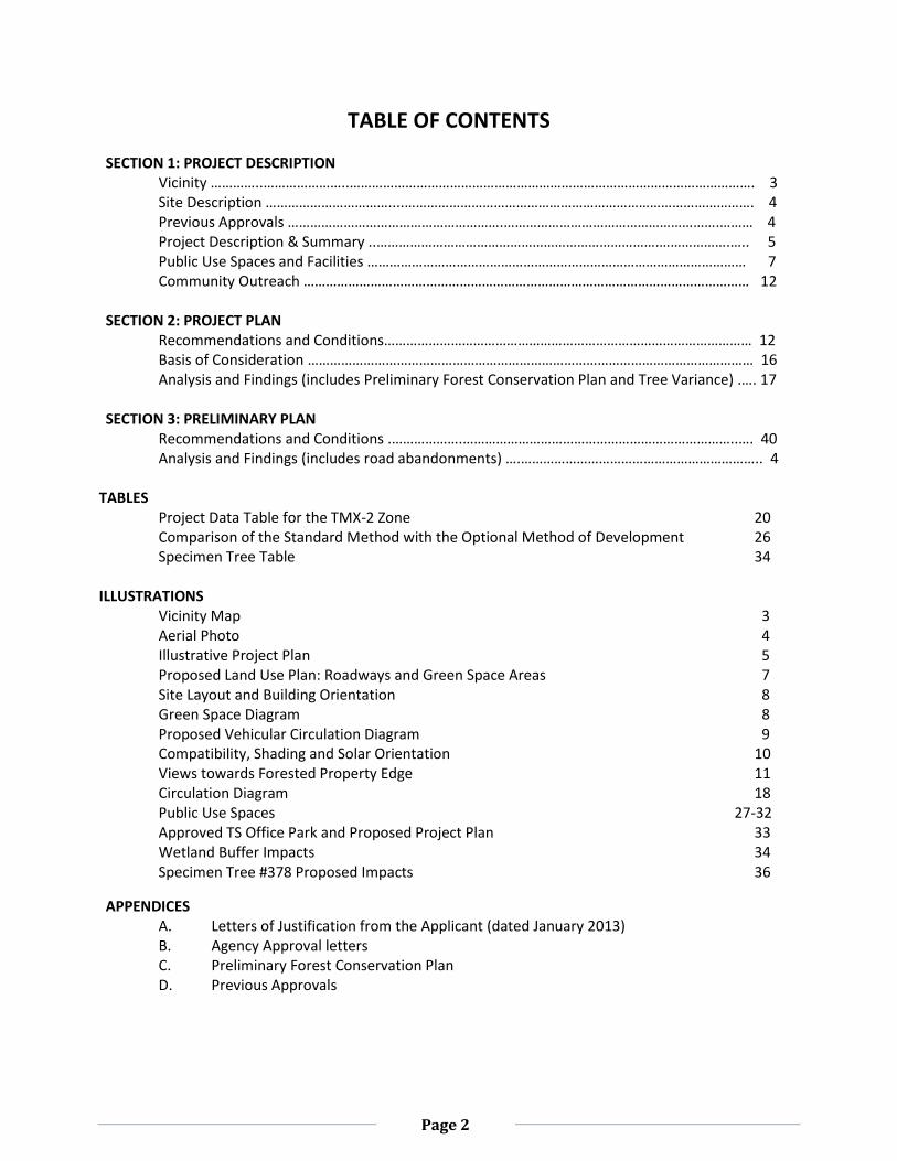
PROJECT DESCRIPTION Vicinity The subject property is approximately 107.7 acres in size and zoned TMX -2; located approximately 1.5 miles north of the Germantown Town Center, and 0.6 miles north of the interchange of Ridge Road/Father Hurley Boulevard (MD 27) and I-270 (“Property” or “Subject Property”). The Property is located west of I-270, south of Black Hills Regional Park (zoned Town Sector, TS) and north of the existing Cloverleaf townhouse development (zoned R-30). A tributary of Little Seneca Creek with a large stream buffer of trees is located on the western boundary of the Property in the TS Zone. Local public facilities include the Germantown Library, the Montgomery College Campus with the new Holy Cross Hospital, Waters Landing Elementary School, Martin Luther King Jr. Middle School, Seneca Valley High School, and BlackRock Center for the Arts. The approved residential and commercial developments include the Churchill Town Sector (819840510, approved May 1984) zoned TS, Cloverleaf Center (No. 81998006B, approved February 2004) zoned R-30 and TMX-2, Milestone Business Park (No. 82001009C, approved February 2011) zoned I-3/TMX-2, and Shops at Seneca Meadows (No. 820100140, approved January 2011) zoned TMX-2.
Vicinity Map
Page 4
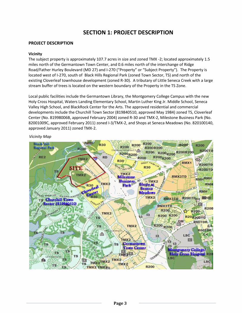
Site Description The Property is located in the northern portion of the Germantown Employment Area near the Corridor Cities Transitway (CCT), directly adjacent to Black Hill Regional Park and I-270. The Waters Landing Golf Driving Range (Site Plan No. 819950170) was developed as a temporary use on a portion of the Property (approximately 21.2 acres) in March 1995. The primary access point is Crystal Rock Drive; which dead ends at the golf driving range. The Property slopes from the northern boundary adjacent to I-270 toward the southern boundary directly adjacent to the existing townhouses, and naturally drains toward the Little Seneca Creek. The Property is partially forested (60 percent of the gross tract area). A tributary of Little Seneca Creek bisects the southern portion of the Property. There are no historic structures located on the Property. The existing development consists of a golf driving range, a surface parking lot, a maintenance shed, landscaping and lighting. Previous Approvals In accordance with the 1989 Germantown Master Plan, Preliminary and Site Plans were approved for the Lerner property with 1,300,000 square feet (sf.) of commercial space in the TS Zone (see Appendix D). As a condition of approval, the Applicant dedicated approximately 64 acres of the land towards open space (currently known as Black Hill Regional Park). The parkland dedication increased the size of the park, ensured a forested stream valley buffer, and extended the recreational opportunities and public amenities. The zoning of the Property was changed from TS to TMX-2 in October 2009 as part of the adopted Sectional Map Amendment (SMA) following the approval of the Germantown Employment Area Sector Plan. The parkland dedication was not included within the Sector Plan boundary; therefore, the zoning on the dedicated parkland remains TS and is not included in the application for the Project or Preliminary Plans.
Aerial Photo
Page 5
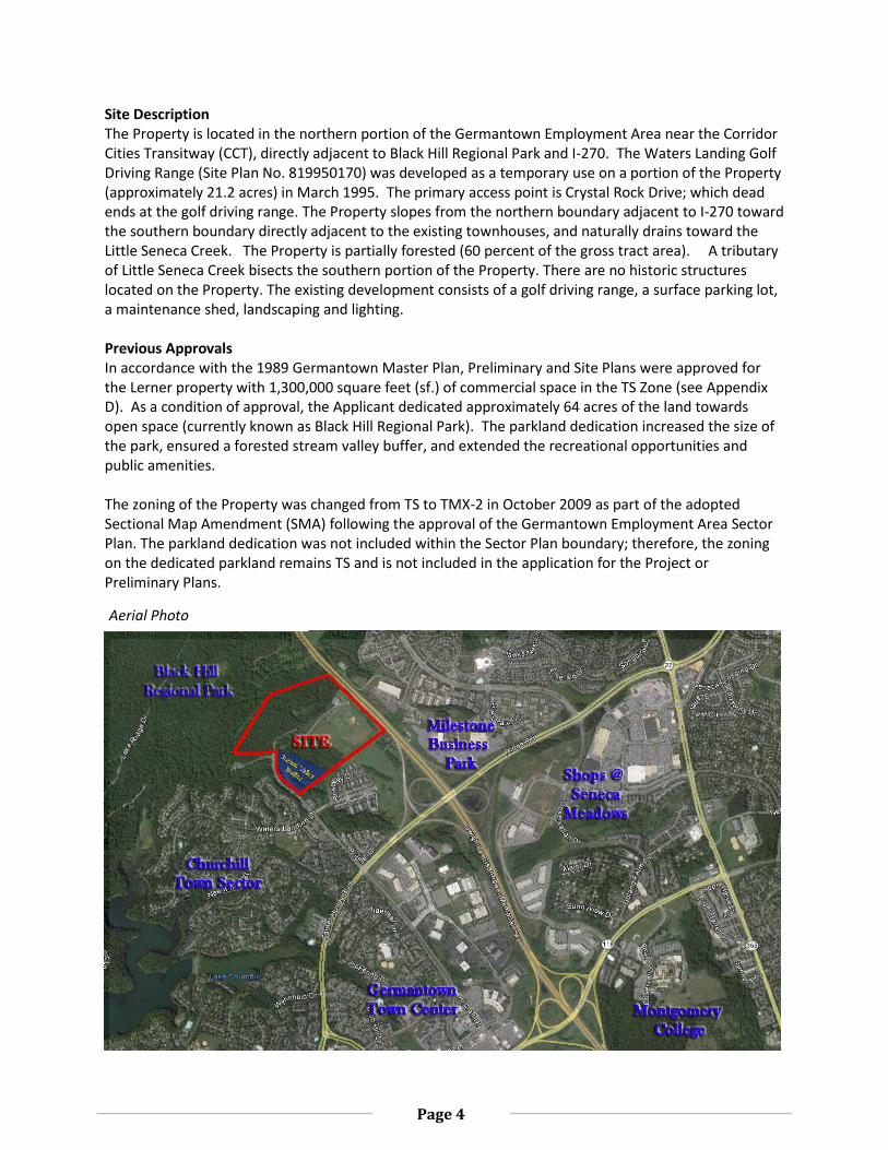
PROJECT DESCRIPTION The existing golf driving range will be replaced with mixed-use development (0.70 FAR) as recommended by the Sector Plan. The Project Plan proposal consists of 1,618 total residential units (including 190 moderately priced dwelling units, MPDUs), office space (1,097,800 sf.), a 350-room hotel (243,240 sf.) and retail space (91,400 sf.). Most of the residential units (approximately 73 percent) are age-restricted for Senior Adults 62 years and above, as defined in the Zoning Ordinance, Section 59-A-2.1 (“Senior Adult”). The MPDUs will be provided within both the Senior Adult housing units (181 units) and the non-age restricted buildings (9 units). In accordance with the TMX-2 Zone and the Project Plan requirements, the Optional Method of development must provide significant public facilities, amenities and other design features that will create an environment capable of supporting the greater densities and intensities. Brief Project Summary: Total Site Area: 107.70 acres. Total Development: 3,284,000 sf. Total Office Space: 1,097,800 sf. ( Buildings E, F, G, H, and I) Total Retail Space: 91,400 sf. Hotel: 243,240 sf. (350-rooms, Building C) Total Residential Units: 1,618 units (including 190 MPDUs)
- 440 units with MPDUs (high-rise and non-age restricted housing units, Buildings J, O and T) - 1,178 units with MPDUs (low-rise and townhouse units for Senior Adults, Buildings K, L, M, N,
P, Q, R, S, V and W)
Illustrative Project Plan
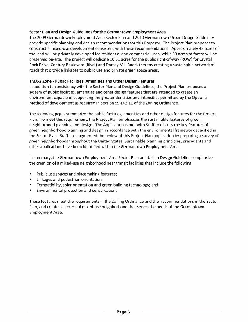
Page 6
Sector Plan and Design Guidelines for the Germantown Employment Area The 2009 Germantown Employment Area Sector Plan and 2010 Germantown Urban Design Guidelines provide specific planning and design recommendations for this Property. The Project Plan proposes to construct a mixed-use development consistent with these recommendations. Approximately 43 acres of the land will be privately developed for residential and commercial uses; while 33 acres of forest will be preserved on-site. The project will dedicate 10.61 acres for the public right-of-way (ROW) for Crystal Rock Drive, Century Boulevard (Blvd.) and Dorsey Mill Road, thereby creating a sustainable network of roads that provide linkages to public use and private green space areas. TMX-2 Zone - Public Facilities, Amenities and Other Design Features In addition to consistency with the Sector Plan and Design Guidelines, the Project Plan proposes a system of public facilities, amenities and other design features that are intended to create an environment capable of supporting the greater densities and intensities permitted by the Optional Method of development as required in Section 59-D-2.11 of the Zoning Ordinance. The following pages summarize the public facilities, amenities and other design features for the Project Plan. To meet this requirement, the Project Plan emphasizes the sustainable features of green neighborhood planning and design. The Applicant has met with Staff to discuss the key features of green neighborhood planning and design in accordance with the environmental framework specified in the Sector Plan. Staff has augmented the review of this Project Plan application by preparing a survey of green neighborhoods throughout the United States. Sustainable planning principles, precedents and other applications have been identified within the Germantown Employment Area. In summary, the Germantown Employment Area Sector Plan and Urban Design Guidelines emphasize the creation of a mixed-use neighborhood near transit facilities that include the following: Public use spaces and placemaking features; Linkages and pedestrian orientation; Compatibility, solar orientation and green building technology; and Environmental protection and conservation. These features meet the requirements in the Zoning Ordinance and the recommendations in the Sector Plan, and create a successful mixed-use neighborhood that serves the needs of the Germantown Employment Area.
Page 7
Public Use Spaces and Placemaking Features In contrast to the Standard Method of development, additional public facilities, amenities, and other design features have also been provided. The following public use spaces, green spaces, on-site recreation facilities, and off-site design features add quality to the neighborhood and create desirable placemaking characteristics. Public use space and public art - The on-site proposed public use spaces of 41 percent of the net lot
area exceeds the minimum 20 percent required in the TMX-2 zone. These spaces not only provide a variety of design features, but they also establish opportunities for community interaction and placemaking. The Art Review Panel has recommended specific locations for public art as placemaking features, and they recognize opportunities to establish temporary or permanent exhibits and programs with other local public facilities (i.e. the American Indian Heritage Education Association, and BlackRock Center for the Arts).
Private Green Spaces - A series of green roofs are proposed above the multi-family parking structures. These areas will be accessible to the residents.
On-site recreational facilities - The clubhouse, tennis courts, hiker/biker trail connections, multi-purpose fields, open lawn areas, and open play areas will offer a variety of active and passive activities. The recreational supply and demand values will be determined during the Site Plan process.
Additional off-site amenities - The streetscape design within the public ROW provides a pedestrian connection to the CCT station and the trail system. In anticipation of constructing a mixed-use development near the future CCT station, parkland was dedicated by the Applicant in 1994. The parkland dedication is not included within this application; however, it is publicly accessible (visually and physically) by the on-site trail system.
Land Use Plan: Roadways & Green Space Areas
Page 8
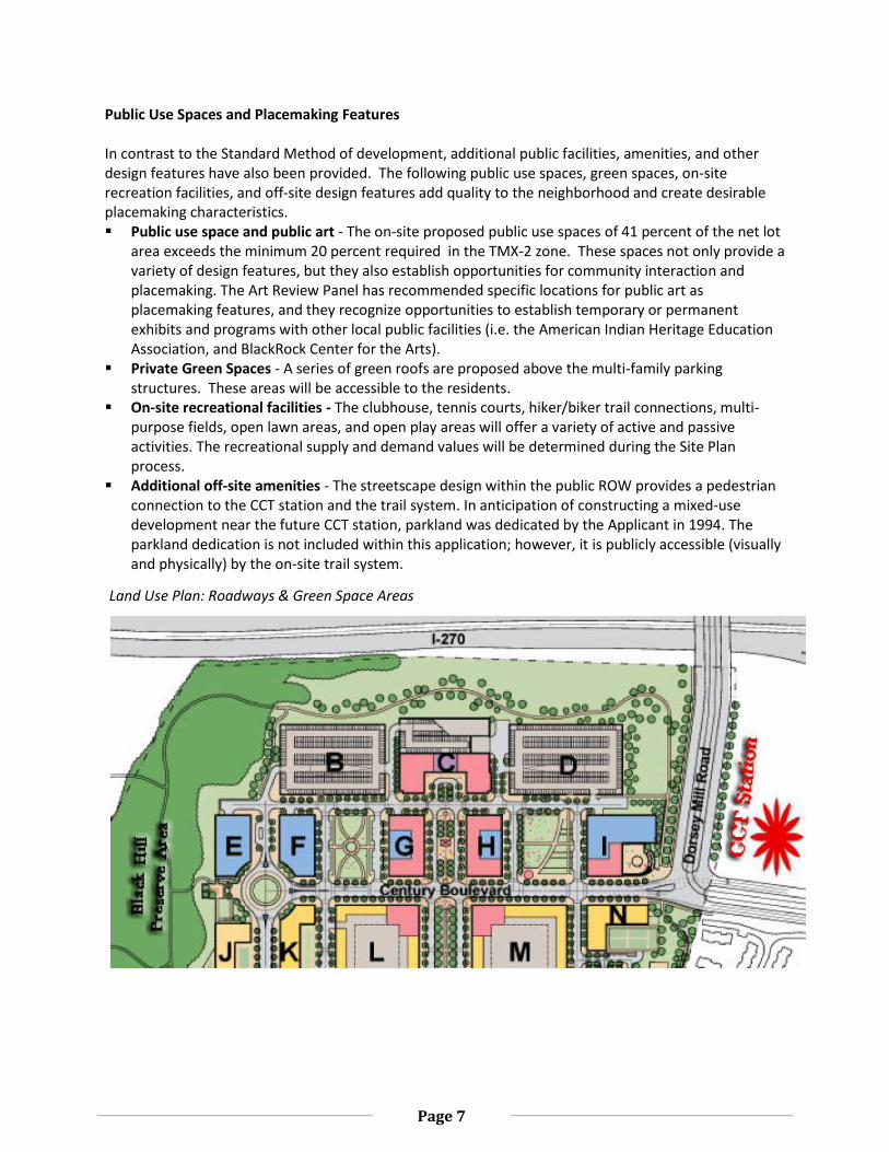
Green Space Diagram
Site Layout and Building Orientation
Site Layout and Building Orientation
Page 9
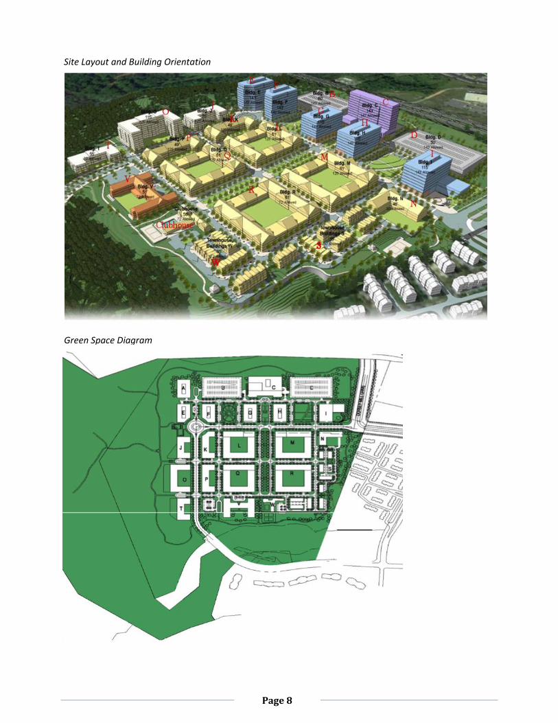
Linkages and Pedestrian Orientation In response to the requirement in the Sector Plan (page 36), the Applicant has proposed a circulation system that gives priority to pedestrians. The Zoning Ordinance also encourages flexible designs that foster use of non-automobile forms of transportation (Section 59- C-14.212 (a3)). Network of pedestrian oriented streets, sidewalks and bikeways - The network will give priority to
the pedestrians. The maximum block lengths are approximately 350 feet as recommended by the Sector Plan (page 25) and the Design Guidelines. The entire development is organized around a street grid pattern. Crystal Rock Drive and Century Blvd. will be realigned through the Property and will intersect at a traffic circle. Both roadways will accommodate bicycles, motorcycles, vehicular traffic, and on-street parking during off-peak hours.
Access to public use spaces - Access to public space is provided along the sidewalks and trails. Ground floor retail and public use spaces are conveniently located along the street edge in order to attract transit commuters, activate the public use spaces and calm traffic.
Streetscape - The proposed streetscape along Crystal Rock Drive and Century Boulevard provides continuous pedestrian sidewalks (ranging from 15 to 28 feet wide). The proposed street trees, outdoor dining areas, retail spaces and benches will enhance the pedestrian experience. These design features create vibrant pedestrian public spaces (Sector Plan, page 25).
Dedication of streets - Century Blvd. and Crystal Rock Drive will be dedicated and constructed in the first phase of development. Dorsey Mill Road will also be dedicated; however, construction will await the I-270 overpass.
Access to recreation and links to regional trial systems - Natural surface trails and hard surface hiker/biker trails that loop around the perimeter of the Property and connects into existing regional trails will provide an alternative “park-like” setting. The hiker/biker trail system may also include an educational component and can be used as a platform for displaying rotational public art pieces to establish partnerships with the local public facilities (i.e. BlackRock Center and/or the American Indian Heritage).
Proposed Vehicular Circulation Diagram: Public Roads (yellow) and Private Roads (green)
Page 10
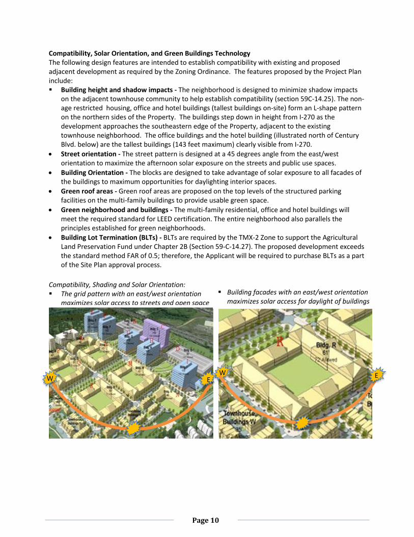
Compatibility, Solar Orientation, and Green Buildings Technology The following design features are intended to establish compatibility with existing and proposed adjacent development as required by the Zoning Ordinance. The features proposed by the Project Plan include: Building height and shadow impacts - The neighborhood is designed to minimize shadow impacts
on the adjacent townhouse community to help establish compatibility (section 59C-14.25). The non-age restricted housing, office and hotel buildings (tallest buildings on-site) form an L-shape pattern on the northern sides of the Property. The buildings step down in height from I-270 as the development approaches the southeastern edge of the Property, adjacent to the existing townhouse neighborhood. The office buildings and the hotel building (illustrated north of Century Blvd. below) are the tallest buildings (143 feet maximum) clearly visible from I-270.
Street orientation - The street pattern is designed at a 45 degrees angle from the east/west orientation to maximize the afternoon solar exposure on the streets and public use spaces.
Building Orientation - The blocks are designed to take advantage of solar exposure to all facades of the buildings to maximum opportunities for daylighting interior spaces.
Green roof areas - Green roof areas are proposed on the top levels of the structured parking facilities on the multi-family buildings to provide usable green space.
Green neighborhood and buildings - The multi-family residential, office and hotel buildings will meet the required standard for LEED certification. The entire neighborhood also parallels the principles established for green neighborhoods.
Building Lot Termination (BLTs) - BLTs are required by the TMX-2 Zone to support the Agricultural Land Preservation Fund under Chapter 2B (Section 59-C-14.27). The proposed development exceeds the standard method FAR of 0.5; therefore, the Applicant will be required to purchase BLTs as a part of the Site Plan approval process.
Compatibility, Shading and Solar Orientation: The grid pattern with an east/west orientation
maximizes solar access to streets and open space
Building facades with an east/west orientation maximizes solar access for daylight of buildings daylightingportunities for daylighting
E W
E W E
Page 11
Environmental Protection and Preservation The Project Plan proposes the following environmental features to protect and preserve the natural environment; therefore, decreasing the negative impacts of the development on neighboring properties. The following features meet the minimum requirements. Forest Conservation - The Project Plan approval (section 59D-2.12(d7) and (d8)) requires
compliance with Chapter 22A (Forest Conservation) and Chapter 19 (Water Quality Resource Protection, SWM). The stream valley buffer, located near the southwest and northwest Property boundaries, includes 9.8 acres of forest and 0.04 acres of wetlands. The forest conservation area exceeds the minimum threshold for forest retained; therefore, the Property has no reforestation requirements.
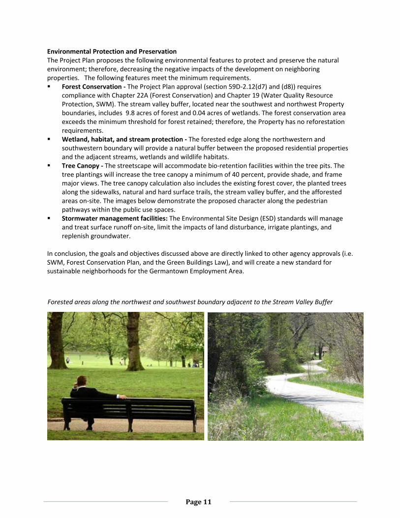
Wetland, habitat, and stream protection - The forested edge along the northwestern and southwestern boundary will provide a natural buffer between the proposed residential properties and the adjacent streams, wetlands and wildlife habitats.
Tree Canopy - The streetscape will accommodate bio-retention facilities within the tree pits. The tree plantings will increase the tree canopy a minimum of 40 percent, provide shade, and frame major views. The tree canopy calculation also includes the existing forest cover, the planted trees along the sidewalks, natural and hard surface trails, the stream valley buffer, and the afforested areas on-site. The images below demonstrate the proposed character along the pedestrian pathways within the public use spaces.
Stormwater management facilities: The Environmental Site Design (ESD) standards will manage and treat surface runoff on-site, limit the impacts of land disturbance, irrigate plantings, and replenish groundwater.
In conclusion, the goals and objectives discussed above are directly linked to other agency approvals (i.e. SWM, Forest Conservation Plan, and the Green Buildings Law), and will create a new standard for sustainable neighborhoods for the Germantown Employment Area.
Forested areas along the northwest and southwest boundary adjacent to the Stream Valley Buffer
Page 12
COMMUNITY OUTREACH The Applicant has met all signage, noticing and pre-submission meeting requirements. Notices for both the Project (920120040) and Preliminary (120120210) Plans were sent out on March 12, 2012, and a community meeting was held on December 15, 2012. Since the community meeting, the Applicant has reduced the total number of residential units by 337, the amount of office by 74,020 sf., and the retail by 3,600 sf. Staff has not received correspondence on either the Project or Preliminary Plan applications.
SECTION 2: PROJECT PLAN
PROJECT PLAN RECOMMENDATIONS AND CONDITIONS
Staff recommends approval of the Project Plan No. 920120040, Crystal Rock for a mixed-use development including 1,097,800 square feet of office uses, 91,400 square feet of retail uses, 1,618 residential uses (including 12.5% MPDUs), and a 350-room hotel (243,240 sf.) on 107.70 acres of land zoned TMX-2. All development elements as shown on the Project Plans stamped December 13, 2012, are required except as modified by the following conditions:
1. DEVELOPMENT CEILING The development is limited to a maximum 0.7 FAR on the 107.70 acres, including the following:
a. Employment uses may not exceed the following.
Office Use: 1,097,800 square feet;
Retail Use: 91,400 square feet; and
Hotel Use: 243,240 square feet (350 rooms). b. Residential uses may not exceed 0.39 FAR.
Non Age-restricted units: 440 units with MPDUs; and
Age-restricted units for Senior Adults: 1,178 units with MPDUs.
2. BUILDING HEIGHTS AND DENSITY a. Building heights must not exceed 143 feet for the multi-family, office, retail and hotel uses. b. The building heights of the townhouse units, directly adjacent to the existing community, may
not exceed 50 feet. c. The building height of the Senior Adult housing facilities (identified as Building V on the
Project Plan) may not exceed 72 feet. d. The building heights must be terraced to ensure compatibility with the neighboring
townhouse communities.
3. HOUSING The Housing and Related Facilities for Senior Adults, hereinafter referred to as Senior Adult housing, may not be converted into non-age restricted units without first revising the traffic study for the approved Project and Preliminary Plans. Occupancy of the Senior Adult housing is limited to the definition (section 59-A-2.1) in the Zoning Ordinance. Senior Adults are defined as persons 62 years and older.
Page 13
4. MODERATE PRICED DWELLING UNITS (MPDUs) The development must provide a minimum of 12.5 percent MPDUs evenly dispersed within the non-age restricted units and the age-restricted units, consistent with the requirements of Chapter 25A. Senior Adult housing facilities without a full kitchen do not qualify as a complete dwelling unit; therefore, these units will not provide MPDUs.
5. LEED CERTIFICATION a. The Applicant will meet the principles of LEED-ND (Leadership in Energy and Environmental
Design for Neighborhoods) as outlined in the Public Facilities, Amenities and Other Design Features Table (page 26 of this Staff Report), and as shown on the Project Plan.
b. The Applicant must also make good faith efforts to achieve a LEED Silver rating for buildings. The Applicant must inform the M-NCPPC Staff of the LEED Certification Level for which they are applying prior to the issuance of the final use and occupancy certificate. If this level is less than a Silver rating, before the issuance of the final use and occupancy certificate, the Applicant must provide the M-NCPPC Staff a written report for public record purposes only from the Applicant’s LEED consultant analyzing the feasibility of achieving a LEED-Silver rating including an affidavit from a LEED-Accredited Professional identifying the minimum additional improvements required to achieve the LEED Silver rating and their extra costs. Submission of this report constitutes compliance with this condition.
6. ENVIRONMENT
a. The Applicant must plant (3) 3” caliper native canopy trees on-site as mitigation for the Variance trees removed.
b. The Final Forest Conservation Plan must show location and species of all mitigation plantings. c. Revise LOD within the wetland buffer near the south side of the property to avoid any impacts
to the wetland buffer. d. Submission and approval of a final forest conservation plan consistent with the preliminary
forest conservation plan must occur prior to any land disturbing activities. e. Category I conservation easements must be placed over all areas of forest retention, forest
planting, and stream/environmental buffers as shown on the preliminary forest conservation plan prior to any land disturbing activities.
7. PUBLIC FACILITIES, AMENITIES, AND OTHER DESIGN FEATURES a. The Applicant must provide a minimum of 41 percent of the net lot area for on-site public use
space. The final design and details will be determined during the Site Plan review process. b. The streetscape design must include street trees (approximately 30 feet on-center),
pedestrian oriented street lights (approximately 60 feet on-center), and street furniture. c. Within the streetscape, the buildings should be setback approximately 28 feet from the curb
along Century Boulevard and Crystal Rock Drive, and from the curb 15 feet along private streets.
d. The proposed public use space must be easily and readily accessible to the general public and available for public enjoyment.
e. The public facilities and amenities will include Black Hill Preserve, Preserve Plaza, Village Green North and South, Main Street East and West Park, Main Street Retail Plaza, South Residential Green Space, Gateway Plaza, Hiker/Biker Trail and public art.
f. The final locations for the retail uses will activate the streetscape along Century Blvd, the gateway entrance to the property (at the intersection of Century Blvd and Dorsey Mill Road) and the public use space areas.
Page 14
8. OTHER DESIGN FEATURES
The Applicant will meet the goals and objectives set forth within the Public Facilities, Amenities and Other Design Features (Optional Method development column) on pages 26 of the Project Plan Staff Report. As required in section 59D-2.11, the incorporation of other design features will create a sustainable environment capable of supporting the greater densities and intensities permitted under the Optional Method of development. The Applicant will submit supporting drawings and documentation that further demonstrate the following criteria during the Site Plan process. a. Provide pedestrian sidewalks at a minimum of 10 feet wide on both sides of public streets,
and 8 feet wide on both sides of the private streets. The sidewalks must be free and clear of all obstructions (including stairwell, utility boxes, and tree pits).
b. Provide green roofs on the multi-family structured parking facilities. c. Provide a minimum tree canopy coverage of 40 percent of the total net tract area. The tree
canopy coverage will include the preservation of existing forest and new tree plantings. d. Provide building articulations on the structured parking facilities directly adjacent to I-270. e. Concentrate the tallest office and hotel buildings along the north eastern property boundary
(directly adjacent to I-270).
9. PUBLIC USE SPACE All record plats that include public use space must include a note that all public use spaces as illustrated on the certified Site Plan(s) must be maintained in perpetuity by the property owners and access must be provided to the general public.
10. DEVELOPMENT STAGING The development will be built in the following six phases. With the exception of Phase 1, the uses within Phases 2 thru 6 may be constructed at any order. However, the public amenities and facilities must be constructed with each phase as shown. The public use spaces and associated amenities listed below must reference the conditions above. The construction and inspection schedules will be determined at Site Plan. a. Phase 1 consists of the pre-construction activities and construction of the public
infrastructure, including the realignment of Crystal Rock Drive and Century Blvd. b. Phase 2 consists of the construction of some of the residential units (senior adult multi-family
buildings), clubhouse, office building (G), the 350-room hotel building (C), portions of the parking garage (B), associated amenities, and infrastructure (Main Street: east/west parks and retail plaza).
c. Phase 3 consists of the construction of the non-age restricted multi-family buildings, the Senior Adult townhouses, associated amenities and infrastructure (South Residential Green, natural/hard surface hiker/biker trails, Nature Pavilion and Preserve Plaza).
d. Phase 4 consists of the construction of office buildings (H), portions of the parking garage (D), Senior housing facilities (Building V), associated amenities and infrastructure (natural/hard surface biker/hiker trail and Black Hill Preserve).
e. Phase 5 consists of the construction of two office buildings (I & F), portions of the parking garage (B & D), associated amenities and infrastructure (Gateway Plaza, and Village Green north/south).
f. Phase 6 consists of the construction of office building E, associated amenities and infrastructure.

Page 15
11. COORDINATION FOR ADDITIONAL APPROVALS REQUIRED PRIOR TO THE SITE PLAN APPROVAL a. The Applicant must coordinate with the Division of Transit Services with regard to
improvements to Ride-On bus facilities in the local vicinity of this project. b. The Applicant must present preliminary public art and amenity concepts to the Art Review Panel
prior to scheduling the Site Plan for a public hearing.
12. BUILDING LOT TERMINATION a. The Applicant must purchase 6.8 BLTs for the commercial space and 7.3 BLTs for the residential
space prior to the release of the first building permit. b. The purchase of commercial and residential BLTs must be modified to reflect any changes to the
employment uses.
Page 16
BASIS FOR CONSIDERATION In accordance with section 59D-2.43, Basis for Consideration which states: In reaching its determination on the application for the optional method of development and in making the required findings, the Planning Board must consider:
(a) The nature of the proposed site and development, including its size and shape, and the
proposed size, shape, height, arrangement and design of structures.
(b) Whether the open spaces, including developed open space, are sized and located to provide convenient areas for recreation, relaxation and social activities for the residents and patrons of the development and are planned, designed and situated to function as necessary physical and aesthetic open areas among and between individuals structures and groups of structures, and whether the setbacks, yards and related walkways are located and of sufficient dimensions to provide for adequate light, air, pedestrian circulation and necessary vehicular access.
(c) Whether the vehicular circulation system, including access and off-street parking and loading, is
designed to provide an efficient, safe and convenient transportation system.
(d) Whether the proposed development contributed to the overall pedestrian circulation system. Pedestrian walkways must:
(1) be located, designed and sized to conveniently handle pedestrian traffic efficiently and without congestion;
(2) be separated from vehicular roadways and designed to be safe, pleasing and efficient for movement of pedestrians;
(3) contribute to a network of efficient, convenient and adequate linkages in the area of the development including linkages among residential areas, open spaces, recreational areas, commercial and employment areas and public facilities.
(e) The adequacy of landscaping, screening, parking and loading areas, service areas, lighting and signs, in relation to the type of use and neighborhood.
(f) The adequacy of provisions for construction of moderately priced dwelling units in accordance
with Chapter 25A if that chapter applies.
(g) The staging program and schedule of development. (g) The adequacy of forest conservation measures proposed to meet any requirements under
Chapter 22A.
(h) The adequacy of water resource protection measures proposed to meet any requirements under Chapter 19.
Page 17
FINDINGS Section 59-D-2.42 of the Zoning Ordinance establishes the findings that must be made by the Planning Board and in concert with the basis considerations. Staff makes the following findings: (a) The application would comply with all of the intents and requirements of the zone. The Property, zoned TMX-2, is in accordance with section 59C-14.212 of the Montgomery County Zoning Ordinance which states that the purpose and intent of this zone is to: (1) Implement the recommendations of the approved and adopted Sector Plans for Transit Station
Development Areas by facilitating mixed-use development with a compatible network of interconnecting streets, open spaces, plazas, and civic and community oriented uses. Providing flexible development standards, and encouraging designs that produce a desirable relationships among individual buildings, the circulation system public spaces and adjacent areas, and foster use of non-auto forms of transportation, including pedestrian, bicycle, and public transit;
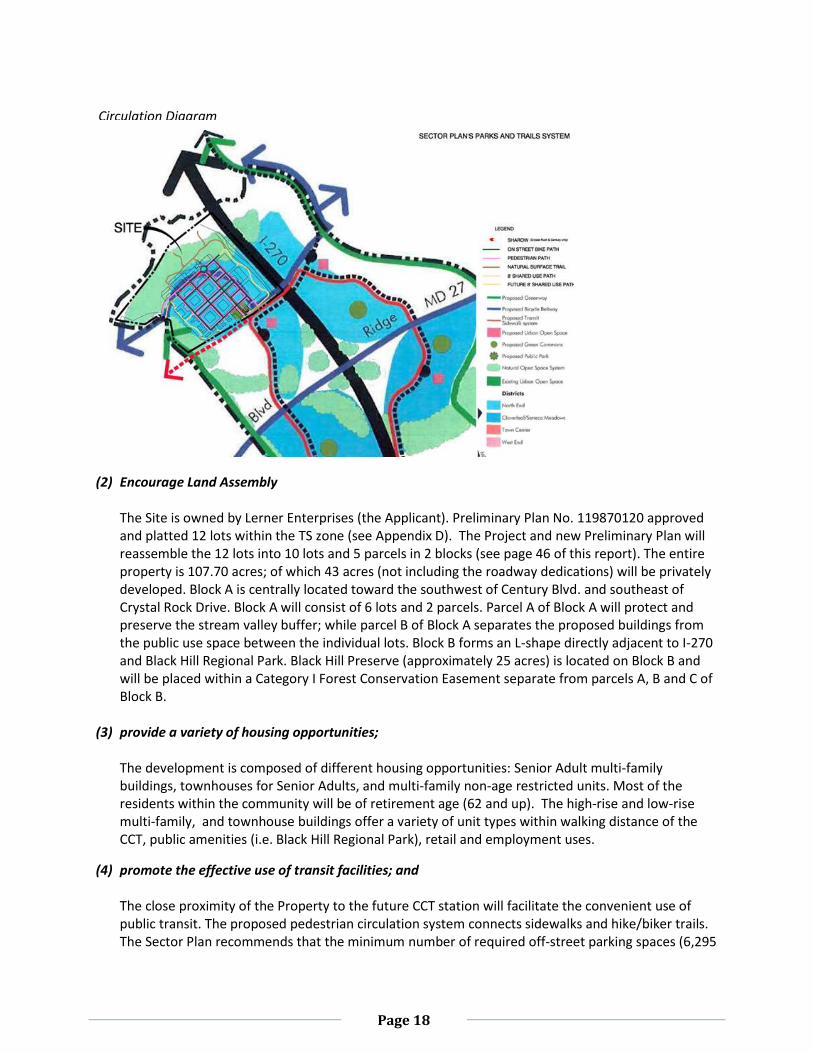
The Project Plan implements the recommendations of the Sector Plan for Transit Station development Areas by providing a mixed-use development within walking distance of the Corridor Cities Transit (CCT) station. The platted public ROW for Crystal Rock Drive and Century Blvd. will be abandoned and re-aligned in order to consistently integrate the urban-grid pattern of the private streets; which directly corresponds to the Germantown Urban Design Guidelines. The urban grid pattern provides safe connections into the existing roadways and the proposed private streets. The pedestrian and vehicular circulation systems encourage the use of bicycles and public transit through the efficient design of the public and private streetscapes. The primary flow of regional vehicular traffic will be on the public streets (Crystal Rock Drive, Century Blvd. and Dorsey Mill Road); while the private streets will manage and disperse the flow of local vehicular traffic. Sidewalks, ranging from 10 to 18 feet in width, are proposed within the public and private streetscapes on both sides of the road. The plantings, building facades, and public use spaces are designed to enhance the pedestrian experience. Open spaces, plaza areas, civic and community oriented uses are provided within public use spaces; some of which are strategically placed along the streets to keep the community engaged and slow vehicular traffic. The proposed circulation system and street network encourages desirable relationships among individual buildings and creates walkable blocks that facilitate active streetscapes. The circulation diagram on the next page overlays the proposed street alignment with the Sector Plan recommendations.
Page 18
Encourage land assembly;
(2) Encourage Land Assembly
The Site is owned by Lerner Enterprises (the Applicant). Preliminary Plan No. 119870120 approved and platted 12 lots within the TS zone (see Appendix D). The Project and new Preliminary Plan will reassemble the 12 lots into 10 lots and 5 parcels in 2 blocks (see page 46 of this report). The entire property is 107.70 acres; of which 43 acres (not including the roadway dedications) will be privately developed. Block A is centrally located toward the southwest of Century Blvd. and southeast of Crystal Rock Drive. Block A will consist of 6 lots and 2 parcels. Parcel A of Block A will protect and preserve the stream valley buffer; while parcel B of Block A separates the proposed buildings from the public use space between the individual lots. Block B forms an L-shape directly adjacent to I-270 and Black Hill Regional Park. Black Hill Preserve (approximately 25 acres) is located on Block B and will be placed within a Category I Forest Conservation Easement separate from parcels A, B and C of Block B.
(3) provide a variety of housing opportunities; The development is composed of different housing opportunities: Senior Adult multi-family buildings, townhouses for Senior Adults, and multi-family non-age restricted units. Most of the residents within the community will be of retirement age (62 and up). The high-rise and low-rise multi-family, and townhouse buildings offer a variety of unit types within walking distance of the CCT, public amenities (i.e. Black Hill Regional Park), retail and employment uses.
(4) promote the effective use of transit facilities; and
The close proximity of the Property to the future CCT station will facilitate the convenient use of public transit. The proposed pedestrian circulation system connects sidewalks and hike/biker trails. The Sector Plan recommends that the minimum number of required off-street parking spaces (6,295
Circulation Diagram
Page 19
spaces) become the maximum allowed on-site. The M-NCPPC Staff, DOT and the Applicant will continue to coordinate shared-use programs during the Site Plan approval process. The specific details of shared parking agreements, bike-share stations, carpooling, and vanpooling spaces may be incorporated into the lease agreements for the employment uses. Bus stops and bike share stations will also encourage and promote the effective use of public transit.
(5) provide for Building Lot Terminations (BLTs). The Project Plan requires that the purchase of BLTs for the commercial uses and residential uses be finalized during the Site Plan approval process. The Applicant is currently obligated to purchase approximately 6.8 BLTs for the commercial uses and approximately 7.3 BLTs for the residential uses. The BLT calculations will reflect any changes to the proposed mix of uses and density if amended.
In accordance with the additional provisions for the optional method of development (section 59C-14.25), the density and building height should generally decrease as the distance from a transit facility increases; and lower as the distance to single family homes decreases. Buildings are sited to minimize the impact of shadows on single family neighborhoods outside the TMX zones. Building heights may be adjusted to avoid or minimize environmental impacts; and the project meets all the standards and requirements of the TMX zone.
The overall Site layout generally conforms to the additional provisions for the Optional Method and the Sector Plan recommendations. The tallest office and hotel buildings (approximately 12 stories or 143 feet) are located north of Century Blvd, Crystal Rock Drive and Dorsey Mill Road, away from the existing townhouses toward the southern edge of the property. The architectural design features of these buildings will be clearly visible from I-270. The shortest residential buildings (approximately 2-3 stories) are located directly adjacent to the forested stream village buffer and the existing townhouses. The overall building orientation is also efficiently designed to maximize the daylighting during the peak hours of the day, on the building facades and the within the public use spaces. Therefore, the proposed building heights have been designed to minimize environmental and shade impacts on the neighboring properties.
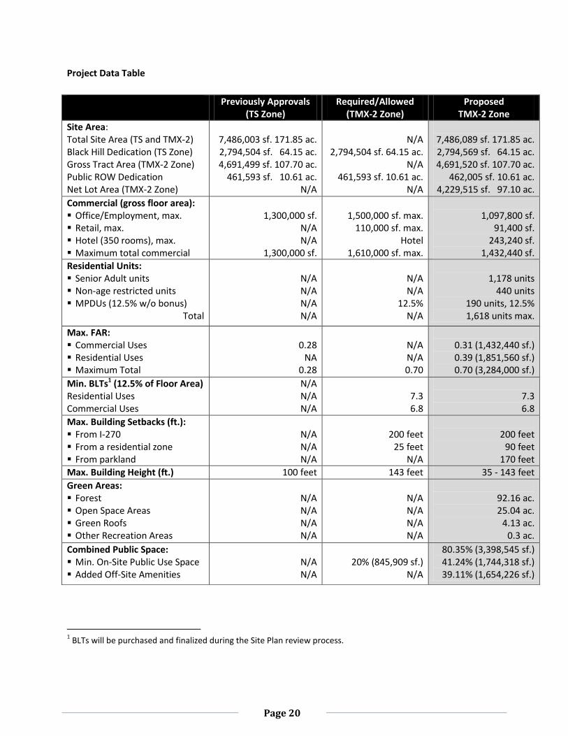
The following Project Data Table compares the proposed project to previous approvals, the Sector Plan recommendations and the Zoning Ordinance requirements.
Page 20
Project Data Table
1 BLTs will be purchased and finalized during the Site Plan review process.
Previously Approvals (TS Zone)
Required/Allowed (TMX-2 Zone)
Proposed TMX-2 Zone
Site Area: Total Site Area (TS and TMX-2) Black Hill Dedication (TS Zone) Gross Tract Area (TMX-2 Zone) Public ROW Dedication Net Lot Area (TMX-2 Zone)
7,486,003 sf. 171.85 ac. 2,794,504 sf. 64.15 ac. 4,691,499 sf. 107.70 ac.
461,593 sf. 10.61 ac. N/A
N/A
2,794,504 sf. 64.15 ac. N/A
461,593 sf. 10.61 ac. N/A
7,486,089 sf. 171.85 ac. 2,794,569 sf. 64.15 ac. 4,691,520 sf. 107.70 ac.
462,005 sf. 10.61 ac. 4,229,515 sf. 97.10 ac.
Commercial (gross floor area): Office/Employment, max. Retail, max. Hotel (350 rooms), max. Maximum total commercial
1,300,000 sf.
N/A N/A
1,300,000 sf.
1,500,000 sf. max.
110,000 sf. max. Hotel
1,610,000 sf. max.
1,097,800 sf.
91,400 sf. 243,240 sf.
1,432,440 sf.
Residential Units: Senior Adult units Non-age restricted units MPDUs (12.5% w/o bonus)
Total
N/A N/A N/A N/A
N/A N/A
12.5% N/A
1,178 units
440 units 190 units, 12.5% 1,618 units max.
Max. FAR: Commercial Uses Residential Uses Maximum Total
0.28
NA 0.28
N/A N/A 0.70
0.31 (1,432,440 sf.) 0.39 (1,851,560 sf.) 0.70 (3,284,000 sf.)
Min. BLTs1 (12.5% of Floor Area) Residential Uses Commercial Uses
N/A N/A N/A
7.3 6.8
7.3 6.8
Max. Building Setbacks (ft.): From I-270 From a residential zone From parkland
N/A N/A N/A
200 feet
25 feet N/A
200 feet
90 feet 170 feet
Max. Building Height (ft.) 100 feet 143 feet 35 - 143 feet
Green Areas: Forest Open Space Areas Green Roofs Other Recreation Areas
N/A N/A N/A N/A
N/A N/A N/A N/A
92.16 ac. 25.04 ac.
4.13 ac. 0.3 ac.
Combined Public Space: Min. On-Site Public Use Space Added Off-Site Amenities
N/A N/A
20% (845,909 sf.)
N/A
80.35% (3,398,545 sf.) 41.24% (1,744,318 sf.) 39.11% (1,654,226 sf.)
Page 21
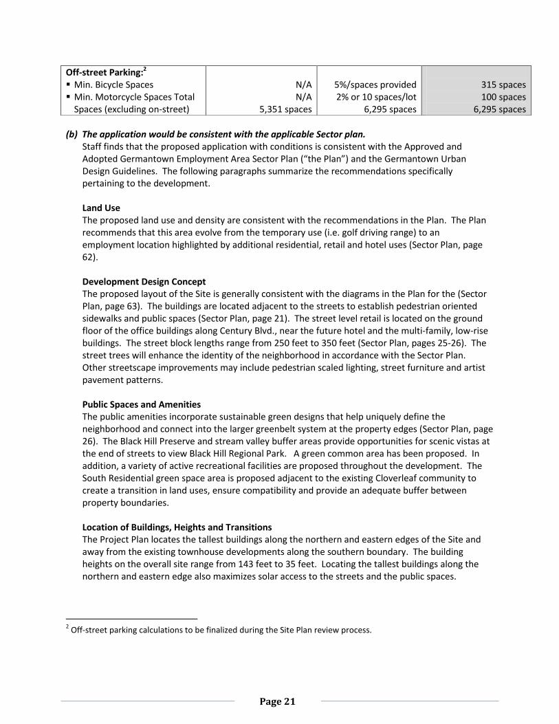
(b) The application would be consistent with the applicable Sector plan.
Staff finds that the proposed application with conditions is consistent with the Approved and Adopted Germantown Employment Area Sector Plan (“the Plan”) and the Germantown Urban Design Guidelines. The following paragraphs summarize the recommendations specifically pertaining to the development. Land Use The proposed land use and density are consistent with the recommendations in the Plan. The Plan recommends that this area evolve from the temporary use (i.e. golf driving range) to an employment location highlighted by additional residential, retail and hotel uses (Sector Plan, page 62).
Development Design Concept The proposed layout of the Site is generally consistent with the diagrams in the Plan for the (Sector Plan, page 63). The buildings are located adjacent to the streets to establish pedestrian oriented sidewalks and public spaces (Sector Plan, page 21). The street level retail is located on the ground floor of the office buildings along Century Blvd., near the future hotel and the multi-family, low-rise buildings. The street block lengths range from 250 feet to 350 feet (Sector Plan, pages 25-26). The street trees will enhance the identity of the neighborhood in accordance with the Sector Plan. Other streetscape improvements may include pedestrian scaled lighting, street furniture and artist pavement patterns. Public Spaces and Amenities The public amenities incorporate sustainable green designs that help uniquely define the neighborhood and connect into the larger greenbelt system at the property edges (Sector Plan, page 26). The Black Hill Preserve and stream valley buffer areas provide opportunities for scenic vistas at the end of streets to view Black Hill Regional Park. A green common area has been proposed. In addition, a variety of active recreational facilities are proposed throughout the development. The South Residential green space area is proposed adjacent to the existing Cloverleaf community to create a transition in land uses, ensure compatibility and provide an adequate buffer between property boundaries.
Location of Buildings, Heights and Transitions The Project Plan locates the tallest buildings along the northern and eastern edges of the Site and away from the existing townhouse developments along the southern boundary. The building heights on the overall site range from 143 feet to 35 feet. Locating the tallest buildings along the northern and eastern edge also maximizes solar access to the streets and the public spaces.
2 Off-street parking calculations to be finalized during the Site Plan review process.
Off-street Parking:2 Min. Bicycle Spaces Min. Motorcycle Spaces Total
Spaces (excluding on-street)
N/A N/A
5,351 spaces
5%/spaces provided 2% or 10 spaces/lot
6,295 spaces
315 spaces 100 spaces
6,295 spaces
Page 22
Transportation The Germantown Employment Area Sector Plan diagrams (Map 11) illustrate a curved roadway alignment along Century Blvd. and Crystal Rock Drive with a public ROW of 100 feet (Sector Plan, page 33). The proposed roadway alignment meets the recommendations of the transportation framework, the street character and the roadway network. The local and arterial roadways will form a dense grid pattern that evenly disperses the traffic, thereby improving the circulation, access and pedestrian environment along Century Blvd (i.e. the main street corridor). The streetscape provides consistent standards for street trees and understory plantings, lighting, seating areas, bike accommodations and on-street parking (Sector Plan, page 30). On-street parking is proposed during off-peak hours to ensure adequate space and distance for sharing the road with bike riders. Staff finds that the proposed 4-lane roadway alignment will slow vehicular traffic and efficiently connects into existing roads. The platted alignment will be abandoned with the approval of the Preliminary Plan (page 45 of this Staff Report). The buildings are setback from I-270 approximately 200 feet as recommended (Sector Plan, pages 30 and 36) in anticipation of future roadway expansions. The Project Plan also acknowledges the Maryland Transit Administration’s (MTA) Corridor Study (S-2009), and will continue to coordinate with the State Highway Administration (SHA) and the Department of Transportation (DOT). The hotel, office buildings will be visible from I-270. The Project Plan includes a network of public and private streets in a grid pattern as recommended by the Sector Plan. These streets will distribute traffic throughout the development. The streets are designed to accommodate pedestrians and bicyclists as well as vehicles. The development will also create connections to the future Corridor Cities Transitway (CCT), the adjacent Black Hill Regional Park, and the adjacent portions of the Germantown Employment Corridor. Dedication of Crystal Rock Drive and Century Blvd. - The first phase of the development will include the dedication and construction of Crystal Rock Drive and Century Blvd. The entrance and exit to the property will remain exactly as shown in the Sector Plan. The alignment within the boundaries of the property will be modified to reduce the speed of traffic, provide safe pedestrian crosswalks and establish an identifiable transition or traffic circle at the intersection of Crystal Rock Drive and Century Blvd. The public ROW (100 feet from building façade to building façade) accommodates four lanes of traffic. Pedestrian sidewalks are accommodated within the public ROW, and provide access to the future CCT station and bus transit facilities (Sector Plan, page 30-31). Bikeways and Trails - The Project Plan includes a bikeway connection (SP-75) to Black Hill Regional Park as recommended in the Sector Plan. In addition, an on-road bikeway will be accommodated along Crystal Rock Drive and Century Blvd. Paved and natural surface trails are proposed within the development. Pedestrian Orientation - The Project Plan proposes an extensive system of sidewalks throughout the development to provide an alternative to the automobile and improve the access to the future transit stations, the Germantown Town Center, the adjacent parkland, and other natural areas in accordance with the recommendations in the Sector Plan. Final streetscape and building setbacks will be determined during the review of the Site Plan. The future streetscape plan must include closely spaced street trees (approximately 30 feet on-center), pedestrian oriented street lights (approximately 60 feet on-center), and street furniture. The
Page 23
buildings should have a setback of approximately 28 feet along Century Blvd. and Crystal Rock Drive and fifteen feet along all private streets from the curb without stairs or other obstructions in the setback area to accommodate pedestrian access. Environment The Project Plan emphases the preservation and conservation of natural resources in accordance with the recommendations in the Sector Plan (pages 39-42) as summarize in the following.. Environmental Framework - The Project Plan proposes the creation the Black Hill Preserve that
provides a significant setback and protected forest resource located between Black Hill Regional Park and any development that will preserve the tributaries of Little Seneca Creek, enhance wildlife habitat, and provide recreational resources.
Forest, Urban Tree Canopy and Wetland Resources - The Project Plan proposes a Category I Forest Conservation Easement directly adjacent to Black Hill Regional Park to protect the forest. The Project Plan will also preserve the wetland resources in the headwaters of a tributary of the Little Seneca Creek by providing a stream buffer protected from development as recommended in the Sector Plan. The tree canopy will be augmented and enhanced to approximately 40 percent of the site area as recommended in the Sector Plan.
Green Design and Buildings - This project will set a new standard for the approach to the design of sustainable neighborhoods in the Germantown Employment Area. The neighborhood’s location near the future transitway in the mixed-use employment area and the plan’s enhanced system of public open spaces and sidewalks establishes a community that can satisfy many of the daily needs of residents and employees. The many linkages and pedestrian orientation reduce dependence on the automobile. The orientation of the blocks and location of buildings will enhance solar access to public spaces, maximize opportunities for daylighting of buildings, and reduce energy consumption. Finally, the strategies for environmental protection and preservation, including forest conservation, wetland protection, habitat protection, and augmented tree canopy, are consistent with the recommendations in the Sector Plan and Urban Design Guidelines.
Balance of Jobs and Housing The Sector Plan recommends a maximum of 1,500,000 sf. of employment space, a maximum of 110,000 sf. of retail space and a hotel specifically for the Property (page 63); which could generate approximately 5,760 jobs. The intent is to achieve an overall balance of land uses for the entire Germantown Master Plan area or a jobs to housing ratio of approximately 1.5 (page 18). The overall land use plan for the Employment Area could result in a ratio of jobs to housing of approximately 4.19. To achieve these results, the Sector Plan recommends a concentration of jobs near the Town Core and a mix of uses including more housing for sites located away from the Town Core (page 44 and 45). The land use plan (page 62) also shows a substantial area for residential development on the interior of the Property and mixed-use including housing along I-270, but the number of dwelling units is not specified. The maps in the Sector Plan are considered as guides when reviewing development applications, but they are not considered rigid requirements for specific locations (page 19).
The proposed Project Plan with a mix of office (1,097,800 sf.), a 350-room hotel (243,240 sf.) and retail uses (91,400 sf.); which provides for approximately 5,106 jobs. The proposed jobs to housing ratio (approximately 3.15) is based on the total residential units (1,618 units).
Page 24
Staff finds that the proposed mix of jobs and housing is consistent with the land use flexibility provided in the Sector Plan (page 19). The proposed mix of retail, office and hotel uses provides significant opportunities for employment with housing in the Germantown Employment Area. The proposed mix of uses is appropriate for this Property located away from the concentration of employment uses in the Town Core, the provision of Senior Adult housing generates a limited need for employment opportunities, and the Sector Plan provides for flexibility in the mix of land uses for specific sites.
(c) Because of its location, size, intensity, design, operational characteristics and staging, it would be
compatible with and not detrimental to, existing or potential development in the general neighborhood.
The location, size, and intensity of the development are compatible with the existing and potential developments in the general neighborhood. The neighboring properties (immediately south) are primarily residential townhouse communities. Germantown Town Center (i.e. Core Neighborhood) is located within a 2 mile radius south of the Property. The proximity to regional amenities (i.e. Germantown Town Center, I-270, BlackRock Center, Montgomery College, the approved Holy Cross Hospital, etc.) and the future CCT station establish the property as a prime location for transit oriented development. Adequate access to the Property and the future CCT station will be provided along Crystal Rock, Century Blvd. and Dorsey Mill Road. The urban grid pattern adequately manages the local and regional traffic flow through the Property, reduces walking distances, provides alternative internal connections, and establishes the framework for an efficient streetscape design.
The proposed design, orientation and operational characteristics provide a desirable and compatible transition to the existing townhouse community toward the south. The Project Plan will improve existing circulation systems through the construction of Crystal Rock and Century Blvd. within the first phase of the construction process. Furthermore, the intent of the Sector Plan and TMX-2 zone will be fulfilled through the construction of a sustainable transit oriented community near the CCT station. While the existing operational character of the Property will change from a golf driving range to a mixed-use development, the proposed use offers greater public benefits. The initial staging of the public amenities package includes the construction of shared-use pathways (Crystal Rock Drive and Century Blvd.) and the roadway dedication of 10.61 acres. The public ROW will be constructed first. Black Hill Preserve (Lot 11) and the stream valley buffer (Lot 13) will protect and preserve existing forest within easements according to the Preliminary Forest Conservation Plan. The Main Street corridor (retail plaza, east and west park) is the main central community space, and will be developed within the second phase of construction. The public use spaces will be phased in conjunction with their associated uses. The proposed staging meets the recommendations of the Germantown Employment Area Sector Plan, and provides a comprehensive public amenities package that adequately accommodates the employment needs and public benefits of the community on and off-site.
(d) The proposal would not overburden existing public services nor those programmed for availability
concurrently with each stage of construction and, if located within a transportation management district designated under Chapter 42A, article II, is subject to a traffic mitigation agreement that meets the requirements of that article.
Page 25
The mixed-use development will not overburden the existing public facilities and services, as the initial stages of construction include major roadway improvements to the existing public facilities. The Project Plan for the proposed development will satisfy the Local Area Transportation Review (LATR) requirements, and is subject to enter into a traffic mitigation agreement (TMA). The TMA and the school facilities payment will all be finalized before the first stage of construction. The Property is located within the Germantown West Policy Area; which does not stipulate any Policy Area Mobility Review (PAMR) trip mitigation requirements. The school facilities payment is calculated based on the total number of non-age restricted units (currently 440 units). This payment is subject to change should there be any modifications. The development phasing of the project currently consists of six stages. The first stage will provide the public roadway and infrastructure improvements that are necessary to ensure safe and adequate circulation on and offsite. The second stage of construction consists of residential, office, retail, and hotel uses. The proposed surface and structured parking facilities and public use spaces will also be constructed in conjunction with their associated uses.
(e) The proposal will be more efficient and desirable than could be accomplished by the use of the standard method of development.
The proposed Optional Method of development (3,284,000 sf. or 0.7 FAR) is more desirable and more efficient than the Standard Method (2,345,750 sf. or 0.5 FAR). The public facilities, amenities, and other design features that support the creation of a green neighborhood with greater densities are divided into the following categories:
Public use space and placemaking - Increases the amount of public use space on and offsite
and establish a sense of place within the community. Linkages and pedestrian orientation - Gives hierarchy to the pedestrian circulation systems,
promotes active streetscapes, and encourages shared uses pathways. Compatibility, solar orientation and green buildings – Meets the environmental objectives for
green buildings in the Sector Plan (page 39 and 41), and the County’s requirements for sustainable buildings.
Environmental protection and preservation – The Forest Conservation Plan requirements (Chapter 22A) will be met on-site; therefore, no afforestation is required. However, the Property will provide additional design features and the preservation of wetland resources. The tree canopy provided also plays a major role in decreasing the environmental impacts.
The following Public Facilities, Amenities and Other Design Features table compares the Standard and Optional Methods of development.
Page 26
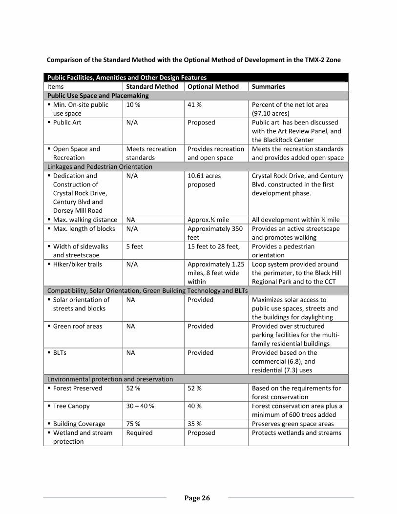
Comparison of the Standard Method with the Optional Method of Development in the TMX-2 Zone
Public Facilities, Amenities and Other Design Features
Items Standard Method Optional Method Summaries
Public Use Space and Placemaking
Min. On-site public use space
10 % 41 % Percent of the net lot area (97.10 acres)
Public Art N/A Proposed Public art has been discussed with the Art Review Panel, and the BlackRock Center
Open Space and Recreation
Meets recreation standards
Provides recreation and open space
Meets the recreation standards and provides added open space
Linkages and Pedestrian Orientation
Dedication and Construction of Crystal Rock Drive, Century Blvd and Dorsey Mill Road
N/A 10.61 acres proposed
Crystal Rock Drive, and Century Blvd. constructed in the first development phase.
Max. walking distance NA Approx.¼ mile All development within ¼ mile
Max. length of blocks N/A Approximately 350 feet
Provides an active streetscape and promotes walking
Width of sidewalks and streetscape
5 feet 15 feet to 28 feet, Provides a pedestrian orientation
Hiker/biker trails N/A Approximately 1.25 miles, 8 feet wide within
Loop system provided around the perimeter, to the Black Hill Regional Park and to the CCT
Compatibility, Solar Orientation, Green Building Technology and BLTs
Solar orientation of streets and blocks
NA Provided Maximizes solar access to public use spaces, streets and the buildings for daylighting
Green roof areas NA Provided Provided over structured parking facilities for the multi-family residential buildings
BLTs NA Provided Provided based on the commercial (6.8), and residential (7.3) uses
Environmental protection and preservation
Forest Preserved 52 % 52 % Based on the requirements for forest conservation
Tree Canopy 30 – 40 % 40 % Forest conservation area plus a minimum of 600 trees added
Building Coverage 75 % 35 % Preserves green space areas
Wetland and stream protection
Required Proposed Protects wetlands and streams
Page 27
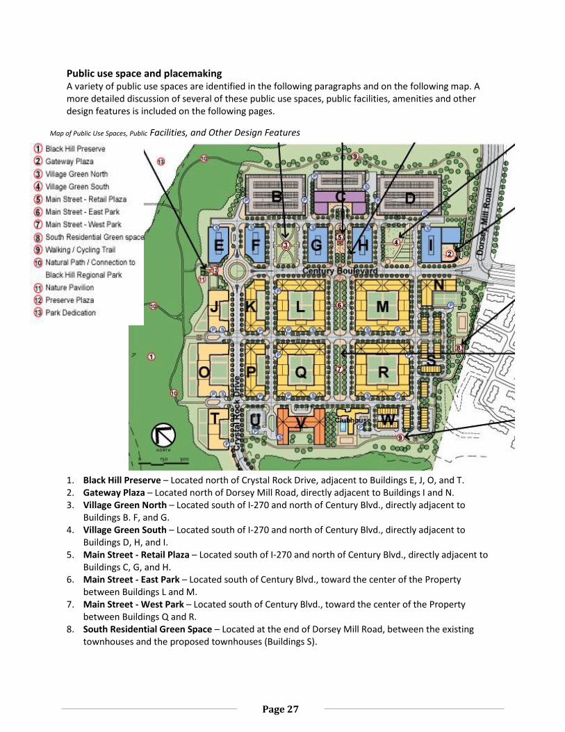
Public use space and placemaking A variety of public use spaces are identified in the following paragraphs and on the following map. A more detailed discussion of several of these public use spaces, public facilities, amenities and other design features is included on the following pages.
Map of Public Use Spaces, Public Facilities, and Other Design Features 1. Black Hill Preserve – Located north of Crystal Rock Drive, adjacent to Buildings E, J, O, and T. 2. Gateway Plaza – Located north of Dorsey Mill Road, directly adjacent to Buildings I and N. 3. Village Green North – Located south of I-270 and north of Century Blvd., directly adjacent to
Buildings B. F, and G. 4. Village Green South – Located south of I-270 and north of Century Blvd., directly adjacent to
Buildings D, H, and I. 5. Main Street - Retail Plaza – Located south of I-270 and north of Century Blvd., directly adjacent to
Buildings C, G, and H. 6. Main Street - East Park – Located south of Century Blvd., toward the center of the Property
between Buildings L and M. 7. Main Street - West Park – Located south of Century Blvd., toward the center of the Property
between Buildings Q and R. 8. South Residential Green Space – Located at the end of Dorsey Mill Road, between the existing
townhouses and the proposed townhouses (Buildings S).
Page 28
9. Walking/Cycling Trail and Public Green Space – Located south of I-270 and Black Hill Preserve, along the perimeter of the property.
10. Nature Path and Connection to Black Hill Regional Park – Located south of I-270 and Black Hill Preserve, near Buildings B and E.
11. Nature Pavilion – Located south of I-270 and Black Hill Preserve. Near the traffic circle at the intersection of Century Blvd. and Crystal Rock Drive, between Buildings E and J.
12. Preserve Plaza – Located south of I-270 and Black Hill Preserve. Near the traffic circle at the intersection of Century Blvd. and Crystal Rock Drive, between Buildings E and J.
13. Park Dedication – Located off-site, north of Black Hill Preserve.
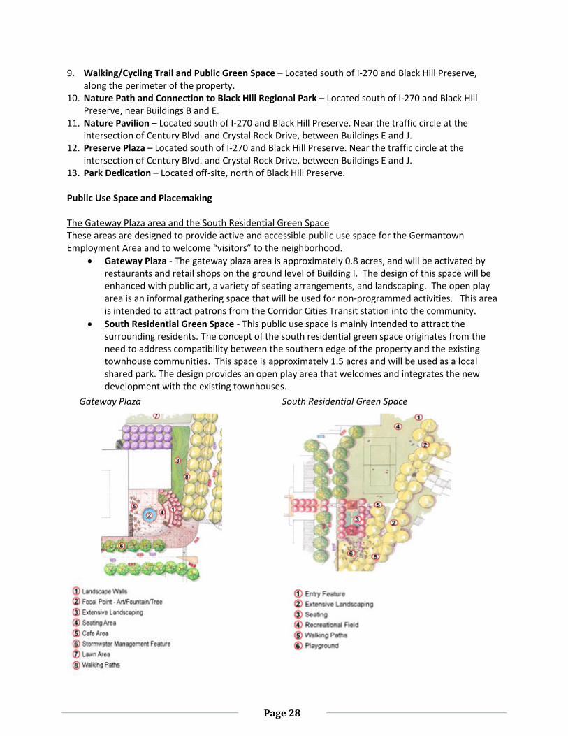
Public Use Space and Placemaking The Gateway Plaza area and the South Residential Green Space These areas are designed to provide active and accessible public use space for the Germantown Employment Area and to welcome “visitors” to the neighborhood.
Gateway Plaza - The gateway plaza area is approximately 0.8 acres, and will be activated by restaurants and retail shops on the ground level of Building I. The design of this space will be enhanced with public art, a variety of seating arrangements, and landscaping. The open play area is an informal gathering space that will be used for non-programmed activities. This area is intended to attract patrons from the Corridor Cities Transit station into the community.
South Residential Green Space - This public use space is mainly intended to attract the surrounding residents. The concept of the south residential green space originates from the need to address compatibility between the southern edge of the property and the existing townhouse communities. This space is approximately 1.5 acres and will be used as a local shared park. The design provides an open play area that welcomes and integrates the new development with the existing townhouses.
Gateway Plaza South Residential Green Space
Page 29
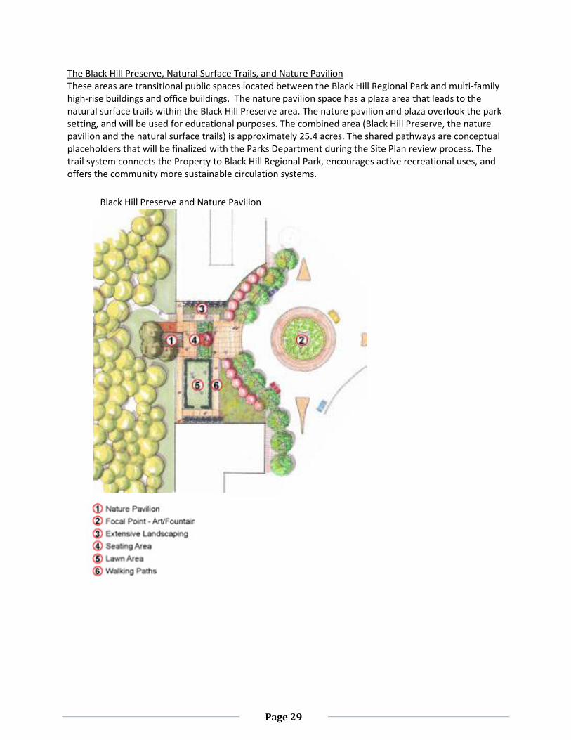
The Black Hill Preserve, Natural Surface Trails, and Nature Pavilion These areas are transitional public spaces located between the Black Hill Regional Park and multi-family high-rise buildings and office buildings. The nature pavilion space has a plaza area that leads to the natural surface trails within the Black Hill Preserve area. The nature pavilion and plaza overlook the park setting, and will be used for educational purposes. The combined area (Black Hill Preserve, the nature pavilion and the natural surface trails) is approximately 25.4 acres. The shared pathways are conceptual placeholders that will be finalized with the Parks Department during the Site Plan review process. The trail system connects the Property to Black Hill Regional Park, encourages active recreational uses, and offers the community more sustainable circulation systems.
Black Hill Preserve and Nature Pavilion
Page 30
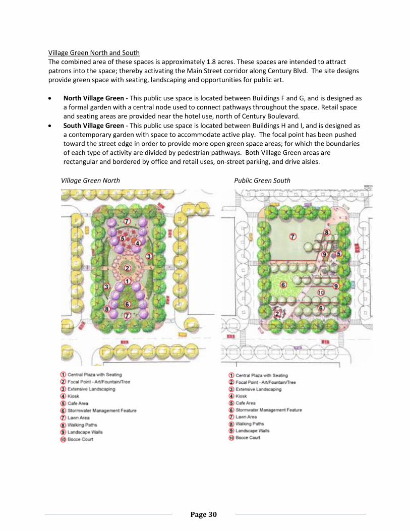
Village Green North and South The combined area of these spaces is approximately 1.8 acres. These spaces are intended to attract patrons into the space; thereby activating the Main Street corridor along Century Blvd. The site designs provide green space with seating, landscaping and opportunities for public art.
North Village Green - This public use space is located between Buildings F and G, and is designed as a formal garden with a central node used to connect pathways throughout the space. Retail space and seating areas are provided near the hotel use, north of Century Boulevard.
South Village Green - This public use space is located between Buildings H and I, and is designed as a contemporary garden with space to accommodate active play. The focal point has been pushed toward the street edge in order to provide more open green space areas; for which the boundaries of each type of activity are divided by pedestrian pathways. Both Village Green areas are rectangular and bordered by office and retail uses, on-street parking, and drive aisles.
Village Green North Public Green South
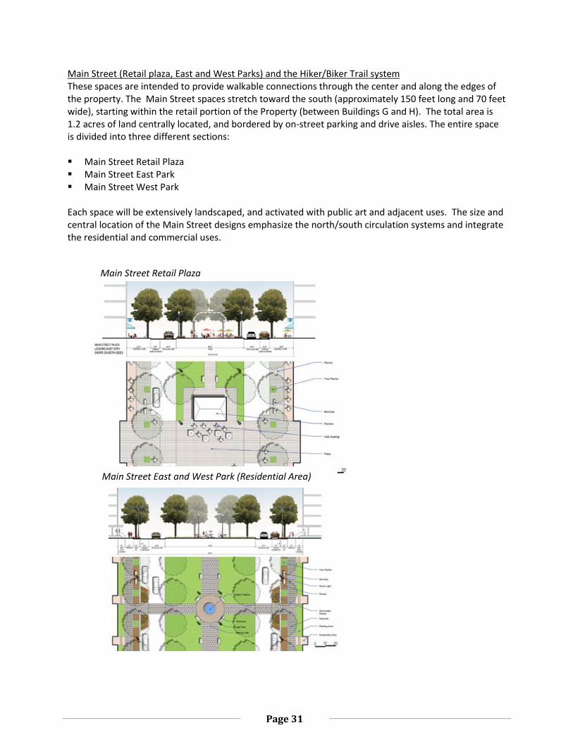
Page 31
Main Street (Retail plaza, East and West Parks) and the Hiker/Biker Trail system These spaces are intended to provide walkable connections through the center and along the edges of the property. The Main Street spaces stretch toward the south (approximately 150 feet long and 70 feet wide), starting within the retail portion of the Property (between Buildings G and H). The total area is 1.2 acres of land centrally located, and bordered by on-street parking and drive aisles. The entire space is divided into three different sections: Main Street Retail Plaza Main Street East Park Main Street West Park
Each space will be extensively landscaped, and activated with public art and adjacent uses. The size and central location of the Main Street designs emphasize the north/south circulation systems and integrate the residential and commercial uses.
Main Street Retail Plaza
Main Street East and West Park (Residential Area)
Page 32
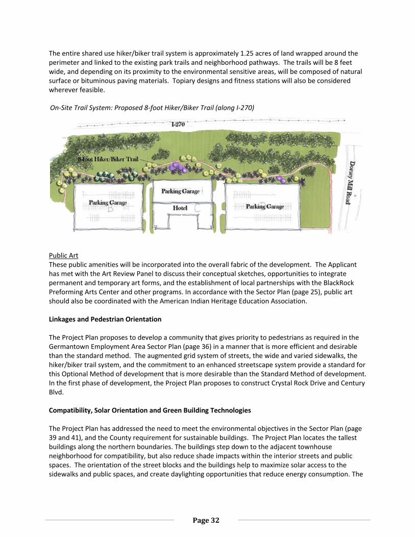
The entire shared use hiker/biker trail system is approximately 1.25 acres of land wrapped around the perimeter and linked to the existing park trails and neighborhood pathways. The trails will be 8 feet wide, and depending on its proximity to the environmental sensitive areas, will be composed of natural surface or bituminous paving materials. Topiary designs and fitness stations will also be considered wherever feasible.
Public Art These public amenities will be incorporated into the overall fabric of the development. The Applicant has met with the Art Review Panel to discuss their conceptual sketches, opportunities to integrate permanent and temporary art forms, and the establishment of local partnerships with the BlackRock Preforming Arts Center and other programs. In accordance with the Sector Plan (page 25), public art should also be coordinated with the American Indian Heritage Education Association.
Linkages and Pedestrian Orientation The Project Plan proposes to develop a community that gives priority to pedestrians as required in the Germantown Employment Area Sector Plan (page 36) in a manner that is more efficient and desirable than the standard method. The augmented grid system of streets, the wide and varied sidewalks, the hiker/biker trail system, and the commitment to an enhanced streetscape system provide a standard for this Optional Method of development that is more desirable than the Standard Method of development. In the first phase of development, the Project Plan proposes to construct Crystal Rock Drive and Century Blvd. Compatibility, Solar Orientation and Green Building Technologies The Project Plan has addressed the need to meet the environmental objectives in the Sector Plan (page 39 and 41), and the County requirement for sustainable buildings. The Project Plan locates the tallest buildings along the northern boundaries. The buildings step down to the adjacent townhouse neighborhood for compatibility, but also reduce shade impacts within the interior streets and public spaces. The orientation of the street blocks and the buildings help to maximize solar access to the sidewalks and public spaces, and create daylighting opportunities that reduce energy consumption. The
On-Site Trail System: Proposed 8-foot Hiker/Biker Trail (along I-270)
Page 33
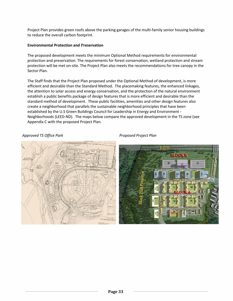
Project Plan provides green roofs above the parking garages of the multi-family senior housing buildings to reduce the overall carbon footprint. Environmental Protection and Preservation The proposed development meets the minimum Optional Method requirements for environmental protection and preservation. The requirements for forest conservation, wetland protection and stream protection will be met on-site. The Project Plan also meets the recommendations for tree canopy in the Sector Plan. The Staff finds that the Project Plan proposed under the Optional Method of development, is more efficient and desirable than the Standard Method. The placemaking features, the enhanced linkages, the attention to solar access and energy conservation, and the protection of the natural environment establish a public benefits package of design features that is more efficient and desirable than the standard method of development. These public facilities, amenities and other design features also create a neighborhood that parallels the sustainable neighborhood principles that have been established by the U.S Green Buildings Council for Leadership in Energy and Environment - Neighborhoods (LEED-ND). The maps below compare the approved development in the TS zone (see Appendix C with the proposed Project Plan.
Approved TS Office Park Proposed Project Plan
Page 34
(f) The proposal will include moderately priced dwelling units in accordance with Chapter 25A of this Code, if the requirements of that chapter apply.
The Project Plan will provide 12.5 percent MPDUs (minimum 190 units) as required by Chapter 25A. In accordance with the conditions of approval, MPDUs will be evenly distributed within the multi-family units (Senior Adult and non-age restricted units) and the townhouse units. The Applicant and the Department of Housing and Community Affairs (DHCA) will continue to work on a final agreement during the Site Plan review process (see Appendix B for Agency Approvals).
(g) The proposal satisfies any applicable requirements for forest conservation under Chapter 22A. The Natural Resource Inventory/Forest Stand Delineation (NRI/FSD) #420110370 for this Subject Property was approved on October 10, 2011. The NRI/FSD identifies the environmental constraints and forest resources on the Subject Property; which contains 65.10 acres of forest. Approximately 46 acres is high priority forest. There are 90 trees 30 inches and greater diameter at breast (DBH). Additionally there were 318 trees between 24” and 30” DBH on the property. Topography is generally sloping from east to west. There are some steep slopes along the streams. There are two streams on or immediately adjacent to the property running along the northwest and southwest boundaries of the Property. The Property contains 9.8 acres of stream valley buffer (SVB) and 0.04 acres of wetlands. The Subject Property is within the Little Seneca Creek watershed; a Use I-P watershed. The Countywide Stream Protection Strategy (CSPS) rates streams in this watershed as excellent condition.
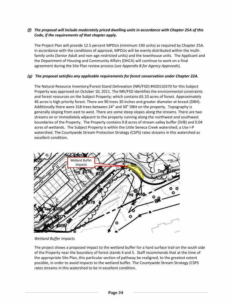
Wetland Buffer Impacts
The project shows a proposed impact to the wetland buffer for a hard surface trail on the south side of the Property near the boundary of forest stands 4 and 5. Staff recommends that at the time of the appropriate Site Plan, this particular section of pathway be realigned, to the greatest extent possible, in order to avoid impacts to the wetland buffer. The Countywide Stream Strategy (CSPS rates streams in this watershed to be in excellent condition.
Page 35
Forest Conservation Plan The forest conservation plan (FCP) submitted and reviewed as part of the Project Plan proposes 31.20 acres of forest clearing and 33.90 acres of forest retention. Based on the land use category, the amount of existing forest, the amount of forest clearing, and the amount of forest retention, the development shown on the Project Plan does not generate a planting requirement that is in addition to the amount of forest retained. The project meets all standard requirements of Chapter 22A; however there are several key Sector Plan statements and objectives3 that need to be reviewed in addition to the standard requirements. Sector Plan Recommendations
On page 40 of the Sector Plan, the area wide recommendation section under Forest Resources and Urban Tree Canopy section it states:
“An analysis of the sector plan area shows that canopy coverage of at least 31 percent is achievable. Achieving this goal depends on retaining substantial areas of remaining existing forest, including most of the forest on the Lerner and Montgomery College properties.”
This project proposes to retain 33.90 acres, or 52.1%, of the existing forest on the Lerner Property.
Also on page 40 of the Sector Plan, the area wide recommendation section under Forest Resources and Urban Tree Canopy section the first bulleted recommendation states:
“Outstanding forest resources on the Montgomery College campus and the North End should be retained to prevent fragmentation of upland forests.”
The Subject Property is within the North End District and contains 46.01 acres of High Priority forest of which 12.11 acres or 26.3% will be cleared for development. However, the term “outstanding” is not defined by the forest conservation law and may not directly correlate to high priority forest so it is difficult to judge which specific forest was to be addressed. Under any circumstance, the proposed clearing, including the high priority forest clearing, has been done in a way that does not fragment upland forest.
On pages 64 and 65 under the district recommendations for the North End District in the Urban Form recommendations, bullet six states:
“Preserve forest adjacent to Black Hills Regional Park on the north side of Century Boulevard as it curves into Crystal Rock Drive and use all available means to incorporate it into the existing park, or place in a conservation easement.”
The recommendation does not define how much forest adjacent to Black Hills Regional Park on the north side of Century Boulevard must be saved. Although certain diagrams on page 63 seem to indicate that potential development may be desirable in some of the forest north of the Century Boulevard right-of-way, Staff has stressed forest save in this area and the Applicant has responded
3 Germantown Forward: Germantown Employment Area Sector Plan 2009
Page 36
by tightening the limits of disturbance and relocating and entire building to protect additional high priority forest resources.
The FCP as submitted is in compliance with Chapter 22A and in substantial conformance with the Sector Plan as it relates to forest conservation issues.
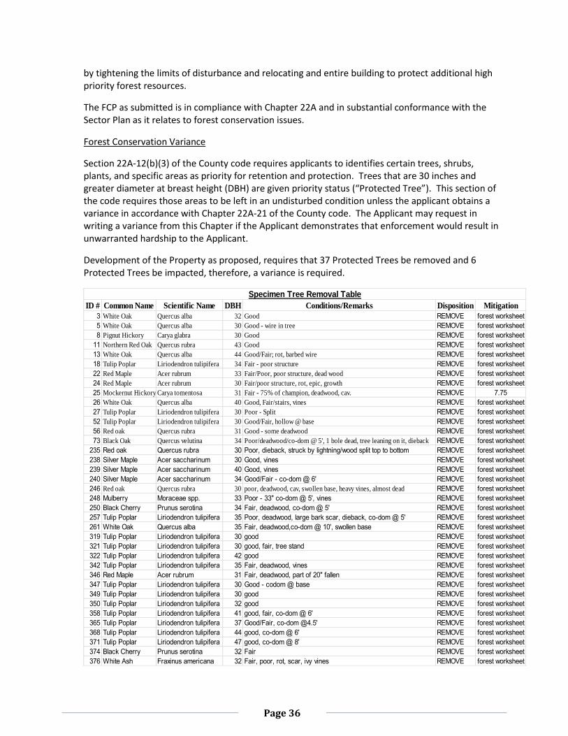
Forest Conservation Variance
Section 22A-12(b)(3) of the County code requires applicants to identifies certain trees, shrubs, plants, and specific areas as priority for retention and protection. Trees that are 30 inches and greater diameter at breast height (DBH) are given priority status (“Protected Tree”). This section of the code requires those areas to be left in an undisturbed condition unless the applicant obtains a variance in accordance with Chapter 22A-21 of the County code. The Applicant may request in writing a variance from this Chapter if the Applicant demonstrates that enforcement would result in unwarranted hardship to the Applicant.
Development of the Property as proposed, requires that 37 Protected Trees be removed and 6 Protected Trees be impacted, therefore, a variance is required.
ID # Common Name Scientific Name DBH Conditions/Remarks Disposition Mitigation
3 White Oak Quercus alba 32 Good REMOVE forest worksheet
5 White Oak Quercus alba 30 Good - wire in tree REMOVE forest worksheet
8 Pignut Hickory Carya glabra 30 Good REMOVE forest worksheet
11 Northern Red Oak Quercus rubra 43 Good REMOVE forest worksheet
13 White Oak Quercus alba 44 Good/Fair; rot, barbed wire REMOVE forest worksheet
18 Tulip Poplar Liriodendron tulipifera 34 Fair - poor structure REMOVE forest worksheet
22 Red Maple Acer rubrum 33 Fair/Poor, poor structure, dead wood REMOVE forest worksheet
24 Red Maple Acer rubrum 30 Fair/poor structure, rot, epic, growth REMOVE forest worksheet
25 Mockernut Hickory Carya tomentosa 31 Fair - 75% of champion, deadwood, cav. REMOVE 7.75
26 White Oak Quercus alba 40 Good, Fair/stairs, vines REMOVE forest worksheet
27 Tulip Poplar Liriodendron tulipifera 30 Poor - Split REMOVE forest worksheet
52 Tulip Poplar Liriodendron tulipifera 30 Good/Fair, hollow @ base REMOVE forest worksheet
56 Red oak Quercus rubra 31 Good - some deadwood REMOVE forest worksheet
73 Black Oak Quercus velutina 34 Poor/deadwood/co-dom @ 5', 1 bole dead, tree leaning on it, dieback REMOVE forest worksheet
235 Red oak Quercus rubra 30 Poor, dieback, struck by lightning/wood split top to bottom REMOVE forest worksheet
238 Silver Maple Acer saccharinum 30 Good, vines REMOVE forest worksheet
239 Silver Maple Acer saccharinum 40 Good, vines REMOVE forest worksheet
240 Silver Maple Acer saccharinum 34 Good/Fair - co-dom @ 6' REMOVE forest worksheet
246 Red oak Quercus rubra 30 poor, deadwood, cav, swollen base, heavy vines, almost dead REMOVE forest worksheet
248 Mulberry Moraceae spp. 33 Poor - 33" co-dom @ 5', vines REMOVE forest worksheet
250 Black Cherry Prunus serotina 34 Fair, deadwood, co-dom @ 5' REMOVE forest worksheet
257 Tulip Poplar Liriodendron tulipifera 35 Poor, deadwood, large bark scar, dieback, co-dom @ 5' REMOVE forest worksheet
261 White Oak Quercus alba 35 Fair, deadwood,co-dom @ 10', swollen base REMOVE forest worksheet
319 Tulip Poplar Liriodendron tulipifera 30 good REMOVE forest worksheet
321 Tulip Poplar Liriodendron tulipifera 30 good, fair, tree stand REMOVE forest worksheet
322 Tulip Poplar Liriodendron tulipifera 42 good REMOVE forest worksheet
342 Tulip Poplar Liriodendron tulipifera 35 Fair, deadwood, vines REMOVE forest worksheet
346 Red Maple Acer rubrum 31 Fair, deadwood, part of 20" fallen REMOVE forest worksheet
347 Tulip Poplar Liriodendron tulipifera 30 Good - codom @ base REMOVE forest worksheet
349 Tulip Poplar Liriodendron tulipifera 30 good REMOVE forest worksheet
350 Tulip Poplar Liriodendron tulipifera 32 good REMOVE forest worksheet
358 Tulip Poplar Liriodendron tulipifera 41 good, fair, co-dom @ 6' REMOVE forest worksheet
365 Tulip Poplar Liriodendron tulipifera 37 Good/Fair, co-dom @4.5' REMOVE forest worksheet
368 Tulip Poplar Liriodendron tulipifera 44 good, co-dom @ 6' REMOVE forest worksheet
371 Tulip Poplar Liriodendron tulipifera 47 good, co-dom @ 8' REMOVE forest worksheet
374 Black Cherry Prunus serotina 32 Fair REMOVE forest worksheet
376 White Ash Fraxinus americana 32 Fair, poor, rot, scar, ivy vines REMOVE forest worksheet
Specimen Tree Removal Table
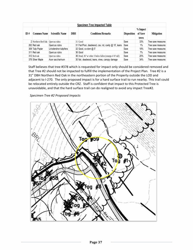
Page 37
Staff believes that tree #378 which is requested for impact only should be considered removed and that Tree #2 should not be impacted to fulfill the implementation of the Project Plan. Tree #2 is a 31” DBH Northern Red Oak in the northeastern portion of the Property outside the LOD and adjacent to I-270. The only proposed impact is for a hard surface trail to run nearby. This trail could be relocated entirely outside the CRZ. Staff is confident that impact to this Protected Tree is unavoidable, and that the hard surface trail can do realigned to avoid any impact Tree#2.
Specimen Tree #2 Proposed Impacts
ID # Common Name Scientific Name DBH Conditions/Remarks Disposition
% Impact
of Save
trees
Mitigation
2 Northern Red Oak Quercus rubra 31 Good Save 33% Tree save measures
262 Red oak Quercus rubra 31 Fair/Poor, deadwood, cav, rot, cavity @ 10', leans Save 1% Tree save measures
309 Tulip Poplar Liriodendron tulipifera 32 Good, co-dom @ 5' Save 18% Tree save measures
311 Red oak Quercus rubra 36 Good Save 7% Tree save measures
312 Red oak Quercus rubra 36 Dead, 36" w/ other 3 boles fallen (stumps 4'-8' tall) Save 20% Tree save measures
378 Silver Maple Acer saccharinum 30 fair, deadwood, leans, vines, canopy damage Save 34% Tree save measures
Specimen Tree Impacted Table
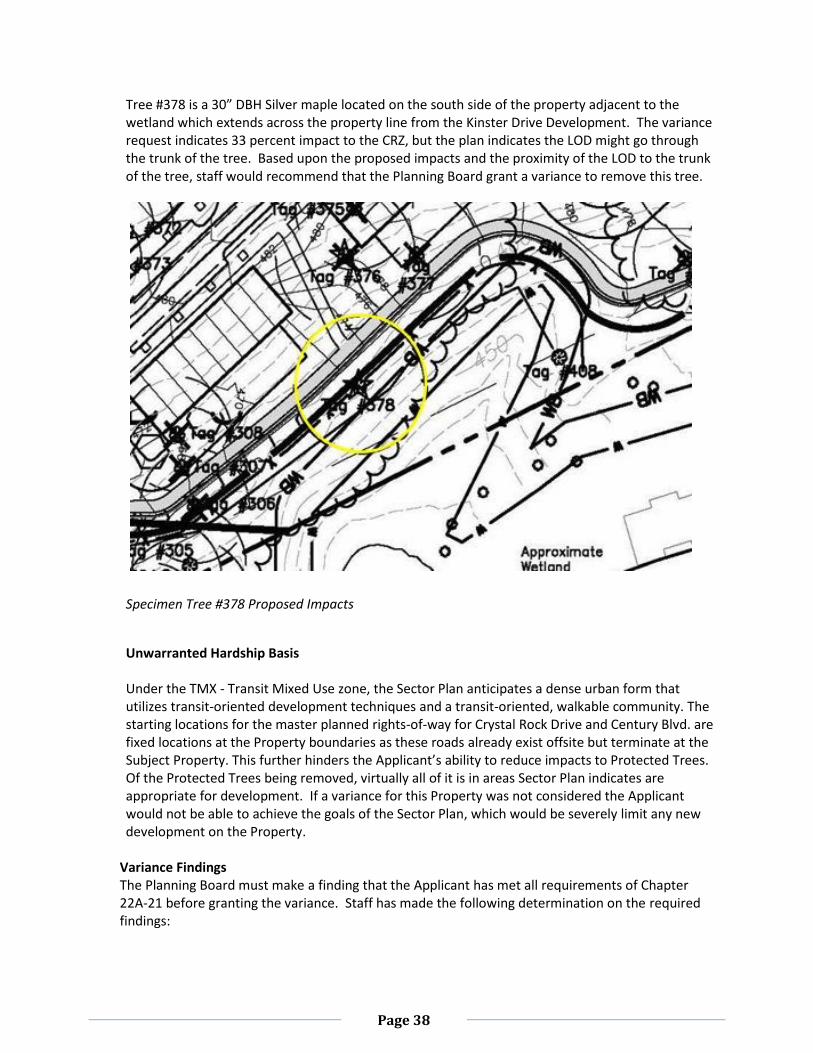
Page 38
Tree #378 is a 30” DBH Silver maple located on the south side of the property adjacent to the wetland which extends across the property line from the Kinster Drive Development. The variance request indicates 33 percent impact to the CRZ, but the plan indicates the LOD might go through the trunk of the tree. Based upon the proposed impacts and the proximity of the LOD to the trunk of the tree, staff would recommend that the Planning Board grant a variance to remove this tree.
Specimen Tree #378 Proposed Impacts
Unwarranted Hardship Basis Under the TMX - Transit Mixed Use zone, the Sector Plan anticipates a dense urban form that utilizes transit-oriented development techniques and a transit-oriented, walkable community. The starting locations for the master planned rights-of-way for Crystal Rock Drive and Century Blvd. are fixed locations at the Property boundaries as these roads already exist offsite but terminate at the Subject Property. This further hinders the Applicant’s ability to reduce impacts to Protected Trees. Of the Protected Trees being removed, virtually all of it is in areas Sector Plan indicates are appropriate for development. If a variance for this Property was not considered the Applicant would not be able to achieve the goals of the Sector Plan, which would be severely limit any new development on the Property.
Variance Findings The Planning Board must make a finding that the Applicant has met all requirements of Chapter 22A-21 before granting the variance. Staff has made the following determination on the required findings:
Page 39
1. Will not confer on the applicant a special privilege that would be denied to other applicants; Granting the variance will not confer a special privilege on the Applicant as disturbance and/or removal of trees are due to the development of the Property. The trees and/or their critical root zones lie within the developable area of the Property. Granting a variance request to allow land disturbance within the developable portion of the Property is not unique to this applicant.
2. Is not based on conditions or circumstances which are the result of the actions by the applicant; The Property is zoned TMX - Transit Mixed Use. The Germantown Employment Sector Plan depicts a dense urban form that utilizes transit-oriented development techniques and imposes special conditions on the Property by requiring a transit-oriented, walkable community. The conditions or circumstances that require the variance are a circumstance of executing the recommendations in the Sector Plan, and existing conditions of the Property are not a direct result of this particular application.
3. Is not based on a condition relating to land or building use, either permitted or non-conforming, on a neighboring property. The requested variance is a result of the proposed development and not a result of land or building use on a neighboring property.
4. Will not violate State water quality standards or cause measurable degradation in water quality. The requested variance will not violate State water quality standards or cause measurable degradation in water quality. The Protected Trees being removed are not within a stream buffer, wetland, or a special protection area. Additionally, the proposed mitigation should be at a rate that approximates the form and function of the Protected Trees removed offsetting the loss of the water quality benefits of the individual trees removed. Furthermore, a storm water management concept plan has been approved by the Montgomery County Department of Permitting Services using Environmental Site Design standards.
Mitigation for Trees Subject to the Variance Provisions The Planning Board has been consistent in requiring mitigation for any specimen trees to be physically removed or required to be counted as cleared that are not within existing forest. Mitigation for the trees within the existing forest is already being achieved, since the trees are shown on the forest conservation worksheet as forest cleared. This plan has requested the removal of 37 trees, of which only one is outside of existing forest on the Property.
Mitigation should be at a rate that approximates the form and function of the trees removed. Staff is recommending that replacement occur at a ratio of approximately 1” caliper size for every 4” DBH removed, using trees that are 3” caliper in size. This means that for the 31 inches of variance trees removed, it should be mitigated by the Applicant with (3) 3” caliper native canopy trees (7.75” rounded up to the nearest 3”) on the Property. While these trees will not be as large as the tree lost, they will provide some immediate canopy and will help augment the canopy coverage and eventually fill in open areas of the forest where the large trees have been removed. The total amount of variance mitigation recommended for this project would be (3) 3” caliper native canopy trees to be planted on-site.
Page 40
County Arborist’s Recommendation on the Variance In accordance with Montgomery County Code, Section 22A-21(c), the Planning Department is required to refer a copy of the variance request to the County Arborist in the Montgomery County Department of Environmental Protection for a recommendation prior to acting on the request. The request was forwarded to the County Arborist on December 3, 2012. On January 2, 2013 the County Arborist issued a recommendation (Appendix C). The county Arborist recommends that the variance can be granted if mitigation is provided.
Variance Recommendation Staff recommends that the variance be granted for the removal of 38 trees and for the impacts to five trees. Staff recommends that Tree #378 should be listed as removed and that no variance be granted for the impacts to Tree #2. Staff will continue to work with the Applicant through the Site Plan review process to minimize the environmental impacts, while maximizing the environmental benefits on-site in a sustainable manner.
(i) The proposal satisfies any applicable requirements for water quality resources protection under
Chapter 19.
The Property is not located within a Special Protection Area, and a Water Quality Plan is not required. In accordance with Chapter 19, this Property is exempt from the water quality resources protection requirements. The project will provide for SWM to be stored and treated on-site for water quantity control and quality improvement. The SWM concept is acceptable and proposes to meet required SWM goals via green roofs and public/private micro-bioretention within the streetscape and planter boxes. SWM facilities are also proposed adjacent to the parallel parking areas within the public ROW.
(j) Any public use space or public facility or amenity to be provided off-site is consistent with the
goals of the applicable Master or Sector Plan and serves the public interest better than providing the public use space or public facilities and amenities on-site. The Project Plan exceeds the 20 percent public use space requirement by providing approximately 41 percent on-site. However, the parkland dedication and the streetscape (10.61 acres) within the public ROW will provide additional public benefits off-site. While the parkland dedication is not included in this Project Plan application, the Applicant’s substantial contribution to Black Hill Regional Park has protected the existing high priority forest directly adjacent to the Little Seneca Creek tributaries, improved the quality of surface runoff, increased the total area of the regional park, provided wildlife habitat, and established a green edge as recommended in the 2009 Germantown Employment Area Sector Plan.
CONCLUSION The Staff recommends approval of the Project Plan with the conditions described at the beginning of this section (page 15). The Project Plan is consistent with the recommendations in the Germantown Employment Area Sector Plan and meets the requirements for the Optional Method of development in the TMX-2 Zone.
Page 41
SECTION 3: PRELIMINARY PLAN
RECOMMENDATIONS AND CONDITIONS The Preliminary Plan meets all requirements for Adequate Public Facilities, conformance with master plan and lot configuration established in Chapter 50 of the County Code, the Subdivision Regulations. Staff recommends approval of the Preliminary Plan No. 120120210, including abandonment of certain portions of the Crystal Rock Drive right-of-way, subject to the following conditions:
1. Approval under this Preliminary Plan is limited to 10 lots for a maximum of 1,097,800 square feet of office space, 91,400 square feet of retail space, a 350 room hotel and a total of 1,618 residential units including 12.5% MPDU’s. No more than 1,178 of the units will be Senior Adult housing units, and no more than 440 units will be non-age restricted.
2. The Housing and Related Facilities for Senior Adults, hereinafter referred to as Senior Adult housing, may not be converted into non-age restricted units without first revising the traffic study for the approved Project and Preliminary Plans. Occupancy of the Senior Adult housing is limited to the definition (section 59-A-2.1) in the Zoning Ordinance. Senior Adults are defined as persons 62 years and older.
3. The Preliminary Plan must comply with all conditions of approval for Project Plan No. 920120040
4. Prior to the release of the first building permit for Phase II of development as specified in the Project Plan, the Applicant must submit design details to MNCPPC, the Montgomery County Department of Transportation (“MCDOT”) and the State Highway Administration (“SHA”) and construct the following roadway improvements to the extent required by MCDOT. a. Construct Crystal Rock Drive and Century Boulevard to full width standards through the
Property. b. At the Father Hurley Boulevard (Blvd.)/Crystal Rock Drive intersection:
Restripe the northbound thru lane on Crystal Rock Drive to include a second right-turn lane on to eastbound Father Hurley Blvd.
On eastbound Father Hurley Blvd., construct a second left-turn lane on to northbound Crystal Rock Drive.
Provide necessary traffic signal modifications. c. At the MD 27/Observation Drive intersection:
Construct a second left-turn lane on southbound Observation Drive to eastbound MD 27.
Restripe the second southbound Observation Drive through lane to a second right turn lane.
Provide necessary traffic signal modifications. d. At the MD 27/MD 355 intersection:
Construct a second dedicated left-turn lane on MD 27 to northbound MD 355.
Provide necessary traffic signal modifications. e. At the MD 27/Brink Road intersection:
Construct a second westbound through lane on Brink Road.
Provide necessary traffic signal modifications. f. At the MD 118/MD 117 intersection:
On eastbound MD 117, construct a second left-turn lane to northbound MD 118.
Provide necessary traffic signal modifications.
Page 42
g. At the MD 118/I-270 interchange
Construct a second left-turn lane on eastbound MD 118 to northbound I-270
Provide traffic signal modifications h. At the MD 118/Goldenrod Lane intersection:
On northbound Goldenrod Lane, construct a second left-turn lane on to westbound MD 118.
Provide necessary traffic signal modifications. i. At the MD 118/MD 355 intersection:
On MD 355, construct a third left-turn lane to westbound MD 118.
On MD 355, construct a second left-turn lane to eastbound MD 118.
On MD 118, construct a second eastbound through lane
On MD 118, construct a separate right turn lane on to northbound MD 355.
Provide necessary traffic signal modification. j. The Applicant must participate on a pro rata share to provide the following improvements
at the MD 355/ West Old Baltimore Road intersection.
Widen eastbound approach of West Old Baltimore Road to provide for a separate right-turn lane to southbound MD 355.
Widen the northbound approach of MD 355 to provide for a separate left-turn lane on to westbound West Old Baltimore Road.
Widen the southbound approach of MD 355 to provide separate right-turn lane to westbound West Old Baltimore Road.
Install traffic signal if warranted by the background development.
5. The Planning Board hereby abandons certain portions of the Crystal Rock Drive right-of-way as
identified on plan drawing titled “Proposed Subdivision and R/W Abandonment Exhibit” dated
10-24-12 and included in the Staff Report. The Resolution number associated with this
Preliminary Plan approval must be reflected on any plat that includes the abandoned areas.
6. The Planning Board has accepted the recommendations of MCDOT in its letter dated January 7,
2013, and does hereby incorporate them as conditions of the Preliminary Plan approval.
Therefore, the Applicant must comply with each of the recommendations as set forth in the
letter, which may be amended by MCDOT provided that the amendments do not conflict with
other conditions of the Preliminary Plan approval.
7. Prior to recordation of plat for the public streets, the Applicant must satisfy the provisions for
access and improvements as required by MCDOT.
8. The Planning Board has accepted the recommendations of the Montgomery County Department
of Fire and Rescue Services (“MCFRS”) in its letter dated January 8, 2013, and does hereby
incorporate them as conditions of the Preliminary Plan approval. Therefore, the Applicant must
comply with each of the recommendations as set forth in the letter, which may be amended by
MCFRS provided that the amendments do not conflict with other conditions of the Preliminary
Plan approval.
9. The Planning Board has accepted the recommendations of the Montgomery County Department
of Permitting Service (“MCDPS”) – Water Resources Section in its stormwater management
concept letter dated November 16, 2012, and does hereby incorporate them as conditions of
the Preliminary Plan approval. Therefore, the Applicant must comply with each of the
Page 43
recommendations as set forth in the letter, which may be amended by MCDPS – Water
Resources Section provided that the amendments do not conflict with other conditions of the
Preliminary Plan approval.
10. The Applicant must construct all road improvements within the rights-of-way shown on the
Certified Preliminary Plan to the full width mandated by the Master Plan and/or to the design
standards imposed by MCDOT. Only those roads (or portions thereof) expressly designated on
the Preliminary Plan, “To Be Constructed By _______” are excluded from this condition.
11. Final location and number of MPDU’s to be determined at the time of Site Plan.
12. The Subject Property is within the Seneca Valley High School cluster area. The Applicant must
make a School Facilities Payment to MCDPS at the elementary school level at the multi-family
garden apt. high-rise and low-rise unit rates for all units for which a building permit is issued and
for which a School Facilities Payment is applicable. The timing and amount of the payment will
be in accordance with Chapter 52 of the Montgomery County Code.
13. The Applicant must dedicate the public road rights-of-way to the full width designated on the
Certified Preliminary Plan for the Crystal Rock Drive, Century Blvd and Dorsey Mill Road.
14. The Applicant must provide proof of purchase and/or payment of the required BLT’s within each
phase of development established at the time of Site Plan prior to release of the first building
permit for core and shell construction within each phase.
15. The record plat must reflect the following: private streets from back of curb to back of curb to
be located within separate parcels; private streets and adjacent sidewalks to be included within
a public use and access easement.
16. The record plat must reflect a Category I easement over all areas of stream valley buffers and
forest conservation as shown on the approved forest conservation plan.
17. The record plat must reflect all areas under Homeowners Association (HOA) ownership, if
applicable, and specifically identify stormwater management parcels.
18. The final number and location of buildings, dwelling units, on-site parking, site circulation,
sidewalks, and bike paths will be determined at Site Plan.
19. At the time of a Site Plan submission containing any of the senior housing units, the applicant
must submit for staff review, draft HOA document language that identifies the specific units or
buildings designated as senior housing as defined under 59-A-2.1 of the zoning ordinance and
the limitations as to residence of that designation.
20. In the event that a subsequent Site Plan approval substantially modifies the subdivision shown
on the approved Preliminary Plan with respect to lot configuration, location or right-of-way
width or alignment, or an increase in units or square footage above those specified in Condition
#1, the Applicant must obtain approval of a Preliminary Plan amendment prior to certification
of the Site Plan.
21. At the time of Site plan, the Applicant must comply with Section 59-C-14.27 of the Zoning
Ordinance regarding Special Regulations for use of BLT Development Rights.
22. The Adequate Public Facility (“APF”) review for the Preliminary Plan will remain valid for a total
of 145 months (12 years) from the date of mailing of this Planning Board Resolution according to
the following schedule:
Page 44
Within 85 months (7 years) - Issuance of building permits for Phases I and II as identified
by Project Plan.
Beyond 85 months (years 7 -12) – issuance of building permits for all remaining
development.
ANALYSIS AND FINDINGS
A Preliminary Plan must analyze a proposed development for conformance with Chapter 50 of the County Code, the Montgomery County Subdivision Regulations. The Subdivision Regulations require that a preliminary plan: conforms to the local area master plan or sector plan; have adequate public facilities; has appropriately dimensioned lots; and adequately protect environmental features. The Preliminary Plan encompasses the same 107.7 acres contained in the Project Plan application and contemplates the same development. While the Project Plan focuses on optional density as it relates to public facilities, amenities and other design features, the Preliminary Plan focuses on the necessary lot configuration and infrastructure required to serve the development shown on the Project Plan. The Germantown Employment Area Sector Plan contains recommendations for building design, neighborhood design, streetscape, and other compatibility concerns that go beyond the capabilities of a Preliminary Plan, hence, the review of the Project Plan provides the best opportunity to examine all of the building and design details for conformance to the Sector Plan. The Project Plan has been found to be in conformance with the Sector Plan and therefore, the Preliminary Plan findings for conformance to the Sector Plan are also made. With respect to roads, the Preliminary Plan proposes a new alignment of Crystal Rock Drive and Century Blvd through the Property that brings the two roads together at a roundabout feature in its northern corner. The right-of-way for these two roads is 100 feet in width as recommended by the Sector Plan. The cross section of the road will consist of four travel lanes also recommended by the Sector Plan. The connection of Century Boulevard and Crystal Rock Drive will provide adequate access for this community to Father Hurley Boulevard, I-270; Germantown Road and the future Dorsey Mill Road overpass and transit station. As part of the transportation requirements, the developer will be required to improve numerous intersections within the local area as outlined in the conditions of approval. A grid system of private streets will disperse traffic and pedestrians throughout the interior of the development. In general, the private streets will be built to public street standards but maintained by a private entity. The pavement of the private streets, including the curbs, will be located within their own separate parcels and public access easements over the private streets and adjacent sidewalks will assure public passage. The grid system of the private street parcels essentially establishes lots and blocks that are also in a grid layout. With few exceptions, all lots have access to a public or private street on all four sides. Sector Plan Conformance As noted previously in this report, Staff finds that the Project Plan conforms to the Sector Plan and the Preliminary Plan is substantially the same as the Project Plan. The Preliminary Plan establishes the required rights of way for the new alignment of Century Blvd., Crystal Rock Drive and Dorsey Mill Road within the development. The Preliminary Plan shows the dedication for these new roads to a width of 100 feet, suitable for four travel lanes to accommodate the traffic demand and be wide enough to provide the sidewalks shown on the Project Plan. The grid pattern established by the public and private
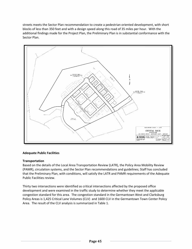
Page 45
streets meets the Sector Plan recommendation to create a pedestrian oriented development, with short blocks of less than 350 feet and with a design speed along this road of 35 miles per hour. With the additional findings made for the Project Plan, the Preliminary Plan is in substantial conformance with the Sector Plan.
Adequate Public Facilities
Transportation Based on the details of the Local Area Transportation Review (LATR), the Policy Area Mobility Review (PAMR), circulation systems, and the Sector Plan recommendations and guidelines; Staff has concluded that the Preliminary Plan, with conditions, will satisfy the LATR and PAMR requirements of the Adequate Public Facilities review. Thirty two intersections were identified as critical intersections affected by the proposed office development and were examined in the traffic study to determine whether they meet the applicable congestion standard for this area. The congestion standard in the Germantown West and Clarksburg Policy Areas is 1,425 Critical Lane Volumes (CLV) and 1600 CLV in the Germantown Town Center Policy Area. The result of the CLV analysis is summarized in Table 1.
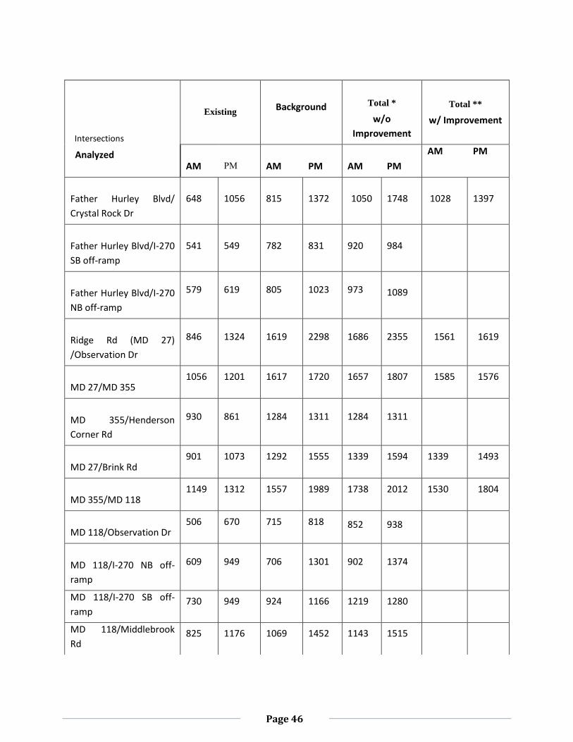
Page 46
Intersections
Analyzed
Existing Background
Total *
w/o
Improvement
Total **
w/ Improvement
AM
PM
AM
PM
AM
PM
AM PM
Father Hurley Blvd/
Crystal Rock Dr
648 1056 815 1372 1050 1748 1028 1397
Father Hurley Blvd/I-270
SB off-ramp
541 549 782 831 920 984
Father Hurley Blvd/I-270
NB off-ramp
579 619 805 1023 973 1089
Ridge Rd (MD 27)
/Observation Dr
846 1324 1619 2298 1686 2355 1561 1619
MD 27/MD 355 1056 1201 1617 1720 1657 1807 1585 1576
MD 355/Henderson
Corner Rd
930 861 1284 1311 1284 1311
MD 27/Brink Rd 901 1073 1292 1555 1339 1594 1339 1493
MD 355/MD 118 1149 1312 1557 1989 1738 2012 1530 1804
MD 118/Observation Dr 506 670 715 818 852 938
MD 118/I-270 NB off-
ramp
609 949 706 1301 902 1374
MD 118/I-270 SB off-
ramp 730 949 924 1166 1219 1280
MD 118/Middlebrook
Rd 825 1176 1069 1452 1143 1515
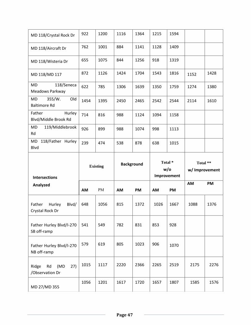
Page 47
MD 118/Crystal Rock Dr 922 1200 1116 1364 1215 1594
MD 118/Aircraft Dr 762 1001 884 1141 1128 1409
MD 118/Wisteria Dr 655 1075 844 1256 918 1319
MD 118/MD 117 872 1126 1424 1704 1543 1816 1152 1428
MD 118/Seneca
Meadows Parkway 622 785 1306 1639 1350 1759 1274 1380
MD 355/W. Old
Baltimore Rd 1454 1395 2450 2465 2542 2544 2114 1610
Father Hurley
Blvd/Middle Brook Rd 714 816 988 1124 1094 1158
MD 119/Middlebrook
Rd 926 899 988 1074 998 1113
MD 118/Father Hurley
Blvd 239 474 538 878 638 1015
Intersections
Analyzed
Existing Background
Total *
w/o
Improvement
Total **
w/ Improvement
AM
PM
AM
PM
AM
PM
AM PM
Father Hurley Blvd/
Crystal Rock Dr
648 1056 815 1372 1026 1667 1088 1376
Father Hurley Blvd/I-270
SB off-ramp
541 549 782 831 853 928
Father Hurley Blvd/I-270
NB off-ramp
579 619 805 1023 906 1070
Ridge Rd (MD 27)
/Observation Dr
1015 1117 2220 2366 2265 2519 2175 2276
MD 27/MD 355 1056 1201 1617 1720 1657 1807 1585 1576
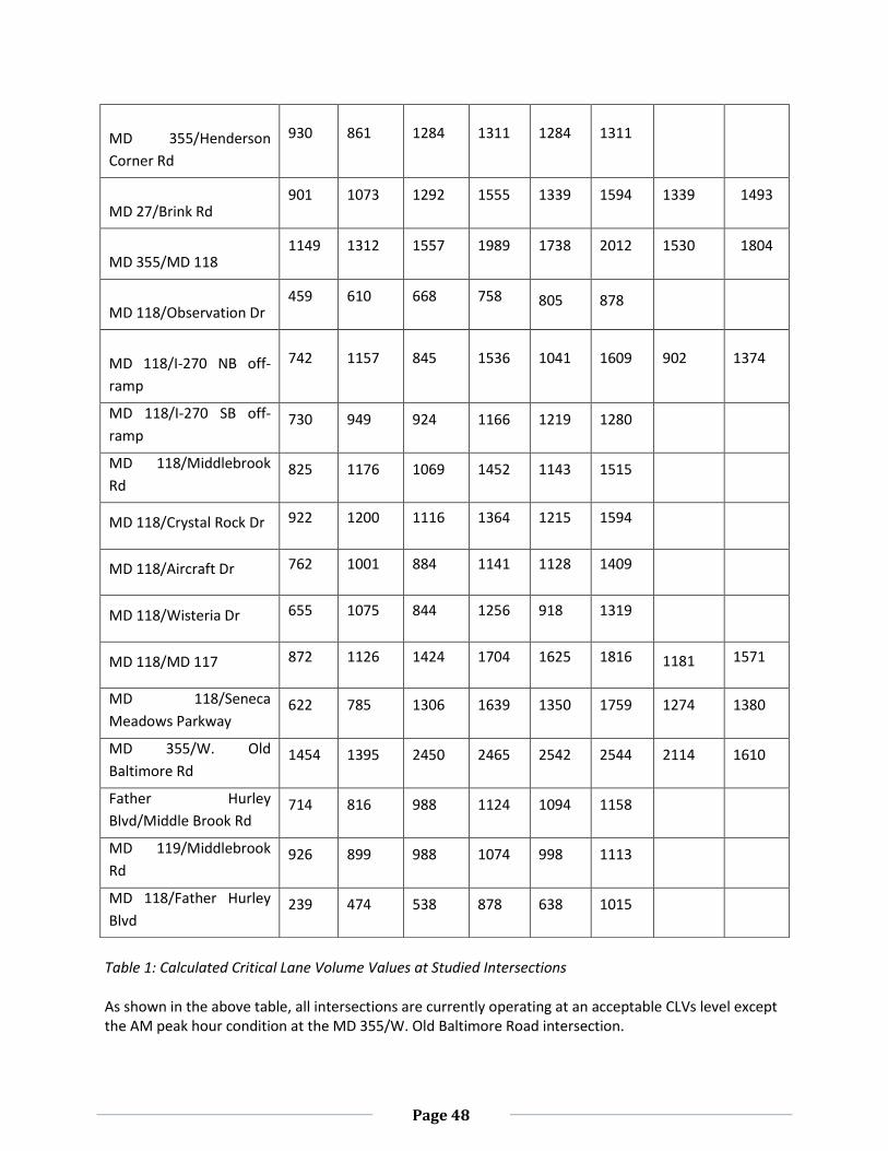
Page 48
Table 1: Calculated Critical Lane Volume Values at Studied Intersections As shown in the above table, all intersections are currently operating at an acceptable CLVs level except the AM peak hour condition at the MD 355/W. Old Baltimore Road intersection.
MD 355/Henderson
Corner Rd
930 861 1284 1311 1284 1311
MD 27/Brink Rd 901 1073 1292 1555 1339 1594 1339 1493
MD 355/MD 118 1149 1312 1557 1989 1738 2012 1530 1804
MD 118/Observation Dr 459 610 668 758 805 878
MD 118/I-270 NB off-
ramp
742 1157 845 1536 1041 1609 902 1374
MD 118/I-270 SB off-
ramp 730 949 924 1166 1219 1280
MD 118/Middlebrook
Rd 825 1176 1069 1452 1143 1515
MD 118/Crystal Rock Dr 922 1200 1116 1364 1215 1594
MD 118/Aircraft Dr 762 1001 884 1141 1128 1409
MD 118/Wisteria Dr 655 1075 844 1256 918 1319
MD 118/MD 117 872 1126 1424 1704 1625 1816 1181 1571
MD 118/Seneca
Meadows Parkway 622 785 1306 1639 1350 1759 1274 1380
MD 355/W. Old
Baltimore Rd 1454 1395 2450 2465 2542 2544 2114 1610
Father Hurley
Blvd/Middle Brook Rd 714 816 988 1124 1094 1158
MD 119/Middlebrook
Rd 926 899 988 1074 998 1113
MD 118/Father Hurley
Blvd 239 474 538 878 638 1015
Page 49
Under the background development (the existing traffic plus traffic from the approved/un-built developments), the MD 355/MD 27, MD 355/MD118, MD 355/W. Old Baltimore Road, MD 27/Observation Drive, MD 27/Brink Road, MD 118/I-270 northbound off-ramp, MD 118/MD 117, and the MD 118/Seneca Meadows Parkway intersections are projected to operate at unacceptable CLVs level during the various weekday peak hours. Under the total future development (the background traffic plus traffic from the Property), the unacceptable traffic conditions under background development are projected to worsen without any intersection improvement. With implementation of the intersection improvements to be provided by the Applicant, all these failing intersections would operate either at an acceptable CLVs or at a number of trips equal to 150 percent of the CLV impact attributable to the development during both the weekday AM and PM peak hours. Therefore, this preliminary plan application meets the LATR requirements of the APF review. MCDOT requires additional detail and analysis prior to acceptance of the roadway improvements outlined in the Applicant’s traffic study. MCDOT recommends that prior to submission of the first Site Plan the Applicant must submit concept plans for all proposed roadway improvements to MCDOT and MDSHA to confirm the proposed improvements are feasible and appropriate. If any of the proposed improvements are found to be infeasible, the Applicant must find alternative roadway improvements acceptable to MCDOT and MDSHA to satisfy the LATR requirements. Policy Area Mobility Review (PAMR) The Property is located within the Germantown West Policy Area where there is no PAMR trip requirement according to the current Subdivision Staging Policy. Site Access and Vehicular/Pedestrian Circulation The Property is to be accessed from Crystal Rock Drive and Century Boulevard with regional access to the Site via the I-270 interchanges with Father Hurley Boulevard, Middlebrook Road, and MD 118. Staff finds that the proposed access point to be adequate to accommodate the Site-generated traffic. Staff has reviewed the proposed internal traffic/pedestrian circulation system shown on the preliminary plan and finds that the private street system will be adequate to serve the vehicular and pedestrian needs for the development. MCDOT has also reviewed the private streets as they intersect with the public streets and finds that the public streets will not be negatively affected by the operation of the private street system. The system of private streets forms a strong grid pattern that is envisioned by the Sector Plan. Private streets will generally be no less than 22 feet from curb face to curb face to accommodate two lanes of travel and no less than 38 feet from curb face to curb face to accommodate two lanes of travel and parking on both sides. In conjunction with the adjacent sidewalks, the private streets system provides adequate interconnectivity and circulation for pedestrians and vehicles. To accommodate flexibility in building design and the building relationship to the private street system at the time of Site Plan, the private streets will be included within separate parcels to contain the private street only, from back of curb to back of curb. The adjacent sidewalks will not necessarily be included within the separate parcel; however both the sidewalks and the private streets will be included within a public access easement. The final width of sidewalks and the proximity of buildings to the private streets will be determined at Site Plan.
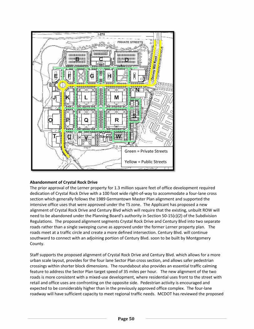
Page 50
Abandonment of Crystal Rock Drive The prior approval of the Lerner property for 1.3 million square feet of office development required dedication of Crystal Rock Drive with a 100 foot wide right-of-way to accommodate a four-lane cross section which generally follows the 1989 Germantown Master Plan alignment and supported the intensive office uses that were approved under the TS zone. The Applicant has proposed a new alignment of Crystal Rock Drive and Century Blvd which will require that the existing, unbuilt ROW will need to be abandoned under the Planning Board’s authority in Section 50-15(c)(2) of the Subdivision Regulations. The proposed alignment segments Crystal Rock Drive and Century Blvd into two separate roads rather than a single sweeping curve as approved under the former Lerner property plan. The roads meet at a traffic circle and create a more defined intersection. Century Blvd. will continue southward to connect with an adjoining portion of Century Blvd. soon to be built by Montgomery County. Staff supports the proposed alignment of Crystal Rock Drive and Century Blvd. which allows for a more urban scale layout, provides for the four lane Sector Plan cross section, and allows safer pedestrian crossings within shorter block dimensions. The roundabout also provides an essential traffic calming feature to address the Sector Plan target speed of 35 miles per hour. The new alignment of the two roads is more consistent with a mixed-use development, where residential uses front to the street with retail and office uses are confronting on the opposite side. Pedestrian activity is encouraged and expected to be considerably higher than in the previously approved office complex. The four-lane roadway will have sufficient capacity to meet regional traffic needs. MCDOT has reviewed the proposed
Green = Private Streets
Yellow = Public Streets
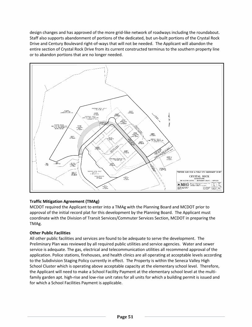
Page 51
design changes and has approved of the more grid-like network of roadways including the roundabout. Staff also supports abandonment of portions of the dedicated, but un-built portions of the Crystal Rock Drive and Century Boulevard right-of-ways that will not be needed. The Applicant will abandon the entire section of Crystal Rock Drive from its current constructed terminus to the southern property line or to abandon portions that are no longer needed.
Traffic Mitigation Agreement (TMAg) MCDOT required the Applicant to enter into a TMAg with the Planning Board and MCDOT prior to approval of the initial record plat for this development by the Planning Board. The Applicant must coordinate with the Division of Transit Services/Commuter Services Section, MCDOT in preparing the TMAg.
Other Public Facilities All other public facilities and services are found to be adequate to serve the development. The Preliminary Plan was reviewed by all required public utilities and service agencies. Water and sewer service is adequate. The gas, electrical and telecommunication utilities all recommend approval of the application. Police stations, firehouses, and health clinics are all operating at acceptable levels according to the Subdivision Staging Policy currently in effect. The Property is within the Seneca Valley High School Cluster which is operating above acceptable capacity at the elementary school level. Therefore, the Applicant will need to make a School Facility Payment at the elementary school level at the multi-family garden apt. high-rise and low-rise unit rates for all units for which a building permit is issued and for which a School Facilities Payment is applicable.
Page 52
Lot Configuration The size, shape width and orientation of the lots were reviewed to determine if they were appropriate given the location of this development, the recommendations of the Sector Plan and for the types of uses intended for the Property. The lots are appropriately dimensioned. As discussed, the grid pattern is specifically recommended by the Sector Plan to reduce the length of the overall blocks in order to create a more walkable community. The large lots will accommodate multi-family apartment buildings, both low-rise and high-rise. Other large lots will accommodate the office buildings and hotel structure. As discussed by the Project Plan, the building height step down towards the existing townhomes along Kinster Drive is achieved by the smaller, one family attached lots in the southern portions of the Property. The lots are appropriately sized to meet the Sector Plan recommendations for building massing and compatibility to the transit station.
Forest Conservation The Project Plan was found to be in conformance with Chapter 22A of the Montgomery County Forest Conservation Law., therefore, the Preliminary Plan also conforms to Chapter 22A because it is unchanged from the Project Plan.
APPENDIX A
APPENDIX A
APPENDIX A
APPENDIX A
APPENDIX A
APPENDIX A
APPENDIX A
APPENDIX A
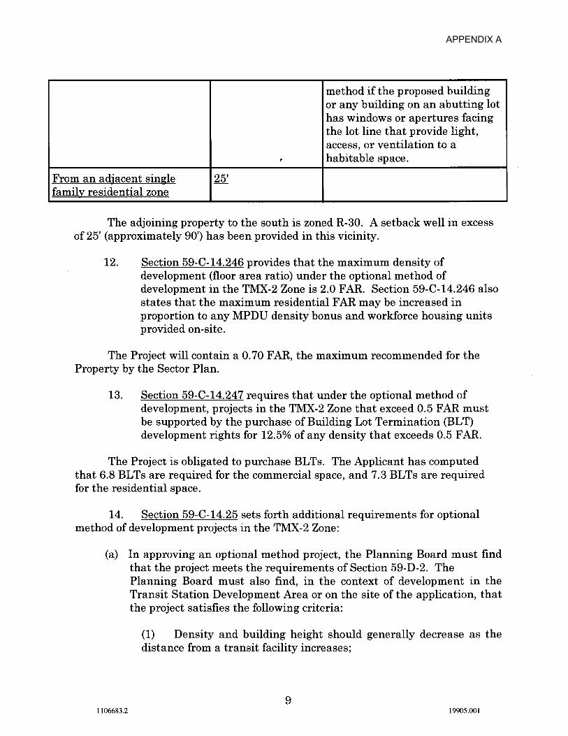
APPENDIX A
APPENDIX A
APPENDIX A
APPENDIX A
APPENDIX A
APPENDIX A
APPENDIX A
APPENDIX A
APPENDIX A
APPENDIX A
APPENDIX A
APPENDIX A
APPENDIX A
APPENDIX A
APPENDIX A
APPENDIX A
APPENDIX A
APPENDIX A
APPENDIX A
APPENDIX A
APPENDIX A
APPENDIX A
APPENDIX A
APPENDIX A
APPENDIX A
APPENDIX A
APPENDIX A
APPENDIX A
APPENDIX A
APPENDIX A
APPENDIX A
APPENDIX A
APPENDIX A
APPENDIX A
APPENDIX A
APPENDIX A
APPENDIX A
APPENDIX A
APPENDIX A
APPENDIX A
APPENDIX A
APPENDIX A
APPENDIX A
APPENDIX A
APPENDIX A
APPENDIX A
APPENDIX A
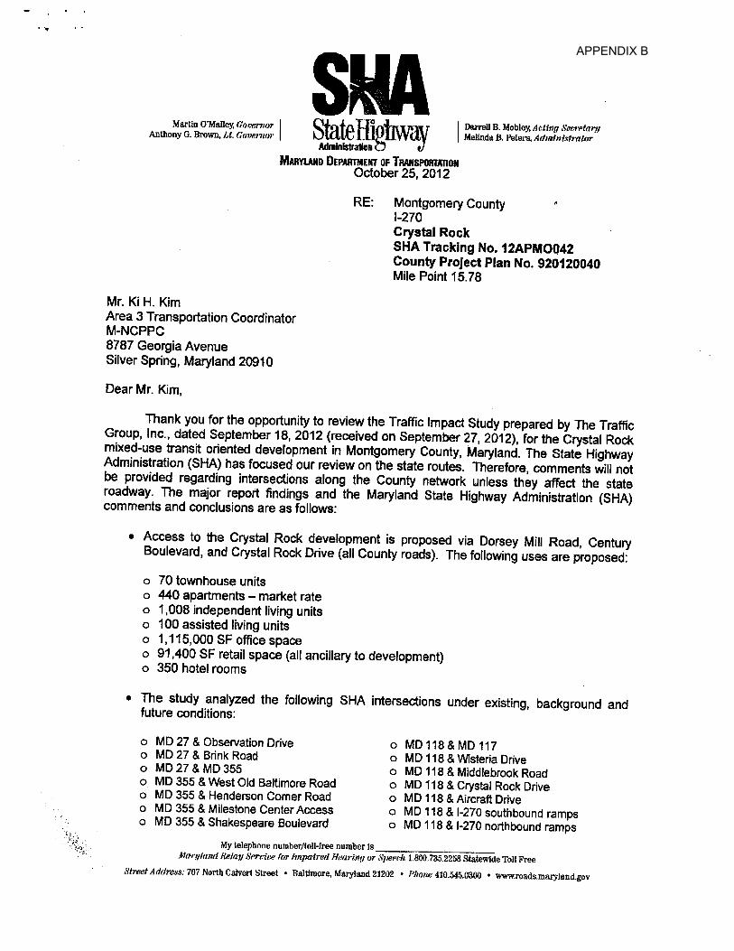
APPENDIX B
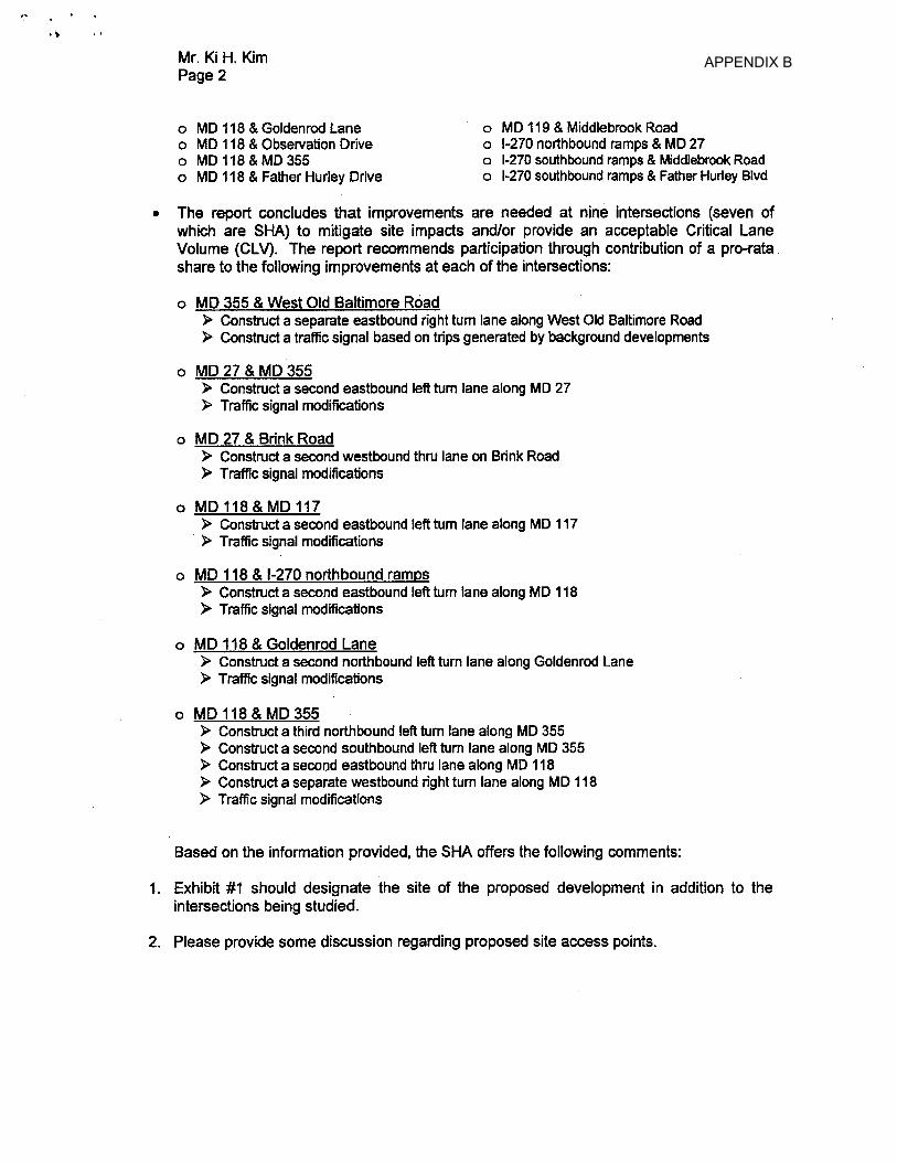
APPENDIX B
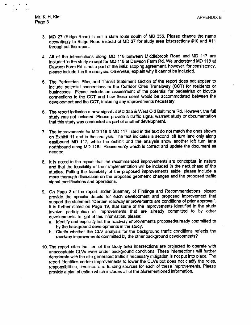
APPENDIX B
APPENDIX B
APPENDIX B
APPENDIX B
APPENDIX B
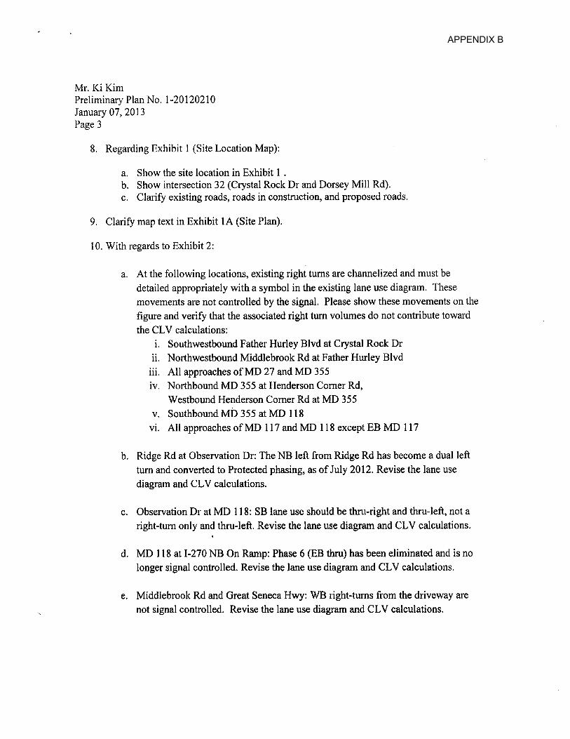
APPENDIX B
APPENDIX B
APPENDIX B
APPENDIX B
APPENDIX B
APPENDIX B
APPENDIX B
APPENDIX B
APPENDIX B
APPENDIX B
APPENDIX B
APPENDIX B
APPENDIX B
APPENDIX B
APPENDIX B
APPENDIX B
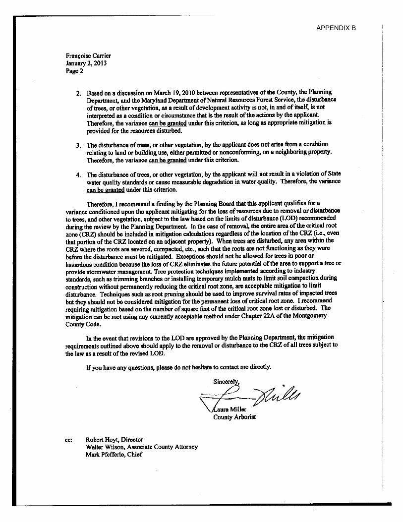
APPENDIX B
APPENDIX B
APPENDIX B
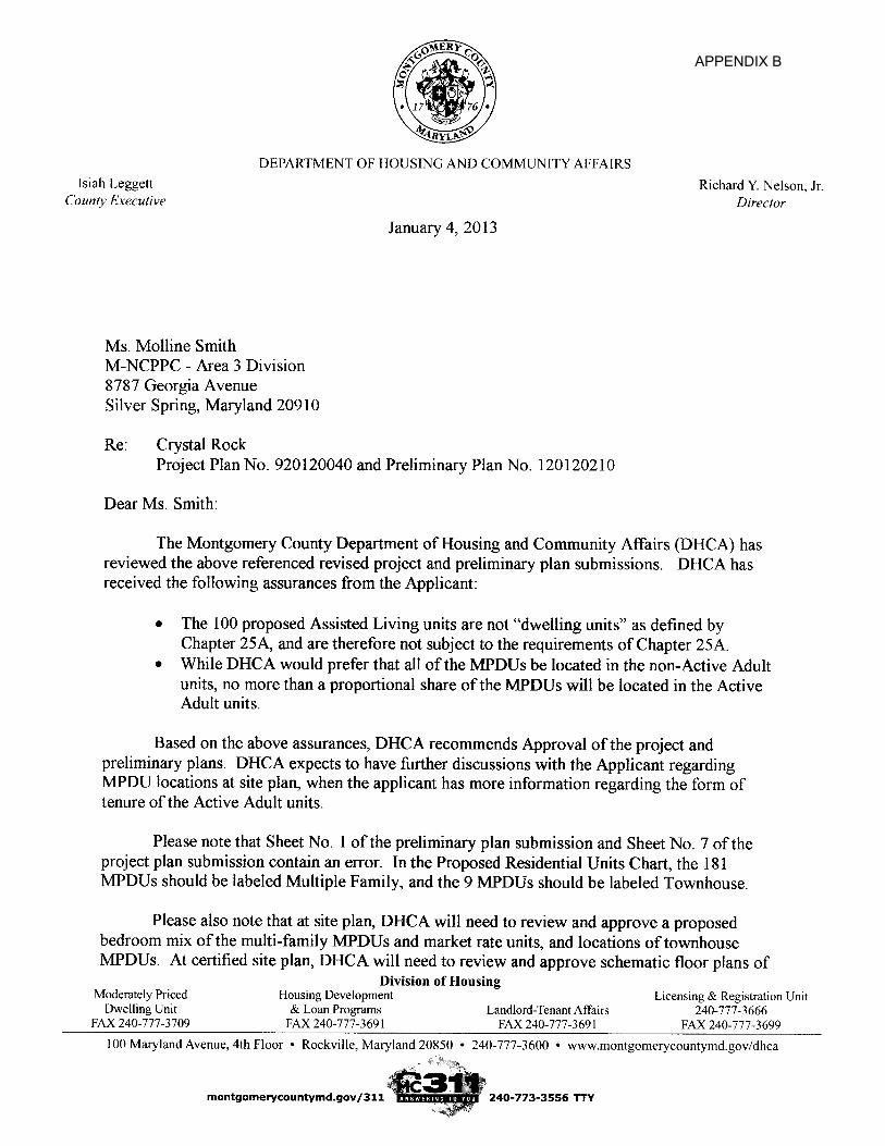
APPENDIX B
APPENDIX B
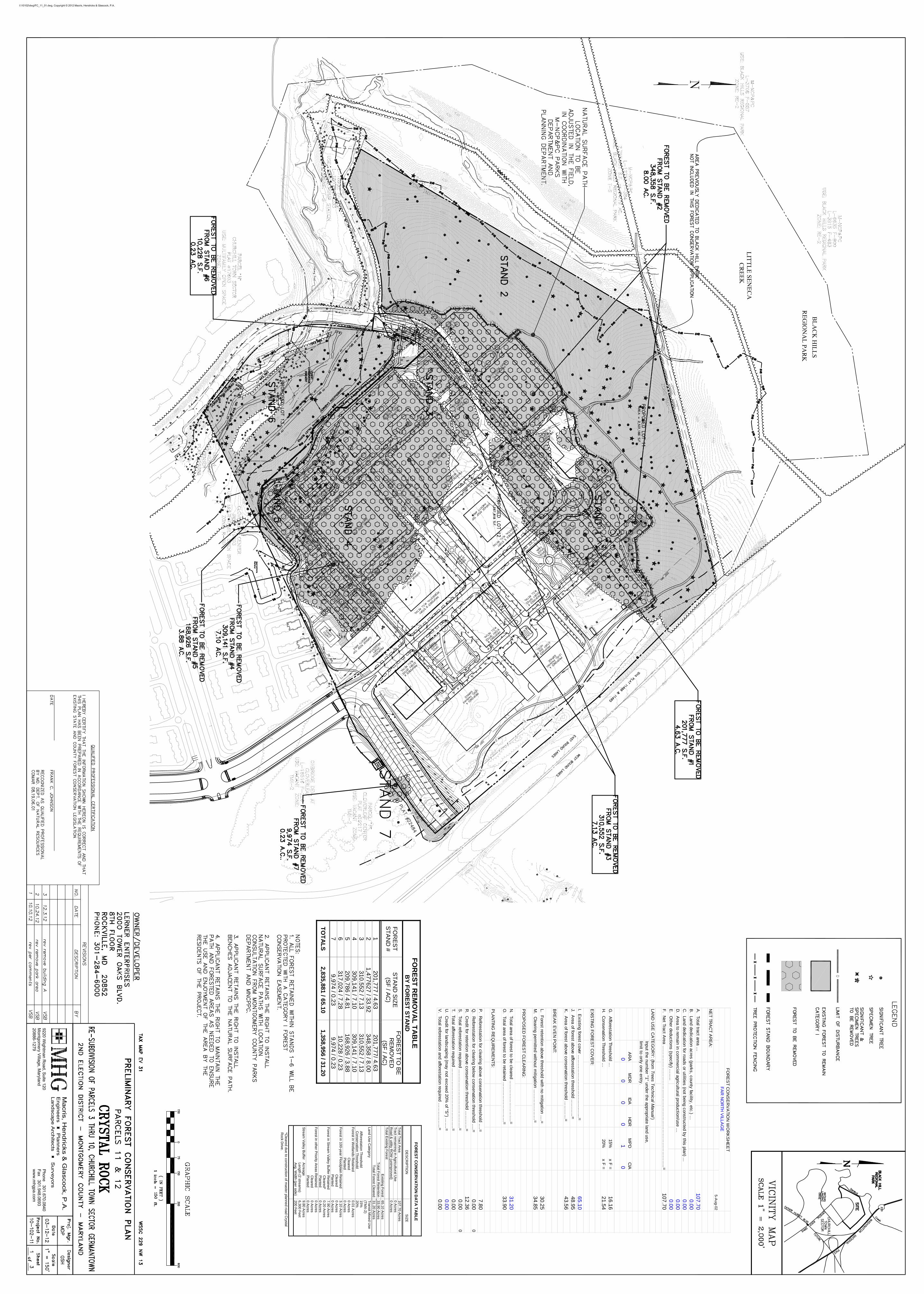
FO
RE
ST
CO
NS
ER
VA
TIO
N D
AT
A T
AB
LE
DE
SC
RIP
TIO
N
SIZ
E
Tota
l Tract A
rea 107
.70 Acre
s T
ract rem
aining in Agricultural U
se 0 A
cres R
oad & utility R
OW
(unimp
roved) 0 A
cres T
otal E
xisting Fore
st
Existin
g Fore
st 6
5.10 A
cres
Total F
orest Re
tention 3
3.90 A
cres T
otal Fo
rest Cleared
31
.20 Acre
s L
and Use C
atego
ry A
fforestatio
n Th
reshold C
onservation T
hreshold
Transit M
ixed Use
(TM
X-2)
15%
20%
Fore
st in Wetla
nds Re
tained
Cleare
d P
lanted
0.01 Acres
0 Acres
0 Acres
Fo
rest in 1
00-ye
ar Flood
plain Re
tained
Cle
are
d P
lanted
3.10 Acres
0 Acres
0 Acres
Fo
rest in S
tream
Valley B
uffe
r Reta
ine
d C
lea
red*
Planted
7.90 Acres
0.20 Acres
0 Acres
Fore
st in other P
riority Areas R
etained C
lea
red P
lanted
0 Acres
0 Acres
0 Acres
Stre
am V
alle
y Buffe
r Acre
age
Le
ngth
(2 stream
s) A
vg. Wid
th (per side)
9.80 Acre
s 6,300 F
eet 200
Feet
*Cleared due to co
nstruction of m
aster planned road C
rystal R
ock Drive.
FO
RE
ST
RE
MO
VA
L T
AB
LE
B
Y F
OR
ES
T S
TA
ND
FO
RE
ST
S
TA
ND
# S
TA
ND
SIZ
E
(SF
/ AC
)
FO
RE
ST
TO
BE
R
EM
OV
ED
(S
F / A
C)
1 2
01
,77
7 / 4.6
3 2
01
,77
7/ 4.63
2 1
,477
627
/ 33
.92
34
8,3
58 / 8
.00
3 3
10
.55
2 / 7.1
3 3
10
,55
2 / 7.1
3 4
30
9,1
41 / 7
.10
30
9,1
41 / 7
.10
5 2
09
,78
6 / 4.8
1 1
68
,92
6 / 3.8
8 6
31
7,0
24 / 7
.28
10
,228
/ 0.23
7 9
,974
/ 0.23
9,9
74 / 0
.23
TO
TA
LS
2
,835
,881
/ 65.1
0 1
,358
,956
/ 31.2
0
5-Aug-02
NE
T TRA
CT A
RE
A:
A. Total tract area …
10
7.7
0B
. Land dedication acres (parks, county facility, etc.) …0
.00
C. Land dedication for roads or utilities (not being constructed by this plan) ...
0.0
0D
. Area to rem
ain in comm
ercial agricultural production/use …0
.00
E. O
ther deductions (specify) ……
..0
.00
F. N
et Tract Area …
……
……
……
……
……
……
……
……
……
……
……
……
……
..=1
07
.70
LAN
D U
SE
CA
TEG
OR
Y: (from
Trees T
echnical Manual)
Input the number "1" under the appropriate land use,
limit to only one entry.
AR
AM
DR
IDA
HD
RM
PD
CIA
00
00
10
G. A
fforestation Threshold …15%
x F =
16
.16
H. C
onservation Threshold …20%
x F =
21
.54
EXIS
TING
FO
RE
ST C
OV
ER
:
I. Existing forest cover …
……
……
……
……
……
...……
.=6
5.1
0J. A
rea of forest above afforestation threshold ..….…
...=4
8.9
5K
. Area of forest above conservation threshold …
……
…=
43
.56
BR
EA
K E
VE
N P
OIN
T:
L. Forest retention above threshold w
ith no mitigation …
.=3
0.2
5M
. Clearing perm
itted without m
itigation ……
……
……
…=
34
.85
PR
OP
OS
ED
FO
RE
ST C
LEA
RIN
G:
N. Total area of forest to be cleared …
……
……
……
……
.=3
1.2
0O
. Total area of forest to be retained ……
……
……
……
…=
33
.90
PLA
NTIN
G R
EQ
UIR
EM
EN
TS:
P. R
eforestation for clearing above conservation threshold ….=
7.8
0Q
. Reforestation for clearing below
conservation threshold ….=
0.0
00
R. C
redit for retention above conservation threshold ……
……
=1
2.3
6S
. Total reforestation required ……
……
……
……
……
……
….=
0.0
00
T. Total afforestation required ……
……
……
……
……
……
…..=
0.0
0U
. Credit for landscaping (m
ay not exceed 20% of "S
") ……
.=0
.00
V. Total reforestation and afforestation required …
……
……
..=0
.00
FO
RE
ST C
ON
SE
RV
ATIO
N W
OR
KS
HE
ET
FA
R N
OR
TH V
ILLAG
E
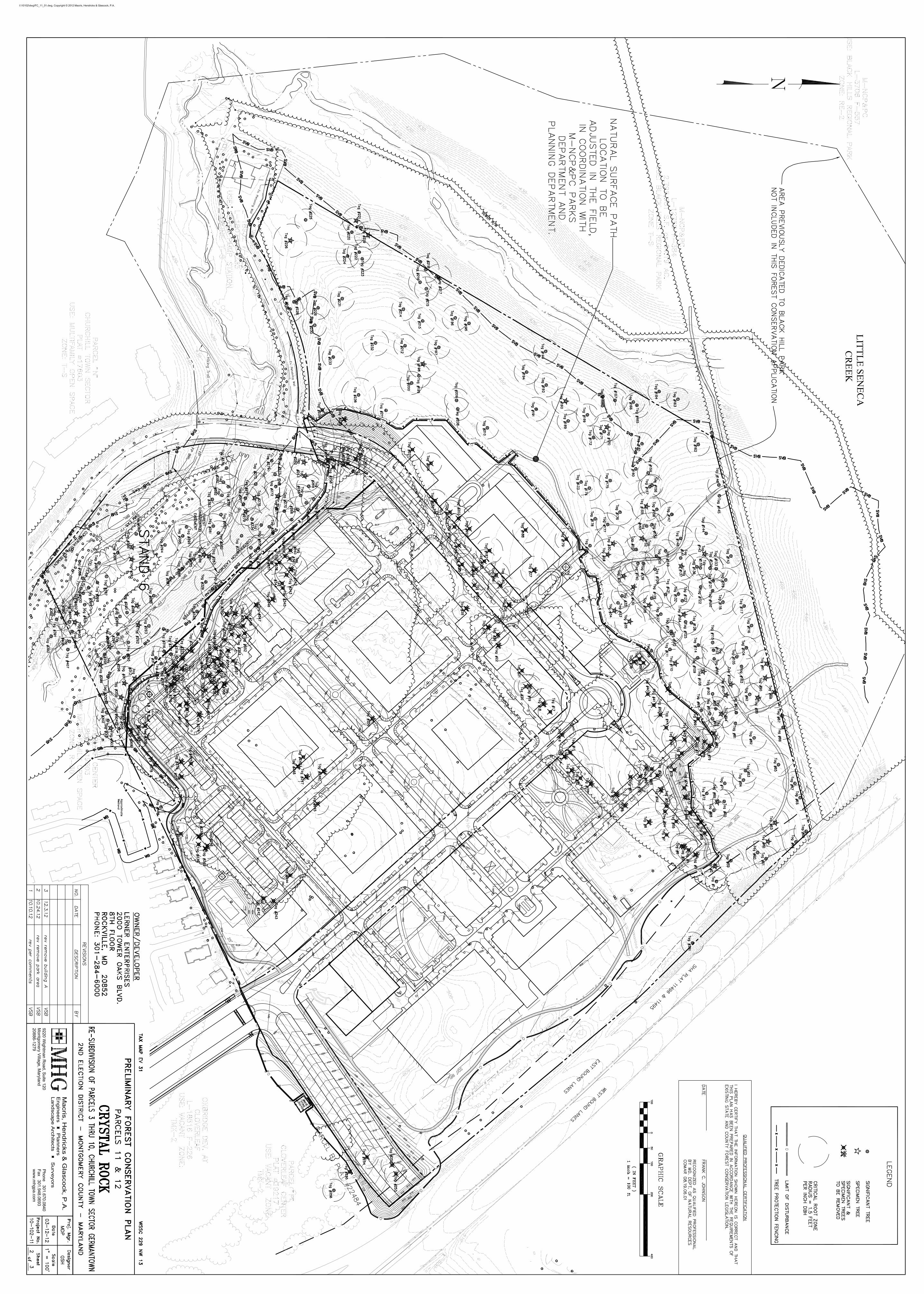
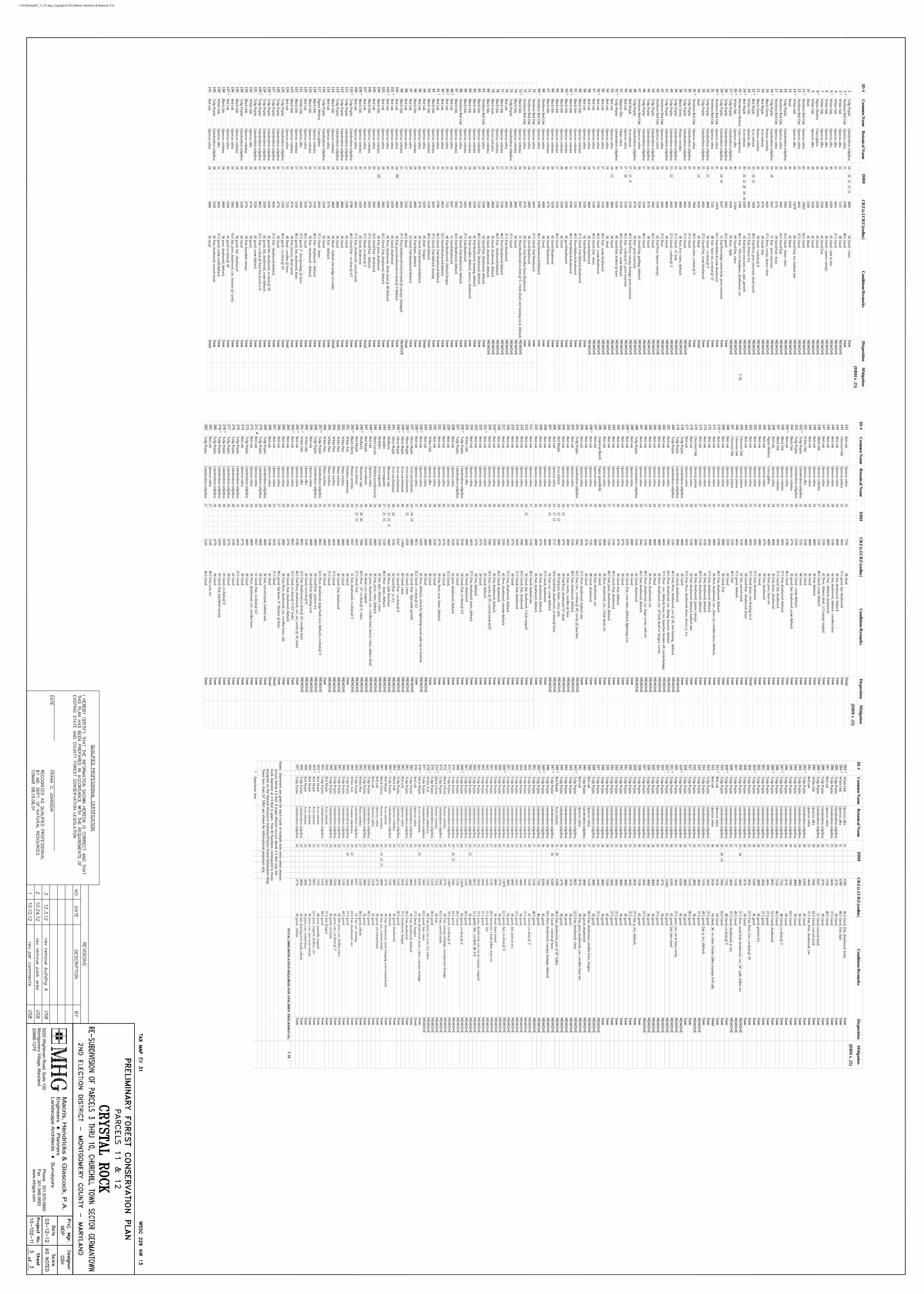
ID #
Com
mon N
ame
Botanical N
ame
CR
Z (s.f.C
RZ
(radius)C
onditions/Rem
arks
Disposition
Mitigation
(DB
H x .25)
1T
ulip PoplarLiriodendron tulipifera
24-
2412
1515
406936
Good - vines
Save
2*
Northern R
ed Oak
Quercus rubra
316789
46.5G
oodS
ave3
*W
hite Oak
Quercus alba
327235
48G
oodR
EM
OV
E4
White O
akQ
uercus alba25
441637.5
Good
RE
MO
VE
5*
White O
akQ
uercus alba30
635945
Good - w
ire in treeR
EM
OV
E6
White O
akQ
uercus alba24
406936
Good - sparse canopy
RE
MO
VE
7W
hite Oak
Quercus alba
285539
42G
ood/FairR
EM
OV
E8
*Pignut H
ickoryC
arya glabra30
635945
Good
RE
MO
VE
9W
hite Oak
Quercus alba
285539
42G
oodR
EM
OV
E10
Dead
306359
45D
eadR
EM
OV
E11
*N
orthern Red O
akQ
uercus rubra43
1306364.5
Good
RE
MO
VE
12N
orthern Red O
akQ
uercus rubra25
441637.5
Good
RE
MO
VE
13*
White O
akQ
uercus alba44
1367866
Good/Fair; rot, barbed w
ireR
EM
OV
E14
Dead
306359
45D
eadR
EM
OV
E15
Tulip Poplar
Liriodendron tulipifera29
594243.5
Good - leans vines
RE
MO
VE
16N
orthern Red O
akQ
uercus rubra29
594243.5
Good/Fair
RE
MO
VE
17N
orthern Red O
akQ
uercus rubra26
477639
Good/Fair - leans
RE
MO
VE
18*
Tulip Poplar
Liriodendron tulipifera34
-18
816751
Fair - poor structureR
EM
OV
E19
Black C
herry Prunus serotina
254416
37.5Poor, cavity, heavy vines
RE
MO
VE
20R
ed Maple
Acer rubrum
264776
39G
ood/ FairR
EM
OV
E21
Black C
herry Prunus serotina
264776
39G
ood - codom @
6'R
EM
OV
E22
*R
ed Maple
Acer rubrum
33-
1615
769449.5
Fair/Poor, poor structure, dead wood
RE
MO
VE
23W
hite Oak
Quercus alba
254416
37.5Fair, Poison Ivy
RE
MO
VE
24*
Red M
apleA
cer rubrum30
-25
2220
1010
635945
Fair/poor structure, rot, epic, growth
RE
MO
VE
25*
Mockernut H
ickoryC
arya tomentosa
316789
46.5Fair - 75%
of champion, deadw
ood, cav.R
EM
OV
E7.75
26*
White O
akQ
uercus alba40
1130460
Good/Fair, vines
RE
MO
VE
27*
Tulip Poplar
Liriodendron tulipifera30
635945
Poor - SplitR
EM
OV
E28
Tulip Poplar
Liriodendron tulipifera29
594243.5
goodS
ave29
*T
ulip PoplarLiriodendron tulipifera
34-
2410
816751
Fair/Poor,large rotten bole, poor structureS
ave30
*N
orthern Red O
akQ
uercus rubra41
1187661.5
Fair/dieback/some deadw
oodS
ave31
Northern R
ed Oak
Quercus rubra
327235
48Fair - base rot, co-dom
@ 15'
Save
32T
ulip PoplarLiriodendron tulipifera
24-
214069
36G
ood - co-dom @
3'S
ave33
Tulip Poplar
Liriodendron tulipifera25
441637.5
Good/Fair, som
e deadwood
Save
34dead
30-
146359
45D
eadD
ead35
*N
orthern Red O
akQ
uercus rubra33
769449.5
Good,vines, codom
@ 6'
Save
36T
ulip PoplarLiriodendron tulipifera
254416
37.5G
oodS
ave37
Tulip Poplar
Liriodendron tulipifera25
441637.5
Good
RE
MO
VE
38B
lack Cherry
Prunus serotina 24
406936
Poor, hvy vines, diebackR
EM
OV
E39
Tulip Poplar
Liriodendron tulipifera25
441637.5
Good - 6" hole
RE
MO
VE
40T
ulip PoplarLiriodendron tulipifera
25-
224416
37.5G
ood - codom @
3'R
EM
OV
E41
Tulip Poplar
Liriodendron tulipifera24
406936
Good
RE
MO
VE
42N
orthern Red O
akQ
uercus rubra25
441637.5
PoorR
EM
OV
E43
Northern R
ed Oak
Quercus rubra
285539
42Fair/Poor, Sparse canopy
RE
MV
OE
44T
ulip PoplarLiriodendron tulipifera
295942
43.5G
oodR
EM
OV
E45
Tulip Poplar
Liriodendron tulipifera26
477639
Good
RE
MO
VE
46T
ulip PoplarLiriodendron tulipifera
275150
40.5G
oodR
EM
OV
E47
Northern R
ed Oak
Quercus rubra
285539
42G
ood/Fair, girdling, diebackR
EM
OV
E48
Tulip Poplar
Liriodendron tulipifera26
477639
Fair - poor structureR
EM
OV
E49
Red M
apleA
cer rubrum27
-15
85150
40.5Fair/Poor, canopy dam
age, poor structureR
EM
OV
E50
Red oak
Quercus rubra
27-
185150
40.5Fair - codom
@ 5', poor structure
RE
MO
VE
51Slippery Elm
Ulm
us rubra 27
515040.5
Good/Fair - som
e diebackR
EM
OV
E52
*T
ulip PoplarLiriodendron tulipifera
306359
45G
ood/Fair, hollow @
baseR
EM
OV
E53
Red oak
Quercus rubra
24-
154069
36G
oodR
EM
OV
E54
Red oak
Quercus rubra
244069
36 dead
RE
MO
VE
55R
ed oakQ
uercus rubra27
515040.5
Fair - some deadw
oodR
EM
OV
E56
*R
ed oakQ
uercus rubra31
678946.5
Good - som
e deadwood
RE
MO
VE
57R
ed oakQ
uercus rubra27
515040.5
Good, Fair - leans
RE
MO
VE
58R
ed oakQ
uercus rubra24
406936
Good/deadw
oodR
EM
OV
E59
Red oak
Quercus rubra
285539
42Fair/deadw
oodS
ave60
Black O
akQ
uercus velutina25
441637.5
Good, Fair/dieback/deadw
oodS
ave61
Black O
akQ
uercus velutina27
515040.5
Poor/dieback/deadwood
Save
62*
Black O
akQ
uercus velutina31
678946.5
Fair/dieback/deadwood
Save
63*
Black O
akQ
uercus velutina30
635945
good/deadwood
Save
64B
lack Oak
Quercus velutina
285539
42G
oodS
ave65
Black O
akQ
uercus velutina27
515040.5
Good
Save
66B
lack Oak
Quercus velutina
285539
42G
ood/Deadw
oodS
ave67
Black O
akQ
uercus velutina26
477639
Good/D
eadwood
Save
68N
orthern Red O
akQ
uercus rubra24
406936
Good
save69
*N
orthern Red O
akQ
uercus rubra31
678946.5
Fair/Deadw
ood/Dieback
save
DB
H
70N
orthern Red O
akQ
uercus rubra25
441637.5
Good, Fair/D
eadwood
save71
Northern R
ed Oak
Quercus rubra
244069
36G
ood/deadwood
save72
Northern R
ed Oak
Quercus rubra
264776
39G
ood, Fair/Swollen base/D
eadwood
save73
*B
lack Oak
Quercus velutina
348167
51Poor/deadw
ood/co-dom @
5', 1 bole dead, tree leaning on it, diebackR
EM
OV
E74
Black O
akQ
uercus velutina24
406936
Good
RE
MO
VE
75T
ulip PoplarLiriodendron tulipifera
254416
37.5G
oodR
EM
OV
E76
Red oak
Quercus rubra
254416
37.5Fair/deadw
oodR
EM
OV
E77
Black O
akQ
uercus velutina27
515040.5
Poor/deadwood/dieback
RE
MO
VE
78B
lack Oak
Quercus velutina
275150
40.5Fair - deadw
ood/diebackR
EM
OV
E79
Black G
umN
yssa sylvatica24
406936
Good, deadw
ood, diebackR
EM
OV
E80
Black O
akQ
uercus velutina24
406936
Good, deadw
ood, diebackR
EM
OV
E81
Northern R
ed Oak
Quercus rubra
285539
42G
ood/Fair, Deadw
ood, diebackS
ave82
Black O
akQ
uercus velutina27
515040.5
Good/Fair, D
eadwood, dieback
Save
83B
lack Oak
Quercus velutina
285539
42Fair/deadw
ood, leaning, diebackS
ave84
Black O
akQ
uercus velutina24
406936
Fair/swollen, dieback, insects, deadw
oodsave
85B
lack Oak
Quercus velutina
254416
37.5Fair/deadw
oodS
ave86
Northern R
ed Oak
Quercus rubra
264776
39G
ood, Fair/deadwood, dieback
Save
87B
lack Oak
Quercus velutina
295942
43.5Fair/deadw
ood, diebackS
ave88
*R
ed oakQ
uercus rubra34
816751
Good/deadw
oodS
ave89
*R
ed oakQ
uercus rubra32
723548
Fair/deadwood, dieback fungus
Save
90*
Red oak
Quercus rubra
358655
52.5G
ood/deadwood/dieback
Save
91*
Red oak
Quercus rubra
316789
46.5G
ood, Fair/deadwood/dieback
Save
92B
lack Oak
Quercus velutina
254416
37.5G
ood, Fair/dieback, leaningS
ave93
Black O
akQ
uercus velutina27
515040.5
Good/dieback
Save
94R
ed oakQ
uercus rubra30
635945
dead - fungusD
ead95
Red oak
Quercus rubra
264776
39G
ood, Fair/deadwood/dieback
Save
96B
lack Oak
Quercus velutina
244069
36Fair/leans, dieback
Save
97R
ed oakQ
uercus rubra28
553942
Good, Fair/deadw
ood/diebackS
ave98
Red oak
Quercus rubra
275150
40.5D
eadD
ead99
Black O
akQ
uercus velutina25
441637.5
Poor/deadwood/curved trunk @
canopy, damaged
RE
MO
VE
100R
ed oakQ
uercus rubra24
-20
406936
Fair, poor/deadwood/co-dom
@ 3' dieback
Save
101*
Red oak
Quercus rubra
306359
45G
ood, deadwood
Save
102*
Red oak
Quercus rubra
306359
45Poor, deadw
ood/ 1bole dead @ 40',dieback
Save
103R
ed oakQ
uercus rubra29
594243.5
Good, Fair, deadw
ood, diebackS
ave104
Black O
akQ
uercus velutina24
-15
406936
Fair, poor, deadwood
Save
105R
ed oakQ
uercus rubra29
594243.5
Good/Fair - deadw
ood S
ave106
Black O
akQ
uercus velutina25
441637.5
Good/Fair - dieback
Save
107R
ed oakQ
uercus rubra25
441637.5
Dead, co-dom
@ 5'
Dead
108*
Black O
akQ
uercus velutina30
635945
Good, deadw
oodS
ave109
Red oak
Quercus rubra
254416
37.5Fair, deadw
ood, curved trunkS
ave110
*T
ulip PoplarLiriodendron tulipifera
316789
46.5G
ood/Fair - co-dom @
4.5'S
ave111
Tulip Poplar
Liriodendron tulipifera28
553942
Good
Save
112T
ulip PoplarLiriodendron tulipifera
244069
36G
oodS
ave113
Tulip Poplar
Liriodendron tulipifera24
406936
Good
Save
114B
lack Oak
Quercus velutina
244069
36D
ead - barbed wire (edge of sw
ale)D
ead115
Red oak
Quercus rubra
264776
39Fair - dieback
Save
116T
ulip PoplarLiriodendron tulipifera
285539
42G
oodS
ave117
Pignut Hickory
Carya glabra
254416
37.5G
ood - leansS
ave118
Black O
akQ
uercus velutina27
515040.5
Fair - deadwood - dieback
Save
119B
lack Oak
Quercus velutina
264776
39Fair - deadw
ood - diebackS
ave120
Red oak
Quercus rubra
275150
40.5G
oodS
ave121
White O
akQ
uercus alba25
441637.5
good, 3" tree growing, @
baseS
ave122
Black O
akQ
uercus velutina27
515040.5
good, fair, deadwood, leans
Save
123B
lack Oak
Quercus velutina
264776
39Fair, insects, dead w
oodS
ave124
Red oak
Quercus rubra
327235
48D
ead - swollen @
baseD
ead125
Tulip Poplar
Liriodendron tulipifera27
515040.5
good - co-dom @
10'S
ave126
Tulip Poplar
Liriodendron tulipifera26
477639
Good
Save
127T
ulip PoplarLiriodendron tulipifera
254416
37.5Fair - deadw
ood/diebackS
ave128
*T
ulip PoplarLiriodendron tulipifera
306359
45good/fair -deadw
ood, co-dom @
50'S
ave129
Tulip Poplar
Liriodendron tulipifera28
553942
good, fair, deadwood, som
e diebackS
ave130
*T
ulip PoplarLiriodendron tulipifera
358655
52.5Fair, co-dom
@ base but fused to 6'
Save
131T
ulip PoplarLiriodendron tulipifera
285539
42good, som
e diebackS
ave132
White O
akQ
uercus alba26
477639
good, S
ave133
Black O
akQ
uercus velutina26
477639
Fair, lopsided canopyS
ave134
Tulip Poplar
Liriodendron tulipifera28
553942
Good
Save
135B
lack Oak
Quercus velutina
244069
36good, fair - deadw
oodS
ave136
Red oak
Quercus rubra
295942
43.5fair, poor, deadw
ood, cav, baserot @ cavity
Save
137*
Red oak
Quercus rubra
306359
45good co-dom
@ 20'
Save
138B
lack Oak
Quercus velutina
244069
36poor, deadw
ood, diebackS
ave139
White O
akQ
uercus alba25
441637.5
good, some sw
ell dieback S
ave140
Tulip Poplar
Liriodendron tulipifera28
553942
Fair, deadwood, curved trunk
Save
141R
ed oakQ
uercus rubra24
406936
deadD
ead
ID #
Com
mon N
ame
Botanical N
ame
CR
Z (s.f.C
RZ
(radius)C
onditions/Rem
arks
Disposition
Mitigation
(DB
H x .25)
142R
ed oakQ
uercus rubra32
723548
deadD
ead143
Chestnut O
akQ
uercus prinus25
441637.5
good, fair, deadwood
Save
144R
ed oakQ
uercus rubra24
406936
fair, deadwood, dieback
Save
145R
ed oakQ
uercus rubra28
553942
fair, deadwood, dieback - sw
ollen baseS
ave146
Red oak
Quercus rubra
244069
36Fair - dieback, deadw
oodS
ave147
Red oak
Quercus rubra
285539
42Poor, A
lmost dead, 1/2 canopy topped
Save
148B
lack Oak
Quercus velutina
275150
40.5G
ood, some dieback
Save
149R
ed oakQ
uercus rubra24
406936
Fair, diebackS
ave150
Red oak
Quercus rubra
244069
36G
oodS
ave151
White O
akQ
uercus alba28
553942
Good
Save
152*
Tulip Poplar
Liriodendron tulipifera32
723548
Good
Save
153T
ulip PoplarLiriodendron tulipifera
285539
42G
ood - some dieback
Save
154B
lack Oak
Quercus velutina
264776
39good, fair, deadw
ood, some dieback
Save
155*
Red oak
Quercus rubra
316789
46.5G
oodS
ave156
Black O
akQ
uercus velutina25
441637.5
Fair, deadwood, dieback
Save
157B
lack Oak
Quercus velutina
254416
37.5G
ood, fair, deadwood
Save
158R
ed oakQ
uercus rubra24
406936
Fair, leans, deadwood
Save
159Pignut H
ickoryC
arya glabra24
406936
Fair, poor, base rotS
ave160
Red oak
Quercus rubra
264776
39Fair, deadw
oodS
ave161
Red oak
Quercus rubra
244069
36G
oodS
ave162
Red oak
Quercus rubra
254416
37.5Fair, deadw
oodS
ave163
Red oak
Quercus rubra
254416
37.5D
ead, leans, tree leaning on itD
ead164
Red oak
Quercus rubra
244069
36G
ood/Fair - deadwood, leans
Save
165C
hestnut Oak
Quercus prinus
285539
42fair, carved trunk
Save
166C
hestnut Oak
Quercus prinus
254416
37.5good, dieback
Save
167C
hestnut Oak
Quercus prinus
275150
40.5Fair
Save
168R
ed oakQ
uercus rubra28
553942
Good
Save
169R
ed oakQ
uercus rubra24
406936
Good, Fair
Save
170*
Red oak
Quercus rubra
316789
46.5Fair, deadw
ood, diebackS
ave171
Red oak
Quercus rubra
244069
36Poor, deadw
ood, cav., base rot, swollen base, dieback,
Save
172R
ed oakQ
uercus rubra25
441637.5
Fair, deadwood, dieback
Save
173R
ed oakQ
uercus rubra28
553942
Fair, deadwood, dieback
Save
174R
ed oakQ
uercus rubra27
515040.5
Fair, deadwood, dieback
Save
175C
hestnut Oak
Quercus prinus
244069
36Fair, deadw
ood, sparse canopyS
ave176
Red oak
Quercus rubra
285539
42Fair, deadw
ood, dieback, barbed wire
Save
177R
ed oakQ
uercus rubra25
441637.5
Fair, Poor, deadwood, leans, heavy p. ivy
Save
178T
ulip PoplarLiriodendron tulipifera
244069
36G
oodS
ave179
Tulip Poplar
Liriodendron tulipifera24
406936
Good, deadw
oodR
EM
OV
E180
Tulip Poplar
Liriodendron tulipifera27
515040.5
Fair, Poor, deadwood, cav @
20', tree leaning , diebackR
EM
OV
E181
Red oak
Quercus rubra
295942
43.5Poor, deadw
ood, cav, dieing, baserot, diebackR
EM
OV
E182
Red oak
Quercus rubra
254416
37.5Poor - cav, dieback, base rot, branches broken off, storm
damage
RE
MO
VE
183R
ed oakQ
uercus rubra24
406936
Poor, deadwood, cav, 25"bole dead w
/ fungus, cavityR
EM
OV
E184
Red oak
Quercus rubra
244069
36D
eadR
EM
OV
E185
Red oak
Quercus rubra
244069
36Poor, deadw
ood, cavR
EM
OV
E186
Red oak
Quercus rubra
275150
40.5Poor, deadw
ood, cav, large cavity with rot
RE
MO
VE
187R
ed oakQ
uercus rubra29
594243.5
Fair, deadwood, dieback
RE
MO
VE
188T
ulip PoplarLiriodendron tulipifera
285539
42G
ood, deadwood
RE
MO
VE
189R
ed oakQ
uercus rubra24
406936
Good
Save
190*
Red oak
Quercus rubra
306359
45G
ood, Fair, over wires, dieback, lightning scar
Save
191R
ed oakQ
uercus rubra26
477639
Good
Save
192R
ed oakQ
uercus rubra26
477639
Good, Fair, dieback
Save
193R
ed oakQ
uercus rubra27
515040.5
Good, Fair, deadw
oodS
ave194
Red oak
Quercus rubra
275150
40.5Fair, poor, deadw
ood, diebackS
ave195
Red oak
Quercus rubra
244069
36Poor, deadw
ood, cav, 1 bole dead, rotS
ave196
Am
erican Beech
Fagus grandifolia28
553942
Good
Save
197R
ed oakQ
uercus rubra24
406936
Fair, deadwood, cav
Save
198*
Red oak
Quercus rubra
327235
48G
ood, deadwood
Save
199R
ed oakQ
uercus rubra26
477639
Good
Save
200R
ed oakQ
uercus rubra25
441637.5
Poor, deadwood, barbed w
ireS
ave201
Tulip Poplar
Liriodendron tulipifera29
594243.5
Fair, cav., co-dom @
20', cavity @ junction
RE
MO
VE
202R
ed oakQ
uercus rubra27
515040.5
Fair, deadwood, dieback
RE
MO
VE
203R
ed oakQ
uercus rubra24
406936
Fair, cavity, swollen @
baseR
EM
OV
E204
Red oak
Quercus rubra
26-
154776
39Fair/Poor, deadw
ood 15" deadR
EM
OV
E205
Red M
apleA
cer rubrum24
-12
124069
36Fair/poor, leans, vines, epic.
RE
MO
VE
206R
ed oakQ
uercus rubra23
-17
123737
34.5G
ood/Fair, deadwood, co-dom
@ base
RE
MO
VE
207R
ed oakQ
uercus rubra24
-15
406936
Fair, cav, some dieback
RE
MO
VE
208R
ed oakQ
uercus rubra25
441637.5
Good, deadw
oodS
ave209
Red oak
Quercus rubra
264776
39Fair, deadw
ood, diebackS
ave210
Red oak
Quercus rubra
244069
36Fair, deadw
ood, diebackS
ave
DB
H
211R
ed oakQ
uercus rubra27
515040.5
Good, barbed w
ireS
ave212
Red oak
Quercus rubra
24-
224069
36G
ood, fair, deadwood, 1 bole topped
Save
213R
ed oakQ
uercus rubra29
594243.5
Good, Fair, deadw
oodS
ave214
Red oak
Quercus rubra
254416
37.5G
ood, Fair, deadwood
Save
215R
ed oakQ
uercus rubra26
477639
Good
Save
216R
ed oakQ
uercus rubra25
441637.5
Fair, deadwood, dieback
Save
217R
ed oakQ
uercus rubra28
553942
Poor, deadwood, extrem
e diebackS
ave218
Red oak
Quercus rubra
295942
43.5G
ood, deadwood
Save
219*
Red oak
Quercus rubra
306359
45Fair, deadw
ood, diebackS
ave220
Red oak
Quercus rubra
295942
43.5Fair, cavity @
25', curved trunk @25'
Save
221*
Red oak
Quercus rubra
306359
45G
ood, diebackS
ave222
Red oak
Quercus rubra
264776
39G
oodS
ave223
Red oak
Quercus rubra
264776
39Fair, dieback
Save
224R
ed oakQ
uercus rubra25
441637.5
Fair, deadwood, leans, dieback
Save
225W
hite Oak
Quercus alba
244069
36G
ood, deadwood
Save
226*
Tulip Poplar
Liriodendron tulipifera36
915654
Good, Fair, co-dom
@ 4.5'
Save
227T
ulip PoplarLiriodendron tulipifera
285539
42G
oodS
ave228
Red oak
Quercus rubra
285539
42poor, deadw
ood, diebackS
ave229
Red oak
Quercus rubra
254416
37.5G
ood,S
ave230
Red oak
Quercus rubra
264776
39G
oodS
ave231
Red oak
Quercus rubra
264776
39Fair, Poor, scar, leans, dieback
Save
232R
ed oakQ
uercus rubra28
553942
Good
Save
233W
hite Oak
Quercus alba
244069
36G
oodS
ave234
Red oak
Quercus rubra
244069
36D
eadR
EM
OV
E235
*R
ed oakQ
uercus rubra30
635945
Poor, dieback, struck by lightning/wood split top to bottom
RE
MO
VE
236*
Red oak
Quercus rubra
379672
55.5G
ood - co-dom @
4.5'S
ave237
Silver Maple
Acer saccharinum
24-
1814
406936
Good, Fair - Epicorm
ic growth
RE
MO
VE
238*
Silver Maple
Acer saccharinum
30-
226359
45G
ood, vinesR
EM
OV
E239
*Silver M
apleA
cer saccharinum40
1130460
Good, vines
RE
MO
VE
240*
Silver Maple
Acer saccharinum
348167
51G
ood/Fair - co-dom @
6'R
EM
OV
E241
Silver Maple
Acer saccharinum
28-
245539
42G
ood/Fair - p. ivyR
EM
OV
E242
Mulberry
Moraceae spp.
24-
1515
84069
36Poor, split from
baseR
EM
OV
E243
Boxelder
Acer negundo
27-
2115
515040.5
Poor - leans, diebackR
EM
OV
E244
Boxelder
Acer negundo
285539
42fair, epic, dieback, vines
RE
MO
VE
245B
lack LocustR
obinia pseudoacacia24
406936
Fair, poor, vines, diebackR
EM
OV
E246
*R
ed oakQ
uercus rubra30
635945
poor, deadwood, cav, sw
ollen base, heavy vines, almost dead
RE
MO
VE
247R
ed Maple
Acer rubrum
306359
45dead, cav, topped
RE
MO
VE
248*
Mulberry
Moraceae spp.
33-
2020
769449.5
Poor - 33" co-dom @
5', vinesR
EM
OV
E249
Red M
apleA
cer rubrum25
-22
154416
37.5G
ood/ FairR
EM
OV
E250
*B
lack Cherry
Prunus serotina 34
816751
Fair, deadwood, co-dom
@ 5'
RE
MO
VE
251W
hite Ash
Fraxinus americana
244069
36G
oodS
ave252
White Pine
Pinus strobus24
406936
Good
RE
MO
VE
253W
hite PinePinus strobus
244069
36G
ood/ Fair, deadwood
RE
MO
VE
254W
hite PinePinus strobus
254416
37.5G
oodR
EM
OV
E255
White Pine
Pinus strobus25
441637.5
Good
RE
MO
VE
256W
hite PinePinus strobus
244069
36G
oodS
ave257
*T
ulip PoplarLiriodendron tulipifera
358655
52.5Poor, deadw
ood, large bark scar, dieback, co-dom @
5'R
EM
OV
E258
Tulip Poplar
Liriodendron tulipifera24
406936
Good/Fair - poison ivy
RE
MO
VE
259R
ed oakQ
uercus rubra24
406936
Good/Fair, lightning scar
RE
MO
VE
260W
hite Oak
Quercus alba
285539
42G
ood, co-com @
6'R
EM
OV
E261
*W
hite Oak
Quercus alba
358655
52.5Fair, deadw
ood,co-dom @
10', swollen base
RE
MO
VE
262*
Red oak
Quercus rubra
316789
46.5Fair/Poor, deadw
ood, cav, rot, cavity @ 10', leans
Save
263*
Red oak
Quercus rubra
358655
52.5G
ood, co-dom @
5' (12" bole)S
ave264
Red oak
Quercus rubra
264776
39G
ood, Fair, deadwood, dieback
Save
265R
ed oakQ
uercus rubra24
406936
Fair, Poor, deadwood, cav, sw
ollen base, slatS
ave266
Red oak
Quercus rubra
275150
40.5good, fair leans, 6" H
ickory @ base
Save
267R
ed oakQ
uercus rubra25
441637.5
Dead
Dead
268R
ed oakQ
uercus rubra28
553942
Dead
Dead
269T
ulip PoplarLiriodendron tulipifera
244069
36Fair, curved trunk, barbed w
ireS
ave270
Tulip Poplar
Liriodendron tulipifera24
406936
Good
Save
271*
Red oak
Quercus rubra
348167
51G
ood, Fair, co-dom @
4.5'S
ave272
Red oak
Quercus rubra
244069
36Poor, deadw
ood, cav, swollen base
Save
273T
ulip PoplarLiriodendron tulipifera
244069
36G
oodS
ave274
Red oak
Quercus rubra
264776
39G
oodS
ave275
Tulip Poplar
Liriodendron tulipifera25
441637.5
Good
Save
276T
ulip PoplarLiriodendron tulipifera
285539
42G
oodS
ave277
Tulip Poplar
Liriodendron tulipifera26
477639
Good
Save
278*
Tulip Poplar
Liriodendron tulipifera30
635945
Good, co-dom
@ 6'
Save
279*
Tulip Poplar
Liriodendron tulipifera30
635945
Good, Fair, lopsided canopy
Save
280T
ulip PoplarLiriodendron tulipifera
264776
39G
oodS
ave281
Red oak
Quercus rubra
275150
40.5Fair, scar, rot
Save
282T
ulip PoplarLiriodendron tulipifera
275150
40.5G
oodS
ave
ID #
Com
mon N
ame
Botanical N
ame
CR
Z (s.f.C
RZ
(radius)C
onditions/Rem
arks
Disposition
Mitigation
(DB
H x .25)
283*
White O
akQ
uercus alba31
678946.5
Good, Fair, deadw
ood, leansS
ave284
*W
hite Oak
Quercus alba
316789
46.5G
ood, Fair, EpicS
ave285
Tulip Poplar
Liriodendron tulipifera26
477639
Good
Save
286T
ulip PoplarLiriodendron tulipifera
254416
37.5G
oodS
ave287
Red oak
Quercus rubra
275150
40.5G
oodS
ave288
Tulip Poplar
Liriodendron tulipifera26
477639
Good
Save
289*
Tulip Poplar
Liriodendron tulipifera34
816751
Good, curved trunk
Save
290W
hite Oak
Quercus alba
295942
43.5G
ood, curved trunkS
ave291
Red oak
Quercus rubra
254416
37.5Fair, Poor, deadw
ood, cavS
ave292
*T
ulip PoplarLiriodendron tulipifera
306359
45G
oodS
ave293
Tulip Poplar
Liriodendron tulipifera24
406936
Good
Save
294T
ulip PoplarLiriodendron tulipifera
244069
36G
oodS
ave295
Tulip Poplar
Liriodendron tulipifera29
594243.5
Good
Save
296T
ulip PoplarLiriodendron tulipifera
264776
39G
oodS
ave297
*T
ulip PoplarLiriodendron tulipifera
327235
48G
ood, co-dom @
5'S
ave298
Tulip Poplar
Liriodendron tulipifera27
515040.5
Good
Save
299*
Tulip Poplar
Liriodendron tulipifera35
865552.5
Good, deadw
oodS
ave300
Tulip Poplar
Liriodendron tulipifera25
441637.5
goodS
ave301
Tulip Poplar
Liriodendron tulipifera25
441637.5
goodS
ave302
Tulip Poplar
Liriodendron tulipifera24
406936
good, poison ivyS
ave303
*T
ulip PoplarLiriodendron tulipifera
306359
45good
Save
304T
ulip PoplarLiriodendron tulipifera
254416
37.5Fair, Poor, C
av, co-dom @
10'S
ave305
Tulip Poplar
Liriodendron tulipifera26
477639
Good
Save
306T
ulip PoplarLiriodendron tulipifera
25-
244416
37.5Poor, w
eak fork, deadwood, cav, 24" split, fallen, rot
RE
MO
VE
307T
ulip PoplarLiriodendron tulipifera
275150
40.5G
oodR
EM
OV
E308
Tulip Poplar
Liriodendron tulipifera25
441637.5
Good, deadw
ood, p. ivyR
EM
OV
E309
*T
ulip PoplarLiriodendron tulipifera
327235
48G
ood, co-dom @
5'S
ave310
Tulip Poplar
Liriodendron tulipifera29
-20
145942
43.5G
oodS
ave311
*R
ed oakQ
uercus rubra36
915654
Good
Save
312R
ed oakQ
uercus rubra36
915654
Dead, 36" w
/ other 3 boles fallen (stumps 4'-8' tall)
Dead
313T
ulip PoplarLiriodendron tulipifera
254416
37.5good
Save
314T
ulip PoplarLiriodendron tulipifera
275150
40.5good, fair, p. ivy, dieback
Save
315T
ulip PoplarLiriodendron tulipifera
254416
37.5good
RE
MO
VE
316T
ulip PoplarLiriodendron tulipifera
244069
36good
RE
MO
VE
317T
ulip PoplarLiriodendron tulipifera
275150
40.5good
Save
318T
ulip PoplarLiriodendron tulipifera
244069
36good
Save
319*
Tulip Poplar
Liriodendron tulipifera30
635945
goodR
EM
OV
E320
Tulip Poplar
Liriodendron tulipifera25
441637.5
poor, cav, rot in base cavityR
EM
OV
E321
*T
ulip PoplarLiriodendron tulipifera
306359
45good, fair, tree stand
RE
MO
VE
322*
Tulip Poplar
Liriodendron tulipifera42
1246363
goodR
EM
OV
E323
Tulip Poplar
Liriodendron tulipifera26
477639
goodR
EM
OV
E324
Tulip Poplar
Liriodendron tulipifera25
441637.5
goodR
EM
OV
E325
Tulip Poplar
Liriodendron tulipifera24
406936
goodR
EM
OV
E326
Tulip Poplar
Liriodendron tulipifera24
406936
goodR
EM
OV
E327
Tulip Poplar
Liriodendron tulipifera25
441637.5
goodR
EM
OV
E328
Tulip Poplar
Liriodendron tulipifera28
553942
goodS
ave329
Tulip Poplar
Liriodendron tulipifera25
441637.5
fair, p. ivy, diebackS
ave330
Tulip Poplar
Liriodendron tulipifera25
441637.5
goodS
ave331
Tulip Poplar
Liriodendron tulipifera24
406936
goodS
ave332
Tulip Poplar
Liriodendron tulipifera24
406936
goodS
ave333
Tulip Poplar
Liriodendron tulipifera25
441637.5
goodS
ave334
Tulip Poplar
Liriodendron tulipifera25
441637.5
goodS
ave335
Tulip Poplar
Liriodendron tulipifera28
553942
goodS
ave336
Tulip Poplar
Liriodendron tulipifera24
406936
goodS
ave337
Tulip Poplar
Liriodendron tulipifera25
441637.5
goodR
EM
OV
E338
Tulip Poplar
Liriodendron tulipifera24
406936
goodR
EM
OV
E339
Red oak
Quercus rubra
275150
40.5Fair, deadw
ood, swollen base, fungus
RE
MO
VE
340T
ulip PoplarLiriodendron tulipifera
244069
36good, deadw
oodR
EM
OV
E341
Red oak
Quercus rubra
264776
39Fair, poor, deadw
ood, cav, swollen base rot
RE
MO
VE
342*
Tulip Poplar
Liriodendron tulipifera35
865552.5
Fair, deadwood, vines
RE
MO
VE
343T
ulip PoplarLiriodendron tulipifera
264776
39good
RE
MO
VE
344T
ulip PoplarLiriodendron tulipifera
244069
36good
RE
MO
VE
345T
ulip PoplarLiriodendron tulipifera
264776
39good
RE
MO
VE
346*
Red M
apleA
cer rubrum31
-20
678946.5
Fair, deadwood, part of 20" fallen
RE
MO
VE
347*
Tulip Poplar
Liriodendron tulipifera30
-16
635945
Good - codom
@ base
RE
MO
VE
348T
ulip PoplarLiriodendron tulipifera
295942
43.5Poor, deadw
ood, canopy damage, dieback
RE
MO
VE
349*
Tulip Poplar
Liriodendron tulipifera30
635945
goodR
EM
OV
E350
*T
ulip PoplarLiriodendron tulipifera
327235
48good
RE
MO
VE
351T
ulip PoplarLiriodendron tulipifera
275150
40.5good
RE
MO
VE
DB
H
35
2T
ulip
Po
plar
Lirio
den
dro
n tu
lipifera
285539
42G
oo
d, co
-do
m @
5'R
EM
OV
E3
53
Tu
lip P
op
larL
iriod
end
ron
tulip
ifera25
441637.5
go
od
RE
MO
VE
35
4T
ulip
Po
plar
Lirio
den
dro
n tu
lipifera
244069
36g
oo
dR
EM
OV
E3
55
Tu
lip P
op
larL
iriod
end
ron
tulip
ifera25
441637.5
go
od
RE
MO
VE
35
6T
ulip
Po
plar
Lirio
den
dro
n tu
lipifera
244069
36g
oo
d, fair, p
oiso
n iv
yR
EM
OV
E3
57
Tu
lip P
op
larL
iriod
end
ron
tulip
ifera24
406936
go
od
RE
MO
VE
35
8*
Tu
lip P
op
larL
iriod
end
ron
tulip
ifera41
1187661.5
go
od
, fair, co-d
om
@ 6'
RE
MO
VE
35
9T
ulip
Po
plar
Lirio
den
dro
n tu
lipifera
264776
39g
oo
dR
EM
OV
E3
60
Tu
lip P
op
larL
iriod
end
ron
tulip
ifera24
406936
dead
, base ro
ttedR
EM
OV
E3
61
Tu
lip P
op
larL
iriod
end
ron
tulip
ifera27
515040.5
fair/po
or, 1 b
ole fallen
, base ro
tR
EM
OV
E3
62
Tu
lip P
op
larL
iriod
end
ron
tulip
ifera25
441637.5
go
od
, fairR
EM
OV
E3
63
Tu
lip P
op
larL
iriod
end
ron
tulip
ifera25
441637.5
go
od
RE
MO
VE
36
4T
ulip
Po
plar
Lirio
den
dro
n tu
lipifera
254416
37.5p
oo
r, dead
wo
od
, cav, ro
t in can
op
y, to
pp
ed
RE
MO
VE
36
5T
ulip
Po
plar
Lirio
den
dro
n tu
lipifera
379672
55.5g
oo
d, fa
ir, co
-do
m @
4.5
'R
EM
OV
E3
66
Tu
lip P
op
larL
iriod
end
ron
tulip
ifera24
-22
406936
go
od
RE
MO
VE
36
7T
ulip
Po
plar
Lirio
den
dro
n tu
lipifera
275150
40.5g
oo
dR
EM
OV
E3
68
*T
ulip
Po
plar
Lirio
den
dro
n tu
lipifera
4413678
66g
oo
d, co
-do
m @
6'R
EM
OV
E3
69
Tu
lip P
op
larL
iriod
end
ron
tulip
ifera27
515040.5
Go
od
RE
MO
VE
37
0T
ulip
Po
plar
Lirio
den
dro
n tu
lipifera
29-
2622
594243.5
go
od
RE
MO
VE
37
1*
Tu
lip P
op
larL
iriod
end
ron
tulip
ifera47
1560770.5
go
od
, co-d
om
@ 8'
RE
MO
VE
37
2B
lack Ch
erry
Pru
nu
s serotin
a 26
477639
Fair, can
op
y d
amag
e, wo
od
pecker d
amag
eR
EM
OV
E3
73
Tu
lip P
op
larL
iriod
end
ron
tulip
ifera29
594243.5
Fair, cu
rved
trun
kR
EM
OV
E3
74
*B
lack Ch
erry
Pru
nu
s serotin
a 32
723548
Fair
RE
MO
VE
37
5T
ulip
Po
plar
Lirio
den
dro
n tu
lipifera
275150
40.5g
oo
dR
EM
OV
E3
76
*W
hite A
shF
raxinu
s american
a32
723548
Fair, p
oo
r, rot, scar, iv
y v
ines
RE
MO
VE
37
7T
ulip
Po
plar
Lirio
den
dro
n tu
lipifera
295942
43.5g
oo
d, fair, v
ines
RE
MO
VE
37
8*
Silv
er Map
leA
cer saccharin
um
30-
256359
45fair, d
eadw
oo
d, lean
s, vin
es, cano
py
dam
age
Sa
ve3
79
Red
oak
Qu
ercus ru
bra
254416
37.5D
ead, fu
ng
us
De
ad
38
0T
ulip
Po
plar
Lirio
den
dro
n tu
lipifera
244069
36F
air, dead
wo
od
, dieb
ackS
ave
38
1T
ulip
Po
plar
Lirio
den
dro
n tu
lipifera
275150
40.5F
air, dead
wo
od
Sa
ve3
82
Red
oak
Qu
ercus ru
bra
254416
37.5d
eadw
oo
d, fu
ng
us
Sa
ve3
83
Tu
lip P
op
larL
iriod
end
ron
tulip
ifera27
515040.5
go
od
Sa
ve3
84
Black O
akQ
uercu
s velu
tina
244069
36g
oo
d, d
eadw
oo
dS
ave
38
5*
Tu
lip P
op
larL
iriod
end
ron
tulip
ifera32
723548
Go
od
Sa
ve3
86
Red
Map
leA
cer rub
rum
264776
39F
air, dead
wo
od
, roo
ts han
gin
g o
ver stream
ban
kS
ave
38
7B
lack Ch
erry
Pru
nu
s serotin
a 24
-23
2215
406936
fair, cav, 2 ro
tten b
oles
Sa
ve3
88
Red
oak
Qu
ercus ru
bra
264776
39g
oo
d, o
n stream
ban
kS
ave
38
9R
ed o
akQ
uercu
s rub
ra28
553942
go
od
Sa
ve3
90
Tu
lip P
op
larL
iriod
end
ron
tulip
ifera27
515040.5
go
od
Sa
ve3
91
Tu
lip P
op
larL
iriod
end
ron
tulip
ifera24
406936
go
od
Sa
ve3
92
Wh
ite Pin
eP
inu
s strob
us
275150
40.5g
oo
d, o
ffsiteS
ave
39
3T
ulip
Po
plar
Lirio
den
dro
n tu
lipifera
348167
51F
air, cav, lean
ing
Sa
ve3
94
Wh
ite Ash
Fraxin
us am
ericana
29-
225942
43.5F
air, dead
wo
od
, cavS
ave
39
5T
ulip
Po
plar
Lirio
den
dro
n tu
lipifera
25-
204416
37.5g
oo
dS
ave
39
6T
ulip
Po
plar
Lirio
den
dro
n tu
lipifera
275150
40.5g
oo
dS
ave
39
7T
ulip
Po
plar
Lirio
den
dro
n tu
lipifera
244069
36fair/ p
oo
r, cav, h
ollo
w b
aseS
ave
39
8T
ulip
Po
plar
Lirio
den
dro
n tu
lipifera
285539
42p
oo
r, cav, co
-do
m @
5'S
ave
39
9T
ulip
Po
plar
Lirio
den
dro
n tu
lipifera
244069
36g
oo
d, o
n b
ank
Sa
ve4
00
Red
Map
leA
cer rub
rum
254416
37.5fair, fu
ng
us
Sa
ve4
01
Tu
lip P
op
larL
iriod
end
ron
tulip
ifera27
515040.5
go
od
Sa
ve4
02
*R
ed M
aple
Acer ru
bru
m32
723548
po
or, p
artially to
pp
edS
ave
40
3*
Red
Map
leA
cer rub
rum
358655
52.5p
oo
r, top
ped
, ho
llow
, cavS
ave
40
4R
ed M
aple
Acer ru
bru
m26
477639
po
or, cav
, lays o
ver stream
Sa
ve4
05
Red
Map
leA
cer rub
rum
244069
36p
oo
r, cav, ro
tted b
aseS
ave
40
6T
ulip
Po
plar
Lirio
den
dro
n tu
lipifera
244069
36fair, lean
ing
ov
er ban
k, offsite
Sa
ve4
07
Tu
lip P
op
larL
iriod
end
ron
tulip
ifera26
477639
go
od
- offsite
Sa
ve
TO
TA
L D
BH
MIT
IGA
TIO
N R
EQ
UIR
ED
FO
R S
PE
CIM
EN
TR
EE
RE
MO
VA
L:
7.7
5
No
tes
: Dia
me
ters
are
give
n fo
r ea
ch
trun
k o
f mu
ltiple
bo
le tre
es
wh
en
divis
ion
oc
cu
rs b
elo
w 4
.5 fe
et. If m
ajo
r divis
ion
oc
cu
rs a
bo
ve 4
.5 fe
et o
nly
the
trun
k d
iam
ete
r at 4
.5 fe
et is
give
n. T
ree
ID N
um
be
rs c
orre
sp
on
d to
tho
se
as
sig
ne
d o
n th
e N
atu
ral R
es
ou
rce
Inve
nto
ry/F
ore
st S
tan
d D
elin
ea
tion
Ma
p.
Tre
es
les
s th
an
24
" DB
H a
re s
ho
wn
for in
form
atio
na
l pu
rpo
se
s o
nly
.
*S
pe
cim
en
tree
APPENDIX D
Previous Approvals Sheet Town Sector Zone (C-1522) was approved in May 1965. Churchill Town Sector Plan (original Development Plan, F-148) was originally approved in November 1967 under the RR zone; which consisted of 1,504 acres of land. The land distribution was such that 109 acres was designated for commercial uses, 75 acres was designated for industrial uses, 100 acres designated for University Science Center, 803.89 acres was designated for residential uses, 12 acres was designated for churches, 294.20 acres was designated for open space and recreational uses, 55 acres was designated for schools, and 55 acres was designated for highways projected for a maximum population of 22,530 people (calculating approximately 15 people per acre). Amendment to the Germantown Master Plan and Development Plan (DPA 83-3) was adopted October 1986 to change the North Village (the Property) from the RR zone to the TS zone in order to increase the amount of employment and change the development sequence plan. Specifically related to the Property, the North Village portion was amended to allow up to 2.7 million square feet for a research and development park. Amendment to the Development Plan (DPA 89-3) was adopted October 1990. Specifically related to the Site, the North Village was amended to decrease the area designated for industrial/employment from 2.7 million square feet with an interim limitation of 400 maximum peak hour trips to 1.3 million square feet with no interim limitations within the TS zone.
Zoning Text Amendment (No. 09-06) approved October 5, 2009 to reclassify the TS zone to TMX-2 to
allow a mix of uses and more density near the transit facilities.
Preliminary Plan Approvals
Preliminary Plan No. 119870120 (original, mailed November 1988) was approved for 1.3 million square
feet of office on 12 lots created on 81 acres of land within the TS zone; including the dedication of
“public and private open space” (parkland property). The parkland deed was later signed June 17, 1994.
Amended Preliminary Plan (mailed March 7, 1995) was approved for the interim use of a golf driving
range and associated uses as approved under the Special Exception No. S-2129 and Site Plan. The
validity period was extended to April 7, 1998.
Amended Preliminary Plan (mailed November 1995) was approved the phasing of 240,000 square feet of
the total 1.3 million square feet of office development on 110.20 acres of land zoned TS.
Amended Preliminary Plan (mailed September 20, 1996) approved Phase I consisting of 400,000 square
feet (30% of the project) by December 1998, and Phase II consisting of 900,000 square feet (70% of the
project) by December 2001.
Amended Preliminary Plan (mailed January 31, 2003) approved revised conditions 4-7; which were
specifically related to the construction of Century Blvd (4-lane divided highway), and the construction of
Crystal Rock Drive (4-lane divided roadway).

Site Plan Approvals
Site Plan No. 819950170 (mailed March 4, 1995) was approved 620 square feet for retail use on 21.02
acres of land zoned TS.
Site Plan No. 820020030 (mailed November 4, 2002) approved 900,000 square feet of office on 55.34
acres on land zoned TS.
Site Plan No. 81995017A (administrative approval) approved in April 18, 2002 for modifications to the
landscape and lighting plans in response to a violation issued in August 2001.
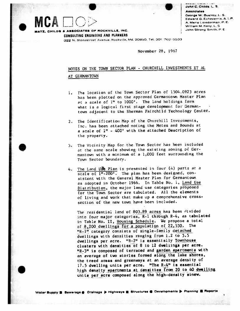
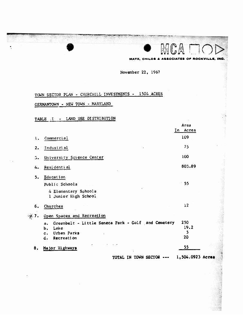
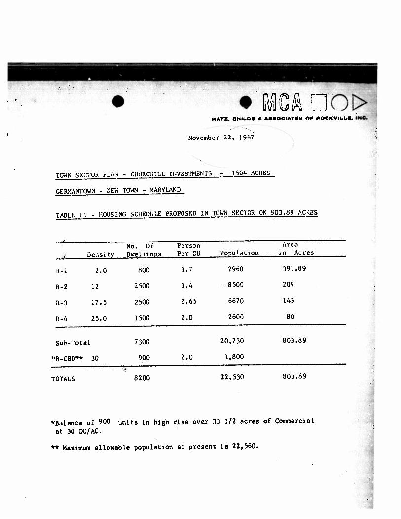
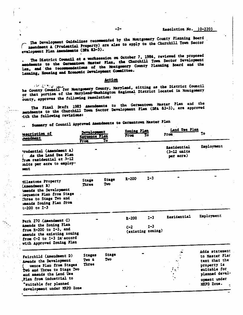
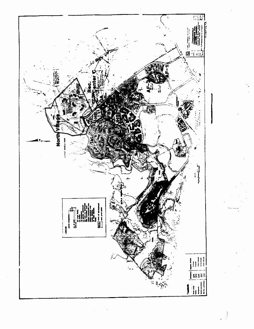
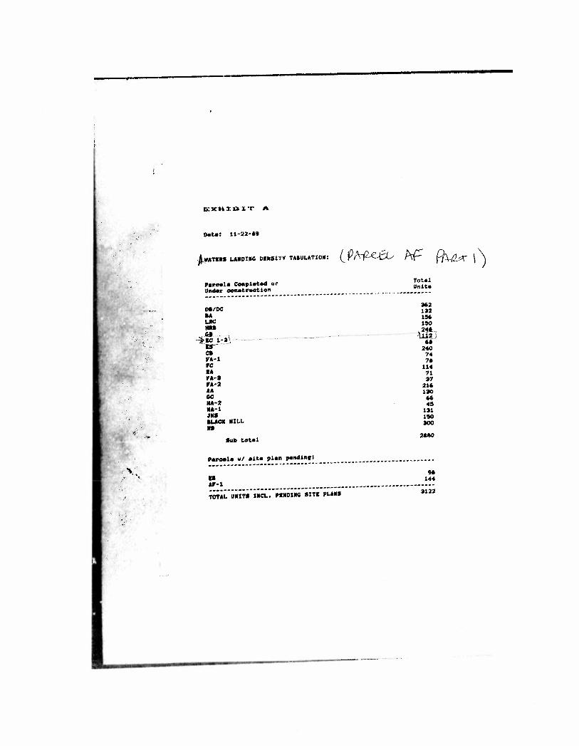
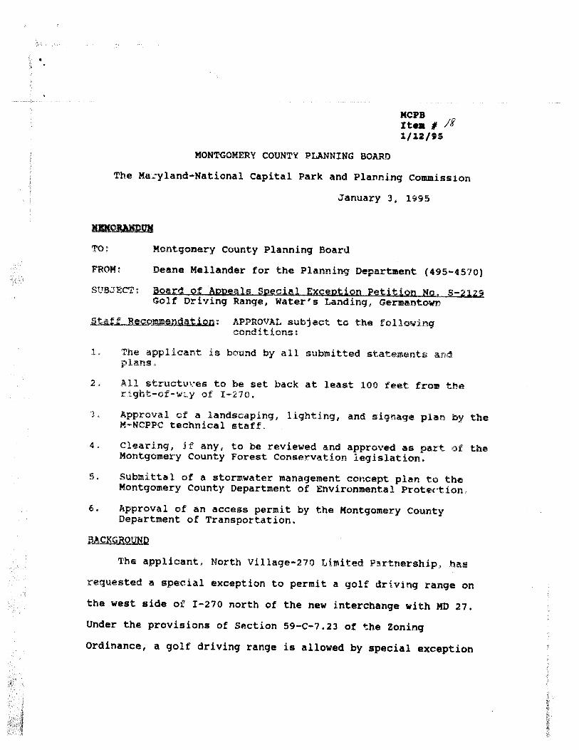

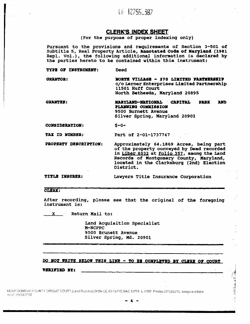
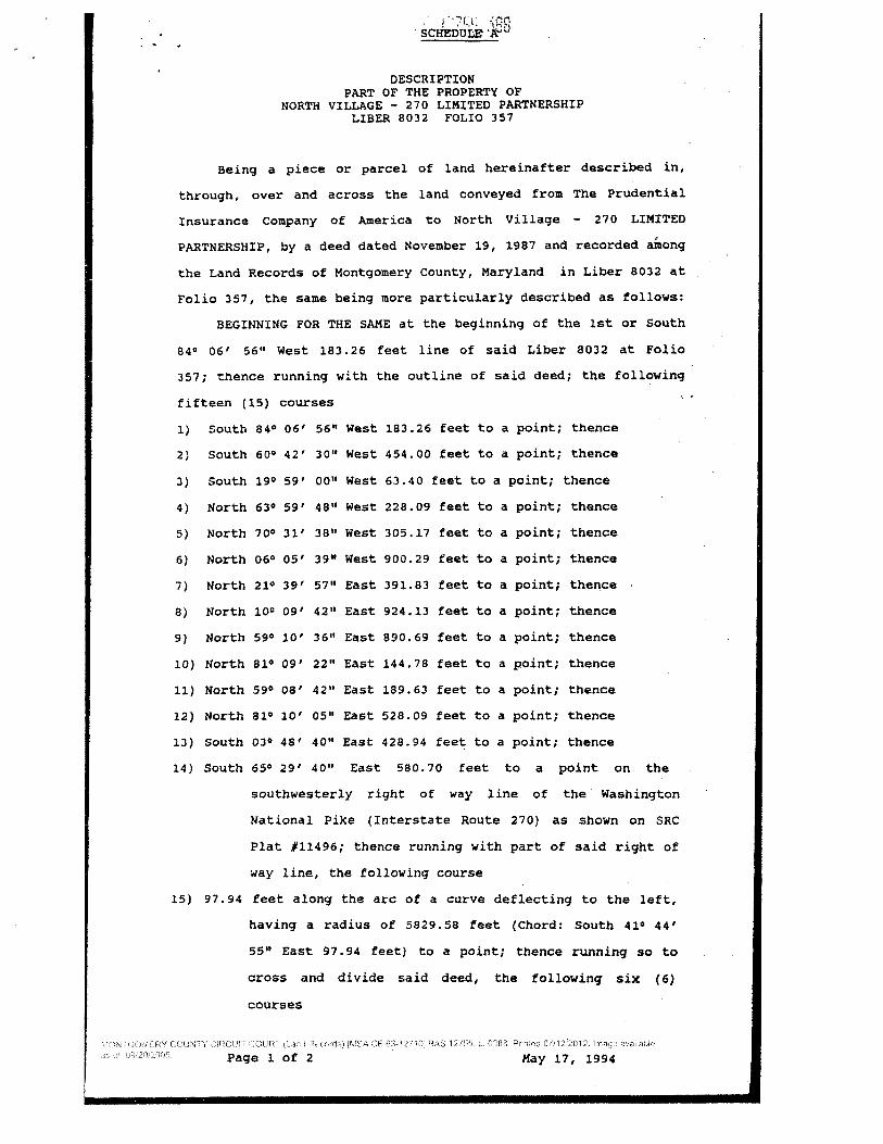
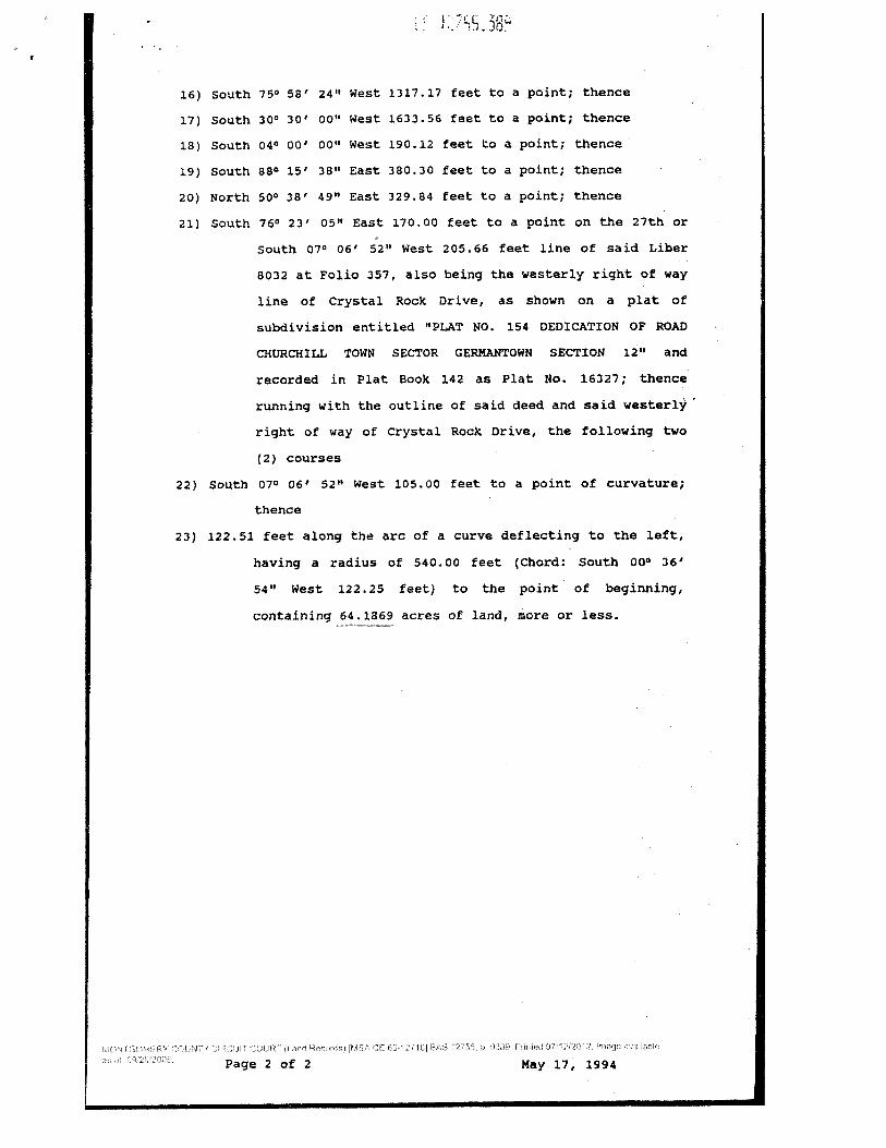
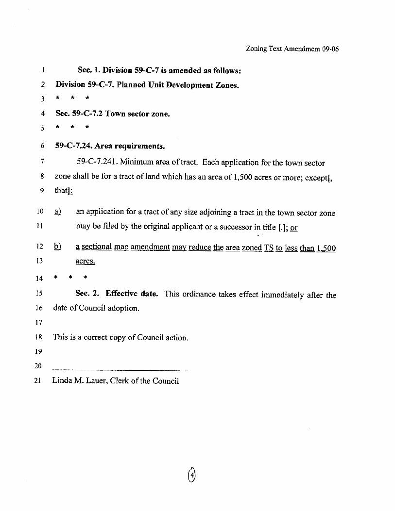
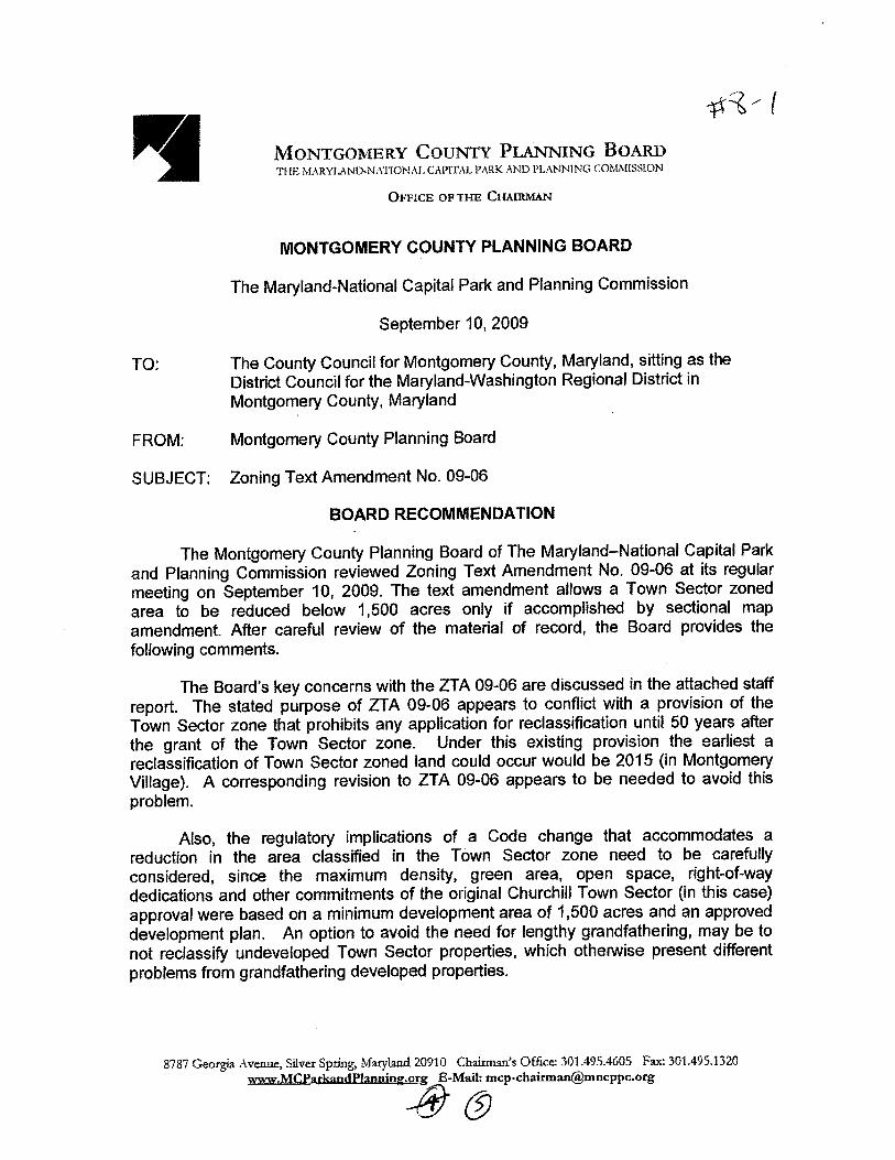

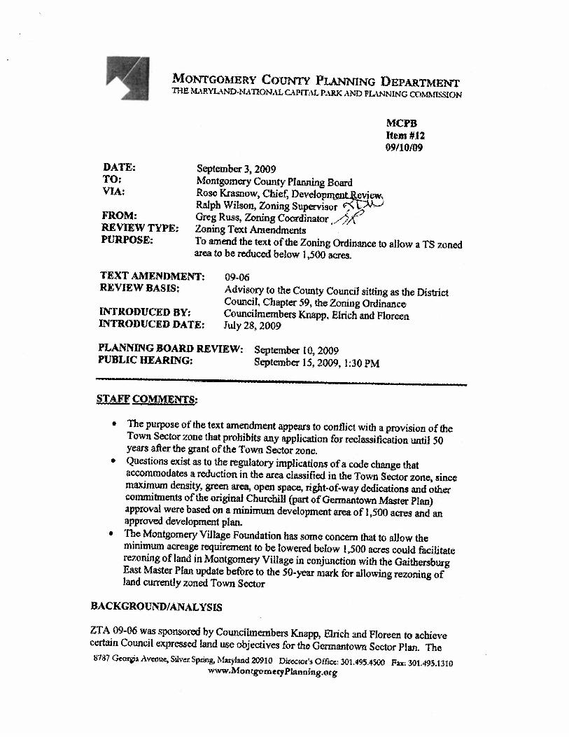
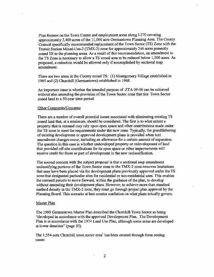
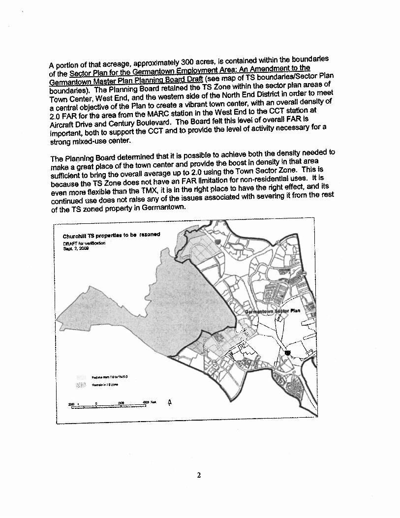
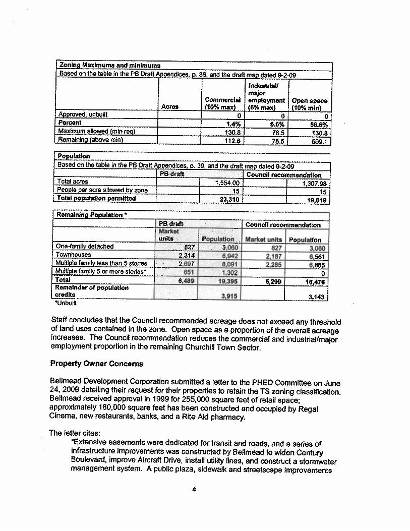
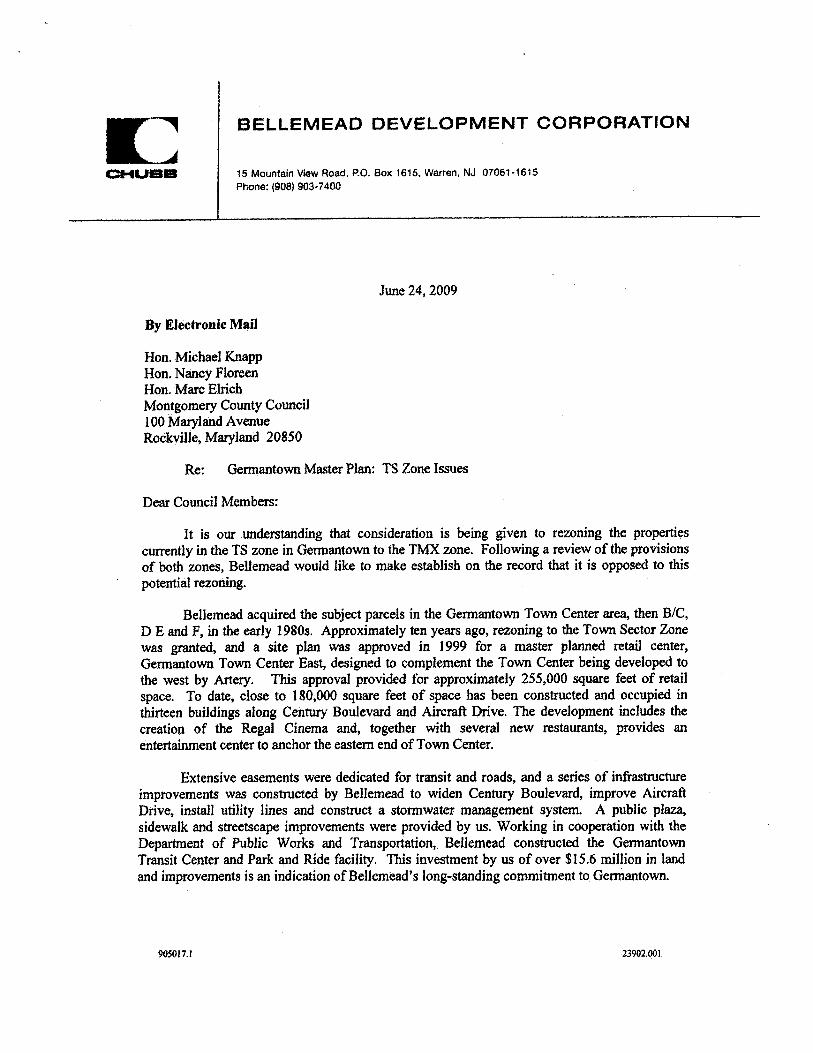
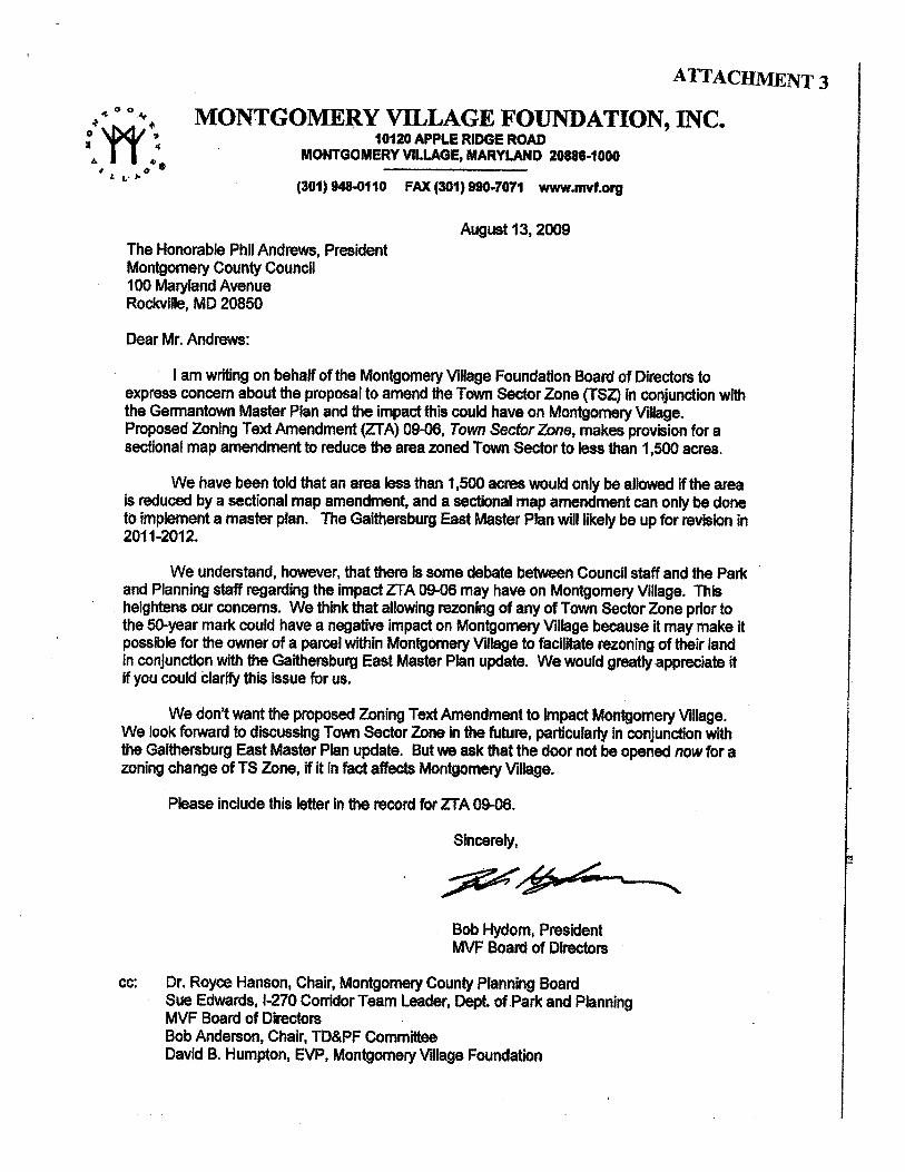

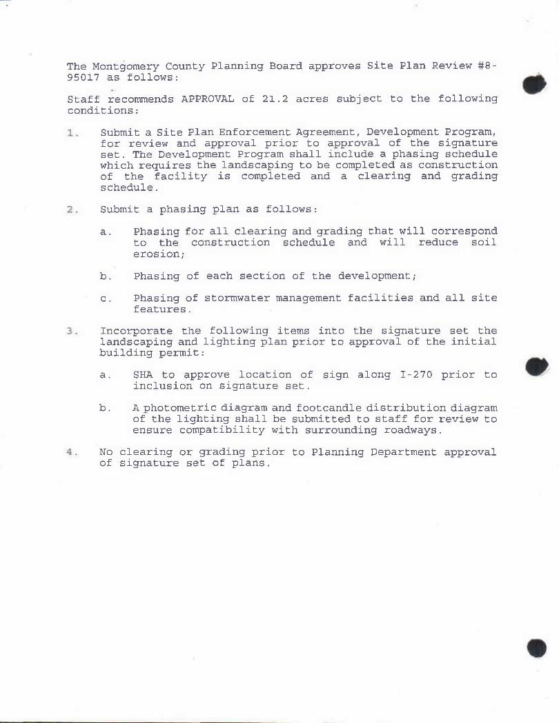
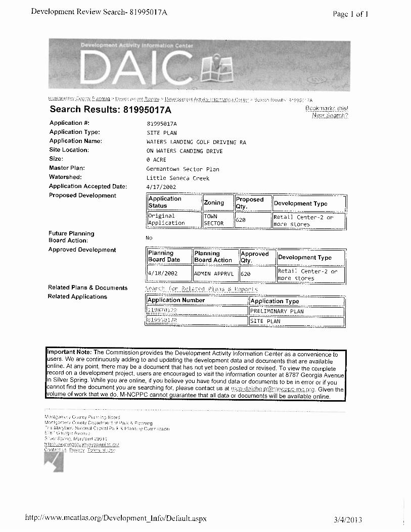
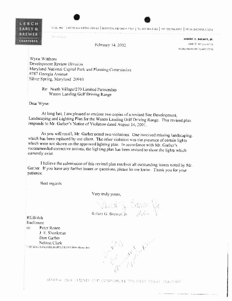
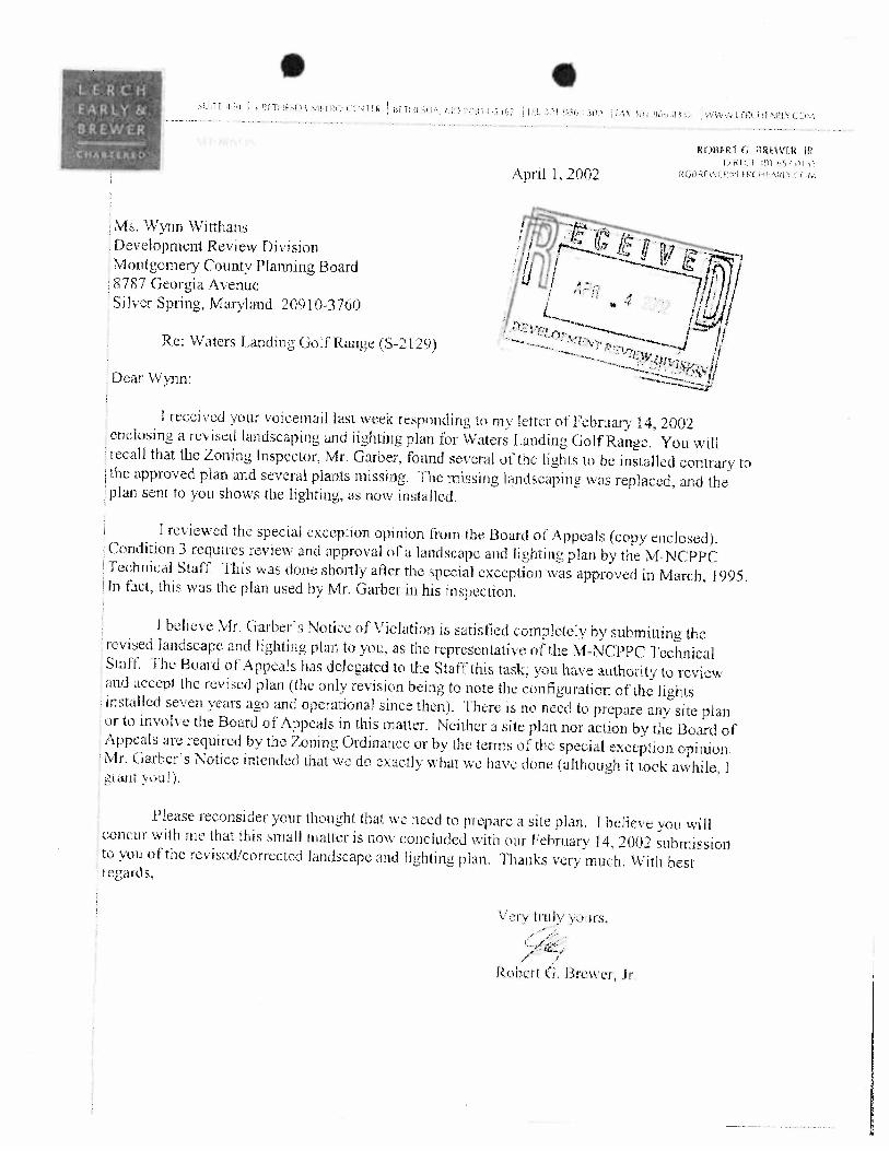
SP Opinion #8-02003
MONTGOMERY COUNTY PLANNING BOARD
O P I N I O N
DATE MAILED: November 4, 2002 SITE PLAN REVIEW #: 8-02003 PROJECT NAME: Churchill Town Sector - Far North Village Action: Approval subject to conditions. Motion was made by Commissioner Wellington, seconded by Commissioner Robinson, with a vote of 4-0, Commissioners Berlage, Bryant, Robinson, and Wellington voting for, and no Commissioners voting against. Commissioners Perdue was necessarily absent. The date of this written opinion is November 4, 2002, (which is the date that this opinion is mailed to all parties of record). Any party authorized by law to take an administrative appeal must initiate such an appeal, as provided in the Maryland Rules of Procedure, on or before December 3, 2002 (which is thirty days from the date of this written opinion). If no administrative appeal is timely filed, this Site Plan shall remain valid for as long as Preliminary Plan #1- 87012R is valid, as provided in Section 59-D-3.8. On October 31, 2001, Site Plan Review #8- 02003 was brought before the Montgomery County Planning Board for a public hearing. At the public hearing, the Montgomery County Planning Board heard testimony and evidence submitted in the record on the application. Based on the testimony and evidence presented and on the staff report, which is made a part hereof, the Montgomery County Planning Board finds: 1. The Site Plan is consistent with an approved development plan; 2. The Site Plan meets all of the requirement of the TS zone. 3. The locations of the buildings and structures, the open spaces, the landscaping, recreation facilities,
and the pedestrian and vehicular circulation systems are adequate, safe, and efficient; 4. Each structure and use is compatible with other uses and other Site Plans and with existing and
proposed adjacent development; 5. The Site Plan meets all applicable requirements of Chapter 22A regarding forest conservation; 6. The Site Plan meets all applicable requirements of Chapter 19 regarding water resource protection
Therefore, the Montgomery County Planning Board APPROVES Site Plan #8-02003, which consists of 900,000 square feet of office use with the following conditions to be met prior to the release of the first building permit:
1
SP Opinion #8-02003
Pedestrian Circulation
1. Submit a plan of the parking garage that clearly shows the pedestrian circulation within the garage and quality of the pedestrian spaces.
2. Add sidewalks to the easternmost garage driveway entrance. 3. Submit a plan showing the connections to the pedestrian bridge and the hours of
operations and availability to public. 4. Increase the pedestrian features along the frontage of the property to encourage
pedestrian access from transit to buildings – provide detail planting and widened pedestrian connections.
Vehicular Circulation
5. Submit a plan of the parking garage showing the all aspects of the parking garage, ie space dimensions, circulation, lighting, etc. Lighting for the parking garages (interior and roof top) shall not create undue glare or off-site visibility in regards to residential development in the area.
6. The number of parking spaces to be reduced to conform to the Planning Board Interim Parking Guidelines of 4 spaces per 1,000 or 3,600 per full site build out.
Landscaping and Lighting
7. Additional landscaping for the parking areas for Buildings 5 and 6 to provide more depth and complete buffers.
8. Landscape plans to show no landscaping in the PUE with improved landscape screening to frontage of parking areas.
9. Lighting plan for entire project to conform to IESNA guidelines and to provide for minimal light trespass or glare, reduced levels after hours, light directed on site, adequate levels for pedestrian safety, etc.
10. Landscape plans to include additional planting for entry areas, pedestrian open space areas and screening as needed. Plans to include more shrubs, and seasonal or perennial accent areas. Any features (ie gazebos, fountains) within the open space will require more detailed schematic plans to indicate the nature of the feature – general building materials, dimensions, colors, etc.
Compatibility
11. Schematic architecture for buildings and parking garages to be submitted for review in conjunction with circulation, the pedestrian bridges and other elements.
12. Façade of parking garage to be detailed for compatibility to surroundings and impact
on pedestrian environment.
13. The Planning Board or their designated representative shall review any changes to the building footprint.
2
SP Opinion #8-02003
Transportation Issues
14. Total development under this site plan application is limited to 900,000 square feet of office space.
15. The applicant shall participate in the County’s future CIP project to construct the
four-lane divided highway portion of Century Boulevard from its current terminus near Father Hurley Boulevard to its intersection with future Dorsey Mill Road by allocating a portion of their impact taxes when paid to this project.
16. The applicant shall construct Crystal Rock Drive as a four-lane divided roadway from
its current terminus to its intersection with future Dorsey Mill Road as shown on the site plan.
17. The applicant shall participate in constructing an acceleration lane on Father Hurley
Boulevard to accommodate the movement from northbound Crystal Rock Drive to eastbound Father Hurley Boulevard.
18. The applicant shall participate in constructing an acceleration lane on Crystal Rock
Drive to accommodate the movement from westbound Father Hurley Boulevard to northbound Crystal Rock Drive including reconstruction/ reconfiguration of the median and travel lanes on the northern leg of the intersection.
Signature Set Approval – Documents and Drawings
19. Submit a Site Plan Enforcement Agreement and Development Review Program for review and approval prior to approval of the signature set as follows:
Development Program to include a phasing schedule as follows:
a. Landscaping associated with each parking garage; open space and
building shall be completed as construction of each facility is completed. b. Pedestrian pathways and seating areas associated with each facility shall
be completed as construction of each facility is completed. c. Clearing and grading to correspond to the construction phasing, to
minimize soil erosion. d. Coordination of each section of the development and roads. e. Phasing of dedications, stormwater management, sediment/erosion
control, recreation, forestation, community paths, trip mitigation or other features.
20. Signature set of site, landscape/lighting, forest conservation and sediment and
erosion Control plans to include for staff review prior to approval by Montgomery County Department of Permitting Services (DPS):
a. Limits of disturbance.
3
SP Opinion #8-02003
b. Methods and locations of tree protection. c. Forest Conservation areas. d. Conditions of DPS Stormwater Management Concept approval letter dated
September 5, 2001. e. Note stating the M-NCPPC staff must inspect tree-save areas and
protection devices prior to clearing and grading. f. The development program inspection schedule. g. Location of outfalls away from tree preservation areas.
21. No clearing or grading prior to M-NCPPC approval of signature set of plans. 22. Prior to the expiration of Preliminary Plan # 1-87012R for the remaining 900,000
square feet, the Applicant is to amend the Preliminary Plan conditions of approval to reflect the revisions to the transportation requirements as stated in the conditions of approval for Site Plan # 8-02003.
G:\SP_OPINION\8-02003.doc
4