Embed Size (px)
Citation preview
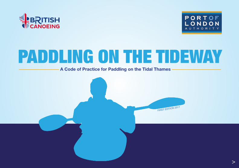
A Code of Practice for Paddling on the Tidal Thames
PADDLING ON THE TIDEWAY
FIRST EDITION 2017
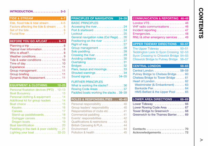
COMMUNICATION & REPORTING 46–49
London VTS . . . . . . . . . . . . . . . . . . . . . 46VHF radio communications . . . . . . . . . 46Incident reporting . . . . . . . . . . . . . . . . . 47Emergencies . . . . . . . . . . . . . . . . . . . . . 48RNLI & other emergency services . . . . 49
UPPER TIDEWAY DIRECTIONS 50–57
The Upper Tideway . . . . . . . . . . . . 50–51Teddington Lock to Syon Crossing 52–53 Syon Crossing to Chiswick Bridge 54–55Chiswick Bridge to Putney Bridge 56–57
CENTRAL LONDON 58–65
Central London . . . . . . . . . . . . . . . . 58–59Putney Bridge to Chelsea Bridge . . . . . 60Chelsea Bridge to Tower Bridge . . . . . 61Heart of London . . . . . . . . . . . . . . . . . . 62
Westminster (& Embankment) . . . . . . 63Bankside Pier . . . . . . . . . . . . . . . . . . . 64HMS Belfast & the Upper Pool . . . . . 65
LOWER AREA DIRECTIONS . . . . 66–69
Lower Tideway . . . . . . . . . . . . . . . . . . 66Lower Rowing Code Area . . . . . . . . . . 67 Tower Bridge to Greenwich . . . . . . . . . 68Greenwich to the Thames Barrier . . . . . 69
APPENDICES 113_116
Contacts . . . . . . . . . . . . . . . . . . . . . . . 70Acknowledgements . . . . . . . . . . . . . . 72
PRINCIPLES OF NAVIGATION 24–39
BASIC PRINCIPLESAccessing the river . . . . . . . . . . . . . . . . 24Port & starboard . . . . . . . . . . . . . . . . . . 24Lookout . . . . . . . . . . . . . . . . . . . . . . . . 25General navigation rules (Col Regs) . . . 26Positioning on the river . . . . . . . . . . . . 27Right of way . . . . . . . . . . . . . . . . . . . . . 27Group management . . . . . . . . . . . . . . . 28Solo paddling . . . . . . . . . . . . . . . . . . . . 28Crossing the river . . . . . . . . . . . . . . . . . 29Avoiding collisions . . . . . . . . . . . . . . . . 30 Overtaking . . . . . . . . . . . . . . . . . . . . . . 31Bridges . . . . . . . . . . . . . . . . . . . . . . . . . 32Piers, buoys and moorings . . . . . . . . . . 33Shouted warnings . . . . . . . . . . . . . . . . . 34Sound signals . . . . . . . . . . . . . . . . . 34–35
FURTHER PRINCIPLESWhat is working the slacks? . . . . . . . . . 36Rowing Code Areas . . . . . . . . . . . . . . . 37Paddled boats working the slacks . 38–39
ROLES & RESPONSIBILITIES . . . 40–45
Personal responsibility . . . . . . . . . . . . . 40Group leaders’ responsibility . . . . . . . . 40Responsibilities of clubs etc . . . . . . . . . 41 Commercial paddling . . . . . . . . . . . . . . 41Events’ responsibilities . . . . . . . . . . . . . 42Qualifications & restrictions . . . . . . . . . 43British Canoeing & PLA . . . . . . . . . . . . . 44Environment . . . . . . . . . . . . . . . . . . . . . 44Pollution & health . . . . . . . . . . . . . . . . . 45
INTRODUCTION . . . . . . . . . . . . . . . . . 2–3
TIDE & STREAM . . . . . . . . . . . . . . . . 4–7
Ebb, flood tide & tidal stream . . . . . . . 4–5Factors affecting the tide & stream . . . . 6Set of the tide . . . . . . . . . . . . . . . . . . . . . 6 Fluvial flow . . . . . . . . . . . . . . . . . . . . . . . 7
BEFORE YOU GO AFLOAT . . . . . . 8–11
Planning a trip . . . . . . . . . . . . . . . . . . . . 8Topical river information . . . . . . . . . . . . . 8Who is afloat? . . . . . . . . . . . . . . . . . . . . . 8Weather conditions . . . . . . . . . . . . . . . . . 9Tide & water conditions . . . . . . . . . . . . 10Time of day . . . . . . . . . . . . . . . . . . . . . . 10Experience . . . . . . . . . . . . . . . . . . . . . . 11Group management . . . . . . . . . . . . . . . 11Group briefing . . . . . . . . . . . . . . . . . . . 11Dynamic Risk Assessment . . . . . . . . . . 11
EQUIPMENT & CLOTHING 12–23
Personal floatation devices (PFD) . 12–13Boat Buoyancy . . . . . . . . . . . . . . . . . . . 13Personal clothing & equipment . . . . . . 14Additional kit for group leaders . . . . . . 14Boat choice . . . . . . . . . . . . . . . . . . . . . 15
Kayaks . . . . . . . . . . . . . . . . . . . . . . . . 16Canoes . . . . . . . . . . . . . . . . . . . . . . . . 17Stand-up paddleboards . . . . . . . . . . . 18Outrigger canoes . . . . . . . . . . . . . . . . 19Dragon boats . . . . . . . . . . . . . . . . . . . 19
Boat Identification . . . . . . . . . . . . . . . . 20 Paddling in the dark & poor visibility . . 21Lighting your boat . . . . . . . . . . . . . 22-23
CO
NT
EN
TS
1
INT
RO
DU
CT
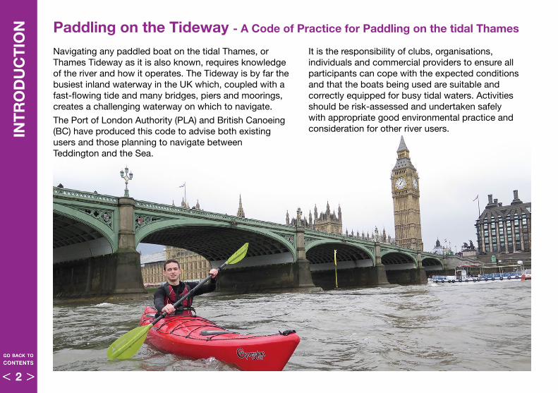
ION Paddling on the Tideway - A Code of Practice for Paddling on the tidal Thames
Navigating any paddled boat on the tidal Thames, or Thames Tideway as it is also known, requires knowledge of the river and how it operates . The Tideway is by far the busiest inland waterway in the UK which, coupled with a fast-flowing tide and many bridges, piers and moorings, creates a challenging waterway on which to navigate .
The Port of London Authority (PLA) and British Canoeing (BC) have produced this code to advise both existing users and those planning to navigate between Teddington and the Sea .
It is the responsibility of clubs, organisations, individuals and commercial providers to ensure all participants can cope with the expected conditions and that the boats being used are suitable and correctly equipped for busy tidal waters . Activities should be risk-assessed and undertaken safely with appropriate good environmental practice and consideration for other river users .
2
The tidal Thames between the estuary and Teddington Lock comes under the jurisdiction of the Port of London Authority (PLA) who regulate navigation on the tidal Thames in a number of ways:
• Collision Regulations (Col Regs)
• Port of London Act• Thames Byelaws • General Directions• Notices to Mariners (NtMs)
By its very nature, the Paddling Code must, in part, refer to and recognise these various regulations. Where navigational regulations are quoted in this Code they are enclosed in a coloured panel for ease of recognition.
The PLA keeps all its regulations under regular review and the latest additions can be found in their entirety on the PLA website – pla.co.uk
Ignorance of the regulations is not a defence in the event of an incident.
INT
RO
DU
CT
ION
This Paddling Code essentially refers to five different types of paddled boat . There are slightly different rules for each of these boat types which are highlighted throughout the Code:
• Kayaks – page 16 • Dragon boats – page 19
• Canoes – page 17 • Outrigger canoes – page 19
• Stand-up paddleboards (SUP) – page 18
Paddling does not include any type of rowing boats (i .e . where the participants have their back to the direction of travel) . Rowers have their own Code of Practice, similar to this one and paddlers are advised to have a working knowledge of “Rowing on the Tideway”, especially in the Upper area . The Rowing Code can be found on the PLA leisure users website: www.boatingonthethames.co.uk/Rowing
As well as the Paddling and Rowing Codes, paddlers on the Tidal Thames should also refer to the following:
• PLA publication: “The Tidal Thames - Recreational Users Guide”
• PLA Leisure users website: www.boatingonthethames.co.uk
• British Canoeing publication: “You, your canoe and the marine environment” – also see page 45
• British Canoeing website: www.britishcanoeing.org.uk/guidance-resources/waterways-environment
• RNLI publication: “Kayaking Safety Pack” – also see page 12
• RNLI website: www.rnli.org/safety/respect-the-water/
Types of paddled boat
3
To avoid any confusion, this code presumes the normal state of the stream and tide flowing in the same direction . This direction of flow is referred to as the ‘tidal stream’ . Tables of predicted tide times are available on the PLA website and there are various other websites and smart phone apps . that can also provide this information .
Apart from tide tables, which show predicted tide times, there are several ways to check the tidal stream direction, although you must always account for the strength and direction of the wind:
• Look at boats moored only at one end, they will hang downstream from their mooring
• See what direction floating objects drift in
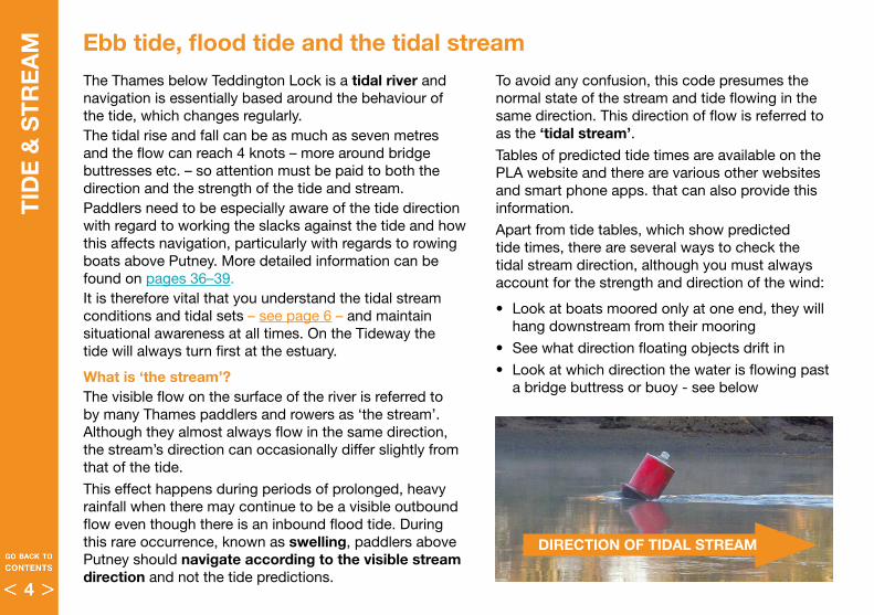
• Look at which direction the water is flowing past a bridge buttress or buoy - see below
TID
E &
ST
RE
AM
The Thames below Teddington Lock is a tidal river and navigation is essentially based around the behaviour of the tide, which changes regularly . The tidal rise and fall can be as much as seven metres and the flow can reach 4 knots – more around bridge buttresses etc . – so attention must be paid to both the direction and the strength of the tide and stream . Paddlers need to be especially aware of the tide direction with regard to working the slacks against the tide and how this affects navigation, particularly with regards to rowing boats above Putney . More detailed information can be found on pages 36–39 .It is therefore vital that you understand the tidal stream conditions and tidal sets – see page 6 – and maintain situational awareness at all times . On the Tideway the tide will always turn first at the estuary .
What is ‘the stream’?The visible flow on the surface of the river is referred to by many Thames paddlers and rowers as ‘the stream’ . Although they almost always flow in the same direction, the stream’s direction can occasionally differ slightly from that of the tide .
This effect happens during periods of prolonged, heavy rainfall when there may continue to be a visible outbound flow even though there is an inbound flood tide . During this rare occurrence, known as swelling, paddlers above Putney should navigate according to the visible stream direction and not the tide predictions .
DIRECTION OF TIDAL STREAM
Ebb tide, flood tide and the tidal stream
4
TID
E &
ST
RE
AM
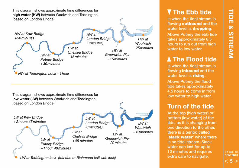
LW at Greenwich Pier
– 20minutes
LW at London Bridge (0minutes)
LW at Chelsea Bridge +45 minutesLW at
Putney Bridge +1hour 40minutes
LW at Kew Bridge +2hours 45minutes LW at
Woolwich– 40minutes
The Ebb tide is when the tidal stream is flowing outbound and the water level is dropping.
Above Putney the ebb tide takes approximately 8.5 hours to run out from high water to low water.
The Flood tide is when the tidal stream is flowing inbound and the water level is rising.
Above Putney the flood tide takes approximately 4.5 hours to come in from low water to high water.
Turn of the tideAt the top (high water) or bottom (low water) of the tide, as it is changing from one direction to the other, there is a period called ‘slack water’ where there is no tidal stream. Slack water can last for up to 10 minutes and requires extra care to navigate.LW at Teddington lock (n/a due to Richmond half-tide lock)
HW at Greenwich Pier
–15minutes
HW at London Bridge (0minutes)
HW at Chelsea Bridge +15minutesHW at
Putney Bridge +30minutes
HW at Kew Bridge +50minutes
HW at Teddington Lock +1hour
HW atWoolwich
– 25minutes
This diagram shows approximate time differences for high water (HW) between Woolwich and Teddington(based on London Bridge)
This diagram shows approximate time differences for low water (LW) between Woolwich and Teddington(based on London Bridge)
5
TID
E &
ST
RE
AM
WindThe wind can have a considerable effect on the river . If the wind is in the same direction as the tide it will speed up the stream . If it is against the tide, it will chop up the top of the water and can make for very difficult conditions, especially at high tide . Sometimes a very strong wind can give a false impression of the tidal stream direction .The Tideway meanders considerably so it is important when planning a trip to remember that wind will affect the river differently along its course .
Thames Barrier closuresWhen the Thames Barrier is closed, it will have a noticeable and confusing effect on the tidal stream . It may be hard to tell which way the tidal stream is flowing . Indeed, the flood tide may not really feature at all .
Draw-offs (normally October – November)The draw-off usually lasts for four weeks and is when the half-tide barrier at Richmond is left open over low water for maintenance . This allows the river to drain to its natural level, which is much lower than usual . This also has an effect on the river flow and low water level down as far as Kew Bridge and sometimes beyond .
SwellingSee page 4 for details . Swelling is rare and generally only occurs during the winter months after heavy rain .
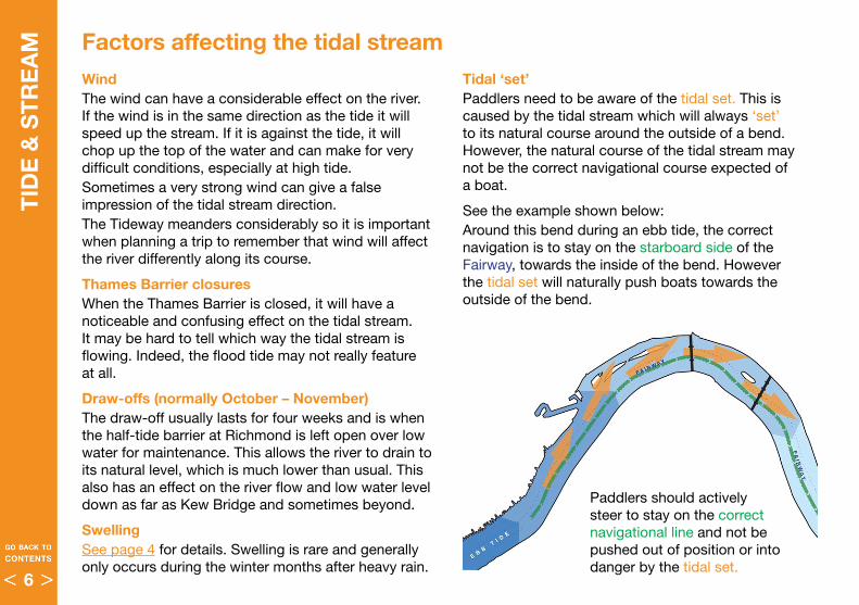
Factors affecting the tidal streamTidal ‘set’ Paddlers need to be aware of the tidal set . This is caused by the tidal stream which will always ‘set’ to its natural course around the outside of a bend . However, the natural course of the tidal stream may not be the correct navigational course expected of a boat .
See the example shown below:Around this bend during an ebb tide, the correct navigation is to stay on the starboard side of the Fairway, towards the inside of the bend . However the tidal set will naturally push boats towards the outside of the bend .
Paddlers should actively steer to stay on the correct navigational line and not be pushed out of position or into danger by the tidal set .
6
TID
E &
ST
RE
AM
Fluvial flowFluvial flow is the amount of water flowing downriver from the non-tidal Thames . There is always water flowing outbound (downriver) and is the reason that the river fills up very quickly when it meets the inbound (flood) tide . After heavy rainfall, the fluvial flow will increase causing the outbound stream to increase in speed . When combined with an ebb tide this can make the river more difficult to navigate on and in some cases, dangerous .
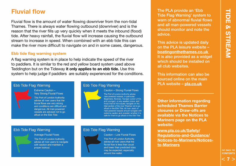
Ebb tide flag warning system A flag warning system is in place to help indicate the speed of the river to paddlers . It is similar to the red and yellow board system used above Teddington but on the Tideway it only applies to an ebb tide . Use this system to help judge if paddlers are suitably experienced for the conditions .
The PLA provide an ‘Ebb Tide Flag Warning’ system to warn of abnormal fluvial flows and all man-powered vessels should monitor and note the advice.
This advice is updated daily on the PLA leisure website – boatingonthethames .co .uk It is also provided as a widget which should be installed on all club websites.
This information can also be sourced online on the main PLA website – pla .co .uk
Other information regarding scheduled Thames Barrier closures or Draw-offs are available via the Notices to Mariners page on the PLA website:www .pla .co .uk/Safety/Regulations-and-Guidance/Notices-to-Mariners/Notices-to-Mariners
7
BE
FOR
E Y
OU
GO
AFL
OA
T Planning a trip It is the responsibility of all paddlers whether paddling solo, as a group member or a group leader to ensure that they have assessed all factors which may affect their trip .
Do not proceed with a trip if the outcome of these checks shows up a problem with your equipment, knowledge, experience or fitness .
Inexperienced paddlers should not be coerced (or allow themselves to be coerced) into going afloat if they are not comfortable with any aspect of the planned trip .
Topical river information – see panel left
Recreational river users must be aware of the information and guidance regarding the Thames Tideway which is available via email alerts and the PLA website .
Who is afloat?
Clubs and centres are advised to keep a log or sign-out board of who is afloat and when they expect to return, in case of an accident . Members should also know what to do if a boat fails to return or is overdue . This information should be part of the club’s standard operating procedures and ideally be displayed near the signing-out board .
In addition to signing-out (or in non-club situations) paddlers are strongly advised to inform London VTS prior to going afloat and on return . Paddlers going afloat in the dark below Putney Bridge must always inform London VTS, either by phone or VHF – see page 46 .
Group leaders, small groups and solo paddlers below Richmond Lock should carry either a mobile phone (in a buoyant, waterproof case) or a personal VHF radio set to communicate with VTS or to summon help in an emergency .
All clubs and group leaders should sign-up on the PLA website to automatically receive, by email, Notices to Mariners pertaining to their stretch of the river. These Notices are also available on the PLA website – pla .co .uk
The PLA also have an online events calendar which shows all recreational events happening on the Tideway
www .pla .co .uk/Events/Annual-Events-Calendar
Topical river information is also available via social media, particularly Twitter:
@LondonPortAuth
@AlanBarrierEA
@MrSafeT_Tideway
@ThamesPoo
@Thames21
@BritishCanoeing
@ChiswickRNLI
@TowerRNLI
@ocukcoach
8
BE
FOR
E Y
OU
GO
AFLO
AT
Temperature
High temperatures as well as cold ones should be considered when deciding on what kit to wear and the duration of your trip . Very hot weather can be as physically demanding as cold weather .
Visibility
As well as rain causing visibility issues, the Tideway is prone to fog and no attempt should be made to go afloat if the visibility is less than 200m . A good guide is that if you cannot see the opposite bank clearly then you should not go afloat . For example: the river is 300m wide at Greenwich, 200m wide at Putney and Hammersmith Bridges but narrower than 200m above Hammersmith .
If you encounter reduced visibility during an outing you should find a safe haven . Fog is often a more serious hazard than darkness and, although large motor vessels may have radar, small paddled boats do not show up on radar .
Lightning
If you experience lightning in your vicinity you should get off the river as soon as possible . No one should go afloat unless 30 minutes have elapsed since the last visible lightning .
Weather conditions
Weather conditions on the tidal Thames can have a significant effect on the safety and handling of small boats . The river is often exposed and weather conditions can create big waves and very choppy water, especially when combined with washes from motor vessels . Conditions can become awkward and physically demanding in a matter of minutes .
Wind
SUPs and open boats are particularly vulnerable to the effect of the wind although all small boats must take the wind into account .
Wind against tide is a serious factor to consider as it can create steep standing waves .
Wind speeds can vary and noticeably increase through and around bridge arches as well as in areas with tall buildings, where there can also be sudden changes of wind direction .
The wind can have an extra chilling effect on the body which will lower the level at which cold is felt and can lead to exposure and even exhaustion, especially if wet .
Rain
Rain can very much affect the perceived temperature . You will feel much colder when wet especially if it is also windy .
Rain can also seriously reduce visibility, particularly the ability for large motor vessels to spot small boats .
9
BE
FOR
E Y
OU
GO
AFL
OA
T
Time of day
Consider the time of day when planning your trip . Weekend mornings and summer evenings are often very busy in the Upper Area where there is a lot of rowing activity .
Central London is almost always busy but even more so in the summer months . Commuter services are less frequent at weekends above Chelsea Bridge but sightseeing trips still operate, beginning at around 10 .00am . The PLA therefore strongly encourage leisure craft to transit Central London before 10 .00am on weekend mornings for the quietest conditions .
Time restrictions for SUPs
• Below Putney Pier No paddling three hours before and two hours after high water (at London Bridge) due to freight vessel movements at Wandsworth
• Between Chelsea Bridge and Tower Bridge (in addition to the above) No paddling between 11:00 and 18:00 from Good Friday and 30th September . Due to busy commercial traffic in Central London
• Below Chelsea Bridge No paddling after dark
Equipment and Clothing
See next section – pages 12–23
Planning a trip Tidal and water conditionsThe Thames Tideway meanders considerably along its course, it is therefore important to understand how this can affect water conditions on different parts of the river, especially with regard to the state of the tide, wind direction and tidal sets:
• What is the direction of the tide? Will the direction of the wind or tidal sets become a factor on your intended course?
• When is the tide predicted to change? Long trips are best arranged to go with the tide as much as possible . Plan return trips around the change of tide .
• How high is the tide? High tide means lumpier water but more space . Low tide means better water but shallows and less space . Towards the end of an ebb tide the stream will be relatively slow .
Also getting off the river two hours either side of high tide can be difficult, as there is little or no foreshore exposed and in places there are few egress points . When you plan an outing find out where you can exit safely .
• What colour is the Ebb tide warning flag?
• Will anything else affect the water? E .g . is the Thames Barrier shut or is Richmond Lock and Weir undergoing maintenance (the “Draw-off”)?
10
BE
FOR
E Y
OU
GO
AFLO
AT
Experience – see page 28 and page 43 for further guidance
The experience of all paddlers, whether as soloist or as members of a group, should be taken into account, particularly with regard to the water and weather conditions:
• Long distance trips may not be suitable for inexperienced paddlers
• Trips through Central London should not be undertaken by inexperienced paddlers in unstable boats . The tidal Thames should be treated as ‘exposed water’ and paddlers using it require suitable knowledge and experience for the potentially demanding conditions
• For inexperienced paddlers consider using stable double kayaks accompanied by leaders who are familiar with the tidal Thames
• Leaders must have the required qualification or experience to take a group out on the tidal Thames
Group management – see page 28 and page 43 for further guidance
A ‘group’ should consist of no more than 10–15 boats . If there are more participants then consider splitting them into smaller groups, each with a suitably qualified leader .
As well as leaders having suitable qualifications, groups should have a sufficient ratio of leaders to participants . This ratio will vary depending on the experience of the group and where on the river they are paddling . Clubs and organisations should produce their own guidelines for this . SUP groups should have a minimum 1:4 ratio of leaders to paddlers .
Group briefingsIn situations where a group is going out for a journey or for instruction it is important that all are briefed by an experienced leader on what to expect before going afloat . The briefing should cover all of the points detailed in this section and also include any relevant information regarding group management – page 28 – and emergency situations – pages 48–49 .
Dynamic Risk Assessment
However well you plan your trip, there will be times when afloat that you will have to make critical decisions regarding choosing the safest option or line, due to the busy nature of the river and changing conditions.
This is described throughout this code as a Dynamic Risk Assessment and certain key situations are marked with this symbol.
Individuals and group leaders must always take into account the conditions and their competence and must ensure that all group members are able to cope with the choice that is made.
This is important in the Upper Rowing Code Area and especially in Central London where early judgement calls are often needed due to the nature of the river and traffic volumes – see pages 60–65.
11
EQ
UIP
ME
NT
& C
LOT
HIN
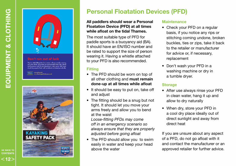
G Personal Floatation Devices (PFD)All paddlers should wear a Personal Floatation Device (PFD) at all times while afloat on the tidal Thames . The most suitable type of PFD for paddle sports is a buoyancy aid (BA) . It should have an EN/ISO number and be rated to support the size of person wearing it . Having a whistle attached to your PFD is also recommended .
Fitting• The PFD should be worn on top of
all other clothing and must remain done-up at all times while afloat
• It should be easy to put on, take off and adjust
• The fitting should be a snug but not tight . It should let you move your arms freely and allow you to bend at the waist Loose-fitting PFDs may come off in an emergency scenario so always ensure that they are properly adjusted before going afloat
• The PFD should allow you to swim easily in water and keep your head above the water
Maintenance • Check your PFD on a regular
basis, if you notice any rips or stitching coming undone, broken buckles, ties or zips, take it back to the retailer or manufacturer for advice or, if necessary, replacement
• Don’t wash your PFD in a washing machine or dry in a tumble dryer .
Storage • After use always rinse your PFD
in clean water, hang it up and allow to dry naturally
• When dry, store your PFD in a cool dry place ideally out of direct sunlight and away from direct heat
If you are unsure about any aspect of a PFD, do not go afloat with it and contact the manufacturer or an approved retailer for further advice .
12
EQ
UIP
ME
NT
& C
LOT
HIN
G
A jacket-style buoyancy aid with side and shoulder adjustment (for a snug fit) and easily accessible pockets – in this case containing a hand-held VHF. Also note the sun glasses and hat for the obviously bright conditions – page 14
Boat BuoyancyConditionsConditions on the tidal Thames can vary considerably and should always be taken into account when choosing the most suitable PFD for a trip .
The main benefit of buoyancy aids over other types of PFD is that they are ‘inherently buoyant’ (i .e . you don’t need to inflate them for them to do their job) .
Therefore, ‘bum-bag’ or pouch style PFDs are strongly discouraged for use on the tidal Thames as they would be very difficult to don and operate if you are already in the water .
Weak or non-swimmers should consider a higher rated PFD or possibly even a manually-inflating life jacket if necessary .
Further information regarding PFD choice, fitting, maintenance and storage is available from the RNLI: www.rnli.org/safety/respect-the-water> Choose your Activity > Kayaking and Canoeing
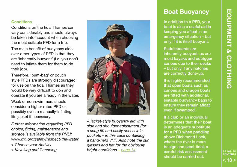
In addition to a PFD, your boat is also a useful aid in keeping you afloat in an emergency situation – but only if it is itself buoyant.
Paddleboards are inherently buoyant, as are most kayaks and outrigger canoes due to their decks – but only if any hatches are correctly done-up.
It is highly recommended that open boats such as canoes and dragon boats are fitted with additional, suitable buoyancy bags to ensure they remain afloat even if swamped.
If a club or an individual determines that their boat is an adequate substitute for a PFD when paddling above Richmond Lock, where the river is more benign and semi-tidal, a careful risk assessment should be carried out.
13
EQ
UIP
ME
NT
& C
LOT
HIN
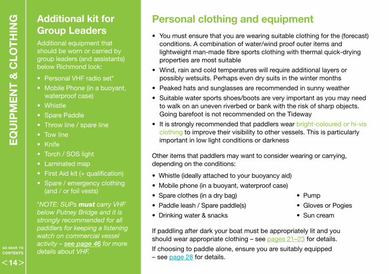
G Additional kit for Group LeadersAdditional equipment that should be worn or carried by group leaders (and assistants) below Richmond lock:
• Personal VHF radio set*
• Mobile Phone (in a buoyant, waterproof case)
• Whistle
• Spare Paddle
• Throw line / spare line
• Tow line
• Knife
• Torch / SOS light
• Laminated map
• First Aid kit (+ qualification)
• Spare / emergency clothing (and / or foil vests)
*NOTE: SUPs must carry VHF below Putney Bridge and it is strongly recommended for all paddlers for keeping a listening watch on commercial vessel activity – see page 46 for more details about VHF.
• You must ensure that you are wearing suitable clothing for the (forecast) conditions . A combination of water/wind proof outer items and lightweight man-made fibre sports clothing with thermal quick-drying properties are most suitable
• Wind, rain and cold temperatures will require additional layers or possibly wetsuits . Perhaps even dry suits in the winter months
• Peaked hats and sunglasses are recommended in sunny weather
• Suitable water sports shoes/boots are very important as you may need to walk on an uneven riverbed or bank with the risk of sharp objects . Going barefoot is not recommended on the Tideway
• It is strongly recommended that paddlers wear bright-coloured or hi-vis clothing to improve their visibility to other vessels . This is particularly important in low light conditions or darkness
Other items that paddlers may want to consider wearing or carrying, depending on the conditions:
•Whistle(ideallyattachedtoyourbuoyancyaid)
• Mobile phone (in a buoyant, waterproof case)
• Spareclothes(inadrybag) • Pump
• Paddleleash/Sparepaddle(s) • Gloves or Pogies
• Drinkingwater&snacks • Sun cream
If paddling after dark your boat must be appropriately lit and you should wear appropriate clothing – see pages 21–23 for details .
If choosing to paddle alone, ensure you are suitably equipped – see page 28 for details .
Personal clothing and equipment
14
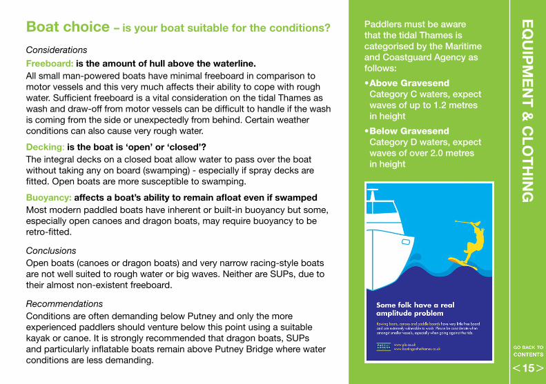
Boat choice – is your boat suitable for the conditions?
Considerations
Freeboard: is the amount of hull above the waterline . All small man-powered boats have minimal freeboard in comparison to motor vessels and this very much affects their ability to cope with rough water . Sufficient freeboard is a vital consideration on the tidal Thames as wash and draw-off from motor vessels can be difficult to handle if the wash is coming from the side or unexpectedly from behind . Certain weather conditions can also cause very rough water .
Decking: is the boat is ‘open’ or ‘closed’?The integral decks on a closed boat allow water to pass over the boat without taking any on board (swamping) - especially if spray decks are fitted . Open boats are more susceptible to swamping .
Buoyancy: affects a boat’s ability to remain afloat even if swampedMost modern paddled boats have inherent or built-in buoyancy but some, especially open canoes and dragon boats, may require buoyancy to be retro-fitted .
ConclusionsOpen boats (canoes or dragon boats) and very narrow racing-style boats are not well suited to rough water or big waves . Neither are SUPs, due to their almost non-existent freeboard .
RecommendationsConditions are often demanding below Putney and only the more experienced paddlers should venture below this point using a suitable kayak or canoe . It is strongly recommended that dragon boats, SUPs and particularly inflatable boats remain above Putney Bridge where water conditions are less demanding .
EQ
UIP
ME
NT
& C
LOT
HIN
GPaddlers must be aware that the tidal Thames is categorised by the Maritime and Coastguard Agency as follows:
•Above Gravesend Category C waters, expect waves of up to 1.2 metres in height
•Below Gravesend Category D waters, expect waves of over 2.0 metres in height
15
EQ
UIP
ME
NT
& C
LOT
HIN
G
Touring canoe C2 racing canoe
Kayaks
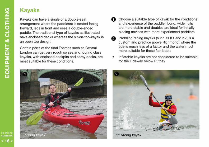
Kayaks can have a single or a double-seat arrangement where the paddler(s) is seated facing forward, legs in front and uses a double-ended paddle . The traditional type of kayaks as illustrated have enclosed decks whereas the sit-on-top-kayak is an open top design .
Certain parts of the tidal Thames such as CentralLondon can get very rough so sea and touring class kayaks, with enclosed cockpits and spray decks, are most suitable for these conditions .
• Choose a suitable type of kayak for the conditions and experience of the paddler . Long, wide hulls are more stable and doubles are ideal for initially placing novices with more experienced paddlers
• Paddling racing kayaks (such as K1 and K2) is a custom and practice above Richmond, where the tide is much less of a factor and the water much more suitable for these fast boats
• Inflatable kayaks are not considered to be suitable for the Tideway below Putney
1
1
2
2
Touring kayak K1 racing kayak
16
EQ
UIP
ME
NT
& C
LOT
HIN
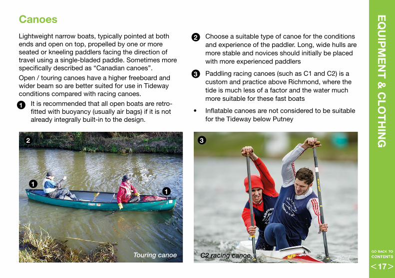
GCanoes Lightweight narrow boats, typically pointed at both ends and open on top, propelled by one or more seated or kneeling paddlers facing the direction of travel using a single-bladed paddle . Sometimes more specifically described as “Canadian canoes” .
Open / touring canoes have a higher freeboard and wider beam so are better suited for use in Tideway conditions compared with racing canoes .
• It is recommended that all open boats are retro-fitted with buoyancy (usually air bags) if it is not already integrally built-in to the design .
• Choose a suitable type of canoe for the conditions and experience of the paddler . Long, wide hulls are more stable and novices should initially be placed with more experienced paddlers
• Paddling racing canoes (such as C1 and C2) is a custom and practice above Richmond, where the tide is much less of a factor and the water much more suitable for these fast boats
• Inflatable canoes are not considered to be suitable for the Tideway below Putney
2
11
1
3
32
Touring canoe C2 racing canoe
17
EQ
UIP
ME
NT
& C
LOT
HIN
G
Stand-up paddleboarding is an offshoot of surfing and an SUP is essentially a surf board whereby paddleboarders maintain an upright stance on their boards and use a long paddle to propel themselves through the water .
SUPs are comparatively unstable craft and have no freeboard . Inflatable boards are even more susceptible than regular boards to water and weather conditions (particularly the wind) . Long, wide boards are slightly more stable and recommended for Tideway use .
SUPs are best suited to the calmer waters found above Putney and there are strict conditions regarding which parts of the Tideway SUPs may use according to their experience and other factors – see page 43
• If choosing to wear a leash it should be a quick-release waist leash . Ankle or knee leashes may prove difficult to reach in strong-flowing water and should be avoided
• On the tidal Thames all stand-up paddlers must use a buoyancy aid
Stand-up paddleboards (SUPs)
SUPs at Chiswick Pier Quick-release waist leashes are recommended
2
2
1
1
18
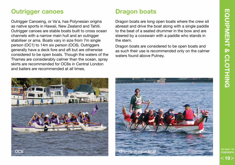
Dragon boatsDragon boats are long open boats where the crew sit abreast and drive the boat along with a single paddle to the beat of a seated drummer in the bow and are steered by a coxswain with a paddle who stands in the stern .
Dragon boats are considered to be open boats and as such their use is recommended only on the calmer waters found above Putney .
Outrigger canoesOutrigger Canoeing, or Va’a, has Polynesian origins as native sports in Hawaii, New Zealand and Tahiti . Outrigger canoes are stable boats built to cross ocean channels with a narrow main hull and an outrigger stabiliser or ama . Boats vary in size from 7m single person (OC1) to 14m six person (OC6) . Outriggers generally have a deck fore and aft but are otherwise considered to be open boats . Though the waters of the Thames are considerably calmer than the ocean, spray skirts are recommended for OC6s in Central London and bailers are recommended at all times .
EQ
UIP
ME
NT
& C
LOT
HIN
G
OC6 12 crew dragon boat
19
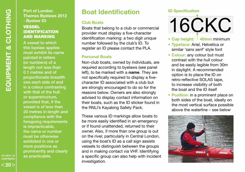
ID Specification
•Cap height: 40mm minimum • Typeface: Ariel, Helvetica or
similar ‘sans serif’ style font• Colour: any colour but must
contrast with the hull colour and be easily legible from 30m in daylight . A recommended option is to place the ID on retro-reflective SOLAS tape, to increase visibility of both the boat and the ID itself
•Position: in a prominent place on both sides of the boat, ideally on the most vertical surface possible above the waterline – see below
Club BoatsBoats that belong to a club or commercial provider must display a five-character identification marking: a two digit unique number followed by the club’s ID . To register an ID please contact the PLA .
Personal BoatsNon-club boats, owned by individuals, are required according to byelaws (see panel left), to be marked with a name . They are not specifically required to display a five-character ID associated with a club but are strongly encouraged to do so for the reasons below . Owners are also strongly advised to display contact information on their boats, such as the ID sticker found in the RNLI’s Kayaking Safety Pack .
These various ID markings allow boats to be more easily identified in an emergency or if found unattended, returned to their owner . Also, if more than one group is out on the river, particularly in Central London, using the boat’s ID as a call sign assists vessels to distinguish between the groups and in making contact via VHF . Identifying a specific group can also help with incident investigation .
Boat IdentificationPort of London Thames Byelaws 2012 - Byelaw 53VESSEL IDENTIFICATION AND MARKING
A vessel to which this byelaw applies must exhibit its name painted in letters (or numbers) of a length not less than 0.1 metres and of proportionate breadth one each side of and in a colour contrasting with that of the hull or superstructure, provided that, if the vessel is of less than 20 metres in length and compliance with the foregoing requirements is impracticable, the name or number must be otherwise exhibited in one or more positions as prominently and clearly as practicable.
EQ
UIP
ME
NT
& C
LOT
HIN
G
16CKC
20
BE
FOR
E Y
OU
GO
AFLO
AT
EQ
UIP
ME
NT
& C
LOT
HIN
G
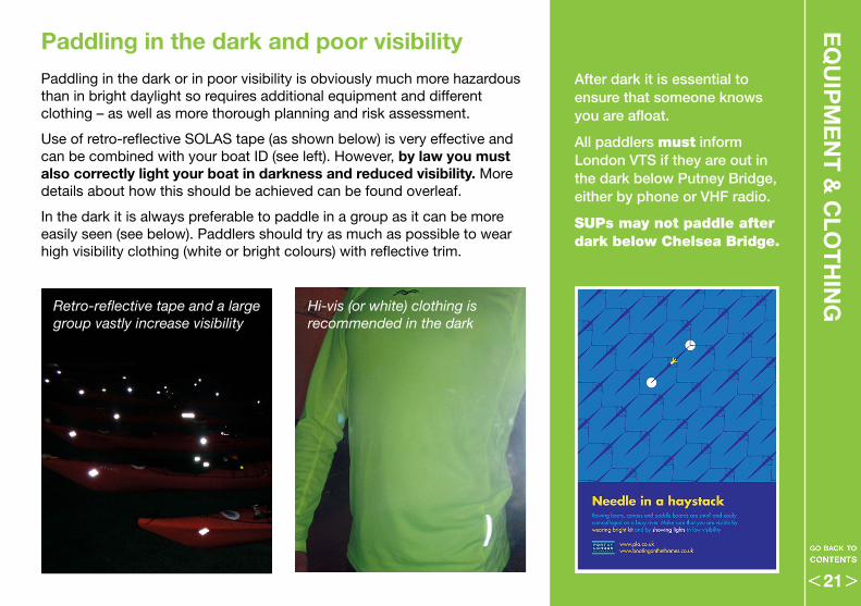
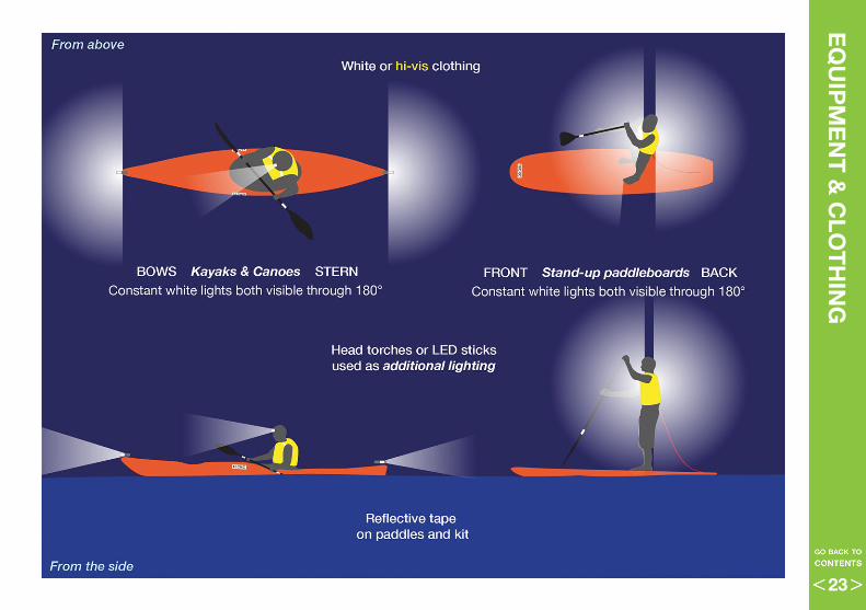
Paddling in the dark or in poor visibility is obviously much more hazardous than in bright daylight so requires additional equipment and different clothing – as well as more thorough planning and risk assessment .
Use of retro-reflective SOLAS tape (as shown below) is very effective and can be combined with your boat ID (see left) . However, by law you must also correctly light your boat in darkness and reduced visibility . More details about how this should be achieved can be found overleaf .
In the dark it is always preferable to paddle in a group as it can be more easily seen (see below) . Paddlers should try as much as possible to wear high visibility clothing (white or bright colours) with reflective trim .
Retro-reflective tape and a large group vastly increase visibility
Hi-vis (or white) clothing is recommended in the dark
Paddling in the dark and poor visibility
After dark it is essential to ensure that someone knows you are afloat.
All paddlers must inform London VTS if they are out in the dark below Putney Bridge, either by phone or VHF radio.
SUPs may not paddle after dark below Chelsea Bridge.
21
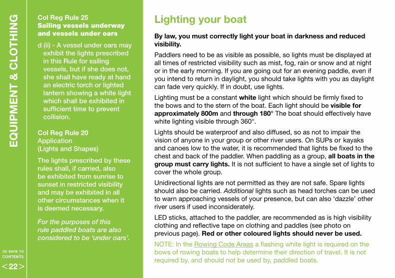
Lighting your boatBy law, you must correctly light your boat in darkness and reduced visibility .
Paddlers need to be as visible as possible, so lights must be displayed at all times of restricted visibility such as mist, fog, rain or snow and at night or in the early morning . If you are going out for an evening paddle, even if you intend to return in daylight, you should take lights with you as daylight can fade very quickly . If in doubt, use lights .
Lighting must be a constant white light which should be firmly fixed to the bows and to the stern of the boat . Each light should be visible for approximately 800m and through 180° The boat should effectively have white lighting visible through 360° .
Lights should be waterproof and also diffused, so as not to impair the vision of anyone in your group or other river users . On SUPs or kayaks and canoes low to the water, it is recommended that lights be fixed to the chest and back of the paddler . When paddling as a group, all boats in the group must carry lights . It is not sufficient to have a single set of lights to cover the whole group .
Unidirectional lights are not permitted as they are not safe . Spare lights should also be carried . Additional lights such as head torches can be used to warn approaching vessels of your presence, but can also ‘dazzle’ other river users if used inconsiderately .
LED sticks, attached to the paddler, are recommended as is high visibility clothing and reflective tape on clothing and paddles (see photo on previous page) . Red or other coloured lights should never be used .
NOTE: In the Rowing Code Areas a flashing white light is required on the bows of rowing boats to help determine their direction of travel . It is not required by, and should not be used by, paddled boats .
EQ
UIP
ME
NT
& C
LOT
HIN
G Col Reg Rule 25 Sailing vessels underway and vessels under oars
d (ii) - A vessel under oars may exhibit the lights prescribed in this Rule for sailing vessels, but if she does not, she shall have ready at hand an electric torch or lighted lantern showing a white light which shall be exhibited in sufficient time to prevent collision.
Col Reg Rule 20Application (Lights and Shapes)
The lights prescribed by these rules shall, if carried, also be exhibited from sunrise to sunset in restricted visibility and may be exhibited in all other circumstances when it is deemed necessary.
For the purposes of this rule paddled boats are also considered to be ‘under oars’.
22
BE
FOR
E Y
OU
GO
AFLO
AT
EQ
UIP
ME
NT
& C
LOT
HIN
G
23
BA
SIC
PR
INC
IPLE
S O
F N
AV
IGA
TIO
N Accessing the riverRiver access for paddled boats is considered safest from a draw dock, slipway or foreshore/beach as these provide a firmer footing to get into a boat or onto a board . There are often eddies or sheltered areas of slack water around these area which can be utilised . Access points can be found on the interactive map at www.boatingonthethames.co.uk as well as on the Recreational Users Guide or charts produced by the Port of London Authority . Principal draw docks are also noted on the diagrams in the Direction sections of this code – from page 52 .
• Avoid obstructing the tow path with boats waiting to go afloat
• Take care not to damage any rudders or skegs the boat may have – it may be best to enter the river stern first, with caution
• SUP should remain on knees until comfortable / in a safe area
• Be aware of the slipping hazard especially on steps or ramps
• Know which way the tidal stream is flowing and ensure there are no obstructions downstream of the launch site
• Lookout for other traffic before entering the main flow of the river and be aware of wash
• When getting novices afloat, make sure there are experienced paddlers already afloat to accompany / manage them
Getting off the river two hours either side of high tide can be difficult, as there is little or no foreshore exposed and in places there are few egress points . There are a fair number of draw docks above Putney Bridge but very few below . Pontoons and piers are privately owned and should only be used to exit in an emergency or with permission . Location of recommended access and egress points should always be included in your outing plan, which should be guided by the club’s procedures .
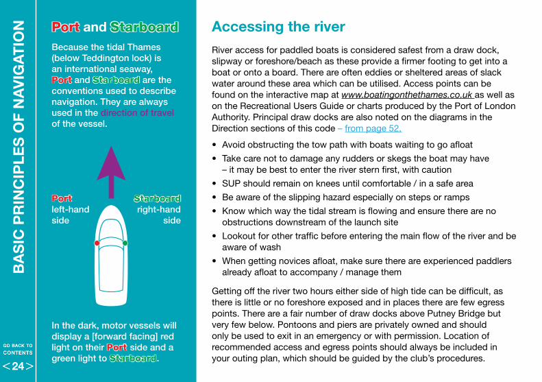
Port and StarboardBecause the tidal Thames (below Teddington lock) is an international seaway, Port and Starboard are the conventions used to describe navigation. They are always used in the direction of travel of the vessel.
Starboard right-hand
side
Port left-hand side
In the dark, motor vessels will display a [forward facing] red light on their Port side and a green light to Starboard.
24
Lookout
Keeping a proper lookout is the single most essential feature of safe navigation . Failure to keep a proper lookout is the single biggest factor in collisions and near-misses . For paddlers it may be that the biggest risk is as likely to come from behind them as from in front .
Paddlers face in the direction of travel so can easily see oncoming hazards but they must also be very aware of quicker vessels that may be approaching from behind . Motor vessels can be easily heard and may even give a sound signal on their horn . Rowing boats however are much smaller and quieter and very often the steers person is facing away from their direction of travel . Rowers may make their presence known by shouting a warning .
It is therefore essential that paddlers check behind them at regular intervals and in addition, is recommended that groups have one or two experienced paddlers at the rear of the group whose specific role it is to keep a lookout behind . This includes being aware of wash from behind or reflected off walls which can cause irregular wave patterns .
Always when in heavy traffic, poor visibility, at the turn of the tide or navigating in the vicinity of bridges, a more proactive lookout should be employed . This includes lookout by hearing, considering both sound signals – page 34–35 – and VHF – page 46 .
BA
SIC
PR
INC
IPLE
S O
F NA
VIG
AT
ION
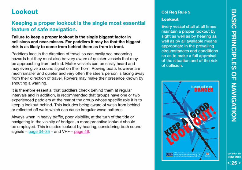
Col Reg Rule 5
Lookout
Every vessel shall at all times maintain a proper lookout by sight as well as by hearing as well as by all available means appropriate in the prevailing circumstances and conditions so as to make a full appraisal of the situation and of the risk of collision.
25
BA
SIC
PR
INC
IPLE
S O
F N
AV
IGA
TIO
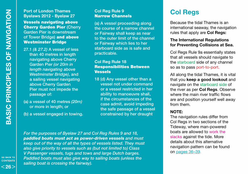
N Col Reg Rule 9Narrow Channels
(a) A vessel proceeding along the course of a narrow channel or Fairway shall keep as near to the outer limit of the channel or Fairway which lies to her starboard side as is safe and practicable.
Col Reg Rule 18 Responsibilities Between Vessels
18 (d) Any vessel other than a vessel not under command or a vessel restricted in her ability to manoeuvre shall, if the circumstances of the case admit, avoid impeding the safe passage of a vessel constrained by her draught
Col RegsBecause the tidal Thames is an international seaway, the navigation rules that apply are Col Regs:
The International Regulations for Preventing Collisions at Sea .
Col Regs Rule 9a essentially states that all vessels should navigate to the starboard side of any channel so as to pass port-to-port .
All along the tidal Thames, it is vital that you keep a good lookout and navigate on the starboard side of the river as per Col Regs . Observe where the main river traffic flows are and position yourself well away from them .
NOTE: The navigation rules differ from Col Regs in two sections of the Tideway, where man-powered boats are allowed to work the slacks against the tide . More details about this alternative navigation pattern can be found on pages 36–39 .
Port of London Thames Byelaws 2012 - Byelaw 27 Vessels navigating above Cherry Garden Pier (Cherry Garden Pier is downstream of Tower Bridge) and above Westminster Bridge
27.1 (& 27.2) A vessel of less than 40 metres in length navigating above Cherry Garden Pier (or 20m in length navigating above Westminster Bridge), and a sailing vessel navigating above Cherry Garden Pier must not impede the passage of:
(a) a vessel of 40 metres (20m) or more in length; or
(b) a vessel engaged in towing.
For the purposes of Byelaw 27 and Col Reg Rules 9 and 18, paddled boats must act as power-driven vessels and must keep out of the way of all the types of vessels listed. They must also give priority to vessels such as (but not limited to) Class V Passenger vessels, tugs and tows and large Dutch barges. Paddled boats must also give way to sailing boats (unless the sailing boat is crossing the fairway).
26
BA
SIC
PR
INC
IPLE
S O
F NA
VIG
AT
ION
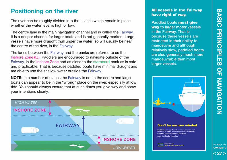
Positioning on the river The river can be roughly divided into three lanes which remain in place whether the water level is high or low .
The centre lane is the main navigation channel and is called the Fairway . It is a deeper channel for larger boats and is not generally marked . Large vessels have more draught (hull under the water) so will usually be near the centre of the river, in the Fairway .
The lanes between the Fairway and the banks are referred to as the Inshore Zone (IZ) . Paddlers are encouraged to navigate outside of the Fairway, in the Inshore Zone and as close to the starboard bank as is safe and practicable . That is because paddled boats have minimal draught and are able to use the shallow water outside the Fairway .
NOTE: In a number of places the Fairway is not in the centre and large boats can appear to be in the “wrong” place on the river, especially at low tide . You should always ensure that at such times you give way and show your intentions clearly .
All vessels in the Fairway have right of way.
Paddled boats must give way to larger motor vessels in the Fairway. That is because these vessels are restricted in their ability to manoeuvre and although relatively slow, paddled boats are also generally much more manoeuvrable than most larger vessels.
27
BA
SIC
PR
INC
IPLE
S O
F N
AV
IGA
TIO
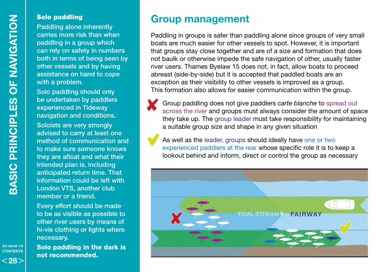
N Group management Paddling in groups is safer than paddling alone since groups of very small boats are much easier for other vessels to spot . However, it is important that groups stay close together and are of a size and formation that does not baulk or otherwise impede the safe navigation of other, usually faster river users . Thames Byelaw 15 does not, in fact, allow boats to proceed abreast (side-by-side) but it is accepted that paddled boats are an exception as their visibility to other vessels is improved as a group . This formation also allows for easier communication within the group .
• Group paddling does not give paddlers carte blanche to spread out across the river and groups must always consider the amount of space they take up . The group leader must take responsibility for maintaining a suitable group size and shape in any given situation
• As well as the leader, groups should ideally have one or two experienced paddlers at the rear whose specific role it is to keep a lookout behind and inform, direct or control the group as necessary
Solo paddling
Paddling alone inherently carries more risk than when paddling in a group which can rely on safety in numbers both in terms of being seen by other vessels and by having assistance on hand to cope with a problem.
Solo paddling should only be undertaken by paddlers experienced in Tideway navigation and conditions.
Soloists are very strongly advised to carry at least one method of communication and to make sure someone knows they are afloat and what their intended plan is, including anticipated return time. That information could be left with London VTS, another club member or a friend.
Every effort should be made to be as visible as possible to other river users by means of hi-vis clothing or lights where necessary.
Solo paddling in the dark is not recommended.
28
Port of London Thames Byelaws 2012 – Byelaw 24Modifications of the International Regulations for Preventing Collisions at Sea (Col Regs) - Crossing
(a) a vessel must not cross or enter a fairway so as to obstruct another vessel proceeding along the fairway.
Port of London Thames Byelaws 2012 - Byelaw 15Modifications of the International Rules
(c) a power-driven vessel must not proceed abreast of another power-driven vessel except for the purposes of overtaking that other vessel.
For the purposes of this rule paddled boats must act as power driven vessels.
BA
SIC
PR
INC
IPLE
S O
F NA
VIG
AT
ION
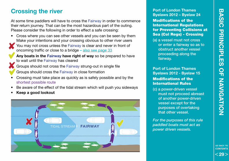
Crossing the riverAt some time paddlers will have to cross the Fairway in order to commence their return journey . That can be the most hazardous part of the outing . Please consider the following in order to effect a safe crossing:
• Cross where you can see other vessels and you can be seen by them Make your intentions and your crossing obvious to other river users
• You may not cross unless the Fairway is clear and never in front of oncoming traffic or close to a bridge – also see page 33
• Any boats in the Fairway have right of way so be prepared to have to wait until the Fairway has cleared
• Groups should not cross the Fairway strung-out in single file
• Groups should cross the Fairway in close formation
• Crossing must take place as quickly as is safely possible and by the shortest possible route
• Be aware of the effect of the tidal stream which will push you sideways• Keep a good lookout
29
BA
SIC
PR
INC
IPLE
S O
F N
AV
IGA
TIO
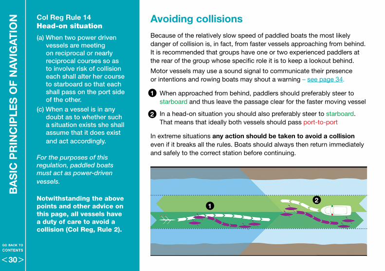
N Col Reg Rule 14 Head-on situation
(a) When two power driven vessels are meeting on reciprocal or nearly reciprocal courses so as to involve risk of collision each shall alter her course to starboard so that each shall pass on the port side of the other.
(c) When a vessel is in any doubt as to whether such a situation exists she shall assume that it does exist and act accordingly.
For the purposes of this regulation, paddled boats must act as power-driven vessels.
Notwithstanding the above points and other advice on this page, all vessels have a duty of care to avoid a collision (Col Reg, Rule 2).
Avoiding collisionsBecause of the relatively slow speed of paddled boats the most likely danger of collision is, in fact, from faster vessels approaching from behind . It is recommended that groups have one or two experienced paddlers at the rear of the group whose specific role it is to keep a lookout behind .
Motor vessels may use a sound signal to communicate their presence or intentions and rowing boats may shout a warning – see page 34 .
• When approached from behind, paddlers should preferably steer to starboard and thus leave the passage clear for the faster moving vessel
• In a head-on situation you should also preferably steer to starboard . That means that ideally both vessels should pass port-to-port
In extreme situations any action should be taken to avoid a collision even if it breaks all the rules . Boats should always then return immediately and safely to the correct station before continuing .
1
1
2
2
30
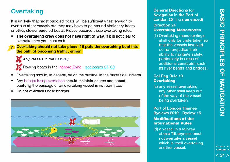
It is unlikely that most paddled boats will be sufficiently fast enough to overtake other vessels but they may have to go around stationary boats or other, slower paddled boats . Please observe these overtaking rules:
• The overtaking crew does not have right of way . If it is not clear to overtake then you must wait
• Overtaking should not take place if it puts the overtaking boat into the path of oncoming traffic, either:
Any vessels in the Fairway
Rowing boats in the Inshore Zone – see pages 37–39
• Overtaking should, in general, be on the outside (in the faster tidal stream)
• Any boat(s) being overtaken should maintain course and speed, baulking the passage of an overtaking vessel is not permitted
• Do not overtake under bridges
OvertakingB
AS
IC P
RIN
CIP
LES
OF N
AV
IGA
TIO
NGeneral Directions for Navigation in the Port of London 2011 (as amended)Direction 24Overtaking Manoeuvres
(1) Overtaking manoeuvrings shall only be undertaken so that the vessels involved do not prejudice their ability to navigate safely, particularly in areas of additional constraint such as river bends and bridges.
Col Reg Rule 13Overtaking
(a) any vessel overtaking any other shall keep out of the way of the vessel being overtaken.
Port of London Thames Byelaws 2012 - Byelaw 15Modifications of the International Rules
(d) a vessel in a fairway above Tilburyness must not overtake a vessel which is itself overtaking another vessel.
1
1
2
2
31
BA
SIC
PR
INC
IPLE
S O
F N
AV
IGA
TIO
N
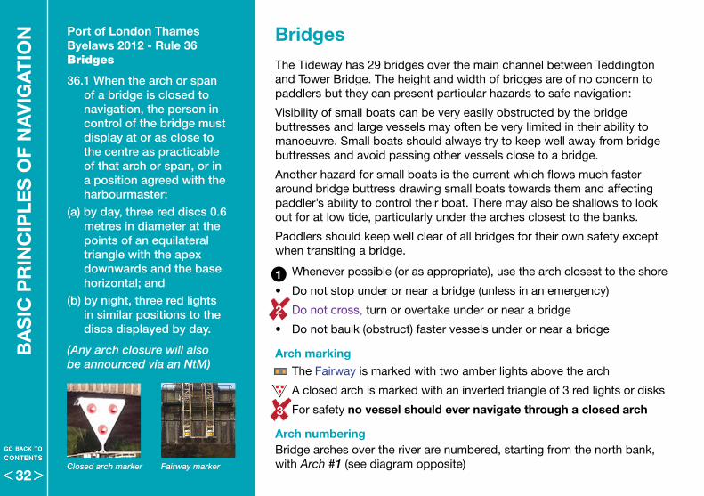
The Tideway has 29 bridges over the main channel between Teddington and Tower Bridge . The height and width of bridges are of no concern to paddlers but they can present particular hazards to safe navigation:
Visibility of small boats can be very easily obstructed by the bridge buttresses and large vessels may often be very limited in their ability to manoeuvre . Small boats should always try to keep well away from bridge buttresses and avoid passing other vessels close to a bridge .
Another hazard for small boats is the current which flows much faster around bridge buttress drawing small boats towards them and affecting paddler’s ability to control their boat . There may also be shallows to look out for at low tide, particularly under the arches closest to the banks .
Paddlers should keep well clear of all bridges for their own safety except when transiting a bridge .
• Whenever possible (or as appropriate), use the arch closest to the shore
• Do not stop under or near a bridge (unless in an emergency)
• Do not cross, turn or overtake under or near a bridge
• Do not baulk (obstruct) faster vessels under or near a bridge
Arch marking • The Fairway is marked with two amber lights above the arch
• A closed arch is marked with an inverted triangle of 3 red lights or disks
• For safety no vessel should ever navigate through a closed arch
Arch numberingBridge arches over the river are numbered, starting from the north bank, with Arch #1 (see diagram opposite)
Bridges Port of London Thames Byelaws 2012 - Rule 36Bridges
36.1 When the arch or span of a bridge is closed to navigation, the person in control of the bridge must display at or as close to the centre as practicable of that arch or span, or in a position agreed with the harbourmaster:
(a) by day, three red discs 0.6 metres in diameter at the points of an equilateral triangle with the apex downwards and the base horizontal; and
(b) by night, three red lights in similar positions to the discs displayed by day.
(Any arch closure will also be announced via an NtM)
Fairway markerClosed arch marker
1
2
3
32
BA
SIC
PR
INC
IPLE
S O
F NA
VIG
AT
ION
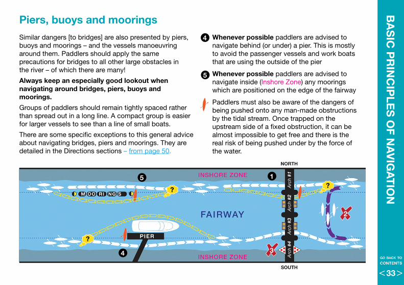
Piers, buoys and moorings Similar dangers [to bridges] are also presented by piers, buoys and moorings – and the vessels manoeuvring around them . Paddlers should apply the same precautions for bridges to all other large obstacles in the river – of which there are many!
Always keep an especially good lookout when navigating around bridges, piers, buoys and moorings .
Groups of paddlers should remain tightly spaced rather than spread out in a long line . A compact group is easier for larger vessels to see than a line of small boats .
There are some specific exceptions to this general advice about navigating bridges, piers and moorings . They are detailed in the Directions sections – from page 50 .
• Whenever possible paddlers are advised to navigate behind (or under) a pier . This is mostly to avoid the passenger vessels and work boats that are using the outside of the pier
• Whenever possible paddlers are advised to navigate inside (Inshore Zone) any moorings which are positioned on the edge of the fairway
• Paddlers must also be aware of the dangers of being pushed onto any man-made obstructions by the tidal stream . Once trapped on the upstream side of a fixed obstruction, it can be almost impossible to get free and there is the real risk of being pushed under by the force of the water .
1
4
4
5
5
3
2
33
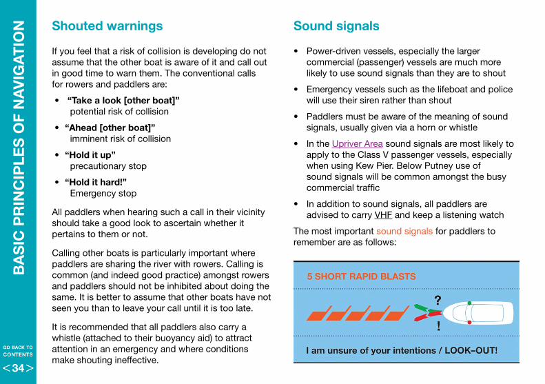
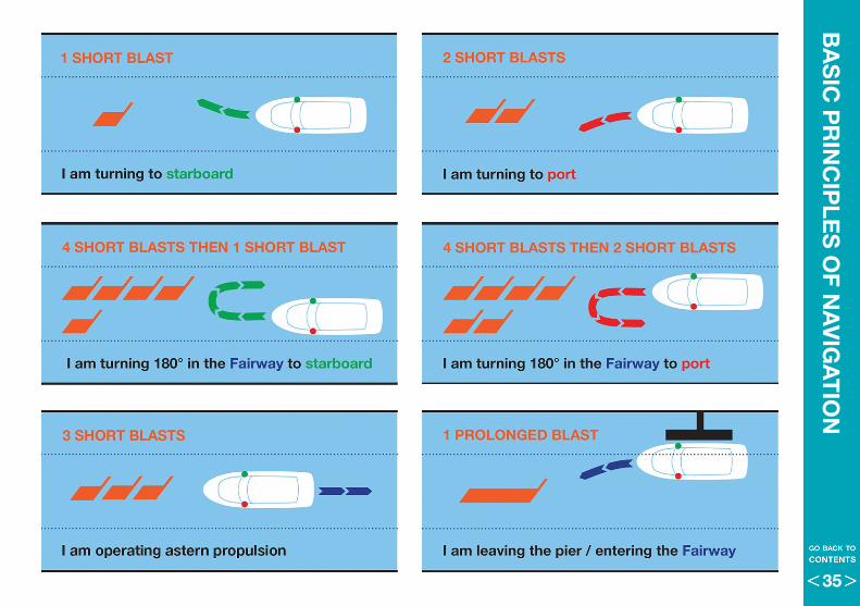
Sound signals
• Power-driven vessels, especially the larger commercial (passenger) vessels are much more likely to use sound signals than they are to shout
• Emergency vessels such as the lifeboat and police will use their siren rather than shout
• Paddlers must be aware of the meaning of sound signals, usually given via a horn or whistle
• In the Upriver Area sound signals are most likely to apply to the Class V passenger vessels, especially when using Kew Pier . Below Putney use of sound signals will be common amongst the busy commercial traffic
• In addition to sound signals, all paddlers are advised to carry VHF and keep a listening watch
The most important sound signals for paddlers to remember are as follows:
Shouted warnings
If you feel that a risk of collision is developing do not assume that the other boat is aware of it and call out in good time to warn them . The conventional calls for rowers and paddlers are:
• “Take a look [other boat]” potential risk of collision
• “Ahead [other boat]” imminent risk of collision
• “Hold it up” precautionary stop
• “Hold it hard!” Emergency stop
All paddlers when hearing such a call in their vicinity should take a good look to ascertain whether it pertains to them or not .
Calling other boats is particularly important where paddlers are sharing the river with rowers . Calling is common (and indeed good practice) amongst rowers and paddlers should not be inhibited about doing the same . It is better to assume that other boats have not seen you than to leave your call until it is too late .
It is recommended that all paddlers also carry a whistle (attached to their buoyancy aid) to attract attention in an emergency and where conditions make shouting ineffective .
BA
SIC
PR
INC
IPLE
S O
F N
AV
IGA
TIO
N
34
BA
SIC
PR
INC
IPLE
S O
F NA
VIG
AT
ION
35
FUR
TH
ER
PR
INC
IPLE
S O
F N
AV
IGA
TIO
N
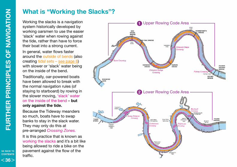
Working the slacks is a navigation system historically developed by working oarsmen to use the easier ‘slack’ water when rowing against the tide, rather than have to force their boat into a strong current .
In general, water flows faster around the outside of bends (also creating tidal sets – see page 6) with slower or ‘slack’ water being on the inside of the bend .
Traditionally, oar-powered boats have been allowed to break with the normal navigation rules (of staying to starboard) by rowing in the slower moving, ‘slack’ water on the inside of the bend – but only against the tide . Because the Tideway meanders so much, boats have to swap banks to stay in the slack water . They may only do this at pre-arranged Crossing Zones.
It is this practice that is known as working the slacks and it’s a bit like being allowed to ride a bike on the pavement against the flow of the traffic .
What is “Working the Slacks”?
Lower Rowing Code Area
Upper Rowing Code Area
2
1
36
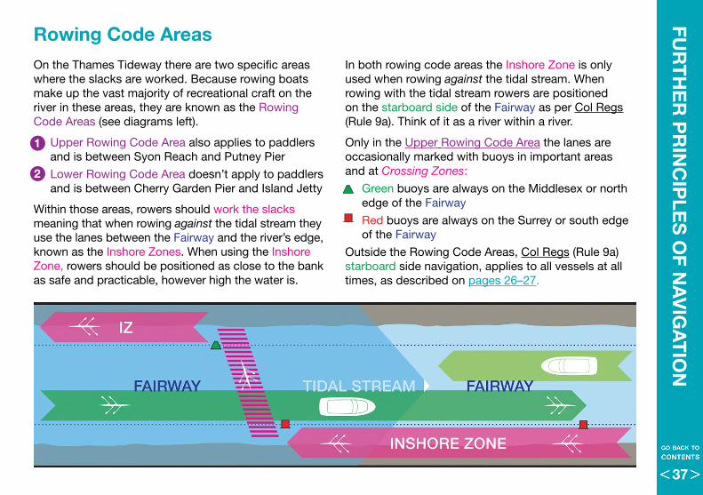
On the Thames Tideway there are two specific areas where the slacks are worked . Because rowing boats make up the vast majority of recreational craft on the river in these areas, they are known as the Rowing Code Areas (see diagrams left) .
• Upper Rowing Code Area also applies to paddlers and is between Syon Reach and Putney Pier
• Lower Rowing Code Area doesn’t apply to paddlers and is between Cherry Garden Pier and Island Jetty
Within those areas, rowers should work the slacks meaning that when rowing against the tidal stream they use the lanes between the Fairway and the river’s edge, known as the Inshore Zones . When using the Inshore Zone, rowers should be positioned as close to the bank as safe and practicable, however high the water is .
In both rowing code areas the Inshore Zone is only used when rowing against the tidal stream . When rowing with the tidal stream rowers are positioned on the starboard side of the Fairway as per Col Regs (Rule 9a) . Think of it as a river within a river .
Only in the Upper Rowing Code Area the lanes are occasionally marked with buoys in important areas and at Crossing Zones:
• Green buoys are always on the Middlesex or north edge of the Fairway
• Red buoys are always on the Surrey or south edge of the Fairway
Outside the Rowing Code Areas, Col Regs (Rule 9a) starboard side navigation, applies to all vessels at all times, as described on pages 26–27 .
FUR
TH
ER
PR
INC
IPLE
S O
F NA
VIG
AT
ION
Rowing Code Areas
2
1
37
FUR
TH
ER
PR
INC
IPLE
S O
F N
AV
IGA
TIO
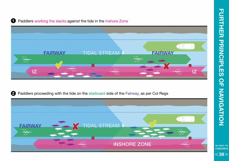
N Paddled boats working the slacksOnly in the Upper Rowing Code Area, paddled boats should use the same navigation pattern as rowing boats so it is vital to understand the specific issues that arise where paddlers and rowers use the same Inshore Zone to work the slacks:
• Paddled boats are usually slower than rowing boats• Paddlers face in their direction of travel• Rowers have their backs to their direction of travel
The consequence of that situation is very obvious – that there is an increased possibility of a rowing boat colliding into the back of a paddled boat when both types of boat are working the same slack water .
It is vital therefore that paddlers also keep a good lookout behind them as well as in front when navigating within the Inshore Zone . Paddlers should make themselves as visible (and audible – see page 34) as possible to rowing boats and to avoid impeding their progress by filling the whole Inshore Zone .
• The rule on paddling in groups is different within the Rowing Code Areas – Paddlers should be no more than two abreast and should stay as close to the bank as is safe thus allowing rowing boats to pass them unhindered on the outside .
When proceeding with the stream in the Fairway, the responsibility is very much the other way around, with rowing boats, as the faster vessel, being obliged to lookout for and safely overtake paddled boats .
• However, paddled boats must not spread out across the whole Fairway nor into the Inshore Zone but paddle as a compact group on the starboard side of the Fairway, as described on page 28 .
Why do paddlers need to know about the Rowing Code Areas?
Because in the Upper Rowing Code Area (Syon to Putney) paddled boats should work the slacks. The navigation rules for paddled boats are the same as for rowing boats.
The fundamental points are covered here but a more detailed explanation about working the slacks within the Rowing Code Areas can be found in the Rowing Code. That is available on the PLA leisure users website:
www.boatingonthethames .co.uk/Rowing
In the Lower Rowing Code Area, the rules for paddlers are different. Unlike rowing vessels there, paddled boats should not work the slacks in the Lower Rowing Code Area. See pages 67–69 for more details. 2
1
38
FUR
TH
ER
PR
INC
IPLE
S O
F NA
VIG
AT
ION
• Paddlers working the slacks against the tide in the Inshore Zone
• Paddlers proceeding with the tide on the starboard side of the Fairway, as per Col Regs2
1
39
RO
LES
& R
ES
PO
NS
IBIL
ITIE
S Personal responsibility
Risk Assessment
Every paddler is responsible for checking the equipment that they are about to go afloat in and also for assessing the environmental conditions plus their own ability and experience .
They should understand the basics of this Code of Practice and be familiar with rules, regulations and emergency procedures set out by their club .
They should be able to swim and wear a suitable PFD .
The Vessel Master
In the context of PLA regulations, the steers person (‘steers’ for paddled boats with more than one person), is deemed to be the master of the vessel - see panel left .
As such, the steers is legally responsible for the navigation, safety and behaviour of the crew .
Group leaders’ responsibilityAs mentioned in other parts of this code, it’s advisable to paddle in groups, which should appoint a person to ‘take charge’ to take an active role to maintain the size, shape, position and route of the group in line with the guidance in this code .
Whilst individuals are ultimately responsible for themselves, leaders are put into a position of trust by the other group members, so they have a duty of care to ensure their experience and ‘local knowledge’ are sufficient to be able to make the right decisions and dynamically risk assess the trip .
It is also recommended that group leaders hold a First Aid qualification .
Port of London Act 1968 (as amended) - Section 108General rules for navigation
A master who navigates his vessel on the Thames
(a) without due care and attention; or
(b) in a manner liable to injure or endanger persons, other vessels, the banks of the Thames (whether above or below mean high water level) or any structure or installation in or beside the Thames;
shall be guilty of an offence and liable to a fine not exceeding [the statutory maximum and on conviction on indictment to a fine].
The statutory maximum fine at time of publication (2016) is £5,000
40
Responsibilities of clubs, organisations and paddle sport providers
Clubs, organisations and paddle sport providers should have measures in place for:
• Generic risk assessments• Standard operating procedures including identifying usable egress points • Up-to-date Health and Safety policies • Appointed coaches/group leaders• Appointed Safety Officer • Other conditions required for affiliation to a national governing body
(e .g . British Canoeing) or if operating as a commercial provider .
ExperienceAssociate clubs, organisations or providers should consider producing their own guidelines based on British Canoeing Coaching and Personal Performance (Leadership and Star) Awards . These guidelines should take into account the level of competence required of paddlers and group leaders, as well what part of the river is being used and the expected conditions . Clubs not associated with British Canoeing are recommended to be guided by the principles within these awards .
Information distributionClubs are also responsible for informing members (i .e . via a notice board, website or social media) of any information relevant to safety and navigation on the Tidal Thames . This information could be any or all of the following issued by the PLA or British Canoeing:
•ThisCodeofPractice •Notices to Mariners (NtM)•SafetyBulletins •Fluvial Flag warnings
RO
LES
& R
ES
PO
NS
IBILIT
IES
Commercial Paddling
Any club, individual or company which offers paid ‘tour guide’ style trips on the tidal Thames requires permission from the PLA Harbourmaster.
Detailed Passage Plans and Risk Assessments are required for operations such as this and these need to be approved by the PLA. Kayaks, canoes and stand-up paddleboards used for commercial trips must also be licensed by the PLA.
A leader of any such commercial outfit is required to hold a Thames Local Knowledge Endorsement (LKE) when operating between Putney and Margaretness.
More details on the LKE can be found on the PLA website or by contacting the Harbourmaster – see page 70 for contact details.
41
RO
LES
& R
ES
PO
NS
IBIL
ITIE
SR
OLE
S &
RE
SP
ON
SIB
ILIT
IES
9.1 A person must not organise or promote [a boat race, regatta, stunt, procession, exhibition, firework display, air race or other river event] on or over the Thames except with the consent of the harbourmaster.
9.2 Any person who proposes to organise [an event] on or over the Thames, must consult with the harbourmaster on the navigational and safety issues arising from the proposed event and give the harbourmaster at least four weeks’ notice of the proposed event.
9.3 Every person navigating a vessel in or in connection with such an event must comply with the instructions of a harbourmaster relating to it.
9.4 Any person who proposes to organise or promote [an event] must provide to the harbourmaster the findings of any comprehensive risk assessment requested as a result of the consultation under byelaw 9.2 in respect of the event in question. The risk assessment must identify the relevant hazards and any suitable procedures, precautions and other risk control measures to be implemented to ensure any risk to persons or navigational safety or both is mitigated and maintained as low as reasonably practicable.
Events’ responsibilities
An ‘event’ is classed as use of the river for anything other than normal training or recreational purposes . This includes mass paddles of (typically) 30-40 paddlers, races, stunts or anything with media interest . The event organiser must advise the Harbourmaster as far in advance as possible and at least four weeks beforehand .
Any event that involves more than 99 boats on the water at any one time, or if the Harbourmaster deems it necessary, must normally have a full river closure, which requires at least one month’s notice .
The organiser must provide:
• Proof of public liability insurance
• A risk assessment and event plan
• A Letter of consent from the Harbourmaster containing an indemnity for the PLA against any costs or claims arising as a result of the event
• Details of any boats involved in the event working for hire or reward
Event organisers should inform London VTS that the event is about to start and again once the event has finished .
The environmental impact of an event must also be considered particularly with regards to dealing with litter – see page 45 .
Port of London Thames Byelaws 2012 - Byelaw 9BOAT RACES, REGATTAS, PROCESSIONS AND OTHER RIVER EVENTS
42
RO
LES
& R
ES
PO
NS
IBILIT
IES
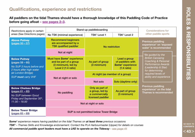
Qualifications, experience and restrictions
Some1 experience means having paddled on the tidal Thames on at least three previous occasions TSK2 – Thames Skills and Knowledge endorsement. Contact the PLA Harbourmaster (Upper) for details on coursesAll commercial paddle sport leaders must have a LKE to operate on the Tideway – see page 41
All paddlers on the tidal Thames should have a thorough knowledge of this Paddling Code of Practice before going afloat – see pages 2–3 .
Restrictions apply in certain areas (See Directions pages)
Stand-up paddleboarding Considerations for other paddle sportsNo TSK (minimal experience) TSK2 Level 1 TSK2 Level 2
Above Putney (pages 50 – 57)
Recommend beginners are accompanied by a TSK qualified paddler No restriction
Previous paddling experience* on ‘exposed water’ is recommended
Not at night
Below Putney (pages 58 – 60) No SUP 3 hours before and 2 hours after high water (at London Bridge)
SUP must carry VHF
Must have Some1 experience and be part of a group
(3 minimum), led by Level 2 (1:4 ratio)
As part of group (3 minimum)
Lead a group of paddlers with
Some1 experience (1:4 ratio)
Previous paddling experience* on the tidal Thames is recommended
Not at night or soloAt night (as member of a group)
Not solo Solo (daytime only)
Below Chelsea Bridge (pages 61 – 65)
No SUP between Good Friday and September 30th, 11.00 – 18.00
No paddling
Only as part of a group, led by a commercially
licensed paddler
As part of group (3 minimum)
Not at night or solo
Below Tower Bridge (pages 65 – 69)
SUP is not permitted below Tower Bridge
*Be guided by the British Canoeing Coaching & Personal Performance Awards (Leadership & Star) for determining required levels of ability and experience
43
EnvironmentAll users of the river should be environmentally friendly and take care not to disturb the wildlife while on the water . Paddlers should also not paddle towards or close by seals on the banks of the river .
Invasive non-native species (INNS) and bio-security Paddlers should take steps to minimise the risk or prevent the movement of invasive non-native species which can be introduced and spread by all waterway users, often unknowingly via contaminated equipment and clothing left in damp conditions . Paddlers should check their gear is clean before bringing it to the Thames from other waterways to prevent INNS contamination . Please remember:
Check your equipment and clothing for live organisms, plant fragments, etc – particularly in areas that are damp or hard to inspect
Clean and wash all equipment, footwear and clothing thoroughly . Soaking small items at 45°C for 15 minutes has been show to caused a 99% mortality rate across all species . If you do find any organisms, leave them at the body of water in which they were found
Dry all equipment and clothing . Some species can live for up to 16 days in moist conditions . Ensure you don’t transfer water anywhere
Other organisations
British Canoeing
British Canoeing is the national governing body for canoeing. It is responsible for setting the overall framework for the National Associations; representing canoeing interests such as coaching and competition at UK and international level. It also formulates standards for training programmes with certification levels and administers a range of personal performance and coaching awards.
Port of London Authority (PLA)
PLA operations cover 95 miles of the River Thames between the estuary and Teddington Lock. Its role is to keep commercial and leisure users safe, protect and enhance the environment and promote the use of the river for trade and travel.
The PLA is ultimately responsible for enforcing the navigation rules of the river, including this Paddling Code.
Environmental ResponsibilitiesR
OLE
S &
RE
SP
ON
SIB
ILIT
IES
44

Litter Do not drop litter in the river, or leave it where it will be taken/blown back into the river . Plastic has been found in fish of the Thames, because they are eating broken-down litter mixed in the river bed with their food . Bin it, for a cleaner Thames!
If organising an event, where litter is likely to collect with spectators, plan your event to minimise the litter generated and event-specific items like flags or banners are secured . Plan to review the area following the event to prevent any litter ending up in the river .
Water pollutionIf you see any pollution of the river, please report it to the relevant London VTS channel by phone or VHF . Take photos if possible, but do not take samples and keep a distance as the pollutant may also be damaging to health . After heavy or prolonged rainfall, screened sewage is released into the river from combined sewage outfalls . Avoid paddling in or near those events as there is an increased risk to your health .
Noise Pollution Please be considerate towards those who live on and near the river . Paddlers should avoid abusive language, playing loud music or shouting during unsociable hours .
Health Paddlers should always be aware of the risk of Weil’s disease which is spread by rodents’ urine . All cuts and grazes should be covered before going afloat . If a bleeding wound occurs during an outing, wash it thoroughly as soon as you return and treat it as an infection risk . Always wash your hands after paddling and before eating .
RO
LES
& R
ES
PO
NS
IBILIT
IES
RO
LES
& R
ES
PO
NS
IBILIT
IES
Pollution and Health
45
CO
MM
UN
ICA
TIO
N &
RE
PO
RT
ING London VTS (Vessel Traffic Services)
Teddington to CrayfordnessVHF: channel 14 Phone: 020 8855 0315
Crayfordness to Sea Reach 4 VHF: channel 68 Phone: 01747 562215
Sea Reach 4 to Seaward LimitVHF: channel 69 Phone: 01747 562215
London VTS oversee safety and navigation across the whole of the tidal Thames, 24/7, 365 days a year . They are the shipping equivalent of Air Traffic Control .
London VTS have a great deal of information to hand regarding such things as river works, arch closures and traffic movements so being involved in this communication network is extremely beneficial .
• All paddled boats are strongly advised to inform London VTS if they intend to paddle into or through Central London – see pages 58–63
• All paddled boats must inform London VTS if they intend to paddle into or through the Heart of London – see pages 62–65
• All paddled boats must inform London VTS when they are afloat in the dark below Putney Bridge
VHF Radio Communications
For channels, see London VTS, left
London VTS are in constant VHF radio communication with commercial, commuter and emergency vessels as well as regularly broadcasting NtMs and other pertinent information .
The duty officers at London Coastguard and London VTS are stationed next to each other . They work closely together and with the emergency services or other vessels to coordinate, via VHF, any emergency response required on the river .
A personal VHF handset is highly recommended in busy commercial traffic areas, such as Central London . It can be invaluable for keeping a listening watch on the intentions of other vessels or to receive critical information from London VTS .
You do not need a licence to listen on VHF but users do need the appropriate licence to broadcast on VHF . If you have such a licence then you are also able to make other river users aware of your intentions .
SUPs must carry VHF below Putney Bridge
Many modern VHF sets also include the option of a Digital Selective Calling (DSC) button . DSC will send a pre-defined distress signal, including your location, and is highly recommended for small boats .
NOTE: Hand-held VHF radios may have limited range, particularly upriver and/or at low water .
46
CO
MM
UN
ICA
TIO
N &
RE
PO
RT
ING
Port of London Thames Byelaws 2012 – Byelaw 8
8.1 Where any vessel has, whilst in the Thames:
a) sunk or is in danger of sinking;b) been abandoned;c) become derelict;d) been in collision with another vessel, shore
facility, the river embankment, a structure including any part of a bridge or a berthed or moored vessel or object;
e) been damaged or caused damage to anything (including a vessel);
f) been or is on fire or has suffered an explosion;g) taken the ground or stranded (not being a vessel
which has intentionally taken the ground);h) run into, fouled or damaged any light, buoy,
beacon or other aid to navigation;i) suffered any person falling overboard except
in relation to a recoverable capsize of a sailing dinghy or a vessel propelled by paddles or oars;
j) suffered any other accident normally required to be reported to the Marine Accident Investigation Branch or the Maritime & Coastguard Agency, or both.
8.2 A written report must be submitted by the vessel master to the harbourmaster, as soon as practicable after the submission of the verbal report, required by byelaw 8.1 above. The written report must give the full details of the occurrence, in a form prescribed by the Harbourmaster.
Incident reporting
Non-emergency incidentsAll incidents on the Tideway must be reported to the PLA – pla .co .uk/incidentreport – who may share the details with the relevant national association . Incidents should also be reported to your club or centre’s safety officer, particularly if it involves damage to a boat or personal injury .
That is the case for all paddlers using the tidal Thames whether or not they are based on the river .
• Incidents should be reported as soon as possible • Any incident where the RNLI is called must be
reported within 24 hours
The sorts of incidents that must be reported are:
• Capsizes caused by a third party or requiring the emergency services
• Collisions – with other vessels• Contact – with stationary objects (bridges, piers,
underwater obstructions etc .) that results in personal injury or shipwreck
• Near misses and poor or unsafe navigation• Personal injury• Inappropriate or inconsiderate behaviour
Behaviour of motor vesselsAny concerns about poor / abusive behaviour or navigation by motor vessels should be reported as soon as possible to London VTS - see left .
47
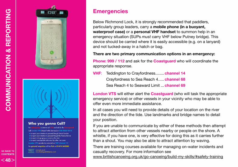
CO
MM
UN
ICA
TIO
N &
RE
PO
RT
ING Emergencies
Below Richmond Lock, it is strongly recommended that paddlers, particularly group leaders, carry a mobile phone (in a buoyant, waterproof case) or a personal VHF handset to summon help in an emergency situation (SUPs must carry VHF below Putney bridge) . This device should be carried where it is easily accessible (e .g . on a lanyard) and not tucked-away in a hatch or bag .
There are two primary communication options in an emergency:
Phone: 999 / 112 and ask for the Coastguard who will coordinate the appropriate response .
VHF: Teddington to Crayfordness . . . . . . . .channel 14
Crayfordness to Sea Reach 4 . . . . . . channel 68
Sea Reach 4 to Seaward Limit . . . channel 69
London VTS will either alert the Coastguard (who will task the appropriate emergency service) or other vessels in your vicinity who may be able to offer even more immediate assistance .
In all cases you will need to provide details of your location on the river and the direction of the tide . Use landmarks and bridge names to detail your position .
If you are unable to communicate by either of these methods then attempt to attract attention from other vessels nearby or people on the shore . A whistle, if you have one, is very effective for doing this as it carries further than a shout . You may also be able to attract attention by waving .
There are training courses available for managing on-water incidents and casualty recovery . For more information see www .britishcanoeing .org .uk/go-canoeing/build-my-skills/#safety-training
48
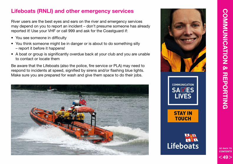
CO
MM
UN
ICA
TIO
N &
RE
PO
RT
ING
Lifeboats (RNLI) and other emergency services
River users are the best eyes and ears on the river and emergency services may depend on you to report an incident – don’t presume someone has already reported it! Use your VHF or call 999 and ask for the Coastguard if:
• You see someone in difficulty
• You think someone might be in danger or is about to do something silly – report it before it happens!
• A boat or group is significantly overdue back at your club and you are unable to contact or locate them
Be aware that the Lifeboats (also the police, fire service or PLA) may need to respond to incidents at speed, signified by sirens and/or flashing blue lights . Make sure you are prepared for wash and give them space to do their jobs .
49
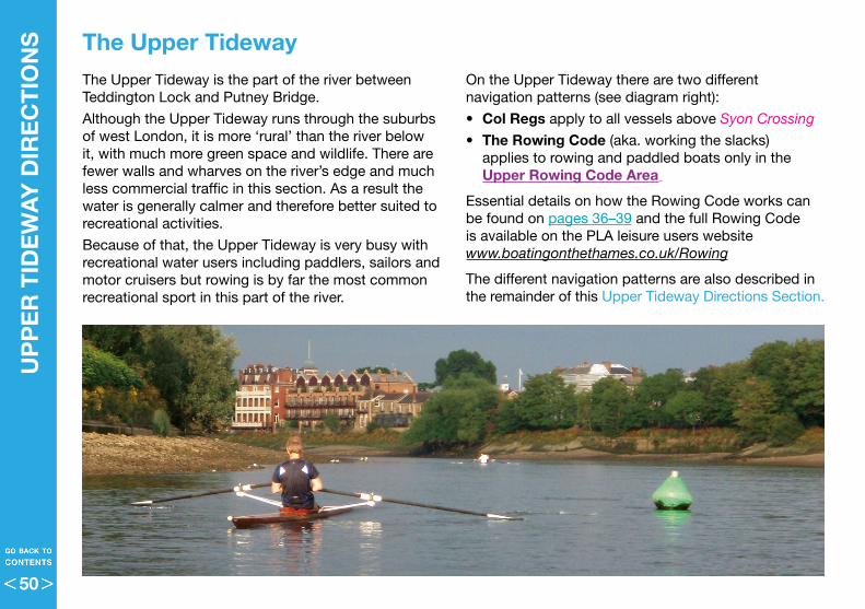
UP
PE
R T
IDE
WA
Y D
IRE
CT
ION
S
The Upper Tideway The Upper Tideway is the part of the river between Teddington Lock and Putney Bridge .
Although the Upper Tideway runs through the suburbs of west London, it is more ‘rural’ than the river below it, with much more green space and wildlife . There are fewer walls and wharves on the river’s edge and much less commercial traffic in this section . As a result the water is generally calmer and therefore better suited to recreational activities .
Because of that, the Upper Tideway is very busy with recreational water users including paddlers, sailors and motor cruisers but rowing is by far the most common recreational sport in this part of the river .
On the Upper Tideway there are two different navigation patterns (see diagram right):
• Col Regs apply to all vessels above Syon Crossing
• The Rowing Code (aka . working the slacks) applies to rowing and paddled boats only in the Upper Rowing Code Area
Essential details on how the Rowing Code works can be found on pages 36–39 and the full Rowing Code is available on the PLA leisure users website www.boatingonthethames.co.uk/Rowing
The different navigation patterns are also described in the remainder of this Upper Tideway Directions Section .
50
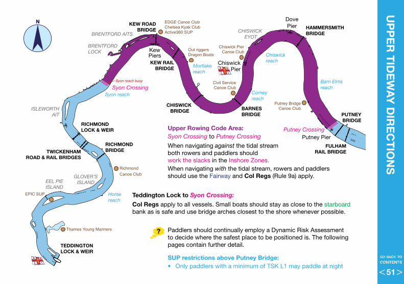
UP
PE
R T
IDE
WA
Y D
IRE
CT
ION
SRichmond Canoe Club
Chiswick PierCanoe Club
Civil ServiceCanoe Club
EDGE Canoe ClubChelsea Kyak ClubActive360 SUP
Out riggersDragon Boats
Putney BridgeCanoe Club
EPIC SUP
Thames Young Mariners
EEL PIEISLAND
GLOVER’SISLAND
ISLEWORTHAIT
BRENTFORD AITSCHISWICK
EYOT
BRENTFORD LOCK
Syon reach
Horse reach
Mortlakereach
Corney reach
Chiswick reach
Barn Elmsreach
BARNES BRIDGE
CHISWICK BRIDGE
RICHMOND LOCK & WEIR
RICHMOND BRIDGETWICKENHAM
ROAD & RAIL BRIDGES
PUTNEYBRIDGE
FULHAMRAIL BRIDGE
HAMMERSMITHBRIDGE
KEW ROADBRIDGE
KEW RAILBRIDGE
TEDDINGTONLOCK & WEIR
ChiswickPier
KewPiers
DovePier
Putney PierPutney Crossing
Syon CrossingSyon reach buoy
N
Upper Rowing Code Area:Syon Crossing to Putney Crossing
When navigating against the tidal stream both rowers and paddlers should work the slacks in the Inshore Zones . When navigating with the tidal stream, rowers and paddlers should use the Fairway and Col Regs (Rule 9a) apply .
Teddington Lock to Syon Crossing:
Col Regs apply to all vessels . Small boats should stay as close to the starboard bank as is safe and use bridge arches closest to the shore whenever possible .
Paddlers should continually employ a Dynamic Risk Assessment to decide where the safest place to be positioned is . The following pages contain further detail .
SUP restrictions above Putney Bridge:• Only paddlers with a minimum of TSK L1 may paddle at night
51
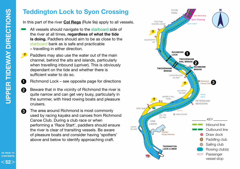
• All vessels should navigate to the starboard side of the river at all times, regardless of what the tide is doing . Paddlers should aim to be as close to the starboard bank as is safe and practicable – travelling in either direction .
• Paddlers may also use the water out of the main channel, behind the aits and islands, particularly when travelling inbound (upriver) . This is obviously dependant on the tide and whether there is sufficient water to do so .
• Richmond Lock – see opposite page for directions
• Beware that in the vicinity of Richmond the river is quite narrow and can get very busy, particularly in the summer, with hired rowing boats and pleasure cruisers .
• The area around Richmond is most commonly used by racing kayaks and canoes from Richmond Canoe Club . During a club race or when performing a ‘Race Start’, paddlers should ensure the river is clear of transiting vessels . Be aware of pleasure boats and consider having ‘spotters’ above and below to identify approaching craft .
Richmond Canoe Club
Chiswick PierCanoe Club
Civil ServiceCanoeClub
EDGE Canoe ClubChelsea Kayak ClubActive360 SUP
Outriggers &Dragon boats
Putney Bridge& Battersea Canoe Clubs
EPIC SUP
ThamesYoung mariners
D
D
FERRY
D
D
DD
D
D
D
D
D
D
D
D
D
D
D
SYONPARK
“THE SHIP”
HAM HOUSE
PETERSHAMMEADOWS
HAM LANDS
MARBLE HILLPARK
‘THE PINK HOUSE/LODGE’
THE BANDSTAND
“YE WHITE HART”
FULLERS BREWERY
St NICHOLASCHURCH
HARRODS
PUTNEY EMBANKMENT
MILE POST
CRAVEN COTTAGE (FFC)
KEWGARDENS
RIVERSIDE PARK
BISHOP’S PARKBeverley Brook
DUKE’S MEADOWS
BARN ELMS
BRENTFORD LOCK
CHISWICKMARINA
Grand Union canal
Mortlakereach
Corney reach
Chiswick reach
Barn Elmsreach
Syon reach
Horse reach
CHISWICK EYOT
BRENTFORDAITS
EEL PIEISLAND
CORPORATION ISLAND
GLOVER’S ISLAND
SWAN ISLAND
ISLEWORTHAIT
OLIVER’S AIT
LOT’S AIT
Small Proffitt’s
Dock
Harbourmaster Pontoon
‘The Petrol Pumps’
Kew Bridge Pontoon
Fulham F la ts
BARNES BRIDGE
CHISWICKBRIDGE
RICHMOND LOCK
RICHMOND BRIDGETWICKENHAM
BRIDGE
TWICKENHAM RAIL BRIDGE
FULHAM RAILWAYBRIDGE
PUTNEY BRIDGE
HAMMERSMITHBRIDGEKEW ‘STONE’
BRIDGE
KEW ‘RAIL’ BRIDGE
TEDDINGTONLOCK & WEIR
CHISWICK PIER
KEWPIERS
DOVEPIER
PUTNEY PIER
‘The Barges’
‘The Black Buoy’Putney Crossing
Chiswick StepsCrossing
Chiswick BridgeCrossing
Syon Crossing
Syon Reach Buoy
FA I R WAY
FAI R
WAY
FA
IRW
AY
FAI R
WA
Y
F A I R WAY
FA I R WAY
FA
IRW
AY
FA
IRW
AY
FA I R W AY
KEY
UP
PE
R T
IDE
WA
Y D
IRE
CT
ION
S
Teddington Lock to Syon Crossing
2
2
3
3
1
1
N
Inbound lineOutbound lineDraw dockPaddling clubSailing clubRowing club(s)Passenger vessel stop
D
In this part of the river Col Regs (Rule 9a) apply to all vessels .
52
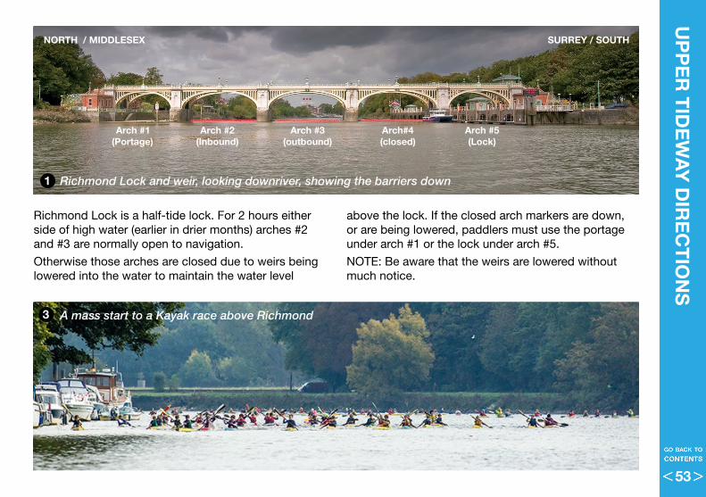
Richmond Lock is a half-tide lock . For 2 hours either side of high water (earlier in drier months) arches #2 and #3 are normally open to navigation .
Otherwise those arches are closed due to weirs being lowered into the water to maintain the water level
UP
PE
R T
IDE
WA
Y D
IRE
CT
ION
S
Richmond Lock and weir, looking downriver, showing the barriers down
A mass start to a Kayak race above Richmond
Arch #1 Arch #2 Arch #3 Arch#4 Arch #5(Portage) (Inbound) (outbound) (closed) (Lock)
NORTH / MIDDLESEX SURREY / SOUTH
above the lock . If the closed arch markers are down, or are being lowered, paddlers must use the portage under arch #1 or the lock under arch #5 .
NOTE: Be aware that the weirs are lowered without much notice .
1
3
53
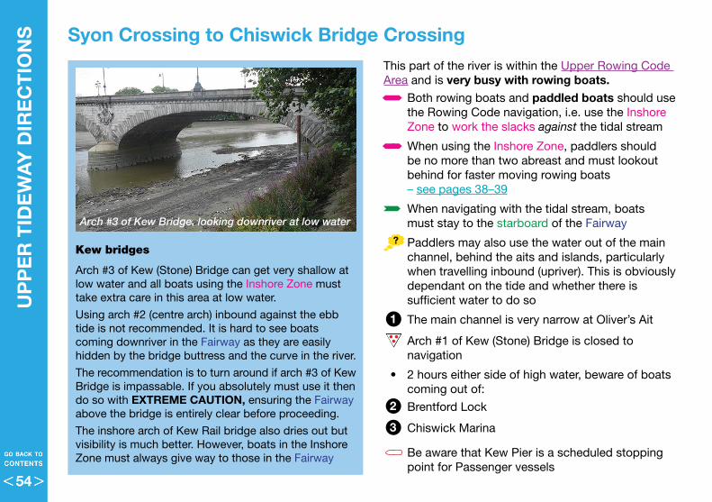
This part of the river is within the Upper Rowing Code Area and is very busy with rowing boats .
• Both rowing boats and paddled boats should use the Rowing Code navigation, i .e . use the Inshore Zone to work the slacks against the tidal stream
• When using the Inshore Zone, paddlers should be no more than two abreast and must lookout behind for faster moving rowing boats – see pages 38–39
• When navigating with the tidal stream, boats must stay to the starboard of the Fairway
• Paddlers may also use the water out of the main channel, behind the aits and islands, particularly when travelling inbound (upriver) . This is obviously dependant on the tide and whether there is sufficient water to do so
• The main channel is very narrow at Oliver’s Ait
• Arch #1 of Kew (Stone) Bridge is closed to navigation
• 2 hours either side of high water, beware of boats coming out of:
• Brentford Lock
• Chiswick Marina
• Be aware that Kew Pier is a scheduled stopping point for Passenger vessels
UP
PE
R T
IDE
WA
Y D
IRE
CT
ION
S
Syon Crossing to Chiswick Bridge Crossing
Kew bridges
Arch #3 of Kew (Stone) Bridge can get very shallow at low water and all boats using the Inshore Zone must take extra care in this area at low water .
Using arch #2 (centre arch) inbound against the ebb tide is not recommended . It is hard to see boats coming downriver in the Fairway as they are easily hidden by the bridge buttress and the curve in the river .
The recommendation is to turn around if arch #3 of Kew Bridge is impassable . If you absolutely must use it then do so with EXTREME CAUTION, ensuring the Fairway above the bridge is entirely clear before proceeding .
The inshore arch of Kew Rail bridge also dries out but visibility is much better . However, boats in the Inshore Zone must always give way to those in the Fairway
2
3
1
Arch #3 of Kew Bridge, looking downriver at low water
54
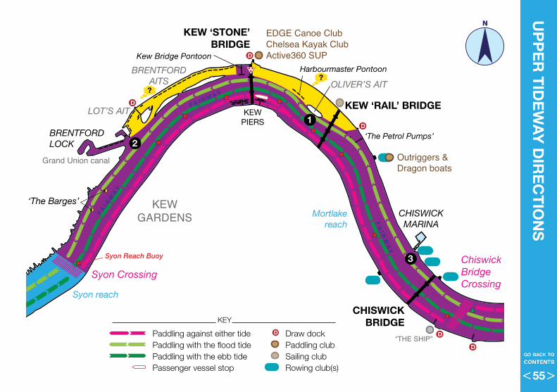
Richmond Canoe Club
Chiswick PierCanoe Club
Civil ServiceCanoeClub
EDGE Canoe ClubChelsea Kayak ClubActive360 SUP
Outriggers &Dragon boats
Putney Bridge& Battersea Canoe Clubs
EPIC SUP
ThamesYoung mariners
D
D
FERRY
D
D
DD
D
D
D
D
D
D
D
D
D
D
D
SYONPARK
“THE SHIP”
HAM HOUSE
PETERSHAMMEADOWS
HAM LANDS
MARBLE HILLPARK
‘THE PINK HOUSE/LODGE’
THE BANDSTAND
“YE WHITE HART”
FULLERS BREWERY
St NICHOLASCHURCH
HARRODS
PUTNEY EMBANKMENT
MILE POST
CRAVEN COTTAGE (FFC)
KEWGARDENS
RIVERSIDE PARK
BISHOP’S PARKBeverley Brook
DUKE’S MEADOWS
BARN ELMS
BRENTFORD LOCK
CHISWICKMARINA
Grand Union canal
Mortlakereach
Corney reach
Chiswick reach
Barn Elmsreach
Syon reach
Horse reach
CHISWICK EYOT
BRENTFORDAITS
EEL PIEISLAND
CORPORATION ISLAND
GLOVER’S ISLAND
SWAN ISLAND
ISLEWORTHAIT
OLIVER’S AIT
LOT’S AIT
Small Proffitt’s
Dock
Harbourmaster Pontoon
‘The Petrol Pumps’
Kew Bridge Pontoon
Fulham F la ts
BARNES BRIDGE
CHISWICKBRIDGE
RICHMOND LOCK
RICHMOND BRIDGETWICKENHAM
BRIDGE
TWICKENHAM RAIL BRIDGE
FULHAM RAILWAYBRIDGE
PUTNEY BRIDGE
HAMMERSMITHBRIDGEKEW ‘STONE’
BRIDGE
KEW ‘RAIL’ BRIDGE
TEDDINGTONLOCK & WEIR
CHISWICK PIER
KEWPIERS
DOVEPIER
PUTNEY PIER
‘The Barges’
‘The Black Buoy’Putney Crossing
Chiswick StepsCrossing
Chiswick BridgeCrossing
Syon Crossing
Syon Reach Buoy
FA I R WAYFA
I RW
AY
FA
IRW
AY
FAI R
WA
Y
F A I R WAY
FA I R WAY
FA
IRW
AY
FA
IRW
AY
FA I R W AY
UP
PE
R T
IDE
WA
Y D
IRE
CT
ION
SN
2
3
1
Paddling against either tide Draw dockPaddling with the flood tide Paddling clubPaddling with the ebb tide Sailing club Passenger vessel stop Rowing club(s)
D
KEY
55
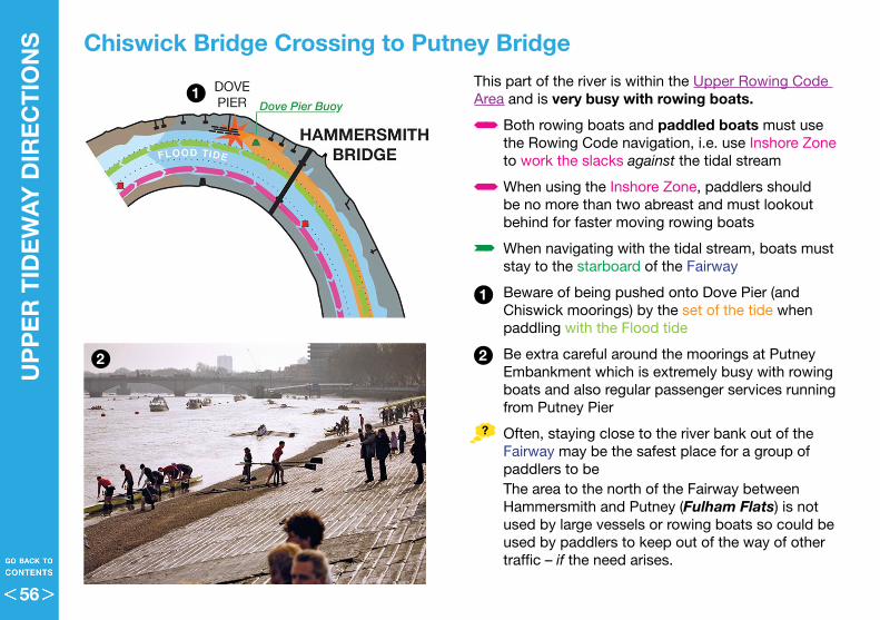
UP
PE
R T
IDE
WA
Y D
IRE
CT
ION
S
Chiswick Bridge Crossing to Putney BridgeThis part of the river is within the Upper Rowing Code Area and is very busy with rowing boats .
• Both rowing boats and paddled boats must use the Rowing Code navigation, i .e . use Inshore Zone to work the slacks against the tidal stream
• When using the Inshore Zone, paddlers should be no more than two abreast and must lookout behind for faster moving rowing boats
• When navigating with the tidal stream, boats must stay to the starboard of the Fairway
• Beware of being pushed onto Dove Pier (and Chiswick moorings) by the set of the tide when paddling with the Flood tide
• Be extra careful around the moorings at Putney Embankment which is extremely busy with rowing boats and also regular passenger services running from Putney Pier
• Often, staying close to the river bank out of the Fairway may be the safest place for a group of paddlers to beThe area to the north of the Fairway between Hammersmith and Putney (Fulham Flats) is not used by large vessels or rowing boats so could be used by paddlers to keep out of the way of other traffic – if the need arises .
2
1
2
1
56
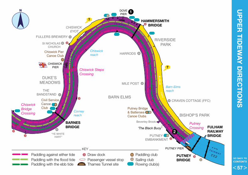
Richmond Canoe Club
Chiswick PierCanoe Club
Civil ServiceCanoeClub
EDGE Canoe ClubChelsea Kayak ClubActive360 SUP
Outriggers &Dragon boats
Putney Bridge& Battersea Canoe Clubs
EPIC SUP
ThamesYoung mariners
D
D
FERRY
D
D
DD
D
D
D
D
D
D
D
D
D
D
D
SYONPARK
“THE SHIP”
HAM HOUSE
PETERSHAMMEADOWS
HAM LANDS
MARBLE HILLPARK
‘THE PINK HOUSE/LODGE’
THE BANDSTAND
“YE WHITE HART”
FULLERS BREWERY
St NICHOLASCHURCH
HARRODS
PUTNEY EMBANKMENT
MILE POST
CRAVEN COTTAGE (FFC)
KEWGARDENS
RIVERSIDE PARK
BISHOP’S PARKBeverley Brook
DUKE’S MEADOWS
BARN ELMS
BRENTFORD LOCK
CHISWICKMARINA
Grand Union canal
Mortlakereach
Corney reach
Chiswick reach
Barn Elmsreach
Syon reach
Horse reach
CHISWICK EYOT
BRENTFORDAITS
EEL PIEISLAND
CORPORATION ISLAND
GLOVER’S ISLAND
SWAN ISLAND
ISLEWORTHAIT
OLIVER’S AIT
LOT’S AIT
Small Proffitt’s
Dock
Harbourmaster Pontoon
‘The Petrol Pumps’
Kew Bridge Pontoon
Fulham F la ts
BARNES BRIDGE
CHISWICKBRIDGE
RICHMOND LOCK
RICHMOND BRIDGETWICKENHAM
BRIDGE
TWICKENHAM RAIL BRIDGE
FULHAM RAILWAYBRIDGE
PUTNEY BRIDGE
HAMMERSMITHBRIDGEKEW ‘STONE’
BRIDGE
KEW ‘RAIL’ BRIDGE
TEDDINGTONLOCK & WEIR
CHISWICK PIER
KEWPIERS
DOVEPIER
PUTNEY PIER
‘The Barges’
‘The Black Buoy’Putney Crossing
Chiswick StepsCrossing
Chiswick BridgeCrossing
Syon Crossing
Syon Reach Buoy
FA I R WAY
FAI R
WAY
FA
IRW
AY
FAI R
WA
Y
F A I R WAY
FA I R WAY
FA
IRW
AY
FA
IRW
AY
FA I R W AY
UP
PE
R T
IDE
WA
Y D
IRE
CT
ION
SN 1
2
Paddling against either tide Draw dock Paddling clubPaddling with the flood tide Passenger vessel stop Sailing club Paddling with the ebb tide Thames Tunnel site Rowing club(s)
D
KEY
57
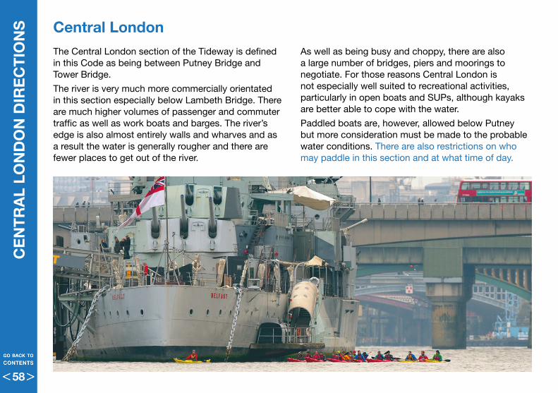
CE
NT
RA
L LO
ND
ON
DIR
EC
TIO
NS
The Central London section of the Tideway is defined in this Code as being between Putney Bridge and Tower Bridge .
The river is very much more commercially orientated in this section especially below Lambeth Bridge . There are much higher volumes of passenger and commuter traffic as well as work boats and barges . The river’s edge is also almost entirely walls and wharves and as a result the water is generally rougher and there are fewer places to get out of the river .
Central LondonAs well as being busy and choppy, there are also a large number of bridges, piers and moorings to negotiate . For those reasons Central London is not especially well suited to recreational activities, particularly in open boats and SUPs, although kayaks are better able to cope with the water .
Paddled boats are, however, allowed below Putney but more consideration must be made to the probable water conditions . There are also restrictions on who may paddle in this section and at what time of day .
58
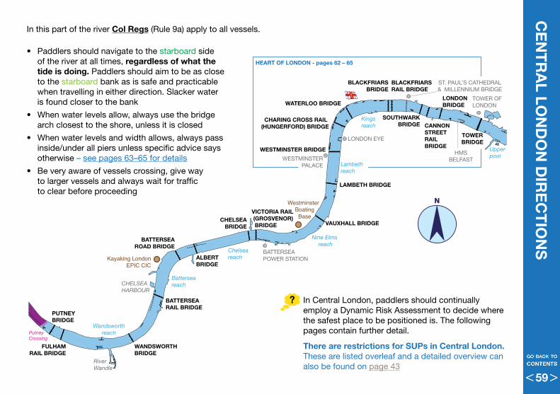
ST. PAUL’S CATHEDRAL& MILLENNIUM BRIDGE
BATTERSEA POWER STATION
TOWER OFLONDON
HMSBELFAST
LONDON EYE
WESTMINSTERPALACE
CHELSEAHARBOUR
RiverWandle
Kayaking LondonEPIC CIC
WestminsterBoating
Base
Battersea reach
Chelsea reach
Nine Elms reach
Lambeth reach
Kings reach
Upper pool
Wandsworthreach
TOWERBRIDGE
LONDONBRIDGE
SOUTHWARKBRIDGE
CHARING CROSS RAIL (HUNGERFORD) BRIDGE
BLACKFRIARSBRIDGE
CANNONSTREETRAIL BRIDGE
VICTORIA RAIL (GROSVENOR) BRIDGE
BATTERSEA RAIL BRIDGE
WANDSWORTHBRIDGE
FULHAMRAIL BRIDGE
PUTNEYBRIDGE
ALBERTBRIDGE
BATTERSEAROAD BRIDGE
VAUXHALL BRIDGE
WATERLOO BRIDGE
LAMBETH BRIDGE
WESTMINSTER BRIDGE
BLACKFRIARSRAIL BRIDGE
CHELSEABRIDGE
Putney Crossing
HEART OF LONDON - pages 62 – 65
CE
NT
RA
L LON
DO
N D
IRE
CT
ION
S
N
• Paddlers should navigate to the starboard side of the river at all times, regardless of what the tide is doing . Paddlers should aim to be as close to the starboard bank as is safe and practicable when travelling in either direction . Slacker water is found closer to the bank
• When water levels allow, always use the bridge arch closest to the shore, unless it is closed
• When water levels and width allows, always pass inside/under all piers unless specific advice says otherwise – see pages 63–65 for details
• Be very aware of vessels crossing, give way to larger vessels and always wait for traffic to clear before proceeding
In this part of the river Col Regs (Rule 9a) apply to all vessels .
In Central London, paddlers should continually employ a Dynamic Risk Assessment to decide where the safest place to be positioned is . The following pages contain further detail .
There are restrictions for SUPs in Central London . These are listed overleaf and a detailed overview can also be found on page 43
59
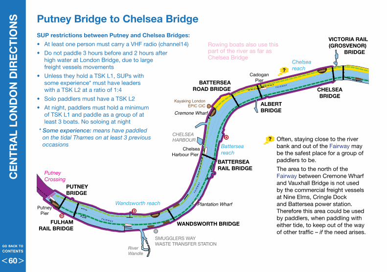
Putney Crossing
ST. PAUL’S CATHEDRAL& MILLENNIUM BRIDGE
BATTERSEA POWER STATION
TOWER OFLONDON
HMSBELFAST
LONDON EYE
WESTMINSTERPALACE
SMUGGLERS WAYWASTE TRANSFER STATION
MI6
CHELSEAHARBOUR
RiverWandle
Kayaking LondonEPIC CIC
WestminsterBoating Base
DD
D
F A I R W AY
FAI R
WA
Y
F A I R W AY
FAI R
WA
Y
FAI R
WA
Y
F A I R W AY
FA I R WAY
F A I R W AY
FA I RWAY
Batterseareach
Chelsea reach
Nine Elms reach
Lambeth reach
Kings reach
Upper pool
Wandsworth reach
Tower Pier
London Bridge City Pier
Bankside Pier
Blackfriers Pier
Westminster Pier
MillbankPier
St. George’sWharf Pier
CadoganPier
ChelseaHarbour Pier
PutneyPier
Embankment Pier
Lambeth Pier
Waterloo Pier
FestivalPier
Cremone Wharf
Plantation Wharf
TOWERBRIDGE
LONDONBRIDGE
SOUTHWARKBRIDGECHARING CROSS RAIL
(HUNGERFORD) BRIDGE
BLACKFRIARSBRIDGE
CANNONSTREETRAIL BRIDGE
BATTERSEARAIL BRIDGE
WANDSWORTH BRIDGEFULHAMRAIL BRIDGE
PUTNEYBRIDGE
ALBERTBRIDGE
BATTERSEAROAD BRIDGE
VAUXHALLBRIDGE
WATERLOOBRIDGE
LAMBETH BRIDGE
WESTMINSTER BRIDGE
BLACKFRIARSRAIL BRIDGE
CHELSEABRIDGE
VICTORIA RAIL(GROSVENOR)
BRIDGE Rowing boats also use this part of the river as far as Chelsea Bridge
CE
NT
RA
L LO
ND
ON
DIR
EC
TIO
NS Putney Bridge to Chelsea Bridge
SUP restrictions between Putney and Chelsea Bridges:
• At least one person must carry a VHF radio (channel14)
• Do not paddle 3 hours before and 2 hours after high water at London Bridge, due to large freight vessels movements
• Unless they hold a TSK L1, SUPs with some experience* must have leaders with a TSK L2 at a ratio of 1:4
• Solo paddlers must have a TSK L2
• At night, paddlers must hold a minimum of TSK L1 and paddle as a group of at least 3 boats . No soloing at night
* Some experience: means have paddled on the tidal Thames on at least 3 previous occasions
Often, staying close to the river bank and out of the Fairway may be the safest place for a group of paddlers to be .
The area to the north of the Fairway between Cremone Wharf and Vauxhall Bridge is not used by the commercial freight vessels at Nine Elms, Cringle Dock and Battersea power station . Therefore this area could be used by paddlers, when paddling with either tide, to keep out of the way of other traffic – if the need arises .
60
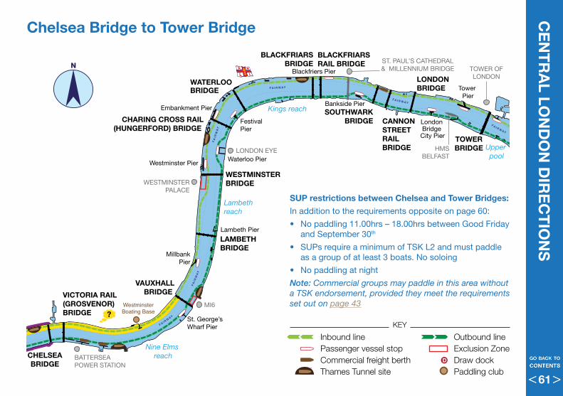
Putney Crossing
ST. PAUL’S CATHEDRAL& MILLENNIUM BRIDGE
BATTERSEA POWER STATION
TOWER OFLONDON
HMSBELFAST
LONDON EYE
WESTMINSTERPALACE
SMUGGLERS WAYWASTE TRANSFER STATION
MI6
CHELSEAHARBOUR
RiverWandle
Kayaking LondonEPIC CIC
WestminsterBoating Base
DD
D
F A I R W AY
FAI R
WA
Y
F A I R W AY
FAI R
WA
Y
FAI R
WA
Y
F A I R W AY
FA I R WAY
F A I R W AY
FA I RWAY
Batterseareach
Chelsea reach
Nine Elms reach
Lambeth reach
Kings reach
Upper pool
Wandsworth reach
Tower Pier
London Bridge City Pier
Bankside Pier
Blackfriers Pier
Westminster Pier
MillbankPier
St. George’sWharf Pier
CadoganPier
ChelseaHarbour Pier
PutneyPier
Embankment Pier
Lambeth Pier
Waterloo Pier
FestivalPier
Cremone Wharf
Plantation Wharf
TOWERBRIDGE
LONDONBRIDGE
SOUTHWARKBRIDGECHARING CROSS RAIL
(HUNGERFORD) BRIDGE
BLACKFRIARSBRIDGE
CANNONSTREETRAIL BRIDGE
BATTERSEARAIL BRIDGE
WANDSWORTH BRIDGEFULHAMRAIL BRIDGE
PUTNEYBRIDGE
ALBERTBRIDGE
BATTERSEAROAD BRIDGE
VAUXHALLBRIDGE
WATERLOOBRIDGE
LAMBETH BRIDGE
WESTMINSTER BRIDGE
BLACKFRIARSRAIL BRIDGE
CHELSEABRIDGE
VICTORIA RAIL(GROSVENOR) BRIDGE
CE
NT
RA
L LON
DO
N D
IRE
CT
ION
S
N
Chelsea Bridge to Tower Bridge
SUP restrictions between Chelsea and Tower Bridges:
In addition to the requirements opposite on page 60:
• No paddling 11 .00hrs – 18 .00hrs between Good Friday and September 30th
• SUPs require a minimum of TSK L2 and must paddle as a group of at least 3 boats . No soloing
• No paddling at night
Note: Commercial groups may paddle in this area without a TSK endorsement, provided they meet the requirements set out on page 43
Inbound line Outbound linePassenger vessel stop Exclusion ZoneCommercial freight berth Draw dockThames Tunnel site Paddling club
D
KEY
61
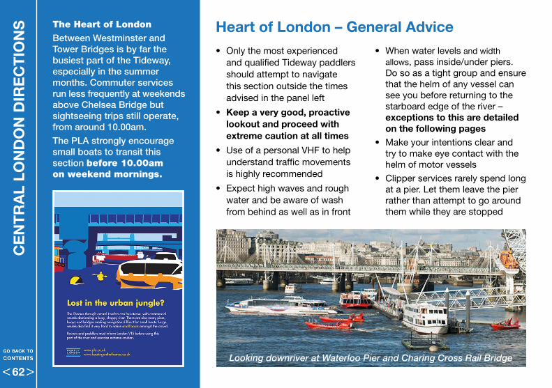
CE
NT
RA
L LO
ND
ON
DIR
EC
TIO
NS
• Only the most experienced and qualified Tideway paddlers should attempt to navigate this section outside the times advised in the panel left
• Keep a very good, proactive lookout and proceed with extreme caution at all times
• Use of a personal VHF to help understand traffic movements is highly recommended
• Expect high waves and rough water and be aware of wash from behind as well as in front
Heart of London – General AdviceThe Heart of London
Between Westminster and Tower Bridges is by far the busiest part of the Tideway, especially in the summer months. Commuter services run less frequently at weekends above Chelsea Bridge but sightseeing trips still operate, from around 10.00am.
The PLA strongly encourage small boats to transit this section before 10.00am on weekend mornings.
• When water levels and width allows, pass inside/under piers . Do so as a tight group and ensure that the helm of any vessel can see you before returning to the starboard edge of the river – exceptions to this are detailed on the following pages
• Make your intentions clear and try to make eye contact with the helm of motor vessels
• Clipper services rarely spend long at a pier . Let them leave the pier rather than attempt to go around them while they are stopped
Looking downriver at Waterloo Pier and Charing Cross Rail Bridge
62
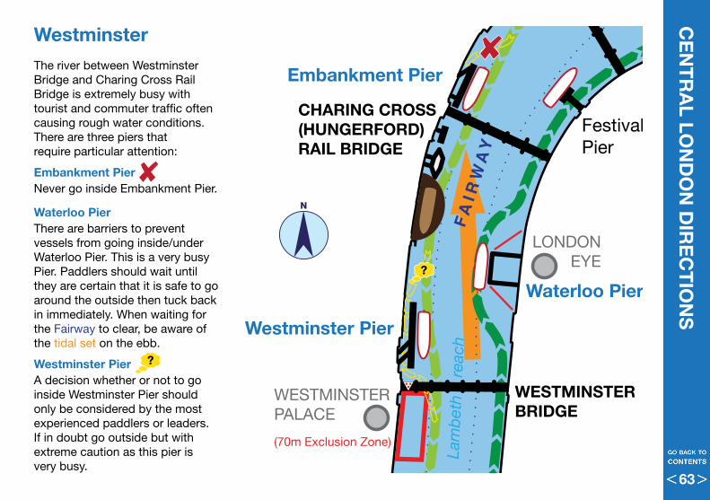
MILLENNIUMBRIDGE
TOWER OFLONDON
HMSBELFAST
LONDONEYE
WESTMINSTERPALACE
ST. KATHARINE’SDOCK
ST. PAUL’S CATHEDRAL
(70m Exclusion Zone)FA
I RW
AY
F A I R W AY
F A I R W AY
F A I R W AY
Lam
bet
h
reac
h
Kings reachKings reach
Upper pool
Tower Pier
London Bridge City Pier
Bankside Pier
Blackfriars Pier
Westminster Pier
Embankment Pier
Waterloo Pier
Festival Pier
TOWERBRIDGE
LONDONBRIDGE
SOUTHWARKBRIDGE
CHARING CROSS (HUNGERFORD) RAIL BRIDGE
CANNONSTREET
RAIL BRIDGE
WATERLOO BRIDGE
WESTMINSTER BRIDGE
BLACKFRIARS RAIL BRIDGEBLACKFRIARS
BRIDGE
N
CE
NT
RA
L LON
DO
N D
IRE
CT
ION
SWestminster The river between Westminster Bridge and Charing Cross Rail Bridge is extremely busy with tourist and commuter traffic often causing rough water conditions . There are three piers that require particular attention:
Embankment PierNever go inside Embankment Pier .
Waterloo PierThere are barriers to prevent vessels from going inside/under Waterloo Pier . This is a very busy Pier . Paddlers should wait until they are certain that it is safe to go around the outside then tuck back in immediately . When waiting for the Fairway to clear, be aware of the tidal set on the ebb .
Westminster PierA decision whether or not to go inside Westminster Pier should only be considered by the most experienced paddlers or leaders . If in doubt go outside but with extreme caution as this pier is very busy .
63
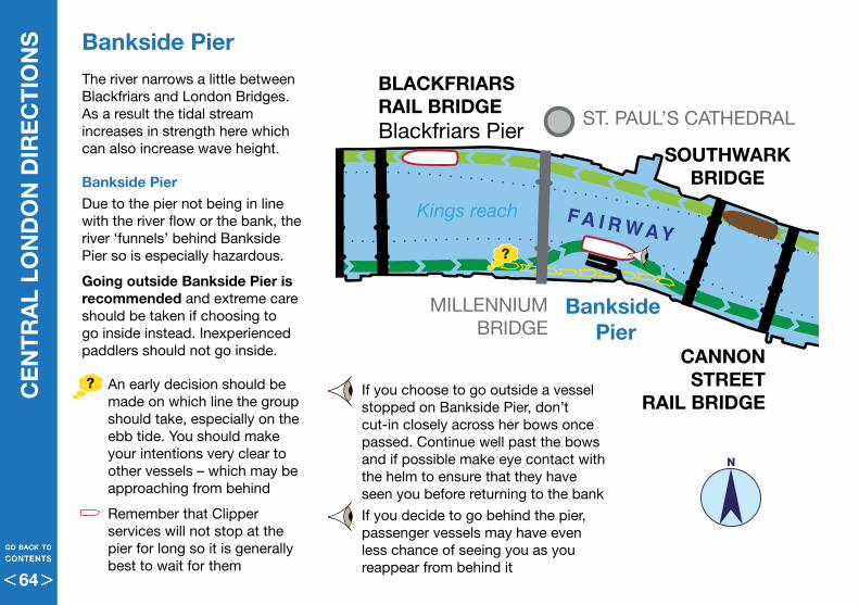
CE
NT
RA
L LO
ND
ON
DIR
EC
TIO
NS
The river narrows a little between Blackfriars and London Bridges . As a result the tidal stream increases in strength here which can also increase wave height .
Bankside Pier Due to the pier not being in line with the river flow or the bank, the river ‘funnels’ behind Bankside Pier so is especially hazardous .
Going outside Bankside Pier is recommended and extreme care should be taken if choosing to go inside instead . Inexperienced paddlers should not go inside .
• An early decision should be made on which line the group should take, especially on the ebb tide . You should make your intentions very clear to other vessels – which may be approaching from behind
• Remember that Clipper services will not stop at the pier for long so it is generally best to wait for them
Bankside Pier
MILLENNIUMBRIDGE
TOWER OFLONDON
HMSBELFAST
LONDONEYE
WESTMINSTERPALACE
ST. KATHARINE’SDOCK
ST. PAUL’S CATHEDRAL
(70m Exclusion Zone)
FAI R
WA
Y
F A I R W AY
F A I R W AY
F A I R W AY
Lam
bet
h
reac
h
Kings reachKings reach
Upper pool
Tower Pier
London Bridge City Pier
Bankside Pier
Blackfriars Pier
Westminster Pier
Embankment Pier
Waterloo Pier
Festival Pier
TOWERBRIDGE
LONDONBRIDGE
SOUTHWARKBRIDGE
CHARING CROSS (HUNGERFORD) RAIL BRIDGE
CANNONSTREET
RAIL BRIDGE
WATERLOO BRIDGE
WESTMINSTER BRIDGE
BLACKFRIARS RAIL BRIDGEBLACKFRIARS
BRIDGE
• If you choose to go outside a vessel stopped on Bankside Pier, don’t cut-in closely across her bows once passed . Continue well past the bows and if possible make eye contact with the helm to ensure that they have seen you before returning to the bank
• If you decide to go behind the pier, passenger vessels may have even less chance of seeing you as you reappear from behind it
N
64
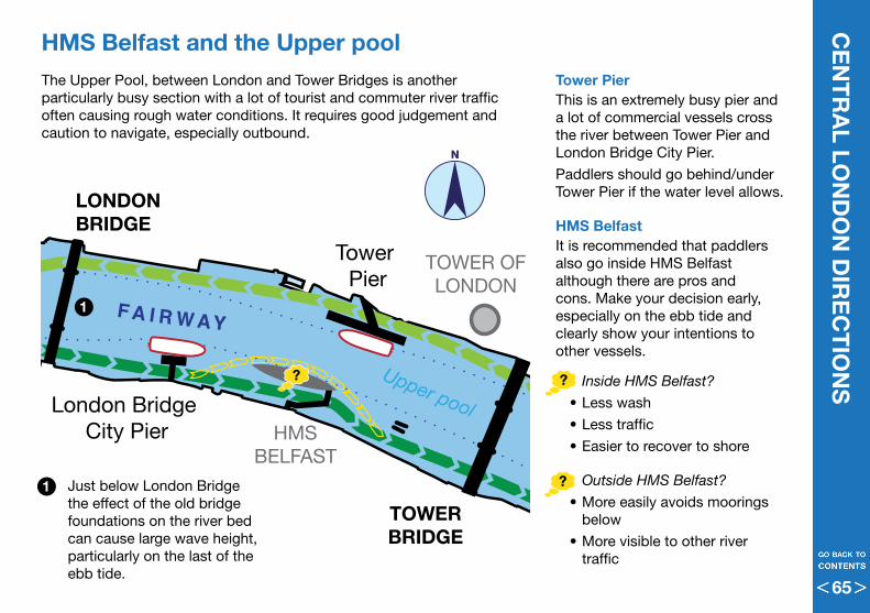
MILLENNIUMBRIDGE
TOWER OFLONDON
HMSBELFAST
LONDONEYE
WESTMINSTERPALACE
ST. KATHARINE’SDOCK
ST. PAUL’S CATHEDRAL
(70m Exclusion Zone)
FAI R
WA
Y
F A I R W AY
F A I R W AY
F A I R W AY
Lam
bet
h
reac
h
Kings reachKings reach
Upper pool
Tower Pier
London Bridge City Pier
Bankside Pier
Blackfriars Pier
Westminster Pier
Embankment Pier
Waterloo Pier
Festival Pier
TOWERBRIDGE
LONDONBRIDGE
SOUTHWARKBRIDGE
CHARING CROSS (HUNGERFORD) RAIL BRIDGE
CANNONSTREET
RAIL BRIDGE
WATERLOO BRIDGE
WESTMINSTER BRIDGE
BLACKFRIARS RAIL BRIDGEBLACKFRIARS
BRIDGE
CE
NT
RA
L LON
DO
N D
IRE
CT
ION
SHMS Belfast and the Upper pool
Tower Pier This is an extremely busy pier and a lot of commercial vessels cross the river between Tower Pier and London Bridge City Pier .
Paddlers should go behind/under Tower Pier if the water level allows .
HMS BelfastIt is recommended that paddlers also go inside HMS Belfast although there are pros and cons . Make your decision early, especially on the ebb tide and clearly show your intentions to other vessels .
• Inside HMS Belfast?
•Less wash
•Less traffic
•Easier to recover to shore
• Outside HMS Belfast?
•More easily avoids moorings below
•More visible to other river traffic
The Upper Pool, between London and Tower Bridges is another particularly busy section with a lot of tourist and commuter river traffic often causing rough water conditions . It requires good judgement and caution to navigate, especially outbound .
• Just below London Bridge the effect of the old bridge foundations on the river bed can cause large wave height, particularly on the last of the ebb tide .
1
1
N
65
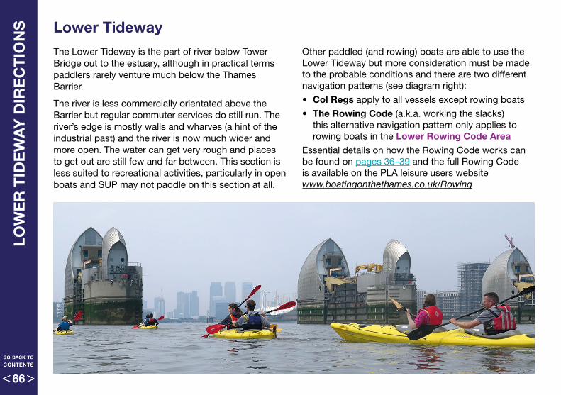
LOW
ER
TID
EW
AY
DIR
EC
TIO
NS
Lower TidewayThe Lower Tideway is the part of river below Tower Bridge out to the estuary, although in practical terms paddlers rarely venture much below the Thames Barrier .
The river is less commercially orientated above the Barrier but regular commuter services do still run . The river’s edge is mostly walls and wharves (a hint of the industrial past) and the river is now much wider and more open . The water can get very rough and places to get out are still few and far between . This section is less suited to recreational activities, particularly in open boats and SUP may not paddle on this section at all .
Other paddled (and rowing) boats are able to use the Lower Tideway but more consideration must be made to the probable conditions and there are two different navigation patterns (see diagram right):
• Col Regs apply to all vessels except rowing boats
• The Rowing Code (a .k .a . working the slacks) this alternative navigation pattern only applies to rowing boats in the Lower Rowing Code Area
Essential details on how the Rowing Code works can be found on pages 36–39 and the full Rowing Code is available on the PLA leisure users website www.boatingonthethames.co.uk/Rowing
66
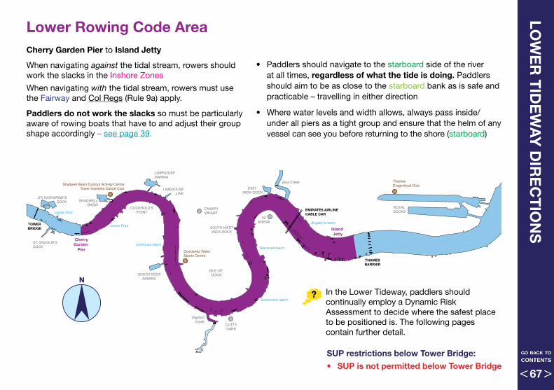
LOW
ER
TID
EW
AY
DIR
EC
TIO
NS
SUP restrictions below Tower Bridge:
• SUP is not permitted below Tower Bridge
Lower Rowing Code AreaCherry Garden Pier to Island Jetty
When navigating against the tidal stream, rowers should work the slacks in the Inshore Zones
When navigating with the tidal stream, rowers must use the Fairway and Col Regs (Rule 9a) apply .
Paddlers do not work the slacks so must be particularly aware of rowing boats that have to and adjust their group shape accordingly – see page 39 .
• Paddlers should navigate to the starboard side of the river at all times, regardless of what the tide is doing . Paddlers should aim to be as close to the starboard bank as is safe and practicable – travelling in either direction
• Where water levels and width allows, always pass inside/under all piers as a tight group and ensure that the helm of any vessel can see you before returning to the shore (starboard)
N
Shadwell Basin Outdoor Activity CentreTower Hamletts Canoe Club
Docklands WaterSports Centre
Thames Dragonboat Club
02ARENA
CANARYWHARF
CUTTYSARK
CUCKHOLD’SPOINT
ISLE OF DOGS
Lower Pool
Upper Pool
Limhouse reachBlackwall reach
Bugsby’s reach
Greenwich reach
LIMEHOUSE MARINA
LIMEHOUSELINK
ST. KATHARINE’SDOCK
ST. SAVIOUR’SDOCK
ROYALDOCKS
EAST INDIA DOCK
SOUTH WESTINDIA DOCK
SOUTH DOCKMARINA
SHADWELLBASIN
Bow Creek
DepfordCreek
CherryGarden
Pier
Island Jetty
THAMESBARRIER
TOWERBRIDGE
EMIRATES AIRLINECABLE CAR
In the Lower Tideway, paddlers should continually employ a Dynamic Risk Assessment to decide where the safest place to be positioned is . The following pages contain further detail .
67
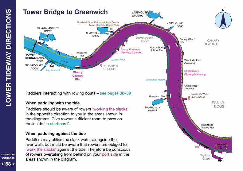
Shadwell Basin Outdoor Activity CentreTower Hamletts Canoe Club
Docklands WaterSports Centre
D
D
D
D
D
ST. MARY’SCHURCH
02ARENA
CANARYWHARF
CUTTY SARK
CUCKHOLD’SPOINT
ISLE OF DOGS
Lower Pool
Upper Pool
Limhouse reach
Blackwall reach
Bugsby’s reach
Greenwich reach
LIMEHOUSE MARINA
LIMEHOUSELINK
ST. KATHARINE’SDOCK
ST. SAVIOUR’SDOCK
South WestIndia Dock
East India Dock
SOUTH DOCKMARINA
SHADWELLBASIN
Bow Creek
DepfordCreek
Greenland Pier
Canary Wharf Pier
Nelson Dock(Hilton) Pier
Greenwich Pier
Masthouse Terrace Pier
North Greenwich
Pier
Trinity Jubilee Pier
WappingPier
Cherry Garden
Pier
Island Jetty
West India Pier(Seacons)
Butler’sWharf
Greenwich Ship Tier
Chalkstones Moorings
London YardMoorings
Follyhouse Barge Roads
Follyhouse(Rowing) Crossing
Blackwall(Rowing) Crossing
Chalkstones(Rowing) Crossing
Surrey Entrance (Rowing) Crossing
FA I R WAY
FAI R
WA
Y
F A I R W AY
FA I RWAY
FA I R WAY
FA I R WAY
THAMESBARRIER
TOWERBRIDGE
EMIRATES AIRLINECABLE CAR
Tower Bridge to GreenwichLO
WE
R T
IDE
WA
Y D
IRE
CT
ION
S
N
Paddlers interacting with rowing boats – see pages 38–39
When paddling with the tide
Paddlers should be aware of rowers ‘working the slacks’ in the opposite direction to you in the areas shown in the diagrams . Give rowers sufficient room to pass on the inside ‘to starboard’ .
When paddling against the tide
Paddlers may utilise the slack water alongside the river walls but must be aware that rowers are obliged to ‘work the slacks’ against the tide . Therefore be conscious of rowers overtaking from behind on your port side in the areas shown in the diagram .
68
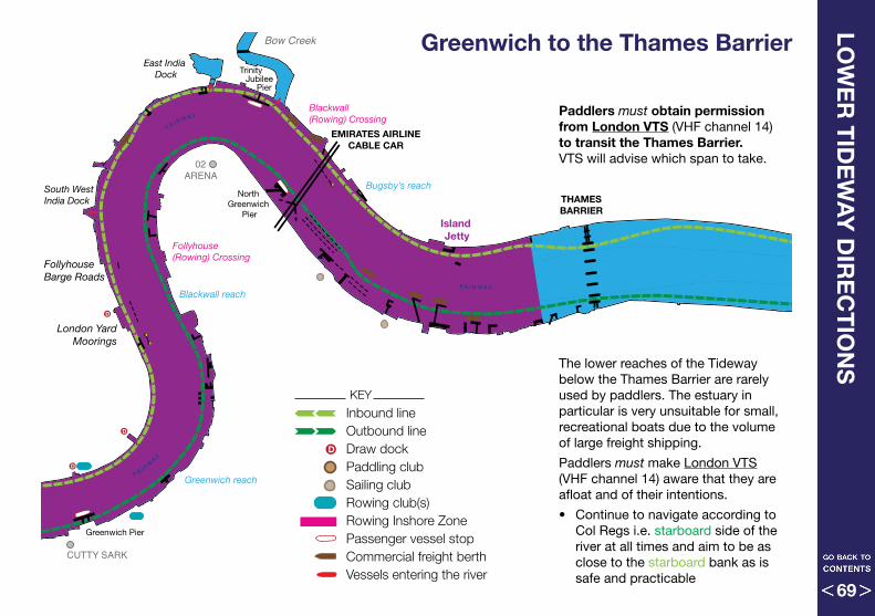
Shadwell Basin Outdoor Activity CentreTower Hamletts Canoe Club
Docklands WaterSports Centre
D
D
D
D
D
ST. MARY’SCHURCH
02ARENA
CANARYWHARF
CUTTY SARK
CUCKHOLD’SPOINT
ISLE OF DOGS
Lower Pool
Upper Pool
Limhouse reach
Blackwall reach
Bugsby’s reach
Greenwich reach
LIMEHOUSE MARINA
LIMEHOUSELINK
ST. KATHARINE’SDOCK
ST. SAVIOUR’SDOCK
South WestIndia Dock
East India Dock
SOUTH DOCKMARINA
SHADWELLBASIN
Bow Creek
DepfordCreek
Greenland Pier
Canary Wharf Pier
Nelson Dock(Hilton) Pier
Greenwich Pier
Masthouse Terrace Pier
North Greenwich
Pier
Trinity Jubilee Pier
WappingPier
Cherry Garden
Pier
Island Jetty
West India Pier(Seacons)
Butler’sWharf
Greenwich Ship Tier
Chalkstones Moorings
London YardMoorings
Follyhouse Barge Roads
Follyhouse(Rowing) Crossing
Blackwall(Rowing) Crossing
Chalkstones(Rowing) Crossing
Surrey Entrance (Rowing) Crossing
FA I R WAY
FAI R
WA
Y
F A I R W AY
FA I RWAY
FA I R WAY
FA I R WAY
THAMESBARRIER
TOWERBRIDGE
EMIRATES AIRLINECABLE CAR
Greenwich to the Thames BarrierLO
WE
R T
IDE
WA
Y D
IRE
CT
ION
S
Paddlers must obtain permission from London VTS (VHF channel 14) to transit the Thames Barrier . VTS will advise which span to take .
The lower reaches of the Tideway below the Thames Barrier are rarely used by paddlers . The estuary in particular is very unsuitable for small, recreational boats due to the volume of large freight shipping .
Paddlers must make London VTS (VHF channel 14) aware that they are afloat and of their intentions .
• Continue to navigate according to Col Regs i .e . starboard side of the river at all times and aim to be as close to the starboard bank as is safe and practicable
KEY
Inbound lineOutbound lineDraw dockPaddling clubSailing clubRowing club(s)Rowing Inshore ZonePassenger vessel stopCommercial freight berthVessels entering the river
D
69
The Port of London Authority (PLA)London River House, Royal Pier Road, Gravesend, Kent DA12 2BG
Head Office: 020 7743 7909 Richmond Lock: 020 8940 0634
www.boatingonthethames.co.uk www.pla.co.uk
London Vessel Traffic Services (VTS)Telephone 020 8855 0315
RNLI Chiswick www.chiswicklifeboat.org.ukTower www.towerrnli.moonfruit.com
British Canoeing www.britishcanoeing.org.uk
Great Britain Outrigger Canoe Association www.gboca.org
Thames Regional Rowing Council (TRRC)www.thames-rrc.org
Thames Waterwww.thameswater.co.uk
The Environment Agencywww.gov.uk/government/organisations/environment-agencywww.gov.uk/check-river-conditions-and-closures/river-thames
CO
NTA
CT
S
7070
We hope that you have found this guide useful and informative. If you have any further questions regarding the Paddling Code or have any queries or suggestions regarding anything in this document, please contact the PLA or British Canoeing. Additional copies are available from the PLA or you can download a pdf version from their website. See opposite for contact details and web addresses.
71

This booklet is a new publication by the PLA .
With thanks to the contributors to this the first (2017) edition:
Port of London Authority, British Canoeing, Great Britain Outrigger Canoe Association, London Kayak Company, Active360, British Dragon Boat Association, RNLI .
Original photography by PLA, Todd-White Art Photography, London Kayak Company, Active360, Neil Pickford, Ollie Harding .
Original illustrations by Neil Pickford (Tideway diagrams based on data supplied by PLA Hydrographic services)
Designed & typeset by Neil Pickford – neilpickford@mac .com
Printed by ft solutions – info@ftsolutions .co .uk
The publisher has made every effort to ensure the content is correct, but takes no responsibility for its accuracy . All information in this book was correct at the time of printing and all copyrights sought . Identification of any club or individual within the photographs used is coincidental and without agenda . No part of this document may be reproduced without permission . ©2017 All rights reserved
AC
KN
OW
LED
GE
ME
NT
S
7272