Embed Size (px)
Citation preview

WDS/DPFS & NWP_Report14, Annex II, p. 2
W O R L D M E T E O R O L O G I C A L O R G A N I Z A T I O N=====================================================
ANNUAL JOINT WMO TECHNICAL PROGRESS REPORT ON THE GLOBAL DATA-PROCESSING AND FORECASTING SYSTEM (GDPFS) INCLUDING NUMERICAL WEATHER
PREDICTION (NWP) RESEARCH ACTIVITIES FOR 2015
TABLE OF CONTENTS
Introduction
[National Contributions and/or Consortia]
1. Summary of highlights
- Consolidation of the ensemble Kalman filter based data assimilation algorithm (COMET-LETKF), operational since june 2011.
- Evaluation of performances, in terms of scores, of theatmospheric short-range ensemble prediction system (COSMO-ME EPS) based on COMET-LETKF analysis and COSMO model (pre-operational since july 2013)
- A new GRIB post-processing system (GRI.D2) is operational since 22nd may 2016
2. Equipment in use at the Centre GTS management:
Message Switching System (MSS):
o IBL Moving Weathero Computer type: cluster of 2 HP ProliantDL380g8o OS Red Hat Enterprise Linux 6.5
WIS (WMO Information System):DCPC (RTH function):
o IBL Discover Weathero Computer type: cluster of 2 HP Proliant DL380g8o OS Red Hat Enterprise Linux 6.5
DCPC (Mediterranean Data Collection & Production Centre for Marine Meteorology and Oceanografy):
o IBL Discover Weathero Computer type: cluster of 2 HP Proliant DL380g8o OS Red Hat Enterprise Linux 6.5
Data collecting and processing system:The data collecting and processing system consists of 2 main areas dedicated to perform specific tasks.
The first one is being used for filtering, collecting and processing data for daily operational activity. A 6 member Linux cluster is being used for this task. It is composed of
o 2 HP DL385G2 each with 2 processors (dual-core AMD Opteron 2218)o 4 HP DL380G5 each with 2 processors (dual-core Intel Xeon 5160)

WDS/DPFS & NWP_Report14, Annex II, p. 3
An additional Virtual Machine with 4vCPU and 16Gb vMem is being used on a VMware High Availability ESXi cluster.
The second one is being used for collecting weather data when they become aged for daily operational activity and are made available for climatological studies/requests. It’s a High Availability 2 member cluster (fail-over) LAMP platform based, composed of
o 2 HP DL585 G7 each with 2 processors (8-core AMD Opteron 2GHz)
with a 6 modular smart-array storage (each with 12 disk SATA 1 TB – 7200 RPM). The operating system in use is Red Hat Enterprise Linux Server release 6.3 (Santiago).
In addition, there are also 6 HP HPProliant DL140 - G3, 4 con 2 DualCore 2 con 2 QuadCore Intel Xeon
Since October 2009 a non-convetional observations collecting system is in pre-operational mode. The focus is to extend the number of observations provided to the data assimilation system. The equipment in use is composed of
o 1 HP Server with 2 Intel Xeon 5310 4 cores processors;
The operating system in use is Suse SLE 10.3 and the database is mysql.
An operative G.I.S. system is hosted on
o 2 HP Server with 2 Intel Xeon 5310 4 cores processors each;
A new G.I.S. project is in advanced development form and it is hosted on the Cloud System infrastructure as follow
o 1 Virtual Machine with 2 cores (AMD Opteron Processors 6234) and 8GB RAM. Role: web server
o 2 Virtual Machines with 8 cores (AMD Opteron Processors 6234) and 32 GB RAM each. Role: Base maps caching an Geo Processing Server
o 2 Virtual Machine with 8 cores (AMD Opteron Processors 6234) and 64 GB RAM each. Role: Map Server
o 1 Virtual Machine with 4 cores (AMD Opteron Processors 6234) and 24 GB RAM. Role: DB Server
A Weather Prediction Editing System (WePES) supporting various warning activities is operational since November of 2015 and it is hosted on the Cloud System infrastructure as follow:
o 1 Virtual Machines with 8 cores (AMD Opteron Processors 6234) and 4 GB RAM.
GRIDDED data collecting system:
The task is accomplished by a software application named GRI.D2 ( GRIB DISTRIBUTION). It works as a FRONT-END for GRIB format data file reception and as BACK-END for GRIB

WDS/DPFS & NWP_Report14, Annex II, p. 4
format data file processing and re-distribution to final users. The application is hosted on the Cloud System infrastructure as follow:
o 2 Virtual Machines with 24 cores (AMD Opteron Processors 6234) and 32 GB RAM each.
High Performance Computing Resources:
The current High Performance Computing Facility was released at the Italian Air Force Operational Centre for Meteorology (COMET, formerly managed by CNMCA, Italian Air Force National Centre for Meteorology and Climatology ) for operations in December 2009. The computing facility is a 194 nodes Hewlett Packard Linux Cluster arranged in three different groups; the first group consists of 128 nodes each of them with two quad-core Intel Harpertown 3.16 GHz onboard. The amount of volatile memory for a single node in this case is 8 GB. The second group consists of 64 dual-processor nodes with the 2.6 GHz AMD Opteron and in this case the amount of volatile memory is 4 GB, The third group is made up by two control nodes in High Availability configuration assisting the whole set of 192 computing nodes. The overall peak performance of the Computing Facility is 12,6 Teraflops.
Since November 2015 the ICT Support Squadron for Meteorology (G.S.I.M.) has been working to set up a new High Performance Computing Cluster (H.P.C.C.) named “RESIA”. RESIA H.P.C.C. will become operational in the second part of 2016.The cluster is composed by 51 DL380G9 computing nodes and 2 DL380G9 management nodes. Each computing node has an innovative hybrid CPU-GPU unit that consists of:- 2 CPU Intel E5-2680v3 2.5GHz with 12 cores;- 2 GPU NVIDIA K80 with 24GB of dedicated RAM;- 64GB RAM.Nevertheless, it has been planned an upgrade of the computing nodes number that will probably increase by the end of 2016. Moreover, it has also been planned a RAM upgrade: all computing nodes will be equipped with 128GB of RAM. Each management node consists of 2 CPU Intel XEON 5450 3.0GHz Quad-Core with 64GB RAM. Management nodes are in High Availability configuration and they assist the whole set of computing nodes.The overall peak performance of the RESIA H.P.C.C. is currently about 190 TFLOPS (290 TFLOPS with GPU software over boost) but this value is going to rise when the number of computing nodes will be increased and the RAM will be upgraded. With these improvements Italian Air Force has the will to make RESIA H.P.C.C. enter the Top500 list.The given performances are based only on those of the GPU part of the cluster (due to the fact that during the computation the CPU part of the computing nodes plays mainly a management role).It must be observed that Italy is one of the first countries which is taking advantage of the hybrid CPU-GPU technology for the elaboration of meteorological models. The best thing that comes from this hybrid technology is that it is possible to obtain peak performances with low energy consumption.Current activities are mainly devoted to the optimisation of the configuration of the cluster and to the initial tests of NWP models.
Graphics and numerical post-elaboration resources:6 nodes cluster:
2 nodes DL 385 G2, 4 cores AMD OPTERON 2218 2.6GHz (2 x 4 cores) and 8 GB RAM
4 nodes DL 380 G5, 4 cores INTEL XEON 5160 3GHz (4x4 cores) and 8 GB RAM
WDS/DPFS & NWP_Report14, Annex II, p. 5
Server for trajectories production with FLEXTRA software: 16 cores AMD socket2 2GHz and 16 GB RAM
3. Data and Products from GTS in useData received from GTS:
3. AIREP4. AMDAR5. BUOY6. PILOT7. SHIP8. SYNOP9. TEMP,TEMP-SHIP and 4D-TEMP10. PROFILER11. ACAR
BUFR from EUMETCAST network:
1. AMSU-A/MHS from NOAA/METOP2. NPPATMS from NPP3. AMV from EUMETSAT4. wind scatterometer from METOP 5. IASI retrivals
Local Area observations and MODE-S from private FTP server
GRIB from ECMWF : Global model, EPS model, Wave model
GRIB from ECMWF : Boundary Condition
4. Forecasting system
The operational short-range numerical forecasting system is composed of :
Ensemble Kalman Filter (EnKF) Data Assimilation System based on the COMET-LETKF algorithm and the High-resolution non-hydrostatic model COSMO integrated over the Mediterranean-European region (10km, 45 vertical levels);
High-resolution non-hydrostatic model COSMO-ME integrated over the Mediterranean-European region (7km, 40 vertical levels);
Very high-resolution non-hydrostatic model COSMO-IT integrated over the Italian region (2.8km resolution).
Along with the standard LETKF analysis, a control state LETKF (deterministic) analysis is computed using the standard Kalman gain and a control forecast, instead of the background ensemble mean. COSMO-ME is initialised by the control state of the Italian Air Force Operational Centre for Meteorology- COMETdata assimilation cycle and driven by IFS boundary conditions. COSMO-IT is nested into COSMO-ME.
4.1 System run schedule and forecast ranges
The schedule of the short range forecasting system, based on LETKF Analysis, is the following:
0000 UTC 0600 UTC 1200 UTC 1800 UTC

WDS/DPFS & NWP_Report14, Annex II, p. 6
Cut-off 2h 50m 2h 50m 2h 50m 2h 50m
LETKF analysis end 03.40 UTC 09.40 UTC 15.40 UTC 21.40 UTC
The high resolution forecasting system has the following schedule:
0000 UTC 0600 UTC 1200 UTC 1800 UTC
COSMO-ME range 72h 72h 72h 72h
COSMO-ME time step 60” 60” 60” 60”
COSMO-ME end 04.30 UTC 10.30 UTC 16.30 UTC 22.30 UTC
0000 UTC 1200 UTC
COSMO-IT range 24h 24h
COSMO-IT time step 25” 25”
COSMO-IT end 05.00 UTC 17.00 UTC
4.2 Medium range forecasting system (4-10 days)4.2.1 Data assimilation, objective analysis and initialization
4.2.1.1 In operationNone
4.2.1.2 Research performed in this field
No research performed in this field
4.2.2 Model
4.2.2.1 In operation
The ECMWF T1279L137 operational deterministic model is being used at COMET and CNMCA. Surface and upper air fields of the 00Z and 12Z runs are routinely downloaded via RMDCN on 0.5° horizontally spaced mesh for surface fields and on a 1.0° horizontally spaced mesh for upper air fields. An increase of the horizontal resolution is being considered and made operational before the end of 2010. The effective horizontal resolution will be determined considering all the data traffic made possible by the current available bandwidth. A bi-dimensional pictorial representation of such fields is being used for operational meteorological support worldwide within 80° N and 60°S. The same data are being used for text and pictorial representation for single site forecasts within the same area. All the upper air fields refer to pressure levels from 925 HPa up to 50 HPa. The time step between two following meteorological fields products issued is 6 hours from T+0h until T+168h and 12 hours between T+168h and T+240h. The possibility to reduce the time step to 3 hours is being considered and applied if allowed by the available bandwidth.
4.2.2.2 Research performed in this field
None

WDS/DPFS & NWP_Report14, Annex II, p. 7
4.2.3 Operationally available Numerical Weather Prediction (NWP) Products
The following field parameters are operationally available. Most of them are pictorially represented in the form of statically produced bidimensionallat-lon maps while some are published via G.I.S. services
ECMWF T1279L137 deterministic atmospheric model from 00Z and 12Z runs:
Analysis products
Surface parameters:1. Mean sea level pressure;2. 10 meters wind;3. 2 meters temperature;4. 2 meters dew point.
Upper Air parameters:1. Geopotential Height at 1000 HPa, 925 HPa, 850 HPa, 700 HPa, 500 HPa,300 HPa;2. Temperature at 1000 HPa, 925 HPa, 850 HPa, 700 HPa, 500 HPa,300 HPa;3. Vertical Velocity at 700 HPa;4. Vorticity at 500 HPa;5. Potential Vorticity at 300 HPa.
Forecast products
Surface parameters:1. 6 hours integrated total and convective precipitation;2. 12 hours integrated total and convective precipitation;3. 2 meters air temperature;4. 2 meters max air temperature in the last 6 hour period;5. 2 meters min temperature in the last 6 hours period;6. 2 meters dew point temperature;7. Mean sea level pressure;8. Surface Pressure;9. Weather impacts on specific activities determined by threshold values set on meteorological impact parameters;10. Vertical Velocity at 700 HPa;11. 10 meters wind;12. Total cloud cover, Low cloud cover, High cloud cover, Medium cloud cover;13. 10 meters wind max gust;14. Cloud base height;15. Composite cloud;16. 6h integrated total snow precipitation;
Upper air parameters:1. Geopotential height at 1000 HPa, 925 HPa, 850 HPa, 700 HPa, 500 HPa, 300 HPa;2. Temperature at 1000 HPa, 925 HPa, 850 HPa, 700 HPa, 500 HPa, 300 HPa;3. Wind at 1000 HPa, 925 HPa, 850 HPa, 700 HPa, 500 HPa, 300 HPa;4. Relative Humidity at 1000 HPa, 925 HPa, 850 HPa, 700 HPa, 500 HPa, 300 HPa;5. Wet bulb potential temperature at 850 HPa;6. Vorticity at 500 HPa;7. Isoentropic potential vorticity IPV = 2 at 300 HPa;8. Dynamic tropopause;9. Freezing level;

WDS/DPFS & NWP_Report14, Annex II, p. 8
10. Wind 200 hpa;ECMWF TCO1279L137 deterministic atmospheric model from 00Z and 12Z runs:Currently under tests for the operational implementation
ECMWF WAMwave model from 00Z and 12Z runs:
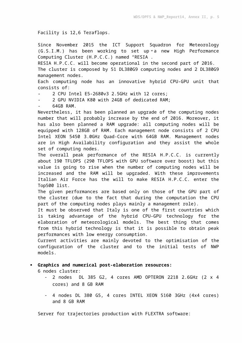
Forecast Products:
1. Significant wave height;2. Mean direction of significant wave height;3. Mean period of significant wave height;4. Sea state.
Fig.1 Example of pictorial representation of 6 hours time interval integrated precipitation from ECMWF T1279L137 operational model.
4.2.4 Operational techniques for application of NWP products (MOS, PPM, KF, Expert Systems, etc.)4.2.4.1 In operationNone
4.2.4.2 Research performed in this field
None

WDS/DPFS & NWP_Report14, Annex II, p. 9
4.2.5 Ensemble Prediction System (EPS) (Number of members, initial state, perturbation method, model(s) and number of models used, number of levels, main physics used,perturbation of physics, post-processing: calculation of indices, clustering)4.2.5.1 In operation
None
4.2.5.2 Research performed in this field
Use of ECMWF EPS system.
4.2.5.3 Operationally available EPS Products
Products and maps from ECMWF EPS, like EPSgrams, probability maps and plumes.
4.3 Short-range forecasting system (0-72 hrs)4.3.1 Data assimilation, objective analysis and initialization
4.3.2.1 In operationThe operational data assimilation cycle (Bonavita, Torrisi and Marcucci, Q.J.R.M.S. 2008, 2010) is based on the Ensemble Kalman Filter (EnKF) approach, in particular the LETKF version (Hunt et al.2007) has been chosen. The COMET-LETKF data assimilation is running on the Mediterranean-European domain with 40 ensemble members plus a deterministic run, having a 0.09° grid spacing (10 km) and 45 vertical levels. The control state LETKF analysis is computed using the standard Kalman gain and a control run, instead of the background ensemble mean. The COSMO-ME deterministic run is initialized from the LETKF control state analysis.
Temperature, wind and specific humidity on model levels and surface pressure are provided as analysis fields.
The main characteristics of the operational atmospheric data assimilation system are reported in the following table:
Assimilated obs. SYNOP, SHIP, BUOY, RAOB (also 4D), , SHIP, PILOT, WIND-PROFILER/RADAR, AIREP, AMDAR, ACAR, MSG3-MET7 AMV, MetopA-B scatt. winds, NOAA-Metop A-BAMSUA/MHS and NPP ATMS radiances
Assimilation cycle 6 hours
Analysis method LETKF
First guess 6 hours COSMO forecasts
Coverage Mediterranean European region (Fig)
Horizontal resolution 0.09 ° x 0.09 °
Vertical resolution 45 model levels
Model and sampling error “Relaxation-to-prior spread”multiplicative inflation method according to Whitaker et al. 2010
WDS/DPFS & NWP_Report14, Annex II, p. 10
Additive noise from scaled ECMWF EPS pertubations
Lateral and surface BCs perturbation
Lateral Boundary conditions from the most recent IFS deterministic run perturbed using ECMWF EPS
Climatologically perturbed SST
A 3 hourly intermittent data assimilation cycle using a multivariate three dimensional variational scheme (3D-VAR) – physical space analysis system (PSAS) with first guess at right time (FGAT) (Bonavita and Torrisi, Meteorol. Atmos. Phys. 8, 2005) and 1.5 h cutoff is mainly run to support the synoptic production of weather rooms (Euro Atlantic maps, etc). Temperature, wind and specific humidity on 45 model levels and surface pressure are provided on the Euro-Atlantic domain (14 km, Fig.1).
The main characteristics of the 3DVAR atmospheric data assimilation system are reported in the following table:
Assimilated obs. SYNOP, SHIP, BUOY, RAOB (also 4D), SHIP, PILOT, WIND-PROFILER/RADAR, AIREP, AMDAR, ACAR, MSG3-MET7 AMV, MetopA-B scatter. winds and AMSU-A radiances.
Assimilation cycle 3 hours
Analysis method 3D Multivariate FGAT PSAS analysis
First guess 3 hours COSMO forecasts
Coverage Euro-Atlantic area
Horizontal resolution 0.125° x 0.125°
Vertical resolution 45 model levels
The IFS snow analysis masked with the snow LAND-SAF product along with the IFS sea surface temperature are used once a day.
4.3.2.2 Research performed in this field
Recent developments are: Assimilation test of MODE-S, GPS zenith total delay ; Monitoring of non-GTS local surface observations; Monitoring of soil moisture product derived from the MetOp scatterometers (ASCAT) by HSAF; Forecast sensitivity to observation evaluation according to Kalnay et al. 2012; Evaluation of performance of the short-range ensemble prediction system based on the LETKF data assimilation system.
Current development activities comprise:
Further tuning of the operational LETKF setup and COSMO-ME EPS;
Continue investigation of model error representation (covariance localization, stochastic physics, bias correction, etc);
WDS/DPFS & NWP_Report14, Annex II, p. 11
Assimilation of soil moisture in the LETKF system.
4.3.2 Model4.3.2.1 In operation
Non-Hydrostatic ModelingThe non-hydrostatic modelling area is based on a COSMO model. COSMO-ME is integrated over the Euro-Mediterranean area with a 7km grid spacing (fig. 2) and 40 vertical levels using COMET-LETKF control analysis as initial state and IFS forecast fields as lateral boundary conditions. The main features of the operational implementations of the COSMO-ME are summarized in the following table:
COSMO-ME
Domain size 779x 401
Grid spacing 0.0625° (7km)
Number of layers / top 40 / 22 Km
Time step and integration scheme 60 sec Runge-kutta HE-VI time-splitting
Forecast range 72 hrs
Initial time of model run 00/06/12/18 UTC
Lateral boundary conditions IFS
L.B.C. update frequency 3 hrs
Initial state COMET-LETKFcontrol state analysis
Initialization None
External analysis snow cover,SST
Special features Filtered topography
Status Operational
Hardware HP Cluster Linux (COMET)/ CRAY (ECMWF)
COSMO-IT is the very high resolution configuration of COSMO Model integrated over the Italian domain (Fig.3) using COSMO-ME fields as boundary conditions.
COSMO-IT
Domain size 542x 604
Grid spacing 0.025° (2.8 km)
Number of layers / top 65 / 22 Km
Time step and integration scheme 25 sec Runge-KuttaHE-VI time-splitting

WDS/DPFS & NWP_Report14, Annex II, p. 12
Forecast range 24 hrs
Initial time of model run 00/06/12/18 UTC
Lateral boundary conditions COSMO-ME
L.B.C. update frequency 1 h
Initial state Nudging
Initialization None
External analysis None
Special features Filtered topography
Status Operational
Hardware HP Cluster Linux (COMET)/CRAY (ECMWF)
Fig. 2: Integration domain for the COSMO-ME non-hydrostatic model implementation.
4.3.2.2 Research performed in this field
test of new physical parameterizations (e.g. marine surface layer) in COSMO models;
test of COSMO-IT rapid update cycle;deterministic post-processing of COSMO-IT fields;reduction of COSMO-ME grid spacing to 5km and of COSMO-IT grid spacing to
1.6km
COSMO-ME - COMET

WDS/DPFS & NWP_Report14, Annex II, p. 13
Fig. 3: Integration domain for the COSMO-IT non-hydrostatic model implementation.
4.3.3 Operationally available NWP productsPrognostic variables on model levels:Temperature, specific humidity, zonal and meridional wind component, vertical wind component,cloud water content, cloud ice content, water content of rain and snow, surface pressure , pressure perturbation, turbulent kinetic energy.
Prognostic surface fields:Temperature, water content and ice content of soil layers, temperature of snow surface, snow density, water content of snow and interception store.
Diagnostic fields:2m temperature, 2m dew point, 10m wind components, mean sea level pressure, total precipitation, synthetic satellite radiances (COSMO), and so on.
A detailed list of numerical weather products available is given below:
COSMO-ME not-hydrostatic deterministic atmospheric model from 00Z and 12Z runs:
Analysis Products:
Surface parameters:
COSMO-IT COMET

WDS/DPFS & NWP_Report14, Annex II, p. 14
1. Mean sea level pressure;2. 2 meters temperature;3. 2 meters dew point temperature;4. 10 meters wind;
Upper air parameters:1. Geopotential height at 1000 HPa, 925 HPa, 850 HPa, 700 HPa, 500
HPa, 300 HPa, 200 HPa, 100 HPa;2. Air temperature at 1000 HPa, 925 HPa, 850 HPa, 700 HPa, 500 HPa,
300 HPa, 200 HPa, 100 HPa;3. Horizontal wind at 1000 HPa, 925 HPa, 850 HPa, 700 HPa, 500 HPa,
300 HPa, 200 HPa, 100 HPa;4. Rel Humidity at 1000 HPa, 925 HPa, 850 HPa, 700 HPa, 500 HPa, 300
HPa, 200 HPa, 100 HPa.
Forecast Products:
Surface parameters:1. Mean sea level pressure;2. 2 meters air temperature;3. 2 meters max and min air temperature;4. 2 meters dew point temperature;5. 10 meters wind;6. 10 meters max gust;7. Total cloud cover, low cloud cover, medium cloud cover, high cloud
cover;8. Base height and top height of convective clouds;9. 6-hours integrated precipitation;10. 6-hours convective precipitation;11. 2 meters relative humidity;12. Composite cloud;13. Convection available potential energy;14. 3-hours integrated precipitation;15. 12-hours integrated precipitation;16. 3-hours integrated snow precipitation;17. 6-hours integrated snow precipitation;18. Supercell index;19. 2 meters air temperature – 24h trend;20. 2 meters max air temperature variation in 48h.
Upper air parameters:1. Geopotential height at 1000 HPa, 925 HPa, 850 HPa, 700 HPa, 500
HPa, 300 HPa, 200 HPa, 100 HPa.2. Air temperature at 1000 HPa, 925 HPa, 850 HPa, 700 HPa, 500 HPa,
300 HPa, 200 HPa, 100 HPa.3. Wind at 1000 HPa, 925 HPa, 850 HPa, 700 HPa, 500 HPa, 300 HPa,
200 HPa, 100 HPa.4. Relative Humidity at 1000 HPa, 925 HPa, 850 HPa, 700 HPa, 500 HPa,
300 HPa, 200 HPa, 100 HPa.5. Freezing level
COSMO-IT not-hydrostatic deterministic atmospheric model from 00Z and 12Z

WDS/DPFS & NWP_Report14, Annex II, p. 15
runs:
Analysis Products:
1. Convention available potential Energy2. Supercell index
Forecast Products:
1. Convention available potential Energy2. Supercell index3. 3-hours integrated precipitation4. 6-hours integrated precipitation5. 10 meters wind6. 10 meters max wind 1h
VERTICAL PROFILES.
Fig. 4: Example of Vertical profile product from COSMO-ME model fieldsA new pictorial representation of vertical profiles has been developed, validated and made operational since summer 2009. In this context an Herloffson diagram is being operationally used. It is an exact digital replica of the paper version used in the past by the Italian Met Service personnel to plot upper air observations. It is used both for observations and forecasts plotting.

WDS/DPFS & NWP_Report14, Annex II, p. 16
METGRAMS.
Fig. 5: Example of a meteogram product fromCOSMO-ME model fields
A massive production of metgrams is being operational at the Italian Met Service. Every day more than 3000 metgrams are being produced and delivered to final users on the Italian Air Force web site via “http” and “ftp” protocols. A thematic criteria is used to produce different kind of metgrams. Aeronautical metgrams are conceived for example in terms of a set of meteorological parameters specific for aeronautical use like ceiling and top of convective clouds, convective and large scale precipitation discriminating rain from snow, low, medium and high cloud coverage, mean sea level pressure and QNH. General purpose metgrams are instead conceived in terms of more general meteorological parameters such as mean sea level pressure, 2m temperature, 2m relative humidity, 10 m horizontal wind. Besides new thematic metgrams are being developed. Among them it is important to point out the “transport theme”which will include all the meteorological parameters related to surface transports (railways, highways, and maritime routing).
SYNTHETIC SATELLITE IMAGES
A process-based modelling approach is used to generate synthetic satellite images from COSMO-ME outputs. The method is based on the radiative transfer model code RTTOV (currently parallelized code of version 10.2 is used) (Fig.6).
AWI
A deterministic post-processing package of the COSMO-ME model fields known as Automatic Weather Interpretation (AWI) is in use at COMET and CNMCA. A series of multi-parameter decisional tree allows the determination of weather phenomena (drizzle, rain, snow, thunderstorms, fog, etc.) as well as of the cloud type, the risk of icing, strong wind or heat waves. Details are given in Ciciulla (Workshop on Statistical and Dynamical Adaptation, 5–6 May 2003, Wien, http://srnwp.met.hu/). An example of AWI product (referring to significant weather phaenomena) is given

WDS/DPFS & NWP_Report14, Annex II, p. 17
in Fig. 7. An improvement of the algorithms used in AWI is currently being developed. Current work is focused on the improvement of thealgorithms used in AWI.
Fig. 6: Example of a synthetic satellite simulated image usingCOSMO-ME model outputs
Fig. 7: Example of AWI product from post-processed COSMO-ME model fields.LOCAL FORECASTS.
The full set of weather parameters from COSMO-ME model and derived variables from Automated Weather Interpreter is daily being retrieved for a collection of about 1200 sites and then encoded both in extended SYNOP-like message and XML

WDS/DPFS & NWP_Report14, Annex II, p. 18
format for further applications.
REGIONAL FORECASTS.
As the reader may be aware, the Italian territory is divided into 20 regional bodies called “Regioni” from the administrative point of view. For these bodies a specific weather forecast at COMET is daily being prepared and issued 24/7 twice a day. To prepare these product the forecaster is presented a synthetic icon representation inferred from the single point forecasts related to all the grid points pertaining each region up to 48 hours. At each point a set of weather parameters is taken from COSMO-ME model and the weather phenomena insisting on that point is inferred through the set of AWI post-processing algorithms. The synthetic icon representation and its spatial range representativeness is performed by an algorithm set up in cooperation with operational forecasters.
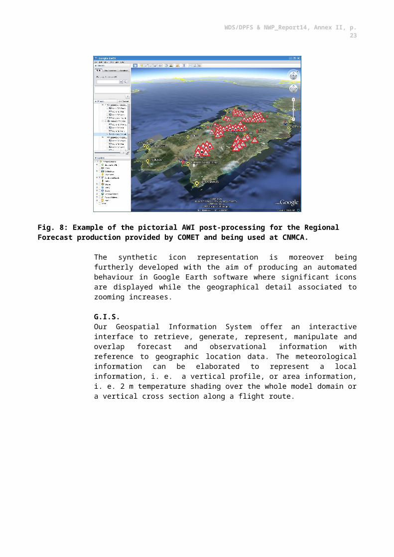
Fig. 8: Example of the pictorial AWI post-processing for the Regional Forecast production provided by COMET and being used at CNMCA.
The synthetic icon representation is moreover being furtherly developed with the aim of producing an automated behaviour in Google Earth software where significant icons are displayed while the geographical detail associated to zooming increases.
G.I.S.Our Geospatial Information System offer an interactive interface to retrieve, generate, represent, manipulate and overlap forecast and observational information with reference to geographic location data. The meteorological information can be elaborated to represent a local information, i. e. a vertical profile, or area information, i. e. 2 m temperature shading over the whole model domain or a vertical cross section along a flight route.

WDS/DPFS & NWP_Report14, Annex II, p. 19
Fig. 9: A snapshot of the G.I.S. Interface at COMET with point and area data overlapped
Fig. 10: Example of a vertical cross section along a flight route dynamically produced by the means of the G.I.S. system being used at COMET.

WDS/DPFS & NWP_Report14, Annex II, p. 20
WEATHER WARNINGS AND FORECAST REPORTS
COMET is responsible to provide meteorological watch for general aviation purposes over the Flight Information Regions (FIRs) of competence, as well as weather watch for sea basins surrounding Italy; in that respect, based on nowcasting and model products described above and below in this document, specific task is the issue of the following contents when needed:
• Sigmets;• Volcanic Ash Sigmets; • Airmets;• Aerodrome Warnings;• Terminal Aerodrome Forecasts,and • Gale Warnings; • Weather Forecasts over Mediterranean Sea;
WePES system is the web-based operational workstation available for COMET and CNMCA forecasters. Specific tools has been designed to cover all the operational meteorological content of information required, generating both graphicformats as well as alphanumeric formats. Tools has also been tailored for depicting Significant Weather Low Level Charts (SWLL), editing of alerts, warnings and weather forecast maps and messages even detailed atregional scale, provisions of severe weather warnings in the Meteoalarm framework.
A snapshot regarding WePES system and the editing activity for Rome FIR AIRMET warnings production.

WDS/DPFS & NWP_Report14, Annex II, p. 21
A snapshot regarding WePES system and the editing activity for SWLL prognostic charts required asAviation WeatherCentre.
4.3.4 Operational techniques for application of NWP products (MOS, PPM, KF, Expert Systems, etc..)4.3.4.1 In operation
None
4.3.4.2 Research performed in this field
Further progress is expected by the foreseen upgrade with MOS / Kalman Filter based algorithms.Currently a dependent regression algorithm is operational for about 50sites, using last 15 days of observations and deterministic forecasts as training dataset. The performance of the statistical algorithm with respect to the deterministic forecast is being investigated.

WDS/DPFS & NWP_Report14, Annex II, p. 22
4.3.5 Ensemble Prediction System (Number of members, initial state, perturbation method, model(s) and number of models used, perturbation of physics, post-processing: calculation of indices, clustering)4.3.5.1 In operation
The atmospheric short-range ensemble prediction system (COSMO-ME EPS) based on the COMET-LETKF analysis and the COSMO model is running operationally at COMET (pre-operational since July 2013). The relevant characteristics of the atmospheric COSMO-ME EPS are:• Domain and resolution: COSMO model is integrated 40 times on the same
domain of the COMET-LETKF system.
• IC and BC: initial conditions are derived from the COMET-LETKF system;lateral boundaries conditions are from the most recent IFS deterministic run perturbed using ECMWF-EPS.
• Model error: stochastics physics perturbation tendencies.
• Forecast range: 72 hours at 00/12 UTC.
4.3.5.2 Research performed in this field
A further work of calibration and tuning of the system is planned to release operationally a full set of probabilistic products from COSMO-ME EPS for most important towns.A convective resolving EPS system based on KENDA system and COSMO-IT model (COSMO-IT EPS) is under development in cooperation with ARPA-Emilia Romagna and ARPA Piemonte.
In the framework of EUMETNET SRNWP-EPS Phase II project, a tool for the probabilistic forecast of fog and thunderstorm is under development.
4.3.5.3 Operationally available EPS products
1. 2 x standard deviation 2m temperature2. 2 x standard deviation 10m wind3. 6h integrated total precipitation > 0.2 mm4. 6h integrated total precipitation > 10 mm5. 6h integrated total precipitation > 20 mm6. 6h integrated total precipitation > 30 mm7. 6h integrated total precipitation > 40 mm8. 24h integrated total precipitation > 100 mm9. 24h integrated total precipitation > 20 mm10. 24h integrated total precipitation > 40 mm11. 6h integrated total snow precipitation > 0.2 cm12. 6h integrated total snow precipitation > 10 cm13. 6h integrated total snow precipitation > 20 cm14. 6h integrated total snow precipitation > 5 cm15. 24h integrated total snow precipitation > 10 cm16. 24h integrated total snow precipitation > 20 cm17. 24h integrated total snow precipitation > 40 cm18. Max 2m temperature > 32°C19. Max 2m temperature > 35°C
WDS/DPFS & NWP_Report14, Annex II, p. 23
20. Max 2m temperature > 38°C21. Min 2m temperature < 5°C22. Min 2m temperature < 0°C23. Min 2m temperature < -5°C24. Min 2m temperature < -10°C25. Wind gust > 21 kt26. Wind gust > 33 kt27. Wind gust > 55 kt
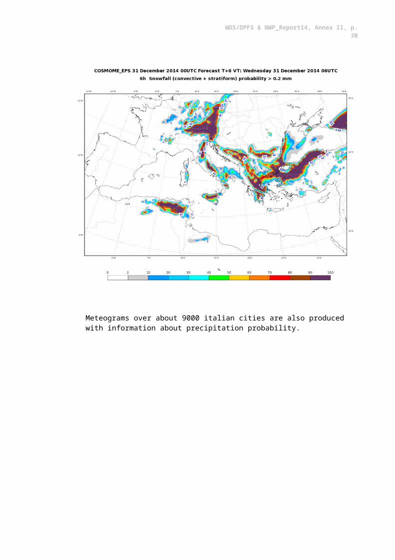
Meteograms over about 9000 italian cities are also produced with information about precipitation probability.

WDS/DPFS & NWP_Report14, Annex II, p. 24
4.4 Nowcasting and Very Short-range Forecasting Systems (0-12 hrs)4.4.1 Nowcasting system
The Nowcasting activities is based on the management of special observation retrieved from RADAR and LIGHTINING network and satellite data.
4.4.1.1 In operationRADAR system:
- SRI composite of radar data collected from the Italian Air force stations (Pisa, Grazzanise, Decimomannu, Capo Caccia), regional meteorological services, National Agency for Civil Aviation, National Department for Civil Protection and few foreign country sites (France, Switzerland, Slovenia) is produced every 10 minutes, as in figure.

WDS/DPFS & NWP_Report14, Annex II, p. 25
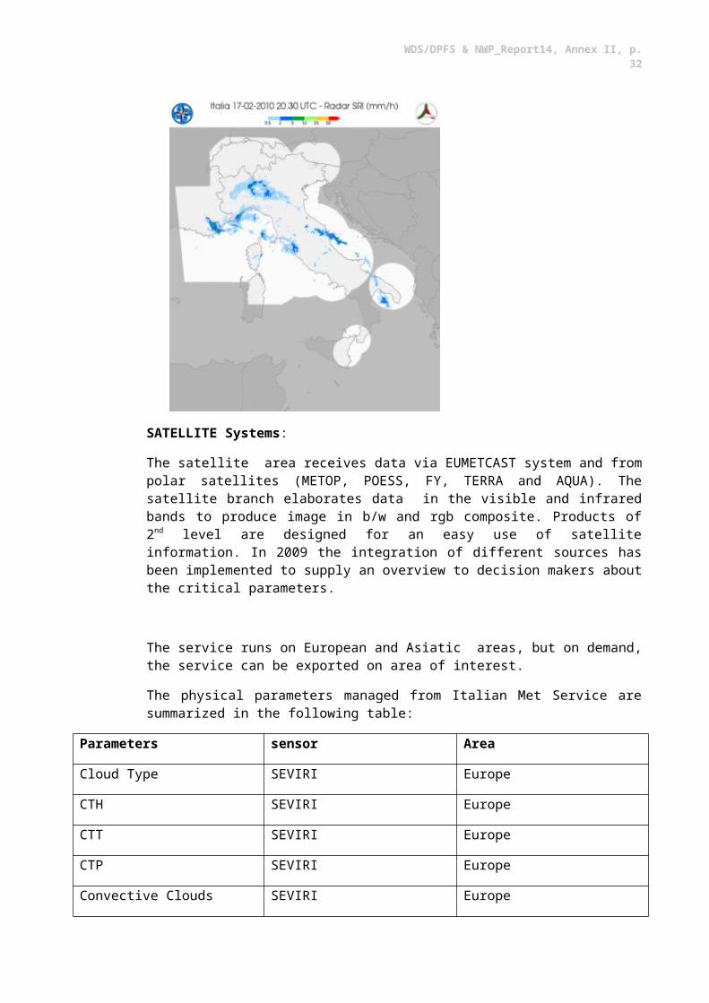
SATELLITE Systems:
The satellite area receives data via EUMETCAST system and from polar satellites (METOP, POESS, FY, TERRA and AQUA). The satellite branch elaborates data in the visible and infrared bands to produce image in b/w and rgb composite. Products of 2nd level are designed for an easy use of satellite information. In 2009 the integration of different sources has been implemented to supply an overview to decision makers about the critical parameters.
The service runs on European and Asiatic areas, but on demand, the service can be exported on area of interest.
The physical parameters managed from Italian Met Service are summarized in the following table:
Parameters sensor Area
Cloud Type SEVIRI Europe
CTH SEVIRI Europe
CTT SEVIRI Europe
CTP SEVIRI Europe
Convective Clouds SEVIRI Europe
LST SEVIRI Europe
SST SEVIRI Mediterranean
Rain Rate AMSU/DMSP Europe/
Accumulated Rain AMSU/DMSP/SEVIRI Europe

WDS/DPFS & NWP_Report14, Annex II, p. 26
Total Ozone SEVIRI Full Disk
Total Humidity SEVIRI Full Disk
AMV SEVIRI Italy
Sea Wind ASCAT/QuickScat Itally
Volcanic Asch SEVIRI/AVHRR Europe/Italy
Fire- probability of detection SEVIRI Italy
Example of infrared picture on European area.

WDS/DPFS & NWP_Report14, Annex II, p. 27
- Example of RGB picture on European area.
- Example of 2nd level product to recognize and very short range forecasts of stormy cells.

WDS/DPFS & NWP_Report14, Annex II, p. 28
- Example of INTEGRATED INFORMATION TO SUPPORT DECISION MAKERS. The pictures visualizes only the presence of parameters showed and the bottom of the figure. The image summarize a lot of parameters retrieved from different sources.
LIGHTNING DETECTION system:
Italian Air Force Operational Met Centre- COMEThas realized a national network for the location of electrical discharge, available every 5 minutes

WDS/DPFS & NWP_Report14, Annex II, p. 29
4.4.1.2 Research performed in this field
Note: please also complete the CBS/PWS questionnaire on Nowcasting Systems and Services, 2014)
In 2009 a comparison about lightning discharge and convection retrieved from satellite data is started. The study is a collaboration with SELEX-GALILEO in support to Lightning Imager for METEOSAT Third Generation.
4.4.2 Models for Very Short-range Forecasting Systems4.4.2.1 In operation
None
4.4.2.2 Research performed in this field
None
4.5 Specialized numerical predictions (on sea waves, storm surge, sea ice, marine pollution transport and weathering, tropical cyclones, air pollution transport and dispersion, solar ultraviolet (UV) radiation, air quality forecasting, smoke, sand and dust, etc.) The ECMWF T1279L137 fields referring to wind, relative humidity and temperature
are being used for NBC protection program. In the same program particle trajectories inferred from ECMWF EPS are used as well.
WDS/DPFS & NWP_Report14, Annex II, p. 30
The ECMWF T1279L137 wind speed, temperature and relative humidity fields are also used to infer heat index and windchill factor.
From DWD Global Model, UV forecasts are routinely downloaded in text format and pictorially represented within the framework of a population protection program.
In cooperation with CNR-ISMAR institute a sea state forecast system, named NETTUNO, has been implemented in 2008.In cooperation with INGV-Bologna a high-resolution oceanic model driven by COSMO-ME model is under development.
4.5.1 Assimilation of specific data, analysis and initialization (where applicable)4.5.1.1 In operationNone
4.5.1.2 Research performed in this field
None
4.5.2 Specific models (as appropriate related to 4.5)4.5.2.1 In operation
NETTUNO system is based on the ECMWF version of WAM model integrated over the whole Mediterranean basin which is driven by COSMO-ME forecast winds. It was developed in cooperation with the ISMAR-CNR institute of Venice.Forecast fields (mean wave period and direction, significant wave height) are given every 3 hrs up to 72 hrs.A brief summary of NETTUNO features is given in the following table:
Domain size 846X321
Grid spacing 0.05°
Time step 120 s
Forecast range 72 hrs
Initial time of model run 00/12 UTC
N° frequencies/directions 30/36
Atmospheric model wind COSMO-ME
Wind update frequency 1 hr
Initial state Previous run
Status Operational
Hardware HP Cluster Linux (COMET)/Cray (ECMWF)
A high resolution (1’) WAM model driven by COSMO-IT wind forecast and nested in the 3’ Nettuno is operational over the Italian domain.

WDS/DPFS & NWP_Report14, Annex II, p. 31
High resolution WAM (1’) driven by COSMO-IT forecast winds
4.5.2.2 Research performed in this field
A two-way coupling between the WAM and COSMO-ME model have been tested
in collaboration with ISMAR-CNR
4.5.3 Specific products operationally available None4.5.4 Operational techniques for application of specialized numerical prediction
products (MOS, PPM, KF, Expert Systems, etc.) (as appropriate related to 4.5)4.2.4.1 In operationNone
4.2.4.2 Research performed in this field
None
4.5.5 Probabilistic predictions (where applicable)4.5.5.1 In operationIn the framework of MyWAVE project a “sea state” EPS based on the NETTUNO
system (Bertotti and Cavaleri 2009) and the COSMO-ME EPS has been
implemented and tested in collaboration with ISMAR-CNR.
The sea state probabilistic forecast is obtained driving the wave model using the
hourly COSMO-ME EPS wind forecast members. The NETTUNO-EPS consists
of 40+1 members, that are integrated at 00 UTC up to 48 hour forecast in the
Mediterranean basin.
4.5.5.2 Research performed in this field
Improvement in this field are linked to the COSMO-ME EPS system progress.
4.5.5.3 Operationally available probabilistic prediction products
WDS/DPFS & NWP_Report14, Annex II, p. 32
Probability maps for sea state field at different threshold are produced.
4.6 Extended range forecasts (10 days to 30 days) (Models, Ensemble, Methodology)4.6.1 In operationNone4.6.2 Research performed in this fieldNone
4.6.3 Operationally available EPS productsNone
4.7 Long range forecasts (30 days up to two years) (Models, Ensemble, Methodology)
4.7.1 In operationNone
4.7.2 Research performed in this fieldNone
4.7.3 Operationally available productsNone
5. Verification of prognostic products
5.1 Annual verification summaryQuality Control of forecast products through the unified system named VERSUS (VERification System Unified Survey) based on RDBMS system and a web-based GUI are carried out routinely at COMET. The development of a complete Conditional and Standard Verification Tool has been the first priority and outcome of the VERSUS project exploited in the COSMO consortium framework (started in 2006 and currently in Project Phase 7).
From a more general point of view the main purpose of VERSUS is the systematic evaluation of model performances in order to reveal, in a way different from the usual classical verification tools, model weaknesses. It is able to provide information providing hints which could be the causes of model deficiencies that can usually be seen in the operational verification. The typical approach to Conditional Verification consist of the selection of one or several forecast products and one or several mask variables or conditions, which would be used to define for example thresholds for the product verification (e.g. verification of T2M only for grid points with zero cloud cover in model and observations). Through the development of VERSUS software a unified, flexible and customizable tool – able to perform operational standard verifications, operational conditional verifications along with experimental standard and conditional verifications, in batch and interactive mode – has been achieved.
Statistical scores and scores plots are routinely produced at COMET for the following NWP models, in operation at COMET: COSMO-ME, COSMO-I7, for both surface and upper air parameters; COSMO-IT and ECMWF, only for surface parameters.
The basic verified weather parameters for all the models are:

WDS/DPFS & NWP_Report14, Annex II, p. 33
2m temperature; 10m wind-speed and direction; 6h,12h,24h cumulated precipitation; MSLP; 2m dew point temperature; total cloud cover
along with forecasted upper air parameters:
temperature; geopotential; wind-speed and direction; relative humidity and/or dew point.
These datasets are regularly available every 3 hours (6 or 12 hours for upper-air) for all the Italian Meteorological stations. A set of stratifications in time are routinely performed as follows:
Monthly mean Quarterly mean Yearly mean (mainly for the calculation of a Global quality index)
The scores can be also morphologically (or geographically) stratified in coastal, valley and mountain stations or Northern, Central and Southern Italy, all over Italy and so on.
The scores produced for continuous variable are: Mean Error, Mean Absolute Error, Root Mean Squared Error and their respective Skill Scores for accuracy. As reference scores both persistence, random chance and climatology can be used.Scores produced for categorical events (e.g. precipitation) are computed from a 2x2 contingency table showing the frequency of “yes” and “no” forecasts and corresponding observation. These contingency tables can be computed for different thresholds values. There are a quite large number of measure that can come out from such a table and all of them can be computed through the use of VERSUS software. Among these: frequency bias, probability of detection, false alarm ratio, equitable threat score, odds ratio.
In the following figures some verification plots are shown as an example for COSMO-ME model 00UTC run, for 2m temperature and 12h cumulated precipitation fields for 2015
T_2m (ME, MAE, RMSE) and 12h-precipitation (FBI) on all Italian Stations DJF 2014-2015

WDS/DPFS & NWP_Report14, Annex II, p. 34
T_2m (ME, MAE, RMSE) and 12h-precipitation (FBI) on all Italian Stations MAM 2015
T_2m (ME, MAE, RMSE) and 12h-precipitation (FBI) on all Italian Stations JJA 2015
T_2m (ME, MAE, RMSE) and 12h-precipitation (FBI) on all Italian Stations SON 2015
An example of upper-air verifications for COSMO-ME model 00UTC run - SON 2015 quarter follows:

WDS/DPFS & NWP_Report14, Annex II, p. 35
5.2 Research performed in this field

WDS/DPFS & NWP_Report14, Annex II, p. 36
In its initial version, VERSUS was not intended to cover all the existing verification methods, as well as all the possible production from a NWP system, since the project started in 2006 and NWP models improved thereafter in resolution and complexity. Furthermore,at present not all types of observations can be processedin VERSUS software, for example satellite and radar observations. In more detail,the main open points and fields of research to be evaluated for possible inclusion in the future releases (from 2015 onwards) of VERSUS software are:
- probabilistic and ensemble forecasts verification;- obj-based (SAL methods) and fuzzy verification methods applied e.g. to precipitation;- new scores for extreme events (e.g. extreme dependency score);- ad hoc tailored user-oriented verification;- inclusion of statistical features like confidence intervals and bootstrap method;- use of non conventional observation datasets (e.g. radar, satellite, raingauges) and
gridded observations (precipitation analysis).
In parallel with the operational verification tasks, the research activities of the Italian Meteorological Service in this field are coordinated within the Working Group on “Verification and Case Studies” of the COSMO Consortium (http://www.cosmo-model.org/content/tasks/workGroups/wg5/default.htm).
6. Plans for the future (next 4 years)
6.1 Development of the GDPFS6.1.1 Major changes in the operational DPFS which are expected in the next year6.1.2 Major changes in the operational DPFS which are envisaged within the next 4
years6.2 Planned Research Activities in NWP, Nowcasting, Long-range Forecasting and
Specialized Numerical Predictions6.2.1 Planned Research Activities in NWPCalibration of theCOSMO-ME EPS short range ensemble prediction system.
Improvement of convection resolving model forecast up to 1km grid spacing.
6.2.2 Planned Research Activities in Nowcasting6.2.3 Planned Research Activities in Long-range Forecasting6.2.4 Planned Research Activities in Specialized Numerical Predictions
7. Consortium(if appropriate)
5.1 System and/or ModelThe COSMO Model (http://cosmo-model.org/content/model/general/default.htm) is a nonhydrostatic limited-area atmospheric prediction model. It has been designed for both operational numerical weather prediction (NWP) and various scientific applications on the meso-β and meso-γ scale. The COSMOModel is based on the primitive thermo-hydrodynamical equations describing compressible flow in a moist atmosphere. The model equations are formulated in rotated geographical coordinates and a generalized terrain following height coordinate. A variety of physical processes are taken into account by parameterization schemes.

WDS/DPFS & NWP_Report14, Annex II, p. 37
Besides the forecast model itself, a number of additional components such as data assimilation, interpolation of boundary conditions from a driving model, and postprocessing utilities are required to run the model in NWPmode, climate mode or for case studies.
5.210.1.1 In operation
Regional numerical weather prediction at COMETis entirely based on the COSMO Model. COSMO-ME (see sections 4.3.2) covers Europe with 779x401 grid points/layer at a grid spacing of 7 km and 40 layers, and the convection-resolving model COSMO-IT, covers Italy and its surroundings with a grid spacing of 2.8 km, 542x604 grid points/layer and 65 layers. Based on COSMO-ME, a probabilistic ensemble prediction system on the convective scale, called COSMO-ME-EPS, became operational with 40 EPS members on 2015. It is based on COSMO-ME with a grid spacing of 10 km, 577x347 grid points/layer and 45 layers. See also section 7.3 for COSMO members.
10.1.2 Research performed in this field
The joint research and development is mainly undertaken in the eight working groups (http://cosmo-model.org/content/consortium/structure.htm) and a number of priority projects and priority tasks. The current priority projects are: “Kilometre-Scale Ensemble-Based Data Assimilation for High-Resolution Observations” (KENDA-O), see section 7.4.1, “COSMO-EULAG Operationalization” (CELO) which aim is to get an operational version of COSMO model employing dynamical core with explicit conservative properties for very-high model resolutions, “Calibration of COSMO Model” (CALMO) which aims at development of automatic, multivariate and based on objective methods calibration of parameterizations of physical processes for the model, “Verification System Unified Survey 2” (VERSUS2) developing an operational verification package for deterministic and ensemble forecasting, “Performance On Massively Parallel Architectures” (POMPA) for preparation of the COSMO model code for running on future high performance computing systems and architectures, “Studying Perturbations for the Representation of modeling uncertainties in Ensemble Development” (SPRED) for improvement of convection-permitting ensembles, “Intercomparison of Spatial Verification Methods for COSMO Terrain” (INSPECT) tests and evaluates new spatial verification methods, “Revised Cloud Radiation Coupling” (T2(RC)2) focuses on improvement of optical properties of clouds and precipitation, “Comparison of the dynamical cores of ICON and COSMO” (CDIC). The current priority tasks include “Consolidation of Operation and Research Results for the Sochi Olimpic Games - A” (CORSO-A) for transferring to COSMO software and know-how results of the previous priority project CORSO. The priority task “Consolidation of Surface to Atmosphere Transfer” (ConSAT) aims at improving diurnal and annual cycles of near surface model variables. The new task “TERRA Stand Alone” (TSA) brings the code of TERRA Stand Alone to the COSMO standards Environmental prediction aspects of the model involving chemistry, aerosol effects and transport (COSMO ART) are developed in close cooperation with Karlsruhe Institute for Technology (KIT) in Germany.
10.2 System run schedule and forecast ranges
See section 4.3.2 for COSMO-ME and COSMO-IT
10.3 List of countries participating in the ConsortiumCOSMO stands for COnsortium for Small-scale MOdelling. The general goal of COSMO is to develop, improve and maintain a non-hydrostatic limited-area

WDS/DPFS & NWP_Report14, Annex II, p. 38
atmospheric model, the COSMOmodel, which is used both for operational and for research applications by the members of the consortium.
The consortium was formed in October 1998 at the regular annual DWD (Germany) and MeteoSwiss (Switzerland) meeting.
A Memorandum of Understanding (MoU) on the scientific collaboration in the field of non-hydrostatic modeling was signed by the Directors of DWD (Germany), MeteoSwiss (Switzerland), REMET(Italy, formerly USAM) and HNMS (Greece) in March/April 1999. The MoU has been replaced by an official COSMO Agreement, which was signed by the Directors of these four national meteorological services on 3 October 2001. Recently a new COSMO Agreement aiming at future challenges in high resolution regional numerical weather prediction as well as climate and environmental applications was accepted by the Directors of the COSMO members and was signed on 19 June 2014.
In 2002, the national weather service of Poland (IMGW) joined the Consortium in effect from 4 July. The National Institute of Meteorology and Hydrology (NMA) of Romania and the Federal Service for Hydrometeorology and Environmental Monitoring of the Russian Federation joined the Consortium in effect from 21 September 2009.
Currently, the following national meteorological services are COSMO members:
Germany DWD Deutscher Wetterdienst
Switzerland MCH MeteoSchweiz
Italy REMET Reparto per la Meteorologia
Greece HNMS Hellenic National Meteorological Service
Poland IMGW Institute of Meteorology and Water Management
Romania NMA National Meteorological Administration
Russia RHM Federal Service for Hydrometeorology and Environmental
Monitoring
These regional and military services within the member states are also participating:
Germany AGeoBw Amt für GeoInformationswesen der Bundeswehr
Italy CIRA Centro ItalianoRicercheAerospaziali
Italy ARPA-SIMC ARPA Emilia Romagna Servizio Idro Meteo Clima
Italy ARPA Piemonte Agenzia Regionale per la Protezione Ambientale
Piemonte
The Meteorological Service of Israel (IMS) has been accepted as an official applicant member of COSMO from 1 September 2014.

WDS/DPFS & NWP_Report14, Annex II, p. 39
Five national meteorological services, namely Botswana Department of Meteorological Services, INMET (Brazil), Namibia Meteorological Service, DGMAN (Oman) and NCMS (United Arab Emirates) as well as the regional meteorological service of Catalunya (Spain) the Brazilian Navy (DHN) and the Center of Excellence for Climate Change Research (King Abdulaziz University, Saudi Arabia) use the COSMO model in the framework of an operational licence agreement including a license fee.
National meteorological services in developing countries (e.g. Egypt, Indonesia, Kenya, Mozambique, Nigeria, Philippines, Rwanda, Tanzania, Vietnam) can use the COSMO model free of charge.
7.4 Data assimilation, objective analysis and initialization7.4.1 In operation7.4.2 Research performed in this field
7.5 Operationally available Numerical Weather Prediction (NWP) Products7.6 Verification of prognostic products7.7 Plans for the future (next 4 years)
7.7.1 Major changes in operations7.7.2 Planned Research Activities
The 6-year science plan covering the period 2015 – 2020(http://cosmo-model.org/content/consortium/reports/sciencePlan_2015-2020.pdf) summarizes the current strategy and defines the main goal of the joint development work within COSMO. The main goal is the development of a model system for short to very short range forecasts with a convective-scale resolution to be used for operational forecasting of mesoscale weather, especially high impact weather. The research-oriented strategic elements to achieve the goal are: an ensemble prediction system, an ensemble-based data assimilation system and a verification and validation tool for the convective scale, extension of the environmental prediction capabilities of the model, use of massively parallel computer platforms. The actions for achieving the goal are undertaken within the current priority projects and task (see section 7.1.2) which will be complemented by the future projects. In the near future, the planned research activities will include new priority projects on:
further development and operationalization of the 4D LETKF data assimilation system
testing the ICON dynamical core further development of cloud-radiation coupling development and implementation of spatial verification methods.
Moreover, until 2020 a gradual transition of the COSMO model system to the regional mode of the ICON modelling framework is planned. As a first step in this direction a common physics library shared by ICON and COSMO is being implemented.
The science plan has been accepted by the COSMO Steering Committee in March 2015.
8. References

WDS/DPFS & NWP_Report14, Annex II, p. 40
EXPLANATORY NOTES
to the suggested contents of Annual Joint WMO Technical Progress Report on the Global Data-Processing and Forecasting System (GDPFS) and Numerical Weather Prediction
(NWP) Research Activities
The WMO progress report will be jointly compiled annually by the WDS and AREP Departments of the WMO Secretariat on the basis of contributions from WMO Members and/or GDPFS centres.
The publication will begin with an introduction prepared by the WMO Secretariat explaining the major purposes of the publication with the appropriate references.
Each individual contribution should contain appropriate parts of the following items.
1. Summary of highlights. This should reflect the major changes in the data-processing and forecasting system during the last year.
2. Equipment in use at the centre. This paragraph should contain information on the major data-processing units, especially in the large centres. Here and in the following paragraphs the information for the first national contribution to the Progress Report should be given in a complete form to avoid too many references. In the next contribution, the information can be restricted to the indication of major changes during the year being reported on.
3. Data and products from GTS in use. It is suggested that only the bulletin headings with the basic information (SYNOP, SHIP, TEMP, SATEM etc.) and the types of products (GRID, GRIB, facsimile charts etc.) received through the GTS or other means and used at the centre will be indicated in this paragraph. The daily statistics for each type of bulletin and the product should be included, if such statistics are available. For example, SYNOP-500, TEM-600, GRID-20.
4. Forecasting system. There are several aspects of this system since some centres run several models which have different approaches to the data assimilation, use different numerical techniques and so on. Consequently, this paragraph is divided into several sub paragraphs.
4.1 System run schedule. It is suggested that the general structure of a prognostic system should be described in the paragraph with an indication of models in operational use, including those for specialized applications, the run schedule and the forecast ranges.
4.2-4.6 These sub-paragraphs are a series of similarly structured texts describing different operational sub-systems of a numerical weather forecasting system: Medium-range forecasting (section 4.2); Short-range forecasting (section 4.3); Nowcasting and very-short-range forecasting (section 4.4), Specialized numerical predictions for various sector specific applications, including sea waves, storm surge, sea ice, marine pollution transport and weathering, tropical cyclones, air pollution transport and dispersion, solar ultraviolet (UV) radiation, air quality forecasting, smoke, sand and dust, etc. (section 4.5), extended-range forecasting (section 4.6) and long-range forecasting (section 4.7). Each sub-paragraph contains the same components starting with data assimilation and objective analysis, description of the model, of operational techniques for application of NWP products, and a section on Ensemble Prediction Systems if used for that range. List of products available for WMO members should be indicated. All sub-paragraphs should include information regarding any performed research activities in the related field.
The list of suggested items in each sub-paragraph is given for 4.2 (it is assumed that for 4.3-4.7 they will be similar).

WDS/DPFS & NWP_Report14, Annex II, p. 41
4.2 Medium range forecasting system (4-10 days).
4.2.1 Data assimilation objective analysis and initialization
4.2.1.1 In operation Assimilated data, Assimilation cycles, including cut-off time, Method of analysis (e.g. 3 D-VAR, 4D-VAR) Analysed variables First guess Coverage Horizontal resolution Vertical resolution (levels) Initialization (non linear normal mode, diabatic etc.)
4.2.1.2 Research performed in this field
4.2.2 Model(If no model is operationally runs for this time range, indicate, if any, the other GDPFS centre and its model from which you use products)
4.2.2.1 In operation Basic equations Independent variables Dependent variables Numerical technique (in horizontal, vertical and in time), hydrostatic or non hydrostatic Integration domain (in horizontal and vertical) Horizontal and vertical resolution Time step Orography, gravity wave drag, bathymetry (ocean models) Horizontal diffusion Vertical diffusion Planetary boundary layer Treatment of sea surface earth surface and soil Radiation Convection (deep and shallow) Atmospheric moisture Boundaries Type of ocean model (deep and shallow waters) Source of input (e.g. wind etc.) data (ocean models).
4.2.2.2 Research performed in this field
4.2.3 Operationally available Numerical weather prediction products. This item should contain a brief description of variables which are outputs from the model integration and the list of products available for WMO Members on Internet and on GTS. (If no model is operationally runs for this time range, indicate the list of products, if any, you use from another GDPFS centre)
4.2.4 Operational techniques for application of NWP products. This item should include only a brief description of automated (formalized) procedures in use for interpretation of NWP output (MOS, PPM, Kalman filter, Expert System, etc.) for example, “the MOS from ECMWF NWP is used to derive extreme temperatures and daily precipitation”.
4.2.4.1 In operation
4.2.4.2 Research performed in this field

WDS/DPFS & NWP_Report14, Annex II, p. 42
4.2.5 Ensemble Prediction System(Number of members, initial state perturbation method, number and different models used, perturbation of physics, post-processing: calculation of indices, clustering). This item should be a brief but clearer description of the techniques used for the ensemble prediction system, including the main post-processing techniques applied.
4.2.5.1 In operation4.2.5.2 Research performed in this field4.2.5.3 Operationally available EPS products. This item should contain a brief description of variables which are outputs from the EPS integration and the list of products available for WMO Members on Internet and on GTS.
5. Verification of prognostic products. Centres producing standard scores are requested to produce an annual summary for insertion in the WMO Progress Report on the GDPFS. The recommended content of this summary is given below:
VERIFICATION SUMMARY FOR INCLUSION IN THE ANNUAL WMO PROGRESS REPORTON THE GDPFS
RSMC error Z 500 NH, SH: against analysis4 extra tropical standard area: against observations
RMS vector wind error W 250 Same areasRMS vector wind error W 250 Tropics: against analysisRMS vector wind error W 850 Tropical standard area: against observations
Forecast range: 1,3 and 5 days
All values to be the average of the monthly values over the year.
For ensemble system, provide annual and seasonal averages of the Brier Skill Score at 24, 72, 120, 168 and 240 hours for Z500 and T850.
6. Plans for the future (next 4 years)
6.1 Development of GDPFS.
6.1.1 Indicate major changes in the data processing and forecasting system which are expected in the next year.6.1.2 Indicate major changes in the data processing and forecasting system which are envisaged within the next 4 years.
6.2 Planned Research activities in NWP, Nowcasting, Long-range Forecasting and Specialized Numerical Predictions. Indicate your planned research and development efforts in the area of understanding of physical processes, models, EPS and other techniques for the next 4 years.
6.2.1 Planned Research Activities in NWP6.2.2 Planned Research Activities in Nowcasting6.2.3 Planned Research Activities in Long-range Forecasting6.2.4 Planned Research Activities in Specialized Numerical Predictions
7. Consortium (if appropriate)
There are a number of GDPFS Centres participating in Consortia. Those Centres participating in and/or responsible for a Consortium should indicate it in this item. Details on the system and/or

WDS/DPFS & NWP_Report14, Annex II, p. 43
model developed and/or operated by a Consortium, including approaches to the data assimilation, use of different numerical techniques and so on, should be reported in sub-paragraphs 7.1-7.7, using a similar approach as described in item 4.
7.1 System and/or Model7.1.1 In operation7.1.2 Research performed in this field
7.2 System run schedule and forecast ranges
7.3 List of countries participating in the Consortium
7.4 Data assimilation, objective analysis and initialization7.4.1 In operation7.4.2 Research performed in this field
7.5 Operationally available Numerical Weather Prediction (NWP) Products
7.6 Verification of prognostic products
7.7 Plans for the future (next 4 years)7.7.1 Major changes in operations7.7.2 Planned Research Activities
8. References: Give references to the sources where more detailed descriptions of different components of the data processing and forecasting system can be found, including WEB sites addresses.


![MANUAL DE USUARIO EXTRANET - DIGEMID - vuce.gob.pe · EXTRANET - DIGEMID] Este Manual sirve de guía para los Funcionarios Extranet de la Dirección General de Medicamentos, Insumos](https://img.pdfslide.us/doc/110x75/5bc4847109d3f237568b7ede/manual-de-usuario-extranet-digemid-vucegobpe-extranet-digemid-este.jpg)