Embed Size (px)
Citation preview

Origins and Evolution of Geospatial Advisory Groups
in the United States
Robert F. Austin, PhD, GISPChair, National Geospatial Advisory Committee
and Milo Robinson
U.S. Geological Survey (Retired)
NGAC Meeting, April 1, 2014

Beginnings
Efforts to standardize data, share resources and avoid duplication began more than a century ago
1890
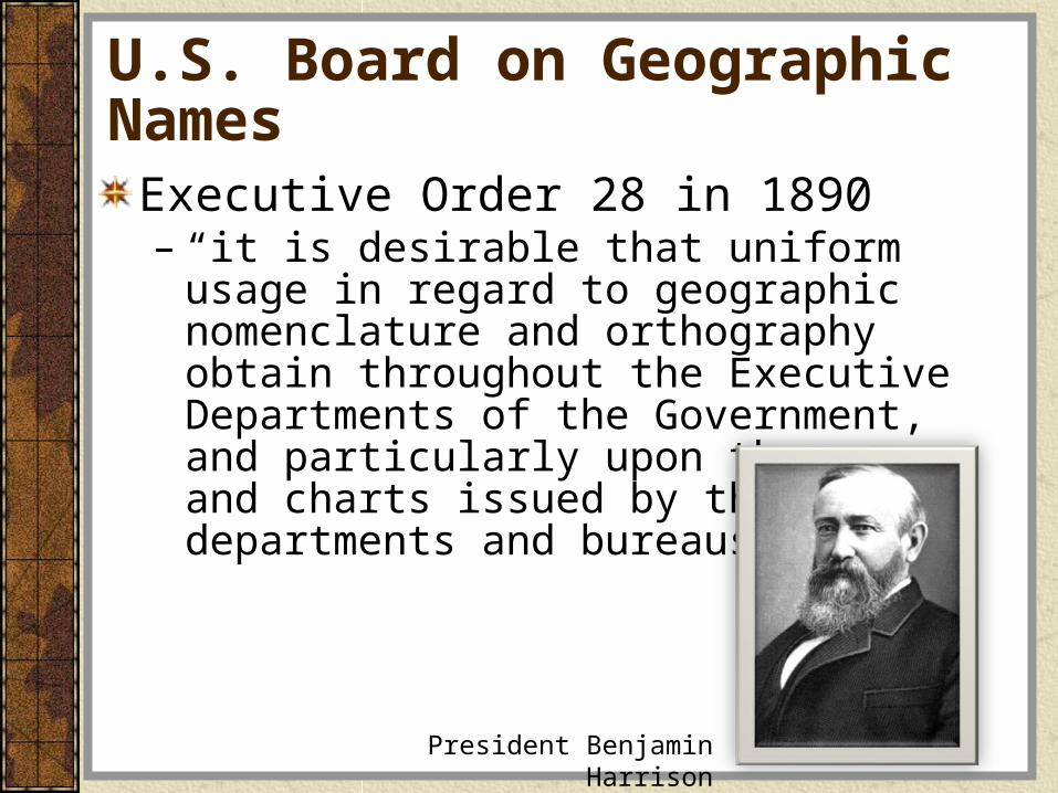
U.S. Board on Geographic Names
Executive Order 28 in 1890– “it is desirable that uniform usage in regard to
geographic nomenclature and orthography obtain throughout the Executive Departments of the Government, and particularly upon the maps and charts issued by the various departments and bureaus”
President Benjamin Harrison

U.S. Geographic Board
Created by Executive Order 493 in 1906 – Renamed U.S. Board on Geographic Names– Expanded mandate: avoid duplication of work
and improve the standardization of maps
President Theodore Roosevelt

Board of Surveys and Maps
Created by Executive Order 3206 in 1919Assumed responsibilities of Geographic BoardGoal: A central informationoffice to furnish all map and survey data information within the government as well as from other sources Invite the “map using public” to meeting for “conference and advice”
President Woodrow Wilson

How did the Board of Survey and Maps get Advice?
Created an Advisory CommitteeMajor focus was the need for – Topographic Map of the U.S.
Held first public conference March 1920“..great possibilities, if we can do our work in harmony within the organizations and in full cooperation with agencies from the outside.”

Who was on the Advisory Committee?
American Automobile AssociationAmerican Forestry AssociationAmerican Institute of Electrical EngineersAmer. Inst. of Mining & Metallurgical Eng.American Railway Eng. AssociationAssociation of State Geologists
Engineering CouncilGeologic Society of AmericaMap PublishersNational Research CouncilSociety of Automotive Eng.Later: American Soc. of PhotogrammetryLater: Rand McNally

Advisory Committee aligned with Board’s Standing Committees
CoordinationCooperationTechnical StandardsTopographic MapsHighway MapsGeneral MapsControlPhotographic SurveyingInformation

Board of Surveys and Maps
During the period 1920-1936, six Executive Orders were issued amending Executive Order 32061942 (Executive Order 9094)– Board and Advisory
Committee abolished– Bureau of Budget took
over responsibilities
President Franklin Roosevelt

Bureau of the Budget Circular A-16
Issued originally in 1953Describes responsibilities of Federal agencies with regard to the coordination of surveying and mapping activitiesRevised and reissued in1967
President Lyndon Johnson
President Dwight Eisenhower

OMB Circular A-16 Updates
1970: Bureau of the Budget reorganized into Office of Management and BudgetRevised and reissued in 1990 and 2002Supplemental Guidance reissued in 2010
President George Bush
President George H. W. Bush
President Barack Obama
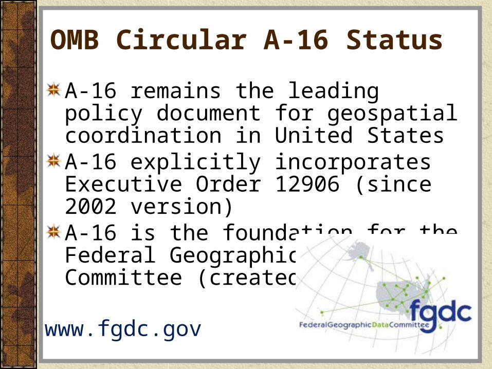
OMB Circular A-16 Status
A-16 remains the leading policy document for geospatial coordination in United StatesA-16 explicitly incorporates Executive Order 12906 (since 2002 version)A-16 is the foundation for the Federal Geographic Data Committee (created in 1990)
www.fgdc.gov

Federal Geographic Data Committee (FGDC)
Promotes the coordinated development, use, sharing and dissemination of geospatial data Nationwide data sharing through National Spatial Data Infrastructure (NSDI)Chair: Secretary of InteriorVice Chair: Deputy Director for Management, OMBSecretariat hosted by U.S. Geological Survey

National Geospatial Advisory Committee (NGAC)
Created in 2008 (88 years after first Advisory Committee) under Federal Advisory Committee Act 28 Diverse Members of the Geospatial CommunityAdvice and Recommendation to FGDC Meets 3-4 times/year Meetings open to the public: public comments are welcome

NGAC Purpose
Provide advice and recommendations on federal geospatial policy and management issues to Federal Geographic Data Committee (FGDC)
Provide a forum to convey views representative of the geospatial community
Provide advice on the development of the National Spatial Data Infrastructure (NSDI)
www.fgdc.gov/ngac

National Geospatial Advisory CommitteeDr. Robert Austin, NGAC ChairCity of Tampa, FL
Mr. Frank HarjoMuscogee (Creek) Nation
Dr. Doug RichardsonAssoc. of American Geographers
Mr. Daniel Cotter, Vice-ChairDept. of Homeland Security
Mr. Jack HildDigitalGlobe
Mr. Anthony SpicciState of Missouri
Mr. Talbot BrooksDelta State University
Mr. Michael JonesGoogle
Ms. Julie Sweetkind-SingerStanford University
Dr. Keith ClarkeUniv. of California Santa Barbara
Mr. Jeff LovinWoolpert
Mr. Gary ThompsonState of North Carolina
Mr. Steve CoastTelenav
Mr. Jack MaguireCounty of Lexington, SC
Dr. Harvey ThorleifsonUniversity of Minnesota
Ms. Patricia CummensEsri
Mr. Keith MasbackUSGIF
Ms. Molly VogtOregon Metro
Mr. David DiSeraEMA
Dr. Carolyn MerryOhio State University
Mr. Jason WarzinikCounty of Boone, MO
Mr. Steve EmmanuelState of New Jersey
Mr. Roger MitchellMDA Information Systems
Mr. David WyattEastern Band Cherokee Indians
Prof. Joanne GabrynowiczUniv. of Mississippi Law School
Dr. Michele MotskoDOD/NGA
Mr. Matthew GentileDeloitte Financial Advisory Svcs
Mr. Kevin PomfretCentre for Spatial Law and Policy
Ivan DeLoatch (FGDC)NGAC Designated Federal Officer
Mr. Bert GranbergState of Utah
Maj. Gen. William N. Reddel IIINew Hampshire National Guard
John Mahoney (FGDC)NGAC Alternate DFO

Recent and Current Guidance
FGDC Strategic Vision for the NationGeospatial Platform National Address Database
Landsat Subcommittee3D Elevation Program (3DEP)Workforce DevelopmentGeospatial Privacy

Geospatial Platform
Portfolio Management approach to GIS– Project Management – Program Management – Portfolio Management
Goals:– Open government, transparency and
accountability – National geographic information system
www.geoplatform.gov

Shared Infrastructure (“Certified” Federal Data Centers and Commercial Clouds)
Federal Services
State, Local and
Tribal Services
Licensed Services
NGO Services
Crowd Sourced Services
Data.gov
Place Based
Homeland Security
Local Planning
AdministrationPriorities
Let’s Move!
Agency Mission Needs
Climate Change
Transparent, Open Government
Environ-mental
Protection
Resource Manage-
ment
Non-Federal Uses
GeoOne Stop

Lessons Learned from a Century+
Coordination policies have well-established rootsPolicy goals have remained consistent– standards– authoritative information source– broad participation in the coordination process.
Coordination of geographic data acquisition and dissemination is important

Lessons Learned from a Century+
Ways to improve the effectiveness of often stove-piped organizational structures within the Federal Government are neededNeed to stimulate cross agency coordination and collaborationImproving coordination and fostering organizational change that will benefit the development of the NSDI is difficult:
– If it was easy, it would have been done 100 years ago