Embed Size (px)
Citation preview
National Geospatial Advisory Committee
Education and Workforce
Subcommittee
United States Geospatial
Intelligence Foundation
June 25, 2014
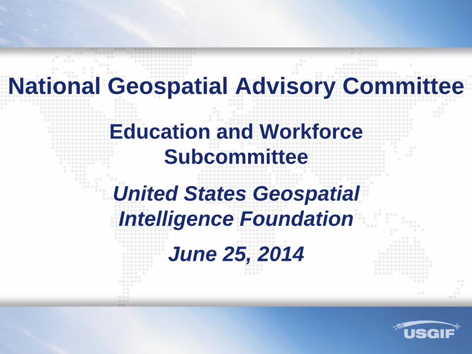
USGIF Accredited Programs
2
USGIF is only organization accrediting
geospatial programs
Strong and growing interest, both in U.S. and
abroad
Accreditation Guidelines and additional
information can be found at:
http://usgif.org/education/accreditation
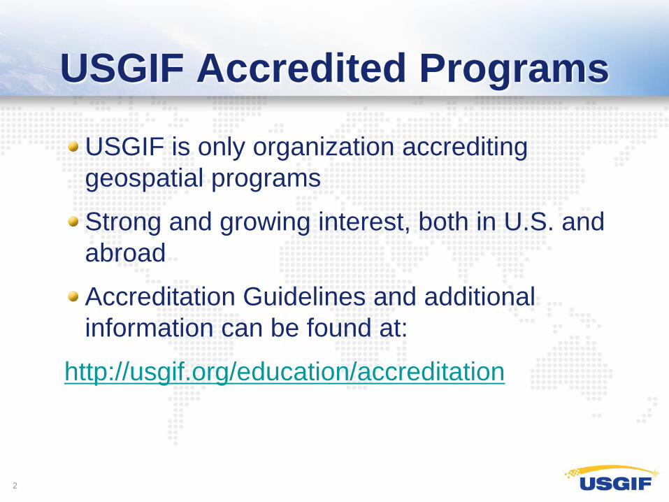
Collegiate GEOINT Certificates
0
20
40
60
80
100
120
140
2009 2010 2011 2012 2013 2014
Year Penn State U. of Missouri George Mason UT Dallas USAF USMA Total
2009 13 3 16
2010 15 5 14 34
2011 46 3 21 3 2 7 82
2012 51 18 28 5 10 18 130
2013 63 11 12 5 14 19 124
2014* 10 13 2 13 38
424 *2014 certificate awarding continues through end of year.
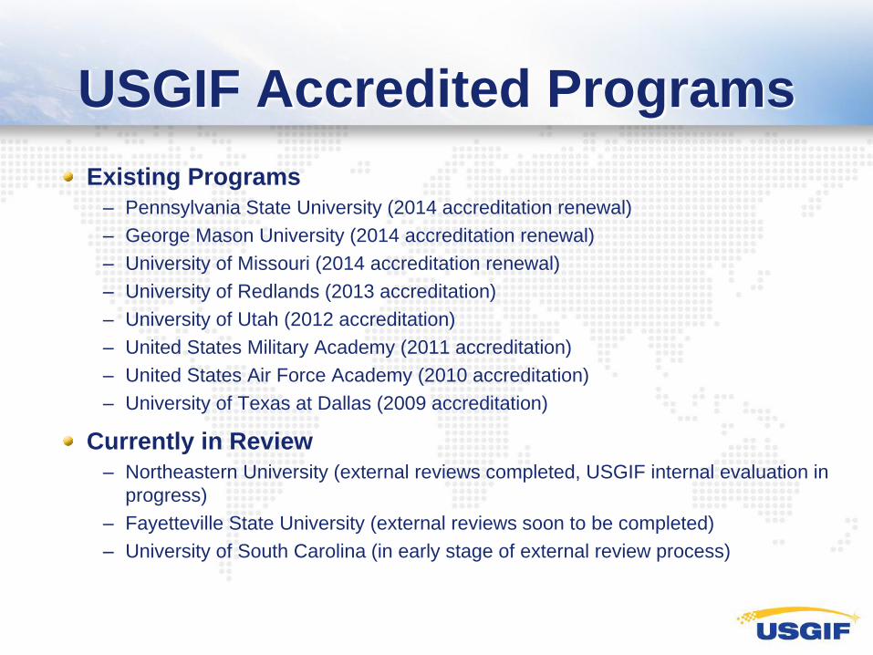
USGIF Accredited Programs
Existing Programs
– Pennsylvania State University (2014 accreditation renewal)
– George Mason University (2014 accreditation renewal)
– University of Missouri (2014 accreditation renewal)
– University of Redlands (2013 accreditation)
– University of Utah (2012 accreditation)
– United States Military Academy (2011 accreditation)
– United States Air Force Academy (2010 accreditation)
– University of Texas at Dallas (2009 accreditation)
Currently in Review
– Northeastern University (external reviews completed, USGIF internal evaluation in
progress)
– Fayetteville State University (external reviews soon to be completed)
– University of South Carolina (in early stage of external review process)
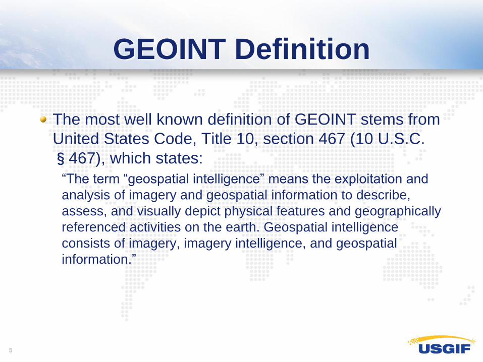
GEOINT Definition
The most well known definition of GEOINT stems from
United States Code, Title 10, section 467 (10 U.S.C.
§467), which states:
“The term “geospatial intelligence” means the exploitation and
analysis of imagery and geospatial information to describe,
assess, and visually depict physical features and geographically
referenced activities on the earth. Geospatial intelligence
consists of imagery, imagery intelligence, and geospatial
information.”
5
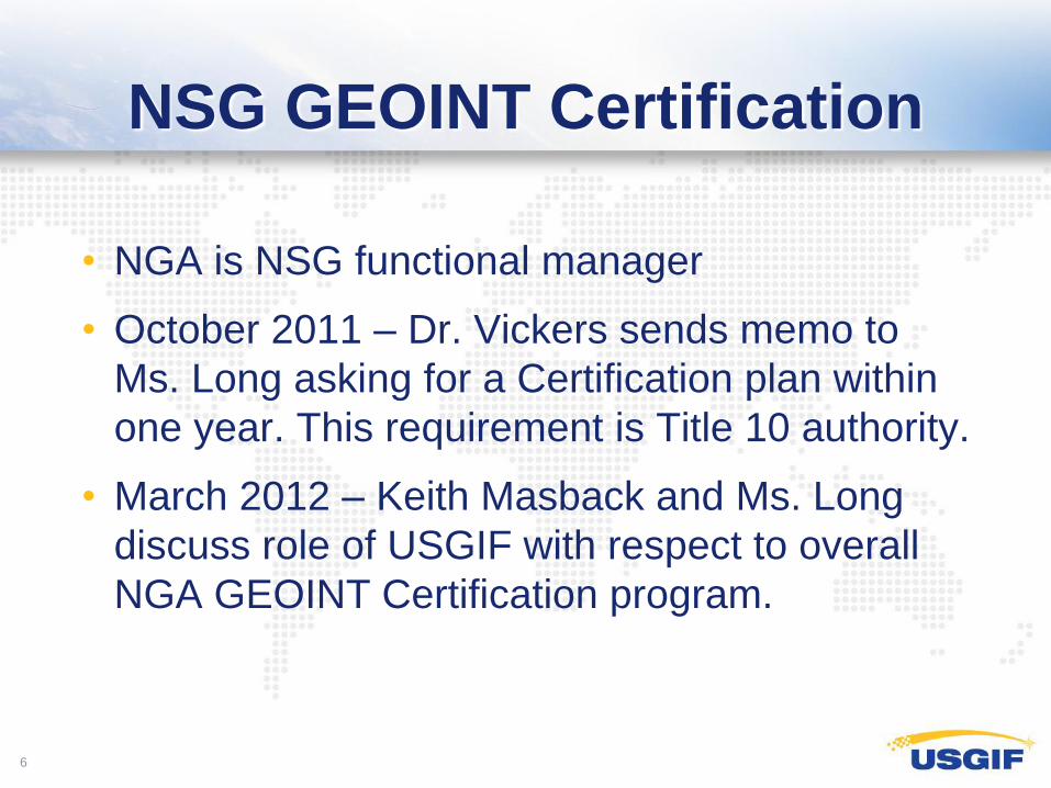
NSG GEOINT Certification
• NGA is NSG functional manager
• October 2011 – Dr. Vickers sends memo to
Ms. Long asking for a Certification plan within
one year. This requirement is Title 10 authority.
• March 2012 – Keith Masback and Ms. Long
discuss role of USGIF with respect to overall
NGA GEOINT Certification program.
6
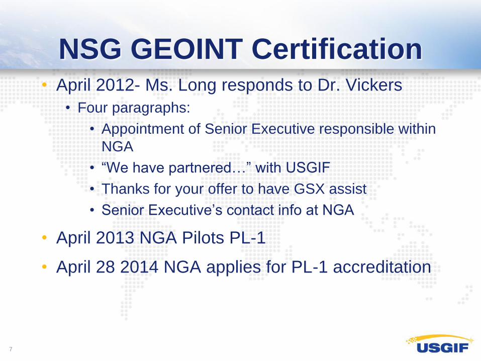
NSG GEOINT Certification
• April 2012- Ms. Long responds to Dr. Vickers
• Four paragraphs:
• Appointment of Senior Executive responsible within
NGA
• “We have partnered…” with USGIF
• Thanks for your offer to have GSX assist
• Senior Executive’s contact info at NGA
• April 2013 NGA Pilots PL-1
• April 28 2014 NGA applies for PL-1 accreditation
7
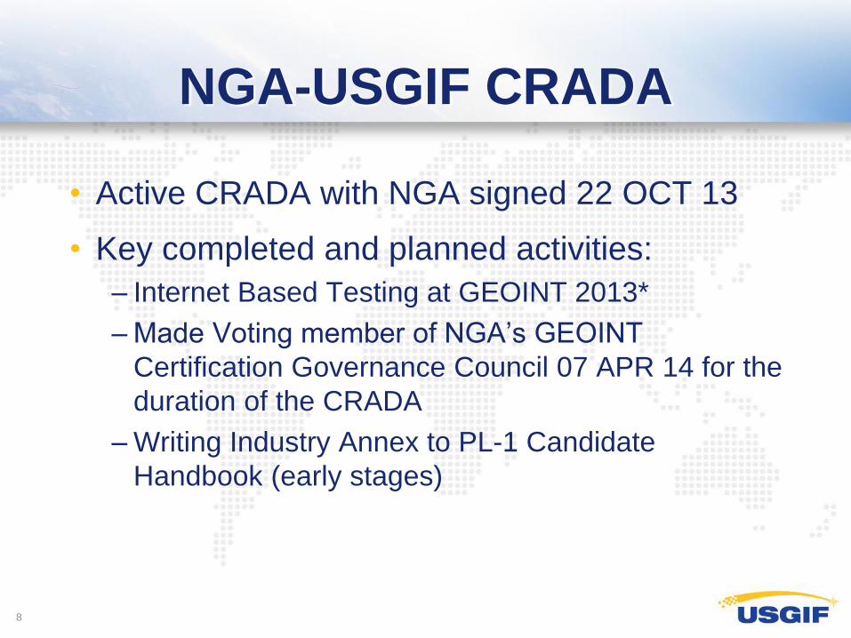
NGA-USGIF CRADA
• Active CRADA with NGA signed 22 OCT 13
• Key completed and planned activities:
– Internet Based Testing at GEOINT 2013*
– Made Voting member of NGA’s GEOINT
Certification Governance Council 07 APR 14 for the
duration of the CRADA
– Writing Industry Annex to PL-1 Candidate
Handbook (early stages)
8
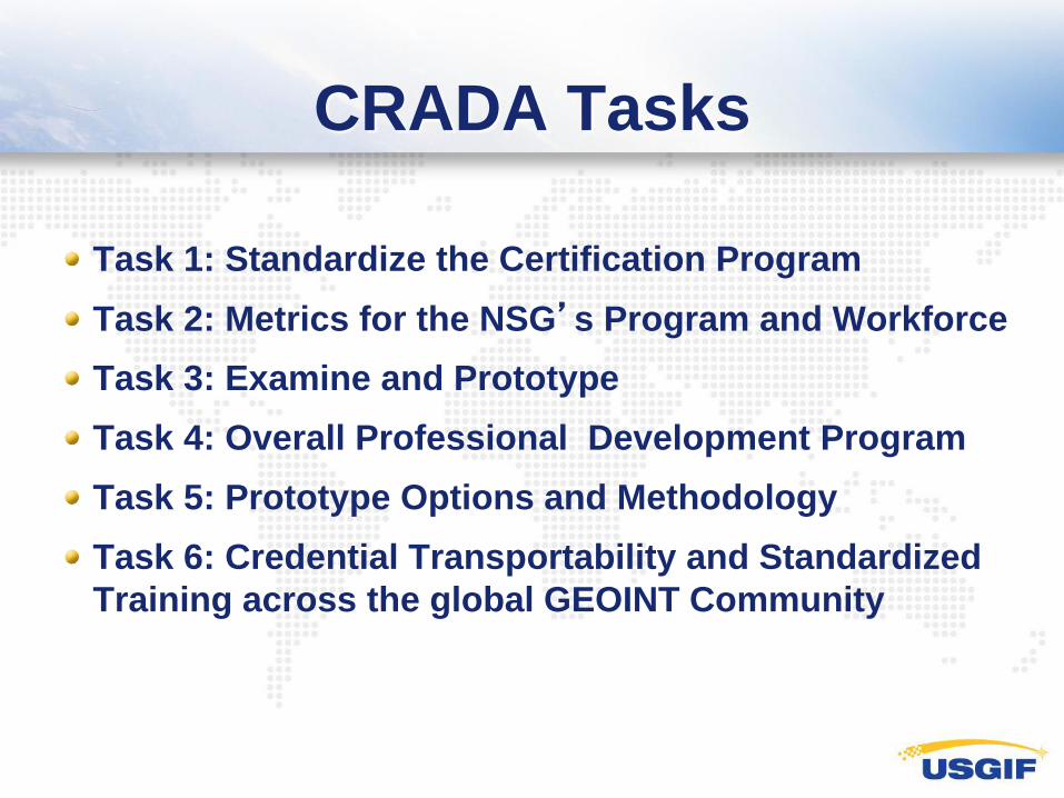
CRADA Tasks
Task 1: Standardize the Certification Program
Task 2: Metrics for the NSG’s Program and Workforce
Task 3: Examine and Prototype
Task 4: Overall Professional Development Program
Task 5: Prototype Options and Methodology
Task 6: Credential Transportability and Standardized
Training across the global GEOINT Community
USGIF Certification
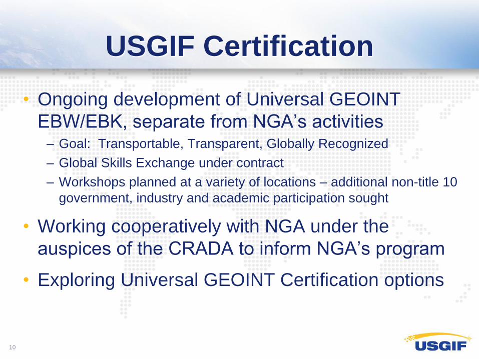
• Ongoing development of Universal GEOINT
EBW/EBK, separate from NGA’s activities – Goal: Transportable, Transparent, Globally Recognized
– Global Skills Exchange under contract
– Workshops planned at a variety of locations – additional non-title 10
government, industry and academic participation sought
• Working cooperatively with NGA under the
auspices of the CRADA to inform NGA’s program
• Exploring Universal GEOINT Certification options
10
USGIF organized Sunday
session description
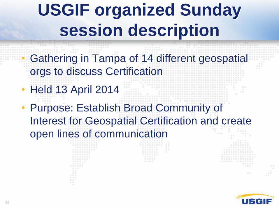
• Gathering in Tampa of 14 different geospatial
orgs to discuss Certification
• Held 13 April 2014
• Purpose: Establish Broad Community of
Interest for Geospatial Certification and create
open lines of communication
11
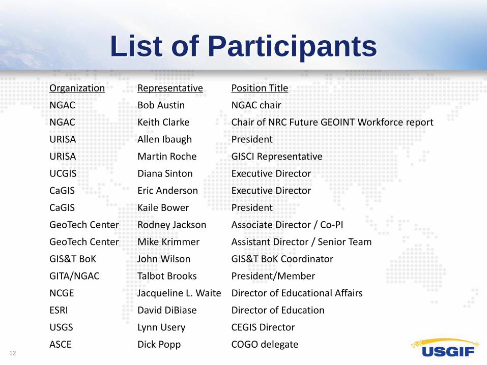
List of Participants
12
Organization Representative Position Title
NGAC Bob Austin NGAC chair
NGAC Keith Clarke Chair of NRC Future GEOINT Workforce report
URISA Allen Ibaugh President
URISA Martin Roche GISCI Representative
UCGIS Diana Sinton Executive Director
CaGIS Eric Anderson Executive Director
CaGIS Kaile Bower President
GeoTech Center Rodney Jackson Associate Director / Co-PI
GeoTech Center Mike Krimmer Assistant Director / Senior Team
GIS&T BoK John Wilson GIS&T BoK Coordinator
GITA/NGAC Talbot Brooks President/Member
NCGE Jacqueline L. Waite Director of Educational Affairs
ESRI David DiBiase Director of Education
USGS Lynn Usery CEGIS Director
ASCE Dick Popp COGO delegate
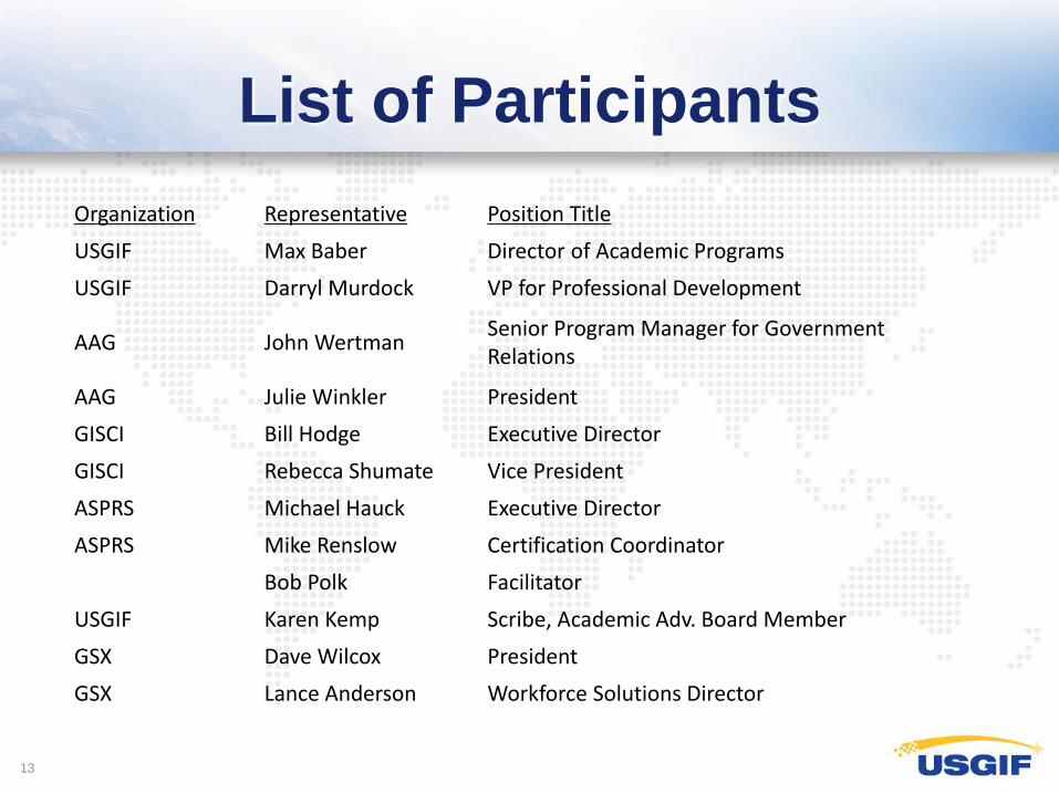
List of Participants
13
Organization Representative Position Title
USGIF Max Baber Director of Academic Programs
USGIF Darryl Murdock VP for Professional Development
AAG John Wertman Senior Program Manager for Government Relations
AAG Julie Winkler President
GISCI Bill Hodge Executive Director
GISCI Rebecca Shumate Vice President
ASPRS Michael Hauck Executive Director
ASPRS Mike Renslow Certification Coordinator
Bob Polk Facilitator
USGIF Karen Kemp Scribe, Academic Adv. Board Member
GSX Dave Wilcox President
GSX Lance Anderson Workforce Solutions Director
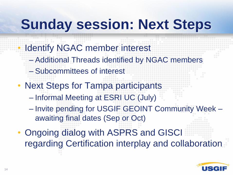
Sunday session: Next Steps
• Identify NGAC member interest
– Additional Threads identified by NGAC members
– Subcommittees of interest
• Next Steps for Tampa participants
– Informal Meeting at ESRI UC (July)
– Invite pending for USGIF GEOINT Community Week –
awaiting final dates (Sep or Oct)
• Ongoing dialog with ASPRS and GISCI
regarding Certification interplay and collaboration
14
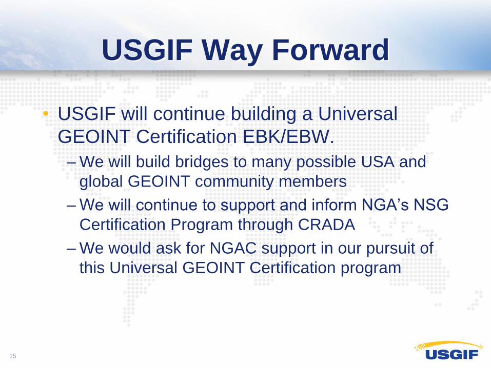
USGIF Way Forward
• USGIF will continue building a Universal
GEOINT Certification EBK/EBW.
– We will build bridges to many possible USA and
global GEOINT community members
– We will continue to support and inform NGA’s NSG
Certification Program through CRADA
– We would ask for NGAC support in our pursuit of
this Universal GEOINT Certification program
15
Thank you
Darryl G. Murdock, Ph.D.
Vice President of Professional Development
United States Geospatial Intelligence Foundation
703-793-0109 ext. 128 (office)
703-463-7868 (mobile)
703-793-9069 (fax)
16