Embed Size (px)
Citation preview

Opportunities and Challenges of Urbanization
DEC Policy Research TalkSeptember 25, 2017
Harris SELOD
Planning for an Unprecedented Future

Outline
Preliminary remarks on the measurement of urbanization and trends about urbanization
Urbanization and economic development usually go hand in hand but some developing countries face strong challenges
Anticipating rapid urban population growth, can we “get cities right”?Land and transport play a critical role
What can we learn from research to guide policy?

See Uwe Deichmann’s preivous DEC Policy and Research Talk “Revisiting Economic Geography” , December 19, 2016

See the Urbanization’s conference website for videos, presentations and papers

Later this week!

Measuring urbanization
Historical trends
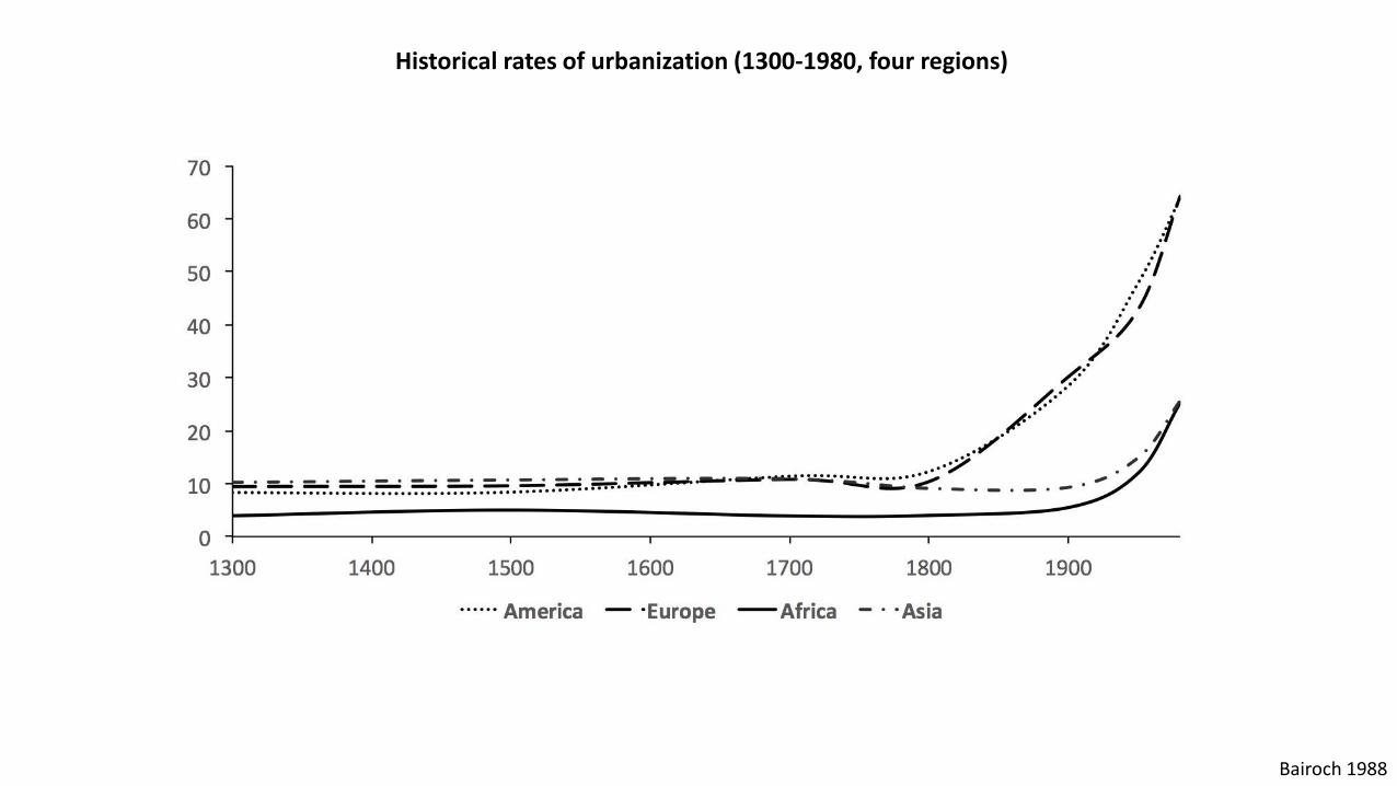
Bairoch 1988
Historical rates of urbanization (1300-1980, four regions)
0
10
20
30
40
50
60
70
80
90
100
1900 1920 1940 1960 1980 2000
Urb
aniz
atio
n R
ate
(%
)
Year
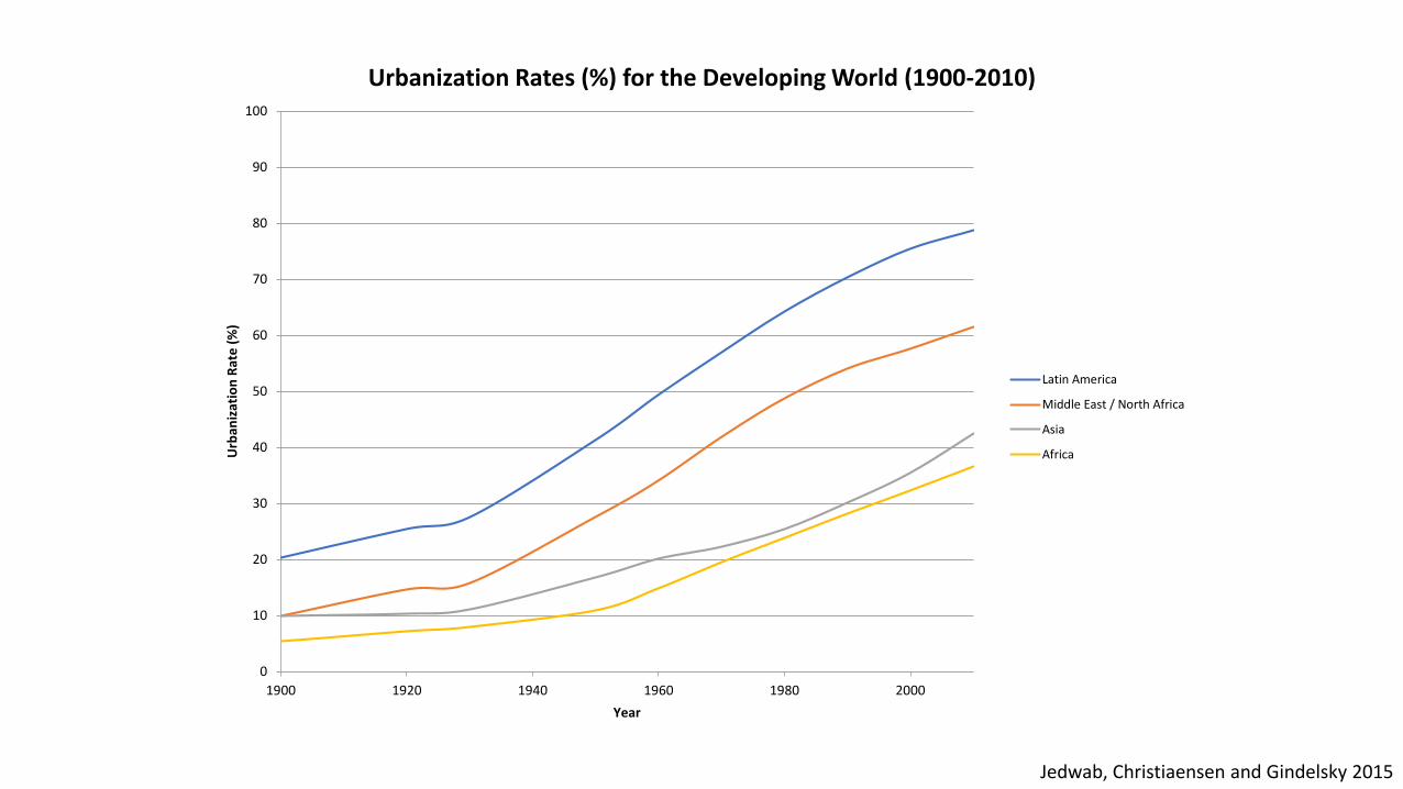
Urbanization Rates (%) for the Developing World (1900-2010)
Latin America
Middle East / North Africa
Asia
Africa
Jedwab, Christiaensen and Gindelsky 2015

Measuring urbanization
City level measures

How are cities defined?
UN World Population Prospects is the standard source
However, there are country-specific definitions according to various criteria (designation, minimum population, minimum density, non-agricultural activities, infrastructure and services, commuting-to-work patterns,…)
Ongoing initiatives try to compile city level population for the whole world using comparable criteria. The main challenge is to aggregate information (often available at a jurisdictional level) for an economically relevant definition of cities
Density and contiguity

Blankespoor, Mesplé-Somps, Spielvogel and Selod 2017
Example 1: Reconstructing urban extent and aggregating census population data
Start from a geo-referenced set of points with associated population
Approximate locality shapes with Voronoi polygons and calculate locality densities
Aggregate localities using a density threshold and proximity or contiguity
This requires access to relatively disaggregated census data
Figure: The urban area of Bamako, Mali

Blankespoor, Khan and Selod 2017
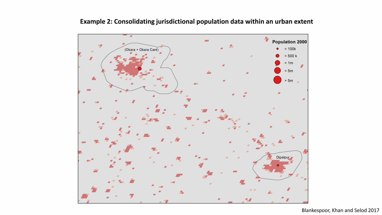
Example 2: Consolidating jurisdictional population data within an urban extent

Blankespoor, Khan and Selod 2017
Example 2: Consolidating jurisdictional population data within an urban extent
Blankespoor, Khan and Selod 2017
Example 2: Consolidating jurisdictional population data within an urban extent

Blankespoor, Khan and Selod 2017
Urban population growth

Blankespoor, Khan and Selod 2017
Urban population growth

Blankespoor, Khan and Selod 2017
Urban population growth (Africa only)

Blankespoor, Khan and Selod 2017
Urban population growth (Africa only)
Growth of cities of all sizes

Christaller 1933; wikispaces.com; Angel 2012; Blankespoor, Khan and Selod, 2017
Example of analysis: the spatial distribution of cities
Blankespoor, Khan and Selod 2017
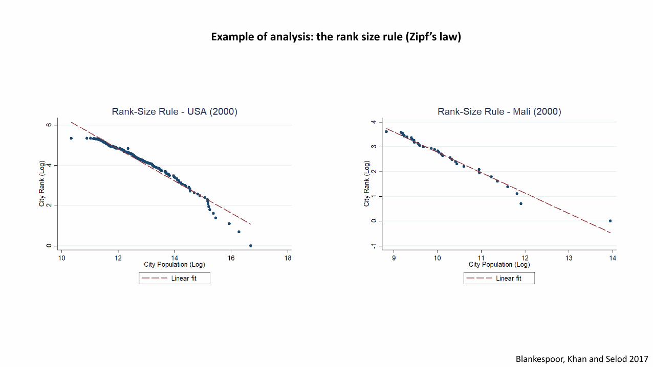
Example of analysis: the rank size rule (Zipf’s law)

Policy research priority: dataImprove measures of urbanizationBuild consistent geo-referenced panel databases of urban areas, consolidating population and economic census information (city level)
Measure city specialization and productivity in cities (see forthcoming flagship on urbanization and productivity in LAC)
Measure the internal spatial organization of cities (density gradient, unbuilt-areas, density of transport, city shape)
Link up data to other geospatial informationInter-city transport networksClimate risks (exposure to natural disasters)
Leverage advances in satellite imagery analysis (nighttime lights)

Urbanization and economic development
The benefits and costs of urbanization

WDI, World Urbanization Prospects 2017
Urbanization and Income (2016)

The benefits of urbanization(“The gods of density”)
Structural transformation, specialization and trade
Increasing returns to scaleInnovation & dynamic human capital accumulation in cities (endogenous growth)
“Agglomeration effects” (as highlighted by Economic Geography)10 % increase in population increases wages or productivity by 0.2- 1 %
Effects could be large (x4) in developing countries (see Duranton 2015)
Mechanisms:Sharing: e.g. sharing suppliers of specialized inputs, lowering input costs
Matching: e.g. labor market pooling, reducing search costs
Learning: e.g. knowledge spillovers

The costs of urbanization(“The demons of density” 1/2)
Cities can be “crowded, disconnected and costly” (Lall, Henderson, Venables 2017)
Externalities from densityTransport congestion
Health and educational impact of poor housing conditions
Air, water and soil pollution
Crime
High costs
Cost of living in cities (housing, transport, other consumption goods)
Labor costs (compensating wages, not higher productivity)
The costs of urbanization(“The demons of density” 2/2)
Remarks
- Population density does not entail “economic” density (in cities that are costly, crowded and disconnected) (Lall, Henderson and Venables 2017)
- Weak land property rights systems and poor transport connectivity (from lack of planning of transport investment) can result in a suboptimal spatial organization of cities that increases costs
See e.g. the disconnection between jobs and residence known as “spatial mismatch” (Gobillon, Selod and Zenou 2007)
- Benefits and costs are affected by distortions

Urbanization without growth
Eponymous seminal study by Fay and Opal (2000)
Explanations1. Consumption cities fueled by natural resource rents, which mainly produce non-tradables (Gollin, Jedwab and Vollarath 2016)

Gollin, Jedwab and Vollrath 2016; Lall, Henderson and Venables 2017
In resource exporting countries, urbanization is not accompanied by the development of manufacturing and services
Urbanization without growth
Eponymous seminal study by Fay and Opal (2000)
Explanations1 .Consumption cities fueled by natural resource rents (Gollin, Jedwab and Vollrath 2016)
2. Cities are not organized in productive ways; structural regulatory and institutional constraints hinder productivity and prevent specialization and trade (Lall, Henderson and Venables 2017)

Policy research priority:Study agglomeration in developing country contexts
Measure gains from densityThe need to replicate studies faces data challenges!
Measure costs associated with densitye.g., congestion in cities
Identify the enabling environment for cities to be productiveSpecial focus on infrastructure and institutions
What can policies do to make cities productive?

Anticipating urban population growth
Can we get “cities right”?

The unprecedented challenge of rapid urban population growth425 million sub-Saharan Africans reside in cities (40% urbanization rate)
The population in some cities grows at 4-5 percent a year
Doubling of population is expected over the next three decades (and tripling of built-up area)
Compare with current urban population of the E.U.: 382 million…
Immense pressure on land and transport infrastructure

Land

Five (ideal) principles about land for urban developmentP1. Land is available for urban expansion (formal response to demand)
P2. The land market functions (tradability)Land is efficiently used (Coase Theorem)
P3. Appropriate instruments are used to plan for urban expansion and address land-use externalities (sustainable planning and management)
P4. Land can be taxed (Henry George)
Land Value Capture principles can be implemented to fund infrastructure
P5. Good land governance supports P1-P4 (Deininger, Burns and Selod 2012)

The real world (e.g., West African cities)…
R1/R2. Scarcity of formally supplied land and distorted land marketLimited formal market segment with unaffordable land prices;Large informal market segment (which is a response to unaffordability of formal land, inadequate legal framework, excessive regulations and costly process of formalization); Informality is the norm, not the exceptionBarriers to tradability and insecure land tenure leading to……underinvestment in land and land misallocation (inefficiency)
R3. Absence of effective urban planningUnplanned urban expansionSuboptimal land use patterns and costly ex-post regularizations
R4. Lost opportunity of land taxationInfrastructure unable to respond to rapid urban expansion
R5. Poor land governance (the core problem?)

Policy research priority:Understand land tenure informalityHow to think about informality in economic terms?
To what extent is (or is not) informality a problem?
Is formalization of land tenure/slum upgrading the right approach?
Data issues:Measuring land tenure insecurity (UN) is difficult (impossible?)
More effort is needed to measure informality (typologies, HH survey, VHR satellite imagery analysis,…)

Picture: Tuca Vieira, São Paulo
How do formal and informal land uses coexist?
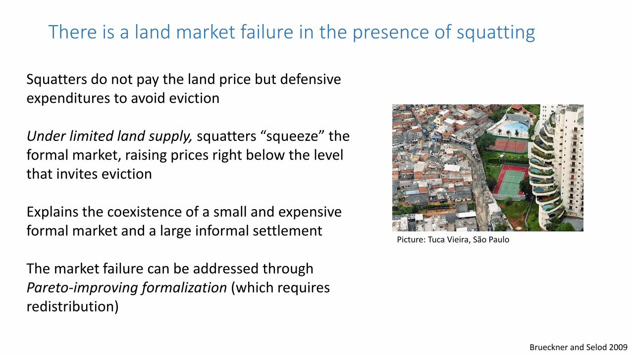
Picture: Tuca Vieira, São Paulo
Squatters do not pay the land price but defensive expenditures to avoid eviction
Under limited land supply, squatters “squeeze” the formal market, raising prices right below the level that invites eviction
Explains the coexistence of a small and expensive formal market and a large informal settlement
The market failure can be addressed through Pareto-improving formalization (which requires redistribution)
There is a land market failure in the presence of squatting
Brueckner and Selod 2009

Durand-Lasserve, Durand-Lasserve and Selod 2015; Selod and Tobin 2015
There are spatial patterns of informality
0.2
.4.6
.81
Sh
are
of
ten
ure
typ
e
0-4km 4-8km 8-12km 12-16km 16-20km 20-24km 24-28km 28-32km 32-36km 36-40km 40km +
No administrative document Administrative document
Precarious title Property title
Map: Land plots sampled in Bamako, Mali Figure: The positive informality gradient
Selod and Tobin 2014
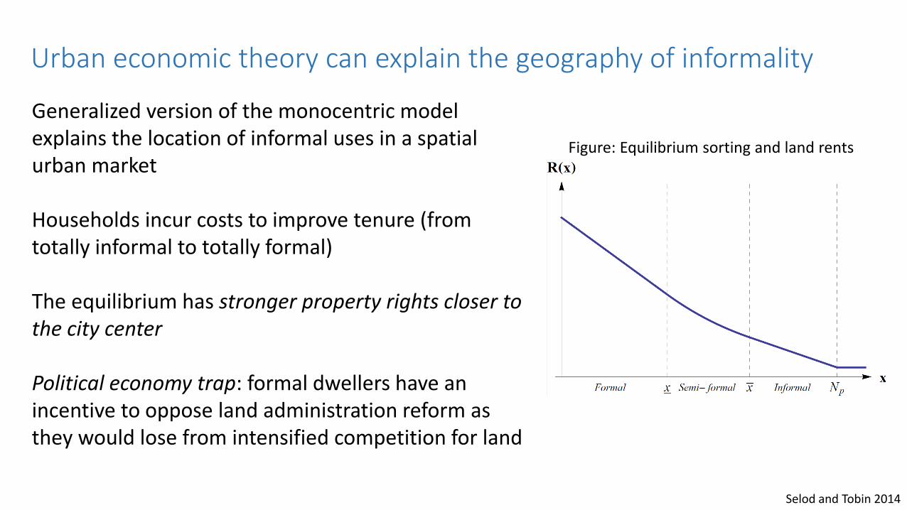
Urban economic theory can explain the geography of informality
Generalized version of the monocentric model explains the location of informal uses in a spatial urban market
Households incur costs to improve tenure (from totally informal to totally formal)
The equilibrium has stronger property rights closer to the city center
Political economy trap: formal dwellers have an incentive to oppose land administration reform as they would lose from intensified competition for land
Figure: Equilibrium sorting and land rents

Picture: The outskirts of Bamako, Mali. Copyright: H. Selod
How does land get converted to residential use?
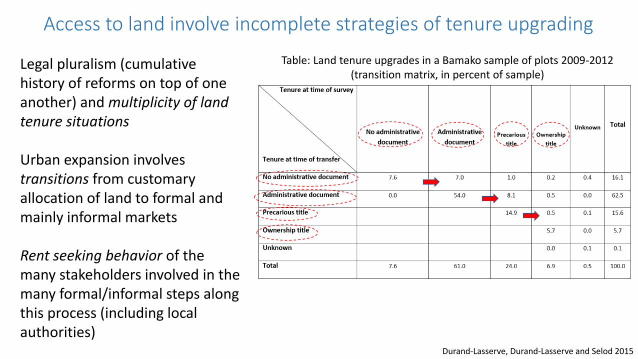
Access to land involve incomplete strategies of tenure upgrading
Legal pluralism (cumulative history of reforms on top of one another) and multiplicity of land tenure situations
Urban expansion involves transitions from customary allocation of land to formal and mainly informal markets
Rent seeking behavior of the many stakeholders involved in the many formal/informal steps along this process (including local authorities)
Durand-Lasserve, Durand-Lasserve and Selod 2015
Table: Land tenure upgrades in a Bamako sample of plots 2009-2012(transition matrix, in percent of sample)

Will informality simply disappear over time?
Optimistic viewEconomic development will pull the system towards formality
This can be enhanced by endogenous improvement in land institutions
Pessimistic viewInsufficient wealth creation (weak agglomeration effects) and no improvement in institutions

Cai, Selod and Steinbuks 2017
Dynamic stochastic model of urbanization and land use with endogenous demand for property rights
Figure: Dynamics of urbanization - the disappearance of informality under strong agglomeration effects
Will informality simply disappear over time?The eradication scenario (thanks to agglomeration effects)

Cai, Selod and Steinbuks 2017
Suboptimal urbanization with informality can persist over time where cities are insufficiently productive
In second best setting (high costs of formalization), the eradication of informality may not be desirable
Figure: Steady states under variousformalization costs and eviction probabilities
Will informality simply disappear over time?The persistence scenario (under high formalization costs)

Policy research priority:Study land use and land market dysfunctionsExpand the study informality
Important changes: from informal settlements to “backyarding” (South Africa)
Better understand land use inefficiencies and measure their impactThe causes of distortions (the role of regulations)How land distortions hinder agglomeration effects
Misallocation of land (Duranton, Ghani, Grover and Kerr 2015)
Study the dynamics of land useImpact on growth? (Bogart and Richardson 2009)Processes of leap frogging development / speculative land holdingsDevelop dynamic models (Henderson, Reagan, Venables 2017)

To succeed, policies need to be cognizant of context(e.g., challenges of formalization programs in West Africa)
Develop systemic and dynamic diagnosesInteractions between formal and informal land markets
Beyond land markets (understand the context of transactions)
Understand land tenure transitions
Policy research priorities:Rethink land sector assessments

What needs to be done, at the very minimum, to prepare new land for urban use?
The top priority. The most feasible approach?
Reliance on zoning and land use regulations that will not be respected will produce little results
Instead, guide spatial expansion by ensuring that cities can proactively plan the entire arterial road network through the acquisition of the right of way for the future transport network (“arterial grid of dirt roads”)
This may however require applying eminent domain in contexts of unclear property rights, which may be very difficult to do
Angel 2008

Lipman and Rajack 2011
See “guided land development”in the “Memo to the Mayor”

Transport
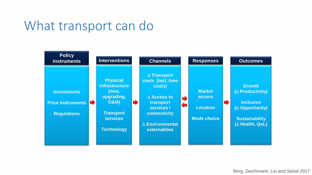
What transport can do
Policy
instruments Interventions Channels Responses Outcomes
Investments
Price instruments
Regulations
Physical
infrastructure
(new,
upgrading,
O&M)
Transport
services
Technology
Transport
costs (incl. time
costs)
Access to
transport
services /
connectivity
Environmental
externalities
Market
access
Location
Mode choice
Growth
( Productivity)
Inclusion
( Opportunity)
Sustainability
( Health, QoL)
Berg, Deichmann, Liu and Selod 2017

Transport: inter-city

Road improvements
Jedwab and Storeygard 2016; reproduced in Berg, Blankespoor and Selod 2017
Map: The road network in SSA, 1970 and 2015

Roads are key to improve access to markets
Blankespoor, Mesplé-Somps, Spielvogel and Selod 2017
Map: Market Access in Mali (south) 1973 Map: Market Access in Mali (south) 2000
Market Access/Marker Potential is an aggregate measure of surrounding markets and the ease to transport goods to those places (weighted sum of populations or incomes in surrounding areas discounted by travel costs)

Impacts of road improvements on agglomeration and income
Jedwab and Storeygard 2016
Modest long-term impact (30 years) on city population and income
Heterogeneity: stronger effects on small and medium cities in SSA

Bosker, Deichmann and Roberts 2015
Large economic benefits from new highways and abolishing migration restrictions
Spatial impacts differ: development of the core at the expense of the periphery
Impacts of road improvements on agglomeration and income

Impacts of bridge construction on structural transformation
Blankespoor, Deichmann, Emran, Shilpi and Xu 2016
Increase in agricultural yield
Long term adjustment in employment
(from agriculture to services)
Long term urbanization
(in larger cities)
Industry moved to center
Welfare improvements
(night light growth)
Picture: The Jamuna bridge, Bangladesh

Blankespoor, Bougna, Garduno-Rivera and Selod 2017
Improved Market Access is associated with higher employment and greater specializationHeterogeneity across sectors and regions
Impacts of road improvements on specializationMap: Road improvement in Mexico (1985-2016) Map: Industry specialization of Mexican cities (2014)

Policy research priorities
DataProduce network-enabled panel datasets of transport infrastructure(ideally with road quality information)
Collect transport information (truck surveys, commodity flow surveys)
Measure non-physical transport costs
Replicate intra-city transport studies in developing countries
Assess the enabling environment (i.e., complementarity of investment with trade openness)

Transport: intra-city

City structure can affect productivity(Exploration of the link in the case of Latin American cities)
Duque, Lozano-Gracia, Patino and Restrepo 2017
Transport investments shape cities in ways that are persistent over time (putty-clay nature)
Beyond density, productivity is correlated with urban form characteristics and transport grid layouts
Table: Urban form indexes

“Lock-in” effects of urban form (in Beijing)
Road expansion
In the periphery
Increased CO2 emission
(extensive margin effects
dominate)
Locked-in sprawl and
decentralization
Reducing core roads
Question: What additional transport investments can reduce CO2 from the lock-in effects?
Making transit (bus and rail)
in the periphery faster
Adds to urban sprawl
(draws population to less
congested area)
Offsets CO2 from cars more
effectively than improving
transit in the urban core
Anas and Timilsina 2015
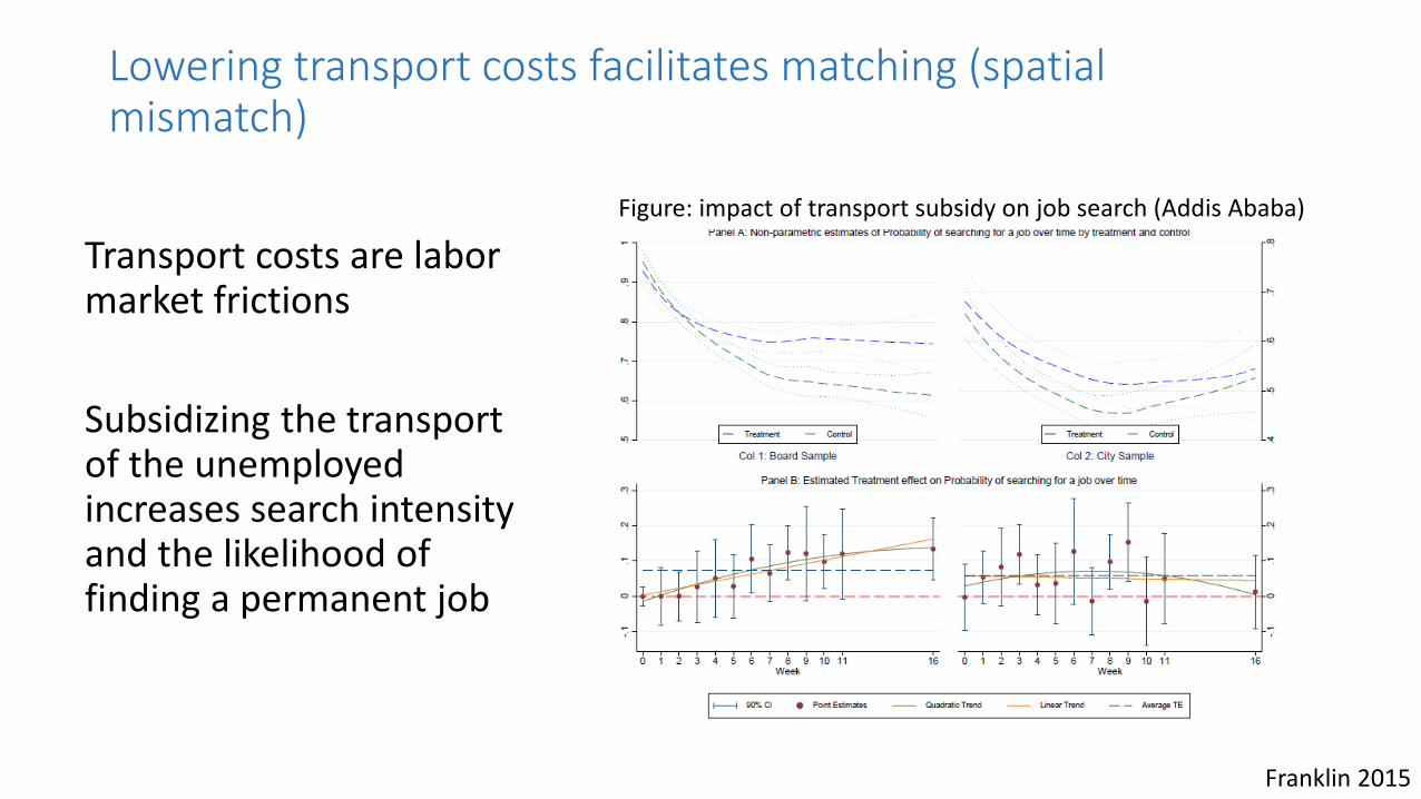
Lowering transport costs facilitates matching (spatial mismatch)
Transport costs are labor market frictions
Subsidizing the transport of the unemployed increases search intensity and the likelihood of finding a permanent job
Franklin 2015
Figure: impact of transport subsidy on job search (Addis Ababa)

Policy research priorities (1/2)
How do transport investments and land use interact to affect urban form?Develop LUTI models to plan ahead
How land form affects agglomeration effects
Policy research priorities (2/2)Cities and climate changes
Cities are major contributors to climate change (energy consumption, CO2)How is this exacerbated by the spatial organization of cities?
Urbanization will be accelerated by climate changeTo what extent? Where and when?
Cities are increasingly exposed to climate induced risksWhat land use policies to increase resilience?

Conclusion
Take away 1: Agglomeration effects require a functional land sector and good transportation
Take away 2: Rapid urban population is likely to be met with market failures in land and inadequate transport
Take away 3: Policy interventions are required to “get cities right”
Take away 4: Because there are likely to be winners and losers, there may be strong political economy obstacles to reforms