Embed Size (px)
DESCRIPTION
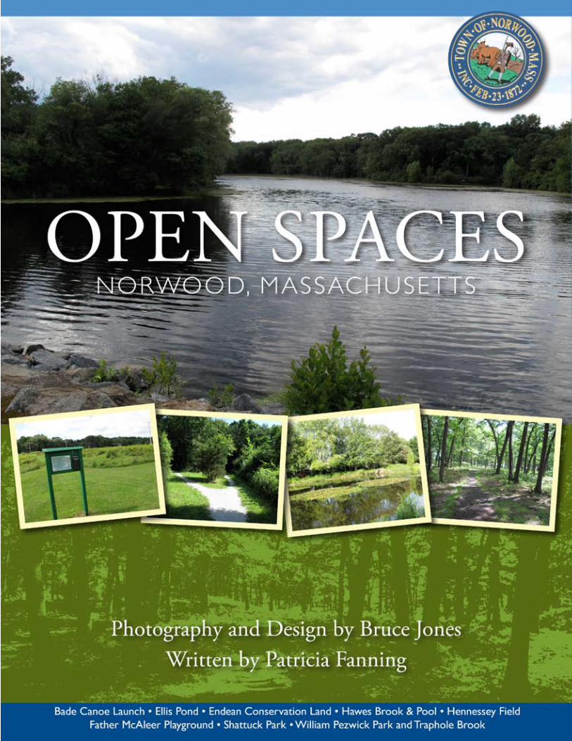
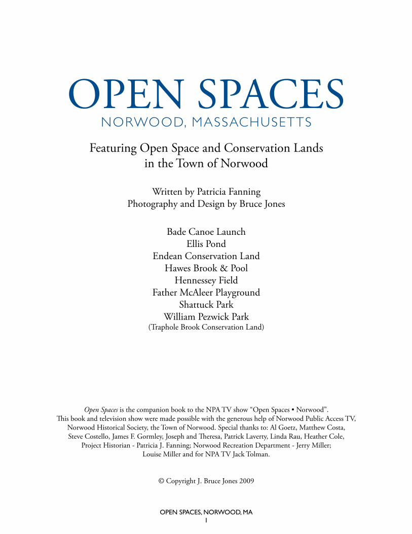
Open Spaces is the companion book to the Norwood Public Access TV show "Open Spaces • Norwood". Written by Patricia Fanning, design, photography and production by Bruce Jones. Featuring current and historical photos, maps and history on the eight most popular open space and conservation lands. Including Bade Canoe Launch, Ellis Pond, Endean Conservation Land, Hawes Brook & Pool, Hennessey Field, Father McAleer Playground, Shattuck Park, and William Pezwick Park.
Citation preview
Open SpaceS, nOrwOOd, Ma1
Nahatan St.
Was
hing
ton
St.
Walpole St.
Dean St.
Cross St.
Sumner St.
Plea
sant
St.
Leno
x St
.
Mylod St.
Prov
iden
ce H
wy. Neponset St.
Airport Rd.
Nahatan St.
Winter St.
Vernon St.
Nichols S
t.
Chapel St.
Prospect St.
Everett St.
1A
95
1
1
1
Norwood Airport
HighlandCemetery
1A
University Ave.
Open SpaceS, nOrwOOd, Ma2
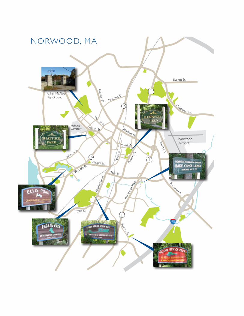
Norwood, ma
Father mcaleer Play Ground
Open SpaceS, nOrwOOd, Ma1
Open SpaceSNorwood, massachusetts
Open Spaces is the companion book to the NPA TV show “Open Spaces • Norwood”. This book and television show were made possible with the generous help of Norwood Public Access TV,
Norwood Historical Society, the Town of Norwood. Special thanks to: Al Goetz, Matthew Costa, Steve Costello, James F. Gormley, Joseph and Theresa, Patrick Laverty, Linda Rau, Heather Cole,
Project Historian - Patricia J. Fanning; Norwood Recreation Department - Jerry Miller; Louise Miller and for NPA TV Jack Tolman.
© Copyright J. Bruce Jones 2009
Featuring Open Space and Conservation Lands in the Town of Norwood
Written by Patricia Fanning Photography and Design by Bruce Jones
Bade Canoe LaunchEllis Pond
Endean Conservation LandHawes Brook & Pool
Hennessey FieldFather McAleer Playground
Shattuck ParkWilliam Pezwick Park
(Traphole Brook Conservation Land)
Open SpaceS, nOrwOOd, Ma2
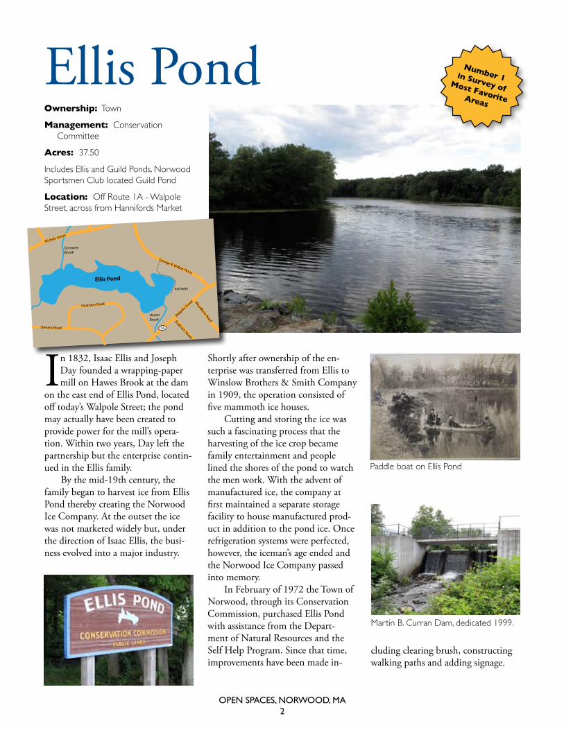
In 1832, Isaac Ellis and Joseph Day founded a wrapping-paper mill on Hawes Brook at the dam
on the east end of Ellis Pond, located off today’s Walpole Street; the pond may actually have been created to provide power for the mill’s opera-tion. Within two years, Day left the partnership but the enterprise contin-ued in the Ellis family.
By the mid-19th century, the family began to harvest ice from Ellis Pond thereby creating the Norwood Ice Company. At the outset the ice was not marketed widely but, under the direction of Isaac Ellis, the busi-ness evolved into a major industry.
Ellis Pond
Nichols Street
Walpole Street
Chatham Road
HawesBrook
Pathway
GermanyBrook
Orleans Road
Endicott StreetW
oodbine Road
1A
George R. Willett Pkwy
Ellis Pond
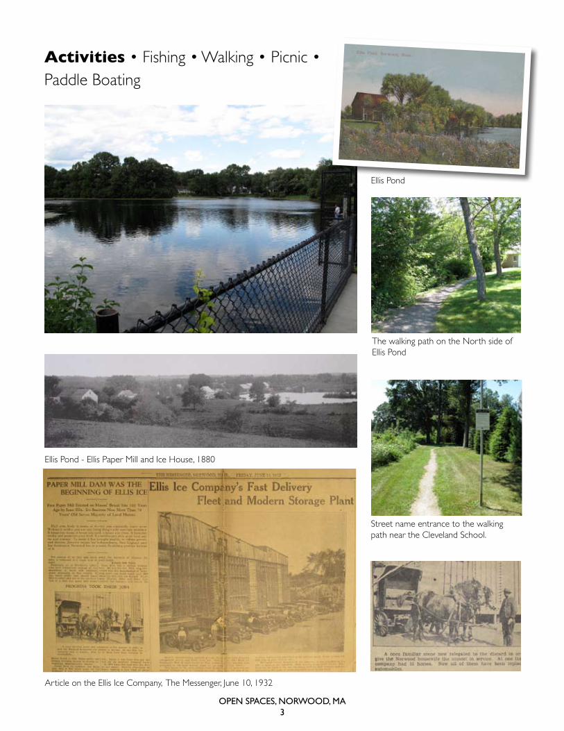
Shortly after ownership of the en-terprise was transferred from Ellis to Winslow Brothers & Smith Company in 1909, the operation consisted of five mammoth ice houses.
Cutting and storing the ice was such a fascinating process that the harvesting of the ice crop became family entertainment and people lined the shores of the pond to watch the men work. With the advent of manufactured ice, the company at first maintained a separate storage facility to house manufactured prod-uct in addition to the pond ice. Once refrigeration systems were perfected, however, the iceman’s age ended and the Norwood Ice Company passed into memory.
In February of 1972 the Town of Norwood, through its Conservation Commission, purchased Ellis Pond with assistance from the Depart-ment of Natural Resources and the Self Help Program. Since that time, improvements have been made in-
cluding clearing brush, constructing walking paths and adding signage.
Paddle boat on ellis Pond
martin B. curran dam, dedicated 1999.
Ownership: town
Management: conservation committee
Acres: 37.50
Includes ellis and Guild Ponds. Norwood sportsmen club located Guild Pond
Location: off route 1a - walpole street, across from hannifords market
Number 1 in Survey of Most Favorite Areas
Open SpaceS, nOrwOOd, Ma3
ellis Pond
ellis Pond - ellis Paper mill and Ice house, 1880
the walking path on the North side of ellis Pond
street name entrance to the walking path near the cleveland school.
article on the ellis Ice company, the messenger, June 10, 1932
Activities • Fishing • Walking • Picnic • Paddle Boating
Open SpaceS, nOrwOOd, Ma4
Hawes Brook
Ownership: town
Management: conservation committee
Acres: 4.78
Property was donated to the town.
Number 2 in survey of most favorite areas
Hawes Brook & Pool
EndeanConservation
Land
Hawes Brook
Little LeagueField
Coakley Middle School W
ashi
ngto
n St
reet
Mylod Street
Thompson Rd.
Short St.
Concord Ave.
Path
SwimmingPool
Alendale Pkwy
Hawes Brook Walkway Con-servation Area is located off of Washington Street
in South Norwood along the Hawes Brook. Totalling about 5 acres from Washington Street to the railroad bridge, it includes two former swim-ming holes (a men’s and a women’s), and a walking trail. Today, a well marked path can be followed through the woods along the brook, return-ing along the access road next to the Coakley Middle School.
The Hawes Brook Swimming Pool opened in June 1949. Built at a cost of $20,000 and holding 200,000 gallons of water, the pool originally
had no modern filtering system, so it had to be closed, drained, cleaned, and refilled weekly. The pool became so popular that when a drought hit in August, it was deemed exempt from a townwide water ban. By the 1970s, more than 500 Norwood children were taking swimming lessons each summer at the pool.
(right) railroad bridge at the end of the walking path, (Far right) walking path with marked trail.
Open SpaceS, nOrwOOd, Ma5
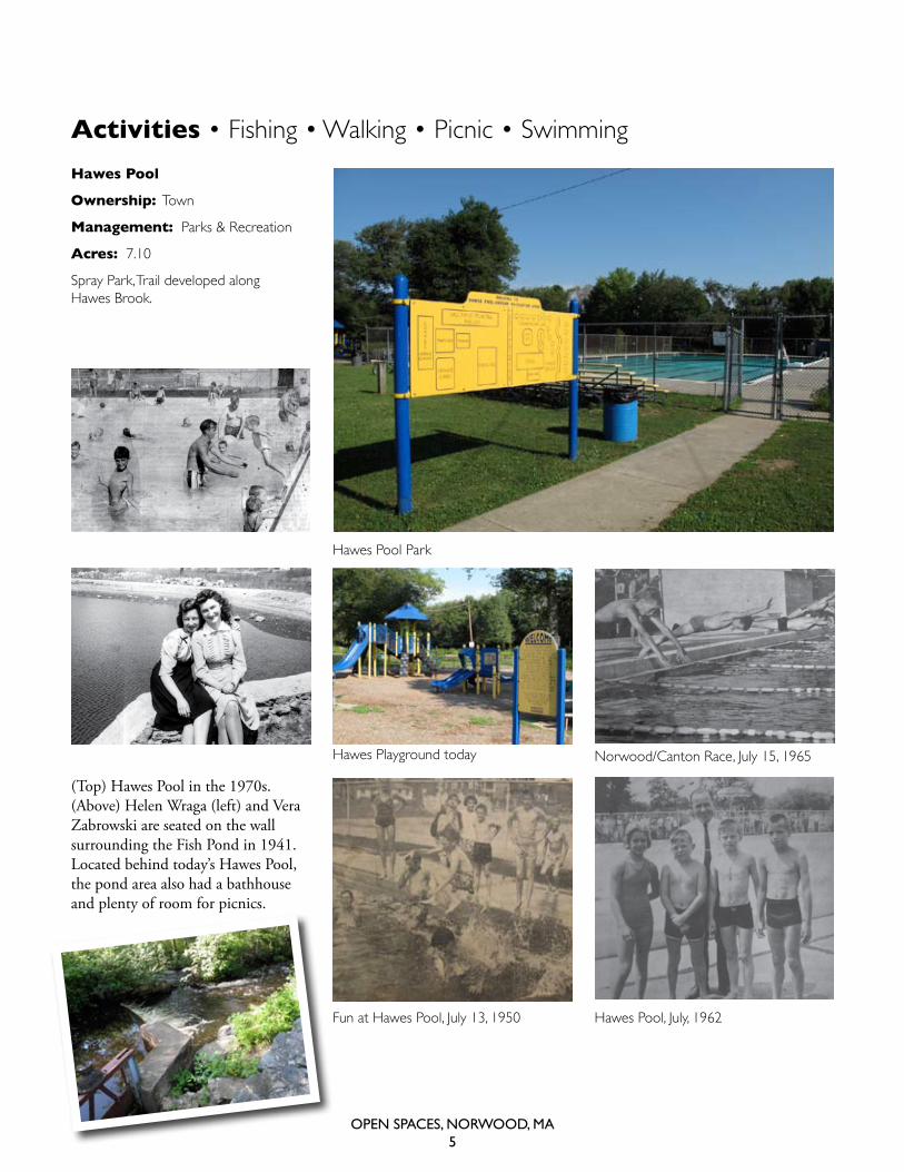
Hawes Pool
Ownership: town
Management: Parks & recreation
Acres: 7.10
spray Park, trail developed along hawes Brook.
(Top) Hawes Pool in the 1970s. (Above) Helen Wraga (left) and Vera Zabrowski are seated on the wall surrounding the Fish Pond in 1941. Located behind today’s Hawes Pool, the pond area also had a bathhouse and plenty of room for picnics.
Activities • Fishing • Walking • Picnic • Swimming
Fun at hawes Pool, July 13, 1950
hawes Pool Park
hawes Playground today
hawes Pool, July, 1962
Norwood/canton race, July 15, 1965
Open SpaceS, nOrwOOd, Ma6
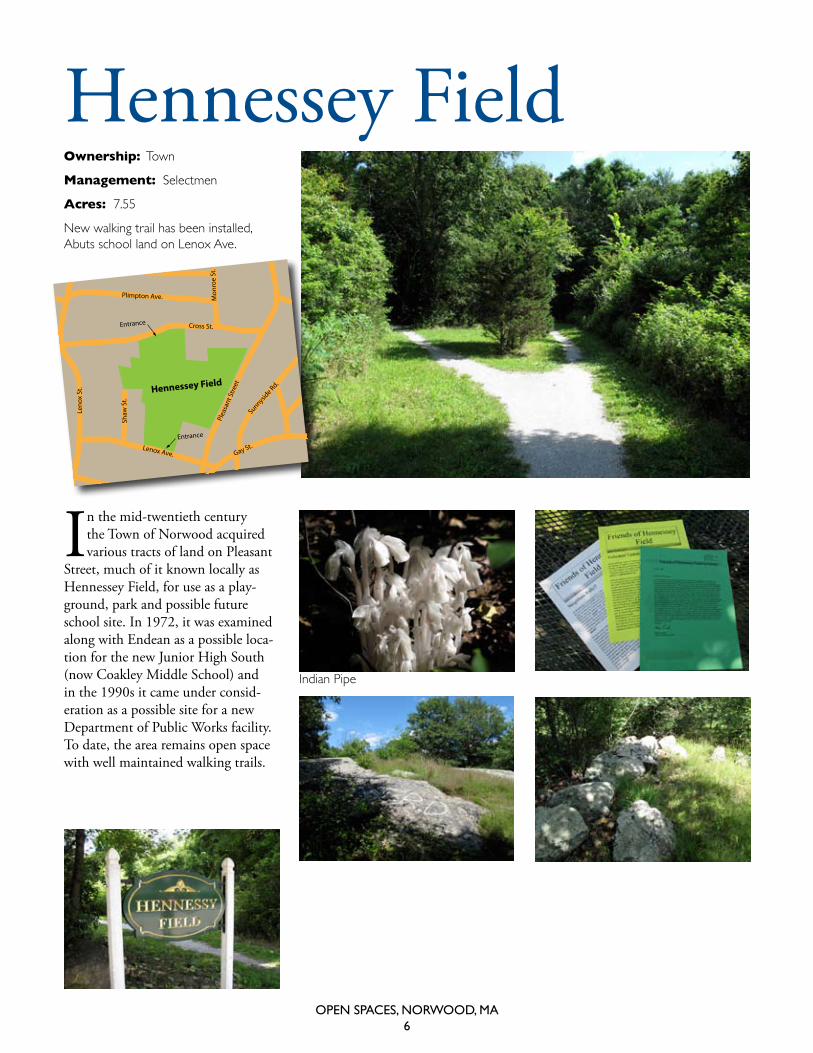
Ownership: town
Management: selectmen
Acres: 7.55
New walking trail has been installed, abuts school land on Lenox ave.
Hennessey Field
In the mid-twentieth century the Town of Norwood acquired various tracts of land on Pleasant
Street, much of it known locally as Hennessey Field, for use as a play-ground, park and possible future school site. In 1972, it was examined along with Endean as a possible loca-tion for the new Junior High South (now Coakley Middle School) and in the 1990s it came under consid-eration as a possible site for a new Department of Public Works facility. To date, the area remains open space with well maintained walking trails.
Hennessey FieldNorwood
Central
Lenox Ave.
Mon
roe
St.
Allen Rd.
Hillside Ave.
Plea
sant
Stre
et
Shaw
St.
Cross St.
Plimpton Ave.
Leno
x St
.
Gay St.
Sunnyside Rd.
Entrance
Entrance
Indian Pipe
Open SpaceS, nOrwOOd, Ma7
Active Community Involvement in 2009
Keeps Hennessey Up-to-Date
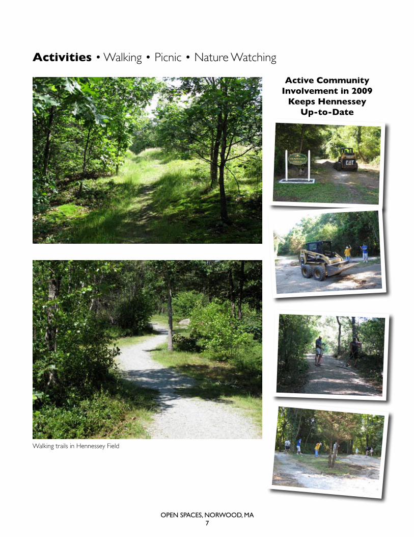
Activities • Walking • Picnic • Nature Watching
walking trails in hennessey Field
Open SpaceS, nOrwOOd, Ma8
Shattuck Park
Shattuck Park
Nichols St.
Rosemary St.
Winter St.
Bond St.
Shattuck Park Rd.
Belmont St.
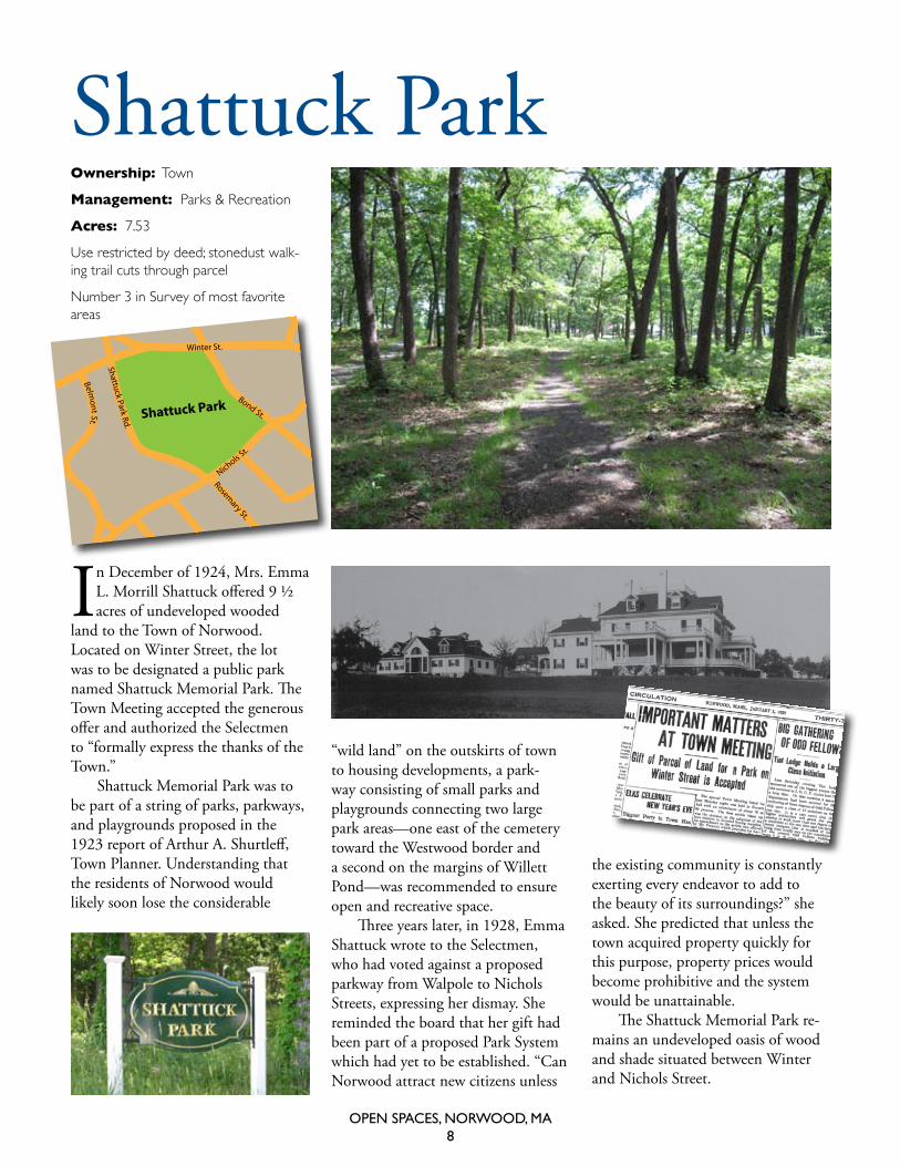
Ownership: town
Management: Parks & recreation
Acres: 7.53
use restricted by deed; stonedust walk-ing trail cuts through parcel
Number 3 in survey of most favorite areas
In December of 1924, Mrs. Emma L. Morrill Shattuck offered 9 ½ acres of undeveloped wooded
land to the Town of Norwood. Located on Winter Street, the lot was to be designated a public park named Shattuck Memorial Park. The Town Meeting accepted the generous offer and authorized the Selectmen to “formally express the thanks of the Town.”
Shattuck Memorial Park was to be part of a string of parks, parkways, and playgrounds proposed in the 1923 report of Arthur A. Shurtleff, Town Planner. Understanding that the residents of Norwood would likely soon lose the considerable
“wild land” on the outskirts of town to housing developments, a park-way consisting of small parks and playgrounds connecting two large park areas—one east of the cemetery toward the Westwood border and a second on the margins of Willett Pond—was recommended to ensure open and recreative space.
Three years later, in 1928, Emma Shattuck wrote to the Selectmen, who had voted against a proposed parkway from Walpole to Nichols Streets, expressing her dismay. She reminded the board that her gift had been part of a proposed Park System which had yet to be established. “Can Norwood attract new citizens unless
the existing community is constantly exerting every endeavor to add to the beauty of its surroundings?” she asked. She predicted that unless the town acquired property quickly for this purpose, property prices would become prohibitive and the system would be unattainable.
The Shattuck Memorial Park re-mains an undeveloped oasis of wood and shade situated between Winter and Nichols Street.
Open SpaceS, nOrwOOd, Ma9
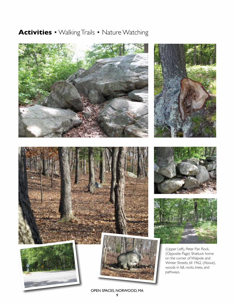
Activities • Walking Trails • Nature Watching
(upper Left), Peter Pan rock, (opposite Page) shattuck home on the corner of walpole and winter streets, till 1962, (above), woods in fall, rocks, trees, and pathways.
Open SpaceS, nOrwOOd, Ma10
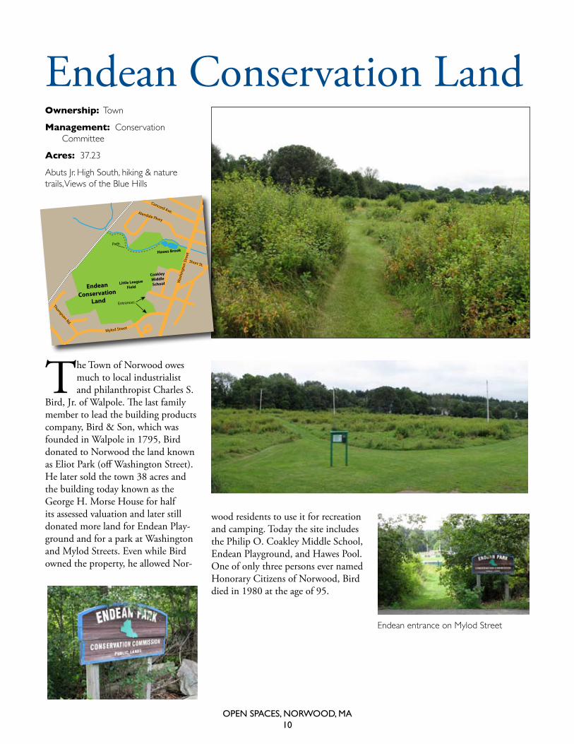
Endean Conservation LandOwnership: town
Management: conservation committee
Acres: 37.23
abuts Jr. high south, hiking & nature trails, Views of the Blue hills
The Town of Norwood owes much to local industrialist and philanthropist Charles S.
Bird, Jr. of Walpole. The last family member to lead the building products company, Bird & Son, which was founded in Walpole in 1795, Bird donated to Norwood the land known as Eliot Park (off Washington Street). He later sold the town 38 acres and the building today known as the George H. Morse House for half its assessed valuation and later still donated more land for Endean Play-ground and for a park at Washington and Mylod Streets. Even while Bird owned the property, he allowed Nor-
wood residents to use it for recreation and camping. Today the site includes the Philip O. Coakley Middle School, Endean Playground, and Hawes Pool. One of only three persons ever named Honorary Citizens of Norwood, Bird died in 1980 at the age of 95.
Endean
Conservation Land
Hawes Brook
Little LeagueField
Coakley Middle School W
ashi
ngto
n St
reet
Mylod Street
Thompson Rd.
Short St.
Concord Ave.
Path
Entrances
Alendale Pkwy
endean entrance on mylod street
Open SpaceS, nOrwOOd, Ma11
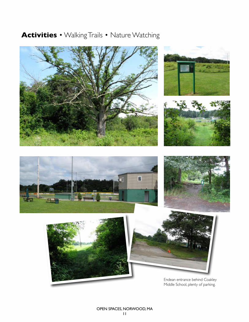
Activities • Walking Trails • Nature Watching
endean entrance behind coakley middle school, plenty of parking.
Open SpaceS, nOrwOOd, Ma12
William Pezwick ParkOwnership: town
Management: selectmen
Acres: 2.3
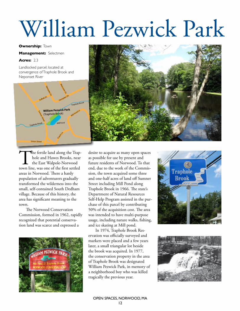
Landlocked parcel; located at convergence of traphole Brook and Neponset river
The fertile land along the Trap-hole and Hawes Brooks, near the East Walpole-Norwood
town line, was one of the first settled areas in Norwood. There a hardy population of adventurers gradually transformed the wilderness into the small, self-contained South Dedham village. Because of this history, the area has significant meaning to the town.
The Norwood Conservation Commission, formed in 1962, rapidly recognized that potential conserva-tion land was scarce and expressed a
desire to acquire as many open spaces as possible for use by present and future residents of Norwood. To that end, due to the work of the Commis-sion, the town acquired some three and one-half acres of land off Sumner Street including Mill Pond along Traphole Brook in 1966. The state’s Department of Natural Resources Self-Help Program assisted in the pur-chase of this parcel by contributing 50% of the acquisition cost. The area was intended to have multi-purpose usage, including nature walks, fishing, and ice skating at Mill pond.
In 1974, Traphole Brook Res-ervation was officially surveyed and markers were placed and a few years later, a small triangular lot beside the brook was acquired. In 1977, the conservation property in the area of Traphole Brook was designated William Pezwick Park, in memory of a neighborhood boy who was killed tragically the previous year.
Open SpaceS, nOrwOOd, Ma13
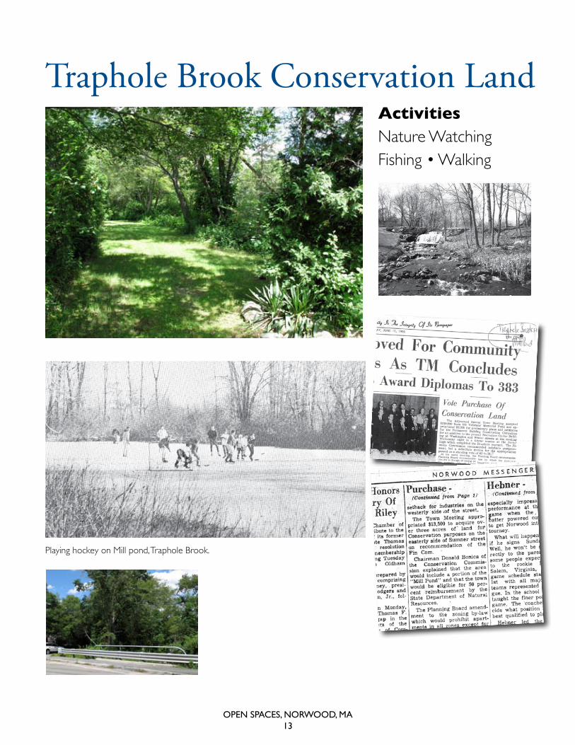
Traphole Brook Conservation LandActivities Nature watchingFishing • Walking
Playing hockey on mill pond, traphole Brook.
Open SpaceS, nOrwOOd, Ma14
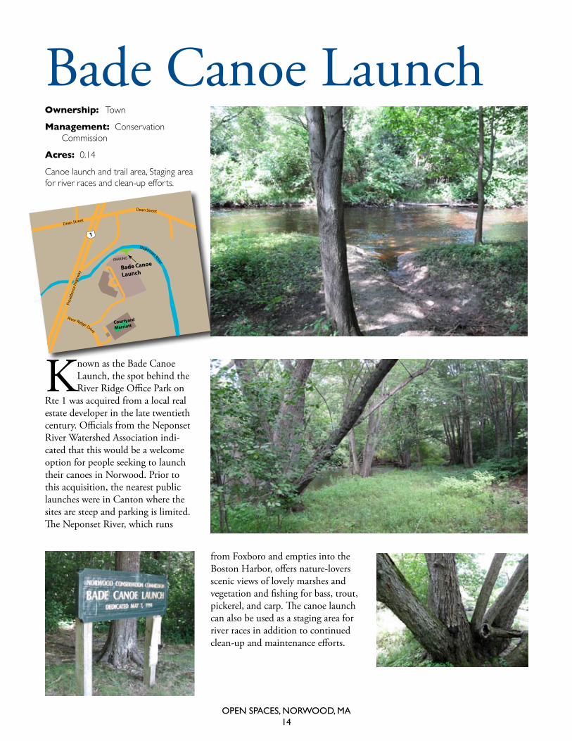
Ownership: town
Management: conservation commission
Acres: 0.14
canoe launch and trail area, staging area for river races and clean-up efforts.
Known as the Bade Canoe Launch, the spot behind the River Ridge Office Park on
Rte 1 was acquired from a local real estate developer in the late twentieth century. Officials from the Neponset River Watershed Association indi-cated that this would be a welcome option for people seeking to launch their canoes in Norwood. Prior to this acquisition, the nearest public launches were in Canton where the sites are steep and parking is limited. The Neponset River, which runs
Bade Canoe Launch
from Foxboro and empties into the Boston Harbor, offers nature-lovers scenic views of lovely marshes and vegetation and fishing for bass, trout, pickerel, and carp. The canoe launch can also be used as a staging area for river races in addition to continued clean-up and maintenance efforts.
PARKING
Bade Canoe
Launch
Courtyard
Marriott
Dean Street
Dean Street
Prov
iden
ce H
ighw
ay
1
Neponset River
River Ridge Drive
Open SpaceS, nOrwOOd, Ma15
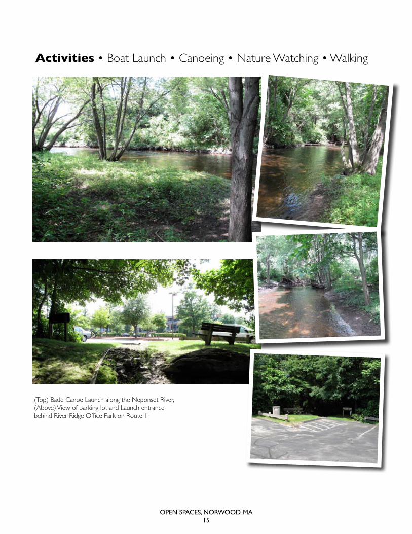
Activities • Boat Launch • Canoeing • Nature Watching • Walking
(top) Bade canoe Launch along the Neponset river, (above) View of parking lot and Launch entrance behind River Ridge Office Park on Route 1.
Open SpaceS, nOrwOOd, Ma16
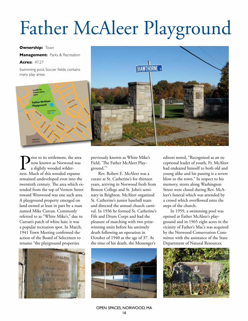
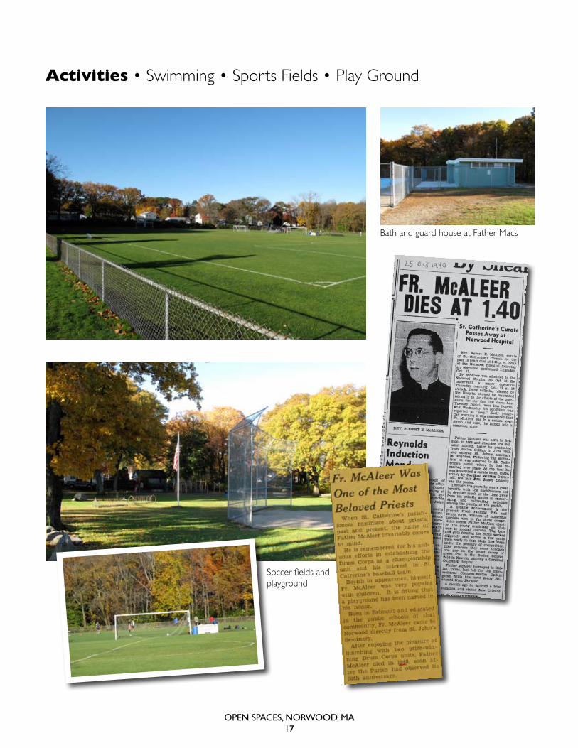
Father McAleer Playground
prior to its settlement, the area now known as Norwood was a slightly wooded wilder-
ness. Much of this wooded expanse remained undeveloped even into the twentieth century. The area which ex-tended from the top of Vernon Street toward Westwood was one such area. A playground property emerged on land owned at least in part by a man named Mike Curran. Commonly referred to as “White Mike’s,” due to Curran’s patch of white hair, it was a popular recreation spot. In March, 1941 Town Meeting confirmed the action of the Board of Selectmen to rename “the playground properties
previously known as White Mike’s Field, ‘The Father McAleer Play-ground.’”
Rev. Robert E. McAleer was a curate at St. Catherine’s for thirteen years, arriving in Norwood fresh from Boston College and St. John’s semi-nary in Brighton. McAleer organized St. Catherine’s junior baseball team and directed the annual church carni-val. In 1936 he formed St. Catherine’s Fife and Drum Corps and had the pleasure of marching with two prize-winning units before his untimely death following an operation in October of 1940 at the age of 37. At the time of his death, the Messenger’s
editors noted, “Recognized as an ex-ceptional leader of youth, Fr. McAleer had endeared himself to both old and young alike and his passing is a severe blow to the town.” In respect to his memory, stores along Washington Street were closed during Rev. McA-leer’s funeral which was attended by a crowd which overflowed onto the steps of the church.
In 1959, a swimming pool was opened at Father McAleer’s play-ground and in 1965 eight acres in the vicinity of Father’s Mac’s was acquired by the Norwood Conservation Com-mittee with the assistance of the State Department of Natural Resources.
Ownership: town
Management: Parks & recreation
Acres: 47.27
Swimming pool, Soccer fields, contains many play areas.
Father McAleer
Playground
Lasalle RdConservation
Land
Vernon St.Cottage St.
Prospect Ave.
Spruce Rd.
Hawth
orne S
t.Sy
cam
ore St
.Elm
St.
Roxanna St.
Nahatan St.
North Ave.
Forrest Ave.
Winter St.
Lincoln St.
Spru
ce Rd.
Swimming
Pool
Prospect St.
HighlandCemetery
GermanyBrook/Lovell
Open SpaceS, nOrwOOd, Ma17
Bath and guard house at Father macs
Activities • Swimming • Sports Fields • Play Ground
Soccer fields and playground
Open SpaceS, nOrwOOd, Ma18
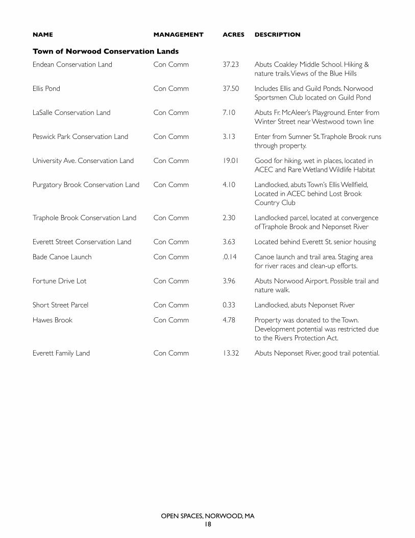
NAMe MANAgeMeNt ACreS DeSCrIPtION
town of Norwood Conservation Lands
endean conservation Land con comm 37.23 abuts coakley middle school. hiking & nature trails. Views of the Blue hills
ellis Pond con comm 37.50 Includes ellis and Guild Ponds. Norwood sportsmen club located on Guild Pond
Lasalle conservation Land con comm 7.10 abuts Fr. mcaleer’s Playground. enter from winter street near westwood town line
Peswick Park conservation Land con comm 3.13 enter from sumner st. traphole Brook runs through property.
university ave. conservation Land con comm 19.01 Good for hiking, wet in places, located in acec and rare wetland wildlife habitat
Purgatory Brook Conservation Land Con Comm 4.10 Landlocked, abuts Town’s Ellis Wellfield, Located in acec behind Lost Brook country club
traphole Brook conservation Land con comm 2.30 Landlocked parcel, located at convergence of traphole Brook and Neponset river
everett street conservation Land con comm 3.63 Located behind everett st. senior housing
Bade canoe Launch con comm .0.14 canoe launch and trail area. staging area for river races and clean-up efforts.
Fortune drive Lot con comm 3.96 abuts Norwood airport. Possible trail and nature walk.
short street Parcel con comm 0.33 Landlocked, abuts Neponset river
hawes Brook con comm 4.78 Property was donated to the town. development potential was restricted due to the rivers Protection act.
everett Family Land con comm 13.32 abuts Neponset river, good trail potential.
Open SpaceS, nOrwOOd, Ma19
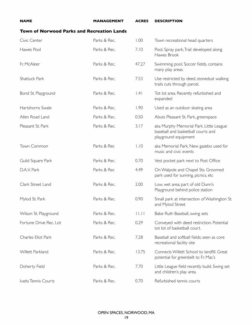
NAMe MANAgeMeNt ACreS DeSCrIPtION
town of Norwood Parks and recreation Lands
civic center Parks & rec. 1.00 town recreational head quarters
hawes Pool Parks & rec. 7.10 Pool, spray park, trail developed along hawes Brook
Fr. McAleer Parks & Rec. 47.27 Swimming pool. Soccer fields, contains many play areas.
shattuck Park Parks & rec. 7.53 use restricted by deed, stonedust walking trails cuts through parcel.
Bond st. Playground Parks & rec. 1.41 tot lot area. recently refurbished and expanded
hartshorns swale Parks & rec. 1.90 used as an outdoor skating area
allen road Land Parks & rec. 0.50 abuts Pleasant st. Park, greenspace
Pleasant st. Park Parks & rec. 3.17 aka murphy memorial Park. Little League baseball and basketball courts and playground equipment
town common Parks & rec 1.10 aka memorial Park. New gazebo used for music and civic events
Guild Square Park Parks & Rec. 0.70 Vest pocket park next to Post Office.
d.a.V. Park Parks & rec 4.49 on walpole and chapel sts. Groomed park used for sunning, picnics, etc
clark street Land Parks & rec. 2.00 Low, wet area; part of old dunn’s Playground behind police station
mylod st. Park Parks & rec. 0.90 small park at intersection of washington st. and mylod street
wilson st. Playground Parks & rec. 11.11 Babe ruth Baseball, swing sets
Fortune drive rec. Lot Parks & rec. 0.29 conveyed with deed restriction. Potential tot lot of basketball court.
Charles Eliot Park Parks & Rec. 7.28 Baseball and softball fields; seen as core recreational facility site
Willett Parkland Parks & Rec. 13.75 Connects Willett School to landfill. Great potential for greenbelt to Fr. mac’s
Doherty Field Parks & Rec. 7.70 Little League field recently build. Swing set and children’s play area.
Ivatts tennis courts Parks & rec. 0.70 refurbished tennis courts
Open SpaceS, nOrwOOd, Ma20
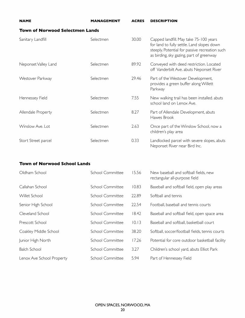
town of Norwood Selectmen Lands
Sanitary Landfill Selectmen 30.00 Capped landfill. May take 75-100 years for land to fully settle. Land slopes down steeply. Potential for passive recreation such as birding, sky gazing, part of greenway
Neponset Valley Land selectmen 89.92 conveyed with deed restriction. Located off Vanderbilt ave. abuts Neponset river
westover Parkway selectmen 29.46 Part of the westover development, provides a green buffer along willett Parkway
hennessey Field selectmen 7.55 New walking trail has been installed. abuts school land on Lenox ave.
allendale Property selectmen 8.27 Part of allendale development, abuts hawes Brook
winslow ave. Lot selectmen 2.63 once part of the winslow school, now a children’s play area
stort street parcel selectmen 0.33 Landlocked parcel with severe slopes, abuts Neponset river near Bird Inc.
town of Norwood School Lands
Oldham School School Committee 15.56 New baseball and softball fields, new rectangular all-purpose field
Callahan School School Committee 10.83 Baseball and softball field, open play areas
willet school school committee 22.89 softball and tennis
senior high school school committee 22.54 Football, baseball and tennis courts
Cleveland School School Committee 18.42 Baseball and softball field, open space area
Prescott school school committee 10.13 Baseball and softball, basketball court
Coakley Middle School School Committee 38.20 Softball, soccer/football fields, tennis courts
Junior high North school committee 17.26 Potential for core outdoor basketball facility
Balch school school committee 3.27 children’s school yard, abuts elliot Park
Lenox ave school Property school committee 5.94 Part of hennessey Field
NAMe MANAgeMeNt ACreS DeSCrIPtION
Open SpaceS, nOrwOOd, Ma21
WILLETT
BABE RUTH
BASEBALL FIELD
CO
ME
NIT
ZL
AN
D
BADE CANOELAUNCH
SPORTSMAN'SCLUB
WESTOVER
PARKWAYHENNESSEY
FIELD
PLEASANT ST.
BALL FIELD
IVATTS
TENNIS COURTS
AIRPORT
COMMISSION
LAND
BOCH
REALTY
BOCH
REALTY
BERRY
Ellis PondWillettPond
Guild
Pond
Purgatory Brook
Purgatory Brook
Hawes Brook
Neponset River
PlantingfieldBrook
Germ
anyBroo k
Traphole Brook
Neponset River
POLICE AND FIRE
DEPT.
WATER
DEPT.
PUBLIC WORKS
DEPARTMENT
EVERETT FAMILY
LAND
NORWOOD GARDENS
LLC.
CIERI LAND
NORWOOD COMMERCE
CENTER
MYLOD STREET
PARK
NORWOOD
CIVIC CENTER
HAWES BROOK
LAND
NORWOOD LITTLE
LEAGUE INC
HAWES
POOL
RECREATION
AREA
LOST BROOK
COUNTRY CLUB
TRAPHOLE BROOK
CONS. LAND
FORTUNE DRIVE
CON. COMM. LOT
FORTUNE DRIVE
REC. LOT
GUILD SQUARE
PARK
TOWN
COMMON
ALLENDALE
PROPERTIES
WINSLOW
FIELD
ELLIS
WELLFIELDS
ELLIS
WELLFIELDS
NORWOOD MEMORIAL AIRPORT
NEPONSET VALLEY
LANDS
JUNIOR HIGH
NORTH /
SENIOR CENTER
LANDFILL
HIGHLAND
CEMETERY
WILLETT
SCHOOL
TOWN
HALL
SUMNER ST
CONSERVATION LAND
(PEZWICK)
BOND ST
PLAYGROUND
EVERETT ST
CONSV LAND
HARTSHORNS
SWALE
VETERANS
MEMORIAL PARK
LASALLE RD
CONSERVATION LAND
PURGATORY
CONS. LANDS
CHARLES
ELLIOT PK
PRESCOTT
SCHOOL
DOHERTY
FIELD
BALCH
SCHOOL
WILSON ST.
PLAYGROUND
UNIV AVE
CONS LAND
SHATTUCK
PARK
CALLAHAN
SCHOOL
WILLET
PARKS LAND
OLDHAM
SCHOOL
CLEVELAND
SCHOOL
ENDEAN
CONSERVATION LAND
NORWOOD
SENIOR HS
FATHER MCALEER
PLAYGRD
JUNIOR
HIGH SOUTH
NORWOOD
COUNTRY CLUB
ELLIS
WELLFIELDS
ST. GEORGE'S
PROPERTY
CROSSPOINT
LAND
COLNAN LAND
CO
ME
NIT
ZL
AN
D
ST. TIMOTHY'S
CHURCH
WALKER PROPERTIES
RILEY LAND
RILEY LAND
CIERI
LAND
TSIMORTOS
LAND
COFSKY
FARM
BOCH
PROPERTY
PARK
DEPARTMENT
ENDEANPARK LAND
BIRD
ROAD
CHATHAM ROAD
EVERETT STREET
WILSON STREET
NEPONSETSTREET
NORMAN DYDRIVE
WES
T BO
RD
ERR
OA
D
DEAN STREET
MINIHAN LANE
MAP
LEST
REET
MORSE STREET
WAS
HING
TON
STRE
ET
NAHATAN
STREET
BLUE
STAR
MEM
ORI
ALHI
GHW
AY
PLIMPTON AVENUEW
ASHI
NG
TON
STR
EET
NORWOOD PARK SOUTH
NICHOLS STREET
NEPONSETSTREET
BULLARD
STRE
ET
RAILROADAVENUE
PRO
SPEC
TST
REET
WINTER STREET
ED
GEWATER
DRIV
E
ROCKSTREET
WILLOW
STREET
CHAPEL STREET
WALPOLE STREET
BON
NEY
LANE
WELD AVENUE
ROCKHILL
STREET
MALVERN ROAD
FULTONSTREET
WESTVIEW DRIVE
CYPRESS STREET
INTE
RSTATE
95
PLEASANTPLA
CE
BRO
OK
STREET W
OODBINEROAD
DAY STREET
WALNUT
AVENUE
FISHERSTREET
DAVIDTERRACE
EASTCROSS
STREET
ROXANA STREET
CHICKERING
ROAD
WINSLOW
AVENUE GAY STREET
NORTON
DRIVE
ELLISAVENUE
HARROWROAD
ALBERMARLE
ROAD
PLANTAT
IO
N CIRCLE
ASH
RO
AD
GARDENPARKW
AY
UPLA
NDROA
D
TREMONT STREET
MYLOD STREET
SPRINGVALEROAD
SHA
TT UC
KPA
R
KROAD
JOY
STREET
MILL
PON
DLANE
DAVIS AVENUE
CRANMORE ROAD
PROSPECT AVENUE
CENT
RA
LST
REET
BELLEVUE AVENUE
ELDA DRIVE
PRESS AVENUE
WEDGEWOODDRIVE
PEABODYRO
AD
SIXTHSTREET
UNIVERSITY AVENUE
MO
NR
OE
STR
EET
GARFIELDAVENUE
DORSET STREET
PELL
ANA
ROAD
LONGFELLOWROA
D
EARLE
STREET
VERNONSTREET
ELLIOTSTREET
FLORENCE AVENUE
COTTAGESTREET
BEECHSTREET
BIRCH ROAD
HAMPDEN
DRIVEFA
LESA
VENU
E
FORBES AVENUE
SAVINAVENUE
EDGEHILL ROAD
ARNOLDROAD
PHILLIPSAVENUE
CODM
AN
RO
AD
ADAMSSTREET
HILLSIDE AVENUELAWNDALE ROAD
CARPENTER STREET
REDWOOD DRIVE
UNIO
NSTR
EET
MADELYN ROAD
YEW DRIVE
BR
OA
DW
AY
HARDINGROAD
GRANTAVENUE
ROSEMARY
STREET
STANDISH DRIVE
BEL
NA
PR
OA
D
KST
REET
LEDGEVIEW DRIVE
BERWICK
STREET
MEADOW STREET
ACHORN STREET
RUGBY ROAD
HIL
LST
RE E
T
CORAL LANE
KENWOOD DRIVE
ANNE ROA
D
ALPINE ROAD
GUILD STREET
EISENHOWER ROAD
EDEN ROAD
CAR
NEG
IER
OW
ENDICOTT STREET
SURREYROAD
THIRDSTREET
BURNLEY
ROAD
HICKORY
ROA
D
IVY CIRCLE
HIGHLAND
STREET
NOTTINGHAMDRIVE
UNNA
ME
DROAD
SHERWOOD DRIVE
WIN
FIELD
STREET
OAKROAD
FACTORY MUTUAL ROAD
SUSANROAD
INTERSTATE 95
HOYLESTREET
MO
RG
AND
RIVE
SAINT JAMES AVEN U E
FRANKLINSTREET
ORLEANS ROAD
LENOX AVENUE
STRATFORD ROAD
ROOSEVELTAVENUE
PARK STREET
WOOD
DRIVE
CROSS STREET
ESSE
XR
OA
D
SCHOOL STREET
PARK
WAY
STURTEVANT AVENUE
AMERICANDRIVE
ROYAL COURT
ARCADIARO
AD
HAWTHORNE
STREET
BRIERWOOD
LANE
SYCAMORESTREET
LIN
DE N
STR E
ET
HO
WA
RD
STREET
FOLAN AVENUE
SUFFOLK DRIVE
PAULA
ROAD
CUSHINGROAD
GER
AL
DINE
DRIVE
RIDGE ROAD
HEATON AVENUE
VALLEY ROADSAUNDERS
ROAD
SUNSET AVENUE
PEMBROKE ROAD
OOLAH AVENUE
ELMSTREET
ALDEN DRIVE
LIBE
RTY
LANE
TALBOT AVENUE
OAKLEIGH ROAD
SHORT STREET
HIGHV
IEW
STRE
ET
AUDUBON
ROAD
MORSEAVENUE
ANDREWS STREET
COACH LANE
LYNWOOD DRIVE
CURRAN AVENUE
SUMMIT AVENUE
OXFORD ROADWHEELO
CKAVENUE
WO
OD
LAN
DRO
AD
ASTOR AVENUE
VANDERBILT AVENUE
HIGHSTREET
NORTHPLAIN STREET
MORRILL ROAD
FAIRVIEW ROAD
FOURTH STREET
INVERNESSROAD
MARION AVENUE
QU
AI LRUN
ROBINWO
OD
ROAD
FIRST STREET
LANC
ASTERLA
NE
CAMBRIDGE ROAD
WEST
STREET
BRADFORDD
RIVE
WH
I TE
WO
OD
CIR
CLE
FIFTH STREET
SECOND STREET
CEMETERY STREET
NORTH AVENUE
LYDONSTREET
CANTERBURY DRIVE
MANCHESTERR
OA
D
HILLCREST ROAD
BERWICK
PLACE
KATHLEENLANE
VARWOODCIRCLE
SILVER STREET
BLOSSOM STREET
AUTUMN STREET
PINESTREET
HILLSHIRE
LAN
E
MARGARET STREET
EAST HOYLE ST REET
BROOKFIELD
R OAD
AUSTIN STREET
ALLEN ROAD
MYRTLESTREET
KINGSROAD
CASEYSTREET
BARBERRY
LANE
HEA
THER
DR
IVE
HAZLEWOOD DRIVE
ALANDALEPARKWAY
WORCESTER
DRIVE
HEM
LOC
KSTR
E ET
BREWSTER
DRIVE
CONCORD AVENUE
COUNTRYSIDE LANE
CHURCHILL
D RIVE
BONDSTREET
AVONROAD
SUMNER
STREET
PEND E RGAST
CIRCLE
PLE A
S AN
TST
REET
IRVING
STREET
LENO
XST
REET
CED
ARSTR
EET
MO
UN
TAI N
AVE
NU
E
MAR
LBOR
O
STREET
BRUC
ER
OA
D
OVERLO OKDRIV
E
ACCESSRO
AD
SPRUCEROAD
CROYDON ROAD
OLDFARM ROAD
JACOBSENDRIV E
DEV
ON
ROAD
BO
RN
WO
OD
DR IVE
LANEDRIVE
RICHLAND
RO
AD
GLEN
DALE
ROAD
WES
TBO
RDER
ROAD
YARMOUTHROAD
LAU
REL
RO
AD
RIV
ERRI
DGE
DRIV
E
INDEPENDENCE
WAY
JUNIPER
DR
I VE
ELKWAY
PILGRIMDRIVE
LON
GW
OO
DTER
RAC
E
AZA
LEAD
RIVE
RID
GEW
OO
DD
RIVE
PLYMOUTH DRIVE
BU
CK
INGHAM ROAD
SUN
NYS
IDE
ROAD
WA
RR
ENST
REE
T
CAMERON
ROAD
FIELDBROOK DRIVE
ORCHARDLAN
E
DO
WN
EYSTR
EET
DEERFIELD
ROAD
DO
WNING STREE
T
JEFF
ERSON DRIVE
LEYT
ON
ROAD
FEENEY ROAD
INDU
ST
RIAL WAY
WIN
DSO
RR
OA
D
EME
RS
ONDRIVE
MORNINGSIDE DRIVE
TAM
WO
RTH
RO
AD
KETTERINGROAD
95
95
95
95
1
1A
1A
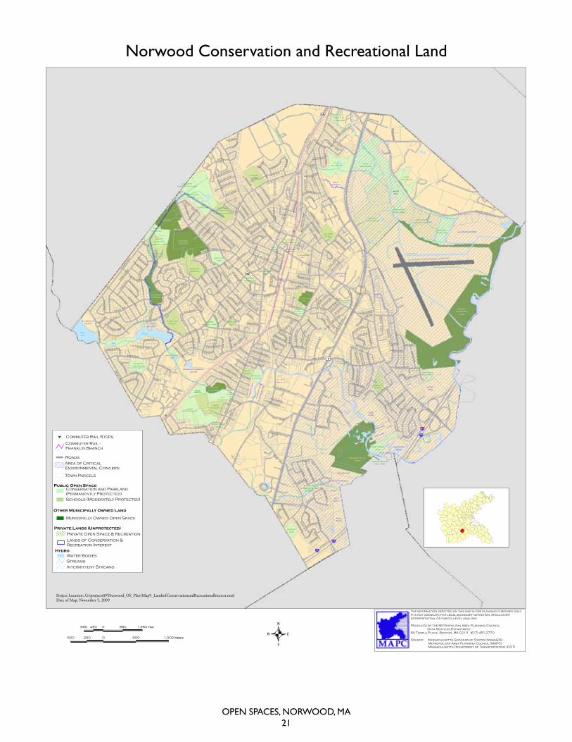
The information depicted on this map is for planning purposes only.It is not adequate for legal boundary definition, regulatoryinterpretation, or parcel-level analysis.
Produced by the Metropolitan Area Planning CouncilData Services Department.
60 Temple Place, Boston, MA 02111 (617) 451-2770
Source: Massachusetts Geographic System (MassGIS)Metropolitan Area Planning Council (MAPC)Massachusetts Department of Transportation (DOT)
Town of NorwoodOpen Space and Recreation Plan
Figure 9Lands of Conservation and Recreational Interest
Coordinate Reference System: Massachusetts State Plane Feet (NAD83)
980 0 980 1,960490 Feet
500 0 500 1,000250 Meters
Project Location: G:\projects09\Norwood_OS_Plan\Map9_LandsofConservationandRecreationalInterest.mxdDate of Map: November 5, 2009
Tax Title
Water BodiesStreamsIntermittent Streams
Public Open SpaceConservation and Parkland(Permanently Protected)Schools (Moderately Protected)
Hydro
Lands of Conservation &Recreation Interest
Area of CriticalEnvironmental Concern
Other Municipally Owned Land
Municipally Owned Open Space
Private Lands (Unprotected)Private Open Space & Recreation
Commuter Rail -Franklin Branch
Commuter Rail Stops
Town Parcels
Roads
norwood conservation and recreational Land
Open SpaceS, nOrwOOd, Ma22
Project produced, photographed and designed byBruce Jones
Bruce Jones Design Inc.661 Washington StreetNorwood, MA 02062
781-255-7171 • [email protected]
AcousticNatureSounds.com