Embed Size (px)
Citation preview
BUS
RB
RB
R-20O&I-2
SCNB
O&I-1
BUS
CUD O&I-1
O&I-2
NB
CUD RB
CUD O&I-1
NB
O&I-1
RB
O&I-2
EAST
DAVIE
BLOU
NT
PERS
ON
SOUTH
LENOIR
MARTIN
WILM
INGT
ON
BLOO
DWOR
TH
CABARRUS
FAYE
TTEV
ILLE
BLAK
E
WORTH
STRONACHS
WOLFE
REGA
N
ELLIN
GTON
PARH
AM
WORTH275
Feet
DAVIE
LENOIR
MARTIN
EAST
HARGETT
SOUTH
BLOU
NT
PERS
ON CHAV
ISDAWS
ON
SWAI
N
MCDO
WELL
BLOO
DWOR
TH CAMD
EN
HAYWOOD
CABARRUS
ALST
ONGALE
WORTHCAPE
KINDLEY
WYNN
E
COMM
ERCE
CANDOR
WOLFE
ARCADE
MARKET
HAYW
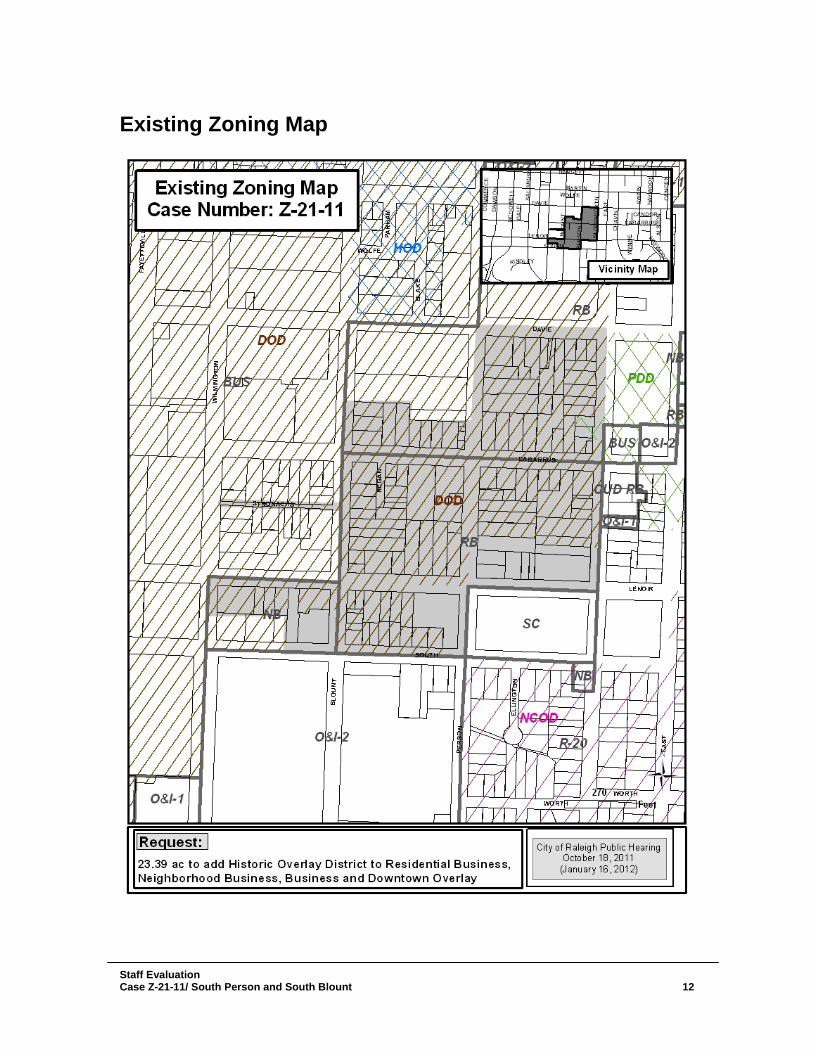
OODExisting Zoning Map
Case Number: Z-21-11
City of Raleigh Public HearingOctober 18, 2011
(January 16, 2012)
Vicinity Map
23.39 ac to add Historic Overlay District to Residential Business,Neighborhood Business, Business and Downtown Overlay
Request:
NB
HOD
PDD
NCOD
Certified Recommendation Raleigh Planning Commission
CR#
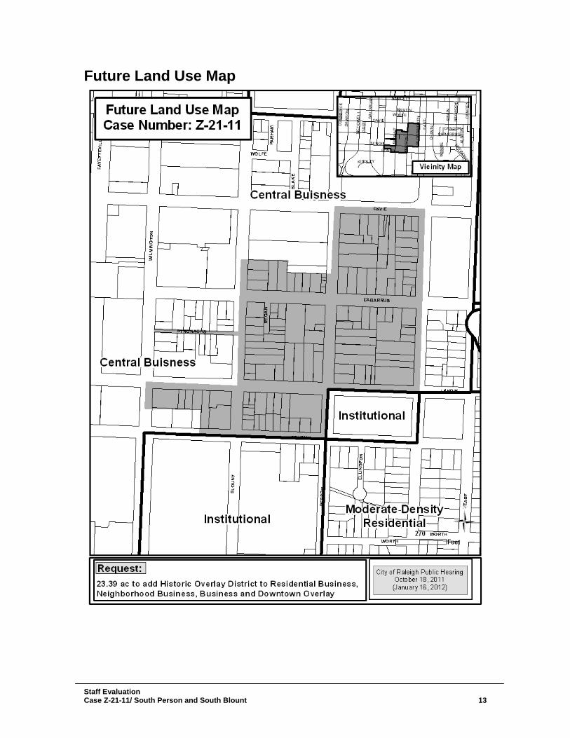
Case Information: Z-21-11 South Person and South Blount Location Area in the general vicinity of South Person and South Blount between
East Davie and East South Street Size 23.39 acres
Request Apply Historic Overlay District zoning to properties zoned RB w/DOD, RB, NB w/DOD, NB, Bus w/DOD
Comprehensive Plan Consistency Consistent Inconsistent Consistent Future Land Use
Designation
Central Business District
Applicable Policy Statements
ED 6.4 Cultural Resource Promotion H 1.6 Housing Preservation UD 1.1 Protecting Neighborhood Identity UD 5.1 Contextual Design UD 5.5 Areas of Strong Architectural Character HP 1.2 Cultural and Historic Resource Preservation HP 2.3 Raleigh Historic Designation HP 2.4 Protecting Historic Neighborhoods ACTION HP 2.6 Downtown Historic Overlays HP 2.7 Mitigating Impacts on Historic Sites HP 3.1 Adaptive Use HP 3.2 Retention over Replacement HP 3.3 Adaptive Use and Parking HP 3.4 Context Sensitive Design DT 1.13 Downtown Transition Areas DT 2.10 Downtown Alleys AP-SP 1 South Park Downtown Transition AP-SP 4 Character of South Park Infill AP-SP 5 South Park Historic Preservation AP-SP 6 South Park/Downtown Overlay Overlap
Summary of Conditions Submitted
Conditions None (general use request)
Issues and Impacts Outstanding
Issues 1. None
Suggested Conditions
1. None
Impacts 1. None Proposed 1. None
Certified Recommendation Case Z-21-11/ South Person and South Blount
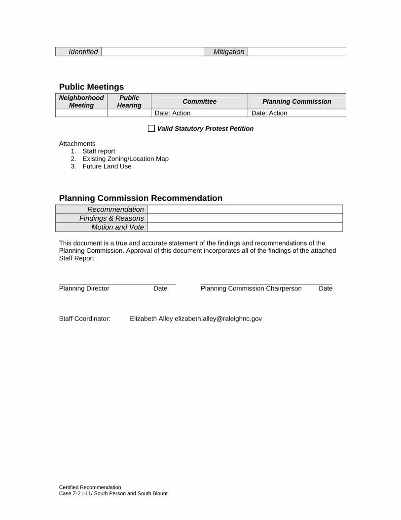
Identified Mitigation
Public Meetings Neighborhood
Meeting Public
Hearing Committee Planning Commission Date: Action Date: Action
Valid Statutory Protest Petition
Attachments 1. Staff report 2. Existing Zoning/Location Map 3. Future Land Use
Planning Commission Recommendation Recommendation
Findings & Reasons Motion and Vote
This document is a true and accurate statement of the findings and recommendations of the Planning Commission. Approval of this document incorporates all of the findings of the attached Staff Report. ________________________________ ____________________________________ Planning Director Date Planning Commission Chairperson Date Staff Coordinator: Elizabeth Alley [email protected]
Certified Recommendation Case Z-21-11/ South Person and South Blount
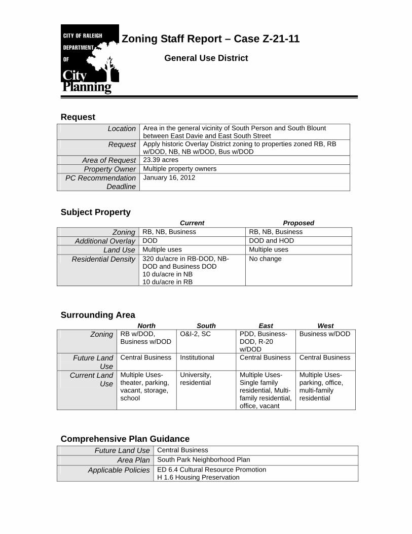
Zoning Staff Report – Case Z-21-11 General Use District
Request Location Area in the general vicinity of South Person and South Blount
between East Davie and East South Street Request Apply historic Overlay District zoning to properties zoned RB, RB
w/DOD, NB, NB w/DOD, Bus w/DOD Area of Request 23.39 acres Property Owner Multiple property owners
PC Recommendation Deadline
January 16, 2012
Subject Property Current Proposed
Zoning RB, NB, Business RB, NB, Business Additional Overlay DOD DOD and HOD
Land Use Multiple uses Multiple uses Residential Density 320 du/acre in RB-DOD, NB-
DOD and Business DOD 10 du/acre in NB 10 du/acre in RB
No change
Surrounding Area North South East West
Zoning RB w/DOD, Business w/DOD
O&I-2, SC PDD, Business-DOD, R-20 w/DOD
Business w/DOD
Future Land Use
Central Business Institutional Central Business Central Business
Current Land Use
Multiple Uses- theater, parking, vacant, storage, school
University, residential
Multiple Uses- Single family residential, Multi-family residential, office, vacant
Multiple Uses- parking, office, multi-family residential
Comprehensive Plan Guidance Future Land Use Central Business
Area Plan South Park Neighborhood Plan Applicable Policies ED 6.4 Cultural Resource Promotion
H 1.6 Housing Preservation
Staff Evaluation Case Z-21-11/ South Person and South Blount 2
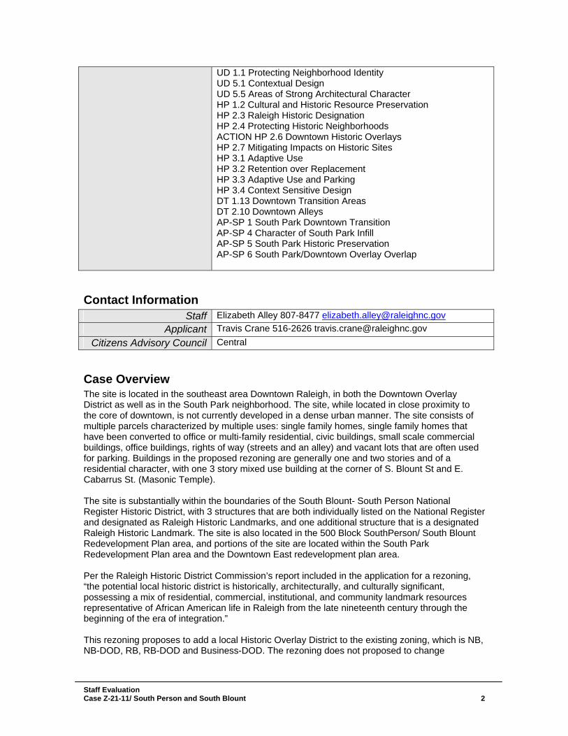
UD 1.1 Protecting Neighborhood Identity UD 5.1 Contextual Design UD 5.5 Areas of Strong Architectural Character HP 1.2 Cultural and Historic Resource Preservation HP 2.3 Raleigh Historic Designation HP 2.4 Protecting Historic Neighborhoods ACTION HP 2.6 Downtown Historic Overlays HP 2.7 Mitigating Impacts on Historic Sites HP 3.1 Adaptive Use HP 3.2 Retention over Replacement HP 3.3 Adaptive Use and Parking HP 3.4 Context Sensitive Design DT 1.13 Downtown Transition Areas DT 2.10 Downtown Alleys AP-SP 1 South Park Downtown Transition AP-SP 4 Character of South Park Infill AP-SP 5 South Park Historic Preservation AP-SP 6 South Park/Downtown Overlay Overlap
Contact Information Staff Elizabeth Alley 807-8477 [email protected]
Applicant Travis Crane 516-2626 [email protected] Citizens Advisory Council Central
Case Overview The site is located in the southeast area Downtown Raleigh, in both the Downtown Overlay District as well as in the South Park neighborhood. The site, while located in close proximity to the core of downtown, is not currently developed in a dense urban manner. The site consists of multiple parcels characterized by multiple uses: single family homes, single family homes that have been converted to office or multi-family residential, civic buildings, small scale commercial buildings, office buildings, rights of way (streets and an alley) and vacant lots that are often used for parking. Buildings in the proposed rezoning are generally one and two stories and of a residential character, with one 3 story mixed use building at the corner of S. Blount St and E. Cabarrus St. (Masonic Temple). The site is substantially within the boundaries of the South Blount- South Person National Register Historic District, with 3 structures that are both individually listed on the National Register and designated as Raleigh Historic Landmarks, and one additional structure that is a designated Raleigh Historic Landmark. The site is also located in the 500 Block SouthPerson/ South Blount Redevelopment Plan area, and portions of the site are located within the South Park Redevelopment Plan area and the Downtown East redevelopment plan area. Per the Raleigh Historic District Commission’s report included in the application for a rezoning, “the potential local historic district is historically, architecturally, and culturally significant, possessing a mix of residential, commercial, institutional, and community landmark resources representative of African American life in Raleigh from the late nineteenth century through the beginning of the era of integration.” This rezoning proposes to add a local Historic Overlay District to the existing zoning, which is NB, NB-DOD, RB, RB-DOD and Business-DOD. The rezoning does not proposed to change
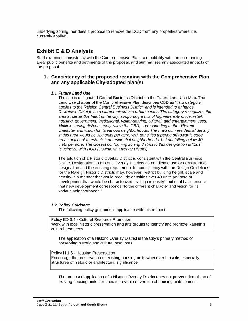
underlying zoning, nor does it propose to remove the DOD from any properties where it is currently applied.
Exhibit C & D Analysis Staff examines consistency with the Comprehensive Plan, compatibility with the surrounding area, public benefits and detriments of the proposal, and summarizes any associated impacts of the proposal.
1. Consistency of the proposed rezoning with the Comprehensive Plan and any applicable City-adopted plan(s)
1.1 Future Land Use
The site is designated Central Business District on the Future Land Use Map. The Land Use chapter of the Comprehensive Plan describes CBD as “This category applies to the Raleigh Central Business District, and is intended to enhance Downtown Raleigh as a vibrant mixed use urban center. The category recognizes the area’s role as the heart of the city, supporting a mix of high-intensity office, retail, housing, government, institutional, visitor-serving, cultural, and entertainment uses. Multiple zoning districts apply within the CBD, corresponding to the different character and vision for its various neighborhoods. The maximum residential density in this area would be 320 units per acre, with densities tapering off towards edge areas adjacent to established residential neighborhoods, but not falling below 40 units per acre. The closest conforming zoning district to this designation is “Bus” (Business) with DOD (Downtown Overlay District).” The addition of a Historic Overlay District is consistent with the Central Business District Designation as Historic Overlay Districts do not dictate use or density. HOD designation and the ensuing requirement for consistency with the Design Guidelines for the Raleigh Historic Districts may, however, restrict building height, scale and density in a manner that would preclude densities over 40 units per acre or development that would be characterized as “high intensity”, but could also ensure that new development corresponds “to the different character and vision for its various neighborhoods.”
1.2 Policy Guidance The following policy guidance is applicable with this request:
Policy ED 6.4 - Cultural Resource Promotion Work with local historic preservation and arts groups to identify and promote Raleigh’s cultural resources
The application of a Historic Overlay District is the City’s primary method of preserving historic and cultural resources.
Policy H 1.6 - Housing Preservation Encourage the preservation of existing housing units whenever feasible, especially structures of historic or architectural significance.
The proposed application of a Historic Overlay District does not prevent demolition of existing housing units nor does it prevent conversion of housing units to non-
Staff Evaluation Case Z-21-11/ South Person and South Blount 3
residential uses. It is, however, the only tool in the existing zoning code to delay demolition of historically significant structures (including residential properties).
Policy UD 1.1 - Protecting Neighborhood Identity Use Neighborhood Conservation Overlay Districts (NCOD), Historic Overlay Districts (HOD), or rezonings to retain the character of Raleigh's existing neighborhoods and strengthen the sense of visual order and stability. The proposed application of a Historic Overlay District will aid in the retention of the character of the South Person-South Blount National Register Historic District and require the application of the Design Guidelines for Raleigh Historic Districts for new development and exterior and site changes to existing properties in the district.
Policy UD 5.1 - Contextual Design Proposed development within established neighborhoods should create or enhance a distinctive character that relates well to the surrounding area. The proposed application of a Historic Overlay District will require review for consistency with the Design Guidelines for Raleigh Historic Districts for new development and exterior and site changes to existing properties in the district. However, the proposed historic district is immediately adjacent on 3 sides to properties zoned Downtown Overlay District, and on the south by properties zoned O&I-2. These properties could be developed at an intensity and height substantially greater than those within the proposed historic overlay district, leading to a dissimilar character with nearby properties.
Policy UD 5.5 - Areas of Strong Architectural Character Preserve the architectural continuity and design integrity of historic districts and other areas of strong architectural character. New development within such areas does not need to replicate prevailing architectural styles exactly but should be complementary in form, height, and bulk. The proposed rezoning will preserve architectural continuity and design integrity through the application of the Design Guidelines for Raleigh Historic Districts.
Policy HP 1.2 - Cultural and Historic Resource Preservation Identify, preserve, and protect cultural and historic resources including buildings, neighborhoods, designed and natural landscapes, cemeteries, streetscapes, view corridors, and archaeological resources.
The proposed Historic Overlay District will protect resources within the boundaries through the use of the Design Guidelines for Raleigh Historic Districts.
Policy HP 2.3 - Raleigh Historic Designation Encourage and sponsor the designation of eligible historic resources for local protection.
The proposed rezoning designates eligible historic resources through the application of a Historic Overlay District.
Policy HP 2.4 - Protecting Historic Neighborhoods Protect the scale and character of the City’s historic neighborhoods while still allowing compatible and context-sensitive infill development to occur.
Staff Evaluation Case Z-21-11/ South Person and South Blount 4
Historic Overlay District allow new development as long at it is consistent with the Design Guidelines for Raleigh Historic Districts, which serves to guide development to a context-sensitive design that is compatible with nearby and well related structures in the historic district. Action HP 2.6 -Downtown Historic Overlays Consider designating local historic overlay districts in downtown for Fayetteville Street National Register district, Depot National Register district, and South Person-South Blount Streets redevelopment plan area.
The rezoning proposes to create a local historic overlay district in the South Person-South Blount Streets redevelopment plan area.
Policy HP 2.7 - Mitigating Impacts on Historic Sites Development proposals adjacent to or including historic sites should identify and minimize or mitigate any negative development impacts on those sites. The application of a Historic Overlay District, and the ensuing use of the Design Guidelines for Raleigh Historic Districts, ensures review of development proposals within the Historic Overlay District for negative impacts on sites within the Historic Overlay District. In addition the Raleigh Historic Districts Commission can provide a non-binding review of development projects outside but adjacent to the Historic Overlay District for consistency and compatibility with the adjacent HOD.
Policy HP 3.1 - Adaptive Use Encourage adaptive use of historic properties to preserve cultural resources and conserve natural resources.
The application of a Historic Overlay District does not directly encourage adaptive use, however is does discourage the demolition of contributing structures and does not regulate property by type of use.
Policy HP 3.2 -Retention over Replacement Encourage the preservation and rehabilitation of significant or contributing existing structures, favoring retention over replacement, especially in areas where other historic resources are present.
The application of a Historic Overlay District does not prevent demolition of contributing structures, but does allow for a demolition delay of up to 365 days per the Design Guidelines for Raleigh Historic Districts. Because new structures in a Historic Overlay District must also be reviewed for consistency in scale, placement and design per the Design Guidelines, the Historic Overlay District indirectly serves as a disincentive for demolition of contributing structures as replacement structures could be required to be of a substantially similar scale.
Policy HP 3.3 - Adaptive Use and Parking Additional parking required for nonresidential adaptive use should be located to the rear of the historic structure. The majority of the properties in the rezoning application are in the Downtown Overlay District, which includes substantial parking exemptions. While additional parking for adaptive use will likely not be required because of the DOD, additional parking may be desired by property owners. The Design Guidelines for Raleigh Historic Districts give
Staff Evaluation Case Z-21-11/ South Person and South Blount 5
guidance for ensuring compatibility with the historic district’s character, but do not specifically require parking to be located to rear of historic structures.
Policy HP 3.4 - Context Sensitive Design Use the existing architectural and historical character within an area as a guide for new construction.
The rezoning, by creating a Local Historic District, would require review of exterior modifications of existing properties, as well as new development to be reviewed for consistency with the Design Guidelines for Raleigh Historic Districts, which give guidance for ensuring compatibility with the historic district’s character.
Policy DT 1.13 - Downtown Transition Areas In areas where the Downtown Element boundaries are located in proximity to established residential neighborhoods, residential densities should taper to be compatible with adjacent development. Non-residential uses with the greatest impacts—such as theaters, concentrated destination nightlife and retail, and sports and entertainment uses—should be directed away from these transition areas. Where existing zoning overlays are mapped, the height guidance in these districts should not be changed outside of an area planning process See Map DT-3 for transition area locations. Not all of the properties in the area to be rezoned are included in the transition area location shown on Map DT-3; however the majority of the properties are in the transition area. While the application of the historic overlay district won’t mandate less intense development on the downtown edge, it certainly could curtail more intense development.
Policy DT 2.10 - Downtown Alleys Encourage the preservation and protection of existing internal alleyways in downtown. The proposed rezoning includes Stronach’s Alley. While inclusion in a historic district does not restrict demolition (or in this case removal or modification of the alley), the demolition, removal or modification would require Historic Districts Commission review and demolition could be delayed up to 365 days. The alley does not meet current street standards for width.
1.3 Area Plan Guidance Policy AP-SP 1 - South Park Downtown Transition Encourage mixed-use development (small-scale Office, Retail, and/or Residential uses) in the area bounded by Cabarrus, East, Lenoir, and Wilmington streets. The proposed Historic Overlay District does not guide use therefore it does not encourage mixed-use development. It does however impact scale through use of the Design Guidelines.
Policy AP-SP 4 - Character of South Park Infill Infill residential development should reflect the existing historic building types in the South Park study area. The proposed Historic Overlay District and associated Design Guidelines regulate development character, and promote compatibility with existing historic building types in the district.
Staff Evaluation Case Z-21-11/ South Person and South Blount 6
Policy AP-SP 5 - South Park Historic Preservation Emphasize the historic significance of the South Park neighborhood through the promotion and protection of contributing historic elements. The proposed rezoning serves to protect contributing historic elements.
Policy AP-SP 6 - South Park/ Downtown Overlay Overlap Where the South Park plan overlaps the Downtown Overlay District, the intent of the Downtown Overlay District shall prevail. The proposed rezoning does not eliminate the Downtown Overlay District, though the use of the Design Guidelines will likely result in new development of a significantly less intense, tall, and dense character than that allowed in the Downtown Overlay District due to Design Guidelines regarding compatibility of scale of new development to existing contributing structures.
2. Compatibility of the proposed rezoning with the property and
surrounding area The Design Guidelines for Raleigh Historic Districts contains character essays for each of the local Historic Overlay Districts. This essay describes the historically contributing characteristics of each district, ranging from streetscape, building type, architecture, site features, and scale. Because each district has a specific character essay, the proposed rezoning is inherently compatible with the properties being rezoned, as the basis of the rezoning is the preservation of the character of the district. The proposed rezoning is also generally compatible with the surrounding area. The application does not propose to change underlying zoning or remove the DOD designation. The proposed rezoning would create a condition similar to that already present in the Blount Street, Capitol, and Moore Square Historic Overlay Districts, all of which contain properties zoned for a variety of districts, and all of which contain properties that are covered by both the DOD and HOD.
3. Public benefits of the proposed rezoning
The proposed rezoning will preserve existing development that has been determined to be historically contributing. The rezoning will also regulate the design of new development and existing building and site alterations by requiring review by the Raleigh Historic Districts Commission. The rezoning furthers the policies and actions of the Comprehensive Plan that call for the preservation of historic resources and existing housing stock, and ensure development is of a compatible scale and design as existing development.
4. Detriments of the proposed rezoning Preservation of the existing low scale development patterns, while compatible with the properties within the proposed Historic Overlay District, may prove to be dissimilar to the development patterns of surrounding properties. The Design Guidelines for Raleigh Historic Districts Guideline 4.3.6 states “Design new buildings to be compatible with surrounding buildings that contribute to the overall character of the historic district in terms of height, form, size, scale, massing, proportion and roof shape.” The proposed district borders properties zoned Downtown Overlay District on the northern, western, and eastern boundaries, and borders properties zoned O&I-2 and owned by Shaw University on the southern boundary.
Staff Evaluation Case Z-21-11/ South Person and South Blount 7
Staff Evaluation Case Z-21-11/ South Person and South Blount 8
These properties in the Downtown Overlay District are zoned to accommodate very dense, urban mixed use, and have no height limit. As properties in the area continue to develop, the Historic Overlay District may become surrounded by development of a dissimilar scale. The Comprehensive Plan calls for transitions in scale to be accommodated on the property of the more intense development. This could create a scenario in which a parcel is in the core of downtown, which is intended to accommodate some of the densest development in the city, while also needing to transition to adjacent properties that are developed at 1-3 stories. There are no differences in allowed uses, and allowed densities between a parcel zoned with only DOD and one zoned with both DOD and HOD, but the difference in allowable height and scale, and as a result intensity, may prove to be incompatible.
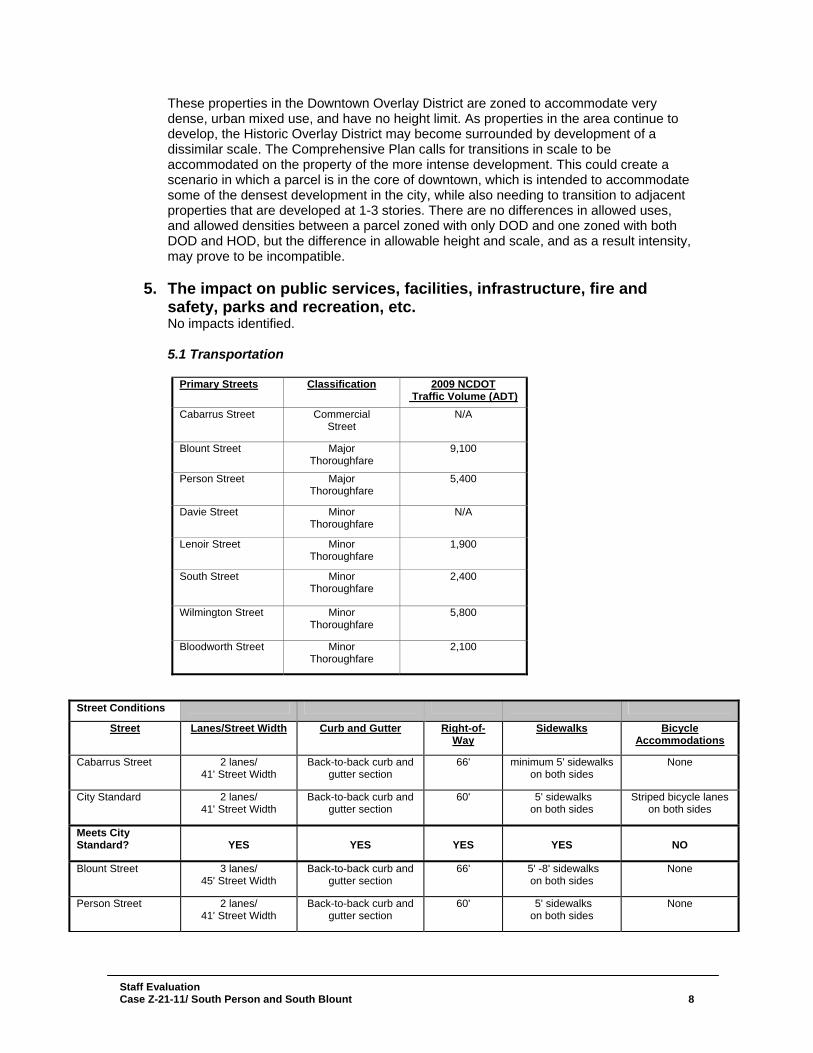
5. The impact on public services, facilities, infrastructure, fire and safety, parks and recreation, etc. No impacts identified. 5.1 Transportation
Primary Streets Classification 2009 NCDOT Traffic Volume (ADT)
Cabarrus Street Commercial Street
N/A
Blount Street Major Thoroughfare
9,100
Person Street Major Thoroughfare
5,400
Davie Street Minor Thoroughfare
N/A
Lenoir Street Minor Thoroughfare
1,900
South Street Minor Thoroughfare
2,400
Wilmington Street Minor Thoroughfare
5,800
Bloodworth Street Minor Thoroughfare
2,100
Street Conditions
Street Lanes/Street Width Curb and Gutter Right-of-Way
Sidewalks Bicycle Accommodations
Cabarrus Street 2 lanes/ 41' Street Width
Back-to-back curb and gutter section
66' minimum 5' sidewalks on both sides
None
City Standard 2 lanes/ 41' Street Width
Back-to-back curb and gutter section
60' 5' sidewalks on both sides
Striped bicycle lanes on both sides
Meets City Standard?
YES
YES
YES
YES
NO
Blount Street 3 lanes/ 45' Street Width
Back-to-back curb and gutter section
66' 5' -8' sidewalks on both sides
None
Person Street 2 lanes/ 41' Street Width
Back-to-back curb and gutter section
60' 5' sidewalks on both sides
None
Staff Evaluation Case Z-21-11/ South Person and South Blount 9
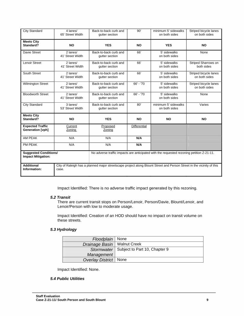
Impact Identified: There is no adverse traffic impact generated by this rezoning.
5.2 Transit There are current transit stops on Person/Lenoir, Person/Davie, Blount/Lenoir, and Lenoir/Person with low to moderate usage. Impact Identified: Creation of an HOD should have no impact on transit volume on these streets.
5.3 Hydrology
Floodplain None Drainage Basin Walnut Creek
Stormwater Management
Subject to Part 10, Chapter 9
Overlay District None Impact Identified: None.
5.4 Public Utilities
City Standard 4 lanes/ 65' Street Width
Back-to-back curb and gutter section
90' minimum 5' sidewalks on both sides
Striped bicycle lanes on both sides
Meets City Standard?
NO
YES
NO
YES
NO
Davie Street 2 lanes/ 41' Street Width
Back-to-back curb and gutter section
66' 5' sidewalks on both sides
None
Lenoir Street 2 lanes/ 41' Street Width
Back-to-back curb and gutter section
66' 5' sidewalks on both sides
Striped Sharrows on both sides
South Street 2 lanes/ 41' Street Width
Back-to-back curb and gutter section
66' 5' sidewalks on both sides
Striped bicycle lanes on both sides
Wilmington Street 2 lanes/ 41' Street Width
Back-to-back curb and gutter section
66' - '70 5' sidewalks on both sides
Striped bicycle lanes on both sides
Bloodworth Street 2 lanes/ 41' Street Width
Back-to-back curb and gutter section
66' - '70 5' sidewalks on both sides
None
City Standard 3 lanes/ 53' Street Width
Back-to-back curb and gutter section
80' minimum 5' sidewalks on both sides
Varies
Meets City Standard?
NO
YES
NO
NO
NO
Expected Traffic Generation [vph]
Current Zoning
Proposed Zoning
Differential
AM PEAK N/A N/A N/A PM PEAK N/A N/A N/A
Suggested Conditions/ Impact Mitigation:
No adverse traffic impacts are anticipated with the requested rezoning petition Z-21-11.
Additional Information:
City of Raleigh has a planned major streetscape project along Blount Street and Person Street in the vicinity of this case.
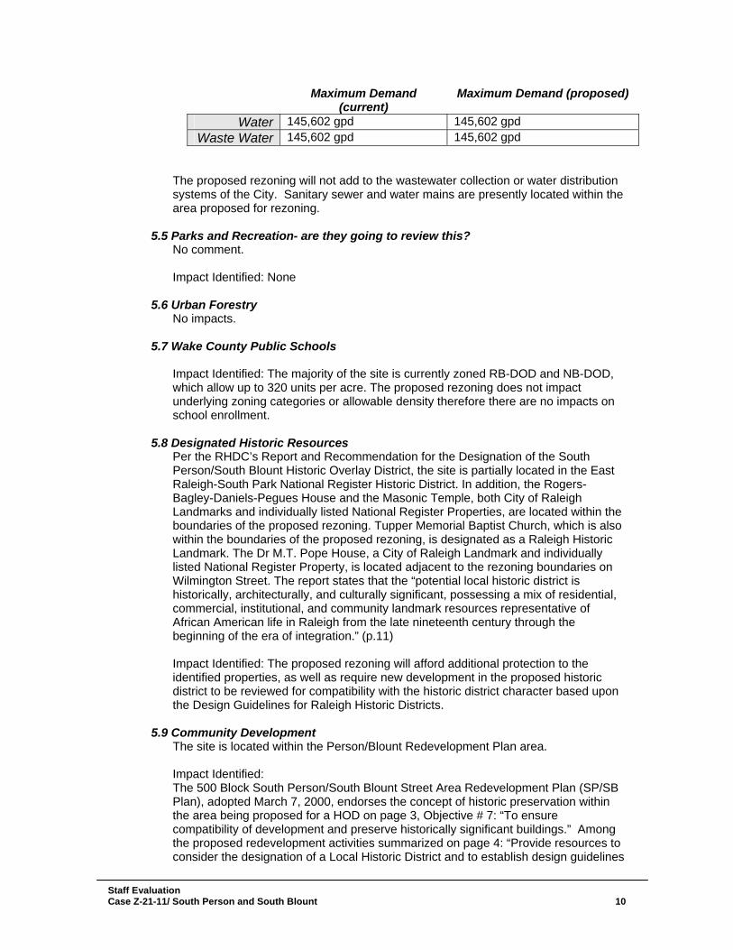
Maximum Demand
(current) Maximum Demand (proposed)
Water 145,602 gpd 145,602 gpd Waste Water 145,602 gpd 145,602 gpd
The proposed rezoning will not add to the wastewater collection or water distribution systems of the City. Sanitary sewer and water mains are presently located within the area proposed for rezoning.
5.5 Parks and Recreation- are they going to review this? No comment. Impact Identified: None
5.6 Urban Forestry No impacts.
5.7 Wake County Public Schools Impact Identified: The majority of the site is currently zoned RB-DOD and NB-DOD, which allow up to 320 units per acre. The proposed rezoning does not impact underlying zoning categories or allowable density therefore there are no impacts on school enrollment.
5.8 Designated Historic Resources Per the RHDC’s Report and Recommendation for the Designation of the South Person/South Blount Historic Overlay District, the site is partially located in the East Raleigh-South Park National Register Historic District. In addition, the Rogers-Bagley-Daniels-Pegues House and the Masonic Temple, both City of Raleigh Landmarks and individually listed National Register Properties, are located within the boundaries of the proposed rezoning. Tupper Memorial Baptist Church, which is also within the boundaries of the proposed rezoning, is designated as a Raleigh Historic Landmark. The Dr M.T. Pope House, a City of Raleigh Landmark and individually listed National Register Property, is located adjacent to the rezoning boundaries on Wilmington Street. The report states that the “potential local historic district is historically, architecturally, and culturally significant, possessing a mix of residential, commercial, institutional, and community landmark resources representative of African American life in Raleigh from the late nineteenth century through the beginning of the era of integration.” (p.11) Impact Identified: The proposed rezoning will afford additional protection to the identified properties, as well as require new development in the proposed historic district to be reviewed for compatibility with the historic district character based upon the Design Guidelines for Raleigh Historic Districts.
5.9 Community Development
The site is located within the Person/Blount Redevelopment Plan area. Impact Identified: The 500 Block South Person/South Blount Street Area Redevelopment Plan (SP/SB Plan), adopted March 7, 2000, endorses the concept of historic preservation within the area being proposed for a HOD on page 3, Objective # 7: “To ensure compatibility of development and preserve historically significant buildings.” Among the proposed redevelopment activities summarized on page 4: “Provide resources to consider the designation of a Local Historic District and to establish design guidelines
Staff Evaluation Case Z-21-11/ South Person and South Blount 10
to ensure compatibility of development.” The Proposed Zoning section of the Plan at page 7 specifically recommends that an historic overlay district be created on the area proposed in this rezoning, except that Stronach’s Alley was not indicated as part of the HOD recommended in the SP/SB Plan. This action (as well as the creation of a local historic district), according to the Plan, would help “stabilize the eroding historic character of this area” and would be “a vital component to maintaining the residential character of this area.” The establishment of an historic overlay district in the area indicated in the Z-21-11 rezoning case is consistent with the adopted 500 Block South Person/South Blount Street Area Redevelopment Plan. Parts of the area are also included in the South Park and Downtown East Redevelopment Plans, as well as the Moore Square South Development Strategy. The twelve properties in or adjacent to the proposed HOD that were acquired by CD are currently unimproved properties, except the one-story commercial structure at 517 Blount Street. Any construction to be undertaken on these properties by CD itself or to entities to whom it sells them will be subject to historic guidelines that can help preserve the character of the area.
5.10 Impacts Summary None
5.11 Mitigation of Impacts None.
6. Appearance Commission No review
7. Conclusions The proposed rezoning is consistent with the Comprehensive Plan and the future land use map. No impacts have been identified, and there are no outstanding issues to be addressed. The application of a historic overlay district would preserve the existing historic character of the area. The historic overlay district could constrain intense development in this urban edge of downtown.
Staff Evaluation Case Z-21-11/ South Person and South Blount 11
Staff Evaluation Case Z-21-11/ South Person and South Blount 12
Existing Zoning Map
Future Land Use Map
Staff Evaluation Case Z-21-11/ South Person and South Blount 13
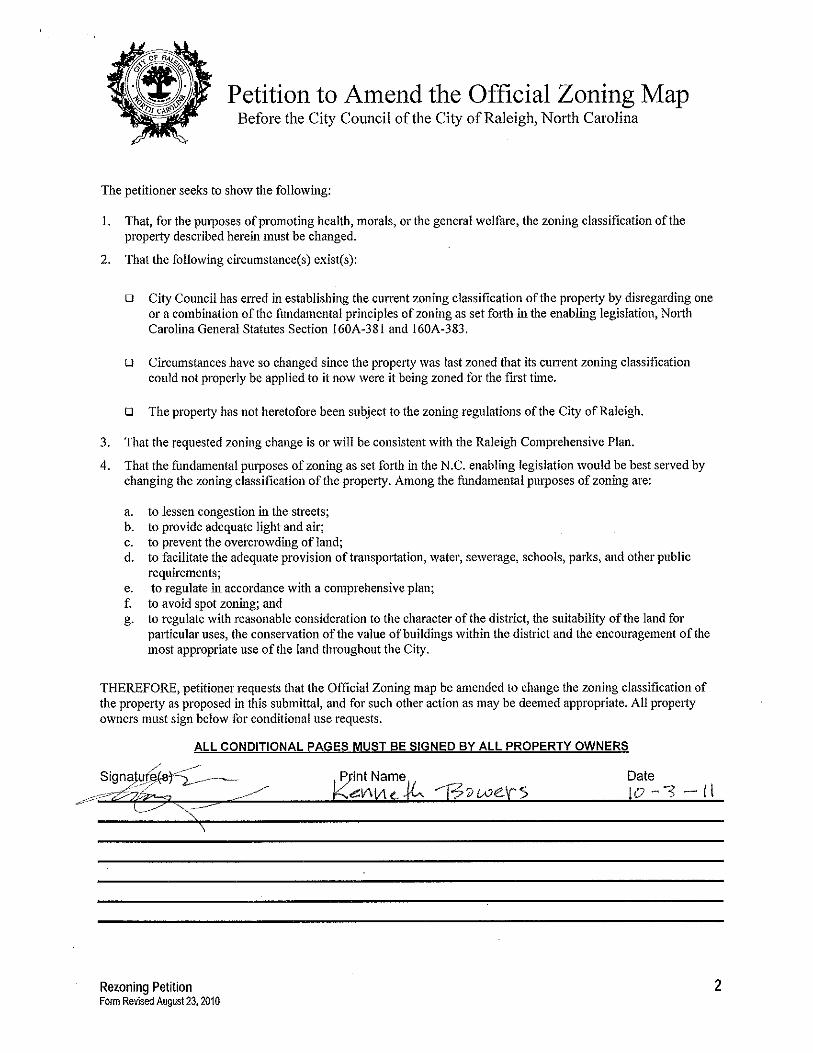
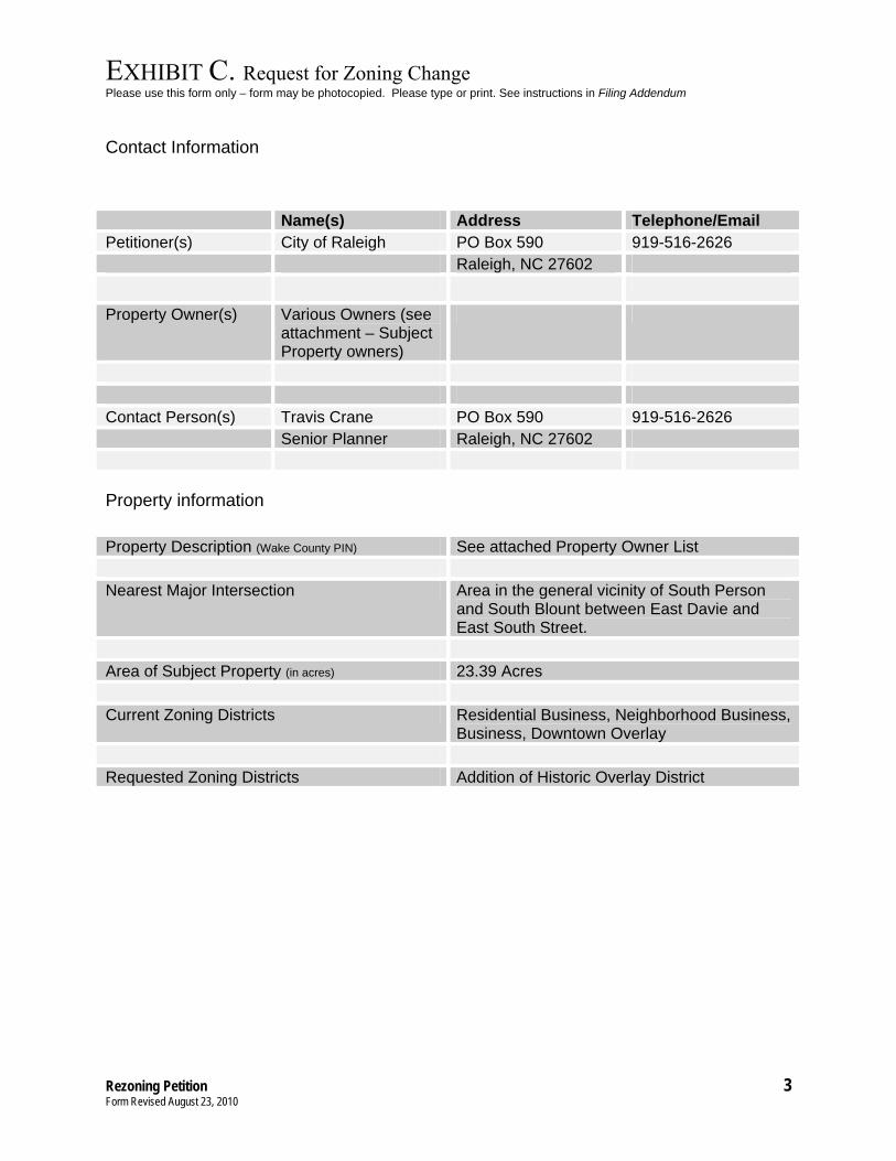
EXHIBIT C. Request for Zoning Change Please use this form only – form may be photocopied. Please type or print. See instructions in Filing Addendum
Rezoning Petition 3 Form Revised August 23, 2010
Contact Information
Property information
Property Description (Wake County PIN) See attached Property Owner List Nearest Major Intersection Area in the general vicinity of South Person
and South Blount between East Davie and East South Street.
Area of Subject Property (in acres) 23.39 Acres Current Zoning Districts Residential Business, Neighborhood Business,
Business, Downtown Overlay Requested Zoning Districts Addition of Historic Overlay District
Name(s) Address Telephone/Email Petitioner(s) City of Raleigh PO Box 590 919-516-2626 Raleigh, NC 27602 Property Owner(s) Various Owners (see
attachment – Subject Property owners)
Contact Person(s) Travis Crane PO Box 590 919-516-2626 Senior Planner Raleigh, NC 27602
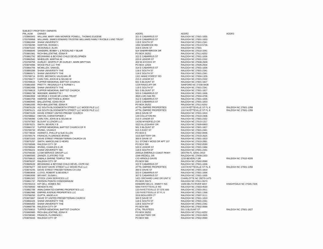
SUBJECT PROPTERY OWNERSPIN_NUM OWNER ADDR1 ADDR2 ADDR31703865943 WILLIAM, MARY ANN MONROE POWELL, THOMAS EUGENE 321 E CABARRUS ST RALEIGH NC 27601-18351703769958 WILLIAMS, JAMES EDWARD TRUSTEE WILLIAMS FAMILY RVCBLE LVNG TRUST 213 E CABARRUS ST RALEIGH NC 27601-18331703862494 SHAW UNIVERSITY 118 E SOUTH ST RALEIGH NC 27601-23411703768290 HORTON, ROSSIE L 1004 SEABROOK RD RALEIGH NC 27610-57361703875102 MCDONALD, ALAN 318 E DAVIE ST RALEIGH NC 276011703866645 SANDERS, BOBBY L & ROSALIND Y BLAIR 524 SHERRYBROOK DR RALEIGH NC 27610-33411703861981 RICH-BALLENTINE, EDNA R PO BOX 26252 RALEIGH NC 27611-62521703862792 BEGINNING & BEYONG CHILD DEVELOPMEN 322 E CABARRUS ST RALEIGH NC 27601-18361703860542 WHEELER, MARTHA W 223 E LENOIR ST RALEIGH NC 27601-23321703769759 GURLEY, WORTH P JR GURLEY, MARK BRITTAIN 403 W AYCOCK ST RALEIGH NC 27608-25091703874096 WOOD PILE LLC THE PO BOX 12504 RALEIGH NC 27605-25041703864706 MCMILLEN, SAMUEL 314 E CABARRUS ST RALEIGH NC 27601-18361703860289 SHAW UNIVERSITY THE 118 E SOUTH ST RALEIGH NC 27601-23411703865571 SHAW UNIVERSITY THE 118 E SOUTH ST RALEIGH NC 27601-23411703768714 BYRD, MEDWICK VAUGHAN JR 1321 WAKE FOREST RD RALEIGH NC 27604-13261703768477 CARLTON, JOHN W & SELMA W 215 E LENOIR ST RALEIGH NC 27601-23321703769615 TUPPER MEMORIAL BAPTIST CHURCH 501 S BLOUNT ST RALEIGH NC 27601-18271703861650 PRETTY, REGINALD F & FURNEY L 1229 RADCLIFF DR SANFORD NC 27330-94281703862498 SHAW UNIVERSITY THE 118 E SOUTH ST RALEIGH NC 27601-23411703768619 TUPPER MEMORIAL BAPTIST CHURCH 501 S BLOUNT ST RALEIGH NC 27601-18271703865738 WAGNER, MARKETTE I 320 E CABARRUS ST RALEIGH NC 27601-18361703863559 GEORGE C EXUM SR LIVING TRUST 3920 LIVE OAK RD RALEIGH NC 27604-47061703863758 HARPER, MATTHEW & JENNY 312 E CABARRUS ST RALEIGH NC 27601-18361703860945 BALLENTINE, EDNA RICH 219 E CABARRUS ST RALEIGH NC 27601-18331703861935 RICH-BALLENTINE, EDNA R PO BOX 26252 RALEIGH NC 27611-62521703876126 412 SOUTH BLOODWORTH STREET LLC WOOD PILE LLC ATTN: EMPIRE PROPERTIES 133 FAYETTEVILLE ST FL 6 RALEIGH NC 27601-13561703876121 416 SOUTH BLOODWORTH STREET LLC WOOD PILE LLC ATTN: EMPIRE PROPERTIES 133 FAYETTEVILLE ST FL 6 RALEIGH NC 27601-13561703873139 DAVIE STREET UNITED PRESBY CHURCH 300 E DAVIE ST RALEIGH NC 27601-18101703768662 HINTON, CHRISTOPHER J 120 COLLETON RD RALEIGH NC 27610-24061703768390 CARLTON, JOHN W & SELMA W 215 E LENOIR ST RALEIGH NC 27601-23321703767363 BLOUNT & LENOIR LLC 14256 WYNDFIELD CIR RALEIGH NC 27615-13171703876221 SMITH, BEVERLY B 3323 ALLEGHANY DR RALEIGH NC 27609-69031703860737 TUPPER MEMORIAL BAPTIST CHURCH OF R 501 S BLOUNT ST RALEIGH NC 27601-18271703769733 IRVING, VIVIAN E 615 S EAST ST RALEIGH NC 27601-24411703778034 HORWITZ, PHILLIP & SUE ELLEN PO BOX 6 RALEIGH NC 27602-00061703769179 FRANCIS, FLORENCE IRVING 1515 BATTERY DR RALEIGH NC 27610-26251703873163 DAVIE STREET PRESBYTERIAN CHURCH US 300 E DAVIE ST RALEIGH NC 27601-18101703875297 SMITH, MARCELINE D HEIRS 311 STONEY MOSS DR APT 107 RALEIGH NC 27610-28911703768568 RALEIGH CITY OF PO BOX 590 RALEIGH NC 27602-05901703768564 IRVING, CHARLES G JR 533 E LENOIR ST RALEIGH NC 27601-24841703766221 SHAW UNIVERSITY INC 118 E SOUTH ST RALEIGH NC 27601-23411703769330 LCSM SERVICE GROUP LLC 20001A EMERALD COAST PKWY DESTIN FL 32541-34101703865565 ZINNER, CLIFFORD TOD 1548 IREDELL DR RALEIGH NC 27608-23031703768615 KABALA SHRINE TEMPLE TRS C/O ARNOLD DAVIS 1233 BEVERLY DR RALEIGH NC 27610-42051703876237 RALEIGH CITY OF PO BOX 590 RALEIGH NC 27602-05901703865639 BEGINNING & BEYOND CHILD DEVEL CNTR INC 322 E CABARRUS ST RALEIGH NC 27601-18361703876277 330 EAST DAVIE STREET LLC WOOD PILE LLC ATTN: EMPIRE PROPERTIES 133 FAYETTEVILLE ST FL 6 RALEIGH NC 27601-13561703874245 DAVIE STREET PRESBYTERIAN CH USA 300 E DAVIE ST RALEIGH NC 27601-18101703863658 LLOYD, ROBERT & BEVERLY 322 E CABARRUS ST RALEIGH NC 27601-18361703863936 BRYANT, SUSAN L 307 E CABARRUS ST RALEIGH NC 27601-18351703861502 STOCK LOAN SERVICES LLC 1421 ORCHARD LAKE DR UNIT E CHARLOTTE NC 28270-14751703861737 PERSON POINTE CONDOMINIUM PO BOX 25573 RALEIGH NC 27611-55731703765313 KIP DELL HOMES INC EDWARD WILLS - EMMYY INC 1028 DELTA RIVER WAY KNIGHTDALE NC 27545-73261703769593 MENDATA INC 5944 FAYETTEVILLE RD RALEIGH NC 27603-45301703862788 AMALGAMATED EMPIRE PROPERTIES LLC 133 FAYETTEVILLE ST STE 600 RALEIGH NC 27601-29111703862986 EMPIRE AVENUE PROPERTIES LLC 133 FAYETTEVILLE ST FL 6 RALEIGH NC 27601-13561703768250 GUPTA, ANGELA K 3316 BOULDER CT RALEIGH NC 27607-31111703873067 DAVIE ST UNITED PRESBYTERIAN CHURCH 300 E DAVIE ST RALEIGH NC 27601-18101703864426 SHAW UNIVERSITY THE 118 E SOUTH ST RALEIGH NC 27601-23411703865455 SHAW UNIVERSITY THE 118 E SOUTH ST RALEIGH NC 27601-23411703866736 RALEIGH CITY OF PO BOX 590 RALEIGH NC 27602-05901703769810 TUPPER MEMORIAL BAPTIST CHURCH ETAL TRUSTEES 501 S BLOUNT ST RALEIGH NC 27601-18271703860985 RICH-BALLENTINE, EDNA R PO BOX 26252 RALEIGH NC 27611-62521703768340 FRANCIS, FLORENCE I 1515 BATTERY DR RALEIGH NC 27610-26251703876033 RALEIGH CITY OF PO BOX 590 RALEIGH NC 27602-0590
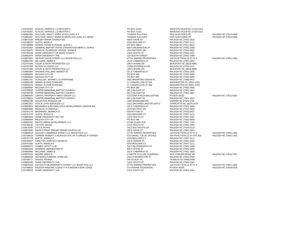
1703764322 SCALES, DERRICK L & HEATHER Z PO BOX 21521 WINSTON SALEM NC 27120-15211703764352 SCALES, DERRICK L & HEATHER Z PO BOX 21521 WINSTON SALEM NC 27120-15211703861984 SULLIVAN, NANCY DORIS W SULLIVAN, K C THOMAS SULLIVAN 2631 GLEN EDEN DR RALEIGH NC 27612-43481703861987 SULLIVAN, NANCY DORIS W HEIRS SULLIVAN, K C HEIRS THOMAS SULLIVAN 2631 GLEN EDEN DR RALEIGH NC 27612-43481703873226 PRESBYTERIAN CHURCH INC 300 E DAVIE ST RALEIGH NC 27601-18101703768220 GUPTA, ANGELA 3316 BOULDER CT RALEIGH NC 27607-31111703768939 HOWZE, VIVIAN W HOWZE, ALPHA L PO BOX 28612 RALEIGH NC 27611-86121703763353 GENERAL BAPTIST STATE CONVENTION WERTZ L W REV. 603 S WILMINGTON ST RALEIGH NC 27601-23381703769370 FRANCIS, FLORENCE I IRVING, VIVIAN E 1515 BATTERY DR RALEIGH NC 27610-26251703765249 SHAW UNIVERSITY OF WAKE COUNTY 118 E SOUTH ST RALEIGH NC 27601-23411703863476 SHAW UNIVERSITY THE 118 SOUTH STREET RALEIGH NC 27601-23991703875250 320 EAST DAVIE STREET LLC WOOD PILE LLC ATTN: EMPIRE PROPERTIES 133 FAYETTEVILLE ST FL 6 RALEIGH NC 27601-13561703864756 WILLIAMS, JAMES E 213 E CABARRUS ST RALEIGH NC 27601-18331703767489 COLBY & HAITH PROPERTIES LLC 199 N SHORE DR BEAUFORT NC 28516-96861703767393 BLOUNT & LENOIR LLC 14256 WYNDFIELD CIR RALEIGH NC 27615-13171703767485 COLBY & HAITH PROPERTIES LLC 199 N SHORE DR BEAUFORT NC 28516-96861703865984 WAGNER-HOLLAND, MARKETTE 321 E CABARRUS ST RALEIGH NC 27601-18351703866945 RALEIGH CITY OF PO BOX 590 RALEIGH NC 27602-05901703866930 RALEIGH CITY OF PO BOX 590 RALEIGH NC 27602-05901703861761 SCHULLER, JEFFREY J & STEPHANIE 2601 BRADFORD GROVE PL RALEIGH NC 27606-94141703860189 MINNIS, ELOISE STARLING 17 LONGFELLOW ST NW WASHINGTON DC 20011-23251703860129 MINNIS, ELOISE STARLING 17 LONGFELLOW ST NW WASHINGTON DC 20011-23251703866960 RALEIGH CITY OF PO BOX 590 RALEIGH NC 27602-05901703769638 TUPPER MEMORIAL BAPTIST CHURCH 501 S BLOUNT ST RALEIGH NC 27601-18271703769730 TUPPER MEMORIAL BAPTIST CHURCH 501 S BLOUNT ST RALEIGH NC 27601-18271703864935 CAPITAL PROPERTY MNGT GROUP LLC C/O EDNA R RICH-BALLENTINE PO BOX 26252 RALEIGH NC 27611-62521703768831 TUPPER MEMORIAL BAPTIST CHURCH 501 S BLOUNT ST RALEIGH NC 27601-18271703864798 GOLDSTON, RONALD LEE 1600 WOODLAND RD GARNER NC 27529-37261703861551 STOCK LOAN SERVICES LLC 1421 ORCHARD LAKE DR UNIT E CHARLOTTE NC 28270-14751703863654 BEGINNING & BEYOND CHILD DEVELOPMENT CENTER INC 322 E CABARRUS ST RALEIGH NC 27601-18361703863996 FRANCIS, FLORENCE I 1515 BATTERY DR RALEIGH NC 27610-26251703767279 BROWNING, BERNICE O 504 PEYTON ST RALEIGH NC 27610-34371703767276 GUPTA, BHOLA N 3316 BOULDER CT RALEIGH NC 27607-31111703863544 SHAW UNIVERSITY INC THE 118 E SOUTH ST RALEIGH NC 27601-23411703866949 RALEIGH CITY OF PO BOX 590 RALEIGH NC 27602-05901703863762 RALPH URBAN DEVELOPMENT LLC 2714A CLARK AVE RALEIGH NC 27607-71021703769230 COTTEN, NAOMI 213 E SOUTH ST RALEIGH NC 27601-23541703874295 LITTLE, KEVIN 1912 SOUTHGATE DR RALEIGH NC 27610-41161703873295 DAVIE STREET PRESBYTERIAN CHURCH US 300 E DAVIE ST RALEIGH NC 27601-18101703865919 313 EAST CABARRUS STREET LLC WOOD PILE LLC ATTN: EMPIRE PROPERTIES 133 FAYETTEVILLE ST FL 6 RALEIGH NC 27601-13561703769918 TURNER, ROBERT S HEIRS ESTATE OF FLOREISS A TURNER C/O DANIEL T BLUE JR EXEC 205 FAYETTEVILLE ST STE 300 RALEIGH NC 27601-13631703767178 GUPTA, ANGELA K 3316 BOULDER CT RALEIGH NC 27607-31111703769447 CARLTON, JOHN W & SELMA W 215 E LENOIR ST RALEIGH NC 27601-23321703767283 GUPTA, ANGELA K 3316 BOULDER CT RALEIGH NC 27607-31111703865670 CUMBO, WYATT S JR 516 S BLOODWORTH ST RALEIGH NC 27601-19481703861626 SANDERS, BERNESTINE W 820 S STATE ST RALEIGH NC 27601-20501703860906 WILLIAMS, JAMES E 213 E CABARRUS ST RALEIGH NC 27601-18331703875216 MOORE, MARY D LYNETTE CULLOM, GUARDIAN 4101 FOWLER RIDGE DR RALEIGH NC 27616-74071703866649 HAYWOOD FUNERAL HOME INC 2415 S WILMINGTON ST RALEIGH NC 27603-25451703769717 ODOOD, PENINA 240 SCHLEY PL TEANECK NJ 07666-34081703864445 SHAW UNIVERSITY THE 118 E SOUTH ST RALEIGH NC 27601-23411703876028 418 SOUTH BLOODWORTH STREET LLC WOOD PILE LLC ATTN: EMPIRE PROPERTIES 133 FAYETTEVILLE ST FL 6 RALEIGH NC 27601-13561703768933 RALEIGH MASONIC LODGE P H A WIDOW'S SON LODGE C/O RONNIE DICKERSON PO BOX 40205 RALEIGH NC 27629-02051703766323 SHAW UNIVERSITY THE 118 E SOUTH ST RALEIGH NC 27601-2341
EXHIBIT C. Request for Zoning Change Please use this form only – form may be photocopied. Please type or print. See instructions in Filing Addendum
Rezoning Petition 4 Form Revised August 23, 2010
The following are all of the persons, firms, property owners, associations, corporations, entities or governments owning property adjacent to and within one hundred feet (excluding right-of-way) of the property sought to be rezoned. Please include Wake County PINs with names, addresses and zip codes. Indicate if property is owned by a condominium property owners association. Please complete ownership information in the boxes below. If you need additional space, please copy this form. Name Street Address City/State/Zip Wake Co. PIN See attached Adjacent Owner List
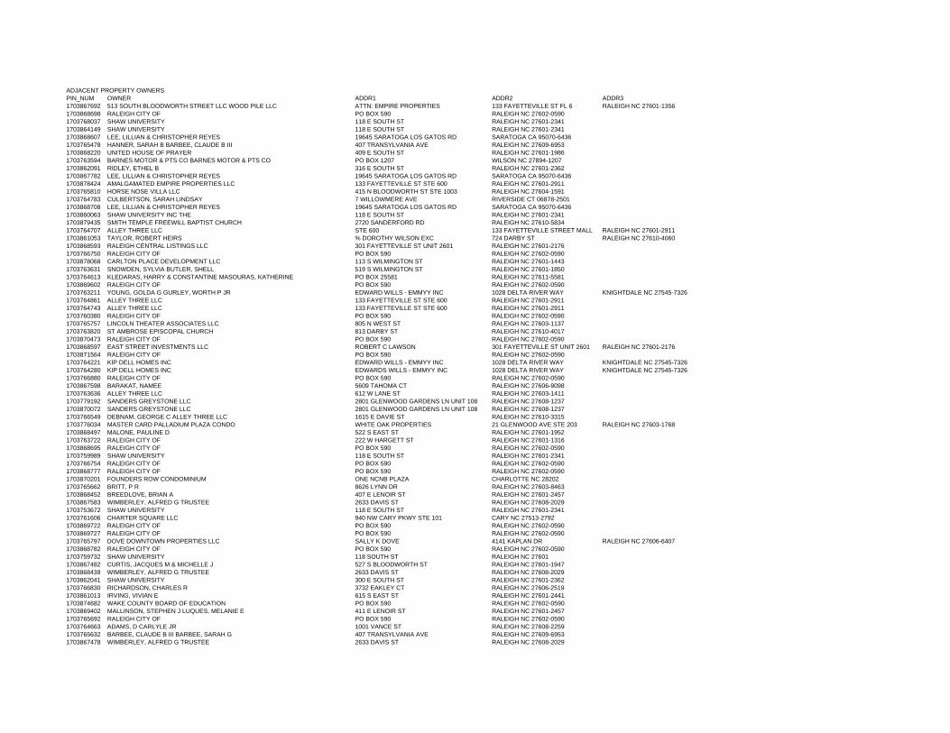
ADJACENT PROPERTY OWNERSPIN_NUM OWNER ADDR1 ADDR2 ADDR31703867692 513 SOUTH BLOODWORTH STREET LLC WOOD PILE LLC ATTN: EMPIRE PROPERTIES 133 FAYETTEVILLE ST FL 6 RALEIGH NC 27601-13561703868698 RALEIGH CITY OF PO BOX 590 RALEIGH NC 27602-05901703768037 SHAW UNIVERSITY 118 E SOUTH ST RALEIGH NC 27601-23411703864149 SHAW UNIVERSITY 118 E SOUTH ST RALEIGH NC 27601-23411703868607 LEE, LILLIAN & CHRISTOPHER REYES 19645 SARATOGA LOS GATOS RD SARATOGA CA 95070-64361703765478 HANNER, SARAH B BARBEE, CLAUDE B III 407 TRANSYLVANIA AVE RALEIGH NC 27609-69531703868220 UNITED HOUSE OF PRAYER 409 E SOUTH ST RALEIGH NC 27601-19861703763594 BARNES MOTOR & PTS CO BARNES MOTOR & PTS CO PO BOX 1207 WILSON NC 27894-12071703862091 RIDLEY, ETHEL B 316 E SOUTH ST RALEIGH NC 27601-23621703867782 LEE, LILLIAN & CHRISTOPHER REYES 19645 SARATOGA LOS GATOS RD SARATOGA CA 95070-64361703878424 AMALGAMATED EMPIRE PROPERTIES LLC 133 FAYETTEVILLE ST STE 600 RALEIGH NC 27601-29111703765810 HORSE NOSE VILLA LLC 415 N BLOODWORTH ST STE 1003 RALEIGH NC 27604-15911703764783 CULBERTSON, SARAH LINDSAY 7 WILLOWMERE AVE RIVERSIDE CT 06878-25011703868708 LEE, LILLIAN & CHRISTOPHER REYES 19645 SARATOGA LOS GATOS RD SARATOGA CA 95070-64361703860063 SHAW UNIVERSITY INC THE 118 E SOUTH ST RALEIGH NC 27601-23411703879435 SMITH TEMPLE FREEWILL BAPTIST CHURCH 2720 SANDERFORD RD RALEIGH NC 27610-58341703764707 ALLEY THREE LLC STE 600 133 FAYETTEVILLE STREET MALL RALEIGH NC 27601-29111703861053 TAYLOR, ROBERT HEIRS % DOROTHY WILSON EXC 724 DARBY ST RALEIGH NC 27610-40601703868593 RALEIGH CENTRAL LISTINGS LLC 301 FAYETTEVILLE ST UNIT 2601 RALEIGH NC 27601-21761703766750 RALEIGH CITY OF PO BOX 590 RALEIGH NC 27602-05901703878068 CARLTON PLACE DEVELOPMENT LLC 113 S WILMINGTON ST RALEIGH NC 27601-14431703763631 SNOWDEN, SYLVIA BUTLER, SHELL 519 S WILMINGTON ST RALEIGH NC 27601-18501703764613 KLEDARAS, HARRY & CONSTANTINE MASOURAS, KATHERINE PO BOX 25581 RALEIGH NC 27611-55811703869602 RALEIGH CITY OF PO BOX 590 RALEIGH NC 27602-05901703763211 YOUNG, GOLDA G GURLEY, WORTH P JR EDWARD WILLS - EMMYY INC 1028 DELTA RIVER WAY KNIGHTDALE NC 27545-73261703764861 ALLEY THREE LLC 133 FAYETTEVILLE ST STE 600 RALEIGH NC 27601-29111703764743 ALLEY THREE LLC 133 FAYETTEVILLE ST STE 600 RALEIGH NC 27601-29111703760380 RALEIGH CITY OF PO BOX 590 RALEIGH NC 27602-05901703765757 LINCOLN THEATER ASSOCIATES LLC 805 N WEST ST RALEIGH NC 27603-11371703763820 ST AMBROSE EPISCOPAL CHURCH 813 DARBY ST RALEIGH NC 27610-40171703870473 RALEIGH CITY OF PO BOX 590 RALEIGH NC 27602-05901703868597 EAST STREET INVESTMENTS LLC ROBERT C LAWSON 301 FAYETTEVILLE ST UNIT 2601 RALEIGH NC 27601-21761703871564 RALEIGH CITY OF PO BOX 590 RALEIGH NC 27602-05901703764221 KIP DELL HOMES INC EDWARD WILLS - EMMYY INC 1028 DELTA RIVER WAY KNIGHTDALE NC 27545-73261703764280 KIP DELL HOMES INC EDWARDS WILLS - EMMYY INC 1028 DELTA RIVER WAY KNIGHTDALE NC 27545-73261703766880 RALEIGH CITY OF PO BOX 590 RALEIGH NC 27602-05901703867598 BARAKAT, NAMEE 5609 TAHOMA CT RALEIGH NC 27606-90981703763636 ALLEY THREE LLC 612 W LANE ST RALEIGH NC 27603-14111703779192 SANDERS GREYSTONE LLC 2801 GLENWOOD GARDENS LN UNIT 108 RALEIGH NC 27608-12371703870072 SANDERS GREYSTONE LLC 2801 GLENWOOD GARDENS LN UNIT 108 RALEIGH NC 27608-12371703766549 DEBNAM, GEORGE C ALLEY THREE LLC 1615 E DAVIE ST RALEIGH NC 27610-33151703776034 MASTER CARD PALLADIUM PLAZA CONDO WHITE OAK PROPERTIES 21 GLENWOOD AVE STE 203 RALEIGH NC 27603-17681703868497 MALONE, PAULINE D 522 S EAST ST RALEIGH NC 27601-19521703763722 RALEIGH CITY OF 222 W HARGETT ST RALEIGH NC 27601-13161703868695 RALEIGH CITY OF PO BOX 590 RALEIGH NC 27602-05901703759989 SHAW UNIVERSITY 118 E SOUTH ST RALEIGH NC 27601-23411703766754 RALEIGH CITY OF PO BOX 590 RALEIGH NC 27602-05901703868777 RALEIGH CITY OF PO BOX 590 RALEIGH NC 27602-05901703870201 FOUNDERS ROW CONDOMINIUM ONE NCNB PLAZA CHARLOTTE NC 282021703765662 BRITT, P R 8626 LYNN DR RALEIGH NC 27603-84631703868452 BREEDLOVE, BRIAN A 407 E LENOIR ST RALEIGH NC 27601-24571703867583 WIMBERLEY, ALFRED G TRUSTEE 2633 DAVIS ST RALEIGH NC 27608-20291703753672 SHAW UNIVERSITY 118 E SOUTH ST RALEIGH NC 27601-23411703761606 CHARTER SQUARE LLC 940 NW CARY PKWY STE 101 CARY NC 27513-27921703869722 RALEIGH CITY OF PO BOX 590 RALEIGH NC 27602-05901703869727 RALEIGH CITY OF PO BOX 590 RALEIGH NC 27602-05901703765797 DOVE DOWNTOWN PROPERTIES LLC SALLY K DOVE 4141 KAPLAN DR RALEIGH NC 27606-64071703868782 RALEIGH CITY OF PO BOX 590 RALEIGH NC 27602-05901703759732 SHAW UNIVERSITY 118 SOUTH ST RALEIGH NC 276011703867482 CURTIS, JACQUES M & MICHELLE J 527 S BLOODWORTH ST RALEIGH NC 27601-19471703868439 WIMBERLEY, ALFRED G TRUSTEE 2633 DAVIS ST RALEIGH NC 27608-20291703862041 SHAW UNIVERSITY 300 E SOUTH ST RALEIGH NC 27601-23621703766830 RICHARDSON, CHARLES R 3732 EAKLEY CT RALEIGH NC 27606-25191703861013 IRVING, VIVIAN E 615 S EAST ST RALEIGH NC 27601-24411703874682 WAKE COUNTY BOARD OF EDUCATION PO BOX 590 RALEIGH NC 27602-05901703869402 MALLINSON, STEPHEN J LUQUES, MELANIE E 411 E LENOIR ST RALEIGH NC 27601-24571703765692 RALEIGH CITY OF PO BOX 590 RALEIGH NC 27602-05901703764663 ADAMS, D CARLYLE JR 1001 VANCE ST RALEIGH NC 27608-22591703765632 BARBEE, CLAUDE B III BARBEE, SARAH G 407 TRANSYLVANIA AVE RALEIGH NC 27609-69531703867478 WIMBERLEY, ALFRED G TRUSTEE 2633 DAVIS ST RALEIGH NC 27608-2029
EXHIBIT C. Request for Zoning Change Please use this form only – form may be photocopied. Please type or print. See instructions in Filing Addendum
Rezoning Petition 6 Form Revised August 23, 2010
This section is reserved for the applicant to state factual information in support of the rezoning request. Required items of discussion: The Planning Department is instructed not to accept any application for amending the official zoning map without a statement prepared by the applicant analyzing the reasonableness of the rezoning request. This statement shall address the consistency of the proposed rezoning with the Comprehensive Plan and any other applicable City-adopted plan(s), the compatibility of the proposed rezoning with the property and surrounding area, and the benefits and detriments of the proposed rezoning for the landowner, the immediate neighbors and the surrounding community. Recommended items of discussion (where applicable): 1. An error by the City Council in establishing the current zoning classification of the property. 2. How circumstances (land use and future development plans) have so changed since the property was last zoned
that its current zoning classification could not properly be applied to it now were it being zoned for the first time.
3. The public need for additional land to be zoned to the classification requested. 4. The impact on public services, facilities, infrastructure, fire and safety, parks and recreation, topography, access
to light and air, etc. PETITIONER’S STATEMENT: I. Consistency of the proposed map amendment with the Comprehensive Plan
(www.raleighnc.gov).
A. Please state the recommended land use(s) for this property as shown on the Future Land Use Map and discuss the consistency of the proposed land uses:
The Future Land Use Map of the Comprehensive Plan designates this area as being within the Central Business District. While the proposed rezoning seeks to introduce a Historic Overlay District to this area, all current underlying zoning would remain in place. The current underlying zoning designations in this area are consistent with the Future Land Use designation of Central Business District.
B. Please state whether the subject property is located within any Area Plan or other City Council-adopted plans and policies and discuss the policies applicable to future development within the plan(s) area.
The area was identified in the “500 Block South Person / South Blount Area Redevelopment Plan” adopted by City Council in 2000. This plan included the action item "Provide resources to consider the designation of a Local Historic District and to establish design guidelines to ensure compatibility of development" for the project area.” A portion of this site is located within the South Park Area Plan. The properties within the Area Plan are also within the Downtown Overlay District, and the Plan specifically notes that in any instance of overlap, the regulations of the Downtown Overlay District will prevail.
EXHIBIT D. Request for Zoning Change Please use this form only – form may be photocopied. Please type or print. See instructions in Filing Addendum
Filing Addendum 7 Form Revised March 10, 2011
The proposal would be consistent with all applicable plans.
C. Is the proposed map amendment consistent or inconsistent with the Comprehensive Plan and other City Council-adopted plans and policies?
The 2030 Comprehensive Plan contains an entire section dedicated to Historic Preservation. The Historic Preservation Element includes several recommendations to promote preservation; one of which being the establishment of new Historic Overlay Districts. The rezoning proposal to apply a Historic Overlay District to this area is consistent with the Comprehensive Plan and all applicable policies listed below. Policy HP 1.2 Cultural and Historic Resource Preservation – Identify, preserve, and protect cultural and historic resources including buildings, neighborhoods, designed and natural landscapes, cemeteries, streetscapes, view corridors, and archaeological resources. Proposal would apply a Historic Overlay District to this area. This overlay was recommended by a Raleigh Historic Districts Commission report adopted in May of 2011. The report outlined the historic significance of the area and provided a detailed inventory of all significant contributing structures within the subject area. Application of the overlay will help to ensure that the cultural and historical resources referenced in the RHDC report are protected and preserved. Policy HP 2.3 Raleigh Historic Designation – Encourage and sponsor the designation of eligible historic resources for local protection. Proposal would apply a Historic Overlay District to this area. Doing so will provide local resource protection through the Raleigh Historic Districts Commission. The overlay recognizes that change is an important element in the city’s evolution, indicating a healthy, vital neighborhood and reflecting the pride of residents in their community. Historic district overlay zoning provides the mechanism of a design review process for exterior changes; however, it does not affect the uses of properties as permitted by the existing zoning. Policy HP 2.4 Protecting Historic Neighborhoods – Protect the scale and character of the City’s historic neighborhoods while still allowing compatible and context-sensitive infill development to occur. The historic neighborhood within the subject area will be protected and preserved through the application of the proposed Historic Overlay District. If approved, all future development within the subject area will be reviewed for compatibility with the district’s special character. Specifically, any exterior alterations, new construction, demolition, significant landscape changes, or moving of buildings will be evaluated for adherence to the Historic Overlay District’s development standards (design guidelines). As mentioned in the Raleigh Historic District Commission’s report, the area is historically, architecturally, and culturally significant, possessing a mix of residential, commercial, institutional, and community landmark resources. Application of the Historic Overlay District will not prevent changes; the neighborhood will be protected from unmanaged change by a review process based on established design guidelines.
EXHIBIT D. Request for Zoning Change Please use this form only – form may be photocopied. Please type or print. See instructions in Filing Addendum
Filing Addendum 8 Form Revised March 10, 2011
Action HP 2.6 Downtown Historic Overlays – Consider designating local historic overlay districts in downtown for Fayetteville Street National Register District, Depot National Register District, and South Person-South Blount Redevelopment Plan Area. Proposal would apply a Historic Overlay District to this area. The boundaries of this area include contributing structures and undeveloped land where protection of the historic urban context will prevent inappropriate development. This request would fulfill one part of this Action Item in the Comprehensive Plan – consideration of designation of the South Person-South Blount Redevelopment Plan Area. Policy HP 2.7 Mitigating Impacts on Historic Sites – Development proposals adjacent to or including historic sites should identify and minimize or mitigate any negative development impacts on those sites. The historic sites within the subject area will be further protected and preserved through the application of the proposed Historic District Overlay. The subject area contains 62 resources that contribute to the historic character of the district; three of these properties, the Tupper Memorial Baptist Church, the Rogers-Bagley-Daniels-Pegues House, and the Masonic Temple, are designated Raleigh Historic Landmarks. If approved, all future development within the subject area will be reviewed for compatibility. The Historic Overlay would mitigate impacts of future development on vacant parcels, as well as sites that are redeveloped. Policy HP 3.1 Adaptive Use – Encourage adaptive use of historic properties to preserve cultural resources and conserve natural resources. Application of a Historic Overlay District will help to encourage the adaptive use and re-use of historic properties in the subject area. The proposed overlay will also discourage demolition of historically significant structures. Policy HP 3.2 Retention Over Replacement – Encourage the preservation and rehabilitation of significant or contributing existing structures, favoring retention over replacement, especially in areas where other historic resources are present. Application of a Historic Overlay District will help to encourage the preservation and rehabilitation of historic structures in this area, while also discouraging the demolition of these structures. Policy HP 3.3 Adaptive Use and Parking – Additional parking required for nonresidential adaptive use should be located to the rear of the historic structure. The development standards applicable to the Historic Overlay District include design guidelines that address the location and design of parking areas. Policy HP 3.4 Context Sensitive Design – Use the existing architectural and historical character within an area as a guide for new construction. The historic neighborhood within the subject area will be further protected and preserved through the application of the proposed Historic District Overlay. If approved, all future
EXHIBIT D. Request for Zoning Change Please use this form only – form may be photocopied. Please type or print. See instructions in Filing Addendum
Filing Addendum 9 Form Revised March 10, 2011
development within the subject area will be reviewed for compatibility. During review by the Raleigh Historic Districts Commission, existing architectural features and historical character will be taken into account to ensure new development is designed and built in a context-sensitive manner. The design guidelines specifically address the sensitive introduction of new construction. Policy HP 4.5 Support for Neighborhoods – Support neighborhood efforts to pursue both federal and Raleigh historic designations, and to make use of zoning overlay districts. This proposal is a result of the public process conducted for the “500 Block South Person / South Blount Area Redevelopment Plan.” Property owners and citizens played a critical role in evaluating the area as a potential Historic Overlay District. Proposal would apply a Historic Overlay District to this area. The area is historically, architecturally, and culturally significant, possessing a mix of residential, commercial, institutional, and community landmark resources. Application of the overlay will help to protect and preserve these resources. Policy H 1.6 Housing Preservation – Encourage the preservation of existing housing units whenever feasible, especially structures of historic or architectural significance. Application of the Historic Overlay will help to encourage the preservation of cultural and historical resources, which in this case include single and multifamily housing. In addition, the South Person South Blount Area has historically been an affordable residential neighborhood, which is a valuable resource in such close proximity to downtown employment centers. Policy ED 6.4 Cultural Resource Promotion – Work with local historic preservation and arts groups to identify and promote Raleigh’s cultural resources. Application of the Historic Overlay will reinforce the City’s recognition of the district as possessing special significance, which may provide for future partnerships in cultural resource promotion. Policy UD 1.1 Protecting Neighborhood Identity – Use Neighborhood Conservation Overlay Districts (NCOD), Historic Overlay Districts (HOD), or rezonings to retain the character of Raleigh’s existing neighborhoods and strengthen the sense of visual order and stability. The historic neighborhoods within the subject area will be further protected and preserved through the application of the proposed Historic District Overlay. Historic district designation is designed to protect and enhance the existing character. If approved, all future development within the subject area will be reviewed for compatibility – the neighborhood will be protected from unmanaged change by a review process based on established design guidelines. Review by the Historic Districts Commission will help to stabilize the neighborhood and preserve the current character. Policy UD 5.1 Contextual Design – Proposed development within established neighborhoods should create or enhance a distinctive character that relates well to the surrounding area. Change is an important element in the city’s evolution, indicating healthy, vital neighborhoods and reflecting the pride of residents in their community. Historic Overlay District designation will encourage development that enhances the character of the proposed Historic Districts
EXHIBIT D. Request for Zoning Change Please use this form only – form may be photocopied. Please type or print. See instructions in Filing Addendum
Filing Addendum 10 Form Revised March 10, 2011
through the design review process for exterior changes. The development standards (design guidelines) are part of a process that ensures that property changes are within the spirit and the character of the historic district. The historic neighborhoods within the subject area will be further protected and preserved through the application of the proposed Historic District Overlay. If approved, all future development within the subject area will be reviewed for compatibility. Proposed development will be reviewed for compatibility by the Historic Districts Commission. Policy UD 5.5 Areas of Strong Architectural Character – Preserve the architectural continuity and design integrity of historic districts and other areas of strong architectural character. New development within such areas does not need to replicate prevailing architectural styles exactly but should be complementary in form, height, and bulk. The historic neighborhoods within the subject area will be further protected and preserved through the application of the proposed Historic District Overlay. If approved, all future development within the subject area will be reviewed for compatibility. The design guidelines specifically address the sensitive introduction of new construction; the introduction of a compatible but contemporary new construction project can add depth and contribute interest to the district.
II. Compatibility of the proposed map amendment with the property and the surrounding area.
A. Description of land uses within the surrounding area (residential housing types, parks, institutional uses, commercial uses, large parking lots, thoroughfares and collector streets, transit facilities):
The surrounding area is primarily large scale commercial to the west, commercial and high density residential to the north, small scale/low density commercial and residential to the east and Institutional/University uses to the south. The subject area contains primarily residential uses, with a few small-scale commercial and institutional uses throughout.
B. Description of existing Zoning patterns (zoning districts including overlay districts) and existing built environment (densities, building heights, setbacks, tree cover, buffer yards):
The subject area is currently zoned Residential Business, Neighborhood Business and Business with Downtown Overlay District. The majority of the area is developed as residential and small scale institutional/commercial.
C. Explanation of how the proposed zoning map amendment is compatible with the suitability of the property for particular uses and the character of the surrounding area: This area contains several historically significant structures, and would be appropriate for the Historic District Overlay designation. The Historic Overlay will help ensure compatibility when future development occurs, and will also preserve and protect the current structures in place.
EXHIBIT D. Request for Zoning Change Please use this form only – form may be photocopied. Please type or print. See instructions in Filing Addendum
Filing Addendum 11 Form Revised March 10, 2011
All development proposals will be required to be sensitive to the context and character of the district. This area has historically been an affordable residential neighborhood, with small pockets of commercial within walking distance to the downtown area. Application of the Historic Overlay District would be compatible with the surrounding area.
III. Benefits and detriments of the proposed map amendment.
A. For the landowner(s):
A Historic Overlay District is a distinctive area, a place of singular historical flavor characterized by its streets and squares, buildings and trees, architectural design and landscape features. A historic district is also a legacy, linking present and future generations with their heritage and providing a diversity vital to the city’s future quality of life. The City’s Code of Ordinances recognizes that Historic Overlay Districts are valuable assets to the identity of the city. It also recognizes that change is an important element in the city’s evolution, indicating a healthy, vital neighborhood and reflecting the pride of residents in their community. The landowners in a Historic Overlay District would benefit from the increased protection measures that a Historic Overlay District provides, as well as a level of predictability in the nature of redevelopment. The proposed overlay would ensure compatible and context-sensitive future development, while preserving the current historic character of the area.
B. For the immediate neighbors:
The immediate neighbors would benefit from the proposed Historic Overlay District’s additional regulations on the subject area, which help to guide development in a uniform and compatible manner.
C. For the surrounding community:
The proposal to apply a Historic Overlay District to this area would benefit the surrounding nearby community and be in the public interest. The area contains several historically significant structures that would be preserved and protected.
IV. Does the rezoning of this property provide a significant benefit which is not available to the
surrounding properties? Explain: The surrounding properties would not benefit from the increased protection measures that a Historic Overlay District provides, or the level of predictability in the nature of redevelopment.
EXHIBIT D. Request for Zoning Change Please use this form only – form may be photocopied. Please type or print. See instructions in Filing Addendum
Filing Addendum 12 Form Revised March 10, 2011
Explain why the characteristics of the subject property support the proposed map amendment as reasonable and in the public interest.
This area was the subject of a City Council-commissioned study recently completed by the Raleigh Historic Districts Commission. The potential local historic district is historically, architecturally, and culturally significant to the City, possessing a mix of residential, commercial, institutional, and community landmark resources representative of African American life in Raleigh from the late nineteenth century through the beginning of the era of integration. 62 structures were catalogued in the report as significant historic resources; three Raleigh Historic Landmarks are located in the proposed district. Despite the vacant lots scattered through the project area, the remaining resources provide a picture of the community that justifies the implementation of a historic overlay district. Overlay zoning is the most appropriate method of preservation for the area, which would protect current structures and landmarks, as well as guide future development on vacant lots.
V. Recommended items of discussion (where applicable).
a. An error by the City Council in establishing the current zoning classification of the property.
N/A
b. How circumstances (land use and future development plans) have so changed since the property was last zoned that its current zoning classification could not properly be applied to it now were it being zoned for the first time.
N/A
c. The public need for additional land to be zoned to the classification requested.
The area proposed to be rezoned is historically significant and in need of further protections and preservation. Applying a Historic Overlay District to this area will help to accomplish this goal. Requiring future development in this area to be reviewed for compatibility will ensure that future development is built in a context-sensitive manner consistent with the surrounding historic structures.
d. The impact on public services, facilities, infrastructure, fire and safety, parks and recreation, topography, access to light and air, etc.
N/A
e. How the rezoning advances the fundamental purposes of zoning as set forth in the N.C. enabling legislation.
FILING ADDENDUM: Instructions for filing a petition to amend the official Zoning Map of the City of Raleigh, North Carolina
Filing Addendum 13 Form Revised March 10, 2011
N/A
VI. Other arguments on behalf of the map amendment requested.
N/A
One Exchange Plaza
Suite 300
PO Box 829
Century Station
Raleigh, NC 27602
Tel 919 832 7238
Fax 919 516 2684
www.rhdc.org
RAlEIGH HISTORIC DISTRICTS COMMISSION
June 13, 2011
Mayor Charles 'Meeker City Councillors
City of Raleigh PO Box 590 Raleigh, NC 27602
RE: South Person / South Blount Historic Overlay District (HOD) Proposal ,
Dear Mayor Meeker and City Councillors:
As follow up to a 2000 City-initiated small area plan, the Raleigh Historic Districts . Commission (RHDC) presents to City Council the Report and Recommendation for the
Designation of the South Person / South Blount Historic Overlay District. Based on feedback received from property owners within the proposed boundaries in response to both mailings and RHDC-sponsored community meetings, RHDC makes the following recommendation to Council:
1. Receive as information the Report and Recommendation for the Designation of
the South Person / South Blount Historic Overlay District.
2. Refer the report and recommendation to the Department of Cultural
Resources, the South Park-East Raleigh Neighborhood Association
(SPERNA), and the Downtown Raleigh Alliance (DRA) for their analysis and recommendation.
Background In 2000, City Council adopted the 500 Block South Person / South Blount Area
Redevelopment,Plan, which included the action item "Provide resources to consider the designation of a Local Historic District and to establish design guidelines to ensure compatibility of development" for the project area. Towards that end, City Council
granted RHDC funds to commission a historic research report. Due to limited staff and commission availability, the. finalization of the report was delayed until this spring. Please find attached the finalized report.
Consideration of HOD designation for theproject area is included as Action Item HP 2.6 in the city's newly-adopted Comprehensive Plan.
Public Process Prior to Rezoning Petition In January of this year, in- cooperation with proposed district property owner and former RHDC member Edna Rich-Ballentine, the commission notified the CAC and reached out to identify property owners who were involved with the 2000 small area
page 2 June 13, 2011 South Person / South Blount Historic Overlay District (HOD) Proposal
plan effort to confirm if there was continued interest in a HOD. After a very positive response from attende~s, a second public meeting was held March 28, 2011 to share the
historic research report, discuss the benefits and trade-offs of local HOD zoning,
answer questions about the Certificate of Appropriateness program, and gauge property owner interest in a potential HOD. For this meeting, the commission notified
the CAC and mailed letters to every property owner within the proposed boundaries. Three. follow-up letters have been mailed to affected property owners and have provided additional information on the benefits and trade-offs of HODs, continued
invitations to property owners to provide feedback, and updates on the status of the commission's evaluation.
At the Central CAC chair's request, the commission attended several CAC meetings.
Although there appeared to be little to no attendance at any of these meetings by property owners within the proposed boundaries of the HOD, on June 6 the CAC voted to not support the HOD.
On behalf of the commission, I have made a significant effort to personally reach out to affected property owners to solicit feedback. Additionally, J.E. Williams, proposed
district property owner and former RHDC member, has personally visited or called as
many property owners as possible to discuss the proposal and to solicit feedback. We have requested written feedback to the greatest extent possible to ensure accurate recordation.
The commission also met with the ORA's Issues Committee; the ORA issued an
opinion with three concerns, including the fear of a negative effect of HOD zoning on property values and the appropriateness of the district boundaries. In its research, the
commission has not found any evidence to support the assertion that HOD zoning negatively impacts property values. However, in response to the broader community's and ORA's concerns regarding the inclusion of the Stronach's Alley block, the
commission modified the boundaries of the proposed HOD.
Recommendation to City Council The Raleigh Historic Districts Commission reviewed the report at its May 17, 2011
meeting. The commission makes the following recommendations to the City Council:
1. That the South Person / South Blount project area be designated as a Historic Overlay District (HOD) according to the boundary described in the revised "Proposed South Person / South Blount Historic Overlay District" map included in the Report and Recommendation for the Designation of the South Person / South Blount Historic Overlay District.
2. That the historic development standards to be applied by RHDC in consideration of applications for Certificates of Appropriateness (COAs) be
page 3 June 13, 2011 South Person / South Blount Historic Overlay District (HOD) Proposal
approved as described in the Report and Recommendation for the Designation of the
South Person / South Blount Historic Overlay District.
3. That City Council add to the RHDC work program an item to explore the possibility of conducting archaeological investigations in cooperation with property owners of the adjacent "Stronach's Alley block," bounded by E. Cabarrus, S. Wilmington, E. Lenoir, and S. Blount streets, and to seek funding for these investigations.
4. That alternative names for the historic overlay district be investigated with the goal of better reflecting the historical significance of the area.
District Name The current working name for the district, "South Person / South Blount Historic Overlay District," does not resonate with the community, which may identify a more appropriate name for the district during the rezoning public process. The commission suggests the name "Deluxe Historic Overlay District" as one alternative. The Deluxe Hotel, formerly the Lewis Hotel, was located in the heart of the project area at 220 E.
Cabarrus Street. Its historic significance lies in that the Deluxe Hotel and Lightner Arcade were the only hotel accommodations for African Americans in Raleigh during the Jim Crow era. Famous guests included the bands of Nat King Cole, Cab Calloway, and Louis Armstrong. The Deluxe, built in 1923 and renamed in 1948, was destroyed by fire in 1992.
HOD Designation Process Section 10-2052 (f) of the city code outlines the procedures for designating a HOD. This includes the preparation of a historic research report and recommendation to City Council, attached; the Council then refers the report and recommendation to the Department of Cultural Resources for its analysis and recommendation. Council- may also choose to forward the item to additional parties.
The code states that the recommendation shall be treated in the same manner as any request for a change in the City's zoning ordinance, then be processed through the procedures outlined in Sectioh 10-2165. Following preparation of the zoning petition, authorization of a joint public hearing will be requested at the City Council's September 20,2011 meeting for a joint public hearing on October 18, 2011.
Summary Based on a positive response from the majority of property owners with whom we've had contact, RHDC recommends that City Council (1) receive as information the Report and Recommendation for the Designation of the South Person /
South Blount Historic Overlay District; and (2).Refer the report to the Department of Cultural Resources, the South Park-East Raleigh Neighborhood Association
page 4 June 13, 2011 South Person / South Blount Historic Overlay District (HOD) Proposal
(SPERNA), and the Downtown Raleigh Alliance (DRA) for their analysis and recommendation.
Sincerely,
Fred Belledin, Chair Raleigh Historic Districts Commission
[email protected] 821.2775 (office)
enc: Report and Recommendation for the Designation of the South Person / South Blount Historic Overlay District
cc: Mitchell Silver, Department of City Planning Property owners, proposed HOD
REPORT AND RECOMMENDATION
FOR THE
DESIGNATION OF THE
SOUTH PERSON/SOUTH BLOUNT
HISTORIC OVERLAY DISTRICT
Adopted by the Raleigh Historic Districts Commission May 17, 2011
THE RALEIGH HISTORIC DISTRICTS COMMISSION
Fred Belledin, Chair Jane Forde, Vice‐chair
Curtis Kasefang, Secretary/treasurer Will Alphin
Jannette Coleridge‐Taylor Nick Fountain Esther Hall Greg Hatem
Scott Shackleton Flora Hatley Wadelington
Barbara Wishy
CITY OF RALEIGH PLANNING DEPARTMENT
Mitchell Silver, Planning Director
Dan Becker, Executive Director of the Raleigh Historic Districts Commission
page 2
BACKGROUND The City Council may designate a “historic overlay district” by zoning ordinance according to §10‐2052 of the Raleigh City Code. These procedures are enabled by North Carolina General Statutes, Chapter 160A‐400.1 through 160A‐400.14. The city has designated five local historic districts: Oakwood (1975), Blount Street (1976), Capitol Square (1976), Boylan Heights (1984), and Moore Square (1992). In 2000 City Council recognized the historic significance of the 500 block of South Person and South Blount streets by including a historic preservation element in the city‐adopted 500 Block S. Person/S. Blount Area Redevelopment Plan. The plan specifically notes historic overlay district zoning as a tool to stabilize the historic character of the neighborhood, also “maintain[ing] the residential character of this area.”1
The Raleigh Historic Districts Commission (RHDC) was tasked with implementing the historic preservation element of the plan, which is the consideration of a historic overlay district (HOD). To accomplish this, City Council funded the preparation of a historic overlay district designation report, with RHDC appointed as the administrator of the project; a consultant was hired and an initial draft was completed. Due to scarce resources, the draft was not finalized in 2000. The project remained on the on the Department of City Planning’s work program, however, and the consideration of designating the South Person/South Blount project area as a local historic overlay district is included as an action item in the 2030 Comprehensive Plan [HP 2.6].
RECOMMENDATION
The Raleigh Historic Districts Commission reviewed this report at its meeting on May 17, 2011, following a neighborhood meeting held on March 28, 2011. The commission makes the following recommendations to the City Council: 1. That the South Person/South Blount project area be designated as a historic
overlay district according to the boundary described in the revised “Proposed South Person/South Blount Historic Overlay District” map included in this report.
1 500 Block S. Person/S. Blount Area Redevelopment Plan item VI.B.2.b, p. 7.
page 3
2. That the historic development standards to be applied by the Raleigh Historic Districts Commission in consideration of applications for Certificates of Appropriateness be approved as described in this report.
3. That City Council add to the RHDC work program an item to explore the possibility of conducting archaeological investigations in cooperation with the property owners of the adjacent “Stronach’s Alley block,” bounded by E. Cabarrus, S. Wilmington, E. Lenoir, and S. Blount streets, and to seek funding for these investigations.
4. That alternative names for the historic overlay district be investigated with the goal of better reflecting the historical significance of the area.
2030 COMPREHENSIVE PLAN SIGNIFICANCE
The Historic Preservation Element of the 2030 Comprehensive Plan offers guidance to sustain and promote the identity of Raleigh as a city with great historic communities. It includes recommendations to promote preservation; enhance planning, regulatory and incentive tools; and improve coordination among stakeholders who impact the preservation of Raleigh’s cultural and architectural heritage. The policies of the Historic Preservation Element advance all six vision themes that serve as the overarching goals of the 2030 Comprehensive Plan. The following policies of the 2030 Comprehensive Plan render further support to the creation of historic overlay districts where appropriate, to help preserve the historic identity of Raleigh:
Policy HP 1.2 Cultural and Historic Resource Preservation Identify, preserve, and protect cultural and historic resources including buildings, neighborhoods, designed and natural landscapes, cemeteries, streetscapes, view corridors, and archaeological resources. Policy HP 2.3 Raleigh Historic Designation Encourage and sponsor the designation of eligible historic resources for local protection. Policy HP 2.4 Protecting Historic Neighborhoods Protect the scale and character of the City’s historic neighborhoods while still allowing compatible and context‐sensitive infill development to occur.
page 4
Action HP 2.6 Downtown Historic Overlays Consider designating local historic overlay districts in downtown for Fayetteville Street National Register district, Depot National Register district, and South Person‐South Blount Streets redevelopment plan area. [emphasis added] Policy HP 4.5 Support for Neighborhoods Support neighborhood efforts to pursue both federal and Raleigh historic designations, and to make use of zoning overlay districts. Policy H 1.6 Housing Preservation Encourage the preservation of existing housing units whenever feasible, especially structures of historic or architectural significance. Policy ED 6.4 Cultural Resource Promotion Work with local historic preservation and arts groups to identify and promote Raleigh’s cultural resources. Policy UD 1.1 Protecting Neighborhood Identity Use Neighborhood Conservation Overlay Districts (NCOD), Historic Overlay Districts (HOD), or rezonings to retain the character of Raleighʹs existing neighborhoods and strengthen the sense of visual order and stability. Policy UD 5.5 Areas of Strong Architectural Character Preserve the architectural continuity and design integrity of historic districts and other areas of strong architectural character. New development within such areas does not need to replicate prevailing architectural styles exactly but should be complementary in form, height, and bulk.
HISTORIC SIGNIFICANCE
The project area is representative of several facets of Raleigh’s African American urban historic significance during the mid‐nineteenth century through the beginning of integration: 1. Architecture: The South Person/South Blount district contains buildings that
are primarily residential in nature, peppered with a handful of small‐scale
page 5
commercial and institutional buildings throughout. Modest in size and scale, the buildings show a progression of architectural styles.
2. Neighborhood/Community: The South Person/South Blount project area
retains an urban residential feel with elements of commercial development. Historically this has been an affordable neighborhood within walking distance of Raleigh’s urban core.
The South Person/South Blount Historic District research report more fully describes these themes. A copy of the research report is attached.
URBAN DESIGN SIGNIFICANCE
The designation of the South Person/South Blount District will put in place an important tool for achieving the goals outlined in the 2030 Comprehensive Plan and the 500 Block S. Person/S. Blount Area Redevelopment Plan. Pertinent objectives include: 1. Preserving the historic architecture and urban cultural landscapes that are
significant to the city’s history and development. 2. Retaining residential character in an area with significant development
pressure threatening its still‐affordable community. 3. Promoting infill development that respects and enhances the existing scale
and density of the area. 4. Providing smaller commercial structures with lower overhead costs to serve
small business needs in the neighborhood.
HISTORIC DEVELOPMENT STANDARDS
The intention of a historic overlay district is “to insure insofar as possible that the exterior portion of buildings, structures and their appurtenant features located within an Historic Overlay District...shall remain in harmony with other buildings, structures and appurtenant features in the District....” Raleigh City Code §10‐2052(e)(4) lists documents entitled Design Guidelines for Raleigh Historic Districts and The Secretary of the Interior’s Guidelines for Rehabilitating Historic Buildings as the development standards for Raleigh historic districts, and it is
page 6

recommended that these standards be used for the South Person/South Blount Historic Overlay District.
page 7
SOUTH PERSON/SOUTH BLOUNT HISTORIC OVERLAY DISTRICT BOUNDARY JUSTIFICATION
The district boundaries were identified in the process of adopting the 500 Block S. Person/S. Blount Area Redevelopment Plan. The boundaries have been updated to reflect changes that have occurred since the plan’s adoption in 2000. The boundaries include contributing buildings as well as undeveloped land and non‐contributing structures where necessary to protect the historic urban context from inappropriate development.
SOUTH PERSON/SOUTH BLOUNT HISTORIC DISTRICT MAP
The following map graphically describes the boundary for the proposed South Person/South Blount Historic Overlay District.
page 8
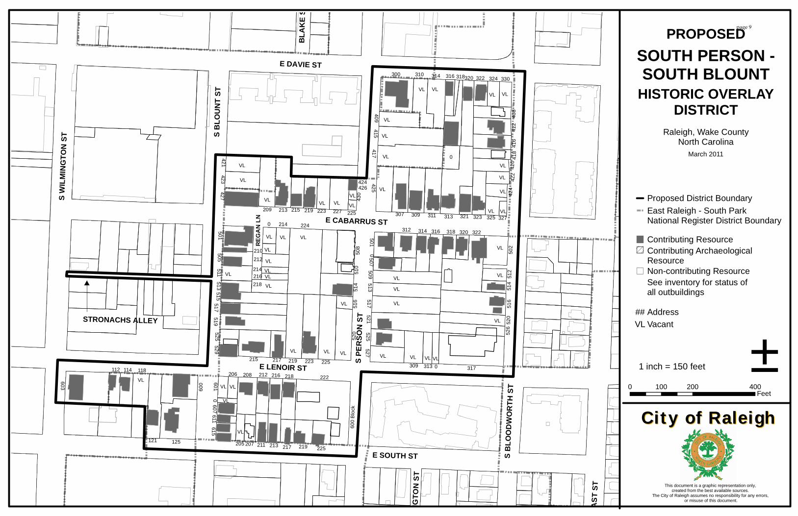
222
224
317
322
417
516
603
125
313
508
0
521415
300
517
225219
519
223
600
513509
121
21552
0
213209
314 320
501
311
425
515
514
309
517
208
520
307
502
310
526
318
0
0
412
0309
409
227
427
323
423421
312
218
525
416
118
527
314
501
511
316
316
218
216
420
212
408
114
225219
505
215
217
219 223
112
211
418
321214
213
507212
615
322
513
217
318 320
324
525
330
512
514
313
207
325
422
424
0607
205
206
601529
516
510214
216
611
210
327
430
225
424426
VLVL VL
VL
VL
VLVL
VL
VL VL VL VL
VL
VL
VL
VL VLVL VL
VLVL
VL
VL
VL
VL
VLVL
VL VL VLVL
VL
VL
VL
VL VL
VLVLVLVLVL
VL
VLVL
VL
VL
VLVL
600 B
lock
E LENOIR ST
S EAS
T ST
E SOUTH ST
E CABARRUS STS B
LOUN
T ST
S PER
SON
ST
S WILM
INGT
ON ST
S BLO
ODWO
RTH
ST
BLAK
E ST
ELLIN
GTON
ST
STRONACHS ALLEY
REGA
N LN
E DAVIE ST
HISTORIC OVERLAYDISTRICT
0 200 400100 Feet
Raleigh, Wake CountyNorth Carolina
±1 inch = 150 feet
This document is a graphic representation only, created from the best available sources.
The City of Raleigh assumes no responsibility for any errors, or misuse of this document.
City of RaleighCity of Raleigh
SOUTH PERSON -SOUTH BLOUNT
Proposed District Boundary
Contributing Resource
Non-contributing ResourceSee inventory for status ofall outbuildingsAddressVacantVL
##
March 2011
Contributing Archaeological Resource
PROPOSED
East Raleigh - South Park National Register District Boundary
page 9
HISTORIC RESEARCH REPORT
FOR THE
DESIGNATION OF THE SOUTH PERSON/SOUTH BLOUNT DISTRICT
AS A
HISTORIC OVERLAY DISTRICT
Prepared for the
Raleigh Historic Districts Commission
by
Dan Pezzoni Landmark Preservation Associates
Raleigh
January 2003, Revised April 2010
Revised by RHDC May 2011
page 10
The South Person/South Blount project area lies within the original limits of the City of
Raleigh as established in 1792. The potential local historic district is historically,
architecturally, and culturally significant, possessing a mix of residential, commercial,
institutional, and community landmark resources representative of African American
life in Raleigh from the late nineteenth century through the beginning of the era of
integration. A portion of the project area is listed in the National Register of Historic
Places as part of the East Raleigh‐South Park Historic District, and three resources
within the project area are individually listed in the National Register: the Masonic
Temple Building, the Dr. M.T. Pope House, and the Rogers‐Bagley‐Daniels‐Pegues
House. These properties, as well as the Tupper Memorial Baptist Church, are designated
Raleigh Historic Landmarks.
Statement of Significance
Little is documented about the project area’s development prior to the Civil War,
although the survival of the ca. 1855 Rogers‐Bagley‐Daniels‐Pegues House confirms
early residential development in the area. Presumably, whites were the area’s principal
landowners before the war, although African Americans would have comprised a
sizable percentage of the area’s population, as blacks represented nearly fifty percent of
Raleigh’s population in the late antebellum period.1
The Reconstruction period marks the beginning of the project area’s development as
part of an African American neighborhood. Freedmen migrated to Raleigh from
surrounding rural areas in hopes of securing economic advancement and the protection
of federal authorities, and African American neighborhoods sprang up around the
periphery of the city. Southeast Raleigh, the section of the city that embraces the project
area, proved particularly attractive to blacks due to its proximity to Shaw University.
Founded in 1866 as the Raleigh Institute and relocated to its present site in 1870, the
1 Wright et al, “East Raleigh-South Park Historic District,” 8.2; Parham, “Rogers-Bagley-Daniels-Pegues House,” 8.1; Simmons-Henry and Edmisten, Culture Town, 77; and Mattson, “Evolution of Raleigh’s African-American Neighborhoods,” 3, 17-18.
page 11
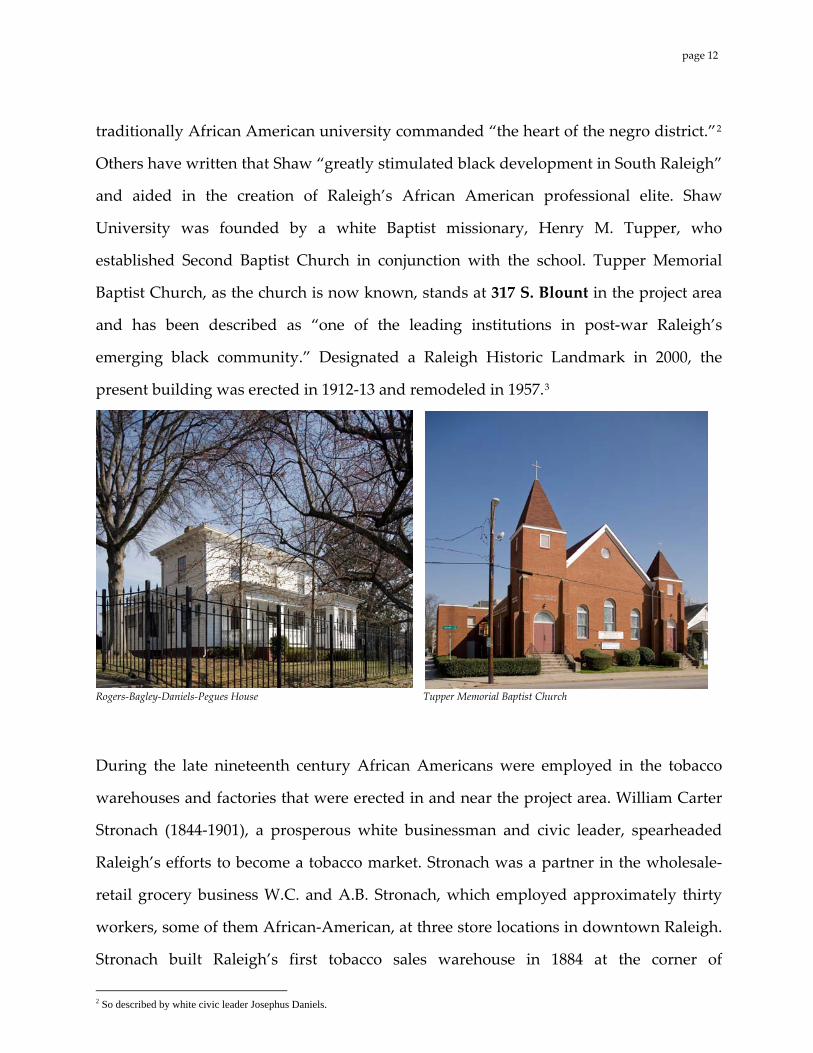
traditionally African American university commanded “the heart of the negro district.”2
Others have written that Shaw “greatly stimulated black development in South Raleigh”
and aided in the creation of Raleigh’s African American professional elite. Shaw
University was founded by a white Baptist missionary, Henry M. Tupper, who
established Second Baptist Church in conjunction with the school. Tupper Memorial
Baptist Church, as the church is now known, stands at 317 S. Blount in the project area
and has been described as “one of the leading institutions in post‐war Raleigh’s
emerging black community.” Designated a Raleigh Historic Landmark in 2000, the
present building was erected in 1912‐13 and remodeled in 1957.3
Rogers‐Bagley‐Daniels‐Pegues House Tupper Memorial Baptist Church
During the late nineteenth century African Americans were employed in the tobacco
warehouses and factories that were erected in and near the project area. William Carter
Stronach (1844‐1901), a prosperous white businessman and civic leader, spearheaded
Raleigh’s efforts to become a tobacco market. Stronach was a partner in the wholesale‐
retail grocery business W.C. and A.B. Stronach, which employed approximately thirty
workers, some of them African‐American, at three store locations in downtown Raleigh.
Stronach built Raleigh’s first tobacco sales warehouse in 1884 at the corner of
So described by white civic leader Josephus Daniels. 2
page 12
Wilmington and Davie streets adjacent to the project area. Soon thereafter a prizery, a
factory for preparing tobacco for shipment, was constructed on the southeast corner of
Wilmington and Cabarrus streets. Raleigh failed to develop as a tobacco market, and
Stronach’s warehouse and other facilities were eventually torn down.
Stronach’s Alley The original study boundaries included a city block bounded by E. Cabarrus, S. Wilmington, E. Lenoir, and S. Blount streets, which is archaeologically sensitive due to its high potential to yield cultural resources. While not included in the recommended boundaries of the South Person/South Blount Historic District, this report recognizes the archaeological potential of the Stronach’s Alley block, and so includes a brief history: Possibly related to the tobacco industry was the development of a small African American enclave on property Stronach owned near the Wilmington‐Cabarrus prizery. Transecting the block bounded by E. Cabarrus, S. Wilmington, E. Lenoir, and S. Blount streets, Stronach’s Alley was a hub of activity. Black carpenter Bibb Matthews (perhaps Robert B. Matthews) named the enclave after his employer W.C. Stronach. It is possible that Matthews, with his father W.H. Matthews, identified as a bricklayer and plasterer in period business directories, and other members of the Matthews family also active in the building trades, were responsible for the construction of houses throughout the project area. The block containing the Stronach’s Alley enclave was a nexus of residential, institutional, and commercial life. As of 1903 residents of the block worked in a variety of trades, with job descriptions such as laborer, porter, gardener, coachman, butler, painter, physician, driver, janitor, pastor, manager.4 In addition to residences, a church, two mission rooms (also labeled “Negro Hall”), a movie theater, a hospital, and commercial uses for the cotton and automobile industries were present during the period of significance. Sanborn maps (Appendix A) show the evolution of the block and give an indication of the broad array of artifacts that may be present on the site. For example, historic St. Ambrose Church, known first as St. Augustine’s, was built in 1868 on the northwest corner of N. Dawson and W. Lane; in 1895 the church was moved to S. Wilmington Street, where it played a large role in the neighborhood until its demolition in 1965.5
3 Wright et al, “East Raleigh-South Park Historic District,” 7.64, 8.5; Mattson, “Evolution of Raleigh’s African-American Neighborhoods,” 16-17; Simmons-Henry and Edmisten, Culture Town, 56; and 1888 and 1896 Sanborn maps. 4 1903 Hill’s City Directory. 5 Simmons-Henry and Edmiston, Culture Town, 102.
page 13
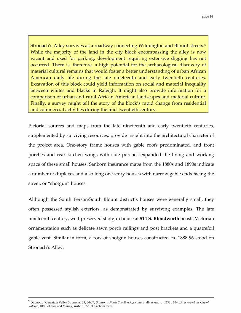
Stronach’s Alley survives as a roadway connecting Wilmington and Blount streets.6 While the majority of the land in the city block encompassing the alley is now vacant and used for parking, development requiring extensive digging has not occurred. There is, therefore, a high potential for the archaeological discovery of material cultural remains that would foster a better understanding of urban African American daily life during the late nineteenth and early twentieth centuries. Excavation of this block could yield information on social and material inequality between whites and blacks in Raleigh. It might also provide information for a comparison of urban and rural African American landscapes and material culture. Finally, a survey might tell the story of the block’s rapid change from residential and commercial activities during the mid‐twentieth century.
Pictorial sources and maps from the late nineteenth and early twentieth centuries,
supplemented by surviving resources, provide insight into the architectural character of
the project area. One‐story frame houses with gable roofs predominated, and front
porches and rear kitchen wings with side porches expanded the living and working
space of these small houses. Sanborn insurance maps from the 1880s and 1890s indicate
a number of duplexes and also long one‐story houses with narrow gable ends facing the
street, or “shotgun” houses.
Although the South Person/South Blount district’s houses were generally small, they
often possessed stylish exteriors, as demonstrated by surviving examples. The late
nineteenth century, well‐preserved shotgun house at 514 S. Bloodworth boasts Victorian
ornamentation such as delicate sawn porch railings and post brackets and a quatrefoil
gable vent. Similar in form, a row of shotgun houses constructed ca. 1888‐96 stood on
Stronach’s Alley.
6 Stronach, “Geranium Valley Stronachs, 29, 34-37; Branson’s North Carolina Agricultural Almanack . . . 1891., 184; Directory of the City of Raleigh, 108; Johnson and Murray, Wake, 132-133; Sanborn maps.
page 14
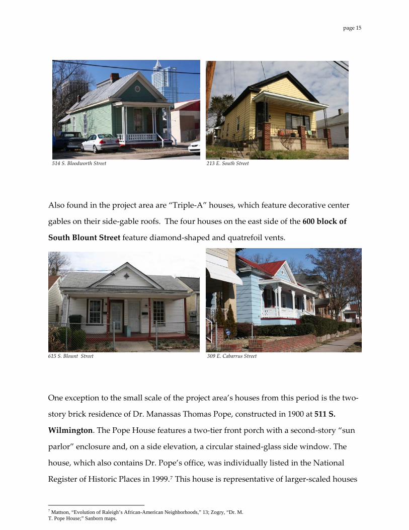
514 S. Bloodworth Street 213 E. South Street
Also found in the project area are “Triple‐A” houses, which feature decorative center
gables on their side‐gable roofs. The four houses on the east side of the 600 block of
South Blount Street feature diamond‐shaped and quatrefoil vents.
615 S. Blount Street 309 E. Cabarrus Street
One exception to the small scale of the project area’s houses from this period is the two‐
story brick residence of Dr. Manassas Thomas Pope, constructed in 1900 at 511 S.
Wilmington. The Pope House features a two‐tier front porch with a second‐story “sun
parlor” enclosure and, on a side elevation, a circular stained‐glass side window. The
house, which also contains Dr. Pope’s office, was individually listed in the National
Register of Historic Places in 1999. This house is representative of larger‐scaled houses 7
7 Mattson, “Evolution of Raleigh’s African-American Neighborhoods,” 13; Zogry, “Dr. M. T. Pope House;” Sanborn maps.
page 15
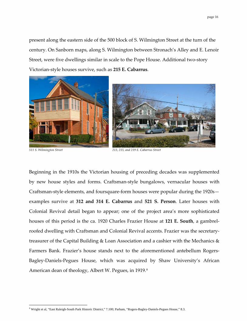
present along the eastern side of the 500 block of S. Wilmington Street at the turn of the
century. On Sanborn maps, along S. Wilmington between Stronach’s Alley and E. Lenoir
Street, were five dwellings similar in scale to the Pope House. Additional two‐story
Victorian‐style houses survive, such as 215 E. Cabarrus.
511 S. Wilmington Street 213, 215, and 219 E. Cabarrus Street
Beginning in the 1910s the Victorian housing of preceding decades was supplemented
by new house styles and forms. Craftsman‐style bungalows, vernacular houses with
Craftsman‐style elements, and foursquare‐form houses were popular during the 1920s—
examples survive at 312 and 314 E. Cabarrus and 521 S. Person. Later houses with
Colonial Revival detail began to appear; one of the project area’s more sophisticated
houses of this period is the ca. 1920 Charles Frazier House at 121 E. South, a gambrel‐
roofed dwelling with Craftsman and Colonial Revival accents. Frazier was the secretary‐
treasurer of the Capital Building & Loan Association and a cashier with the Mechanics &
Farmers Bank. Frazier’s house stands next to the aforementioned antebellum Rogers‐
Bagley‐Daniels‐Pegues House, which was acquired by Shaw University’s African
American dean of theology, Albert W. Pegues, in 1919.8
8 Wright et al, “East Raleigh-South Park Historic District,” 7.100; Parham, “Rogers-Bagley-Daniels-Pegues House,” 8.3.
page 16
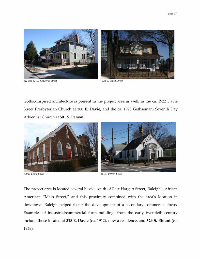
312 and 314 E. Cabarrus Street 121 E. South Street
Gothic‐inspired architecture is present in the project area as well, in the ca. 1922 Davie
Street Presbyterian Church at 300 E. Davie, and the ca. 1923 Gethsemani Seventh Day
Adventist Church at 501 S. Person.
300 E. Davie Street 501 S. Person Street
The project area is located several blocks south of East Hargett Street, Raleigh’s African
American “Main Street,” and this proximity combined with the area’s location in
downtown Raleigh helped foster the development of a secondary commercial focus.
Examples of industrial/commercial form buildings from the early twentieth century
include those located at 318 E. Davie (ca. 1912), now a residence, and 529 S. Blount (ca.
1929).
page 17
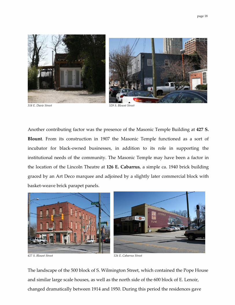
318 E. Davie Street 529 S. Blount Street
Another contributing factor was the presence of the Masonic Temple Building at 427 S.
Blount. From its construction in 1907 the Masonic Temple functioned as a sort of
incubator for black‐owned businesses, in addition to its role in supporting the
institutional needs of the community. The Masonic Temple may have been a factor in
the location of the Lincoln Theatre at 126 E. Cabarrus, a simple ca. 1940 brick building
graced by an Art Deco marquee and adjoined by a slightly later commercial block with
basket‐weave brick parapet panels.
427 S. Blount Street 126 E. Cabarrus Street
The landscape of the 500 block of S. Wilmington Street, which contained the Pope House
and similar large scale houses, as well as the north side of the 600 block of E. Lenoir,
changed dramatically between 1914 and 1950. During this period the residences gave
page 18
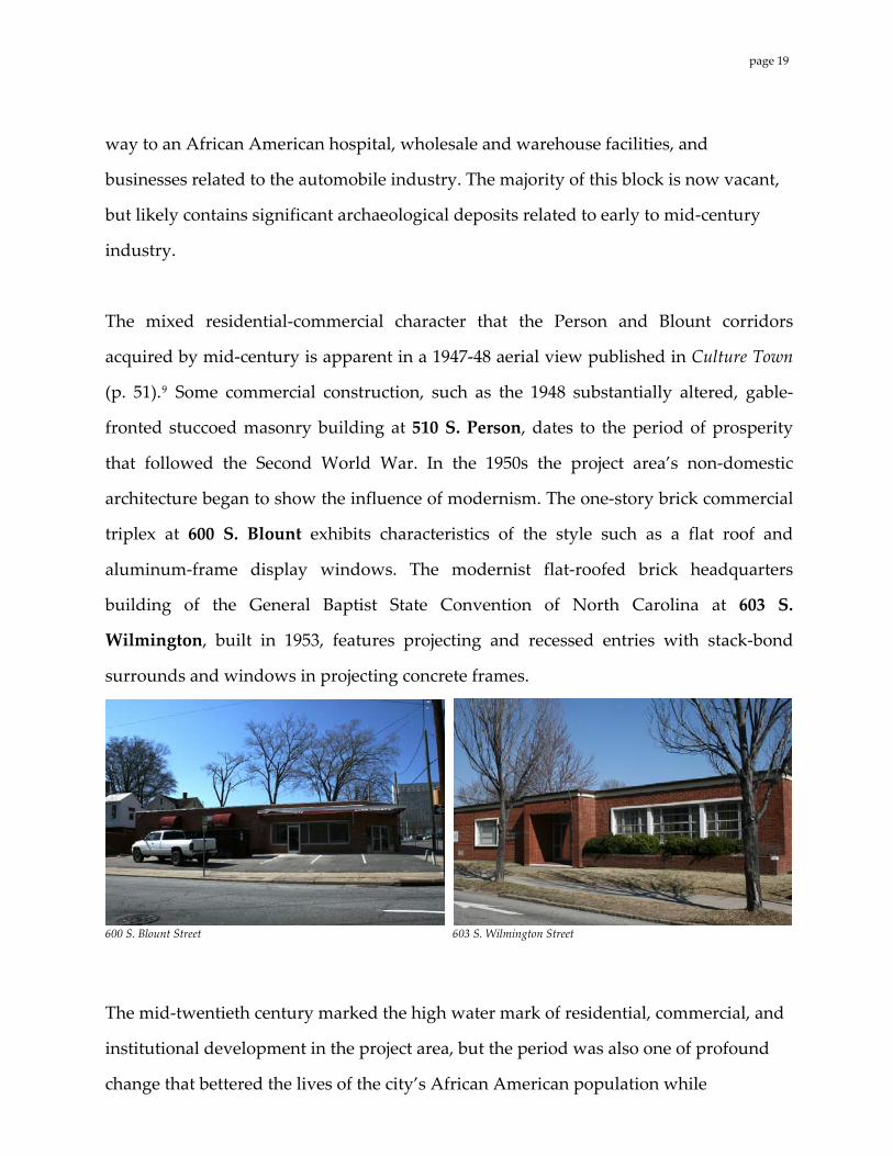
way to an African American hospital, wholesale and warehouse facilities, and
businesses related to the automobile industry. The majority of this block is now vacant,
but likely contains significant archaeological deposits related to early to mid‐century
industry.
The mixed residential‐commercial character that the Person and Blount corridors
acquired by mid‐century is apparent in a 1947‐48 aerial view published in Culture Town
(p. 51).9 Some commercial construction, such as the 1948 substantially altered, gable‐
fronted stuccoed masonry building at 510 S. Person, dates to the period of prosperity
that followed the Second World War. In the 1950s the project area’s non‐domestic
architecture began to show the influence of modernism. The one‐story brick commercial
triplex at 600 S. Blount exhibits characteristics of the style such as a flat roof and
aluminum‐frame display windows. The modernist flat‐roofed brick headquarters
building of the General Baptist State Convention of North Carolina at 603 S.
Wilmington, built in 1953, features projecting and recessed entries with stack‐bond
surrounds and windows in projecting concrete frames.
600 S. Blount Street 603 S. Wilmington Street
The mid‐twentieth century marked the high water mark of residential, commercial, and
institutional development in the project area, but the period was also one of profound
change that bettered the lives of the city’s African American population while
page 19
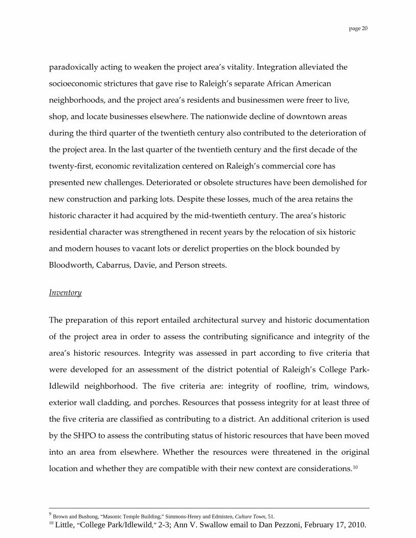
paradoxically acting to weaken the project area’s vitality. Integration alleviated the
socioeconomic strictures that gave rise to Raleigh’s separate African American
neighborhoods, and the project area’s residents and businessmen were freer to live,
shop, and locate businesses elsewhere. The nationwide decline of downtown areas
during the third quarter of the twentieth century also contributed to the deterioration of
the project area. In the last quarter of the twentieth century and the first decade of the
twenty‐first, economic revitalization centered on Raleigh’s commercial core has
presented new challenges. Deteriorated or obsolete structures have been demolished for
new construction and parking lots. Despite these losses, much of the area retains the
historic character it had acquired by the mid‐twentieth century. The area’s historic
residential character was strengthened in recent years by the relocation of six historic
and modern houses to vacant lots or derelict properties on the block bounded by
Bloodworth, Cabarrus, Davie, and Person streets.
Inventory
The preparation of this report entailed architectural survey and historic documentation
of the project area in order to assess the contributing significance and integrity of the
area’s historic resources. Integrity was assessed in part according to five criteria that
were developed for an assessment of the district potential of Raleigh’s College Park‐
Idlewild neighborhood. The five criteria are: integrity of roofline, trim, windows,
exterior wall cladding, and porches. Resources that possess integrity for at least three of
the five criteria are classified as contributing to a district. An additional criterion is used
by the SHPO to assess the contributing status of historic resources that have been moved
into an area from elsewhere. Whether the resources were threatened in the original
location and whether they are compatible with their new context are considerations.10
9 Brown and Bushong, “Masonic Temple Building;” Simmons-Henry and Edmisten, Culture Town, 51. 10 Little, “College Park/Idlewild,” 2-3; Ann V. Swallow email to Dan Pezzoni, February 17, 2010.
page 20
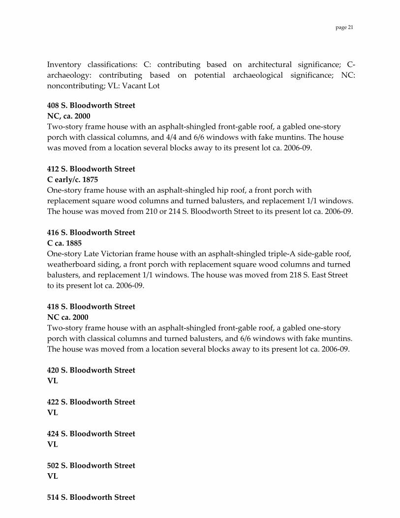
Inventory classifications: C: contributing based on architectural significance; C‐archaeology: contributing based on potential archaeological significance; NC: noncontributing; VL: Vacant Lot
408 S. Bloodworth Street NC, ca. 2000 Two‐story frame house with an asphalt‐shingled front‐gable roof, a gabled one‐story porch with classical columns, and 4/4 and 6/6 windows with fake muntins. The house was moved from a location several blocks away to its present lot ca. 2006‐09. 412 S. Bloodworth Street C early/c. 1875 One‐story frame house with an asphalt‐shingled hip roof, a front porch with replacement square wood columns and turned balusters, and replacement 1/1 windows. The house was moved from 210 or 214 S. Bloodworth Street to its present lot ca. 2006‐09. 416 S. Bloodworth Street C ca. 1885 One‐story Late Victorian frame house with an asphalt‐shingled triple‐A side‐gable roof, weatherboard siding, a front porch with replacement square wood columns and turned balusters, and replacement 1/1 windows. The house was moved from 218 S. East Street to its present lot ca. 2006‐09. 418 S. Bloodworth Street NC ca. 2000 Two‐story frame house with an asphalt‐shingled front‐gable roof, a gabled one‐story porch with classical columns and turned balusters, and 6/6 windows with fake muntins. The house was moved from a location several blocks away to its present lot ca. 2006‐09. 420 S. Bloodworth Street VL 422 S. Bloodworth Street VL 424 S. Bloodworth Street VL 502 S. Bloodworth Street VL 514 S. Bloodworth Street
page 21
C ca. 1880 One‐story Victorian shotgun‐form frame house with weatherboard siding, a metal‐sheathed front‐gable roof, 6/6 windows, a front porch with a sawn balustrade and slender posts with sawn brackets, and a quatrefoil gable vent. The front entry is boarded up. 512 S. Bloodworth Street VL 516 S. Bloodworth Street C late 19th century One‐story frame house with vinyl siding, an asphalt‐shingled hip roof, 3/1 and 6/6 windows, and a front porch with recently inserted (apparently salvaged) square posts with heavy molded caps. Cumbo’s Barber Shop 518 S. Bloodworth Street (part of 516 S. Bloodworth Street parcel) C 1933 One‐story, two‐bay, concrete block commercial building with a shed roof with a stepped side parapet, a plate glass window, and a replacement front door. A mural depicting a fighter jet is painted on one side. Founded by African American barber Frank W. Cumbo between 1927 and 1938.11 520 S. Bloodworth Street VL 526 S. Bloodworth Street (see 317 E. Lenoir Street) 421 S. Blount Street VL 423 S. Blount Street VL Masonic Temple Building (RHL) 427 S. Blount Street C 1907 Three‐story brick‐veneer frame building with segmental‐arched windows, a cutaway corner entry with a cast iron column, and street‐level storefronts with metal cornices. The first‐story windows have replacement 1/1 sashes and the upper‐story windows are boarded up. The building is individually listed in the National Register and designated 11 Wright et al, “East Raleigh-South Park Historic District,” 7.45.
page 22
a Raleigh Historic Landmark. 500 S. Blount Street C‐archaeology Adjacent to Stronach’s Alley, this property has potential as an archaeological site: Location of the Taylor & Moore Tobacco Factory [1896 Sanborn map]; location of the Raleigh Leaf Tobacco Factory [1903 Sanborn map]. Site of Negro Hall [1914 Sanborn maps]. Tupper Memorial Baptist Church 501 S. Blount Street C 1912‐13; 1957; 1976 Tall one‐story Gothic‐influenced church of brick‐veneered frame construction with corner entry towers, an asphalt‐shingled front‐gable roof, and 1957 remodelings including buttresses and round‐arched windows (the veneer also dates to 1957). A memorial wing was added to the rear in 1976. Tupper Memorial Baptist Church is designated a Raleigh Historic Landmark. Previously the site of the Blount Street Baptist Church (Colored) [1896,1903,1909 Sanborn maps]. 503 S. Blount Street C late 19th century; ca. 1925 One‐story shotgun‐form frame house with vinyl siding, an asphalt‐shingled front‐gable roof, a Craftsman front porch with remnant Victorian details, barred replacement 1/1 windows, and a modern two‐story rear addition. 505 S. Blount Street NC 1962; 1990s One‐story concrete block building with an asphalt‐shingled front‐gable roof. Building originally commercial in function; recently remodeled as a garage. 508 S. Blount Street C‐archaeology Adjacent to Stronach’s Alley, this property has potential as an archaeological site: Location of the Taylor & Moore Tobacco Factory [1896 Sanborn map]; location of the Raleigh Leaf Tobacco Factory [1903 Sanborn map]. Site of dwelling [1914 Sanborn map]. 510 S. Blount Street C‐archaeology Adjacent to Stronach’s Alley, this property has potential as an archaeological site: Location of the Taylor & Moore Tobacco Factory [1896 Sanborn map]; location of the Raleigh Leaf Tobacco Factory [1903 Sanborn map]. Site of dwelling [1914 Sanborn map].
page 23
511 S. Blount Street VL 512 S. Blount Street C‐archaeology Adjacent to Stronach’s Alley, this property has potential as an archaeological site: location of dwelling [1896, 1903, 1909 Sanborn maps]. 513 S. Blount Street C ca. 1945 Two‐story gable‐front building with brick piers at first story framing storefront. Asbestos shingles. Formerly Cannon Grocery Company.12 514 S. Blount Street C‐archaeology Adjacent to Stronach’s Alley, this property has potential as an archaeological site: location of dwelling [1896, 1903, 1909 Sanborn maps]. 516 S. Blount Street C‐archaeology Adjacent to Stronach’s Alley, this property has potential as an archaeological site: location of dwelling [1896, 1903, 1909 Sanborn maps]. 515 S. Blount Street C ca. 1945 One‐story concrete block commercial building with brick facing, shed roof with parapet, projecting ca. 1980 plastic sign and display windows. Building may have housed a dry cleaning business. 517 S. Blount Street C ca. 1945 One‐story concrete block commercial building with brick facing, shed roof with parapet, double entries, and barred display windows and doors with transoms. 519 S. Blount Street C ca. 1905 Two‐story frame house with weatherboard siding, an asphalt‐shingled front‐gable roof with diamond‐shaped vents, a one‐story wraparound porch with turned posts, sawn brackets, and a spindle frieze, and 2/2, 4/4, and replacement 1/1 windows. The house is used as offices by The Carolinian newspaper.
12 Wright et al, “East Raleigh-South Park Historic District,” 7.124.
page 24
524 S. Blount Street C mid to late 20th century One‐story concrete block and brick building with barred 2/2 windows. Previous site of dwelling [1914 Sanborn maps]. 525 S. Blount Street NC mid twentieth century One story stucco building with flat, faux Mansard‐style roof, a glass storefront barred 4/2 windows, and fire stair. 529 S. Blount Street C ca. 1929 Two‐story building of concrete block (perhaps veneer) with flat roof and terra‐cotta flashing, with an inset corner drive‐through for a former service station, a signage panel in the front parapet, an asphalt‐shingled pent awning, and replacement 1/1 windows. Housed 1930s service station.13 600‐604 S. Blount Street C ca. 1951 One‐story brick commercial building with a flat roof, an angled corner entry, and plate glass, glass block, and industrial windows. At the rear of this lot, fronting E. Lenoir, is a stone retaining wall and concrete stairs. 601 S. Blount Street VL 607‐609 S. Blount Street C ca. 1910 One‐story, four‐bay Victorian frame duplex with asbestos‐shingle siding, an asphalt‐shingled triple‐A gable roof with a diamond‐shaped vent in the front gable, double entries, replacement 1/1 windows, and a concrete slab front porch with turned posts on brick pedestals. 611‐613 S. Blount Street C ca. 1910 One‐story, four‐bay Victorian frame duplex with vinyl siding, an asphalt‐shingled triple‐A gable roof with a quatrefoil diamond‐shaped vent in the front gable, a 9/9 historic window, replacement windows, double entries, and a concrete slab front porch
13 Wright et al, “East Raleigh-South Park Historic District,” 7.124.
page 25

with replacement wood posts. 615‐617 S. Blount Street C ca. 1910 One‐story, four‐bay Victorian frame duplex with vinyl siding, an asphalt‐shingled triple‐A gable roof with a diamond‐shaped quatrefoil vent in the front gable, replacement 1/1 windows, double entries, and a concrete slab front porch with replacement wood posts. 619‐621 S. Blount Street (part of 615 S. Blount Street parcel) C ca. 1910 One‐story, four‐bay Victorian frame duplex with vinyl siding, an asphalt‐shingled triple‐A gable roof with a tall, narrow, diamond‐shaped vent in the front gable, a concrete slab front porch with modern wood posts and balusters, double entries, and round‐arched and square‐headed replacement windows. 0 E. Cabarrus Street VL 100 E. Cabarrus Street C‐archaeology This property has potential as an archaeological site: location of the Lipscomb & Faison Tobacco Prize House [1888 Sanborn maps]; location of the St. Ambrose Church (Colored) and School (fronting S. Wilmington Street) [1903, 1914 Sanborn maps]. 116 E. Cabarrus Street C‐archaeology This property has potential as an archaeological site: site of dwelling(s) [1896, 1903, 1909, 1914 Sanborn maps]. 124 E. Cabarrus Street C‐archaeology This property has potential as an archaeological site: site of dwelling(s) [1896, 1903, 1909, 1914 Sanborn maps]. Lincoln Theatre 126 E. Cabarrus Street C ca. 1940 Two‐story brick theater with stuccoed front, Art Deco marquee, shed roof with stepped side parapets, a mural on the west elevation, and one‐story side wing.
page 26
128 E. Cabarrus Street C ca. 1940 One‐story brick and concrete block commercial building with soldier course and basketweave panels in front parapet, display windows, and modern garage door. There was a (Colored) Mission Room, or Negro Hall, located at the rear of this property, accessed by Stronach’s Alley [1896, 1903, 1909, 1914 Sanborn maps]. 130 E. Cabarrus Street C‐archaeology Adjacent to Stronach’s Alley, this property has potential as an archaeological site: site of dwellings [1914 Sanborn maps]. 209 E. Cabarrus Street VL Jones‐Williams House 213 E. Cabarrus Street C 1923 Two‐story Craftsman frame house with asbestos‐shingle siding, an asphalt‐shingled front‐gable roof, gable brackets, some replacement windows, an attached rear carport, and a one‐story wraparound porch with battered wooden posts on brick piers and an enclosed side. “First owner was Dr. George T. Jones, a black pharmacist and manager of Mallette Drug Co. His wife, Alice Jones, a school teacher, sold the house to the current owner J.E. Williams. According to Mr. Williams, the house was constructed by Lucius Wilcox, who is the only black builder listed in the 1925 directory.”14 In front of the house at the curb is a marble carriage stone inscribed with the name Davis, probably a relic from an earlier house on this site. 214 E. Cabarrus Street VL M. D. Haywood House 215 E. Cabarrus Street C ca. 1917 Two‐story Neoclassical Revival foursquare form frame house with wood‐shingle siding on the second story, weatherboard siding on the first story, an asphalt‐shingled pyramidal roof, 1/1 windows, a two‐story side bay window, and a one‐story front porch with a pediment and classical columns. “Haywood family lived here from 1917 to after 1938. M.D. Haywood, a black postal carrier, who was later a Justice of the Peace and Notary Public, was the first occupant.”15 14 Wright et al, “East Raleigh-South Park Historic District,” 7.85. 15 Wright et al, “East Raleigh-South Park Historic District,” 7.85.
page 27
Jones‐Mial House 219 E. Cabarrus Street C ca. 1917 One‐story Neoclassical Revival frame cottage with asbestos siding, an asphalt‐shingled pyramidal roof with a front gable with decorative wood‐shingle sheathing, 6/1 and 6/6 barred windows, a corbelled brick chimney, and a front porch with square wood columns. “Originally owned by Dr. George T. Jones, this house was sold to Rev. George A. Mial when Dr. Jones moved to #213 E. Cabarrus. Nina I. Mial, a black hairdresser owned the house in 1938.”16
223 E. Cabarrus Street VL 224 E. Cabarrus Street VL 227 E. Cabarrus Street VL 307 E. Cabarrus Street C ca. 1918 Two‐story frame house with aluminum siding, an asphalt‐shingled front‐gable roof, 6/6 and 1/1 windows, a front entry with sidelights, and an engaged two‐tier front porch with two‐story brick pillars, metal balustrades, and an enclosed second tier (possibly a sleeping porch). 309 E. Cabarrus Street C late 19th century One‐story Victorian frame house with aluminum siding, a metal‐sheathed triple‐A gable roof, a front porch with wood posts with elaborate sawn brackets and balustrade, replacement 6/6 windows, and replacement diamond‐shaped gable vents. 311 E. Cabarrus Street C late 19th century One‐story Victorian, four‐bay frame house with weatherboard siding, an asphalt‐shingled triple‐A gable roof, 2/2 windows, round and diamond‐shaped gable vents, converted to a duplex subsequent to 1914, with dual front porches and front doors.
16 Wright et al, “East Raleigh-South Park Historic District,” 7.85.
page 28
Leonidas Frazier House 312 E. Cabarrus Street C ca. 1922 Two‐story, three‐bay Craftsman frame house with weatherboard siding, an asphalt‐shingled pyramidal roof with a hipped front dormer and exposed rafter ends, a one‐story front porch with battered wood posts on brick piers and a gabled extension, a front entry with old sidelights and a replacement door, and replacement 2/1 windows. First owner was Leonidas Frazier, an African American who owned the house through 1938.17 313 E. Cabarrus Street C 1895 Two‐story Victorian form house with weatherboard siding, an asphalt‐shingled hip roof with hipped ventilation dormers, a one‐story front porch with replacement square wood columns and balusters, a smaller second‐story porch engaged under the main roof, and replacement 1/1 windows. The house was moved from 402 E. Hargett Street to its present lot ca. 2006‐09. 314 E. Cabarrus Street C ca. 1926 Two‐story Craftsman frame house with original brick veneer, an asphalt‐shingled pyramidal roof with a hipped front ventilation dormer, a one‐story front porch with patterned battered wood posts on brick piers, and 9/1 windows. 316 E. Cabarrus Street C late 19th century One‐story Victorian frame house with asymmetrical angled 2‐story bay, weatherboard siding, an asphalt‐shingled triple‐A gable roof, a front porch with chamfered posts and sawn brackets and balusters, 4/4 windows, a three‐pane transom over the front entry, and diamond‐shaped gable vents. 318 E. Cabarrus Street C late 19th century One‐story Victorian frame house with aluminum siding, an asphalt‐shingled triple‐A gable roof, a front porch with replacement square wood columns, 4/4 windows, a one‐pane transom over the front entry, and peaked gable vents. 320 E. Cabarrus Street C‐ late 19th century; ca. 1960 One‐story Victorian frame house with brick veneer added ca. 1960, an asphalt‐shingled
17 Wright et al, “East Raleigh-South Park Historic District,” 7.90.
page 29
triple‐A gable roof, a front porch rebuilt in 2002, and replacement 1/1 windows. 321 E. Cabarrus Street C late 19th century; ca. 1930 One‐and‐a‐half‐story, three‐bay frame house with aluminum siding, an asphalt‐shingled cross‐gable roof, a Craftsman front porch with battered wooden posts on brick piers and a solid railing, 6/6 windows, and floor‐to‐ceiling 4/6 windows on the porch. 322 E. Cabarrus Street C ca. 1930 Two‐story, six‐bay building of concrete block construction with a brick front and a flat roof. Changes to the building since 1989 include the replacement of 6/1 windows with modern 6/1 sashes, addition of a small bay window on the front, and removal of stoops over the entries. 323 E. Cabarrus Street C late 19th century; ca. 1960 One‐story frame, three‐bay house with an offset gabled front wing, brick veneer, an asphalt‐shingled gable roof, a front porch with replacement metal supports, and replacement 3/1 windows, resulting in a Minimal Traditional feel. 325 E. Cabarrus Street VL 327 E. Cabarrus Street VL Davie Street Presbyterian Church 300 E. Davie Street C 1922; ca. 1980 One‐story, seven‐bay Gothic‐influenced frame church with brick veneer, a slate gable roof, a corner tower with crenellation and corbelling, lancet‐arched stained glass windows, circular windows, and a modern rear addition. The 1909 Sanborn maps show the Davie Street Presbyterian Church (Negro).18 310 E. Davie Street VL
18 Wright et al, “East Raleigh-South Park Historic District,” 7.82 describes “7-bay Neo-Gothic Revival church with irregular plan: front-facing gable on east side of facade (original pre-1922 sanctuary). Hipped-roof block between original sanctuary and tower, which is on northeast corner of building. Rear hipped-roof block faces S. Person St. New addition to southeast corner of church. Very intact; brick-veneer siding; slate roof; pointed-arch doors and stained-glass windows with hood mold and keystone; tower features round windows flanking entrances, castellations, and corbelled cornice; original sanctuary has returns, molded cornice, and frieze board. Original sanctuary first occupied by Raleigh Methodist Church, current congregation first listed at this address in 1875-76 directory. Church remodelled and enlarged by Calvin E. Lightner, prominent black Raleigh builder and businessman, who served as elder here for 62 years.”
page 30
314 E. Davie Street VL R.H.W. Leake House 316 E. Davie Street C late 19th century Remodeled one and three‐quarter‐story, two‐bay frame house with vinyl siding, an asphalt‐shingled gable roof, a one‐story wraparound porch with replacement wood posts, and modern 1/1 windows. Rev. R.H.W. Leake, presiding elder at A.M.E. church, and Dewey E. Leake resided in the house from before 1900 to 1926.19 318 E. Davie Street C ca. 1912 One‐story brick building of industrial form with a hip‐roofed roof housing, modern glass‐panel doors, remodeled as single‐family dwelling. Young House 320 E. Davie Street C ca. 1900 One‐story late Victorian frame house with an asphalt‐shingled hip roof, weatherboard siding, a front porch with replacement wood posts and balusters, and replacement 2/1 windows. The house was moved from 224 S. Bloodworth Street to its present lot ca. 2006‐07. Abraham Young and wife Julia, a domestic worker, resided here from before 1900 to ca. 1925.20 322 E. Davie Street C ca. 1908 One‐story frame house with weatherboard siding, an asphalt‐shingled triple‐A gable roof, a front porch with replacement metal supports, replacement 2/2 windows, and diamond‐shaped gable vents. 324 E. Davie Street VL Brick retaining wall and two sets of concrete steps remain. 330 E. Davie Street Stone retaining wall/foundation wall and stone steps remain. 112 E. Lenoir Street 19 Wright et al, “East Raleigh-South Park Historic District,” 7.83. 20 Wright et al, “East Raleigh-South Park Historic District,” 7.83.
page 31
C late 19th century One‐story, narrow Victorian frame house with vinyl siding, an asphalt‐shingled triple‐A gable roof, a front porch with replacement turned posts, altered round gable vents, and replacement 1/1 windows. Front yard is enclosed with a Gothic wood picket fence. Gorham House 114 E. Lenoir Street C late 19th century; ca. 1930 Two‐story Victorian frame I‐house with vinyl and fake stone siding, an asphalt‐shingled triple‐A gable roof, a one‐story front porch with brick wood columns with brick supports, and 4/4 windows (floor‐to‐ceiling on first floor). Family of African American letter carrier Arthur L. Gorman resided here prior to 1900 to ca. 1930.21 118 E. Lenoir Street VL 206 E. Lenoir Street VL 208 E. Lenoir Street C‐architecture Late 19th century Two‐story frame I‐house with brick‐pattern asphalt siding, an asphalt‐shingled gable roof, a one‐story front porch with wood posts, 6/6 windows (likely original), replacement 1/1 windows, and round vents in the gables. 212 E. Lenoir Street C ca. 1880 One‐story frame house with weatherboard siding, an asphalt‐shingled hip roof, a front porch with slender wood posts, a three‐pane transom over the front entry, and replacement 2/2 windows under boarded transoms. 215 E. Lenoir Street C ca. 1950 One‐story, three‐bay Minimal Traditional house of brick veneer frame construction with an asphalt‐shingled gable roof, 6/6 windows, picture window, a round attic window, a Colonial Revival front entry surround, and an attached garage. 216 E. Lenoir Street C 1945 Two‐story, three‐bay apartment building of concrete block and brick construction with a
21 Wright et al, “East Raleigh-South Park Historic District,” 7.126.
page 32
parapet shed roof, a front stoop with classical columns and a metal roof balustrade, and replacement vinyl windows. 217 E. Lenoir Street C 1909 Two‐story, three‐bay Foursquare‐form frame house with vinyl siding, an asphalt‐shingled hip roof with a hipped dormer, a one‐story partly screened wraparound porch on sided, battered posts on brick supports, and 4/1 windows. 218 E. Lenoir Street C ca. 1875 One‐story, five‐bay frame duplex with weatherboard siding, a metal‐sheathed hip roof, and 4/4 windows. The house is notable for its front porch with slender square posts with elaborate sawn brackets and a sawn balustrade. 219 E. Lenoir Street VL 222 E. Lenoir Street NC 1966 Two‐story, four‐bay four‐unit apartment building of brick‐ and wood‐clad frame construction with a side‐gable roof. The apartments on the 600 block of S. Person are part of the complex. Dr. Peter H. Williams House 223 E. Lenoir Street C late 19th century One‐story, three‐bay Queen Anne frame house with aluminum siding and an asphalt‐shingled hip‐and‐gable roof. The front porch has turned posts, a decorative frieze, a metal balustrade, and a projecting corner with a turret roof. The house also has a decorative gable with a stained glass lunette, 2/2 windows, a non‐original picture window, a trefoil vent in a rear wing gable, and a brick foundation with corbelling and honeycomb vents. African American physician Peter Williams resided here from 1914‐1939.22 225 E. Lenoir Street VL 309 E. Lenoir Street VL
22 Wright et al, “East Raleigh-South Park Historic District,” 7.95.
page 33
Parking lot for 317 E. Lenoir Street. 313 E. Lenoir Street VL Parking lot for 317 E. Lenoir Street. Shaw University Early Childhood Development Center 317 E. Lenoir Street (also 526 E. Lenoir) NC ca. 2006 One‐story Modernist building of stuccoed concrete block construction with varied window sizes and polychromatic paint scheme. 409 S. Person Street VL 415 S. Person Street VL 417 S. Person Street VL 424 S. Person Street C 1940s One‐story concrete block commercial building with a metal‐sheathed front‐gable roof with a false front and 6/6 windows. 425 S. Person Street VL 426 S. Person Street C 1940s One story concrete block commercial building with flat roof and display windows. 430 S. Person Street VL Gethsemani Seventh Day Adventist Church 501 S. Person Street C ca. 1923 One‐story Gothic‐influenced church of decorative pebble‐textured and white‐painted concrete block construction with an asphalt‐shingled front‐gable roof, a centered front tower‐like projection with an entry with a lancet‐arched transom, and square‐headed
page 34
stained glass windows. Occupied by a black congregation from 1923 to 1982.23 507 S. Person Street C pre‐1914 One‐story, three‐bay frame house with weatherboard siding, an asphalt‐shingled hip roof with a hipped dormer with a 6/6 window, a front hipped porch with decorative pediment and replacement square wood columns, and boarded up 1/1 windows. 508 S. Person Street NC ca. 1995 Three‐story Neo‐Craftsman frame apartment or condominium building. The first story has brick veneer, the second story has weatherboard siding, and the third story has wood‐shingle siding. 509 S. Person Street VL 510 S. Person Street NC 1948; 2010 Recently remodeled one‐story commercial building of cinderblock construction with an asphalt‐shingled front‐gable roof. The remodeling resulted in a fake stone front gable end, a stuccoed side elevation with fake stone accents, a front entry with double‐leaf wood and decorative glass doors, and plate glass windows. In front of the building is a concrete‐block double archway. The present occupant is the I Believe Multi Cultural Salon. 513 S. Person Street VL 514 S. Person Street C ca. 1875 One‐story, three‐bay frame house with aluminum siding, an asphalt‐shingled hip roof with a non‐original hipped dormer, a front porch with brick foundation and replacement red tile floor and replacement metal supports, and on‐original 6/6 windows. 516 S. Person Street VL 517 S. Person Street
23 Wright et al, “East Raleigh-South Park Historic District,” 7.54.
page 35
VL 520 S. Person Street VL 521 S. Person Street C early 20th century; ca. 1949 Two‐story, three‐bay Foursquare‐form house with weatherboard or HardiePlank siding, an asphalt‐shingled hip roof with a hipped dormer, a one‐story front porch with replacement square wood posts, and replacement 6/6 windows. The house may have been moved to its site after 1949. The present occupant is the Shaw University Football Office. 525 S. Person Street C ca. 1905 One‐story, three‐bay frame house with vinyl siding, an asphalt‐shingled gable roof, a front stoop with metal awning (original porch was removed), horizontal 2/2 windows, and a non‐original picture window. 527 S. Person Street VL 610 S. Person Street NC ca. 1966 Two‐story apartment building of brick‐ and wood‐clad frame construction with a side‐gable roof. The apartments at 222‐228 E. Lenoir are part of the complex. 600 block S. Person Street NC ca. 1966 Two‐story apartment building of brick‐veneered frame construction with a side‐gable roof. The apartments at 222‐228 E. Lenoir are part of the complex. 210 Regan Lane (formerly Tuppers Lane) VL Parking lot. 212 Regan Lane (formerly Tuppers Lane) VL Parking lot. 214 Regan Lane (formerly Tuppers Lane) VL
page 36
Parking lot. 216 Regan Lane (formerly Tuppers Lane) VL Parking lot. 218 Regan Lane (formerly Tuppers Lane) VL Parking lot. Charles Frazier House 121 E. South Street C 1925 Story‐and‐a‐half frame house with Craftsman and Colonial Revival influences. The house has an asphalt‐shingled gambrel roof with a shed dormer across the front with a center gable, and a front porch with Craftsman brick and wood supports. Windows have decorative Craftsman sashes and the front entry has decorative Craftsman sidelights, transom, and door. The house was rehabilitated and a new foundation inserted in 2002. A black metal fence encloses this and the adjacent property, 125 E. South Street. Owned by C.R. Frazier, an African American cashier for the Mechanics & Farmers Bank and secretary‐treasurer of the Capital Building & Loan Association.24 Rogers‐Bagley‐Daniels‐Pegues House (RHL) 125 E. South Street C ca. 1855 One of the few surviving antebellum houses in the city, this two‐story Greek Revival‐Italianate frame house has weatherboard siding, a metal‐sheathed hip roof, a bracketed cornice, comer pilasters, side bay windows, 6/6 windows, and rear wings. The one‐story front porch has classical columns, a ca. 1906 enclosure, flush board sheathing on the house wall behind, and a deck extension with a decorative sawn balustrade. The house, which is listed individually in the National Register in 1979, and designated a Raleigh Historic Landmark in 2009, was rehabilitated in 2002. A black metal fence encloses this and the adjacent property, 121 E. South Street. 205 E. South Street VL 207 E. South Street NC late 19th century One‐story, frame shotgun‐form house with modern beaded weatherboard siding, an
24 Wright et al, “East Raleigh-South Park Historic District,” 7.100.
page 37
asphalt‐shingled gable roof with the gable facing the street, a shed wing, and mostly replacement windows. 211 E. South Street C late 19th century One‐story, two‐bay Victorian frame house with an asphalt‐shingled front‐gable roof, asbestos‐shingle siding, replacement windows, and a quatrefoil gable vent. The front porch has modern Craftsman wood posts on parged pedestals that are modeled on early‐twentieth‐century supports that survived on the house wall. 213 E. South Street C late 19th century One‐story, two‐bay frame house with vinyl siding, an asphalt‐shingled gable roof, a front porch with replacement roof, metal supports on brick pedestals, and a metal balustrade, 6/6 windows, and a picture window. Cornice returns and water table remain. 217 E. South Street C late 19th century One‐story, three‐bay Victorian shotgun‐form frame house with asbestos shingle siding, an asphalt‐shingled front‐gable roof with a diamond‐shaped vent, a front porch with wood posts and slatted balusters, and 1/1, 4/4, and 6/6 windows. 219 E. South Street C late 19th century One‐story frame house with weatherboard siding, an asphalt‐shingled hip roof, the brick foundation of a porch with wood lattice railing, and 6/6 and 9/9 windows. 225 E. South Street C pre‐1914 Two‐story, three‐bay frame house with weatherboard siding, an asphalt‐shingled hip roof with open soffit and a hipped dormer, a one‐story entry porch with square wood columns and metal balustrade, and 4/4 and replacement 1/1 windows. 105 Stronach’s Alley C‐archaeology Adjacent to Stronach’s Alley and the Dr. M.T. Pope House, this property has potential as an archaeological site. As many as thirteen dwellings fronted the alley [1909, 1914 Sanborn maps]. To the rear of this property, fronting E. Cabarrus Street, was a dwelling [1896, 1903, 1909, 1914 Sanborn maps]. 106 Stronach’s Alley
page 38
C‐archaeology Adjacent to Stronach’s Alley, this property has potential as an archaeological site. As many as thirteen dwellings fronted the alley [1909, 1914 Sanborn maps]. 107 Stronach’s Alley C‐archaeology Adjacent to Stronach’s Alley, this property has potential as an archaeological site. As many as thirteen dwellings fronted the alley [1909, 1914 Sanborn maps]. 108 Stronach’s Alley C‐archaeology Adjacent to Stronach’s Alley, this property has potential as an archaeological site. As many as thirteen dwellings fronted the alley [1909, 1914 Sanborn maps]. At the rear of this property stood a Woodworking shop [1914‐1950 Sanborn maps]. 111 Stronach’s Alley C‐archaeology Adjacent to Stronach’s Alley, this property has potential as an archaeological site. As many as thirteen dwellings fronted the alley [1909, 1914 Sanborn maps]. 112 Stronach’s Alley C‐archaeology Adjacent to Stronach’s Alley, this property has potential as an archaeological site. As many as thirteen dwellings fronted the alley [1909, 1914 Sanborn maps]. 114 Stronach’s Alley C‐archaeology Adjacent to Stronach’s Alley, this property has potential as an archaeological site. As many as thirteen dwellings fronted the alley [1909, 1914 Sanborn maps]. 116 Stronach’s Alley C‐archaeology Adjacent to Stronach’s Alley, this property has potential as an archaeological site. As many as thirteen dwellings fronted the alley [1909, 1914 Sanborn maps]. Dr. M. T. Pope House (RHL) 511 S. Wilmington Street C 1900; ca. 1920; ca. 1940 Two‐story brick house with an asphalt‐shingled front‐gable roof, a two‐tier front porch added ca. 1920 with a weatherboard‐enclosed “sun parlor” in the upper tier, 2/2 and 6/6 windows, one‐story rear additions (one from ca. 1940), and a round stained glass window. The house is individually listed in the National Register.
page 39
513 S. Wilmington Street C‐archaeology Adjacent to Stronach’s Alley, this property has potential as an archaeological site. As of 1896 the lots adjoining the east side of S. Wilmington between Stronach’s Alley and E. Lenoir Street contained a series of five dwellings [1896, 1903, 1909, 1914 Sanborn maps]. The McCauley Private Hospital (Colored) stood at this site in the early twentieth century [1914‐1950 Sanborn maps]. 519 S. Wilmington Street C‐archaeology Adjacent to Stronach’s Alley, this property has potential as an archaeological site. As of 1896 the lots adjoining the east side of S. Wilmington between Stronach’s Alley and E. Lenoir Street contained a series of five dwellings [1896, 1903, 1909, 1914 Sanborn maps]. A Wholesale Auto Parts stood on this property [1914‐1950 Sanborn maps]. 521 S. Wilmington Street C‐archaeology Adjacent to Stronach’s Alley, this property has potential as an archaeological site. As of 1896 the lots adjoining the east side of S. Wilmington between Stronach’s Alley and E. Lenoir Street contained a series of five dwellings [1896, 1903, 1909, 1914 Sanborn maps]. An alley adjacent to the south lot line of this property accessed up to four interior lots with dwellings (later recombined with this property) [1896, 1909, 1914 Sanborn maps]. 529 S. Wilmington Street C‐archaeology Adjacent to Stronach’s Alley, this property has potential as an archaeological site. As of 1896 the lots adjoining the east side of S. Wilmington between Stronach’s Alley and E. Lenoir Street contained a series of five dwellings [1896, 1903, 1909, 1914 Sanborn maps]; three Cotton Ware Houses, fronting E. Lenoir Street, and a Cotton Platform stood at this site [1914 Sanborn maps]; the Cotton Ware Houses became the Parker Bonded Ware Houses, with a Tin Shop and Motor Freight Station to the east (fronting Lenoir) and Ware House, Auto Repair shop, and Filling Station at the northwest corner of E. Lenoir and S. Blount Street [1914‐1950 Sanborn maps]. General Baptist State Convention of North Carolina Building 603 S. Wilmington Street C 1953 One‐story Modern Movement brick building with a flat roof, projecting and recessed entries with stack‐bond surrounds, and aluminum‐framed windows in projecting concrete frames.
page 40
Bibliography “500 Block S. Person/S. Blount Street Redevelopment Plan.” Report, 2000. Branson’s North Carolina Agricultural Almanack . . . 1891. Raleigh: Levi Branson,
1891. Brown, Charlotte Vestal, and William Bushong. “Masonic Temple Building.” National
Register of Historic Places Inventory‐Nomination Form, 1983. Directory of the City of Raleigh, North Carolina, 1887. Raleigh: Edwards, Broughton and Company, 1887. Johnson, K. Todd, and Elizabeth Reid Murray. Wake, Capital County of North Carolina. Volume 2. Raleigh: Wake County, 2008. Little, M. Ruth. “College Park/Idlewild Mini‐district Phase I Survey.” Report, 1998. Mattson, Richard. “The Evolution of Raleigh’s African‐American Neighborhoods in the
19th and 20th Centuries.” Report, 1988. Parham, David W. “Rogers‐Bagley‐Daniels‐Pegues House.” National Register of
Historic Places Inventory‐Nomination Form, 1979. Raleigh, North Carolina. 1872 aerial perspective map. Sanborn Map Company. Maps of Raleigh, N.C., for 1884, 1888, 1896, 1903, 1909, 1914, 1914‐1950. Simmons‐Henry, Linda, and Linda Harris Edmisten. Culture Town: Life in Raleigh’s
African American Communities. Raleigh: Raleigh Historic Districts Commission, Inc., 1993.
Smith, Gordon. Conversation with Dan Pezzoni, March 11, 2010. Stronach, Alexander. “The Geranium Valley Stronachs.” Typescript (1956) on file at Olivia Raney Library, Raleigh. Swallow, Ann V. Email to Dan Pezzoni, February 17, 2010. Wright, Elliott K., et al. “East Raleigh‐South Park Historic District.” National Register of
Historic Places Registration Form, 1990.
page 41

Zogry, Kenneth Joel. “Dr. M. T. Pope House.” National Register of Historic Places
Registration Form, 1999.
page 42
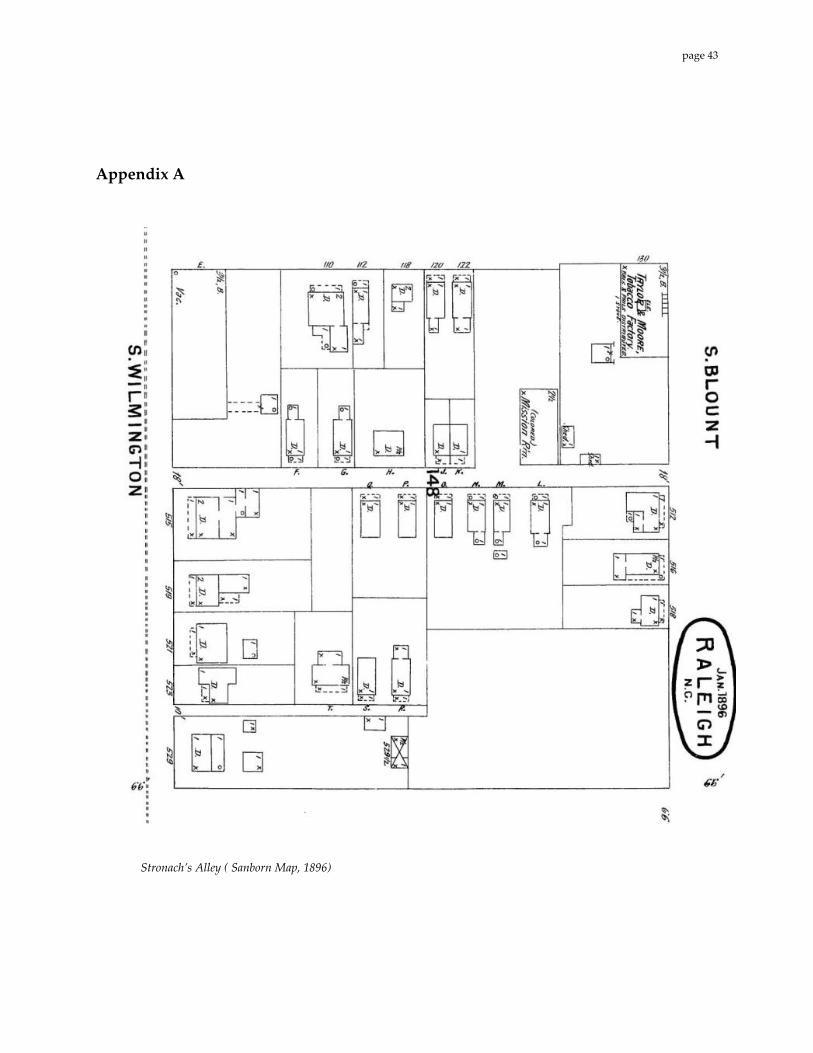
Appendix A
Stronach’s Alley ( Sanborn Map, 1896)
page 43

Stronach’s Alley ( Sanborn Map, 1903)
page 44
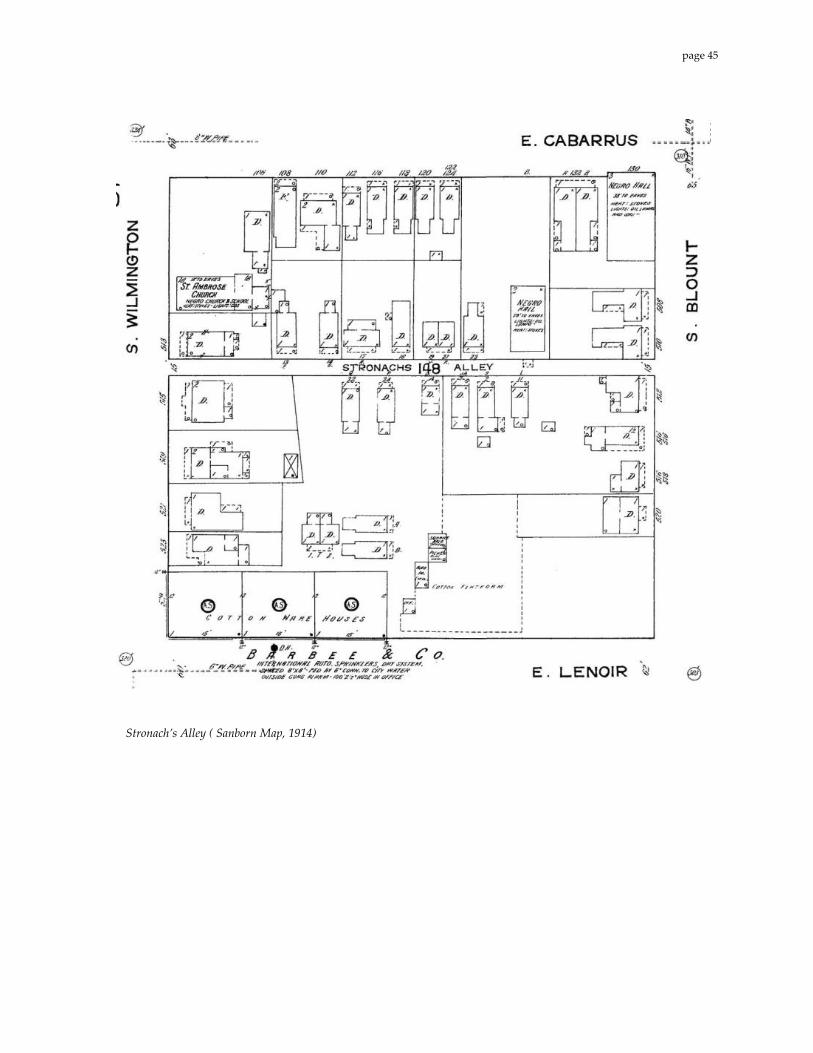
Stronach’s Alley ( Sanborn Map, 1914)
page 45
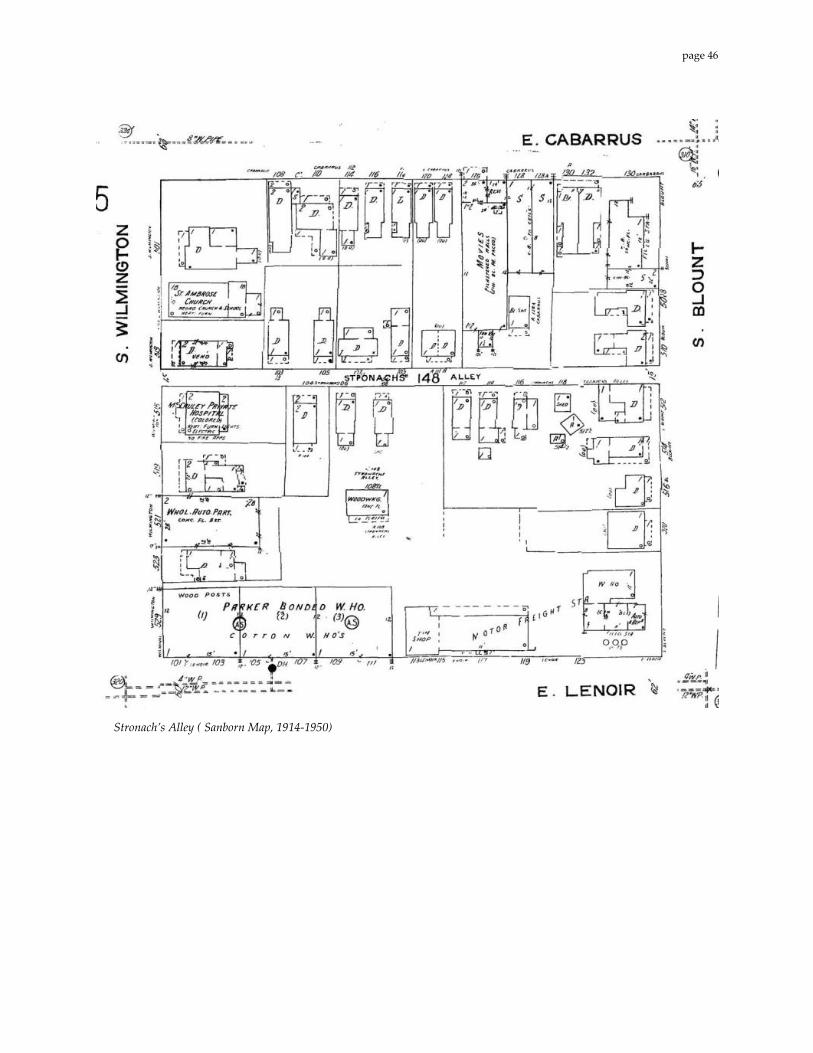
Stronach’s Alley ( Sanborn Map, 1914‐1950)
page 46