Embed Size (px)
Citation preview
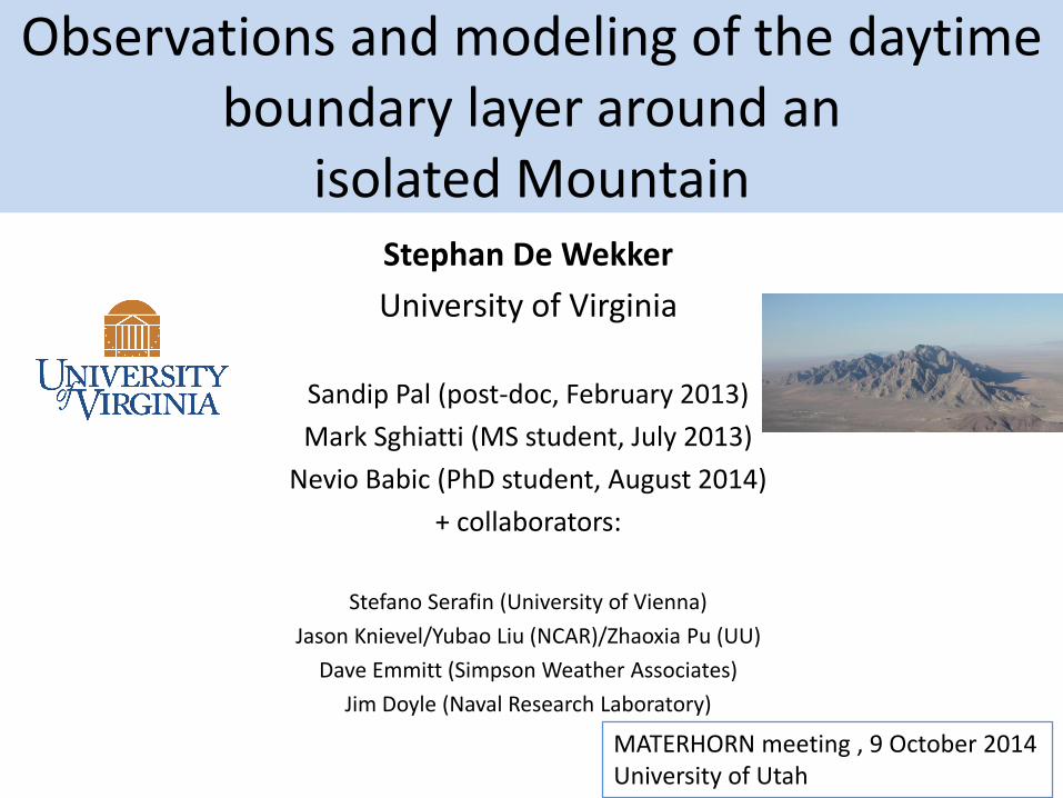
Observations and modeling of the daytime boundary layer around an
isolated Mountain Stephan De Wekker
University of Virginia
Sandip Pal (post-doc, February 2013)
Mark Sghiatti (MS student, July 2013)
Nevio Babic (PhD student, August 2014)
+ collaborators:
Stefano Serafin (University of Vienna)
Jason Knievel/Yubao Liu (NCAR)/Zhaoxia Pu (UU)
Dave Emmitt (Simpson Weather Associates)
Jim Doyle (Naval Research Laboratory)
MATERHORN meeting , 9 October 2014University of Utah
Summary of FY 14 accomplishments
• Spatial variability of winds and PBL height was analyzed using airborne Twin Otter Doppler Wind Lidar (TODWL) measurements from MATERHORN-1.
• Two years of 4DWX output were analyzed to investigate PBL height climatology
• The relative contribution of complex topography and land-surface heterogeneity on the spatial variability in PBL height was investigated using idealized large-eddy-simulations
• Turbulence Kinetic Energy and turbulent fluxes were analyzed from in-situ measurements of the Navy Twin Otter during MATERHORN-1
• Two years of 4DWX output were analyzed to identify the most favorable regions for the onset of boundary-layer separation
• The sensitivity of 4DWX to the assimilation of wind profiles from the airborne Doppler wind lidar was investigated
• An unmanned aerial system consisting of a hexa-copter and meteorological sensors was developed for collecting vertical profiles of temperature, humidity, and wind from the surface to 400 ft AGL.

• Downward conical scans and stare
– U,V,W with 50 m vertical resolution with DX ~ 1 - 1.2 km
– SNR (aerosols)
• Forward stare (for prospecting turbulence structures)
• Additional Twin Otter Measurements, e.g. in situ fluxes, meteorological variables, surface temperature, particle counts
Twin Otter Doppler Wind Lidar (TODWL) data products

MATERHORN-X Fall - airborne
• Twin Otter in Utah between 5 October and 18 October, 2012, participated in 4 IOPs• Missions lasted ~ 4 hours• 7 research flights yielded ~3000 wind profiles between surface and 3400 m MSL• low level flights during each flight• Co-funded by ONR and ARO
quiescent quiescent quiescent moderate
Rainfall event

Spatial variability of PBL height from TODWL
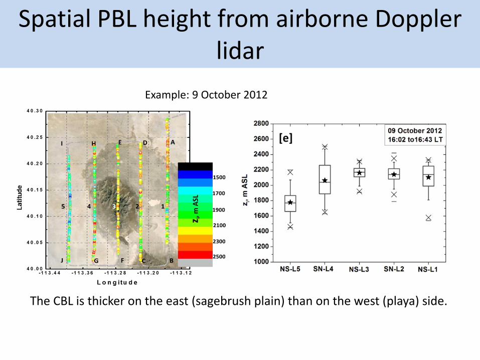
Spatial PBL height from airborne Doppler lidar
The CBL is thicker on the east (sagebrush plain) than on the west (playa) side.
Example: 9 October 2012

Comparison of PBL heights from 4DWX simulations and from TODWL observations
Red = observationsBlack = simulationsPBL height in meters (MSL) from 4DWX
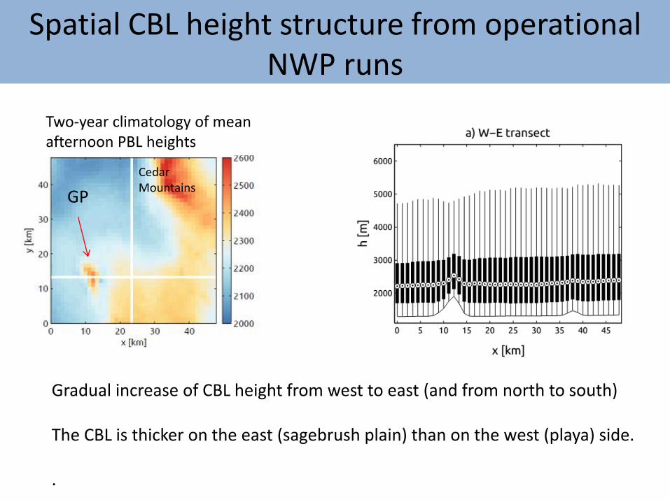
Gradual increase of CBL height from west to east (and from north to south)
The CBL is thicker on the east (sagebrush plain) than on the west (playa) side.
.
Spatial CBL height structure from operational NWP runs
Two-year climatology of mean afternoon PBL heights
GP
Cedar Mountains
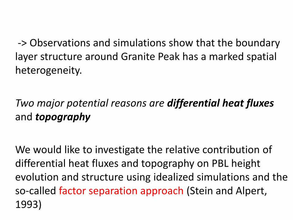
-> Observations and simulations show that the boundary layer structure around Granite Peak has a marked spatial heterogeneity.
Two major potential reasons are differential heat fluxesand topography
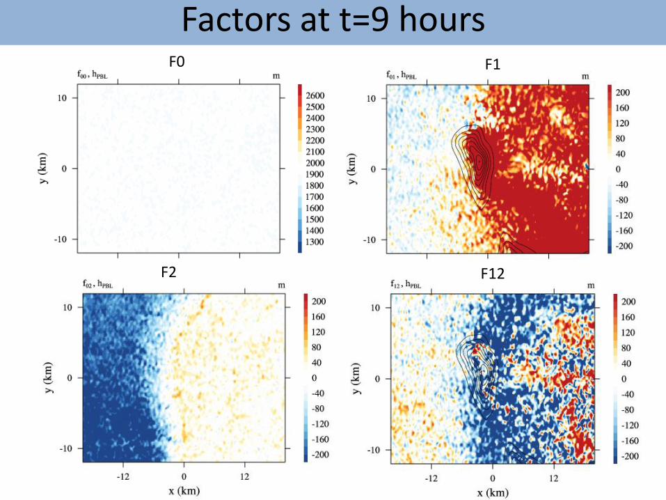
We would like to investigate the relative contribution of differential heat fluxes and topography on PBL height evolution and structure using idealized simulations and the so-called factor separation approach (Stein and Alpert, 1993)

Model setup
LES with CM1 with 100 m horizontal resolution and 20 m max. vertical resolution
84 x 64 km domain centered on Granite Peak. 9-hour simulations starting at sunrise.Open lateral boundary conditions, lateral and upper Rayleigh damping layers
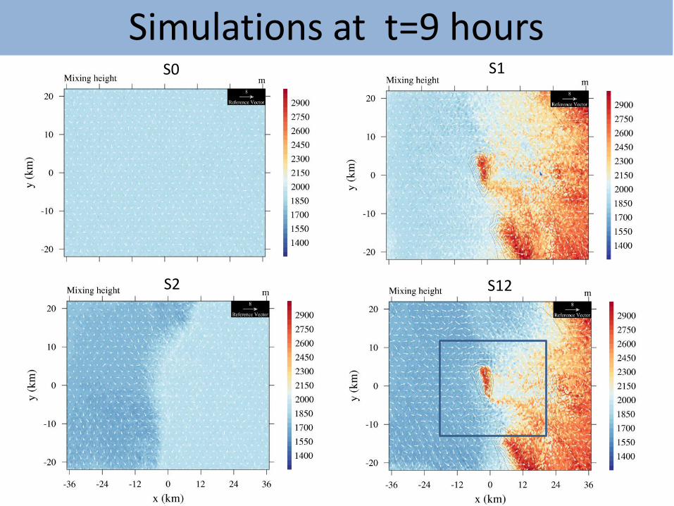
We look at model output after 9 hours of integration (late afternoon).
• S0: no topography, uniform heat input.
• S1: with topography, uniform heat input.
• S2: without topography, differential heat input
• S12: with topography, differential heat input
Topography in modeling domain
GP
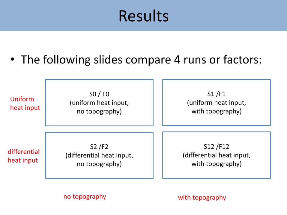
Results
• The following slides compare 4 runs or factors:
S0 / F0(uniform heat input,
no topography)
S1 /F1(uniform heat input,
with topography)
S2 /F2(differential heat input,
no topography)
S12 /F12(differential heat input,
with topography)
with topographyno topography
differential heat input
Uniform heat input
S1S0
S2 S12
Simulations at t=9 hours
F1F0
F2 F12
Factors at t=9 hours
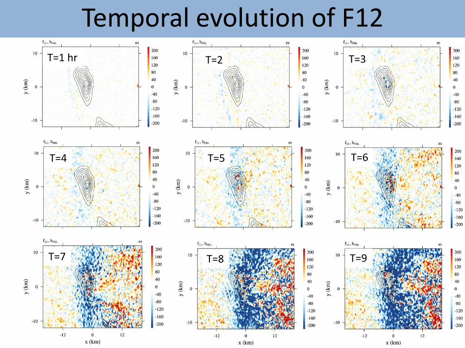
Temporal evolution of F12
T=9T=8T=7
T=6T=5T=4
T=3T=2T=1 hr
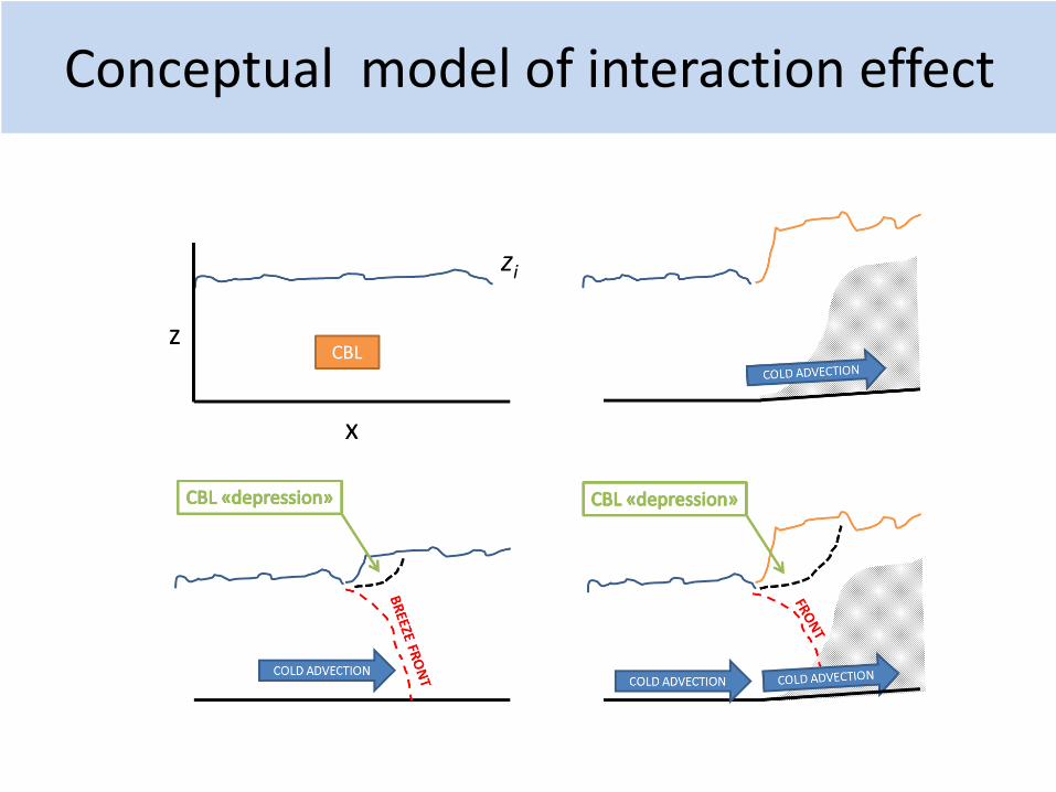
Conceptual model of interaction effect

Outlook summary
Continued efforts on:
• Spatial variability of winds , PBL height, and PBL turbulence
• PBL height climatology• idealized large-eddy-simulations• assimilation of wind profiles from the airborne Doppler
wind lidar in WRF/4DWX
New efforts on:
• MATERHORN case study simulations using COAMPS-EDMF• Surface layer/boundary layer similarity theory

Publications/presentations (FY 2014):peer reviewed publications
Vecenaj, Z. and S.F.J. De Wekker, 2014: Determination of nonstationarity in the surface layer during the T-REX experiment. Quarterly Journal of the Royal Meteorological Society, DOI: 10.1002/qj.2458
Conference presentations
Babic, N., S.F.J. De Wekker, and Z. Vecenaj Influence of applying stationarity criteria to turbulence data on flux-variance similarity relationships in complex terrain. 16th AMS Conference on Mountain Meteorology, 17-22 August, 2014, San Diego, CA.
Pal, S., S.F.J. De Wekker, and G. D. Emmitt, , 2014: Spatial Variability of the Atmospheric Boundary Layer Height over an Isolated Mountain: Selected Cases from the MATERHORN-2012 Field Experiment. 16th AMS Conference on Mountain Meteorology, 17-22 August, 2014, San Diego, CA.
Sghiatti, M., S. Pal, G. D. Emmitt, and S.F.J. De Wekker, 2014: Spatial variability of turbulent kinetic energy and the turbulent fluxes in a daytime boundary layer around an isolated mountain. 16th AMS Conference on Mountain Meteorology, 17-22 August, 2014, San Diego, CA.
De Wekker, S.F.J., D. Chestnut, G. Lewin, I. Deboisblanc, N. Dodbele, L. Kussmann, R. Mukherji, and S. Phelps, 2014: Investigating local-scale flows in a valley using an instrumented multi-rotor copter. 16th AMS Conference on Mountain Meteorology, 17-22 August, 2014, San Diego, CA.
De Wekker, S.F.J., and S. Serafin, 2014: Understanding the spatial variability of convective boundary layer depth around an isolated mountain with a factor separation approach. 16th AMS Conference on Mountain Meteorology, 17-22 August, 2014, San Diego, CA.
Knievel, J.C., Y. Liu, S.F.J. De Wekker, W.Y.Y. Cheng, Y. Liu, and J. C. Pace, 2014: Simulations of meso-gamma-scale circulations near Granite Peak, Utah with NCAR's WRF-based 4DWX system and assimilated airborne lidar data from the MATERHORN 2012 field campaign. 16th AMS Conference on Mountain Meteorology, 17-22 August, 2014, San Diego, CA.
De Wekker, S.F.J., D. Chestnut, G. Lewin, I. Deboisblanc, N. Dodbele, L. Kussmann, R. Mukherji, and S. Phelps, 2014: Development of an autonomous multi-rotor copter for probing the atmospheric boundary layer. 17th Symposium on Meteorological Observation and Instrumentation. 9-13 June 2014, Westminster, CO.
Babic, N., Z. Vecenaj, and S.F.J. De Wekker, 2014: Impact of stationarity criteria on surface layer similarity functions in complex terrain, 21st AMS Symposium on Boundary Layers and Turbulence, June 2014, Leeds, UK.
Serafin, S., and S.F.J. De Wekker, 2014, Understanding the effects of multi-scale flow interactions on convective boundary layer depth. 21st AMS Symposium on Boundary Layers and Turbulence, June 2014, Leeds, UK.
deBoisblanc, I., N. Dodbele, L. Kussmann, R. Mukherji, D. Chestnut, S. Phelps, G. Lewin, S.F.J. De Wekker, 2014: Designing a Hexacopter for the Collection of Atmospheric Flow Data. IEEE Systems and Information Engineering Design Symposium (SIEDS'14) (Student conference). 25 April 2014. Charlottesville, VA.
Sghiatti, M.D., S. Pal, G.D. Emmitt, and S.F.J. De Wekker, 2014: Turbulence structure in the daytime boundary layer around an isolated mountain from in-situ airborne measurements. American Meteorological Society Annual Meeting, Atlanta, GA, 3-7 February 2014.
Knievel, J.C., Y. Liu, S.F.J. De Wekker; J. Pace, W.Y. Cheng, and Y. Liu, 2013: Simulation of meso-gamma-scale morning-transition flows at Granite Peak, Utah with NCAR’s WRF-based 4DWX and observations from the MATERHORN 2012 field campaign. American Geophysical Union, San Francisco, 9 - 13 December 2013.
De Wekker, S.F.J., Y. Liu, J.C. Knievel, S. Pal, G.D. Emmitt, 2013: Observations and simulations of the wind structure in the boundary layer around an isolated mountain during the MATERHORN field experiment. American Geophysical Union, San Francisco, 9 - 13 December 2013.
Serafin, S., S.F.J. De Wekker, and J.C. Knievel, 2013: Boundary-Layer Phenomena in the Vicinity of an Isolated Mountain: A Climatography Based on an Operational High-Resolution Forecast System. American Geophysical Union, San Francisco, 9 - 13 December 2013.
Liu, Y., Y. Liu, J.C. Knievel, J. Pace, D. Zajic, S.F.J. De Wekker, LES simulation of synoptic, mechanic-forcing, and thermally-driven flow interaction of Granite Mountain, UT. American Geophysical Union, San Francisco, 9 - 13 December 2013.
Serafin, S., S.F.J. De Wekker and J. Knievel (2013): Boundary-layer phenomena in the vicinity of an isolated mountain: A climatography based on an operational high-resolution forecast system. 32nd International Conference on Alpine Meteorology, Kranjska Gora (Slovenia), June 3-June 7, 2013.