Embed Size (px)
DESCRIPTION
In English after this. Nos últimos dez anos, os israelitas foram alargando as restrições ao acesso às terras agrícolas do lado de Gaza da "Linha Verde", e às zonas de pesca ao longo da sua costa, com a intenção declarada de impedir os ataques por grupos palestinos. Os resultados deste estudo indicam um impacto devastador sobre a segurança física e a subsistência de cerca de 180.000 pessoas, agravando a agressão à dignidade humana provocada pelo bloqueio imposto por Israel em Junho 2007.| Over the past ten years, the Israeli military has gradually expanded restrictions on access to farmland on the Gaza side of the ‘Green Line’, and to fishing areas along the coast, with the stated intention of preventing attacks by Palestinian armed factions. The findings of this study indicate that this regime has had a devastating impact on the physical security and livelihoods of nearly 180,000 people, exacerbating the assault on human dignity triggered by the blockade imposed by Israel in Jun 2007.
Citation preview

UNITED NATIONSOffice for the Coordination of Humanitarian Affairs
occupied Palestinian territory
SPECIAL FOCUSAugust 2010
Over the past ten years, the Israeli military has gradually expanded restrictions on access to farmland on the Gaza side of the ‘Green Line’, and to fishing areas along the Gaza Strip coast, with the stated intention of preventing attacks by Palestinian armed
factions. The findings of this study indicate that this regime has had a devastating impact on the physical security and livelihoods of nearly 180,000 people, exacerbating the assault on human dignity triggered by the blockade imposed by Israel in June 2007.
THE HUMANITARIAN IMPACT OF ISRAELI-IMPOSED RESTRICTIONS ON ACCESS TO LAND AND SEA IN THE GAZA STRIP
BETWEEN THE FENCE AND A HARD PLACE

2 SPECIAL FOCUS August 2010OCHA-WFP
DisclaimerThis publication has been produced with financial assistance of the donors of the World Food Programme (WFP) and
the Office for the Coordination of Humanitarian Affairs (OCHA). The content of this publication can in no way be taken
to reflect the official opinion of their donors.
This report is based upon a study commissioned to Al-Sahel Co. for Institutional Development and Communications, and supplemented with further research by the Office for the Coordination of Humanitarian Affairs (OCHA - oPt) and the World Food Programme (WFP).
For information about WFP in the oPt, please visit: www.wfppal.org
For information about OCHA in the oPt, please visit: www.ochaopt.org
Unless otherwise stated, all photos were taken by WFP/ Shareef Sarhan
Front cover photo: Land levelled in the area of Juhor ad Dik.Back cover photo: Aneesa Moamar in her home in Fukhkhari area, east of Khan Yunis, next to Sofa crossing
WFP and OCHA wish to thank the International Committee of the Red Cross (ICRC), the Food and Agricultural Organization (FAO), the United Nations Children’s Fund (UNICEF) and the Office of the High Commissioner for Human Rights (OHCHR) for their feedback on this report
3SPECIAL FOCUS August 2010OCHA-WFP
Executive Summary ........................................................................................................... 5
Introduction ........................................................................................................................ 7
Methodology ................................................................................................................................................. 7
I. Defining the restricted areas and affected populations .............................................. 8
Land restricted areas ................................................................................................................................... 8
Restricted sea areas ...................................................................................................................................10
Affected population ...................................................................................................................................11
II. A protection crisis ........................................................................................................ 13
Arbitrary opening of fire ..........................................................................................................................13
Land levelling and property destruction ...............................................................................................16
Military activities by armed factions and clashes.................................................................................17
III. Impact on Livelihoods ................................................................................................ 19
Loss of assets ..............................................................................................................................................19
Loss of agricultural yield and related income ......................................................................................22
Loss of fishing output and related income ...........................................................................................24
IV. Coping mechanisms .................................................................................................... 25
Income generation strategies ..................................................................................................................25
Cost and consumption reduction strategies ........................................................................................27
Humanitarian assistance ...........................................................................................................................27
V. Impact on access to education.................................................................................... 29
VI. Impact on Utility Infrastructure ............................................................................... 31
Waste Water Treatment Plants ...............................................................................................................31
Electricity .....................................................................................................................................................32
The way forward ............................................................................................................... 33
TABLE OF CONTENTS

4 SPECIAL FOCUS August 2010OCHA-WFP
ACRONYMS
CMWU Coastal Municipalities Water Utility
COGAT Coordinator of Government Activities in the Territories
GEDCO Gaza Electricity Distribution Company
ICRC International Committee of the Red Cross
IDF Israel Defence Forces
IEC Israel’s Electricity Corporation
IHL International Humanitarian Law
KFW German Development Bank
MoA Ministry of Agriculture
NM Nautical Miles
NGO Non Governmental Organization
NIS New Israeli Shekel
OCHA Office for the Coordination of Humanitarian Affairs
oPt occupied Palestinian territory
PA Palestinian Authority
PCBS Palestinian Central Bureau of Statistics
PLO Palestinian Liberation Organisation
UN United Nations
UNDP United Nations Development Programme
UNRWA United Nations Relief and Works Agency for Palestine Refugees in the Near East
USD United States Dollar
WFP World Food Programme
WHO World Health Organization

5SPECIAL FOCUS August 2010OCHA-WFP
Over the past ten years, the Israeli military has gradually expanded restrictions on access to farmland on the Gaza side of the 1949 ‘Green Line’, and to fishing areas along the Gaza Strip coast, with the stated intention of preventing attacks on Israel by Palestinian armed factions, including firing projectiles.
This study aims at assessing the scope of these restrictions, as well as their impact on physical security, livelihood and access to services. The information and analysis presented is based on over 100 interviews and focus group discussions carried out during March-April 2010, and complemented with analysis of quantitative data available from other sources.
Since late 2008, Palestinians have been totally or partially prevented from accessing land located up to 1,000-1,500 meters from the Green Line (depending on the specific area), and sea areas beyond 3 nautical miles from shore. Overall, the land restricted area is estimated at 17 percent of the total land mass of the Gaza Strip and 35 percent of its agricultural land. At sea, fishermen are totally prevented from accessing some 85 percent of the maritime areas they are entitled to access according to the Oslo Agreements.
An estimated 178,000 people - 12 percent of the population of the Gaza Strip - are directly affected by the access regime implemented by the Israeli military. This includes approximately 113,000 people affected by such measures in land areas, and 65,000 people affected by restrictions to maritime areas.
Access restrictions are primarily enforced by opening live fire on people entering the restricted areas. While in most cases it is ‘warning shots’ that force people from the area, since the end of the “Cast Lead” offensive in January 2009, the Israeli army has also killed a total of 22 civilians and injured another 146 in these circumstances. Despite the potential for civilian casualties, the Israeli authorities have not informed the affected population about the precise
boundaries of the restricted areas and the conditions under which access to these areas may be permitted or denied.
Additional risks to the affected population stem from military activities of Palestinian armed factions in the restricted areas and their confrontations with the Israeli military. Since the end of the “Cast Lead” offensive 41 Palestinian militants and four Israeli soldiers were killed in the restricted area or its vicinity in these circumstances and another 26 Palestinian militants and ten Israeli soldiers were injured.
A complementary method used by the Israeli military to discourage access is the systematic levelling of farm land and the destruction of other private property located in restricted areas. Given that levelling operations usually target fruit trees and greenhouses, some farmers have re-planted previously levelled areas with rain-fed crops, which demand less care and have better chances of survival. However, the ability of farmers to harvest these crops is limited and the income is only a fraction of the income of the original crops.
The value of agricultural and other property destroyed in the past five years in the land restricted area is conservatively estimated at USD 308 million (replacement cost). Agriculture-related assets include fruit trees, greenhouses, chicken and sheep farms and water wells, and account for 90 percent of this cost.
It has been further estimated that access restrictions and the related destruction of agricultural assets results in a yearly loss of approximately 75,000 metric tons of potential produce. The market value of this produce is conservatively estimated at USD 50.2 million a year. Most farmers interviewed for this study indicated that since the expansion of the restricted area in 2008, their income from agriculture has been reduced to less than a third of its previous amount. Others reported having their income wiped out. In the fishing sector, the potential fishing catch lost as a result of access restrictions is estimated at
EXECUTIVE SUMMARY

6 SPECIAL FOCUS August 2010OCHA-WFP
approximately 7,000 metric tonnes, with a related income loss of some USD 26.5 million over a period of five years.
The erosion of livelihoods has forced affected families to develop a variety of coping mechanisms aimed at generating alternative income and reducing expenditure. Some of these practices raise significant concerns, including reductions in the quantity of food consumed; gradual shifts in diets (from vegetables and animal products to low-cost and high-carbohydrate items); reductions in the length of school enrolment for children; and increased inclination of parents to marry off daughters earlier.
The current regime also affects access to schools, seven of which are located within the restricted areas. The safety of students and staff attending these institutions (4,600), the quality of education provided and the level of educational achievement have been seriously undermined by the frequent exposure to Israeli fire at people present in open areas, be they farmers or armed militants.
Finally, access restrictions have significantly impeded the maintenance and upgrade of existing wastewater and electricity infrastructure, negatively impacting the provision of services to the entire population of the Gaza Strip. In particular, the prolonged delay in the construction of three wastewater treatment plants has contributed to the daily release of some 80 million litres of raw and partially-treated sewage into the sea and streams, thus adding a significant environmental and health hazard.
To start addressing the dire situation of one of the most vulnerable segments of Gaza’s population, the current restrictions on civilian access to Gaza’s land and sea must be urgently lifted to the fullest extent possible. All parties must abide by their obligations under international humanitarian and human rights law, including full implementation of Security Council Resolution 1860.1
The findings of this study also indicate that larger and better targeted humanitarian assistance is required to mitigate the impact of the ongoing erosion to livelihoods and to prevent further deterioration.

7SPECIAL FOCUS August 2010OCHA-WFP
INTRODUCTIONIsrael’s 2005 “Disengagement Plan” entailed the unilateral redeployment of the Israeli army out from the Gaza Strip and the evacuation of the military installations and civilian settlements established there since 1967. Despite these measures, Israel has continued exercising significant control over key aspects of the lives of its 1.5 million residents. One such aspect pertains to the access of people to farming areas within Gaza located along the 1949 Armistice Line between Israel and Gaza (also known as the Green Line), and to fishing areas along Gaza’s coast – hereafter “the restricted areas”.
Reference to a special regime regulating Palestinian access to these areas can be found in the Gaza-Jericho Agreement, between Israel and the Palestine Liberation Organization (PLO) in 1994.2 This agreement provided for the establishment of a 1,000 meter-wide “security perimeter” on the Gaza side of the Green Line, with the Palestinian Police to enforce “special security measures” to prevent the entry of people into Israel, and the introduction of arms or ammunitions into that area, without coordination with the Israeli army.3 A separate provision established that maritime areas 20 nautical miles off Gaza’s coast into the Mediterranean Sea would be open (under certain conditions) to Palestinian use for fishing, recreation and economic activities, while responsibility for law enforcement in this area would be shared between Israel and the Palestinian Authority.4
These provisions were only partially implemented before the beginning of the second Intifada in September 2000. Since then, Palestinian access into the above areas has been entirely subject to Israel’s unilateral measures, which have become increasingly restrictive and dangerous. The Israeli authorities justify these measures as a means to protect Israeli civilians and soldiers from attacks by Palestinian armed factions. Indeed, since the ‘Disengagement’ the lives of hundreds of thousands of Israeli civilians in southern Israel have been frequently disrupted and put under threat as a result of the intermittent firing of rockets and mortars by Palestinian armed groups. This fire also resulted in the killing of 11 Israeli civilians over the course of the past five years.
However, the main parameters of the access regime implemented by the Israeli military have since remained vague and unpredictable, including the precise boundaries of the restricted areas, the conditions under which access to these areas may be permitted or denied, and the consequences of prohibited entry. Similarly, while evidence from the field indicates that the impact of these restrictions on the physical security and economic livelihoods of the population is significant, so far, no in-depth assessment of this impact has been carried out. This study aims to fill this gap.
The first section provides working definitions for the restricted areas and the affected populations referred to in the remainder of the report. The following five sections address the impact of restrictions on various areas of concern, including civilian protection, livelihoods, coping mechanisms, access to education, and the provision of electricity and sanitation services.5
Methodology The information and analysis presented in this report is based on 101 semi-structured interviews and focus group discussions carried out among affected populations and key informants, most of them during March-April 2010. This is complemented with an analysis of quantitative data available from other sources.6
A total of 77 semi-structured interviews were conducted targeting individuals from different regions and holding different positions relevant to this study, including farmers (26), fishermen (10), municipal officials in affected localities (11), representatives from agricultural cooperatives (5), representatives from the Fishermen’s Syndicate (5), personnel and students attending affected schools (10), and key informants from a variety of public utilities, local NGOs and UN agencies (10). In addition, 24 focus group discussions were held involving men and women living in the affected localities, of which, 11 groups were exclusively composed of farmers, five of women, and one of fishermen.

8 SPECIAL FOCUS August 2010OCHA-WFP
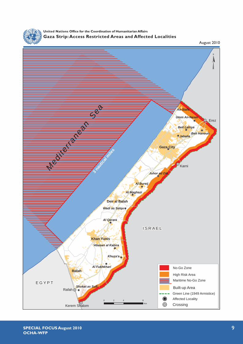
The precise parameters of the access regime implemented by the Israeli military regarding land in the proximity of the fence along the Green Line (hereafter: the fence), and along Gaza’s shore on the Mediterranean Sea, are uncertain. These parameters include the precise boundaries of the restricted areas, the conditions under which Palestinian access to these areas may be allowed or denied, and the consequences of prohibited entry.
The information presented below relies primarily on the observations of enforcement practices of the Israeli military in the relevant areas, made by the participants of interviews and focus groups carried out for this study. Figures and definitions provided here are, therefore, estimates produced for the purposes of this report and are not intended to be authoritative or definitive. Nonetheless, the rough boundaries of the restricted land and sea areas, were shared by OCHA in a meeting with the Israeli COGAT, and confirmed by the latter.7
Land restricted areasThe land areas along the fence affected by access restrictions have gradually expanded since the beginning of the second Intifada in September 2000. As the enforcement of restrictions over this period has been irregular over time and across geographical area, a precise historical reconstruction of the expansion process in each specific locality was not feasible, based on the methodology used in this study. However, information collected through the interviews and focus groups consistently indicates that until November 2008, access restrictions were implemented in most areas within 300 meters from the fence. That month, following the collapse of
the ceasefire (‘calm’) agreement between Israel and Hamas,8 the Israeli military began expanding the restricted area up to 1,000-1,500 meters.
A detailed account of the depth and overall size (area) of the restricted land areas in each of the 14 affected localities considered in this study is provided in Table 1 and the accompanying map. A number of areas located less than 1,000-1,500 meters from the fence were not considered part of the restricted area, for the purpose of this study, since movement within them appears to be governed by a different, less dangerous, regime.9 These include a number of residential (currently-inhabited) built-up areas, as well as the area of the Karni crossing.
Based on the enforcement practices reported in the interviews and focus groups, the land restricted area can be schematically sub-divided into two:
The “no-go zone”: covers the area between zero to 500 meters from the fence, where access is totally prohibited and poses an extreme threat to life if entered. The Israeli army carries out incursions into this zone a number of times a week, during which land is levelled and any property found there is destroyed. The existence of such a zone was partially acknowledged by the Israeli army in May 2009, when its air force dropped thousands of pamphlets over different parts of the Gaza Strip stating that anybody entering areas closer than 300 meters from the fence endangers his or her life.10
The “high risk zone”: covers the area located between 500 to 1,000-1,500 meters from the fence, depending on the area. Opening fire
I. DEFINING THE RESTRICTED AREAS AND AFFECTED POPULATIONS
Figures on the size of the different areas affected by access restrictions were calculated with GIS software on the basis of the information collected in the interviews and focus group discussions. Other figures, including the size of the affected population, the amount of land allocated in the past for various crops, the income loss per year, and
the replacement value of destroyed property, are estimates produced on the basis of official statistics (PCBS and MoA), which were then analyzed and extrapolated in light of initial information collected in the interviews and focus groups. The source of casualty figures provided in this report is OCHA’s Protection of Civilians Database.
9SPECIAL FOCUS August 2010OCHA-WFP
Medite
rrane
anSea
I S R A E L
E G Y P T
Erez
Karni
Rafah
Kerem Shalom
Khuza'a
Jabalia
Al Qarara
Gaza City
Beit Hanoun
Beit Lahiya
Al Fukhkhari
Juhor ad Dik
Wadi as Salqa
Shokat as Sufi
Al Bureij
Al Maghazi
'Abasan al Kabira
Umm An-Naser
As-Siafa
3 naut
ical m
iles
Rafah
Khan Yunis
Deir al Balah
0 4 82Km
Built-up Area
CrossingAffected LocalityGreen Line (1949 Armistice)
Maritime No-Go Zone
High Risk Area
No-Go Zone
United Nations Office for the Coordination of Humanitarian Affairs
Gaza Strip: Access Restricted Areas and Affected LocalitiesAugust 2010
10 SPECIAL FOCUS August 2010OCHA-WFP
at people accessing this area, as well as land levelling and property destruction, are common and widespread practices; however, they are carried out irregularly and unpredictably. As a general rule, the deeper one enters these areas in the direction of the fence, the more likely one is to receive warning or direct fire. Some sections of this zone have been levelled in the past two years (some more than once) and subsequently re-cultivated with rain-fed crops, primarily wheat and barley.11
Participants of the interviews and focus groups indicated that incidents of warning fire and land levelling have occurred in areas beyond the 1,000-1,500 meters from the fence, and as far as 3,000 meters. However, due to the lower frequency of such incidents and the relatively regular access of Palestinian farmers to these areas, for the purpose of this study, these areas were not considered part of the calculations of estimates pertaining to restricted areas.
In sum, the land restricted areas - combining the “no go” and “high risk” zones - is estimated to cover approximately 62,600 dunums (62.6 sq. kilometres) representing 17 percent of the Gaza Strip’s total land mass (365 sq. kilometres).12
After measuring the size of areas used for non-agricultural purposes, it has been further estimated that approximately 95 percent (59,500 dunums or 59.5km2) of the restricted area is arable land.13 On the basis of 2004/5 PCBS data on the size of cultivated land in the Gaza Strip (168,506 dunums), it can be estimated that approximately 35 percent of Gaza’s cultivable land is located within the restricted area.14
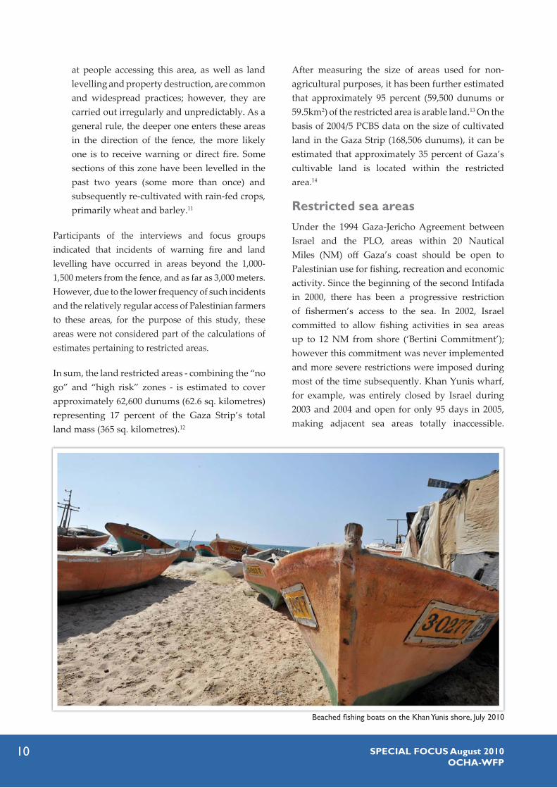
Restricted sea areasUnder the 1994 Gaza-Jericho Agreement between Israel and the PLO, areas within 20 Nautical Miles (NM) off Gaza’s coast should be open to Palestinian use for fishing, recreation and economic activity. Since the beginning of the second Intifada in 2000, there has been a progressive restriction of fishermen’s access to the sea. In 2002, Israel committed to allow fishing activities in sea areas up to 12 NM from shore (‘Bertini Commitment’); however this commitment was never implemented and more severe restrictions were imposed during most of the time subsequently. Khan Yunis wharf, for example, was entirely closed by Israel during 2003 and 2004 and open for only 95 days in 2005, making adjacent sea areas totally inaccessible.
Beached fishing boats on the Khan Yunis shore, July 2010

11SPECIAL FOCUS August 2010OCHA-WFP
Access to other areas along the coast also fluctuated over the years, often in response to concerns that weapons were being smuggled into Gaza by sea. In mid-2006, Israel announced that fishing activities beyond 6 NM from shore were prohibited.
Based on interviews and focus groups, the latest expansion of the restricted sea areas can be dated to late 2008, on the eve of the “Cast Lead” offensive. Along most of Gaza’s coast, the restricted areas begin at 3 NM from shore. In the north, Palestinians are totally prevented from accessing a 1.5 NM-wide strip along the maritime boundary with Israel, and a 1 NM-wide strip in the south, along the maritime boundary with Egypt, as established in the 1994 Gaza-Jericho Agreement.15
Overall, Palestinians are totally prevented from accessing 85 percent of the sea areas on which they are entitled to carry out maritime activities, including fishing, according to the 1994 Gaza-Jericho Agreement.
Similar to the restricted areas on land, Palestinian fishermen entering the restricted sea areas are regularly exposed to warning fire by Israeli naval forces, and in some cases, directly targeted. Fishing
boats intercepted by the Israeli military in these areas are regularly confiscated, along with their fishing equipment, and fishermen are detained.
Affected population
For the purpose of estimating the scope of the population directly affected by access restrictions to land areas, as defined above, the following types of households were considered:
the family owns land in the restricted area; at least one of its members works or used to work in the restricted area in agriculture or in the collection of scrap metal;the house is located within 100 meters from the boundary of the restricted area;16 the family was displaced and relocated elsewhere as a result of the destruction of its house and assets within the restricted area;at least one of its members studies or works in an affected school.
The total population meeting these criteria is estimated at approximately 113,000 people, or 7.5 percent of Gaza’s total population, distributed across 14 main localities (see Table 1).17
Farmers in the Fukhkhari area, east of Khan Yunis, July 2010

12 SPECIAL FOCUS August 2010OCHA-WFP
The Gaza governorate has the largest affected population (43 percent), followed by Khan Yunis (24 percent) and Northern Gaza (21 percent). Rural localities are also disproportionately affected compared to towns, cities and refugee camps. In villages like Khuza’a and ‘Abasan in the Khan Yunis governorate, at least 50 percent of the village population is affected, whereas in Gaza City no more than 10 percent is.
According to the Ministry of Agriculture in Gaza, as of the end of 2009, there were approximately 3,500 people registered as active fishermen. This figure represents a decrease from the approximately 10,000
practising fishermen in the Gaza Strip on the eve of the second Intifada in September 2000, when Israel began restricting access to fishing areas. Assuming that the progressive reduction of the accessible fishing areas has been the main factor pushing people out of the fishing sector, the population affected by the access restrictions at sea is estimated at 65,000.18
Combined, the number of people directly affected by the access restrictions to land and to fishing areas is 178,000 persons, or approximately 12 percent of the total population of the Gaza Strip.
Table 1: Depth, size, and affected population of land restricted areas by locality
Governorate LocalityDepth of restricted areas (in meters)
Area (in dunums)Affected
population
North Gaza
Beit Lahiya 1,500 6,032 6,400
Jabalia 1,000 2,895 12,300
Beit Hanoun N: 1,500; E: 1,000 9,447 3,800
Umm An-Naser* 1,500 1,778 1,400
Gaza Juhor Ad Dik 1,500 8,605 1,500
Gaza City 1,000 5,258 44,900
Deir Al-Balah
Wadi as Salqa 1,000 3,949 2,300
Al Maghahzi 1,000 2,370 3,300
Al Bureij 1,000 2,002 4,900
Khan Yunis
Al Foukhkhari 1,000 2,984 2,800
Khuza’a 1,000 5,075 4,600
Abasan Al Kabira 1,000 2,468 9,200
Al Qarara 700 2,383 9,900
Rafah Shokat as Sufi 1,000 7,370 5,400
Total 62,616 112,700
* Includes the community of As-Siafa
13SPECIAL FOCUS August 2010OCHA-WFP
II. A PROTECTION CRISIS19
The civilian population affected by access restrictions imposed by the Israeli military suffers from a systematic lack of respect for their basic rights, as enshrined in international humanitarian and human rights law. This situation stems from the methods used by the Israeli military to enforce these restrictions and discourage access to these areas, which has placed civilian lives at grave risk and resulted in the widespread loss of civilian property. Additional risk to life and property loss stems from military activities of Palestinian armed factions in the restricted areas and their exchanges with the Israeli military.
Arbitrary opening of fire One of the two main methods used by the Israeli military to enforce access restrictions to the land and sea areas is the opening of live fire at people entering these areas. In most cases “warning shots” are fired to force people out of the area, which results in no
casualties. No comprehensive and accurate account of the frequency of this type of incident exists. Representatives of local organizations interviewed for this study estimate that these incidents occur almost on a daily basis. The Fishermen’s Syndicate reported that in the first three months of 2010 it recorded 48 incidents involving the opening of “warning fire” at fishermen entering the restricted area by sea, or an average of four incidents a week.
A minority of cases have resulted in the death and injury of civilians. Since the end of the “Cast Lead” offensive in January 2009 up to the end of July 2010, OCHA recorded the killing of 22 civilians in the restricted areas by the Israeli army, of whom six were children. During this period, 146 Palestinian civilians were injured in the same circumstances (including 16 farmers and 9 fishermen), of whom at least 27 were children (the age of 26 people injured during this period in this area could not be verified).
Protecting the civilian population during armed conflicts is one of the main objectives of International Humanitarian
Law (IHL).19 The principle of distinction between combatants and military objectives and civilians and civilian objects
is the cornerstone of this body of law and the source of more specific rules regulating the conduct of hostilities.
According to this principle,
It is absolutely prohibited to target civilians, regardless of the circumstances. When launching attacks, parties to a conflict must take all feasible precautions to avoid, and in any event to minimize, incidental loss of civilian life
and injury to civilians;21
it is absolutely prohibited to target civilian objects (legitimate military targets are only those objects which by their nature, location, purpose or use make an effective contribution to military action);22
parties to a conflict must take all feasible precautions to protect the civilian population and civilian objects under their control against the effects of attacks; to the extent feasible, they must avoid locating military objectives
within or near densely populated areas.23
Both Israel, as the occupying power, and the de facto authorities in Gaza are obliged to respect the human rights
of people living in the Gaza Strip, as defined in the various human rights treaties and in accordance with customary
international law. Particularly relevant to the subject addressed in the present study are the right of every person to life
(not to be arbitrarily deprived from it),24 to freedom of movement and to choose his/her place of residence within his/
her country,25 to work and gain a living from work,26 and to enjoy an adequate standard of living.27
As pointed out by the International Court of Justice (ICJ) its Advisory Opinion on the West Bank Barrier, Israel “has
the right, and indeed the duty, to respond in order to protect the life of its citizens [but] the measures taken are
bound nonetheless to remain in conformity with applicable international law”.28
THE LEGAL FRAMEWORK

14 SPECIAL FOCUS August 2010OCHA-WFP
Farmers and fishermen are not the only civilians who are regularly exposed to live fire. Since the beginning of 2010 there has been an increasing number of shooting incidents affecting people collecting rubble and scrap metal in the restricted areas, resulting in the injury of 19. The number of people engaged in rubble collection has steadily increased, due to the growing demand for such materials by the recycling industry.29
The largest number of civilian casualties in a single month was recorded in March 2010 (1 fatality and 36 injuries); these occurred in the context of a series of Israeli land incursions and airstrikes, launched in response to the killing of a foreign national employed in Israel by a Palestinian rocket, and the subsequent killing of two Israeli soldiers in clashes between Israeli troops and Palestinian militants. Many of the Israeli attacks targeted agricultural structures located in the restricted area, which in addition to the multiple injuries, resulted in damage to 13 homes, one school and one water reservoir; four people were injured during various demonstrations carried out on 30 March in the restricted areas, in commemoration of ‘Land Day’.
In addition to the incompatibility of this enforcement method with the IHL rule requiring parties to a conflict to take all feasible precautions to protect the civilian population and civilian objects, and despite its lethal nature, the Israeli military has consistently failed to provide the affected population with accurate information about the main parameters of the access regime being enforced, particularly in the farming areas, and to a lesser degree in the restricted fishing areas. Uncertainty and lack of clarity are high regarding the precise boundaries
Mohammed Abu Wardeh, 22, has been collecting rubble since March 2010 to provide an income for his wife and three children, while supporting his extended family which relies upon him as the main bread winner. Prior to that, he was unemployed and worked in a temporary poverty alleviation project at Gaza Municipality. Every morning, at approximately 6 am, he and his 16 year old brother depart from their home in Beit Lahiya with a donkey-cart to the former Erez industrial area.
On 15 May, 2010 Mohammed arrived at the site at 7am and 200-300 workers were already on site; many of them displayed a white cloth to indicate their presence and civilian status to the Israeli troops. Despite intermittent warning fire, Abu Wardeh began working in a shallow pit, approximately 400m from the fence. Later on, when he tried to exit the pit, he was hit by a bullet, which penetrated his right leg and exited from the other side. His cousin called an ambulance; however the latter refused to access the restricted area. Therefore, he was put on a donkey cart and transported to an area half an hour away, where the ambulance was waiting and brought him to the hospital. Abu Wardeh suffered from multiple leg fractures and underwent external fixation surgery.
MOHAMMED ABU WARDEH – RUBBLE COLLECTOR
On 13 July 2010, one woman was killed and three of her relatives injured by a flechette shell that hit their house in Juhor Ad-Dik, 400 meters from the fence

15SPECIAL FOCUS August 2010OCHA-WFP
of the restricted areas, the conditions under which access to these areas may be allowed or denied, and the consequences of a prohibited entry. Regarding the boundaries, the Israeli military has failed to physically demarcate the restricted areas in any meaningful way, even though it carries out land incursions into the restricted areas 3-4 times every week (see below) and naval forces continuously patrol the coast.
Moreover, on at least one occasion, the Israeli military provided the affected population with clearly misleading information: in May 2009 the Israeli Air Force dropped thousands of leaflets along the affected areas warning people not to access areas closer than 300 meters from the fence; in reality however, access restrictions were and are being enforced on areas up to 1,000-1,500 metres from the fence.
The lack of clarity and unpredictability associated with this access regime makes it highly arbitrary, thus significantly increasing the level of risk to thousands of civilians who depend on access to the restricted areas for their livelihoods. A key factor increasing the arbitrariness of this regime is the relatively high frequency in which some of the main parameters of the regime appeared to be modified, primarily the depth of the restricted areas.
In the absence of accurate information, civilians are forced to assess the risks before every entry, based on their individual and collective experience. Participants in interviews and focus groups agreed that, in the land areas, the following factors increase the risk of being shot at:
Proximity to the fence Proximity to watchtowers and crossings Being a man Being in a small group (4-6 people) Wearing a veil Entering with a donkey cart Entering between dusk and dawn Foggy weather
Fishermen reported that sailing in a single fishing boat (rather than with a group of boats), as well as in boats without registration plates, increase the risk of being shot at. In both land and sea areas, times of tension between Palestinian factions and Israel are perceived as most dangerous.
Conversely, presence of staff from international organizations in a given area, particularly ICRC staff, is perceived by the affected population as a significant factor diminishing the chances of being shot at.
Graph 1: Civilian casualties in the restricted areas by month
* The January 2009 figure includes only casualties that occur between 19 and 31 of the month (i.e. after the end of the “Cast Lead” offensive)
1
1
225
30
35
40
Injured Killed
35 4 0 1
5 4 5
22
24
1
6
36
8 7
13
23
21
1
22
1
1
4
11
2
0
5
10
15
20
Jan Feb Mar Apr May Jun Jul Aug Sep Oct Nov Dec Jan Feb Mar Apr May June July
2009 2010

16 SPECIAL FOCUS August 2010OCHA-WFP
Land levelling and property destructionThe other method used to prevent or discourage access to the restricted areas is the levelling of farm land and the destruction or damaging of private property. The gradual elimination of the means of production and the housing located in the restricted areas, in and by itself, reduces the number of people willing to access these areas. Moreover, the expectation of further destruction and land levelling in the future reduces the incentive to re-cultivate and reconstruct.
Most land in the ‘no-go zone’ located primarily within 300 meters from the fence has been gradually levelled since the beginning of the second Intifada in the year 2000, including the destruction of structures (residential and agricultural) that existed there. Areas between 300 and 500 meters have been the main focus of levelling since 2006. Due to the
threat to life of those attempting to access, most agricultural land in this area has been gradually abandoned and structures never reconstructed.
In the ‘high-risk zone’ (i.e. 500 to 1,000-1,500 meters from the fence), land levelling and destruction of trees and field crops is carried out more or less regularly since late 2008, during the weekly incursions conducted by the Israeli army. A typical incursion involves between four to ten military vehicles (tanks, bulldozers, military jeeps), frequently accompanied by helicopters, drones and heavy bursts of fire. During the first five months of 2010, OCHA recorded 72 incursions into the restricted areas, averaging over three every week.
Farmers interviewed indicated that trees and crops growing higher than 80cm are systematically levelled. On the basis of this understanding, many farmers have planted wheat and barley in areas previously levelled, as these crops generally do not
Shooting at people accessing restricted areas is often carried out from remotely-controlled weapon stations. These
stations are deployed in secured pillboxes every several hundred meters along the fence, each containing machine
guns protected by retractable armoured covers, whose fire can reach targets up to 1.5km.30
A team of all-female soldiers act as lookout staff of the operation rooms located at the battalions’ headquarters
around Gaza.31 These soldiers identify potential targets and suggest them to their battalion commanders, who
authorize whether the target is “incriminated” or not, i.e. whether warning or direct fire can be opened at them.
According to a recent report from the Israeli daily Haaretz, “the procedure to authorize opening fire is complex,
but takes less than two minutes”.32
Actual fire is ultimately carried out by pressing a button, which opens the pillbox dome revealing the machine gun,
and operating a joystick which allows the soldier to aim the weapon toward a designated target, guided by the
images relayed from the field. The operator also draws upon images and information from ground sensors, aircrafts,
and overhead drones,33 and is fed with real time audio of the target being struck: “This [the sound of the shots being
fired] gives you the feeling of, ‘Wow, I’ve fired now” explained one twenty-year old operator. “It’s very alluring to be
the one to do this. But not everyone wants this job. It’s no simple matter to take up a joystick like that of a Sony
PlayStation and kill, but ultimately it’s for defense”.34
Other military means are also used to enforce access restrictions to land, including airstrikes from unmanned
drones and shooting from tanks. Ammunition used during the latter include ‘flechette’ projectiles, which explode in
midair releasing thousands of 3.75 cm metal darts that disperse in a conical arch three hundred meters long and
about ninety meters wide.35 During July 2010, a least 2 civilians were killed and 10 injured (including 4 children) by
this type of ammunition.
REMOTELY-CONTROLLED WEAPON STATIONS
17SPECIAL FOCUS August 2010OCHA-WFP
reach that height and have therefore better chances to evade destruction (see also section on ‘Coping Mechanisms’). In contrast to the gradual elimination of crops and trees, the bulk of the structures that existed in these areas were destroyed after the expansion of the land restricted area since the end of 2008, and in their vast majority during the three weeks of the “Cast Lead” offensive.
The replacement value of civilian property destroyed in the restricted areas during the past five years is conservatively estimated at USD 308 million.36 This includes some 18,000 dunums of land planted with fruit trees, 5,800 dunums of greenhouses, nearly 1,000 residential structures, more than 300 water wells and six factories, among others. Further elaboration of these figures is presented in the following section, which deals with the impact of the access regime on livelihood.
Naturally, the scope of property loss incurred by the fishing sector is significantly smaller than equivalent losses on land and usually includes the destruction of, and damage to fishing boats and equipment in the course of shooting incidents. Since the beginning of 2007, the Fishermen’s Syndicate recorded some 130 shooting incidents resulting
in either damage to fishing boats (including total loss) or to fishing equipment. In some cases fishing boats sailing beyond three nautical miles from the shore are intercepted by the Israeli navy and seized. According to the Fishermen’s Syndicate since January 2007, 35 boats have been seized in such incidents and returned after periods ranging from three to nine months; at least seven fishing boats are currently in Israeli custody. Some interception incidents also involve the arrest of fishermen and their detention in military bases for interrogation, mostly for periods of one to three days.
Activities by armed factions and clashesThe restricted areas are regularly used by Palestinian armed factions for carrying out various military activities against Israeli targets, including against Israeli military vehicles patrolling the fence or carrying out levelling operations inside Gaza; the planting of explosives on the routes used by the army during incursions; and the firing of mortars and rockets towards Israel and the border. Sea areas along the coast are also used by Palestinian armed factions to smuggle weapons into Gaza and to deploy explosive barrels along routes used by the Israeli Navy. While these activities are cited
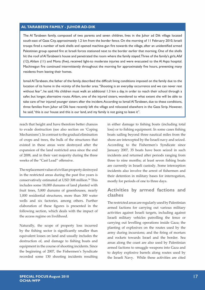
The Al Tarabeen family, composed of two parents and seven children, lives in the Juhor ad Dik village located
south-east of Gaza City, approximately 1.2 km from the border fence. On the morning of 11 February 2010, Israeli
troops fired a number of tank shells and opened machine-gun fire towards the village, after an unidentified armed
Palestinian group opened fire at Israeli forces stationed next to the border earlier that morning. One of the shells
hit the roof of Al Tarabeen’s house and penetrated the room where the family stayed. Three of the family’s girls, Afaf
(12), Ahlam (11) and Mona (five), received light-to moderate injuries and were evacuated to the Al Aqsa hospital.
Machinegun fire continued intermittently throughout the morning for approximately five hours, preventing many
residents from leaving their homes.
Ismail Al Tarabeen, the father of the family, described the difficult living conditions imposed on the family due to the
location of its home in the vicinity of the border area. “Shooting is an everyday occurrence and we can never rest
without fear”, he said. His children must walk an additional 1.3 km a day, in order to reach their school through a
safer, but longer, alternative route. Ahlam, one of the injured sisters, wondered to what extent she will be able to
take care of her injured younger sisters after the incident. According to Ismail Al Tarabeen, due to these conditions,
three families from Juhor ad Dik have recently left the village and relocated elsewhere in the Gaza Strip. However,
he said, “this is our house and this is our land, and my family is not going to leave it”.
AL TARABEEN FAMILY - JUHOR AD-DIK
18 SPECIAL FOCUS August 2010OCHA-WFP
by the Israeli authorities as the justification for the practices detailed above, they create additional risks to civilian life and property, as a result of attacks launched by the Israeli army against militants, some of which evolve into prolonged armed clashes in the vicinity of residential, agricultural or fishing areas.
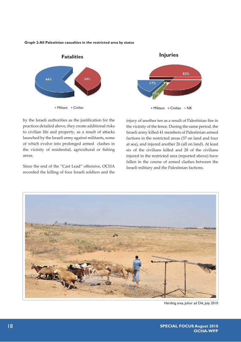
Since the end of the “Cast Lead” offensive, OCHA recorded the killing of four Israeli soldiers and the
Injuries
17%
82%
1%
Militant Civilian NK
66% 34%
Fatalities
66% 34%
Militant Civilian
Graph 2: All Palestinian casualties in the restricted area by status
injury of another ten as a result of Palestinian fire in the vicinity of the fence. During the same period, the Israeli army killed 41 members of Palestinian armed factions in the restricted areas (37 on land and four at sea), and injured another 26 (all on land). At least six of the civilians killed and 28 of the civilians injured in the restricted area (reported above) have fallen in the course of armed clashes between the Israeli military and the Palestinian factions.
Herding area, Juhor ad Dik, July 2010
19SPECIAL FOCUS August 2010OCHA-WFP
The Israeli military-enforced regime of access restrictions has had a negative effect on the livelihoods of the affected population. Increased rates of poverty and food insecurity, as well as the adoption of negative coping mechanisms (see following section), are some of the ways in which the deterioration to livelihood is reflected. This section attempts to assess the economic impact of this regime by estimating the value of property destroyed in the restricted areas over the course of the past five years, along with the value of potential income from agricultural and fishing activities lost annually due to the destruction of productive assets or the loss of access to them.
Loss of assetsFor the purpose of this assessment, assets located in restricted areas on land can be divided into four types according to their use: agricultural, industrial, residential and services.
The number of structures destroyed since 2005 in each of these categories is calculated by aggregating figures collected in interviews and focus groups across the affected localities.37 By contrast, due to limitations in data collection techniques used in this study, the amount of destroyed orchards, greenhouses and field crops was estimated by extrapolating PCBS data from 2004-5 on the use of agricultural land at the governorate level, to the affected localities.38 Additionally, it was assumed that in the ‘no-go zone’, 100 percent of agricultural land was leveled, while a conservative assumption of 70 percent destruction of the areas cultivated with fruit trees or greenhouses-crops was applied to the ‘high-risk zone’.39
Considering that the large majority of the restricted area on land is agricultural and comprises some 35 percent of Gaza’s cultivable land, it is not surprising that agriculture-related assets, including fruit trees, greenhouses, chicken and sheep farms and water wells account for 90 percent of all asset losses. The total value of this property was estimated at USD 275 million (unless otherwise stated all economic value figures hereafter are in USD). Within this category, the most valuable type of asset is fruit bearing trees, including olive, almond, citrus and grapes. These trees, which take years to grow and maintain before yielding a profitable income, account for more than 213 million, or 77 percent of all agricultural losses, followed by greenhouses (47 million), water wells (9 million), sheep farms (4.5 million) and chicken
Table 2: Number of structures destroyed since 2005 (by type) and replacement value (in thousands of USD)
TypeNumber of
unitsReplacement
Value
Water wells 305 9,150
Chicken farms 197 1,970
Sheep farms 377 4,524
Houses totally destroyed 996 17,330
Houses partially destroyed 371 2,226
Mosques 3 57
Schools (destroyed or
severely damaged) 3 300
Factories 6 12,000
Total 2,259 47,557
III. IMPACT ON LIVELIHOODS
Table 3: Cultivated areas leveled (in dunums) and their replacement value (in thousands of USD) by crop and zone
Crop/ZoneNo-go zone* High Risk zone Total
Area Value Area Value Area Value
Olive 4,015 42,353 3,336 35,199 7,351 77,552
Almond 353 3,724 237 2,500 590 6,224
Citrus 3,475 49,001 3,551 50,066 7,026 99,067
Other fruit trees 1,148 9,699 854 7,215 2,002 16,914
Grapes 780 6,587 781 6,598 1,561 13,185
Greenhouses 2,968 23,740 2,916 23,330 5,884 47,070
Total 12,738 135,104 11,675 124,908 24,413 260,012
* since 2005

20 SPECIAL FOCUS August 2010OCHA-WFP
0 500 1,000250 Meters
Green L
ine(19
49 Arm
istice
)
Pre 20
08 'N
o-Go Z
one'
Bound
ary
(300
meters)
Curren
t 'High
Risk
Zone'
Bound
ary
(100
0-150
0 mete
rs)
United Nations Office for the Coordination of Humanitarian Affairs
Agricultural Land, Beit Hanoun 2003

21SPECIAL FOCUS August 2010OCHA-WFP
0 500 1,000250 Meters
Green L
ine(19
49 Arm
istice
)
Pre 20
08 'N
o-Go Z
one'
Bound
ary
(300
meters)
Curren
t 'High
Risk
Zone'
Bound
ary
(100
0-150
0 mete
rs)
United Nations Office for the Coordination of Humanitarian Affairs
Agricultural Land, Beit Hanoun 2008

22 SPECIAL FOCUS August 2010OCHA-WFP
farms (2 million).40 The other three types of land use account for the remaining 10 percent of total losses, including houses totally or partially destroyed (19.6 million), factories (12 million), and schools and mosques (0.4 million).
Overall the total value of assets lost as a result of their leveling and destruction by the Israeli army in restricted areas on land is estimated at USD 308 million. Approximately a third of this value pertains to property in the ‘no-go zone’ maintained until late 2008 (i.e. up to 300 meters from the fence), most of which was destroyed in 2006 and 2007, while the rest relates to property located in the areas expanded since then.
The above figures are conservative estimates. For example, while in the ‘no-go zone’, land levelling operations have been taking place since the year 2000, due to methodological difficulties only losses incurred since 2005 were considered. Other unaccounted loss stems from the sharp depreciation in the value of agricultural land. Available estimates indicate that current land prices in the ‘high- risk zone’ are one third of what they were five years ago. In addition to the obvious reasons related to the access regime enforced by the Israeli army, farmers
also link this decline in value to the degradation of Gaza’s soil quality as a result of the frequent leveling operations; during these operations, the most fertile upper soil layers are usually buried beneath originally deeper soil layers, with poor soil structure and little organic matter content.
Compared to areas on land, losses due to the implementation of the access regime at sea are relatively limited. As noted in the previous section, since 2007 more than 130 shooting incidents resulted in damage to boats and fishing equipment (including a few vessels that were entirely burned). Estimate of these losses however was unavailable. Additionally, according to the Fishermen’s Syndicate, a total of 83 boats docked at wharfs along the coast were damaged during the “Cast Lead” offensive, together with fishing lightening equipment, and whose combined estimated value is USD 342,000.
Loss of agricultural yield and related incomeThe destruction of agricultural assets in restricted areas on land necessarily results in the loss of potential agricultural output and corresponding
Faraheen area, east of Khan Younis, on the periphery of the high risk zone, July 2010

23SPECIAL FOCUS August 2010OCHA-WFP
Fayyadh Al-Sumeiri, 47, heads a farming household
of 10 people in the Al Qarara area of Khan Yunis. He
owns a plot of land of 12 dunums located 150 meters
from the fence, which in the past was planted with
almonds, olives and cactus. In 2003 the area was
leveled by the Israeli military and has since remained
inaccessible due to warning fire opened from a near-
by watch tower at any person attempting to reach
the area. A second plot of six dunums, located 1.5km
west of the fence, was cultivated with olive trees
and leveled in late 2008. This plot has subsequently
been replanted with wheat, which was consumed
by the family, or bartered with two day laborers. To
help offset financial losses, the family rented a 3-dunum plot of land in the area of Suq Mazen, which it planted with
zucchini. Both areas were bulldozed during the Israeli ‘Cast Lead’ offensive. An irrigation network he installed in the
rented plot with the assistance of the European Union was also totally destroyed. The loss of income pushed the
family into a state of dire poverty and 14,000 NIS in debt.
“Everyday I pass by shops and see people that I owe money to, and I lower my head. I don’t know what to do because I have no income. Everything we earned was from the land, and every meter we planted was destroyed… Every day I pray that I will be able to return to my land and bring it back to the state it was in.”
Table 4: Potential annual agricultural yield and income lost by type of crop
Average yield (kg/dunum)
Affected area (dunums) Potential total yield (tons)
Market value (thousands dollars)No-go High risk
Olive* 700 4,015 3,336 5,146 8,233
Almond 150 353 237 89 466
Citrus 2,500 3,475 3,551 17,565 13,876
Other fruit trees 1,000 1,148 854 2,002 2,372
Grapes 1,000 780 781 1,560 2,060
Greenhouses 8,000 2,968 2,916 47,071 22,594
Wheat 300 1,829 1,447 983 383
Barley 200 1,887 1,398 657 256
Total 16,455 14,520 75,073 50,240
* Market value reflects olive oil prices and is estimated based on the potential oil yield for each tonne of olive produced.
FAYYADH AL-SUMEIRI – FARMER
income. Using the same methodology outlined above, it is estimated that some 75,000 metric tons of potential produce are lost per year due to the levelling of land and access restrictions.41 The potential market value of this produce is estimated at approximately USD 50.2 million a year. Some 54 percent of this value stems from fruit orchards (27 million), 45 percent (22.6 million) from greenhouses
and less than two percent from field crops (0.7 million).
Most of the interviewed farmers indicated that following the expansion of the restricted area in 2008, their income from agriculture was reduced to less than a third of what it was previously, while others report even larger losses.
Fayyadh Al-Sumeiri, July 2010

24 SPECIAL FOCUS August 2010OCHA-WFP
YASSER ABU JARAD – FISHERMAN
Yasser Abu Jarad, 50, is the main provider for
a family of nine. He owns one large boat and
several smaller boats, which he uses to fish off
the Khan Yunis coast. “The Israeli Navy has shot at my boats many times and damaged three of them for approaching areas within the vicinity of the three nautical mile zone”, he said. Abu Jarad now refrains
from fishing throughout the year, limiting his
outings to twice a month during sardine season,
from April to November. “It’s not worth the risk”, he notes. In turn his catch has dropped from 400-
500kg an outing, to less than 100kg, causing his
monthly income to decline by some 70 percent. He
has been partially able to offset losses by buying cheaper, smuggled Egyptian diesel fuel available on the Gaza market.
Nonetheless, the lost earnings have plunged his family USD 4,200 into debt - money the family borrowed to cover
its expenses, including rent. The family now purchases its supplies on credit from the local grocer. The family also
receives assistance in kind through UNRWA, without which, Abu Jarad believes, they would not have survived the
negative repercussions of the increased access restrictions to fishing areas.
Similar to capital losses, estimates of output and income losses are conservative. For example, due to lack of sufficient information, the value attributed to each kilogram of produce grown in a greenhouse was calculated as an average of the three most common crops grown (tomato, cucumber and squash), thus excluding much more profitable crops produced mainly for export (cut flowers and strawberries) that were possibly grown in the restricted areas.42
An alternative rough estimate confirms the conservative nature of the above estimates; according to PCBS data for the 2007/8 season, the total value of agricultural produce in the Gaza Strip stood at USD 333.6 million.43 Assuming an even distribution of this value across the restricted and non-restricted areas, as well as a 70 percent loss in the restricted area, the aggregated income loss would stand at USD 81.7 million a year.
Loss of fishing output and related incomeThe reduction of maritime areas accessible to Palestinian fishermen since late 2008 to three nautical miles from the coast has resulted in a
significant reduction in the volume of fishing catch. The 2009 fishing catch amounted to a total of 1,525 metric tonnes, only 53 percent of the amount during 2008 (2,845 metric tonnes) and 41 percent of the amount in 1999 (3,650 metric tonnes), before access restrictions at sea began to be imposed. Current figures indicate that during 2010 the decline in fishing catch continues.
According to the Fishermen’s Syndicate, some 60 percent of small-motor boats and 22 percent of the large trawler boats throughout the Gaza Strip sit idle due to the high level of risk involved in each fishing excursion, as well as the decreasing income fishing provides.
In addition to the reduction in volume, restrictions prevent fishermen from accessing areas where more lucrative fish, such as grouper and red mullet, are found. While sardine continues to be the main type of fish within the total catch (about two thirds), the share of cheap ‘baby sardines’ increased.
However, due to high fluctuations in prices, available figures indicate that decline in the volume
Yasser Abu Jarad in Mawasi area, Khan Yunis, July 2010.

25SPECIAL FOCUS August 2010OCHA-WFP
of the fishing catch was only partially reflected in the overall income of the fishing sector. According to information collected by FAO, this income reached 7.1 million dollars in 2009 – close to ten percent below the equivalent income in 2008 (7.8 million), and 35 percent below the 1999 figure (11 million). Overall, using the 1999 fish catch figure as a baseline (3,650 metric tonnes), the potential fishing output lost over a five year period as a result
The findings below suggest that individual attempts to generate alternative income have cumulatively triggered significant transformations in the agricultural and fishing sectors of the Gazan economy, as well as in the traditional roles and division of labour within the family. The full scope and impact of these transformations, however, are yet to be fully assessed.
Income generation strategiesStrategies aimed at generating alternative income are varied and include diversification of crops, engagement in new types of economic activity, and selling of assets, among others.
IV. COPING MECHANISMS
Fukhkhari area, east of Khan Yunis, July 2010
of the access regime can be estimated at some 7,041 metric tonnes and the potential income lost at some USD 26.5 million.
Beyond losses in potential yield and income, the inability to access deeper sea areas has resulted in the overfishing of shallow coastal waters and the depletion of breeding grounds, threatening the future sustainability of fishing breeds.44
The erosion of livelihoods has obliged affected families to develop a variety of coping mechanisms, some of which attempt to generate alternative income, and others which reduce expenditure. While part of these measures are directly related to the access regime implemented by the Israeli army, others, particularly those targeting expenditures, cannot be isolated from the larger impact of the ongoing blockade. While the assistance provided by humanitarian organizations had been mentioned in interviews as an additional resource used to cope with the situation, often this has not been sufficient to make a substantial difference in the lives of the affected population.

26 SPECIAL FOCUS August 2010OCHA-WFP
Farmers affected by the destruction or loss of access to fruit orchards or greenhouses, have shifted to the cultivation of open-air crops, mostly wheat and barley. These crops are rain-fed and less affected by access restrictions and risks, as they require little care during the growing season. Additionally, because they do not grow higher than 80 cm, their chances of surviving recurrent levelling operations are perceived as higher when compared with fruit bearing trees. These crops however are far less lucrative than orchards and greenhouses, with many farmers reporting being able to only partially harvest these crops due to the access restrictions. Even if farmers succeed in harvesting most of this produce, the income generated from these crops is insignificant compared to the original crops. Some farmers reported that due to the low value of these crops, they are not worth marketing and are therefore are used exclusively for domestic consumption.
Some farmers reported the renting of land in other, safer areas of the Gaza Strip, particularly in former settlement areas, where land resources became accessible for cultivation after the 2005 Israeli ‘disengagement’. Others note the gradual increase of households engaging in limited animal rearing projects, usually within house compounds (such as poultry breeding on rooftops and backyards), including the marketing of related products like chicken, eggs, and pigeons.
In the fishing sector, one of the main coping mechanisms reported by participants in interviews and focus groups is the use of smaller nets in an attempt to improve fishing yield by catching smaller fish like baby sardine. However, these fish only partially compensate for the loss of larger, more lucrative fish, now inaccessible. In addition, this coping mechanism has a long term detrimental impact, as it results in over-fishing in shallow coastal waters, depleting stocks and compromising the
future viability of the fishing industry.45 As a result, many of the now-unemployed fishermen have been exploring various alternative income generation strategies.
One strategy has been to sail into Egyptian waters to purchase fish from Egyptian fishermen, which is subsequently sold in Gaza Strip markets. The trips to the sites where these transactions are conducted are long and dangerous, lasting between six and ten hours in each direction, and expose fishermen to the risk of coming under fire or being arrested by Israeli or Egyptian naval forces. Other fishermen opt to import Egyptian fish for marketing through tunnels running under the Gaza-Egypt border. According to the Fishermen’s Syndicate, a monthly average of 105 tonnes of fish has been entering Gaza through the tunnels since the beginning of 2010. An additional emergent activity reported is the establishment of fish farms. To date, 18 such farms are registered throughout Gaza, compared to only one in 2005.
Many have opted to entirely abandon their agricultural and fishing livelihoods and seek employment or income opportunities in other areas. As mentioned above, one such income generating activity is the collection of rubble and scrap metal, left after the evacuation of settlements during the “Disengagement” and later, the “Cast Lead” offensive. Some rubble collection sites are located
A demolished home in the Fukhkhari area, east of Khan Yunis, very close to the ‘no go’ area, July 2010

27SPECIAL FOCUS August 2010OCHA-WFP
in the restricted areas, such as the former settlement area in northern Gaza (Dugit, Nissanit and Elei Sinai settlements), the former industrial area next to the Erez crossing, and the former Gaza Airport south of Rafah, bringing consequent risks to this activity. The demand for building supplies to rehabilitate and reconstruct damaged and destroyed buildings, combined with ongoing restrictions on the import of construction materials as part of the blockade, has led to the rise of a lucrative but dangerous market based on recovering and recycling building material. Most commonly, chunks of concrete rubble are unearthed and ground down, and then remixed to make poor grade bricks.
Many others have turned to the “tunnel industry”, which also burgeoned in the wake of the imposition of the Gaza blockade. While precise information is unavailable, various sources suggest that there are thousands of people employed in the construction and maintenance of tunnels, and the transfer of goods through them.46 Even more than rubble collection, employment in tunnel activity poses high safety risks. Since the “Cast Lead” offensive, at least 86 people have died in tunnel accidents, mainly following the collapse of tunnels and electrocution, and airstrikes, and another 144 people have been injured.
Additional income generation strategies reported during this study entail significant changes in the traditional roles and division of labour within the family. An increasing number of women have sought employment outside the household. One focus group mentioned that more men have been seeking employed women as second wives, as customary familial arrangements generally allow for the appropriation of spousal income by husbands. Four focus groups noted that parents increasingly reduce child school enrolment to facilitate faster entry into the workforce, either as additional labour within family-owned activities (hence reducing costs on paid labour), or as wage labourers. These groups further suggested that girls may be dropping out at higher rates than boys.
Finally, participants in interviews and focus groups also report the gradual liquidation or renting of personal and productive assets in order to generate income - from selling off women’s jewellery and gold, to selling or renting land, equipment, greenhouses, and livestock.
Cost and consumption reduction strategiesOverall, the ability of farmers and fishermen to reduce the cost of production appears to be very limited. Nonetheless, wherever relevant, poorer quality inputs (usually brought in through the tunnels) are used to replace higher quality inputs; organic, lower yield fertilizers, such as sheep dung, are substituting more expensive chemical fertilizers. The reduction in the quality of inputs is necessarily reflected in the productivity of the land and/or the quality of the produce.
Additional coping mechanisms adopted by affected families aim at reducing expenditures and household living standards. While the consequences of some of these mechanisms might be limited (e.g. refraining from buying new clothes or paying utility bills), others raise serious concerns about their potential health and social impact. A clear case raised in three focus groups relates to changes in food consumption patterns of affected families. Changes reported included both an overall reduction in the quantity of food consumed, as well as a gradual shift from high-cost and protein-rich food items such as vegetables and animal products, to low-cost and high-carbohydrate foods such as cereals and sugar.47 Higher incidence of health problems, including anaemia among children, diabetes and blood pressure, mentioned by some of the focus groups, may be linked to that deterioration in nutrition. Other worrying practices mentioned as means to reduce expenditures include the abovementioned tendency to reduce the schooling period of children, including refraining from sending youth to university, and the inclination of parents to marry off daughters earlier.
28 SPECIAL FOCUS August 2010OCHA-WFP
Humanitarian assistanceMost participants reported that since the expansion of the restricted areas in 2008 they have received some kind of humanitarian assistance delivered by UN agencies, international and local NGOs or the Palestinian authorities in Ramallah and Gaza. The main types of assistance are food parcels, agricultural inputs, and cash assistance to families that had their homes destroyed or damaged during the “Cast Lead” offensive.
While some participants maintained that aid packages represented a safety net for households whose livelihoods collapsed, others argued that the impact of such assistance has been only marginal, and has not reached some of the most affected households. An additional argument made by many participants is that some of the agricultural aid packages which included fruit and vegetable seedlings, material for greenhouses and irrigation channels, were of little or no help, given the Israeli military’s continued land levelling practices.
V. IMPACT ON ACCESS TO EDUCATION
Restrictions on the access of humanitarian workers to beneficiaries and affected areas undermine the efficient delivery of humanitarian assistance. Many international organizations, including UN agencies, inform the Israeli military of expected movement of their staff into areas located less than 1 km from the fence, and from time to time, the Israeli military recommends that organizations postpone their missions due to “security concerns”. In particular, to access areas less than 500 meters from the fence, many international organizations ‘coordinate’ their entry with the military in advance, with postponements and delays occurring frequently, on the advice of the military, when safety of staff cannot be ensured. These restrictions impede the conduct of needs assessment, the delivery of aid packages and the monitoring and evaluation of programs. Additionally, many organizations are reluctant to invest donor resources in areas where levelling and destruction operations are recurrent, and where they assess that the risk of loss is very high.
This study has identified seven educational institutions throughout the Gaza Strip, which have facilities located within 1,500 meters from the fence. These institutions provide educational services to a student population of approximately 4,400 females and males, ranging from elementary school to vocational training. About 250 additional people are employed as teachers and administrative/ maintenance staff in these facilities. One additional school that existed in the restricted area was entirely destroyed over the course of Israel’s “Cast Lead” offensive.48
The safety of students and staff attending these institutions, the quality of education provided and the level of educational achievement have been seriously undermined by their frequent exposure to Israeli fire at people present in the restricted areas, farmers or armed militants. School facilities have incurred significant damage, consuming available funds with recurrent repair needs.
Students and staff interviewed report that interruptions to classes due to the outbreak of armed clashes between the Israeli army and Palestinian militants have become a frequent phenomenon. Based on their risk assessments during these times, administrators decide to gather people present in the school in the safest area available, or to evacuate them entirely from school premises. Local Ministry of Education officials often inform school guards to leave the school premises by nightfall for their safety.
Conditions created by the access regime compound the impact of other constraints affecting the functioning of all schools in the Gaza Strip, primarily the shortage of classrooms. This problem has been exacerbated since the imposition of the blockade in 2007, due to restrictions on the entry of construction material, which prevents construction, rehabilitation or expansion of schools.49 Most schools in the Gaza Strip are currently run on a double-
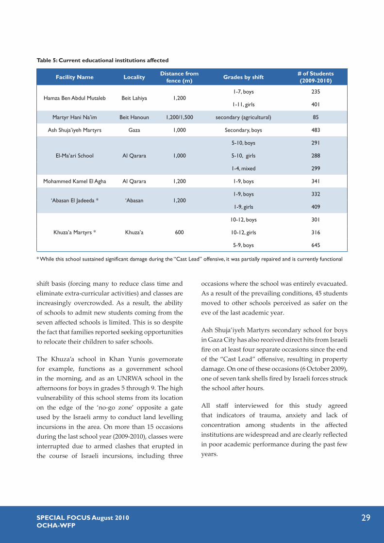
29SPECIAL FOCUS August 2010OCHA-WFP
Table 5: Current educational institutions affected
Facility Name Locality Distance from fence (m) Grades by shift # of Students
(2009-2010)
Hamza Ben Abdul Mutaleb Beit Lahiya 1,2001-7, boys 235
1-11, girls 401
Martyr Hani Na’im Beit Hanoun 1,200/1,500 secondary (agricultural) 85
Ash Shuja’iyeh Martyrs Gaza 1,000 Secondary, boys 483
El-Ma’ari School Al Qarara 1,000
5-10, boys 291
5-10, girls 288
1-4, mixed 299
Mohammed Kamel El Agha Al Qarara 1,200 1-9, boys 341
‘Abasan El Jadeeda * ‘Abasan 1,2001-9, boys 332
1-9, girls 409
Khuza’a Martyrs * Khuza’a 600
10-12, boys 301
10-12, girls 316
5-9, boys 645
* While this school sustained significant damage during the “Cast Lead” offensive, it was partially repaired and is currently functional
shift basis (forcing many to reduce class time and eliminate extra-curricular activities) and classes are increasingly overcrowded. As a result, the ability of schools to admit new students coming from the seven affected schools is limited. This is so despite the fact that families reported seeking opportunities to relocate their children to safer schools.
The Khuza’a school in Khan Yunis governorate for example, functions as a government school in the morning, and as an UNRWA school in the afternoons for boys in grades 5 through 9. The high vulnerability of this school stems from its location on the edge of the ‘no-go zone’ opposite a gate used by the Israeli army to conduct land levelling incursions in the area. On more than 15 occasions during the last school year (2009-2010), classes were interrupted due to armed clashes that erupted in the course of Israeli incursions, including three
occasions where the school was entirely evacuated. As a result of the prevailing conditions, 45 students moved to other schools perceived as safer on the eve of the last academic year.
Ash Shuja’iyeh Martyrs secondary school for boys in Gaza City has also received direct hits from Israeli fire on at least four separate occasions since the end of the “Cast Lead” offensive, resulting in property damage. On one of these occasions (6 October 2009), one of seven tank shells fired by Israeli forces struck the school after hours.
All staff interviewed for this study agreed that indicators of trauma, anxiety and lack of concentration among students in the affected institutions are widespread and are clearly reflected in poor academic performance during the past few years.

30 SPECIAL FOCUS August 2010OCHA-WFP
PSYCHOSOCIAL EFFECT
While an assessment of the social and psychological ramifications of the access regime implemented by the
Israeli military in the Gaza Strip was beyond the original objective of this study, most interview and focus group
participants took the opportunity to express some perceptions and concerns in this regard. Even though participants
recognized that the well-being of their families and communities has been undermined by multiple sources of
tension and trauma in past years, most pointed to the expansion of restricted areas since late 2008 as a significant
factor behind that deterioration.
A consistent message to emerge was that frequent exposure to life threatening situations, along with the systematic
destruction of livelihoods, severely eroded people’s basic sense of physical and economic security. This erosion is
perceived as a key cause behind the recurrence of an array of negative symptoms observed in their families and
communities. Part of the 24 focus groups elaborated on these symptoms and their impact among different gender
and age groups, in spite of the sensitivity of the subject. For example:
five groups reported an increase in depression among adults;
eleven groups reported an increase in bedwetting among children;
eight groups reported a decline in the school performance of children;
eight groups reported an increase in domestic violence, which is perceived as symptomatic to the frustration of men who lost their role as breadwinners.
Some groups also expressed concern for the gradual weakening of social networks. This phenomenon is perceived
as particularly affecting families whose relatives and friends are more reluctant to visit them due to the dangerous
conditions prevailing in the areas where they live, as well as families forced to relocate to new areas following the
demolition of their homes. As the social interaction of families with the broader community declines, community
support-structures subsequently weaken.
Additionally, it is reasonable to assume that the negative symptoms reported above were, to some extent,
triggered or influenced by some of the mechanisms adopted by the affected families to cope with the erosion of
their livelihoods. This includes changes in nutrition habits, the employment of women outside the household, the
dropping out of children from school, and the early marriage of girls, among others.
While the information collected in this study points to the existence of significant hardship, more targeted
research is required to further substantiate the above-mentioned phenomena, establish their scope, and plan
adequate responses.

31SPECIAL FOCUS August 2010OCHA-WFP
The access regime implemented in the restricted areas has significantly impeded the maintenance, repair and upgrade of existing wastewater and electricity infrastructure. In contrast to other aspects of this regime, which affect specific sectors of Gaza’s population, the restrictions on access to these facilities negatively impact the provision of services to the entire population of the Gaza Strip and compound environmental concerns.
Waste Water Treatment PlantsDue to health and planning concerns, wastewater treatment facilities are typically located in less populated areas. Indeed, three key projects funded by international donors, aimed at increasing current treatment capacity and reducing risks to communities in the vicinity of existing treatment facilities, are located within the restricted areas.
The North Gaza Emergency Sewage Treatment Plant, funded by the World Bank, is the largest of these projects. It is located east of Jabalia and in reaches up to 200 meters from the fence. Once complete, the plant will be able to treat the sewage of more than 500,000 people - a third of the Gaza Strip’s overall population - and filter the treated effluent back into the aquifer. While implementation of the project’s first phase, aimed at draining the effluent lake at Beit Lahiya and alleviating threats of flooding, began in
early 2005, it could only be completed by mid-2009, primarily due to access restrictions. It is estimated that these restrictions have delayed completion of the first phase by some two years, including ten months (June 2007- March 2008) during which work came to a complete halt. In March 2007, five people were killed and 25 others injured when one of the embankments of the Beit Lahiya wastewater lake was breached and flooded the Umm An -Naser village. Currently, access of staff to the site requires prior approval by the Israeli army and works are allowed only during daylight times, among other restrictions.
The site of the planned wastewater treatment plant for the Khan Yunis area, which is funded by the Japanese development agency,50 reaches as close as 400 meters from the fence. After prolonged delays, including demands to relocate the site, the Israeli authorities recently gave approval to the project ‘in principle’. Yet, additional negotiations are required to obtain approval for the import of the required materials as well as access of workers to the site.
Building of a new wastewater treatment plant for Gaza City has also been frozen for the past three years in part due to the same reason. The project, funded by the German Development Bank (KFW), was aimed at replacing the existent plant (located in the Ash Sheikh ‘Ijleen district of Gaza City). While the latter is equipped to treat 32 million litres of
VI. IMPACT ON UTILITY INFRASTRUCTURE
Sewage outlet, Rafah beach. April 2009
Phot
o by
JCTo
rdai
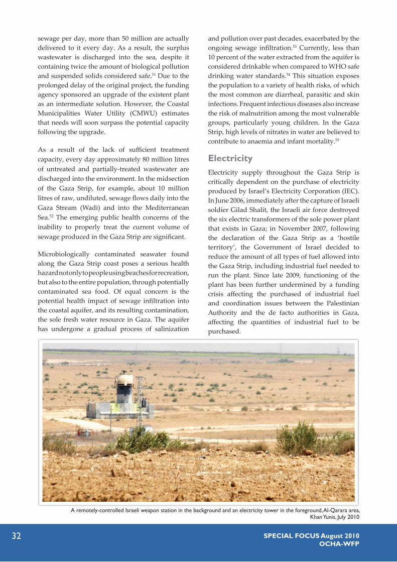
32 SPECIAL FOCUS August 2010OCHA-WFP
sewage per day, more than 50 million are actually delivered to it every day. As a result, the surplus wastewater is discharged into the sea, despite it containing twice the amount of biological pollution and suspended solids considered safe.51 Due to the prolonged delay of the original project, the funding agency sponsored an upgrade of the existent plant as an intermediate solution. However, the Coastal Municipalities Water Utility (CMWU) estimates that needs will soon surpass the potential capacity following the upgrade.
As a result of the lack of sufficient treatment capacity, every day approximately 80 million litres of untreated and partially-treated wastewater are discharged into the environment. In the midsection of the Gaza Strip, for example, about 10 million litres of raw, undiluted, sewage flows daily into the Gaza Stream (Wadi) and into the Mediterranean Sea.52 The emerging public health concerns of the inability to properly treat the current volume of sewage produced in the Gaza Strip are significant.
Microbiologically contaminated seawater found along the Gaza Strip coast poses a serious health hazard not only to people using beaches for recreation, but also to the entire population, through potentially contaminated sea food. Of equal concern is the potential health impact of sewage infiltration into the coastal aquifer, and its resulting contamination, the sole fresh water resource in Gaza. The aquifer has undergone a gradual process of salinization
and pollution over past decades, exacerbated by the ongoing sewage infiltration.53 Currently, less than 10 percent of the water extracted from the aquifer is considered drinkable when compared to WHO safe drinking water standards.54 This situation exposes the population to a variety of health risks, of which the most common are diarrheal, parasitic and skin infections. Frequent infectious diseases also increase the risk of malnutrition among the most vulnerable groups, particularly young children. In the Gaza Strip, high levels of nitrates in water are believed to contribute to anaemia and infant mortality.55
ElectricityElectricity supply throughout the Gaza Strip is critically dependent on the purchase of electricity produced by Israel’s Electricity Corporation (IEC). In June 2006, immediately after the capture of Israeli soldier Gilad Shalit, the Israeli air force destroyed the six electric transformers of the sole power plant that exists in Gaza; in November 2007, following the declaration of the Gaza Strip as a ‘hostile territory’, the Government of Israel decided to reduce the amount of all types of fuel allowed into the Gaza Strip, including industrial fuel needed to run the plant. Since late 2009, functioning of the plant has been further undermined by a funding crisis affecting the purchased of industrial fuel and coordination issues between the Palestinian Authority and the de facto authorities in Gaza, affecting the quantities of industrial fuel to be purchased.
A remotely-controlled Israeli weapon station in the background and an electricity tower in the foreground, Al-Qarara area, Khan Yunis, July 2010

33SPECIAL FOCUS August 2010OCHA-WFP
As a result of the decline in the condition of the Gaza power plant, over two thirds of the current electricity supply (120MW) originates from Israel. It is delivered through ten electricity feeder lines, with many of the electricity towers located at 10-20 meters of distance from the fence. These lines are maintained by the Gaza Electricity Distribution Company (GEDCO) and the IEC on either side of the fence. Access of GEDCO’s staff to this infrastructure for regular maintenance and repairs requires prior coordination with the Israeli army. A typical coordination request takes between six
to ten hours to be processed, before a response is given. GEDCO also records multiple cases in which requests were delayed for several days. For example, in August 2009, a request to access the tower with the electricity line feeding Khan Yunis was delayed for ten days.
Overall, access restrictions to infrastructure delivering electricity from Israel into the Gaza Strip have compounded an already precarious situation caused by the steady decline in the electricity produced by the Gaza power plant.
The findings of this study indicate that the access regime implemented by the Israeli military on land areas along the Green Line and on sea areas along Gaza’s coast severely compromise the physical security and livelihoods of nearly 180,000 people. This regime has exacerbated the assault on human dignity triggered by the blockade imposed by Israel in June 2007.
Since late 2008, the Israeli army has expanded access-restricted areas to cover approximately 17 percent of the Gaza Strip’s territory and 85 percent of its maritime area (as defined in the Oslo Agreement). The lethal methods used to enforce this regime –triggered and compounded by the military activities carried out by Palestinian armed factions – have resulted in a severe ‘protection crisis’, characterized by a systematic lack of respect for the most basic rights afforded to civilian populations under international law.
The losses inflicted by the access regime and its associated enforcement methods are enormous. They have severely penalized the agricultural sector, one of the most important sectors in Gaza’s economy, and contributed to the further impoverishment of tens of thousands of people, who have become increasingly dependant on humanitarian assistance. This study also demonstrates that the high levels of insecurity and erosion of livelihood have had serious implications on food security and psychosocial well-being, while undermining the ability of people to rely on social networks, thus undermining their resilience. It is likely that that the situation has made women, children, and the elderly within affected communities especially vulnerable.
THE WAY FORWARDTo start addressing the dire situation of one of the most vulnerable segments of Gaza’s population, the current restrictions on civilian access to Gaza’s land and sea must be urgently lifted to the fullest extent possible. All parties must abide by their obligations under international humanitarian and human rights law. In particular, the Israeli army must immediately stop the opening of ‘warning fire’ at civilians, as well the levelling of agricultural land and the destruction of civilian property. Palestinian armed factions must also stop the firing of rockets and mortars at civilians within Israel; cease smuggling weapons by sea and land; and avoid placing military objectives within, or in the vicinity of, civilian built-up areas.56
Furthermore, while the recent limited easing of restrictions on imports implemented by Israel is a welcome step, to restore rights of the entire population, including those affected by access restrictions, a sustained reopening of the crossing points on the basis of the 2005 Agreement on Movement and Access between the Palestinian Authority and Israel and in accordance with the provisions of UNSCR 1860 is urgently required. This is crucial as land currently inaccessible has major potential for fruit and vegetable production for export markets, and hence constitutes an important foreign revenue earner for the Gazan population.
The findings of this study also indicate that larger and better targeted humanitarian assistance is required to mitigate the impact of the ongoing erosion of livelihood and to prevent further deterioration.
34 SPECIAL FOCUS August 2010OCHA-WFP
UNSCR 1860 calls for, among other things, a durable 1. ceasefire, unimpeded provision throughout Gaza of humanitarian assistance and condemns all violence and hostilities directed against civilians and all acts of terrorism,Agreement on the Gaza Strip and Jericho, Cairo, 4 May 2. 1994.Ibid., Annex I, Protocol Concerning Withdrawal of 3. Israeli Military Forces and Security Arrangements, Article 4 (2).Ibid., Article 11 (1). This fishing area excludes two 4. narrow strips in the north and south, along the maritime borders with Israel and Egypt, respectively.The data collected during the study, which could serve 5. as a comprehensive baseline for future monitoring of the impact of the restricted areas, are available upon request for further study/analysis. A focus group is a structured discussion among 6. approximately 15-20 people who have opinions on a given topic. A focus group is facilitated by one person who contributes questions for exploring the topic, probing issues, and clarification, but does not otherwise voice an opinion in the discussion.Meeting between OCHA and COGAT, 3 May, 2010.7. On 19 June 2008, a six-month ceasefire (“tahdiyeh” or 8. “calm”) agreement negotiated by Egypt took effect between Hamas and the Government of Israel, entailing a suspension of hostilities from both sides and an Israeli commitment to gradually relax access restrictions on goods and people. People accessing, or moving within residential areas in 9. the restricted areas, such as parts of Khuza’a village in Khan Younis area, or Umm An-Naser in Northern Gaza, have established somewhat of a routine and are usually not targeted. Similarly, rules governing access to the Karni (Al Muntar) crossing are relatively well defined and implemented.An exception within this policy involves staff of 10. international organizations and public utilities, who may be allowed entry following coordination with the Israeli army. See also sections below on “Coping mechanisms” and “Infrastructure utilities”.The choice of these two crops is related to the 11. understanding that crops growing higher than wheat and barley (i.e. over 80 cm) are automatically levelled by the Israeli military, as they obstruct sight. On this issue see section on “Coping mechanisms”. One dunum equals 1,000 square meters.12. This estimate is based on the calculation of the areas 13. that have not been cultivated in the past ten years. These areas cover approximately 2,900 dunums, including the area of the former Israeli settlements located in the northern section (1,500 dunums), the roads (1,000 dunums), the part of the former Gaza airport within the restricted area in the south (400 dunums) and the Beit Lahiya wastewater treatment lake (100 dunums).
ENDNOTESThe total size of arable land in the Gaza Strip (as 14. opposed to actually cultivated land) is unavailable. It was assumed that the 2004-5 figure used here includes most currently restricted areas, which at the time were cultivated. See Gaza-Jericho Map No. 6 - Maritime Activity Zones. 15. According to some of the fishermen interviewed, access to sea areas between 1 and 3 NM from shore is sometimes also prevented; however, due to the lower frequency of such incidents, this area was not considered part of the calculation of estimates regarding restricted areas for this study. This includes houses located in areas between 1,000-16. 1,100 or 1,500-1,600 meters from the fence, as well as built up areas located less than 1,000 meters from the fence, which for the purpose of this study were not considered part of the restricted areas.On the basis of the information provided by participants 17. in the interviews and focus groups in the 14 localities targeted in this study, an estimate for the percentage of each locality’s population meeting one of the above criteria was produced. Estimates are based on PCBS 2007 population figures for these localities and the annual population growth rate since.PCBS, “On the Eve of International Population Day”, 11 18. July 2009. Estimate is based upon assuming an average family size of 6.5 persons per family.This section was developed exclusively by OCHA.19. Customary law is binding to all states, organized armed 20. groups and individuals, regardless of the ratification of any specific treaty. In 2005, ICRC published a study that set out the rules of IHL, which, in its view, had attained customary law status. See, J.M. Henckaerts and L. Doswald-Beck, Customary International Humanitarian Law, Volume I: Rules, ICRC, Cambridge University Press, 2005 (hereafter: ICRC Study on Customary IHL). ICRC Study on Customary IHL, Rules 1 and 15.21. Ibid., Rules 7, 8 and 16.22. Ibid., Rules 22 and 23.23. International Covenant on Civil and Political Rights, 24. Article 6.Ibid., Article 12.25. International Covenant on Economic, Social and 26. Cultural Rights, Article 6.Ibid., Article 11.27. ICJ, Legal Consequences of the Construction of a Wall in 28. the Occupied Palestinian Territory, Advisory Opinion of 9 July 2004, para. 141.See also section below on “Coping mechanisms”.29. “Israel Wants Robotic Guns, Missiles To Guard Gaza 30. Border”, Barbara Opall-Rome, DefenseNews.com 1 June 2007“IDF’s newest heroes: Women spotters on Gaza border”, 31. Anshel Pfeffer, Haaretz, 3 March 2010.“Lethal Joysticks”, Anshel Pfeffer, Haaretz, 2 July 201032.

35SPECIAL FOCUS August 2010OCHA-WFP
“Automated Border”, Arieh Egozi, Ynetnews.com 6 33. October 2007Op cite Pfeffer, 2 July 201034. http://www.btselem.org/english/firearms/flechette.asp35. Estimate based on information from interviews and 36. focus groups, complemented by the extrapolation of agricultural data produced by PCBS/MoA.The value of the destroyed structures are then estimated 37. based upon the replacement cost of each unit, with estimates taken on the lower range of pricing indices. PCBS, Cultivated Area of Fruit Trees, Vegetables and 38. Field Crops in the Palestinian Territory by Governorate, 2004/2005. This was done under the assumption that the land-use patterns in each of the affected localities mirrors the patterns reported by PCBS at the governorate level. For example, if according to PCBS data, ten percent of the agricultural land in the Northern Governorates was cultivated with olives, it was assumed that ten percent of the restricted area for the locality of Beit Hanoun was used in the same manner.Subsequently, losses are calculated based upon the 39. market value of an equivalent dunum of land planted with the relevant crop, as estimated on the basis of data provided by the MoA. For the purpose of this study, annual field crops (mainly wheat and barley) were not considered as an asset, and therefore not included in the present calculations but only in the next section, which addresses loss of output and income.Estimates for greenhouses and animal farms include 40. only the value of the structure and not their content or income generation potential. PCBS data for the 2007/8 season on the average yield per 41. dunum of each type of crop in the Gaza Strip was used to estimate the potential output lost. The market value of the potential output was calculated on the basis of 2010 MoA data on the average market price of each type of crop. This calculation takes into account that some areas that had previously been cultivated with fruit orchards and leveled were subsequently re-cultivated with wheat and barley. In regard to the latter, it was assumed that “only” 50 percent of cultivated areas were levelled in the high risk zone. Due to the same reason, the potential output and income 42. lost by the livestock sector, as well as by field crops other than wheat and barley, could not be assessed. PCBS, Value Added of Agriculture Sector in the 43. Palestinian Territory by Governorate, 2007/2008.FAO/WFP, Food Security and Vulnerability Analysis 44. Report in the oPt, December 2009.FAO/WFP, December 2009 – Food Security and 45. Vulnerability Analysis Report in the oPt. Interviews with several tunnels traders carried in 46. September 2009 confirmed several media reports suggesting that tunnels employ between 20,000-25,000 workers, who could earn anywhere between NIS 100-
200 for 10 hours of work. See, Al-Sahel, The Impact of Closure and High Food Prices on Performance of Imported Staple Foods and Vegetable and Fruits Markets in the oPt, January 2010. This seems to confirm similar findings reported by WFP/47. FAO/PCBS, in the Socio Economic and Food Security Survey Report in Gaza Strip, November 2009. The Agricultural College in Beit Hanoun affiliated to 48. al-Azhar University in Gaza. According to university officials, the damage estimate stands at approximately USD 4.3 million. The college’s students have since been relocated to the main Al Azhar University campus in Gaza City. To properly accommodate the growing student 49. population, UNRWA requires 100 additional schools within the next five academic years, of which 15 are needed immediately. In addition, the Gaza Ministry of Education estimates that it needs 10-14 new schools to address the needs of the student population in the coming year.Partners include the United Nations Development 50. Project, the Coastal Municipalities Water Utility, the Palestine Water Authority and the municipality of Khan Yunis.Gaza wastewater treatment works was designed to 51. produce an effluent quality of 30 mg/L BOD (Biological Oxygen Demand-Measure) and 30 mg/L of suspended solids. As a result of the increased quantities of sewage effluent, quality is up to 100 mg/L BOD and 100 mg/L suspended solids. To address this problem and to partially compensate 52. for the failure to build the new plant for Gaza City, the ICRC is currently engaged in constructing a temporary emergency waste water treatment plant south of Gaza City.The growing water needs of the population have led to 53. an increasing over-use of the aquifer, with the quantity of water extracted exceeding natural replenishment. As a result, the aquifer has undergone a gradual process of salinization, caused by the emergence of brackish water from deeper strata and the intrusion of sea water. See, The World Bank, Assessment of Restrictions on Palestinian Water Sector Development, April 2009. The gap in the availability of drinkable water has been 54. met by emerging small private desalination plants selling desalinated water. This “solution” has triggered serious health concerns, due to a lack of regulation and control over the quality of the water produced by these plants. FAO/WFP, Food Security and Vulnerability Analysis 55. Report in the oPt, December 2009.These recommendations are based on the analysis 56. developed by OCHA in Section II of this report.

36 SPECIAL FOCUS August 2010OCHA-WFP
UNITED NATIONSOffice for the Coordination of Humanitarian Affairsoccupied Palestinian territory
P. O. Box 38712 East Jerusalem 91386 www.ochaopt.org
Tel. +972 (0)2 582 9962 Fax +972 (0)2 582 [email protected]
P. O. Box 51359Al-Nouman St. East Jerusalem www.wfp.org
Tel. +972 (0)2 540 340/1/2 Fax +972 (0)2 540 1227