Embed Size (px)
Citation preview

Decadal Survey for Earth Science and Applications from Space 31 December 2015
NEW NEED TO UNDERSTAND CHANGING COASTAL AND INLAND AQUATIC ECOSYSTEM SERVICES
Coastal and inland aquatic ecosystems support biodiversity, buffer human and animal habitats against storms and floods, and play a key role in the cycling of carbon, minerals and nutrients. Coastal wetlands support fisheries that provide food, livelihood, and recreation to roughly half of the global population (Barbier et al 2011). Inland waters provide critical freshwater resources for human consumption, irrigation, sanitation, industry, recreation, and play a vital role in human health and safety. With a growing global population of over seven billion people, and a warming atmosphere driven by carbon dioxide now in excess of 400 ppm, it has become clear that these services are at risk globally. We know little, however, about how these ecosystems function in response to such unprecedented external pressures, partly because we cannot adequately observe or monitor even the highest-level attributes such as extent, phenology, standing biomass, material exchanges, and rate of change. Timely and accurate, spatially resolved environmental information is necessary to support effective aquatic resource policy and management and assure water quality for human health and welfare.
KEY SCIENCE QUESTIONS
It is critical that we characterize coastal and inland ecosystem benefits and understand and monitor their change. The following general science questions provide guidance towards that goal:
Q1. What are the distribution, abundance, function, and state of biodiversity for coastal and inland aquatic ecosystems on regional and global scales? At what rate are theses quantities changing and what factors are driving their change?
Q2. What are the biogeochemical fluxes across the boundaries between land, water, and air; how are they changing? How are these rates related to climate?
Q3. How are these changes interconnected and what are the consequences to important ecological resources, e.g., fish stocks and water quality and availability?
The first, and most fundamental, question seeks to establish a baseline and measure change. Characterizing these ecosystems and how they are changing under increased anthropogenic and environmental stresses will lead to recommendations for sustainable practices. However, to address this on synoptic and global scales requires satellite remote sensing imagery.
The second question evaluates material storage and flux in coastal and inland aquatic ecosystem. Coastal and inland waters and associated aquatic habitats, including wetlands, mangroves, submerged grasses, and coral reefs, are amongst the most productive ecosystems on the planet
Glossy ibises in a pristine salt marsh on the Atlantic coast of Maryland, USA. Salt marshes are amongst the most diverse ecosystems on the planet, providing valuable services at the land and sea interface.

Changing Coastal and Inland Aquatic Ecosystems
2
(Day et al., 2012; Cebrian, 2002). Coastal and inland aquatic ecosystems store and are affected by material fluxes (e.g., freshwater, nutrients, minerals, pollutants, and carbon). Collectively, these ecosystems store 44.6 Tg C yr-1, including vegetation stocks and soils rich in organic matter held by seagrass, mangrove, and marsh ecosystems (Chmura et al., 2003). Despite their important role in the global carbon cycle, there are large uncertainties in these quantities and their change rates because wetlands have not been adequately inventoried or monitored globally.
The third question explores how changes in coastal and inland aquatic ecosystems affect services critical to human health, safety, and prosperity. Both the second and third questions depend on the development of improved modeling of coastal and inland aquatic processes. These models must rely information derived from satellite remote sensing acquired to address the first question. Modeling efforts will require collaboration of researchers across multiple disciplines, such as aquatic and terrestrial ecologists, hydrologists, soil and agricultural scientists, geographers, and remote sensing scientists. The third question in particular would guide research towards informing environmental resource managers, policy makers, and stakeholders.
AN URGENT NEED FOR ANSWERS
Dramatic changes in these aquatic systems call for immediate assessment and monitoring. Within the USA, development since colonization has led to a 50% decline in the areal extent of emergent wetlands (EPA 843-F-01-002d, 2001). Sub-merged aquatic vegetation is highly sensitive to environmental changes and a vital component of coastal ecosystems (Orth et al., 2006). 29% of the known areal extent of seagrass meadows has vanished globally only since 1879 and the rate of loss has risen from 0.7% yr-1 before 1940 to a staggering 9% yr-1 after 1990 (Waycott et al., 2009). Globally, wetland habitats have declined 64–71% and the rate of degradation continues to increase due to climate change, sea level rise, and human encroachment (Davidson, 2014). Coral reefs, the most biologically diverse ecosystems worldwide (Hoegh-Guldberg et al., 2007), provide important services to tropical and sub-tropical coastal nations. But, many reef systems are in decline due to direct human impacts and changing ocean conditions linked to climate change, e.g., mechanical erosion by storms, elevated water temperature, and acidification (Hughes et al., 2003). Lakes and inland seas worldwide are experiencing rapid and variable rates of warming (O’Reilly et al., 2015), affecting water quality and availability. Many species of phytoplankton that are detrimental to humans and aquatic systems alike are forming Harmful Algal Blooms (HAB). HAB events are being introduced through human activities or being driven by climatic change (Anderson et al., 2002). Invasive fauna and flora are becoming more prevalent and have been reported for at least 84% of the world’s 232 marine ecoregions (Molnar et al., 2008). Climate change can influence rates and patterns of invasion (Guareschi et al., 2013) and complex intereactions between climate change and invasive species at differing trophic levels can have profound influence on ecosystem function (Rahel and Olden, 2008).
Bleached branching coral (foreground) and normal branching coral (background). Keppel Islands, Great Barrier Reef. CC-A3 License.

Changing Coastal and Inland Aquatic Ecosystems
3
Global distribution of coastal and inland aquatic ecosystems. Red indicates regions where water depth is less than 50 m and where land elevation is less than 50 m. Light to dark violent gives the concentration of inland wetlands, lakes, rivers and other aquatic systems. Increased darkness means greater percentage of areal coverage for inland aquatic ecosystems (UNEP-WCMC, 2005).
REMOTE SENSING NECESSITY AND TECHNOLOGICAL CHALLENGES
Because of the scale and rapidity of changes being observed in coastal and inland aquatic ecosystems, the key science questions need to be addressed at national and global scales. Actionable resolutions will require immediate commitment to decades of focused research. Because aquatic ecosystems are by nature difficult to access directly on large scales, remote sensing is a vital tool for their assessment and monitoring. However, global remote sensing of aquatic ecosystems poses important technical challenges.
Spectral Resolution – An important technical challenge for aquatic remote sensing is acquiring adequate spectral information. Because water strongly absorbs light at red or longer wavelengths, retrieval of in-water optical constituent concentration or benthic cover information is limited to the visible part of the spectrum. Regions where water and land meet are optically complex and host a diverse range of spectral end members. Spectral information at 10 nm or better resolution in the visible can be used to differentiate between constituents in the water (Ortiz et al., 2013). Near infrared (NIR) or shortwave infrared (SWIR) measurements are used to 1) separate atmospherically reflected light from light reflected from beneath the water’s surface (Ahmad et al., 2010); 2) to observe the condition of emergent vegetation (Adam et al., 2010; Heumann, 2011); or 3) to mark the presence of floating biota (Hu et al., 2015). Observations in the ultraviolet (UV) have potential to address complex atmospheric conditions near land and to better quantify in-water concentrations of organic compounds. Observations of water surface temperature, an important environmental parameter, require two or more bands in the thermal infrared (TIR). Passive microwave sensors can be used to measure soil moisture in watersheds and coastal salinity, while active remote sensing (SAR, LIDAR) can provide further information for emergent wetland structure.
Spatial and Temporal Resolution – Because the components and processes in these ecosystems vary on spatial scales of centimeters to tens of kilometers and time scales of hours to years, a

Changing Coastal and Inland Aquatic Ecosystems
4
significant technological challenge is to develop observational capabilities that span these broad spatial and temporal scales. Habitats require ground spatial distance (GSD) of 30 m spatial resolution or better, but only need to be sampled at weekly to monthly rates to observe seasonal phenology (Turpie et al., 2015). Similar spatial and temporal resolutions are needed to observe the majority of inland water bodies (Hestir et al., 2015). Observing variation in larger water bodies and coastal shelf waters, including changes in phytoplankton growth or composition or water surface temperature, requires 50 to 1000 m resolution (with increasing distance from shore), but needs hourly to daily sampling (Mouw et al., 2015).
Radiometric Performance – Observations of aquatic targets with low reflectance required high radiometric performance. Sun glint avoidance is crucial to make radiometric measurements of aquatic habitats. Collecting key data across aquatic and terrestrial habitats also requires a large radiometric range and resolution, with high signal-to-noise ratio (SNR) for dark targets, typically between 100 to 1000 (Devred et al., 2014). Experience with previous sensors show that a 13 to 14-bit sensor would provide the needed radiometric resolution.
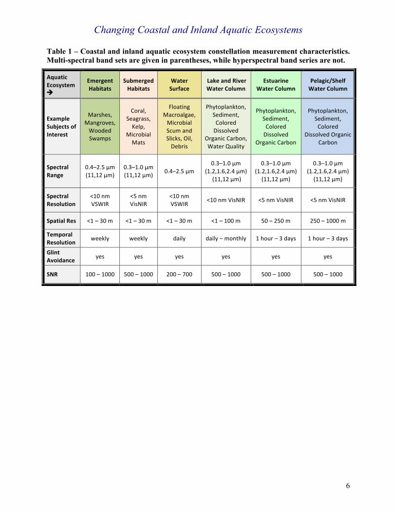
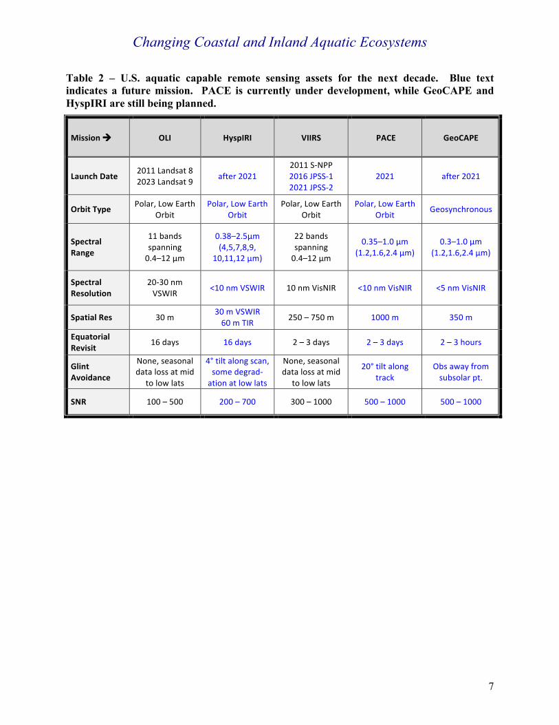
Table 1 provides an overview of requirements by aquatic ecosystem type and Table 2 gives a synopsis of passive U.S. Earth sensors for the coming decade. These sensors collectively do not meet all the spectral, spatial, temporal, and radiometric requirements and some will miss nearly a decade of change by launch, if they launch at all. Development of remote sensing resources has tended to favor purely terrestrial or oceanic disciplines, marginalizing support of coastal and inland aquatic ecosystem research. Coastal and inland aquatic ecosystems are not simply boundary ecosystems for either land or sea; they are a vital nexus, where interaction and interdependency are greatest, leading to the most productive and diverse systems on the planet and vital resources for humans. Thus, addressing coastal and inland aquatic ecosystem science questions will require strongly interdisciplinary research supported by a diverse array of remote sensing assets developed for the study of the land/sea interface.
Coastal and inland aquatic ecosystems are not simply boundary ecosystems for either land or sea; they are a vital nexus, where interaction and interdependency are greatest…

Changing Coastal and Inland Aquatic Ecosystems
5
RECOMMENDATION FOR SPACE-BASED AND FIELD OBSERVATIONS Our nation requires an observation-based approach for coastal and inland aquatic ecosystems where space-borne sensing systems are supported by coordinated in situ calibration and product validation activities. To meet the challenges outlined above, a range of instrumentation on multiple platforms will be necessary. Advancing and building on existing and planned missions, and applying innovative approaches such as a CubeSat constellation, can provide the needed observations from space. NASA is well positioned to take on these important challenges. What is required is a national will and determination to make coastal and inland aquatic ecosystems a top priority, commensurate with the risks faced in these vulnerable regions that are important for both environmental and societal reasons.
Long-term, interdisciplinary field investigations must also verify and validate satellite retrievals and glean additional information from remote signals that are not currently understood. Foundational field studies should focus on regions of high economic and social significance in the USA. Thus, we recommend seven candidate regions in the USA for nationally focused interdisciplinary research, spanning at least a decade:
1. Chesapeake Bay and Delaware Bay watersheds, and neighboring coastal bays. 2. San Francisco Bay region, including Sacramento-San Joaquin River Delta marshes. 3. Mississippi River Delta and nearby marshes and mangroves along the Gulf of Mexico. 4. Great Lakes, with a focus on Lake Erie. 5. Florida Bay, Florida Keys and Everglades, including benthic and emergent ecosystems. 6. Monterey Bay, including kelp forests, Elkhorn Slough and marsh systems. 7. Hawaiian Islands, including coral reefs.
Focus regions outside of the USA would likewise be of great importance, e.g., sites identified by the Ramsar Convention, but would require international collaboration and support.
Summary: A constellation of Earth observing technologies, coordinated with sustained, focused in situ studies, and interdisciplinary model development, are required to constitute a system that collects key timely data at regional, national, and global scales and addresses immediate, critical threats to coastal and inland aquatic ecosystem services.
Changing Coastal and Inland Aquatic Ecosystems
6
Table 1 – Coastal and inland aquatic ecosystem constellation measurement characteristics. Multi-spectral band sets are given in parentheses, while hyperspectral band series are not.
AquaticEcosystem!
EmergentHabitats
SubmergedHabitats
WaterSurface
LakeandRiverWaterColumn
EstuarineWaterColumn
Pelagic/ShelfWaterColumn
ExampleSubjectsofInterest
Marshes,Mangroves,WoodedSwamps
Coral,Seagrass,Kelp,
MicrobialMats
FloatingMacroalgae,MicrobialScumandSlicks,Oil,Debris
Phytoplankton,Sediment,ColoredDissolved
OrganicCarbon,WaterQuality
Phytoplankton,Sediment,ColoredDissolved
OrganicCarbon
Phytoplankton,Sediment,Colored
DissolvedOrganicCarbon
SpectralRange
0.4–2.5μm(11,12μm)
0.3–1.0μm(11,12μm) 0.4–2.5μm
0.3–1.0μm(1.2,1.6,2.4μm)(11,12μm)
0.3–1.0μm(1.2,1.6,2.4μm)
(11,12μm)
0.3–1.0μm(1.2,1.6,2.4μm)
(11,12μm)
SpectralResolution
<10nmVSWIR
<5nmVisNIR
<10nmVSWIR
<10nmVisNIR <5nmVisNIR <5nmVisNIR
SpatialRes <1–30m <1–30m <1–30m <1–100m 50–250m 250–1000m
TemporalResolution
weekly weekly daily daily–monthly 1hour–3days 1hour–3days
GlintAvoidance yes yes yes yes yes yes
SNR 100–1000 500–1000 200–700 500–1000 500–1000 500–1000
Changing Coastal and Inland Aquatic Ecosystems
7
Table 2 – U.S. aquatic capable remote sensing assets for the next decade. Blue text indicates a future mission. PACE is currently under development, while GeoCAPE and HyspIRI are still being planned.
Mission! OLI HyspIRI VIIRS PACE GeoCAPE
LaunchDate2011Landsat82023Landsat9 after2021
2011S-NPP2016JPSS-12021JPSS-2
2021 after2021
OrbitType Polar,LowEarthOrbit
Polar,LowEarthOrbit
Polar,LowEarthOrbit
Polar,LowEarthOrbit
Geosynchronous
SpectralRange
11bandsspanning0.4–12μm
0.38–2.5μm(4,5,7,8,9,
10,11,12μm)
22bandsspanning0.4–12μm
0.35–1.0μm(1.2,1.6,2.4μm)
0.3–1.0μm(1.2,1.6,2.4μm)
SpectralResolution
20-30nmVSWIR <10nmVSWIR 10nmVisNIR <10nmVisNIR <5nmVisNIR
SpatialRes 30m30mVSWIR60mTIR 250–750m 1000m 350m
EquatorialRevisit
16days 16days 2–3days 2–3days 2–3hours
GlintAvoidance
None,seasonaldatalossatmid
tolowlats
4°tiltalongscan,somedegrad-ationatlowlats
None,seasonaldatalossatmid
tolowlats
20°tiltalongtrack
Obsawayfromsubsolarpt.
SNR 100–500 200–700 300–1000 500–1000 500–1000

Changing Coastal and Inland Aquatic Ecosystems
8
REFERENCES
Adam, E., Mutanga, O. and Rugege, D. (2010). Multispectral and hyperspectral remote sensing for identification and mapping of wetland vegetation: a review. Wetlands Ecology and Management, 18, 281-296.
Ahmad, Z., B.A. Franz, C.R. McClain, E.J. Kwiatkowska, J. Werdell, E.P. Shettle, and B.N. Holben (2010). New aerosol models for the retrieval of aerosol optical thickness and normalized water-leaving radiances from the SeaWiFS and MODIS sensors over coastal regions and Open Oceans. Applied Optics, 49(29).
Anderson, D.M., P.M. Glibert, J.M. Burkholder (2002). Harmful algal blooms and eutrophication: nutrient sources, composition, and consequences. Estuaries. 25(4), pp 704-726.
Barbier, E.B., S.D. Hacker, C. Kennedy, E. W. Koch, A.C. Stier & B.R. Silliman (2011). The value of estuarine and coastal ecosystem services. Ecological Monographs, 81(2), 169-193.
Cebrian, J. (2002). Variability and control of carbon consumption, export, and accumulation in marine communities, Limnology and Oceanography, 47(1), pp 11-12.
Chmura, G. L., S. C. Anisfeld, D. R. Cahoon, and J. C. Lynch (2003). Global carbon sequestration in tidal, saline wetland soils. Global Biogeochem. Cyc., 17(4), ISBN 978-0-471-75567-8
Davidson (2014), http://www.publish.csiro.au/paper/MF14173.htm Day, J.W., C. Hall, W.M. Kemp, and A. Yanez-Arancibia (2012). Estuarine Ecology, 2nd
Edition. John Wiley and Sons, Inc., Hoboken, New Jersery. Devred, E., K.R. Turpie, W. Moses, V.V., Klemas, T. Moisan, M. Babin, M.-H. Forget, G. Toro-
Farmer, Y.-H. Jo (2013). Future retrievals of water column bio-optical properties using the Hyperspectral Infrared Imager (HyspIRI), Remote Sensing, 5, 6812-6837. doi:10.3390/rs5126812.
EPA 843-F-01-002d (2001). http://water.epa.gov/type/wetlands/outreach/upload/threats_pr.pdf Fourqurean, J.W., C.M. Duarte, H. Kennedy N. Marbà, M. Holmer, M.A. Mateo, E.T.
Apostolaki, G.A. Kendrick, D. Krause-Jensen, K.J. McGlathery (2012). Seagrass ecosystems as a globally significant carbon stock. Nat Geosci 5, pp 505–509
Guareschi, S., C. Coccia, D. Sánchez-Fernández, J.A. Carbonell, J.Velasco, L. Boyero, A.J. Green, A. Millán (2013). How far could the alien boatman Trichocorixa verticalis verticalis spread? Worldwide estimation of its current and future potential distribution, PLOS One, 8(3) : e59757. doi:10.1371/journal.pone.0059757.
Hestir, E.L., V.E. Brando, M. Bresciani, C. Giardino, E. Matta, P. Villa, A.G. Dekker (2015). Measuring freshwater aquatic ecosystems: The need for a hyperspectral global mapping satellite mission. Remote Sensing of Environment, 167, pp 181-195.
Heumann, B.W. (2011). Satellite remote sensing of mangrove forests: Recent advances and future opportunities. Progress in Physical Geography, 35, 87-108.
Hoegh-Guldberg, O., P. J. Mumby, A. J. Hooten, et al. (2007). Coral Reefs Under Rapid Climate Change and Ocean Acidification. Science, (318), pp 1737-1742.
Hu, C., L. Feng, R.F. Hardy, E.J. Hochberg (2015). Spectral and spatial requirements of remote sensing measurements of pelagic Sargassum macroalgae. Remote Sensing of Environment, 167, pp 229-246.
Hughes, T. P., A. H. Baird, D. R. Bellwood, M. Card, S. R. Connolly, C. Folke, R. Grosberg, O. Hoegh-Guldberg, J. B. C. Jackson, J. Kleypas, J. M. Lough, P. Marshall, M. Nyström, S. R.

Changing Coastal and Inland Aquatic Ecosystems
9
Palumbi, J. M. Pandolfi, B. Rosen, and J. Roughgarden (2003). Climate Change, Human Impacts, and the Resilience of Coral Reefs. Science, 301, pp 929-933. doi: 10.1126/science.1085046.
Molnar et al. (2008). Assessing the global threat of invasive species to marine biodiversity. Frontiers in Ecology and the Environment. 6(9), pp 485-492.
Mouw, C.B., S. Greb, D. Aurin, P.M. DiGiacomo, Z-P. Lee, M. Twardowski, C. Binding, C. Hu, R. Ma, T. Moore, W. Moses, S.E. Craig (2015). Aquatic color radiometry remote sensing of coastal and inland waters: Challenges and recommendations for future satellite missions, Remote Sensing of Environment. 160, pp 15-30. http://dx.doi.org/10.1016/j.rse.2015.02.001
NOAA Press Release, October 2015, http://www.noaanews.noaa.gov/stories2015/100815-noaa-declares-third-ever-global-coral-bleaching-event.html.
O’Reilly, C.M., et al. (2015). Rapid and highly variable warming of lake surface waters around the globe. Geophysical Research Letters, 42, doi:10.1002/2015GL066235.
Orth, R. J., T. J. B. Carruthers, W. C. Dennison, C. M. Duarte, J. W. Fourqurean, K. L. Heck Jr., A. R. Hughes, G. A. Kendrick, W. J. Kenworthy, S. Olyarnik, F. T. Short, M. Waycott, and S. L. Williams (2006). A global crisis for seagrass ecosystems. Bioscience, 56(12), pp 987-996.
Ortiz, J.D., D.L. Witter, K.A. Alia, N. Fela, M. Duff and L. Mills (2013). Evaluating multiple colour-producing agents in Case II waters from Lake Erie. International Journal of Remote Sensing, 34(24), pp 8854-8880. doi: 10.1080/01431161.2013.853892.
Pendleton, L., D.C. Donato, B.C. Murray, S. Crooks, W.A. Jenkins, S. Sifleet, C. Craft, J.W. Fourqurean, J.B. Kauffman, N. Marbà, et al. (2012). Estimating global “blue carbon” emissions from conversion and degradation of vegetated coastal ecosystems. PloS One (7).
Rahel, F.J. and J.D. Olden (2008). Assessing the Effects of Climate Change on Aquatic Invasive Species. Conservation Biology, Volume 22, No. 3, 521–533 doi: 10.1111/j.1523-1739.2008.00950.x.
Turpie, K.R., V.V. Klemas, M. Kelly, Y.-H. Jo, K. Byrd, (2015). Prospective HyspIRI global observations of tidal wetlands (HyspIRI), Remote Sensing of Environment, 167, pp 206-217.
UNEP-WCMC: Millennium Ecosystem Assessment (2005). Coastal vector digital data. Washington DC, USA, Island Press.
UNEP-WCMC: Millennium Ecosystem Assessment (2005). Inland water raster digital data. Washington DC, USA, Island Press.
United Nations, Department of Economic and Social Affairs, Population Division. 2015. World Population Prospects: The 2015 Revision, Key Findings and Advance Tables. Working Paper No. ESA/P/WP.241.
Waycott, M., C.M. Duarte, T.J.B. Carruthers, R.J. Orth, W.C. Dennison, S. Olyarnik, A. Calladine, J.W. Fourqurean, K.L. Heck, Jr., A.R. Hughes, G.A. Kendrick, W.J. Kenworthy, F.T. Short and S.L. Williams (2009). Accelerating loss of seagrasses across the globe threatens coastal ecosystems. PNAS, 106(30), pp 12377-12381.
Zimmerman, R., V. Hill, and C. Gallegos. 2015. Predicting effects of ocean warming, acidification and water quality on Chesapeake region eelgrass. Limnol. Oceanogr. 60, pp 1781-1804.

Changing Coastal and Inland Aquatic Ecosystems
10
AUTHORS
David W. Allen, National Institute of Standards and Technology, [email protected] Steven Ackelson, Naval Research Laboratory, [email protected] Thomas Bell, University of California, Santa Barbara, [email protected] Heidi Dierssen, University of Connecticut, [email protected] Kyle Cavanaugh, University of California, Los Angeles, [email protected] Joshua B. Fisher, NASA Jet Propulsion Laboratory, [email protected] James Goodman, HySpeed Computing LLC, [email protected] Liane Guild, NASA Ames Research Center, [email protected] Eric Hochberg, Bermuda Institute for Ocean Science, [email protected] Victor V. Klemas, University of Delaware, [email protected] Samantha Lavender, Pixalytics, Ltd., [email protected] Christine Lee, NASA Jet Propulsion Laboratory, [email protected] Frank Muller-Karger, University of South Florida, [email protected] Joseph Ortiz, Kent State University, [email protected] Sherry Palacios, Bay Area Environmental Research Institute, [email protected] David R. Thompson, NASA Jet Propulsion Laboratory, [email protected] Kevin Turpie*, University of Maryland, Baltimore County, [email protected] Richard Zimmerman, Old Dominion University, [email protected]
* - Lead author.
REVIEWERS AND ENDORSERS
Ricky Becker, University of Toledo, [email protected] Tom Bridgeman, University of Toledo, [email protected] George Bullerjahn, Bowling Green State University, [email protected] Kristin Byrd, U.S. Geological Survey, [email protected] Petya Campbell, University of Maryland, Baltimore County, [email protected] Justin Chaffin, Ohio Sea Grant, Ohio State University, [email protected] Ernesto Diaz, NASA Jet Propulsion Laboratory, [email protected] Bryan Franz, NASA Goddard Space Flight Center, [email protected] Bo-Cai Gao, Navy Research Laboratory, [email protected] David Humm, Johns Hopkins Applied Physics Laboratory, [email protected] John Lekke, Glenn Research Center, [email protected] George Leshkevich, NOAA Great Lakes Env Res Lab, [email protected] Larry Liou, Glenn Research Center, [email protected] Hongxing Liu, University of Cincinnati, [email protected] Dan Mandl, NASA Goddard Space Flight Center, [email protected] Cecile Rousseaux, University Space Research Association, [email protected] Steve Ruberg, NOAA Great Lakes Env Res Lab, [email protected] Crystal Schaaf, University of Massachusetts, [email protected] Nicholas Scott, Riverside Research Institute, [email protected]

Changing Coastal and Inland Aquatic Ecosystems
11
Robert Shuchman, Michigan Tech Research Institute, [email protected] Amin Tayyebi, University of California-Riverside, [email protected] Hideyuki Tonooka, Ibaraki University, [email protected] Jianwei Wei, University of Massachusetts, [email protected] P. Jeremy Werdell, NASA Goddard Space Flight Center, [email protected] Jack Xiong, NASA Goddard Space Flight Center, [email protected] Lei Yan, Peking University, [email protected] Qian Yu, University of Massachusetts, Amherst, [email protected]