Embed Size (px)
Citation preview

1
Note on the objections to the Nagarjuna power plant in Udupi District
Plant site and location The proposed 1,000 MW Nagarjuna thermal power plant will use coal as fuel. The Nagarjuna site is 5 km away from a site where KTPC, NTPC and Cogentrix had in turn proposed to build coal-based power plants of capacities ranging from 1,000 MW to 2,420 MW. None of these proposed plants have fructified. The Nagarjuna plant site is located in Yellur village, Udupi district, close to the Mulki River off Padubidri town, and about 7-8 km from the coast. The site is within 35 km aerial distance from the Kudremukh National Park, and is in the midst of a mixed forest and cultivated area. North and south of the Kudremukh NP are a series of sanctuaries—Someshwara, Mookambika, etc.
The plant site and surroundings
Environmental attributes that make the area unsuitable for industry Certain environmental attributes make the area a poor site for locating polluting industries. 1. Low wind strengths: The wind regime of the area is dominated by low wind speeds and high
wind calms. This makes dispersion of air pollution poor.
Plant site windrose and area wind strengths indicate low wind speeds, hence high air pollution concentrations

2
Locating a power plant (which is primarily an air polluting industry) in such an area implies that there would be high ground level concentrations of air pollution, which would lead to higher incidence of respiratory ailment in humans, and crop yield losses up to 50%.
Air pollution-related health risk estimates
Range of reduction Crop
Minimum (%)
Maximum (%)
Sensitivity range
Triticum aestivum (Wheat) 30 50 S
Hordeum vulgare (Barley) 25 40 S Cicer arietinum (Gram) 10 15 R Brassica campestris (Mustard)
10 15 R
Pisum sativum (Pea) 40 50 S Zea mays (Maize) 20 30 I Phaseolus mungo (Urd) 30 50 S Oryza sativa (Rice) 30 40 S Cajanus cajan (Arhar) 20 30 I Sorghum vulgare (jowar) 15 20 R
Sesamum indicum (Til) 10 15 R
Yield reductions in different crop plants growing in the Obra, Dala and Renukoot [S: Sensitive (>30%); I: Intermediate (15-30%); R: Resistant (< 15%)] (Agrawal, 2003)
Thermal power Plant District Capacity
(MW)
Total district crop loss (kilo tons)
Estimated mean wheat yield reduction in 10 km range (%)
Singrauli Sonbadhra (UP) 2050 52.5 59 Koradi Nagpur (Mah) 1080 57.7 36 Dadri Ghaziabad (UP) 630 334.8 19 Bhusawal Jalgaon (Mah) 420 66.0 16 Sikka Jamnagar (Guj) 440 46.0 13
Summary of estimated yield losses due to Sulphur dioxide within 10 km of thermal power plants in India (Ashmore and Marshall, 1997)
Location Crop Effect Indian Punjaba Potato Visible leaf injury Valley of Mexicob Bean 40% yield loss in sensitive cultivar Nile Deltac Radish 30% yield loss Turnip 17% yield loss Pakistan Punjabd Wheat 40% yield loss Rice 40% yield loss Pakistan Punjabe Soybean 57% yield loss
Examples of studies showing effects of ozone on tropical crops (arural; Bambawale, 1986, b rural; Laguette-Rey, 1986, c rural; Hassan et al.1995, d peri-urban; Wahid et al, 1995a and 1995b, e rural; Wahid et al, 2000)
3
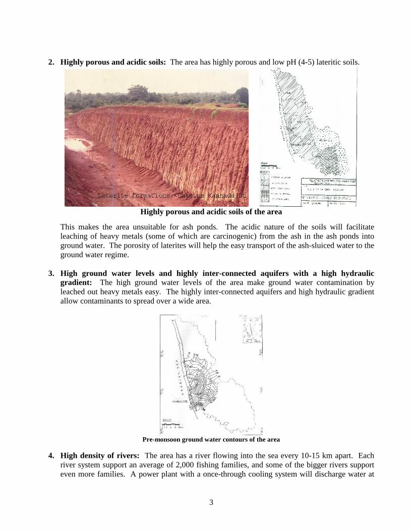
2. Highly porous and acidic soils: The area has highly porous and low pH (4-5) lateritic soils.
Highly porous and acidic soils of the area
This makes the area unsuitable for ash ponds. The acidic nature of the soils will facilitate leaching of heavy metals (some of which are carcinogenic) from the ash in the ash ponds into ground water. The porosity of laterites will help the easy transport of the ash-sluiced water to the ground water regime.
3. High ground water levels and highly inter-connected aquifers with a high hydraulic
gradient: The high ground water levels of the area make ground water contamination by leached out heavy metals easy. The highly inter-connected aquifers and high hydraulic gradient allow contaminants to spread over a wide area.
Pre-monsoon ground water contours of the area
4. High density of rivers: The area has a river flowing into the sea every 10-15 km apart. Each
river system support an average of 2,000 fishing families, and some of the bigger rivers support even more families. A power plant with a once-through cooling system will discharge water at

4
10oC above ambient. Thermal shock modeling indicates that a 1,000 MW plant will require a river length of 15 km for the heated water discharged into a river to come down to within 5oC of the ambient temperature, a river length not available in this part of the west coast. Such raised temperatures will alter the aquatic ecology of the river and severely affect estuarine fishing, a major source of livelihood in the area.
High river density of the area and hot water plumes in rivers due to discharges from once-
through cooling water discharge from power plants
5. Soils with poor buffering capacity for acid gases: The soils of the area have poor buffering capacity for acid gases.
Areas with low buffering capacity to acid gases
Long-range transported acidic gases from North Indian power plants will be carried by upper air winds that blow from the north to the south for eight months in the year. These gases are predicted (by models) to further acidify the low pH soils of the Western Ghats. The quantity of acid gases transported over long range will increase significantly as India plans to expand its

5
power generating capacity significantly in North India.
Power plant map and upper air wind map for predominant winds over India
Sulphur dioxide deposition over India in 2000 and 2030
This will lead to a significant increase in the area unprotected to acidic gases, particularly in Western and the Eastern Ghats and southern tip of India.
Percent unprotected area to acid gases in 2000 and 2030

6
Even with virtually no industry in the area, acid rain has already been observed in the area close to the proposed Nagarjuna power plant. The Nagarjuna power plant will contribute directly to more acid rain and acid gas deposition in the area, which in turn will make portions of the Western Ghats in the proximity of the plant rapidly become unprotected. This will lead to forest dieback and loss of flora and fauna in an area that is very rich in biodiversity, and also an area that new species are observed at regular intervals.
Class Number of species Fish 32 Amphibians 29 Reptiles 16 Birds 16 Mammals 6 Total 99 Lion tailed macaque and an endangered reptile endemic
to the KESA area
Endangered species in KESA area Forest dieback will put to risk the water security of the people of the Western Ghats, and the livelihoods of those dependent on the waters of the rivers flowing east (The Tunga and the Bhadra flow east from the KESA area) and west from the Western Ghats, which are the source of 200 billion m3 of the 700 billion m3 of available surface water in India.
Drainage map of KESA area showing east and west flowing rivers
The area does not require industry for development Udupi District is already a top-ranking district in Karnataka in terms of human developed index.
District HDI Rank District HDI Rank Dakshina Kannada* 1 Chickmagalur 5 Bangaluru 2 Uttara Kannada 6 Kodagu 3 Belgaum 7 Shimoga 4 Mysore 8
* includes Mangalore and Udupi

7
The route to development of this area does not have to be through industrialization, but given the high literacy, good human resources and infrastructure, development could be rapid if the service sector, particularly IT and ITES, are encouraged to develop in this region. I fact, this route of development will lead to faster development as it will avoid environmental injury and consequent impact to a section of the vulnerable population, and also more equitable development, which industry never achieves. The area is ecologically sensitive The area in which the Nagarjuna plant is located (The KESA area) meets 12 out of the 13 primary criteria (endemism, rarity, endangered species, centers of domestication of plant and animals, wildlife corridors, specialized ecosystems, areas with intrinsically low resilience, sacred groves and places of worship, frontier forests, steep slopes, origin of rivers and uninhabited islands) and 5 out 6 auxiliary criteria (wetlands, grasslands, upper catchment areas, not-so-steep slopes and high rainfall areas) defined by Ministry of Environment and Forests (MoEF) to be declared as an ecologically sensitive area (ESA).
The Kodachadri Ecologically Sensitive Area
In pursuant of one of MoEF’s mandates regarding protecting ecologically sensitive areas, the Kodachadri Environment Forum has submitted a detailed technical proposal to MoEF to declare a 15,000 km2 area as an ESA named as the Kodachadri Ecologically Sensitive Area (KESA). A power plant’s employment generation potential is low and environmental destruction potential is high in this area A power plant will attract other industry to the area, and consequently ribbon development of the area. The industry it will attract will be automated, hence have low employment potential. Even the indirect job creating potential will not be very high. However, migration from North Karnataka into this area will swell the ranks of the unemployed, and strain the civic amenities of Udupi and

8
Mangalore towns and lead to illegal squatters along forest borders, adding further pressure on the forests. Local objection to power plants The local population, including the current Udupi MP and several MLAs, have objected to power plants for the last 15 years on grounds that their environment and livelihoods would be affected. They have seen concrete evidence of this around other thermal power plants. Alternative site As Bangaluru is the load center in Karnataka, the power plant may be located not in the KESA area, but closer to Bangaluru. If imported coal is used as the feedstock, Chennai port may be used for coal handling.