Embed Size (px)
Citation preview
______________________________________________
1NOAA Center for Coastal Monitoring and Assessment, 1�0� East West Highway, Silver Springs, MD �0�10 USA, E-mail: [email protected]
NORTHWESTERN HAWAIIAN ISLANDS SPATIAL BIBLIOGRAPHY: A SCIENCE-PLANNING TOOL
BY
CHRISTINE TAYLOR1 AND DAVID MOE NELSON1
ABSTRACT
The Northwestern Hawaiian Islands Spatial Bibliography (NWHI-SB) is a science-planning tool that will help the National Oceanic and Atmospheric Administration (NOAA) and partners to plan for future research and project investments in the Northwestern Hawaiian Islands. The main purpose of this tool is to provide text reference and/or spatial metadata on NWHI research using either spatial-area or keyword searches so that scientists may reduce duplicative research, prioritize their efforts, and identify obvious research partnerships in the NWHI region. The NWHI-SB includes a suitable base map of the Northwestern Hawaiian Islands and spatial locations of key characterization information (e.g., published studies and geographic metadata). Using ESRI ArcMap, a user can now pick any combination of polygons from a 100-square-nautical-mile grid layer, and search for bibliographic data that is linked to those squares. One may also search using a combination of query criteria and grid location selections. Conversely, users may also select bibliographic entries and query the system to locate the related 100-square-nautical mile-squares. Standard nautical charts for the area are included as background information. In addition, other geographic data layers may be added into ArcMap for comparison and used as grid selection criteria. This tool is currently available by request.
INTRODUCTION
In �00�, an unprecedented ��1,000 square km were set aside as the Northwestern Hawaiian Islands Coral Reef Ecosystem Reserve (NWHI-CRER) by Executive Orders 1�1�� and 1�1��. The NWHI-CRER is currently under the management of NOAA’s National Marine Sanctuary Program. The National Marine Sanctuary Program (NMSP) is now responsible for future science plans, reserve boundary creation, conservation controls, project planning, joint agency/organizational collaborations, and creation of educational and public relations materials for the NWHI-CRER. Due to the lack of publicly available transportation to the remote Northwestern Hawaiian Islands (NWHI) and the cost of setting up a shipboard expedition, conducting research within the NWHI is very expensive and time consuming. With this in mind, it follows that knowledge of past research, data, and contact information for principal investigators who have
��
studied or conducted research in the NWHI is crucial to setting up a new research plan or information-gathering activity for any part of the region. It is for this reason that the NWHI Spatial Bibliography was created.
The Northwestern Hawaiian Islands Spatial Bibliography is a publicly available spatial search engine for bibliographic references, geographic data, and gray literature for the NWHI region. This tool is intended to help guide researchers and scientists toward all available information prior to mission planning, thesis work, or any other research planned for the region. It was conceived from a need to gather the available information, and inspired by the work by David Coleman and Eric Hill (Coleman et al., �00�) at Leeward Community College (LCC) of Hawaii and the Literature review and cultural, geological, and biological history for the Northwestern Hawaiian Islands Coral Reef Ecosystem Reserve (Eldredge, �00�) put together by Lu Eldredge and his colleagues at the Bernice P. Bishop Museum.
One of the many benefits of this system is its potential for reducing duplication of research in specific areas within the NWHI. In addition, it provides a “who’s who” of the experts in the region and will hopefully allow for the formation of new partnerships and cost savings for future research efforts. It also allows the users to visualize where research and information has taken place, which is easier to decipher than a list of references alone. It is essential that any information about the natural and economic resources within the NWHI and the study of them be known to the NWHI-CRER staff, partner programs, and any other organizations or individuals planning to do research about or in the NWHI-CRER.
METHODS
Existing spatial database projects were investigated in order to determine if a similar tool already existed in which we might be able to incorporate the NWHI bibliographic data rather than starting a project from scratch. LCC’s database (Coleman et al., �00�) is similar in concept to the NWHI-SB, but focuses primarily on the main eight Hawaiian Islands, with only a few hundred references for the Northwestern Hawaiian Islands. The majority of LCC’s references were for land-based studies in NWHI, and LCC was not in the position to add all the new reference and GIS data. Another geographic data search engine was designed by the Hawaii Natural Heritage Program at the University of Hawaii, but it also focuses on the main eight Hawaiian Islands and could not incorporate data from outside that region. In addition, the University of Hawaii project focuses on linking actual data sets rather than bibliographic references and links to data locations. Clearly, a new spatial database project specific to the NWHI was needed.
ESRI’s ArcGIS, the most commonly used GIS product in the world, was chosen as the base program in which to build the spatial bibliography. ESRI’s ArcMap �.1 had just incorporated a feature called a geo-database (Booth et al., �00�). A geo-database enables the user to link a feature-based GIS layer (e.g., points, polygons, lines, grids) to a database using a set of relational tables. Microsoft Access (MS Access) is the default
��
database format for ArcMap. For this reason, and because of its low cost and popularity, MS Access was chosen to house the bibliographic data and the relational database tables. A user is not required to have both ArcMap and MS Access to use the database; however users must have ArcMap to view and interactively select grids with the geographic component of the system.
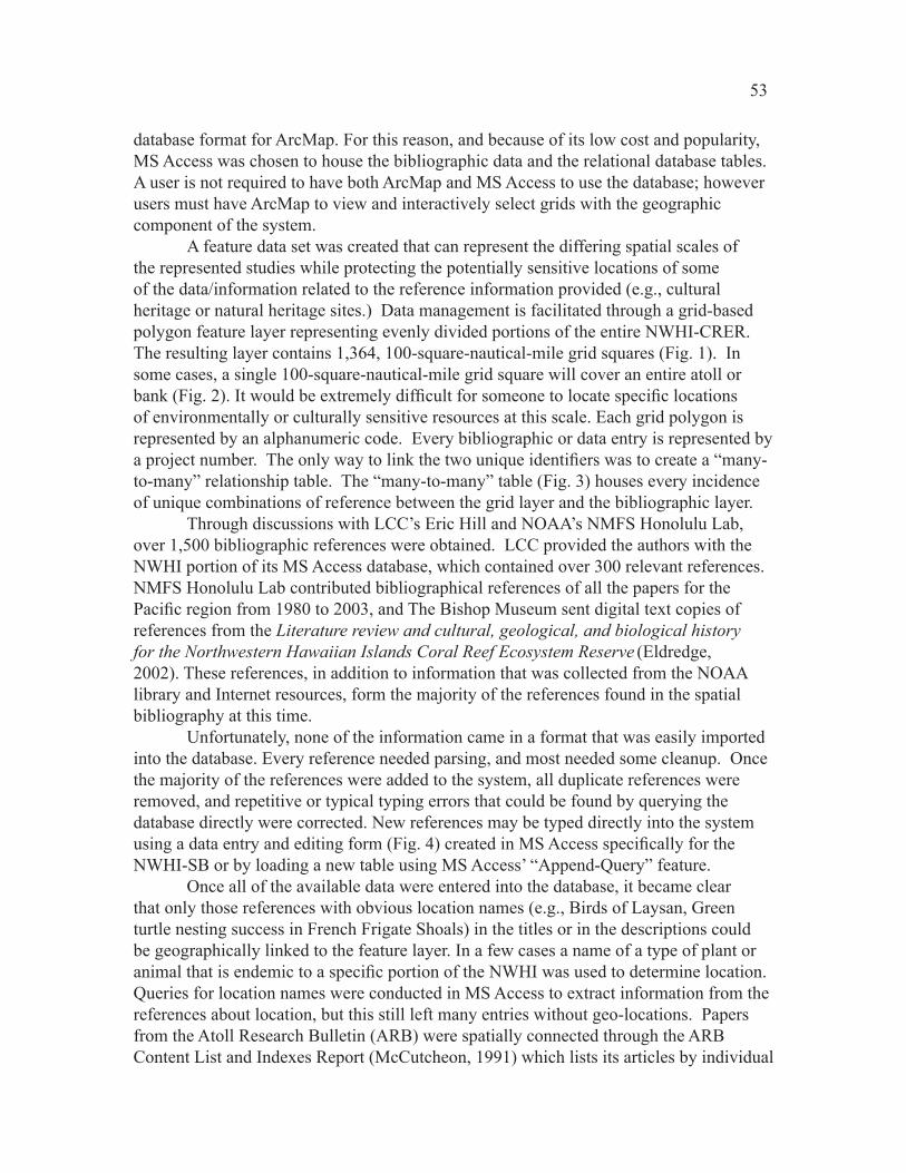
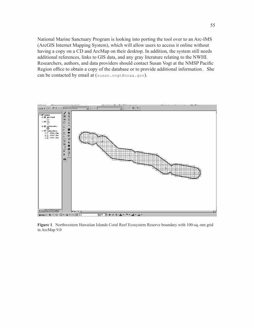
A feature data set was created that can represent the differing spatial scales of the represented studies while protecting the potentially sensitive locations of some of the data/information related to the reference information provided (e.g., cultural heritage or natural heritage sites.) Data management is facilitated through a grid-based polygon feature layer representing evenly divided portions of the entire NWHI-CRER. The resulting layer contains 1,���, 100-square-nautical-mile grid squares (Fig. 1). In some cases, a single 100-square-nautical-mile grid square will cover an entire atoll or bank (Fig. 2). It would be extremely difficult for someone to locate specific locations of environmentally or culturally sensitive resources at this scale. Each grid polygon is represented by an alphanumeric code. Every bibliographic or data entry is represented by a project number. The only way to link the two unique identifiers was to create a “many-to-many” relationship table. The “many-to-many” table (Fig. �) houses every incidence of unique combinations of reference between the grid layer and the bibliographic layer.
Through discussions with LCC’s Eric Hill and NOAA’s NMFS Honolulu Lab, over 1,�00 bibliographic references were obtained. LCC provided the authors with the NWHI portion of its MS Access database, which contained over �00 relevant references. NMFS Honolulu Lab contributed bibliographical references of all the papers for the Pacific region from 1980 to 2003, and The Bishop Museum sent digital text copies of references from the Literature review and cultural, geological, and biological history for the Northwestern Hawaiian Islands Coral Reef Ecosystem Reserve (Eldredge, �00�). These references, in addition to information that was collected from the NOAA library and Internet resources, form the majority of the references found in the spatial bibliography at this time.
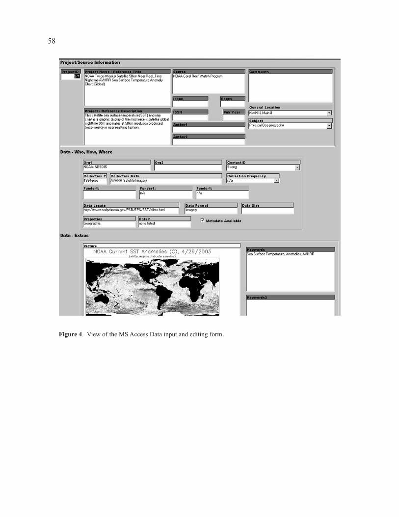
Unfortunately, none of the information came in a format that was easily imported into the database. Every reference needed parsing, and most needed some cleanup. Once the majority of the references were added to the system, all duplicate references were removed, and repetitive or typical typing errors that could be found by querying the database directly were corrected. New references may be typed directly into the system using a data entry and editing form (Fig. 4) created in MS Access specifically for the NWHI-SB or by loading a new table using MS Access’ “Append-Query” feature.
Once all of the available data were entered into the database, it became clear that only those references with obvious location names (e.g., Birds of Laysan, Green turtle nesting success in French Frigate Shoals) in the titles or in the descriptions could be geographically linked to the feature layer. In a few cases a name of a type of plant or animal that is endemic to a specific portion of the NWHI was used to determine location. Queries for location names were conducted in MS Access to extract information from the references about location, but this still left many entries without geo-locations. Papers from the Atoll Research Bulletin (ARB) were spatially connected through the ARB Content List and Indexes Report (McCutcheon, 1��1) which lists its articles by individual
��
islands. Spatial locations for each tripartite study (Grigg and Pfund, 1��0; Grigg and Tanoue, 1���, vol. 1&�) reference were determined by reading through each study.
Colleagues at the NOAA/NMFS Honolulu Lab suggested that it might be easier to contact the authors to find out where their research had occurred or for what area it represented. However, because many of the references were co-authored, and more than 250 authors were listed in the database, it was difficult to know whom to contact. In order to simplify the task of contacting the authors, the database was queried to sort out the �0 authors that showed up in the database most frequently. MS Access reports linking all of the references to these authors were generated, and each author was sent an Adobe Acrobat file including their references, a map of the grid, and directions on how to fill in the information. Unfortunately, after � months, only six authors responded.
RESULTS
The Spatial Bibliography presently contains over �0 subject categories and can be sorted by over �0 bibliographic or location categories. For the 1,��� references currently available in the database, ��0 have some level of geographic location information. These ��0 spatially linked references can be sorted within the database and queried by geographic location using ArcMap. The remaining 1,0�� references can be found using MS Access’ database query functions.
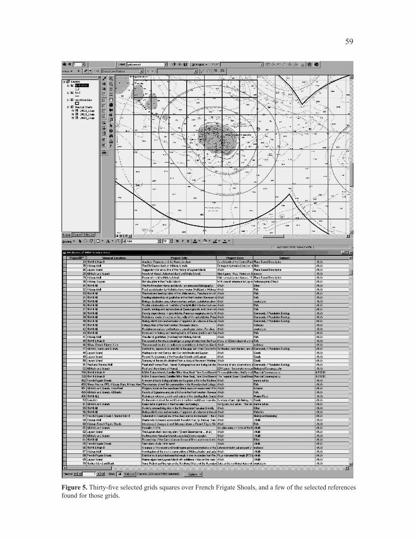
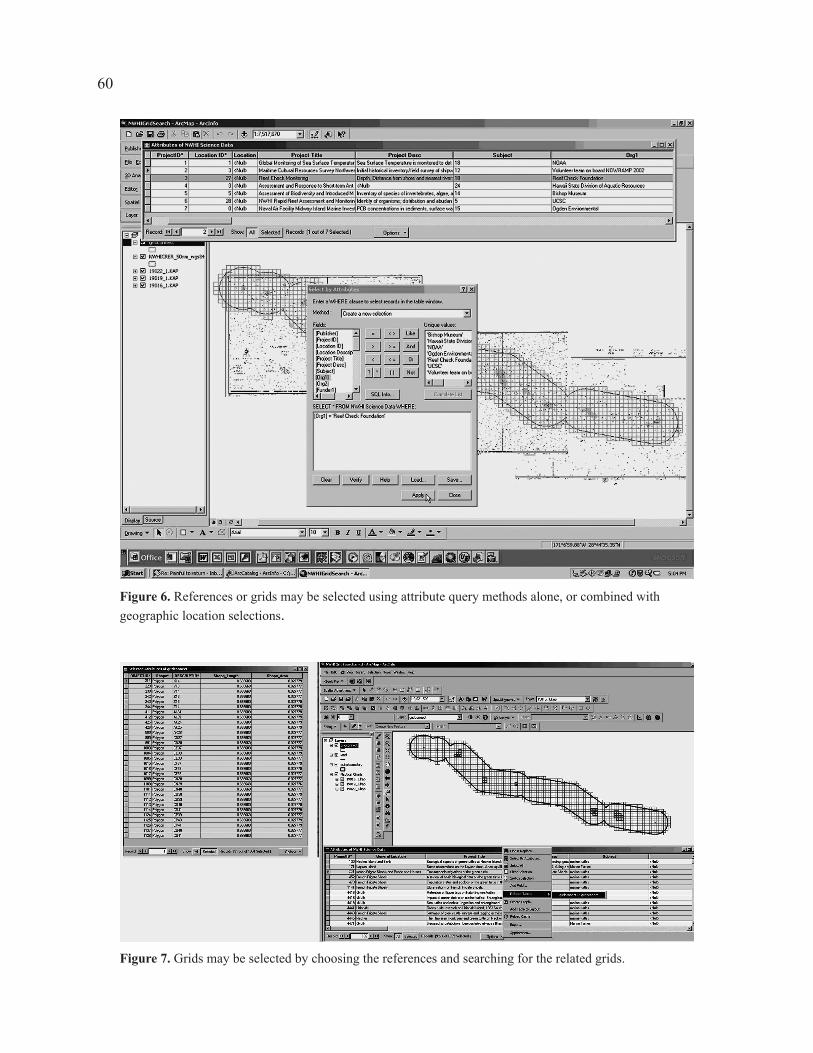
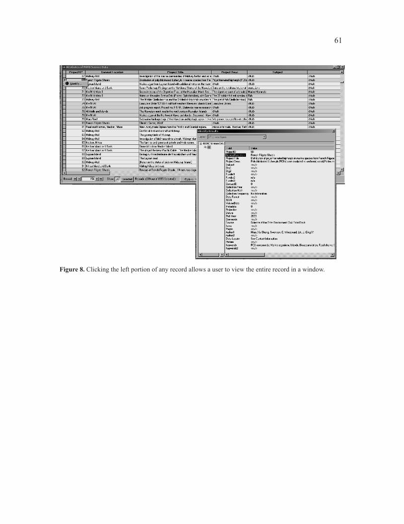
Using ArcMap, a user can now pick any combination of polygons from the polygon grid layer and search for bibliographic data that is linked to those areas (Fig. �). One may also search the database using a combination of user-defined query criteria and area location selections (Fig. 6). Conversely, users may also find locations of data by selecting bibliographic entries and asking the system to locate the related grids (Fig. �). A user may also select an individual record and display it in a new window by clicking to the left of any record in a table (Fig. �). Standard nautical charts for the area are included as background information. In addition, other geographic data layers may be added, by the user, into ArcMap for comparison and use as grid selection criteria.
DISCUSSION
The NWHI Spatial Bibliography has the potential to be a powerful research tool once it contains all the necessary references for the NWHI, and the spatial connections for all the relevant references are made. The NWHI-CRER office has access to a GIS Specialist at its Honolulu office who will handle the project. The spatial bibliography should enjoy a much faster evolution at the NWHI-CRER office in Honolulu because those researchers, educators, and others knowledgeable in the topics and data referenced in the Spatial Bibliography are much better equipped to maintain it, update it, and ensure the information is correctly geographically linked. They are also much better located to contact authors and data providers for needed information.
The NWHI Spatial Database needs to be made available to the public. The
��
National Marine Sanctuary Program is looking into porting the tool over to an Arc-IMS (ArcGIS Internet Mapping System), which will allow users to access it online without having a copy on a CD and ArcMap on their desktop. In addition, the system still needs additional references, links to GIS data, and any gray literature relating to the NWHI. Researchers, authors, and data providers should contact Susan Vogt at the NMSP Pacific Region office to obtain a copy of the database or to provide additional information. She can be contacted by email at ([email protected]).
Figure 1. Northwestern Hawaiian Islands Coral Reef Ecosystem Reserve boundary with 100-sq.-nm grid in ArcMap �.0

��
Figure 2. French Frigate Shoals with overlying 100-sq.-nm grid in ArcMap �.0
��
Figure 3. The relational database table linkages in MS Access. The Many-to-Many relational table is in the box labeled “Many-to-Many Relationship Connecting Table.”
��
Figure 4. View of the MS Access Data input and editing form.
��
Figure 5. Thirty-five selected grids squares over French Frigate Shoals, and a few of the selected references found for those grids.
�0
Figure 7. Grids may be selected by choosing the references and searching for the related grids.
Figure 6. References or grids may be selected using attribute query methods alone, or combined with geographic location selections.
�1
Figure 8. Clicking the left portion of any record allows a user to view the entire record in a window.
��
LITERATURE CITED
Booth, B., S. Crosier, J. Clark, and A. MacDonald�00�. Building a geodatabase GIS. Environmental Systems Research Institute.
Redlands, CA.Coleman, D.E., P. Jokiel, E. Hill, and N. Bentivoglio
�00�. Better document management through georeferencing. ArcUser Online, April-June �00�.
Eldredge, L.G. �00�. Literature review and cultural, geological, and biological history for the
Northwestern Hawaiian Islands Coral Reef Ecosystem Reserve. A report to NOAA/NOS from Hawaii Biological Survey. Hawaii Biological Survey Contrib. No. �00�-0��. Bernice P. Bishop Museum, Honolulu.
Grigg, R.W., and R.T. Pfund 1��0. Proceedings of the Symposium on Status of Resource Investigations in the
Northwestern Hawaiian Islands. UNIHI-SEAGRANT-MR-�0-0�. Univ. Hawaii Sea Grant College Program, Honolulu. ��� p.
Grigg, R.W., and K.Y. Tanoue 1���. Proceedings of the Second Symposium on Resource Investigations in the
Northwestern Hawaiian Islands, Volume 1. UNIHI-SEAGRANT-MR-84-01. Univ. Hawaii Sea Grant College Program, Honolulu. ��1 p.
Grigg, R.W., and K.Y. Tanoue 1���. Proceedings of the Second Symposium on Resource Investigations in the
Northwestern Hawaiian Islands, Volume 2. UNIHI-SEAGRANT-MR-84-01. Univ. Hawaii Sea Grant College Program, Honolulu. ��� p.
McCutcheon, Mary1��1. Contents list and indexes for the Atoll Research Bulletin. Atoll Research
Bulletin No. ���.