Embed Size (px)
Citation preview

North American drought: Reconstructions, causes, and consequences
Edward R. Cook a,!, Richard Seager a, Mark A. Cane a, David W. Stahle b
a Lamont-Doherty Earth Observatory, Palisades, NY 10964 USAb Department of Geosciences, University of Arkansas, Fayetteville, AR 72701 USA
Received 29 December 2005; accepted 18 December 2006Available online 3 January 2007
Abstract
Severe drought is the greatest recurring natural disaster to strike North America. A remarkable network of centuries-long annualtree-ring chronologies has now allowed for the reconstruction of past drought over North America covering the past 1000 or moreyears in most regions. These reconstructions reveal the occurrence of past “megadroughts” of unprecedented severity and duration,ones that have never been experienced by modern societies in North America. There is strong archaeological evidence for thedestabilizing influence of these past droughts on advanced agricultural societies, examples that should resonate today given theincreasing vulnerability of modern water-based systems to relatively short-term droughts. Understanding how these megadroughtsdevelop and persist is a timely scientific problem. Very recently, climate models have succeeded in simulating all of the majordroughts over North America from the Civil War to the severe 1998–2004 drought in the western U.S. These numericalexperiments indicate the dominating importance of tropical Pacific Ocean sea surface temperatures (SSTs) in determining howmuch precipitation falls over large parts of North America. Of central importance to drought formation is the development of cool“La Niña-like” SSTs in the eastern tropical Pacific region. This development appears to be partially linked to changes in radiativeforcing over that region, which affects the Bjerknes feedback mechanism of the ENSO cycle there. Paradoxically, warmerconditions over the tropical Pacific region lead to the development of cool La Niña-like SSTs there, which is drought inducing overNorth America. Whether or not this process will lead to a greater prevalence of drought in the future as the world warms due toaccumulating greenhouse gases is unclear at this time.© 2007 Elsevier B.V. All rights reserved.
Keywords: North American drought; Palmer drought index; tree rings; drought reconstructions; drought causes and consequences; ENSO variability
1. Introduction
The western United States (the ‘West’) has been inthe grip of a severe drought since late 1999, which onlyrecently (mid-2005) appears to be ending (U.S. DroughtMonitor; http://www.drought.unl.edu/dm/monitor.html;Svoboda et al., 2002). Whether or not this changetowards wetter conditions truly represents the end of thissevere multi-year drought remains to be seen. However,
at its peak in July 2002, more than 50% of thecontiguous U.S. was under moderate to severe droughtconditions, with record or near-record precipitationdeficits throughout the West (Lawrimore and Stephens,2003). Large portions of the Canadian Prairie provincesalso suffered from severe drought (Agricultural andAgri-Food Canada, 2002), as well as extensive areas ofMexico, particularly in the northern and western parts ofthe country (Lawrimore et al., 2002; consult the March2003 drought map and associated report located at theNorth American Drought Monitor website addressprovided with the reference).
Earth-Science Reviews 81 (2007) 93–134www.elsevier.com/locate/earscirev
! Corresponding author. Tel.: +1 845 365 8618; fax: +1 845 365 8152.E-mail address: [email protected] (E.R. Cook).
0012-8252/$ - see front matter © 2007 Elsevier B.V. All rights reserved.doi:10.1016/j.earscirev.2006.12.002
The impacts of this drought on the West have beenconsiderable. Four consecutive years of drought resultedin water supply deficits in reservoir storage, with 10 of 11western states having below average storage by May2004, and below 50% capacity in Arizona, NewMexico,Nevada, Utah, and Wyoming (USDA, 2004). BySeptember 22, 2004, the elevation of Lake Powell wasdown 129 ft from full pool level, only 38% of livecapacity (Upper Colorado Region Water OperationsData; http://www.usbr.gov/uc/crsp/GetSiteInfo). Mostof this water loss from Lake Powell occurred in onlythree years beginning with the epic 2002 drought year,down from a lake level that was near its historic maxi-mum in early 2000. Exacerbated by drought conditions,the 2002 fire season was the second worst in the last50 yr, with wildfire burning over 370,000 ha, includingthe largest fires in the past century in Oregon, Arizona,and Colorado (NASA, 2004). Persistent drought in theAmerican Southwest in combination with associatedinsect outbreaks also resulted in over three million acresof pinyon and ponderosa pine mortality in Arizona andNew Mexico (Betancourt, 2003), with die-off spreadinginto southwestern Colorado as well. This droughthighlights both the extreme vulnerability of the semi-arid West to shortfalls in precipitation and the need tobetter understand long-term drought variability and itscauses in North America.
The impact of drought on the environment isobvious. Perhaps less obvious is its surprisingly higheconomic cost. Over the years 1980 to 2003, for theUnited States as a whole, droughts (and associated heatwaves) accounted for 10 of the 58 weather-relateddisasters that are estimated to have cost more than onebillion dollars (normalized to 2002 dollars; Ross andLott, 2003). Those drought disasters (17.2% of the total)accounted for $144 billion (41.2%) of the estimated$349 billion total cost of all weather-related disasters(Ross and Lott, 2003). This is considerably more, atleast until Hurricane Katrina struck the Gulf Coast, thanthe cost of hurricanes and tropical storms, the mostfrequent source of billion-dollar disasters: (16 eventsand 102 billion dollars over the same time period). So, ineconomic terms alone, droughts are the most costlynatural disasters to strike the United States.
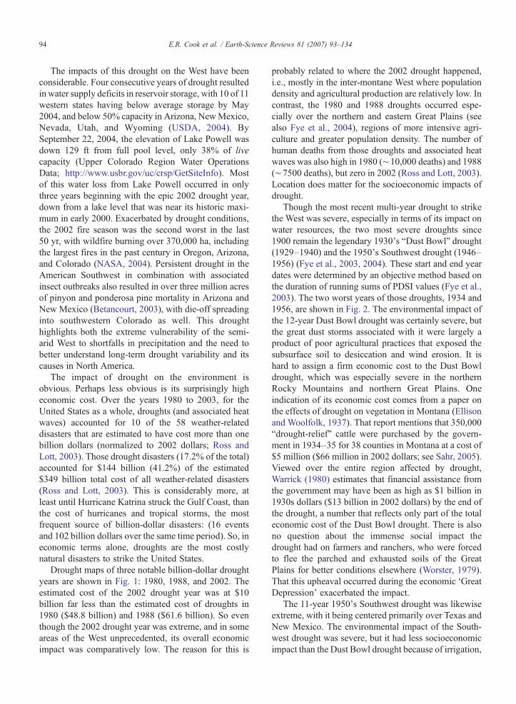
Drought maps of three notable billion-dollar droughtyears are shown in Fig. 1: 1980, 1988, and 2002. Theestimated cost of the 2002 drought year was at $10billion far less than the estimated cost of droughts in1980 ($48.8 billion) and 1988 ($61.6 billion). So eventhough the 2002 drought year was extreme, and in someareas of the West unprecedented, its overall economicimpact was comparatively low. The reason for this is
probably related to where the 2002 drought happened,i.e., mostly in the inter-montane West where populationdensity and agricultural production are relatively low. Incontrast, the 1980 and 1988 droughts occurred espe-cially over the northern and eastern Great Plains (seealso Fye et al., 2004), regions of more intensive agri-culture and greater population density. The number ofhuman deaths from those droughts and associated heatwaves was also high in 1980 (!10,000 deaths) and 1988(!7500 deaths), but zero in 2002 (Ross and Lott, 2003).Location does matter for the socioeconomic impacts ofdrought.
Though the most recent multi-year drought to strikethe West was severe, especially in terms of its impact onwater resources, the two most severe droughts since1900 remain the legendary 1930's “Dust Bowl” drought(1929–1940) and the 1950's Southwest drought (1946–1956) (Fye et al., 2003, 2004). These start and end yeardates were determined by an objective method based onthe duration of running sums of PDSI values (Fye et al.,2003). The two worst years of those droughts, 1934 and1956, are shown in Fig. 2. The environmental impact ofthe 12-year Dust Bowl drought was certainly severe, butthe great dust storms associated with it were largely aproduct of poor agricultural practices that exposed thesubsurface soil to desiccation and wind erosion. It ishard to assign a firm economic cost to the Dust Bowldrought, which was especially severe in the northernRocky Mountains and northern Great Plains. Oneindication of its economic cost comes from a paper onthe effects of drought on vegetation in Montana (Ellisonand Woolfolk, 1937). That report mentions that 350,000“drought-relief” cattle were purchased by the govern-ment in 1934–35 for 38 counties in Montana at a cost of$5 million ($66 million in 2002 dollars; see Sahr, 2005).Viewed over the entire region affected by drought,Warrick (1980) estimates that financial assistance fromthe government may have been as high as $1 billion in1930s dollars ($13 billion in 2002 dollars) by the end ofthe drought, a number that reflects only part of the totaleconomic cost of the Dust Bowl drought. There is alsono question about the immense social impact thedrought had on farmers and ranchers, who were forcedto flee the parched and exhausted soils of the GreatPlains for better conditions elsewhere (Worster, 1979).That this upheaval occurred during the economic ‘GreatDepression’ exacerbated the impact.
The 11-year 1950's Southwest drought was likewiseextreme, with it being centered primarily over Texas andNew Mexico. The environmental impact of the South-west drought was severe, but it had less socioeconomicimpact than the Dust Bowl drought because of irrigation,
94 E.R. Cook et al. / Earth-Science Reviews 81 (2007) 93–134

improved agricultural practices, better governmentalsupport, and a much stronger underlying economy.Regardless, the hydroclimatic severity and duration ofthe 12-year Dust Bowl and 11-year Southwest droughtstell us from even the relatively short 20th century climaterecords that things could get worse than the recentdrought in the West that has lasted only 5–6 yr and,depending on locale, may not yet be ending.
The annual drought maps in Figs. 1 and 2 alsoillustrate that individual drought years are not necessar-ily good indicators of cumulative environmental andsocioeconomic impacts. One dry year may be accom-modated without undue environmental and economicharm providing that it is sufficiently offset by wetterconditions the following year. What really matters isduration because recovery from the cumulative damage
of consecutive drought years is more difficult. Thus,while the 1934 drought year clearly exceeds the overallseverity of the other years shown in Figs. 1 and 2, it wasalso part of a much longer sequence of drier thanaverage years (Fye et al., 2004) that resulted in thecatastrophic Dust Bowl drought.
Given the enormous environmental and socioeco-nomic impacts of drought over the U.S., Canada, andMexico, it is important to develop a better understandingof North American drought, especially for multi-yearevents. This is a propitious time to review the state ofpresent knowledge because of striking advances in justthe past two or three years:
(1) A recent reconstruction of North Americandrought from AD 800 (Cook et al., 2004) creates
Fig. 1. Maps showing the U.S. regions most affected by drought in 1980, 1988, and 2002. The drought metric used for this purpose is the PalmerDrought Severity Index (Palmer, 1965). Note that the 2002 drought was mostly restricted to the inter-montane West, while the other two droughtswere located more so in more agriculturally important regions of the Great Plains and Corn Belt. (Maps from http://www.ncdc.noaa.gov/oa/climate/research/drought/palmer-maps/).
95E.R. Cook et al. / Earth-Science Reviews 81 (2007) 93–134

the first annual, regionally resolved picture ofmore than a millennium of droughts and wetperiods for most of the North American continent.It provides a context for the handful of droughtsthat we know of from the instrumental period(roughly, the 1850s onward) and a more completepicture of North American droughts of exception-al intensity and duration, “megadroughts” (Wood-house and Overpeck, 1998; Stahle et al., 2000).For example, the 16th century megadrought iden-tified by Stahle et al. (2000) is now seen to haveaffected large areas of North America, especiallyin the West and northern Mexico, and was muchmore prolonged than any of the 20th centurydroughts. The drought reconstructions also pro-vide clear evidence for a much drier climateacross the West and Great Plains during Medievaltimes, a drought that lasted with few interruptionsfor a few hundred years and which greatly taxedboth hunter–gatherer and agriculturalist popula-tions (Jones et al., 1999). Such “no analog”megadroughts are scary because the modern-dayagricultural and hydrologic systems that dependupon adequate water supplies to produce andfunction may not have the resilience to survivemuch beyond the observed “worst case scenario”droughts of the past 100–150 yr, e.g., the DustBowl drought. The unprecedented growth of theWest occurring now, with its increasing demandfor water, makes this concern for the future even
more serious. So, understanding the causes ofthese past megadroughts is vitally important.
(2) There has been rapid progress in simulating NorthAmerican drought with comprehensive atmo-spheric general circulation models (AGCMs;Schubert et al., 2004b; Seager et al., 2005b;Herweijer et al., 2006). If global sea surfacetemperatures (SSTs) are specified, then importantdroughts such as those of the 1930s and 1950s arelargely reproduced by the AGCMs. These resultsadd important evidence about causality to thestrong statistical association between certain spatialdrought patterns over North America and SSTanomalies over the tropical Pacific Ocean (Cole andCook, 1998; Cook et al., 2000; Cole et al., 2002;Fye et al., 2004). An astonishing finding of thismodeling work is that droughts with such majorecological and socioeconomic impacts apparentlywere “forced” by coherent tropical SST signals ofno more than a few tenths of a degree Celsius.
(3) The modeling results have stimulated a newunderstanding of the mechanisms connectingtropical SST anomalies to drought over NorthAmerica. The most accepted ideas about “tele-connections” rely on Rossby wave propagation tomid-latitudes. In addition, it now appears thatzonally symmetric changes in the atmospheric cir-culation in subtropical and middle latitudes drivenby the overall warming of the tropical troposphereare a means whereby the tropics influence the mid-
Fig. 2. Maps showing the U.S. regions most affected by drought in 1934 and 1956. These two years are part of the Dust Bowl and Southwestdroughts, considered to be the worst of the 20th century. (Maps from http://www.ncdc.noaa.gov/oa/climate/research/drought/palmer-maps/).
96 E.R. Cook et al. / Earth-Science Reviews 81 (2007) 93–134

latitudes throughout the year, (Seager et al., 2003,2005a,b; Lau et al., 2006, in press). Bothmechanisms imply that North American droughtsshould be an element of a more global pattern ofdrought (e.g., in southern South America, parts ofEurope and Asia) (Herweijer and Seager, 2006).
(4) To date the only part of the climate system that hasproved to be predictable on seasonal and longertimescales is the tropical Pacific. That NorthAmerican droughts – and their associated globalhydroclimatic regimes – are linked to tropicalSSTs raises the question of whether the SSTpatterns responsible are predictable on the time-scales of years to decades over which a seriousdrought develops. The importance of tropical SSTsfor forcing these global hydroclimatic regimes alsomakes it clear that the hydrological future of manyareas will be influenced by how the tropicalatmosphere–ocean system responds to anthropo-genic forcing. This is currently a subject of greatuncertainty in model simulations and one for whichtheoretical understanding is limited at best.
(5) Recent research has greatly extended our knowl-edge of the cultural and social impacts of pastdroughts (Stahle and Dean, in press). Examiningthese connections reveals the vulnerability of pastcultures to drought, cautionary tales that especial-ly resonate now because of the recent and perhapsongoing drought in the West.
This paper aims to report on the current status ofresearch into North American droughts and theirconsequences. It does not purport to be a comprehensivereview of all work to date, much of which has beenmade obsolete as a result of the recent climate modelingstudies. In the next section we describe the PalmerDrought Severity Index (PDSI) and explain why it isused to characterize drought. Sections 3 and 4 describethe tree-ring network that is used for drought recon-struction and the statistical methods employed. Thereader who is primarily interested in the actual droughts,or is familiar with the methodology used for droughtreconstruction from tree rings, may want to jump aheadto Section 5 where reconstructed drought variabilitysince 800A.D. is discussed together with evidence forwidespread medieval megadroughts. Following this, inSection 6, the social impacts of selected droughts overthe last 1000 yr are discussed. This includes examples ofthe impacts of droughts on Indian cultures and alsopresents a climate background to the changing nature ofEuropean immigrants perceptions of the West throughthe Nineteenth Century from descriptions of the ‘Great
American Desert’ to a later ‘garden myth’ that coincidedwith the opening of the railroads and migration ofsettlers into the Plains.
Section 7 presents the results of climate modelingstudies (conducted at LDEO) and makes the case fordroughts being forced by cold tropical Pacific seasurface temperature (SST) anomalies. The zonal meaneddy–mean flow interaction and Rossby wave tele-connection means of transmitting the signal of coldSSTs into the mid-latitudes is discussed and it is arguedthat North American droughts fit into a global pattern ofhydroclimate regimes with elements of zonal andhemispheric symmetry. Modeling results are illustratedthrough a case study of the 1890s drought, the one thatcreated a semblance of realism in the attitudes of theFederal government to settlement of the arid regions ofthe West. Section 8 discusses the causes of tropicalPacific SST anomalies both on decadal timescales andover the last millennium and makes the case that themedieval megadrought was caused by a shift to a moreLa Nina-like state during those centuries which itselfwas forced by relatively high solar irradiance and weakvolcanism. Section 9 considers how tropical SSTs willchange in the greenhouse future and how this willimpact the hydroclimatic future of the West. A summaryand conclusions are offered in Section 10.
2. Measuring drought variability over NorthAmerica
The environmental and socioeconomic impacts ofdrought over North America reveal a great need for adetailed history of drought variability and extremes forreal-time drought assessment studies as new droughtsdevelop, for modeling the causes of drought, and forimproving drought prediction. As a step in thatdirection, Karl and Koscielny (1982) used the PalmerDrought Severity Index (PDSI; Palmer, 1965), calcu-lated from monthly temperature and precipitation data,to describe the temporal and spatial properties ofdrought over the coterminous U.S. back to 1895. Priorto 1895, the available climate data used to calculatePDSI were too sparse for any earlier large-scale analysesof drought across the U.S. Shabbar and Skinner (2004)developed a similar PDSI dataset for most of Canada,but only as far back as 1940 because of short instru-mental climate records in the more northerly latitudes.
Dai et al. (1998, 2004) expanded the spatial coverageof PDSI on a regular 2.5° grid to cover most of NorthAmerica and other global land areas, in the processextending the PDSI records back to 1870 at somelocations as well. The paucity of early climate records innorthern Canada and much of Mexico limits the
97E.R. Cook et al. / Earth-Science Reviews 81 (2007) 93–134

usefulness of these PDSI estimates prior to the early20th century. Another gridded PDSI dataset for NorthAmerica south of 50° N has recently been produced byvan der Schrier et al. (2006b). It extends back to 1901 atall locations of the grid and is based on finelyinterpolated monthly temperature and precipitationdata (New et al., 2000; Mitchell et al., 2004; Mitchelland Jones, 2005). Again, the quality of these PDSIestimates suffers in areas like Mexico with few climaterecords that extend back into the early 20th century.
Based on instrumental data alone, we are largelyrestricted to studies of variability over the 20th century.More or less, the PDSI is a commonly used metric ofdrought over North America and other global land areas.Other measures of drought have also been developedfor use in North America and elsewhere (Heim, 2002),such as the Standardized Precipitation Index (Gutt-man, 1998), but are not used to the same degree as thePDSI.
So, what exactly is the PDSI? Succinctly put, thePDSI is a reflection of how much soil moisture is cur-rently available compared to that for normal or averageconditions. The PDSI incorporates both precipitationand temperature data in a reasonably realistic waterbalance model that accounts for both supply (rain orsnowfall water equivalent) and demand (temperaturetransformed into units of water lost through evapotrans-piration), which affect the content of a simple 2-layersoil moisture reservoir model. A runoff term is alsoactivated when the reservoir is full. See Palmer (1965)for details. The PDSI is most commonly calculated atmonthly time steps, although there is no formal restric-tion on its calculation at shorter or longer intervals. ThePDSI has built into its formulation a Markovian persis-tence term of 0.897 from one time step to the next,corresponding to an e-folding time of !10 months. Thisis expressed as
PDSIt ! :0897!PDSIt"1 " #1=3$Zt
where Zt is the moisture anomaly index for time t(Palmer, 1965; Wells et al., 2004). The Z index indicateshow wet or dry it was during a single month withoutregard to past precipitation anomalies. Its combinationwith past PDSI means that the PDSI for a given month isa weighted function of current moisture conditions andan exponentially damped contribution of PDSI overprevious months. This means that PDSI for the month ofJuly integrates current and prior soil moisture conditionsover several months. This point is important in under-standing why only one month of PDSI is sometimesreconstructed by tree rings even though the trees are
usually sensitive to several months of changing moisturesupply during a typical growing season.
Numerous reviews of the PDSI have criticized it forits complexity and empiricism (Karl, 1983; Alley, 1984;Karl, 1986; Heddinghaus and Sabol, 1991; Guttmanet al., 1992; Guttman, 1998; Heim, 2002; Keyantash andDracup, 2002), but it remains one of the most widelyused drought indices in the world and is a fundamentalpart of the U.S. and North American drought monitors(Svoboda et al., 2002; Lawrimore et al., 2002).
From the above brief description, it is apparent thatthe PDSI provides information on both relative wetnessand dryness. The index itself is a dimensionless quantitythat is scaled to remove, among other things, differencesbetween regional precipitation climatologies. In princi-ple, this allows the PDSI to be compared between, say,New York and Arizona, regions with radically differentprecipitation regimes. The PDSI typically falls in therange of ±4, which defines the extreme drought ("4)and extremely wet (+4) thresholds of the index(Table 1), but the range limit of the PDSI is not explic-itly bounded. The frequency of events within each PDSIclass in Table 1 should also be roughly comparableacross regions and, therefore, independent of their re-gional climatologies. This means that an extremedrought (PDSIb"4) in New York should have roughlythe same frequency of occurrence as an extreme drought(PDSIb"4) in Arizona. Unfortunately, this was foundnot to be the case using the original algorithm devisedby Palmer (1965).
The spatial comparability of the PDSI across diverseclimate regions has been questioned (e.g., Karl, 1983;Guttman et al., 1992) because Palmer (1965) derivedcoefficients used in estimating PDSI from a very geo-graphically limited region of the central U.S. Wells et al.(2004) addressed this issue through the development of aself-calibrating PDSI (SC-PDSI) that locally adapts to thecharacteristics of the climate data being analyzed. This
Table 1Classification of wet and dry conditions as defined by Palmer (1965)for the PDSI
4.00 or more Extremely wet3.00 to 3.99 Very wet2.00 to 2.99 Moderately wet1.00 to 1.99 Slightly wet0.50 to 0.99 Incipient wet spell0.49 to "0.49 Near normal"0.50 to "0.99 Incipient dry spell"1.00 to "1.99 Mild drought"2.00 to "2.99 Moderate drought"3.00 to "3.99 Severe drought"4.00 or less Extreme drought
98 E.R. Cook et al. / Earth-Science Reviews 81 (2007) 93–134

produces better spatial comparability of PDSI over theU.S. compared to Palmer's original index, i.e., thefrequency of occurrence in each PDSI class is morecomparable from region to region. This improvement isespecially apparent in the extreme ends of the PDSIrange, a result independently validated by van derSchrier et al. (2006a,b) in Europe and North Americasouth of 50° N. None of the other aforementioned PDSIstudies (i.e., Karl and Koscielny, 1982; Dai et al., 1998,2004), or the tree-ring reconstructions described below,is based on the SC-PDSI because it is such a newdevelopment.
3. Tree-ring reconstructions of large-scale droughtvariability
As indicated above (Karl and Koscielny, 1982; Daiet al., 1998, 2004; Shabbar and Skinner, 2004; Van derSchrier et al., 2006b), the climate records used to gen-erate the large-scale PDSI datasets for North Americabecome very sparse even in the early 20th century oversignificant portions of Canada and Mexico. The 100 yrof instrumental data is not enough to capture the fullrange of drought variability (Woodhouse and Overpeck,1998). It is also not enough to allow drought variabilityto be evaluated during a time when the climate systemwas not heavily affected by the radiative forcing ofanthropogenic greenhouse gases. Consequently, there isan urgent need to provide greatly expanded records ofdrought variability over North America.
The paleo-drought reconstructions needed to com-plement and augment the relatively short instrumentalPDSI records for North America require a very specialkind of climate proxy with the following properties:
1. The proxy must be highly sensitive to changes inmoisture supply and evaporative stress, i.e., it mustbe drought-sensitive.
2. The proxy must have broad spatial coverage overNorth America to capture the complex spatialpatterns of droughts, as revealed in Figs. 1 and 2.
3. The proxy must have well-resolved annual resolutionto capture even single-year droughts.
4. The proxy must be exactly dated to allow annuallyresolved drought variability over North America tobe compared from region to region.
5. The proxy must provide long enough records toproduce estimates of past drought over the pastseveral centuries to millennia.
Given these required properties, there is only oneclimate proxy that satisfies all of them: annual tree-ring
chronologies. This understanding is not new, but onlyover the past few decades has the power of tree-ringanalysis and its well developed statistical methods beenbrought to bear on the reconstruction of the joint space–time properties of past climate (e.g., Fritts et al., 1971;Briffa et al., 1986; Fritts, 1991; Cook et al., 1994, 1999;Zhang et al., 2004).
The development of an extraordinary network ofclimate-sensitive annual tree-ring chronologies thatcovers much of North America has now made it possibleto reconstruct the joint space–time properties of droughtover much of North America. This tree-ring network isthe outcome of years of effort by many dendrochronol-ogists and tree-ring laboratories throughout NorthAmerica and even Europe, often working independentlyof each other. Because of a willingness to collaborate,share tree-ring data, and deposit tree-ring data for publicaccess in the International Tree-Ring Data Bank (http://www.ncdc.noaa.gov/paleo/treering.html), this collectivedendrochronological effort has resulted in a tree-ringnetwork that enables the reconstruction of large-scaleannual patterns of drought and wetness over much ofNorth America for the past several centuries to millennia.
3.1. Previous large-scale drought reconstructions fromtree rings
One of the earliest efforts to reconstruct drought fromtree rings over a large portion of the coterminous U.S. wasmade by Stockton andMeko (1975). Their reconstructionof July PDSI was made for 40 variable-sized climateregions located in the western two-thirds of the U.S. usinga tree-ring network of 40 tree-ring chronologies thatspanned most of the reconstruction domain. Recall thatJuly PDSI is actually a reflection of July moisture supplythrough the Z index plus an exponentially dampedfunction of previous monthly PDSIs, which means thatJuly PDSI integrates the soil moisture conditions overseveral months. These PDSI reconstructions covered theperiod 1700–1962. Later, Mitchell et al. (1979) producedPDSI reconstructions for the same 40 climate regions thatextended back to 1600 using the Fritts and Shatz (1975)tree-ring network of the 65 longest tree-ring chronologieslocated over the western portion of the domain. In eachcase, the method used for reconstruction was canonicalregression (Fritts et al., 1971), a method that simulta-neously estimates one field of variables from another fieldof variables. See Cook et al. (1994) for additionalexamples of the use of canonical regression for recon-structing climate from tree rings.
The tree-ring network in the eastern half of the U.S.was poorly developed when Stockton and Meko (1975)
99E.R. Cook et al. / Earth-Science Reviews 81 (2007) 93–134

made their pioneering drought reconstructions. It tookseveral more years of intensive tree-ring networkdevelopment in the eastern U.S. before a full continentalreconstruction of drought for the U.S. was feasible.Experiments in that direction were conducted by Cooket al. (1992) for the eastern U.S. to test the feasibility ofproducing PDSI reconstructions like those produced byStockton and Meko (1975). However, it was not untilMeko et al. (1993) that a full continental examination oftree growth patterns was made using a network of 248chronologies. That effort did not produce explicitestimates of past drought. Rather it sought to understandhow best to utilize the complex mix of tree species anddrought regions over the U.S. for eventual reconstruc-tion purposes.
Meko et al. (1993) used rotated principal componentsanalysis (RPCA; Richman, 1986) to demonstrate that thetree-ring chronologies themselves could reproduce thesame nine spatial drought factors in the U.S. identified byKarl and Koscielny (1982) from their gridded instru-mental PDSI data. The tree-ring factor scores were alsohighly correlated in most cases with the actual PDSI datain the drought factor regions. This result was highlyencouraging because it demonstrated that the tree-ringnetwork inherently contained the spatial patterns ofdrought variability known to exist in the instrumentalrecords. However, Meko et al. (1993) also showed thatthe uneven distribution and concentration of tree-ringchronologies over the U.S., and the geographic cluster-ing of certain tree species as well, led to geographicdistortion in the RPCA spatial factors unless the tree-ringdata were first gridded. This procedure itself had its ownproblems, however, because of the way that different treespecies in the same region might respond somewhatdifferently to the same climate forcing. Consequently,the direct gridding of tree-ring data distributed over alarge geographic region, and with a complex assemblageof tree species, will mix differences in climate responsein unclear ways that are unlikely to produce the bestquality drought reconstructions.
3.2. The point-by-point regression method
Building upon the results of Meko et al. (1993), Cooket al. (1996) developed and tested a reconstructionmethod that successfully eliminated the previously noteddifficulties associated with using a complex multi-species tree-ring network for reconstructing droughtacross the U.S. This method is called Point-by-PointRegression (PPR) (Cook et al., 1996).
PPR is the sequential, automated fitting of individualprincipal components regression models of tree rings to
each point in a grid of instrumental climate variables, inthis case PDSI. The sequential nature of PPR differ-entiates it from joint space–time methods used tosimultaneously relate two fields of variables, such ascanonical regression (Fritts et al., 1971) and orthogonalspatial regression (Briffa et al., 1986).
PPR is based on the premise that only those tree-ringchronologies proximal to a given PDSI grid point arelikely to be true predictors of drought at that location,where ‘‘true” implies a causal relationship between treerings and drought that is stable through time. Therationale behind this premise is our understanding ofdrought in the U.S. as a regional or mesoscalephenomenon. Consequently, synoptic-scale teleconnec-tions between tree rings and drought, while statisticallysignificant during any given calibration period, may notbe stable through time. The local control over eachregression model provided by PPR when reconstructingeach grid point PDSI is not possible using the jointspace–time reconstruction methods mentioned above. Italso eliminates the need to grid the tree-ring data andallows each tree-ring chronology to be separatelymodeled as a predictor of drought.
PPR uses a search radius around each grid point todefine the zone of local control exercised by the methodin selecting candidate tree-ring predictors of PDSI. Asecond level of control is the screening probability forthe correlation between tree rings and PDSI, whicheliminates those chronologies from the initial candidatepool that are poorly correlated with drought. Thescreening is done on prewhitened tree-ring and PDSIdata after the removal of short-lag autoregressive persis-tence (Box and Jenkins, 1976). Prewhitening effectivelyeliminates problems that can arise from differing levelsof autocorrelation in the tree-ring and PDSI time series.It also makes statistical significance testing straightfor-ward. The autoregressive coefficients used to prewhitenthe PDSI data are also used later in PPR to add lostpersistence back into the PDSI reconstructions that areinitially based on the prewhitened tree-ring data. SeeCook et al. (1996, 1999) for details.
Search radius and screening probability are the twoprimary controlling variables of PPR, but there was no apriori way of knowing if optimal values existed foreither one. Consequently, both were tested over a broadrange of values in principal components regressionanalysis to determine the overall best combination to usefor reconstructing past drought. Each regression modelwas based on prewhitened instrumental PDSI and tree-ring data over a 1928–1978 calibration period commonto all series. The pertinent statistic of interest here is therelative amount of PDSI variance explained by the
100 E.R. Cook et al. / Earth-Science Reviews 81 (2007) 93–134

regression model, i.e., the regression R2. Pre-1928 PDSIdata were withheld from this procedure for regressionmodel validation tests.
For testing the level of agreement between actualPDSI and model estimates in the pre-1928 verificationperiod, three statistics in order of increasing rigor werecalculated: the square of the Pearson correlation (RSQ),the reduction of error (RE), and the coefficient ofefficiency (CE). RSQ, RE, and CE are also measures ofrelative variance in common between actual andestimated PDSI. All four statistics have an upper limitof 1.0, meaning perfect agreement between the actualand estimated data. However, unlike calibration R2,which can never be negative, verification RSQ, RE, andCE can take on negative values if there is no verificationof the estimates. As the square of Pearson correlationcoefficient, RSQ is assigned a negative value if thePearson r is negative. This places a lower limit on RSQof "1.0. In contrast, RE and CE have unbounded lowerlimits and CE can never be more positive than RE. SeeCook et al. (1999) for details. After extensive testingusing the calibration and verification statistics justdescribed, Cook et al. (1999) found that a 450-kmsearch radius and a screening probability of 0.10 (the90% significance level) were on average the best com-bination to use for reconstructing PDSI over the 155-gridpoint domain.
3.3. Drought reconstructions for the coterminous U.S.
Using PPR, Cook et al. (1999) successfully recon-structed the PDSI across the coterminous U.S. from anetwork of 425 tree-ring chronologies and the sameinstrumental PDSI grid as Meko et al. (1993). The June–July–August average (summer) PDSI season wasreconstructed instead of a single month like July(Stockton and Meko, 1975). This seasonal averagewas chosen because the northward march of the growingseason in spring caused the peak response of trees to soilmoisture deficits to vary with latitude. Experiments withdifferent months and seasons indicated that the summerseason PDSI was the best compromise for reconstruc-tion. Of the 155 grid points, only the southernmost gridpoint in peninsular Florida (Fig. 3A) failed to recon-struct because of a lack of suitable tree-ring chronolo-gies in that region. The PDSI reconstructions for thecoterminous U.S. covered the common period 1700–1978 at 154 grid point locations.
Extensive tests of these tree-ring reconstructionsrevealed that they contained the large-scale features ofdrought variability found in the instrumental data (Cooket al., 1999). These tests included the use of RPCA,
which recovered the same nine spatial drought patternsfound by Karl and Koscielny (1982) and Meko et al.(1993). This result validated the use of PPR as a methodthat could recover spatial information with a high degreeof fidelity even though the method itself has no explicitspatial component in it. Subsequent comparisons ofthese drought reconstructions with those developedfrom the identical datasets using a completely indepen-dent method (Regularized Expectation Maximization;Zhang et al., 2004) further validated the use of PPR forreconstructing drought over the U.S.
The successful reconstruction of drought across thecoterminous U.S. was a breakthrough, but it had somesignificant limitations. One obvious problem was thatdrought variability over North America does not stop atthe U.S. political boundaries with Canada and Mexico.In order to study the natural patterns of droughtvariability over North America, those artificial con-straints had to be eliminated. Another problem related tothe length of these PDSI reconstructions. Although theywere almost three times as long as the instrumentalrecords, there were good reasons to believe that theywere not nearly long enough to capture the full range ofdrought variability. Woodhouse and Overpeck (1998)and Stahle et al. (2000) each provided evidence formegadroughts in North America (i.e., droughts of excep-tional intensity and duration) that predated the beginningof the reconstructions produced by Cook et al. (1999).Therefore, a concerted effort was made to eliminate theartificial political boundaries of the drought reconstruc-tions and to extend them as far back in time as the tree-ring chronologies would allow.
4. North American drought reconstructions
In order to expand the drought reconstructions tocover most of North America, two challenges had to beovercome. First, the instrumental PDSI grid had to begreatly expanded to include parts of Canada and Mexicowhere the length and quality of the instrumental datawas limited. The second challenge was to greatly ex-pand the tree-ring network to enable the reconstructionof drought over as much of Canada and Mexico aspossible.
4.1. Expanding the drought grid over North America
A logical choice for expanding the instrumental PDSIgrid into Canada andMexicowould have been to directlyuse the existing 2.5° PDSI grid of Dai et al. (1998) forglobal land areas. This possibility was investigated, but acomparison of some of the Dai et al. (1998) grid point
101E.R. Cook et al. / Earth-Science Reviews 81 (2007) 93–134

records with those closest to ones from the Cook et al.(1999) PDSI grid for the U.S. indicated somewhat weakagreement at times between the two datasets. Since theCook et al. (1999) PDSI grid was based on the highestquality single-station USHCN monthly climate records(Karl et al., 1990), the decision was made to use thesePDSI records in the expanded North American grid.
At about the same time, 131 high-quality monthlyinstrumental PDSI records for Canada, which all beganprior to 1946, were obtained from the MeteorologicalService of Canada (Skinner et al., 2001). This datasetwas the basis for the interpolated PDSI records used byShabbar and Skinner (2004) in their analyses ofCanadian drought. The high-quality U.S. and Canadian
Fig. 3. The old (A) and new (B) instrumental PDSI grids used for reconstruction.
102 E.R. Cook et al. / Earth-Science Reviews 81 (2007) 93–134

single-station PDSI records were then jointly interpo-lated to the same 2.5° grid as that used by Dai et al.(1998) using the same inverse distance weighted method(Cook et al., 1996). The interpolated PDSI records allbegan on or before 1900 in the U.S. As indicated byShabbar and Skinner (2004), this was not possibleeverywhere in Canada. Therefore, areas of the Canadiangrid that did not extend back to 1900 were in-filled withPDSI estimates back to 1900 using reduced-spaceoptimal interpolation (Kaplan et al., 2000).
No similar set of high-quality single-station PDSIrecords existed for Mexico at the time, so the decisionwas made to use the Mexico portion of Dai et al. (1998)PDSI grid for that part of the North American grid.Some of the Mexican PDSI gridded records were foundto be unusually erratic, with discontinuities and unrealis-tic extremes at some grid points, which indicated dataquality problems. Those suspect PDSI grid point recordswere carefully edited to remove gross outliers anddiscontinuities. The remaining data were improved andgaps filled through the use of reduced-space optimalinterpolation (Kaplan et al., 2000).
The data from the U.S., Canada, and Mexico pro-duced a North American monthly PDSI grid composedof 286 2.5° grid points that covered most of NorthAmerica (Fig. 3B). The time period common to all gridpoints was 1900–1990. This grid does not includeAlaska, which lacks the high-quality single-stationPDSI records needed for interpolation. The northernboundary of the grid in Canada was also determined bythe distribution of PDSI records available for interpo-lation. Finally, the lack of any useful tree-ring data in thefar southeastern Yucatan region of Mexico (see Fig. 3B)led to the decision not to include any PDSI grid pointsfrom that region in the new reconstructions.
4.2. Expanding the tree-ring network over North America
The second challenge was expanding the tree-ringnetwork to cover enough of the new PDSI grid forreconstruction purposes. The tree-ring community inNorth America had been very active over the previousseveral years in developing a number of very importantnew tree-ring chronologies in critical areas of NorthAmerica. Its willingness to share these data for large-scale drought reconstruction made it possible to rapidlyexpand the North American tree-ring network used here.Fig. 4A shows the tree-ring network available forreconstruction. It totals 835 annual records, many ofwhich occupy important new regions of the grid. Thenew network is almost twice as large as the 425-chrono-logy network used by Cook et al. (1999) and better fills
in important parts of the U.S. in the Great Plains andRocky Mountains. Mexico is also now well representedby the network, but significant portions of Canada areclearly under-represented. However, the results to bepresented next show that the tree-ring coverage forCanada still provides useful PDSI reconstructions in anumber of regions there.
Another important feature of the expanded tree-ringnetwork is the number of new chronologies that extendback 500 or more years in the past. Fig. 4B shows afrequency histogram of starting years of the 835chronologies, broken down into the original 425 (blue)used by Cook et al. (1999) and the additional 410 (red)in the expanded network. There are many more now thatextend back into the 16th century, a period of mega-drought (Stahle et al., 2000). In addition, there are anumber of new chronologies that extend back beforeAD 1300, another time of megadrought in some areas ofthe West (Woodhouse and Overpeck, 1998). This en-abled the PDSI reconstructions at certain grid points tobe extended much further back in time into thoseclimatically interesting times.
4.3. Extending the PDSI reconstructions back in time
The reconstructions produced by Cook et al. (1999)were originally constrained to utilize the time intervalcommon among all 435 annual tree-ring chronologies: AD1700–1978. In order to utilize the full lengths of theavailable tree-ring records for reconstructing drought, PPRwas used in a nested manner whereby the shorterchronologies alreadyused for reconstructionwere droppedout and the procedure repeated using the remaining longerseries. For example, if three tree-ring chronologies passedthe screening probability test and their starting years wereAD 1700, 1600, and 1500, then three reconstructions weregenerated. The first used all three chronologies and beganin AD 1700, the second used the two longer chronologiesand began in AD 1600, and the third used the remaininglongest chronology and began in AD 1500. Each recon-struction would also have its own calibration period R2
and verification period RSQ, RE, and CE.In order to put these three reconstructions together
into one reasonably homogeneous record back to AD1500, it was necessary to adjust each series to account forits different level of regression R2. Otherwise theremight be an artificial trend or fluctuation in the recon-structed PDSI variance over time. This was accom-plished by adding the lost variance due to regressionback into each reconstruction, i.e., each nested recon-struction was rescaled to have the same variance over the1928–1978 calibration period as the instrumental PDSI
103E.R. Cook et al. / Earth-Science Reviews 81 (2007) 93–134

data. In the hypothetical example used here, this wouldcreate a PDSI reconstruction as a combination of threerescaled segments: 1500–99, 1600–99, and 1700–1978.
Fig. 5 shows an example of one reconstruction fromthe North American Drought Atlas that was created over
the 286 PDSI grid points (Fig. 3B). The North AmericanDrought Atlas can be accessed online at http://iridl.ldeo.columbia.edu/SOURCES/.LDEO/.TRL/.NADA2004/.pdsi-atlas.html (see also http://www.ncdc.noaa.gov/paleo/newpdsi.html for an alternative source of these
Fig. 4. The North American tree-ring network (A) used for drought reconstruction and the frequency histogram of starting years of those chronologies(B). Each shows the earlier 425-chronology network used by Cook et al. (1999) to reconstruct drought over the coterminous U.S. (blue) and theadditional chronologies that make up the expanded 835-chronology North American network (red).
104 E.R. Cook et al. / Earth-Science Reviews 81 (2007) 93–134

data). Note how the calibration and verification statisticschange with time as the number of available chronol-ogies declines. Except for one short interval centered onAD 1200 where CEb0, all of these statistics remainstatistically significant ( pb0.05) or have some detect-able skill (REN0 and CEN0) over the past 2000 yr,which indicates that this reconstruction located at a gridpoint in northern Colorado is useful for charactering pastdrought over the entire period of record. However, thesharp decline in the number of chronologies prior toabout AD 1200 means that greater caution must beexercised in using the earlier portion.
5. The North American summer PDSIreconstructions
Using the 835 tree-ring chronologies in our network(Fig. 4A), PPR was applied sequentially over the 286PDSI grid points (Fig. 3B) in a nested fashion toproduce drought reconstructions of maximal length at
each location. The calibration period was 1928–1978and the verification period was 1900–1927 in everycase. This process produced 286 summer droughtreconstructions of the kind illustrated in Fig. 5. Manyof them extend back into the megadrought epochs notedby Woodhouse and Overpeck (1998) and Stahle et al.(2000). The median starting year of the reconstructionsis AD 951 and 75% of the series begin on or before AD1380. This is a remarkable improvement over thereconstructions of Cook et al. (1999) that all began onAD 1700. The reliability of the North American summerdrought reconstructions will be described next throughmaps of the calibration and verification statistics andtheir overall summary statistics.
5.1. Calibration and verification results
Calibration R2 and verification RSQ, RE, and CEstatistics have been mapped over the grid to provideguidance for which areas are reconstructed well. These
Fig. 5. An example of an extended PDSI reconstruction (upper plot in gray and red) from the North America Drought Atlas, created by using PPR in anested manner to generate all possible length reconstructions from a suite of tree-ring chronologies with uneven starting years. The blue curve in theupper plot shows the change in the number of chronologies available back in time. As a consequence, each extension back in time has its owncalibration (CRSQ, same as R2 in the text) and verification (VRSQ, RE, and CE; VRSQ=RSQ in the text) statistics, which causes them to vary overtime in the lower plot.
105E.R. Cook et al. / Earth-Science Reviews 81 (2007) 93–134

maps (Fig. 6A–D) are based on the model statistics forthe most highly replicated portion of the reconstruction,i.e., that interval based on the maximum number of tree-ring chronologies used in each model. Areas withsignificant ( pb0.05 or REN0.1 and CEN0.1) calibra-tion and verification are those shaded in all but thedarkest blue color.
Each grid point must have a significant calibrationR2. Otherwise, it would not have been reconstructed.Not surprisingly, the weakest areas of calibration arelocated in parts of northern Canada where the tree-ringnetwork is weakly developed. Some parts of Mexico are
likewise weakly calibrated, but given the suspect qualityof the PDSI data used in the Mexico part of the grid, thisresult may not be the fault of the tree rings alone.
The verification statistics are in general weaker thanthe calibration R2, a result that was expected based uponthe well known “shrinkage” of fitted relationships whenapplied to withheld or independent data. In general, theareas that calibrated best also verified best. This isindicated by the correlation of R2 with each verificationstatistic: 0.79 for RSQ, 0.67 for RE, and 0.50 for CE. Thesystematic decline in correlation from RSQ to CE reflectsthe increasing difficulty in achieving positive values from
Fig. 6. Calibration and verification maps of the North America summer PDSI reconstructions. All of the grid points are significantly calibrated( pb0.05). Verification RSQN0.1 ( pb0.05) is passed at most grid points. While RE and CEN0 is often considered a sign of verification, for practicalpurposes, RE and CEN0.1 is probably the more appropriate threshold. This being the case, parts of northern Canada and central Mexico fail toproduce positive REs and CEs.
106 E.R. Cook et al. / Earth-Science Reviews 81 (2007) 93–134

RSQ to RE and to CE. Over the domain, there are 7negative RSQs, 58 negative REs and 77 negative CEs.Most are located in Canada, but some are also found incentral Mexico. Again, the questionable quality of thegridded PDSI data in Mexico suggests that the poorverification there may not be due to the tree rings alone.
Overall, the median R2, RSQ, RE, and CE statisticsare 0.51, 0.44, 0.42, and 0.36, respectively. These resultsare interesting to compare to those reported by Cooket al. (1999) for the coterminous U.S. alone: 0.55, 0.36,0.31, and 0.22, respectively. The median R2 in the pre-vious study is slightly higher, but the median verifica-tion statistics are noticeably lower. Most of theimproved verification in the present study probablycomes about from a substantially increased tree-ringnetwork over the coterminous U.S. (Fig. 5), which morethan offsets the poor verification found in parts ofCanada and Mexico.
5.2. North American drought variability since AD 951
The beginning years of the summer droughtreconstructions over North America range from "1BC to AD 1648, with most of the longer records locatedin the western portion of the grid. This makes a large-scale North American drought average difficult to makewithout introducing some geographic bias into theestimates back in time as shorter grid point reconstruc-tions drop out. To avoid the worst of this bias, weillustrate the long-term history of North Americansummer drought only back to AD 951, the medianstarting year of the grid point reconstructions. Thisincludes several grid points in both western and easternNorth American (Fig. 7A), so there is some degree ofgeographic balance. The biggest missing component inthe beginning is Mexico, but it is almost fullyrepresented by AD 1380 (Fig. 7B), the year when75% of all grid points are available.
Fig. 8 shows the average summer PDSI (MPDSI)reconstruction for all available grid points (Fig. 8A), thedrought area index (DAIb"1) (in this case the percentof available grid points each year over the grid withPDSIb"1; Fig. 8B), and the percent of all grid pointsreconstructed for calculating these records each year(Fig. 8C). The solid black curves are the same seriesafter applying a 60-year low-pass filter to each to high-light multi-decadal changes in drought and the upperand lower black dashed curves are 95% confidencelimits based on 1000 bootstrap pseudo-samples (Efronand Tibshirani, 1986).
Not surprisingly, the MPDSI and DAIb"1 recordsare highly correlated with each other in an inverse sense
(r="0.91). Roughly speaking, the DAIb"1 over arange of 10–50% covers an MPDSI range of ±1.0.Interestingly, both series have long-term, nearly lineartrends that collectively indicate an evolution towardswetter-than-average conditions over North America.This overall trend is punctuated by significant periods ofdrought and wetness that in some cases lasted for severalyears.
The single greatest megadrought in the recordoccurred over AD 1140–1162, a period of 23 consec-utive years of negative MPDSI across North America.The worst decade during that period was AD 1150–59when seven of the ten years had an average PDSI acrossNorth America below "1.0. The spatial pattern of thatdecade of megadrought is shown in Fig. 9. Interestingly,this period of unusually severe aridity was mainly
Fig. 7. Maps of reconstructed PDSI showing the geographic coveragefor the years when the median (AD 951) and 75% of the grid points arereconstructed (AD 1380).
107E.R. Cook et al. / Earth-Science Reviews 81 (2007) 93–134

restricted to the western half of North America, with theeastern half experiencing close to normal moistureconditions on the PDSI scale (Table 1). This pattern issimilar to that of the 2002 drought shown in Fig. 1, but itlasted for 10 yr. It is hard to imagine what the Westwould look like if the current drought with comparableseverity were to last that long.
5.3. Changing aridity in the West since AD 800
Cook et al. (2004) used the North American summerPDSI reconstructions to describe long-term ariditychanges in the West since AD 800 and place the currentdrought there in a long-term context. Fig. 10 shows thespecific geographic region defined as the West(Fig. 10A) and its DAI record (Fig. 10B). On inter-
annual, 20-year, and 60-year time scales of variability,the West DAI record is similar to that for North Americasince AD 951 (r=0.81, r=0.86, and r=0.93, respec-tively). With 60-year smoothing, the three megadroughtepochs indicated for the West, centered on AD 1034,1150, and 1253, are all similarly pronounced in theNorth America average. The bigger differences appearto be found in the wetter epochs. In particular, the early20th century “pluvial” centered on 1915, which hasreceived much recent attention in the West (Woodhouseet al., 2005), is not as pronounced in the North Americaaverage because it was largely restricted to the West(Fye et al., 2003). This again reveals an east–westcontrast in moisture supply across North America, simi-lar in form to that during the AD 1150–1159 mega-drought, but with opposite sign.
Fig. 8. Mean summer PDSI for North America (A) and percent area occupied by drought (PDSIb"1) each year (B), and the percent of the overall gridthat is reconstructed each year (C). The thick solid curves are 60-year low-pass filtered versions of the annual values indicated in gray. The thickdashed curves are upper and lower 95% bootstrap confidence limits of the low-pass filtered values.
108 E.R. Cook et al. / Earth-Science Reviews 81 (2007) 93–134

Fig. 10B also highlights the differences between 20thcentury drought area up through AD 2003 (boxed inyellow) and the past, especially the !400-year period ofelevated aridity from AD 900 to 1300. The mean DAI forAD 900–1300 and AD 1900–2003 are 42.3% and30.0%, respectively, a 29% reduction in the average areaaffected by drought in the 20th century. This difference inaverage DAI is highly significant statistically (pb0.001).
Further analysis of the tree-ring reconstructions(Herweijer and Seager, 2006) shows that the spatialpatterns of the medieval droughts were essentially in-distinct from those in the instrumental record. In addi-tion, the PDSI extremes during the medieval droughtswere no greater than for the more recent ones. While it ispossible that some degree of survivorship bias in thesurviving trees used to estimate severe droughts in thepast has censored the magnitude of certain extremeevents to some degree, it is impossible to know if thishas actually occurred. Consequently, the observationsmade by Herweijer and Seager (2006) remain appro-priate. What was so different is that, whereas the recentdroughts last at most a decade, the medieval ones lastedfor decades at a time and came in quick succession. ThePDSI variability was, however, also similar to that of theinstrumental period. The easiest way to characterize themedieval drought record is as one with variability muchlike today but around a mean climate that was drier. Allin all this suggests that whatever currently forcesintermittent droughts in the West and Plains was simplythe normal state of affairs during the medieval period.
It would have immense impact on the water resourcesof the West in the future were modern-day conditions to
revert to the drought experienced prior to AD 1300.Understanding the causes of persistent drought, and howthese will be impacted by anthropogenic climatechange, should therefore be a high research priority.
6. Past historic and cultural impacts of droughts inNorth America
The new reconstructions of summer PDSI providesobering examples of intense decadal droughts over thepast millennium that likely had severe social conse-quences in both the arid West and the higher rainfallareas of the eastern United States. A well documentedexample from the tree-ring reconstructions is the 16thcentury multi-decadal megadrought over the Englishand Spanish colonies in North America, with the gravestimpacts among the native societies of Mexico wheredrought interacted with conquest, forced labor, anddisease to contribute to one of the most catastrophicepisodes of human mortality in world history (Acuna-Soto et al., 2002). In this section, we describe three suchcase studies of past megadroughts over North Americato provide a human impact dimension to the tree-ringreconstructions.
6.1. Drought and the Puebloan society in the AmericanSouthwest
Decadal drought seems to have also played a key rolein the history of Pueblo society in the AmericanSouthwest. The “Great Drouth” from AD 1276 to1299 was famously documented by A.E. Douglass(1929, 1935) when he developed the first archaeologicaltree-ring chronology for Chaco Canyon, Mesa Verde,and other major prehistoric occupations across theColorado Plateau. Hundreds of precipitation-sensitivetree-ring chronologies have been developed followingDouglass' groundbreaking research, and they confirmthe multi-decadal drought of the late 13th century. Thesenew chronologies (e.g., those indicated in Fig. 4) havebeen used to estimate moderate drought (summer PDSI-2.0) or worse for the entire 22-year period from AD1276 to 1297, concentrated over the Colorado Plateauand the ancestral Pueblo cultural area (Fig. 11).
Computational models of Anasazi farming groups intime and space (so-called multiagent models; Gumer-man and Dean, 2000), using surficial geomorphologyand soils, palynology, tree-ring reconstructions ofclimatic variability and crop yields, estimated demo-graphic conditions, and social structures for the 11ththrough 14th centuries in Long Valley, Arizona, indicatethat the Great Drouth would have contributed to heavy
Fig. 9. Map showing the decadal mean PDSI pattern for the worstNorth American megadrought since AD 951. Note that it is mainlyrestricted to the West.
109E.R. Cook et al. / Earth-Science Reviews 81 (2007) 93–134

population loss among the ancestral Pueblo, consistentwith the archaeological evidence for abandonment ofthe region (Axtell et al., 2002). However, the modelingalso indicates that the carrying capacity of Long Valleymay not have been entirely depleted by the late 13thcentury drought, suggesting that social considerationsmust have influenced the decision to abandon the region(Axtell et al., 2002).
A six-year uninterrupted drought occurred over thePuebloan region and Great Plains during the mid-17thcentury (Fig. 11), and its impacts as described by theSpanish included famine, disease, mortality, and villageabandonment (Sauer, 1980). The historical and dendro-climatic records for this 17th century drought mayprovide a useful analog for the social response of Puebloagriculturalists to prolonged drought, including socialchanges associated with the Great Drouth of the late-13th century.
6.2. Drought during the Mississippian Phase
Severe decadal drought was not confined to the aridwest over the past millennium. The tree-ring reconstruc-tions document prolonged drought over the central andlower Mississippi Valley during the 14th, 15th, and 16thcenturies, which may have contributed to the disintegra-tion of the large complex chiefdoms of the Mississippianperiod. The Mississippian Phase was characterized byplatform mounds, elaborate material culture, evidence forlong distance trade, and a reliance on maize and nativeseed cultivation, fishing, and hunting. Mississippian sitesare distributed across much of the central and southeast-ern United States, but were most spectacularly developedat Cahokia, the largest prehistoric site in the easternUnited States, located in the American Bottoms south ofthe confluence of the Mississippi and Missouri Rivers(Pauketat, 2004).
Fig. 10. Long-term aridity changes in the West (A) as measured by the percent area affected by drought (PDSIb"1) each year (B) (redrawn fromCook et al., 2004). The four most significant ( pb0.05) dry and wet epochs since AD 800 are indicated by arrows. The 20th century, up through 2003,is highlighted by the yellow box. The average drought area during that time, and that for the AD 900–1300 interval, are indicated by the thick blueand red lines, respectively. The difference between these two means is highly significant ( pb0.001).
110 E.R. Cook et al. / Earth-Science Reviews 81 (2007) 93–134

The archaeological record of development and declineat Cahokia and other major Mississippian sites has beendocumented with artifact analysis and radiocarbon dating(Milner, 1998). The original dating of the cultural phasesat Cahokia has been shifted forward in time by a fewdecades in light of new results and radiocarbon cali-bration (Milner, 1998, p. 21). These cultural phases arebelieved to reflect significant changes in the humanpopulation at Cahokia, but the absolute magnitude of thepopulation at Cahokia or in the larger American Bottomsis still very poorly known. The largest population declineat Cahokia appears to have occurred with the close of theSterling Phase (ca. AD 1000–1200), but the final phaseof occupation at Cahokia occurred during the SandPrairie Phase, which may have persisted until ca. AD1400 (Milner, 1998; Thomas, 2000).
Several other Mississippian mound centers wereabandoned ca. 1450, including the Kincaid, TwinMounds, and Angel sites in southern Illinois andIndiana (Cobb and Butler, 2002). The large Mississip-pian mound center at Spiro in eastern Oklahoma wasalso abandoned ca. AD 1450 (Thomas, 2000). In fact,the region from the American Bottoms south to the OhioRiver and extending into central Tennessee was largelydepopulated by ca. AD 1450 (Cobb and Butler, 2002).This region is centered on the confluence of the Ohioand Mississippi Rivers and is referred to as “the VacantQuarter” (Williams, 1990; Cobb and Butler, 2002).
The abandonment of the large complex Mississippianchiefdoms by the 15th century is not well understood.Theories for chiefdom decline in the Mississippi Valleyinclude collapse of the social organization needed tosustain the network of trade and tribute, increasedwarfare (which is indicated by palisade walls andskeletal evidence), deforestation and environmentaldegradation in the vicinity of the major populationcenters, flooding, and drought (Thomas, 2000; Pauke-tat, 2004). It is also unclear whether there was asignificant population decline with the collapse of thecomplex chiefdoms, or whether the population wassimply redistributed in smaller settlements across theregion.
The summer PDSI reconstructions for the central andlower Mississippi Valley during the 14th century arebased primarily on precipitation sensitive baldcypressand red cedar chronologies located in southeastMissouri, Arkansas, northern Louisiana, and eastTexas (Stahle et al., 2004). These data indicate thatdrought prevailed in the latter half of the 14th century.Below average moisture conditions were reconstructedover the lower Mississippi Valley for 46 of 58 yr from1344–1401 (Fig. 12). Uninterrupted moderate to severedrought was reconstructed for the two worst decades ofthe 14th century, AD 1344–1353 and 1379–1388(Fig. 12). These decadal droughts were roughly contem-poraneous with the decline of complex chiefdoms in
Fig. 11. Tree-ring reconstructed summer PDSI during two multi-year droughts centered over the Puebloan cultural area. The “Great Drouth”(Douglass 1929, 1935) lasted for at least 22 yr (left). The social and environmental effects of the six-year drought during the mid-17th century (right)were mentioned by Spanish archivists and may provide useful insight into the consequences of multi-year drought on prehistoric farmers in theregion.
111E.R. Cook et al. / Earth-Science Reviews 81 (2007) 93–134

the region, possibly including the conclusion of theSand Prairie Phase at Cahokia. Severe drought alsoprevailed for ten consecutive years from AD 1449–1458
(Fig. 12) and may have contributed to the depopulationof the Vacant Quarter and to the abandonment of theSpiro site.
Fig. 12. Four intense decadal droughts over the central United States may have contributed to the syndrome of social and environmental change thatresulted in the decline of complex Mississippian chiefdoms in the 14th and 15th centuries. The impacts of the 16th century drought (1564–1573) onnative agriculturalists in South Carolina was mentioned by Spanish colonists at Santa Elena and may be relevant to earlier prehistoric droughtimpacts. The PDSI reconstructions for the central Mississippi Valley (time series for 37.5° N–90.0° W) indicate that the Mississippian droughts of the14th, 15th and 16th centuries (red shading) may have been the most severe and sustained in 700 yr.
112 E.R. Cook et al. / Earth-Science Reviews 81 (2007) 93–134

Multi-decadal drought occurred in the MississippiValley and across the Southeast during the late 16thcentury, where it was most intense from AD 1564–1573(Fig. 12). The agricultural impacts of this 16th centurydrought among the native Orista tribes of SouthCarolina were severe as described by the Spanish atSanta Elena colony (Anderson et al., 1995), and like the17th century Pueblo drought (Fig. 11), the 16th centurydrought may provide an important historical analog tothe impacts of severe decadal drought among prehistoricMississippian agriculturalists.
The new PDSI reconstructions provide the firstdetailed estimates of the spatial impact of prolongeddrought during this period of changing settlement pat-terns and increasing warfare among Mississippianchiefdoms. The widespread decadal droughts illustratedin Fig. 12 would likely have caused a sequence of poorharvests extending over a large sector of the Mississip-pian cultural area. The food storage capabilities ofcomplex Mississippian chiefdoms were limited toperhaps only two years (Anderson et al., 1995), and asequence of poor yields repeated over a few years couldhave been disastrous (Milner, 1998). Milner (1998)argues that widespread crop failures would have limitedthe ability of these chiefdoms to deploy crop surplusesfrom one region to another in an effort to amelioratefamine.
The time series of summer PDSI reconstructed forthe confluence region of the Ohio and MississippiRivers (37.5° N–90.0° W) is included in Fig. 12 andindicates that the decadal droughts of the mid- to late-Mississippian period were probably the most severeand long lasting of the past 700 yr (i.e., AD 1344–1353, 1379–1388, 1449–1458, and 1564–1573; thereplication and reliability of the PDSI reconstructionsin the region declines before AD 1300). Climaticdeterioration has been previously implicated in thedecline of the Mississippian period (Thomas, 2000;Cobb and Butler, 2002), and the new PDSI reconstruc-tions provide the first detailed temporal and spatialestimates of the most severe and sustained droughtsover the central United States during the disintegrationof these societies.
6.3. Perceptions of the Great Plains: The GreatAmerican Desert and the Garden Myth
The new PDSI reconstructions add interesting insightinto 19th century perceptions of the American West,especially the Great Plains, and their potential forsettlement and economic development. Lawson andStockton (1981) used the earlier more limited network
of tree-ring chronologies of Stockton and Meko (1975)to document widespread drought during the explora-tions of Stephen Long from 1819–1820, justifying theperception of the Great American Desert that arose fromthe expedition. We confirm their analyses with im-proved estimates of the severity and geographicalimpact of a three-year drought (1818–1820) duringand just before the Long expedition (Fig. 13). The newreconstructions also indicate a severe two-year drought(1805–1806) during and just prior to the Zebulon Pikeexpedition (1806–1807). These extraordinary multi-year droughts must have had a severe negative impacton the vegetation cover and wildlife population levels inthe Great Plains. Weaver and Albertson (1936) docu-mented the impact of the 1930s drought on the trueprairies of western Iowa, Nebraska, and Kansas, wherethe death of prairie plants from drought on thin uplandsoils ranged from 20–50% in the east to 80–95% in thewestern portions of their study area. Ellison andWoolfolk (1937) documented similar damage to thegrasslands and woodlands of eastern Montana duringthe 1930s drought. The arid conditions reported by Pikeand Long seem certainly to have arisen in part from theprevailing drought conditions they observed and notsimply from a naïve prejudice for the wetter climates ofthe eastern United States.
The Garden Myth of the Great Plains, including thenotion that “rain follows the plow”, was largelypropaganda promoted by boosters and land speculatorsafter the Civil War to encourage settlement (Stegner,1992). In fact, the tree-ring reconstructions indicatethat the latter half of the 19th century was frequentedby persistent, multi-year, droughts across much of theWest (Fye et al., 2003; Cook et al., 2004; Herweijeret al., 2006). Nonetheless, three consecutive wet yearsoccurred from the Southern Plains into the westernUnited States from 1867–1869 (Fig. 13), and duringthis moist interval Clarence Thomas declared that“rains follows the plow” (Stegner, 1992, p. 298). Thetree-ring data also indicate a three-year wet episodeover the central Great Plains andWest from 1877–1879(Fig. 13), and soon after Charles Dana Wilberpublished his glowing impressions of Great Plainsagricultural potential (Wilber, 1881). Both these wetperiods, in the late 1860s and later 1870s, correspondedto El Niños and came on the heels of protracted LaNiñas and droughts (see Section 7). The promisingmoist conditions of the late 1870s were soon followedby recurrent drought in the late 1880s and 1890s,corresponding to a return to a persistent La Niña-likestate, and which followed the catastrophic blizzards of1886–1887, leading to the collapse of many pioneer
113E.R. Cook et al. / Earth-Science Reviews 81 (2007) 93–134

farms and ranches (Stegner, 1992; Wheeler, 1991,Herweijer et al., 2006).
The Great Plains climate is transitional between thehumid east and the arid west. The instrumental and tree-ring reconstructed PDSI indicate that large portions of thePlains can become garden-like or desert-like, dependingon the prevailing climatic regime. The proxy tree-ringdata tell us that drought prevailed over much of the Plainsduring the 19th century. They further imply that modernindustrial agriculture will become increasingly vulnerableto these decadal moisture regimes if the water resources of
the region continue to be depleted, e.g., the High PlainsAquifer (McGuire, 2004).
7. The dynamics of persistent North Americandroughts
It is only in the last decade, and really only in the lastfew years of that decade, that progress has been made indetermining the causes of sustained, multi-year, droughtsover North America. This work has made clear thattropical SSTs, and in particular, tropical Pacific SSTs,
Fig. 13. Perceptions of the agricultural potential of the American West were influenced by prevailing climatic conditions (Lawson and Stockton,1981). The Pike expedition of 1806–1807 and the Long expedition of 1819–1820 both encountered extreme drought conditions which must havecontributed to their descriptions of the “Great American Desert.” Episodes of above average wetness in the 1860s and 1870s may also have helpedboosters briefly promote the “Garden Myth of the Great Plains,” before the return of drought to the Plains in the 1880s and 1890s.
114 E.R. Cook et al. / Earth-Science Reviews 81 (2007) 93–134

are the ultimate driver. Three developments allowed thisbreakthrough:
1. The first was a natural development as the firstpersistent drought since the 1950s spread across thenorthern mid-latitudes in 1998 becoming the firstmulti-year drought event to be well captured withinthe Earth and space-based instrumental record.
2. The second development was a research advance thatallowed the creation of global SST and sea icedatasets using sparse, ship-based, observations.These datasets extended the record of global oceanvariations back until 1856 (Kaplan et al., 1998;Rayner et al., 2003). Prior to this work research onthe causes of drought proceeded like the drunklooking for his keys under the lamppost — lookingfor causes in SST variations where there was data,that is, in the North Pacific and North AtlanticOceans. Namias (1983) is a good place to start downthis confusing route1.
3. The third development was a change in the attitude ofclimate modelers. Until very recently, model simula-tions of SST-forced climate variations typically beganin the 1950s partly because it was only over this periodthat upper air data was available for verification(atmospheric reanalyseswere only extended back from1960 until 1949 a few years ago). Hence modelsimulations tended to begin during or after the 1950sdrought and, until the last few years, end before themost recent drought. Recently, enabled by the seconddevelopment above, modelers have conducted simula-tions that begin earlier and capture the Dust Bowldrought (Schubert et al., 2004a,b) and all six multi-year droughts in the instrumental record (Herweijerand Seager, 2006; Herweijer et al., 2006; Seager,submitted for publication; Seager et al., 2005b).
The context and dynamics of North Americandroughts will here be illustrated using as an examplethe drought that began in the late 1880s and continueduntil 1896. The 1890s drought came after a feverousperiod of migration to the West, encouraged by therailroad companies and state and federal governments(Reisner, 1986). By and large the settlement had gonealong with a period of wetter than usual conditions thatencouraged widespread belief that ‘rain follows the
plow'. Frederick Jackson Turner had announced theclosing of the frontier – defined as a region of minimalpopulation density – in 1890 but, by the end of thedrought depopulation had caused its resurrection(Worster, 1985). The 1890s drought, coming on theheels of a phenomenally cold winter in 1886 that killedvast numbers of cattle, restored some sense of realism tothe difficulty of settlement in the arid regions and endedthe idea that sturdy settlers, working alone, would beable to transform the West.
Libecap and Hansen (2002) demonstrate the impactsof the drought on agriculture and homesteading and theextent to which the prevalent ‘dry farming' doctrine wasinadequate to deal with the drought. To prevent furthercatastrophes it became recognized that the Federalgovernment would have to be involved and the 1890sdrought can take some credit for the beginning ofFederally-driven irrigated agriculture with the Recla-mation Act of 1902. It is of interest to examine themeteorological origins of such an important drought andhistorical turning point. Results presented here for the1890s drought are very similar to those presented fortwentieth century droughts by Seager et al. (2005b) andfor the two other nineteenth century droughts byHerweijer et al. (2006).
7.1. The global context of North American drought
Determining the causes of North Americandroughts, like most climate phenomena, is greatlyaided by taking a global perspective and recognizingthat these are not geographically isolated events.Hoerling and Kumar (2003), in an influential paperentitled ‘The Perfect Ocean for Drought', were the firstto point out that the North American drought at theturn of the 21st century fitted into a zonally symmetricpattern of mid-latitude dryness that dynamically linkedthe droughts in North America, the Mediterranean andcentral Asia.
Schubert et al. (2004b) then demonstrated thatwithin a climate model the Dust Bowl drought of the1930s fitted into a pattern that had not just zonalsymmetry but also hemispheric symmetry. This pointwas amplified by Seager et al. (2005b) in a climatemodel simulation of the 1856 to 2000 period. To ramthe point home, Herweijer and Seager (2006) usedstation precipitation data and climate model simula-tions to demonstrate that each of the six multi-yearmid-latitude drought events in North America that haveoccurred since the onset of SST observations (1856–65, the 1870s, 1890s, 1930s, 1950s and the mostrecent, turn-of-the-century, drought) fitted into a global
1 It would be an interesting topic for a historian of science todetermine by how many years progress in understanding globalclimate variations was set back by meteorologist's habitual use ofpolar stereographic map projections, which inhibited the identificationof tropical forcing, let alone hemispheric symmetry.
115E.R. Cook et al. / Earth-Science Reviews 81 (2007) 93–134

pattern with hemispheric symmetry and, in theextratropics, zonal symmetry. The drought records ofthe Pampas in southern South America and that of theGreat Plains, in fact, share a remarkable similarity.
The global footprint of these hydroclimate regimes,and their hemispheric symmetry, suggested that thecauses lay in the tropics. Indeed, Hoerling and Kumar(2003) and Schubert et al. (2004a,b) implicated tropicalSSTs as the cause of the recent and Dust Bowl droughts,respectively. Going further, Seager et al. (2005b),Herweijer et al. (2006), Herweijer and Seager (2006),and Seager (submitted for publication) demonstratedthat all of the six mid-latitude drought regimes wereaccompanied by persistent La Niña-like SSTs in thetropical Pacific, even as SST anomalies in the otheroceans varied between the different events. Further, theydemonstrated that this global drought history could bereproduced with remarkable fidelity in a climate modelforced by the history of tropical Pacific SSTs alone.
Fig. 14 shows the observed station precipitationanomaly (from the Global Historical Climatology Net-work (GHCN)) and the observed SST anomaly (Kaplanet al., 1998; Rayner et al., 2003), averaged over the 1890–1896 period relative to a 1856 to 2005 climatology,together with the equivalents from the climate modelensemble of Seager et al. (2005b). The atmosphere generalcirculation model used is the Community Climate Model3 (CCM3) of the National Center for AtmosphericResearch. The model ensemble members were forcedwith observed SSTanomalies in the tropical Pacific Oceanonly and SST anomalies elsewhere were computed with amixed layer ocean model — the so-called POGA-MLconfiguration (for Pacific Ocean–Global Atmosphere–Mixed Layer ocean). The model ensemble consists of 16members, each integrated from 1856 to 2005 beginningwith different atmospheric initial conditions on January 1,1856. The ensemble average is shown here. The meanover such a large ensemble effectively averages over andremoves the uncorrelated internal atmospheric variabilityin the ensemble members and isolates the part of theatmospheric circulation common to the members, that isthe part that is forced by the imposed SSTs.
Station data from the 1890s is relatively sparse, and ofquestionable reliability, in the Americas. Nonetheless, thedrought over North America can be easily seen, especiallyin the Plains region. The tree-ring reconstruction of thesummer PDSI, which may be more accurate than thestation data, is shown in the top left panel and clearlyshows the drought extending into the Rockies. Asdescribed earlier, PDSI is meant to be an indicator forsoil moisture anomalies. Consequently the upper rightpanel of Fig. 14 shows the soil moisture anomaly in the
upper 1.5 m as simulated by the POGA-ML model. Themodel soil moisture and tree-ring reconstructed PDSIshow general agreement that most of North Americaexcept for part of the Pacific coast and New England(according to the trees) were struck by drought.
Station data is very sparse in South America but thereis an indication of drought in the southern regions, anarea also impacted by drought in the 1930s and 1950s.Areas of Europe were also struck by drought during thisperiod. The observed global SST anomaly of the 1890shas a classic persistent La Niña-like pattern with a broadarea of colder than usual waters in the eastern tropicalPacific, warmer waters in the central and westernsubtropical and mid-latitude Pacific Ocean, cool watersalong the Pacific coasts of the America and a cool IndianOcean. This pattern is very similar to that whichaccompanies interannual La Niña events.
The middle and lower right hand panels of Fig. 14show the drought regime from the POGA-ML modelsimulations. The model reproduces the North Americandrought and brings into relief the drought in southernSouth America. The tropical Americas were wet in themodel – a situation hinted at in the station data – whichis also typical of La Niña conditions. The model alsoreproduced a drought over Europe in agreement withobservations. The rough hemispheric and zonal sym-metry of this drought period, like the others before andafter, is clear in the model.
It is also striking that most features of the global SSTfield during the 1890s are reproduced by the POGA-MLmodel as a remote response to the tropical Pacific, LaNiña-like, SST forcing. This includes the cool watersalong the west coasts of the Americas and the warmwaters in the mid-latitude western and central PacificOcean in each hemisphere, a cool Indian Ocean and coolwaters across most of the Atlantic Ocean. Although themodeled SST anomalies are systematically too weak – aproblem we are yet to diagnose – this amount ofagreement is convincing evidence that the climate regimeof the 1890s, with widespread drought throughout themid-latitudes, was a result of the persistently cold tropicalPacific Ocean of that period. It also makes clear that theSST anomalies in regions of the ocean away from thetropical Pacific, while perhaps influencing the develop-ment of the mid-latitude droughts, are not causal but arethemselves a response to the tropical Pacific SSTs.
7.2. Eddy–mean flow interaction and tropical forcing ofmid-latitude drought
The anomaly during the 1890–1896 period of thezonal mean zonal winds and temperature are shown in
116 E.R. Cook et al. / Earth-Science Reviews 81 (2007) 93–134

Fig. 15, as simulated by the POGA-ML model, forboth the winter and summer half years of the period.Generally the troposphere in the model was cooler
during this period, a manifestation of the overalltropical Pacific warming in the Twentieth Century,but, once more, the typical La Niña-like pattern is
Fig. 14. Top row: the tree-ring reconstructed PDSI (left) and the modeled soil moisture anomaly within the POGA-ML ensemble (right), both non-dimensional. Middle row: the observed precipitation anomaly for 1890–1896 as derived from station data (left) and the POGA-ML simulation (right).Bottom row: the observed SST anomaly (left) and the SST anomaly from the POGA-ML model (right) which is a combination of observed SSTanomaly in the tropical Pacific and computed SST anomaly elsewhere. Units are mm per month for precipitation and Kelvin for temperature.
117E.R. Cook et al. / Earth-Science Reviews 81 (2007) 93–134

evident. There was strong cooling in the tropicswith a maximum in the upper troposphere and acooling minimum, or actual warming, in the mid-latitudes of each hemisphere. Consistent with thispattern, the subtropical jets were weaker in eachhemisphere. Allowing for the overall cooler period,this is essentially the opposite of the pattern ofhemispherically symmetric climate change, withtropical temperature anomalies inducing oppositesigned anomalies in mid-latitudes, identified bySeager et al. (2003) as the typical response to ElNiño.
How the changes in the subtropical jets impact themid-latitude climate can be understood with reference tothe zonal mean governing equations in the extratropics:
"f hmi ! "hP
u Vm Viy; #1$
f hui ! "h/iy; #2$
hmiy " hxip ! 0; #3$
hxi#hTip"jhTi=p$ ! "hP
m VT Viy"hP
x VT Vip" jh
P
x VT Vi=p" R; #4$
Fig. 15. Anomalies of the zonal mean temperature (colors) and zonal mean zonal wind (contours) from the POGA-ML model for the 1890–1896period for the northern hemisphere summer seasons (above) and winter seasons (below). Units are Kelvin for temperature and meters per second forwinds.
118 E.R. Cook et al. / Earth-Science Reviews 81 (2007) 93–134

together with the vertically integrated moisture equation:
h P i !h E i"Z ps
0#hm ihq i$y " h
P
m Vq Viy! "
dp: #5$
In these equations the angle brackets denote a zonalmean, overbars denote the monthly time mean andprimes denote the deviation from the time mean. Thezonal, meridional and vertical pressure velocities aredenoted by u, v and !, T is temperature, q is specifichumidity, P is precipitation, E is surface evaporation, pis pressure, " is geopotential height, f is the Coriolisparameter, # is the gas constant divided by the specificheat of air at constant pressure and R is the radiative fluxconvergence. Contributions to the zonal mean circula-tion, temperature, and precipitation by the stationarywaves have been omitted for illustrative purposes butcan be important.
Seager et al. (2003) detailed the way in which thechanges in the subtropical jet streams impact the verticaland meridional propagation of transient eddies. Thechanges in subtropical jet stream and location are con-trolled by thermal wind balance (Eq. (2)): as the tropicscool a reduced meridional pressure gradient causes thesubtropical jet to weaken. For the case of weaker jets, asduring persistent La Niña conditions, transient eddiespropagate less deeply into the tropical upper tropo-sphere, instead depositing their momentum further pole-ward. As such, there is less poleward eddy transport ofzonal momentum in the subtropical upper troposphereand more poleward transport in the mid-latitudes. Themodeled anomalies of eddy momentum fluxes duringthe 1890s drought for the summer and winter half yearsare shown in Fig. 16A.
As seen in the equations, the convergence of eddymomentum flux has to be balanced by the Coriolistorque associated with the mean meridional velocity.That is, the anomalous eddy momentum fluxes induce amean poleward flow. By continuity the induced merid-ional flow will force descent where there is upper tro-pospheric mass convergence. The subsidence is givenby:
hx#p$i ! "Z p
0
1fhP
u Vm Viyy"bf 2
hP
u Vm Viy# $
dp: #6$
By examining the eddy momentum fluxes shown inFig. 16A (here shown just for the October throughMarch half year) it can be deduced from this relation thatsubsidence (positive !) will occur due to the first termon the right. (The $ term will move the subsidenceequatorward.) The modeled subsidence anomaly during
the 1890s drought is shown in Fig. 16B: there isanomalous downward motion in the mid-latitudes ofeach hemisphere, just where expected if eddy momen-tum fluxes were the cause.
Downward motion forces warming due to compres-sion. This is balanced in part by increased radiativecooling and in part by reduced transient eddy heat fluxconvergence (Seager et al., 2003). Note that, as istypical, the transient eddy heat flux acts diffusively,opposing a temperature anomaly created by the meanflow (see Robinson (2005) for a discussion of this). Thesubsidence will also lead to low level divergence and, ascan be seen from the moisture equation, to a reduction ofP–E and, in general, a reduction in precipitation itself.This makes sense as a budget but also in a morefundamental way. Precipitation only occurs where thereis ascending motion since that is required to convertwater vapor into condensate. Any process, in this casetransient eddy momentum fluxes, that forces descentwill suppress precipitation. The details of how themoisture budget comes back into balance – whetherthere is reduced evaporation or moisture convergence bythe mean flow or transient eddies – is less importantthan the fact that forced descent will suppressprecipitation (Seager et al., 2005a). The changes in thezonal mean moisture budget are much the same as isshown for the 1930s and 1950s in Seager et al. (2005b):the precipitation anomalies most closely track theanomalous moisture convergence by the zonal meanflow, both in the tropics and the extratropics. In thezonal mean the convergences and divergences by tran-sient eddies and stationary eddies largely cancel eachother out. These results are not shown here for brevity.
7.3. Tropically-forced stationary Rossby waves anddrought over North America
The zonal mean circulation anomalies are not theentire story however. In addition stationary Rossbywaves are excited by the precipitation anomalies overthe tropical Pacific (reduced precipitation and atmo-spheric heating at the Equator and increases off theEquator) and propagate poleward and eastward. Under-standing of these waves goes back to Hoskins andKaroly (1981) and Trenberth et al. (1998) provide auseful review. The Rossby wave- or teleconnection-pattern associated with La Niñas creates an upper levelanticyclone over the eastern North Pacific, a cycloneover western Canada, and another anticyclone over thesouthern United States. In winter these wave trains areessentially equivalent barotropic, that is they have thesame sign throughout the troposphere, as can be seen by
119E.R. Cook et al. / Earth-Science Reviews 81 (2007) 93–134

comparing the upper level height anomalies with thelower level height anomalies in Fig. 17B.
Fig. 17A shows the upper level geopotential heightanomalies over the Americas during the winters of the1890s drought. The ridges of high pressure, expected aspart of the zonal mean response to La Niña conditions,are clearly seen in the mid-latitudes of each hemisphere.In addition the Rossby wave signal over the Americas isclear with a wave train of alternating cyclones and
anticyclones. The southern United States lies under ahigh. Also shown in Fig. 17A is the P–E anomaly and itis clear that this high corresponds to atmosphericmoisture divergence and, hence, negative P–E. Thus,the zonal mean signal of mid-latitude drought isregionally intensified over North America by Rossbywaves propagating from the tropical Pacific Ocean.
Fig. 17C shows that the regions of drying lie underregions of anomalous descent, just as in the zonal mean.
Fig. 16. The meridional flux anomalies of zonal momentum by transient eddies (top) and vertical pressure velocity (below) for the northernhemisphere winter half years as simulated by the POGA-ML model. Units are meters squared per second squared for momentum flux and Pascals persecond, times one thousand, for pressure velocity.
Fig. 17. The winter half years of the 1890–1896 drought as simulated with the POGA-ML model. The top panel shows the 250 mb geopotentialheight anomaly (contours) and the P–E anomaly (colours). The middle panel shows anomalies of 850 mb geopotential height (contours) and surfacetemperature (colors). The bottom panel shows the 850 mb winds as vectors and the 500 mb vertical pressure velocity and colors and contours. Unitsare mm per month for P–E, meters for geopotential height, Kelvin for temperature, Pascals per second, times one thousand, for pressure velocity andthe scale for the vectors is shown at lower right.
120 E.R. Cook et al. / Earth-Science Reviews 81 (2007) 93–134

121E.R. Cook et al. / Earth-Science Reviews 81 (2007) 93–134

In this case however the possible causes of descent aremore complex than in the zonal mean and linked into thestationary wave response. As can be seen by the lowlevel wind field anomalies in Fig. 17C, equatorwardflow induces descent. This could arise from a balancebetween advection of planetary vorticity by the anom-alous flow and vortex compression and/or betweenadvective cooling and subsidence warming. This is quiteapparent west of the west coast of North America. It isalso, in general, true over the Great Plains region duringsummer. In this case the equatorward flowmay be causedby eddy-induced subsidence and can amplify the droughtby reducing the poleward flow of moisture from the Gulfof Mexico. But the situation can be made more complexby the ability of both anomalous transient eddy fluxes ofheat, and anomalous mean flow advection of mean flowvorticity, to induce patterns of vertical motion.
7.4. Summertime drought and the possible role of soilmoisture and land–atmosphere interaction
It has long been thought that land–atmosphereinteraction can introduce persistence into droughts asreduced precipitation lowers soil moisture, reducessurface evapotranspiration and further reduces precipi-tation. In this sequence the length of time for soilmoisture adjustment introduces a lag and a memory.Koster et al. (2004) demonstrate that, in climate models,the Great Plains and the Sahel are the two regions of theworld where there is strong coupling between soilmoisture and precipitation and where land surface pro-cesses can lead to persistence. Normally the timescale isthought to be on the order of seasons rather than years.
Land–atmosphere interactions are most commonlyinvoked during the summer season. In the models and inobservations precipitation is greatly reduced during thesummer (Seager et al., 2005b). During the 1930s DustBowl drought winter precipitation remained normal butduring other droughts winter precipitation was alsoreduced. In general the droughts appear to be year-roundphenomena.
The model simulations analyzed provide some sup-port for a summer land–atmosphere feedback (Fig. 18).During the summers of the persistent droughts,including the 1890s one, there are positive anomaliesof P–E over Mexico and the southern United States.
This is despite negative P anomalies and indicates thatthe surface evapotranspiration is reduced by even morewith anomalous atmospheric moisture convergencestepping in to provide balance. This situation wouldnot lead to a self-sustaining drought. Instead it suggeststhat negative P–E anomalies before the summer reducethe soil moisture and, hence, the evapotranspiration insummer leading to reduced precipitation. Since the at-mospheric column becomes dry, transient eddies, actingdiffusively, converge more moisture into the region. Inother words soil moisture feedbacks are acting as abridging mechanism that extends the influence of winterprecipitation reductions into summer.
However this is not the only process at work in thesummer. The mid-latitude ridges, related to tropicalcooling, are still present in summer (Seager et al., 2005b;Herweijer et al., 2006) indicating the continued existenceof atmospheric circulation anomalies forced from thetropics. It is also noticeable that, during summer, theequivalent barotropic structure of the mid-latitudecirculation anomalies is interrupted over North Americaas surface low pressure develops over the southeast andnortherlies develop to the west over the Plains. Thisthermal low type of pattern is suggestive of a circulationresponse to the change in surface and column heating asthe diabatic heating by precipitation is reduced and thesurface cooling by sensible heat and longwave radiationis increased. This possible circulation response, and howit feeds back into the moisture budget, is deserving ofmore attention.
7.5. Summary of drought mechanisms
In summary, then, the persistent droughts over NorthAmerica all arose as part of the response of the globalclimate to persistent La Niña-like conditions in thetropical Pacific Ocean. When the waters are cool so isthe tropical troposphere and the subtropical jet streamsweaken and move poleward. This impacts the propaga-tion of transient eddies such that they propagate lessdeeply into the tropical upper troposphere. As such thereis less poleward transport of zonal momentum in thesubtropics and more in the mid-latitudes. The divergenceof the eddy momentum transports is balanced by theCoriolis torque, resulting in poleward flow in the uppertroposphere from the subtropics into the mid-latitudes.
Fig. 18. The summer half years of the 1890–1896 drought as simulated with the POGA-ML model. The top panel shows the 250 mb geopotentialheight anomaly (contours) and the P–E anomaly (colours). The middle panel shows anomalies of 850 mb geopotential height (contours) and surfacetemperature (colors). The bottom panel shows the 850 mb winds as vectors and the 500 mb vertical pressure velocity and colors and contours. Unitsare mm per month for P–E, meters for geopotential height, Kelvin for temperature, Pascals per second, times one thousand, for pressure velocity andthe scale for the vectors is shown at lower right.
122 E.R. Cook et al. / Earth-Science Reviews 81 (2007) 93–134

123E.R. Cook et al. / Earth-Science Reviews 81 (2007) 93–134

By continuity this induces downward motion that causeswarming and suppresses precipitation— at all longitudesand in each hemisphere. This zonally symmetric mech-anism of tropical forcing of mid-latitude drought regimesis interrupted by stationary Rossby wave propagationfrom the tropical Pacific region. These stationary wavesplace anomalous anticyclones over North America duringextended La Niña events and enhance the droughts withinthis region.
7.6. Possible role of Atlantic SST anomalies
The mechanism of drought generation that we havedescribed has only involved forcing from the tropicalPacific Ocean. This is consistent with the model resultspresented in which adding in global SST anomalies didnot lead to clearly greater skill at simulating NorthAmerican droughts. In contrast using a different climatemodel, Schubert et al. (2004a) claim that the Dust Bowldrought was about equally forced by the cool tropicalPacific and the warm tropical Atlantic. Sutton andHodson (2005) have also claimed that warm tropicalAtlantic SSTanomalies induce drying over North Amer-ica. Their results are not, however, of direct relevanceto the drought problem as they examined the entire 30-year period from 1930 to 1960 and compared it to the1960 to 1990 period, whereas it is the multi-year time-scale that is of most relevance to North Americandroughts. Sutton and Hodson also only considered theJune through August part of the year whereas, as wehave already stated, the droughts in general containsignificant drop-offs of precipitation in spring, fall andwinter as well.
There is general agreement that it is the tropicalcomponent of Atlantic SST anomalies that are importantthough they arise as part of a pattern with the same signanomalies throughout the North Atlantic. Warm Atlanticanomalies go along with drought. It is often suggestedthat this pattern arises as a response to changes in theAtlantic thermohaline circulation (Kushnir, 1994).However there is a significant complication in that thetropical Pacific can force remote Atlantic SSTanomaliesand perhaps also change the strength of the thermoha-line circulation. Currently there is no proposed mech-anism for how tropical Atlantic anomalies forcedrought. This is in contrast to the two mechanismsproposed for linking tropical Pacific anomalies andNorth American (and global) hydroclimate, which arewell evidenced in observational analyses and modelsand which have clear basis in dynamical theory. It couldbe that, during summer, Atlantic SST anomaliesinfluence the southerly flow on the western flank of
the North Atlantic subtropical anticyclone, but this is yetto be demonstrated.
The possibility of a role for the tropical AtlanticOcean needs more investigation. The model resultspresented here and in the referenced papers clearly linkthe six droughts that have occurred since the mid-nineteenth century to cool tropical Pacific SSTs. Furtherthe model results provide a consistent dynamicalexplanation. What is more, the observed droughts fitinto as global pattern with hemispheric symmetry, apattern that the tropical Pacific-forced model canreproduce (Herweijer and Seager, 2006). The hemi-spheric symmetry argues for a tropical Pacific cause,whereas the Atlantic mechanism relies on SST anoma-lies that have notable hemispheric asymmetry. It is hardto imagine how the subtropical North Atlantic SSTanomalies could be responsible for the correlationbetween North American and South American droughts.
However it could be that the CCM3 model used here,while correctly representing the Pacific influence,misses an additional influence of the Atlantic Ocean.The other models that have been used to make the casefor an Atlantic SST-drought link during the Dust Bowlneed to be further investigated to see if the Atlantic alsoimpacts the other five droughts. Further, it is imperativethat the mechanisms that underlay such a link bedetermined.
8. Causes of tropical Pacific SST variability ondecadal and centennial timescales
The last section makes a compelling case that thepersistent North American droughts are “caused” by aparticular pattern of decadal SST anomalies in thetropical Pacific that bears enough resemblance to theinterannual La Niña SST pattern to be termed “La Niña-like”. The obvious next questions are what causes thesetemperature patterns and are they predictable. A clearanswer has yet to emerge.
While the principal decadal pattern of Pacific SSTvariability does resemble the ENSO pattern, it hasbroader scales and relatively greater amplitude in extra-tropical latitudes (e.g., Fig. 14C; Zhang et al., 1997).The strength of the pattern in the North Pacific led anumber of investigators to regard it as primarily anorthern hemisphere extratropical phenomenon, thePacific Decadal Variation or PDO (see especiallyMantua et al., 1997). In this guise it has been shownto be linked to rainfall over western North America(Gershunov and Barnett, 1998), in the same sense as thelong-established link between the ENSO cycle andrainfall (Ropelewski and Halpert, 1987). An important
124 E.R. Cook et al. / Earth-Science Reviews 81 (2007) 93–134
finding of this work is that the relationship between thePDO and rainfall is not merely the decadal average ofENSO events. This result is confirmed by the numericalexperiments of Huang et al. (2005), who show that thedifference between the relatively wet period from 1976to 1998 and the preceding dry decades is successfullysimulated by an atmosphere model forced only by themean SSTanomalies in the two periods; the difference isnot a rectified effect of the greater El Niño activity in thelater period. Consistent with the results reported in theprevious section, Huang et al. (2005) also show that thetropical SSTs are the primary reason for the rainfalldifference.
These model results are in keeping with observationalstudies showing that there are decadal variations in theSouth Pacific, and that these are linked to the PDO(Garreaud and Battisti, 1999; Power et al., 1999; Deseret al., 2004). Power et al. (1999), noting that “PDO” isusually taken to be centered in the North Pacific, use“Interdecadal Pacific Oscillation” (IPO) to emphasize thebasin-wide nature of Pacific variability. Having the signalappear in both hemispheres implicates the tropics as alikely source, and some of this work finds a clear tropicalsignature in the data (see especially Deser et al., 2004).
8.1. Origins of tropical Pacific decadal variability
How much of the basin wide decadal variability isdriven from coupled interactions in the tropical Pacificsimilar to ENSO, and how much is attributable to mid-latitude sources is an area of active research. Recall thatthe POGA-ML experiments described in the previoussection strongly suggest that the mid-latitude SST partof the IPO pattern could be forced by atmosphericanomalies driven by tropical SST anomalies. Gu andPhilander (1997) proposed that mid-latitude SSTanomalies generated by anomalous heat fluxes couldbe subducted and carried to the equator, changingtemperatures in the equatorial thermocline and thenupwelled to change equatorial surface temperatures.This mechanism would complete a loop from equatorialSSTs through the atmosphere to mid-latitude SSTs andthen back through the ocean to equatorial SSTs.However, careful studies of Pacific SST variations inrecent decades have shown that the oceanic pathway isineffective because the mid-latitude anomalies arediluted by mixing, especially as they move along thewestern boundary on their way to the equator (Schneideret al., 1999; Hazeleger et al., 2001). Still, since subduc-tion and advection of mid-latitude waters is the sourcefor the equatorial thermocline, this oceanic mechanismmust become effective at some longer timescale.
An alternate hypothesis for Pacific variability atdecadal and longer periods is that it is generated solelyin the tropical Pacific by ocean–atmosphere interactionssimilar to those driving ENSO (Karspeck and Cane,2002; Karspeck et al., 2004). If chaotic dynamics aredominant then there might be some hope of predictingdecadal variations. Karspeck et al. (2004) and Seageret al. (2004) investigated decadal predictability inidealized experiments with the intermediate Zebiakand Cane (1987) ENSO model. They found a modestdegree of decadal predictability, perhaps too modest tobe of practical value. Since this was in idealizedexperiments, it overstates the ability to predict the realworld even if the dynamics of the simplified modelcorrectly captures the dominant dynamics in nature. Ifthe random intrusions of mid-latitude systems or therandom perturbations of intraseasonal and other tropical“noise” are more important in nature than in the model,then the predictability is smaller still. At this point theissue of predictability has barely transitioned from theissue of model predictability to real world predictabilitywith data assimilation. The origins and predictability ofdecadal variability of the tropical Pacific Ocean remainsa fundamental research frontier. Any multi-year predict-ability of North American droughts will require success-ful multi-year predictions of tropical Pacific SSTs.
8.2. Tropical Pacific SSTs over the last millennium
All the hypotheses described thus far rely oninteractions internal to the earth's climate system.Another possibility is that the variations are forcedexternally by solar variations and changes in volcanicaerosols. The perennial problem with solar-climateconnections is the very small size of the solar forcingsignal, but because the amplitude of the decadal SSTanomalies responsible for major droughts is so small(viz. Fig. 15), the solar option cannot be dismissed.
To explore this issue further, we begin with themillennium long record of drought in the west shown inFig. 10. The first question to be answered is whetherthere is any evidence that the tropical Pacific SST-drought relation seen in the past 150 yr – the period ofinstrumental data – holds for the more extreme andextended droughts of this longer period. In this periodwe must rely on paleoproxies for SST information aswell as for drought. The principal proxies able to resolvedecadal variations are tree rings and isotopic analyses ofcorals. The tree rings relevant for tropical Pacific SSTsare primarily proxies for precipitation in places wherethe influence of ENSO and the IPO are strong, and sonecessarily build in the modern relationship between
125E.R. Cook et al. / Earth-Science Reviews 81 (2007) 93–134

ENSO or IPO and drought. A true test of the SST-drought relationship can use only corals as a proxy forSSTs. Evans et al. (2002) obtained measures of tropicalSSTs from corals at multiple sites, but since there is onlya single coral head at each site, the records go back nomore than a few hundred years. Cobb et al. (2003)overlapped shorter segments of fossil coral in a mannersimilar to the way tree-ring time series have been splicedtogether from individual trees. The result is displayed inFig. 19. Palmyra (6° N, 162° W) is in a prime locationto provide an ENSO proxy, and Cobb et al.'s %18Orecord from modern corals correlates with the NINO3.4(120° W to 170° W, 5° S to 5° N) SST at r="0.84 in theENSO band. In other words, this coral proxy seriescorrelates as well or better than any two commonly usedENSO indices (e.g. SOI, NINO3, NINO3.4) correlatewith each other. It is likely that the %18O signal primarilyreflects rainfall and so correlates better with NINO3.4(and NINO3) than with local SST (see Evans et al.,2002). It also appears that the %18O signal is a goodproxy for decadal SST.
The Cobb et al. record, taken together with thedrought record of Fig. 10, appears to verify the modern
relationship between SST and drought. SSTs in theeastern Pacific are low (La Niña-like) in the period circaAD 1200 when severe drought prevailed in the west, andhigh in the 1600s, during the Little Ice Age, when thewest was wetter.
Fig. 19 also displays the mean of a 100-memberensemble calculated by forcing the Zebiak–Cane modelwith a slightly updated version of the Crowley (2000)solar and volcanic forcing; for details see Mann et al.(2005). There is general agreement that much of theENSO variability is generated in ways internal to theclimate system, either by chaos or noise, so we cannotexpect even a perfect model to agree in detail with thesingle realization present in the observational record.Insofar as ENSO variability is forced, then it is possiblefor values averaged over a number of ENSO events tohave similar features in different realizations. Indeed,Fig. 19 shows, for both model and data, cold SSTs in themean in the late 12th–early 13th centuries, moderateSSTs in the 14th–early 15th centuries, and warm SSTs inthe late 17th century. In all three cases the means of theobservations and the model ensemble are consistentwithin the ensemble sampling distribution (dashed lines
Fig. 19. After Mann et al. (2005). The annual mean NINO3 response of the Zebiak–Cane model to the combined volcanic and solar radiative forcingis compared with reconstructions of ENSO behavior from Palmyra coral oxygen isotopes. The model is run over the interval AD 1000–1999; thecoral reconstruction, shown as darker grey curves, is available only for the 4 intervals shown. The continuous faint grey curve is the annual meanmodel NINO3 anomaly (in °C relative to the AD 1950–1980 reference period) averaged over a 100 member ensemble. Despite the averagingconsiderable variability remains, largely due to the influence of volcanic eruptions. The heavy black line shows 40-year smoothed values of modelNINO3. The coral data (darker grey curves) are scaled so that the mean agrees with the model (see Mann et al, 2005 for details). Thick grey linesindicate averages of the scaled coral data for the three available time segments; the thick black lines are the ensemble-mean averages from the modelfor the corresponding time intervals. The associated inter-fourth quartile range for the model means (the interval within which the mean lies for 50%of the model realizations) is also shown (dashed grey lines). The ensemble mean is not at the center of this range, due to the skewed nature of theunderlying distribution of the model NINO3 series.
126 E.R. Cook et al. / Earth-Science Reviews 81 (2007) 93–134

on Fig. 4). Moreover, the late 17th century warmth andthe 12–13th century cold are well separated within thedistribution of states from the model ensemble runs: onewould expect the later period to be warmer than theearlier one in roughly 7 out of every 8 realizations.Assuming these statistics, which are derived from anensemble of model runs, apply to reality, we wouldexpect nature's single realization to be warmer in the laterperiod with close to a 90% probability. In both data andmodel there is also a systematic difference in the strengthof the ENSO cycle in the two periods with more (less)ENSO variability going with a warmer (colder) meanSST in the eastern equatorial Pacific.
Due to both greater solar irradiance and fewervolcanic eruptions, the late 12th–early 13th centuriesis a time of greater heating compared with the centuriessince up until the last decade or two. This period issometimes referred to as the “Medieval Warm Period”,especially in studies based on data from Europe. Thelate 17th century, during the Little Ice Age, is a time ofreduced solar radiance and more volcanic eruptions(Crowley, 2000; Jones et al., 2001). The model and dataagree on a counterintuitive result: the eastern equatorialPacific is colder when the heating is greater and visaversa. This may be understood as follows (Clementet al., 1996). If there is a heating over the entire tropicsthen the Pacific will warm more in the west than in theeast because the strong upwelling and surface diver-gence in the east moves some of the heat poleward.Hence the east–west temperature gradient will strength-en, so the winds will also strengthen, so the temperaturegradient will increase further – the Bjerknes (1969)feedback – leading to a more La Niña-like state.
This chain of physical reasoning is certainly correctas far as it goes, but the climate system is complex andprocesses not considered in this argument might beimportant. Perhaps cloud feedbacks play a substantialrole. In a time of enhanced solar heating, the oceansshould generally warm everywhere, including thesubduction zones of the waters, which ultimately makeup the equatorial thermocline. This might mean that theupwelled waters would warm, though, as discussedabove, this mechanism does not seem to have influencedthe changes observed in the past few decades. In anycase, the observational evidence is that times of greaterheating are times when the tropical Pacific is more LaNiña-like, and the agreement between the data and thesimulation with the simplified Zebiak–Cane modelsupports the idea that the Bjerknes feedback isdominant. Future research, especially experiments withmore complex models, will doubtless clarify themechanisms.
8.3. Uncertainties in the climate forcing over the lastmillennium
A more problematic issue is the great uncertainties inthe solar and volcanic forcing. The size of past volcaniceruptions is inferred from proxies, primarily volcanic ashin polar ice cores (e.g., Crowley, 2000). Converting theproxy records into a radiative impact requires some formof extrapolation from the few well observed volcaniceruptions in recent times, such as Pinatubo. There is nosure way to do this. The solar forcing is at least asuncertain. Reconstructions rely on sunspot observationsfor recent centuries, and on paleoproxy records ofcosmogenic nuclides for the longer record. The latterare directly influenced by changes in magnetic flux fromthe sun, not changes in irradiance. A relationship betweenthe two must be created by extrapolating from the shortperiod of instrumental observations, a period dominatedby 11-year solar cycles which have less variation thanthat implied by the proxies for past centuries. The valuesused in the model experiments fall somewhere in themiddle of values appearing in the literature, but are higherthan the most recent estimates (Lean et al., 2002). Sincethe SST response to this forcing is just at the magnitudeof the drought patterns of recent times, any reduction inthe estimate of irradiance forcing makes the sun animplausible cause of the drought-inducing SST anoma-lies. Further, Lean et al. (2002) claim that there may notbe a systematic relationship between changes inirradiance and those in magnetic flux. So while there isa reasonably convincing empirical correspondence be-tween proxies for solar output and tropical Pacific SSTs,the great uncertainties in solar irradiance forcing raisedoubts about explanations of these SST variations asresponses to solar forcing.
We saw that the Cobb et al. (2003) proxy data showscooling in the eastern equatorial Pacific at times in thepast when the global climate warmed due to increasedsolar radiation or reduced volcanism, a result repro-duced in the modeling study of Mann et al. (2005) andexplained by the Bjerknes feedback. However, this samerelation does not appear to hold for the 20th century,when radiative forcing and global temperatures increase.(Crowley, 2000 found the greatest disagreement be-tween global mean temperature and a model forced bysolar, volcanic and greenhouse gas variations in theearly 20th century.) Perhaps this change in behavior isdue to the impact of atmospheric aerosol or perhapsthere is something missed in our argument when theradiative increase is due to increased greenhouse gases.Another possibility is suggested by Fig. 20, whichupdates Cane et al. (1997) to show the temperature trend
127E.R. Cook et al. / Earth-Science Reviews 81 (2007) 93–134

from 1900 to 2000. There is no change in the easterncentral Pacific, but the strong warming in the westmeans that the east–west SST gradient significantlystrengthens over the century — as would be expectedfrom the Bjerknes feedback (Fig. 20, bottom panel). Itmay no longer be safe to infer the basin wide tropicalPacific SST pattern from the eastern end alone.
9. Tropical Pacific SSTs and North Americandrought in the greenhouse future
As has been shown, precipitation over NorthAmerica is highly sensitive to tropical Pacific SSTs.Consequently the hydrological future of the American
West will, at least partially, be determined by howtropical Pacific SSTs respond to rising levels ofgreenhouse gases. Predictions of future tropical PacificSSTs rely on models. We would prefer that the modelsdemonstrate the ability to simulate the defining featuresof the ENSO cycle with some skill. Unfortunately, mostof the comprehensive Coupled General CirculationModels (CGCMs) fall short. AchutaRao and Sperber(2002) reviewed the simulations of ENSO in 17 CGCMsthat were part of the Coupled Model IntercomparisonProject (CMIP). Most of the model El Niños were tooweak and markedly in the wrong location. Five of themodels were judged to “represent well the Walker cir-culation anomalies, the warming and enhanced rainfall
Fig. 20. (A) The trend in monthly mean SSTanomalies from 1900 to 2000 in °C per century. Updated from Cane et al. (1997). Regions that cool, suchas the eastern equatorial Pacific, are significantly different from the mean global SST warming of 0.4 °C per century. (B) Time series of: (top) theaverage SSTanomaly in theWP region (120° E to 160° E; 5° N to 5° S); (middle) average SSTanomaly in the NINO3.4 region (120°W to 170°W; 5°N to 5° S); (bottom) the difference WP-NINO3.4, a measure of the zonal SST gradient. The least squares estimate of the linear trends in the 3 timeseries (°C per century) are 0.41±0.06, "0.08±0.25, and 0.50±0.25, respectively.
128 E.R. Cook et al. / Earth-Science Reviews 81 (2007) 93–134

in the central/east Pacific.” Some of these model ENSOshad most of their power at a higher frequency (!2 yr)than observed, and most did not have the correct phasewith respect to the annual cycle.
Collins and the CMIP Modelling Groups (2005)examined the predictions from 20 CMIP CGCMs forcedby a 1% per year increase in greenhouse gases to seewhether the mean state becomes more El Niño-like ormore La Niña-like. The most probable outcome is nolarge trend in either direction. Doherty and Hulme(2002) looked at the simulations from 12 CGCMs ofchanges in the SOI and tropical precipitation from 1900to 2099. They found that changes in SOI variability arenot coherent among the models, broadly consistent withCollins et al. (2005). They do find a slight overalltendency toward a more positive SOI; that is, a more LaNiña-like state. Specifically, 6 of the simulationsshowed a statistically significant positive trend and 2 astatistically significant negative (El Niño-like) trend,while the remaining 4 showed no significant trends.
The positive trend is in keeping with expectationsbased on the Bjerknes feedback, but was surprisingbecause two of the earliest studies of ENSO in thegreenhouse with this generation of models reported apositive (more El Niño-like) trend in NINO3 (Timmer-mann et al., 1999; Cai and Whetton, 2000). Moreover,the models used in these studies, ECHAM4 and CSIRO,are among those found to have positive trends in theSOI. One possible reason for the discrepancy betweenthe two measures of ENSO is that a trend toward moreLa Niña-like SSTs in the eastern Pacific is overridden bythe overall global warming; as with Fig. 20, it would berevealed by looking at east–west temperature gradientsinstead of solely at eastern SSTs. Or, it might be that theoverall pattern of the ENSO events is altered in thegreenhouse world; for example, a shift to the southeastas observed in the late 20th century by Kumar et al.(1999). Doherty and Hulme (2002) found patternchanges in a minority of the 12 simulations theyconsidered, with HADCM2 and ECHAM4 showingeastward shifts.
Recently Liu et al. (2005) have questioned thewisdom of searching for El Niño-like or La Niña-likeresponses to greenhouse forcing. Instead they examinea number of CGCMs subject to rising greenhouse gasesand demonstrate that, instead of a change in the east–west temperature gradient, the common response is forthe equatorial Pacific Ocean to warm by more than thesubtropical Pacific Ocean. They relate this to changesin the Hadley Cell and surface heat fluxes. From theperspective of the zonal mean atmospheric circulationand mid-latitude drought this `enhanced equatorial
warming' is likely to have impacts akin to those of El Niño.As the equator warms so will the tropical troposphere, thejets will move equatorward and strengthen and thetransient eddies will drive mid-latitude ascent, increasingprecipitation. Anomalous descent, and drying, wouldinstead occur in the subtropics.
Probably the tropical ocean temperatures will respondto greenhouse forcing with somemix of a change in east–west gradient and north–south gradient and there will beattendant changes in stationary waves and the zonal meanatmospheric circulation. The hydrological future of theWest will depend on what this mix is. While currentmodels may agree on the north–south gradients theydisagree on the east–west gradient and, overall, are tooinconsistent to provide much guidance. Perhaps the newgeneration of coupled GCMs created for the fourth IPCCassessment will show more of a consensus.
Tropical SSTs are not the only influence on howprecipitation will change in the greenhouse future.Globally averaged precipitation is expected to increaseto balance the increase in surface evaporation, whichitself is needed to balance enhanced downwardlongwave radiation from the atmosphere to thesurface. However, the distribution of this increase inprecipitation will depend on changes in surfaceevaporation and changes in atmospheric moisturetransport to which ENSO-like changes are only onecontributor. Further, a warmer atmosphere can holdmore water vapor. Because the water vapor content isinfluenced by the exponential increase of saturationwater vapor content with temperature, while the globalincrease in precipitation is more linear in temperature,the intensity of precipitation events is expected toincrease (Trenberth et al., 2003). This has hydrologicalimplications in that, potentially, more precipitationwill go into runoff and less into recharge of soilmoisture. Winter snowpack is also expected todecrease in the West reducing the spring melt andgradual recharge of streams and soil moisture at lowerlevels. See Stewart et al. (2004) and Mote et al. (2005)on this topic as well. These changes that can occur inthe absence of circulation changes could also increasethe drought risk in North America. Further, if tropicalAtlantic SST anomalies really do impact precipitationover North America, the weakening of the AtlanticTHC that many model project for the next centurywould cause cooling in the subtropical North Atlanticwhich, on the basis of the experiments of Sutton andHodson (2005), would tend to increase precipitationover parts of North America. Given these complexitiesit is currently impossible to project what the hydro-logical future of the Plains and the West will be.
129E.R. Cook et al. / Earth-Science Reviews 81 (2007) 93–134

10. Conclusions
Recent advances in the reconstruction of past droughtover North America and in modeling the causes ofdroughts there have provided important new insightsinto one of the most costly recurring natural disasters tostrike North America. A grid of summer PDSI recon-structions has been developed now for most of NorthAmerica from a remarkable network of long, drought-sensitive tree-ring chronologies. These reconstructions,many of which cover the past 1000 yr, have revealed theoccurrence of a number of unprecedented megadroughtsover the past millennium that clearly exceed any found inthe instrumental records since about AD 1850, includingan epoch of significantly elevated aridity that persistedfor almost 400 yr over the AD 900–1300 period. In termsof duration, these past megadroughts dwarf the famousdroughts of the 20th century, such as the Dust Bowldrought of the 1930s, the southern Great Plains droughtof the 1950s, and the current one in theWest that began in1999 and still lingers on as of this writing in 2005.
The impact of the earlier megadroughts on PuebloanandMississippian agricultural societies, ones based on theclever use of available water resources, is also indicatedby the decline and disappearance of those cultures duringprolonged drought periods. In turn, the perception of theAmericanWest as a place of settlement in the 19th centurywas strongly influenced by the timing of droughts andwetperiods during periods of exploration there.
The extraordinary duration of past North Americanmegadroughts is difficult to explain, but climate modelsstrongly point to tropical Pacific Ocean SSTs as a primeplayer in determining how much precipitation falls overlarge parts of North America. Numerical experimentsthat successfully simulate major droughts over NorthAmerica from the Civil War to the severe 1999–2004drought in the West indicate the dominating importanceof these SSTs in determining how much precipitationfalls over large parts of North America. Of centralimportance to drought formation is the development ofcool “La Niña-like” SSTs in the eastern tropical Pacificregion. This development appears to be partially linkedto changes in radiative forcing over that region, whichaffects the Bjerknes feedback mechanism of the ENSOcycle there. Paradoxically, warmer conditions over thetropical Pacific region lead to the development of cool LaNiña-like SSTs there, which is drought inducing overNorth America. La Niña-like conditions were apparentlythe norm during much of the Medieval period when theWest was in a protracted period of elevated aridity andsolar irradiance was unusually high. Whether or not thisprocess will lead to a greater prevalence of drought in the
future as the world warms due to accumulatinggreenhouse gases is unclear at this time.
It may well be that the West will luck out as risinggreenhouse gases induce an equatorial warming, or an ElNiño-like response, and the resulting circulation changesincrease precipitation across the mid-latitudes. But we havethe nagging reality that a previous time of high positiveradiative forcing – the Medieval period – was associatedwith both colder tropical Pacific SSTs and epic droughtacross the West. Where the climate system to revert to thatseverity of drought, conflict, at least on a political level,would return to the West as cities, with relatively modestclaims on availablewater but huge and growing populations,and water-hungry agribusiness, with great political clout, dobattle over diminishing resources. The ancient Pueblomigrations may be an unfair analogy, but modern Westernsociety, highly dependent on hydraulic engineering, is yet tobe tested by the dreadful droughts we know can occur.
Acknowledgements
The drought reconstructions and their presentation inthe North American Drought Atlas were supported byNOAA grant no. NA06GP0450 and NSF grant no. ATM03-22403, respectively (to ERC). We also gratefullyacknowledge the NOAA International Tree-Ring DataBank and its many contributors for much of the tree-ringdata used in this work. In addition, many tree-ringrecords not yet in the public domain were kindlycontributed to the drought reconstruction project by anumber of tree-ring scientists doing work in the UnitedStates, Canada, and Mexico. All are gratefully appre-ciated. Contributions of DWS were supported by theNSF Earth System History Program, grant no. ATM 04-00713. RS and MAC were funded in part under theCooperative Institute for Climate Applications Research(CICAR) award number NA03OAR4320179 from theNational Oceanic and Atmospheric Administration, U.S. Department of Commerce. The statements, findings,conclusions, and recommendations are those of theauthor(s) and do not necessarily reflect the views of theNational Oceanic and Atmospheric Administration orthe Department of Commerce. RS and MAC alsoreceived additional funding from the National ScienceFoundation (ATM 03-47009). This is Lamont-DohertyEarth Observatory contribution no. 6858.
References
AchutaRao, K., Sperber, K.R., 2002. Simulation of the El NiñoSouthern Oscillation: results from the Coupled Model Intercom-parision Project. Climate Dynamics 19, 191–209.
130 E.R. Cook et al. / Earth-Science Reviews 81 (2007) 93–134

Acuna-Soto, R., Stahle, D.W., Cleaveland, M.K., Therrell, M.D.,2002. Megadrought and megadeath in 16th century Mexico.Emerging Infectious Diseases 8 (4), 360–362.
Agricultural and Agri-Food Canada, 2002. Drought Watch (foragricultural year 2002). http://www.agr.gc.ca/pfra/drought/maps/archives/e1020830.pdf.2002.
Alley, W.M., 1984. The Palmer Drought Severity Index: limitationsand assumptions. Journal of Climate and Applied Meteorology 23,1100–1109.
Anderson,D.G., Stahle,D.W., Cleaveland,M.K., 1995. Paleoclimate andthe potential food reserves of Mississippian societies: a case studyfrom the Savanna River valley. American Antiquity 60, 258–286.
Axtell, R.L., Epstein, J.M., Dean, J.S., Gumerman, G.J.,Swedlund, A.C., Harburger, J., Chakravarty, S., Hammond, S.,Parker, J., Parker, M., 2002. Population growth and collapse I amultiagent model of the Kayenta Anasazi in Long House Valley.Proceedings of the National Academy of Sciences 99 (suppl. 3),7275–7279.
Betancourt, J., 2003. The current drought (1999–2003) in historicalperspective. Paper Presented at the Southwest Drought Summit,NorthernArizonaUniversity, Flagstaff,May 12–13, 2003.Available athttp://www.mpcer.nau.edu/megadrought/Betancourt%2520Abstract.pdf.
Bjerknes, J., 1969. Atmospheric teleconnections from the equatorialPacific. Monthly Weather Review 97, 163–172.
Box, G.E.P., Jenkins, G.M., 1976. Time Series Analysis: Forecastingand Control. Holden Day, San Francisco. 553 pp.
Briffa, K.R., Jones, P.D., Wigley, T.M.L., Pilcher, J.R., Baillie, M.G.L.,1986. Climate reconstruction from tree rings: Part 2, spatialreconstruction of summer mean sea-level pressure patterns overGreat Britain. Journal of Climatology 6, 1–15.
Cai, W., Whetton, P.H., 2000. Evidence for a time-varying pattern ofgreenhouse warming in the Pacific Ocean. Geophysical ResearchLetters 27, 2577–2580.
Cane, M.A., Clement, A.C., Kaplan, A., Kushnir, Y., Murtugudde, R.,Pozdnyakov, D., Seager, R., Zebiak, S.E., 1997. 20th century seasurface temperature trends. Science 275, 957–960.
Clement, A., Seager, R., Cane, M.A., Zebiak, S.E., 1996. An oceandynamical thermostat. Journal of Climate 9, 2190–2196.
Cobb, C.R., Butler, B.M., 2002. The vacant quarter revisited: lateMississippian abandonment of the Lower Ohio Valley. AmericanAntiquity 67, 625–641.
Cobb, K.M., Charles, C.D., Edwards, R.L., Cheng, H., Kastner, M.,2003. El Niño–Southern Oscillation and tropical Pacific climateduring the last millennium. Nature 424, 271–276.
Cole, J.E., Cook, E.R., 1998. The changing relationship betweenENSO variability and moisture balance in the continental UnitedStates. Geophysical Research Letters 25 (24), 4529–4532.
Cole, J.E., Overpeck, J.T., Cook, E.R., 2002. Multiyear La Niña eventsand persistent drought in the contiguousUnited States. GeophysicalResearch Letters 29 (13). doi:10.1029/2001GL013561.
Collins, M., the CMIP Modelling Groups, 2005. El Niño or La Niña-like climate change? Climate Dynamics 24, 89–104.
Cook, E.R., Stahle, D.W., Cleaveland, M.K., 1992. Dendroclimatic evidencefrom eastern North America. In: Bradley, R.S., Jones, P.D.(Eds.), Climate Since 1500. Routledge, London, pp. 331–348.
Cook, E.R., Briffa, K.R., Jones, P.D., 1994. Spatial regression methodsin dendroclimatology: a review and comparison of two techniques.International Journal of Climatology 14, 379–402.
Cook, E.R., Meko, D.M., Stahle, D.W., Cleaveland, M.K., 1996. Tree-ring reconstructions of past drought across the coterminous UnitedStates: tests of a regressionmethod and calibration/verification results.
In: Dean, J.S., Meko, D.M., Swetnam, T.W. (Eds.), Tree Rings,Environment, and Humanity. Radiocarbon, Tucson, pp. 155–169.
Cook, E.R., Meko, D.M., Stahle, D.W., Cleaveland, M.K., 1999.Drought reconstructions for the continental United States. Journalof Climate 12, 1145–1162.
Cook, E.R., D'Arrigo, R.D., Cole, J.E., Stahle, D.W., Villalba, R., 2000.Tree-ring records of past ENSO variability and forcing. In: Diaz,H.F., Markgraf, V. (Eds.), El Niño and the Southern Oscillation:Multiscale Variability and its Impacts on Natural Ecosystems andSociety. Cambridge University Press, Cambridgep, pp. 297–323.
Cook, E.R., Woodhouse, C.A., Eakin, C.M., Meko, D.M., Stahle, D.W.,2004. Long-term aridity changes in the western United States.Science 306, 1015–1018.
Crowley, T.J., 2000. Causes of climate change over the past 1000 years.Science 289, 270–277.
Dai, A., Trenberth, K.E., Karl, T.R., 1998. Global variations in droughtsand west spells: 1900–1995. Geophysical Research Letters 25 (17),3367–3370.
Dai, A., Trenberth, K.E., Qian, T., 2004. A global dataset of PalmerDrought Severity Index for 1870–2002: relationship with soilmoisture and effects of surface warming. Journal of Hydromete-orology 5, 1117–1130.
Deser, C., Phillips, A.S., Hurrell, J.W., 2004. Pacific interdecadal climatevariability, linkages between the tropics and north Pacific duringboreal winter since 1900. Journal of Climate 17 (16), 3109–3124.
Doherty, R., Hulme, M., 2002. The relationship between the SOI andthe extended tropical precipitation in simulations of future climatechange. Geophysical Research Letters 29 (10), 1475. doi:10.1029/2001GLO14601.
Douglass, A.E., 1929. The secret of the Southwest solved withtalkative tree rings. National Geographic 736–770. December.
Douglass, A.E., 1935. Dating Pueblo Bonito and other ruins of theSouthwest. National Geographic Society Contributed TechnicalPapers. Pueblo Bonito Series, 1, pp. 1–74.
Efron, B., Tibshirani, R., 1986. Bootstrap methods for standard errors,confidence intervals, and other measures of statistical accuracy.Statistical Science 1, 54–77.
Ellison, L., Woolfolk, E.J., 1937. Effects of drought on vegetation nearMiles City, Montana. Ecology 18 (3), 329–336.
Evans, M.N., Kaplan, A., Cane, M.A., 2002. Pacific sea surfacetemperature field reconstruction from coral %18O data usingreduced space objective analysis. Paleoceanography 17 (1).doi:10.1029/2000PA000590.
Fritts, H.C., 1991. Reconstructing Large-Scale Climatic Patternsfrom Tree-Ring Data. University of Arizona Press, Tucson, AZ.286 pp.
Fritts, H.C., Shatz, D.J., 1975. Selecting and characterizing tree-ringchronologies for dendroclimatic analysis. Tree-Ring Bulletin 35,31–40.
Fritts, H.C., Blasing, T.J., Hayden, B.P., Kutzbach, J.E., 1971.Multivariate techniques for specifying tree-growth and climaterelationships and for reconstructing anomalies in paleoclimate.Journal of Applied Meteorology 10, 845–864.
Fye, F., Stahle, D.W., Cook, E.R., 2003. Paleoclimatic analogs to 20thcentury moisture regimes across the USA. Bulletin of theAmerican Meteorological Society 84 (7), 901–909.
Fye, F., Stahle, D.W., Cook, E.R., 2004. Twentieth-century sea surfacetemperature patterns in the Pacific during decadal moistureregimes over the United States. Earth Interactions 8, 22 Paper.
Garreaud, R.D., Battisti, D.S., 1999. Interannual and interdecadalvariability of the tropospheric circulation in the SouthernHemisphere. Journal of Climate 12, 2113–2123.
131E.R. Cook et al. / Earth-Science Reviews 81 (2007) 93–134

Gershunov, A., Barnett, T.P., 1998. Interdecadal modulation of ENSOteleconnections. Bulletin of the American Meteorological Society79, 2715–2725.
Gu, D., Philander, S.G.H., 1997. Interdecadal climate fluctuations thatdepend on exchanges between the tropics and extratropics. Science275, 805–807.
Gumerman, G.J., Dean, J., 2000. Artificial Anasazi. DiscoveringArchaeology 2, 44–51.
Guttman, N.B., 1998. Comparing the Palmer Drought Index and theStandardized Precipitation Index. Journal of the American WaterResources Association 34, 113–121.
Guttman, N.B., Wallis, J.R., Hosking, J.R.M., 1992. Spatialcomparability of the Palmer Drought Severity Index. WaterResources Bulletin 28, 1111–1119.
Hazeleger, W., Visbeck, M., Cane, M.A., Karspeck, A.R., Naik, N.H.,2001. Decadal upper ocean temperature variability in the tropicalPacific. Journal of Geophysical Research 106, 8971–8988.
Heddinghaus, T.R., Sabol, P., 1991. A review of the Palmer DroughtSeverity Index and where do we go from here? Preprints, SeventhConference on Applied Climatology, Dallas, TX. AmericanMeteorological Society 242–246.
Heim Jr., R.R., 2002. A review of Twentieth-Century drought indicesused in the United States. Bulletin of the American MeteorologicalSociety 83, 1149–1165.
Herweijer, C., Seager, R., 2006. The global footprint of persistentextra-tropical drought In the instrumental era. International Journalof Climatology (in review).
Herweijer, C., Seager, R., Cook, E.R., 2006. North American droughtsof the mid to late nineteenth century: a history, simulation andimplication for Medieval drought. The Holocene 16, 159–171.
Hoerling, M., Kumar, A., 2003. The perfect ocean for drought. Science299, 691–694.
Hoskins, B.J., Karoly, K., 1981. The steady response of a sphericalatmosphere to thermal and orographic forcing. Journal of theAtmospheric Sciences 38, 1179–1196.
Huang, H.-P., Seager, R., Kushnir, Y., 2005. The 1976/77 transition inprecipitation over the Americas and the influence of tropical seasurface temperature. Climate Dynamics 24, 721–740.
Jones, T.L., Brown, G.M., Raab, L.M., McVickar, J.L., Spaulding,W.G., Kennet, D.J., York, A., Walker, P.L., 1999. Environmentalimperatives reconsidered: demographic crises in western NorthAmerica during the medieval climate anomaly. Current Anthro-pology 40, 137–169.
Jones, P.D., Osborn, T.J., Briffa, K.R., 2001. The evolution of climateover the last millennium. Science 292, 662–667.
Kaplan, A., Cane, M.A., Kushnir, Y., Clement, A.C., Blumenthal, M.B.,Rajagopalan, B., 1998. Analyses of global sea surface temperature:1856–1991. Journal of Geophysical Research 103, 18567–18589.
Kaplan, A., Kushnir, Y., Cane, M.A., 2000. Reduced space optimalinterpolation of historical marine sea level pressure: 1854–1992.Journal of Climate 13, 2987–3002.
Karl, T.R., 1983. Some spatial characteristics of drought duration inthe United States. Journal of Climate and Applied Meteorology 22,1356–1366.
Karl, T.R., 1986. The sensitivity of the Palmer Drought Severity Indexand Palmer's Z-index to their calibration coefficients includingpotential evapotranspiration. Journal of Climate and AppliedMeteorology 25, 77–86.
Karl, T.R., Koscielny, A.J., 1982. Drought in the United States. Journalof Climatology 2, 313–329.
Karl, T.R., Williams Jr., C.N., Quinlan, F.T., 1990. United StatesHistorical Climatology Network (HCN) serial temperature and
precipitation data. Environmental Sciences Division Publication,vol. 3404, p. 371. Available from Carbon Dioxide InformationAnalysis Center, Oak Ridge National Laboratory, Oak Ridge, TN37831.
Karspeck, A., Cane, M.A., 2002. Tropical pacific 1976–77 climateshift in a linear, wind driven model. Journal of PhysicalOceanography 32, 2350–2360.
Karspeck, A., Seager, R., Cane, M.A., 2004. Predictability of tropicalPacific decadal variability in an intermediate model. Journal ofClimate 17, 2842–2850.
Keyantash, J., Dracup, J.A., 2002. The quantification of drought: anevaluation of drought indices. Bulletin of the American Meteoro-logical Society 83, 1167–1180.
Koster, R.D., Dirmeyer, P.A., Guo, Z., Bonan, G., Chan, E., Cox, P.,Gordon, C.T., Kanae, S., Kowalczyk, E., Lawrence, D., et al.,2004. Regions of strong coupling between soil moisture andprecipitation. Science 305, 1138–1140.
Kumar, K., Rajagopalan, B., Cane, M.A., 1999. On the weakeningrelationship between the Indian Monsoon and ENSO. Science 284,2156–2159.
Kushnir, Y., 1994. Interdecadal variations in north-Atlantic sea-surfacetemperature and associated atmospheric conditions. Journal ofClimate 7, 141–157.
Lau, N.-C., A. Leetmaa, A., Nath, M.J., 2006. Attribution ofatmospheric variations in the 1997–2003 period to SST anomaliesin the Pacific and Indian Ocean basins. Journal of Climate 19,3607–3628.
Lau, N.-C., Leetmaa, A., Nath, M.J., Wang, H.-L., in press. Influences ofENSO-induced Indo-West Pacific SST anomalies on extratropicalatmospheric variability during the boreal summer. Journal of Climate.
Lawrimore, J., Stephens, S., 2003. Climate of 2002 Annual Review.NOAA National Climatic Data Center. http://lwf.ncdc.noaa.gov/oa/climate/research/2002/ann/drought-summary.html.
Lawrimore, J., Heim Jr., R.R., Svoboda, M., Swail, V., Englehart, P.J.,2002. Beginning a new era of drought monitoring across NorthAmerica. Bulletin of the American Meteorological Society 83,1191–1192. Available at http://www.ncdc.noaa.gov/oa/climate/monitoring/drought/nadm/nadm-map.html.
Lawson, M.P., Stockton, C.W., 1981. Desert myth and climatic reality.Annals, Association of American Geographers 71, 527–535.
Lean, J.L., Wang, Y.-M., Sheeley Jr., N.R., 2002. The effect ofincreasing solar activity on the Sun's total and open magnetic fluxduring multiple cycles: implications for solar forcing of climate.Geophysical Research Letters 29 (24), 2224. doi:10.1029/2002GL015880.
Libecap, G.D., Hansen, Z.K., 2002. ‘Rain follows the plow' and dryfarming doctrine: the climate information problem and homesteadfailure in the upper Great Plains, 1890–1925. Journal of EconomicHistory 62, 86–120.
Liu, Z., Vavrus, S., He, F., Weng, N., Zhong, Y., 2005. Rethink tropicalocean response to global warming: the enhanced equatorialwarming. Journal of Climate 18, 4684–4700.
Mann, M.E., Cane, M.A., Zebiak, S.E., Clement, A., 2005. Volcanicand solar forcing of El Niño over the past 1000 years. Journal ofClimate 18, 447–456.
Mantua, N.J., Hare, S.R., Zhang, Y., Wallace, J.M., Francis, R.C., 1997.APacific interdecadal oscillationwith impacts on salmon production.Bulletin of the American Meteorological Society 78, 1069–1079.
McGuire, V.L., 2004. Water-level changes in the high plains aquifer,predevelopment to 2003 and 2002 to 2003 (Fact Sheet 2004–3097). Washington, DC, US Geological Survey. Available at http://pubs.usgs.gov/fs/2004/3097/.
132 E.R. Cook et al. / Earth-Science Reviews 81 (2007) 93–134

Meko, D.M., Cook, E.R., Stahle, D.W., Stockton, C.W., Hughes,M.K.,1993. Spatial patterns of tree-growth anomalies in the United Statesand southeastern Canada. Journal of Climate 6, 1773–1786.
Milner, G.R., 1998. The Cahokia Chiefdom. Smithsonian InstitutionPress, Washington. 216 pp.
Mitchell, T.D., Jones, P.D., 2005. An improved method of constructinga database of monthly climate observations and associated high-resolution grids. International Journal of Climatology 25,693–712.
Mitchell Jr., J.M., Stockton, C.W., Meko, D.M., 1979. Evidence of a22-year rhythm of drought in the western United States related tothe Hale solar cycle since the 17th century. Solar-TerrestrialInfluences on Weather and Climate. In: McCormac, B.M., Seliga,T.A. (Eds.), D. Reidel, pp. 125–144.
Mitchell, T.D., Carter, T.R., Jones, P.D., Hulme, M., New, M., 2004.A comprehensive set of high-resolution grids of monthly climatefor Europe and the globe: the observed record (1901–2000) and 16scenarios (2001–2100). Tyndall Working Paper, 55. TyndallCentre, UEA, Norwich, UK.
Mote, P.W., Hamlet, A.F., Clark, M.P., Lettenmaier, D.P., 2005.Declining mountain snowpack in western North America. Bulletinof the American Meteorological Society 86, 39–49.
Namias, J., 1983. Some causes of United States drought. Journal ofApplied Meteorology 22, 30–39.
NASA, 2004. Looking at Earth, “Drought Signals Sever Fire Seasonin the U.S.” Available at http://www1.nasa.gov/vision/earth/lookingatearth/Western_Drought.html.
New, M., Hulme, M., Jones, P.D., 2000. Representing twentiethcentury space–time climate variability. Part 2: development of1901–96 monthly grids of terrestrial surface climate. Journal ofClimate 13, 2217–2238.
Palmer, W.C., 1965. Meteorological drought. Research Paper, vol. 45.U.S. Weather Bureau.
Pauketat, T.R., 2004. Ancient Cahokia and the Mississippians.Cambridge University Press. 218 pp.
Power, S., Casey, T., Folland, C., Colman, A., Mehta, V., 1999. Inter-decadal modulation of the impact of ENSO on Australia. ClimateDynamics 15 (5), 319–324.
Rayner, N.A., Parker, D.E., Horton, E.B., Folland, C.K.,Alexander, L.V.,Rowell, D.P., Kent, E.C., Kaplan, A., 2003. Global analyses of seasurface temperature, sea ice, and night marine air temperature sincethe late nineteenth century. Journal of Geophysical Research 108.doi:10.1029/2002JD002670.
Reisner, M., 1986. Cadillac Desert: the American West and itsDisappearing Water. Penguin Books, New York. 582 pp.
Richman, M.B., 1986. Rotation of principal components. InternationalJournal of Climatology 6, 293–335.
Robinson, W.A., 2005. Eddy-mediated interactions between lowlatitudes and the extratropics. In: Schneider, T., Sobel, A.S. (Eds.),The Global Circulation. Princeton University Press, Princeton, NJ.
Ropelewski, C., Halpert, M., 1987. Global and regional scaleprecipitation patterns associated with the El Niño/SouthernOscillation. Monthly Weather Review 115, 1606–1626.
Ross, T., Lott, N., 2003. A climatology of 1980–2003 extreme weatherand climate events. National Climatic Data Center TechnicalReport No. 2003-01. NOAA/NESDIS. National Climatic DataCenter, Asheville, NC. Available at http://www.ncdc.noaa.gov/ol/reports/billionz.html.
Sahr, R.C., 2005. Inflation conversion factors for dollars 1665 toestimated 2015. Political Science Department, Oregon StateUniversity, Corvallis, OR. Available at http://oregonstate.edu/dept/pol_sci/fac/sahr/sahr.htm.
Sauer, C.O., 1980. Seventeenth Century North America. Turtle Island,Berkeley, CA. 295 pp.
Schneider, N., Venzke, S., Miller, A.J., Pierce, D.W., Barnett, T.O.,Deser, C., Latif, M., 1999. Pacific thermocline bridge revisited.Geophysical Research Letters 26, 1329–1332.
Schubert, S.D., Suarez, M.J., Region, P.J., Koster, R.D., Bacmeister,J.T., 2004a. On the cause of the 1930s Dust Bowl. Science 303,1855–1859.
Schubert, S.D., Suarez, M.J., Region, P.J., Koster, R.D., Bacmeister,J.T., 2004b. Causes of long-term drought in the United StatesGreat Plains. Journal of Climate 17, 485–503.
Seager, R., submitted for publication. The turn-of-the-century droughtover North America: global context, dynamics and past analogues.Journal of Climate.
Seager, R., Harnik, N., Kushnir, Y., Robinson, W.A., Miller, J., 2003.Mechanisms of hemispherically symmetric precipitation variabil-ity. Journal of Climate 16, 2960–2978.
Seager, R., Karspeck, A., Cane, M.A., Kushnir, Y., Giannini, A.,Kaplan, A., Kerman, B., Velez, J., 2004. Predicting Pacific decadalvariability. In: Wang, C., Xie, S.-P., Carton, J.A. (Eds.), In theOcean–Atmosphere Interaction. American Geophysical Union,Washington DC, pp. 115–130.
Seager, R., Harnik, N., Robinson, W.A., Kushnir, Y., Ting, M., Huang,H.-P., Velez, J., 2005a. Mechanisms of ENSO-forcing ofhemispherically symmetric precipitation variability. QuarterlyJournal of the Royal Meteorological Society 131, 1501–1527.
Seager, R., Kushnir,Y.,Herweijer, C., Naik,N.,Miller, J., 2005b.Modelingof tropical forcing of persistent droughts and pluvials over westernNorth America: 1856–2000. Journal of Climate 18, 4065–4088.
Shabbar, A., Skinner, W., 2004. Summer drought patterns in Canadaand the relationship to global sea surface temperatures. Journal ofClimate 17 (14), 2866–2880.
Skinner, W.R., Heinze, K., Vincent, L.A., Mekis, E., 2001. The PalmerDrought Severity Index as calculated from the rehabilitated Canadianhistorical climate database over the 20th Century. Climate Changes:Proceedings of the 2001 Annual Meeting of the CanadianAssociation of Geographers, Montreal, May 30–June 3, 2001.
Stahle, D.W., Dean, J.S., in press. Tree ring evidence for NorthAmerican climatic extremes and social disasters. In: Hughes, M.K.,Swetnam, T.W., Diaz, H.F. (Eds.), Dendroclimatology: Progressand Prospects. Springer Series “Developments in PaleoecologicalResearch”.
Stahle, D.W., Cook, E.R., Cleaveland, M.K., Therrell, M.D., Meko,D.M., Grissino-Mayer, H.D., Watson, E., Luckman, B.H., 2000.Tree-ring data document 16th century megadrought over NorthAmerica. Eos 81 (12), 121.
Stahle, D.W., Fye, F.K., Therrell, M.D., 2004. Interannual to decadalclimate and streamflow variability estimated from tree rings. In:Gillespie, A.R., Porter, S.C., Atwater, B.F. (Eds.), In theQuaternary Period in the United States. Elsevier, Amsterdam,pp. 491–504.
Stegner, W., 1992. Beyond the Hundredth Meridian. Penguin Books,New York. 438 pp.
Stewart, I.T., Cayan, D.R., Dettinger, M.D., 2004. Changes insnowmelt runoff timing in western North America under a‘business as usual' climate change scenario. Climatic Change 62,217–232.
Stockton, C.W., Meko, D.M., 1975. A long-term history of droughtoccurrence in western United States as inferred from tree rings.Weatherwise 28, 244–249.
Sutton, R.T., Hodson, D.L.R., 2005. Atlantic Ocean forcing of NorthAmerican and European summer climate. Science 309, 115–118.
133E.R. Cook et al. / Earth-Science Reviews 81 (2007) 93–134

Svoboda, M., LeComte, D., Hayes, M., Heim, R., Gleason, K., Angel,J., Rippey, B., Tinker, R., Palecki, M., Stooksbury, D., Miskus, D.,Stephens, S., 2002. The drought monitor. Bulletin of the AmericanMeteorological Society 83 (8), 1181–1190. Available at http://www.drought.unl.edu/dm/monitor.html.
Thomas, D.H., 2000. Exploring Native North America. OxfordUniversity Press. 227 pp.
Timmermann, A., Oberhuber, J., Bacher, A., Esch, M., Latif, M.,Roeckner, E., 1999. Increased El Niño frequency in a climate modelforced by future greenhouse gas warming. Nature 398, 694–696.
Trenberth, K.E., Branstator, G.W., Karoly, D., Kumar, A., Lau, N.-C.,Ropelewski, C., 1998. Progress during TOGA in understanding andmodeling global teleconnections associated with tropical sea surfacetemperature. Journal of Geophysical Research 103, 14291–14324.
Trenberth, K.E., Dai, A., Rasmusson, E.M., Parsons, D.B., 2003. Thechanging character of precipitation. Bulletin of the AmericanMeteorological Society 37, 129–148.
USDA, 2004. Natural resources conservation service. National Waterand Climate Center. Reservoir Storage as of May 1, 2004. Availableat http://www.wcc.nrcs.usda.gov/cgibin/resvgrph2.pl?area%=west&year=2004&month=05.
van der Schrier, G., Briffa, K.R., Jones, P.D., Osborn, T.J., 2006a.Summer moisture availability across Europe. Journal of Climate19, 2818–2834.
van der Schrier, G., Briffa, K.R., Osborn, T.J., Cook, E.R., 2006b.Summer moisture availability across North America. Journal ofGeophysical Research 111, D11102. doi:10.1029/2005JD006745.
Warrick, R.A., 1980. Drought in the Great Plains: a case study ofResearch on Climate and Society in the USA. In: Ausubel, J.,Biswas, A.K. (Eds.), Climatic Constraints and Human Activities,pp. 93–123. IIASA Proceedings Series, vol. 10. Pergamon Press,New York.
Weaver, J.E., Albertson, F.W., 1936. Effects of the Great Drought onthe prairies of Iowa, Nebraska, and Kansas. Ecology 17, 567–639.
Wells, N., Goddard, S., Hayes, M.J., 2004. A self-calibrating PalmerDrought Severity Index. Journal of Climate 17, 2335–2351.
Wheeler, D.L., 1991. The blizzard of 1886 and its effect on the rangecattle industry in the southern Plains. Southwestern HistoricalQuarterly 94.
Wilber, C.D., 1881. The Great Valley and Prairies of Nebraska and theNorthwest. Daily Republican Print, Omaha, NB. 382 pp.
Williams, S., 1990. The Vacant Quarter and other late events in theLower Valley. In: Dye, D.H., Cox, C.A. (Eds.), Towns andTemples Along the Mississippi. University of Alabama Press,Tuscaloosa, pp. 170–180.
Woodhouse, C.A., Overpeck, J.T., 1998. 2000 years of droughtvariability in the central United States. Bulletin of the AmericanMeteorological Society 79, 2693–2714.
Woodhouse, C.A., Kunkel, K.E, Easterling, D.R., Cook, E.R., 2005. Thetwentieth-century pluvial in the western United States. GeophysicalResearch Letters 32, L07701. doi:10.1029/2005GL022413.
Worster, D., 1979. Dust Bowl: the southern plains in the 1930s. OxfordUniversity Press, New York. 227 pp.
Worster, D., 1985. Rivers of Empire: Water, Aridity and the Growthof the American West. Pantheon Books, New York, p. 402.
Zebiak, S.E., Cane, M.A., 1987. A model El Niño–SouthernOscillation. Monthly Weather Review 115, 2262–2278.
Zhang, Y., Wallace, J.M., Battisti, D.S., 1997. ENSO-like decade-to-century scale variability. 1900–93. Journal of Climate 10,1004–1020.
Zhang, Z., Mann, M.E., Cook, E.R., 2004. Alternative methods ofproxy-based climate field reconstruction: application to summerdrought over the conterminous United States back to AD 1700from tree-ring data. The Holocene 14 (4), 502–516.
134 E.R. Cook et al. / Earth-Science Reviews 81 (2007) 93–134