Embed Size (px)
Citation preview
Norfh Lanarkshire
Council
Planning Applications for consideration of PI an n i ng a nd Transport at io n Co m m ittee
Committee Date : 27th June 2007
Ordnance Survey maps reproduced from Ordnance Survey with permission of HMSO Crown Copyright reserved
1
APPLICATIONS FOR PLANNING AND TRANSPORTATION COMMITTEE 27th June 2007
Page No 4
Application No.
N/07/00750/FU L
Applicant
Greenbud Limited
10 N/07/00778/FUL Mrs. S. Gregg
15 N1071008361FUL I. Bennie
23 N/07/00838/FUL C. Hone
29
36
41
46
50
C/07/00608/FUL
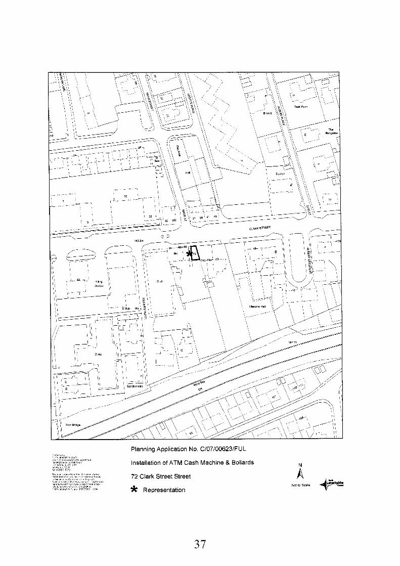
C/07/00623/FUL
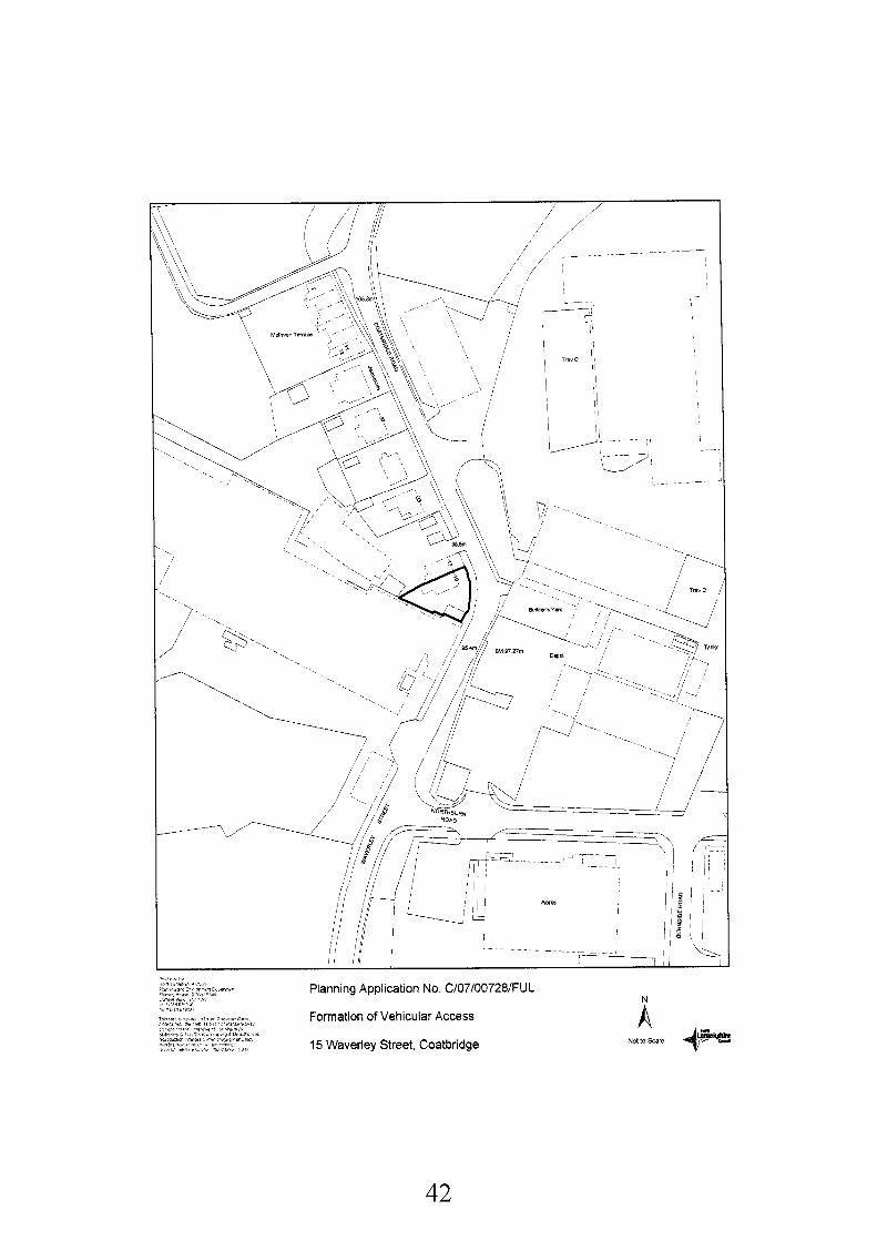
C/07/00728/FU L
C/07/00735/H SC
S/06/01533/OUT
NHS Lanarkshire
Manzuban Mohammed T/A Quickbite
Kevin Boyce
National Grid Plc
Cockspur Property (General Partner) L td
DevelopmenVLocus Recommendation
Construction of Four Refuse (P) Dwellinghouses Request for a Site Site to the North of 2 Nethercroy Road Croy
Visit and a Hearing
Construction of a Dormer Grant and Roof-Top Decking 16 Victoria Crescent Kilsyth
Constructed of Two Dwelling houses Laundry Lane Stepps
Construction of a Dwelling house Adjacent to 148 Chryston Road Chryston
Grant
Grant
Demolition of Existing Ward Grant and Construction of a Two Storey Complex Needs Facility at Coathill Hospital, Hospital Street, Coatbridge
Grant Installation of ATM Cash Machine at 72 Clark Street, Airdrie
Formation of Vehicular Refuse Access at 15 Waverley Street, Coatbridge
Continuation of Hazardous Grant Substances Consent Following a Change in Control of Part of the Land at British Gas Plc, Mollinsburn Road, Annathill, Coatbridge
Construction of 3,020 Grant Square Metre Non-food Retail Units Rannoch Road, Birkenshaw, Uddi ng ston
2
Grant 60 S/06/02032/FUL GMC Homes Ltd Erection of 28 Flatted Dwellings Land To West Of 607 Main Street, Mossend, Bellshill
69 S/07/00308/FUL Lanarkshire Housing Residential Development Grant Association Ltd Comprising of 8 no. Two
Storey Flatted Dwellings and 18 no. Semi-detached Dwellinghouses with Associated Parking and Open Space Land at Unitas Road Pollock Street, Bellshill
78 S/07/00320/CAAD Mr Strickland Certificate of Appropriate Issue CAAD Alternative Development at Land South Of Garrion Cottage, Garrion Bridge, Overtown
Request for Site Visit & Hearing
84 S/07/00321/CAAD Mr & Mrs Burk & Mr Certificate of Appropriate Issue CAAD & Mrs Bell Alternative Development at Request for Site
Land Adjacent To Garrion Hurst And Garrion Mill, Garrion Bridge, Overtown
Visit & Hearing
90 S/07/00499/FUL S M Hargrave Change of Use from Retail to Grant StoragelDistribution Depot 18 North Road, Bellshill
97 S/07/00599/FUL Donald Waring Erection of Two Storey Grant Extension to Side and Conservatory to Rear 29 Marius Crescent, Motherwell
102 S/07/00610/FUL Rea Development Erection of Entrance Canopy Grant Ltd Dalziel Park Golf & Country (In Retrospect)
Request for Site Visit & Hearing
Club, Hagen Drive, Cleland
109 S/07/00700/OUT Mr D Stirling Erection of Detached Refuse (P) Dwellinghouse (In Outline) Land South West of 25 Maryville View, Uddingston
11 5 S/07/00701/FUL Mr Stephen Young Erection of Offices One for Refuse Use as Taxi Radio Base (24 Hour Use) and One With Ancillary Garage and Workshop/Store Land North of, 1 Myrtle Road, Viewpark
N/07/00750/FUL: If granted, refer to Scottish Ministers (Historic Scotland) S/07/00700/OUT: If granted, refer to Scottish Ministers (Contrary to Greenbelt Policy)
3
N/07/00750/FUL Application No:
Date Registered:
Applicant:
Development:
Location:
Ward:
Grid Reference:
File Reference:
Site History:
Development Plan:
Contrary to Development Plan:
Consultations:
Representations:
Newspaper Advertisement:
2nd May 2007
Greenbud Ltd 12 Hurworth Street Falkirk FKI 5GN
Construction of Four Dwellinghouses
Site to the North of 2 Nethercroy Road Croy
1 Kilsyth - Councillors Griffin, Jones and Key
272310676154
0
0
0
91/0024/PL : Residential Development : Granted August 1991 91/0140/PL : Construction of Five Houses : Refused March 1992 N/04/00858/OUT Residential Development. Refused 28'h July 2004 N/05/00972/OUT Construction of 10 Flats. Withdrawn gth November 2005
The site is covered by Village Area Policies and by a Protection of Scheduled Ancient Monument Sites Policy in the Kilsyth Local Plan 1999
Yes
Historic Scotland (Objection) West Of Scotland Archaeology Service (Objection) Scottish Water (Comments)
None
Not Required
Recommendation: Refuse for the Following Reasons:-
1. In the interests of archaeology in that the proposed development will adversely affect the Antonine Wall and its setting; in this respect the proposal is contrary to National Planning Guideline 5 : "Archaeology and Planning" and Development Plan Policies (The Glasgow and the Clyde Valley Joint Structure Plan 2000 : Aim 4 and Strategic Policies 7 and 9; and Kilsyth Local Plan 1999 : Policy BE8) concerning the protection of Scheduled Ancient Monuments and their settings
4
5
2. That the proposed plot layout does not fully comply with the Council's policy on Open Space around new Dwellings; the design of the proposed houses do not fully take account of their positioning on a prominent site on the edge of the village and in close proximity to the Antonine Wall and insufficient information has been provided relative to technical matters such as surface water drainage.
NOTE TO COMMITTEE
If granted, this application will require to be notified to the Scottish Ministers in accordance with the Town & Country Planning (Notification of Applications) (Scotland) Direction 1997 because the proposed development constitutes a significant departure from the Glasgow & The Clyde Valley Joint Structure Plan 2000 and because Historic Scotland have objected as a Statutory Consultee
Background Papers:
Application form and plans received 2nd May 2007
Letter from Historic Scotland received 6th June 2007 Letter from West of Scotland Archaeology Service received 4th June 2007 Letter from Scottish Water received 22nd May 2007
Memo from Traffic & Transportation (Northern Area) received 24th May 2007
Kilsyth Local Plan 1999
Any person wishing to inspect these documents should contact Mr Graeme Lee at 01236 616474.
Date: 14'h June 2007
6

APPLICATION NO. N/07/00750/FUL
REPORT
This application is for a residential development comprising 4 semi detached houses on a site of approximately 0.08 hectares (0.2 acres) to the east of Nethercroy Road, Croy. A public house and a hot food takeaway are located to the south of the site and the access road to the Croy Miners Welfare Club car park forms the northern and eastern boundaries. The site has recently been cleared of vegetation.
The Antonine Wall and related scheduled area occupy the northern half of the site, whilst the remainder of the site is within the general Croy village envelope. Although the Antonine Wall is not physically evident on the application site, its line can clearly be distinguished on nearby land to the east and west.
The submitted site layout shows that 2 of the houses are positioned within the scheduled area. In view of this the applicant was asked to reconsider the proposed development and to exclude the scheduled area from the application site. The applicant was unwilling to change the proposed development and has requested that the application be determined as it stands.
National Plannina Guidance and Development Plan
National Planning Policy Guideline 5 : “Archaeology and Planning” confirms that the preservation of scheduled monuments and their settings is a material consideration in determining planning applications. The Antonine Wall is designated as of national importance, and the PAN states that :- “Scheduled ancient monuments are of national importance and it is particularly important that they are preserved in situ and within an appropriate setting. Developments which would have an adverse effect on scbeduled monuments or the integrify of their settings should not be permitted unless there are exceptional circumstances. ” The Glasgow and the Clyde Valley Joint Structure Plan 2000 has the following relevant Aim and Policies :-
0 Aim 3: The Structure Plan seeks to protect the environmental inheritance of the area.
Strategic Policy 7: The sustainable development of the Structure Plan area requires that particular regard be had to safeguarding and managing international, national and strategic environmental resources. This includes the Antonine Wall.
0 Strategic Policy 9: The proposal is a departure from the Structure Plan in that it does not safeguard the environmental resources covered by Strategic Policy 7.
Kilsyth Local Plan 1999 has the following relevant Policies :-
e BE8: The council will oppose any development which would adversely affect or threaten a scheduled ancient monument or its setting, in particular in the vicinity of the Antonine Wall.
HG3: New residential developments should be in keeping with the scale and character of the surrounding area.
7
3.
3.1
4.
4.1
4.2
4.3
4.4
4.5
Planning History
Since the early 1990’s there have been a number of planning applications related to the application site as follows :-
0 91/0024/PL: Residential Development - Outline planning permission was granted in August 1991 with a condition stating that development must be a specified distance from the line of the Antonine Wall.
0 91/0140/PL: Construction of 5 Dwellinghouses - Permission was refused in March 1992 due to interference with the line and setting of the Antonine Wall.
0 N/04/00858/OUT: Residential Development - Outline planning permission was refused in July 2004, being contrary to the Development Plan and National Planning Guidance due to the impact on the Antonine Wall and its setting.
N/05/00972/0UT: Construction of 10 Flats. Withdrawn gth November 2005 0
Consultations and Representations
Historic Scotland advise that the development proposal directly affects part of the Antonine Wall, a monument of national importance scheduled under the Ancient Monuments and Archaeological Areas Act 1979 and the most substantial and important roman monument in Scotland. It should be noted that the Ministers fully support the nomination of the Antonine Wall as part of a multi-country World Heritage Site covering the Frontiers of the Roman Empire. In addition to the physical protection of the scheduled area of the wall itself, Historic Scotland is also concerned to ensure that the setting of the wall is safeguarded. As a linear frontier system stretching across Scotland from coast to coast it can only be properly understood if its wider setting is kept as unencumbered as possible by modern development
On the basis of the above, Historic Scotland objects and advises that the proposed development does not accord with national planning guidance or development plan policies concerning the protection of scheduled monuments. Also that scheduled monument consent is required for the proposed development and it is considered unlikely that such consent will be granted. Therefore and in the absence of any case in relation to exceptional circumstances which would outweigh the national importance which policy attaches to the in situ preservation of the monument, Historic Scotland objects to the grant of planning permission.
West of Scotland Archaeology Service objected as the proposed development straddles the line of the Antonine Wall and ditch and impinges into the scheduled ancient monument area. They consider that the planning application should be refused on archaeological grounds and because of the adverse impact that the proposed development will have on the setting of the Antonine Wall. The service does indicate that if the application boundary was redrawn to exclude the Scheduled Area then this would address the concerns regarding the setting of the monument and planning conditions could cover the archaeological investigation of the revised development site.
Scottish Water commented that there are constraints issues within their networks that would require to be addressed.
The Forestry Commission (Scotland), whilst not objecting to the proposal, commented on the fact that Nethercroy Road is the only HGV access to their land at Croy Hill
My Pollution Control Section has not yet commented on this application but it should be noted that on previous applications they have indicated that the site lies within close proximity to two
8
4.6
5.
5.1
5.2
5.3
5.4
5.5
5.6
5.7
5.8
closed landfill sites and that before development starts a site investigation survey should be carried out in order to remove or render harmless any contaminants.
My Traffic and Transportation Section does not object to the proposed development provided certain conditions are complied with.
Planning Assessment and Conclusions
In accordance with Section 25 of the Town and Country Planning (Scotland) Act 1997 the determination of planning applications must be made in accordance with the development plan unless material considerations dictate otherwise.
The Antonine Wall and its setting is an archaeological feature of local, national and international importance. It is vital to ensure that it is not adversely affected by inappropriate development. This is especially the case as the Antonine Wall is part of a proposed World Heritage Site.
The proposed development will clearly affect local, national and international interests by having residential development within the scheduled area of the Antonine Wall and affecting its setting. In this respect the proposal is contrary to National Planning Guidance and Development Plan Policies.
The applicant has indicated that the landscaping works at the Miners Welfare building are within the scheduled area and set a precedent. The landscaping and access improvements have been devised by a number of parties working closely together including Historic Scotland. The works have the benefit of scheduled ancient monument consent. There is a clear difference between these works and the proposal to erect two houses within the scheduled area. Historic Scotland has indicated a willingness to work with the applicant to improve the setting of the monument in the same way as has been done at the Miners Welfare.
It should be noted that a planning application is also under consideration for the redevelopment of the Croy Tavern for flats (N/07/00493/FUL). This application raises similar concerns in relation to the Antonine Wall. Initially part of this application site also encroached on the scheduled area of the wall. In view of likely objections from Historic Scotland and the West of Scotland Archaeology Service the application boundary has been redrawn to remove the scheduled area from the application site. This has removed any fundamental policy objection to the proposed development. It was suggested that the applicant in this case may wish to remove the scheduled area from his application site. He was not willing to do this and asked that the application be determined as it stands.
Although it is conceded that no changes have been sought, it should be noted that, given the prominent location of the site on the edge of the village and next to the Antonine Wall, the design of the proposed dwellings should be improved upon. Also, the submitted layout does not fully comply with the Council’s standards on open space around new dwellings.
Having considered this planning application in the above policy context, it is recommended that permission be refused. Should the Committee decide to grant outline planning permission, it will be necessary to notify the Scottish Ministers.
The Committee should also note that the applicant has made a request that a site visit and hearing be undertaken before this application is determined.
9
Application No:
Date Registered:
Applicant:
Agent
Development:
Location:
Ward:
Grid Reference:
File Reference:
Site History:
Development Plan:
Contrary to Development Plan:
Consultations:
Representations:
Newspaper Advertisement:
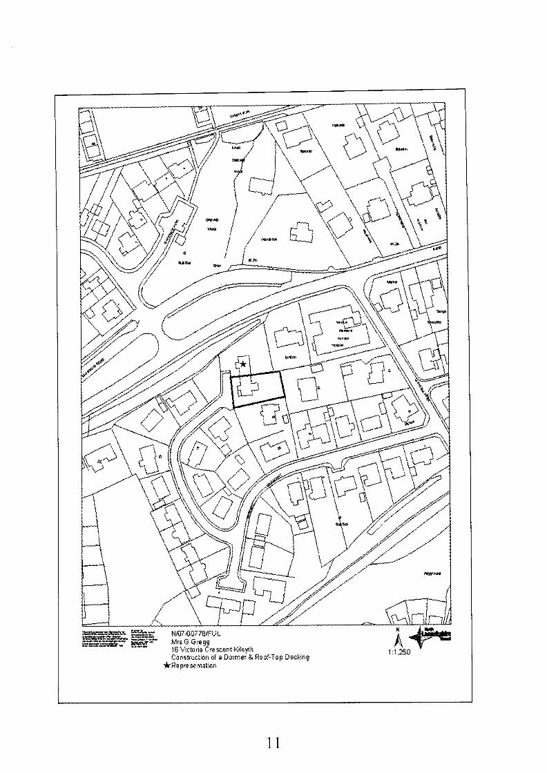
N/07/00778/FU L
8th May 2007
Mrs S Gregg 16 Victoria Crescent Kilsyth G65 9BJ
Aros Design 5A Burnbank Terrace Ki lsyt h G65 OAE
Construction of a Dormer and Roof-Top Decked Area
16 Victoria Crescent Kilsyth
1 Kilsyth - Councillors: Griffin, Jones & Key
270861 677870
N/07/00778/FUL
No relevant history
Kilsyth Local Plan 1999, Policy HG3 applies
No
None
I letter of representation received.
Not Required
Recommendation:
1.
Approve Subject to the Following Conditions:-
That the development hereby permitted shall be started within five years of the date of this permission
Reason: To accord with the provisions of the Town and Country Planning (Scotland) Act 1997.
That the facing materials to be used for the external walls and roof of the dormer, shall match in colour and texture those of the existing building.
Reason: To safeguard the residential amenity of the area.
That before any construction of the rooftop decking area hereby approved commences, amended plans shall be submitted for the approval of the Planning Authority. The amended plans shall detail the screening to be erected along the entire depth of the north facing elevation and for the avoidance of doubt the screen will be solid and will be 2 metres in height when measured from the surface of the deck.
Reason: To enable the Planning Authority to retain effective control and to safeguard the privacy of neighbouring property No. 15 Victoria Crescent.
2.
3.
10
11
4. That before the rooftop decking area is brought into use, the method of screening approved under Condition 3 above, shall be constructed and thereafter retained for the purpose of providing screening.
Reason: To safeguard the residential amenity of the area.
5. That should the method of screening approved under Condition 3 above ever require to be replaced, it shall be replaced using the same materials and shall be constructed to the same specifications as detailed in Condition 3 above.
Reason: To safeguard the residential amenity of the area.
Background Papers:
Application form and plans received 8th May 2007
Letter from Jean Cull, 15 Victoria Crescent, Kilsyth, G65 9BJ received 23rd May 2007.
Kilsyth Local Plan 1999
Any person wishing to inspect these documents should contact Ms Erin Louise Deeley at 01236 616464.
Date: 14'h June 2007
12
AP PLI CAT1 0 N NO. N/07/00778/F U L
REPORT
1.
1.1
1.2
2.
2.1
2.2
3.
3.1
3.2
4.
4.1
Description of Site and Proposal
The application property is a 1.5 storey semi-detached dwellinghouse at Victoria Crescent, Kilsyth. There is an existing single, small scale dormer to the front of the property. There is an existing single storey flat roof rear extension that has a footprint of approximately 20 square metres. When measured from the extension, the garden ground has a depth of approximately 15 metres. The rear garden ground begins to ascend towards the rear. The north elevation of the extension measures approximately 5 metres from the mutual boundary with No. 15. There are established fir trees on the southern boundary of the site and a 2 metre high fence surrounds the rear eastern boundary and northern boundary.
The proposal is for the formation of a single rear dormer measuring approximately 6.4 metres wide and would be positioned predominantly on the on left hand side of the roof when viewed from the rear garden. The purpose of the dormer is to provide additional head room, primarily for the creation of an en-suite that would serve one of two bedrooms previously created as a result of a loft conversion. There is a small window proposed for the en-suite. Patio doors are proposed that would link a small corridor between the bedrooms and the proposed external decking area that would be located on top of the flat roof extension.
Development Plan
This proposal raises no strategic issues in terms of the Glasgow and the Clyde Valley Joint Structure Plan 2000 and can therefore be assessed against local plan policies.
In the Kilsyth Local Plan, the site lies within a defined residential area where policy HG3 (Residential Amenity) applies. This policy seeks to protect residential amenity from inappropriate developments.
Consultations and Representations
No consultations were required in respect of this application.
There has been one letter of objection received from the occupiers of No. 15 Victoria Crescent. The points of objection raised can be summarised as follows:
0 The rooftop decking area will directly overlook into my back garden and will remove all privacy that I currently enjoy.
Comment.' In assessing the plans as submitted, it is considered that when standing or sitting on the rooftop decking area, the occupiers of No.16 would have a full view into the garden ground of No. 15. Although there are no window to window issues, it is considered that the extent of the impact on the neighbouring garden ground is significant enough to merit the requirement of 2 metre high solid screening (when measured from the surface of the deck), along the entire depth of the north elevation of the decking area. A condition has been attached with respect to this.
Planning Assessment and Conclusions
In terms of Section 25 of the Town and Country Planning (Scotland) Act 1997, planning applications must be determined in accordance with the relevant development plan unless material considerations indicate otherwise. In this case, the proposal complies with policy HG3 of the Kilsyth Local Plan 1999.
13
4.2 Although the required screening will reduce the ability to overlook into the rear garden of No.15, it will not completely remove this ability. As the screening is only required on the north elevation, anyone utilising the decking area would have the ability to overlook the lower part of the rear garden of No.15. Notwithstanding this, the impact is not considered detrimental enough to recommend refusal of this application. Furthermore, it is considered unreasonable to attach a condition requiring further screening on the east elevation as this would almost completely obstruct any outlook from the deck on to the applicant’s own garden ground.
4.3 The distance between the proposed decking area and No. 12 Victoria Park is approximately 29 metres and as such there are no window to window issues or privacy issues. There is adequate screening between the application property and No, 23 Victoria Crescent.
4.4 Having considered the merits of this case, it is considered that planning permission be granted subject to conditions.
14
Application No:
Date Registered:
Applicant:
Agent
Development:
Location:
Ward:
Grid Reference:
File Reference:
Site History:
Development Plan:
Contrary to Developm,ent Plan:
Consultations:
Representations:
Newspaper Advertisement:
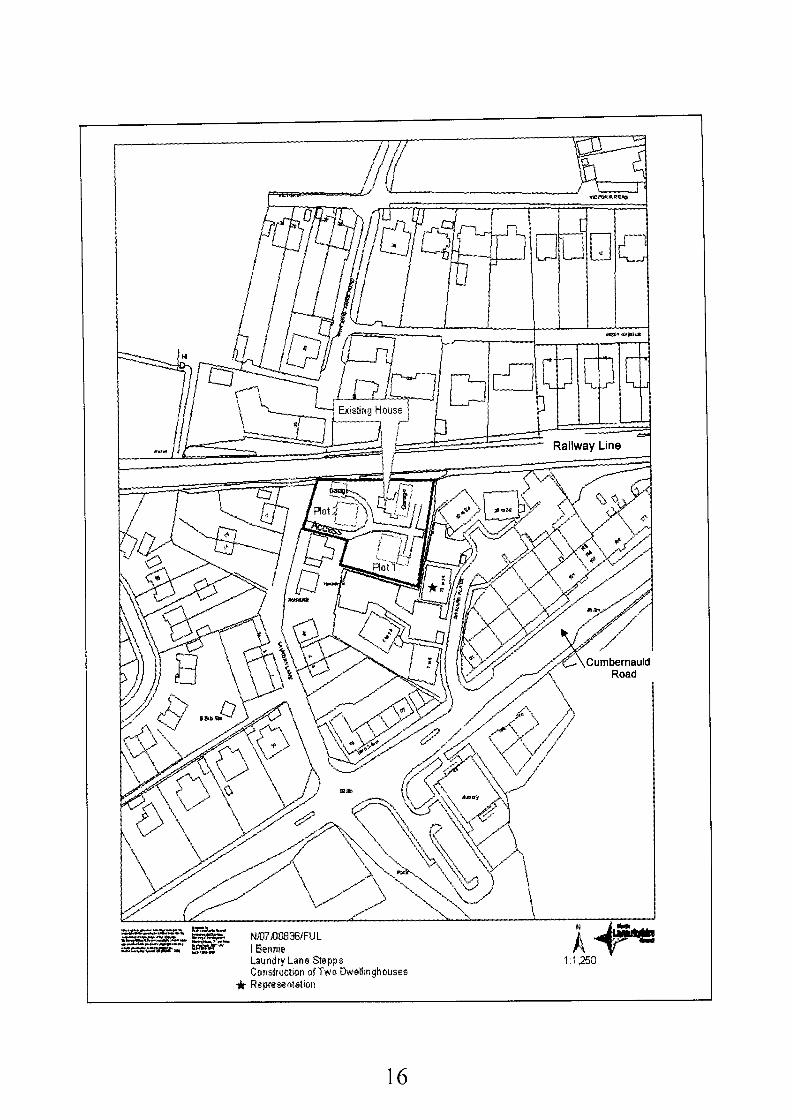
N107/00836/FU L
16th May 2007
tan Bennie Flat 311 53 Bentinck Street Glasgow G3 7TS
Robin Hopkins Architect 16 Fitzroy Place Glasgow G3 7RW
Construction of Two Dwellinghouses and Lock-Up Garages
Stepps Cottage Laundry Lane Stepps G33 6LT
5 Strathkelvin - Councillors Hogg, McGlinchey, Shaw and Wallace
265538668353
N/07/00836/FU L
No recent history
The site is covered by policy HG3 (Protection of Residential Amenity) of The Northern Corridor Local Plan, 2005
No
Scottish Water (Conditions) Network Rail (Comments) Stepps Community Council (No response)
I letter of representation received.
Not Required
Recommendation: Approve Subject to the Following Conditions:-
1. That the development hereby permitted shall be started within five years of the date of this permission
Reason: To accord with the provisions of the Town and Country Planning (Scotland) Act 1997.
15
16
2. That prior to any works commencing on site, the applicant must confirm in writing to the Planning Authority that the foul drainage can be connected to the public sewer in accordance with the requirements of Scottish Water. The surface water must be treated in accordance with the principles of the Sustainable Urban Drainage Systems Design Manual for Scotland and Northern Ireland published by ClRlA in March 2000.
Reason: To prevent groundwater or surface water contamination in the interests of environmental and amenity protection
That before the development hereby permitted starts a scheme providing full details of the improvements to be carried out to the running surface of Laundry Lane shall be submitted to and approved in writing by the Planning Authority.
Reason: To ensure that improvements are carried out to the running surface of Laundry Lane.
3.
4. That before either house hereby approved is occupied the scheme as approved under the terms of Condition 3 above shall be implemented.
Reason: To ensure that improvements are carried out to the running surface of The Lane.
5. That when the development is completed the finished site levels and building finished floor levels shall be as detailed on the approved plans.
Reason: To ensure that the approved site levels are implemented on site.
6. That before the development hereby permitted starts protection measures in accordance with British Standard BS 5837 shall be erected along the drip line of the bushes and shrubs within the application site and shall be retained for the duration of the works on site and only removed with the approval in writing of the Planning Authority.
Reason: To ensure that the interests of general amenity of the area that the established vegetation is protected.
7. That before the development hereby permitted starts details of the surface of the shared access road and driveways shall be submitted to and approved in writing by the Planning Authority and before either house is occupied the access and driveways shall be surfaced in accordance with the approved details.
Reason: To ensure that satisfactory access arrangements are put in place.
That before the development hereby permitted starts, full details of the design and location of all fences and walls to be erected on the site shall be submitted to, and approved in writing by the Planning Authority. For the avoidance of doubt a solid 1.8 metre high fence shall be erected along the entire length of the rail line boundary.
8.
Reason: To ensure that these matters are considered in detail
9. That before either house is occupied, the fences, or walls, as approved under the terms of condition 8 above, shall be erected
Reason: In the interest of the visual amenity of the area
That before the development hereby permitted starts, full details of the facing materials to be 10.
17
11.
12.
13
14.
15.
16.
used on all external walls and roofs shall be submitted to, and approved in writing by the Planning Authority.
Reason: In the interest of the visual amenity of the area
That the houses and garage block shall be constructed using the materials approved under the terms of Condition 10 above.
Reason: In the interest of the visual amenity of the area
That before the development hereby permitted starts and notwithstanding what is shown on the approved plans a revised rear elevation shall be submitted to and approved in writing by the Planning Authority for the house that backs onto 7-12 Edward Place. This house will be constructed in accordance with the revised details.
Reason: In the interest of the visual amenity of the area.
That before the development hereby permitted starts, a scheme of landscaping, including boundary treatment, shall be submitted to, and approved in writing by the Planning Authority in consultation with Network Rail, and it shall include:-
(a) details of any earth moulding and hard landscaping, grass seeding and turfing; (b) a scheme of tree and shrub planting, incorporating details of the location, number, variety and size of trees and shrubs to be planted; (c) except as may otherwise be agreed by the Planning Authority the scheme shall pay particular attention to the southern and eastern boundaries of the application site and shall take account of Network Rail’s requirements for planting in proximity to rail lines.
Reason: In the interests of the visual amenity of the area
That within one year of the occupation of the house hereby permitted, all planting, seeding, turfing and earth moulding included in the scheme of landscaping and planting, approved under the terms of condition 13 above, shall be completed and any trees, shrubs, or areas of grass which die, are removed, damaged, or become diseased, within two years of the completion of the development, shall be replaced within the following year with others of a similar size and species.
Reason: In the interests of the visual amenity of the area
That the use of the garage block and the garages associated with each of the dwellinghouses hereby permitted shall be restricted to private use incidental to the enjoyment of the dwellinghouses on the site and no commercial activity shall be carried out, in, or from, any of the garages.
Reason: In the interests of the amenity of the area
That, notwithstanding the provisions of the Town and Country Planning (General Permitted Development) (Scotland) Order 1992, no internal or external changes shall be undertaken to the garage block without the prior written approval of the Planning Authority.
Reason: To enable the Planning Authority to retain control over future changes to the garage block
Background Papers:
18
Application form and plans received 16th May 2007
Letter from Scottish Water received 25th May 2007 Letter from Network Rail received 18th May 2007 Memo from Traffic and Transportation received 1 lth June 2007
Letter from Anne Sinclair, 18 Edward Place, Stepps, Glasgow, G 3 EN received 23rd May 307.
Any person wishing to inspect these documents should contact Mr Graeme Lee at 01236 616474.
Date: 14'h June 2007
19
AP PLlCAT I0 N NO. N/07/00836/F U L
REPORT
1.
1 .I
1.2
1.3
1.4
1.5
2.
2.1
2.2
3.
3.1
3.2
Description of Site and Proposal
This application proposes the demolition of Stepps Cottage and associated outbuildings on Laundry Lane in Stepps with the site being redeveloped for two houses and a detached garaging block (the applicant has a collection of cars).
The existing building is in a poor state of repair and would require extensive works to modernise it to today’s standards. Although the original part of the building must date back some hundred years or thereabouts, it is not listed and is not of sufficient quality to merit retention.
The two replacement houses (and the garage block) will be accessed from Laundry Lane. Both houses are the same. Both will have 5 bedrooms and are effectively 2 % storeys in height with bedrooms in the roof space. Plot 1 has been formed in the southern part of the site and the house will back onto the car park area for flats 7-12 on Edward Place. Plot 2 is being formed in the north west portion of the site adjacent to ‘Lynholm Cottage’. The proposed garage block will be in the north east portion of the site in the vicinity of the existing house.
The site is 0.2 hectares or 0.5 acres in area. The site is bounded by the Rail Line to the north, the new flats on Edward Place to the east and south and existing residential properties on Laundry Lane to the west. Until recently, when the site was cleared, there was a significant amount of mature vegetation within and on its boundaries. Most of this was removed before the application was submitted, especially the trees within the site and on the eastern and southern boundaries (with Edward Place). Some screening has been retained along the railway boundary and on the western boundaries. The site slopes generally north-south from the rail line down to the boundary with the flats at Edward Place and from the eastern boundary down to Laundry Lane.
Following discussions with the applicant‘s, agent the house on Plot 1 has been moved further north increasing the distance between the house and the site boundary from 6 metres to 9.4 metres. This was done to reduce the amount of underbuilding that would have been required.
Develop rn e n t Plan
There are no issues in terms of the Glasgow and the Clyde Valley Joint Structure Plan 2000 and the application can be assessed against the relevant provisions of the Local Plan.
The site is covered by policy HG3 (Protection of Residential Amenity) of The Northern Corridor Local Plan. 2005.
Consultations and Representations
Network Rail has no objection to the proposed development, but in view of the close proximity of the application site to an operational rail line make a number of points regarding fencing, landscaping, drainage, lighting and working methods.
Comment I am satisfied that where appropriate the planning conditions imposed will protect Network Rail’s interests.
Scottish Water has no objection to the proposed development but point out that there are
20
known constraints issues and a planning condition requiring surface water drainage is recommended.
Comment A planning condition will be imposed.
3.3 Stepps Community Council requested a formal consultation on this application. At time of writing no response has been received, but should the Community Council make any comments these will be reported to the Committee.
My Traffic and Transportation Section has not objected to the proposed development. They advise that Laundry Lane is substandard and serves a significant number of houses and business premises. It is recommended that a turning facility be provided at the end of the road and that the road be improved along is length.
3.4
Comment Although the proposal involves the complete redevelopment of the site, when completed there will only be one additional house. As such, it is not considered necessary or reasonable to require the applicant to secure agreements with or aquire land from neighbouring landowners to form a turning facility. The principle of an upgrade of Laundry Lane has been discussed and the applicant is agreeable to carrying out some improvements to the road so long as the improvements are limited to filling in potholes and the laying of ‘type 1’ material (i.e. not an upgrade to adoptable standards). This is considered reasonable and a condition will be imposed requiring the submission of an improvement scheme.
3.5 One letter of representation has been received from a resident of a top floor flat at 18 Edward Place. The points raised along with my comments are summarised as follows:
I purchased my top floor flat because it did not overlook or was overlooked by residential properties. The proposed development will adversely impact upon my residential amenity and impact upon the value of my property.
Comment Number 18 Edward Place is the block situated immediately to the east of Plot 1 at the south eastern corner of the application site. This block was screened from the site by mature conifer trees that ran along the eastern boundary of the application site. This block is 1.5 metres away from the shared boundary. It should be noted that because the trees were not protected, regardless of any plans to redevelop the site, at any point the owner of the site could have removed the trees that screened the rear of the flats. The removal of the trees has altered the outlook from the flats and has opened up views of the flats from surrounding properties.
The proposed house on Plot 1 has been positioned gable on to the eastern boundary with a single storey garage in between (sited 4 metres from the boundary). The house itself is over 12.6 metres away from the flats. Apart from a side sitting room window at ground level which will look on to the flats at an oblique angle, there is only a toilet window facing the flats. There is a deck to the rear of the house, but this will in part be screened by the garage.
As stated above, the removal of the trees has had a significant effect on the outlook from the flats and although the proposed development will alter the character of the area, it is not considered that the impact on the existing levels of residential amenity will be so significant as to justify refusing planning permission.
The proposed house on Plot 2 is approximately 11 metres in height to the ridge of the roof. The garage is 4.5 metres in height to the ridge and again is gable on to the flats. it should be noted that following discussions with the applicant‘s agent the house has been moved forward on the site so that the rear of the house is in line with the front of the garage. This has the effect of
21
moving the house outside the direct line of sight of the bedroom windows on the adjacent flats. The windows on the rear elevations of the flats are for bedrooms (the lounge and kitchens are to the front). Even given the differences in ground level between the application site and the flats (the flats sit on lower ground approximately 2 metres below the level of the application site) the rear windows on the upper floor of the flats will look over the top of the garage and into the garden ground of the proposed house (the mid point of these windows is approximately 7 metres above ground level). The mid point of the windows on the middle floor of the flats will be approximately 4 metres above ground level so they will look on to the gable wall of the garage. Given the fact that the garage wall will be over 6 metres away this is considered to be acceptable. Nevertheless, the condition regarding the submission of a landscaping scheme will require that this boundary receives specific attention. The outlook from the windows on the ground floor of this block is unaltered as they look on to a retaining wall and fence.
The impact on property values is not a material planning consideration.
4. Plannina Assessment and Conclusions
4.1 In accordance with Section 25 of the Town and Country Planning (Scotland) Act 1997 the determination of planning applications must be made in accordance with the development plan unless material considerations dictate otherwise. In this case I am satisfied that the proposed development accords with the local plan and is otherwise acceptable in planning terms.
4.2 Although the character of the site has been significantly changed by the removal of the mature conifers on the northern, southern and eastern boundaries, the proposed development has been laid out in such a manner so as to minimise the impact on surrounding properties. The garage block will have a minimal impact on flats 19 - 24 Edward Place. The proposed house on Plot 2 has been positioned gable on to ’Lynholm Cottage’ and boundary screening has been retained. This combined with the garden size and distances between the house and surrounding properties will ensure that proposed house will have a minimal impact.
The house in Plot 1 will be the most visible, being overlooked not only by the flats at 13-18 Edward Place (discussed at 3.5 above) but also from flats 7-12 Edward Place. This block is set at an angle to the application site and is separated from the site by a parking court. At the closest the block is set back some 16 metres from the application site. Again there is a difference in levels between the flats and the application site and the proposed house will sit in an elevated position. The house has been moved forward on the site and will be over 9 metres away from the mutual boundary. Therefore although privacy will not be an issue, it should be noted that all but the lower 0.5 metres of the rear elevation of the house will be visible (even with a standard 1.8 metre screen fence along the southern boundary of the site). A landscaping condition will be imposed to require some tree planting along the southern boundary to replace the conifers that were removed and to assist in reducing the visual impact of this block.
As indicated above, the principle of an upgrade of Laundry Lane has been discussed and the applicant is agreeable to carrying out some improvements to the road so long as the improvements are limited to filling in potholes and the laying of ‘type 1’ material (i.e. not an upgrade to adoptable standards). This is considered reasonable and a condition will be imposed requiring the submission of an improvement scheme
4.3
4.4
4.5 The site is within an established residential area. Both houses will have adequate garden ground. The design and layout of the houses is acceptable. Despite the concerns raised by an adjacent resident, I am satisfied that the proposed development will not impact upon the existing properties so significantly as to justify refusing planning permission. Accordingly it is recommended that planning permission be granted
22
Application No:
Date Registered:
Applicant:
Agent
Development:
Location:
Ward:
Grid Reference:
File Reference:
Site History:
Development Plan:
Contrary to Development Plan:
Consultations:
Representations:
Newspaper Advertisement:
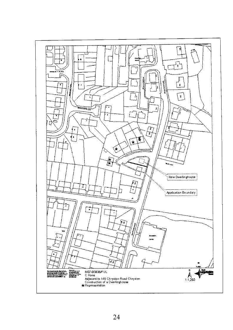
N/07/00838/FU L
17th May 2007
Mr Charles Hone 159 Chryston Road C h ryston G69 9LE
Sconaplans Ltd 26 Howard Court Nerston East Kilbride G74 4QZ
Construction of a Dwellinghouse
Land Adjacent To 148 Chryston Road Chryston G69 9LQ
5 Strathkelvin - Councillors Hogg, McGlinchey, Shaw and Wallace
268924669934
N/07/00838/FUL
No recent history
The site is covered by policy HG3 (Protection of Residential Amenity) of The Northern Corridor Local Plan, 2005
No
6 letters of representation received.
Not Required
Recommendation: Approve Subject to the Following Conditions:-
1. That the development hereby permitted shall be started within five years of the date of this permission
Reason: To accord with the provisions of the Town and Country Planning (Scotland) Act 1997.
23
*Fa epresentatian
24
2. That prior to any works commencing on site, the applicant must confirm in writing to the Planning Authority that the foul drainage can be connected to the public sewer in accordance with the requirements of Scottish Water. The surface water must be treated in accordance with the principles of the Sustainable Urban Drainage Systems Design Manual for Scotland and Northern Ireland published by ClRlA in March 2000
Reason: To prevent groundwater or surface water contamination in the interests of environmental and amenity protection
That before the development starts full details of the existing and proposed finished site levels and building finished floor levels shall be submitted for the written approval of the Planning Authority, following approval these levels will be implemented on site
Reason: To ensure that the site levels are fully considered
That notwithstanding what is shown on the approved plans, before the development starts, a revised plan shall be submitted for the written approval of the Planning Authority detailing the access and parking arrangements for both the proposed house and the existing house and for the avoidance of doubt, the following requirements of the Council as Roads Authority shall be incorporated:
3.
4.
a) A revised layout shall be submitted detailing 2 in-curtilage car parking spaces being formed for both the existing and proposed house b) A visibility splays will be formed at both access points and, except as may otherwise be agreed in writing by the Planning Authority, visibility splays of 2.5 metres by 60 metres shall be formed and thereafter maintained and nothing above 0.9 metres in height will be placed planted or allowed to grow within the visibility splays. c) A visibility splay of 2.5 metres by 60 metres shall be formed and thereafter maintained on the right hand side of the junction of Hillcrest and Chryston Road and nothing above 0.9 metres in height will be placed planted or allowed to grow within the visibility splays d) The first two metres of both driveways shall be hard surfaced over their entire width e) Drainage facilities shall be installed across both driveways to prevent water running onto the public road. f) If gates are proposed they must open into the site and not onto the public footway or road.
Reason: In the interests of pedestrian and road safety and to ensure that there is adequate parking within the plot
That before the house is occupied the access and parking arrangements as may be approved under the terms of Condition 4 above for both the existing and proposed house will be implemented and thereafter the visibility splays and parking areas shall be retained
Reason: In the interests of pedestrian and road safety and to ensure that there is adequate parking within the plot
5.
6. That before the development hereby permitted starts, full details of the design and location of all fences and walls to be erected on the site shall be submitted to, and approved in writing by the Planning Authority
Reason: To ensure that these matters are considered in detail
7. That before the house is occupied, the fences, or walls, as approved under the terms of Condition 6 above, shall be erected
Reason: In the interest of the visual amenity of the area
25
8.
9.
10.
11.
That before the development hereby permitted starts, full details of the facing materials to be used on all external walls and roofs shall be submitted to, and approved in writing by the Planning Authority.
Reason: In the interest of the visual amenity of the area
That the house shall be constructed using the materials approved under the terms of Condition 8 above
Reason: In the interest of the visual amenity of the area
That before the development hereby permitted starts, a scheme of landscaping, including boundary treatment, shall be submitted to, and approved in writing by the Planning Authority, and it shall include:-
(a) details of any earth moulding and hard landscaping, grass seeding and turfing; (b) a scheme of tree and shrub planting, incorporating details of the location, number, variety and size of trees and shrubs to be planted;
Reason: In the interests of the visual amenity of the area
That within one year of the occupation of the house hereby permitted, all planting, seeding, turfing and earth moulding included in the scheme of landscaping and planting, approved under the terms of Condition 10 above, shall be completed and any trees, shrubs, or areas of grass which die, are removed, damaged, or become diseased, within two years of the completion of the development, shall be replaced within the following year with others of a similar size and species.
Reason: In the interests of the visual amenity of the area
Background Papers:
Application form and plans received 17th May 2007
Memo from Traffic & Transportation received 12th June 2007
Letter from A Love, 20 Hillcrest, Chryston, G69 received 22nd May 2007. Letter from Owner, 18 Hillcrest, Chryston, Glasgow, G69 9LG received 24th May 2007. Letter from Mr & Mrs William John Milligan, 12 Hillcrest, Chryston, Glasgow, G69 9LG received 31st May 2007. Letter from Helen McGinness, 2 Hillcrest, Chryston, Glasgow, G69 9LG received 31st May 2007. Letter from George Clelland, 4 Hillcrest, Chryston, Glasgow, G69 9LG received 31st May 2007. Letter from Mrs Margaret Black, 6 Hillcrest, Chryston, Glasgow, G69 9LG received 31st May 2007.
Northern Corridor Local Plan, 2005
Any person wishing to inspect these documents should contact Mr Graeme Lee at 01236 616474.
Date: 14'h June 2007
26
APPLICATION NO. N/07/00838/FUL
REPORT
Description of Site and Proposal
The application site relates to the side garden ground of 148 Chryston Road, Chryston. The existing property occupies a large corner plot. The side garden ground currently contains an area of hardstanding and a garage. To the north of the site and on higher ground are the properties on Hillcrest. New houses are being constructed opposite the site.
Planning permission is being sought for the construction of a 2 storey dwelling to the side of the existing house and accessed from Chryston Road. The proposed house has 3 bedrooms and will exactly replicate the existing house at 148 Chryston Road. There will be 4 metres between the existing and the proposed house and the ground levels will be altered to ensure that the proposed house will not be higher than the existing house. The house will maintain the existing building line. On the elevation facing Hillcrest there is a bedroom window, a hallway window and the main door to the property.
Development Plan
There are no issues in terms of the Glasgow and the Clyde Valley Joint Structure Plan 2000 and the application can be assessed against the relevant provisions of the Local Plan
The site is covered by policy HG3 (Protection of Residential Amenity) of The Northern Corridor Local Plan, 2005
Consultations and Representations
My Traffic and Transportation section has no objections to the principle of the development but do point out that the proposal as submitted will result in the loss of driveway and in-curtilage parking for the existing house. Conditions are suggested regarding parking, visibility splays and driveway construction and drainage.
Comments: All along the length of Chryston Road there is a mix of on street and in-curtilage parking. Nevertheless, given the new development opposite and the proximity of the site to the junction with Hillcrest, it is considered reasonable that the issue of parking is addressed and a planning condition will be imposed requiring the submission of a scheme demonstrating two parking spaces for each of the properties.
A total of six letters of representation have been received in relation to the development. The points raised and my comments thereon are summarised as follows:
0
0
The proposed house will reduce the view, block and overshadow 20 Hillcrest. The rear windows will look directly into the living room and bedroom windows of 18 Hillcrest resulting in a loss of privacy
Comment The position of the house and the distance between it and the existing properties on Hillcrest is such that it will not overshadow them. The existing dwellings are to the north of, and on higher ground, than the proposed house. Properties 2-16 are all situated a similar distance away from the boundary of the application site - over 18 metres. At the closest the proposed house is no closer than 2.8 metres from the pavement on Hillcrest. As such there will be sufficient distance between the proposed house and the existing houses for privacy not to be an issue. It should be noted that the house is over 35 metres away from 18 Hillcrest.
27
The proposed development will alter the views of the existing properties but this is not a material planning consideration. With regards to outlook, the proposed house will not impact so significantly as to justify refusing planning permission.
Comment It is true that the in recent years there have been a number of new houses built in this area. Indeed the Housing Association houses opposite the application site are still under construction. The fact that there has been development would not justify refusing the current application.
This part of Chryston has had its share of new house building
Comment The loss of the side garden ground is unfortunate but the existing house and the proposed house will have more than adequate garden ground. The proposed house properly relates to the road and in terms of design and appearance it will replicate the existing house (and those in the surrounding area). As such it is my assessment that the proposed house will not alter the character of the area so significantly as to justify refusing planning permission.
The development will ruin the character of this part of Chryston.
There are many other similar properties in this part of Chryston and if permitted a precedent will be set
Comment Each application must be considered on its merits and in this case the proposed house is considered to be acceptable in planning terms.
4. Planning Assessment and Conclusions
4.1 In accordance with Section 25 of the Town and Country Planning (Scotland) Act 1997 the determination of planning applications must be made in accordance with the development plan unless material considerations dictate otherwise. In this case I am satisfied that the proposed house is acceptable in planning terms. The site is within an established residential area. Both the existing house and the proposed house will have adequate garden ground. The design and layout of the house reflects the surrounding properties. Despite the concerns raised by surrounding residents, I am satisfied that the proposed house will not impact upon the existing properties so significantly as to justify refusing planning permission. Accordingly it is recommended that planning permission be granted.
28
Application No:
Date Registered:
Applicant:
Agent
Development:
Location:
Ward:
Grid Reference:
File Reference:
Site History:
Development Plan:
C/07/00608/F U L
17th April 2007
NHS Lanarkshire 14 Beckford Street Hamilton ML3 OTA
SMC Davis Duncan Architects 20 Royal Crescent Glasgow G3 7SL
Demolition of Existing Ward and Construction of a Two Storey Complex Needs Facility
Coathill Hospital Hospital Street Rose h a I I Coatbridge North Lanarkshire ML5 4DN
9 Coatbridge West Councillors Maginnis, Smith and Welsh
273258663570
C/PL/CTH7350000/SMI/EL
00/00234/FUL Alterations To Building 01/01284/FUL Alterations and Extension to Hospital 02/00336/FUL Extension to Dining Area 05/00457/FUL Extension to Day Hospital 99/004OO/FUL Alterations To Roof Of Service Building 07/0047O/FUL Formation of Car Park
The application site is located within the existing hospital grounds, adjacent to Hospital Street and is designated as NHSI (Develop Health Facilities) in the Monklands District Local Plan 1991.
Contrary to Development Plan: No
Consultations: Scottish Water British Gas Scottish Power
Representations: None
Newspaper Advertisement: Not Required
29
Planning Application No. C/07/00608/FU L
Demolition of Existing Ward and Construction of a Two Storey Complex Needs Facility
1
Coathill Hospital, Hospital Street, Rosehall, Coatbridge NottoS-le
30
Recommendation: Approve Subject to the Following Conditions:-
1.
2.
3.
4,
5
6
That the development hereby permitted shall be started within five years of the date of this permission.
Reason: To accord with the provisions of the Town and Country Planning (Scotland) Act 1997.
That before the development hereby permitted starts, full details of all external materials to be used in construction, including walls, roofs, windows, doors, gutters and downpipes, shall be submitted to, and approved in writing by the Planning Authority, including any modifications as may be required.
Reason: To enable the Planning Authority to consider these aspects in detail
That before the development hereby permitted starts, a scheme of landscaping, including boundary treatment, shall be submitted to, and approved in writing by the Planning Authority, and it shall include:- (a) details of any earth moulding and hard landscaping, grass seeding and turfing; (b) a scheme of tree and shrub planting, incorporating details of the location, number, variety and size of trees and shrubs to be planted; (c) an indication of all existing trees and hedgerows, plus details of those to be retained, and measures for their protection in the course of development (d) details of the phasing of these works.
For the avoidance of doubt the existing line of trees which forms part of the west boundary between the dwellinghouses at St Martins Gate shall not be removed.
Reason: To enable the Planning Authority to consider these aspects in detail
That prior to the building hereby permitted first coming into use, all planting, seeding, turfing and earth moulding included in the scheme of landscaping and planting, approved under the terms of condition 3 above, shall be completed; and any trees, shrubs, or areas of grass which die, are removed, damaged, or become diseased within two years of completion of the development, shall be replaced within the following year with others of a similar size and species.
Reason: In the interest of the amenity of the site and the general area.
For the avoidance of doubt the existing line of trees which form part of the west boundary between the building hereby approved and the neighbouring dwellinghouses at 33 and 35 St Martins Gate shall not be removed. Accordingly, before the development starts, tree protection measures in accordance with British Standard BS 5837 shall be erected along the drip line of the trees and shall not be removed without the approval in writing of the Planning Authority.
Reason: In the interests of visual amenity
That before the development hereby permitted starts, revised layout plans shall be submitted to the Planning Authority for its prior written approval and these shall show the following:
a) 9 metre internal junction radii b) The provision of adequate turning facilities for service vehicles c) Pedestrian facilities linking the parking area to the building entrance d) Details of the surface finishes to all parking and manoeuvring areas e) Details of measures to resolve conflict between pedestrians, the disabled parking bays and service vehicles.
Reason: In the interests of vehicle and pedestrian safety, and to resolve potential conflict
31
between pedestrians, the disabled parking area and the servicing vehicles. That prior to the building hereby permitted first coming into use the revised access and parking layout plans as agreed under condition 6 above shall be completed.
Reason: To ensure the provision of adequate parking facilities within the site.
7.
Background Papers:
Application form and plans received 10th April 2007 Monklands District Local Plan 1991, Including Finalised First Alterations A, B & C September 1996
Memo from Transportation received 4'h June 2007 Letter from Scottish Power received 24'h April 2007 Letter from Strathclyde Police received 4th May 2007 Letter from Scottish Water received 4th May 2007 Letter from Scotland Gas Networks received 1 lth May 2007
Glasgow and Clyde Valley Structure Plan 2000
Any person wishing to inspect these documents should contact Ms Susan Miller at 01236 812374.
Date: 14th June 2007
32
APPLICATION NO. C/07/00608/FUL
REPORT
1.
1 .I
1.2
1.3
1.4
1.5
2.
2.1
3.
3.1
Description of Site and Proposal
Planning permission is being sought for the demolition of the existing ward building and erection of two-storey complex needs facility building within the grounds of Coathill Hospital, Hospital Street, Coatbridge.
The site lies within the boundaries of the larger hospital site. The original hospital buildings are of architectural merit, however, they are not listed and do not fall within a conservation area. There are various buildings, extensions and small outbuildings that have been erected within the site at different dates in the past. The site slopes down from the main site entrance at Hospital Street, to the North, down towards the open space and industrial estate to South.
The proposed building is of modern appearance with a flat roof. The building is ‘L’ Shaped, has a footprint of approximately 725 square metres and accommodates 2 full storeys (at a height of 9.2m) and due to the sloping nature of the site 21/2 storeys (1 1.8 metres) in part.
The lower ground floor accommodates the water storage room and air handing equipment room. The ground floor accommodates general living areas (sitting room, lounge, dining room, multi-purpose room, visiting family area), office and reception, staff rooms, kitchens, cleaning and equipment stores. The first floor accommodates 20 en-suite bedrooms, staff office, 2 quiet rooms, utility rooms, cleaning and equipment stores.
The main entrance is located on the North elevation of the building. Staff and visitor parking will be located to the north of the building with 15 parking spaces (3 being disabled bays).
Development Plan
The application site is located within the existing hospital grounds, adjacent to Hospital Street and is designated as NHSI (Develop Health Facilities) in the Monklands District Local Plan 1991. The development represents no strategic issues and therefore the application can be assessed against the local plan.
Consultations and Representations
The transportation section was consulted and submitted the following comments:
(i) The road running parallel to the proposed building should extend beyond the west kerb of the turning area by 25m to provide adequate turning facilities for service vehicles. The proposed arrangement extends to approximately 20 metres beyond this point. (ii) The radius between the access road and the turning area should be increased from approximately 3m to 9 metres. (iii) Internal junction radii should be 9m. (iv) Pedestrian facilities should be provided to link the proposed car parking area to the building entrance. (v) Servicing to the building should be segregated from the main pedestrian/visitor access to the front of the building. Consideration should be given to servicing the building from the rear. This may require the building to be relocated northwards.
33
(vi) Further information should be provided to assess the level of parking proposed for the development. Parking should be provided on the basis of 1 space per 3 beds, + I space per doctor/surgeon, + I space per 3 other staff. Confirmation of the staff numbers should be provided.
3.2
3.3
Scottish Water was consulted and has no objection to the planning application.
Scottish Power was consulted and has advised that an underground transmission cable runs along School Street.
3.4 Scotland Gas Networks was consulted and has not objected to the proposal
3.5 Strathclyde Police provided observations on the Crime Profile of the area and specific security advice for the site.
3.6 Following standard neighbour notification procedures no letters of objection have been received.
4. Planninn Assessment and Conclusions
4.1 The proposals require to be assessed under the terms of the development plan and any other material considerations. In terms of the Monklands District Local Plan I991 the site is located in an area designated as NHSI Develop Health Facilities. This policy supports the development of new health facilities, The principle of this type of replacement building is therefore considered acceptable.
4.2 As noted the original hospital buildings are of architectural merit, however, they are not listed and do not fall within a conservation area. There is a myriad of other buildings, extensions and small outbuildings that have been erected within the site at different dates in the past which all vary in size, scale and design. It is therefore considered that the proposed building despite being of modern appearance would sit satisfactorily amongst the other architectural styles.
The dwellinghouses Nos33 - 42 St Martins Gate, to the west, are the nearest residential properties to the proposed building. The proposed building does not move closer to the western boundary than the existing but is further to the north and increases in height from single storey to two storey. There is only one window (with obscured glazing) on the ground floor west elevation which provides light to a clean utility room. It is considered that this will not cause any privacy issues or overlooking.
4.3
4.4 Due to the proposed buildings orientation and positioning and the offset layout of neighbouring dwellinghouses No.s 42-48 St Martins Gate the 2 storey building will not impact on either the available sunlight or daylight.
4.5 The building passes the standard daylight test in relation to the neighbouring dwellinghouses at 33 and 35 St Martins Gate. The building will, however, impact on the sunlight that these properties receive. A sun-on-ground indicator was used to plot the course of the shadows cast by the building through out the morning in relation to these two properties. The showed that a shadow will be cast across the rear elevation of both properties at 8 am in the morning. However by 9 am the shadow will no longer cast across either of the rear elevations. By 1 Oam the shadow will have receded to the farthest 2 metres of the rear garden ground and by 11 am there will be no shadow cast across either garden. When considering the shadow cast it is important to note that there is an existing line of mature trees along the boundary between the existing building and 33 & 35 therefore these will currently be casting some shadow on the rear garden ground. Taking into the account the foregoing it is considered that the impact on the available sunlight to these properties is not considered significant enough to merit the refusal of this application.
34
4.6 The comments submitted by the Transportation Section are addressed as follows:
0) The distance from the end of the road running parallel to the building is less than 5 metres from the boundary with the neighbouring properties at St Martins Gate. At present there is a line of trees which provides screening of the building. A condition would be placed on any permission requiring the submission of a revised road layout plan incorporating 9m junction radii and pedestrian links to and from the building entrance. Should permission be granted a condition would be attached requesting a revised parking and road layout with a view to resolving any conflict that may be caused by pedestrians, disabled parking spaces and any service vehicles. Due to the nature of the complex needs facility the layout of the proposed building has been designed to give as much residential amenity to the south as possible with ground floor doors opening out onto an area of open space. As such this must be borne in mind when considering any revisions to the servicing arrangements. In terms of the parking provision the layout provides 15 parking spaces (3 of which are disabled). Following the guidance from the Transportation Section the spaces required in respect of the number of beds (20 in total) would amount to 7 parking spaces. Therefore the remaining 8 parking spaces would provide enough parking spaces for approximately 24 members of staff. Planning permission C/07/0047O/FUL was granted on the 30th April 2007 this provided additional car parking throughout the wider hospital grounds. The largest building on site which is due to be demolished is currently used as staff offices and does not at present have any designated parking. For these reasons the parking provision in this case is considered acceptable.
(ii), (iii) & (iv)
(v)
4.7 Taking into account the above information the proposal is considered acceptable in terms of use and location. The building would cause no adverse amenity effects in relation to the neighbouring residential properties or wider surrounding area. No objections have been received and it is therefore recommended that permission be granted subject to the attached conditions.
35
C/07/00623/FU L Application No:
Date Registered:
Applicant:
Agent
Development:
Location:
Ward:
Grid Reference:
File Reference:
4th May 2007
Manzuban Mohammed T/A Quickbite 72 Clark Street Airdrie ML6 6DW
Sigma Blackgrove Farm Estate Bullslane Wishaw Sutton Coldfield 876 9QN
Installation of ATM Cash Machine
72 Clark Street Airdrie North Lanarkshire ML6 6DW
8 Airdrie Central Councillors Devine, Logue and Stocks
276748665457
C/PL/AIC4560000072/SMI/EL
Site History:
Development Plan:
Contrary to Development Plan: No
Consultations:
Representations: I letter of representation.
Newspaper Advertisement: Not Required
Monklands District Local Plan 1991
Recommendation: Approve Subject to the Following Conditions:-
1. That the development hereby permitted shall be started within five years of the date of this permission.
Reason: To accord with the provisions of the Town and Country Planning (Scotland) Act 1997.
2. That the permission hereby granted excludes the anti-ram raid bollards shown on the approved plans.
Reason: The anti-ram raid bollards represent a road safety hazard.
36
Planning Application No. C/07/00623/FUL
Installation of ATM Cash Machine & Bollards
37
3. That the ATM backing panel shall be finished in laminated glazing, or other suitable material to be agreed in writing by the Planning Authority, and not aluminium as shown on the approved plans.
Reason: In the interests of the visual amenity.
Background Papers:
Application form and plans received 16th April 2007
Monklands District Local Plan 1991, Including Finalised First Alterations A, B & C September 1996
Memo from Transportation Section received 7'h June 2007 Letter from R Biggart, 70 Clark Street, Airdrie, North Lanarkshire, ML6 6DW received 24th April 2007.
Any person wishing to inspect these documents should contact Ms Susan Miller at 01236 812374.
Date: 13'h June 2007
38
APPLICATION NO. C/07/00623/FUL
REPORT
1.
1.1
1.2
2.
2.1
3.
3.1
3.2
4.
4.1
4.2
Description of Site and Proposal
Planning permission is being sought for the installation of an Automatic Teller Machine (ATM) at 72 Clark Street, Airdrie. The application site is a ground floor shop unit with residential flats above.
The applicant proposes to install an ATM within the window of the shop front anti-ram raid bollards on the pavement to the front of the shop on Clark Street. The existing building frontage consists of one window and the entrance door.
There are other commercial uses in surrounding ground floor uses nearby.
Development Plan
The application site is located in an area designated as HG9 (Existing Residential Areas) in the Monklands District Local Plan 1991. There are no strategic issues.
Consultations and Representations
The Transportation Section was consulted and has not objected to the installation of the ATM provided that the proposed Guardsman Anti-Ram Raid Bollards are removed from the proposal as they would not be granted permission under Section 56 of the Roads (Scotland) Act 1984 as they represent a road safety hazard.
Following standard neighbour notification procedures one letter of representation has been received. The main points of objection are summarised below:
(a)
(b)
(c)
(d)
There would be noise from members of the public withdrawing cash at all times of the night. The bollards are there to prevent ram raiders. If they did succeed they would bring down the front of the house. There is a cash machine at Morrison’s (750 yards away) and the shop in Clarkston only 100 yards away. An application for a disabled parking space at the front of the shop has been applied for.
Planning Assessment and Conclusions
Under the Town and Country Planning (Scotland) Act 1997 planning applications require to be assessed against the development plan and any other material considerations. In terms of the Monklands District Local Plan 1991 the application site is located in an area designated as HG9 (Existing Residential Areas) this seeks to protect such areas by opposing development that would adversely affect the amenity of the established housing.
Policy HG9 (existing Residential Areas) states that developments clearly of an ancillary nature (including nursery schools, corner shops, and local health facilities) may be permitted subject to the development satisfying considerations such as amenity, other local plan policies and proven need for the facility The council will encourage the grouping of these ancillary features near local shops and schools.
39
4.3 The location and scale of the ATM machine is considered to accord with the provisions of policy HG9 as it is located within an existing group of commercial properties and the site is a shop unit. The installation of the ATM within the shop window opening removes the existing glazing and replaces it with an aluminium backing panel. The replacement of the window with an aluminium back panel was considered undesirable and following discussions with the applicant's agent it has been agreed that the backing panel will be finished in anti-bandit glass. As the ATM will be operational for 24 hours the agent requested that an obscured acrylic vinyl be affixed to the glazing on the inside of the window to prevent people being able to see inside the shop when it is closed.
4.4 The use of anti-bandit glazing and the obscured acrylic vinyl is considered an acceptable compromise as the existing proportions of the shopfront will be retained and the lights from inside the shop will be visible from Clarks Street during their opening hours.
The points of objection are addressed as follows: 4.5
(a) It is acknowledged that the ATM is likely to increase the amount of people visiting the site outwith the opening hours of the shop unit. However, bearing in mind that Clark Street is a busy main through route, it is considered that the additional vehicular and pedestrian traffic to and from the site will not increase so significantly as to adversely impact on the residential amenity of the residential properties above or within the surrounding area. This is not a material planning consideration. It is acknowledged that there are other ATMs nearby, however, this does not preclude the installation of others. There is existing lay by parking in front of the shop currently used by visitors to the shop. It is not envisaged that the installation of an ATM would affect the application for a disabled parking space.
(b) (c)
(d)
4.6 Due to the location of the site within an existing group of commercial properties it is considered that the ATM will not result in a significant increase in traffic or create parking problems in the surrounding area. It is considered that the proposal generally complies with policy HG9 (Existing Residential Areas) in the Monklands District Local Plan 1991 and will not adversely impact on the residential amenity of the surrounding area. It is therefore recommended that planning permission be granted subject to the attached conditions.
40
Application No:
Date Registered:
Applicant:
Development:
Location:
Ward:
Grid Reference:
File Reference:
Site History:
Development Plan:
C/07/00728/FU L
1 I th May 2007
Kevin Boyce 45 Townhead Road Coatbridge ML5 2HT
Formation of Vehicular Access
15 Waverley Street Green hill Coatbridge North Lanarkshire ML5 2BE
006 Coatbridge North and Glenboig Councillors Clarke, McWilliams, McWilliams, Shields and Wilson
273983666262
C/PL/CTWI 05000/SMI/EL
05/0168O/FUL Erection of Rear Extension and Installation of 2 No. Dormer Windows to Dwellinghouse 06/01473/FUL Re-Roofing in Marley Major
The application site falls within an area designated as HG9 (Existing Residential Areas) in the Monklands District Local Plan 1991.
Contrary to Development Plan: No
Consultations:
Representations: None
Newspaper Advertisement: Not Required
Recommendation:
Refuse for the reason that the proposed vehicular access to Waverley Street will be detrimental to road safety as it is at a point where visibility is significantly below the standard required, due to the road geometry, with no prospect for improvement.
41
42
Background Papers:
Application form and plans received 30th April 2007 Monklands District Local Plan 1991, Including Finalised First Alterations A, B & C September 1996 Glasgow and Clyde Valley Structure Plan 2000
Memo from NLC Transportation received 13'h June 2007
Any person wishing to inspect these documents should contact Ms Susan Miller at 01236 812374.
Date: 14th June 2007
43
AP PLl CAT10 N N 0. C/07/00728/F UL
REPORT
1.
1 .I
1.2
2.
4.1
3.
3.1
3.2
4.
4.1
4.2
4.3
DescriDtion of Site and ProDosal
Planning permission is being sought for the creation of a vehicular access at 15 Waverley Street, Coatbridge. The application site is a semi-detached traditional dwellinghouse located in a small residential pocket designated as HG9 (Existing Residential Areas) in the Monklands District Local Plan 1991.
Vehicular access to the dwellinghouse is currently shared with the adjoining property (No.17) and is located to the north of No.17.There is an existing single storey garage, which forms part of the property boundary onto Waverley Street, which the applicant intends to demolish to provide the vehicular access.
The application site falls within an area designated as HG9 (Existing Residential Areas) in the Monklands District Local Plan 1991. There are no strategic issues.
Consultations and ReDresentations
The Transportation Section was consulted and has recommended that the application be refused on the following grounds:
The maximum visibility achievable from the proposed site access, 2.5m x 30m to the left along Waverly Street is substandard as the minimum visibility requirements along Waverley Street is 2.5 x 120m in both directions.
Following standard neighbour notification procedures no letters of representation have been received.
Plannina Assessment and Conclusions
The application site falls within an area designated as HG9 (Existing Residential Areas) in the Monklands District Local Plan. Reference is made to accesses in the associated Design Guidance on House extensions. Whilst this relates specifically to Garages and their accesses it is the most relevant guidance in this case. It states that the access must be from a safe point of the road ie away from road junctions and having good visibility to the satisfaction of the Transportation Section.
Waverly Street forms part of the road linking Coatbridge to Glenmavis the 6803. Whilst the dwellinghouse is located in a residential pocket to the West of Waverley Street there is an established industrial area which surrounds it on both sides of the 6803. The 6803 is a busy road with a number of large industrial vehicles using this stretch to access the industrial units and to link into the A73 east of Glenmavis.
The existing garage forms part of the property boundary facing onto Waverly Street. From the information available, including the lack of a dropped kerb, it is clear that the garage has not been accessed from Waverley Street for quite some time, if ever.
44

4.4 The proposed access is located on a significant bend in the road and it is considered that the poor visibility achievable at this location, its proximity to other vehicular accesses and the industrial vehicles entering and exiting the industrial estate would combine to create an extremely unsafe situation for all traffic on this busy route. On this basis it is recommended that planning permission be refused.
45
Application No:
Date Registered:
Applicant:
Agent
Development:
Location:
Ward:
Grid Reference:
File Reference:
Site History:
Development Plan:
C/07/00735/HSC
30th April 2007
National Grid Gas Plc Reg'd Office 1 - 3 The Strand London WC2N 5EH
RSK Environment Ltd Green Farm Business Park lronacton BS37 9TS
Continuation of Hazardous Substances Consent Following a Change in Control of Part of the Land
British Gas Plc Mollinsburn Road Annathill Coatbridge
07 Airdrie North Councillors C Cameron, S.Coyle J McGuigan, T Morgan 274205668459
C/PL/ANM650/CM/EL
01/00964/FUL Installation of Three Containers within Enclosed Compound (in Retrospect) 05/00415/FUL Installation of New Demethaniser Tower and Coldbox (As Part of New Replacement Liquefacation Process Plant) 06/01242/FUL Replacement of Site Perimeter Security Fence with 4 Metre High Pallisade Electric Fence
Contrary to Development Plan: No
Glasgow and Clyde Valley Structure Plan 2000 Monklands District Local Plan 1991, Including Finalised First Alterations A, B & C September 1996
Consultations: Scottish Natural Heritage Scottish Environment Protection Agency Health and Safety Executive British Gas Scottish Power Fire Safety Officer Glenmavis Community Council SEPA
Representations: No letters of representation received.
(No Objection) (No Objection (No objection) (No Objection) (No Response) (No Response (No Objection) (No Response)
Newspaper Advertisement: Not Required
46
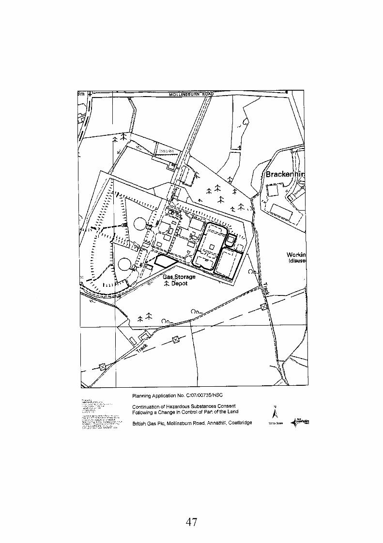
47
Recommendation: Approve Subject to the Following Conditions:-
1. That the Hazardous Substances Consent shall continue in accordance with the standard conditions, as applicable, of Schedule 3 of the Town and Country Planning (Hazardous Substances)(Scotland) Regulations 1993
Reason: In order to comply with the safety requirements of the Health and Safety Executive
Background Papers:
Application form and plans received 30th April 2007
Letter from Scottish Natural Heritage received 14th May 2007 Letter from Health and Safety Executive received 2nd May 2007 Letter from Scotland Gas Network received 2gth May 2007
Glasgow and Clyde Valley Structure Plan 2000 Monklands District Local Plan 1991, Including Finalised First Alterations A, B & C September 1996
Any person wishing to inspect these documents should contact Mr Colin Marshall at 01236 812376.
Date: 14th June 2007
48
APPLICATION NO. C/07/00735/HSC
REPORT
1.
1.1
1.2
1.3
2.
2.1
3.
3.1
4.
4.1
Description of Site and Proposal
An application for Hazardous Substances Consent is required due to a change to the person in control of part of the Gas Storage Depot at Glenmavis. The Depot is currently operated by National Grid Gas plc (formerly Transco plc) and it is proposed that operational responsibility for part of the site would be transferred to Scottish Gas Network plc as part of a business transfer
The operations taking place at the depot have not changed since the existing HSC consent for the Glenmavis Gas Storage Depot was previously granted to Transco plc.
The plan submitted with the application outlines in red the area of the plant which would be operated by Scottish Gas Network Network plc. There are no other changes to the operation Of the plant.
Development Plan
The application site falls within an area covered by Policy GB1 (Restrict Development in the Green Belt) of the Adopted Monklands District Local Plan 1991, There are no strategic planning issues.
Consultations and Representations
There was no objection from the Health and Safety Executive, Scottish Gas, Scottish Natural Heritage. The Secretary of Greengairs Community Council verbally advised they had no objection. At the time of consideration of the application there was no response from the Fire Safety Officer, Scottish Power or SEPA. There were no representations.
Planning Assessment and Conclusions
Essentially the proposals represent an alteration to the management circumstances at the gas depot with no alterations to the plant itself. Therefore there are no planning issues to address. There would be no amenity concerns and although some consultees failed to respond timeously, it is considered there would be no detriment to the functions or responsibilities of these statutory consultees. It is therefore recommended that Hazardous Substances Consent be granted subject to condition.
49
S10610153310UT Application No:
Date Registered:
Applicant:
Agent
Development:
Location:
Ward:
Grid Reference:
File Reference:
Site History:
Development Plan:
Contrary to Development Plan:
Consultations:
Representations:
Newspaper Advertisement:
13th September 2006
Cockspur Property (General Partner) Ltd 1 Cabot Square London E14 4QJ
Comprehensive Design Architects 299 West George Street Glasgow G2 4LF
Construction of Four Non-food Retail Units Totalling 3,020 Square Metres Gross Floorspace (In Outline)
Rannoch Road Birkenshaw Uddingston North Lanarkshire
13 Thorniewood: Councillors Burrows, McCabe and McShannon
269564662240
SIPLIBI9I74ILCIMM
None relevant
The Adopted Uddingston and Tannochside Town Map 1973 zones the site as an area primarily for industrial use.
The Southern Area Local Plan Finalised Draft zones the site as RTL 1 (Retail Development Opportunities)
Glasgow and The Clyde Valley Joint Structure Plan 2000 - Strategic Policies 6(c), 9, and 10 are relevant.
No
Scottish Environment Protection Agency (Comments) Scottish Water (Comments)
Two letters of representation were received.
Advertised on 21st September 2006
Recommendation:
1.
Approve Subject to the Following Conditions:-
That the development hereby permitted shall be started, either within 5 years of the date of this permission, or within 2 years of the date of which the last of the reserved matters are approved, whichever is the later.
50
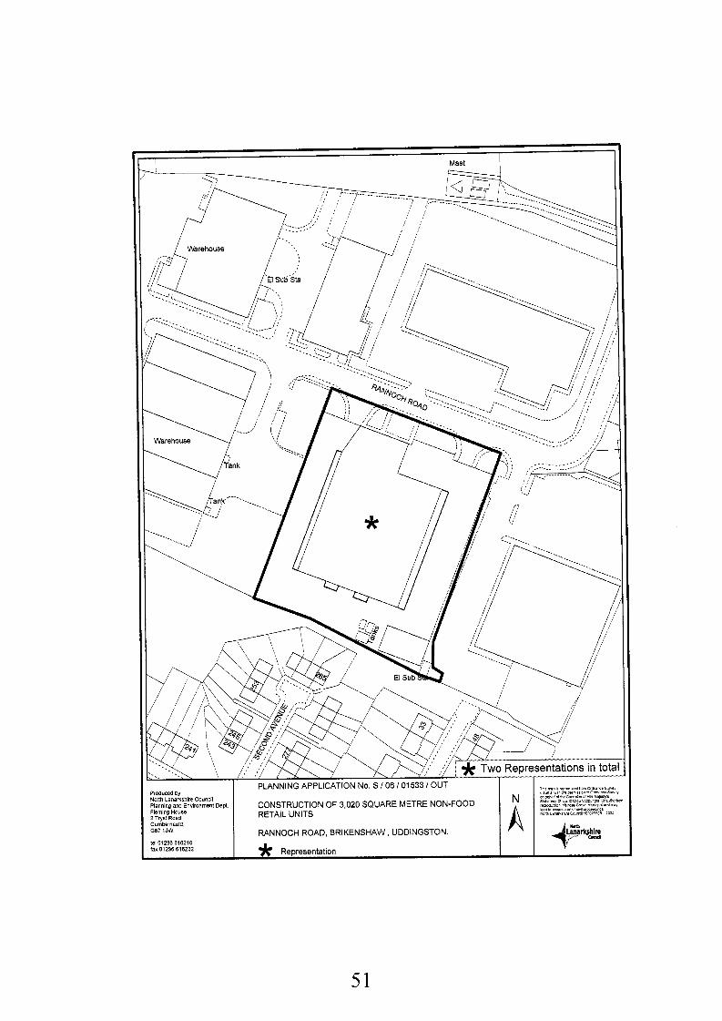
Mast I
Produwd by North Lanarkshire Counal Plannino and Environment Dept 1 CONSTRUCTION OF 3,020 SQUARE METRE NON-FOOD
RETAIL UNITS
RANNOCH ROAD, BRIKENSHAW , UDDINGSTON
FlemingHaure 2 Tryst Road Cumbemauld 067 i JW
lei 01238 816210
lax 01236 816232 * Representation
51
Reason: To accord with the outline permission.
2.
3.
4.
5.
6.
7
That within three years of the date of this permission, an application for approval of the reserved matters, specified in condition (1) above, shall be made to the Planning Authority.
Reason: To accord with the provisions of the Town and Country Planning (Scotland) Act 1997.
That before development starts, a further planning application shall be submitted to the Planning Authority in respect of the following reserved matters:- (a) the siting, design and external appearance of all buildings and other structures; (b) the means of access to the site; (c) the layout of the site, including all roads, footways, and parking areas; (d) the details of, and timetable for, the hard and soft landscaping of the site; (e) the design and location of all boundary walls and fences; (f) the provision of drainage works; (9) the disposal of sewage; (h) details of existing and proposed site levels.
Reason: To enable the Planning Authority to consider these aspects in detail.
That as part of the submission under the terms of condition (I), (2) and (3) above a scheme of landscaping and boundary treatment for the site, shall be submitted to, and approved in writing by the Planning Authority, and it shall include: - (a) details of the proposed earth works, hard landscaping, grass seeding and turfing; (b) a scheme of tree and shrub planting for the land to be subject to the earthworks as well
as the soft landscaping of the frontages of the site and within the car park, incorporating details of the location, number, variety and size of trees and shrubs to be planted;
(c) an indication of all existing trees and hedgerows, and measures for their protection in the course of development.
This scheme shall include the retention of the existing peripheral landscaping around the southern boundary of the site.
Reason: To enable the Planning Authority to consider these aspects in detail.
That the reserved matters application required in condition (1) above shall include, full details of the location and design of the surface water drainage scheme to be installed within the application site shall be submitted to and for the approval of the Planning Authority, and for the avoidance of doubt the scheme requires to be approved by the Scottish Water and the Scottish Environment Protection Agency in terms of their principles of Sustainable Urban Drainage Systems.
Reason: To enable the Planning Authority to consider these details and to safeguard the amenity of the area, to prevent groundwater pollution and to ensure that the proposed drainage system complies with the latest SEPA guidance.
That before the development hereby permitted starts, tree protection in accordance with British Standard BS 5837 shall be erected along the drip line of trees on the southern boundary of the site and shall not be removed without the approval in writing of the Planning Authority.
Reason: In order to safeguard the trees in the interests of the visual amenity of the site and surrounding area.
That before the development hereby permitted starts, a report describing the soil and ground conditions prevailing over the application site (including details of the nature, concentration and distribution of any contaminants), shall be submitted to the Planning Authority and the works required in order to remove or render harmless these contaminants, having regard to the
52
proposed use of the site, shall be agreed in writing with the Planning Authority, and development shall not be commenced until these works have been completed.
Reason: To ensure the site is free of contamination.
8. That the application submitted in accordance with condition (3), shall include the following details; (a) The existing junction at the east end of the development's Rannoch Road frontage shall
be reinstated to footway, with a full upstand carriageway kerbline, and this footway shall be 2 metres in width.
(b) A 2 metre wide length of footway adjacent to the staff parking (c) A 30 metre diameter turning circle
Reason: In the interests of road and pedestrian safety.
9. For the avoidance of doubt, the design, installation and operation of any ventilation/cooling/heating/extraction system or any other plan equipment shall be such that any noise generated, when measured within any nearby dwelling (with windows open), complied with the requirements of the Environmental Protection Act 1990 and in particular, shall not exceed the equivalent of Noise Rating Curve NRC35, between the hours of 7.00am and 8.00pm and Noise Rating Curve NRC 25, at all other times.
Reason: To safeguard the residential amenity of the area.
10. That notwithstanding that this permission is in outline only, the provisions of the Town and Country Planning (Use Classes) (Scotland) Order and the generalities of Condition 2, the use of the Class 1 (Retail) Units hereby approved shall be restricted to the sale of the following categories of goods: - DIY, furniture, carpets, electrical, gardening, pet supplies or such other bulky goods that may first be approved in writing by the Planning Authority.
Reason: To restrict the size of the development and clarify the use of the unit, in view of the potential impact on the Town Centre and adjoining retail units.
Background Papers:
Application form and plans received 13th September 2006 Retail Impact Assessment received 1 5'h March 2007
Memo from Transportation Team Leader, received 2gth September 2006 Memo from Geotechnical Team Leader received 19th October 2006 Memo from Head of Protective Services received 13th October 2006 Letter from Scottish Environment Protection Agency received 30th October 2006 Letter from Scottish Water received 21 st September 2006
Letter from Marley Extrusions, received 2gth September 2006 Letter from Turner Morum Chartered Surveyors, on behalf of Marley Extrusions, received 21" May 2007
Glasgow and the Clyde Valley Joint Structure Plan 2000 Adopted Uddingston and Tannochside Town Map 1973 Southern Area Local Plan, Finalised Draft (Modified 2001, 2004 and 2005)
Any person wishing to inspect these documents should contact Mrs Lesley Carus at 01698 302142.
53
APPLICATION NO. S/06/01533/OUT
REPORT
1.
1 .I
1.2
1.3
2.
2.1
2.2
2.3
3.
3.1
3.2
Description of Site and ProDosal
This application seeks outline planning permission for the erection of four class one retail non- food units totalling 3,020 square metres in a single building at Rannoch Road, Birkenshaw. The site is located at the eastern end of Birkenshaw Trading Estate, and is currently occupied by a 3,609 square metre general industrial building operated by Marley Extrusions. This building is approximately 8 metres in height, with single storey office accommodation to the front. There is also a garage building on the south east corner of the site. The remaining hardstanding within the site is currently used for storage.
The site is accessed from Rannoch Road, with an existing access at the eastern end of the site. Egress from the site is taken from the western end, and thus a one-way system operates. An indicative site layout has been submitted showing the units located towards the south of the site with car parking to the front and servicing to the rear. Access is proposed from Rannoch Road, where the existing egress from the site exists. The indicative layout also illustrates that the four units will all be contained within one larger unit, although will vary in floorspace.
Given the position of the site within the wider context, it should be noted that the surrounding land uses are very varied. To the south of the site lie residential properties and to the north, east and west lie large retail units. Further east lies Aitkenhead School, and residential properties lie to the north-east. In terms of the topography of the site, it is relatively flat, although there are some level differences with adjoining retail units, particularly those to the west, that sit lower than the site.
Development Plan
Due to the size of the proposed development, it is considered to be strategic as it falls within the threshold of a significant development, as stated in Schedule 10 of the Glasgow and Clyde Valley Joint Structure Plan 2000. Therefore policies 6(c), 9 and 10 are relevant in assessing the application.
The Adopted Uddingston and Tannochside Town Map 1973 zones the site as an area primarily for industrial use.
The Southern Area Local Plan Finalised Draft zones the site as RTL 1 (Retail Development Opportunities).
Consultations and Representations
Scottish Water advised that there is sufficient capacity at the Glassford Treatment Works to serve this development. However, there are known constraints within the waste water network, and the developer is required to demonstrate that the development will not impact on Scottish Water’s assets, or implement suitable infrastructure to support the development. In addition, Scottish Water recommends that a separate drainage system is required with the surface water discharging to a suitable outlet, and the principle of SUDS is recommended in this regard.
SEPA advised that all foul drainage from the site should be connected to the public sewer. Written assurance from Scottish Water would be required confirming that additional flow arising from this development will not cause or contribute to the premature operation of consented
54
storm overflows. In addition, SEPA reiterated that surface water should be treated in accordance with the principles of SUDS.
The Geotechnical Team Leader commented that there are no records of flooding in the vicinity of the site. However, the absence of flood reports should not be interpreted as an absence in flood risk.
3.3
3.4 The Transportation Team Leader had no objections, subject to condition relating to; the existing junction at the east end of the development’s Rannoch Road frontage should be reinstated to footway; there should be a 2 metre wide length of footway adjacent to the proposed ‘3 staff spaces’; the service yard should have a 30 metre diameter turning circle; 151 parking spaces would be required to serve the development, where only 149 are shown. However this is indicative and not to be part of this application.
Protective Services commented that a comprehensive site investigation would require to be undertaken to assess any potential risks arising from previous site uses. In addition, the design, installation and operation of any ventilation/cooling/heating/extraction system, or any other plant and equipment shall comply with the requirements of the Environmental Protection Act 1990. It was also advised that due to the close proximity of the site to residential properties, servicing and delivery times should be restricted to between 8am and 8pm Monday to Friday, and the road layout should be designed to minimise the amount of reversing required. Finally, they advised that a note should be placed on any consent restricting the production of noise during construction periods, and that precautions should be taken if the building is demolished and asbestos is found to be present.
3.5
3.6 Following neighbour notification, two letters of objection were received. The first letter, received from Marley Extrusions in September 2006, advised that although this unit is currently leased by Marley Extrusions, the lease expires in 28 years. The unit currently serves the Scottish market and employs 33 people, and therefore Marley Extrusions have no desire to move from this site. Following the submission of a Retail Impact Assessment, the second letter was received from Turner Morum on behalf of Marley Extrusions. This letter criticised the Retail Impact Assessment, disputing the comments that retail development of this site would remove the risk of conflict between the existing use and the residential amenity of nearby housing. Turner Morum state that Marley Extrusions has never received any complaints from adjacent residents, and advises that Marley’s working week is limited to Monday to Friday, and their total hours of operation are less than most retail stores as the unit is closed at weekends, public holidays and over the festive season. Turner Morum also reiterate the point raised in the first letter that Marley Extrusions have no desire to move from the property as the lease does not expire for another 28 years.
4. Plannina Assessment and Conclusions
4.1 Section 25 of the Town and Country Planning (Scotland) Act 1997 requires that planning applications are determined in accordance with the development plan unless material considerations indicate otherwise. This application raises issues of a strategic and local nature and therefore must be considered in terms of both the Structure Plan and Local Plans for the area.
4.2 Since the development exceeds 2,000 square metres of comparison floorspace, the proposal is considered to be of a strategic scale, as per the thresholds set in the Glasgow and Clyde Valley Joint Structure Plan 2000. The application therefore requires to be assessed against the terms of Structure Plan Strategic Policies 6, 9 10. If the application fails to satisfy the criteria of Strategic Policy 9, then it is regarded as a departure from the development plan, therefore requiring consideration under Strategic Policy 10.
55
4.3
4.4
4.5
4.6
4.7
4.8
4.9
4.10
4.1 1
Strategic Policy 9 requires consideration of the proposal in relation to three sets of criteria, and these relate to: establishing a case for any development which exceeds the thresholds set out in Schedule 9; ensuring the location is appropriate and; appropriate provision has been made for the developer for infrastructure. In order to justify this proposal, it is necessary to assess the development against the three sets of criteria of Strategic Policy 9 noted above.
In terms of the first criterion, the findings of the RIA, as discussed in paragraph 4.18 below, suggest that there would be no adverse impact arising from this proposal due to available expenditure within the catchment area arising from limited over-trading and leakage of expenditure. Local Plan policy also supports a retail land use, and therefore a case has been established for retail development at this site.
The second criterion relates to the acceptability of the location of this development and requires that a sequential approach be applied to proposals for retail development. The policy states that the location of the development requires to be appropriate in terms of the need to safeguard and promote the vitality and viability of town centres by taking the sequential approach to proposals for retail developments, as set out in Schedule 6 (c)(ii) of Strategic Policy 6, and this is addressed below. It can be concluded, however, that the location of the proposal is acceptable.
In terms of the third criterion, there are no infrastructure constraints affecting this site that cannot be addressed by recommending suitable conditions.
In view of the above, I consider that although the proposals satisfy the main criteria of Strategic Policy 9, an additional aim of this policy is to safeguard and promote the vitality and viability of town centres by taking the sequential approach to proposals for retail developments as set out in Schedule 6(c)(ii) of Strategic Policy 6, and this must also be taken into consideration.
Strategic Policy 6 sets out provisions for the protection, management and enhancement of town centres, including their status as the preferred location for retailing and other community focused activities. Schedule 6(c)(ii) identifies that the sequential approach should be adopted when assessing applications for retailing and other town centre uses. This policy states that first preference for retail developments should be for town centre sites, where sites or buildings suitable for conversion are available, followed by out-of-centre sites which can be made accessible by various modes of transport. Consideration should be applied to whether the range of goods to be sold could be retailed from a town centre or edge of centre site, and developers should demonstrate that they have applied the sequential approach by showing that town centre sites have been thoroughly assessed, before edge-of-centre locations are considered. This issue is addressed in paragraph 4.18 below. Nevertheless, since the application site is not located within a town centre, it is considered contrary to Strategic Policy 6, and therefore the application requires to be assessed against Strategic Policy 10.
Strategic Policy 10 gives consideration to the appropriateness of the development having regard to; evidence of a shortfall in the existing and planned supply of land for retail development within the appropriate catchment area: the contribution the development would make to remedying any qualitative deficiencies in existing retail provision and; specific locational need. Consideration must also be given to the economic, social and environmental benefit of the proposal. In terms of assessing this proposal against Strategic Policy 10, quantitative and qualitative analysis of the shopping catchment area and impact of the development is considered under the assessment of the Retail Impact Assessment, and this is examined below.
Overall, it is considered that although the site is considered to be an out-of-centre location under the terms of the sequential test, the established retail nature of this site within the Birkenshaw Trading Estate allows the principle of retail development at this location to be acceptable.
The Uddingston and Tannochside Town Map 1973 zones the site for industrial purposes.
56
4.12
However, since the adoption of this plan, the nature and use of the area has changed through the granting of various planning consents, and it is considered that it is no longer relevant in assessing applications at this location.
The Southern Area Local Plan Finalised Draft (Modified 2001, 2004 and 2005) offers more contemporary guidance for assessing applications at this location. The site is zoned as RTLI (Retail Development Opportunities), and this policy directs major retail developments (over 2,000 sq metres gross) to established Town Centres. Town centres have been the focus of considerable investment and provide their catchment populations with a diverse range of retail and commercial services, and out-of-town retail developments should be discouraged. However, as this site is specifically identified as a Retail Development opportunity, the proposed commercial use of the site would accord with the local plan land use designation. If the development is suitably restricted to non-food bulky goods, the development can be considered to comply with the terms of RTLI.
4.13 Policy RTL 4 (Assessing Applications for Retail Development) is also relevant in assessing this application. This policy states that in determining applications for Class 1 Retail Development, the Council will consider the following;
1) whether the proposal could be supported by the appropriate catchment population; 2) the effect on the vitality and viability of existing shopping centres: 3) the availability of suitable alternative sites in or around town centres; 4) the extent to which the proposals would be accessible by public transport and their effects
on travel patterns by motor car; 5) the suitability and impact of the proposal on the character and amenity of adjoining
properties and the surrounding environment; 6) detailed design elements such as building height, materials, positioning and access for
pedestrians and disabled people, and; 7) the provisions made for vehicular access, parking, and the impact of the proposal on
pedestrian safety and traffic circulation.
4.14 In assessing this proposal against RTL 4, it is considered that points 1, 2, and 3 have been addressed in the preceding paragraphs. With regards to point 4, the site is currently not served by public transport facilities, although a footpath link to the adjoining residential properties on Sixth Street ensures the development would be within 500 metres of a bus service. There is also good pedestrian links into the site from adjoining areas, and the applicant has indicated that there is scope for providing cycle racks within the site. However, the nature of sales from this site is proposed to be bulky goods, it is anticipated that most customers would arrive by car. Therefore, it is important to ensure that adequate parking is provided within the site, and the area shown on the indicative layout can accommodate an adequate number of spaces. With regards to point 5, the detailed design elements of the proposal, no elevational details have been submitted since the application has been submitted in outline, however it is indicated that the building will be similar to others within the estate. It is considered if planning permission is granted, suitable conditions should be imposed relating to parking and design details. The proposal is considered to be in accordance with RTL 4.
Policy TR13 (Assessing the Transport Implications of Development) is also a consideration. This policy seeks to assess: the level of traffic generated and its impact on the environment and adjoining land uses; the scope to integrate development proposals with existing public transport facilities; the impact of the development on road traffic circulation and road safety; the provisions made for access, parking and vehicle manoeuvring and; the extent to which the development promotes 'access for all', particularly for those with impaired mobility. The Transportation Team Leader has offered no objections to the proposal, subject to conditions regarding the parking provision and turning areas. These matters can be addressed through the imposition of suitable planning conditions. Therefore it is considered that this proposal is in accordance with policy TR 13
4.1 5
57
4.16 Other material considerations which must be taken into consideration in this case include the assessment of the application in terms of SPP 8 (Town Centres and Retailing). The sequential approach is set out in SPP 8, which states that preference should be given firstly to town centre sites followed by edge of centre sites, then to other commercial centres as identified in the Development Plan, and then to out-of-centre sites that can be accessed by a range of Transport facilities. The nearest town centre is Baillieston. The evidence presented in the RIA indicates that there are no town centre sites available for such a development within the catchment area and the only remaining edge of centre site was the subject of an application for a Tesco food store at North Road, Bellshill. In terms of the sequential approach, although this proposal relates to an area defined as a commercial centre in SPP 8, it is largely designated for retail purposes in the draft local plan and has therefore been accepted for retail development. Furthermore this site is located close to existing residential areas, is accessible by pedestrians and buses and would reduce car travel. In terms of SPP 8 such a location is acceptable if the levels of impact upon the vitality and viability of existing centres is shown to be acceptable. Since the nature of the goods is bulky items, I am satisfied that the development would be consistent with the aims of the sequential test. In addition, this policy lists criteria with which developments must satisfy. These include:
(a) sustaining and enhancing the vitality, viability and design quality of town centres, as the most appropriate location for retailing and other related activities ;
(b) maintaining an efficient, competitive and innovative retail sector offering consumer choice, consistent with the overall commitment to town centres; and
(c) ensuring that ways of meeting these objectives are compatible with sustainable development and, in particular, that new developments are located where there are good public transport services, and better access for those walking and cycling, leading to less dependence on access by car.
4.17 In assessing this proposal against national planning policy SPP8 (Town Centres and Retailing), it is considered that while retail developments should generally be directed to town centres it has to be accepted that this site is zoned for retail development and is situated within an area where there are a number of similar developments. Furthermore, the site is accessible by public transport as indicated above, and it can be considered to satisfy the above criteria. In view of this, and as the predicted expenditure will not impact on the existing town centres, the application can be considered to be in keeping with the provisions of SPP 8.
The applicants have undertaken a Retail Impact Assessment (RIA) which considers the impact of the proposal on this site. The includes an assessment of the impact of the development in relation to existing retail parks, namely Hamilton (Palace Grounds), Coatbridge (Faraday), and East Kilbride (Kingsgate), and town centres operating in the catchment area, namely Bellshill and Baillieston. It was concluded that on the basis of the current proposals there is a surplus of available expenditure within the catchment area and that this surplus compares favourably with the projected turnover of the new floorspace. In relation to trade diversion and impact, the assessment has shown that existing protected town centres are essentially convenience-based and that comparison floorspace within the centres does not tend to trade in bulky goods or related items. Hence, the assessment demonstrates that trade is most likely to be diverted to the new floorspace from other retail parks, freestanding warehouses or the existing units within the Birkenshaw Trading Estate. Therefore the impact of the development on the viability and vitality of existing town centres is considered to be acceptable.
In terms of consultation responses the issues raised by the Transportation Team Leader and by Pollution Control can be the subject of conditions should approval be given. Conditions can also be imposed to cover the matters raised by the other consultees, particularly in relation to SUDS and drainage. In response to the points of objection, it is considered that although it is noted that the current
4.18
4.19
4.20
58
lease held by the present occupants expires in 28 years, this is not a material planning consideration and cannot be taken into account when assessing this application. With regards to the points raised in connection to the Retail Impact Assessment, and its comments relating to the conflict between the existing use and the residential amenity of nearby housing are noted. However, this application must be considered on its own merits. Following the assessment Of this application against the development plan, it is considered to be compatible with the surrounding land uses, and the points raised by the objectors do not preclude the granting Of this application.
In conclusion, the application has been assessed against the relevant policies contained within the Structure Plan and was found to be acceptable in land use policy terms. The zoning of the Southern Area Local Plan Finalised Draft (Modified 2001, 2004 and 2005) supports the use of this site as a retail unit. In terms of national planning policy SPP 8 (Town Centres and Retailing), it has been demonstrated that no negative effects will arise from the provision of a bulky goods retail store at this location, and the vitality and viability of the existing town centres within the catchment area will be protected. Furthermore, the proposal would not result in a significant adverse effect on the environment. Therefore I recommend that planning permission be granted, subject to the appropriate conditions.
4.21
59
Application No:
Date Registered:
Applicant:
Agent
Development:
Location:
Ward:
Grid Reference:
File Reference:
Site History:
Development Plan:
Contrary to Development Plan:
Consultations:
Representations:
Newspaper Advertisement:
S106102032lFUL
8th December 2006
GMC Homes Ltd 43 Morris Crescent Motherwell ML1 5NH
Skirling Design Studio 80 High Street lnnerliethen KH44 6HF
Erection of 28 Flatted Dwellings
Land To West Of 607 Main Street Bellshill ML4 1DX
15 Mossend and Holytown: Councillors Coyle, Delaney and McKeown
274661 660382
SIP LIB Fl7l50lLClM M
None relevant, although the site is currently used as a car park and landscaped area.
The site is zoned in the adopted Bellshill and Mossend Local Plan as I1 - Areas where new industrial Development will be Concentrated.
The Southern Area Local Plan Finalised Draft (Modified 2001, 2004 and 2005) zones the site as RTL 9 - Other Commercial Uses.
Yes
British Telecom (Comments) Scottish Water (Comments) British Gas (Comments) Scottish Power (Objections) SEPA (Comments)
1 letter of representation received.
Advertised on 21st December 2006
Recommendation:
1.
Approve Subject to the Following Conditions:-
That the development hereby permitted shall be started within five years of the date of this permission
60
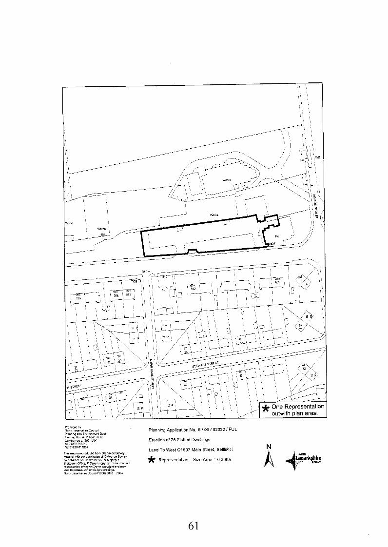
Planning Application No. S / 06 I02032 / FUL
Erection of 28 Flatted Dwellings
Land To West Of 607 Main Street, Belllshill * Representahon Size Area = 0.30ha.
Produced by North Lsnarkshiie Council Plannlng and Environment Dept Fkming HOUSB 2 Tryst Raad C ~ i ~ e i n a ~ l d , 067 1JW tei 03236 616210 fax 01236 616232
Ths map h reproduced tiOmOidnanceSuPley material w t h me pBmiuion of Ordnance SYweY
Siatlonery Onice 0 C r w n Copyrlght Unaiithorlbed repmdudion InfrinyesCmwn Copyrightand may lead to pmseciibon or civil proceedings NOM Lanarkshire Council 100023396 2004
00 behalf of the Contioiiar of Her Ma)erI+
61
Reason: To accord with the provisions of the Town and Country Planning (Scotland) Act 1997
2.
3.
4.
5.
6.
7.
8.
9.
10.
That before the development hereby permitted starts, full details of all external materials to be used in construction, including walls, roofs, windows, doors, gutters and downpipes, shall be submitted to, and approved in writing by the Planning Authority.
Reason: To enable the Planning Authority to consider these aspects in detail.
That notwithstanding the details shown on the approved plans, before the development hereby permitted starts, full details of the design and location of all fences and walls to be erected on the site shall be submitted to, and approved in writing by the Planning Authority.
Reason: To enable the Planning Authority to consider these details.
That notwithstanding the requirement of condition (13) below, for the avoidance of doubt, the boundary treatment adjacent to Main Street shall comprise a facing brick or stone wall and metal railings above, cumulatively not exceeding 1.8 metres in height, and shall not impede the visibility splay, details of which will be submitted to, and approved in writing by the Planning Authority.
Reason: For the avoidance of doubt and to enable the Planning Authority to consider these aspects.
That before any of the flats hereby permitted are occupied, the fences and walls, as approved under the terms of conditions (3) and (4) above, shall be erected.
Reason: In the interests of residential amenity.
That notwithstanding condition (4) above, visibility splays of 2.5 metres x 120 metres shall be provided from the access along Main Street in both directions, and nothing shall be placed or allowed to grow over 1.05 metres in height above carriageway level.
Reason: In the interests of road safety
That before development hereby permitted starts, a right turn storage bay on Main Street shall be provided to serve the site. Full details of this shall be provided for the written approval of the Planning Authority prior to the commencement of works on site.
Reason: In the interest of road safety
That before development hereby permitted starts, a plan showing the relocation of the parking spaces hatched BLUE on the approved plans and the incorporation of a turning head facility within the area hatched YELLOW on the approved plans shall be submitted and approved by the Planning Authority.
Reason: In the interest of road safety
That before the occupation of the first flat, the access, parking and manoeuvring areas as shown on the approved plans and agreed under the terms of condition (8) above, shall be levelled, surfaced and properly drained, to the satisfaction of the Planning Authority.
Reason: In the interest of road safety.
That before the development hereby permitted starts, a scheme of landscaping, including boundary treatment, shall be submitted to, and approved in writing by the Planning Authority and it shall include:- (a) details of any earth moulding and hard landscaping, grass seeding and turfing;
62
(b) a scheme of tree and shrub planting, incorporating details of the location, number, variety and
(c) an indication of all existing trees and hedgerows, and measures for their protection in the size of trees and shrubs to be planted;
course of development.
Reason: In the interests of the visual amenity of the area.
11. That before the development hereby permitted starts, a management and maintenance scheme under the terms of condition (10) above shall be submitted to, and approved in writing by the Planning Authority, and it shall include proposals for the continuing care, maintenance and protection of the landscaped amenity areas, internal lighting and upkeep of communal areas, as shown on the approved plans
Reason: To enable the Planning Authority to consider these details in the interests of amenity.
That before the occupation of the last flat hereby permitted, the management and maintenance scheme approved under the terms of condition (1 1) above shall be in operation.
12.
Reason: In the interests of residential amenity.
That before the occupation of the last eight units within the development hereby permitted, all planting, seeding, turfing and earth moulding included in the scheme of landscaping and planting, approved under the terms of condition (10) above, shall be completed; and any trees, shrubs, or areas of grass which die, are removed, damaged, or become diseased within two years of the completion of the development, shall be replaced within the following year with others of a similar size and species.
13.
Reason: In the interests of the visual amenity of the area.
That before the residential development hereby permitted is completed, the surface water drainage scheme as shown on the approved plans shall be installed, and thereafter maintained in accordance with the approved details.
14.
Reason: In the interests of water quality and the environment.
15. That before the development hereby permitted starts, the applicant shall provide written confirmation to the Planning Authority that all the requirements of Scottish Water have been fully met to demonstrate that the development will not have an impact on their assets and that suitable infrastructure can be put in place to support the development, and in addition, before development commences, full information on post-development overland flow rates from the proposed drainage system for up to a 1 in 200 year storm event, shall be submitted and agreed in writing with the Planning Authority.
Reason: To ensure that there is sufficient capacity in the sewerage and water supply systems to allow the residential development to proceed.
That before the flats hereby permitted are occupied, noise mitigation measures for the site as specified in section 6 of the report by Nicol Acoustic Consultancy shall be implemented in full and before the last flat is occupied, a letter from a professionally qualified source shall be submitted to the Planning Authority confirming that these works have been satisfactorily carried out.
Reason: In the interests of the amenity of residents in adjacent dwellinghouses.
16.
17. That before the development hereby permitted starts, confirmation from a suitably qualified person that the issues raised in the memorandum from Geotechnical Section dated 3rd April 2007 have been addressed and the works required in order to remove or render harmless any
63
18.
19.
20.
contaminants, and development shall not be commenced until these works have been completed.
Reason: To enable the Planning Authority to fully consider this aspect of the development in the interests of future residents.
That any tree removal or cutting shall be undertaken outwith the bird-breeding season (March to September inclusive).
Reason: To minimise the risk to wild birds and their nests to ensure legal compliance with the requirements of the Wildlife and Countryside Act 1981 and the Nature Conservation (Scotland) Act 2004.
That before the development hereby permitted is commenced, full details of the proposed bin stores and recycling points shall be submitted to and approved in writing by the Planning Authority.
Reason: To enable the Planning Authority to consider these aspects.
That before the occupation of the first flat hereby permitted, the bin stores and recycling points approved under the terms of condition (16) above shall be completed.
Reason: In the interests of residential amenity.
Background Papers:
Application form and plans received 8th December 2006
Transportation Team Leader received 15'h December 2006 and Memo from Local Plans Section received 2nd April 2007 Memos from Head of Protective Services received 16th January, lgth April and email received 14'h June 2007 Memo from Geotechnical Team Leader received lo th April 2007 Memo from Community Services dated 7'h February 2007 Letter from Scottish Natural Heritage received 22nd December 2006 Letter from British Telecom received 28th December 2006 Letter from Scottish Water received 22nd December 2006 Letter from British Gas received 28th December 2006 Letter from Scottish Power received 27th December 2006 Email from SEPA received 14" June 2007
June 2007
Letter from W. R. Hall, Chartered Quantity Surveyors and Valuers, Building Surveyors, 7 Main Street, Bothwell, G71 8RD received 19th December 2006.
Adopted Bellshill and Mossend Local Plan 1985 Southern Area Local Plan, Finalised Draft (Modified 2001, 2004 and 2005)
Any person wishing to inspect these documents should contact Mrs Lesley Carus at 01698 302142.
Date: 19 June 2007
64
AP PLlCAT 10 N N 0. S/06/02032/F U L
REPORT
1.
1 .I
1.2
1.3
2.
2.1
2.2
2.3
3.
3.1
3.2
3.3
Description of Site and Proposal
Detailed planning permission is sought for a residential development comprising 28 flats with associated car parking on a 0.29 hectare area of land at The Derby Inn, 607 Main Street, Bellshill. The layout submitted by the applicant proposes flats of 2 and 3 storeys in height, and comprise of both projecting and recessed elevational features with balconies to add visual interest to the building. The blocks are proposed to be set back from the heel of the footway by approximately 5 metres, reducing gradually to 3 metres from east to west and will be finished in brick and render with tiles on the roof. The northern end of the site be used as the parking area for the flats, comprising 36 parking spaces, whilst the southern end will be the location of the flats with soft landscaping used as an entrance feature to the site.
The site is bounded to the west by open space, while industrial premises lie to the north, the Derby Inn lies to the east and residential properties lie to the south. An industrial unit forms part of the northern boundary, while a row of mature conifers and grassed area line the southern boundary, adjacent to Main Street. The remainder of the site is currently used as a car parking area serving the industrial units to the north and the Derby Inn to the east.
The site is currently accessed via an existing entrance from Main Street. Pedestrian access into the site is also via this access.
Development Plan
The,proposal raises no strategic issues in terms of the Glasgow and Clyde Valley Joint Structure Plan 2000 and can therefore be assessed in terms of Local Plan policies.
The site is zoned in the Adopted Bellshill and Mossend Local Plan 1985 as I1 - Areas where industrial developments will be concentrated.
The Southern Area Local Plan Finalised Draft (Modified 2001, 2004 and 2005) zones the site as RTL 9 - Other Commercial Uses.
Consultations and Representations
Scottish Gas Networks, British Telecom and Scottish Natural Heritage indicated that they have no objections to the proposals.
Scottish Power objected to the proposal on the basis that there are underground cables within the vicinity of the proposed development.
Scottish Water have no objections to the proposal, however they advised that planning approval does not guarantee a connection to the infrastructure until a satisfactory solution is identified. There are known constraints in the waste water network and Scottish Water is keen to understand the phasing and timescales of the proposed development in order to examine all options available to allow connection. In addition, Scottish Water recommends that a separate drainage system is required with the surface water discharging to a suitable outlet. The principle of SUDS is recommended for discharging surface water, and following the submission of a SUDS scheme, Scottish Water have confirmed that the design principle is acceptable and can accept surface and foul water into their system.
65
3.4 SEPA have no objections to the proposal since all surface and foul water is being discharged to the public sewer network.
The Transportation Team Leader initially recommended that the application be refused as there were issues with the parking levels, bin store location and vehicle manoeuvring. Following the submission of amended plans, the Transportation Team Leader recommended conditions in relation to visibility splays, access and parking, although concerns remained regarding vehicle manoeuvring, and in particular, the lack of turning facilities within the site.
The Geotechnical Team Leader commented in relation to mineral stability that it would be prudent for the applicant to obtain a coal mining report from the coal authority. In addition, made ground, in association with former land use is commonly present in all urban, built over and landscaped areas. The report submitted by the consulting engineers suggests that an intrusive investigation be carried out to determine the nature, extent and thickness of made ground on the site, as well as the potential for any contaminants or harmful gases, this is reiterated in the comments by the Geotechnical Team Leader. Following the submission of a SUDS scheme, the Geotechnical Team Leader advised that further details would be required in relation to the overland flows, and the developer should demonstrate how the system will operate.
3.5
3.6
3.7 Protective Services advised that a comprehensive site investigation would require to be undertaken. They also advised that a note should be placed on any consent restricting the production of noise during construction periods. A noise assessment was submitted and Protective Services offered no objections to the proposal, provided that the mitigation measures for noise arising from road traffic are implemented in accordance with those stated in the submitted report. Following the submission of a site investigation, the Head of Protective Services commented that although the site has no history of contaminative use, the investigations at the site have identified made ground of unknown origin. Chemical contamination has been identified, although only 5 samples were tested. Constraints have been placed on the reuse of these contaminated materials during redevelopment, but no details of how this is to be achieved or plans for validation testing of redistributed fill are provided. Similarly, no details of precautionary measures to be adopted to protect water supply or drainage from infiltration of contamination from the identified source materials are included in the recommendations. Although it is accepted that there is no evidence of soil gas emissions or migrating contamination from the adjacent former steelworks / chemical works site, the close proximity of such an extensive heavy industrial complex should be acknowledged and vigilance maintained during groundworks in case visual or olfactory evidence of contamination is encountered. It is therefore concluded that additional information should be sought from the applicant to address the issues raised above.
3.8 The Countryside and Landscape Manager raised some concern over the height of the proposed flats and their proximity to the footpath, however offered no objections to the proposal provided that their recommendations were incorporated into the development. These recommendations relate to additional landscaping, planting and wastewater management. It is stated that it would be desirable to retain some of the mature conifer trees adjacent to the footpath, but since the industrial site to the north may be redeveloped, the existing belt of trees could be considered for removal.
3.9 The Executive Director of Learning Services advised that all pupils within the proposed development could be accommodated within existing schools, and therefore had no objections to the proposals.
3.10 Following the standard neighbour notification procedure, one letter of representation was received from a solicitor on behalf of Strockweld Ltd. Strockweld Ltd is a well-established engineering company located within the industrial estate and have purchased two areas of land to the north of the proposed site. The points of objection raised by Strockweld Ltd relate to the establishment of residential accommodation adjacent to a manufacturing industrial estate,
66
contrary to good planning directives; the retention of the public house is questionable considering the fact that the present car parking facilities are not used by the existing public house patrons, therefore Marion StreeUMain Street is used for car parking by the public house patrons, which restricts the entrance to Marion Street Industrial Estate entrance and the removal of the car parking facilities would exacerbate the problem and; that the southern boundary between the Derby Inn and Strockweld Ltd is in dispute.
4. Planninca Assessment and Conclusions
4.1 The proposals require to be assessed under the terms of the development plan and any other material considerations. The proposal raises no strategic issues and therefore can be assessed in terms of local plan policies and other material considerations. In this instance the terms of policies I1 of the Adopted Northern Area Local Plan and RTL 9, HSG 10 and TR 13 of the Southern Area Local Plan Finalised Draft (Modified 2001, 2004 and 2005) are most relevant.
4.2 Policy I1 of the adopted Bellshill and Mossend Local Plan states that new industrial development will be concentrated on the Righead and Bellshill Industrial Estates and within established industrial areas. It is considered that although the area is zoned for industrial use, it is not currently utilised for industrial purposes as it is only a marginal landscapedlcar parking area of insignificant size and therefore there would be no loss of industrial land.
Policy RTL 9 (Other Commercial Uses) states that within these areas, the Council will accept the continuation of such uses. While any changes of use or proposed new uses will be considered in light of the other policies contained within the local plan, particular regard should be given to their potential compatibility with surrounding land uses. In terms of the compatibility of the proposal with surrounding land uses, a noise assessment has been carried out and was found to be acceptable by the Pollution Control Team Leader, subject to conditions. Therefore, the proximity of the development to the industrial area and adjacent public house is acceptable. In addition, the character of the area is a combination of industrial, commercial and residential, with residential properties opposite the site, therefore the principle of residential development on the site is acceptable.
4.3
4.4 Policy HSGl 0 (Assessing Applications for Housing Development) states that in determining planning applications for new housing, the Council will take into consideration: the impact of the development on the existing built and natural environment; density, layout and mix of housing; detailed design elements such as building height, materials and positioning; provision of landscaping, screening and open space; and the provision made for roads, access, parking and garage space; treatment of the existing environmental conditions of the site (mineral and contamination); and measures taken to ameliorate the risk of flooding. When assessing this proposal against the provisions of HSG 10, the development is considered to be acceptable in terms of the impact on existing housing. The proposed flats reflect the existing architecturally diverse properties on Main Street, and when the development is viewed on approach from both directions of Main Street, the undulating height and building line will provide visual interest and enhance the appearance of the wider area. In addition, proposed planting and landscaping will help to enhance amenity afforded to the site. There is no loss of privacy or amenity in relation to the houses to the south of the site on Main Street, as the distance to the closest property is approximately 30 metres. In addition, the development conforms to the Council’s open space guidelines in terms of amenity space within the site. Access, parking and circulation requirements are considered below. Overall, the scale and design of the flats is considered acceptable and complementary to other properties at this locale. Therefore the proposal complies with the criteria of Policy HSG 10.
4.5 Policy TR 13 (Assessing Transport Implications of Development) sets out criteria for the Council to consider when assessing applications for development. These criteria include: the level of traffic generated and its impact on the environment and adjoining land uses; the impact of the
67
development on road traffic circulation and road safety and; the provisions made for access, parking and vehicle manoeuvring. With regard to access and parking provision for the site, it is considered that the location of the access leading into the site from Main Street, coupled with the suitable provision of junction sightlines, would allow vehicles to enter the road network in an acceptable and safe manner. As indicated in paragraph 3.4, the Transportation Team Leader raised concerns over the lack of a turning facility within the site, however, all other details with regards to access and visibility are satisfactory. It is therefore considered that a turning facility can be accommodated within the site and this can be dealt with by the imposition of suitable conditions Therefore it is considered that the development complies with Policy TR 13.
4.6 With regard to the issues raised by the consultees, the developer will be required to satisfy Scottish Water in terms of the impact of the development on the existing infrastructure. In addition, a condition is recommended requiring the developer to ensure that Scottish Water are satisfied with the proposals if Committee grant this application. The objection raised by Scottish Power with regards to the presence of equipment within the vicinity is the responsibility of the developer.
4.7 With regards to the issues raised by the Geotechnical Team Leader, the Head of Protective Services and the Head of Community Services, these can be dealt with by the imposition of suitable conditions, if Committee are minded to grant this application. With regards to the construction noise a note can be placed on any consent, if granted, advising on construction noise.
4.8 With regards to the points of objection relating to noise and incompatibility of the proposed use, I would comment that although there is an established industrial user within close proximity of the site, the applicant has provided sufficient information to satisfy Pollution Control that any noise issues can be dealt with adequately. In addition, as noted above, the site lies within an area where there is a range of uses, and this is reflected in the policy zoning of the site. Furthermore, the access and parking arrangements are satisfactory, and the Transportation Team Leader has no objections subject to conditions. Lastly, land ownership disputes are not material planning considerations and therefore cannot be taken into account when assessing this application. Therefore it is considered that a residential development on this site is suitable and I cannot support the objector’s concerns in this respect.
4.9 To conclude, it is considered that the principle of residential development at this location is acceptable and accords with the zoning of the site. The layout and design of the proposal is in accordance with policies TR 13 and HSG 10. Therefore, the development is deemed to be acceptable and therefore it is recommended that planning permission be granted subject to the attached conditions.
68
Application No:
Date Registered:
Applicant :
Agent
Development:
Location:
Ward:
Grid Reference:
File Reference:
Site History:
Development Plan:
S/07/00308/F U L
26th February 2007
Lanarkshire Housing Association Ltd 191 Brandon Street Motherwell MLI IRS
Austin Smith Lord LLP 202 Bath Street Glasgow G2 4HW
Residential Development Comprising of 8 no. Two Storey Flatted Dwellings and 18 no. Semi-detached Dwellinghouses with Associated Parking and Open Space
Land At Unitas Road / Pollock Street Bellshill Lanarkshire ML4 I Q L
15 Mossend and Holytown: Councillors Coyle, Delaney and McKeown
2741 32 6601 83
S/PL/B/7/53/LC/MM
Site to the immediate north - S/96/10650/FUL Erection of 36 Flats (3 Storey) - Granted February 1997
The site is zoned in the Adopted Bellshill and Mossend Local Plan as M1 (The existing commercial centre of Mossend will be consolidated, only permitted uses applicable to its role as a local neighbourhood facility).
The Southern Area Local Plan Finalised Draft (Modified 2001, 2004 and 2005) zones the site as RTL 6 (Secondary, Village and Neighbourhood Commercial Areas).
Contrary to Development Plan: Yes
Consultations: Scottish Environment Protection Agency (Comments) Scottish Water (Comments) British Gas (Com men ts) Scottish Power (comments) British Telecom (Comments) NLC Geotechnical Team Leader (Com men ts)
Representations: No letters of representation received
Newspaper Advertisement: Advertised on 8th March 2007
69
RESIDENTIAL DEVELOPMENT COMPRISING OF 8 TWO STOREY FLATTED DWELLINGS AND 18 SEMI-DETACHED DWELLINGHOUSES WITH ASSOCIATED PARKING AND OPEN SPACE.
LAND AT UNITAS ROAD / POLLOCK STREET, BELLSHILL 181 01236 616210 fax 01236 616232
70
Recommendation: Approve Subject to the Following Conditions:-
1.
2.
3.
4.
5.
6
7.
That the development hereby permitted shall be started within five years of the date of this permission
Reason: To accord with the provisions of the Town and Country Planning (Scotland) Act 1997.
That before the development hereby permitted starts, full details of all external materials to be used in construction, including walls, roofs, windows, doors, gutters and downpipes, shall be submitted to, and approved in writing by the Planning Authority.
Reason: To ensure that all external finishing materials are appropriate in the interests of residential amenity.
That before the development hereby permitted starts, full details of the design and location of all fences and walls to be erected on the site shall be submitted to, and approved in writing by the Planning Authority.
Reason: To ensure that all fences and walls within the site are adequately sited and designed in the interests of residential amenity.
That before the residential development hereby permitted starts, a scheme of landscaping, including boundary treatment, shall be submitted to, and approved in writing by the Planning Authority, and it shall include:-
(a) details of any earth moulding and hard landscaping, grass seeding and turfing; (b) a scheme of tree and shrub planting, incorporating details of the location, number, variety
and size of trees and shrubs to be planted, such planting shall consist of native, non- invasive species characteristic of the local area;
(c) an indication of all existing trees, plus details of those to be retained, and measures for their protection in the course of development.
Reason: To enable the Planning Authority to consider these aspects in detail.
That before the residential development hereby permitted starts, a management and maintenance scheme shall be submitted to, and approved in writing by the Planning Authority, and it shall include proposals for the continuing care, maintenance and protection of:-
(a) the proposed parking areas shown on the approved plans; (b) the proposed external lighting to be provided for the site; (c) the proposed grassed, planted and landscaped areas agreed under the terms of condition 4
(d) the proposed fences to be erected. above and;
Reason: To enable the Planning Authority to consider these aspects in detail.
That before the occupation of the last dwellinghouse within the development hereby permitted, all planting, seeding, turfing and earth moulding included in the scheme of landscaping and planting, approved under the terms of condition 4 above, shall be completed; and any trees, shrubs, or areas of grass which die, are removed, damaged, or become diseased within two years of the completion of the development, shall be replaced within the following year with others of a similar size and species.
Reason: To ensure the implementation of the landscaping scheme in the interest of amenity.
That before the occupation of the last dwellinghouse of the development hereby permitted, the
71
8.
9.
10.
11.
12.
13.
14.
15.
management and maintenance scheme approved under the terms of condition 5 shall be in operation.
Reason: In the interests of the visual amenity of the site and surrounding residential amenity.
That before the development commences, a full Site Investigation report shall be submitted, describing the soil and ground conditions prevailing over the application site (including details of the nature, concentration and distribution of any contaminants), and the works required in order to remove or render harmless these contaminants, having regard to the proposed use of the site, shall be agreed in writing with the Planning Authority, and development shall not be commenced until these works have been completed.
Reason: In order for the Planning Authority to consider these aspects in detail.
That no dwellinghouse shall be occupied until all of the associated parking bays shown on the approved plans are levelled, properly drained, surfaced in a material which the Planning Authority has approved in writing before the start of surfacing work and clearly marked out, and shall, thereafter, be maintained as parking and manoeuvring areas.
Reason: To ensure the provision of adequate parking facilities within the site in the interests of residential amenity and road safety.
That before any dwellinghouse within the development hereby permitted is occupied, the means of vehicular and pedestrian access shall be constructed in accordance with the approved plans.
Reason: To ensure satisfactory vehicular and pedestrian access facilities to the dwellings in the interests of residential amenity and road safety.
That notwithstanding condition (10) above, the area shaded GREEN on the approved plans shall form an extension the immediately adjoining driveway, to the satisfaction of the Planning Authority.
Reason: In the interests of road safety.
That no dwellinghouse hereby permitted shall be occupied until the roads and footways adjacent to it have been constructed to basecourse standard and the footway shall be maintained thereafter to the satisfaction of the Planning Authority during the construction phase.
Reason: To ensure the provision of satisfactory vehicular and pedestrian access facilities.
That before the last of the dwellinghouses hereby permitted is occupied, all roads and footways shall be completed to final wearing course.
Reason: To ensure the provision of satisfactory vehicular and pedestrian access facilities.
That before the development starts, the applicant shall provide written confirmation to the Planning Authority that all the requirements of Scottish Water, have been fully met in respect of providing the necessary site drainage infrastructure to serve the development. For the avoidance of doubt, this shall also include confirmation of the long term maintenance arrangements for the proposed treatmenuattenuation system identifying the extent of infrastructure to be vested with Scottish Water.
Reason: To ensure the provision of satisfactory site drainage arrangements.
That before the development hereby permitted is commenced, full details of the proposed bin stores shall be submitted to and approved in writing by the Planning Authority.
72
Reason: To enable the Planning Authority to consider these aspects.
That before the occupation of the last dwellinghouse of the development hereby permitted, the bin stores approved under the terms of condition 14 shall be built to the satisfaction of the Planning Authority.
16.
Reason: To ensure the provision of adequate bin storage facilities.
That for the avoidance of doubt, this permission hereby approved shall enure solely for the benefit of Lanarkshire Housing Association.
17.
Reason: To define the permission.
Background Papers:
Application form and plans received 26th February 2007
Memo from Local Plans Section received 25th April 2007 Memo from NLC Housing Department received 8th March 2007 Memo from Transportation Team Leader received 28'h March 2007 Memo from Geotechnical Team Leader received 14'h May 2007 and email received 1 8th May 2007 Letter from Scottish Water received 20th March 2007 Letter from British Gas received 9th March 2007 Letter from Scottish Power received 2nd March 2007 Letter from British Telecom received 5th March 2007 Letter from Environmental Services (Pollution Control) received 14th March 2007
Adopted Bellshill and Mossend Local Plan 1985 Southern Area Local Plan, Finalised Draft (Modified 2001, 2004 and 2005)
Any person wishing to inspect these documents should contact Mrs Lesley Carus at 01698 302142.
Date: 18 June 2007
73
APPLICATION NO. S/07/00308/FUL
REPORT
1.
1 .I
1.2
1.3
2.
2.1
2.2
2.3
3.
3.1
3.2
3.3
Description of Site and Proposal
Detailed consent is sought for residential development on the site. This will comprise of 26 units in total, divided into 8 flats and 18 semi-detached houses. The site is a 0.62 hectare area of land presently occupied by the Mossend Shopping Centre, currently owned by North Lanarkshire Council. The shopping centre is empty following the relocation of many of the units and the buildings are due for demolition. The main road is Pollock Street, which forms the western boundary. The north, east and southern boundaries are formed by Unitas Road, a currently un- adopted road in poor condition. The site is not visually prominent from Main Street as it is recessed and sits behind 3-storey flats. The site is bounded on all sides by residential properties varying in age and character. The most recent properties are the 3-storey flats on Main Street to the north, while 2 storey properties lie to the south, east and west.
All units will be 2 storeys in height and finished in render. Due to the orientation of the properties having a street frontage around the periphery of the site, there is a central area to the rear of the properties which is designated as a communal area of open space. This area will only be accessible to the residents of the properties who will have a key to this space.
Currently, vehicular access can be taken from various points around Unitas Road and Pollock Street into the site. However, the proposed properties will have individual driveways accessed from Unitas Road or Pollock Street. The applicants also proposed to upgrade Unitas Road, which is currently unadopted and in poor condition.
Development Plan
The site is an urban brownfield location and therefore raises no strategic issues and therefore can be assessed against the local plan policies.
The site is zoned in the Adopted Bellshill and Mossend Local Plan as M1 (The existing commercial centre of Mossend will be consolidated, only permitted uses applicable to its role as a local neighbourhood facility).
The Southern Area Local Plan Finalised Draft (Modified 2001, 2004 and 2005) zones the site as RTL 6 (Secondary, Village and Neighbourhood Commercial Areas).
Consultations and Representations
Scottish Power and British Telecom had no objections to the proposal.
Scottish Gas had no objections to the proposal, but confirmed the presence of a Low/Medium/lntermediate Pressure gas main within proximity of the site. Therefore no mechanical excavations should take place above or within specified distances of the systems.
Scottish Water have no objections to the proposal, however they advised that planning approval does not guarantee a connection to the infrastructure until a satisfactory solution is identified. In addition, it was advised that although Daldowie Waster Water Treatment works has sufficient capacity to service this proposed development, there are known constraint issues within the Waste Water Network that serves the development. Therefore Scottish Water is keen to understand the phasing and timescales of the proposed development in order to examine all options available to allow connection. Scottish Water recommends that a separate drainage system is required with the surface water discharging to a suitable outlet. The principle of SUDS
74
is recommended and this should be used in discharging surface water. However, the applicant submitted a further letter from Scottish Water confirming that both foul and surface water can be taken into the foul sewer system, on the basis that the foul and surface water are separated on site prior to discharging to the combined sewer system.
Strathclyde Police advised that the proposal will give a much needed redevelopment of vacant ground. Good passive surveillance is afforded by the surrounding houses, with sheltered housing to the southeast and a doctor’s surgery to the northeast. On the whole, this area reports very little crime, but there are some incidences of car and opportunist crime. The concept of the residents’ controlled amenity space is supported.
3.4
3.5 The Transportation Team Leader had concerns regarding the level of parking and the proposed direct access from driveways onto Pollock Street. He also comments relating to visibility splays, traffic calming, and vehicular accesses. The applicant will require to upgrade Unitas Road to adoptable standards including the provision of footways.
3.6 The Pollution Control Manager has advised that a site investigation will be required to be carried out in order to address the possible contamination of the site, with particular reference to addressing the issue in terms of assessing the risk posed by the presence of pollutants in relation to sensitive receptors and where appropriate, must include remediation proposals.
3.7 The Head of Property Services stated that a replacement shopping centre has been established with the mixed-use development at Main StreeVCalder Road, and the redevelopment of this site has long been the ambition of the Council, and this will be realised by this proposal.
3.8 The Geotechnical Team Leader stated that he was unaware of any incidences of flooding in the vicinity, but the absence of flood reports should not be interpreted as an absence in flood risk. However, given the location of the site, there would appear to be little concern over the need for a flood risk assessment from fluvial sources.
3.9 No letters of objection were received following neighbour notification and press advertisement.
4. Planning Assessment and Conclusions
4.1 In accordance with Section 25 of the Town and Country Planning (Scotland) Act 1997, planning decisions must be made in accordance with the development plan unless material considerations indicate otherwise. This application raises no issues of a strategic importance, and therefore can be assessed against the Local Plan policies.
The Adopted Bellshill and Mossend Local Plan 1985 zones the site as M1 - (The existing commercial centre of Mossend will be consolidated, only permitted uses applicable to its role as a local neighbourhood facility). This policy states that the Council’s development strategy for Mossend will be to consolidate the existing commercial centre, permitting only uses applicable to its neighbourhood role on sites adjacent to the existing facilities. However, it is considered that this site no longer provides a shopping area for local residents, both as a result of the closure of the units and the provision of the new shopping area on Main StreeVCalder Road. It is therefore considered that this policy is no longer relevant in assessing this proposal.
More contemporary is the Southern Area Local Plan (Finalised Draft) Modified 2001, 2004 and 2005, which zones the site as RTL 6 (Secondary, Village and Neighbourhood Commercial Areas). This policy seeks to support commercial activities, namely Class 1 (Shops), 2 (Financial, Professional and other Services), 3 (Food and Drink) and 11 (Assembly and Leisure) where such development does not adversely affect the character and amenity of the area. This policy also supports the retention and provision of other uses which complement the role and function of these areas. In assessing the proposal against RTL 6, it is considered that the
4.2
4.3
75
character of the area has changed since the closure of the shopping centre. As indicated above, many of the businesses have relocated to sites nearby and it is considered that it is no longer appropriate to retain this site for commercial purposes. In addition, the application site is located in a predominantly residential area where there are a range of local shops, open space and community facilities. The use of the site for housing would not be harmful to the amenity or character of the area and therefore the proposal is in accordance with policy RTL 6.
Policy HSG 1 (Housing Strategy) seeks to direct new residential development to brownfield sites within built up areas in preference to the release of land in greenfield locations and in doing so will aim to encourage the process of urban renewal and regeneration, satisfy the majority Of demand for housing and widen housing choice. Further to this, HSG 5 (Housing for Rent, Shared Ownership and Special Needs) states that the Council will support the continued involvement of housing associations and housing co-operatives in providing a range of housing opportunities. It is clear that this proposal is in accordance with these policies.
4.5 Policy HSG 10 (Assessing Applications for Housing Development) is also a material consideration in the determination of this application. This local plan policy requires the following matters to be taken into consideration: the impact on the existing built and natural environment; design, density, layout and mix of housing; provision of landscaping, screening and open space; the environmental condition of the site; and provision made for roads, access and parking. In assessing this proposal against HSG 10, it is necessary to consider the relationship of the housing area to the wider area. At present, the immediate area is predominantly housing, except for the community centre further to the east, and a new surgery to the west. It is considered that this proposal would have a positive impact on the amenity of the existing properties by way of regeneration. In terms of the details of the proposal, it is considered that the design, layout and mix of housing is acceptable, as the proposal offers a range of housing types, all designed to a high standard and in-keeping with the surrounding area. The landscaping is acceptable, mainly comprising the garden ground of the individual properties, which conforms to Council guidelines, and the communal space to the rear is an added benefit to the properties. There are no issues with privacy, and the proposal will benefit the wider area in terms of the environmental and visual impacts. Access and parking issues are considered in paragraph 4.6. Given the above, the application is considered to be in accordance to policy HSG 10.
4.4
4.6 Policy TR13 (Assessing the Transport Implications of Development) is also a consideration. This policy seeks to assess: the level of traffic generated and its impact on the environment and adjoining land uses; the scope to integrate development proposals with existing public transport facilities; the impact of the development on road traffic circulation and road safety; the provisions made for access, parking and vehicle manoeuvring and; the extent to which the development promotes ‘access for all’, particularly for those with impaired mobility. As indicated at paragraph 3.5, the Transportation Team Leader had concerns regarding parking provision and that no driveway access should be taken onto Pollock Street due to the existing roundabout junction with Greenmoss Place. It was recommended that a minimum of 2 in-curtilage parking spaces are provided for each dwellinghouse, with 150% in-curtilage parking for the proposed flats. Due to the layout of the proposal, these conditions are largely unachievable. However, it is considered that since Greenmoss Place only serves a chemist and residential properties, the conflict at this roundabout with cars accessing from the development site will be minimal. In addition, it is noted that the parking levels for dwellinghouses is usually 2 in-curtilage spaces, yet a balance has to be achieved between the levels of parking and the urban form of developments. In this instance, if 2 in-curtilage spaces were insisted upon, it would result in the monoblocking of most of the frontage, and there would be little front garden ground. Furthermore, it is acknowledged that these properties are for the use of Housing Association tenants, and supporting information supplied by the applicant indicates that car ownership is low, and that there are high levels of satisfaction among existing residents where only 1 in- curtilage space is provided. However in order to address the concerns raised it is recommended that conditions be imposed if permission is granted to secure an extension to the parking
76
proposed. It is also recommended that the permission be a personal permission and limited to the Housing Association rather than a mainstream developer who would require a higher level of parking provision. Finally, the applicant has indicated that Unitas Road will be upgraded to adoptable standards, which will benefit the wider area. Therefore it is considered that this proposal is in accordance with policy TR 13.
4.7 Turning to the points raised by consultees, the points raised by Scottish Water, the Pollution Control Manager and the remaining points raised by the Transportation Team Leader can be secured by conditions if consent is granted.
The Town and Country Planning (Scotland) Act 1997, Section 25 requires the application to be determined in accordance with the development plan unless material considerations indicate otherwise. Although the development is not in accordance with the zoning of the site within the relevant local plan, the circumstances have altered since that time and the retention of the site for commercial use is no longer considered to be appropriate. Policies HSG 10 and TR 13 can be complied with, and the development will also offer a benefit to the wider area by redeveloping a site which is currently vacant and does not offer any aesthetic merit or community benefit. Therefore, taking into account the Development Plan and other material considerations, I recommend that this application be granted.
4.8
77
Application No:
Date Registered:
Applicant:
Agent
Development:
Location:
Ward:
Grid Reference:
File Reference:
Site History:
Development Plan:
S1071003201CAAD
23rd February 2007
Mr Strickland Garrion Cottage Garrion Bridge Overtown
Stanley C. Cook M.R.T.P.1 12 Beveridge Terrace Mossend Bellshill
Certificate of Appropriate Alternative Development
Land South Of Garrion Cottage Garrion Bridge Overtown
20 Wishaw : Councillors Adamson, Love, McKay and Pentland
27941 1 651 106
SIPLIBFl21451EMIMM
186190 Erection of Dwellinghouse at Horsley Brae, Garrion Bridge, Wishaw. Approved 22nd January 1991.
Contrary to Development Plan: Yes
The site is zoned as Green Belt and an Area of Great Landscape Value in the Central Industrial Area Part Development Plan 1964. The site is zoned as ENV6 (Green Belt), ENV15 (Area of Great Landscape Value) and TR7 (South Motherwell - Wishaw Transport Improvements) in the Southern Area Local Plan Finalised Draft Modified (2001, 2004 and 2005)
Consultations: Scottish Water Transco Scottish Power SNH
Representations: No letters of representation
Newspaper Advertisement: Not Required.
(No Objection) (No Objection) (No Objection) (No Objection)
Recommendation: That a Certificate of Appropriate Alternative Development be issued in respect of Class 9 (Residential) of the Town and Country Planning (Use Classes) (Scotland) Order 1997 subject to the following Condition.
78
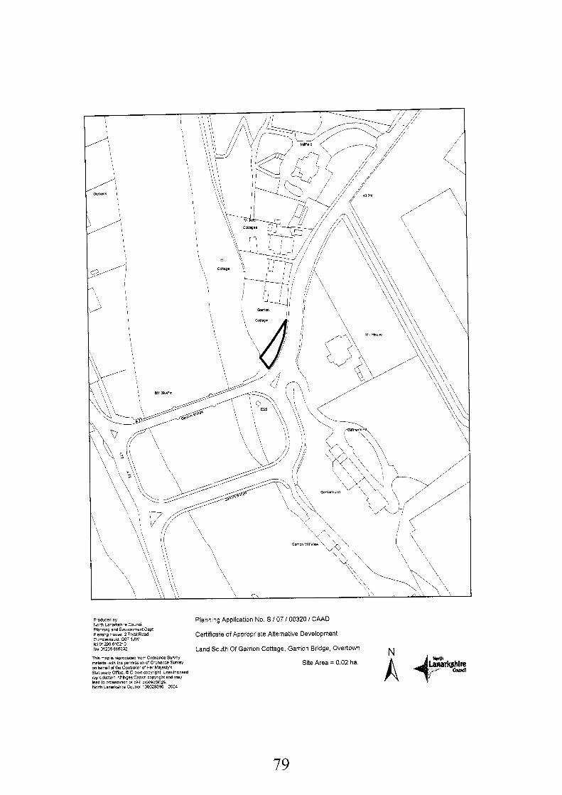
Produced by North Lanarkshire Council Planning and Environment Dept FleminQ Houre. 2 Twt Road Cucrbdlwuld. 067 1JW tel01236616210 fax 01236615232
Planning Application No. S I07 I00320 / CAAD
Certificate of Appropriate Alternative Development
Land South Of Garrion Cottage, Garrion Bridge, Overtown N T h s map IS RprOdUC8d from Ordnance SYrIeY material mth me permcssion d Ordnance SWeY on behalf of the Controller of Hac Malesty's Statloneiy Office 0 C r w n copyright UnaiithoriEgd reproduCtion ~ n h l n g e i c i o ~ copyright and may lead to prtirewbon of C i w proceedings North Lanarkrhlre Counc~I 100023306 2004
Site Area = 0 02 ha
79
1. That the application site shall only be used in conjunction with land to the north for a single dwelling house.
Reason: To accord with outline permission 186/90 granted in January 1991 for a dwellinghouse.
Background Papers:
Application form and plans received 23" February 2007 Outline Planning Permission 186/90 for a Dwellinghouse, Granted on 22"' January 1991
Memo from Geotechnical Team Leader received 18th May 2007 Letter from Transco received 1 5'h March 2007 Letter from Scottish Water received 12'h March 2007 Letter from Scottish Power received 8'h March 2007 Letter from Scottish Natural Heritage received gth March 2007
Central Industrial Area Part Development Plan 1964 Southern Area Local Plan, Finalised Draft (Modified 2001, 2004 and 2005) Land Compensation (Scotland) Act 1963 The Town and Country Planning (Use Classes) (Scotland) Order 1997
Any person wishing to inspect these documents should contact Mr Edward McLennaghan at 01698 302 137.
Date: 10th April 2007
80
APPLICATION NO. S/07/00320/CAAD
REPORT
1.
1 .I
1.2
1.3
2.
2.1
2.2
2.3
3.
3.1
3.2
3.3
Purpose of Application
This is an application for a Certificate of Appropriate Alternative Development (CAAD) under the Land Compensation (Scotland) Act 1963. This type of application is relatively rare, occurring where compulsory purchase of a piece of land is proposed, without agreement between the parties as to the value of the land. A party with a legal interest in the land may apply for a CAAD as a means of defining any development value of the land which can be taken into account in assessing the compensation for the land being compulsorily acquired.
The applicants seek a Certificate in respect of the part of the land in their ownership which was the subject of a Draft Compulsory Purchase Order (CPO) issued by the Scottish Ministers on 2"' November 1998. The order relates to various parcels of land required for the purpose of the construction of an additional road bridge over the River Clyde near to the existing Garrion Bridge and the construction of roadworks associated therewith, including the construction of a roadway connecting the existing A72 (Lanark Road) with the A71 (Ayr Road/Cornsilloch Road). The CAAD application must be considered primarily on the planning situation at the date on which the Draft Order was published.
The planning authority must not refuse a certificate solely on the grounds that it would be contrary to policies which have no purpose beyond the scheme for which the compulsory acquisition is being promoted. Broader policies which would prevent any of the Classes of Use proposed can, however, be taken into account.
Description of Site and Proposal
For the purposes of this application the description of the site is that of how it would have previously appeared at the time of the Compulsory Purchase Order. The application site comprises 0.02 hectares of ground adjacent to the A71 and would have comprised part of the garden ground of the Garrion Bridge cottages to the north.
The applicants seek a CAAD and suggest that Use Class 9 (Residential) of the Town and Country Planning (Use Classes) (Scotland) Order 1997 is an appropriate use. No indicative plans were submitted in relation to the use proposed.
The site forms part of a larger area previously granted planning consent for the erection of a dwellinghouse on 22"' January 1991.
Development Plan
The site is zoned as Green Belt and an Area of Great Landscape Value in the then relevant Central Industrial Area Part Development Plan 1964.
The same zoning also applies in the up to date Southern Area Local Plan Finalised Draft (Modified 2001, 2004 & 2005), with the site also being covered by policies ENV6 (Green Belt) and ENV15 (Area of Great Landscape Value). This plan was not, however, in existence, at the time of the draft CPO.
The Glasgow & Clyde Valley Joint Structure Plan 2000, preceded by the Strathclyde Structure Plan 1997 both zone the area as Green Belt and an Area of Great Landscape Value.
81
4.
4.1
4.2
4.3
4.4
4.5
5.
5.1
5.2
5.3
Consultations and ReDresentations
Scottish Natural Heritage (SNH) has offered no objections to the proposals.
Scottish Water has offered no objections to this application. A SUDS drainage system would be required.
Transco and Scottish Power have offered no objections to this application, although both may have apparatus within the site, which may require works at the applicant’s expense.
The Geotechnical Tam Leader has raised no objection to this application and has advised that no instances of flooding has been recorded at this location.
No letters of representation have been received.
Planninn Assessment and Conclusions
The CAAD procedure requires that the planning authority certifies the alternative development for which planning permission would have been granted for land if it were not proposed to be acquired by an authority possessing compulsory purchase powers. It should be noted that in this case the CPO was progressed by South Lanarkshire Council. Any issues of financial compensation associated with the CPO process are part of the considerations assigned to South Lanarkshire Council and are not relevant in the consideration of this application. The CAAD procedure requires that account must be taken of Development Plan policies, such as Green Belts. The Development Plan is, however, set aside in so far as the development plan allocates the site for the purpose for which it is being compulsorily acquired. In this case the land is allocated for the use for which it is being acquired (TR7 South Motherwell - Wishaw Transport Improvements) in the Southern Area Local Plan Finalised Draft (Modified 2001, 2004 & 2005) but was not allocated as such in the adopted development plan at the time of issue of the Draft CPO. The applicable policies of Green Belt and Area of Great Landscape Value (AGLV) are the broader policies which must therefore be taken account.
In assessing potential development against relevant Development Plan policies the following is noted; a) Green Belt: The purpose of Green Belt policy is to prevent inappropriate new development in order to safeguard its character and function. Any Use Class development, including the applicants’ suggested residential use, would adversely affect the area by introducing an urbanising element and by reducing the openness of the area. Development would, therefore, be contrary to this policy. b) Area of Great Landscape Value: This policy seeks to protect and enhance the Clyde Valley by resisting any proposal which will have a significant adverse effect on the character and quality of the environment. Any new Use Class development would have a significant adverse effect on the sensitive and high quality landscape and environment at this part of the Clyde Valley and would be detrimental to the local landscape quality. Development would, therefore, be contrary to this policy.
The relevant national Green Belt planning policy at the time of the draft CPO was covered by Circular 24/1985 “Development in the Countryside and Greenbelts”. This Circular presumes against inappropriate development in the Green Belt and identifies the following main purposes for Green Belt land. Green Belt land should a) maintain the identity of settlements by establishing a clearly defined physical boundary; b) should prevent coalescence; c) should provide countryside for recreation or institutional purposes of various kinds; and d) should maintain the landscape setting of settlements. It also indicates a presumption against
82
development which would have an adverse impact on the environment, landscape and nature conservation. Development at this location would have such an adverse impact and therefore is not in keeping with this national planning policy.
Notwithstanding the above it is noted that outline planning permission for a dwellinghouse (ref 186/90) was granted in January 1991 on the current application site plus land to the north. In granting this permission it was determined that the policy objections were outweighed by material considerations relating to the position and character of the site. In particular it was noted that this was a constrained section of garden whereby a dwellinghouse would not look significantly out of place and would not set a precedent for similar developments in more open parts of the Clyde Valley. Although this permission had lapsed by the 1998 date for considering the current CAAD application it is a material consideration, particularly in that there had been no physical or policy changes in the intervening period.
5.4
5.5 Taking account of the above it is considered that the previous grant of outline planning permission for a dwellinghouse on the application site and land to the north outweighs the Development Plan presumption against development on the site. As such it is recommended that a CAAD be granted for Use Class 9 (Residential) subject to a condition limiting potential development to a single dwellinghouse.
83
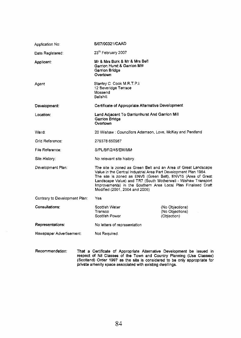
Application No:
Date Registered:
Applicant:
Agent
Development:
Location:
Ward:
Grid Reference:
File Reference:
Site History:
Development Plan:
Contrary to Development Plan:
Consultations:
Representations:
Newspaper Advertisement:
Recommendation: That a
S/07/00321 /CAAD
23'' February 2007
Mr & Mrs Burk & Mr & Mrs Bell Garrion Hurst & Garrion Mill Garrion Bridge Overtown
Stanley C. Cook M.R.T.P.1 12 Beveridge Terrace Mossend Bellshill
Certificate of Appropriate Alternative Development
Land Adjacent To Garrionhurst And Garrion Mill Garrion Bridge Overtown
20 Wishaw : Councillors Adamson, Love, McKay and Pentland
279378650987
No relevant site history.
The site is zoned as Green Belt and an Area of Great Landscape Value in the Central Industrial Area Part Development Plan 1964. The site is zoned as ENV6 (Green Belt), ENV15 (Area of Great Landscape Value) and TR7 (South Motherwell - Wishaw Transport Improvements) in the Southern Area Local Plan Finalised Draft Modified (2001, 2004 and 2005)
Yes
Scottish Water Transco Scottish Power
No letters of representation
Not Required.
(No Objections) (No Objections) (Objection)
Certificate of ApDropriate Alternative DeveloDment be issued in respect of Nil Classes of the Town and Country Planning (Use Classes) (Scotland) Order 1997 as the site is considered to be only appropriate for private amenity space associated with existing dwellings.
84
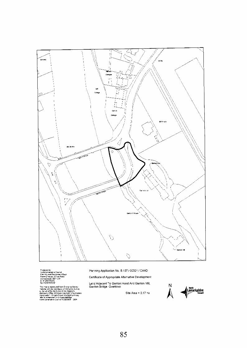
Produced by
Fleming HOUW 2TwtRoad
iax 01238 616232
This map is reproduced 1romOidnanceSvrvey mteriel WN, the wrrniswn d Ordnance SYWBY on bRhalf of the Contlaller 01 Her Ma]esI)/s Slatoneiyoffice O C r w n Copyright UnauthonSBd reprodudion nhingehCmwn Copyright and may lead to pros~c~ition or civil proceedings North Lanarkshire Council 100023396 2004
Planning Application No S I 0 7 I00321 I CAAD
Certificate of Appropriate Alternative Development
Land Adjacent To Garrion Hurst And Garrion Mill, Garrion Bridge, Overtown
Site Area = 0 17 ha
North Lanarkshire Council Planning and Environment Dept
Cumbarnauld 067 1JW te101236616210
85
Background Papers:
Application form and plans received 23'' February 2007.
Memo from Conservation & Greening Section received 15'" March 2007 Letter from Transco received 1 3'h March 2007 Letter from Scottish Water received 12'h March 2007 Letter from Scottish Natural Heritage received gth March 2007
Central Industrial Area Part Development Plan 1964 Southern Area Local Plan, Finalised Draft (Modified 2001, 2004 and 2005) Land Compensation (Scotland) Act 1963 The Town and Country Planning (Use Classes) (Scotland) Order 1997
Any person wishing to inspect these documents should contact Mr Edward McLennaghan at 01698 302137.
Date: 24 May 2007
86
APPLICATION NO. S/07/00321 /CAAD
REPORT
1.
1.1
1.2
1.3
1.4
2.
2.1
2.2
2.3
3.
3.1
3.2
Purpose of ApDlication
This is an application for a Certificate of Appropriate Alternative Development (CAAD) under the Land Compensation (Scotland) Act 1963. This type of application is relatively rare, occurring normally where compulsory purchase of a piece of land is proposed, without agreement between the parties as to the value of the land. A party with a legal interest in the land may apply for a CAAD as a means of defining any development value of the land which can be taken into account in assessing the compensation for the land being compulsorily acquired.
The applicants seek a Certificate in respect of the part of the land in their ownership which was the subject of a Draft Compulsory Purchase Order (CPO) issued by the Scottish Ministers on 2"d November 1998. The order relates to various parcels of land required for the purpose of the construction of an additional road bridge over the River Clyde near to the existing Garrion Bridge and the construction of roadworks associated therewith, including the construction of a roadway connecting the existing A72 (Lanark Road) with the A71 (Ayr Road/Cornsilloch Road).
In terms of the regulations governing the assessment of CAAD applications, the planning circumstances at the date of the publication of the Draft Compulsory Purchase Order must guide the decision. In this case the relevant date is 2"d November 1998.
The planning authority must not refuse a certificate solely on the grounds that it would be contrary to policies which have no purpose beyond the scheme for which the compulsory acquisition is being promoted. Broader policies which would prevent any of the Classes of Use proposed can, however, be taken into account.
Description of Site and Proposal
For the purposes of this application the description of the site is that of how it would have previously appeared at the time of the Compulsory Purchase Order. The application site comprises 0.22 hectares of ground adjacent to the line of the old A71 and would have formed part of the curtillage of Garrionhurst (C-Listed) and Garrion Mill residential properties. The site sits in between the old A71 and Garrionhurst, to the southwest of the access leading to the existing properties.
The application site would have formed an area of open space associated with the existing dwellings and would have been part of the dwellings curtillage.
The applicants seek a CAAD and suggest that Use Class 9 (Residential) of the Town and Country Planning (Use Classes) (Scotland) Order 1997 is an appropriate use. No indicative plans were submitted in relation to the use proposed.
Development Plan
The site is zoned as Green Belt and an Area of Great Landscape Value in the then relevant Central Industrial Area Part Development Plan 1964.
The same zoning also applies in the up to date Southern Area Local Plan Finalised Draft (Modified 2001, 2004 & 2005), with the site also being covered by policies ENV6 (Green Belt) and ENVIS (Area of Great Landscape Value). This plan was not, however, in existence, at the
87
time of the draft CPO.
The Glasgow & Clyde Valley Joint Structure Plan 2000, preceded by the Strathclyde Structure Plan 1997 both zone the area as Green Belt and an Area of Great Landscape Value.
3.3
4.
4.1
4.2
4.3
4.4
4.5
4.6
4.7
5.
5.1
5.2
Consultations and ReDresentations
The Conservation and Greening Section manager has commented that the site is located along the Clyde Valley which is valued as having very good landscape quality. The site was and is located at a very prominent location. Because of the sensitivities of the site development would need to be judged by the capacity of the landscape to take on the proposal. It is therefore considered that the site would have been best kept for conservation, but if other developments were allowed the potential of the site would be for another residential dwelling of good quality. Commercial operations would not be considered appropriate because of the often associated higher volume of traffic in an already congested area.
Scottish Natural Heritage (SNH) has offered no objections to the development of this site but has noted that due to the proximity of the development to the bank of the River Clyde, and the flooding risks inherent with this section of the river, there may be limitations on the type and size of development that could occur safely without detriment to the watercourse.
Scottish Water has offered no objections to this application. A SUDS drainage system would be required.
Transco have offered no objections to this application, although Transco may have apparatus within the site, which may require works at the applicant's expense.
Scottish Power have objected to the application as they have an operational substation and underground apparatus within the proposed site.
No letters of representation have been received.
The applicant has requested a site visit and hearing should it be recommended that a CAAD is not granted for residential use.
Planning Assessment and Conclusions
The CAAD procedure requires that the planning authority certifies the alternative development for which planning permission would have been granted for land if it were not proposed to be acquired by an authority possessing compulsory purchase powers. It should be noted that in this case the CPO was progressed by South Lanarkshire Council. Any issues of financial compensation associated with the CPO process are part of the considerations assigned to South Lanarkshire Council and are not relevant in the consideration of this application. The CAAD procedure requires that account must be taken of Development Plan policies, such as Green Belts. The Development Plan is, however, set aside in so far as the development plan allocates the site for the purpose for which it is being compulsorily acquired. In this case the land is allocated for the use for which it is being acquired (TR7 South Motherwell - Wishaw Transport Improvements) in the Southern Area Local Plan Finalised Draft (Modified 2001, 2004 & 2005) but was not allocated as such in the adopted development plan at the time of issue of the Draft CPO. The applicable policies of Green Belt and Area of Great Landscape Value (AGLV) are the broader policies which must therefore be taken account.
In assessing potential development against relevant Development Plan policies the following is noted:
88
a) Green Belt: The purpose of Green Belt policy is to prevent inappropriate new development in order to safeguard its character and function. Any Use Class development, including the applicants’ suggested residential use, would adversely affect the area by introducing an urbanising element and by reducing the openness of the area. Development would, therefore, be contrary to this policy.
b) Area of Great Landscape Value: This policy seeks to protect and enhance the Clyde Valley by resisting any proposal which will have a significant adverse effect on the character and quality of the environment. Any new Use Class development would have a significant adverse effect on the sensitive and high quality landscape and environment at this part Of the Clyde Valley and would be detrimental to the local landscape quality. Development would, therefore, be contrary to this policy.
The relevant national Green Belt planning policy at the time of the draft CPO was covered by Circular 2411 985 “Development in the Countryside and Greenbelts”. This Circular presumes against inappropriate development in the Green Belt and identifies the following main purposes for Green Belt land. Green Belt land should a) maintain the identity of settlements by establishing a clearly defined physical boundary; b) should prevent coalescence; c) should provide countryside for recreation or institutional purposes of various kinds; and d) should maintain the landscape setting of settlements. It also indicates a presumption against development which would have an adverse impact on the environment, landscape and nature conservation. Development at this location would have such an adverse impact and therefore is not in keeping with this national planning policy.
5.3
5.4 Taking account of the above it is considered that a Class 9 (Residential) use, as suggested by the applicants, would not have been appropriate for this site given that development would constitute an encroachment into the countryside. It would also have significantly affected the character of the Green Belt and Area of Great Landscape Value at this location by virtue that it would displace a natural greenfield site already utilised for amenity spaced associated with the existing dwellings. Such development would have had a visual impact at the site and from the wider area as it would have been visible from the A71 and have been detrimental to the landscape setting of the area. For these reasons it is considered that any other alternative Use Class development would have been unacceptable at the site.
In conclusion, it is considered for the purposes of the Certificate of Appropriate Alternative Development that the site could not have been satisfactorily used for Class 9 (residential) purposes as proposed by the applicant, or for any other use class given the sensitive and prominent nature of this rural site. It is therefore recommended that a CAAD be issued in respect of Nil Classes of the Town and Country Planning (Use Classes) (Scotland) Order 1997 as the site is considered to be appropriate only for private amenity space associated with the existing dwellings.
5.5
89
Application No:
Date Registered:
Applicant:
Agent
Development:
Location:
Ward:
Grid Reference:
File Reference:
Site History:
Development Plan:
S/07/00499/FU L
26th March 2007
S M Hargrave 100 Hamilton Road Bellshill
Stanley C Cook 12 Beveridge Terrace Bellshill
Change of Use from Retail to Storage/Distribution Depot
18 North Road Bellshill ML4 IEN
15 Mossend and Holytown: Councillors Coyle, Delaney and McKeown
273342 660407
S/PL/BF/7/43/AM/M M
S/04/02112/OUT Erection of Class 1 Foodstore Incorporating Car Parking, Access, Landscaping and Associated Works - Withdrawn 6 June 2007
S/05/00502/FUL Erection of a 7,687 square metres Class 1 Superstore, Incorporating Car Parking, Access, Landscaping, Upgrade of Existing Roundabout & Associated Works - Granted 28 December 2006
Various approvals relative to Consarc / Calcarb
208/93 Change of Use Wholesale to Retail Foodstore - granted October 1993.
Glasgow and Clyde Valley Structure Plan 2000
Southern Area Local Plan Finalised Draft (Modified 2001, 2004 and 2005)
Contrary to Development Plan: Yes
Consultations: No external consultations required
Representations: I letter of representation received.
Newspaper Advertisement: Advertised on 5th April 2007
90
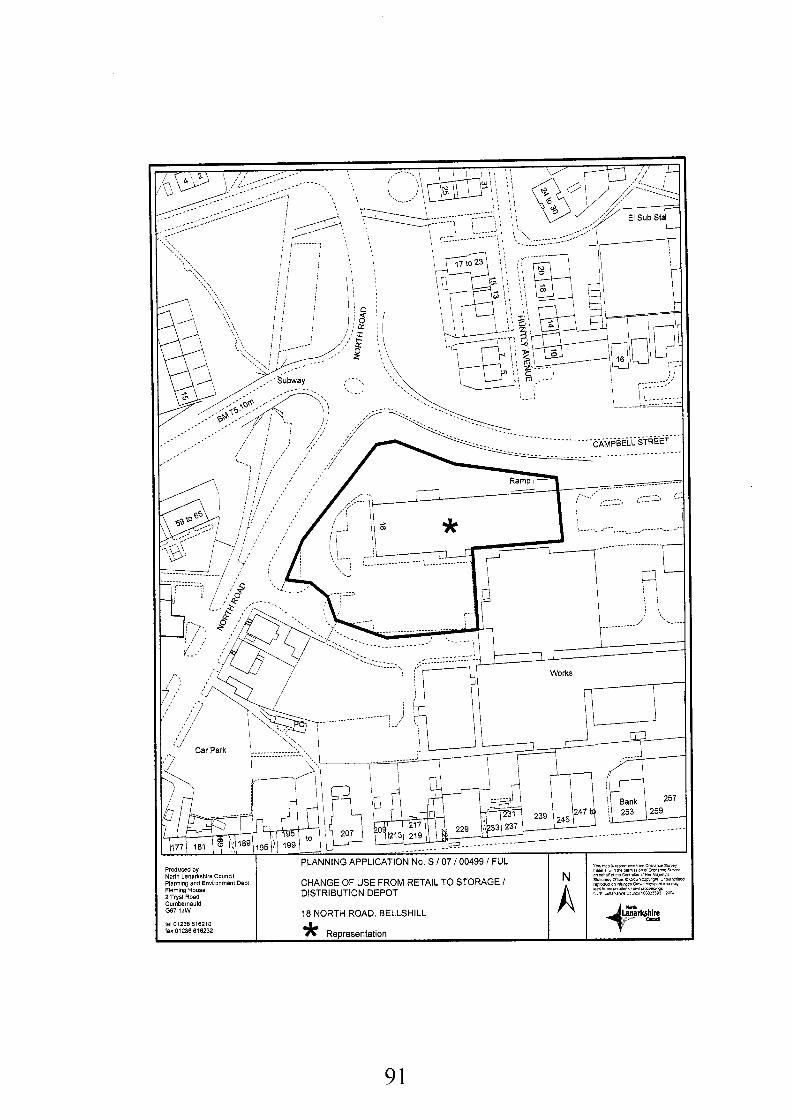
le1 01236515210 lax01235615232 * Representation
91
Recommendation: Approve subject to the Following Conditions:-
1.
2.
3.
4.
5.
6.
7.
That the permission hereby approved shall be for a temporary period only and shall expire on 27'h June 2010.
Reason: To accord with the provisions of the Town and Country Planning (Scotland) Act 1997.
That before the development hereby permitted starts, full details of the design and location of all fences to be erected on the site shall be submitted to, and approved in writing by the Planning Authority.
Reason: To ensure that all fences within the site are adequately sited and designed in the interests of amenity.
That before the proposal hereby permitted is brought into use, the fencing required and approved under the terms of condition 2 above shall be erected to the satisfaction of the Planning Authority.
Reason: To ensure that all fences and walls within the site are implemented in the interests of amenity.
That before the development hereby permitted starts, full details of all external alterations to the building, including any new door/window openings and materials to be used in construction, including walls, roofs, windows, doors, gutters and downpipes, shall be submitted to, and approved in writing by the Planning Authority.
Reason: To ensure that all external alterations and finishing materials are appropriate in the interests of the amenity of the surrounding area.
That before the proposed development is brought into use, a plan showing all parking and manoeuvring areas within the site, including the parking bays, accesses and turning areas; AND a scheme of junction/access improvements for the area shaded BLUE on the approved plans, shall be submitted to and approved in writing by the Planning Authority.
Reason: To ensure the provision of adequate access to, and manoeuvring and parking facilities within the site in the interests of road safety.
That before the proposed development is brought into use, all of the associated parking and manoeuvring areas, including the parking bays, accesses and communal parking areas AND the junction/access improvements, as agreed under the terms of Condition 5 above, shall be implemented, levelled, properly drained, surfaced in a material which the Planning Authority has approved in writing before the start of surfacing work and clearly marked out, and shall, thereafter, be maintained as such to the satisfaction of the Planning Authority.
Reason: To ensure the provision of adequate access to and manoeuvring and parking facilities within the site in the interests of road safety.
That no outdoor storage of materials and/or equipment is hereby permitted unless it is firstly approved in writing by the Planning Authority.
Reason: To enable the Planning Authority to consider these aspects in detail and to preserve the amenity of the wider area.
Background Papers:
92
Application form and plans received 26th March 2007
Memo from Transportation Team Leader dated 23rd May 2007. Memo from Head Of Protective Services received 16th May 2007
Letter from P McLaren, Development Planning Partnership, The Hatrack, 144 St Vincent Street, Glasgow, G2 5LQ received 24th April 2007.
Glasgow and Clyde Valley Structure Plan 2000 Southern Area Local Plan, Finalised Draft (Modified 2001, 2004 and 2005)
Any person wishing to inspect these documents should contact Mr Alistair Maclean at 01698 302093.
Date: 19 June 2007
93
AP PLI CAT 10 N N 0. S/07/00499/F U L
REPORT
1.
1.1
1.2
1.3
2.
2.1
2.2
3.
1 . I
1.2
1.3
4.
4.1
Description of Site and Proposal
The development proposes the change of use of a store previously occupied by Iceland and KwikSave to use as a Storage/Distribution Depot at 18 North Road, Bellshill. The applicant proposes to use the site as a storage and distribution centre, mainly between the hours of 8am to 8pm Monday to Friday and 8am to Ipm on Saturday. Vehicles to be used would vary from 7.5 ton to 26 ton rigid vehicles to 44 ton artics.
The floorspace of the building amounts to some 1900 square metres with adjacent parking and yard areas all of which are accessed off Dennistoun Street some 25 metres from the junction with North Road. The site is relatively flat, sloping gently from north to south. The present building is about 83 metres long, running west to east, by 23 metres wide. From the junction with Dennistoun Street there is vehicular access to the north, west and south sides of the building. There is a car park that would accommodate 15 cars while the large car park to the south is large enough to be used as a turning facility for commercial vehicles and access to the premises.
The proposed development site lies within the site which was the subject of the application by Tesco for the development of a superstore (ref 05/00502/FUL) which was granted planning consent, after conclusion of a legal agreement on off site road works, on 28‘h December 2006.
Development Plan
The proposal raises no strategic issues in terms of the Glasgow and Clyde Valley Joint Structure Plan 2000 and can therefore be assessed against Local Plan Policies.
The site is zoned as RTL5 ‘Town Centre Areas’ on the Southern Area Local Plan Finalised Draft (Modified 2001, 2004 and 2005).
Consultations and Representations
The Transportation Team Leader recommended refusal of the application as the proposed use would lead to a high level of goods vehicle movements onto North Road. The proximity of the site access and the access to North Road does not allow two vehicles to pass which would result in vehicles queuing on North Road to the detriment of the wider road network.
The Head of Protective Services had no comments to make on the application.
One representation was received from Development Planning Partnership (DPP). They raised concerns that their clients, Tesco, who own the premises, would lose the open Class 1 consent over the property if this permission was granted and implemented. Tesco would then require to make a subsequent application to re-establish a Class 1 consent. They are, however, keen to see the property being put to beneficial use and suggest a temporary consent would be in order but would object if a permanent consent was granted..
Planninq Assessment and Conclusions
In accordance with Section 25 of the Town and Country Planning (Scotland) Act 1997, planning decisions must be in accordance with the development plan unless material considerations
94
indicate otherwise.
4.2 The application site lies within an area zoned as RTL5 ‘Town Centre Areas’. Also relevant are Policies RTL2 ‘Improvement of Shopping Centres’, ENVl6 ‘Improving the Environment of Town Centres’, IND9 ‘Assessing Applications for Industrial and Business Development’ and TR13 ‘Assessing the Transport Implications of Development’.
Policy RTL5 ‘Town Centre Areas’ aims to protect and enhance the retail and commercial function of Town Centres by encouraging and supporting: existing retail concerns; new retail outlets; changes of use to non-retail town centre uses which reinforce and revitalise town centres including Class 3 Food and Drink or Class 11 Assembly and Leisure where they do not adversely affect the character and amenity of Town Centres. The proposed development does not accord with the criteria listed in Policy RTL5 as it would involve loss of retail, however, the building is currently vacant, and while located within the Town Centre it is located directly adjacent to existing industrial sites at Consarc and Calcarb. The application is by a local business and I consider that it can be conditioned to be a temporary consent for reasons contained within this report.
4.3
4.4 Policy RTL2 ‘Improvement of Shopping Centres’ lists a number of criteria which seek to improve the character of existing shopping facilities including improving the environment of town centre areas; supporting the provision of associated facilities such as offices, leisure facilities and car parks and undertaking measures to improve traffic flow. There is an existing planning permission for a superstore which includes this site. Its implementation depends on the relocation of industrial uses currently on the site, and therefore is not immediate. The application site is currently vacant, and a temporary use would occupy the building until such times as the larger site is ready for redevelopment.
4.5 Policy IND9 ‘Assessing Applications for Industrial and Business Development‘ lists a number of criteria to be considered, including whether the proposal is located in an Established Industrial and Business Area; the extent to which there are deficiencies in the land supply for industry and business; the extent to which vacant and derelict land is being re-used; suitability to the character of the area; provisions made for servicing, access, circulation, manoeuvring and parking. Considering the above, while the proposal is not within an established industrial and business area nor has it been demonstrated that there is a shortage in the land supply for industry and business, the proposal does make use of a vacant premises which, although zoned within the town centre, lies directly adjacent to existing industrial sites. Furthermore, the applicant intends to use the premises for a temporary period only. Under these particular circumstances I do not consider there to be a long term adverse impact on the integrity and vitality of the town centre. The proposal would use a vacant building and is unlikely to seriously damage the character of the area given the close proximity to the large adjacent industrial concerns, Consarc and Calcarb. The consent for a superstore (Tesco), which is an appropriate town centre use incorporates this site, however, again I would recommend that the consent, if granted, should be for a temporary period only, as not to prejudice the long term development of Bellshill Town Centre. Issues regarding access and internal site layout are discussed in the following paragraph. Under the circumstances, I consider that the proposed development complies with the spirit and intentions of Policy IND 9.
Policy TR13 ‘Assessing the Transport Implications of Development‘ lists a number of criteria to be considered including: the level of traffic generated and its impact on the environment and adjoining land uses; impact of the development on road traffic circulation and road safety; and the provisions for access, parking and vehicle manoeuvring. It is acknowledged that the proposed use would lead to a higher level of goods vehicle movements onto North Road. While one house lies adjacent to the access to the development site, North Road is already very busy at this location it is unlikely that additional vehicle movements would cause undue additional disturbance. It is recommended that a condition restricts the hours of operation from 8am to 8pm through the week and 8am to Ipm on Saturday. I note that the Pollution Control Section
4.6
95
had no adverse comments to make on the application in respect to noise. Provisions for parking and vehicle manoeuvring are likely to be adequate within the site although it has not been demonstrated how the servicing arrangements would work. I recommend that a condition be attached requiring the submission of an internal parking and manoeuvring layout for the approval of the Planning Authority, prior to any development commencing. While the Transportation Section have concerns about the junction and access off North Road, I consider that this matter can be sufficiently accommodated given the site characteristics (the existing junction/access can be widened/altered) and the fact that the consent would be for a temporary period only. I propose a further condition requiring a scheme of junction and access improvements to be devised and implemented at the junction of North Road with Dennistoun Street and the access into the site. While this may not be to the full standard normally required for this type of use, it will be acceptable in light of the temporary consent and other material considerations pertaining to the development as discussed in this report.
4.7 Having regard to the representation made by DPP on behalf of Tesco, there are no restrictions in re-using the building which is the subject of this application as a retail store. Such a use would not require planning consent as this was the last use of the building. While a permanent consent may make it necessary to re-establish a Class 1 consent for the Tesco superstore, I consider that it is appropriate to grant a temporary consent in this instance, running for a period of three years. This would also allow for the situation to be re-evaluated in regard to potential land-use changes in and around the site, including future retail development and relocation of the adjacent industrial sites, in the coming years.
4.8 In conclusion, it is considered that the proposed development would make use of a vacant building for a temporary period only benefiting a local business, is located adjacent to existing industrial sites and would not cause serious detriment to the environment or have a long term impact on the town centre. I therefore recommend that the application be approved subject to conditions.
96
Application No:
Date Registered:
Applicant:
Agent
Development:
Location:
Ward:
Grid Reference:
File Reference:
Site History:
Development Plan:
Contrary to Development Plan:
Consultations:
Representations:
Newspaper Advertisement:
S/07/00599/F U L
30th April 2007
Donald Waring 29 Marius Crescent Motherwell MLI 3GA
Plans And Drawings.Com 5 Station Road Stepps G33 6HB
Erection of Two Storey Extension to Side and Single Storey Extension to Rear
29 Marius Crescent Motherwell MLI 3GA
16 Motherwell West: Councillors Kelly, Ross and Valentine
274289658068
SIPLIB11 311 3/GS/MM
None
The site is zoned as HSG 8 (Established Housing Areas) on the Southern Area Local Plan Finalised Draft (Modified 2001, 2004 and 2005).
No
None
1 letter of representation received.
Not Required
Recommendation:
1.
Approve Subject to the Following Conditions:-
That the development hereby permitted shall be started within five years of the date of this permission
Reason: To accord with the provisions of the Town and Country Planning (Scotland) Act 1997
2. That the facing materials to be used for the external walls and roof shall match in colour and texture those of the existing adjoining building.
Reason: To ensure that the extension matches the external appearance of the existing adjoining dwelling house.
97
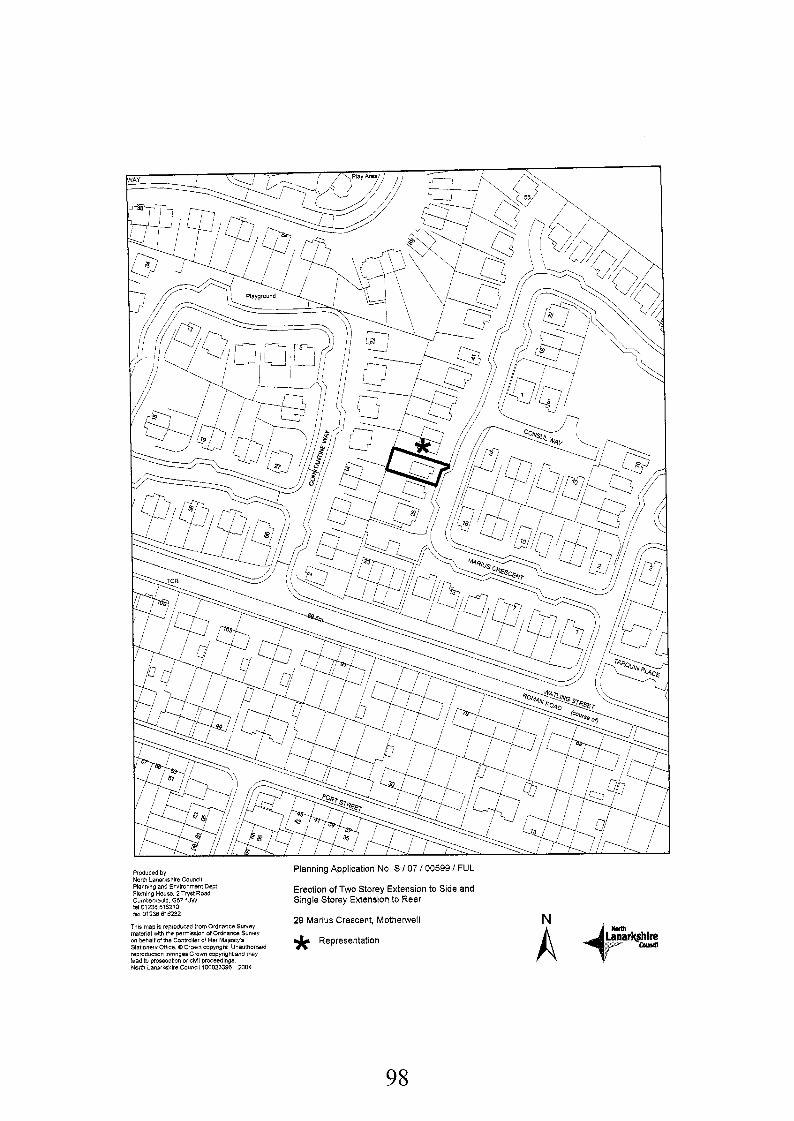
Planning Application No. S I07 / 00599 I FUL
Erection of Two Storey Extension to Side and Single Storey Extension to Rear
29 Marius Crescent, Mothemell * Representation
Produced by North Lanarkshire Council Planning snd Environment Dept Fleming House. 2 Tryst Road
&I 01238 616210 fax 01236618232
This map I$ reproduced frOmOidnaneeSuFley mterial mth the psrmtwion d Ordnance Suwey
Stationery Onice 0 Crwn copyright Unatithonssd iepmdudlon InfringesCmw Copyright and rnq lead to prosBciibon of civil proceeding6 Nom Lanaikrhiia Council 100023396 2004
Curnbernauld. 067 1JW
00 bahilf of the Controller of Her Ma~estYs
98
3. That before the development starts, full details of the facing materials to be used on all external walls and roofs shall be submitted to and approved by the Planning Authority.
Reason: To enable the Planning Authority to consider these aspects in detail.
That the existing single space driveway and integral garage as shown on the approved plans shall be retained as such within the site at all times to the satisfaction of the Planning Authority.
Reason: To ensure the provision of adequate parking facilities within the site.
4.
Background Papers:
Application form and plans received 4th April 2007 and amended plans received 2"' May and 6Ih June 2007
Memo from NLC Traffic and Transportation Section received 23" May 2007
Letter from Mrs L McLeod, 31 Marius Crescent, North Motherwell, Motherwell, MLI 3GA received 12th April 2007.
Southern Area Local Plan, Finalised Draft (Modified 2001, 2004 and 2005)
Any person wishing to inspect these documents should contact Mr Graham Smith at 01698 302081
Date: 18 June 2007
99
AP P Ll CAT10 N NO. S/07/00599/F U L
REPORT
1.
1.1
1.2
2.
2.1
2.2
3.
3.1
3.2
4.
4.1
4.2
4.3
Description of Site and ProDosal
Planning consent is sought for the erection of a two storey extension to the side and a single storey extension to the rear of the dwellinghouse at 29 Marius Crescent, Motherwell. The property is a two storey detached dwellinghouse located within an established residential area and is bound by dwellings on all sides.
The side extension will create an integral garage on the ground floor and an en-suite bedroom on the first floor. The extension will project 2.7 metres from the side of the dwelling, retaining the existing front and rear building line and will have a pitched roof that will tie in with the existing house. The rear extension will project 4 metres from the back of the building, is 3.7 metres in width and will be 3.6 metres in height with a pitched roof.
Development Plan
The proposal raises no strategic issues in terms of the Glasgow and Clyde Valley Joint Structure Plan 2000 and can therefore be assessed against Local plan Policies.
The site is covered by Policy HSG 8 (Established Housing Areas) of the Southern Area Local Plan Finalised Draft (Modified 2001, 2004 and 2005)
Consultations and Representations
My Transportation Team Leader initially recommended that planning permission be refused due to the proposal resulting in 1 remaining off-street parking space.
One letter of objection was received from the owners of 29 Marius Crescent, Motherwell. Their objections can be summarised as follows:
i. The side extension will restrict the amount of daylight and sunlight currently enjoyed by the property at 31 Marius Crescent. The kitchen, dining area, driveway and back garden with decking area will all be adversely affected.
ii. The gap between buildings will be too narrow and will resemble an alleyway. iii. The proposal will have an adverse affect the value of the property at 29 Marius Crescent
and potentially discourage future buyers. iv. The view onto the street, particularly visitor parking, would be restricted.
Planning Assessment and Conclusions
Planning applications require to be assessed against the Development Plan and other material considerations. In this instance the Southern Area Local Plan Finalised Draft (Modified 2001, 2004 and 2005) is relevant, where the site is zoned as HSG 8 (Established Housing Areas).
Policy HSG 8 seeks to protect the established character of existing housing areas by opposing development that adversely affects their amenity. Applications for extensions in such areas are acceptable subject to meeting the requirements of Policy HSG 13 (House Extensions).
Policy HSG 13 sets out various criteria for assessing such applications, including the size, proportion and position of extensions, the effect on the amount of garden ground retained and
100
the impact on the streetscene. The impact of the proposal on neighbouring properties is also considered as is effect on privacy, daylighffsunlight, parking provision and access. The design details of the extensions are also considered.
The proposed extensions to the side and rear are considered acceptable in terms of design, size and scale and it is considered that they will integrate satisfactorily with the existing dwellinghouse. The proposal retains approximately 132 square metres of garden ground which is an acceptable amount.
With regards to the impact on privacy on 31 Marius Crescent there is one first floor window on the side elevation of the side extension, however this is a bathroom window. The impact on the privacy of the surrounding dwellings as a result of the rear extension will be minimised by the 1.8 metre boundary fence currently located around the perimeter of the garden which provides adequate screening. The results from the sunlightldaylight tests on the side extension revealed that there will be a marginal reduction in the amount of sunlighffdaylight currently received by a window on the side elevation of 31 Marius Crescent and a window to the rear. On balance, this impact is considered to be acceptable as the window next to the side door is a secondary window for the dining kitchen, the main one being located on the front elevation which will remain unaffected. The side window and door are already overshadowed to an extent. Secondly, due to the configuration of the extension not extending beyond the established rear building line and the presence of an existing garage at the end of the objectors driveway, the resultant reduction in sunlight and daylight to the existing rear elevation windows is also not considered sufficient enough reason to merit refusal of the application.
4.4
4.5
4.6 The original proposal submitted was considered to be unacceptable as it would have resulted in adequate space for only one off-street parking space and this was considered by the Traffic and Transportation Section to be insufficient in light of current standards. The applicant did however submit amended plans that incorporate an integral garage on the ground floor in order to maintain an acceptable level of parking provision within the site.
On the grounds of the objections raised, I would comment as follows: 4.7
i. As indicated above there will be a marginal effect on the daylightlsunlight currently enjoyed by the property at 31 Marius Crescent with regards to the secondary window on the side elevation and the closest windows on the rear elevation. Although there will be some overshadowing, the levels of sunlight and daylight received by this neighbouring property will still be acceptable and not significantly different to the current situation. The resultant overshadowing of the driveway, back garden area and decking is also considered to be marginal in light of the configuration of the plots and footprint of the extension, and on balance, this too is not significant enough to merit a refusal of the application. As detailed above, I consider the design of the extension to be acceptable including its impact on the streetscene. While the space between the two properties is reduced, on balance, I do not consider this to be so unacceptable as to merit refusal of the application.
iii. The effect the extension will have on the value and perceived sale desirability of the property at 31 Marius Crescent is not a material consideration.
iv. The effect the extension will have on the view from 31 Marius Crescent is not a material consideration. It is noted that visitor parking spaces on the public road can also be seen from the front elevation windows.
ii.
4.3 In conclusion I am satisfied that the design and impact of the extensions are acceptable from a planning viewpoint and the proposal is therefore in compliance with the development plan. Notwithstanding the objections raised by the neighbours and for the reasons stated above, it is recommended that planning permission be granted subject to conditions.
101
Application No:
Date Registered:
Applicant:
Agent
Development:
Location:
Ward:
Grid Reference:
File Reference:
Site History:
Development Plan:
S/07/0061 O/FUL
23rd April 2007
Rea Development Ltd Dalziel Park Golf & Country Club Hagen Drive Cleland ML1 5RZ
John Russell Partnership Ltd Anderson House Dundyvan Road Coatbridge ML5 IDB
Erection of Entrance Canopy
Dalziel Park Golf & Country Club Hagen Drive Cleland MLI 5RZ
19 Murdostoun: Councillors Martin, McKendrick, Shevlin and Taggart
278342 657792
SIP L/B F/5/50/G L/M M
S/06/01276/FUL Extension to Kitchen and Locker Room - granted 20 December 2006
S/06/01369/FUL Extension to Clubhouse to form Office - granted 20 October 2006
S/96/00704/AMD Renovation of Changing Rooms and Extensions to Incorporate Golf Clubhouse, Meeting Rooms and Gymnasium / Leisure Facilities - granted 3 February 1997
S/98/00268/FUL Change of Use from Office Suite to Fitness Centre - granted 22 April 1998
S/OO/O1359/FUL Extensions to Country Club Building - granted 18 December 2000
S/01/00695/FUL Change of Use from Golf and Country Club to Hotel -granted 10 July 2001
Southern Area Local Plan Finalised Draft (Modified 2001, 2004 and 2005) Policy ENV6 Green Belt
Contrary to Development Plan: No
Consultations:
102
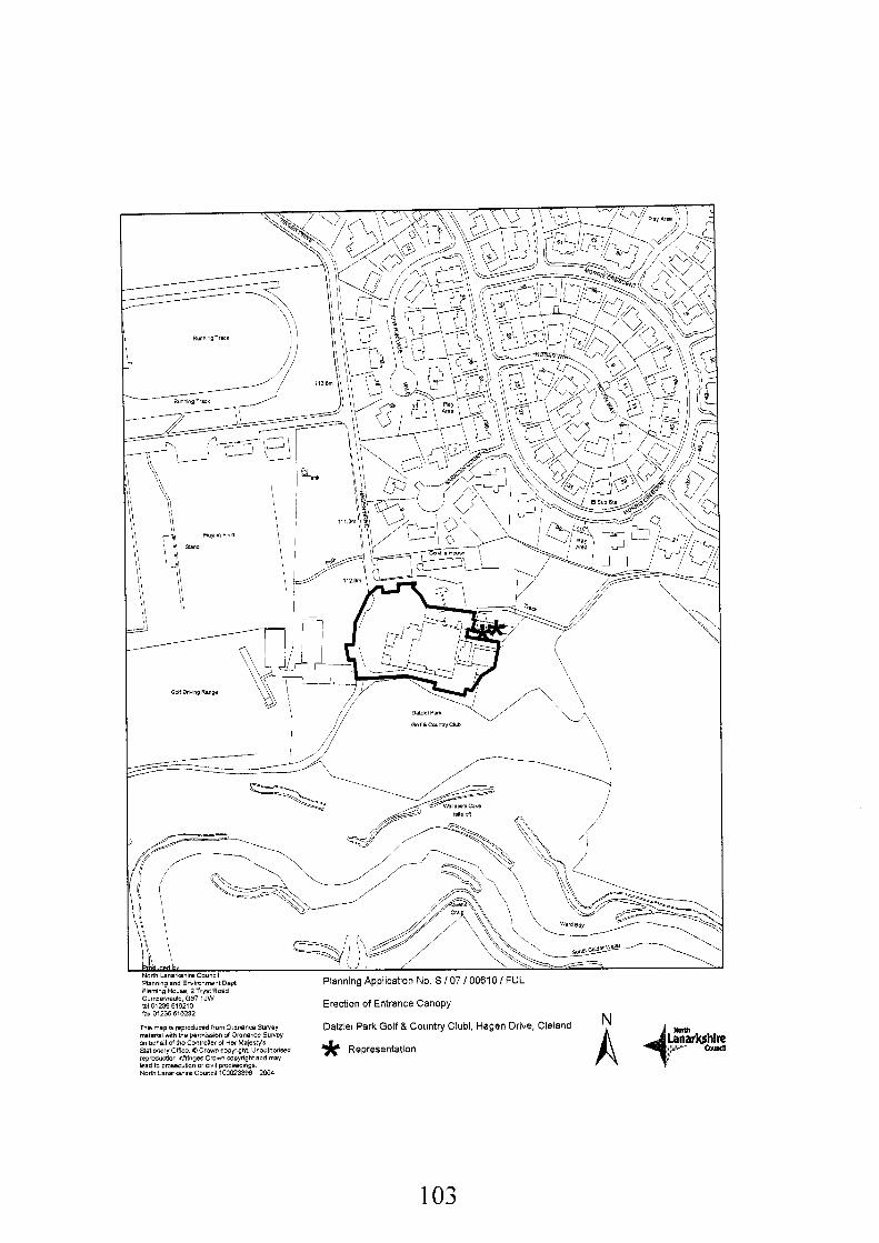
€0 I
Representations:
Newspaper Advertisement: Not Required
2 letters of representation received.
Recommendation: Approve Subject to the Following Conditions:-
1. That within 1 month from the date of this consent, a 1.8 metre high fence shall be erected along the line highlighted BLUE on the approved plans, details of which shall first be submitted to and approved in writing by the Planning Authority. Details of any gate to be incorporated in this fence shall also firstly be submitted to and approved in writing by the Planning Authority. Thereafter, the fence and gate shall be maintained to the satisfaction of the Planning Authority. For the avoidance of doubt, the gate shall be locked, self closing and used for maintenance purposes only and NOT for golfers/public access.
Reason: To enable the Planning Authority to consider these aspects in detail and in the interest of the residential amenity of adjacent houses at Hagen Drive.
That within 1 month from the date of this consent new directional signage shall be erected in the car park, highlighting that golfers must use the main entrance, details and the location of which shall first be submitted to and approved in writing by the Planning Authority.
2.
Reason: To direct golfers to the main entrance and away from established houses at Hagen Drive in the interest of residential amenity.
3. That within 2 weeks from the date of this consent, all signage directing golfers to the door highlighted GREEN on the approved plan, and the existing signage on the over door canopy subject of this application, shall be removed to the satisfaction of the Planning Authority.
Reason: To direct golfers to the main entrance and away from established houses at Hagen Drive in the interest of residential amenity.
NOTE TO COMMITTEE: It should be noted that the objectors have requested that a site visit and hearing be conducted prior to the Committee’s determination of the application.
Background Papers:
Application form and plans received 10th April 2007 and correspondence from John Russell Partnership received 8th and 11 th June 2007.
Letter from P McAleer, 3 Hagen Drive, Cleland, Motherwell, MLI 5RZ received 19th April 2007. Letter from J McAviney, 2 Hagen Drive, Cleland, Motherwell, MLI 5RZ received 19th April 2007.
Glasgow and Clyde Valley Structure Plan 2000 Southern Area Local Plan, Finalised Draft (Modified 2001, 2004 and 2005)
Any person wishing to inspect these documents should contact Mr Gordon Liddell at 01698 302128.
Date: 13 June 2007
104
APPLICATION NO. S/07/0061 OlFUL
REPORT
Description of Site and Proposal
Retrospective planning permission is sought for the erection of an entrance canopy over an existing door on the eastern elevation of the Dalziel Park Country Club. This door provides a direct access from the locker rooms within the Clubhouse to the first tee and was previously separated from the main car park and adjacent housing to the front of the complex by a 1.8 metre high boundary fence. The design of the canopy comprises a pitched roof and pillars, creating an entrance feature. While permission is sought for the canopy structure (which was constructed some months ago), the door has effectively been operating as a new dedicated golfers entrance, away from the Main Entrance of the building. The design, new signage (‘golfers entrance’) and earlier removal of the boundary fence separating this door from the front of the building and car park all contribute to it‘s intensified use and this has clearly been the reason for the development. The applicant now proposes erecting a new locked gated access reinstating the separation between the two sections of the complex.
Dalziel Park Country Club comprises the golf course, a mixture of bar, restaurant and changing/locker facilities as well as meeting rooms and ancillary accommodation. It is primarily a single storey building with a series of pitched and flat roofs, finished in roughcast with red tiled roofs. This proposal is localised to an existing door on the north eastern elevation directly adjacent to residential properties at 1 - 3 Hagan Drive.
Members may recall previous application S/06/01276/FUL for the demolition of a detached laundry building and the extension to the side of the Country Club to extend the kitchen and locker rooms, approved by Committee in December 2006 following a site visit and hearing. This application has not been implemented and the current proposal displaces a section of the site that would have been developed under the earlier consent.
DeveloDment Plan
The application is of no strategic importance and can be considered within the framework of Local Plan Policies. The proposed development is within an area covered by Policy ENV6 ‘Green Belt’ in the Southern Area Local Plan Finalised Draft (Modified 2001, 2004 and 2005).
Consultations and Representations
Two letters of objection were received from the owners of neighbouring properties at 2 and 3 Hagen Drive. The letters raised a number of points which are summarised as follows:
(a) The proposal does not accord with the previously approved application S/06/01276/FUL and
(b) The purpose and description of the development is misleading. (c) The plans submitted through neighbour notification were incorrect. (d) The over-door canopy is effectively unauthorised development and in breech of planning
control as is the removal of the boundary fence which was due to be replaced by a wall in Planning Consent S/06/01276/FUL.
(e) A new golf shop has been built and this forms no part of the previous or current application and is contrary to policy RTL 11.
(9 The proposal amounts to a new dedicated golfers entrance directly at the end an existing residential driveway. This is causing problems with noise (particularly for children sleeping at weekends/evenings/holidays), intimidation with golfers congregating in such close
the previous consent has not been implemented.
105
proximity, invasion of privacy and the blocking of driveways by golfers and their equipment. There has also been a loss of light due to objectors having to keep their blinds drawn to retain privacy and air pollution with golfers congregating and smoking in such close proximity.
(9) The application contravenes the previous consent inasmuch as it will, and already has increased the number of people using the resource and it will have an adverse impact on the character and amenity of adjacent properties;
(h) The development is having an unacceptable impact on the accesslparking provision of adjacent properties (residential spaces are being used by golfers) as well as an adverse impact on pedestrian safety, emergency vehicle access and traffic circulation. The proposal is therefore contrary to policy TRI 3.
(i) There was a complete lack of consideration to residents during the construction of the structure.
(j) The application may be a ploy to unsettle remaining residents into selling their homes following an earlier offer from the Country Club.
(k) The objector is keen to stress that although there may be limited numbers of objections, only a limited number (2) properties are affected.
4. Planning Assessment and Conclusions
4.1 Planning decisions must be made in accordance with the development plan unless material considerations indicate otherwise. This application raises no strategic issues and needs to be assessed against Local Plan Policies and other material considerations.
4.2 Policy ENVG ‘Green Belt’ of the Southern Area Local Plan Finalised Draft (Modified 2001, 2004 and 2005) aims to safeguard the character and function of the Green Belt. Proposals to extend established industrial and business uses will be acceptable where this will not result in an adverse affect. In terms of it‘s size and location, this proposal involves a relatively small scale building alteration to a well established use within the Green Belt. As the extension is to an existing building and within its curtilage it will have no impact on the Green Belt and therefore accords with Policy ENVG.
4.3 Policy ENVS ‘Assessment of Environmental Impact’ requires the Council to take a number of criteria into account when determining applications. Development is generally acceptable if it can be demonstrated that it will not be likely to inflict an unacceptable impact on the environment. The canopy extension is in keeping with the scale and design of the existing building and the materials that have been used tie in with those already present. I consider that the proposal is acceptable in terms of design, has no adverse visual impact nor does it have any adverse affect on the landscape. As indicated above it is within the curtilage of the existing building and does not result in any loss of trees. In terms of the environmental impact of any new traffic generation, the proposal is also considered to be acceptable. This is not significantly different to the current situation subject to the proposed conditions detailed later in this report. Transportation issues in relation to adjacent housing is discussed in paragraph 4.4. There is unlikely to be any significant increase in any of the other items listed in the latter criterion of policy ENVS.
Policy HSG8 ‘Established Housing Areas’ seeks to protect the established character of existing housing areas by opposing incompatible developments. This is important due to the close proximity of adjacent housing at Hagen Drive. Policy RTLI 1 ‘Assessing Applications for Bad Neighbour Development’ is primarily aimed at the establishment of ‘Bad Neighbour’ developments nevertheless 3 of the 4 criteria listed are also of relevance in this instance, particularly relating to the initial intention of the works as a new dedicated golfers entrance. These are; the impact of the proposal on the character and amenity of adjoining properties and the surrounding environment; detailed design elements; provisions made for vehicular access, servicing, parking and the impact on pedestrian safety and traffic circulation. As discussed in
4.4
106
paragraph 4.3, the design of the canopy extension is acceptable and is in keeping with the existing building. Furthermore, having carried out appropriate tests, there is no unreasonable reduction to the sunlight and daylight enjoyed by adjacent residents and there are no new windows that would result in any loss of privacy. This application should be considered separately from the recently approved consent and subject to the replacement of the section of fencing between the doorlcanopy and the car park and houses at Hagen Drive (effectively ceasing use of the door as a dedicated golfers entrance), there are no implications for the existing access, servicing, parking and pedestriadtraffic circulation. The applicant has agreed to the reinstatement of this fence, subject to their being locked gated access for maintenance purposes only and I propose a condition to ensure that this is implemented should planning permission be granted. I also propose a condition to ensure all existing signage is removed from the northern elevation of the canopy, with a sign erected directing golfers to the existing main entrance. In this respect, I consider that the application complies with policies HSG8 and RTLl 1.
4.5 It is worth acknowledging that the spirit and intention behind the works was to create a dedicated golfers access and this is how the site is currently operating. I consider that this is unacceptable and does not comply with Policies HSG 8 and RTLl 1. The new access is directly adjacent to no's 1 - 3 Hagan Drive and the resulting effect is that the location has become a focal point for golfers and their equipment, including motorised buggies. I consider this to be unreasonably close to the established housing, particularly at 3 Hagan Drive by virtue of the level of activity and disturbance directly in front of these properties. The general effects of this being noise, particularly in summer months when the course can be busy into the evening, invasion of privacy due to the proximity of public room windows on the front elevation of the dwellinghouses and the blocking of driveways by golfers and their equipment. Substantial photographic evidence has been submitted by the objectors demonstrating these problems and the issues were evident following standard site inspections. As detailed in paragraph 4.4 above, the application has however agreed to reinstate the separation fencing at this location.
4.6 Under Policy TR13 'Assessing the Transport Implications of Development' the Council considers a range of issues concerning traffic generation, access, parking, manoeuvring and road safety. Subject to the reinstatement of the fence. There will be no difference to the current situation. The locked gated access will be for maintenance purposes only.
4.7 In response to the points of objection, they can be addressed as follows: (a) It is noted that this proposal does not accord with the previously approved application
S/06/01276/FUL and that the previous consent has not been implemented. This is a different application and requires to be assessed on it's individual merits. The applicant has 5 years in which to commence development on they earlier consent should they chose to do so. Given these works have now taken place, an amendment application would be required.
(b) In relation to the purpose and description of the development being misleading, I refer to paragraph 4.4 above.
(c) While it is highlighted that the plans submitted through neighbour notification were incorrect, full correct plans have been available at the area office and I do not consider this to have prejudiced the assessment process.
(d) It is acknowledged that the over-door canopy is effectively unauthorised development and in breech of planning control, the purpose of this application being to regularise the situation. The fact that the former boundary fence was due to be replaced by a wall through Planning Consent S/06/01276/FUL is not material. This is a new application and the original fence is to be re-instated with a locked gate access for maintenance only.
(e) In regard to the provision of a Golf Shop, the applicant has confirmed that a former locker room measuring 9 square metres has been converted to a starters office. This in itself does not require planning permission. That applicant has confirmed that a marginal degree of sales takes place from this office (golf balls, tees, confectionaries and some club pullovers). Given the size of the office and limited nature of goods being sold, I consider
I07
this to be ancillary, as opposed to a formal shop which would potentially require a further application. This is not under consideration here.
(9 In regards to the different adverse impacts being experienced by residents at Hagen Drive, I refer to paragraph 4.5 above. Without the re-instatement of a boundary fence at this location, I would agree that the dedicated golfers entrance would continue to have an unacceptable impact on the residential amenity enjoyed by these properties.
(9) Given the boundary fence is to be re-instated, the location will not be used as a dedicated golfers entrance and I do not see this application in itself as increasing numbers to an extent that would result in an adverse impact on established housing in the area;
(h) It is acknowledged that under the current arrangements there has been an adverse impact on the accesslparking provision of adjacent properties (residential spaces are being used by golfers and spaces are being blocked by golfers and their equipment). However, with the re-instatement of the boundary fence there will be no significant difference to the original situation.
(i) Any lack of consideration to residents during the construction is unfortunate, although not a material consideration.
(j) Any perceived ploy to unsettle remaining residents into selling their homes is not a material consideration.
(k) It is acknowledged that only two properties are affected by this proposal.
4.7 In conclusion, taking in to consideration Local Plan policies, the objections submitted and all other material considerations, I recommend that permission be granted, subject to conditions.
108
Application No:
Date Registered:
Applicant:
Agent
Development:
Location:
Ward:
Grid Reference:
File Reference:
Site History:
Development Plan :
S/07/00700/OUT
15th May 2007
Mr D Stirling 27 Maryville View Uddingston G716NT
Stanley C Cook M.R.T.P.I. 12 Beveridge Terrace Mossend Bellshill ML4 2RJ
Erection of Detached Dwellinghouse (In Outline)
Land South West of 25 Maryville View Uddingston Glasgow North Lanarkshire G716NT
13 Thorniewood: Councillors Burrows, McCabe and McShannon
270805 661 695
S/PL/BF/9/71 /GA/MM
71/1095 Erection of 2 Houses in Outline Maryville View refused 29 June 1972
72/1613 Erection of 2 Houses Maryville View refused 15 March 1973
233183 Erection of 1 house granted December 1983
104/86 Erection of 1 house granted 16 April 1986
S/96/10174/FUL 25 Maryville yiew Erection of Store (Storage for Poultry and Stables) granted 5 November 1996
Contrary to Development Plan: Yes
Glasgow and Clyde Valley Joint Structure Plan 2000 Southern Area Local Plan Finalised Draft (Modified 2001, 2004, and 2005).
Consultations: Scottish Environment Protection Agency (No response) Scottish Water (comments) Health and Safety Executive (No response) British Gas (Comments) Scottish Power (no objection) British Telecom (no objection)
109
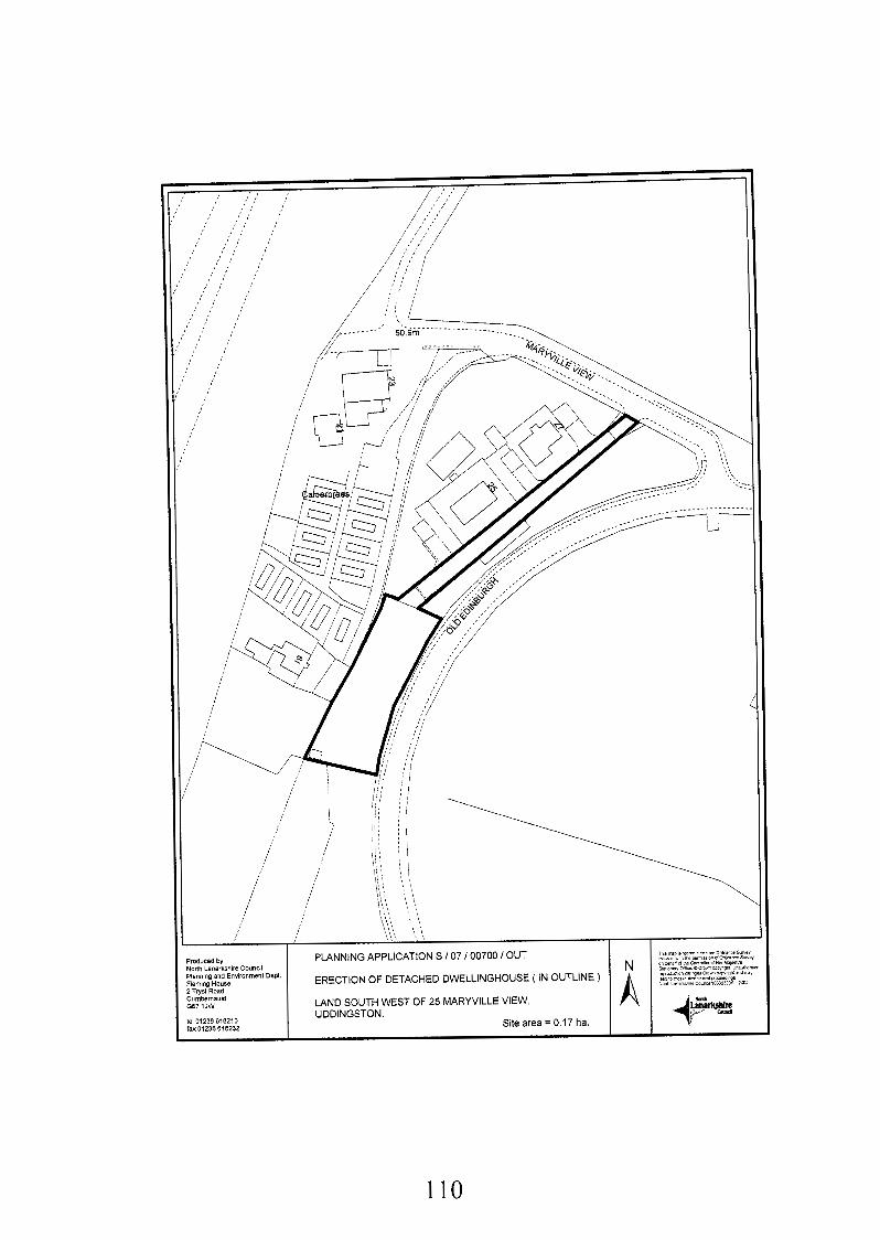
'roduced by iorlh Lanslkshlre Council 'ianning and Environment Dept. Yeming House, ! Twst Road
LAND SOUTH WEST OF 25 MARYVILLE VIEW, UDDINGSTON.
;umbrmuH 3 7 1JW
el01230610210 sxO1236 616232
Site area = 0.17 ha.
PLANNING APPLICATION S / 07 I00700 I OUT
ERECTION OF DETACHED DWELLINGHOUSE ( IN OUTLINE )
110
Representations:
Newspaper Advertisement:
No letters of representation received.
Advertised on 31st May 2007
Recommendation: Refuse for the Following Reason:-
1. The proposed development is contrary to Green Belt policy set out in Strategic Policies 1, 9 and 10 of the approved Glasgow and the Clyde Valley Joint Structure Plan 2000, Policy ENV 6 and HSG 12 of the Southern Area Local Plan Finalised Draft (Modified 2001, 2004 and 2005), national planning policy contained in SPP 3 “Planning and Housing” and Circular 2411985 “Development in the Countryside and Green Belts” in that it constitutes an additional dwellinghouse in the Green Belt where there is no justification in terms of agriculture, forestry, outdoor leisure or recreation. Furthermore, approval of a new dwelling would set an undesirable precedent for other developments within the Green Belt.
Note to Committee:
If granted this application will require to be referred to the Scottish Ministers in accordance with the Town and Country Planning (Notification of Applications) (Scotland) Direction 2006 as a development contrary to the development plan.
Background Papers:
Application form and plans received 26th April 2007
Memo from Transportation Team Leader received 14‘h June 2007 Memo from Geotechnical Team Leader received 30th May 2007 Letter from Scottish Water received 31 st May 2007 Letter from British Gas received 11 th June 2007 Letter from Scottish Power received 31 st May 2007 Letter from British Telecom received 29th May 2007
Glasgow and Clyde Valley Structure Plan 2000 Southern Area Local Plan, Finalised Draft (Modified 2001, 2004 and 2005) Uddingston and Tannochside Town Map approved 1973 SPP3 Planning for Housing 2003 Circular 24/1985 Development in the Countryside and Greenbelts
Any person wishing to inspect these documents should contact Mr Gordon Arthur at 01698 302136.
Date: 19 June 2007
111
AP PLI CAT1 0 N N 0. S/07/00700/0 UT
REPORT
1.
1 .I
2.
2.1
2.2
3.
3.1
3.2
3.3
3.2
3.3
Description of Site and Proposal
The application seeks permission in outline for the erection of a dwelling house on land south west of Maryville View. The site is bounded to the north by land at 25 Maryville View, to the west by the Calderbraes residential caravan site and to the east by Old Edinburgh Road (B7001). The south of the site is bound by open fields for a distance of 130 metres before reaching the Glasgow Road. The western part of the site is relatively level but falls away sharply on the eastern side towards Old Edinburgh Road. The site measures 20 metres wide by 50 metres long and is accessed from Maryville View via an existing private access which connects the site.
DeveloDment Plan
Strategic Policy 1 in the Glasgow and the Clyde Valley Structure Plan 2000 is applicable in this case. This states a presumption against the spread of built up areas and the encroachment of development into the countryside.
The site is identified as Policy ENV 6 (Green Belt) in the Southern Area Local Plan Finalised Draft (Modified 2001, 2004 and 2005).
Consultations and ReDresentations
Scottish Power has no objections but note the location of their plant in the vicinity of the site.
British Telecom has not objected to the proposal and give general information about their apparatus.
Scottish Water has no objections to the development. However, they state that the sewer network assets have adequate capacity to accommodate this development and their general preference is for a SUDS based surface water drainage scheme. They also note that there are issues within the waste water network which may require dialogue between themselves and the developer.
The Transportation Section advise that they have no objections to the application
Following neighbour notification and advertisement in the local press no objections were received.
112
4.
4.1
4.2
4.3
4.4
4.5
4.6
4.7
Plannina Assessment and Conclusions
In accordance with Section 25 of the Town and Country Planning (Scotland) Act 1997 planning decisions require to be made in accordance with the development plan unless material considerations indicate otherwise.
The application raises issues of a strategic and local nature and therefore must be considered in terms of both the Structure Plan and Local Plans for the area. The site is zoned as Green Belt in the Glasgow and the Clyde Valley Joint Structure Plan 2000. Strategic Policy 1 of the Structure Plan requires the continued safeguarding of the Glasgow and the Clyde Valley Green Belt, and imposes a presumption against the spread of built up areas and the encroachment of development into the countryside. The Structure Plan states that Local Plans shall define the detailed boundaries and policies to safeguard the Green Belt. The development must be assessed against the criteria set out in Strategic Policy 9, which include giving preference to brownfield rather than Greenfield sites and avoiding isolated and sporadic development in the Green Belt. Where any proposal fails to meet the criteria listed in Strategic Policy 9, the development is considered as a departure from the Structure Plan and must be justified against the criteria in Strategic Policy 10. The criteria in Strategic Policy 10 consider:
0 The contribution to promoting urban regeneration; 0 Avoiding any isolated and sporadic development in the Green Belt and the wider
countryside; 0 Effective Housing Land Supply and the establishment of a clear shortfall within the
appropriate Housing Market Area; 0 Specific Location Need.
The proposal is for a single house within the Green Belt and can therefore be considered contrary to the presumption in Strategic Policy 1. For this reason also, the proposal fails to satisfy the criteria contained in Strategic Policy 9. In terms of Strategic Policy 10, the applicant has not provided justification for the dwelling in terms of any of the above criteria listed at para 4.2 above. The proposal is therefore considered a departure from the Structure Plan.
With respect to Local Plan policies, the site is covered by Policy ENV6 (Green Belt) in the Southern Area Local Plan Finalised Draft (Modified 2001, 2004 and 2005). Policies HSG12 (Housing in the Green Belt and Countryside), ENVS (Assessment of Environmental Impact) and Policy TR13 (Assessing the Transport Implications of Development) are also relevant to the assessment of this application.
Policy ENV 6 presumes against any development that will affect the character and function of the Green Belt, within which there will be a presumption against development other than that directly associated with an appropriate rural use. In this instance, the applicant has provided no justification in terms of operational need for this dwelling at this particular location. The application is therefore clearly contrary to the provisions of Policy ENV6.
Policy HSG12 (Housing in the Green Belt and Countryside) of the Southern Area Local Plan Finalised Draft is a material consideration in the determination of this application. Policy HSG12 indicates that new houses will only be permitted where there is a proven operational need in accordance with Policy ENV6. As indicated in paragraph 4.5 above the proposal does not have such a justification and is therefore also contrary to Policy HSG12.
Policy TR 13 (Assessing Transport Implications of Development) sets out criteria for the Council to consider when assessing applications for development. These criteria include: the level of traffic generated and its impact on the environment and adjoining land uses; the impact of the development on road traffic circulation and road safety and; the provisions made for access, parking and vehicle manoeuvring. It is proposed that an existing access via an existing private road be used to serve the development. While there would be additional movements at this
113
location this would not be to the serious detriment of road safety and therefore would not be contrary to policy TR13. Subject to details being confirmed through a detailed application, the site could reasonable accommodate the required parking and turning facilities.
With regards to Circular 24/1985 “Development in the Countryside and Green Belts”, this states that urban sprawl and ribbon development should be avoided and isolated development in the countryside should be discouraged. This proposal is outwith any of the surrounding settlements and although there are some individual houses in the vicinity, it is considered that the proposed dwelling would result in an incremental erosion of the Green Belt at this location.
Further planning policy which is relevant to this application is contained in SPP3 “Planning for Housing”, which states that housing requirements should be met within existing towns and villages, in order to prevent sprawl and coalescence of settlements. The current application is therefore in conflict with this national policy guidance
4.8
4.9
4. 10 Scottish Planning Policy 21 (Green Belts) is also relevant to this proposal. SPP 21 states that there will be a strong presumption against inappropriate development in the green belt. Where a proposed use would not normally be consistent with green belt designation, exceptionally it may still be considered appropriate, either as a national priority or to meet an established need. No such justification has been submitted and it is therefore considered the application is contrary to SPP21 “Green Belts”.
4.1 1 In regard to consultation responses, these matters could be addressed through the submission of a Reserved Matters application,
5. Conclusion
5.1 The proposed development is considered to be contrary to development plan policy and the relevant national planning guidance and advice, in that the applicant has not provided any justification or need for the dwelling within the Green Belt. The proposal and would set a precedent for other similar developments within the Green Belt. In view of all relevant development plan policies and planning policy guidance, I find no justification for this proposed dwelling in the Green Belt. It is therefore recommended that planning permission be refused.
114
Application No:
Date Registered:
Applicant:
Agent
Development:
Location:
Ward:
Grid Reference:
File Reference:
Site History:
Development Plan:
S/O7/00701 /FUL
3rd May 2007
Mr Stephen Young 101 Heather Gardens Viewpark Uddingston G71 5DF
W. R. Hall Chartered Surveyors 7 Main Street Bothwell G718RD
Erection of Offices - One for Use as Taxi Radio Base (24 Hour Use) and One With Ancillary Garage and Workshop/Store
Land North Of 1 Myrtle Road Viewpark Uddingston Glasgow G71 5JF
13 Thorniewood: Councillors Burrows, McCabe and McShannon
270805 661 695
SIPLIBI9I85IGAIMM
None relevant
The adopted Uddingston and Tannochside Town Map 1973 zones the site as an Area Primarily for Industrial Use.
The Southern Area Local Plan Finalised Draft (Modified 2001, 2004 and 2005) zones the site as IND 8 (Established industrial and Business Areas).
Contrary to Development Plan: No
Consultations: Scottish Environment Protection Agency (No Response) Scottish Water (No Objection) Scottish Gas (No Objection) British Telecom (No Objection)
Representations:
Newspaper Advertisement:
1 letter of representation received.
Advertised on 1 7'h May 2007
115
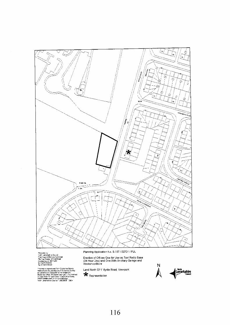
Produced by Nonh Lanarkshire Council Planning and Envimnment Dept Fieming HOUSB 2 Tryst Road Cumbarndd G67 1JW te 01236516210 fax 01236 616232
This map is rep(oducBd from Oidnance Survey mteriel wnh the pimission of Ordnance Sulyey on behalf d the C~nnollef of Her MalesHs Satiooery Office Q C i w n copyfight UnaiithorlLBd reprOdUCtion lnfiingea C r o w sopyrlght and may lead to prosecubon 01 civil Pmceedmgb N o m Lanarkshre Council 100023386 2004
Planning Application No. S I 07 I00701 I FUL
Erection of Offices One for Use as Taxi Radio Base (24 Hour Use) and One With Ancillary Garage and WorkshoplStore N Land North Of 1 Myrtle Road, Viewpark * Representation
116
Recommendation: Refuse for the Following Reasons:-
1. The proposed development is contrary to Policy IND9 (Assessing Applications for Industry and Business Developments) in the Southern Area Local Plan Finalised Draft (Modified 2001, 2004, and 2005), as the proposal is considered unsuitable adjoining a residential area and will have a negative impact on the character of the adjoining properties and the surrounding environment.
In the interest of amenity, in that the operation of a 24 hour business would constitute an inappropriate new development adjacent to an established residential area and would be considered contrary to policy RTL 1 1 (Assessing Applications For Bad Neighbour Development) of the Southern Area Local Plan Finalised Draft (Modified 2001, 2004 and 2005) which seeks to locate such uses in town centre areas, secondary, village or neighbourhood commercial areas.
2.
3. The proposed office development is contrary to Policy HSG8 (Established Housing Area) of the Southern Area Local Plan Finalised Draft (Modified 2001, 2004, and 2005), as the proposal is considered unsuitable adjoining a residential area and will have a detrimental impact on the amenity of the adjoining residential area and the surrounding environment.
Background Papers:
Application form and plans received 26th April 2007
Memo from Transportation Team Leader received 14th June 2006 Memo from Geotechnical Team Leader received 15th May 2007 Letter from British Telecom received 17th May 2007 Letter from Scottish Water received 23rd May 2007 Letter from Scotland Gas Networks received 30th May 2007
Letter from Joseph Young, 8 Myrtle Road, Viewpark, Uddingston, Glasgow, North Lanarkshire, G71 5JF received 8th May 2007.
Adopted Uddingston and Tannochside Town Map 1973 Southern Area Local Plan, Finalised Draft (Modified 2001, 2004 and 2005)
Any person wishing to inspect these documents should contact Mr Gordon Arthur at 01698 302136.
Date: 14 June 2007
117
APPLICATION NO. S/07/00701/FUL
REPORT
1.
1 .I
1.2
1.3
2.
2.1
2.2
2.3
3.
3.1
3.2
3.3
3.4
Description of Site and Proposal
Planning Permission is sought for the erection of a single building comprising 2 offices and ancillary garage and workshop/store accommodation, at land north of 1 Myrtle Road, Viewpark, Uddingston. One office would be used as a taxi radio base (24 hour), while the other with the associated garage and workshop/store would be used as premises for a company who supplies two-way radio equipment.
The proposed building is 7 metres in height and although it is single storey, a number of velux- type windows are proposed in the roof on both the front and rear elevations. The building is proposed to be 27 metres long and 10 metres wide, and finished in facing brick with a tiled roof.
The proposal is bounded by No.1 Myrtle Road (local newsagent shop) to the south and a large area of open ground which forms the rear curtilage (buffer zone) of the existing brickworks which lies to the north and east. This site is traversed by an existing bund measuring approximately 1.5 metres in height within the site area. To western boundary of the site is an established residential area.
Development Plan
The proposal raises no strategic issues in terms of the Glasgow and Clyde Valley Joint Structure Plan 2000 and can therefore be assessed against Local Plan Policies.
The adopted Uddingston and Tannochside Town Map 1973 zones the site as an Area Primarily for Industrial Use.
The application site is located within an area designated as Policy IND8 (Established Industrial Business Area) of the Southern Area Local Plan Finalised Draft (Modified 2001, 2004, and 2005).
Consultations and Representations
Scottish Gas Networks and British Telecom raised no objections to the proposal.
Scottish Water have no objections to the proposal, however they advised that planning approval does not guarantee a connection to the infrastructure until a satisfactory solution is identified. They advised that there may be pressure issues within the Water Network that serves this development, and there are known constraints in the waste water network. The developer is therefore required to ensure that this development will not have a detrimental impact on the water services currently provided. In addition, Scottish Water recommends that a separate drainage system is required with the surface water discharging to a suitable outlet. The principle of SUDS is recommended for discharging surface water.
The Geotechnical Section Team Leader has advised that insufficient detail has been submitted in respect of foul and surface water drainage and flooding to give proper consideration of this application.
The Transportation Section have no objections to the application, subject to conditions ensure appropriate access and parking provision.
118
3.5 Protective services advise that a phase 1 desk top study including the site history requires to be provided by the applicant to ascertain if the site has been previously used for any potentially contaminative purposes. Depending on the results of this investigation, further intrusive ground investigations may be required.
Following neighbour notification and advertisement in the local press one letter of objection was received and the following comments noted;
a) The proximity of the development to the local Primary School, a children’s crossing, the bend on Myrtle Road and there are houses immediately opposite the development.
b) The operation will involve 30 Taxi vehicles and operate on a 24 hour basis thereby causing noise and disturbance in a residential area.
3.6
4. Plannina Assessment and Conclusions
4.1 In accordance with Section 25 of the Town and Country Planning (Scotland) Act 1997 planning decisions require to be made in accordance with the development plan unless material considerations indicate otherwise.
4.2 The site is zoned in the adopted Uddingston and Tannochside Town Map 1973 as an Area Primarily for Industrial Use. This policy seeks to direct industrial development to appropriately zoned areas, where all proposals for development will be considered in relation to the surroundings. In assessing this proposal against the provisions of this policy, it is considered that although the site is zoned for industrial purposes, the proximity of this development to residential properties would result in a form of development which is incompatible with its surroundings. Therefore it is considered that this proposal is contrary to the policy contained within the adopted local plan.
4.3 The site is zoned within an area covered by policy IND 8 (Established Industrial and Business Area) in the Southern Area Local Plan Finalised Draft (Modified 2001, 2004, and 2005). Policies HSG8 (Established Housing Areas), IND9 (Assessing Applications for Industrial and Business Development), RTLI 1 (Assessing Applications for Bad Neighbour Development) and TRI 3 (Assessing the Transport Implications of Development) are also relevant to consideration of this application.
4.4 Policy IND 8 seeks to retain the existing character of Established Industrial and Business Areas by safeguarding existing uses and supporting the development of General Industrial, Distribution, Storage or Class 4 Business Uses where appropriate. In considering Policy IND8, the site lies within the curtilage of the existing lbstock Brickworks, however the application site is accessed from Myrtle Road, which currently serves primarily residential properties. This site also forms part of a landscaped buffer zone between the brick works and the established residential area to the east. While the proposal represents a development which may, in principle, accord with the development plan in terms of zoning, the zoning reflects the site’s wider use by lbstock Brickworks. This site is located within an important landscaped buffer associated with the brickworks, and would require a new dedicated access through a residential area. In this respect, it is considered that the proposal constitutes an inappropriate location for the type of development proposed.
4.5 Policy IND 9 (Assessing Applications for Industry and Business Developments) is also considered relevant as the proposal includes a taxi radio base, workshop and store. In assessing applications for industrial and business development the following criteria are considered: the suitability to the character of the area within which it is set; detailed design elements such as building height, materials and positioning; and provision made for servicing, access, vehicle circulation, manoeuvring and parking. In considering these criteria, the site
119
fronts on to an established residential area. The additional vehicular activity and 24 hour operation, as well as disturbance generated from the garage I workshop element of the proposal, does not accord with a residential area and the loss of amenity to the surrounding environment of established residential properties is considered to be unacceptable. Introducing two business premises into an otherwise homogenous residential area will give rise to a conflict of uses. Therefore, the residential character of the wider area is not a suitable location for this proposal. In terms of the detailed design elements, it is considered that the proposed design and materials raise no specific issues, However, although this proposal is single storey, it is 7 metres in height. The surrounding residential properties are predominantly 2 storeys, and 8 metres in height. Therefore, by virtue of the height and positioning, particularly in light of the industrial type of building proposed in an established residential area, it would be visually prominent within the streetscape at this location. In terms of access, vehicle circulation, manoeuvring and parking, these issues are examined in paragraph 4.8 below. However, overall the proposal is considered to be contrary to the criteria of policy IND 9.
As the site is adjacent to an established housing area, Policy HSG 8 is relevant. The policy seeks to protect the established character of existing and new housing areas by opposing development which is incompatible with a residential setting and adversely affects the amenity of established housing areas. The additional vehicular traffic and 24 hour operation as well as the garage workshop element of the proposal does not conform to the expectations of its residential surroundings. The impact in terms of character and the surrounding environment of established residential properties is considered to be negative, introducing Bad Neighbour business premises into a residential area. While there is a small shop adjacent to the proposed development this serves the needs of the residential area and is considered to be generally ancillary to the established housing by virtue of its scale and compatible nature. I would also note that in visual terms, part of an existing landscaped buffer would be lost, further impacting on the general amenity of the area and its relationship with the brickworks. The proposed development is considered inappropriate in this area and is therefore contrary to Policy HSG 8.
4.6
4.7 Policy RTLl1 (Assessing Applications for Bad Neighbour Development) is also relevant in assessing the proposal in that the proposal would introduce a 24 hour commercial use adjacent to an established residential area. Policy RTL 11 states that bad neighbour development should preferably be located in town centre areas, secondary, village, or in this example neighbourhood commercial area. In assessing proposals for the establishment of such uses the council will consider a number of criteria including: the impact of the proposal on the character and amenity of adjoining properties and the surrounding environment; detailed design elements such as building height, materials, positioning, access for pedestrians and disabled people; and the provisions made for vehicular access, servicing, parking and the proposals' impact on pedestrian safety and traffic circulation. With regard to design issues I refer to paragraph 4.5 above. There will be no loss of sunlight or privacy and materials can be controlled by condition. The site, however is not within a town centre or secondary shopping area. While it does have an industrial zoning, it is on the periphery of a large industrial site and forms part of a landscape buffer. In character, this site is related more closely to the residential area to the west. Bad Neighbour uses in this area are therefore considered to be incompatible with the established character and should be directed to more appropriate sites. No supporting information has been provided to justify the uses at this location or to demonstrate there are no vacant sites in other established industriakommercial areas. No information has been submitted with respect to anticipated noise. Notwithstanding this information, I still consider that in basic policy terms, the uses should be directed to appropriate sites, and not in residential areas.
4.8 In assessing transportation implications for the development, Policy TR13 (Assessing the Transport Implications of Development) sets out criteria which include: the level of traffic generated and its impact on the environment and adjoining land uses; impact of the development on road traffic circulation and road safety; and the provisions made for access, parking and vehicle manoeuvring. The Transportation Team Leader has no objections subject to conditions regarding access to the site and internal parking provisions. It is also noted that
120
the existing lay-by should not be extended in order to prevent adverse vehicle manoeuvres on Myrtle Road. These matters could be addressed through the imposition of a suitable planning condition. However, in this case the decision to recommend refusal renders this ineffective.
4.9 In response to the letter of objection received I would advise as follows:
(a) In regard to the proximity of the development to the local Primary School, a children’s crossing, the bend on Myrtle Road and nearby houses, I note that my Transportation Section consider the development to be acceptable subject to conditions. Although the development would be located next to an existing shop and the taxi use proposed is as a radio base only, the proposed development is not appropriate adjacent to a residential area and would result in a loss of amenity. I refer to the details contained in this report.
(b)
4.10 In conclusion it is considered that the development, while not contrary in policy zoning terms, would give rise to material considerations that would merit a presumption against the proposal. Therefore, it is recommended that permission be refused for the reasons outlined above.
121