Embed Size (px)
Citation preview
83© 2016 GEUS. Geological Survey of Denmark and Greenland Bulletin 35, 83–86. Open access: www.geus.dk/publications/bull
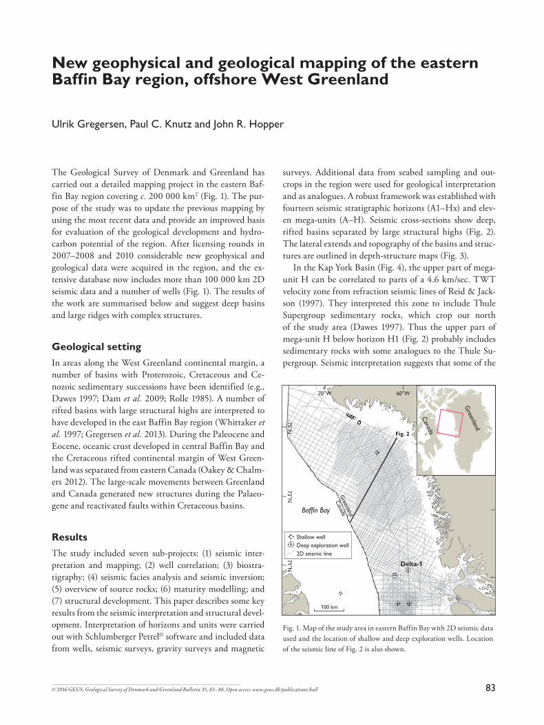
The Geological Survey of Denmark and Greenland has
carried out a detailed mapping project in the eastern Baf-
fin Bay region covering c. 200 000 km2 (Fig. 1). The pur-
pose of the study was to update the previous mapping by
using the most recent data and provide an improved basis
for evaluation of the geological development and hydro-
carbon potential of the region. After licensing rounds in
2007–2008 and 2010 considerable new geophysical and
geological data were acquired in the region, and the ex-
tensive database now includes more than 100 000 km 2D
seismic data and a number of wells (Fig. 1). The results of
the work are summarised below and suggest deep basins
and large ridges with complex structures.
Geological setting In areas along the West Greenland continental margin, a
number of basins with Proterozoic, Cretaceous and Ce-
nozoic sedimentary successions have been identified (e.g.,
Dawes 1997; Dam et al. 2009; Rolle 1985). A number of
rifted basins with large structural highs are interpreted to
have developed in the east Baffin Bay region (Whittaker et
al. 1997; Gregersen et al. 2013). During the Paleocene and
Eocene, oceanic crust developed in central Baffin Bay and
the Cretaceous rifted continental margin of West Green-
land was separated from eastern Canada (Oakey & Chalm-
ers 2012). The large-scale movements between Greenland
and Canada generated new structures during the Palaeo-
gene and reactivated faults within Cretaceous basins.
ResultsThe study included seven sub-projects: (1) seismic inter-
pretation and mapping; (2) well correlation; (3) biostra-
tigraphy; (4) seismic facies analysis and seismic inversion;
(5) overview of source rocks; (6) maturity modelling; and
(7) structural development. This paper describes some key
results from the seismic interpretation and structural devel-
opment. Interpretation of horizons and units were carried
out with Schlumberger Petrel© software and included data
from wells, seismic surveys, gravity surveys and magnetic
surveys. Additional data from seabed sampling and out-
crops in the region were used for geological interpretation
and as analogues. A robust framework was established with
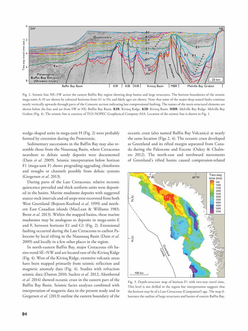
fourteen seismic stratigraphic horizons (A1–Hx) and elev-
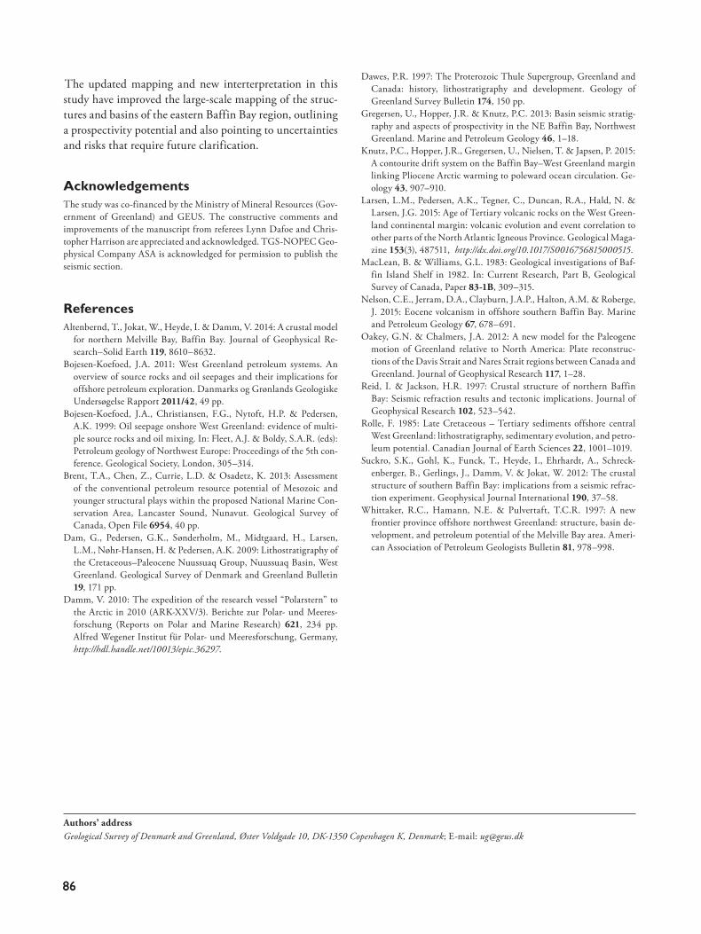
en mega-units (A–H). Seismic cross-sections show deep,
rifted basins separated by large structural highs (Fig. 2).
The lateral extends and topography of the basins and struc-
tures are outlined in depth-structure maps (Fig. 3).
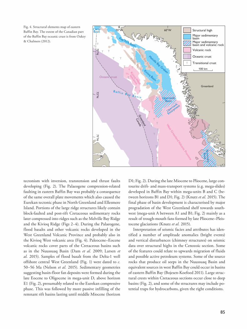
In the Kap York Basin (Fig. 4), the upper part of mega-
unit H can be correlated to parts of a 4.6 km/sec. TWT
velocity zone from refraction seismic lines of Reid & Jack-
son (1997). They interpreted this zone to include Thule
Supergroup sedimentary rocks, which crop out north
of the study area (Dawes 1997). Thus the upper part of
mega-unit H below horizon H1 (Fig. 2) probably includes
sedimentary rocks with some analogues to the Thule Su-
pergroup. Seismic interpretation suggests that some of the
New geophysical and geological mapping of the eastern Baffin Bay region, offshore West Greenland
Ulrik Gregersen, Paul C. Knutz and John R. Hopper
70°W 60°W
Fig. 2
Delta-1
Baffin Bay
71°N73°N
75°N
100 km
Canada
Greenland
Canada
Greenland
Shallow well
Deep exploration well
2D seismic line
Fig. 1. Map of the study area in eastern Baffin Bay with 2D seismic data
used and the location of shallow and deep exploration wells. Location
of the seismic line of Fig. 2 is also shown.
8484
wedge-shaped units in mega-unit H (Fig. 2) were probably
formed by extension during the Proterozoic.
Sedimentary successions in the Baffin Bay may also re-
semble those from the Nuussuaq Basin, where Cretaceous
nearshore to deltaic sandy deposits were documented
(Dam et al. 2009). Seismic interpretation below horizon
F1 (mega-unit F) shows prograding-aggrading clinoforms
and troughs or channels possibly from deltaic systems
(Gregersen et al. 2013).
During parts of the Late Cretaceous, relative tectonic
quiescence prevailed and thick uniform units were deposit-
ed in the basins. Marine mudstone deposits with suggested
source-rock intervals and oil seeps were recovered from both
West Greenland (Bojesen-Koefoed et al. 1999) and north-
ern East Canadian islands (MacLean & Williams 1983;
Brent et al. 2013). Within the mapped basins, these marine
mudstones may be analogous to deposits in mega-units E
and F, between horizons E1 and G1 (Fig. 2). Extensional
faulting occurred during the Late Cretaceous to earliest Pa-
leocene by local rifting in the Nuussuaq Basin (Dam et al.
2009) and locally in a few other places in the region.
In north-eastern Baffin Bay, major Cretaceous rift ba-
sins trend SE–NW and are located east of the Kivioq Ridge
(Fig. 4). West of the Kivioq Ridge, extensive volcanic areas
have been mapped primarily from seismic reflection and
magnetic anomaly data (Fig. 4). Studies with refraction
seismic data (Damm 2010; Suckro et al. 2012; Altenbernd
et al. 2014) showed oceanic crust in the eastern part of the
Baffin Bay Basin. Seismic facies analyses combined with
interpretation of magnetic data in the present study and in
Gregersen et al. (2013) outline the eastern boundary of the
oceanic crust (also named Baffin Bay Volcanics) at nearly
the same location (Figs 2, 4). The oceanic crust developed
as Greenland and its rifted margin separated from Cana-
da during the Paleocene and Eocene (Oakey & Chalm-
ers 2012). The north-east and northward movements
of Greenland’s rifted basins caused compression-related
2
0
4
Tw
o-w
ay t
rave
l tim
e (s
ec.)
6
8 20 km
Melville Bay GrabenMBRKIRKIRBaffin Bay Basin KIB Kivioq Basin
A1B1C1D1
HxH2
A1Quaternary
Archaean
Ce n o z o
i c
F2
Quaternary
SW NE
Archaean C
r et a
c eo
us
Cr e
t ac e
ou
s
Proterozoic
Proterozoic
Ce n o z o
i cB1C1D1E1F1
G1
H1
E1
ExEx
PalaeogeneBaffin Bay Volcanics
(Oceanic crust)
PalaeogeneBaffin Bay Volcanics
(Oceanic crust)
F1 F2 F1
E1
F1
E1
G1
H1
HxH2
100 km
Canada
Greenland
70°W 60°W
73°N75°N
Two-waytime (ms)
5500500045004000350030002500200015001000500
Fig. 2. Seismic line NE–SW across the eastern Baffin Bay region showing deep basins and large structures. The horizon boundaries of the seismic
mega-units A–H are shown by coloured horizons from A1 to Hx and likely ages are shown. Note that some of the major deep-seated faults continue
nearly vertically upwards through parts of the Cenozoic section indicating late compressional faulting. The names of the main structural elements are
shown below the line and are from SW to NE: Baffin Bay Basin. KIR: Kivioq Ridge. KIB: Kivioq Basin. MBR: Melville Bay Ridge. Melville Bay
Graben (Fig. 4). The seismic line is courtesy of TGS-NOPEC Geophysical Company ASA. Location of the seismic line is shown in Fig. 1.
Fig. 3. Depth-structure map of horizon F1 with two-way travel time.
This level is not drilled in the region but interpretation suggests that
the horizon may be of a Late Cretaceous (Campanian?) age. The map il-
lustrates the outline of large structures and basins of eastern Baffin Bay.
85
tectonism with inversion, transtension and thrust faults
developing (Fig. 2). The Palaeogene compression-related
faulting in eastern Baffin Bay was probably a consequence
of the same overall plate movements which also caused the
Eurekan tectonic phase in North Greenland and Ellesmere
Island. Portions of the large ridge structures likely contain
block-faulted and post-rift Cretaceous sedimentary rocks
later compressed into ridges such as the Melville Bay Ridge
and the Kivioq Ridge (Figs 2–4). During the Palaeogene,
flood basalts and other volcanic rocks developed in the
West Greenland Volcanic Province and probably also in
the Kivioq West volcanic area (Fig. 4). Paleocene–Eocene
volcanic rocks cover parts of the Cretaceous basins such
as in the Nuussuaq Basin (Dam et al. 2009; Larsen et
al. 2015). Samples of flood basalt from the Delta-1 well
offshore central West Greenland (Fig. 1) were dated to c.
50–56 Ma (Nelson et al. 2015). Sedimentary geometries
suggesting basin-floor fan deposits were formed during the
late Eocene to Oligocene in mega-unit D, above horizon
E1 (Fig. 2), presumably related to the Eurekan compressive
phase. This was followed by more passive infilling of the
remnant rift basins lasting until middle Miocene (horizon
D1; Fig. 2). During the late Miocene to Pliocene, large con-
tourite drift- and mass-transport systems (e.g. mega-slides)
developed in Baffin Bay within mega-units B and C (be-
tween horizons B1 and D1; Fig. 2) (Knutz et al. 2015). The
final phase of basin development is characterised by major
progradation of the West Greenland shelf towards south-
west (mega-unit A between A1 and B1; Fig. 2) mainly as a
result of trough-mouth fans formed by late Pliocene–Pleis-
tocene glaciations (Knutz et al. 2015).
Interpretation of seismic facies and attributes has iden-
tified a number of amplitude anomalies (bright events)
and vertical disturbances (chimney structures) on seismic
data over structural highs in the Cenozoic section. Some
of the features could relate to upwards migration of fluids
and possible active petroleum systems. Some of the source
rocks that produce oil seeps in the Nuussuaq Basin and
equivalent sources in west Baffin Bay could occur in basins
of eastern Baffin Bay (Bojesen-Koefoed 2011). Large struc-
tural crests within Cretaceous sections occur close to deep
basins (Fig. 2), and some of the structures may include po-
tential traps for hydrocarbons, given the right conditions.
70°W 60°W 50°W
71°N
73°N
75°N
Kivioq Basin
Kivioq Ridge
West G
reenland Volcanic Province
Melville Bay R
idge
Kap York Basin
Kivioq W
est
Volcanics
CareyBasin
Upern
avik
Esca
rpmen
t
Canada
Greenland
Melville Bay G
raben
TT
T
T
T
TT
T
T
T
T
TT
T
T
T
T
T
T
T
T
T
T
T
T
T
T
T
UpernavikBasin
Nuussu
aq
Basin
B a f f i n B a y B a s i n
Greenland
Oceanic crust
T
Structural high
Major sedimentarybasinMajor sedimentarybasin and volcanic rock
Volcanic rock
Oceanic crust
Transitional crust
100 km
Fig. 4. Structural elements map of eastern
Baffin Bay. The extent of the Canadian part
of the Baffin Bay oceanic crust is from Oakey
& Chalmers (2012).
8686
The updated mapping and new interterpretation in this
study have improved the large-scale mapping of the struc-
tures and basins of the eastern Baffin Bay region, outlining
a prospectivity potential and also pointing to uncertainties
and risks that require future clarification.
AcknowledgementsThe study was co-financed by the Ministry of Mineral Resources (Gov-
ernment of Greenland) and GEUS. The constructive comments and
improvements of the manuscript from referees Lynn Dafoe and Chris-
topher Harrison are appreciated and acknowledged. TGS-NOPEC Geo-
physical Company ASA is acknowledged for permission to publish the
seismic section.
ReferencesAltenbernd, T., Jokat, W., Heyde, I. & Damm, V. 2014: A crustal model
for northern Melville Bay, Baffin Bay. Journal of Geophysical Re-
search–Solid Earth 119, 8610–8632.
Bojesen-Koefoed, J.A. 2011: West Greenland petroleum systems. An
overview of source rocks and oil seepages and their implications for
offshore petroleum exploration. Danmarks og Grønlands Geologiske
Undersøgelse Rapport 2011/42, 49 pp.
Bojesen-Koefoed, J.A., Christiansen, F.G., Nytoft, H.P. & Pedersen,
A.K. 1999: Oil seepage onshore West Greenland: evidence of multi-
ple source rocks and oil mixing. In: Fleet, A.J. & Boldy, S.A.R. (eds):
Petroleum geology of Northwest Europe: Proceedings of the 5th con-
ference. Geological Society, London, 305–314.
Brent, T.A., Chen, Z., Currie, L.D. & Osadetz, K. 2013: Assessment
of the conventional petroleum resource potential of Mesozoic and
younger structural plays within the proposed National Marine Con-
servation Area, Lancaster Sound, Nunavut. Geological Survey of
Canada, Open File 6954, 40 pp.
Dam, G., Pedersen, G.K., Sønderholm, M., Midtgaard, H., Larsen,
L.M., Nøhr-Hansen, H. & Pedersen, A.K. 2009: Lithostratigraphy of
the Cretaceous–Paleocene Nuussuaq Group, Nuussuaq Basin, West
Greenland. Geological Survey of Denmark and Greenland Bulletin
19, 171 pp.
Damm, V. 2010: The expedition of the research vessel “Polarstern” to
the Arctic in 2010 (ARK-XXV/3). Berichte zur Polar- und Meeres-
forschung (Reports on Polar and Marine Research) 621, 234 pp.
Alfred Wegener Institut für Polar- und Meeresforschung, Germany,
http://hdl.handle.net/10013/epic.36297.
Dawes, P.R. 1997: The Proterozoic Thule Supergroup, Greenland and
Canada: history, lithostratigraphy and development. Geology of
Greenland Survey Bulletin 174, 150 pp.
Gregersen, U., Hopper, J.R. & Knutz, P.C. 2013: Basin seismic stratig-
raphy and aspects of prospectivity in the NE Baffin Bay, Northwest
Greenland. Marine and Petroleum Geology 46, 1–18.
Knutz, P.C., Hopper, J.R., Gregersen, U., Nielsen, T. & Japsen, P. 2015:
A contourite drift system on the Baffin Bay–West Greenland margin
linking Pliocene Arctic warming to poleward ocean circulation. Ge-
ology 43, 907–910.
Larsen, L.M., Pedersen, A.K., Tegner, C., Duncan, R.A., Hald, N. &
Larsen, J.G. 2015: Age of Tertiary volcanic rocks on the West Green-
land continental margin: volcanic evolution and event correlation to
other parts of the North Atlantic Igneous Province. Geological Maga-
zine 153(3), 487511, http://dx.doi.org/10.1017/S0016756815000515.
MacLean, B. & Williams, G.L. 1983: Geological investigations of Baf-
fin Island Shelf in 1982. In: Current Research, Part B, Geological
Survey of Canada, Paper 83-1B, 309–315.
Nelson, C.E., Jerram, D.A., Clayburn, J.A.P., Halton, A.M. & Roberge,
J. 2015: Eocene volcanism in offshore southern Baffin Bay. Marine
and Petroleum Geology 67, 678–691.
Oakey, G.N. & Chalmers, J.A. 2012: A new model for the Paleogene
motion of Greenland relative to North America: Plate reconstruc-
tions of the Davis Strait and Nares Strait regions between Canada and
Greenland. Journal of Geophysical Research 117, 1–28.
Reid, I. & Jackson, H.R. 1997: Crustal structure of northern Baffin
Bay: Seismic refraction results and tectonic implications. Journal of
Geophysical Research 102, 523–542.
Rolle, F. 1985: Late Cretaceous – Tertiary sediments offshore central
West Greenland: lithostratigraphy, sedimentary evolution, and petro-
leum potential. Canadian Journal of Earth Sciences 22, 1001–1019.
Suckro, S.K., Gohl, K., Funck, T., Heyde, I., Ehrhardt, A., Schreck-
enberger, B., Gerlings, J., Damm, V. & Jokat, W. 2012: The crustal
structure of southern Baffin Bay: implications from a seismic refrac-
tion experiment. Geophysical Journal International 190, 37–58.
Whittaker, R.C., Hamann, N.E. & Pulvertaft, T.C.R. 1997: A new
frontier province offshore northwest Greenland: structure, basin de-
velopment, and petroleum potential of the Melville Bay area. Ameri-
can Association of Petroleum Geologists Bulletin 81, 978–998.
Authors’ addressGeological Survey of Denmark and Greenland, Øster Voldgade 10, DK-1350 Copenhagen K, Denmark; E-mail: [email protected]