Embed Size (px)
Citation preview
FS 4D - Landslide and Subsidence Monitoring II 1/17 Febri HIRNAWAN, Dicky MUSLIM, and Emi SUKIYAH, Indonesia A Measure of Intense Active Tectonism Through Manifestation of River Basin Morphometry Development on Quaternary Volcanic Deposits (4235) - Case study : at Ciremai and Slamet Volcanoes FIG Congress 2010 Facing the Challenges – Building the Capacity Sydney, Australia, 11-16 April 2010
A Measure of Intense Active Tectonism Through Manifestation of River Basin Morphometry Development on Quaternary Volcanic Deposits (4235)
Case study : at Ciremai and Slamet Volcanoes
Febri HIRNAWAN, Dicky MUSLIM, and Emi SUKIYAH, Indonesia
Key words : tectonic morphometry, tectonic intensity, neotectonism, Indonesia. SUMMARY This is a summary on the paper on neotectonism in West and Central Java, which explains the latest scientific invention in these issues. Significant coefficients of correlation of no less than 0.9 between river segment and lineament azimuths in river basins developing on both Tertiary rocks and the unconformably overlying Quaternary deposits exhibit that drainage networks are governed by deformation pattern due to tectonic activity. Pattern and density of deformation, represented by bifurcation ratio (Rb) and drainage density (Dd) respectively as samples of morphometry variables taken from many river basins developing in both the chronostratigraphic systems due to neotectonics have been tested to verify the hypotheses about the active tectonics. The result in the region around the Ciremai volcano region proved that difference of mean values of pattern and fracture density on Quaternary deposits with that on Tertiary sediments are not significant, suggesting intense neotectonism. On the other hand, result in Slamet volcano region exhibits less intense active tectonism, by which the mean difference of deformation pattern (mean Rb) developing on the above mentioned systems is not significant, whereas mean of fracture density (mean Dd) on the systems is significantly different. SUMMARY (Summary in Bahasa Indonesia) Ini adalah ikhtisar makalah tentang neotektonika di Jawa Barat dan Tengah, yang menjelaskan temuan ilmiah mutakhir tentang gejala tersebut. Koefisien korelasi yang signifikan tidak kurang dari 0,9 antara arah segmen sungai dan kelurusan pada batuan Tersier dan endapan Kuarter menunjukan bahwa kegiatan tektonik mengendalikan pola pengaliran. Pola dan kerapatan deformasi, yang diwakili nisbah percabangan (Rb) dan kerapatan pengaliran (Dd) sebagai sample morfometri dari beberapa daerah aliran sungai pada kedua system kronostratigrafi tsb di atas telah digunakan untuk menguji hipotesis tentang tektonik aktif tsb. Hasilnya di wilayah G. Ciremai telah membuktikan bahwa rata-rata pola dan kerapatan deformasi dari kedua system tidak berbeda nyata, yang berarti kegiatan neoteknonik intensif. Dalam hal lain, hasil di wilayah G. Slamet menujukkan kegatan tektonik yang kurang intensif, yang menyebabkan harga rata-rata pola deformasi dari kedua system tidak berbeda nyata, tetapi harga rata-rata kerapatan deformasi dari kedua sistem itu berbeda secara nyata.
FS 4D - Landslide and Subsidence Monitoring II 2/17 Febri HIRNAWAN, Dicky MUSLIM, and Emi SUKIYAH, Indonesia A Measure of Intense Active Tectonism Through Manifestation of River Basin Morphometry Development on Quaternary Volcanic Deposits (4235) - Case study : at Ciremai and Slamet Volcanoes FIG Congress 2010 Facing the Challenges – Building the Capacity Sydney, Australia, 11-16 April 2010
A Measure of Intense Active Tectonism Through Manifestation of River Basin Morphometry Development on Quaternary Volcanic Deposits (4235)
Case study : at Ciremai and Slamet Volcanoes
Febri HIRNAWAN, Dicky MUSLIM, and Emi SUKIYAH, Indonesia
ABSTRACT Indications exhibiting active tectonic movements in Java occur in many regions characterized by unstable regions, such as active faults, mass movements, earthquakes, volcanic eruptions, etc. Deformation encompassing folds, joints, and faults in the Quaternary volcanic deposits indicates active tectonic movement or neotectonism. Differences of pattern and joint frequency or density of lineaments representing deformation in the same rock stratigraphic unit are able to be utilized to measure the tectonic intensity which deformed the unit. This approach can also be used to measure the degree of active tectonic intensity by comparing the deformation pattern and density developing in Tertiary rocks with those in Quaternary deposits. The intense tectonic activity should generate the same pattern and density of lineaments in both rock units, whereas the less tectonic intensity should be indicated by less lineament density in the Quaternary deposits. This paper presents the results of researches conducted in studied areas in West and Central Java on tectonic morphometry developments of river basins both in Quaternary deposits and Tertiary sediments, which exhibit degree of active tectonic intensity. Statistics approach as the chosen methodology had been utilized to gain meaningful conclusions through the verification of hypotheses, which are based on valid and reliable tested data obtained from the fields and satellite imagery. Results of regression-correlation tests between azimuths of river segment and lineaments in both chronostratigraphic systems mentioned earlier are significant with several large values of correlation coefficients r of no less than 0.9. On the other hand, results of t-tests are not significant difference of means of bifurcation ratio (Rb) and drainage density (Dd) from many river basins. These results of all tests have verified the effect of active tectonic control on the morphometry development process regarding river segments and density of drainage patterns development in Tertiary and Quaternary deposits. Such the researches are very important regarding the spatial development design of region of active tectonism that should be well understood by planners for decision making mainly through comprehensive approach, in which the phenomena involved explaining the characteristics of the region as part of an active plate margin.
FS 4D - Landslide and Subsidence Monitoring II 3/17 Febri HIRNAWAN, Dicky MUSLIM, and Emi SUKIYAH, Indonesia A Measure of Intense Active Tectonism Through Manifestation of River Basin Morphometry Development on Quaternary Volcanic Deposits (4235) - Case study : at Ciremai and Slamet Volcanoes FIG Congress 2010 Facing the Challenges – Building the Capacity Sydney, Australia, 11-16 April 2010
1. INTRODUCTION Neotectonic movements are manifested by unstable regions, in which active faults, land subsidences, earthquakes, volcanic eruptions, rock mass movements, etc., occur. This active tectonic movement in West Java plays an important role in affecting the development of river basin morphology on Quaternary volcanic deposits (Hirnawan et al., 1998; Hirnawan & Muslim, 2006). Recent flexural deformations are good indicators to the surface movement characterizing recent tectonic activity or neotectonism (Nakata et al., 1996). Tectonic movement is also known as tectonism. Tectonism or diastrophism is a general term for all movement of the crust caused by all tectonic processes, including the formation of trenches and ocean basins, volcanic belts, continents, plateaus, and mountain ranges. Tectonism is more suitable for the more specific term (Bates & Jackson, 1984; McNeil, 1999). This paper is written based on results of three researches of neotectonic activity conducted by the present author himself, also by him and his team, using verification method through data analyses of deformation pattern and river basin morphometry in terms of geomorphology development determined by active tectonic movements in the region between eastern West Java (Hirnawan, 1997; Hirnawan & Muslim, 2006; Sophian, 2009) and western Central Java (Hirnawan et al., 2007) as shown in Figure 1, instead of usual approach of descriptive and qualitative characterization of the phenomena. At least, in this region four variables encompassing lineament, river segment, drainage density, and bifurcation ratio of drainage basins developing in areas of distribution of both Quaternary volcanic deposits and the unconformably underlying Tertiary marine sediments were measured, analyzed, and tested for the verification of the hypotheses. Geomorphology of a region should be of destructional or constructional origin. Destructional origin generates erosional and residual features, whereas constructional origin generates depositional feature (Linsley et al., 1975). Valleys were developed by erosional process, along which streams flow following geological weaknesses, such as joints or faults (or lineaments), bedding planes, unconformities, zones of weak rocks, etc., in the region. In other words, this erosional feature is governed by the pattern of erodible geological weaknesses and the climate, by which the characteristics of river basins are generated (Stewart & Hancock, 1994; Keller & Pinter, 1999). Tectonic geomorphology, as has been well known by geologists, involves the processes of tectonism, erosion, and deposition in a region (Burbank & Anderson, 2001). The objective of the researches are to get the measures of tectonic intensity based on manifestations of measurable and verifiable morphometry developments as the responses to the tectonism itself. Scientific problems as the reason to conduct the researches of the active tectonic region with the occurrences of the indications mentioned above are as follows :
FS 4D - Landslide and Subsidence Monitoring II 4/17 Febri HIRNAWAN, Dicky MUSLIM, and Emi SUKIYAH, Indonesia A Measure of Intense Active Tectonism Through Manifestation of River Basin Morphometry Development on Quaternary Volcanic Deposits (4235) - Case study : at Ciremai and Slamet Volcanoes FIG Congress 2010 Facing the Challenges – Building the Capacity Sydney, Australia, 11-16 April 2010
1) how far has the recent tectonic activity been controlling or determining river segments development pattern of drainage network;
2) how far has the tectonic activity generated deformation configuration in terms of lineament
pattern and density that facilitated the river basin morphometry developments on both Quaternary and Tertiary rock deposits.
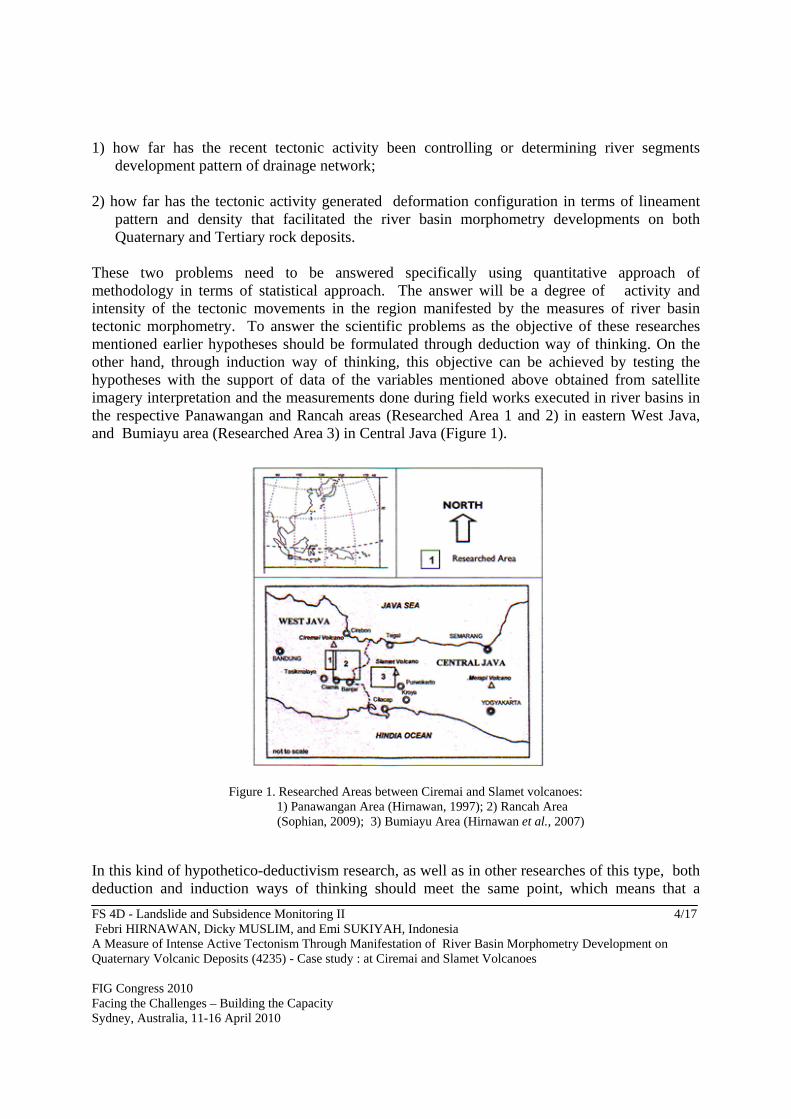
These two problems need to be answered specifically using quantitative approach of methodology in terms of statistical approach. The answer will be a degree of activity and intensity of the tectonic movements in the region manifested by the measures of river basin tectonic morphometry. To answer the scientific problems as the objective of these researches mentioned earlier hypotheses should be formulated through deduction way of thinking. On the other hand, through induction way of thinking, this objective can be achieved by testing the hypotheses with the support of data of the variables mentioned above obtained from satellite imagery interpretation and the measurements done during field works executed in river basins in the respective Panawangan and Rancah areas (Researched Area 1 and 2) in eastern West Java, and Bumiayu area (Researched Area 3) in Central Java (Figure 1).
Figure 1. Researched Areas between Ciremai and Slamet volcanoes: 1) Panawangan Area (Hirnawan, 1997); 2) Rancah Area
(Sophian, 2009); 3) Bumiayu Area (Hirnawan et al., 2007)
In this kind of hypothetico-deductivism research, as well as in other researches of this type, both deduction and induction ways of thinking should meet the same point, which means that a
FS 4D - Landslide and Subsidence Monitoring II 5/17 Febri HIRNAWAN, Dicky MUSLIM, and Emi SUKIYAH, Indonesia A Measure of Intense Active Tectonism Through Manifestation of River Basin Morphometry Development on Quaternary Volcanic Deposits (4235) - Case study : at Ciremai and Slamet Volcanoes FIG Congress 2010 Facing the Challenges – Building the Capacity Sydney, Australia, 11-16 April 2010
hypothesis is testable or verified to generate a gained proper or reliable conclusion about the phenomenon of the neotectonic activity determining the river basin morphometry development on both Quaternary volcanic deposits and the unconformably underlying rock formations. This tectonic geomorphology phenomenon, in which many morphometry variables involved gives scientific reasons to conduct the verification of the hypotheses to achieve the measured, tested and powerful conclusions instead of qualitative interpretations. The formulated hypotheses that should be verified using statistics are presented below. 1) Active tectonic movement has been determining river segment development patterns or
drainage network, in which correlation between river segment azimuth and lineament azimuth significantly confirms this process.
2) An intense and active tectonic movement generated similar both deformation pattern and
density developing on Quaternary volcanic deposits with that on Tertiary sedimentary rocks respectively, by which both bifurcation ratio and drainage density of river basins (the entire area drained by a river and its tributaries. Cf : drainage basin; McNeil, 1999) being formed on these rock formations are not significant difference.
2. METHOD 2.1. Sampling Technique For every researched area test of Hypothesis 1 needs data of lineaments and river segment azimuths, while test of Hypothesis 2 needs data of drainage density Dd and bifurcation ratio Rb of river basin. A probabilistic approach gives a clear understanding that a sample is known as a group of n-sized individual data representing a population. Hypothesis 1 needs to be tested using one-grouped sample of lineaments and river segment azimuths taken from either a Tertiary or a Quaternary rock formation as the respective tested populations to verify if these two variables closely correlate or relate to each other. Hypothesis 2, on the other hand, needs to be tested using two-grouped sample for verifying the difference between two means of the samples. Both one- and two-grouped samples are statistic nomenclature, which are presented below. 2.1.1. Studied population of pairs of lineament and river segment To obtain data of drainage network of a river basin as a phenomenon of tectonic morphometry, both river segment and lineament azimuths were employed as involved variables representing the phenomenon. Either aerial photo or satellite imagery interpretation was utilized to identify lineaments originated from tectonic activity distributed in the river basin, which were then plotted on the topographic base map, as shown on Figure 4 and 6. These lineaments, along which river or stream segments have been developing and flowing to follow the lineament directions, were selected as the members of the studied population. So, this population is a group of pairs of
FS 4D - Landslide and Subsidence Monitoring II 6/17 Febri HIRNAWAN, Dicky MUSLIM, and Emi SUKIYAH, Indonesia A Measure of Intense Active Tectonism Through Manifestation of River Basin Morphometry Development on Quaternary Volcanic Deposits (4235) - Case study : at Ciremai and Slamet Volcanoes FIG Congress 2010 Facing the Challenges – Building the Capacity Sydney, Australia, 11-16 April 2010
the involved variables. Every lineament without being paired by a river segment is not a member of the population or is not a representation of the subject of study, which shall not be taken as a sample member. 2.1.2. One-grouped sampling In preparing the sample representing the studied population mentioned above, every single pair of these data variables was then randomly taken and gathered as a sample representing the studied phenomenon. This kind of sampling technique is known as one-grouped sampling taken from one population, of which every single member of the sample presents two variables. These one-grouped samples taken from respective Studied Area 1, 2, and 3 represent their populations on both Tertiary and Quaternary rock deposits. 2.1.3. Studied population of river basins Every river basin as a subject of study of tectonic morphometry phenomenon, of which its drainage network shows indications of being affected by deformation pattern represented by lineaments due to tectonic activity, such as rectangular, trellis patterns, etc, was selected from area of distribution of Tertiary sedimentary rock formations and also from deformed Quaternary volcanic deposits. 2.1.4. Two-grouped sampling Besides the above mentioned variables the other variables explained below are also studied. The study is conducted to measure river density (originated from fracture density) of the river basin developing on deformed rock formations of both Tertiary marine sediments and Quaternary volcanic deposits. To achieve the objective of the study, comparison of samples taken from these respective chronostratigraphic systems were carried out using statistical test of difference between two means of variables indicating the phenomenon of the effect of tectonic activity on the river density. The employed variables are Dd and Rb (explained in section of Testing Hypothesis 2). Sampling technique carried out for taking such the samples is two-grouped sampling. In other words, two-grouped samples are taken each from two respective populations and then grouped together for test of difference between two means. The populations in this case are drainage basins on both Quaternary and Tertiary rock formations, of which the studied variables from every population are Dd and Rb representing phenomenon of their tectonic morphometry developments due to recent tectonism. 2.1.5. Validation of samples River basins consisting of subriver basins distributed on both Tertiary rocks and Quaternary deposits in the researched areas were the studied populations, in which the respective variables of river segment, lineament, bifurcation ratio (Rb), and drainage density (Dd) were randomly taken as sample members for the verification of the hypotheses. In this case, both one-grouped samples
FS 4D - Landslide and Subsidence Monitoring II 7/17 Febri HIRNAWAN, Dicky MUSLIM, and Emi SUKIYAH, Indonesia A Measure of Intense Active Tectonism Through Manifestation of River Basin Morphometry Development on Quaternary Volcanic Deposits (4235) - Case study : at Ciremai and Slamet Volcanoes FIG Congress 2010 Facing the Challenges – Building the Capacity Sydney, Australia, 11-16 April 2010
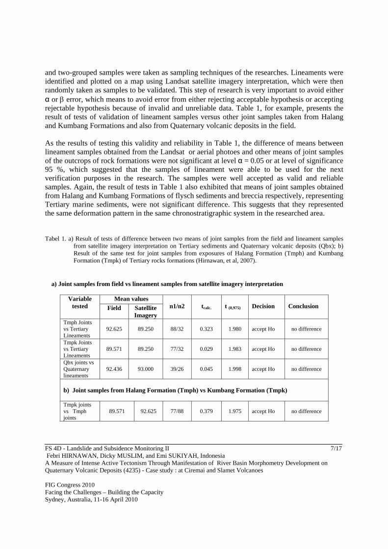
and two-grouped samples were taken as sampling techniques of the researches. Lineaments were identified and plotted on a map using Landsat satellite imagery interpretation, which were then randomly taken as samples to be validated. This step of research is very important to avoid either α or error, which means to avoid error from either rejecting acceptable hypothesis or accepting rejectable hypothesis because of invalid and unreliable data. Table 1, for example, presents the result of tests of validation of lineament samples versus other joint samples taken from Halang and Kumbang Formations and also from Quaternary volcanic deposits in the field. As the results of testing this validity and reliability in Table 1, the difference of means between lineament samples obtained from the Landsat or aerial photoes and other means of joint samples of the outcrops of rock formations were not significant at level α = 0.05 or at level of significance 95 %, which suggested that the samples of lineament were able to be used for the next verification purposes in the research. The samples were well accepted as valid and reliable samples. Again, the result of tests in Table 1 also exhibited that means of joint samples obtained from Halang and Kumbang Formations of flysch sediments and breccia respectively, representing Tertiary marine sediments, were not significant difference. This suggests that they represented the same deformation pattern in the same chronostratigraphic system in the researched area. Tabel 1. a) Result of tests of difference between two means of joint samples from the field and lineament samples
from satellite imagery interpretation on Tertiary sediments and Quaternary volcanic deposits (Qbx); b) Result of the same test for joint samples from exposures of Halang Formation (Tmph) and Kumbang Formation (Tmpk) of Tertiary rocks formations (Hirnawan, et al, 2007).
a) Joint samples from field vs lineament samples from satellite imagery interpretation
Variable tested
Mean values n1/n2
tcalc.
t (0,975)
Decision
Conclusion Field Satellite
Imagery Tmph Joints vs Tertiary Lineaments
92.625
89.250
88/32
0.323
1.980
accept Ho
no difference
Tmpk Joints vs Tertiary Lineaments
89.571
89.250
77/32
0.029
1.983
accept Ho
no difference
Qbx joints vs Quaternary lineaments
92.436
93.000
39/26
0.045
1.998
accept Ho
no difference
b) Joint samples from Halang Formation (Tmph) vs Kumbang Formation (Tmpk) Tmpk joints vs Tmph joints
89.571
92.625
77/88
0.379
1.975
accept Ho
no difference
FS 4D - Landslide and Subsidence Monitoring II 8/17 Febri HIRNAWAN, Dicky MUSLIM, and Emi SUKIYAH, Indonesia A Measure of Intense Active Tectonism Through Manifestation of River Basin Morphometry Development on Quaternary Volcanic Deposits (4235) - Case study : at Ciremai and Slamet Volcanoes FIG Congress 2010 Facing the Challenges – Building the Capacity Sydney, Australia, 11-16 April 2010
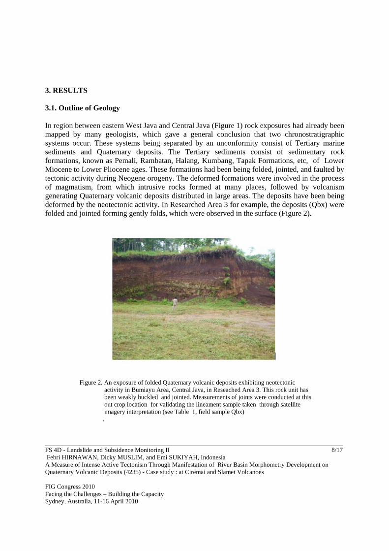
3. RESULTS 3.1. Outline of Geology In region between eastern West Java and Central Java (Figure 1) rock exposures had already been mapped by many geologists, which gave a general conclusion that two chronostratigraphic systems occur. These systems being separated by an unconformity consist of Tertiary marine sediments and Quaternary deposits. The Tertiary sediments consist of sedimentary rock formations, known as Pemali, Rambatan, Halang, Kumbang, Tapak Formations, etc, of Lower Miocene to Lower Pliocene ages. These formations had been being folded, jointed, and faulted by tectonic activity during Neogene orogeny. The deformed formations were involved in the process of magmatism, from which intrusive rocks formed at many places, followed by volcanism generating Quaternary volcanic deposits distributed in large areas. The deposits have been being deformed by the neotectonic activity. In Researched Area 3 for example, the deposits (Qbx) were folded and jointed forming gently folds, which were observed in the surface (Figure 2).
Figure 2. An exposure of folded Quaternary volcanic deposits exhibiting neotectonic
activity in Bumiayu Area, Central Java, in Reseached Area 3. This rock unit has been weakly buckled and jointed. Measurements of joints were conducted at this out crop location for validating the lineament sample taken through satellite imagery interpretation (see Table 1, field sample Qbx) .
FS 4D - Landslide and Subsidence Monitoring II 9/17 Febri HIRNAWAN, Dicky MUSLIM, and Emi SUKIYAH, Indonesia A Measure of Intense Active Tectonism Through Manifestation of River Basin Morphometry Development on Quaternary Volcanic Deposits (4235) - Case study : at Ciremai and Slamet Volcanoes FIG Congress 2010 Facing the Challenges – Building the Capacity Sydney, Australia, 11-16 April 2010
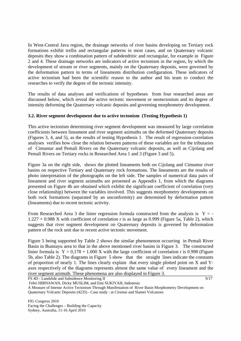
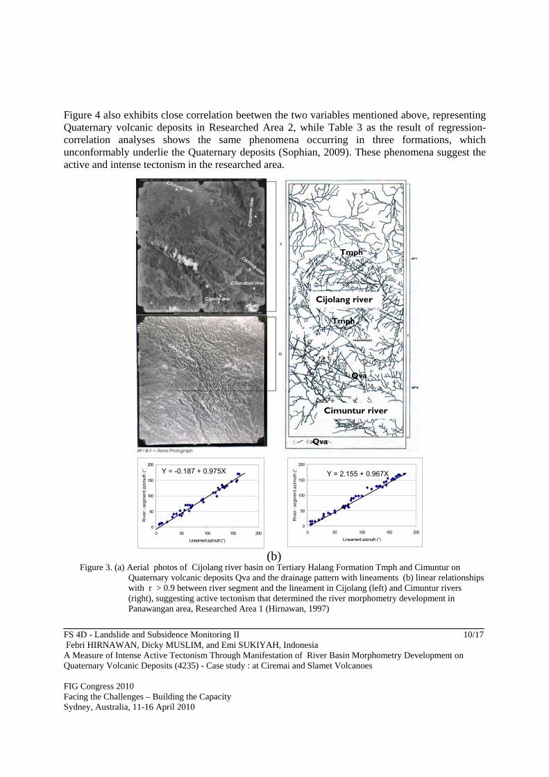
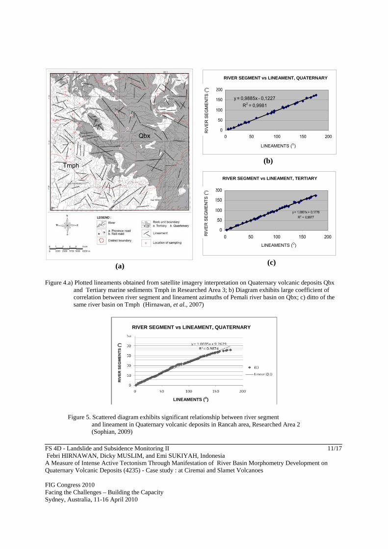
In West-Central Java region, the drainage networks of river basins developing on Tertiary rock formations exhibit trellis and rectangular patterns in most cases, and on Quaternary volcanic deposits they show a combination pattern of subdendritic and rectangular, for example in Figure 2 and 4. These drainage networks are indicators of active tectonism in the region, by which the development of stream or river segments, mainly on the Quaternary deposits, were governed by the deformation pattern in terms of lineaments distribution configuration. These indicators of active tectonism had been the scientific reason to the author and his team to conduct the researches to verify the degree of the tectonic intensity. The results of data analyses and verifications of hypotheses from four researched areas are discussed below, which reveal the active tectonic movement or neotectonism and its degree of intensity deforming the Quaternary volcanic deposits and governing morphometry development. 3.2. River segment development due to active tectonism (Testing Hypothesis 1) This active tectonism determining river segment development was measured by large correlation coefficients between lineament and river segment azimuths on the deformed Quaternary deposits (Figures 3, 4, and 5), as the results of testing Hypothesis 1. The result of regression-correlation analyses verifies how close the relation between patterns of these variables are for the tributaries of Cimuntur and Pemali Rivers on the Quaternary volcanic deposits, as well as Cijolang and Pemali Rivers on Tertiary rocks in Researched Area 1 and 3 (Figure 3 and 5). Figure 3a on the right side, shows the plotted lineaments both on Cijolang and Cimuntur river basins on respective Tertiary and Quaternary rock formations. The lineaments are the results of photo interpretation of the photographs on the left side. The samples of numerical data pairs of lineament and river segment azimuths are presented as Appendix 1, from which the diagrams presented on Figure 4b are obtained which exhibit the significant coefficient of correlation (very close relationship) between the variables involved. This suggests morphometry developments on both rock formations (separated by an unconformity) are determined by deformation pattern (lineaments) due to recent tectonic activity. From Researched Area 3 the linier regression formula constructed from the analysis is Y = -1.227 + 0.988 X with coefficient of correlation r is as large as 0.999 (Figure 5a, Table 2), which suggests that river segment development on Quaternary deposits is governed by deformation pattern of the rock unit due to recent active tectonic movement. Figure 5 being supported by Table 2 shows the similar phenomenon occurring in Pemali River Basin in Bumiayu area to that in the above mentioned river basins in Figure 3. The constructed linier formula is Y = 0,178 + 1.000 X with the large coefficient of correlation r is 0.998 (Figure 5b, also Table 2). The diagrams in Figure 5 show that the straight lines indicate the constants of proportion of nearly 1. The lines clearly explain that every single plotted point on X and Y-axes respectively of the diagrams represents almost the same value of every lineament and the river segment azimuth. These phenomena are also displayed in Figure 3.
FS 4D - Landslide and Subsidence Monitoring II 10/17 Febri HIRNAWAN, Dicky MUSLIM, and Emi SUKIYAH, Indonesia A Measure of Intense Active Tectonism Through Manifestation of River Basin Morphometry Development on Quaternary Volcanic Deposits (4235) - Case study : at Ciremai and Slamet Volcanoes FIG Congress 2010 Facing the Challenges – Building the Capacity Sydney, Australia, 11-16 April 2010
Figure 4 also exhibits close correlation beetwen the two variables mentioned above, representing Quaternary volcanic deposits in Researched Area 2, while Table 3 as the result of regression-correlation analyses shows the same phenomena occurring in three formations, which unconformably underlie the Quaternary deposits (Sophian, 2009). These phenomena suggest the active and intense tectonism in the researched area.
Figure 3. (a) Aerial photos of Cijolang river basin on Tertiary Halang Formation Tmph and Cimuntur on
Quaternary volcanic deposits Qva and the drainage pattern with lineaments (b) linear relationships with r > 0.9 between river segment and the lineament in Cijolang (left) and Cimuntur rivers (right), suggesting active tectonism that determined the river morphometry development in Panawangan area, Researched Area 1 (Hirnawan, 1997)
0
50
100
150
200
0 50 100 150 200
Lineament azimuth (°)
Riv
er -
se
gm
ent a
zim
uth
(°)
Y = -0.187 + 0.975X
0
50
100
150
200
0 50 100 150 200
Lineament azimuth (°)
Riv
er
- se
gm
en
t azi
mu
th (
°)
Y = 2.155 + 0.967X
CCijolang RCiver
Cijolang river
Cimuntur river
Tmph
Tmph
Qva
Qva
(b)
FS 4D - Landslide and Subsidence Monitoring II 11/17 Febri HIRNAWAN, Dicky MUSLIM, and Emi SUKIYAH, Indonesia A Measure of Intense Active Tectonism Through Manifestation of River Basin Morphometry Development on Quaternary Volcanic Deposits (4235) - Case study : at Ciremai and Slamet Volcanoes FIG Congress 2010 Facing the Challenges – Building the Capacity Sydney, Australia, 11-16 April 2010
(a)
KELURUSAN vs SEGMEN SUNGAI, KUARTER
y = 0,9885x - 0,1227
R2 = 0,9981
0
50
100
150
200
0 50 100 150 200
KELURUSAN (o)
SE
GM
EN
SU
NG
AI (
o
(b)
KELURUSAN VS SEGMEN SUNGAI, TERSIER
y = 1,0001x + 0,1778
R2 = 0,9977
0
50
100
150
200
0 50 100 150 200
KELURUSAN (o)
SE
GM
EN
SU
NG
AI
(o)
(c)
Figure 4.a) Plotted lineaments obtained from satellite imagery interpretation on Quaternary volcanic deposits Qbx
and Tertiary marine sediments Tmph in Researched Area 3; b) Diagram exhibits large coefficient of correlation between river segment and lineament azimuths of Pemali river basin on Qbx; c) ditto of the same river basin on Tmph (Hirnawan, et al., 2007)
Figure 5. Scattered diagram exhibits significant relationship between river segment and lineament in Quaternary volcanic deposits in Rancah area, Researched Area 2 (Sophian, 2009)
Qbx
Tmph
RIVER SEGMENT vs LINEAMENT, QUATERNARY
RIVER SEGMENT vs LINEAMENT, TERTIARY
RIV
ER
SE
GM
EN
TS
(o)
RIV
ER
SE
GM
EN
TS
(o)
LINEAMENTS (O)
LINEAMENTS (O)
RIVER SEGMENT vs LINEAMENT, QUATERNARY
RIV
ER
SE
GM
EN
TS
(o)
LINEAMENTS (O)
FS 4D - Landslide and Subsidence Monitoring II 12/17 Febri HIRNAWAN, Dicky MUSLIM, and Emi SUKIYAH, Indonesia A Measure of Intense Active Tectonism Through Manifestation of River Basin Morphometry Development on Quaternary Volcanic Deposits (4235) - Case study : at Ciremai and Slamet Volcanoes FIG Congress 2010 Facing the Challenges – Building the Capacity Sydney, Australia, 11-16 April 2010
Table 3 showing the result of verification of Hypotheses 1 in Researched Area 2 exhibits the similar phenomenon of morphometry development of river basins in this area with that in Researched Area 1 and 3. In this table three morphometry of river basin developments are proven to be determined by the lineament pattern on three formations.
Table 3 .Result of regression-correlation analyses between river segment and lineament azimuths in respective Halang, Kumbang, and Tapak Formations of Tertiary Epoch in Rancah area, Researched Area 2 (Sophian, 2009) Epoch Formation n r R2 Reg. formulae Decision Conclusion
Tertiary
Halang 86 0,999 0,999 y = 1,0169x - 3,3913 reject Ho
close relation
Kumbang 61 0.9997 0.9996 y = 0,9948x + 0,2799 reject Ho
close relation
Tapak 44 0.998 0.9976 y =0,9804x + 2,4598 reject Ho close relation
3.3. A measure of intense degree of tectonism (Testing Hypothesis 2) The measurements of degree of tectonic intensity, in terms of verification of Hypothesis 2 from three researched areas in Figure 1, were carried out by testing the difference between two means of the following variables representing the morphometry of river basins development on respective Tertiary marine sediments and Quaternary volcanic deposits. The variables of drainage basins involved for this test are drainage density (Dd) and bifurcation ratio (Rb). Drainage density (Dd) is the average length of streams per unit area (total stream length L divided by total basin area A): D = L/A (Horton,1945 in Jun Xu, 2007). Drainage density is one of the mostly used basin morphometric parameters because it is a good indicator of the relationship between climate, geology, soil, and vegetation. Drainage density varies largely, mostly from 0.5 to 30, but can be as high as 100. This variable mainly represents fracture density of river basin bed rock due to the tectonic activity. Bifurcation ratio (Rb) is the ratio between the total number of streams of one order (Nu) to that of the next higher order (Nu+1) in a drainage basin. Rb = Nu / Nu+1 (Horton,1945 in Jun Xu, 2007; Senadeera et al, 2007). The bifurcation ratio changes from one order to the next, but tends to be constant, mostly within the range of 3 to 5. These data of drainage density (Dd) and bifurcation ratio (Rb) taken from Researched Area 1, 2, 3, and 4 are presented in Appendices 1 up to 4. The results of testing the hypothesis using data from all researched areas gave conclusions that degree of tectonic intensity in several places were very intense, by which mean difference between drainage density (Dd) of Cimuntur river basins manifesting lineament density on Quaternary volcanic deposits of Ciremai volcano in Panawangan area in Researched Area 1, for
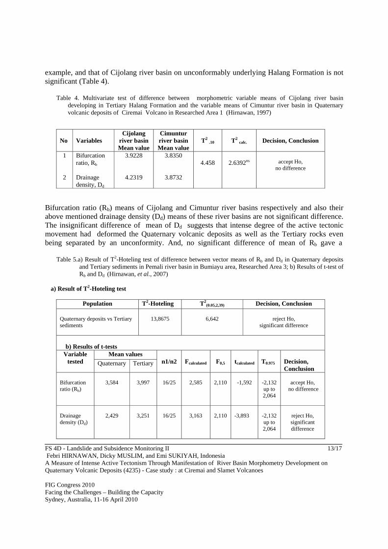
FS 4D - Landslide and Subsidence Monitoring II 13/17 Febri HIRNAWAN, Dicky MUSLIM, and Emi SUKIYAH, Indonesia A Measure of Intense Active Tectonism Through Manifestation of River Basin Morphometry Development on Quaternary Volcanic Deposits (4235) - Case study : at Ciremai and Slamet Volcanoes FIG Congress 2010 Facing the Challenges – Building the Capacity Sydney, Australia, 11-16 April 2010
example, and that of Cijolang river basin on unconformably underlying Halang Formation is not significant (Table 4).
Table 4. Multivariate test of difference between morphometric variable means of Cijolang river basin developing in Tertiary Halang Formation and the variable means of Cimuntur river basin in Quaternary volcanic deposits of Ciremai Volcano in Researched Area 1 (Hirnawan, 1997)
No
Variables
Cijolang river basin Mean value
Cimuntur river basin Mean value
T2 .10
T2 calc.
Decision, Conclusion
1 2
Bifurcation ratio, Rb
Drainage density, Dd
3.9228
4.2319
3.8350
3.8732
4.458
2.6392ns
accept Ho,
no difference
Bifurcation ratio (Rb) means of Cijolang and Cimuntur river basins respectively and also their above mentioned drainage density (Dd) means of these river basins are not significant difference. The insignificant difference of mean of Dd suggests that intense degree of the active tectonic movement had deformed the Quaternary volcanic deposits as well as the Tertiary rocks even being separated by an unconformity. And, no significant difference of mean of Rb gave a
Table 5.a) Result of T2-Hoteling test of difference between vector means of Rb and Dd in Quaternary deposits and Tertiary sediments in Pemali river basin in Bumiayu area, Researched Area 3; b) Results of t-test of Rb and Dd (Hirnawan, et al., 2007)
a) Result of T2-Hoteling test
Population T2-Hoteling T2(0.05,2,39) Decision, Conclusion
Quaternary deposits vs Tertiary sediments
13,8675
6,642
reject Ho,
significant difference
b) Results of t-tests
Variable tested
Mean values n1/n2
Fcalculated
F0,5
tcalculated
T0.975
Decision, Conclusion
Quaternary Tertiary
Bifurcation ratio (Rb)
3,584
3,997
16/25
2,585
2,110
-1,592
-2,132 up to 2,064
accept Ho,
no difference
Drainage density (Dd)
2,429
3,251
16/25
3,163
2,110
-3,893
-2,132 up to 2,064
reject Ho, significant difference
FS 4D - Landslide and Subsidence Monitoring II 14/17 Febri HIRNAWAN, Dicky MUSLIM, and Emi SUKIYAH, Indonesia A Measure of Intense Active Tectonism Through Manifestation of River Basin Morphometry Development on Quaternary Volcanic Deposits (4235) - Case study : at Ciremai and Slamet Volcanoes FIG Congress 2010 Facing the Challenges – Building the Capacity Sydney, Australia, 11-16 April 2010
conclusion that river basin morphometries on both Quaternary volcanic deposits and Tertiary rock formation have been developing into the similar numbers of river junctions of the same stream orders (one order and the next higher order) governed by lineament pattern of the respective river bed rocks due to the intense tectonism. An other different phenomenon occurs, exhibiting a less intense tectonic activity in western slope region of Slamet volcano in Bumiayu area in Researched Area 3, which is indicated by significant difference between two means of drainage density (Dd) on Tertiary and Quaternary rocks in Table 5. Such the phenomenon also occurs in Rancah area (Sophian, 2009). The insignificant difference between means of bifurcation ratio Rb of the river basins on the respective rocks manifests fracture pattern that facilitates similar river basin morphometry development in two systems (Tertiary and Quaternary rocks) due to the tectonic activity. On the contrary, the significant difference of means of those river basin drainage density (Dd) was presented earlier, of which the variable mean on Tertiary rocks is larger, suggests that the fracture density in Quaternary deposits is lower than that in Tertiary rocks, or degree of active tectonic intensity deforming the deposits is less, compared with that in area around Ciremai volcano mentioned in the foregoing part. 4. DISCUSSION The degree of tectonic intensity particularly with respect to stability of region is an important information needed for decision making in an area development planning, which should be well understood and considered as an important determinant in a comprehensive approach of characterization of a region. This aspect has not been seriously considered so far in this intellectual tasks or assignments. This morphotectonic phenomenon is very important to be studied. The result should be a base for a land stability mapping prior to any area development plan particularly in this country of active tectonism. Zonation of degree of tectonic intensity should be able to be mapped using verified indicators discussed in the foregoing part, by which zones of low to high tectonic intensities can be delineated. This zonation map can be very helpful in supporting the tasks. 5. CONCLUSION 1. The results of these researches conducted in the region between eastern West Java and
Central Java have proven and strongly supported the conclusion that the recent tectonism is active. This neotectonic activity manifested by frequent shallow earthquakes, active faults, and landslides, etc., enables the present author to measure its stage of intensity through the similarity of tectonic morphometry development of river basins on Quaternary to that on Tertiary rock deposits. This phenomenon is as the continuation of the former post Tertiary
FS 4D - Landslide and Subsidence Monitoring II 15/17 Febri HIRNAWAN, Dicky MUSLIM, and Emi SUKIYAH, Indonesia A Measure of Intense Active Tectonism Through Manifestation of River Basin Morphometry Development on Quaternary Volcanic Deposits (4235) - Case study : at Ciremai and Slamet Volcanoes FIG Congress 2010 Facing the Challenges – Building the Capacity Sydney, Australia, 11-16 April 2010
tectonic period generating deformation pattern in Quaternary volcanic deposits, which is similar to that for the Tertiary marine sedimentary rock formations.
2. Manifestations of drainage basin morphometry development being determined or controlled
by deformation pattern in Quaternary volcanic deposits, which are similar to that in Tertiary marine sedimentary rock formations in several places in the region due to neotectonism are as follows :
a) Correlation coefficients r of no less than 0,9 between river segments and lineaments on
Quarternary volcanic deposits are very signifycant, b) Differences between means of bifurcation ratio of river basins on Quaternary volcanic
deposits and those on Tertiary rock formations are not significant, and c) Differences between means of drainage density of river basins on Quaternary volcanic
deposits and those on Tertiary rock formations are not significant, except in Rancah and Bumiayu areas, where the differences are significant.
3. The manifestations of the active tectonic movements mentioned above suggest the following
conclusions : a) River segment development on Quaternary volcanic deposits are merely governed or
determined by lineament or deformation pattern due to active tectonic movements. b) Drainage network on Quaternary volcanic deposits is similar to that on Tertiary rock
formations due to active tectonic movements. c) Fracture density as the basic factor determining the drainage density of river basins on
Quaternary deposits is similar to that on Tertiary rock formations due to neotectonism. This phenomenon measuring the intense degree of tectonic activity is verified, except in Rancah and Bumiayu areas, where the active tectonic effect is less intense.
REFERENCES CITED Bates, L.B. & Jackson, J.A., 1984, Dictionary of geological terms : The American Geological Institute, Anchor Book
Doubleday, New York, 571 p. Burbank, D.W. & Anderson, R.S., 2001, Tectonic geomorphology, Massachusetts, Blackwell Science Djuri, M., Samodra, H., Min, T.C., & Gafoer, S, 1996, Geological Map of Purwokerto and Tegal Sheet, Java, scale
1:100.000, Geological Research and Development Centre *) Doornkamp, J.E., 1986, Geomorphological approach to the study of neotectonics. Jour. Geol. Soc. London, (143),
p. 335-342. Haig, Brian D. (1995). Grounded Theory as Scientific Method, Philosophy of`Education. University of Caterbury.
[August 8, 2006], http://www.ed.uiuc.edu/EPS/PESYearbook/ 95_ docs/haig.html Hirnawan, F., 1987, The effect of reverse fault on patterns of strike and dip of bedding planes and joints in Halang
Formation, Bantarujeg, Regency of Kuningan, West Java : Research, Geology, and Mining, Research Center for Geotechnology (Riset, Geologi & Pertambangan), Puslit Geoteknologi, p. 31-40*)
FS 4D - Landslide and Subsidence Monitoring II 16/17 Febri HIRNAWAN, Dicky MUSLIM, and Emi SUKIYAH, Indonesia A Measure of Intense Active Tectonism Through Manifestation of River Basin Morphometry Development on Quaternary Volcanic Deposits (4235) - Case study : at Ciremai and Slamet Volcanoes FIG Congress 2010 Facing the Challenges – Building the Capacity Sydney, Australia, 11-16 April 2010
Hirnawan, F., 1997, Morphometry characteristics of drainage system in the region of active tectonic effects – Case
Study of Cijolang and Cimuntur Drainage System) : Analisis Sistem, BPPT (Technology Evaluation and Application Board), Kedeputian Bidang Analisis Sistem, No. 9, IV, p. 67-77*)
Hirnawan, F., Sudarsono, U., & Soehaimi, A, 1998, Tracing landslide hazards zonation of slope stability dynamic
system and the stabilization by optimizing the integrated role of vegetation and slope geometry, State Ministry Office of Research & Technology, National Research Council, Multy Years Research Report of 1995-1998 Riset Unggulan Terpadu Program (Integrated Research Program), Field of Environment Protection Technology, 141 pp.*)
Hirnawan, F., & Muslim, D., 2006, Drainage morphometry characterizing active tectonism in West Java. Proceeding
of 2006 MapAsia International Conference Agustus-September 2006, Bangkok, Thailand : 18 pp. Hirnawan, F., Agus Nur, A., Sophian, I., 2007, Response of Quaternary morphometry to active tectonism as area
constraint for spatial and infrastructure development program, Bumiayu, Central Java, Research Institute, Padjadjaran University.*)
Jun Xu, 2007, Watershed Hydrology, [10/23/2007], http://hydrology.lsu.edu. Kastowo & Suwarna, 1996, Geological Map of Majenang Sheet, Java, scale 1:100.000, Geological Research and
Development Centre *) Keller, E.A., & Pinter, N., 1999, Active tectonism, New York : Prentice Hall Inc. 337 p. Linsley, R.K., Kohler, M.A. & Paulhus, J.L.H., 1975, Applied Hydrology, Tata MacGraw Hill Pub. Co. Ltd., New
Delhi. McNeil, L., 1999, Illustrated Dictionary of Earth Science, the American Geological Institute, Tasa Graphic Arts, Inc. Nakata, T., Odaka, J., Goto, H., Asahi, K., Chida, N., Suzuki, Y., Watanabe, K., & Nakamura, T. 1996, A trench
study on the surface fault rupture in Awaji Island associated with the 1995 Hyokogen-nambu earthquake, Jour. Active Fault Res., (14), p. 23-27.
Senadeera, K.P.G.W., Piyasiri, S. & Nandalal, K.D.W., 2007, The evaluation of Morphometric Characteristics of
Kotmale Reservoir catchment using GIS as a tool, Sri Lanka, Department of Civil Engineering, University of Peradeniya, Peradeniya , Sri Lanka : The International Archives of the Photogrammetry, Remote Sensing and Spatial Information Sciences, Vol. 34, Part XXX
Sophian, R.I., 2009, Contribution of neotectonic activity to drainage basin morphometry development in Tertiary
rock formations and Quaternary volcanic deposits in Rancah area, Regency of Ciamis, Province of West Java, Master Thesis, Padjadjaran University, unpublished *).
Splitz, W.J. & Schumm, S.A., 1997, Tectonic geomorphology of Mississippi Valley between Osceola, Arkansas and
Friars Point, Mississippi, Engin. Geol., Vol. 46, p 259-280. Stewart, I.S. & Hancock, P.L., 1994, Neotectonics, PL Hancock Ed., Continental Deformation, Pergamon Press, p.
370-404 *) in Indonesian with English abstract
FS 4D - Landslide and Subsidence Monitoring II 17/17 Febri HIRNAWAN, Dicky MUSLIM, and Emi SUKIYAH, Indonesia A Measure of Intense Active Tectonism Through Manifestation of River Basin Morphometry Development on Quaternary Volcanic Deposits (4235) - Case study : at Ciremai and Slamet Volcanoes FIG Congress 2010 Facing the Challenges – Building the Capacity Sydney, Australia, 11-16 April 2010
BIOGRAPHICAL NOTES Dicky Muslim was graduated from Doctor of Science (Dr), Graduate School of Science, Dept. of Geosciences, Osaka City University, Japan, in 2003. He has been working as lecturer in Geology Department, Faculty of Mathematic and Natural Sciences, University of Padjadjaran, since 1993. Since 2007 this department has been Faculty of Geosciences and Engineering. Since 1993 up to now he carried out many geological investigations and researches in some region in Indonesia and Japan about neotectonic, disaster, engineering geology, land development, remote sensing, etc. He is a member of Indonesia Association of Geologists (IAGI). He often follows some international activities that held by ADPC, NGI, etc. He had published his papers in many journals of geosciences and international seminars. R. Febri Hirnawan was graduated from Ph.D. Program of Geosciences, University of Padjadjaran, Bandung, Indonesia in 1993 majoring in engineering geology. He was appointed as a professor in geology in 2000. He has been working as lecturer in Geology Department, Faculty of Mathematic and Natural Sciences, University of Padjadjaran, since 1973. Since 2007 this department has been Faculty of Geosciences and Engineering. Since 1970 up to now he carried out hundreds of geological investigations and researches in many regions in Indonesia about engineering geology, geotechnics, tectonics, neotectonics, and areal development geology. He is a member of a famous Indonesia Association of Geologists (IAGI) in the country. He had published his papers in many journals of geosciences and wrote few books. His technology invention in slope stabilization system has been patented and was presented before in 1995 IAMG (International Association for Mathematical Geology) Annual Conference in Osaka, Japan. Two other inventions of his about holistic valuation of terrain being based on genetic approach for spatial planning, and sand column infiltration well named GEOINFILTRANT are being finalized in a substantive examination by patent office to achieve patents. Emi Sukiyah was graduated from Ph.D. Program of Geosciences, University of Padjadjaran, Bandung, Indonesia in 2009. She has been working as lecturer in Geology Department, Faculty of Mathematic and Natural Sciences, University of Padjadjaran, since 1997. Since 2007 this department has been Faculty of Geosciences and Engineering. Since 1997 up to now she carried out many geological investigations and researches in some region in Indonesia about environmental geology, GIS, land development, morphometry, remote sensing, etc. She is a member of a famous Indonesia Association of Geologists (IAGI) in the country. She often follows some international activities that held by ADPC, NGI, etc. She had published her papers in many journals of geosciences and international seminars.