Embed Size (px)
Citation preview
For permission to copy, contact [email protected]� 2003 Geological Society of America
GSA Bulletin; January 2003; v. 115; no. 1; p. 000–000; 8 figures; 5 tables.
The Tula uplift, northwestern China: Evidence for regional tectonismof the northern Tibetan Plateau during late Mesozoic–early
Cenozoic time
Delores M. Robinson†
Guillaume Dupont-Nivet‡
George E. Gehrels§Department of Geosciences, University of Arizona, Tucson, Arizona 85721, USA
Yueqiao ZhangInstitute of Geomechanics, Beijing 100081, People’s Republic of China
ABSTRACT
Geologic mapping combined with petro-graphic and geochronologic studies in theTula uplift of western China provides in-sights into the tectonic evolution of thenorthern edge of the Tibetan Plateau. TheMesozoic and early Cenozoic history of thearea is preserved in the Tula uplift, whichincludes basin strata now exposed in a largesyncline, pre-Mesozoic metamorphic base-ment, and Cretaceous plutons. Petrograph-ic analyses of Upper Jurassic through Pa-leogene syntectonic sandstones show thatrocks in the area were derived from litho-logically diverse source terranes consistingof sedimentary, metasedimentary, and ig-neous rocks. These relationships imply thatuplift in the Tula area began in Late Ju-rassic time and that uplift of the TibetanPlateau’s northern edge may have been ini-tiated long before the early Tertiary India-Asia collision. Continued orogenic activityin the Tula area is recorded by intrusion ofca. 74 Ma granitoid bodies, latest Creta-ceous to Paleogene shortening, uplift of Pre-cambrian basement rock, the syntectonicnature of Cretaceous and Paleogene sand-stones, and folding of all the basin stratainto a regional north-vergent syncline. Thenorthern range-bounding thrust of the Tulauplift has been recently active, suggestingthat uplift and thickening continues in thenorthern Tibetan Plateau.
†E-mail: [email protected].‡E-mail: [email protected].§E-mail: [email protected].
Keywords: Asian tectonics, China, syntec-tonic processes, Tibetan Plateau.
INTRODUCTION
Central Asia contains young mountainranges, polycyclic basins filled with syntec-tonic sediments, and orogenic plateaus that arethe result of progressive accretion of terranesand India onto the active southern margin ofAsia (Sengor and Natal’in, 1996; Yin and Nie,1996). Since about 1990, considerable geolog-ic research in Asia has concentrated on Ce-nozoic deformation resulting from the Asia-India collision (see summaries in Matte et al.,1997; Yin and Harrison, 2000). The accretionof India created continental-scale featuressuch as the Tibetan Plateau and the AltynTagh fault (Molnar and Tapponnier, 1975).This Cenozoic deformation overprinted earliertectonic events, making it difficult to distin-guish pre-Cenozoic deformation. In this paper,we explore the record of Mesozoic and earlyCenozoic tectonism preserved within the Tulauplift in western China. This is the first com-prehensive study in the Tula uplift, which islocated in the northern part of the Arka Taghin the remote north-central part of the TibetanPlateau.
The Tula uplift is an ideal location in whichto explore the history of Mesozoic and earlyCenozoic tectonism, as the uplift has a nearlycontinuous stratigraphic section that was de-posited during this time. By contrast, Meso-zoic strata in most regions of central Asiahave been removed by erosion or are buriedby younger sediments (Graham et al., 1993).In previous studies, exposures around the edg-
es of modern basins in Asia have been usedto interpret the Mesozoic tectonic history(e.g., Watson et al., 1987; Graham et al., 1990;Hendrix et al., 1992, 1996; Carroll et al.,1995; Sobel, 1995, 1999; Sobel and Dimitru,1997; Guo et al., 1998; Ritts, 1998; Yin, 1998;Vincent and Allen, 1999; Ritts and Biffi,2000,2001). In the Tula uplift, Upper Jurassic–Paleogene strata are exposed in a mountainrange that has 2600 m of topographic relief.The Tula uplift includes the Tula syncline, whichis a large regional fold within the Jurassic–Paleogene strata, metamorphic basement, andCretaceous plutons. The uplift has had a pro-tracted period of sedimentation and deforma-tion that help address regional tectonic ques-tions such as, Does the thickening recorded inthe Tula area signify the beginning of TibetanPlateau uplift? How much uplift of the TibetanPlateau is pre-Himalayan? What was the pa-leogeographic setting of central Asia beforeTertiary uplift of the plateau? How much ofthe deformation along the Altyn Tagh faultwas inherited from pre-Tertiary orogenicevents?
An additional objective of this researchwas to determine the origin of an oroclinalbend in the Tula uplift, which is apparentboth from the topography of the presentmountain range and from the pattern of unitsand contacts shown on the Geological Mapof the Xinjiang Uygur Autonomous Region(Chen, 1985; 1:2,000,000) and theRegionalGeology of Xinjiang Uyger Autonomous Re-gion (XBGMR, 1993; 1:1,500,000). This fea-ture, along with other arcuate mountain rangesin the region, may be a true orocline thatformed as a result of distributed deformation
Geological Society of America Bulletin, January 2003
THE TULA UPLIFT, NORTHWESTERN CHINA
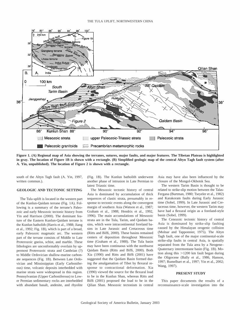
Figure 1. (A) Regional map of Asia showing the terranes, sutures, major faults, and major features. The Tibetan Plateau is highlightedin gray. The location of Figure 1B is shown with a rectangle. (B) Simplified geologic map of the central Altyn Tagh fault system (afterA. Yin, unpublished). The location of Figure 2 is shown with a rectangle.
south of the Altyn Tagh fault (A. Yin, 1997,written commun.).
GEOLOGIC AND TECTONIC SETTING
The Tula uplift is located in the western partof the Kunlun-Qaidam terrane (Fig. 1A). Fol-lowing is a summary of the terrane’s Paleo-zoic and early Mesozoic tectonic history fromYin and Harrison (2000). The dominant fea-ture of the Eastern Kunlun-Qaidam terrane isthe Kunlun batholith (Harris et al., 1988; Jianget al., 1992; Fig. 1B), which is part of a broad,early Paleozoic magmatic arc. The westernpart of the terrane consists of Middle to LateProterozoic gneiss, schist, and marble. Theselithologies are unconformably overlain by up-permost Proterozoic strata and Cambrian (?)to Middle Ordovician shallow-marine carbon-ate sequences (Fig. 1B). Between Late Ordo-vician and Mississippian (Early Carbonifer-ous) time, volcanic deposits interbedded withmarine strata were widespread in this region.Pennsylvanian (Upper Carboniferous) to Low-er Permian sedimentary rocks are interbeddedwith abundant basalt, andesite, and rhyolite
(Fig. 1B). The Kunlun batholith underwentanother phase of intrusion in Late Permian tolatest Triassic time.
The Mesozoic tectonic history of centralAsia is dominated by accumulation of thicksequences of clastic strata, presumably in re-sponse to tectonic events along the convergentmargin of southern Asia (Watson et al., 1987;Graham et al., 1988; Hendrix et al., 1992,1996). The main accumulations of Mesozoicstrata are in the Tula, Tarim, and Qaidam ba-sins, which were intracontinental foreland ba-sins in Late Jurassic and Cretaceous time(Ritts and Biffi, 2000). These basins remainedcenters of deposition throughout Mesozoictime (Graham et al., 1988). The Tula basinmay have been continuous with the northwestQaidam Basin (Ritts and Biffi, 2000). BothXia (1990) and Ritts and Biffi (2001) havesuggested that the Qaidam Basin formed dur-ing the amalgamation of Tibet by flexural re-sponse to contractional deformation. Xia(1990) viewed the source for the flexural loadto be in the Kunlun Shan, whereas Ritts andBiffi (2001) proposed the load to be in theQilian Shan. Mesozoic tectonism in central
Asia may have also been influenced by theclosure of the Mongol-Okhotsk Sea.
The western Tarim Basin is thought to berelated to strike-slip motion between the Talas-Fergana (Burtman, 1980; Tseyeler et al., 1982)and Karakoram faults during Early Jurassictime (Sobel, 1999). In Late Jurassic and Cre-taceous time, however, the western Tarim mayhave had a flexural origin as a foreland-stylebasin (Sobel, 1999).
The Cenozoic tectonic history of centralAsia is dominated by strike-slip faultingcaused by the Himalayan orogenic collision(Molnar and Tapponnier, 1975). The AltynTagh fault, one of the major continental-scalestrike-slip faults in central Asia, is spatiallyseparated from the Tula area by a Neogene–Quaternary intermontane basin (Fig. 1B). Mo-tion along this�1200 km fault began duringthe Oligocene (Bally et al., 1986, Hanson,1997; Rumelhart et al., 1997; Yin et al., 2002;Wang, 1997).
PRESENT STUDY
This paper documents the results of areconnaissance-scale investigation into the
Geological Society of America Bulletin, January 2003
ROBINSON et al.
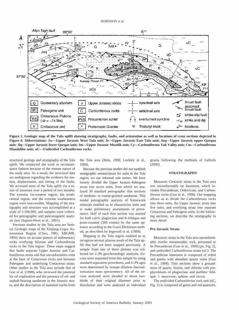
Figure 2. Geologic map of the Tula uplift showing stratigraphy, faults, and orientation as well as locations of cross sections depicted inFigure 6. Abbreviations: Jw—Upper Jurassic West Tula unit; Je—Upper Jurassic East Tula unit; Juq—Upper Jurassic upper Qarqanunit; Jlq—Upper Jurassic lower Qarqan unit; Jm—Upper Jurassic Muselik unit; Cy—Carboniferous Yak Valley unit; Cm—CarboniferousMandalike unit; uC—Undivided Carboniferous rocks.
structural geology and stratigraphy of the Tulauplift. We conducted the work in reconnais-sance fashion because of the remote nature ofthe study area. As a result, the structural dataare ambiguous regarding the evidence for mo-tion, displacement, and timing of the faults.We accessed most of the Tula uplift via a se-ries of traverses over a period of two months.The extreme far-western region, the south-central region, and the extreme southeasternregion were inaccessible. Mapping of the stra-tigraphy and structure was accomplished at ascale of 1:100,000, and samples were collect-ed for petrographic and paleomagnetic analy-sis (see Dupont-Nivet et al., 2001).
Previous studies in the Tula area are limit-ed. Geologic maps of the Xinjiang Uygur Au-tonomous Region (Chen, 1985; XBGMR,1993) show an arcuate pattern of sedimentaryrocks overlying Silurian and Carboniferousrocks in the Tula region. These maps suggestthat faults separate Upper Jurassic and Car-boniferous strata and that unconformities existat the base of Cretaceous rocks and betweenPaleogene and underlying Cretaceous strata.Other studies in the Tula area include that ofGuo et al. (1998), who reviewed the potentialfor oil exploration and the presence of oil- andasphalt-bearing sandstone in the Jurassic stra-ta, and the description of mammal tracks from
the Tula area (Ritts, 1998; Lockley et al.,1999).
Because the previous studies did not establishstratigraphic nomenclature for units in the Tularegion, we use informal unit names. We haveloosely divided the Upper Jurassic–Paleogenestrata into seven units, from which we ana-lyzed 30 standard petrographic thin sectionsof medium- to coarse-grained sandstone. Thismodal petrographic analysis of frameworkminerals enabled us to characterize units andto make preliminary assessments of prove-nance. Half of each thin section was stainedfor both calcic plagioclase and K-feldspar andpoint-counted (500 counts) by the same op-erator according to the Gazzi-Dickinson meth-od, as described by Ingersoll et al. (1984).
Mapping in the Tula region enabled us torecognize several plutons south of the Tula up-lift that had not been mapped previously. Asample from one of these plutons was col-lected for U-Pb geochronologic analyses. Zir-cons were separated from this sample by usingstandard separation procedures, and U-Pb ageswere determined by isotope dilution–thermal-ionization mass spectrometry. All of the zir-cons analyzed were abraded to about two-thirds of their original diameter prior todissolution and were analyzed as individual
grains following the methods of Gehrels(2000).
STRATIGRAPHY
Mesozoic–Cenozoic strata in the Tula arearest unconformably on basement, which in-cludes Precambrian, Ordovician, and Carbon-iferous rocks (Guo et al., 1998). Our mappingallows us to divide the Carboniferous rocksinto three units, the Upper Jurassic strata intofive units, and overlying strata into separateCretaceous and Paleogene units. In the follow-ing sections, we describe the stratigraphy inmore detail.
Pre-Jurassic Strata
Mesozoic strata in the Tula area unconform-ably overlie metamorphic rock, presumed tobe Precambrian (Guo et al., 1998) (ps, Fig. 2),and undivided Carboniferous strata (uC). ThePrecambrian basement is composed of schistand gneiss with abundant quartz veins (Guoet al., 1998). Thin sections show a ground-mass of quartz, biotite, and chlorite with por-phyroblasts of plagioclase and perthitic feld-spar� muscovite, sphene, and zircon.
The undivided Carboniferous rock unit (uC,Fig. 2) is composed of green and red quartzite,
Geological Society of America Bulletin, January 2003
THE TULA UPLIFT, NORTHWESTERN CHINA
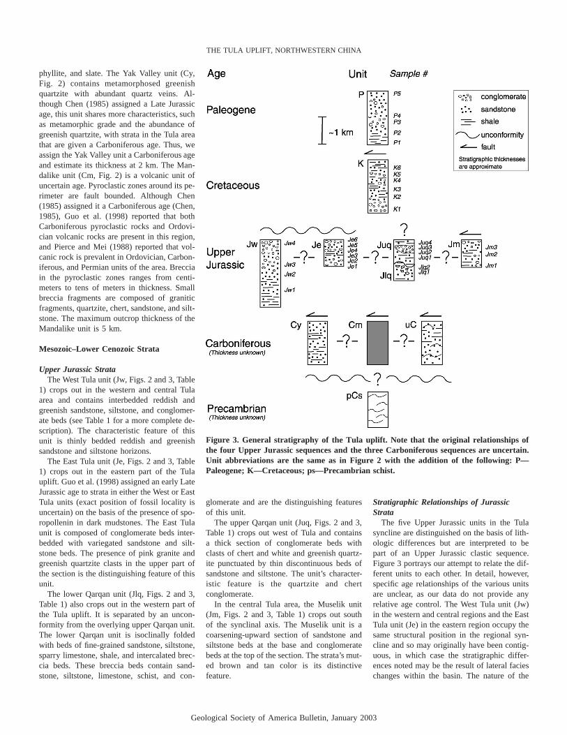
Figure 3. General stratigraphy of the Tula uplift. Note that the original relationships ofthe four Upper Jurassic sequences and the three Carboniferous sequences are uncertain.Unit abbreviations are the same as in Figure 2 with the addition of the following: P—Paleogene; K—Cretaceous; ps—Precambrian schist.
phyllite, and slate. The Yak Valley unit (Cy,Fig. 2) contains metamorphosed greenishquartzite with abundant quartz veins. Al-though Chen (1985) assigned a Late Jurassicage, this unit shares more characteristics, suchas metamorphic grade and the abundance ofgreenish quartzite, with strata in the Tula areathat are given a Carboniferous age. Thus, weassign the Yak Valley unit a Carboniferous ageand estimate its thickness at 2 km. The Man-dalike unit (Cm, Fig. 2) is a volcanic unit ofuncertain age. Pyroclastic zones around its pe-rimeter are fault bounded. Although Chen(1985) assigned it a Carboniferous age (Chen,1985), Guo et al. (1998) reported that bothCarboniferous pyroclastic rocks and Ordovi-cian volcanic rocks are present in this region,and Pierce and Mei (1988) reported that vol-canic rock is prevalent in Ordovician, Carbon-iferous, and Permian units of the area. Brecciain the pyroclastic zones ranges from centi-meters to tens of meters in thickness. Smallbreccia fragments are composed of graniticfragments, quartzite, chert, sandstone, and silt-stone. The maximum outcrop thickness of theMandalike unit is 5 km.
Mesozoic–Lower Cenozoic Strata
Upper Jurassic StrataThe West Tula unit (Jw, Figs. 2 and 3, Table
1) crops out in the western and central Tulaarea and contains interbedded reddish andgreenish sandstone, siltstone, and conglomer-ate beds (see Table 1 for a more complete de-scription). The characteristic feature of thisunit is thinly bedded reddish and greenishsandstone and siltstone horizons.
The East Tula unit (Je, Figs. 2 and 3, Table1) crops out in the eastern part of the Tulauplift. Guo et al. (1998) assigned an early LateJurassic age to strata in either the West or EastTula units (exact position of fossil locality isuncertain) on the basis of the presence of spo-ropollenin in dark mudstones. The East Tulaunit is composed of conglomerate beds inter-bedded with variegated sandstone and silt-stone beds. The presence of pink granite andgreenish quartzite clasts in the upper part ofthe section is the distinguishing feature of thisunit.
The lower Qarqan unit (Jlq, Figs. 2 and 3,Table 1) also crops out in the western part ofthe Tula uplift. It is separated by an uncon-formity from the overlying upper Qarqan unit.The lower Qarqan unit is isoclinally foldedwith beds of fine-grained sandstone, siltstone,sparry limestone, shale, and intercalated brec-cia beds. These breccia beds contain sand-stone, siltstone, limestone, schist, and con-
glomerate and are the distinguishing featuresof this unit.
The upper Qarqan unit (Juq, Figs. 2 and 3,Table 1) crops out west of Tula and containsa thick section of conglomerate beds withclasts of chert and white and greenish quartz-ite punctuated by thin discontinuous beds ofsandstone and siltstone. The unit’s character-istic feature is the quartzite and chertconglomerate.
In the central Tula area, the Muselik unit(Jm, Figs. 2 and 3, Table 1) crops out southof the synclinal axis. The Muselik unit is acoarsening-upward section of sandstone andsiltstone beds at the base and conglomeratebeds at the top of the section. The strata’s mut-ed brown and tan color is its distinctivefeature.
Stratigraphic Relationships of JurassicStrata
The five Upper Jurassic units in the Tulasyncline are distinguished on the basis of lith-ologic differences but are interpreted to bepart of an Upper Jurassic clastic sequence.Figure 3 portrays our attempt to relate the dif-ferent units to each other. In detail, however,specific age relationships of the various unitsare unclear, as our data do not provide anyrelative age control. The West Tula unit (Jw)in the western and central regions and the EastTula unit (Je) in the eastern region occupy thesame structural position in the regional syn-cline and so may originally have been contig-uous, in which case the stratigraphic differ-ences noted may be the result of lateral facieschanges within the basin. The nature of the
Geological Society of America Bulletin, January 2003
ROBINSON et al.
TABLE 1. LITHOLOGIC UNIT DESCRIPTIONS
Paleogene (P)Structural thickness is �1 km on south side of Tula syncline; basal contact—fault; upper contact—not preserved; section coarsens upward with an increase in the abundance
of interbedded conglomerate, sandstone, and siltstone; clasts include quartzite, light colored gneiss, sandstone, siltstone, dolostone, and limestone; beds are tabular ona 10 m horizontal scale and lenticular at a larger scale; cliff-forming unit; trough cross-beds and ripples
Cretaceous (K)Outcrop thickness on the north side of syncline is �3 km and �300 m on the south side (truncated by a fault); basal contact—angular unconformity with Jw and Je; upper
contact—fault; section grades upward from 300 m of conglomerate into 2 km of red lenticular sandstone, siltstone, and shale with interspersed conglomerate beds,clasts are white, red,and green quartzite, tan and red siltstone, light gray and red sandstone, and rare metamorphic fragments; uppermost Km consists of interbeddedconglomerate and sandstone; beds vary in thickness and are lenticular; trough cross-beds, soft-sediment deformation, mudcracks, ripple marks, and climbing ripples.
West Tula (Jw)Monocline west of Tula contains �1.5 km of continuous section, structural thickness is locally 2.5 km; base contact—covered by alluvium; upper contact—angular
unconformity with overlying K; basal section contains �1 km of interbedded gray to green sandstone and siltstone and grades into a thick sequence of interbeddedconglomerate and green sandstone, above which are thinly bedded red siltstone, sandstone, and conglomerate beds; conglomerate beds are more common near thetop of the section and have a dark green sandstone matrix; conglomerate clasts are 10 cm in diameter, rounded to subrounded, moderately well sorted clasts thatinclude white quartzite, red plutonic rock, dark brown and orange weathering conglomerate, black volcanic rock, dark green and gray quartzite, maroon, dark gray, andgreen sandstone, and green and red siltstone; bedding in the sandstone and siltstone is lenticular on a 1 m scale; beds weather with a red stain; trough cross-beds,burrowed and rippled siltstone.
East Tula (Je)Structural thickness of �4 km but is faulted and folded; basal contact—covered by alluvium; upper contact—angular unconformity with overlying K; basal section contains
green conglomerate interbedded with green, tan, and red siltstone and sandstone; clasts are subangular, moderately well sorted, and include green quartzite, light greenphyllite, multicolored sandstone, and white vein quartz; overlying section is a brown to tan conglomerate and gray sandstone; top of the section has red sandstone,siltstone, and conglomerate with clasts of pink granite and green quartzite; yellowish sandstone and siltstone beds are common in the upper part of the section in theeast; sandstone and siltstone beds are 1-m-thick lenticular beds; conglomerate beds are lenticular on a 10 m horizontal scale; channelized sandstone and siltstonebeds, trough cross-beds and local paleosols.
Upper Qarqan (Juq)Outcrop thickness of �8 km, true thickness unknown; basal contact—unconformable with Jlq; upper contact—buried under alluvium or fault truncated; contains a thick
section of resistant conglomerate that is well organized and well sorted; clasts include chert and white and green quartzite in a gray to green matrix; conglomerate bedsare interbedded with thin black shales and green micaceous sandstone, siltstone, and shale; contains lenticular pods of conglomerate 3 m thick punctuated by thinlenticular beds of sandstone and siltstone.
Lower Qarqan (Jlq)Isoclinally folded with an outcrop thickness of �3 km; basal contact—bounded by a fault; upper contact—overlain unconformably by Juq; contains green to gray, fine-
grained sandstone, green and tan fissile sandstone, sparry limestone, gray and red sandstone interbedded with light gray siltstone, thin black shale beds, and intercalatedbreccia beds �3 m thick; breccia contains a variety of lithologies including schist and conglomerate; bedding is lenticular over a 10 m horizontal scale; climbing ripplesin siltstone.
Muselik (Jm)Outcrop thickness of �1 km; southern contact—intrusive; northern contact—fault; basal section has a coarse-grained tan and gray sandstone and beige and red siltstone,
which grade upward into green conglomerate interbedded with brown sandstone on a 1 m scale; brown conglomerate at top of section contains clasts of chert, whitequartzite, and variegated sandstone and siltstone; bedding is lenticular on a 10 m horizontal scale; trough cross-beds.
contact between the lower Qarqan (Jlq) andupper Qarqan (Juq) units varies; in one loca-tion, they are separated by a fault, whereas atanother site, they are separated by an uncon-formity. The age relationship between thelower and upper Qarqan units and the Westand East Tula units is uncertain. The Muselikunit (Jm) may be the same as the West or EastTula units, but is retained as a separate unitbecause it is fault bounded and has a distinc-tive brown and tan color. Petrographic dataprovide additional information that helps tofurther define the stratigraphy.
Cretaceous StrataThe Cretaceous unit (K, Figs. 2 and 3, Table
1) crops out in the central and eastern parts ofthe Tula syncline and is separated by a 12�angular unconformity from the underlyingUpper Jurassic West and East Tula units. TheCretaceous unit is composed of generally fining-upward interbedded reddish sandstone andsiltstone with thick conglomerate beds. Theunit is intensely folded near the synclinal axisand dips gently at the northern edge of theTula uplift. In the southeastern part of the Tulauplift, Cretaceous plutons intrude the Creta-ceous strata, providing a minimum deposition-
al age. Although a Cretaceous age is assignedto this unit by XBGMR (1993), Lockley et al.(1999) reported an Eocene age based on smalltridactyl vertebrate tracks that appear to cor-relate with Eocene tracks found in NorthAmerica. Two explanations for this inconsis-tency exist. It is possible that the track wasderived from the youngest unit because it wasdiscovered near the contact between the Cre-taceous and Paleogene unit (Fig. 2), or theCretaceous age assigned by XBGMR (1993)is actually Cretaceous through Eocene. Fur-ther investigation is needed to clarify the in-consistency in the available age data for thisunit.
Paleogene StrataIn the central and eastern parts of the Tula
syncline, the Paleogene unit (P, Figs. 2 and 3,Table 1) crops out in the core of the syncline.The Paleogene and Cretaceous units are sep-arated by a thrust fault; thus, the original re-lationship is unknown. However, petrographicdata suggest that the Paleogene unit was de-posited in the Tula basin, overlying the Cre-taceous unit. The fault that separates the Pa-leogene unit from the Cretaceous unit is theresult of tight folding of the Tula syncline.
Chinese researchers assigned a Paleogene ageto these strata on the basis of the presence ofOligocene ostracods in the section (XBGMR,1993). The section coarsens upward with anincrease in the abundance of conglomerate to-ward the top. The characteristic feature is thedominance of limestone and metamorphicclasts in the conglomerate beds.
Cretaceous Plutons
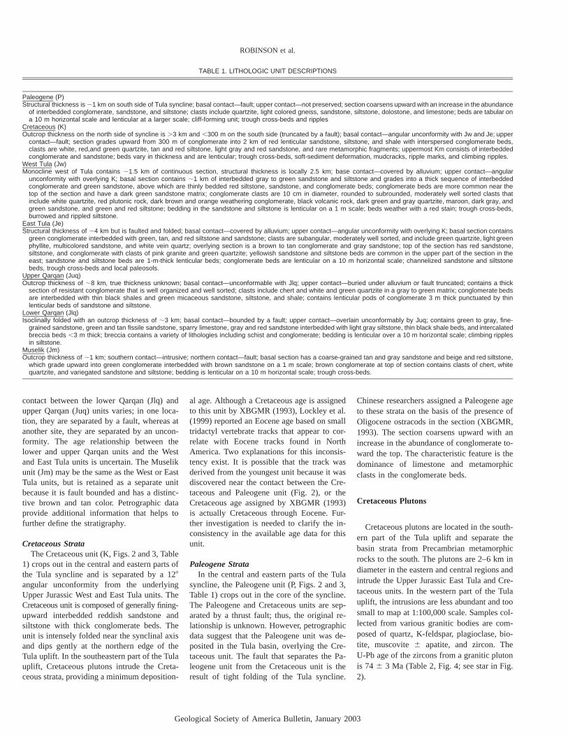
Cretaceous plutons are located in the south-ern part of the Tula uplift and separate thebasin strata from Precambrian metamorphicrocks to the south. The plutons are 2–6 km indiameter in the eastern and central regions andintrude the Upper Jurassic East Tula and Cre-taceous units. In the western part of the Tulauplift, the intrusions are less abundant and toosmall to map at 1:100,000 scale. Samples col-lected from various granitic bodies are com-posed of quartz, K-feldspar, plagioclase, bio-tite, muscovite� apatite, and zircon. TheU-Pb age of the zircons from a granitic plutonis 74� 3 Ma (Table 2, Fig. 4; see star in Fig.2).
Geological Society of America Bulletin, January 2003
THE TULA UPLIFT, NORTHWESTERN CHINA
TABLE 2. U-Pb ISOTOPIC DATA AND AGES FOR CRETACEOUS PLUTON
Grain Apparent ages (Ma) 207Pb* 207Pb*mass
Pbc U 206Pbm206Pbc
206Pb* 235U 206Pb*(�g)(pg) (ppm) 204Pb 208Pb 238U
13 1405 4148 52.5 1.2 88.9 � 2.6 118.5 � 16.7 762 � 2709 285 1462 57.9 1.3 86.2 � 2.2 88.5 � 14.1 149 � 350
14 120 794 146.4 2.4 141.9 � 1.4 145.1 � 6.9 197 � 10012 205 949 119 2.1 178.2 � 1.9 215.9 � 1.2 650 � 11012 830 3028 63.2 1.4 103.9 � 2.4 113.5 � 14.9 319 � 28011 705 2421 46.3 1.1 74.5 � 2.2 74.9 � 17.6 88 � 5208 690 4738 90.5 1.8 133.2 � 2.0 141.4 � 11.7 281 � 180
11 36 1256 307 4.1 74.9 � 1.7 77.1 � 3.8 143 � 1009 56 1804 234 3.5 74.7 � 1.6 75.9 � 4.9 116 � 1387 175 1652 118 2.3 151.8 � 1.8 159.3 � 9.5 273 � 130
Notes: All analyses are of single zircon crystals. 206Pb/204Pb is measured ratio, uncorrected for blank, spike, orfractionation. 206Pb/208Pb is corrected for blank, spike, and fractionation. Most concentrations have an uncertaintyof 25% due to uncertainty in mass of grain. Constants used: 238U/235U � 137.88. Decay constant for 235U � 9.8485� 10–10. Decay constant for 238U � 1.55125 � 10–10. All uncertainties are at the 95% confidence level. Pb blankwas �5 pg. U blank was �1 pg. All analyses conducted by using conventional isotope dilution and thermal-ionization mass spectrometry, as described by Gehrels (2000).
*Radiogenic Pb.
Figure 4. U-Pb single-zircon analyses (n � 10) from a Cretaceous pluton. The interpretedage of 74� 3 Ma (95% confidence level) is based on three concordant analyses.
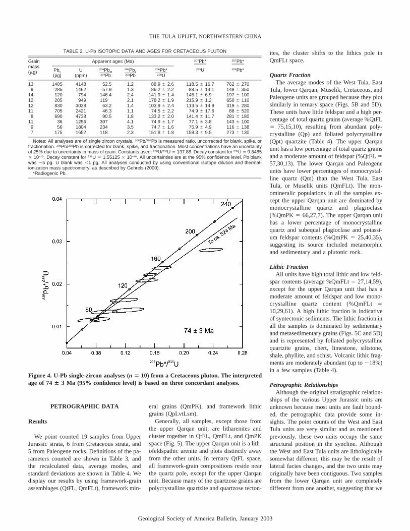
PETROGRAPHIC DATA
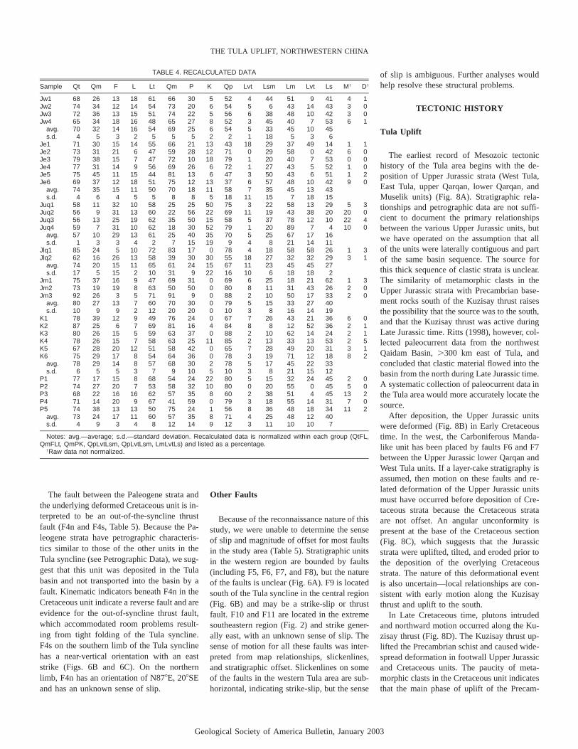
Results
We point counted 19 samples from UpperJurassic strata, 6 from Cretaceous strata, and5 from Paleogene rocks. Definitions of the pa-rameters counted are shown in Table 3, andthe recalculated data, average modes, andstandard deviations are shown in Table 4. Wedisplay our results by using framework-grainassemblages (QtFL, QmFLt), framework min-
eral grains (QmPK), and framework lithicgrains (QpLvtLsm).
Generally, all samples, except those fromthe upper Qarqan unit, are litharenites andcluster together in QtFL, QmFLt, and QmPKspace (Fig. 5). The upper Qarqan unit is a lith-ofeldspathic arenite and plots distinctly awayfrom the other units. In ternary QtFL space,all framework-grain compositions reside nearthe quartz pole, except for the upper Qarqanunit. Because many of the quartzose grains arepolycrystalline quartzite and quartzose tecton-
ites, the cluster shifts to the lithics pole inQmFLt space.
Quartz FractionThe average modes of the West Tula, East
Tula, lower Qarqan, Muselik, Cretaceous, andPaleogene units are grouped because they plotsimilarly in ternary space (Figs. 5B and 5D).These units have little feldspar and a high per-centage of total quartz grains (average %QtFL� 75,15,10), resulting from abundant poly-crystalline (Qp) and foliated polycrystalline(Qpt) quartzite (Table 4). The upper Qarqanunit has a low percentage of total quartz grainsand a moderate amount of feldspar (%QtFL�57,30,13). The lower Qarqan and Paleogeneunits have lower percentages of monocrystal-line quartz (Qm) than the West Tula, EastTula, or Muselik units (QmFLt). The mon-omineralic populations in all the samples ex-cept the upper Qarqan unit are dominated bymonocrystalline quartz and plagioclase(%QmPK� 66,27,7). The upper Qarqan unithas a lower percentage of monocrystallinequartz and subequal plagioclase and potassi-um feldspar contents (%QmPK� 25,40,35),suggesting its source included metamorphicand sedimentary and a plutonic rock.
Lithic FractionAll units have high total lithic and low feld-
spar contents (average %QmFLt� 27,14,59),except for the upper Qarqan unit that has amoderate amount of feldspar and low mono-crystalline quartz content (%QmFLt�10,29,61). A high lithic fraction is indicativeof syntectonic sediments. The lithic fraction inall the samples is dominated by sedimentaryand metasedimentary grains (Figs. 5C and 5D)and is represented by foliated polycrystallinequartzite grains, chert, limestone, siltstone,shale, phyllite, and schist. Volcanic lithic frag-ments are moderately abundant (up to�18%)in a few samples (Table 4).
Petrographic RelationshipsAlthough the original stratigraphic relation-
ships of the various Upper Jurassic units areunknown because most units are fault bound-ed, the petrographic data provide some in-sights. The point counts of the West and EastTula units are very similar and as mentionedpreviously, these two units occupy the samestructural position in the syncline. Althoughthe West and East Tula units are lithologicallysomewhat different, this may be the result oflateral facies changes, and the two units mayoriginally have been contiguous. Two samplesfrom the lower Qarqan unit are completelydifferent from one another, suggesting that we
Geological Society of America Bulletin, January 2003
ROBINSON et al.
TABLE 3. PETROGRAPHIC PARAMETERS
Qm Monocrystalline quartzQp Polycrystalline quartzQpt Foliated polycrystalline quartzQss Monocrystalline quartz in sandstone/quartzite lithic grainC ChertQt Total quartzose grains (� Qm Qp Qpt Qss C)K Potassium feldspar (including perthite, myrmekite, microcline)P Plagioclase feldspar (including Na and Ca varieties)F Total feldspar grains (� K P)Lvl Lath-work volcanic grainsLvm Microlitic volcanic grainsLvf Felsic volcanic grainsLvv Vitric volcanic grainsLvt Total volcanic lithic grains (� Lvl Lvm Lvf Lvv)Lph PhylliteLsch SchistLma Marble (foliated, coarse-grained)Lshs Mudstone and siltstoneLls LimestoneLd DolostoneLsm Total metasedimentary lithic grains (� Lshs Lph Lsch Lma Lls Ld)Ls Total sedimentary lithic grains (� Lshs Lls Ld)Lm Total metamorphic lithic grains (� Lph Lsch Lma)L Lithic grains (� Lvt Lsm)Lt Total lithic grains (� Qp Qpt Qss C Lvt Lsm)M Phyllosilicates � muscovite, biotite, chlorite, kaoliniteD Dense minerals � apatite, amphibole, tourmaline, zircon, sphene
do not have enough data to characterize thisunit. Petrographically, the upper Qarqan unitis distinct from the other units in the Tula area.The average modes of the Cretaceous and Up-per Jurassic Muselik units are indistinguish-able in all the ternary diagrams (Fig. 5). Al-though the Muselik unit was assigned aJurassic age, because it is fault bounded andhas unique lithologies, it may be Cretaceousin age. Further work is necessary to clarifythis relationship.
Provenance Interpretations
The sedimentary strata in the Tula uplift arevery immature and have a high proportion ofunstable lithics and feldspars. All of the sam-ples plot within or near the recycled-orogenprovenance field of Dickinson (1985) (Fig.5A). Sandstones that plot within this field aretypical of foreland basins and texturally andcompositionally immature sediments derivedfrom nearby tectonically active highlands.Thus, all units are undoubtedly syntectonicand were derived from a local source that waslithologically diverse, consisting of metamor-phic, igneous, and metasedimentary rocks.The fact that the Upper Jurassic units are syn-tectonic suggests that uplift on the northernpart of the Tibetan Plateau began in Late Ju-rassic time, concurrent with tectonic activityon the southern margin of Asia. The syntec-tonic nature of the Cretaceous and Paleogeneunits suggests that uplift continued throughCretaceous and early Tertiary time in the Tulaarea.
Paleocurrent data collected�300 km to the
east by Ritts (1998) suggests that the sourceof the Upper Jurassic and Cretaceous strata inthe northwestern Qaidam Basin was located tothe north. However, current directions in theTula uplift are potentially different than thosein the northwest Qaidam Basin. Thus, thesource area is ambiguous. If sediment in theTula area came from the north, any potentialsource terranes for the Mesozoic strata are atpresent far from Tula because of the 400 kmof offset (Ritts and Biffi, 2000) on the AltynTagh fault just north of the Tula area. Thesource area would now be located in the west-ern Kunlun Shan, which contains a multitude ofPhanerozoic sedimentary rocks and Paleozoic–Mesozoic igneous bodies (Sobel, 1999). How-ever, if the source of the Upper Jurassic andCretaceous rock is located to the south, thestrata may have been derived from the pre-Mesozoic metamorphic basement. The sourceof the volcanic lithics could be the unroofingof the Kunlun arc to the south. Additional pet-rographic analyses coupled with statisticallysignificant paleocurrent data would help re-solve the provenance of the Upper Jurassicand Cretaceous Tula basin sedimentary rocks.Our mapping suggests that the Paleogene stra-ta were derived from the Precambrian base-ment rock south of the Tula syncline, and thepetrographic data are concordant with thatsuggestion.
STRUCTURAL GEOLOGY
Tula Syncline
The Tula uplift is bounded by Precambrianbasement to the south, Carboniferous rocks to
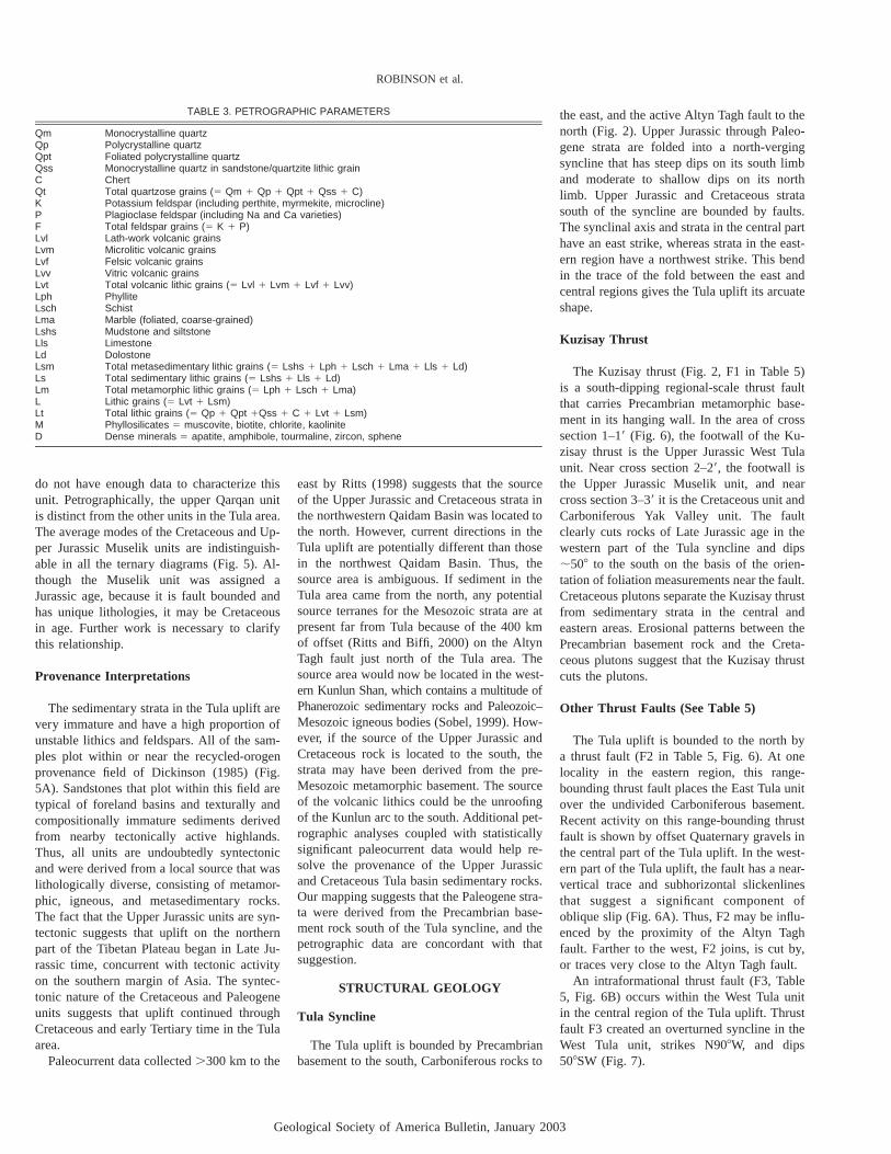
the east, and the active Altyn Tagh fault to thenorth (Fig. 2). Upper Jurassic through Paleo-gene strata are folded into a north-vergingsyncline that has steep dips on its south limband moderate to shallow dips on its northlimb. Upper Jurassic and Cretaceous stratasouth of the syncline are bounded by faults.The synclinal axis and strata in the central parthave an east strike, whereas strata in the east-ern region have a northwest strike. This bendin the trace of the fold between the east andcentral regions gives the Tula uplift its arcuateshape.
Kuzisay Thrust
The Kuzisay thrust (Fig. 2, F1 in Table 5)is a south-dipping regional-scale thrust faultthat carries Precambrian metamorphic base-ment in its hanging wall. In the area of crosssection 1–1 (Fig. 6), the footwall of the Ku-zisay thrust is the Upper Jurassic West Tulaunit. Near cross section 2–2, the footwall isthe Upper Jurassic Muselik unit, and nearcross section 3–3 it is the Cretaceous unit andCarboniferous Yak Valley unit. The faultclearly cuts rocks of Late Jurassic age in thewestern part of the Tula syncline and dips�50� to the south on the basis of the orien-tation of foliation measurements near the fault.Cretaceous plutons separate the Kuzisay thrustfrom sedimentary strata in the central andeastern areas. Erosional patterns between thePrecambrian basement rock and the Creta-ceous plutons suggest that the Kuzisay thrustcuts the plutons.
Other Thrust Faults (See Table 5)
The Tula uplift is bounded to the north bya thrust fault (F2 in Table 5, Fig. 6). At onelocality in the eastern region, this range-bounding thrust fault places the East Tula unitover the undivided Carboniferous basement.Recent activity on this range-bounding thrustfault is shown by offset Quaternary gravels inthe central part of the Tula uplift. In the west-ern part of the Tula uplift, the fault has a near-vertical trace and subhorizontal slickenlinesthat suggest a significant component ofoblique slip (Fig. 6A). Thus, F2 may be influ-enced by the proximity of the Altyn Taghfault. Farther to the west, F2 joins, is cut by,or traces very close to the Altyn Tagh fault.
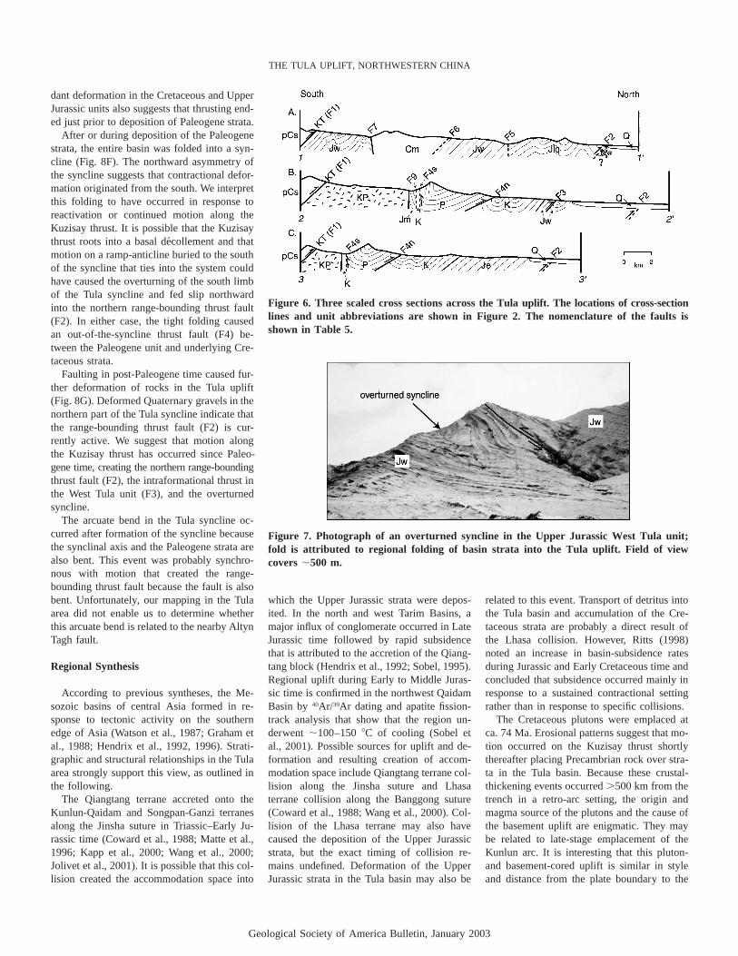
An intraformational thrust fault (F3, Table5, Fig. 6B) occurs within the West Tula unitin the central region of the Tula uplift. Thrustfault F3 created an overturned syncline in theWest Tula unit, strikes N90�W, and dips50�SW (Fig. 7).
Geological Society of America Bulletin, January 2003
THE TULA UPLIFT, NORTHWESTERN CHINA
TABLE 4. RECALCULATED DATA
Sample Qt Qm F L Lt Qm P K Qp Lvt Lsm Lm Lvt Ls M† D†
Jw1 68 26 13 18 61 66 30 5 52 4 44 51 9 41 4 1Jw2 74 34 12 14 54 73 20 6 54 5 6 43 14 43 3 0Jw3 72 36 13 15 51 74 22 5 56 6 38 48 10 42 3 0Jw4 65 34 18 16 48 65 27 8 52 3 45 40 7 53 6 1
avg. 70 32 14 16 54 69 25 6 54 5 33 45 10 45s.d. 4 5 3 2 5 5 5 2 2 1 18 5 3 6
Je1 71 30 15 14 55 66 21 13 43 18 29 37 49 14 1 1Je2 73 31 21 6 47 59 28 12 71 0 29 58 0 42 6 0Je3 79 38 15 7 47 72 10 18 79 1 20 40 7 53 0 0Je4 77 31 14 9 56 69 26 6 72 1 27 43 5 52 1 0Je5 75 45 11 15 44 81 13 6 47 3 50 43 6 51 1 2Je6 69 37 12 18 51 75 12 13 37 6 57 48 10 42 9 0
avg. 74 35 15 11 50 70 18 11 58 7 35 45 13 43s.d. 4 6 4 5 5 8 8 5 18 11 15 7 18 15
Juq1 58 11 32 10 58 25 25 50 75 3 22 58 13 29 5 3Juq2 56 9 31 13 60 22 56 22 69 11 19 43 38 20 20 0Juq3 56 13 25 19 62 35 50 15 58 5 37 78 12 10 22 4Juq4 59 7 31 10 62 18 30 52 79 1 20 89 7 4 10 0
avg. 57 10 29 13 61 25 40 35 70 5 25 67 17 16s.d. 1 3 3 4 2 7 15 19 9 4 8 21 14 11
Jlq1 85 24 5 10 72 83 17 0 78 4 18 58 58 26 1 3Jlq2 62 16 26 13 58 39 30 30 55 18 27 32 32 29 3 1
avg. 74 20 15 11 65 61 24 15 67 11 23 45 45 27s.d. 17 5 15 2 10 31 9 22 16 10 6 18 18 2
Jm1 75 37 16 9 47 69 31 0 69 6 25 18 21 62 1 3Jm2 73 19 19 8 63 50 50 0 80 8 11 31 43 26 2 0Jm3 92 26 3 5 71 91 9 0 88 2 10 50 17 33 2 0
avg. 80 27 13 7 60 70 30 0 79 5 15 33 27 40s.d. 10 9 9 2 12 20 20 0 10 3 8 16 14 19
K1 78 39 12 9 49 76 24 0 67 7 26 43 21 36 6 0K2 87 25 6 7 69 81 16 4 84 8 8 12 52 36 2 1K3 80 26 15 5 59 63 37 0 88 2 10 62 14 24 2 1K4 78 26 15 7 58 63 25 11 85 2 13 33 13 53 2 5K5 67 28 20 12 51 58 42 0 65 7 28 49 20 31 3 1K6 75 29 17 8 54 64 36 0 78 3 19 71 12 18 8 2
avg. 78 29 14 8 57 68 30 2 78 5 17 45 22 33s.d. 6 5 5 3 7 9 10 5 10 3 8 21 15 12
P1 77 17 15 8 68 54 24 22 80 5 15 32 24 45 2 0P2 74 27 20 7 53 58 32 10 80 0 20 55 0 45 5 0P3 68 22 16 16 62 57 35 8 60 2 38 51 4 45 13 2P4 71 14 20 9 67 41 59 0 79 3 18 55 14 31 7 0P5 74 38 13 13 50 75 24 1 56 8 36 48 18 34 11 2
avg. 73 24 17 11 60 57 35 8 71 4 25 48 12 40s.d. 4 9 3 4 8 12 14 9 12 3 11 10 10 7
Notes: avg.—average; s.d.—standard deviation. Recalculated data is normalized within each group (QtFL,QmFLt, QmPK, QpLvtLsm, QpLvtLsm, LmLvtLs) and listed as a percentage.
†Raw data not normalized.
The fault between the Paleogene strata andthe underlying deformed Cretaceous unit is in-terpreted to be an out-of-the-syncline thrustfault (F4n and F4s, Table 5). Because the Pa-leogene strata have petrographic characteris-tics similar to those of the other units in theTula syncline (see Petrographic Data), we sug-gest that this unit was deposited in the Tulabasin and not transported into the basin by afault. Kinematic indicators beneath F4n in theCretaceous unit indicate a reverse fault and areevidence for the out-of-syncline thrust fault,which accommodated room problems result-ing from tight folding of the Tula syncline.F4s on the southern limb of the Tula synclinehas a near-vertical orientation with an eaststrike (Figs. 6B and 6C). On the northernlimb, F4n has an orientation of N87�E, 20�SEand has an unknown sense of slip.
Other Faults
Because of the reconnaissance nature of thisstudy, we were unable to determine the senseof slip and magnitude of offset for most faultsin the study area (Table 5). Stratigraphic unitsin the western region are bounded by faults(including F5, F6, F7, and F8), but the natureof the faults is unclear (Fig. 6A). F9 is locatedsouth of the Tula syncline in the central region(Fig. 6B) and may be a strike-slip or thrustfault. F10 and F11 are located in the extremesoutheastern region (Fig. 2) and strike gener-ally east, with an unknown sense of slip. Thesense of motion for all these faults was inter-preted from map relationships, slickenlines,and stratigraphic offset. Slickenlines on someof the faults in the western Tula area are sub-horizontal, indicating strike-slip, but the sense
of slip is ambiguous. Further analyses wouldhelp resolve these structural problems.
TECTONIC HISTORY
Tula Uplift
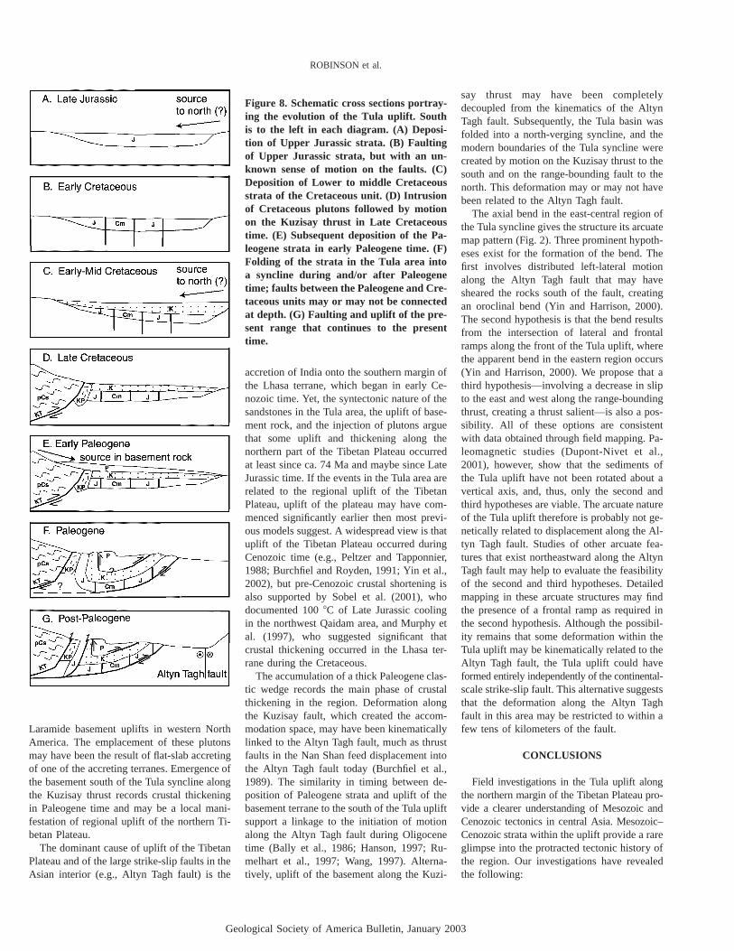
The earliest record of Mesozoic tectonichistory of the Tula area begins with the de-position of Upper Jurassic strata (West Tula,East Tula, upper Qarqan, lower Qarqan, andMuselik units) (Fig. 8A). Stratigraphic rela-tionships and petrographic data are not suffi-cient to document the primary relationshipsbetween the various Upper Jurassic units, butwe have operated on the assumption that allof the units were laterally contiguous and partof the same basin sequence. The source forthis thick sequence of clastic strata is unclear.The similarity of metamorphic clasts in theUpper Jurassic strata with Precambrian base-ment rocks south of the Kuzisay thrust raisesthe possibility that the source was to the south,and that the Kuzisay thrust was active duringLate Jurassic time. Ritts (1998), however, col-lected paleocurrent data from the northwestQaidam Basin,�300 km east of Tula, andconcluded that clastic material flowed into thebasin from the north during Late Jurassic time.A systematic collection of paleocurrent data inthe Tula area would more accurately locate thesource.
After deposition, the Upper Jurassic unitswere deformed (Fig. 8B) in Early Cretaceoustime. In the west, the Carboniferous Manda-like unit has been placed by faults F6 and F7between the Upper Jurassic lower Qarqan andWest Tula units. If a layer-cake stratigraphy isassumed, then motion on these faults and re-lated deformation of the Upper Jurassic unitsmust have occurred before deposition of Cre-taceous strata because the Cretaceous strataare not offset. An angular unconformity ispresent at the base of the Cretaceous section(Fig. 8C), which suggests that the Jurassicstrata were uplifted, tilted, and eroded prior tothe deposition of the overlying Cretaceousstrata. The nature of this deformational eventis also uncertain—local relationships are con-sistent with early motion along the Kuzisaythrust and uplift to the south.
In Late Cretaceous time, plutons intrudedand northward motion occurred along the Ku-zisay thrust (Fig. 8D). The Kuzisay thrust up-lifted the Precambrian schist and caused wide-spread deformation in footwall Upper Jurassicand Cretaceous units. The paucity of meta-morphic clasts in the Cretaceous unit indicatesthat the main phase of uplift of the Precam-
Geological Society of America Bulletin, January 2003
ROBINSON et al.
Figure 5. Ternary diagrams for Upper Jurassic–Paleogene strata in the Tula uplift: (A) QtFL and QmFLt diagrams with each sampledepicted by a symbol; the recycled-orogen provenance fields from Dickinson (1985) are shown by the light gray shading. (B) QtFL andQmFLt diagrams; average modes for each unit are depicted by a single symbol; standard deviations are depicted by trapezoids sur-rounding each symbol. (C) QmPK and QpLvtLsm diagrams with each sample depicted by a symbol. (D) QmPK and QpLvtLsm diagramsshowing average modes for each unit by a single symbol; the standard deviations are shown by the surrounding trapezoids.
TABLE 5. FAULT DATA
Fault Region Structural data Type of fault
F1 All regions Precambrian basement over West Tula unit, N70�E, 45–65�S ThrustF2 All regions Western—upper Qarqan next to undivided Carboniferous, near vertical Thrust or strike-slip
Central—deformed Quaternary gravels ThrustEastern—East Tula next to undivided Carboniferous, near vertical Thrust or strike-slip
F3 Central Intraformational; N90�W, 50�S ThrustF4n Central and eastern Paleogene over Cretaceous; Cretaceous deformed under fault; N70�E, 20–30�S ThrustF4s Central and eastern Paleogene over Cretaceous; N90�E, 75�N to 80�S overturned Thrust or strike-slipF5 Western Upper Qarqan on top of lower Qarqan, E-W, 70�N; upper Qarqan and West Tula, relationship
uncertain, covered by QuaternaryThrust or strike-slip
F6 Western Lower Qarqan over Mandalike, N55�E, 40�SE; dike intruded along contact in one location Probably thrustF7 Western Mandalike over West Tula, N80�W, 80�N; zone of deformation Probably thrustF8 Western Separates lower Qarqan from West Tula; assumed buried under Quaternary inferred to strike
NW-SEUnknown
F9 Central Cretaceous next to Muselik; N90�E, vertical Probably strike-slip possibly thrustF10 Eastern Cretaceous next to Yak Valley; vertical, various orientations UnknownF11 Eastern Yak Valley next to Cretaceous; contact inferred Assumed
brian schist occurred after deposition of theCretaceous strata.
The Paleogene unit, however, containsabundant metamorphic, plutonic, and meta-
sedimentary clasts that probably originatedfrom the hanging wall of the Kuzisay thrust.Their presence suggests that uplift of rocks tothe south was occurring along the fault, caus-
ing the development of flexural accommoda-tion space, into which Paleogene strata weredeposited (Fig. 8E). The lack of penetrativedeformation in the Paleogene unit but abun-
Geological Society of America Bulletin, January 2003
THE TULA UPLIFT, NORTHWESTERN CHINA
Figure 6. Three scaled cross sections across the Tula uplift. The locations of cross-sectionlines and unit abbreviations are shown in Figure 2. The nomenclature of the faults isshown in Table 5.
Figure 7. Photograph of an overturned syncline in the Upper Jurassic West Tula unit;fold is attributed to regional folding of basin strata into the Tula uplift. Field of viewcovers�500 m.
dant deformation in the Cretaceous and UpperJurassic units also suggests that thrusting end-ed just prior to deposition of Paleogene strata.
After or during deposition of the Paleogenestrata, the entire basin was folded into a syn-cline (Fig. 8F). The northward asymmetry ofthe syncline suggests that contractional defor-mation originated from the south. We interpretthis folding to have occurred in response toreactivation or continued motion along theKuzisay thrust. It is possible that the Kuzisaythrust roots into a basal de´collement and thatmotion on a ramp-anticline buried to the southof the syncline that ties into the system couldhave caused the overturning of the south limbof the Tula syncline and fed slip northwardinto the northern range-bounding thrust fault(F2). In either case, the tight folding causedan out-of-the-syncline thrust fault (F4) be-tween the Paleogene unit and underlying Cre-taceous strata.
Faulting in post-Paleogene time caused fur-ther deformation of rocks in the Tula uplift(Fig. 8G). Deformed Quaternary gravels in thenorthern part of the Tula syncline indicate thatthe range-bounding thrust fault (F2) is cur-rently active. We suggest that motion alongthe Kuzisay thrust has occurred since Paleo-gene time, creating the northern range-boundingthrust fault (F2), the intraformational thrust inthe West Tula unit (F3), and the overturnedsyncline.
The arcuate bend in the Tula syncline oc-curred after formation of the syncline becausethe synclinal axis and the Paleogene strata arealso bent. This event was probably synchro-nous with motion that created the range-bounding thrust fault because the fault is alsobent. Unfortunately, our mapping in the Tulaarea did not enable us to determine whetherthis arcuate bend is related to the nearby AltynTagh fault.
Regional Synthesis
According to previous syntheses, the Me-sozoic basins of central Asia formed in re-sponse to tectonic activity on the southernedge of Asia (Watson et al., 1987; Graham etal., 1988; Hendrix et al., 1992, 1996). Strati-graphic and structural relationships in the Tulaarea strongly support this view, as outlined inthe following.
The Qiangtang terrane accreted onto theKunlun-Qaidam and Songpan-Ganzi terranesalong the Jinsha suture in Triassic–Early Ju-rassic time (Coward et al., 1988; Matte et al.,1996; Kapp et al., 2000; Wang et al., 2000;Jolivet et al., 2001). It is possible that this col-lision created the accommodation space into
which the Upper Jurassic strata were depos-ited. In the north and west Tarim Basins, amajor influx of conglomerate occurred in LateJurassic time followed by rapid subsidencethat is attributed to the accretion of the Qiang-tang block (Hendrix et al., 1992; Sobel, 1995).Regional uplift during Early to Middle Juras-sic time is confirmed in the northwest QaidamBasin by40Ar/39Ar dating and apatite fission-track analysis that show that the region un-derwent�100–150�C of cooling (Sobel etal., 2001). Possible sources for uplift and de-formation and resulting creation of accom-modation space include Qiangtang terrane col-lision along the Jinsha suture and Lhasaterrane collision along the Banggong suture(Coward et al., 1988; Wang et al., 2000). Col-lision of the Lhasa terrane may also havecaused the deposition of the Upper Jurassicstrata, but the exact timing of collision re-mains undefined. Deformation of the UpperJurassic strata in the Tula basin may also be
related to this event. Transport of detritus intothe Tula basin and accumulation of the Cre-taceous strata are probably a direct result ofthe Lhasa collision. However, Ritts (1998)noted an increase in basin-subsidence ratesduring Jurassic and Early Cretaceous time andconcluded that subsidence occurred mainly inresponse to a sustained contractional settingrather than in response to specific collisions.
The Cretaceous plutons were emplaced atca. 74 Ma. Erosional patterns suggest that mo-tion occurred on the Kuzisay thrust shortlythereafter placing Precambrian rock over stra-ta in the Tula basin. Because these crustal-thickening events occurred�500 km from thetrench in a retro-arc setting, the origin andmagma source of the plutons and the cause ofthe basement uplift are enigmatic. They maybe related to late-stage emplacement of theKunlun arc. It is interesting that this pluton-and basement-cored uplift is similar in styleand distance from the plate boundary to the
Geological Society of America Bulletin, January 2003
ROBINSON et al.
Figure 8. Schematic cross sections portray-ing the evolution of the Tula uplift. Southis to the left in each diagram. (A) Deposi-tion of Upper Jurassic strata. (B) Faultingof Upper Jurassic strata, but with an un-known sense of motion on the faults. (C)Deposition of Lower to middle Cretaceousstrata of the Cretaceous unit. (D) Intrusionof Cretaceous plutons followed by motionon the Kuzisay thrust in Late Cretaceoustime. (E) Subsequent deposition of the Pa-leogene strata in early Paleogene time. (F)Folding of the strata in the Tula area intoa syncline during and/or after Paleogenetime; faults between the Paleogene and Cre-taceous units may or may not be connectedat depth. (G) Faulting and uplift of the pre-sent range that continues to the presenttime.
Laramide basement uplifts in western NorthAmerica. The emplacement of these plutonsmay have been the result of flat-slab accretingof one of the accreting terranes. Emergence ofthe basement south of the Tula syncline alongthe Kuzisay thrust records crustal thickeningin Paleogene time and may be a local mani-festation of regional uplift of the northern Ti-betan Plateau.
The dominant cause of uplift of the TibetanPlateau and of the large strike-slip faults in theAsian interior (e.g., Altyn Tagh fault) is the
accretion of India onto the southern margin ofthe Lhasa terrane, which began in early Ce-nozoic time. Yet, the syntectonic nature of thesandstones in the Tula area, the uplift of base-ment rock, and the injection of plutons arguethat some uplift and thickening along thenorthern part of the Tibetan Plateau occurredat least since ca. 74 Ma and maybe since LateJurassic time. If the events in the Tula area arerelated to the regional uplift of the TibetanPlateau, uplift of the plateau may have com-menced significantly earlier then most previ-ous models suggest. A widespread view is thatuplift of the Tibetan Plateau occurred duringCenozoic time (e.g., Peltzer and Tapponnier,1988; Burchfiel and Royden, 1991; Yin et al.,2002), but pre-Cenozoic crustal shortening isalso supported by Sobel et al. (2001), whodocumented 100�C of Late Jurassic coolingin the northwest Qaidam area, and Murphy etal. (1997), who suggested significant thatcrustal thickening occurred in the Lhasa ter-rane during the Cretaceous.
The accumulation of a thick Paleogene clas-tic wedge records the main phase of crustalthickening in the region. Deformation alongthe Kuzisay fault, which created the accom-modation space, may have been kinematicallylinked to the Altyn Tagh fault, much as thrustfaults in the Nan Shan feed displacement intothe Altyn Tagh fault today (Burchfiel et al.,1989). The similarity in timing between de-position of Paleogene strata and uplift of thebasement terrane to the south of the Tula upliftsupport a linkage to the initiation of motionalong the Altyn Tagh fault during Oligocenetime (Bally et al., 1986; Hanson, 1997; Ru-melhart et al., 1997; Wang, 1997). Alterna-tively, uplift of the basement along the Kuzi-
say thrust may have been completelydecoupled from the kinematics of the AltynTagh fault. Subsequently, the Tula basin wasfolded into a north-verging syncline, and themodern boundaries of the Tula syncline werecreated by motion on the Kuzisay thrust to thesouth and on the range-bounding fault to thenorth. This deformation may or may not havebeen related to the Altyn Tagh fault.
The axial bend in the east-central region ofthe Tula syncline gives the structure its arcuatemap pattern (Fig. 2). Three prominent hypoth-eses exist for the formation of the bend. Thefirst involves distributed left-lateral motionalong the Altyn Tagh fault that may havesheared the rocks south of the fault, creatingan oroclinal bend (Yin and Harrison, 2000).The second hypothesis is that the bend resultsfrom the intersection of lateral and frontalramps along the front of the Tula uplift, wherethe apparent bend in the eastern region occurs(Yin and Harrison, 2000). We propose that athird hypothesis—involving a decrease in slipto the east and west along the range-boundingthrust, creating a thrust salient—is also a pos-sibility. All of these options are consistentwith data obtained through field mapping. Pa-leomagnetic studies (Dupont-Nivet et al.,2001), however, show that the sediments ofthe Tula uplift have not been rotated about avertical axis, and, thus, only the second andthird hypotheses are viable. The arcuate natureof the Tula uplift therefore is probably not ge-netically related to displacement along the Al-tyn Tagh fault. Studies of other arcuate fea-tures that exist northeastward along the AltynTagh fault may help to evaluate the feasibilityof the second and third hypotheses. Detailedmapping in these arcuate structures may findthe presence of a frontal ramp as required inthe second hypothesis. Although the possibil-ity remains that some deformation within theTula uplift may be kinematically related to theAltyn Tagh fault, the Tula uplift could haveformed entirely independently of the continental-scale strike-slip fault. This alternative suggeststhat the deformation along the Altyn Taghfault in this area may be restricted to within afew tens of kilometers of the fault.
CONCLUSIONS
Field investigations in the Tula uplift alongthe northern margin of the Tibetan Plateau pro-vide a clearer understanding of Mesozoic andCenozoic tectonics in central Asia. Mesozoic–Cenozoic strata within the uplift provide a rareglimpse into the protracted tectonic history ofthe region. Our investigations have revealedthe following:
Geological Society of America Bulletin, January 2003
THE TULA UPLIFT, NORTHWESTERN CHINA
1. The lithic composition of Upper Jurassicsandstones and the deformation, uplift, anderosion of Upper Jurassic strata suggest thatsignificant regional uplift occurred in the Tulaarea during Late Jurassic time. This uplift mayhave been caused by accretion of the Qiang-tang or Lhasa terranes onto the southern mar-gin of Asia.
2. The intrusion of Cretaceous plutons andthe uplift of basement rock along the Kuzisaythrust support crustal thickening and shorten-ing in the northern Tibetan Plateau prior todeposition of Paleogene strata, and perhapsbeginning by ca. 74 Ma. The intrusion anduplift may record collisional tectonics alongthe southern margin of Asia during or prior tothe onset of the Indian collision.
3. Folding of the Tula syncline is syn- orpost-Paleogene and is probably related to con-tinued motion on the Kuzisay thrust.
4. A prominent bend in the synclinal axisdeveloped after the Tula syncline was formed,giving the structure its arcuate shape. Field re-lationships do not discriminate between sev-eral possible hypotheses for the formation ofthe Tula syncline. However, paleomagneticdata (Dupont-Nivet et al., 2001) rule out thepossibility that it is the result of shear alongthe Altyn Tagh fault. Thus, the oroclinal shapemay result from either a salient of a south-dipping thrust or the intersection of a frontalramp with a lateral ramp.
5. The Tula uplift has an active northernrange-bounding fault, which suggests thatthickening and uplift of the Tibetan Plateau isstill occurring. These data and other studiessuggest that this region has a long history re-lated to the tectonic activity occurring syn-chronously on the southern margin of Asia.
6. Uplift in the northern Tibetan Plateaumay have begun in Late Jurassic time, contin-ued through Cretaceous and early Tertiarytime, and continues to the present day. There-fore, the northern Tibetan Plateau may havebeen tectonically active—and undergoing re-gional compressional deformation, uplift, anderosion—long before the early Tertiary India-Asia collision. Further stratigraphic, prove-nance, and geochronologic investigations inthe Tula syncline will clarify the details of thistectonic activity.
ACKNOWLEDGMENTS
We thank Wang Xiao Feng and the Institute ofGeomechanics, Beijing, PRC, for organizing ourfield logistics in China. E. Cowgill and An Yin pro-vided assistance within China and perceptive dis-cussions. P. DeCelles provided invaluable assistancewith the petrographic and sedimentological data.We also thank An Yin as the leader of the AltynTagh fault project. Formal reviews by Ed Sobel and
an unknown reviewer improved this manuscript. A.Hanson, O. Pearson, B. Ritts, Ed Sobel, and An Yinprovided informal reviews in the earliest stages ofthis manuscript. This study was supported by Na-tional Science Foundation Continental DynamicsProgram grant EAR-9725663.
REFERENCES CITED
Bally, A.W., Chou, I.M., Clayton, R., Eugster, H.P., Kid-well, S., Meckel, L.D., Ryder, R.T., Watts, A.B., andWilson, A.A., 1986, Notes on sedimentary basins inChina—Report of the American Sedimentary BasinsDelegation to the People’s Republic of China: U.S.Geological Survey Open-File Report 86–327, 108 p.
Burchfiel, B.C., and Royden, L.H., 1991, Tectonics of Asia50 yr after the death of Emile Argand: Eclogae Geo-logica Helvetica, v. 84, p. 599–629.
Burchfiel, B.C., Deng, Q., Molnar, P., Royden, L., Qang,Y., Zhang, P., and Zhang, W., 1989, Intracrustal de-tachment within zones of continental deformation: Ge-ology, v. 17, p. 448–452.
Burtman, V.S., 1980, Faults of middle Asia: American Jour-nal of Science, v. 280, p. 725–744.
Carroll, A.R., Graham, S.A., Hendrix, M.S., Ying, D., andZhou, D., 1995, Late Paleozoic tectonic amalgamationof northwestern China: Sedimentary record of thenorthern Tarim, northwestern Turpan, and southernJunggar Basins: Geological Society of America Bul-letin, v. 107, p. 571–594.
Chen, Z., ed., 1985, Geological map of Xinjiang UygurAutonomous Region, China: Beijing, Geological Pub-lishing House, scale 1:2,000,000.
Coward, M.P., Kidd, W.S.F., Pan, Y., and Shackleton, R.M.,1988, Structure of the 1985 Geotraverse, Lhasa toGolmud: Royal Society of London PhilosophicalTransactions, Ser. A, v. 327, p. 307–336.
Dickinson, W.R., 1985, Interpreting provenance relationsfrom detrital modes of sandstones,in Zuffa, G.G., ed.,Provenance of arenites: Dordrecht, Netherlands, Rei-del, p. 333–361.
Dupont-Nivet, G., Butler, R.F., Yin, A., Robinson, D.M.,Zhang, Y., and Qiao, W.S., 2001, Paleomagnetism ofthe Altyn Tagh South of the Altyn Tagh Fault: Impli-cations for Intracontinental Deformation Processes inAsia: EOS Transactions AGU, Fall Meeting Supple-ment Abstract T12F–06, v. 82, no. 47.
Gehrels, G.E., 2000, Introduction to detrital zircon studiesof Paleozoic and Triassic strata in western Nevadaand northern California,in Soreghan, M.J., and Geh-rels, G.E., eds., Paleozoic and Triassic paleogeog-raphy and tectonics of western Nevada and northernCalifornia: Geological Society of America SpecialPaper 347, p. 1–17.
Graham, S.A., Zuchang, X., Carroll, A., Mcknight, C.,1988, Mesozoic–Cenozoic basins of western China asexample of partitioned retro-arc foreland basin system:Association of American Petroleum Geologists Bul-letin, v. 72, p. 191.
Graham, S.A., Brassell, S., Carroll, A.R., Xiao, X., De-maison, G., McKnight, C.L., Liang, Y., Chu, J., andHendrix, M.S., 1990, Characteristics of selected petro-leum source rocks, Xianjiang Uygur Autonomous Re-gion, northwest China: American Association of Pe-troleum Geologists Bulletin, v. 74, p. 493–512.
Graham, S.A., Hendrix, M.S., Wang, L.B., and Carroll,A.R., 1993, Collisional successor basins of westernChina: Impact of tectonic inheritance on sand com-position: Geological Society of America Bulletin,v. 105, p. 323–344.
Guo, Z., Zhang, Z., and Zeng, F., 1998, Discovery of mega-thick oil sandstone and asphalt in the Jurassic Systemin the Tula basin and its significance: Chinese ScienceBulletin, v. 43, p. 1898–1901.
Hanson, A.D., 1997, Evidence of Cenozoic erosional un-roofing adjacent to the northern Qaidam Basin, north-west China, preserved within basin-margin strata:Geological Society of America Abstracts with Pro-grams, v. 29, no. 6, p. A143.
Harris, N.B.W., Xu, R., Lewis, C.L., Haekeworth, C.J.,
Zhang, Y., 1988, Isotopic geochemistry of the 1985Tibet Geotraverse, Lhasa to Golmud: Royal Societyof London Philosophical Transactions, Ser. A, v. 327,p. 263–85.
Hendrix, M.S., Graham, S.A., Carroll, A.R., Sobel, E.R.,McKnight, C.L., Schulein, B.S., and Wang, Z., 1992,Sedimentary record and climatic implications of re-current deformation in the Tian Shan: Evidence fromMesozoic strata of the north Tarim, south Junggar andTurpan Basins, northwest China: Geological Societyof America Bulletin, v. 104, p. 53–79.
Hendrix, M.S., Graham, S.A., Amory, J.Y., and Badarch,G., 1996, Noyon Uul syncline, southern Mongolia:Lower Mesozoic sedimentary record of the tectonicamalgamation of central Asia: Geological Society ofAmerica Bulletin, v. 108, p. 1256–1274.
Ingersoll, R.V., Bullard, T.F., Ford, R.L., Grimm, J.P., Pick-le, J.D., and Sares, S.W., 1984, The effect of grainsize on detrital modes: A test of the Gazzi-Dickinsonpoint-counting method: Journal of Sedimentary Pe-trology, v. 54, p. 103–116.
Jiang, C., Yang, J., Feng, B., Zhu, Z., Zhao, M., et al., 1992,Opening-closing tectonics of Kunlun Mountains, Bei-jing: Geologic Publishing House, 224 p. (in Chinesewith English abstract).
Jolivet, M., Brunel, M., Seward, D., Xu, Z., Yang, J., Roger,F., Tapponnier, P., Malavieille, J., Arnaud, N., and Wu,C., 2001, Mesozoic and Cenozoic tectonics of thenorthern edge of the Tibetan Plateau: Fission-trackconstraints: Tectonophysics, v. 343, p. 111–134.
Kapp, P., Yin, A., Manning, C.E., Murphy, M., Harrison,T.M., Spurlin, M., Ding, L., Deng, X.-G., and Wu, C.-M., 2000, Blueschist-bearing metamorphic core com-plexes in the Qiangtang block reveal deep crustalstructure of northern Tibet: Geology, v. 28, p. 19–22.
Lockley, M.G., Ritts, B.D., and Leonardi, G., 1999, Mam-mal track assemblages from the early Tertiary of Chi-na, Peru, Europe, and North America: Palaios, v. 14,p. 398–404.
Matte, Ph., Tapponnier, P., Arnaud, N., Bourjot, L., Avouac,J.P., Vidal, P., Liu, Q., Pan, Y.S., and Wang, Y., 1996,Tectonics of western Tibet, between the Tarim and theIndus: Earth and Planetary Science Letters, v. 142,p. 311–330.
Matte, Ph., Mattauer, M., Olivet, J.M., and Griot, D.A.,1997, Continental subductions beneath Tibet and theHimalayan orogeny: A review: Terra Nova, v. 9,p. 264–270.
Molnar, P., and Tapponnier, P., 1975, Cenozoic tectonics ofAsia: Effects of a continental collision: Science,v. 189, p. 419–426.
Murphy, M.A., Yin, A., Harrison, T.M., Durr, S.B., andChen, Z., 1997, Significant crustal shortening insouth-central Tibet prior to the Indo-Asian collision:Geology, v. 25, p. 719–722.
Peltzer, G., and Tapponnier, P., 1988, Formation and evo-lution of strike-slip faults, rifts, and basins during theIndia-Asia collision: An experimental approach: Jour-nal of Geophysical Research, v. 93, p. 15,085–15,117.
Pierce, J.A., and Mei, H., 1988, Volcanic rocks of the 1985Tibet Geotraverse Lhasa to Golmud: Royal Society ofLondon Philosophical Transactions, Ser. A, v. 327,p. 203–213.
Ritts, B.D., 1998, Mesozoic tectonics and sedimentation,and petroleum systems of the Qaidam and Tarim Ba-sins, northwest China [Ph.D. thesis]: Stanford, Cali-fornia, Stanford University, 691 p.
Ritts, B.D., and Biffi, U., 2000, Magnitude of post–MiddleJurassic (Bajocian) displacement on the central AltynTagh fault system, northwest China: Geological So-ciety of America Bulletin, v. 112, p. 61–74.
Ritts, B.D., and Biffi, U., 2001, Mesozoic northeast QaidamBasin: Response to contractional reactivation of the Qil-ian Shan, and implications for the extent of Mesozoicintracontinental deformation in central Asia,in Hendrix,M.S., and Davis, G.A., eds., Paleozoic and Mesozoictectonic evolution of central Asia: From continental as-sembly to intracontinental deformation: Geological So-ciety of America Memoir 194, p. 293–316.
Rumelhart, P.E., 1998, Cenozoic basin evolution of south-ern Tarim, northwestern China: Implications for the
Geological Society of America Bulletin, January 2003
ROBINSON et al.
uplift history of the Tibetan Plateau [Ph.D. thesis]:Los Angeles, University of California, 298 p.
Rumelhart, P.E., Yin, A., Butler, R., Richards, D., Wang,X., Zhou, X., and Zhang, Q., 1997, Oligocene initia-tion of deformation of northern Tibet, evidence fromthe Tarim Basin, northwest China: Geological Societyof America Abstracts with Programs, v. 29, no. 6,p. A143.
Sengor, A.M.C., and Natal’in, B.A., 1996, Paleotectonicsof Asia: Fragments of a synthesis,in Yin, A., andHarrison, T.M., eds., The tectonics of Asia: New York,Cambridge University Press, p. 486–640.
Sobel, E.R., 1995, Basin analysis and apatite fission-trackthermochronology of the Jurassic–Paleogene south-west Tarim Basin, northwest China [Ph.D. thesis]:Stanford, California, Stanford University, 308 p.
Sobel, E.R., 1999, Basin analysis of the Jurassic–LowerCretaceous southwest Tarim Basin, northwest China:Geological Society of America Bulletin, v. 111,p. 709–724.
Sobel, E.R., and Dimitru, T.A., 1997, Exhumation of themargins of the western Tarim Basin during the Hi-malayan orogeny: Journal of Geophysical Research,v. 102, p. 5043–5064.
Sobel, E.R., Arnaud, N., Jolivet, M., Ritts, B.D., and Bru-nel, M., 2001, Jurassic to Cenozoic exhumation his-tory of the Altyn Tagh range, northwest China, con-
strained by 40Ar/39Ar and apatite fission trackthermochronology,in Hendrix, M.S., and Davis, G.A.,eds., Paleozoic and Mesozoic tectonic evolution ofcentral Asia: From continental assembly to intracon-tinental deformation: Geological Society of AmericaMemoir 194, p. 247–267.
Tseyeler, V.M., Florenskiy, V.S., Vasyukov, V.S., and Turov,A.V., 1982, Tectonic structure of the northern FerganaRange: International Geology Review, v. 24,p. 881–890.
Vincent, S.J., and Allen, M.B., 1999, Evolution of the Min-le and Chaoshui Basins, China: Implications for Me-sozoic strike-slip basin formation in central Asia: Geo-logical Society of America Bulletin, v. 111,p. 725–742.
Wang, E., 1997, Displacement and timing along the north-ern strand of the Altyn Tagh fault zone, northern Ti-bet: Earth and Planetary Science Letters, v. 150,p. 55–64.
Wang, X., Metcalfe, I., Jian, P., He, L., and Wang, C., 2000,The Jinshajiang-Ailaoshan suture zone, China: Tec-tonostratigraphy, age and evolution: Journal of AsianEarth Sciences, v. 18, p. 675–690.
Watson, M.P., Hayward, A.B., Parkinson, D.N., and Zhang,Zh.M., 1987, Plate tectonic history, basin develop-ment and petroleum source rock deposition onshoreChina: Marine Petroleum Geology, v. 4, p. 205–225.
XBGMR (Bureau of Geology and Mineral Resources ofXinjiang Uygur Autonomous Region), 1993, Regionalgeology of Xinjiang Uygur Autonomous Region: Bei-jing, Geological Publishing House, Geological Mem-oirs, Series 1, Number 32, 841 p., scale 1:1,500,000.
Xia, B., 1990, Terranes of Xizang (Tibet), China,in Wiley,T.J., Howell, D.G., and Wong, F.L., eds., Terrane anal-ysis of China and the Pacific rim: Circum-PacificCouncil for Energy and Mineral Resources Earth Sci-ence Series, v. 13, p. 231–241.
Yin, A., and Harrison, T.M., 2000, Geologic evolution ofthe Himalayan-Tibetan orogen: Annual Review ofEarth and Planetary Science, v. 28, p. 211–280.
Yin, A., and Nie, S.Y., 1996, A Phanerozoic palinspastic re-construction of China and its neighboring regions,inYin, A., and Harrison, T.M., eds., The tectonics of Asia:New York, Cambridge University Press, p. 442–485.
Yin, A., Rumelhart, P.E., Butler, R., Cowgill, E., Harrison,T.M., Foster, D.A., Ingersoll, R.V., Zhang Qing, ZhouXian-Qiang, Wang Xiao-Feng, Hanson, A., and Raza,A., 2002, The uplift history of the Tibetan Plateau asrecorded in the Cenozoic stratigraphy of southern Ta-rim, northwestern China: Geological Society of Amer-ica, v. 114, p. 1257–1295.
MANUSCRIPT RECEIVED BY THE SOCIETY 24 AUGUST 2001REVISED MANUSCRIPT RECEIVED 18 APRIL 2002MANUSCRIPT ACCEPTED7 MAY 2002
Printed in the USA