Embed Size (px)
Citation preview

MARCH 2016
NETWORKED TRANSPARENCY
Constructing a Common Operational Picture of the South China Sea
Dr. Van Jackson, Dr. Mira Rapp-Hooper, Paul Scharre,
Harry Krejsa, and Commander Jeff Chism

About the AuthorsDr. Van Jackson is an Adjunct Senior Fellow with the Asia-Pacific Security Program at CNAS and Associate Professor at the Daniel K. Inouye Asia-Pacific Center for Security Studies in Honolulu. From 2009 to 2014, Dr. Jackson held positions in the Office of the Secretary of Defense (OSD) as
a strategist and policy advisor focused on the Asia-Pacific, senior country director for Korea, and working group chair of the U.S.–Republic of Korea Extended Deterrence Policy Committee. Additionally, he contributed to the 2013 Strategic Choices Management Review, the 2014 Quadrennial Defense Review, and OSD’s implementation of the U.S. policy of rebalancing to the Asia-Pacific. Any views expressed are personal and do not reflect the opinions of the Department of Defense or U.S. Government.
Dr. Mira Rapp-Hooper is a Senior Fellow with the Asia-Pacific Security Program at CNAS. She is formerly a fellow with the CSIS Asia Program and director of the CSIS Asia Maritime Transparency Initiative. Her expertise includes Asia security issues, deterrence, nuclear strategy and policy,
and alliance politics. She was previously a Stanton Nuclear Security Fellow at the Council on Foreign Relations. Dr. Rapp-Hooper is a Foreign Policy Interrupted Fellow and a David Rockefeller Fellow of the Trilateral Commission.
Paul Scharre is a Senior Fellow and Director of the 20YY Future of Warfare Initiative at CNAS. Previously, Mr. Scharre worked in the Office of the Secretary of Defense (OSD) and played a leading role in establishing policies on unmanned and autonomous systems and emerging weapons
technologies. He also led DoD efforts to establish policies on intelligence, surveillance, and reconnaissance programs and directed-energy technologies. Prior to joining OSD, Mr. Scharre served as a special operations reconnaissance team leader in the Army’s 3rd Ranger Battalion and completed multiple tours to Iraq and Afghanistan.
Harry Krejsa is a Research Associate with the Asia-Pacific Security Program at CNAS. Prior to joining CNAS, Mr. Krejsa worked as a policy analyst for the Congressional Joint Economic Committee’s Democratic staff and also served as a researcher with the Center for the Study of Chinese Military Affairs
at National Defense University. Mr. Krejsa has led a field analysis on political transition in Myanmar, piloted anti-terror training programs in the Maldives, and served as a Fulbright Fellow in Taiwan.
Jeff Chism is a Commander in the U.S. Navy and at the time of writing was a Military Fellow at CNAS. Recent assignments include the Office of the Under Secretary for Acquisitions, Technology, and Logistic in Tactical Warfare Systems and Commanding Officer of the “Zappers” VAQ-13, an
electronic warfare squadron. Any views expressed are personal and do not reflect the opinions of the Department of Defense or U.S. Government.
AcknowledgementsThis report was the result of extensive discussions and workshops with subject matter experts, academics and practitioners, and stakeholder organizations, to whom we are very grateful. Al Song, Ely Ratner, JC Mock, Zachary Hosford, Alexander Sullivan, Shawn Brimley, and Loren Schulman provided crucial support and feedback. The input of working group attendees like Mark Richardson and Mark Young of the The Pew Charitable Trusts proved vital to this report’s construction. We thank Maura McCarthy and Melody Cook for their excellent assistance with editing and graphic design.
While many colleagues contributed to the research effort, the views herein are the authors’ alone. We are solely responsible for any errors in fact, analysis, or omission
About the Asia-Pacific Security ProgramThe Asia-Pacific Security program seeks to inform the exercise of U.S. leadership in Asia by analyzing how the United States can rebalance its priorities; shape a rules-based regional order; modernize traditional alliances; build the capacity of new partners; and strengthen multilateral institutions. From exploring rising maritime tensions in the region to crafting ways to renew key alliances and partnerships to articulating strategies to extend and enhance America’s influence, the program leverages the diverse experience and background of its team, deep relationships in the region and in Washington, and CNAS’ convening power to shape and elevate the conversation on U.S. policy across a changing Asia.
Cover Photo: iStock

NETWORKED TRANSPARENCYConstructing a Common Operational Picture of the South China Sea
2 INTRODUCTION
5 TAKING ACTION AGAINST TROUBLING REGIONAL TRENDS
15 INFORMATION-SHARING CAPACITY FOR THE SOUTH CHINA SEA
22 THE PROCESS ELEMENTS OF MARITIME AWARENESS
26 THREE MODELS OF MARITIME AWARENESS
31 STRATEGIES FOR IMPROVING SOUTH CHINA SEA SITUATIONAL AWARENESS
40 GETTING REAL: A ROAD MAP FOR THE MARITIME SECURITY INITIATIVE
44 LIST OF ACRONYMS & ENDNOTES

01 CHAPTER
Introduction
2

3
@CNASDC
I. Introduction The South China Sea is strategically important and resource-rich, crucial to the lifeblood of U.S. and Indo-Pacific economies. Roughly one-third, or $5 trillion, of the world’s commercial shipping passes through its waterways annually. The South China Sea is home to proven reserves of at least 7 billion barrels of oil, as well as what is estimated to be 900 trillion cubic feet of natural gas.1 Fif-ty percent of all global oil tanker shipments pass through the region.2 And these shipments are vital to meeting the energy needs of most Asian coun-tries, providing 60 percent of Japan’s and Tai-wan’s energy, two-thirds of South Korean imports, and 80 percent of China’s crude oil imports.3
It is also a highly contested space, and the proxi-mate sources of tensions are well-known. Ongoing sovereignty disputes among China, the Philip-pines, Vietnam, Taiwan, Malaysia, and Brunei lead to competition over hundreds of islands, reefs, and reclaimed land. The strategic implications for growing tensions among these claimants are profound. Together these nations produce $11.7 trillion of global gross domestic product (GDP) and are home to a third of the world’s popula-tion, including half a billion who live within 100 miles of the South China Sea coastline alone.4
Yet underlying these resource and sovereignty tensions is something even more pernicious: The South China Sea is an opaque, low-information environment. Most South China Sea islets are hundreds of miles from shore, making it especially difficult for governments and commercial entities to monitor events at sea when they occur. This dearth of situational awareness worsens regional competition in the South China Sea. The region is already rife with rapid military modernization, resurgent nationalism, the blurring of economic and security interests, and heightened geopolit-ical wrangling with China (by great and small powers alike). Left unchecked, these pressures make conflict more likely by tempting major mil-itary accidents and crises that could drag down the economic and political future of the region.
These negative trends converging in the South China Sea also create missed opportunities among regional stakeholders for positive gains. South China
Sea stakeholders have many transnational and eco-nomic interests of growing importance in common – from counterpiracy to maritime commerce and disaster response – but the competitive nature of the South China Sea today impedes collective action to solve shared problems. States have trouble engag-ing in cooperation, even when it would advance shared interests. This challenges the foundations of a stable regional order. The more states believe they live in an anarchical neighborhood, the more likely the region sees the worst of geopolitics: security dilemmas, arms races, and policies motivated by fear and greed rather than reason and restraint.
There is no silver bullet to entirely resolve the his-torical, strategic, and technological factors that are contributing to a more contentious security environ-ment in Asia. Nevertheless, there remain practical and politically viable initiatives that could have a substantial effect in mitigating insecurities while fostering cooperation on issues of common interest.
The South China Sea is an opaque, low-information environment.
This report proposes that enhanced, shared mari-time domain awareness (MDA) – that is, a near-real-time understanding of air and sea activities – in the South China Sea is a realistic means of addressing some of the underlying and proximate problems facing this strategic waterway. A maritime domain awareness architecture may engender cooperation in a region devoid of trust, prevent misunderstandings, encourage operational transparency, and lead to capacity-building efforts that contribute to the regional public good. This study explores how advances in commercial technology services, regional information-sharing, and security coopera-tion can contribute to enhanced regional security. We believe these advances can do so by moving the region closer to establishing a common, layered, and regularly updated picture of air and maritime activity in the South China Sea – a common opera-tional picture (COP) for a tempestuous domain.

A maritime domain awareness architecture may engender cooperation in a region devoid of trust, prevent misunderstandings, [and] encourage operational transparency.
Asia-Pacific Security | Networked Transparency: Constructing a Common Operational Picture of the South China Sea
4
The U.S. military has long relied on a common operational picture to enable com-mand and control linking strategic decisionmakers located at headquarters ele-ments and operational units located in the field. A COP amounts to a visualiza-tion tool for situational awareness, described more narrowly by the military as “a single identical display of relevant information shared by more than one com-mand that facilitates collaborative planning and assists all echelons to achieve situational awareness.”5 This domain-agnostic military definition conveys that a COP is a tool for maintaining situational awareness, but not how situation-al awareness occurs. That requires the confidence-building, technical capacity, and commitment to stability-promoting transparency that this report explores.
Transparency: The Next Phase of the Rebalance While this report was being written, U.S. policymakers made two major public com-mitments linking South China Sea transparency to larger goals of stability and assured access. The first, the Asia-Pacific Maritime Security Strategy, lays out what the Depart-ment of Defense (DoD) sees as the most pressing challenges facing the region, as well as the most promising openings for future collaboration and improvement. The second, the Maritime Security Initiative, seeks to make these opportunities reality, funding re-gional capacity-building efforts to the tune of $425 million. Both initiatives rightly pri-oritize enhancing local partner military abilities, regional cooperation, and maritime domain awareness in the South China Sea, but they focus much more on framing past actions and justifying present initiatives than on laying out a road map for the future.
Such an effort could be an important part of the broader U.S. strategy for the re-gion. To that end, this report prescribes for the United States a maritime do-main awareness road map comprising four lines of effort. We envision coor-dinated capacity-building for select Southeast Asian militaries through:
• A concert of outside stakeholder powers;
• A U.S.-centric effort relying heavily on U.S.-controlled in-formation collection and distribution;
• Expansion of the capacity and reach of extant institutions that per-form maritime awareness and information-sharing functions; and
• An inclusive approach that empowers regional institu-tions and relies on private-sector partnerships.
Each of these strategies prioritizes different ways of enhancing maritime do-main awareness, and each has distinct benefits and drawbacks. In aggregate, the types of activities constituting these strategies offer policymakers menus from which they can pick and choose to build better maritime domain awareness giv-en political realities, cost constraints, trust, and other salient conditions that may shift over time. Advancing shared situational awareness in practice will likely require drawing on all four strategic approaches, and this report identi-fies several key near-term tasks for policymakers and operators to render the region’s most volatile waterway into an open, transparent, and stable one.

02 CHAPTER
Taking Action Against Troubling Regional Trends
5

Asia-Pacific Security | Networked Transparency: Constructing a Common Operational Picture of the South China Sea
6
The evolving Asian security environment is on a trajectory that promises to become less stable absent intervention.
II. Taking Action Against Troubling Regional TrendsThe evolving Asian security environment – increas-ingly influenced by the aforementioned resource and sovereignty competition – is on a trajectory that promises to become less stable absent inter-vention. Territorial disputes in the South China Sea have long been a source of friction, but the stra-tegic landscape is shifting in new directions. The lack of maritime domain awareness in the South China Sea is encouraging military competition and increasing the risk of miscalculation. Three interlocking trends are feeding this trajectory: widespread military buildups in high technolo-gy; a distinct type of coercion that blurs the line between aggressor and defender; and a growing “securitization” of maritime economic issues.
The Spread of Advanced Military TechnologiesIn this environment of increasing uncertainty, mil-itaries across the Asia-Pacific region are engaged in arms buildups and force modernization initiatives. These efforts are both fueled by and simultaneously reinforce mistrust about the intentions and capa-bilities of neighbors.6 China’s growth in military spending and capability development is well-known, and a source of concern for many, but China is not alone.7 Japan’s shift in both its acquisition and devel-opment of advanced capabilities has gained notice, but of even more interest to its neighbors are the (U.S.-backed) changes to the historically restrained role of the Japanese Self-Defense Forces. North and South Korea, the Philippines, India, Indonesia, Sin-gapore, Malaysia, Australia, Vietnam, and Myanmar are all undertaking major modernization programs as well, ranging from improved coastal defenses and surveillance to investments in modern fighter aircraft, unmanned aerial vehicles, cruise missiles, and ballistic missile defense.8 There are even creep-ing indications of an arms race in aircraft carriers among China, India, Japan, and South Korea just over the horizon.9 The danger, of course, is that all of these growing military capabilities are increas-ing the latent capacity for violence should conflict occur, which enhances mistrust among neighbors.
The Emergence of “Gray-Zone” Challenges and Land ReclamationAsia’s territorial disputes have also seen a new pattern of “gray-zone” conflicts, defined broadly as a distinct form of coercion that falls somewhere between peace and war. In contrast to the blatant use of force for political ends, gray-zone strategies exploit operational ambiguities and informational asymmetries, often through the use of intermediar-ies rather than rank-and-file military forces. They employ militaristic aggression behind a thin veil of deniability.10 Although this phenomenon is not unique to Asia, China’s pattern of assertiveness in the South China Sea provides an apt illustration of what gray-zone conflicts are and why they threat-en regional stability. While other countries have also engaged in provocative behavior to advance their claims in the South China Sea, China’s be-havior has become increasingly coercive in recent years and may have outsized strategic effect.
As a means of asserting and defending its territorial claims in the region, China has often eschewed di-rect use of the People’s Liberation Army (PLA) in fa-vor of its increasingly muscular coast guard, fishing vessels, and construction crews building artificial islands. China has used its coast guard, for example, to contest Japan’s administration of the Senkaku Islands and to force the Philippines off Scarborough Shoal. China’s artificial island-building in the South China Sea is likely military in its intended purposes but was executed primarily by private companies. In addition to nontraditional coercive actors, China has also employed nontraditional coercive means, including high-powered water cannons, unarmed intrusions using surveillance drones, and sound-wave equipment that induces nausea in its target.11 Because gray-zone coercion falls short of traditional militarized violence, it aims to avoid provoking a major military response from other major powers, such as the United States, and to avoid sparking regional conflict.
7
@CNASDC
Its effect is to shift the burden of retaliation decisions to defenders, and in the pro-cess it blurs the lines of legitimacy and culpability.12 China’s seizure of Scarborough Reef in 2012 was emblematic of the coercion that can occur in this environment of low information. When the Filipino coast guard stopped private Chinese vessels suspected of illegal fishing, China responded by unexpectedly and rapidly escalat-ing the standoff with its own vessels – blurring the roles of coast guard and naval ships in the process – and ordering the Filipinos to withdraw.13 Despite objec-tions from the United States and others in the region, Chinese behavior has con-tinued apace, particularly in areas such as maritime patrols, energy exploration, and land reclamation, where there is great opacity about Chinese intentions.
Many of the negative regional security trends that led to these types of events, in-cluding military modernization and the securitization of economic interests, have been unfolding and accelerating over many years. One punctuated development, however, took place over the course of just 18 months. More brazen than even the seizure of Scarborough Reef are China’s Spratly Islands land reclamation efforts. This building of new, artificial islands, more than any other trend, highlights the need for improved and cooperative maritime domain awareness in the South China Sea.
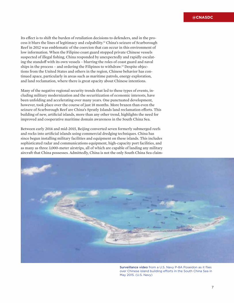
Between early 2014 and mid-2015, Beijing converted seven formerly submerged reefs and rocks into artificial islands using commercial dredging techniques. China has since begun installing military facilities and equipment on these islands. This includes sophisticated radar and communications equipment, high-capacity port facilities, and as many as three 3,000-meter airstrips, all of which are capable of landing any military aircraft that China possesses. Admittedly, China is not the only South China Sea claim-
Surveillance video from a U.S. Navy P-8A Poseidon as it flies over Chinese island building efforts in the South China Sea in May 2015. (U.S. Navy)

Asia-Pacific Security | Networked Transparency: Constructing a Common Operational Picture of the South China Sea
8
ant to have used land reclamation in the Spratlys: Taiwan reclaimed 5 acres over two years; Malaysia, approximately 60 acres over 30 years; and Vietnam, 50 to 60 acres over five years. China, however, has done so at an unprecedented rate, reclaiming over 3,000 acres in just one year.14 And while Taiwan, Ma-laysia, Vietnam, and the Philippines all have airstrips in the Spratlys, these pale in comparison to China’s in size and capacity.15 With its new island bases, Chi-na will significantly improve its ability to monitor the Spratly Islands area. With the ability to install radar and communications equipment and conduct reconnaissance flights 1,000 miles farther from its shores than it could previously, this may also allow Beijing to put pressure on other claimants. Experts have speculated that in relatively short order, China may use its new monitoring capabilities to declare a South China Sea air defense identification zone (ADIZ), as it did in the East China Sea in 2013.
More troubling than any one of Beijing’s new island capabilities, however, is the deep uncertainty about China’s long-term intentions that this building has raised. By using a construction technique that is not illegal and that other claimants have employed, and by unfurling its island bases at lightning pace, Beijing made it difficult for regional states to mount a coordinated response to its efforts. But it also made minimal effort to assure its neighbors that it was not seeking to upend the political or territorial status quo in the South China Sea. With a limited ability to monitor Beijing’s Spratly Islands construction as it unfolded, and few avenues through which to share information or coordinate responses, oth-er claimants were forced to accept a Chinese fait accompli. This, in turn, has likely changed forever geography and security in the South China Sea.
Economic-Security NexusEconomic issues in the South China Sea can actually feed – rather than ameliorate – risks of political and military confrontation, which constitutes a third worrisome trend. Asian policymakers increasingly face an environment that blurs the lines between distinctly economic and security-related activi-ties.16 Many of the interactions that occur routinely in the South China Sea involve nongovernmental commercial entities fishing and hauling cargo, both of which are crucial to the economies of the surrounding areas. Some of these activities may
involve contested geographic boundaries but are fundamentally legal, as with Malaysian or Filipino fishing vessels or Chinese oil exploration. Yet this type of overt and nominally legal activity regularly leads to gray-zone confrontations with government entities operating in the South China Sea. Chi-na’s coast guard, for example, routinely intercepts and blocks Filipino ships in contested areas from conducting otherwise innocuous resupply activi-ty, and the two-month China-Philippines standoff over Scarborough Reef started with a Filipino law enforcement action against Chinese fishing vessels.
Other commercial activity is unambiguously illegal, such as with Chinese oil rigs operating inside other countries’ territory or narcotics and human traf-ficking embedded inside the Thai fishing industry. These types of illicit commercial activity can also produce confrontations between governments. In May 2015, Indonesia destroyed 41 foreign ships, including a Chinese-flagged ship, after they were caught illegally fishing in its waters, which caused China to issue a statement of “serious concern.” Conflict was unlikely, but the incident ratcheted up political tensions and the Chinese reaction was much stronger than many expected. And in the largely ungoverned “tri-border” maritime area shared among the Philippines, Malaysia, and Indonesia, pirates and insurgents conducting raids or attacks in the Philippines have been known to exploit the opacity of the area to seek shelter in or launch attacks against a neighboring country.
In the South China Sea, then, it is not only increas-ingly difficult to separate economic issues from national security issues, but civilian actors pur-suing their economic interests – whether legally or illicitly – risk forcing governments to clash.
More troubling than any one of Beijing’s new island capabilities is the deep uncertainty about China’s long-term intentions that this building has raised.

9
@CNASDC
To What End, Maritime Domain Awareness?As these miscalculations, crises, and examples of coercion caused by regional mil-itary modernization and gray-zone ambiguity have grown, regional states have voiced a concomitant interest in maritime domain awareness capabilities. Malay-sia exercises leadership in convening Southeast Asian states to discuss MDA in the South China Sea.17 Indonesia has pursued closer MDA ties with Australia.18 Vietnam has made public its interest in closer MDA cooperation with the United States.19 Washington and Manila already collaborate closely on the Philippines’ Coast Watch System (CWS).20 State-level demand for maritime domain awareness does not necessarily translate into regional collaboration toward that end, however.
Southeast Asian countries are eager to acquire MDA capabilities for their own se-curity needs close to their shores but are not necessarily convinced of the utility of sharing this information with their neighbors to create a common picture of the South China Sea. This hesitation, which risks MDA efforts being seen as yet anoth-er destabilizing example of military modernization, has at least two sources. First, regional states have deep concerns about sharing information with their neighbors, including those with whom they have positive relations. Second, Southeast Asian countries have hesitations about the political ends toward which a common operat-ing picture may be directed. If policymakers are to implement a truly collaborative MDA system in the region, they must understand and surmount both obstacles.
The first of these political hurdles is not unique to Southeast Asia. Sensitive intelli-gence- and information-sharing can be a challenge even among long-standing allies – after 60 years of close ties, the United States and Japan are still working to improve their intelligence-sharing. In Southeast Asia, the Philippines and Thailand have formal treaties with the United States, but these states do not have close defense ties to each other. Regional trends have encouraged new alignments, including a new partner-ship between the Philippines and Vietnam, but this is only a first step toward deeper defense cooperation. Even as regional states increase the frequency and nature of their military interactions, they may hesitate to share sensitive maritime information. In-telligence-sharing has a unique ability to reveal state weaknesses as well as strengths.
A second, less common political hurdle also presents itself in Southeast Asia. Region-al states have complex security and economic relationships with China, and there-fore to the political goals that a South China Sea common operating picture would serve. As negative trends in the South China Sea have accelerated, U.S. policymakers have searched for ways to support regional partners and are themselves increasingly interested in providing countries with MDA capabilities. Improved maritime domain awareness can give partners the ability to monitor events at sea, deter and dissuade gray-zone coercion, and may even engender deeper regional understandings if mari-time information-sharing begets broader patterns of cooperation. These capabilities are appropriate for engaging all manner of regional threats and challenges. The United States’ interest in supporting them, however, has an added, if unspoken, motivation: MDA can help partners deter and defend their own interests against a rising China.
U.S. policymakers do not generally articulate a China-focused aim of their MDA efforts, and this reticence is sensible for several reasons. First, publicly identifying China or its behaviors as the object of a U.S.-led regional maritime domain awareness network would contribute to a containment narrative. Second, it would obscure the fact that regional partners who seek MDA capabilities may desire maritime aware-
Improved maritime domain awareness can give partners the abili-ty to monitor events at sea, deter and dissuade gray-zone coercion, and may even engender deeper regional under-standings if maritime information-sharing begets broader patterns of cooperation.

Asia-Pacific Security | Networked Transparency: Constructing a Common Operational Picture of the South China Sea
10
ness for narrower and more parochial purposes, discussed below; in many instances, these pur-poses too align with U.S. interests. Third, while most Southeast Asian states are deeply troubled by Beijing’s assertiveness in the South China Sea, they have complex relationships to China that include deep ties in other domains. It would be inimical to Malaysian or Indonesian interests to sign onto an MDA project that explicitly targeted China.
The lack of a clearly articulated, unifying political purpose for a regional maritime domain awareness network, however, means that regional states are somewhat skeptical of its merits. Beyond China’s assertiveness, each state can point to other national MDA missions and would prefer to do so if asked to opine in public. States can also point to existing national or international information networks that may at least partially help to fill these needs. The political obstacles to a common and trans-parent picture of the South China Sea therefore require that the United States not only exercise leadership in making MDA technology available. It must also work to craft a nuanced, persuasive narrative about the political ends that the tech-nology will serve and convince Southeast Asian states that their need for this capability outweighs their reservations about information-sharing. This, in turn, requires that the United States iden-tify the common mission threads among claimant states and analyze the degree to which existing regional networks fill national MDA needs.
Opportunities for Collective Action: Common Mission Threads In the absence of shared maritime domain awareness, Asia’s negative security trends will continue to enhance the opacity of an already dimly lit domain and increase risks of accidents and conflict as a result. Strengthening information-sharing mechanisms in the South China Sea can ameliorate the downside risks of these trends and in some cases harness them to promote stability.
Since at least 2013, improved situational aware-ness in the South China Sea has been a Secretary of Defense-level priority and is central to the De-partment of Defense’s 2015 Asia maritime security strategy. DoD’s emphasis on operational transpar-ency through surveillance and information-shar-ing responds to the South China Sea’s emerging
strategic dilemmas in several ways. First, moving the region closer to a common operational picture of this contested space would enhance regional stability by increasing transparency, information, and communication. Second, it would help deter adventurous behavior by raising the likelihood that provocations at sea are met with appropriate responses, and it would help countries to better calibrate and coordinate their maritime and air activities. And most importantly, it would provide an impetus for more coherent and effective region-al cooperation that would ultimately result in the kinds of interoperability and closer political and military ties that serve U.S. and regional interests.
At the same time, we recognize that macro-level regional trends – however problematic – are like-ly insufficient to catalyze collective action among maritime Southeast Asian countries. Low trust and limited maritime surveillance capacity continue to hamper information-sharing and situational aware-ness. Yet there are numerous collective problems be-yond traditional security concerns facing maritime Southeast Asia that are exacerbated by the region’s larger negative trends and that can be a basis for cooperation without needing a great deal of trust. Greater shared awareness of who is doing what and where in the South China Sea is a cross-cutting way to address multiple “mission threads” – shared motivations for operational-level cooperation. Through background research, workshops, and interviews, the Center for a New American Security (CNAS) has identified several common, potential mission threads that may form the basis for region-al information-sharing in the South China Sea.
In the absence of shared maritime domain awareness, Asia’s negative security trends will continue to enhance the opacity of an already dimly lit domain and increase risks of accidents and conflict as a result.

11
@CNASDC
China
Malaysia
Philippines
Brunei
Vietnam
Claim lines
China’s nine-dash line
COMPETING SOUTH CHINA SEA CLAIMS

Asia-Pacific Security | Networked Transparency: Constructing a Common Operational Picture of the South China Sea
12
Illegal FishingThe fishing industry is central to Southeast Asian economic development. The export industry for global marine products exceeds $129 billion annually,21 and Southeast Asia remains the second-highest-producing fisheries subregion in the world.22 Illegal, unreported, and unregulated (IUU) fishing activities – that is, fishing without proper licensing, pursuing catches of endangered marine life, or fishing in protected areas or other states’ exclusive economic zones (EEZs) – are worth more than $23 billion annually.23 Although the figures vary, Indonesia alone claims annual revenue losses from illegal activities are worth $20 billion.24 For Southeast Asian governments, the billions of dollars in illegal fishing is more than lost income for registered, law-abiding fishermen; it represents uncollected tax revenue that could be used for development.
Governments across Southeast Asia have signaled an appetite to combat the epidemic of illegal fishing. In 2007, 11 Southeast Asian and Pacific Island nations – Australia, Brunei Darussalam, Cambodia, Indonesia, Malaysia, Papua New Guinea, the Philip-pines, Singapore, Thailand, Timor-Leste, and Vietnam – signed the Regional Plan of Action to Promote Responsible Fishing Practices (RPOA). This agreement commits governments to jointly ending IUU fishing and coordinating best practices of fisheries conservation, though most signatories face challenges with governmental capacity to monitor and enforce it.25 And although it can raise the ire of neighbors, Asian states have adopted certain deterrent practices. Not only have Southeast Asian governments begun prosecuting illegal fishing crews even when hailing from other countries, but they have also started a practice of burning or blowing up the captured ships.26 Thai-land, Vietnam, Malaysia, Indonesia, China, and the Philippines have all either con-ducted these prosecutorial practices or had ships and citizens subjected to them.
The Taiwanese-flagged fishing vessel Yu Feng shortly before being boarded by law enforcement on suspicion of illegal fishing in 2009. (Wiki Commons)
Illegal, unreported, and unregulated fishing activities are worth more than $23 billion annually.

13
@CNASDC
Despite a demonstrable and collective will to curb illegal fishing, the practice remains widespread. Informational opacity in the South China Sea is part of the problem, constituting a wide area of cover-age where sovereign claims to EEZs are contested and therefore difficult to monitor persistently. But maritime capacity is an issue as well. Southeast Asian states operate small navies and coast guards, yet face the challenge of tracking down the 5,000 vessels that illegally harvest fish within their EEZs each day.27 With greater surveillance and interdic-tion capacity, Southeast Asian states may be able to drastically reduce illegal fishing, as well as the oppor-tunities for geopolitical friction that result from it.
The Transnational Crime ComplexBeyond illegal fishing, parts of maritime Southeast Asia have shown interest in cooperation on a complex of other challenges, including nuclear nonprolifera-tion, piracy, the narcotics trade, and human trafficking.
Working with international partners to curb and inter-dict illicit trafficking in nuclear materials is a shared interest of many states in Southeast Asia that rely on maritime commerce and need to maintain a reputa-tion for competent and transparent management of territorial waters and port facilities. This rationale is part of a likely complex set of motivations for South-east Asian states joining the Proliferation Security Initiative (PSI), which is designed to foster interna-tional cooperation to counter nuclear proliferation.28
Other nontraditional security challenges are also becoming increasingly important to the area. Pi-racy, human trafficking, and the narcotics trade are all festering problems confronting Southeast Asia. While substantial challenges on their own, they are made even more so because they pres-ent themselves as an interwoven set of issues that overlap with one another – and with illegal fisher-ies – in ways that make combating one challenge difficult to distinguish from combating them all.
The South China Sea’s regional geography makes piracy an ongoing and difficult challenge. To tackle this challenge, most member states in the Associ-ation of Southeast Asian Nations (ASEAN) have joined with other interested stakeholders to form the Regional Cooperation Agreement on Combat-ing Piracy and Armed Robbery against Ships in Asia (ReCAAP), which is responsible for most of the data that the International Maritime Bureau uses to account for piracy attacks. These attacks on maritime commerce run the gamut from kid-nappings to petty theft of textiles and ship parts, but the primary target in 2014 was the hijacking of tankers; the gas-oil cargo onboard can be eas-ily siphoned and sold on the black market.29
Combating the narcotics trade in Southeast Asia is a related and pre-existing common mission thread. As early as the 1976 ASEAN Declaration of Principles to Combat the Abuse of Narcotics Drugs, ASEAN governments have shared a consensus to cooperate against the drug trafficking that flourishes in the po-rous maritime borders in and around the South Chi-na Sea, particularly in Myanmar and Laos inside the “Golden Triangle.”30 In subsequent decades, ASEAN has convened regular meetings to address narcotics coordination among ministers and chiefs of po-lice, which demonstrates a political will to at least address the issue. Regional coordination of national policing and enforcement efforts has resulted in an average of 50,000 arrests per year in the region. Nevertheless, the value of illegal drugs consumed in East and Southeast Asia in 2011 still reached $31.3 billion, implying the problem is far from resolved.31
Human trafficking in Southeast Asia, which over-laps to a great degree with the fisheries problem, is emblematic of the difficulty in separating combating one nontraditional security challenge from anoth-er. International human rights nongovernmental organizations (NGOs) and the U.S. State Department have identified Southeast Asian countries such as Thailand as hotbeds for trafficking activity that presses individuals into sexual slavery, but less well-known is the prevalence of “sea slaves” in Southeast Asia: the practice of forced labor at sea to support IUU fishing and other illicit activities that require maritime transit. On some occasions, low-income la-borers are tricked into joining a maritime crew when they are in fact being sold into slavery. In other in-stances, entire communities of desperate, displaced
Piracy, human trafficking, and the narcotics trade are all festering problems confronting Southeast Asia.

Asia-Pacific Security | Networked Transparency: Constructing a Common Operational Picture of the South China Sea
14
migrants are offered passage out of oppression only to be stripped of any legal identity and pressed into unpaid labor at sea. The Rohingya, a community long displaced by an ethnic war with the military junta in Myanmar, have faced this problem en masse.
Fortunately, human trafficking too is a problem Southeast Asian governments are at least rhetorically committed to correcting. For example, Thailand – one of the region’s worst human rights violators – has acknowledged its marred internation-al standing and has pledged to work with others to end the “sea slave” trade.
These nontraditional security challenges all share several features: They af-fect multiple Southeast Asian nations; they are facilitated by the opacity of the South China Sea and the porousness of overlapping borders in maritime South-east Asia; and they are issues for which political-level recognition and com-mitments to address the problems have already been publicly declared.
Humanitarian Assistance and Disaster Relief (HA/DR)Mitigating threats and combating transnational crime are not the only bases for multilateral cooperation in Southeast Asia. Governments have also demonstrated the strongest cooperation consensus on an area of common interest that is not cast in threatening security terms: alleviating human suffering and the destruction of government capacity by natural disasters. HA/DR is a cooperative mission thread on which all Southeast Asian governments agree. Natural disasters, which disrupt social and economic life, afflict every ASEAN government. When national govern-ments are not able to respond quickly enough to relieve post-disaster suffering, the legitimacy of political elites is challenged, making HA/DR that rare issue that is at once a national public good, an international public good, and a domestic polit-ical expedient. It is, perhaps, the safest of issues on which to cooperate regional-ly. This may explain the commitment that ASEAN has made to the issue, standing up the ASEAN Coordinating Centre for Humanitarian Assistance (AHA Centre), which trades in HA/DR best practices and supports capacity-building efforts for Southeast Asian governments to become more resilient to natural calamities.
Human trafficking in Southeast Asia is emblematic of the difficulty in sepa-rating one nontra-ditional security challenge from another.

03 CHAPTER
Information-Sharing Capacity for the South China Sea
15
Asia-Pacific Security | Networked Transparency: Constructing a Common Operational Picture of the South China Sea
16
III. Information-Sharing Capacity for the South China Sea Any project to enhance South China Sea maritime domain awareness starts from a solid baseline; Southeast Asian governments own some capabil-ities and participate in local information-sharing networks that may lend themselves to a more integrated picture of South China Sea activity. Regional states vary substantially in the intelli-gence, surveillance, and reconnaissance (ISR) assets they possess, as well as those they desire, and this may inform the degree to which they are able to contribute to and draw from collaborative MDA efforts. There are also several functional but incomplete multinational platforms in the region, some of which may have a role to play in an integrated MDA picture, but all of which are decidedly limited in their scope at present.
Asia’s ISR GapMany countries in the region face an ISR “gap” – a shortfall between their actual and desired capa-bility for maritime domain awareness. Perhaps counterintuitively, this gap is in large part a prod-uct of the new surveillance opportunities enabled by information technology. Seafaring nations have always had limited awareness of what was over the horizon, but modern technology now holds the potential for greater awareness than ever before. To achieve this, however, nations must invest in various surveillance assets – drones, satellites, radars, or other collection tools – along with the analytic backbone to process and make sense of this information. Drones in particular have dramatically lowered the cost of persistent surveillance, mak-ing previously unimaginable levels of continuous situational awareness now reasonably affordable for many nations. Space-based surveillance is similarly poised on the brink of a new revolution in low-cost satellites capable of delivering imagery and resilient communications. Regional countries are pursuing a number of investments to increase their ISR capac-ity, building off of a baseline foundation of open-source tracking systems. Even as nations, including the United States, continue to invest in additional surveillance capacity, the gap between their actual and desired capability is likely to persist. It may even grow as the appetite for awareness and the opportunities enabled by technology increase.
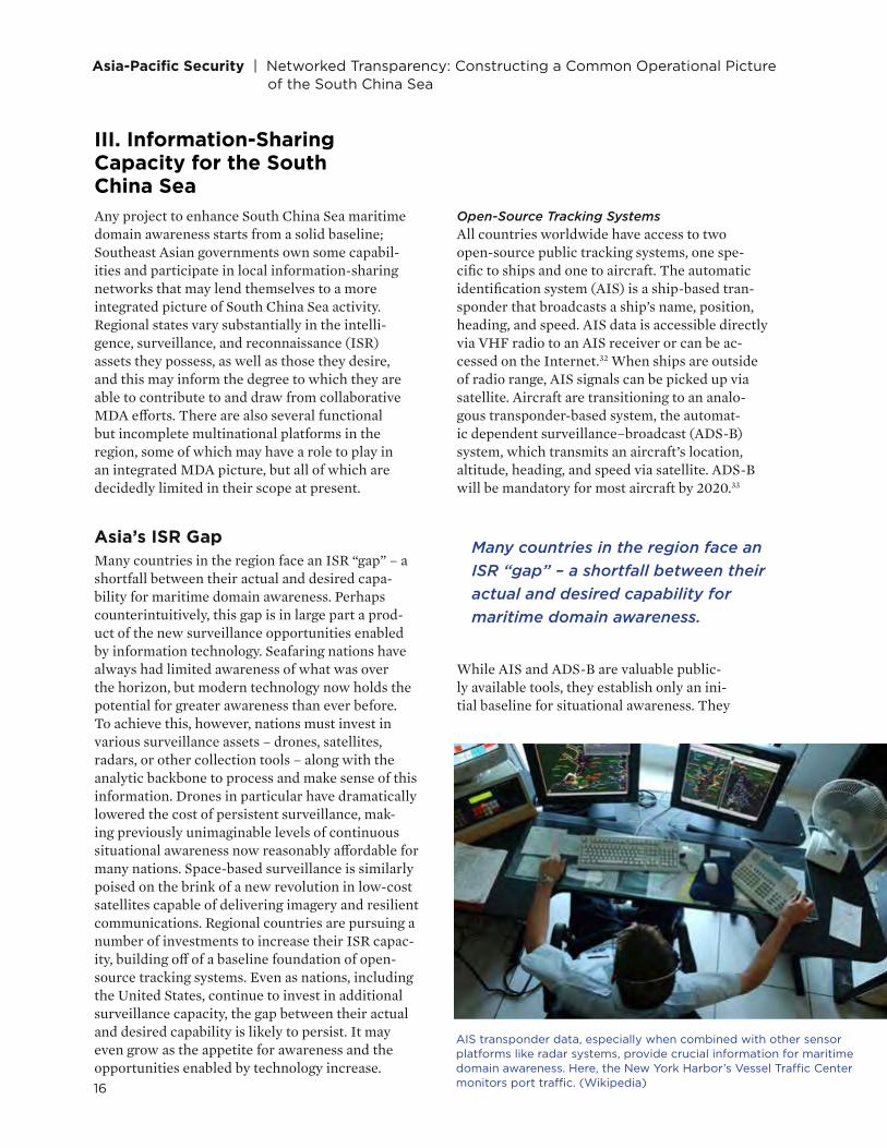
Open-Source Tracking SystemsAll countries worldwide have access to two open-source public tracking systems, one spe-cific to ships and one to aircraft. The automatic identification system (AIS) is a ship-based tran-sponder that broadcasts a ship’s name, position, heading, and speed. AIS data is accessible directly via VHF radio to an AIS receiver or can be ac-cessed on the Internet.32 When ships are outside of radio range, AIS signals can be picked up via satellite. Aircraft are transitioning to an analo-gous transponder-based system, the automat-ic dependent surveillance–broadcast (ADS-B) system, which transmits an aircraft’s location, altitude, heading, and speed via satellite. ADS-B will be mandatory for most aircraft by 2020.33
While AIS and ADS-B are valuable public-ly available tools, they establish only an ini-tial baseline for situational awareness. They
Many countries in the region face an ISR “gap” – a shortfall between their actual and desired capability for maritime domain awareness.
AIS transponder data, especially when combined with other sensor platforms like radar systems, provide crucial information for maritime domain awareness. Here, the New York Harbor’s Vessel Traffic Center monitors port traffic. (Wikipedia)

17
@CNASDC
do not in and of themselves achieve sufficient domain awareness. Since both AIS and ADS-B require ships and aircraft to activate transponders to opt into the net-work, actors wishing to avoid detection can choose not to use these systems to broadcast their position. In order to detect actors not using AIS or ADS-B, other methods such as radars, ships, surveillance aircraft, or satellites are required.
Existing ISR CapabilitiesAll nations in the region have some capacity for maritime surveillance, although every country desires more. The below table, adapted from IHS Jane’s, shows the current and desired ISR capabilities for a number of countries in the region.34
Planned InvestmentsCountries in the region are pursuing a number of investments in order to ex-pand their ISR capabilities. Several nations are investing in maritime patrol and reconnaissance aircraft, such as the P-3 Orion, P-8 Poseidon, or the un-manned MQ-4 Triton. Australia and India each plan to purchase eight P-8s, with the option to buy four additional aircraft.35 Australia also has indicated it will purchase MQ-4s, although the total number is not yet finalized.36 India has ex-pressed interest in either the MQ-4 or the related RQ-4 Global Hawk.37
Several additional countries are also investing in high-end reconnaissance drones, capitalizing on the revolution in uninhabited aircraft. South Korea is buying four RQ-4 Global Hawks and Japan plans on buying three.38 Both the RQ-4 and MQ-4 are notable for their extreme endurance, on the order of 24 to 30 hours; large payload capacity; high altitude (allowing coverage over a wide area); and range. The RQ-4 and MQ-4 can carry a range of sensors, including electro-optical, infrared, radar, and signals intelligence.39 They can also be equipped with communications relay pay-loads, allowing them to relay data among aircraft, ships, and ground stations. The
Maritime Patrol and
ReconnaissanceAirborne Early
Warning
Electronic Warfare and Signals Intelligence Reconnaissance
EXISTINGGREATER DESIRED EXISTING
GREATER DESIRED EXISTING
GREATER DESIRED EXISTING
GREATER DESIRED
Australia ¾ ¾ ¾ ¾ ¾
India ¾ ¾ ¾ ¾ ¾ ¾ ¾ ¾
Indonesia ¾ ¾ ¾ ¾ ¾
Japan ¾ ¾ ¾ ¾ ¾
Malaysia ¾ ¾ ¾ ¾ ¾
Philippines ¾ ¾
Singapore ¾ ¾ ¾ ¾ ¾
South Korea ¾ ¾ ¾ ¾ ¾ ¾ ¾
Vietnam ¾ ¾ ¾

Asia-Pacific Security | Networked Transparency: Constructing a Common Operational Picture of the South China Sea
18
aircraft are costly, however, at well over $100 million apiece. In addition, because of their payload and range, they qualify as Category I systems under the Missile Technology Control Regime (MTCR), which limits their export.40 With the goal of limiting missile proliferation, MTCR members, which include most advanced mili-taries, agree to a “strong presumption of denial” when faced with export requests for any missiles, UAVs, or space-launch vehicles that qualify as Category I systems.41
The uninhabited-aircraft ecosystem, however, is diverse and includes a range of smaller, shorter-range, and more affordable systems, both on the global market and indigenous to various countries. Israel continues to dominate the global drone market and has sold to a number of countries in the region, including Indonesia, Singapore, and Vietnam. Nearly every country is also developing some indigenous drone capaci-ty, although indigenous drones are usually smaller and less capable, at least initially.42 These drones will range from larger, medium-altitude land-based systems similar to the U.S. MQ-9 Reaper drone to smaller, ship-based systems like the U.S. ScanEagle.
Medium-altitude land-based drones can serve a wide variety of functions for countries beyond simply maritime domain awareness, including border surveillance, search and rescue, humanitarian and disaster relief, and national security, making them an attractive investment. Ship-based drones, which are generally smaller and cost less, can also provide a valuable way for vessels to put “eyes on” a situation remotely at lower cost and lower risk than a manned helicopter, all while maintaining persistent surveillance for longer durations. For these reasons, small and midsized drones are likely to contribute most to the expansion of ISR capacity in the coming decade.
Space-Based SurveillanceJust as investments in uninhabited aircraft have been enabled by lower costs and improved technology, the satellite industry may be poised for a revolution in lower-cost access to space. Companies such as Skybox Imaging and Plan-et Labs are capitalizing on the democratization of geospatial information due to less expensive, small satellites and offering high-quality commercial satellite imaging.43 In addition, the invention of reusable rockets has the potential to dra-matically lower the cost per pound of putting satellites into orbit, ushering in a new revolution in satellite use.44 Many countries in the region, including In-dia, Indonesia, Japan, Malaysia, Singapore, South Korea, and Vietnam, already have government/military surveillance satellites, but lower-cost space access could expand their capabilities and the number of space-faring countries.45
Insatiable Demand for InformationOver the past 15 years, the U.S. military has dramatically expanded its ISR ca-pability and capacity, driven in large part by the urgent needs of the wars in Iraq and Afghanistan. U.S. defense planners have grappled with a seemingly in-satiable demand, however, for more information. Even as ISR capacity has in-creased, most notably with the addition of thousands of drones, military com-manders’ interest in and demand for ISR have increased even further.
Today, despite massive investments, ISR remains a critical capability gap for U.S. mili-tary commanders. In their 2015 posture statements to Congress, both the U.S. Central Command (CENTCOM) and U.S. Pacific Command (PACOM) commanders noted
Countries in the re-gion are pursuing a number of invest-ments in order to expand their ISR capabilities.

19
@CNASDC
shortfalls in ISR capacity.46 Their statements are particu-larly notable because CENTCOM and PACOM generally are the highest-priority commands for resourcing. Be-tween the two of them, they are likely getting the lion’s share of U.S. military ISR assets. Yet gaps still remain.
Military commanders can never have complete in-formation about what is happening on the battlefield. Countries can never have total awareness about what is happening in their maritime domains. However, technology is increasing the opportunities avail-able to countries to enhance their maritime domain awareness. As opportunity increases, interest and expectations rise commensurately. Greater domain awareness is vital for a range of critical national and regional issues, and countries will continue invest-ing in ISR capabilities, hoping to close the ISR gap.
Inexpensive, small satellites (or “cube sats”) are lowering the cost of geospatial information by offering high-quality commercial imaging. Here, Planet Labs cube sats are launched from the International Space Station. (Wiki Commons)
Greater domain awareness is vital for a range of critical national and regional issues, and countries will continue investing in ISR capabilities, hoping to close the ISR gap.

Asia-Pacific Security | Networked Transparency: Constructing a Common Operational Picture of the South China Sea
20
A Patchwork of Maritime Domain AwarenessBeyond these national ISR capabilities, the Asia-Pa-cific region has already invested in several mul-tilateral information-sharing structures. These include limited-scope maritime domain awareness efforts, some of which could play a role in en-hancing the overall operational transparency of the South China Sea. At present, however, there are barriers to unity among these existing struc-tures. Most are limited by their technical capacity, the political rules governing their use, or both.
Information Fusion Centre Singapore’s Information Fusion Centre (IFC) is among the most mature operational informa-tion-sharing systems in the Asia-Pacific region. The IFC has expanded over the last several years to cover other international law enforcement issues such as fishery crimes and maritime terrorism.47 Its Open and Analysed Shipping Information Sys-tem (OASIS) combines vessel information from multiple commercial tracking platforms, and it stores this information for over a million ships.
Organizationally, the IFC was established through the implementation of overlapping memorandums of understanding (MOUs) to combat piracy. Most of the IFC’s 23 participants have dedicated an on-site liaison officer to the endeavor. While it is inclusive in its membership and wide in geographic scope, the IFC’s operational jurisdiction is functionally narrow. The Centre expressly excludes all interstate issues from its purview. At its founding, the IFC’s OASIS software did not provide for its members to share the locations of coast guard or naval vessels, even voluntarily. And its primary reliance on human liaison officers to relay real-time information manu-ally from national commands to the IFC is not only slow and inefficient; it creates single-nodal points of failure or bottlenecks for information-sharing.
MALSINDO Patrols The Malacca Straits Sea Patrols, also called MALSINDO or the Trilateral Coordinated Patrols, are a geographically narrow but operationally deep exercise in shared maritime domain awareness. Be-ginning in 2004, Indonesia, Malaysia, and Singapore started building the foundation for what would be-
come a sophisticated operational information-shar-ing system. With a simple platform and constrained geographic scope, MALSINDO has iteratively added technical capabilities over time. The resulting system has been successful, contributing to a large reduction in piracy in the Malacca Strait, through which flows a quarter of global commerce and half of all oil ship-ments. 48 Piracy rates have fallen from 38 attacks in 2004 to an average of zero to two attacks annually.49 Like the IFC, the MALSINDO Patrols rely on infor-mation-sharing – but on a much more localized scale.
Though MALSINDO began as an effort to deconflict patrol routes, it has evolved over time to include re-al-time location-sharing of both ships and aircraft, in-tegrated aerial surveillance, an intelligence exchange system, and an information technology platform that coordinates these inputs. Despite its growing capabil-ity and success in thwarting piracy, MALSINDO pa-trols occur only infrequently, hindered on all sides by limited capacity to commit naval assets. The tendency of each nation, moreover, is to conduct patrols in lim-ited areas near its own coasts but not the coasts of the other participant nations, which constrains the ability to expand or build on MALSINDO patrol success.
AHA CentreThe ASEAN Coordinating Centre for Humanitarian Assistance, or AHA Centre, was founded in 2011 by 10 ASEAN member-states after a series of disasters demonstrated the need for multilateral humanitarian assistance capabilities. The organization has focused on missions that are logistically complex and has sought to develop a stockpile of relief supplies as well as the relationships and transportation plans to dis-tribute them.50 While managing these complex supply chain coordination issues across national boundaries is an impressive goal, the AHA Centre suffers from insufficiently integrated operational and distribu-tion capabilities across national boundaries.51 Most importantly, the AHA Centre does not trade in the real-time, continuously updated operational informa-tion that matters most for maintaining a regional-lev-el awareness of activities across the South China Sea.
21
@CNASDC
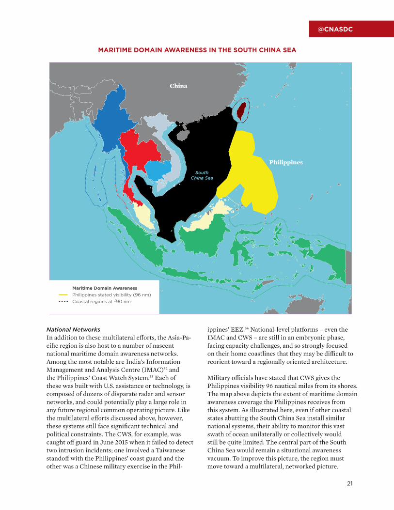
National NetworksIn addition to these multilateral efforts, the Asia-Pa-cific region is also host to a number of nascent national maritime domain awareness networks. Among the most notable are India’s Information Management and Analysis Centre (IMAC)52 and the Philippines’ Coast Watch System.53 Each of these was built with U.S. assistance or technology, is composed of dozens of disparate radar and sensor networks, and could potentially play a large role in any future regional common operating picture. Like the multilateral efforts discussed above, however, these systems still face significant technical and political constraints. The CWS, for example, was caught off guard in June 2015 when it failed to detect two intrusion incidents; one involved a Taiwanese standoff with the Philippines’ coast guard and the other was a Chinese military exercise in the Phil-
ippines’ EEZ.54 National-level platforms – even the IMAC and CWS – are still in an embryonic phase, facing capacity challenges, and so strongly focused on their home coastlines that they may be difficult to reorient toward a regionally oriented architecture.
Military officials have stated that CWS gives the Philippines visibility 96 nautical miles from its shores. The map above depicts the extent of maritime domain awareness coverage the Philippines receives from this system. As illustrated here, even if other coastal states abutting the South China Sea install similar national systems, their ability to monitor this vast swath of ocean unilaterally or collectively would still be quite limited. The central part of the South China Sea would remain a situational awareness vacuum. To improve this picture, the region must move toward a multilateral, networked picture.
China
SouthChina Sea
Maritime Domain AwarenessPhilippines stated visibility (96 nm)Coastal regions at ~90 nm
Philippines
ChinaChina
MARITIME DOMAIN AWARENESS IN THE SOUTH CHINA SEA

04 CHAPTER
The Process Elements of Maritime Awareness
22

23
@CNASDC
IV. The Process Elements of Maritime Awareness The South China Sea’s patchwork of maritime awareness capacity already contains nascent capa-bilities and process norms needed to build a robust, regional architecture for maritime awareness. The tasks that remain are to generate more and better overall information coverage and to forge a shared, networked picture of activities and assets operating in the South China Sea. Such a “common opera-tional picture” can serve many purposes and take many forms. But regardless of form or function, all manifestations of maritime domain awareness involve three process elements: data collection, data analysis, and information distribution via visual display. Maritime domain awareness fun-damentally depends on and functions as an infor-mation-sharing regime among participating actors, guided by three questions. What sources of data will feed the display? Who or what will analyze and fuse the data for the display, and how? And who has what level(s) of access to the display?
Data CollectionThe information inputs for a process of visualizing activities and assets in the South China Sea can, in principle, come from anywhere. Private firms such as Spire, FedEx, and FlightAware, for whom maritime awareness is crucial for business opera-tions, draw on publicly available tracking data for aircraft and shipping vessels.55 For U.S. military commanders, most information for a COP tradition-ally comes from cooperative and noncooperative sources: U.S. and allied units in the field “push-ing” information updates to military commands, and ISR assets “pulling” information from various types of signals and images by using high-technol-ogy sensors. “Pushed” information is cooperative, voluntarily shared information (e.g., self-reported situational updates), while “pulled” information refers to information collected uncooperatively or surreptitiously (e.g., intelligence collection). These are the principal sources of raw data used to populate visual displays that provide situation-al awareness in support of decisionmaking. The sensitive sources and methods of collection used – especially when conducted by ISR assets – often necessitate high classification levels. The apparent need for classification imposes constraints on the
ability to share the data collected, which logically limits who gets access to it. This dynamic creates room for information asymmetries, misunder-standings, and misaligned perceptions, not only within the U.S. government, but between the United States and its network of allies and partners.56
Data AnalysisOnce raw data has been collected, it must be inte-grated with other data, interpreted, and assigned meaning. This process of analysis can occur manu-ally through tradecraft conducted by analysts or au-tomatically through algorithms that detect patterns and assign meaning based on programmed rule sets.
The former, analytic tradecraft, tends to be sub-ject-specific expertise, methods, and software applications honed through investments in train-ing and expertise-building. Experienced, well-trained analysts can be very powerful but suffer from two major drawbacks: high human capital investments and limited bandwidth. Illustrating the former, each military service trains and equips a cadre of professional intelligence analysts for up to two years before designating them operationally ready. The latter, limited bandwidth, is becoming more of a problem as advanced ISR technolo-gy has enabled more data collection than human
analysts can process. U.S. Air Force leaders, for example, claim the amount of ISR video data the U.S. Air Force collects in a single day is “the equiv-alent of a football season’s worth of footage.”57
Given the large supply of potentially available data, automated analysis is a necessary and promising supplement to human-based analysis. Nongovern-
Regardless of form or function, all manifestations of maritime domain awareness involve three process elements: data collection, data analysis, and information distribution via visual display.

Asia-Pacific Security | Networked Transparency: Constructing a Common Operational Picture of the South China Sea
24
mental actors have made noteworthy strides devel-oping algorithms that look for meaningful patterns in large masses of data that human analysts and decisionmakers then interpret and act on. Global Fishing Watch, funded by Google, has developed an algorithm that uses publicly available data from ships – Automatic Identification System and Ves-sel Monitoring System (VMS) data systems – and compares it to ship tracks detected by satellite radar systems to deduce who might be fishing within banned “no-take” zones or restricted fishing pre-serves. Commercial firms such as Spire have com-bined proprietary algorithms that use AIS, VMS, and other publicly available data with deployed minia-ture satellites and a large number of ground stations to provide accurate depictions of global sea lines of communication used for commercial shipping.
Information DistributionThe final element in an information-sharing regime focused on maritime domain awareness is informa-tion distribution – who gets access to the informa-tion that has been assigned meaning, whether by human analysts or algorithmic processes. As much as any of the high-technology collection sensors, it is the distribution network that makes the COP such a powerful decisionmaking aid for the U.S. military and coalition partners. The two most common, and logical, criticisms of attempts to expand maritime domain awareness among a group of actors are the constraints on the ability to distribute informa-tion – namely political mistrust and technological incompatibility. Both constraints on informa-tion-sharing in the maritime domain are overstated.
Trust – in the form of political will to share in-formation collected using sensitive sources or methods – is a widely recognized constraint on information-sharing among governments.58 But, as described above, many forms of information-shar-ing do not require any kind of trust or vulner-ability in order to take place. And gone are the days when only governments had the capacity or authority to collect and share information; mari-time domain awareness in particular has become a commercial and philanthropic endeavor,59 mak-ing certain types of information-sharing possible even if governments choose not to cooperate.
Another constraint on information-sharing is tech-nological: interoperability of hardware and software across participants in a regime. Not all governments operate facilities, systems, or personnel capable of receiving and processing high-resolution, streaming video feeds from a Global Hawk or the exploited col-lection from synthetic aperture radar sensors on U.S. surveillance aircraft. Yet commercial software and globally recognizable programming languages al-ready facilitate information-sharing across legal and political boundaries. Corporations and NGOs con-cerned with domain awareness typically use a com-mon file format through which disparate sources of data get presented on a common display through Keyhole Markup Language (KML) – which is also used for Google Maps and Google Earth – or a com-parable programming language that overlays data onto map displays, making it highly cost-effective.
Even at the intergovernmental level, classified and unclassified technological solutions have been in use with select U.S. allies and partners for years. At the unclassified level, DoD has employed a software application called the Unclassified Information Sharing/All Partners Access Network (UIS/APAN) that facilitates Web-based chat and information transfers without requiring access to DoD computer networks or hardware. UIS/APAN has been used during contingencies to coordinate information from NGOs, and foreign governments are routine-ly granted access to it for both HA/DR crises and military exercise coordination. UIS/APAN was, for example, the primary network for multilateral coordination of humanitarian assistance opera-tions in the wake of 2013’s Typhoon Haiyan, which ravaged the Philippines, as well as for coordinating HA/DR information trilaterally among the United States, Japan, and South Korea.60 UIS/APAN was also the conduit by which China was able to partici-pate for the first time ever in part of the annual Rim of the Pacific (RIMPAC) military exercise in 2014.61
As much as any of the high-technology collection sensors, it is the distribution network that makes the COP such a powerful decisionmaking aid for the U.S. military and coalition partners.

25
@CNASDC
Whereas other RIMPAC participants had access to a common classified information network to coor-dinate exercise information, DoD would not grant China access to that system; UIS/APAN allowed China to participate despite the security limitation.62
At the classified level, a system called the Com-bined Enterprise Regional Information Exchange System (CENTRIXS) has been used with trusted U.S. allies and partners from Australia to Afghan-istan to support a common situational awareness display using information derived from classified sources. CENTRIXS has proved crucial to op-erations requiring command and control across multinational coalitions, which is why U.S. Pacif-ic Command deployed it during the 2012 RIM-PAC exercise to facilitate operational informa-tion exchanges among 22 national militaries.63

26
05 CHAPTER
Three Models of Maritime Awareness

27
@CNASDC
V. Three Models of Maritime Awareness These process elements – data collection, data analysis, and information distribu tion – can be used to build a common operational picture of different depths and characters. The basic vision of shared, continuous, near-real-time awareness of the South China Sea via visual displays of information, which is technologically possi-ble today but cost-prohibitive, consists of at least three layered pictures or models: open access, participatory access, and exclusive access. As captured in the table be-low, one can conceptualize each of these pictures of activity as “layers” of situation-al awareness because they complement one another, but also have distinct limita-tions; a complete picture of activity is only possible with all “layers” combined.
There are relative cost-benefit tradeoffs in pursuing each of these layered pictures of maritime awareness. Although discussed in greater detail below, a comparison rendered in terms of projected Maritime Security Initiative (MSI) funding (roughly $425 million over 10 years) illustrates the point. An exclusive-access layer, for example, may be the most reliable and actionable maritime awareness solution, but it could not be established for even a single Southeast Asian military at the cost of $425 million, given the cost of ISR platforms. By contrast, an imperfect open-access layer of maritime awareness could be constructed for the cost of building a Web-based application, on the order of $5 million to $10 million. For the price of less than half of MSI funding, the United States could equip more than 400,000 fishing vessels with VMS transponders, dramatically increasing open-access visibility.64 And for less than 1 percent of MSI funding (roughly $3 million), the United States could construct a participatory-access picture to promote informa-tion-sharing across regional partners. Enhancing ISR capacity in Southeast Asia is crucial, but for less than two-thirds of MSI funding, the United States could make huge strides in promoting regional information-sharing and increasing South China Sea transparency.
INFORMATION-SHARING LAYERS OF DOMAIN AWARENESS FOR THE SOUTH CHINA SEA
Open Access Participatory Access Exclusive Access
Main Info Sources Cooperative – VMS, AIS, ADS-B, transponders
Cooperative – unclassi-fied info at participant’s discretion
Noncooperative – elec-tronic and acoustic signals collection, intelligence reporting
Purpose/Mission Thread
Fisheries protection, open commerce, select transna-tional crime
Humanitarian assistance/disaster relief, counter-ing proliferation, ad hoc operations
“Kill chain” operations, interdictions, conflict indi-cators and warning
Distribution Network Governments, firms, and individuals Governments Select allies/partners;
situation-dependent
DrawbacksLimited scope, limited actionability, questionable reliability
Questionable reliability, limited to unclassified information
Expensive, limited distri-bution/effect, not per-sistent

Asia-Pacific Security | Networked Transparency: Constructing a Common Operational Picture of the South China Sea
28
Open-Access Domain AwarenessAn open-access layer of information-sharing for the South China Sea would deliver situational aware-ness via Web-based maps and mobile applications. The principal data sources (inputs) are publicly available – AIS, VMS, ADS-B, and aircraft tran-sponders, supplemented by commercial satellite imagery. The visual feed of information (outputs) would also be a public good; governments, commer-cial firms, NGOs, and individual fishermen would all be potential users of an open-access layer. At this level of information-sharing, concerns about free-riding – that is, participants consuming but not contributing information – are mooted by the fact that free-riding means that users will share a com-mon baseline picture of what is happening where in the South China Sea. There is value in everyone’s sharing the same foundational picture of activities in the South China Sea, and that picture does not inherently require contributions from participating consumers. In an open-access information-sharing regime, therefore, free-riding goes from being a liability to being an asset; from a stubborn barrier of cooperation to a mechanism for reducing miscal-culation, accidents, and operational uncertainty.
Variations on the open-access layer already ex-ist. The company FlightAware tracks and makes publicly available near-real-time transmissions from aircraft. The Sea Around Us, a project of The Pew Charitable Trusts, employs its own ver-sion of a COP that helps monitor illegal fishing around Palau and Easter Island, off the coast of Chile, with little more than VMS and AIS data.65 And as discussed above, SkyTruth uses an algo-rithm that identifies suspicious vessels based on their non-use of VMS and AIS transmissions.
But an open-access layer, despite its benefits to maritime commerce and having successfully cracked down on illegal fishing in specific instanc-es, has serious limitations. First, while the above examples are proofs of concept for an open-access layer information-sharing regime for the South China Sea, they also show disunity of effort. One organization is tracking air activity, another sea-based activity, and a third is providing sporadic direct support to law enforcement but on the geographic fringe of the Asia-Pacific rather than
A domain awareness model that relies on only publicly available data – even if cleverly analyzed – will be better suited to some purposes than others.
the South China Sea. Most importantly, nobody is integrating all of these independent insights into something more holistic and coherent.
Second, a domain awareness model that relies on only publicly available data – even if clever-ly analyzed – will be better suited to some pur-poses than others. While an open-access layer may help combat illegal fishing and some forms of transnational crime, other crucial missions may require information collected from nonco-operative sources. Moreover, by virtue of data sources, an open-access layer is uniquely vulner-able to deception and evasion by lawbreakers.
Third, the greatest value-add of an open-access information-sharing regime may well be “big data” analysis – pattern recognition in large masses of data – but the insights generated by this meth-od may not always operate on timescales that are actionable for law enforcement or other govern-ment agencies. Big-data analysis usually requires aggregating information from past events over time, which may then allow governments to employ law enforcement or the military more efficiently, to take action to disrupt what proves to be a trend based on historical evidence rather than caprice, bureaucrat-ic inertia, or unsubstantiated theories about what works. But any discrete instance of a threatened vessel or illegal fishing, for example, requires re-al-time information best derived from ISR systems.

29
@CNASDC
Participatory-Access Domain AwarenessA middle layer of domain awareness for the South China Sea would effectively serve as a latent infor-mation-sharing network that can be activated to facilitate cooperation when and where necessary. It would ideally operate as a Web-based platform using software that allows a common visual display of mostly unclassified information to be shared among governments. This participatory-access layer sources its information from participating govern-ments, which can upload information anonymously or with attribution. The advantage of an anonymous upload capability is that countries can share infor-mation without the domestic political risk of being seen as cooperating with an unfriendly neighboring country. By contrast, the advantage of attributed information-sharing is that reputations for coopera-tive or uncooperative behavior will accrue over time as users observe the sharing track record of others; a reputational system that functions in this way incen-tivizes sharing. The shared technology and ability for participants to push and pull information at will offers two other benefits that make it operationally realistic. The first is that it uniquely empowers the information users, who have total control over the type and extent of information they choose to share. The second is that it allows each government to continue operating its own ISR collection platforms, sensors, and hardware. This latter innovation makes it a highly adaptable, inexpensive solution that – through its diversity of indigenous data – potentially provides a richer picture of the South China Sea.
A successful model of this type of domain awareness layer can be found at the Joint Interagency Task Force (JIATF)-South in U.S. Southern Command (SOUTHCOM). What started out as a pilot pro-gram called Cooperative Situational Information Integration (CSII) to enable Western Hemisphere partners to help the United States combat drug trafficking and organized crime now consists of a robust information-sharing regime among 14 Latin American countries and the United States. CSII is an unclassified, nonproprietary software pro-gram that facilitates information-sharing among Latin American governments using a Google Map background to display and track activities of interest that cross sovereign borders. Each gov-ernment operates its own radars, coastal patrols,
and maritime surveillance systems. As a default, none of the nationally collected information is shared. Instead, each government decides when and what to share with neighboring governments, and CSII allows each to do it anonymously.
Several governments within the CSII informa-tion-sharing scheme are generally unfriendly toward one another, yet CSII has become a low-cost (around $3 million) virtual bridge among nations that facilitates regional cooperation even beyond the original counternarcotics mission. As of this writing, SOUTHCOM aims to make CSII part of a larger and more enduring Region-al Domain Awareness (RDA) initiative, but the Joint Staff has yet to validate the requirement that would make it a DoD program of record.
For all its promise, a participatory-access layer of domain awareness is also an incomplete solu-tion. The chief limitation is the scope of partic-ipation: Government users are important, but much of the activity in the South China Sea is commercial, and interstate friction tends to orig-inate with the illicit or misunderstood actions of individuals, not governments. A participato-ry-access layer is also of questionable reliability. The extent and quality of situational awareness will depend greatly on the willingness of par-ticipating governments to share, which raises classical concerns with free-riding if the sharing is allowed to occur anonymously. And because a participatory-access layer is limited to unclassi-fied information, governments may be constrained from sharing information they deem sensitive.
The advantage of attributed information-sharing is that reputations for cooperative or uncooperative behavior will accrue over time as users observe the sharing track record of others; a reputational system that functions in this way incentivizes sharing.

Asia-Pacific Security | Networked Transparency: Constructing a Common Operational Picture of the South China Sea
30
Exclusive-Access Domain AwarenessThe exclusive-access domain awareness layer is the traditional military conception of a COP in-volving high-technology sensor-based intelligence collection and battlefield awareness for precision operations. It functions by the same process as other domain awareness layers – collection, analysis, and distribution via visual display – but the data are typically collected using sensitive technical means shared only on classified government systems.
The prevalence of exclusive-access domain aware-ness cases involving the United States is a statement of its potential utility. In Afghanistan, CENTRIXS became the targeting and situational awareness backbone for coalition operations in Afghanistan to share classified information with 48 nations fight-ing alongside the United States. The U.S.-South Korea alliance operates a tightly integrated bilateral warfighting command that shares and fuses nation-ally collected information from nationally owned ISR assets to form a single picture of the delicate military balance on the Korean Peninsula. With less of a warfighting emphasis, the United States also operates an exclusive-access domain awareness layer with Australia and Japan. These are trusted U.S. allies that operate largely interoperable mili-tary equipment and with whom the United States routinely conducts military exercises and real-world operations. Commanders and operators rely on an exclusive-access layer for timely and—to the ex-tent possible—precise information with which to conduct targeted strikes, maneuver forces, adapt to adversary movements, or refine collection priorities.
Nevertheless, exclusive-access domain awareness is highly problematic for a number of reasons. First, the enormous cost associated with collect-ing noncooperative information from sensors and satellites makes it prohibitively expensive for even most advanced industrial nations. In the 10-year period after September 11, 2001, DoD spent $67 billion on ISR programs,66 yet ISR demand today still far outpaces available capability.67 The cost of a single Global Hawk UAV exceeds $200 mil-lion, and that excludes the expenses for main-tenance and the processing, exploitation, and dissemination (PED) of intelligence it collects.68
Second, the necessary tradeoff for exquisite pre-cision intelligence collection is limited breadth or persistence. Whereas an open-access layer casts a wide geographic net of information collection with-out additional cost or effort, ISR collection – much of which comes from ships and aircraft equipped with collection sensors – must be narrowly targeted in, over, or around the site of collection. The SPY-1D radar, for example, found on many U.S. Navy ships, as well as Japan’s newest Atago-class destroyer, can track up to 200 contacts within a maximum range of 175 nautical miles, and track sea-skimming vessels up to only 45 nautical miles.69 Most ISR operates in this way, with limited capability requir-ing forethought about positioning it for maximum effect, and ultimately trading off its availability among competing priorities (in the Strait of Hor-muz versus the South China Sea, for instance).
Finally, the highly exclusionary nature of an ex-clusive-access layer – distributing information only among key allies and partners on classified, interoperable hardware – limits the potential value of the information collected. If another country does not operate interoperable classified hard-ware – CENTRIXS, for example – then it will be deprived of information that may be of greater use to it or the region than to the United States alone. An exclusive-access layer of maritime awareness also presumes that partner governments will be able to take action based on information received, but they may lack both the analytical capacity to derive actionable insights from intelligence collec-tion and the operational capacity by military or law enforcement to take action in a timely manner.
The necessary tradeoff for exquisite precision intelligence collection is limited breadth or persistence.

06 CHAPTER
Strategies for Improving South China Sea Situational Awareness
31

Asia-Pacific Security | Networked Transparency: Constructing a Common Operational Picture of the South China Sea
32
VI. Strategies for Improving South China Sea Situational Awareness Enhancing the operational transparency of the South China Sea is a complex task with no single or obvious solution. How should the United States go about expanding the circle of access to situational awareness information while increasing the volume and quality of operational information available as well? As underscored in the previous section, each layer of maritime awareness has unique data collec-tion and information distribution requirements. Ac-cordingly, the types of effort and expense needed to
CONSTRUCTING A COMMON OPERATIONAL PICTURE OF THE SOUTH CHINA SEA: FOUR APPROACHES
Type of Approach What It Entails
Key Stakeholders
Rough U.S. Cost
Types of Domain
Awareness Limitations
Concert of Stakeholders
Work with external stakeholders to coordi-nate maritime awareness efforts; jointly establish collection and capability requirements for differ-ent countries
Australia, India, Japan, South Ko-rea, and possibly NATO members
MediumParticipatory and Exclusive Access
Difficult to coordinate; requires subordinat-ing defense industry competition for the SE Asian market; Chinese opposition
Hub-and-Spoke 2.0
U.S.-centered model of collecting and distrib-uting info; U.S. capaci-ty-building
Select U.S. allies/partners
HighParticipatory and Exclusive Access
Extremely high cost and commitment from the U.S., making it unsus-tainable long-term; limit-ed network of info-shar-ing to only trusted partners; perceptions of containing China
Institutional Bridging
Brokering info-sharing arrangements among existing maritime aware-ness architectures in the region
Information Fusion Centre, CWS, IMAC, National Maritime Security Informa-tion Centre (NMIC), MALSINDO/Eyes in the Sky
LowOpen and Participatory Access
Some ASEAN members do not want to build up the IFC; does little to address capacity issues
Inclusive Access
Expanding maritime awareness through regional institutions and private-sector partner-ships
International Mari-time Organization, Asia-Pacific Fishery Commission, NGOs, private firms, possi-bly China
Low Open Access
Lowest-common-de-nominator approach; cannot address high-end precision info needs; most vulnerable to de-ception/spoofing
enhance one layer may be different from – and even potentially rob the available resources from – anoth-er layer. This section therefore considers multiple approaches to building enhanced maritime domain awareness for the South China Sea, recognizing that no singular approach is going to be sufficient and that policymakers may need different options at dif-ferent times, given political or budgetary constraints.

33
@CNASDC
Concert of External Powers ApproachThe United States is not the only external power interested in South China Sea transparency or in improving the maritime security capacity of ASEAN nations. Several U.S. allies and partners – Australia, India, Japan, and even South Korea (hereinafter the “Concert Nations”) – have their own defense relations in Southeast Asia as well and make use of their local ties to advance their respective interests, which include promoting exports to support their respective defense industrial bases. At best, the involvement of outside powers in this manner is inefficient and risks duplication of effort while po-tentially neglecting strategically important maritime security requirements of recipient governments.
South China Sea military and coast guard operations, arms sales and financing, and access agreements involving outside powers all need to be coordinated and deconflicted. Rather than toil independently and in occasional competition with others, the Unit-ed States can leverage the willingness that Concert Nations have already shown to share the overall burden of building maritime awareness capacity in the South China Sea and more efficiently determine where its own contributions are most needed.
How It Would WorkA Concert approach would convene a series of Track 1 and Track 1.5 meetings involving the Con-cert Nations, including the United States, with the common goal of building regional maritime do-main awareness capacity in Southeast Asia. Each government would ideally come with a writ to report back to its home government. The group would need to address several questions that can be decided quickly, but whose implementation and oversight would require ongoing work.
• What maritime surveillance activities and transactions are each of the Con-cert Nations already conducting in the re-gion, and what activities are planned?
• What, if any, sustainment activities (ana-lyst training, facilities construction, infor-mation-sharing requirements, equipment maintenance, etc.) do Concert Nations conduct after an arms sale transaction?
• What are the near-term and long-term ISR collection requirements for an ex-panse as large as the South China Sea?
• What areas within the South China Sea most require persistent surveillance coverage?
• What national constraints exist on shar-ing ISR collection with ASEAN nations, and to what extent can they be relaxed?
• What are the local ISR needs of each Southeast Asian country? Given already planned sales and financing arrangements, what capability gaps remain unfilled?
• In the near term, which Concert Nations are willing to entertain a joint schedule of limit-ed-scope ISR and surface patrol missions?
• In the longer term, how do you wean ASEAN governments off of Concert Nation ISR collection as their indigenous capacity improves? And how do you ensure maritime awareness continues to be shared when the information comes from ASEAN governments and not Concert Nations?
Jointly answering these questions as a concert of concerned powers provides a foundation for a col-laborative approach to maritime transparency. The Concert Nations can do more than compare notes on the problem and issue joint statements. They can jointly determine the region’s operational needs, surveillance priorities, possibilities for expanding collection distribution, and optimal divisions of labor for arms sales/financing, training, and surveillance operations. In effect, the Concert approach would result in a de facto regime for maritime capaci-ty-building in Southeast Asia. This kind of collective consultation and decisionmaking may also help keep outside powers vested in ongoing U.S. transparency and capacity-building initiatives for the South Chi-na Sea, which makes international narratives about such activities more easily align with U.S. intentions.
The United States is not the only external power interested in South China Sea transparency or in improving the maritime security capacity of ASEAN nations.

Asia-Pacific Security | Networked Transparency: Constructing a Common Operational Picture of the South China Sea
34
DrawbacksA Concert approach to building maritime aware-ness capacity is not without troubles, the greatest of which is that it would be a purely voluntary arrange-ment involving the Concert Nations. Deconflicting arms sales, for example, may require subordinating defense industry competition for the Southeast Asian market, which countries may be unwilling or unable to do. Moreover, given the players involved, China may accuse the group of unlawfully intruding into what it claims as its territorial waters, and some Concert Nations may be reluctant to draw China’s ire. Indeed, Chinese land reclamation and other assertive activities in the South China Sea may well be within the scope of what the Concert Nations de-cide are appropriate mission threads for coordinated ISR activity and information-sharing in the region, raising a possible dilemma: Some ASEAN govern-ments may wish to avoid the appearance of collabo-ration with outside powers against China, whether or not that is the case. Finally, a Concert approach is a potentially high-impact approach in the long term, but there is little it could do to achieve immediate operational impact. None of this suggests forgoing an attempt at establishing a Concert approach, but it does caution counting on it as the approach to re-solving the region’s maritime awareness deficiency.
Hub-and-Spoke 2.0 ApproachThe case can be made that the United States is uniquely endowed with the organizational knowl-edge, doctrine, military hardware, and resource capacity to enhance maritime awareness in the South China Sea. It might even be argued that the United States cannot afford to rely solely on the capacity-building of other Concert Nations given its growing importance to the United States, and even if it supports a Concert approach, a large burden will still fall to the United States. It would therefore make sense that the United States might material-ly lead the effort to enhance maritime awareness through capacity-building and information-sharing. Indeed, the Pentagon’s 2015 Asia-Pacific Mari-time Security Strategy suggests the United States already frames its joint military exercises and foreign military financing/foreign military sales (FMF/FMS) as contributing to a U.S.-led approach to maritime transparency in Southeast Asia.
How It Would WorkA U.S.-centric approach would focus on the ex-clusive-access layer of domain awareness, which could proceed in one of two ways. The first would set up an actual COP geographically scoped to the South China Sea, a version of which may already reside in PACOM’s Joint Operations Center, and then grant access to the display through CENTRIXS for a broader audience that would include most or all ASEAN governments. This would primarily entail internal U.S. bureaucratic wrangling about what types of ISR collection and analysis to share with whom, followed by diplomatic outreach to the recipient governments to gauge their interest.
The second is to equip ASEAN governments with more and better-quality information about hap-penings in the South China Sea on a largely bilat-eral basis, recognizing that the extent of informa-tion-sharing may depend on the specifics (trust, prospect of reciprocity, need, etc.) of each relation-ship. Even without having ASEAN governments share the same physical display of information, this implicitly produces a more common picture of what is happening where in the South China Sea than exists today. But putting better information in the hands of ASEAN governments requires filling Southeast Asia’s ISR gap noted above, through a combination of increased U.S. surface patrols and ISR missions, FMF cases for surveillance assets, and radar and data analysis facility construction.
In 2015 the United States announced that it intend-ed to increase its surveillance and patrol missions in the South China Sea, though the baseline and scope of increase remain publicly unclear.70 As greater surveillance capacity comes to the region as part of a larger U.S. force posture shift to the Pacific, the United States would need to work out a way to share the collection output – the situational awareness – that comes from its en-
The United States is uniquely endowed with the organizational knowledge, doctrine, military hardware, and resource capacity to enhance maritime awareness in the South China Sea.

35
@CNASDC
hanced patrols and surveillance with its regional partners. For instance, when the U.S. Navy’s MQ-4C Triton reconnaissance UAV makes its first deployments to US-PACOM in FY2017,71 DoD could negotiate advance information-sharing agreements with Singapore, the Philippines, Vietnam, and others that will permit each to have access to analyzed output of MQ-4C Triton missions in the South China Sea, ensur-ing a richer shared situational awareness picture than each has today on its own.
As the Pentagon’s Asia-Pacific Maritime Security Strategy advertises, the United States is already doing much to improve the maritime awareness capacity of select Southeast Asian countries. The United States has aided Malaysia with coastal sur-veillance radar stations. It is providing assistance constructing the Philippines Coast Watch System. It is transferring a number of small patrol vessels to the Philippines. And it is supporting Indonesia’s effort to enhance MDA through a number of activ-ities. But these efforts are a pittance compared with what is needed for actionable situational awareness. Most maritime Southeast Asian militaries still lack aerial reconnaissance, rudimentary electronic warfare and signals intelligence, and airborne early warning capabilities; all have only limited maritime patrol and reconnaissance capacity. Current U.S. efforts improve regional capability only on the margins.
Early warning ISR capabilities, such as those provided by this E-2C Hawkeye operating over the Pacific Ocean, are still lacking among many Southeast Asian countries. (U.S. Navy Photo/Master Chief Spike Call)

Asia-Pacific Security | Networked Transparency: Constructing a Common Operational Picture of the South China Sea
36
DrawbacksThe drawbacks of a purely U.S.-led, U.S.-centric approach are significant: cost, a high risk of gen-erating a “China containment” narrative, and the limited value of ISR collection that can only be shared with a narrow cross-section of partners.
The associated costs of the United States’ trying to fill Southeast Asia’s ISR gap and single-handedly furnishing exclusive-access domain awareness for its allies and partners are a burden that the United States cannot realistically bear. The absolute cost of U.S.-run ISR missions is significant, but the oppor-tunity cost of dedicating ISR collection to the South China Sea necessarily decreases collection against other priority targets in Northeast Asia, the Middle East, or Northern Africa. The United States may be a global power with global interests, but it has limit-ed resources; it cannot be everywhere at once. The South China Sea is important, but there is a limit to how much the United States can siphon resources from other global operations. And any meaning-ful increases in defense appropriations dedicated specifically to the South China Sea – should Con-gress even allow that – rub up against an uncom-fortable reality: The strategic planning community in Washington may view the South China Sea as an interest over which it must be prepared to fight Chi-na, but U.S. public opinion about Chinese military power (in the South China Sea or anywhere else) remains far down the list of the threats Americans see from Beijing, which are principally economic.72
Moreover, many partner nations cannot afford the price tag of acquiring modern U.S. equipment or the significant ancillary costs for logistics, training, maintenance, and the PED for collected intelligence from that equipment. As of 2013, the acquisition of a single Global Hawk UAV cost over $222 million,73
which is more than 40 percent of the Philippines’ entire 2015 defense budget.74 This means the sale of the most advanced ISR assets would require generous U.S. subsidies for a sustained period of time – probably 10 years at minimum given the time it takes to establish programs of record and integrate a system into regular operations. So even U.S. attempts to build the capacity of key part-ners on a bilateral basis will require extensive cost increases. This means that fully funding the U.S. Maritime Security Initiative ($425 million over 10 years) may only provide a foundation for maritime awareness, not a complete picture.
A U.S.-only approach to furnishing maritime aware-ness for the region also runs a significant risk of ceding the regional narrative that U.S. actions help keep the region stable, which China regularly dis-putes and attempts to reframe as U.S. encirclement of China.75 If maritime domain awareness takes on the appearance of a U.S.-led military scheme, it will nudge regional perceptions to more closely fit the erroneous Chinese narrative of containment. The battle for narrative control is a meaningful one, and it is affected not only by U.S. messaging, but also local perceptions of the overarching U.S. approach to the region. Southeast Asian governments have historically welcomed U.S. military presence in the region as a hedge against Chinese ambitions,76 and it is incumbent on the United States to ensure that its actions in Asia align with that local strategic need. A U.S.-only approach could increase the political costs to regional states of joining the network.
Institutional Bridging ApproachA third approach to enhancing shared maritime domain awareness would involve bridging and brokering activities to forge information-sharing ties among existing maritime surveillance net-works in the region. This approach maximizes the value of the existing maritime awareness capaci-ty of U.S. allies and partners. The U.S. role would primarily entail leveraging its resources and rela-tionships to create a more integrated picture of the South China Sea among ASEAN governments.
The associated costs of the United States’ trying to fill Southeast Asia’s ISR gap and single-handedly furnishing exclusive-access domain awareness for its allies and partners are a burden that the United States cannot realistically bear.

37
@CNASDC
How It Would Work Three intersecting lines of effort would help con-nect the region’s fragmented maritime domain awareness architectures: distributing a shared software application that facilitates informa-tion-sharing without requiring new hardware; using FMF, Maritime Security Initiative funding, and the surveillance picture already resident at PACOM as “carrots” to encourage regional infor-mation-sharing; and reaching out to key maritime awareness organizations in the region to discuss systematic information exchanges among them.
The ongoing success of SOUTHCOM’s Regional Domain Awareness initiative in facilitating coop-eration among otherwise reluctant Latin American governments offers a low-cost technical solution that can be exported to PACOM with little reconfig-uration. Putting CSII – the shared Web-based soft-ware application that serves as the “architecture” of RDA – in the hands of Southeast Asian partners gives recipient governments the means to share operational information without necessitating any changes to how they do business or what equip-ment they operate. Alternatively, the United States could provide financial backing for the expansion of information-sharing and visualization software that already exists locally in Southeast Asia. Singapore and Indonesia operate a common Web-based ap-plication called Project SURPIC to monitor vessels in the Singapore Strait. The United States might enter talks with Singapore about expanding both the geographic coverage and number of participants involved in Project SURPIC, offering funding to sup-port expansion if Singapore and others are willing.
The second line of effort would more intelligently leverage U.S. FMF projects in the region to nudge its Southeast Asian partners toward greater in-formation-sharing with one another. FMF cases routinely include contingencies intended to serve U.S. political and economic interests, requiring everything from end-user compliance with tech-nology transfer prohibitions and proliferation controls to U.S. human rights law. Yet FMF cases involving maritime security in Southeast Asia have not historically included any contingencies for information-sharing with neighboring governments. The United States, for example, provides security assistance for the Philippines’ Coast Watch System, but there is no agreement in place that the Philip-
pines will be required to share information with or grant access to other maritime awareness organi-zations. As the United States considers transferring radar or other ISR technology to Southeast Asian governments, it can stipulate that information collected be distributed to other designated orga-nizations or countries as a condition of transfer.
The third line of effort in an institutional bridging approach would involve outreach to regional and national organizations responsible for maritime awareness with the goal of opening or expanding the flow of operational information among them. This could be made an agenda item at the Western Pacific Naval Symposium (WPNS), in which all maritime Southeast Asian nations participate, and could be further pursued at the bilateral level through U.S. delegations seeking to negotiate information-shar-ing agreements. The priority engagements given enduring interests in the South China Sea and geographic coverage of their systems would be with Singapore’s Information Fusion Centre, India’s Information Management and Analysis Centre, the Philippines’ CWS, and Indonesia’s National Mar-itime Security Information Centre (NMIC). Even in cases where nascent linkages are already being discussed absent the United States, as is underway between India and Singapore’s IFC, no operational capability has yet been established and the United States might be able to facilitate improved or more rapid connectivity. It may seem a strange role for the United States to attempt to broker informa-tion-sharing between third-party organizations, but the U.S. Maritime Security Initiative – which authorizes DoD to use $425 million over 10 years to enhance maritime security in Asia – gives the United States a unique ability to negotiate local information-sharing among existing maritime awareness centers in the region in exchange for U.S. financial support for facilities, radars, and analytical capacity at the region’s various centers.
DrawbacksAn institutional bridging approach to enhancing maritime awareness of the region suffers a number of limitations. One is the risk that this approach could not be executed as intended; ASEAN gov-ernments simply may not be incentivized by U.S. funding or offers of military construction to enhance cooperation with one another. During our research

Asia-Pacific Security | Networked Transparency: Constructing a Common Operational Picture of the South China Sea
38
for this project, interviews with anonymous offi-cials from multiple Southeast Asian governments corroborated the basic, if unsurprising, finding that the current fragmentation of the region’s information-sharing architecture has much to do with the mistrust among neighbors that endures within ASEAN. MALSINDO Patrol Network, Eyes in the Sky, and a number of ASEAN transnational security initiatives prove that regional coopera-tion has been possible despite mistrust, but only in accordance with a slow, gradual, and highly constrained model of consensus-building that makes it difficult to fill existing cooperation gaps.
Given the constraints of mistrust, moreover, the ability to enhance the region’s shared maritime awareness will necessarily be limited to open-ac-cess and participatory-access models, which excludes the precise and actionable situational awareness of an exclusive-access model of mari-time awareness. And even if individual maritime awareness architectures are connected techno-logically and via information-sharing agreements, there is no reason to expect the sharing of sen-sitive intelligence collection among states that do not trust one another to any great degree.
An institutional bridging approach also does lit-tle to address the limited maritime awareness capacity in the region. Even if all of the region’s national maritime awareness architectures were connected during the Scarborough Shoal inci-dent in 2012, it is doubtful that anyone would have had sufficient capacity to recognize and inform the Philippines that Chinese coast guard vessels were operating just over the horizon from where Filipino law enforcement intercepted a Chinese fishing vessel. As discussed above, there is a con-siderable shortfall in regional maritime awareness capacity, and stitching the region’s extant archi-tectures together does not by itself remedy that.
Inclusive ApproachA fourth approach to enhancing shared mari-time awareness of the South China Sea largely eschews reliance on traditional conceptions of international cooperation. An inclusive approach could bypass some of the constraints of dealing with governments by working with networks of international organizations, NGOs, and commer-cial firms to deliver a baseline of South China Sea situational awareness as a shared public good. Given its scope, inclusiveness, and the types of stakeholders involved, this approach is the most likely to accommodate Chinese participation and the least likely to alienate ASEAN govern-ments or feed China “containment” narratives.
How It Would WorkSetting up an open-access picture of South China Sea activity would require building a Web-based application that could be accessed by interested par-ties potentially ranging from private firms involved in commercial shipping to states and organizations whose missions emphasize maritime awareness, such as the IFC. Rather than the U.S. State De-partment or Department of Defense hosting an open-access application, though, U.S. funding would be better used to allow hosting responsibilities to fall under the auspices of the Western Pacific Naval Symposium, the ASEAN Defense Ministers Meet-ing-Plus (ADMM+), or even Singapore’s IFC. All three involve both ASEAN governments and China.
Publicly available Web-based applications already exist that show AIS tracks and limited details about the identified ships. And a number of private firms already provide services that analyze and integrate multiple streams of public tracking data to give accurate and near-real-time pictures of maritime spaces. What remains is to match international se-curity and economic needs for maritime awareness with largely off-the-shelf commercial capabilities and analytic services. The State Department has recently pioneered a proof of concept along these lines called “mFish.” The mFish application claims to help underserved fishing communities conduct sustainable fishing practices and connect with markets and each other through little more than mobile phone technology and voluntary reporting of GPS locations and illegal fishing incidents by individual fishermen. The mFish initiative, launched
ASEAN governments simply may not be incentivized by U.S. funding or offers of military construction to enhance cooperation with one another.

39
@CNASDC
in June 2014, illustrates a model for how open-ac-cess domain awareness can function: through government sponsorship and defined mission threads, combined with commercial technology and nongovernmental partners capable of deliver-ing a product of common (and public) interest.
Building out an effective inclusive approach entails maximizing the sources of data collection, settling on means for delivering value-added analysis of data, and the legitimacy of a host for a Web-based application whose interests extend beyond those of the United States. Several lines of engagement, outreach, and negotiation will be necessary.
First, and in addition to incorporating public data, the United States could engage in outreach to the International Maritime Organization or the Asia-Pa-cific Fishery Commission (APFIC) to request that VMS transponders be required for anyone to receive fishing permits in Asia. To offset the cost of this requirement for fishermen, the United States could draw funds from its Maritime Security Initiative.
Second, the United States might also engage China to request that it share access to its indig-enous BeiDou navigation satellite system – the real-time tracking data it collects and maintains for more than 30,000 Chinese-registered fishing vessels.77 Adding a large number of VMS and Bei-Dou data sources to other public data enriches the situational awareness picture of an open-ac-cess approach, but only with sufficient analysis.
Third, therefore, the United States would also need to engage with technology firms that specialize in big-data analysis to devel-op algorithms tailored to the various mission threads needed in the South China Sea.
Fourth, drawing inspiration from the mFish model, the United States could initiate a conver-sation with the technology sector about what it would take to give commercial vessels in the South China Sea the ability to report instances of harassment by other commercial vessels or by foreign coast guard and navy services. Over time, a grassroots-accessible mobile upload ca-pability will crowdsource visual displays of pat-terns of harassment, safe passage, and friction.
Finally, the United States would need to engage with prospective regional hosts of an open-access awareness application – the WPNS, ADMM+, and IFC. Each regional body has formal meeting agendas that could, at U.S. urging, accommodate a discussion about managing an inclusive, open-access applica-tion for maritime awareness in the South China Sea.
DrawbacksAn open-access approach to expanding maritime awareness suffers three limitations. First, it does not inherently require greater cooperation or informa-tion-sharing among Southeast Asian states, and by providing a common baseline picture of the South China Sea, it is possible that in isolation from other approaches it actually removes incentives for great-er regional cooperation. Second, an open-access approach serves a limited function, contributing to an open-access model of maritime awareness but not to models requiring more active informa-tion-sharing and actionable intelligence. There are times when insights derived from pattern analysis on public data can be actionable – which the exam-ple of SkyTruth serves well – but it does not serve the same purpose of operational surveillance; it cannot be relied upon to execute precision opera-tions. Third, the inclusive nature of an open-access approach and the public data on which it relies makes it more vulnerable than other approaches to spoofing and spurious or misleading insights. Trans-missions of AIS and other signals can potentially be manipulated for purposes of deception, or outright jamming that can block data collection altogether.
The inclusive nature of an open-access approach and the public data on which it relies makes it more vulnerable than other approaches to spoofing and spurious or misleading insights.

07 CHAPTER
Getting Real: A Road Map for the Maritime Security Initiative
40

41
@CNASDC@CNASDC
VII. Getting Real: A Road Map for the Maritime Security InitiativeAs the previous section outlines, making operational transparency of the South China Sea a reality requires a wide array of diplomatic, military, and com-mercial activity. There is no silver bullet, and the goal of perfect, real-time shared awareness may always remain elusive. Still, drawing on all four ap-proaches described here as a foundation, there are a number of tasks that the United States can begin today to significantly enhance information-shar-ing about and awareness of who does what in the South China Sea.
Nontraditional Outreach
• Set Up a Big-Data Task Force: The secretary of defense, in partnership with the State Department’s Bureau of Political-Military Affairs and Office of Global Partnerships, should convene a task force of technology company and NGO repre-sentatives to brainstorm how commercial-sector solutions can enhance maritime awareness in the South China Sea in support of the cooperative mission threads identified in this paper: IUU fishing, the transnational crime complex, and HA/DR.
In 2012 the Republic of Singapore Navy frigate RSS Stalwart deployed alongside U.S. guided-missile destroyers USS Gridley (center) and USS Stockdale (far right). (U.S. Navy/Mass Communication Specialist Seaman Apprentice Nicolas C. Lopez)

Asia-Pacific Security | Networked Transparency: Constructing a Common Operational Picture of the South China Sea
42
• Issue a Call for an “Anti-Gray-Zone” App: The Defense Innovation Unit Experimental (DIUx) – a new Silicon Valley outpost of DoD – should issue a request for proposals (RFP) or a broad agency announcement (BAA) with three functional requirements. First, develop a mobile application that allows commer-cial vessels transiting the South China Sea to self-report GPS locations, safe passage expe-riences, and instances of harassment at sea by foreign governments or nongovernment ac-tors. Second, cue the nearest law enforcement entity from friendly or neighboring govern-ments for a real-time emergency response. Third, create a “back end” that accrues and analyzes patterns in reporting data to better position maritime law enforcement and pre-dict most likely safe passage routes over time.
• Propose VMS Transponders for Regional Fishing Vessels: The U.S. representative to the Asia-Pacific Fishery Commission should propose requiring VMS transponders on all legally permitted fishing vessels operating in Asian international waters as a baseline stan-dard and best practice. Leveraging Maritime Security Initiative funding, DoD and the State Department can incentivize support from other member states by creating a fund to subsi-dize or offset the cost ($500 to $1,000 each) of equipping vessels with the new standard.
Internal U.S. Decisions
• Bring CSII to PACOM: During the Pentagon’s next Program Budget Review, PACOM should submit an “issue paper” requesting the expan-sion of CSII software to Asian governments. The Joint Staff would need to validate the require-ment and establish it as a “program of record” – falling under the name Regional Domain Awareness in SOUTHCOM – but it is low-risk and low-cost (~$3 million) and has high poten-tial to strengthen practices of information-shar-ing across Southeast Asian governments.
• Use FMF as an Information-Sharing “Car-rot”: As a measure to promote a larger and richer ISR information-sharing network in Southeast Asia, the Office of the Secretary of Defense (OSD)’s Office of Security Cooperation, in partnership with the State Department’s Bu-
reau of Political-Military Affairs, should jointly determine how to establish information-sharing contingencies as part of FMF cases involving the transfer of U.S. ISR-related technologies to partner governments in Southeast Asia.
• Disseminate Collection from New ISR Deploy-ments: As PACOM prepares to receive MQ-4C Triton reconnaissance UAVs in 2017, it should work with the Defense Intelligence Agency and the undersecretary of defense for intelligence to determine the extent to which the processed information collected from new ISR missions conducted by these UAVs can be disseminated to a wider array of regional players. Because situa-tional awareness information can be a strategic asset supporting South China Sea stability, there should be a prejudice against withholding in-telligence information from allies and partners on the basis of protecting sources and methods.
• Rebalance Global FMF: The global distribu-tion of U.S. FMF (which includes transfers of ISR and patrol assets) has not recalibrated in response to the U.S. strategic prioritization of the Asia-Pacific as part of a longer-term pol-icy of rebalancing. As of 2015, only 1 percent of FMF supported capacity-building in the Asia-Pacific. Meaningful change will require sustained attention from the secretary of defense and secretary of state. The Defense Security Cooperation Agency, OSD’s Office of Security Cooperation, and the State Depart-ment’s Bureau of Political-Military Affairs should make collective recommendations to the two secretaries on where global compro-mises in FMF can be made in order to allocate a more realistic proportion of U.S. financing in support of the U.S. rebalance to Asia.

43
@CNASDC
• Start Filling Southeast Asia’s ISR Gap: As a corollary to the above recommendation to rebalance global FMF, the United States should be prioritizing FMF/FMS for certain types of ISR capabilities to certain recipients to expedi-tiously fill existing regional ISR gaps. In some cases, this may require making exceptions to export control regulations. Without advocat-ing for the sale of specific platforms to specific customers, priority capability transfers include:
» Airborne early-warning capability for In-donesia, the Philippines, and Vietnam;
» Maritime patrol and reconnaissance capability for Indonesia, the Philip-pines, Vietnam, and Malaysia; and
» Aerial reconnaissance capabilities for Indonesia, the Philippines, Viet-nam, Malaysia, and Singapore.
» It should also be considered whether the Philippines and Vietnam merit de-veloping an electronic warfare and sig-nals intelligence capability as part of a long-term force modernization effort.
Diplomatic Tasks
• Start a Multilateral Dialogue to Coordinate Capacity-Building: In bilateral dialogues with Australia, India, Japan, and South Korea, the State Department’s and OSD’s regional policy offices should propose forming a concert among all of them to jointly establish shared maritime awareness requirements and coordinate capac-ity-building activities. As needed, these should be supplemented with – or even driven by – Track 1.5 meetings to explore sensitive capabil-ity-, information-, or cost-sharing possibilities.
• Negotiate a Regional MDA Network: Through visits to the region and Track 2 interlocutors, U.S. representatives should probe the ability to bridge the region’s fragmented maritime sur-veillance architecture. The State Department’s and OSD’s regional policy offices should lead coordination of the effort, which will also need to involve the PACOM Joint Operations Center. Numerous incentives are available for U.S. nego-tiators to offer to promote information-sharing across the IMAC, CWS, and IFC: sharing track information with PACOM’s Joint Operations
Center information, distributing new infor-mation collected from forthcoming MQ-4C UAV reconnaissance missions, and extending the offer for regional MDA hubs to use CSII as the technical information-sharing bridge.
• Broach BeiDou Data-Sharing with China: At the next Strategic & Economic Dialogue, the U.S. delegation should raise with China the importance of sharing the tracking infor-mation it maintains on Chinese fishing vessels as a strategic signal to the region of a willing-ness to be both cooperative and transparent. The technology that its BeiDou navigation data relies on is not sensitive, and releas-ing the locations of commercial vessels does not undermine Chinese military interests.
All Strategy Is LocalEstablishing greater situational awareness in the South China Sea has become a strategic imperative. DoD’s Maritime Security Initiative is a laudable initial response to the complex ways in which the South China Sea security environment is changing. But it cannot be static; it needs to subsequently explain what types of actions will be undertaken by whom, on what timeline, and for what purpos-es. There must be, in other words, a continuously justified “theory of victory” that relates what the United States says and does in maritime Asia to larger U.S. goals; without that, there is a high risk of strategic drift, bureaucratic inertia, and excessive militarization in the region. The approaches out-lined in this report and the immediate recommen-dations in this concluding section offer concrete ways to relate the ends and means of U.S. policy in maritime Asia. As any strategy should, it presents real choices that involve real risks and costs in order to pursue what statements of U.S. policy claim is worth pursuing: a stable, liberal, and consequently more transparent order in the Asia-Pacific region.

List of Acronyms & Endnotes
44

45
@CNASDC
List of Acronyms
ADIZ Air defense identification zone
AHA Centre ASEAN Coordinating Centre for Humanitarian Assistance
ADMM+ ASEAN Defense Ministers Meeting Plus
APFIC Asia-Pacific Fisheries Commission
ASEAN Association of Southeast Asian Nations
ADS-B Automatic dependent surveillance - broadcast
AIS Automatic identification system
BAA Broad agency announcement
CNAS Center for a New American Security
PLA Chinese People’s Liberation Army
CENTRIXS Combined Enterprise Regional Information Exchange System
COP Common operating picture
CSII Cooperative Situational Information Integration
DSCA Defense Security Cooperation Agency
EEZ Exclusive economic zone
FMF/FMS Foreign military financing/foreign military sales
GPS Global Positioning System
HADR Humanitarian assistance and disaster relief
IUU Illegal, unreported, and unregulated [fishing]
IMAC India’s Information Management and Analysis Centre
NMIC Indonesia’s National Maritime Security Information Centre
IFC Information Fusion Centre
ISR Intelligence, surveillance, and reconnaissance
JIATF Joint Interagency Task Force
KML Keyhole Markup Language
MALSINDO Malaysian, Singaporean, and Indonesian joint patrols
MDA Maritime domain awareness
MOU Memorandum of understanding
MTCR Missile Technology Control Regime
OSD Office of the Secretary of Defense
OASIS Open and Analyzed Shipping Information System
PED Processing, exploitation, and dissemination
PSI Proliferation Security Initiative
ReCAAP Regional Cooperation Agreement on Piracy and Armed Robbery against Ships in Asia

Asia-Pacific Security | Networked Transparency: Constructing a Common Operational Picture of the South China Sea
46
RDA Regional Domain Awareness
RPOA Regional Plan of Action to Promote Responsible Fishing Practices
RFP Request for proposals
RIMPAC Rim of the Pacific military exercises
CWS The Philippines’ Coastal Watch System
CENTCOM U.S. Central Command
DoD U.S. Department of Defense
PACOM U.S. Pacific Command
SOUTHCOM U.S. Southern Command
UIS/APAN Unclassified Information Sharing/All Partners Access Network
UAV Unmanned aerial vehicle
VHF Very high frequency (radio transmission standard)
VMS Vessel Monitoring System
WPNS Western Pacific Naval Symposium

47
@CNASDC
Endnotes
1. World Bank, “GDP at market prices,” http://data.worldbank.org/indicator/NY.GDP.MKTP.CD.
2. Beina Xu, “South China Sea Tensions” (Council on Foreign Relations, May 14, 2014), http://www.cfr.org/china/south-china-sea-tensions/p29790.
3. Robert Kaplan, “Why the South China Sea is so crucial,” BusinessInsider.com.au, February 20, 2015, http://www.businessinsider.com.au/why-the-south-china-sea-is-so-crucial-2015-2.
4. Xu, “South China Sea Tensions.”
5. Department of Defense, Joint Operations, Joint Pub-lication 3-0 (2011), http://www.dtic.mil/doctrine/new_pubs/jp3_0.pdf.
6. Van Jackson, “Power, Trust, and Network Complexity: Three Logics of Hedging in Asian Security,” Interna-tional Relations of the Asia-Pacific, 14 no. 3 (2014), 331–356, http://irap.oxfordjournals.org/content/14/3/331.full.
7. U.S. Office of the Secretary of Defense, Annual Report to Congress: Military and Security Developments Involving the People’s Republic of China 2013 (2013), http://archive.defense.gov/pubs/2013_China_Report_FINAL.pdf.
8. Van Jackson, “The Rise and Persistence of Strategic Hedging across Asia: A System-Level Analysis,” in Strategic Asia 2014-15: U.S. Alliances and Partner-ships at the Center of Global Power, eds. Ashley Tellis, Abraham Denmark, and Greg Chaffin (Seattle: National Bureau of Asian Research, 2014), 316–342; and Richard Bitzinger, “Military Modernization in Asia,” in Strat-egy in Asia: The Past, Present, and Future of Regional Security, eds. Thomas G. Mahnken and Dan Blumenthal (Palo Alto: Stanford University Press, 2014).
9 . Donald Kirk, “Asian Aircraft Carrier Race – China vs. India vs. Japan,” Forbes (August 13, 2013), http://www.forbes.com/sites/donaldkirk/2013/08/13/aircraft-carri-ers-first-chinathen-india-and-japan-all-want-one/.
10. For a discussion, see Patrick M. Cronin, Ely Ratner, Elbridge Colby, Zachary M. Hosford, and Alexander Sullivan, “Tailored Coercion: Competition and Risk in Maritime Asia” (Center for a New American Security, 2014), http://www.cnas.org/sites/default/files/publi-cations-pdf/CNAS_TailoredCoercion_report.pdf.
11. Amy Chang, Ben FitzGerald, and Van Jackson, “Shades of Gray: Technology, Strategic Competition, and Sta-bility in Maritime Asia” (Center for a New American Security, 2015), http://www.cnas.org/sites/default/files/publications-pdf/CNAS%20Maritime%207%20Report%20FINAL.pdf.
12. Van Jackson, Visiting Fellow at the Center for a New American Security, “Across the Other Pond: U.S. Opportunities and Challenges in the Asia Pacific,” Statement before the Subcommittee on Asia and the Pacific, Committee on Foreign Affairs, U.S. House of Representatives, February 26, 2015, http://docs.house.gov/meetings/FA/FA05/20150226/103064/HHRG-114-FA05-Transcript-20150226.pdf.
13. Ely Ratner, “Learning the Lessons of Scarborough Reef,” The National Interest (November 21, 2013), http://nationalinterest.org/commentary/learning-the-les-sons-scarborough-reef-9442.
14. Mira Rapp-Hooper, Director of the Center for Strategic and International Studies’ Asia Maritime Transparency Initiative, “America’s Security Role in the South China Sea,” Statement before the Subcommittee on Asia and the Pacific, Committee on Foreign Affairs, U.S. House of Representatives, July 23, 2015, http://docs.house.gov/meetings/FA/FA05/20150723/103787/HHRG-114-FA05-Wstate-HooperM-20150723.pdf.
15. Asia Maritime Transparency Initiative, “Airpower in the South China Sea,” August 2015, http://amti.csis.org/airstrips-scs/.
16. Jackson, “The Rise and Persistence of Strategic Hedg-ing across Asia,” 316–342.
17. See, for example, 12th Annual Maritime Security and Coastal Surveillance Agenda, Kuala Lumpur, December 1-2, 2015, http://www.coastalsurveillancemda.com/de-fault.aspx.
18. Ristian Supriyanto, “Waves of opportunity: Enhancing Australia-Indonesia maritime security cooperation,” (Australian Strategic Policy Institute, November 2014), https://www.aspi.org.au/publications/waves-of-oppor-tunity-enhancing-australia-indonesia-maritime-secu-rity-cooperation/SI79_Aus_Indon_maritime_coopera-tion.pdf.
19. “United States-Vietnam Joint Vision Statement,” The White House, Office of the Press Secretary, press release, July 7, 2015, https://www.whitehouse.gov/the-press-office/2015/07/07/united-states-%E2%80%93-vietnam-joint-vision-statement.
20. Angel Rabasa and Peter Chalk, “Non-Traditional Threats and Maritime Domain Awareness in the Tri-Border Area of Southeast Asia: The Coast Watch System of the Philippines” (Rand Corp., 2012), http://www.rand.org/content/dam/rand/pubs/occasion-al_papers/2012/RAND_OP372.pdf.
21. Marine Stewardship Council, “The seafood economy,” https://www.msc.org/healthy-oceans/the-oceans-to-day/the-seafood-economy.
22. Food and Agricultural Organization Statistics, “Fisher-ies,” http://faostat.fao.org/site/629/default.aspx.

Asia-Pacific Security | Networked Transparency: Constructing a Common Operational Picture of the South China Sea
48
23. “Palau burns Vietnamese boats caught fishing ille-gally,” The Washington Times (June 11, 2015), http://www.washingtontimes.com/news/2015/jun/11/palau-burns-vietnamese-boats-caught-fishing-ille-ga/?page=all.
24. Prashanth Parameswaran, “Explaining Indonesia’s ‘Sink The Vessels’ Policy Under Jokowi,” The Diplomat (January 13, 2015), http://thediplomat.com/2015/01/ex-plaining-indonesias-sink-the-vessels-policy-under-jo-kowi/.
25. Murray Johns, “Enhancing Responsible Fishing Prac-tices in South East Asia to Combat Illegal, Unreported and Unregulated (IUU) Fishing,” Australian Journal of Maritime & Ocean Affairs, 5 no. 3 (2013), 112–119.
26. “China says concerned over Indonesia’s blowing up of fishing boat,” Reuters, May 21, 2015, http://www.reu-ters.com/article/us-china-indonesia-boats-idUSKB-N0O613F20150521.
27. Parameswaran, “Explaining Indonesia’s ‘Sink the Ves-sels’ Policy Under Jokowi.”
28. Indonesia, which considers itself part of the Non-Aligned Movement, is the only maritime Southeast Asian nation to refrain from joining PSI to date. David A. Cooper, “Challenging Contemporary Notions of Middle Power Influence: Implications of the Prolifer-ation Security Initiative for ‘Middle Power Theory,’” Foreign Policy Analysis, 7 no. 3 (2011), 317–336.
29. Keith Wallis, “Asia maritime piracy attacks rise to 75 percent of global total,” Reuters, January 14, 2015, http://www.reuters.com/article/us-asia-pira-cy-idUSKBN0KN10O20150114.
30. United Nations Office on Drugs and Crime, “Opium production in the Golden Triangle continues at high levels, threatening regional integration,” December 8, 2014, https://www.unodc.org/unodc/en/front-page/2014/December/opium-production-in-the-gold-en-triangle-continues-at-high-levels--threatening-re-gional-integration.html.
31. “Transnational Organized Crime in East Asia and the Pacific: A Threat Assessment,” (United Nations Office on Drugs and Crime, April 2013), https://www.unodc.org/documents/data-and-analysis/Studies/TOCTA_EAP_web.pdf.
32. International Maritime Organization, “AIS Transpon-ders,” http://www.imo.org/OurWork/Safety/Naviga-tion/Pages/AIS.aspx.
33. Federal Aviation Administration, “Automatic Depen-dent Surveillance – Broadcast (ADS-B),” https://www.faa.gov/nextgen/programs/adsb/.
34. Table from James C. Mock, “Picture This: The Case for Multilateral Common Operating Picture Networks in
the Indo-Asia-Pacific Region,” Air University (un-published), as adapted from IHS Jane’s 360 Sentinel Security Assessments for Oceania (Australia), Sentinel Security Assessments for China and Northeast Asia (Ja-pan and South Korea), Sentinel Security Assessments for South Asia (India), and Sentinel Security Assessments for Southeast Asia (Indonesia, Malaysia, Philippines, Singapore, and Vietnam), which include separate reports on each country’s current air force, navy, and army ISR capabilities and procurement efforts. Reports accessed from the U.S. Air Force Air University Muir S. Fairchild Research Information Center Database, IHS Jane’s Da-tabase, https://janes-ihs-com.aufric.idm.oclc.org/Grid.aspx.
35. Nigel Pittaway, “P-8 News: Indian Options, Australian Production,” Defense News, February 26, 2015, http://www.defensenews.com/story/defense/show-dai-ly/avalon/2015/02/26/boeing-p-8-india-austra-lia/24054707/; and Gareth Jennings, “Update: Austra-lia signs up for Poseidon,” IHS Jane’s 360, February 23, 2014, http://www.janes.com/article/34492/up-date-australia-signs-up-for-poseidon.
36. Gareth Jennings, “Avalon 2015: Australia seeks co-op-erative development with US on Triton UAV,” IHS Jane’s 360, February 25, 2015, http://www.janes.com/article/49422/avalon-2015-australia-seeks-co-opera-tive-development-with-us-on-triton-uav.
37. Dinakar Peri, “Deal for high altitude UAVs likely,” The Hindu, December 22, 2014, http://www.thehindu.com/news/national/deal-for-high-altitude-uavs-likely/arti-cle6711371.ece.
38. Marina Malenic, “South Korea Signs Global Hawk Deal for 2017-2019 Delivery,” IHS Jane’s 360, December 16, 2014, http://www.janes.com/article/47052/south-ko-rea-signs-global-hawk-deal-for-2017-2019-delivery; and Seth Robson, “Reports say Japan buying 3 Global Hawk drones,” Stars and Stripes, November 24, 2014, http://www.stripes.com/news/reports-say-japan-buy-ing-3-global-hawk-drones-1.315706.
39. U.S. Air Force, “RQ-4 Global Hawk,” October 2014, http://www.af.mil/AboutUs/FactSheets/Display/ta-bid/224/Article/104516/rq-4-global-hawk.aspx; and U.S. Naval Air Systems Command, “MQ-4C Triton,” http://www.navair.navy.mil/index.cfm?fuseac-tion=home.displayPlatform&key=F685F52A-DAB8-43F4-B604-47425A4166F1.
40. Missile Technology Control Regime, http://www.mtcr.info/english/.
41. Ibid. Category I systems are those capable of deliver-ing a payload of at least 500 kilograms more than 300 kilometers.
42. Kelley Sayler, “A World of Proliferated Drones: A

49
@CNASDC
Technology Primer” (Center for a New American Se-curity, June 2015), http://www.cnas.org/sites/default/files/publications-pdf/CNAS%20World%20of%20Drones_052115.pdf.
43. Skybox Imaging, “Data Sheet: Imagery and Video,” https://earsc-portal.eu/download/.../imageryandvid-eospecsheet1-6-14.pdf.
44. Tim Fernholz, “Elon Musk and SpaceX are escalating the race for reusable rockets,” QZ.com, December 2, 2015, http://qz.com/562972/elon-musk-and-spacex-are-escalating-the-race-for-reusable-rockets/.
45. Union of Concerned Scientists, “UCS Satellite Da-tabase,” February 1, 2015, http://www.ucsusa.org/nuclear_weapons_and_global_security/solutions/space-weapons/ucs-satellite-database.html#.VQVCX-caxH2g.
46. General Lloyd J. Austin III, Commander of U.S. Cen-tral Command, “Commander’s Posture Statement,” Statement before the Appropriations Committee, U.S. House of Representatives, March 5, 2015, http://www.centcom.mil/en/about-centcom-en/commanders-pos-ture-statement-en; and Admiral Samuel J. Locklear III, Commander of U.S. Pacific Command, testimony to the Appropriations Committee, U.S. House of Representa-tives, March 18, 2015, http://www.pacom.mil/Media/SpeechesTestimony/tabid/6706/Article/581146/pa-com-before-the-house-appropriations-committee-re-marks.aspx. //
47. Christian Bueger, “A role model for information shar-ing? Visiting the Singapore IFC,” Bueger.info, March 10, 2015, http://bueger.info/a-role-model-for-informa-tion-sharing-visiting-the-singapore-ifc/.
48. “Factsheet: Milestones of Malacca Strait Patrols,” Min-istry of Defense of Singapore, news release, March 28, 2008, http://www.mindef.gov.sg/imindef/press_room/official_releases/nr/2008/mar/28mar08_nr/28mar08_fs.html#.Vjania6rSRs.
49. Oceans Beyond Piracy, “Malacca Strait Patrols,” http://oceansbeyondpiracy.org/matrix/malacca-strait-patrols.
50. “About AHA Centre,” ahacentre.org, http://www.aha-centre.org/about-aha-centre.
51. Saifulbahri Ismail, “Natural disaster response cen-tre could expand scope beyond ASEAN,” Channel NewsAsia, November 17, 2015, http://www.channel-newsasia.com/news/asiapacific/natural-disaster-re-sponse/2268328.html.
52. Ranjit B. Rai, “IMAC: Indian Navy’s Eyes and Ears,” IndiaStrategic.in, December 2014, http://www.india-strategic.in/topstories3616_Indian_Navy_setting_up_Coastal_Eyes_and_Ears.htm.
53. Rabasa and Chalk, “Non-Traditional Threats and Maritime Domain Awareness in the Tri-Border Area of Southeast Asia.”
54. Miguel Ortilla, “Government scrambles to boost mar-itime security,” CNNPhilippines.com, June 19, 2015, http://cnnphilippines.com/news/2015/06/19/Philip-pines-scrambles-to-boost-maritime-security.html.
55. Amos Maki, “Command and Control: Special unit ensures FedEx delivers,” The Memphis News, January 1, 2015, http://www.memphisdailynews.com/news/2015/jan/1/command-and-control/; and FlightAware and ADS-B, http://flightaware.com/adsb.
56. On information asymmetries and the implications of uncertainty in international relations, see Brian C. Rathbun, “Uncertain about Uncertainty: Understand-ing the Multiple Meanings of a Crucial Concept in International Relations Theory,” International Studies Quarterly, 51 no. 3 (2007), 533–557. On the conse-quences of failing to share information within the U.S. government, see Michael A. Turner, Why Secret Intelli-gence Fails (Herndon, VA: Potomac Books, Inc., 2005).
57. Ali Rockett, “Langley ISR wings watch out for de-ployed troops from home,” Daily Press (March 18, 2015), http://www.dailypress.com/news/military/dp-nws-tst-480-isr-hosts-media-20150317-story.html.
58. Andrew H. Kydd, Trust and Mistrust in International Relations (Princeton, NJ: Princeton University Press, 2005).
59. Although a full stocktaking exceeds the scope of this report, there are a number of notable nonprofit insti-tutions marshaling commercially available technology to enhance transparency as a public good, including 38 North, the CSIS Asia Maritime Transparency Initiative, and projects sponsored by The Pew Charitable Trusts.
60. All Partners Access Network, “Philippines Typhoon Haiyan Response,” https://www.apan.org/pages/case-study-haiyan.
61. Interview with Defense Information Systems Agency official, March 2, 2015.
62. Ibid.
63. “RIMPAC World’s Largest International Maritime Exercise,” MarineLink.com, December 19, 2012, http://www.marinelink.com/news/international-mari-time350183.aspx.
64. Based on estimates of pricing for VMS systems be-tween $500 and $1,000 per unit.
65. .“Pew Unveils Pioneering Technology to Help End Illegal Fishing,” The Pew Charitable Trusts, January 21, 2015, http://www.pewtrusts.org/en/about/news-

Asia-Pacific Security | Networked Transparency: Constructing a Common Operational Picture of the South China Sea
50
room/press-releases/2015/01/21/pew-unveils-pioneer-ing-technology-to-help-end-illegal-fishing.
66. House Permanent Select Committee on Intelligence, Performance Audit of Department of Defense Intelli-gence, Surveillance, and Reconnaissance (April 2012), ii, iv, http://intelligence.house.gov/sites/intelligence.house.gov/files/documents/ISRPerformanceAudit%20Final.pdf.
67. Marcus Weisgerber, “Are High-Tech Sensors the An-swer to the Pentagon’s Drone Demand?” DefenseOne.com, March 17, 2015, http://www.defenseone.com/technology/2015/03/are-high-tech-sensors-answer-pentagons-drone-demand/107811/.
68. U.S. Government Accountability Office, Defense Ac-quisitions: Assessments of Selected Weapon Programs, GAO-13-294SP (March 2013), 113–114, http://www.gao.gov/assets/660/653379.pdf.
69. “Naval Forces News – Japan: Lockheed Martin Will Upgrade the AEGIS Combat System Onboard Ja-pan’s Atago Class Destroyers,” NavyRecognition.com, June 1, 2015, http://www.navyrecognition.com/index.php/news/defence-news/year-2015-news/june-2015-navy-naval-forces-defense-industry-tech-nology-maritime-security-global-news/2771-lock-heed-martin-will-upgrade-the-aegis-combat-sys-tem-onboard-japans-atago-class-destroyers.html; and Norman Friedman, The Naval Institute Guide to World Naval Weapon Systems (Annapolis, MD: Naval Institute Press, 2006), 31–37.
70. Gordon Lubold, “Pentagon to Sharply Expand U.S. Drone Flights Over Next Four Years,” The Wall Street Journal (August 16, 2015), http://www.wsj.com/arti-cles/pentagon-to-add-drone-flights-1439768451; and Kris Osborn, “LCS to Boost U.S. Presence in Disputed South China Sea,” DoD Buzz (August 21, 2015), http://www.dodbuzz.com/2015/08/21/lcs-to-boost-u-s-pres-ence-in-disputed-south-china-sea/.
71. Department of Defense, Asia-Pacific Maritime Security Strategy, 21.
72. Richard Wike, “6 facts about how Americans and Chinese see each other,” PewResearch.org, Septem-ber 22, 2015, http://www.pewresearch.org/fact-tank/2015/09/22/6-facts-about-how-americans-and-chinese-see-each-other/.
73. U.S. Government Accountability Office, Defense Ac-quisitions: Assessments of Selected Weapon Programs, 113–114.
74. “Philippines Hikes Defense Budget 25%,” Agence France-Presse for DefenseNews.com, July 21, 2015, http://www.defensenews.com/story/defense/poli-cy-budget/budget/2015/07/21/philippines-hikes-de-fense-budget-25-percent-amid-south-china-sea-dis-pute--china/30464145/.
75. “PLA researcher says U.S. aims to encircle China,” Reuters (November 28, 2011), http://www.reuters.com/article/us-china-usa-pla-idUSTRE7AR07Q20111128.
76. Evelyn Goh, “Southeast Asian Perspectives on the China Challenge,” Journal of Strategic Studies, 30 no. 4 (2007), 809–832.
77. “Beidou navigation system installed on more Chi-nese fishing boats,” news.xinhuanet.com, May 17, 2012, http://news.xinhuanet.com/english/chi-na/2012-05/17/c_131594665.htm.
About the Center for a New American SecurityThe mission of the Center for a New American Security (CNAS) is to develop strong, pragmatic and principled national security and defense policies. Building on the expertise and experience of its staff and advisors, CNAS engages policymakers, experts and the public with innovative, fact-based research, ideas and analysis to shape and elevate the national security debate. A key part of our mission is to inform and prepare the national security leaders of today and tomorrow.
CNAS is located in Washington, and was established in February 2007 by co-founders Kurt M. Campbell and Michèle A. Flournoy.
CNAS is a 501(c)3 tax-exempt nonprofit organization. Its research is independent and non-partisan. CNAS does not take institutional positions on policy issues. Accordingly, all views, positions, and conclusions expressed in this publication should be understood to be solely those of the authors.
© 2016 Center for a New American Security.
All rights reserved.
1152 15th Street, NW Suite 950 Washington, DC 20005
t. 202.457.9400 | f. 202.457.9401 | [email protected] | cnas.org

Bold. Innovative. Bipartisan.